determining the regional context for landscape planning
TRANSCRIPT

Landscape Planning. 10 (1983) 269-296 Elsevier Science Publishers B.V., Amsterdam - Printed in The Netherlands
269
DETERMINING THE REGIONAL CONTEXT FOR LANDSCAPE PLANNING
GERALD YOUNG’, FREDERICK STEINER**, KENNETH BROOKS’ and KENNETH
STRUCKMEYER’
’ Department of Biology and Program in Environmental Science and Regional Planning, Washington State University, Pullman, WA 99164-4430 (U.S.A.) ‘Department of Horticulture and Landscape Architecture and Program in Environmental Science and Regional Planning, Washington State University, Pullman, WA 99164-6414 (U.S.A.) 3 Department of Landscape Architecture, Kansas State University, Manhattan, KS 66506 (U.S.A.) ‘Department of Horticulture and Landscape Architecture, Washington State University, Pullman, WA 99164-6414 (U.S.A.)
Scientific Paper No. 6443, College of Agriculture Research Center, Washington State Uni- versity, Pullman, WA 99164-6240. Project No, 0442
(Accepted for publication 7 June 1983)
ABSTRACT
Young, G., Steiner, F., Brooks, K. and Struckmeyer, K.. 1983. Determining the regional context for landscape planning. Landscape Plann., 10: 269-296.
To be successful, landscape planners must understand the nature and characteristics of the regions in which they work. Various definitions of regions are reviewed. Regional structure and complexity are compared. Theoretical techniques in human ecology are presented as a framework to integrate regional processes. Watersheds are identified as a useful, common unit of spatial organization delimiting regions. Several hierarchical sys- tems for classifyind components of regions are discussed, including the U.S. Fish and Wildlife Service’s system for classification of wetlands and deepwater habitats, the U.S. Geological Survey’s system for classifying land use and land cover, and environmentally sensitive areas of classification. Bivariate relationships and layer-cake simulation models are identified as two means used to establish interrelationships between the structural components or phenomena of repions.
INTRODUCTION
All humans live in a world with an explicit spatial dimension; do now and always have. Being human, we prefer that world to be as ordered and pre- dictable as possible. So, ordering is an on-going human endeavor in all en- vironments, those real and those perceived. Planning, as a process and as a discipline, has emerged as a result of that need for organization and through
*Author to whom correspondence should be addressed.
0304-3924/83/$03.00 o 1983 Elsevier Science Publishers B.V.

270
the effort to establish it. Part of the planning response has been a search for mechanisms or techniques to make or allow the ordering process to be more accessible, clearer and more useful. One such concept is region; we use regions to identify and order spatial patterns. Indeed, the concept of region seems intrinsic to the thought patterns of contemporary humans, especially in western, industrialized nations. Planners, perhaps more than most, have to work within the patterns imposed by this ordering process. However, they can also often take advantage of such patterns, can sometimes manipulate them to help achieve specified goals, and can even occasionally create regions to their own specifications.
What is true for planning in general is also true for each of the more cate- gorical, specialized orientations within planning--city and urban planning, regional planning, community planning, landscape planning - by whatever label they are known. All are concerned with, and confined by, regions at some level; of some type or other. Recognition of this is implicit in Artur Glikson’s statement that “to become fully effective, landscape planning has to form part of regional planning.” (Glikson, 1967, p. 38). Understanding that, however, creates problems rather than solutions: what is a “region”?, what is “regional” planning?, at what levels is it appropriate?, how do plan- ners deal with such ambiguous concepts ?, how can planners set and achieve reasonable goals, confronted as they are by the multiplicity of regions at a number of different levels in every place where planning is attempted?
This paper is an attempt to clarify some of these issues in a way appropri- ate to landscape planning. The approach is one of synthesis, first by com- paring a variety of specific and then composite regions useful to the land- scape planner, and second, by identifying theoretical ideas within an eco- logical perspective, especially human ecology, that should prove useful in applying the concept “region” in planning.
DEFINING REGIONS AND REGIONAL TYPES
Regional landscape planning is often undertaken with the presumption that there is an inherent understanding of the meaning of the terms region and regional. In spite of its wide usage, region is a difficult word to apply. Regions have been used by governmental agencies and others to delineate multi-jurisdictional areas, such as those comprised of more than one town, city, county, state, or nation. Natural scientists use regions in reference to parts of the surface of the earth, such as watersheds, physiographic pro- vinces, climatic zones or faunal areas. Geographers define a region as an un- interrupted area possessing some kind of homogeneity in its core, but lacking clearly defined limits (James, 1972). Even the standard dictionary definition is ambiguous - any more or less extensive, contiguous part of a surface of space.
Regions may be political, economic, biophysical and/or sociocultural. Political-regulatory regions are the quickest and easiest to identify. Political

271
regions are simply the civil divisions, such as state, county and township boundaries, in the United States and similar divisions in other nations. Al- though these civil divisions bound a number of basic regulatory functions (zoning is an American example), other regulatory agencies must be con- sidered. These have legal control over an issue or a set of issues.
Biophysical regions are the type most commonly used by landscape plan- ners and resource managers. In the simplest terms, biophysical regions may be described as the interacting biological and physical phenomena that con- stitute a given area. Purely physical (see Fig. 1) and the more complex eco- logical (see Fig. 2) regions have both been mapped. Sociocultural regions are perhaps the most elusive type. Unlike most of the phenomena that con- stitute biophysical regions, people with widely varying social characteristics can occupy a single settlement space. While such groups of people can be re- latively independent, the more usual case is some measure of interdepen- dence, but either can be useful in defining region. Human movement in re- sponse to seasons also means that different populations may occupy the same space at different times of the year.
Planners share their concern for regions and regional patterns not only with geographers, but with scholars in area studies and regional science, the emergence of which are post-World War II indicators of on-going interest in such phenomena. Indeed, planners routinely use material from such sources in their own work. Geographers especially have made repeated attempts to define regions, usually expressed in common, widely accepted terminology.
Fig. 1. Hunt’s physiographic provinces (Hunt, 196’7; see also Fenneman, 1931,1938, and Thornbury, 1965).

272
__-- _----.____---\, ,r--

273
Fig. 2. Ecoregions of the United States after Bailey (1976, 1978) with the addition of 10 marine and estuarine provinces proposed by Cowardin et al. (1979).
Explanations of Bailey’s Ecoregions.
1000 Polar 1200 Tundra
1210 Arctic Tundra 1220 Bering Tundra
Ml210 Brooks Range 1300 Subarctic
1320 Yukon Forest Ml310 Alaska Range
2000 Humid Temperate 2100 Warm Continental
2110 Laurentian Mixed Forest 2111 Spruce-Fir Forest 2 112 Northern Hardwoods-Fir
Forest 2113 Northern Hardwoods
Forest 2114 Northern Hardwoods-
Spruce Forest M2 110 Columbia Forest
M2 111 Douglas-fir Forest M2112 CedarHemlock-Douglas-
fir Forest 2200 Hot Continental
2210 Eastern Deciduous Forest 2211 Mixed Mesophytic Forest 2212 Beech-Maple Forest 2213 Maple-Basswood Forest +
Oak Savanna 2214 Appalachian Oak Forest 2215 Oak-Hickory Forest
2300 Subtropical 2310 Outer Coastal Plain Forest
2311 Beech-Sweetgum-Mag- nolia-Pine--Oak 2312 Southern Floodplain
Forest 2320 Southeastern Mixed Forest
2400 Marine 2410 Willamette-Puget Forest
M2410 Pacific Forest (in conterminous U.S.)
M2411 Sitka Spruce-Cedar-Hem- lock Forest
M2412 Redwood Forest M2413 CedarHemlock-Douglas-
fir Forest M2414 California Mixed Evergreen
Forest
M2415 Silver fir-Douglas-fin Forest M2410 Pacific Forest (in Alaska)
2500 Prairie 2510 Prairie Parkland
25 11 Oak-Hickory-Bluestem Parkland
2512 Oak + Bluestem Parkland 2520 Prairie Brushland
2521 Mesquite-Buffalo Grass 2522 Juniper-Oak-Mesquite 2523 Mesquite-Acacia
2530 Tall-Grass Prairie 2531 Bluestem Prairie 2532 Wheatgrass-Bluestem-
Needlegrass 2533 Bluestem--Grama Prairie
2600 Mediterranean (Dry-summer Sub- tropical) 2610 California Grassland
M2610 Sierran Forest M2620 California Chaparral
3000 Dry 3100 Steppe
3110 Great Plains-Shortgrass Prairie 3111 Grama-Needlegrass-Wheat-
grass 3112 Wheatgrass-Needlegrass 3113 Grama-Buffalo Grass
M3110 Rocky Mountain Forest M3111 Grand fir-Douglas-fir
Forest M3112 Douglas-fir Forest M3113 Ponderosa Pine-Douglas-fir
Forest 3120 Palouse Grassland
M3120 Upper Gila Mountains Forest 3130 Intermountain Sagebrush
3131 Sagebrush-Wheatgrass 3132 Lahontan Saltbush-Grease-
wood 3133 Great Basin Sagebrush 3134 Bonneville Saltbush-
Greasewood 3135 Ponderosa Shrub Forest
P3130 Colorado Plateau P3131 JuniperPinyon Woodland
+ Sagebrush-Saltbush Mosaic
(continued)

Fig. 2. (Continued)
P3132 Grama-Galleta Steppe + Juniper-Pinyon Woodland Mosaic
3140 Mexican Highland Shrub Steppe
A3140 Wyoming Basin A3141 Wheatgrass-Needlegrass-
Sagebrush A3142 Sagebrush-Wheatgrass
3200 Desert 3210 Chihuahuan Desert
32 11 Grama-Tobosa 3212 Tarbush--Creosote Bush
32 20 American Desert 3221 Creosote Bush 3222 Creosote Bush-Bur Sage
4000 Humid Tropical 4100 Savanna
4 110 Everglades 4200 Rainforest
M4210 Hawaiian Islands
Regions commonly defined in North America, for example, are often ex- pressed by popular labels, such as New England, the South, the Midwest, or the Pacific Northwest in the United States, and the Maritimes, the Canadian Shield, the Prairies, or the Yukon in Canada. For these examples and others see such standard texts as Smith and Phillips (1942), Garland (1955), Paterson (1965), Monkhouse and Hardy (1965) and Alexander (1967). These can be accepted as common cultural regions because they are so deeply implanted in public consciousness.
The geographer Wilbur Zelinsky (1980) has suggested an even wider use of such “vernacular” regions to describe social and cultural components. Basically, a vernacular, or popular, region is an embodiment of the spatial perception of indigenous people. Zelinsky suggests that regional, ethnic and historical questions may be answered by looking more closely at such regions (see Fig. 3). Popular regions are well-known by European scholars, profes- sionals and intellectuals (France is a good example), but not as widely recog nized in the United States. A recent attempt to broaden such recognition was made by Joel Garreau (1981).
Functionally, economic regions are a special case of the cultural region, often the dominant one, e.g. when a metropolitan region is defined by such factors as daily trips to work and circulation of newspapers, by shopping trips or as a market center. A common such delineation is that of agricultural regions (Haystead and Fite, 1955; Higbee, 1958; Ebeling, 1979), which are often taken as a synthesis of all regional types, especially in terms of land- scape analysis. The basic resources of agriculture are the biophysical factors of soil, water and plants, and the sociocultural factor of people, with climate providing a linkage; a measure of coincidence for the production of food and fiber. It is not uncommon to substitute labels from agriculture as synonyms for more incorporative regional types: Cotton Belt for the southeastern United States, for example, or Corn Belt for the Midwest.
Another type of economic region has been described by August Liisch (1964), who felt physical and cultural regions were as artificial as political ones. Liisch started with the following premise: “We assume a vast plain with

275
Fig. 3. Zelinsky’s popular regions (Zelinsky, 1980. Reproduced by permission from the Annals of the Association of American Geographers, Vol. 70, No. 1, 1980, pp. l-16, W. Zelinsky.)
an equal distribution of raw materials, and a complete absence of any other inequalities, either political or geographical. We further assume that nothing but self-sufficient farmyards are regularly dispersed over that plain” (L%ch, 1964, p. 107). Lijsch suggests three main types of market areas: “simple market areas, nets of such areas, and systems of nets. Or [in popular terms] markets, belts and regions” (Losch, 1964, p. 115).
Poets are often far ahead of the rest of us in recognizing and using lan- guage forms that help us organize our environment; they have long recog- nized the importance of regions and regionalism. T.S. Eliot (1949), for example, in his attempt to define “culture”, found region to be a particular- ly useful idea by which to examine unity and diversity: “we have not given enough attention to the ecology of cultures”, a “regional problem” that can best be addressed by giving “our attention to the question of unity and di- versity within the limited area that we know best” although the “regional problem” has to be seen in a “larger content”. The Kentucky poet Wendell Berry (1975, p, 67) defines region in the following manner:
The regionalism that I adhere to could be defined simply as local life aware of itself. It would tend to substitute for the myths and stereotypes of a region a particular knowledge of the life of the place one lives in and intends to live in.
Similarly, Gary Snyder, a poet who strongly identifies with the biomes of northern California, especially the Sierran forests, has long urged a return to regionalism for an at least partial cure of the ills that beset humankind:

276
“people have to learn a sense of region, and what is possible within a region . . . we are extremely deficient in regional knowledge . . . it takes a long time to get to know how to live in a region gently and easily and with a maximal annual efficiency” (Snyder, 1980, pp. 25, 27,28).
A region is a complex entity that involves many phenomena and pro- cesses. To be useful, such information must be ordered. This involves estab- lishing cores and boundaries, hierarchial classifications and interrelation- ships.
The anthropologist Julian Steward (1955) defined the cultural core of a region as “the basic livelihood arrangements of a community, those aspects of the human eco-system or man-land relationships whereby a group ob- tains those goods deemed necessary for an adequate existence”. Zelinsky (1973) offers as an alternative definition the central assumptions, the basic values and the axioms that define aspiration and direction, even if they seldom describe actual performance. Donald Meinig (1965) expanded the concept of core to explain the larger structure of regions in terms of cores, domains and spheres. Zelinsky adapted Meinig’s concepts to illustrate the cultural regions of Mormons and Texans (Meinig, 1965, 1969; Zelinksy, 1973) (see Figs. 4 and 5).
DOMAIN
. TEMPLES
PACIFIC COAST METROPOLITAN
Fig. 4. Mormon cultural region (Meinig, 1965. Reproduced by permission from the Annals of the Association of American Geographers, Vol. 55, No. 2, 1965, pp. 191-220, D. Meinig.)

277
Primary Domain
m; Secondary Domain -vv ,
Sphere
3 Articulations with Hispanic Culture
Fig. 5. Texas cultural region (Meinig, 1969. Reproduced by permission from the Uni- versity of Texas Press.)
According to Derwent Whittlesey (1954, p. 42) “boundary lines used to separate regions are of three sorts, depending on whether they are drawn in discontinuities, continuities, or areas of discontinuous distribution”. He observed, however, that “whatever the kind of boundary, on a map, the line depicting it always strikes the eye. It therefore tends to appear more real than the zone it symbolizes, and to divert the attention from the core it separates” (p. 44).
Boundaries are most often determined for planning purposes through the political process. Goals are established for planning in a variety of ways, and these goals result in irregular boundaries. This is a well-recognized problem of regional planning. Harold Mayer (1973) explains this problem in the fol- lowing manner:
A major difficulty in preparing, and especially in effecting a regional plan, is that most appropriate real units very rarely coincide with a governmental jurisdiction. Metropolitan areas such as New York, Chicago, London, Tokyo, and Paris involve many municipalities and other units of local government; river basins seldom are in- cluded entirely within individual states or provinces and many of them such as the Rhine, Rio Grande, Columbia and Congo, are international (Mayer, 1973).
As these various views should indicate, regions are defined differently de- pending on the perspective of the person doing the defining. An operational

278
definition for region must be uniquely interpreted for each planning effort. For a specific planning project, the region is the area affected by the collec- tive biophysical, political, economic, and sociocultural influences related to the project. Despite this uniqueness, the concept of region can be approach- ed from a perspective that should be useful to landscape planners in what- ever context they are confronted with the regional problem.
THE FUNDAMENTAL PROBLEM
Franqois Molnar (1966) described the relationship between the “unit and the whole” as the “fundamental problem of the plastic arts”. In a similar way, Rupert Vance and Howard Odum, in Regionalism in America, both emphasize, in Vance’s (1965) words, that “the region gains its significance only from its relation to a total structure”, that “the relation that regional- ism presumes to study is that of parts to wholes”, and that “no region can be defined except in relation to the total structure of which it is a compo- nent part”. These statements can be expanded to a claim that the fundamen- tal problem faced by humanity - of all art and not just the plastic arts, of the natural and the social sciences, and of planning also - is, in abstract terms, the relationship between the unit and the whole. In social terms, the problem is reconciliation of the often conflicting needs and goals of the in- dividual (the unit) and the society (the whole).
The economist Alfred E. Kahn (1966) has described this problem as the “tyranny of small decisions”. William E. Odum (1982, p. 728) explains:
A series of small, apparently independent decisions are made, often by individuals or small groups of individuals. The end result is that a big decision occurs (post hoc) as an accretion of these small decisions; the central question is never addressed direct- ly at the higher decision-making levels. Usually, this process does not produce an op- timal, desired, or preferred solution for society.
A common definition of planning is one which outlines as objectives the attainment of balance and equilibrium between competing factors, which can (again) be defined as a problem of conflict between unit and whole. In this sense, region is a particularly apt tool because as Howard Odum (1965) describes it, “always, regionalism is a two-way concept. The region, yes, but primarily the region as a composite unit of the whole”; a way of saying that regions, once acknowledged, are reminders of the part-whole problem: “we have to distinguish between that which concerns the area primarily and that which pertains to the area in relation to other areas, or to the place of the area in some total structure”.
REDEFINING REGIONS: OPTIONS FROM HUMAN ECOLOGY
Because the part-whole problem is fundamental to so many areas of in- quiry (perhaps to all), a number of theoretical techniques can be identified (again common to many disciplines) to help deal with such relationships. In

279
landscape planning, the most evident unit is the human-being - as individual human, as individual population, or individual community of some sort; the whole of concern is the landscape, or environment, especially as expressed in spatial or regional terms. In this sense, unit-whole relationships become a problem of classical ecology, especially of human ecology; a study of pro- cess and relationships in a regional landscape setting. The techniques are ex- pressed in terms of ecological theory, focusing on (a) interaction and field theory, (b) levels-of-organization or hierarchy theory, (c) the ecosystem and general systems theory, (d) functionalism and studies of structure, and (e) holism. These should all be useful in landscape planning, especially as order in the landscape is expressed regionally and if the fundamental problem of the region is considered a parts-whole problem.
Interaction and field theory
Adams (1935) early asserted that one of the distinguishing features of ecology was its major emphasis on process. Darling (1951) later agreed with Adams that “ecology deals essentially with process”, and Sears (1954) has called analysis of process the “constructive procedure”, the “essential busi- ness” (Sears, 1959) of ecology. Bates (1956) argued that organism and en- vironment should never be thought of as discrete, definable entities, but rather that scientists should think in terms of “transactions between pro- cesses”.
Can reality in human ecology (and then in regional planning) also be de- fined as a product of process, or rather of processes? In fact, both Adams and Darling were referring quite as specifically to human ecology as to general or biological ecology in their references to process. The most funda- mental of the almost innumerable processes in the systems of concern to the landscape planner is the process of interaction. Simply defined, interaction means reciprocal action, the action or influence of persons or things on each other. Even such a simple definition clarifies and emphasizes the significance of a sort of doubleended arrow, underlining the salient nature of reciprocity as a condition in the formulation and emergence of ecological relationships, including those of the natural and human systems of concern to the land- scape planner.
Interaction is commonly used in the definition of the basic ecological unit, the ecosystem. Tansley (1935), when he coined the word “ecosystem”, underscored the importance of interaction, declaring that all parts of such a system may be considered to be interacting factors, and that it is through such interaction that the entire (or whole) system is maintained. Evans (1956) reiterated Tansley’s notion of the ecosystem as an interaction sys- tem. Gates (1968) described an ecosystem, by definition, as the total sum of organism and environment and the processes of interaction between and among all parts of the system. Margalef (1963) claimed that ecology studies systems at a level in which individuals (whole organisms) should be con-

280
sidered to be elements of interaction. Use of the term and concept of inter- action is a commonplace in most such unit definitions in ecology.
The same is true in the social sciences, disciplines most strongly identified with an ecological approach to the study of human beings. Interaction is the keystone in the Parsonian approach to the study of social systems (Parsons, 1961, 1968). For Parsons, interaction holds a cardinal position as the first- order step beyond the non-reciprocal action concept toward formulation of social system. He presents two crucial points of reference for the analysis of interaction: (1) that each factor is both an acting agent as well as an ob- ject of orientation both to itself and to the other or others; and (2) that, as acting agent, the factor orients to itself and to others and, as object, has meaning to itself and to others, in all basic modes or aspects. Within this framework of part-whole reciprocity, Parsons considers such factors as media (especially language), control mechanisms, and the affective domain, all considerations applicable in planning.
A human ecological synthesis relevant to planning must be respondent to the kinds of ideas just discussed; it should be a synthesis of interaction the- ory as it has become known in the social sciences, blended with its latent di- mensions in biological ecology. It is the nature and frequency of interac- tion that most strongly affects relationships and associations, including those with the landscape or environment. Ecology is the essential study of these kinds of connections; process is the essence of ecology; interaction is the quintessential process. Once connections have been established, then some sort of interactional system or field has been created, and is main- tained through the same process. It seems possible to frame nearly every kind of ecological problem, and by extension every planning problem, in terms of subsequent processes which derive their particular forms from the interaction context in which they occur. Interaction provides the medium through which systems, including ecosystems and regional systems, perform functions and, in terms of human systems, carry out intended purposes. Un- less interaction takes place, no system can continue to exist.
A field is a construct that emerges out of this process. When Lewin (1944) used field theory to describe the life-space of an individual or group, that space was defined by the way the individual or group interacted with others and with the environment. The life-space of a person or group consists of that person or group and its environment as it exists for the organisms being considered: “all behavior is conceived of as a change of some state of a field in a given unit of time” (Cartwright, 1951, p. xi).
So the field motif, notably that of interactional field, provides planners with a paradigm through which the part and the whole can be analyzed and regions at various levels derived; regions as interactional fields relating or- ganisms and environments, in which each initially has common parameters and a common base. Fields can be constructed around individuals or around groups at various levels; they can be inclusive or exclusive of environment; and they can be “real” or simply products of perception, or imagination, or even of convenience. We think of a field as a bounded area, e.g. a pasture

281
with a fence, but fields in physics deal with flux and certainly with proba- bilities, and they should in ecology and planning also. Field in this sense is a quicksilver concept, a gestalt concept tying figure and ground; a field sort of flows out from the figure (or figures) tying it in a dynamic way - Venn diagrams with fuzzy edges.
A practical example of the field concept, one directly applicable to plan- ning, is proved by Smailes (1968); “modem communications [interaction] have enabled town and city greatly to extend their range . . . [forming an] urban-rural continuum”. Smailes goes on to say that as this process devel- ops, the town“becomes the focusing point of a district” or region, the devel- opment and acceleration of interaction greatly increasing “the urban inte- gration of life . . . the range and power of the influence of towns”. Smailes goes “so far as to suggest that the fundamental unit in the geographical structure of community life . . . is today the town region” an “urban field . . . that must be reckoned with the town’s own inhabitants in a single com- munity” or region.
Hierarchy theory
Another key to a better understanding of the increased integration of human life into dynamic fields or regions is hierarchy theory, the idea of levels-of-organization or hierarchical systems. The real meaning of integra- tion in a series of levels begins with an understanding of how the integration takes place; of how the levels are connected each to the other. The essential process, the mechanism of integration, is interaction. Pattee (1973), for example, asserts that the most obvious concept associated with hierarchical organization is that of “interacting levels”. Weiss (1971) also notes that the connecting link is an all-pervading matrix of forces and interactions.
Once such a connection is made between two previously isolated entities, once the entities are connected through the process of interaction, then neither, in terms of planning, are ever again understandable in totality with- out reference to the other. This is going beyond the first, isolated entity or unit to the next step, a higher and more integrated level composed of the first and second entities plus the connective or interactional process (Young, 1978).
Thinking in terms of levels formalizes the part-whole relationship, im- plies synthesis as well as analysis, provides context and implies interdepen- dence in the sense intended by Smailes’ discussion of the urban-rural field. Interdependence implies connectivity, which in turn implies communication, the essence of the interaction process. All of these imply order, and that leads naturally to an idea of system.
Functionalism and studies of structure
One way to deal with parts and wholes in a systems framework is best labeled functionalism. Most simply defined, functionalism is the study of

282
how the parts of a whole or system interrelate. One approach, in terms of the analysis of the social or ecological systems of interest to planners, is to consider interrelationships as a product of connectivity . . . and (again) in- teraction is a connective process. Interaction processes, communication for example, or transportation improvements, provide the cement that holds the parts into an interacting whole, into a system, a field, or a region.
Duncan and Schnore (1959) define such systems in structural terms, noting that ecological structure can be thought of as an interactional or- ganization of functions, activities that become dependent on other activi- ties. Parsons often made the same point; that a system depends on the in- teraction of its parts for its functional integrity. Sorokin (1941) talks about functional relationships as the means of integration in social (interactional) systems. Radcliffe-Brown (1935) early described function as the mutual re- lations, the interactions, between structure and process, between process and structure.
More explicitly, in terms of regions and landscape planning, we are asking how is a region organized, how does it work (or function), and why does it work that way? The form of the region is described as its structure, which can be compared to a scaffolding of parts that come together to make up the whole. In biophysical regions, this scaffolding is the geology, physio- graphy, groundwater, surface water, soils, climate, vegetation, wildlife and land use. Structural components of economic regions include products of labor, markets, resources, capitalization and consumption. Finally, struc- tural components of sociocultural regions are demographic aspects such as population size and density, age, ethnicity, education, occupation and cul- tural aspects such as values, beliefs, attitudes, knowledge, information, technology, literature and aesthetics.
As implied above, the working of a region is dependent upon the inter- actions of these structural components - their functional connections. In biophysical regions, these functions include such processes as biochemical cycles and energy flows (Odum, 1963). The structural/functional relation- ships of biophysical, economic, political and sociocultural regions may be fairly simple, defined perhaps by the significance of a single factor or small group of factors, or they may be rather complex. If the complexity is not so easily reduced, as is often the case, then regions can still be considered in totality, as wholes or total systems.
Holism
The most evident holistic manifestation or expression of interactions be- tween parts and wholes is its utility in the definition of systems, an expres- sion that has already been noted and that will be developed more fully later. Short of that, interaction can still be said to lead inevitably to consideration of a greater whole because it is, in essence, a connective process. This sug gests that examination of the process leads naturally from consideration of

283
a part, to its connection to another part, through its interaction with that part, to consideration of the next higher level as a greater, more integrated, whole.
Koestler (1968) coined the term “holon” to deal with this notion of an entity, that must be considered as both part and as whole. First, an isolated entity that can itself be considered as a whole, but also to incorporate its existence or function as part of a larger whole - a context that appreciates through the connections issuing from the interaction process. Koestler’s term is a more concise explication of the Odum/Vance statements: a region as a holon is a composite of its component parts and in turn part of some- thing larger.
Ecosystem and systems analysis
For a system to exist, including ecosystem or anything organized enough to be called a region, there must be ordered connecting channels of commu- nication; the essence of the interaction process. Kalmus (1966) notes that societies are more than the sum of their parts, i.e. “systems”, only to the extent that there is controlled interaction among those parts. As noted ear- lier, any number of biological ecologists have described the reality of ecosys- tems in interactional terms. Ripley and Buechner (1967) have boiled this notion down to the simple statement that ecosystems “function as an inter- acting whole”.
Eugene Odum (1971) suggested the watershed as a practical ecosystem unit for management that combines natural and cultural attributes (see Fig. 6). According to Odum (1971, p. 16),
Fig. 6. Eighteen major river basins of the United States.

284
It is the whoie drainage basin, not just the body of water, that must be considered as the minimum ecosystem unit when it comes to man’s interests. The ecosystem unit for practical management must then include for every square meter or acre of water at least 20 times an area of terrestrial watershed.
The watershed, then, is one possible unit for determining the regional con- text for planning. Watersheds have discrete boundaries. Watersheds can vary in scale. These characteristics provide flexibility adaptable to social, econ- omic and political issues.
The use of watersheds for planning is not new. John Wesley Powell essen- tially suggested the use of watersheds in his 1878 plan for the American west (Kraenzel, 1955). Philip Lewis’s recent derivation of environmental corridors in his work in Wisconsin closely followed and strengthened this usage. The use of watersheds is also consistent with past efforts of the river basin com- missions, such as the Delaware River Basin Commission, the Columbia River Basin Commission and the Tennessee Valley Authority.
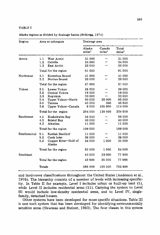
An excellent example of the use of watersheds for regional planning is the Alaska regional profile series (Selkregg, 1974) (see Table I). Alaska was divided into six regions for planning; &ctic, Northwest, Yukon, Southwest, Southcentral and Southeast. These regions, and related subregions, were determined by major river basins. A detailed inventory and analysis of bio- physical, sociocultuml, economic and political structure and process was produced for each region (Selkregg, 1974). The watershed is an ideal, but one that offers an exciting framework for planning. Some applications of the concept are discussed in the next paper (Steiner, 1983).
Once cores and boundaries have been identified, it is necessary to describe and classify the structure, or internal phenomena, of ecosystem regions. Many hierarchical classifications have been developed to accomplish this: the U.S. Fish and Wildlife Service’s system for the classification of wetlands and deepwater habitats; the U.S. Geological Survey’s system for classifying land use and land cover; and environmentally sensitive areas classification. Hier~hic~ structures, even in pragmatic, applied forms such as these, are created primarily as a tool to link parts and wholes in a series of levels.
The US. Fish and Wildlife Service system was established for regionaf inventories of wetlands and deepwater habitats. It is intended to describe ecological taxa (parts), arrange them in a system (whole) useful to resource managers and regional planners, and provide uniformity of concepts and terms. Wetlands are defined by plants, soils and frequency of flooding. Eco- IogicaIly related areas of deep water are also included. Systems form the highest (holistic) level of this classification hierarchy (see Fig. 7). Lower levels (parts or units) include subsystems and classes (Cowardin et al., 1979). This is especially helpful in classifying the biophysical components of a region.
A useful system for classifying human land use of an area has been de- veloped by the Geological Survey (see Table II). This was originally de- veloped for use with remote sensor data, but is applicable to other land-use
285
TABLE I
Alaska regions as divided by drainage basins (Selkregg, 1974)
Region Area or subregion Drainage area
Arctic 1.1 West Arctic 31000 1.2 Colville 24 000 1.3 East Arctic 26 000
Northwest
Total for the region
2.1 Kotzebue Sound 2.2 Norton Sound
81 000
Yukon
Southwest
Total for the region
3.1 Lower Yukon 3.2 Central Yukon 3.3 Koyukuk 3.4 Upper Yukon-North 3.5 Tanana 3.6 Upper Yukon-Canada
Total for the region
4.1 Kuskokwim Bay 4.2 Bristol Bay 4.3 Aleutian
41000 26 000
67 000
38 000 19 000 33 000 60 000 45 000
9 000
204 000
58 000 40 000 11000
Total for the region
Southcentral 5.1 Kodiak Shelikof 5.2 Cook Inlet 5.3 Copper River-Gulf of
Alaska
109 000
11000 38 000 34 000
Southeast
Total for the region
Total for the region
83 000
42 000
42 000
Totals 586 000
Alaska Canada Total miles* miles’ miles*
-
-
-
25 000 500
105 000
130 500
-
-
- -
1000
1 000
35 000
35 000
166 500
31000 24 000 26 000
81000
41000 26 000
67 000
38 000 19 000 33 000 85 000 45 500
114 000
334 500
58 000 40 000 11000
109 000
11000 38 000 35 000
84 000
77 000
77 000
752 500
and land-cover classifications throughout the United States (Anderson et al., 1976). The hierarchy consists of a number of levels with increasing specific- ity. In Table II for example, Level I includes urban or built-up land (1 ), while Level II includes residential areas (11). Carrying the system to Level III would include low-density residential areas, and to Level IV, single- family, detached houses.
Other systems have been developed for more specific situations. Table III is one such system that has been developed for identifying environmentally sensitive areas (Newman and Steiner, 1983). The four classes in this system

286
SVStelll Subsystem class
-
-1
-1
Marine -;‘--
Subrid*, +;Lzzz%&d Bottom
Intertidal ---_ig;;;Y;t, Shore
, Subtidal _iFsed Bottom
---I Estuarine L Aquatic Bed Reef
Emergent Wetland Scrub-Shrub Wetland Forested Wetland
r- Rock Bottom Unconsolidated Bottom
L Rock Bottom Unconsolidated Bottom
IT -Rock Bottom -Unconsolidated Bottom
Upper Perennial -----------Aquatic Bed -Rocky Shore -Unconsolidated Shore
-Intermittent Streambed
-trineC
Limnetic .~~p~~~ed Bottom
Fig. 7. Classification hierarchy of wetlands and deepwater habitats (Cowardin et al., 1979).

287
TABLE II
Land-use and land-cover classification system for use with remote sensor data (Anderson et al., 1976)
Level I Level II
2 Agricultural land 21 22
6 Wetland 61 Forested wetland 62 Nonforested wetland
7 Barren land 71 Dry salt flats 72 Beaches 73 Sandy areas other than beaches 74 Bare exposed rock 75 Strip mines, quarries and gravel pits 76 Transitional areas 77 Mixed barren land
8 Tundra
3 Rangeland 31 Herbaceous rangeland 32 Shrub and brush rangeland 33 Mixed rangeland
4 Forest land 41 Deciduous forest land 42 Evergreen forest land 43 Mixed forest land
5 Water 51 Streams and canals 52 Lakes 53 Reservoirs 54 Bays and estuaries
1 Urban or built-up land 11 Residential 12 Commercial and services 13 Industrial 14 Transportation, communications and utilities 15 Industrial and commercial complexes 16 Mixed urban or built-up land 17 Other urban or built-up land
23 24
Cropland and pasture Orchards, groves, vineyards, nurseries and ornamental horticultural areas Confined feeding operations Other agricultural land
81 Shrub and brush tundra 82 Herbaceous tundra 83 Bare ground tundra 84 Wet tundra 85 Mixed tundra
9 Perennial snow on ice 91 Perennial snowfields 92 Glaciers

288
TABLE III
An environmentally sensitive area classification system
Class Subclass
Ecologically critical areas 1. Natural wildlife habitat areas 2. Natural ecologica areas 3. Scientific areas
Perceptual and cultural critical areas
4. Scenic areas 5. Wilderness recreation areas 6. Historic, archeological and cultural areas
Resource production critical areas
7. 8. 9.
Agricultural lands Water quality areas Mineral extraction areas
Natural hazard critical areas
10. Flood prone areas 11. Fire hazard areas 12. Geologic hazard areas 13. Air pollution areas
have been adapted from Odum (1971) and the New Jersey Pinelands Com- mission (1980). The 13 subclasses were adapted from the Center for Natural Areas of the Smithsonian Institute (1974).
It is also necessary to establish interrelations between the structural com- ponents or phenomena of regions, to show process. One tool to accomplish this is to identify bivariate relationships. The matrix in Fig. 8 is a convenient way to show such relationships. Both spatial and process relationships exist between each numbered pair of elements. For instance, the geology of a region exerts a direct influence on its physiography (1). Through geologic time, the physical form of the landscape is developed. Likewise, the physio- graphy inff uences the microclimate (9). Rainfall and temperature vary from mountainous areas to valleys. Climate, in turn, affects potential habitats for plants and animals (19, 20), and so on. For each number on the chart, the indicated interaction may be described (Steiner and Brooks, 1981).
Joanne Jackson (1978) has developed similar matrices which can compare bivariate relationships between land uses (see Fig. 9) and between land uses and biophysical processes (see Fig. 10). These matrices heIp to illustrate the human functions and processes of a region.
Another tool to show interrelationships is the layer-cake model popular- ized by Ian McHarg (1969). Layer-cake models help to gain a perspective about how various components of the environment interact across the land- scape (see Fig. 11). A cross-section of an area is drawn and then the com- ponents of the biophysics and social en~onment are stacked like a layer cake (see Fig. 12) (Steiner, 1982). In this manner elements, notably parts and wholes, can be compared and analyzed.

289
GEOLOGY
PHYSIOGRAPHY
CLIMATE
SOILS
GROUNDWATER
SURFACE WATE
VEGETATION
Fig. 8. Bivariate relationships.
RESIDENTIAL I
I COMMERCIAL I
INDUSTRIAL I
j TF~..NC;~J~I=N 1
-
J a G 5
: u
-
-
-
-
-
-
-
Fig. 9. Bivariate relationships: land uses (adapted from Jackson, 1978).

290
CLIMATE
GEOLOGY
PHYSlOGRAPHY
VEGETATION I
WILDLIFE I
-
2 5 0’ E 2
-
-
-
-
-
-
-
-
-
E F
Y K L W
-
-
-
-
-
-
-
- Fig. 10. Bivariate relationships: land uses and biophysical processes (adapted from Jackson, 1978).
CONSPECTUS
There should be little argument that some conception of “region” is a given in planning, not only in the United States but around the world; in- deed a given in the cultural, social, economic and political affairs of human- ity in all its manifestations at local levels and as a global entity. Planners, then, can never lose sight of this given, must indeed keep it in mind in all of the broad range of considerations that make up the complexity of plan- ning.
Despite this, planning is quite often proto-planning, concerned too ex- cusively with the lowest or most local, forced into the atomistic mode by parochial politics. Or, planning is centralized, emanating from a national center and imposed on the locality. However, regional planning, if worthy of the name, must account for the local and the larger, for transcendent “fields”, for regions as holons as Koestler intended the term.
Region is both a discriminatory device and an integrative concept (and reality); factionalism is a problem in contemporary human relations, as it has always been, and a realistic conception of region can be an integrative factor, and can help planners achieve conflict resolution. Identity likewise has always been a human problem, but especially so in the mass societies

Fig. 11. Layer-cake simulation model (adapted from Wallace et al., 1974).
of the modern world, so that a popular or even a mythical formulation of region can be a factor in group discrimination, thus helping to distinguish and to establish identity. “I am an American” is a regional claim to separate the speaker from others in the world, but also to integrate the speaker with other Americans, to establish identity through both separation and integra- tion. On another level, the claim “I am a Southener” accomplishes the same purpose in the same way, though even more “regionally” defined. Such pro- nouncements provoke distinction in one direction and provide identity in the other.
Human ecology - as a study of the relationships between parts and wholes - may hold the key to the integration of regional types, structure and complexity. This is what Bennett (1976) suggested by viewing a region as a frame for multidisciplinary research with human ecology as a synthesis.

292
SECTION A-A,
i- HGW 128
SECTION B-B,
SOUTH FORK ASOTIN CREEK
3000
2000
SECTION C-C,
WEISSENF’ELS RIDGE COUSE CREEK
2000
Fig. 12. ExampIe of layer-cake [Beach et al., 1978).

293
Since humans are living beings, human ecology may be thought of as an ex- pansion of general ecology to how humans interact with each other and with all components of their environments. Interaction, then, has been suggested here as both a basic concept and an explanatory device:
In human ecology, the way people interact with each other and with the environ- ment is definitive of a number of basic relationships. Interaction provides a measure of belonging [of community], it affects identity versus alienation, including alienation from the environment. The system of obligation, responsibility and liability is defined through interaction. The process has become definitive of the public interest as op- posed to private interests which prosper in the spirit of independence (Young, 1976, p. 294). Landscape planners, then, should be more familiar with human ecology;
should use such access sources as Young’s extensive bibliography (1978) that explores the pandisciplinary nature and the applied aspects of human ecol- ogy, or the special issue of the journal Landscape Planning (Johnson, 1981) devoted to planning as applied human ecology. They should also avail them- selves of such sources as Rerger (1976,1978,1981), Rose et al. (1979), Rose and Jackson (1978) and Rose (1981).
A human ecological approach to landscape planning allows regions to be considered in terms of the relationship between parts and wholes, using a number of techniques from human ecology tc gain access to such relation- ships. Ultimately, the interaction of parts and wholes in a functional regional system is a measure of fitness. Ian McHarg (1981, pp. 112-113) has sum- marized human ecological planning in terms of such fitness:
All systems aspire to survival and success. This state can be described as sYn- thropic-fitness-health. Its antithesis is entropicmisfitness-morbidity. To achieve the first state requires systems to find the fittest environment, adapt it and themselves. Fitness of an environment for a system is defined as that requiring the minimum work of adaptation. Fitness and fitting are indications of health and the process of fitness is health-giving. The quest for fitness is entitled adaptation. Of all the instrumentalities available to man for successful adaptation, cultural adaptation in general and planning in particular, appear to be the most direct and efficacious for maintaining and en- hancing human health and well-being.
REFERENCES
Adams, C.C., 1935. The relation of general ecology to human ecology. Ecology, 16: 316-335.
Alexander, L.M., 1967. The Northeastern United States. Van Nostrand, Princeton, NJ, 122 pp.
Anderson, J.R., Hardy, E.E., Roach, J.T. and Witmer, R.E., 1976. A Land Use and Land Cover Classification System for Use with Remote Sensor Data. Geological Survey Professional Paper 964, U.S. Government Printing Office, Washington, DC, 28 pp.
Bailey, R.G., 1976. Ecoregions of the United States. U.S. Forest Service, Ogden, UT (map only; scale 1:7 500 000).
Bailey, R.G., 1973. Ecoregions of the United States. U.S. Forest Service, Ogden, UT, 77 PP.
Bates, M., 1956. Process. In: W.L. Thomas, Jr. (Editor), Man’s Role in Changing the Face of the Earth. University of Chicago Press, Chicago, pp. 1136-1140.

294
Beach, R., Benson, D., Brunton, D., Johnson, K.L., Knowles, J., Michaiovic, J., Newman, H.G., Tripp, B.J. and Wunschel, C., 1978. Asotin County Ecological Inventory and Land Use Suitability Analysis. Washington State University, Pullman, WA, 356 pp.
Bennett, J., 1976. The Ecological Transition: Cultural Anthropology and Human Adap- tation. Pergamon, New York, 378 pp.
Berger, J., 1976. The Hazelton ecological planning study. Human adaptations in a rural and urban environment: The basis for possible future land use patterns. Landscape Plann., 3: 303-335.
Berger, J., 1978. Toward an applied human ecology for landscape architecture and region- al planning. Human Ecol., 6: 179-199.
Berger, J., 1981. Landscape patterns of local social organization and their importance for land use planning. Landscape PIann., 8: 193-232.
Berry, W., 1975. A Continuous Harmony, Essays Cultural and Agricultural. A Harvest/ HBJ Book, New York, 182 pp.
Cartwright, D. (Editor), 1951. Field Theory in Social Science: Selected Theoretical Papers of Kurt Lewin. Harper and Row, New York, 346 pp.
Center for Natural Areas, Smithsonian Institute, 1974. Planning Considerations for Statewide Inventories of Critical Environmental Areas: a Reference Guide. Washing- ton, DC, 274 pp.
Cowardin, L.M., Carter, V., Golet, F.C. and LaRoe, E.T., 1979. Classification of Wet- lands and Deepwater Habitats in the United States. U.S. Government Printing Office, Washington, DC, 103 pp.
Darling, F.F., 1951. The ecological approach to the social sciences. Am. Sci., 25: 244- 254.
Duncan, O.D. and Schnore, L.F., 1959. Cultural, behavioral and ecological perspective in the study of social organization. Am. J. Social., 65: 132-146.
Ebeling, W., 1979. The Fruited Plain. University of California Press, Berkeley, CA, 433
PP. Eliot, T.S., 1949. Notes Toward the Definition of Culture. Harcourt, Brace, New York,
128 pp. Evans, F.C., 1956. Ecosystem as the basic unit in ecology. Science, 123: 1127-1128. Fenneman, N.M., 1931. Physiography of Western United States. McGraw-Hill, New
York, 534 pp. Fenneman, N.M., 1938. Physiography of Eastern United States. McGraw-Hill, New York,
714 pp. Garland, J.H. (Editor), 1955. The North American Midwest. Wiley, New York, 252 pp. Garreau, J., 1981. The Nine Nations of North America, Houghton Mifflin, New York,
423 pp. Gates, D.M., 1968. Toward understanding ecosystems. Adv. Ecol. Res., 5: l-35. Glikson, A., 1967. The relationship between landscape planning and-regional planning.
In: Towards a New Relationship of Man and Nature in Temporate Lands. Proceedings and Papers of the Tenth Technical Meeting, International Union for Conservation of Nature and Natural Resources, Lucerne, 26-30 June 1966. ICUN, Morges, Swit- zerland, pp. 37-50.
Haystead, L. and Fite, G.C., 1955. The Agricultural Regions of the United States. Uni- versity of Oklahoma Press, Norman, 288 pp.
Higbee, E., 1958. American Agriculture: Geography, Resources, Conservation. Wiley, New York, 399 pp.
Hunt, C.B., 1967. Physiography of the United States. W.H. Freeman, San Francisco, 480 pp.
Jackson, J., 1978. Planning for People and Places. Unpublished Master’s Thesis. Depart- ment of Landscape Architecture and Regional Planning, University of Pennsylvania, Philadelphia, PA, 102 pp.
James, P.E., 1972. All Possible Worlds. Odyssey Press, Indianapolis, 622 pp.

295
Johnson, A.H. (Editor), 1981. Special Issue: Human Ecological Planning. Landscape Plann., 8: 105-232.
Kahn, A.E., 1966. The tyranny of small decisions: market failures, imperfections, and the limits of economics. Kyklos, 19: 23-47.
Kalmus, H. (Editor), 1966. Regulation and Control in Living Systems. Wiley, New York, 468 pp.
Koestler, A., 1968. The Ghost in the Machine. Macmillan, New York, 384 pp. Kraenzel, C.F., 1955. The Great Plains in Transition. University of Oklahoma Press,
Norman, 428 pp. Lewin, K., 1944. Constructs in psychology and psychological ecology. In: Authority and
Frustration. University of Iowa Press, Iowa City, pp. l-29. LSsch, A., 1964. The nature of economic regions. In: J. Friedmann and W.Alonso
(Editors), Regional Development and Planning. M.I.T. Press, Cambridge, MA, pp. 107-115.
Margalef, R., 1963. On certain unifying principles in ecology. Am. Nat., 97: 357-374. Mayer, H.M., 1973. Regional Planning. In: University of Chicago (Editors), Encyclopae-
dia Britannica, University of Chicago, Chicago, pp. 83-84. McHarg, I.L., 1969. Design with Nature. Doubleday/Natural History Press, Garden City,
New York, 197 pp. McHarg. I.L., 1981. Human ecological planning at Pennsylvania. Landscape Plann. 8:
109-120. Meinig, D.W., 1965. The Morman culture region: strategies and patterns in geography of
the American west, 1947-1964. Ann. Assoc. Am. Geogr., 55: 213-217. Meinig, D.W., 1969. Imperial Texas: An Interpretive Essay in Cultural Geography. Uni-
versity of Texas Press, Austin, 145 pp. Molnar, F., 1966. The unit and the whole: fundamental problem of the plastic arts. In:
G. Kepes (Editor), Module, Proportion, Symmetry, Rhythm. Braziller, New York, pp. 204-217.
Monkhouse, F.J. and Hardy, A.V., 1965. North American Landscapes. The University Press, Cambridge, 96 pp.
New Jersey Pinelands Commission, 1980. Critical Areas Study for the Pinelands. Rogers, Golden and Halpern, Philadelphia, PA, 446 pp.
Newman, H.G., III and Steiner, F.R., 1983. The Definition of Environmentally Sensitive Areas for Planning. Washington State University, Pullman, W.A., unpublished paper,
28 PP. Odum, E.P., 1963. Ecology. Holt. Rinehart and Winston, New York, 244 pp. Odum, E.P., 1971. Fundamentals of Ecology. W.B. Saunders, Philadelphia, 574 pp. Odum, H.W., 1965. The promise of regionalism. In: M. Jensen (Editor), Regionalism in
America. University of Wisconsin Press, Madison, pp. 395-419. Odum, W.E., 1982. Environmental degradation and the tyranny of small decisions. Bio-
Science, 32: 728-729. Parsons, T., 1961. The general interpretation of action. In: T. Parsons, E. Shils, K.
Naegele and J.R. Pitts (Editors), Theories of Society: Foundations of Modern Sociological Theory, Vol. I. The Free Press, New York, pp. 85-97.
Parsons, T., 1968. Interaction. In: D.L. Sills (Editor), International Encyclopedia of the Social Sciences. Macmillan and the Free Press, New York, pp. 429-474.
Paterson J.H., 1965. North America. A Geography of Canada and the United States. Oxford University Press, London, 477 pp.
Pattee, H.H. (Editor), 1973. Hierarchy Theory: The Challenge of Complex Systems. Braziller, New York, 156 pp.
Radcliffe-Brown, A.R., 1935. On the concept of function in social science. Am. Anthro- pol., 37 : 394-402.
Ripley, S.D. and Buechner, H.K., 1967. Ecosystem science as a point of synthesis. Daedalus, 196: 1192-1199.

296
Rose, D., 1981. Energy Transition and the Local Community. University of Pennsyl- vania Press, Philadelphia, 189 pp.
Rose, D. and Jackson, J., 1978. Human ecology for ecosystem management. In: Coastal Zone ‘78, ASCE Technical Publications, New York, pp. l-16.
Rose, D., Steiner, F. and Jackson, J., 1979. An applied human ecological approach to regional planning. Landscape Plann., 5: 241-261.
Sears, P.B., 1954. Human ecology: a problem in synthesis. Science, 120: 959-963. Sears, P.B., 1959. The Ecology of Man. Smithsonian, Washington, DC, 24 pp. Selkregg, L.L. (Editor), 1974. Alaska Regional Profiles (6 volumes). Anchorage: Arctic
Environmental Information and Data Center, University of Alaska, various pages. Smailes, A.E., 1968. The Geography of Towns. Aldine, Chicago, 160 pp. Smith, J.R. and Phillips, M.O., 1942. North America. Harcourt, Brace, New York, 1016
PP. Snyder, G., 1980. The Real Work. New Directions Books, New York, 189 pp. Sorokin, P.A., 1941. The Crisis of Our Age: The Social and Cultural Outlook. E.P.
Dutton, New York, 338 pp. Steiner, F., 1982. Ecological Planning for Farmlands Preservation. APA Planners Press,
Chicago IL, 122 pp. Steiner, F., 1983. Regional planning in the United States: historic and contemporary
examples. Landscape Plann., 10: 297-315. Steiner, F. and Brooks, K., 1981. Ecological planning: a review. Environ. Manage., 5:
495-505. Steward, J., 1955. Theory of Cultural Change. University of Illinois Press, Urbana, 244
PP. Tansley, A.G., 1935. The use and abuse of vegetational concepts and terms. Ecology, 16:
284-307. Thornbury, W.E., 1965. Regional Geomorphology of the United States. Wiley, New
York, 609 pp. Vance, R.B., 1965. The regional concept as a tool for social research. In: M. Jensen (Edi-
tor), Regionalism in America. University of Wisconsin Press, Madison, pp. 119-140. Wallace, McHarg, Roberts and Todd, Inc., 1971-1974. Woodlands New Community
(4 volumes). Philadelphia, PA, various pages. Weiss, P.A. (Editor), 1971. Hierarchically Organized Systems in Theory and Practice.
Hafner, New York, 263 pp. Whittlesey, D., 1954. The regional concept and the regional method. In: E. James and
C.F. Jones (Editors). American Geography: Inventory and Prospect. Syracuse University Press, Syracuse, pp. 19-68.
Young, G.L., 1976. Environmental law: perspectives from human ecology. Environ. Law, 6: 289-307.
Young, G.L., 1978. Human Ecology as an Interdisciplinary Domain: An Epistemological Bibliography. Vance Bibliographies, Monticello, IL, 71 pp.
Zelinsky, W., 1973. The Cultural Geography of the United States. Prentice-Hall, Engle- wood Cliffs, NJ, 164 pp.
Zelinsky, W., 1980. North America’s vernacular regions. Ann. Assoc. Am. Geogr., 70: l-16.