developing one of north americas highest grade … · 4 • in 2013, maine started process to...
TRANSCRIPT

Developing one of North Americas Highest Grade Base Metal Deposits

2
Disclaimer
This presentation may contain "forward looking information" within the meaning of Canadian securities legislation, which are based on the opinions and estimates of management and are subject to a variety of risks and uncertainties and other factors that could cause actual events or results to differ materially from those projected in the forward looking information. Such risks and uncertainties include, but are not limited to, risks associated with the mining industry, the risk of commodity price and foreign exchange rate fluctuations, the ability of Wolfden to fund the capital and operating expenses necessary to achieve the business objectives of Wolfden, as well as those risks described in public disclosure documents filed by Wolfden. Due to the risks, uncertainties and assumptions inherent in forward-looking information, prospective investors in securities of Wolfden should not place undue reliance on these forward-looking information. This presentation has been completed by Wolfden. Certain corporate projects referred to herein are subject to agreements with third parties who have not prepared, reviewed nor approved this presentation. The presentation is not intended to reflect the actual plans or exploration and development programs contemplated for such projects. Donald Hoy, P. Geo., is the Qualified Person for the information contained in this presentation and is a Qualified Person within the meaning of National Instrument 43-101. For further information on the technical data provided in this presentation, including the key assumptions underlying the mineral resource herein, refer to the Sedar filings as listed below: Unless otherwise stated, the financial information in this presentation is as reported in the latest quarterly filings or press release related to the financial information of the Corporation. Pickett Mountain aerial photographs provided courtesy of LandVest
2
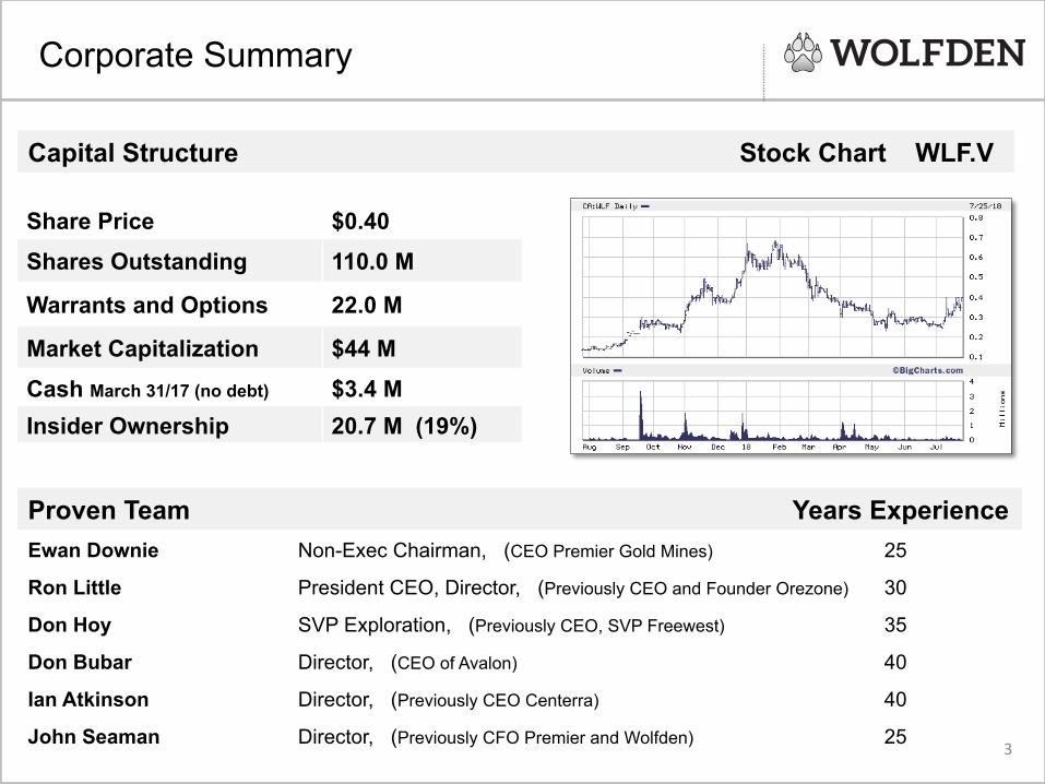
Capital Structure Stock Chart WLF.V
Share Price $0.40 Shares Outstanding 110.0 M
Warrants and Options 22.0 M
Market Capitalization $44 M Cash March 31/17 (no debt) $3.4 M Insider Ownership 20.7 M (19%)
3
Proven Team Years Experience Ewan Downie Non-Exec Chairman, (CEO Premier Gold Mines) 25
Ron Little President CEO, Director, (Previously CEO and Founder Orezone) 30
Don Hoy SVP Exploration, (Previously CEO, SVP Freewest) 35
Don Bubar Director, (CEO of Avalon) 40
Ian Atkinson Director, (Previously CEO Centerra) 40
John Seaman
Director, (Previously CFO Premier and Wolfden) 25
Corporate Summary
3 John Seaman

4
• In 2013, Maine started process to reform mining laws to allow underground mining only
• November 2017 New Mining Code
enacted - Bill LD820 • 1980’s was the last significant exploration
• Pickett Mountain is one of the highest-grade undeveloped volcanogenic massive sulphide deposits in North America that remains open for potential expansion
Wolfden First Mover in Maine
4

Meguma
Avalonia Ganderia Terrain
Notre Dame
Humber
• Ganderia Terrain endowed
with high-grade Zn-Pb-Cu-Ag massive sulphide deposits
• BATHURST CAMP 349 Mt Worlds Largest VMS District Production 134 MT
• BUCHANS CAMP 112 Mt Production 46 MT
• PICKETT MOUNTAIN
Proximal to other camps and very much underexplored
• New Mining Code in Maine in 2017
VMS Endowment Appalachians
After Hubbard et al. (2006)
BATHURST BRUNSWICK #12 – 128 MT 8.6% Zn, 3.5%PB, 0.3% Cu, 100 g/t Ag
BUCHANS DEPOSIT – 16 MT 14.5% Zn, 7.6% Pb, 1.3% Cu, 126 g/t Ag
Ganderia
BALD MOUNTAIN – 30 MT 1.1% Zn, 1.0% Cu, 14.1 g/t Ag
PICKETT MOUNTAIN Zn-Pb-Cu-Ag Deposit
200 km
Tectonic Map of the Appalachians

History, Location & Infrastructure
PICKETT MOUNTAIN Zn-Pb-Cu-Ag Deposit
State Highway 11 1 km
PROPERTY BOUNDARY 6870 Acres
• Discovered in 1979 by Getty Mines Ltd and called Mount Chase; Diamond drilling, metallurgical work, environmental studies and PF studies 1979 – 1984
• Chevron Ltd.- Deeper drilling,
metallurgical work 1984-1989 • Easy year round access via State
Highway 11 and three miles of forestry road
• Access to Power Line – 11 km
• No population living within miles of the project
• Potential to sell timber from the Property
6

Geology & Area of Exploration 2018
7
Airborne Geophysics completed over the main deposit and the larger grid Other similar targets targets identified within the same favourable package of rocks Drill testing of targets to commence in Q3

Well defined soil anomalies of Zn-Pb-Cu along strike Coincident HLEM conductors along strike No down-hole EM surveying never completed Drill testing geophysics will follow-up these targets
Expansion Potential – Geochemistry/Geophysics
500 m

Vertical Longitudinal Drill Section
9
2018 Deep Drilling
Open at Depth
Open at Depth
West Lens 1
East Lens 1
East Lens 2

Isometric View of Main Zone Lenses
10
Looking NW Azimuth 327 (Straight on)
Looking WNW Azimuth 282 (at 45 degrees)
2018 Deep Drilling
400 m

Mineralized Drill Results – West Lens
Note: This table is comprised of selected intervals within each mineralized intersection that reflects optimized grades and widths based on the relative metal prices and cutoff grades that were appropriate at the time (circa 1985). Wolfden will compile a table of all results from the original drill logs and database in order to regenerate its own table of optimized intervals based on current market conditions. Drill holes in red font (Hole #001-0023) are those drilled by Wolfden for comparison that intersected massive sulphide mineralization. 11
Sec$on Hole # lens From To length T.width Zn Pb Cu Ag Au Zn+Pb+Cu (Zn+Pb+Cu)xTw (m) (m) (m) (m) % % % g/t g/t total % Total %m
1250E 29 West 279.2 279.8 0.6 0.4 3.5 1.3 0.3 8.6 0.3 5.1 2.0 1300E 76 West 162.9 165.5 2.7 2.0 3.2 1.1 3.5 46.6 0.3 7.8 15.5 1350E 55 West 460.0 462.8 2.7 3.0 1.5 0.5 0.8 15.0 0.3 2.8 8.3 1350E 62 West 199.3 221.9 22.7 9.0 4.6 2.4 0.7 34.1 0.6 7.6 68.5 1350E 74 West 158.2 163.2 5.0 5.0 11.7 4.8 1.6 128.1 0.6 18.0 89.9 1350E 94 West 318.0 331.6 13.6 8.0 3.1 1.2 1.1 43.8 0.6 5.4 42.9 1350E 18-‐018 West 110.1 110.6 0.5 0.4 11.7 8.3 2.3 100.0 0.5 22.3 8.9 1400E 19 West 48.5 74.4 25.9 15.0 0.7 0.2 0.2 4.4 0.0 1.0 15.5 1400E 23 West 197.2 200.6 3.4 2.0 0.0 1.9 2.1 203.8 0.7 4.0 8.0 1400E 25 West 317.0 327.7 10.7 9.0 5.8 2.5 1.3 45.6 0.3 9.5 85.3 1400E 82 West 254.2 259.1 4.9 4.0 7.3 2.9 2.6 105.0 0.9 12.8 51.0 1400E 85 West 398.5 409.4 10.8 6.0 10.3 4.7 1.8 95.6 0.9 16.8 100.9 1400E 18-‐010 West 124.2 126.0 1.8 1.3 8.7 2.9 0.5 58.1 0.4 12.1 15.7 1450E 54 West 111.6 121.3 9.8 7.0 7.2 2.3 1.1 37.5 0.6 10.5 73.7 1450E 59 West 194.3 217.6 23.3 6.0 13.1 6.4 2.4 110.0 0.9 22.0 131.9 1450E 72 West 525.8 532.5 6.7 4.0 12.5 5.8 0.4 127.5 0.6 18.7 75.0 1450E 86 West 172.2 176.8 4.6 3.0 4.6 1.8 2.4 48.8 0.6 8.8 26.4 1450E 18-‐007 West 279.7 311.2 31.5 25.0 4.4 1.6 1.0 60.5 1.3 7.0 175.7 1450E 18-‐008 West 342.3 346.0 3.7 2.5 12.8 3.6 0.3 63.9 0.5 16.7 41.6 1450E 18-‐009 West 380.9 384.4 3.5 2.8 10.6 4.1 1.3 85.2 0.6 16.0 44.8 1450E 18-‐011 West 56.6 59.6 3.0 2.6 4.2 1.4 2.6 34.3 0.5 8.2 21.3 1450E 18-‐022 West 662.2 666.9 4.7 2.4 23.9 9.9 0.9 267.3 1.6 34.7 81.6 1500E 28 West 200.7 210.9 10.2 7.0 16.0 7.4 1.4 164.1 1.9 24.8 173.4 1500E 30 West 342.9 344.0 1.1 1.0 1.2 0.5 0.4 22.5 0.3 2.1 2.1 1500E 52 West 57.8 68.0 10.2 7.0 4.7 1.9 1.1 33.1 0.6 7.7 53.8 1500E 68 West 64.8 73.8 9.0 5.0 15.3 4.9 2.2 52.2 0.9 22.4 112.0 1500E 69 West 89.9 121.6 31.6 7.0 8.1 3.4 1.1 93.8 0.9 12.7 88.8 1500E 80 West 282.2 293.1 10.8 7.0 1.7 1.1 0.6 12.8 0.3 3.3 22.9 1500E 90 West 812.4 814.4 1.9 1.2 25.4 10.7 0.9 129.1 0.9 37.0 44.4 1500E 91 West 431.6 438.3 6.7 4.0 5.2 2.0 0.7 31.9 0.6 7.9 31.7 1500E 90A West 761.5 763.1 1.7 1.0 10.4 4.0 0.8 74.7 0.6 15.1 15.1 1500E 18-‐023 West 661.2 667.1 5.9 3.0 7.5 3.2 1.3 64.8 0.7 12.0 36.0 1550E 53 West 156.4 171.8 15.4 9.0 17.0 9.3 1.5 189.7 1.3 27.7 249.7 1550E 57 West 81.4 96.0 14.6 9.0 11.1 5.9 1.6 133.1 0.9 18.5 166.8 1550E 58 West 284.4 292.6 8.2 4.0 4.8 2.1 1.1 120.3 0.6 8.0 32.0 1550E 87 West 215.0 220.7 5.7 4.0 15.5 6.0 2.3 174.7 0.9 23.8 95.2 1550E 17-‐001 West 85.5 92.2 6.7 5.5 9.1 4.4 1.7 117.4 1.0 15.2 83.8 1550E 17-‐002 West 111.0 119.7 8.7 5.0 18.4 8.0 1.9 207.1 1.6 28.3 141.5 1550E 18-‐012 West 39.2 46.9 7.7 5.1 4.6 1.9 1.0 40.5 0.4 7.5 38.3 1600E 33 West 157.9 158.3 0.5 0.3 10.0 9.3 0.8 190.6 0.9 20.1 6.0 1600E 35 West 211.2 215.0 3.8 3.0 14.7 6.5 0.9 90.9 0.9 22.0 66.1 1600E 38 West 327.6 331.6 4.0 3.0 2.3 0.9 0.7 32.4 0.3 3.9 11.6

Mineralized Drill Results – East Lens
Note: This table is comprised of selected intervals within each mineralized intersection that reflects optimized grades and widths based on the relative metal prices and cutoff grades that were appropriate at the time (circa 1985). Wolfden will compile a table of all results from the original drill logs and database in order to regenerate its own table of optimized intervals based on current market conditions. Drill holes in red font (Hole #001-0023) are those drilled by Wolfden for comparison that intersected massive sulphide mineralization.
12
Sec$on Hole # Lens From To length T.width Zn Pb Cu Ag Au Zn+Pb+Cu (Zn+Pb+Cu)xTw (m) (m) (m) (m) % % % g/t g/t total % Total %m
1700E 51 East 229.5 229.9 0.3 0.3 1.7 0.6 0.6 10.6 1.1 2.9 0.7 1750E 36 East 275.9 282.3 6.4 5.0 6.1 2.5 1.1 57.8 0.4 9.6 48.1 1750E 40 East 385.7 388.9 3.2 3.0 1.5 0.6 0.8 0.0 1.3 2.9 8.7 1850E 34 East 243.8 259.1 15.3 10.0 8.1 3.1 0.8 67.5 0.3 11.9 119.4 1850E 37 East 320.1 332.2 12.1 9.2 2.3 1.0 0.8 56.3 1.3 4.1 37.8 1850E 18-‐020 East 194.6 197.8 3.2 2.2 13.2 5.4 1.7 124.8 0.6 20.3 44.7 1850E 18-‐021 East 358.2 362.2 4.0 3.2 6.6 2.3 0.4 22.6 0.6 9.3 29.8 1900E 47 East 181.1 187.6 6.6 4.0 16.9 6.3 1.0 116.9 1.3 24.2 97.0 1900E 49 East 68.3 68.5 0.2 0.1 10.5 2.5 1.9 77.2 0.6 14.9 1.5 1900E 56 East 396.9 398.8 1.9 1.0 12.2 4.2 0.7 89.4 0.6 17.0 17.0 1900E 64 East 118.1 132.1 14.0 6.0 8.9 4.0 1.3 81.6 0.6 14.1 84.7 1900E 92 East 225.3 229.5 4.2 4.0 8.5 3.3 0.9 70.3 0.6 12.7 50.8 1900E 93 East 331.2 343.7 12.4 10.0 4.2 1.5 0.9 70.9 0.6 6.6 66.0 1900E 18-‐005 East 278.1 323.9 45.8 27.0 1.3 0.5 0.6 24.0 1.0 2.4 65.4 1950E 39 East 260.9 268.7 7.8 6.0 7.4 3.1 1.8 64.7 1.3 12.3 74.0 1950E 46 East 163.7 172.7 9.0 9.0 9.7 3.7 0.8 78.8 0.3 14.2 127.8 1950E 67 East 172.7 234.2 61.6 9.0 7.5 3.4 1.3 50.0 0.3 12.1 109.2 1950E 18-‐003 East 194.0 202.6 8.6 7.0 10.4 3.8 1.1 63.9 0.9 15.2 106.4 1950E 18-‐004 East 173.6 180.9 7.3 5.9 13.8 5.1 1.3 144.7 0.3 20.3 119.9 2000E 8 East 89.0 92.7 3.7 3.0 6.2 2.3 1.4 49.4 0.6 9.9 29.7 2000E 44 East 312.0 319.9 7.9 6.0 2.5 1.0 0.5 17.2 0.6 4.1 24.3 2000E 63 East 95.4 95.9 0.5 0.3 5.3 2.4 0.5 27.5 0.6 8.2 2.1 2000E 81 East 248.3 255.6 7.3 5.0 8.1 3.1 1.5 76.6 0.6 12.7 63.6 2000E 83 East 204.4 209.9 5.5 5.0 3.2 1.2 0.4 26.9 0.4 4.8 24.1 2050E 9 East 77.7 85.7 8.1 6.9 2.1 0.3 0.3 18.4 0.0 2.6 18.2 2050E 13 East 183.8 186.5 2.7 2.0 2.6 0.5 0.7 52.8 0.6 3.9 7.8 2050E 70 East 336.8 353.7 16.9 11.0 4.7 1.6 1.0 29.7 0.3 7.3 80.6 2050E 78 East 236.1 253.4 17.3 11.0 6.4 2.6 1.4 56.6 0.4 10.4 114.3 2050E 18-‐006A East 254.5 296.9 42.4 29.0 1.7 0.6 0.6 22.8 0.4 2.9 83.8 2100E 1 East 41.2 47.8 6.6 5.9 2.1 0.8 0.7 27.5 0.3 3.6 21.3 2100E 2 East 62.9 76.8 13.9 11.0 4.6 1.7 0.8 41.3 0.6 7.1 78.5 2100E 10 East 169.0 170.1 1.1 1.0 2.5 0.7 0.9 44.1 0.2 4.1 4.3 2100E 18-‐015 East 229.0 232.6 3.6 3.1 1.8 0.7 0.6 22.8 0.4 3.1 9.6 2150E 18-‐013 East 70.6 74.0 3.4 1.9 5.2 2.2 0.7 39.4 0.4 8.1 15.4 2150E 18-‐014 East 87.3 91.7 4.4 3.7 1.8 0.6 0.5 26.2 0.3 2.9 10.7

Exploration Upside – IP Targets
• Main Zone Lens correlate well with high chargeability anomalies
• Other similar anomalies to the North and West will be drill tested as shown in black areas
IP Chargeability 300m Elevation

14
Exploration Upside – Airborne EM & Ground InfiniTEM
• Airborne EM Survey identifies East & West lenses as conductors (orange and red contours) and identifies continuous conductive trend to the SW
• Ground EM survey (black lines and rectangles) with higher resolution identifies target 750 metres SW of the West lens at depth of 200m
Ground EM Target

15
Exploration Upside – Soil Geochemistry
• The East & West lenses of the massive sulphide deposit are coincident with a well-defined Zn+Pb+Cu soil anomaly
• There are 2 soil anomalies located up-ice and to the north of the known deposits that have not been drill tested
Not drilled
Not drilled
Corresponds to IP Targets
1 km

• Preliminary metallurgical work (1984) on drill core produced 3 floatation concentrates with recoveries of 88% Zinc, 78% Lead and 77% Copper
• These are excellent recoveries in comparison to most volcanogenic massive sulphide deposits in the North American Appalachians
Preliminary Metallurgical Results
Pickett Mountain Forest Land Tract 16

ü The Pickett Mountain is one of the highest-grade undeveloped VMS deposits in
North America
ü Excellent potential to expand the deposit and discover other lenses and satellite deposits
ü Preliminary metallurgical work yielded recoveries of Zinc (88%), Lead (77%) and Copper (74%) which are excellent for a VMS deposit in the Appalachians
ü The Maine Volcanic Belt neighbours the well endowed Bathurst Camp in New Brunswick
ü Entire Belt is very much underexplored compared to Bathurst
ü 2017 Maine enacts New Mining Laws
ü Local community very supportive on ongoing exploration
Pickett Mountain Summary
17

Pickett Mountain Focus • 10,000 m Diamond Drilling Program underway – 6,500 m completed to date in 23 holes; Drilling continues and will be expanded based on results and new targets
• Ground Geophysical Surveys (IP and EM) have identified targets along strike and to the North that have a similar signatures to the Main Zone lenses
• Airborne Geophysical Survey (High Resolution VTEM) has identified compelling conductors along trend of the known deposits as well as in the footwall
• Previous Soil Anomalies to the North remain untested.
• All new and untested targets will be drilled in the coming weeks
Other Drill Ready Projects
• Orvan Brook, New Brunswick – recent high-grade drill results in Bathurst Mining Camp • Rice Island & Nickel Island, Manitoba – high-grade Ni-Cu-Co deposits Evaluate prospective base metal opportunities in North America
Programs for 2018
18

Donald Hoy, M.Sc., P. Geo. SVP Exploration Tel: 807-624-1131 Ronald Little, P.Eng President & CEO Tel: 613-862-3699 Office Address: 1100 Russell Street, Thunder Bay, ON P7B 5N2 Website: www.wolfdenresources.com
Contact Details
Pickett Mountain Forest Road
Diamond Drill site
19
VTEM Survey