development management plan dpd
TRANSCRIPT
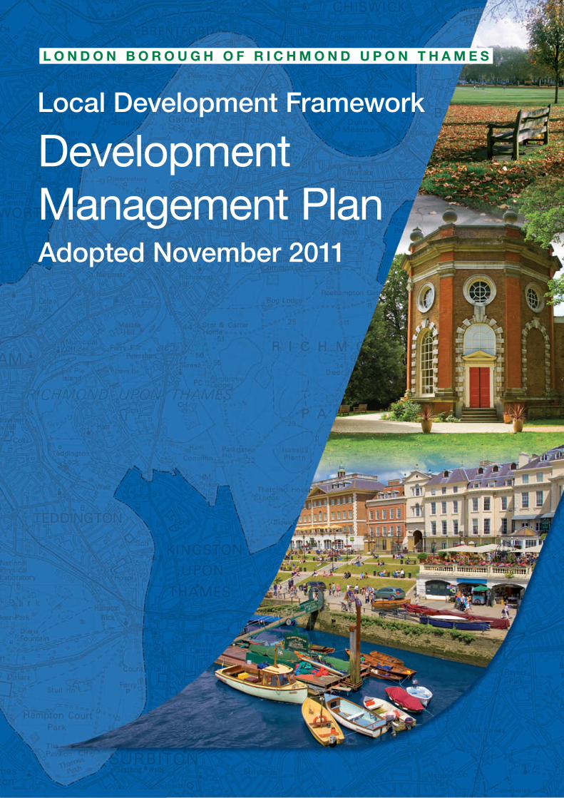
Local Development Framework
Development Management PlanAdopted November 2011

If you need this leaflet in Braille,
large print, audio tape,
or another language,
please contact us on
020 8891 7117
or minicom 020 8831 6001
Farsi
Arabic
Punjabi
Albanian
Gujarati
Urdu
Bengali

Adopted DevelopmentManagement Plan
Adopted Development Management Plan
1

6Foreword1
8Introduction2
11For A Sustainable Future3
113.1 Sustainable Development
36Protecting Local Character4
364.1 Open Land and Rivers544.2 Shopping and Centres644.3 Heritage
77Meeting People's Needs5
775.1 Housing895.2 Social Infrastructure Provision935.3 Employment985.4 Transport and Parking
111Detailed Generic Policies6
1116.1 Detailed Generic Policies
128Appendix One - Saved UDP policies superseded
133Appendix Two - Centres Hierarchy
135Appendix Three - List of Key and Secondary Shopping Frontages
143Appendix Four - Parking Standards
151Glossary
ContentsAdopted Development Management Plan

List of Policies13Policy DM SD 1 Sustainable Construction15Policy DM SD 2 Renewable Energy and Decentralised Energy Networks16Policy DM SD 3 Retrofitting18Policy DM SD 4 Adapting to Higher Temperatures and Need for Cooling20Policy DM SD 5 Living Roofs23Policy DM SD 6 Flood Risk27Policy DM SD 7 Sustainable Drainage29Policy DM SD 8 Flood Defences31Policy DM SD 9 Protecting Water Resources and Infrastructure33Policy DM SD 10 Water and Sewerage Provision37Policy DM OS 1 Major Developed Site in the Green Belt38Policy DM OS 2 Metropolitan Open Land39Policy DM OS 3 Other Open Land of Townscape Importance41Policy DM OS 4 Historic Parks, Gardens and Landscapes42Policy DM OS 5 Biodiversity and new development43Policy DM OS 6 Public Open Space45Policy DM OS 7 Children’s and Young People’s Play Facilities46Policy DM OS 8 Sport and Recreation Facilities47Policy DM OS 9 Floodlighting48Policy DM OS 10 Allotments and other food growing spaces50Policy DM OS 11 Thames Policy Area52Policy DM OS 12 Riverside Uses53Policy DM OS 13 Moorings and Floating Structures55Policy DM TC 1 Larger Town Centres
57Policy DM TC 2 Local and Neighbourhood Centres and Areas of MixedUse
59Policy DM TC 3 Retail Frontages62Policy DM TC 4 Local Shops, Services and Public Houses63Policy DM TC 5 The Evening Economy
65Policy DM HD 1 Conservation Areas - designation, protection andenhancement
67Policy DM HD 2 Conservation of Listed Buildings and ScheduledAncient Monuments
69Policy DM HD 3 Buildings of Townscape Merit71Policy DM HD 4 Archaeological Sites73Policy DM HD 5 World Heritage Site74Policy DM HD 6 War Memorials75Policy DM HD 7 Views and Vistas
77Policy DM HO 1 Existing Housing (including conversions, reversionsand non self-contained accommodation)
79Policy DM HO 2 Infill Development80Policy DM HO 3 Backland Development82Policy DM HO 4 Housing Mix and Standards84Policy DM HO 5 Housing to Meet Specific Community Needs87Policy DM HO 6 Delivering Affordable Housing90Policy DM SI 1 Encouraging New Social Infrastructure Provision92Policy DM SI 2 Loss of Existing Social Infrastructure Provision
ContentsAdopted Development Management Plan
93Policy DM EM 1 Development for Offices, Industrial, Storage andDistribution uses
96Policy DM EM 2 Retention of Employment99Policy DM TP 1 Matching Development to Transport Capacity
100Policy DM TP 2 Transport and New Development101Policy DM TP 3 Enhancing Transport Links
102Policy DM TP 4 Integration of different types of Transport andInterchange Facilities
103Policy DM TP 5 Taxis and Private Hire Vehicles104Policy DM TP 6 Walking and the Pedestrian Environment105Policy DM TP 7 Cycling106Policy DM TP 8 Off Street Parking - Retention and New Provision108Policy DM TP 9 Forecourt Parking111Policy DM DC 1 Design Quality115Policy DM DC 2 Layout and Design of Mixed Use Schemes117Policy DM DC 3 Taller Buildings120Policy DM DC 4 Trees and Landscape121Policy DM DC 5 Neighbourliness, Sunlighting and Daylighting122Policy DM DC 6 Balconies and Upper Floor Terraces123Policy DM DC 7 Shop fronts and shop signs124Policy DM DC 8 Advertisements and Hoardings125Policy DM DC 9 Planning Application Checklist
List of Statements36Statement 1 Green Belt
125Statement 2 Telecommunications
ContentsAdopted Development Management Plan

Foreword 1Adopted Development Management Plan
5
1 Foreword
The Development Management Plan (DMP) takes forward the Core Strategy’sthree inter-related themes of ‘A Sustainable Future’, ‘Protecting Local Character’and ‘Meeting People’s Needs’, with more detailed policies for the control ofdevelopment.
The DMP has been subject to extensive public consultation and I believe the Plan hassuccessfully addressed the key issues raised by local residents and businesses.
Firstly, the Plan addresses the challenges of climate change. There are many innovativepolicies which seek to tackle climate change through sustainable construction, energyefficiency, use of renewable energy and retrofitting. The policies also recognise the need toadapt to climate change and in view of the presence of the River Thames a key aspect ofthis is ensuring that development is planned to avoid the risks of flooding. They also beginto address the need to cool buildings without resorting to air conditioning systems. Finallythere are policies to address the protection of water resources and provision for water andsewage.
Secondly, the policies seek to protect local character and they again build on the CoreStrategy protecting green belt, metropolitan open land, public open space, sport, recreationand children’s play facilities and allotments. They also protect the Borough’s conservationareas and the historic buildings and landscapes. Many new areas have been defined as‘other open land of townscape importance’ where built development will not be allowed,including some important swathes of back garden land.The design policies ensure that newdevelopment will first and foremost be compatible with local character and that it is basedon traditional design and materials. Policies generally preclude taller buildings but withinTwickenham Station area and Richmond Station, where taller buildings may be appropriate,height limits are firmly set.
In terms of meeting peoples needs, the policies require the retention of existing housing andthere are strict new policies to ensure that infill development reflects local character. Thereis a presumption against back garden development. The emphasis is on building housessuitable for families rather than more flats, and for the first time the policies require standardsof internal and external space. All sites are expected either directly or indirectly to provideaffordable housing, but the policies also recognise that financial viability will mean that thelevel will vary from site to site. The policies also recognise the additional pressures newdevelopment generates for infrastructure such as schools and health facilities and they areexpected to contribute towards new or improved facilities. Policies encourage the improvementof town and local centres and the retention of employment land with the aims of providingaccessible shops and services and employment opportunities for residents.
Finally, the Plan recognises that residents of new developments are likely to own cars andit moves away from the approach based solely on setting ‘maximum’ standards towards onewhere developments will be expected to provide sufficient parking to meet residents’ needs.
I strongly believe that the new policies will provide protection for our valued building andnatural environment while providing for the needs of residents and businesses and I endorsethe Plan to you.
Councillor Virginia Morris, Cabinet Member for the Environment
6
1 ForewordAdopted Development Management Plan

Introduction 2Adopted Development Management Plan
7

2 Introduction
The Local Development Framework
2.0.1 The Development Management Plan (DMP) is a Development Plan Document (DPD)and one of the documents that make up the Local Development Framework, the newdevelopment plan for the Borough. The other documents are as follows:
1. The Core Strategy – adopted in April 2009; this sets out the Strategic PlanningFramework for the Borough for the next 15 years, taking account of other plans andstrategies and is the delivery mechanism for the spatial elements of the CommunityPlan.
2. The Twickenham Area Action Plan – policies and proposals for Twickenham Towncentre; this is currently being developed and will be adopted in 2012.
3. The Site Allocations DPD – site specific proposals for the remainder of the Borough;work has just started on this and the DPD will be adopted in 2013.
What is the Development Management Plan and how was it prepared?
2.0.2 The DMP includes the detailed policies which will be used when new developmentsare considered. The DMP takes forward the strategic objectives in the Core Strategy and isconsistent with it and with National and Regional Policies. It also takes into account emergingpolicies. Where relevant it also takes account of the plans of other local bodies, theCommunity Plan and other relevant Borough Strategies.The DMP has to be evidence basedand subject to a Sustainability Appraisal and statutory public consultation.
The content
2.0.3 The DMP policies follow the three themes in the Core Strategy – For a SustainableFuture, Protecting Local Character and Meeting People’s Needs, with a fourth section ofDetailed Generic Policies. The Proposals Map has also been reviewed.
Superseded Plans and other policy documents
2.0.4 Policies and proposals in the saved Unitary Development Plan 2005, which will besuperseded by this Plan (see 'Appendix One - Saved UDP policies superseded'), are alsoapplicable until they are replaced as each DPD is adopted. As each new DPD is adoptedthere will be an updated Proposals Map produced which supersedes any previous ones.Various Supplementary Planning Documents have been and will be produced from time totime to provided very detailed advice on how adopted policies will be applied to a particularsite or situation.
New National and Regional Policy
2.0.5 After the DMP was submitted in February 2011, a number of new national andregional policy documents were produced; these were all taken into account by the Examinerin considering the DMP to be sound.
2.0.6 The Government published “Planning for Growth” in March 2011 and the Examinerrequested that all parties be consulted on the implications. The Examiner took account ofthese in his deliberations.
8
2 IntroductionAdopted Development Management Plan

2.0.7 During the course of the Examination the Panel Report of the Examination in Publicof the Draft Replacement London Plan was published. In addition to considering the PanelReport as a whole, all relevant panel recommendations were reported to each session ofthe Hearings and thus issues of general conformity with the London Plan were fully consideredin the Examination. Subsequently the London Plan 2011 was published with effect from 22July 2011 and was taken into account in the preparation of the Examiners Report.
2.0.8 Further, during the Examination the Government published the draft National PlanningPolicy Framework for consultation. A further consultation of all parties was therefore carriedout prior to this report being submitted. The draft Framework includes a proposed‘Presumption in favour of sustainable development’, with the aim of planning positively fornew development. Such an approach (including matters of viability) was considered thoroughlyin part due to the Ministerial Statement 'Planning for Growth' and the consideration wastherefore fully taken into account. No changes were requested by the Council, nor wereconsidered necessary following examination in relation to the draft National Planning PolicyFramework.
2.0.9 Where this Plan refers to PPG or PPS, any subsequent adopted national policy,which supersede this document, will be regarded as a material consideration.
9
Introduction 2Adopted Development Management Plan

For A Sustainable Future 3Adopted Development Management Plan
10

3 For A Sustainable Future
3.0.1 The prudent use of natural resources, promoting sustainable construction andsustainable energy, and the adaptation to climate change, in particular to the increasedlikelihood of flooding, are important matters to be addressed in securing a sustainable futurefor this Borough. The strategic approach to sustainable development, climate changemitigation and adaptation is set out in the Core Strategy Policies CP1 to CP3.
3.0.2 This section contains policies which take account of environmental issues such as:
tackling climate change through sustainable construction, energy efficiency, use ofrenewable energy, and retrofitting;adapting to a changing climate, in particular to an increased likelihood of flooding, highertemperatures and the need for cooling and recognising the environmental and socialbenefits of green infrastructure including living roofs;protecting water resources and making provision for water and sewerage.
3.1 Sustainable Development
11
For A Sustainable Future 3Adopted Development Management Plan

Sustainable Development
The following table provides an overview of which of the following DMP policies apply forwhat type of development, and whether the Sustainable Construction Checklist is requiredor encouraged.
Sustainable ConstructionChecklist SPD
DMP policies
EncouragedRequirementRetrofittingRenewableEnergy andDecentralisedEnergyNetworks
SustainableConstruction
Type of development
New build
XXXNew residentialdevelopment (creating 1dwelling unit or more)
XNew non-residentialdevelopment of less than100sqm floorspace
XXXNew non-residentialdevelopment of more than100sqm floorspace
Extensions
XXNon-residential extensionless than 100sqm
XXXXNon-residential extensionover 100sqm or more
XXResidential extension (notcreating new dwellingunits)
XXXXResidential extension(creating 1 new dwellingunit or more)
Conversion
X (1)XXConversions
NB: Core Strategy Policy CP1 (Sustainable Development) and CP2 (Reducing CarbonEmissions) apply to all types of development.
1 Depending on the nature of the conversion, the Sustainable Construction Checklist SPD maybe required, i.e. if it involves the creation of a new residential unit.
12
3 For A Sustainable FutureAdopted Development Management Plan

Policy DM SD 1
Sustainable Construction
All development in terms of materials, design, landscaping, standard of constructionand operation should include measures capable of mitigating and adapting to climatechange to meet future needs.
New buildings should be flexible to respond to future social, technological and economicneeds by conforming to the Borough’s Sustainable Construction Checklist SPD.
New homes will be required to meet or exceed requirements of the Code for SustainableHomes Level 3.
They also must achieve a minimum 25 per cent reduction in carbon dioxide emissionsover Building Regulations (2010) in line with best practice from 2010 to 2013, 40 percent improvement from 2013 to 2016, and 'zero carbon' standards (2) from 2016. It isexpected that efficiency measures will be prioritised as a means towards meeting thesetargets. These requirements may be adjusted in future years to take into account thethen prevailing standards and any other national guidance to ensure the standards aremet or exceeded.
New non-residential buildings over 100sqm will be required to meet the relevant BREEAM‘excellent’ standards. For conversions see Policy DM SD 3 'Retrofitting'.
3.1.1 All new buildings should be built to a standard which minimises the consumption ofresources during construction and thereafter in its occupation. This policy takes forward theCouncil’s commitment both to sustainable construction and to take account of prevailingnational guidance and to exceed the national standards if possible, as set out in Core PolicyCP1, which also refers to the need to consider the overall environmental impact of newdevelopment, including demolition and redevelopment. All schemes including one or moreresidential units and commercial or other developments of 100sqm or more are subject tothe Sustainable Construction Checklist SPD. More detailed policies and guidance will becontained in The Mayor’s forthcoming draft Climate Change Mitigation and Energy Statement,which seeks to tackle climate change through de-carbonising London’s energy systems andreducing the CO2 emissions of London’s existing building stock, and other LDF documentsprepared after the Core Strategy and in accordance with it. These will include:
A Site Allocations DPD – this will identify the sites required to achieve the spatial strategyset out in the Core Strategy;Supplementary Planning Documents (SPDs) – these will elaborate on particular aspectsof policy in the Core Strategy and DMP.
3.1.2 To achieve the highest standards of sustainable design and construction a numberof measures should be employed such as: incorporation of energy efficient passive solardesign, reduced carbon dioxide and greenhouse gas emissions, coherence with the characterof the location, protection of the environment and local ecosystems, energy saving, provisionfor waste and recycling, use of environmentally friendly construction materials and avoidanceof materials with a high embodied energy, being healthy and adaptable, and other measures
2 as defined in future legislation
13
For A Sustainable Future 3Adopted Development Management Plan

as set out in separate guidance. Relevant design and technological measures enablingproposals to realise their full potential to reduce carbon dioxide emissions and adapt toclimate change should be incorporated in the early design stage. The Council will take intoaccount relevant viability information. See also CP1 and para. 5.1.3 of Policy DM HO 1'Existing Housing (including conversions, reversions and non self-contained accommodation)'.
National:PPS 1: Delivering Sustainable Development (2005)Supplement to PPS 1: Planning and Climate Change (2007)PPS 10: Planning for Sustainable Waste Management (2005)Planning for Sustainable Waste Management:: A Companion Guide to PPS 10 (2006)PPG 13: Transport (2011)PPG 14 Annex 2: Development on Unstable Land – Subsidence and Planning (2002)PPS 22: Renewable Energy (2004)PPS 23: Planning and Pollution Control (2004)PPS 23: Annex 1: Pollution Control, Air andWater Quality (2004)PPG 24: Planning and Noise (1994)PPS 25: Development and Flood Risk: Development and Flood Risk (2010)PPS 25: Development and Flood Risk Practice Guide (2009)The Code for Sustainable Homes: Setting the standard in sustainability for new homes (2008)The Code for Sustainable Homes: Technical guide (2010)Regional:The London Plan (2011); policies 5.1, 5.2, 5.3Sustainable Design and Construction Supplementary Planning Guidance (2006)South London Sub-Regional Development Framework (2006)The London climate change adaptation strategy (draft, 2010)The Mayor’s Energy Strategy (2004)The Mayor’s Water Strategy (draft, 2009)Local:CP1 Sustainable Development
PolicyBackground
Core Strategy Indicator Indicator for CP1Targets andMonitoring
14
3 For A Sustainable FutureAdopted Development Management Plan
Policy DM SD 2
Renewable Energy and Decentralised Energy Networks
New development will be required to conform with the Sustainable Construction ChecklistSPD and:
(a) Maximise opportunities for the micro-generation of renewable energy. Some formof low carbon renewable and/or de-centralised energy will be expected in all newdevelopment, and
(b) Developments of 1 dwelling unit or more, or 100sqm of non-residential floor spaceor more will be required to reduce their total carbon dioxide emissions by following ahierarchy that first requires an efficient design to minimise the amount of energy used,secondly, by using low carbon technologies and finally, where feasible and viable,including a contribution from renewable sources.
(c) Local opportunities to contribute towards decentralised energy supply from renewableand low-carbon technologies will be encouraged where there is no over-riding adverselocal impact.
(d) All new development will be required to connect to existing or planned decentralisedenergy networks where one exists. In all major developments and large Proposals Sitesidentified in the (forthcoming) Site Allocations DPD, provision should be made for futureconnection to a local energy network should one become available.
3.1.3 Tackling climate change will require widespread uptake of sustainable energy sourcesand support decentralised energy systems, through greater support of both established andinnovative low carbon and renewable energy technologies. Over time the Governmentexpects all new developments to be zero carbon. This can be best achieved through theapplication of the energy hierarchy whereby development should maximise energy efficiency,use low carbon technologies and reduce carbon dioxide emissions through the use ofrenewable energy. This also reflects the approach in the London Plan.
3.1.4 In this policy new development does not apply to residential extensions, unlesscreating one new dwelling unit or more, and non residential extensions below 100sqm. TheCouncil expects all schemes including 1 or more residential units and commercial or otherdevelopments of 100sqm or more, to be subject to the Sustainable Construction ChecklistSPD. Designing for minimum energy use and reducing predicted site CO2 emissions shouldbe addressed in an energy statement. The Council encourages developers to achieve a 20per cent reduction in total site CO2 emissions from the use of on-site renewable energy, toimprove savings beyond those generated by energy efficiency measures, as set out in CoreStrategy Policy CP2. The Council will take into account relevant viability information.
3.1.5 Due to the built up nature of most of the borough, wind turbines are unlikely to besuitable, but other renewable technologies such as photovoltaic cells, solar panels, groundand air source heat pumps and other forms of renewable energy may be appropriate in manyparts of the borough.
15
For A Sustainable Future 3Adopted Development Management Plan
3.1.6 Decentralised energy (DE) systems generate power at the point of use therebyreducing energy loss and waste. DE will be predominantly based around combined heatand power (CHP), district heating and cooling. Opportunities for decentralised heating andcooling networks at the development and area wide level and larger scale heat transmissionnetworks will be explored by the Council. The Mayor has set a target for London to generate25 per cent of its heat and power requirements through the use of local DE systems by 2025.The GLA Heat density map shows areas of high heating fuel use, major developments andproposals on larger sites identified in the Site Allocations DPD must prioritise connection toexisting or planned decentralised energy networks where feasible. These may be CCHP orenergy from waste schemes.
National:PPS 1: Delivering Sustainable Development (2005)Supplement to PPS 1: Planning and Climate Change (2007)PPS 22: Renewable Energy (2004)PPS 23: Planning and Pollution Control (2004)PPS 23: Annex 1: Pollution Control, Air and Water Quality (2004)PPG 24: Planning and Noise (1994)The Code for Sustainable Homes: Setting the standard in sustainability for new homes(2008)The Code for Sustainable Homes: Technical guide (2010)Regional:The London Plan (2011); policies 5.5, 5.6, 5.7, 5.8Sustainable Design and Construction Supplementary Planning Guidance (2006)South London Sub-Regional Development Framework (2006)The London climate change adaptation strategy (draft, 2010)The Mayor’s Energy Strategy (2004)The Mayor’s Water Strategy (draft, 2009)Local:CP2 Reducing Carbon Emissions
PolicyBackground
Core Strategy Indicator for CP2Targets andMonitoring
Policy DM SD 3
Retrofitting
High standards of energy and water efficiency in existing developments will be supportedwherever possible through retrofitting. Proposals for conversions and extensions willbe encouraged to comply with the Sustainable Construction Checklist SPD as far aspossible and opportunities for micro-generation of renewable energy will be supported.
Development in an area susceptible to flooding should include flood resistant and/orresilient measures to mitigate potential flood risks.
3.1.7 London’s existing domestic buildings contribute 38 per cent of the region’s carbondioxide emissions and around 70 per cent of the existing building stock will still be standingin 2080. Retrofitting presents a significant opportunity to help meet the CO2 reduction target.
3.1.8 Adapting existing homes is crucial to ensure that they are comfortable, marketable,resource efficient, and fit for purpose in the present and the future. For each individualapplication for planning permission, we will particularly encourage compliance with the energyand water saving sections of the Sustainable Construction Checklist SPD, please refer toTable 3.1 above. Conversions and extensions that can be assessed under “EcoHomes” are
16
3 For A Sustainable FutureAdopted Development Management Plan

required to meet the "excellent" standard as set out in Core Strategy CP1. "EcoHomes"assessments are typically only available to those dwellings where an extension is doublingthe existing floor area of the building, or where the internal re-modelling work of the conversionis such that the vast majority of the internal structure will be altered. The Government’sGreen Deal would give every household the right to home energy efficiency improvements,the cost of which will be paid back through reduced energy bills and savings that arise froman energy efficient home. Public buildings, schools and Council owned property should adoptthe highest standards feasible in any development undertaken, however, the costs of meetingthe highest sustainability standards will be balanced against the need to provide schoolplaces or other public community facilities. The sensitivity of existing developments in termsof their historic fabric and significance should be considered before developing methods inwhich to retrofit higher standards of energy and water efficiency. Policies for protecting localheritage are set out in section 4.3, in particular Policy DM HD 2 'Conservation of ListedBuildings and Scheduled Ancient Monuments' , Policy DM HD 3 'Buildings of TownscapeMerit' and Policy DM HD 5 'World Heritage Site'. Policies for protecting water resources andfor adaptation to higher temperatures are set out at Policy DM SD 4 'Adapting to HigherTemperatures and Need for Cooling' and Policy DM SD 9 'Protecting Water Resources andInfrastructure' in this DPD.
3.1.9 Given the borough’s susceptibility to flooding, applicants should seriously considerprotecting their properties from flooding by preventing or limiting the amount of water enteringthe homes (flood resistance) or reducing time and cost of recovering from a flood (floodresilience). Retrofitting properties during repair or refurbishment procedures, particularlyrepairing flooded properties will significantly reduce the damage, cost and time of repair ifproperties are flooded. A balance is needed between incorporating measures to preventfloodwater entering a property and measures to promote rapid recovery. The retrofitting ofSustainable Drainage Systems (SuDS), including green roofs, can also be considered as aflood alleviation measure in particular problem areas of existing development. See PolicyDM SD 5 'Living Roofs' and Policy DM SD 7 'Sustainable Drainage' in this DPD.
3.1.10 The Council and partners will seek funding from various sources to enable thepossible distribution of grants for retrofitting schemes. In the Ham and Petersham Low CarbonZone, which is expected to run until 2012, it may be possible to apply for loans and grantsfrom the scheme to invest in measures such as: insulation upgrades; switching to energyefficient lighting; upgrading old appliances; and investing in renewable energy technologies.The Zone will provide a model to encourage other residents within the borough to likewisegenerate cost savings through these or similar efficiency measures.
3.1.11 Guidance on retrofitting can be found in "Your Home in a Changing Climate"(February 2008).
17
For A Sustainable Future 3Adopted Development Management Plan

National:PPS 1: Delivering Sustainable Development (2005)Supplement to PPS 1: Planning and Climate Change (2007)PPS 22: Renewable Energy (2004)PPS 23: Planning and Pollution Control (2004)PPS 23: Annex 1: Pollution Control, Air and Water Quality (2004)PPG 24: Planning and Noise (1994)The Code for Sustainable Homes: Setting the standard in sustainability for new homes(2008)The Code for Sustainable Homes: Technical guide (2010)Regional:The London Plan (2011); policy 5.4Sustainable Design and Construction Supplementary Planning Guidance (2006)South London Sub-Regional Development Framework (2006)The London climate change adaptation strategy (draft, 2010)The Mayor’s Energy Strategy (2004)The Mayor’s Water Strategy (draft, 2009)Local:CP2 Reducing Carbon Emissions
PolicyBackground
Core Strategy Indicator for CP2Targets andMonitoring
Policy DM SD 4
Adapting to Higher Temperatures and Need for Cooling
All new developments, in their layout, design, construction, materials, landscaping andoperation, are required to take into account and adapt to higher temperatures, avoidand mitigate overheating and excessive heat generation to counteract the urban heatisland effect, and meet the need for cooling.
All new development proposals should reduce reliance on air conditioning systems anddemonstrate this in accordance with the following cooling hierarchy:
1. minimise internal heat generation through energy efficient design2. reduce the amount of heat entering a building in summer through shading, reducing
solar reflectance, fenestration, insulation and green roofs and walls3. manage the heat within the building through exposed internal thermal mass and
high ceilings4. passive ventilation5. mechanical ventilation6. active cooling systems (ensuring they are the lowest carbon options).
Opportunities to adapt existing buildings, places and spaces to manage highertemperatures should be maximised and will be supported.
3.1.12 Hot weather is expected to become more frequent and more intense as a result ofclimate change. It is predicted that London’s summers will get progressively warmer and thetemperatures of the hottest days are rising even more quickly. This is likely to intensify theurban heat island effect (see Glossary).
18
3 For A Sustainable FutureAdopted Development Management Plan

3.1.13 Richmond borough may experience an increasing risk of overheating due to globalwarming and the intensification of the urban heat island effect from climate change, increasein man-made heat contributions as a response to higher temperatures (e.g. air conditioning)and growth, and reduced evaporative cooling due to drier summers.
3.1.14 Higher temperatures can have various impacts on people, buildings and openspaces in this borough, including:
Impacts on health: increase in heat stress to the old, poor and vulnerable communitiesand people, which will in turn lead to an increased demand for public places and buildingsthat provide adequate shade or cooled areas.Impacts on open spaces: increased demand on recreational needs and (public) openspace requirements as warmer climate would provide greater potential for outdoorliving.Impacts on living and working space environment: increased demand for cooling andventilation for thermal comfort.Impacts on the built environment: increased risk of subsidence (in clay soils)
3.1.15 The cooling hierarchy seeks to reduce any potential overheating and also the needto cool a building through active cooling measures. Air conditioning systems are a veryresource intensive form of active cooling, increasing carbon dioxide emissions, and alsoemitting large amounts of heat into the surrounding area. By incorporating the coolinghierarchy into the design process buildings will be better equipped to manage their coolingneeds and to adapt to the changing climate they will experience over their lifetime.
3.1.16 Adaptation to higher temperatures should be considered from the outset, not addedas an afterthought and new developments should therefore take into account the following:
3.1.17 Site layout and design:
Passive design: shading and orientation to reduce excessive solar gain in summer;balancing the need for shade in summer with the need for light and warmth in winteris required. Passive buildings aim to maintain interior thermal comfort throughout thesun's daily and annual cycles whilst reducing the requirement for active heating andcooling systems.Orientation of buildings and streets to capture passive ventilation and to reduceexcessive solar gain and catch breezes. Reduce the amount of heat entering a buildingin summer through fenestration (the placing of windows on a buildings exterior; use ofdouble-glazing).New developments should optimise sky view and consider street orientation to maximisethe rate of urban cooling.Maximise natural vegetation – see “Urban greening” section.
3.1.18 Construction and materials:
The use of materials that create light coloured façades to buildings can help to minimisethe need for artificial cooling.Use of advanced glazing systems to reduce solar heat gain.Cool roofs, including white roofs, built from materials with high solar reflectance, absorband store less solar energy during the day and thus are not major emitters of heat intothe urban atmosphere at night.
19
For A Sustainable Future 3Adopted Development Management Plan
Surfacing material with high solar reflectivity and good water permeability is potentiallya very effective way of mitigating high urban temperatures.Materials to prevent penetration of heat, including use of cool building materials andgreen roofs and walls.Innovative systems to make use of thermal storage or mass to absorb heat during hotperiods so that it can dissipate in cooler periods (thermal mass is the capacity of a bodyto store heat).
3.1.19 Urban greening:
A network of high quality green spaces has social, health, ecological, recreational andflood storage benefits and can help to manage and reduce high temperatures. It isimportant to consider subsidence risk, availability of water, longer growing seasons andthe species suitability and ability to adapt to a changing climate (“xeriscaping”).Wateringand vegetation care needs to be taken into account, particularly during dry seasons,when water resources become limited.Roof top temperatures of green roofs may be up to 20-40ºC cooler than a conventionalflat dark coloured roof (see Policy DM SD 5 'Living Roofs').“Urban Greening” can be a cost effective way as trees and vegetation provideevapotranspirative cooling and shade.
3.1.20 The GLA has developed with the Chartered Institute of Building Services Engineers(CIBSE) guidance for developers (Technical Manual 49 - TM49) to address the risk ofoverheating in buildings (work in progress).
3.1.21 See also Policy DM SD 5 'Living Roofs' and Policy DM DC 4 'Trees and Landscape',which take account of the need to adapt to climate change.
National:PPS1: Delivering Sustainable Development (2005)PPS1: Planning and Climate Change - Supplement to PPS1 (2007)Regional:London Plan (2011); policies 5.9, 5.10Sustainable Design and Construction Supplementary Planning Guidance (2006)The London Climate Change Adaptation Strategy (draft, 2010)Local:Core Strategy CP3 Climate Change - Adapting to the Effects
Policy Background
N/ATargets and Monitoring
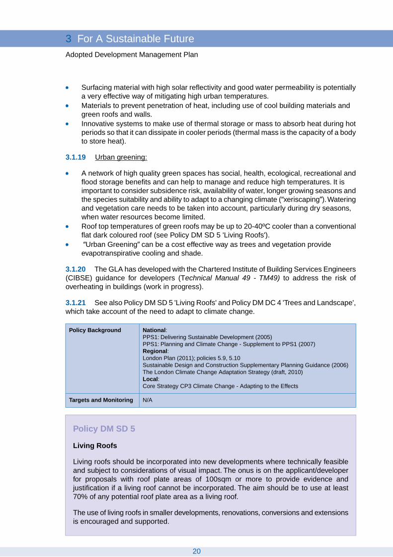
Policy DM SD 5
Living Roofs
Living roofs should be incorporated into new developments where technically feasibleand subject to considerations of visual impact. The onus is on the applicant/developerfor proposals with roof plate areas of 100sqm or more to provide evidence andjustification if a living roof cannot be incorporated. The aim should be to use at least70% of any potential roof plate area as a living roof.
The use of living roofs in smaller developments, renovations, conversions and extensionsis encouraged and supported.
20
3 For A Sustainable FutureAdopted Development Management Plan

3.1.22 Living roofs, in particular green roofs, are an essential sustainable designconsideration and can take many forms in order to maximise their benefits in a given location.Vegetated roofs have many benefits, including the following:
Sustainable Drainage Systems (SuDS) to avoid rapid rain run-off into drains and riversand improve water qualityadaptation to climate change and reduction in urban heat island effect (i.e. aidingcooling)mitigation of climate change and carbon savings (i.e. aiding energy efficiency)enhancement of biodiversity and important refuges for wildlife in urban areasprovision of green space and potentially accessible roof spaceimprovements to visual appearanceenhanced roof and sound insulation properties and resilience of the buildingenhanced roof lifespan by protecting underlying waterproofing systemreduction in air and noise pollutiongrowing food
3.1.23 Brown roofs are similar to green roofs in that they share many of the same benefits,but the overriding aim is to encourage biodiversity and to reinstate habitat conducive to localspecies on the roof. They can maximise the number of species (biodiversity) living on therooftop or provide a habitat for example for threatened species living on a brownfield sitethat a building is being constructed on.
3.1.24 Living roofs, especially green roofs, are of importance in this borough because ofthe following:
The borough is very susceptible to surface water flooding and living roofs can make animportant contribution to reducing surface run-off volumes and rates, and reduce flashflooding.There may be higher temperatures in this borough due to climate change (see PolicyDM SD 4 'Adapting to Higher Temperatures and Need for Cooling'). The evaporation(see Glossary) and evapotranspiration (see Glossary) from a green roof cools the air.The combined effect of a cooler surface at roof level coupled with better thermalinsulation that reduces the need for air conditioning during periods of higher than normaltemperatures reduces and counteracts the urban heat island effect.New living roofs, particularly brown roofs, in this borough could provide new habitat inareas which are currently deficient and lacking in wildlife habitat. They could createnew links in the borough’s and London’s network of habitats and green infrastructureand could provide additional habitat for protected, rare or important species, which canin turn help to meet the targets in the UK, Regional and Richmond upon ThamesBiodiversity Action Plans.Living roofs could contribute to the overall amount of greenness in the borough. Inparticular, such roof space could also be made accessible, which can be of benefit forresidents who do not have access to private gardens. Proposals for accessible livingroof space have to conform to Policy DM DC 6 'Balconies and Upper Floor Terraces',to ensure they are adequately designed and safe and do not adversely affectneighbourliness (see also Policy DM DC 5 'Neighbourliness, Sunlighting andDaylighting').
21
For A Sustainable Future 3Adopted Development Management Plan
3.1.25 A living roof is defined as having a minimum of 70% soil/vegetation coverage, witha minimum substrate depth of 85mm, and a maximum of 30% hardstanding. Living roofsare not roof terraces (see Policy DM DC 6 'Balconies and Upper Floor Terraces'). Livingroofs can be installed on any pitch of roof; however, as the pitch increases, additional specificdesign measures will be required in order to retain the substrate across the roof surface,which will result in increased costs. The appearance of the living roof also needs to becompatible with the surrounding area.The aim should be to use at least 70% of any potentialroof plate area as a living roof; that is, the total roof plate area including space for renewableenergy solutions such as photovoltaic panels and solar thermal but excluding non-living roofsolutions such as air conditioning units. The Council will take into account relevant viabilityinformation. Note that living roofs do not preclude the use of renewable energy technologies.Living roofs and photovoltaic panels or solar thermal units can be used together and livingroofs increase the efficiency of solar photovoltaic panels by regulating temperature. Theapplicant/developer will have to provide evidence and justification if a living roof cannot beincorporated for proposals with roof plate areas of 100sqm or more.
3.1.26 The design and operational needs of a living roof should not place undue stresson water supply and other natural resources. Extensive living roofs, which are suitable forflat and pitched roofs and also for retrofitting, with low maintenance and no requirement forirrigation once established, are particularly encouraged. All green and brown roof systemsshould use a high percentage of recycled products.
3.1.27 The provision of living roofs does not negate the need to make adequate openspace provision on the ground. Any proposals for accessible living roofs need to be designedfor security and safety and not adversely affect neighbouring properties (see also Policy DMDC 5 'Neighbourliness, Sunlighting and Daylighting', Policy DM DC 6 'Balconies and UpperFloor Terraces' and Policy DM HO 4 'Housing Mix and Standards').
3.1.28 The use of living roofs in smaller developments, renovations, conversions, extensionsand retrofitting is encouraged and supported, where opportunities arise.
3.1.29 Guidelines for planning (construction and design), installation and maintenance ofgreen roofs can be found in SPD, the Mayor’s Living Roofs and Walls Technical Report, theMayor’s Sustainable Design and Construction SPG, www.livingroofs.org, The Green RoofCentre, CIRIA and in the Environment Agency’s Green Roof Toolkit.
3.1.30 Conditions will be used where appropriate to secure the proper installation,maintenance and responsibility for living roofs.
3.1.31 Living/green walls, which is vegetation over a building’s vertical surfaces, may bean alternative if living roofs cannot be incorporated, but they need to be properly designedand maintained.
National:PPS1: Delivering Sustainable Development (2005)PPS1: Planning and Climate Change - Supplement to PPS1 (2007)Regional:London Plan (2011); policy 5.11
Policy Background
Number of green roofs permitted each year (no target)Targets and Monitoring
22
3 For A Sustainable FutureAdopted Development Management Plan

Policy DM SD 6
Flood Risk
Development will be guided to areas of lower risk by applying the Sequential Test asset out in paragraph 3.1.35. Unacceptable developments and land uses will be restrictedin line with PPS25 and as outlined below. Developments and Flood Risk Assessmentsmust consider all sources of flooding and the likely impacts of climate change.
Where a Flood Risk Assessment is required and in addition to the Environment Agency'snormal floodplain compensation requirement, attenuation areas to alleviate fluvial and/orsurface water flooding must be considered where there is an opportunity. The onus ison the applicant/developer for proposals on sites of 10 dwellings or 1000sqm ofnon-residential development or more to provide evidence and justification if attenuationareas cannot be used.
In areas at risk of flooding, all proposals on sites of 10 dwellings or 1000sqm ofnon-residential development or more are required to submit a Flood Warning andEvacuation Plan.
Flood RiskAssessment
ExceptionTest
SequentialTest
Land uses (refer to PPS25) anddevelopments – restrictions
Required foralldevelopmentproposals
Required foressential utilityinfrastructure
Required foressential utilityinfrastructure
The functional floodplain as identified inthe Borough’s Strategic Flood RiskAssessment will be protected by notpermitting any form of development onundeveloped sites unless it:
Zone3b
is for water-compatibledevelopment;is for essential utility infrastructurewhich has to be located in a floodrisk area and no alternativelocations are available and it canbe demonstrated that thedevelopment would be safe,without increasing flood riskelsewhere and where possiblewould reduce flood risk overall.
Redevelopment of existing developedsites will only be supported if there is noland use intensification and a net floodrisk reduction; the restoration of thefunctional floodplain to its original functionwill be supported.
Proposals for the change of use orconversion to a use with a highervulnerability classification will not bepermitted.
Basements, basement extensions,conversions of basements to a highervulnerability classification orself-contained units will not be permitted.
23
For A Sustainable Future 3Adopted Development Management Plan
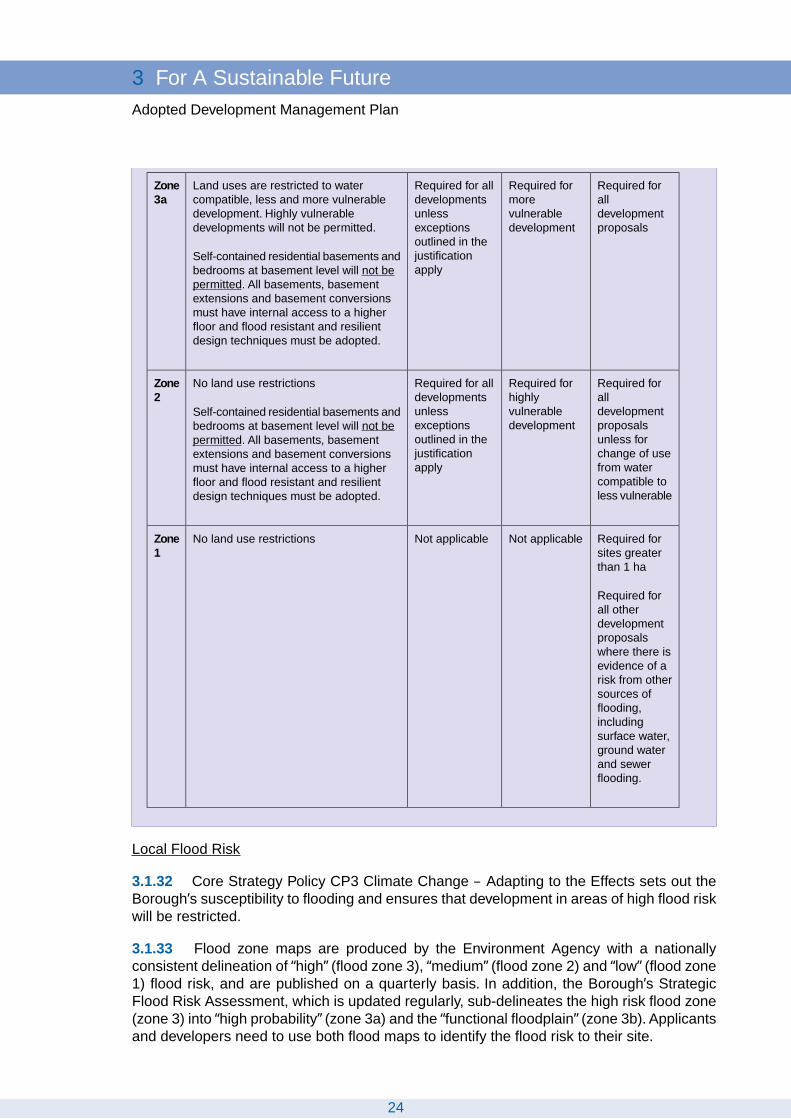
Required foralldevelopmentproposals
Required formorevulnerabledevelopment
Required for alldevelopmentsunlessexceptionsoutlined in thejustificationapply
Land uses are restricted to watercompatible, less and more vulnerabledevelopment. Highly vulnerabledevelopments will not be permitted.
Self-contained residential basements andbedrooms at basement level will not bepermitted. All basements, basementextensions and basement conversionsmust have internal access to a higherfloor and flood resistant and resilientdesign techniques must be adopted.
Zone3a
Required foralldevelopmentproposalsunless forchange of usefrom watercompatible toless vulnerable
Required forhighlyvulnerabledevelopment
Required for alldevelopmentsunlessexceptionsoutlined in thejustificationapply
No land use restrictions
Self-contained residential basements andbedrooms at basement level will not bepermitted. All basements, basementextensions and basement conversionsmust have internal access to a higherfloor and flood resistant and resilientdesign techniques must be adopted.
Zone2
Required forsites greaterthan 1 ha
Required forall otherdevelopmentproposalswhere there isevidence of arisk from othersources offlooding,includingsurface water,ground waterand sewerflooding.
Not applicableNot applicableNo land use restrictionsZone1
Local Flood Risk
3.1.32 Core Strategy Policy CP3 Climate Change – Adapting to the Effects sets out theBorough’s susceptibility to flooding and ensures that development in areas of high flood riskwill be restricted.
3.1.33 Flood zone maps are produced by the Environment Agency with a nationallyconsistent delineation of “high” (flood zone 3), “medium” (flood zone 2) and “low” (flood zone1) flood risk, and are published on a quarterly basis. In addition, the Borough’s StrategicFlood Risk Assessment, which is updated regularly, sub-delineates the high risk flood zone(zone 3) into “high probability” (zone 3a) and the “functional floodplain” (zone 3b). Applicantsand developers need to use both flood maps to identify the flood risk to their site.
24
3 For A Sustainable FutureAdopted Development Management Plan

3.1.34 Definitions and explanations for the flood zones, land uses and their flood riskvulnerability, including definitions for essential infrastructure, highly vulnerable, morevulnerable, less vulnerable and water-compatible are set out in PPS25.
Sequential Test
3.1.35 Future development in zone 3a and zone 2 will only be considered if there hasbeen a Sequential Test applied in accordance with PPS 25 and guidance contained withinthe SPD, however there will be some exceptions to this. The Sequential Test will not berequired if is not a major development (3)and at least one of the following applies:
It is a LDF proposal site that has already been sequentially tested, unless the use ofthe site being proposed is not in accordance with the allocations in the LDF.It is within a town centre boundary(4)as identified within the plan (Richmond, Twickenham,Teddington, Whitton and East Sheen).It is for residential development or a mixed use scheme and within the 400m bufferarea identified within the plan or SPD surrounding the town centres referred to above.Redevelopment of an existing single residential property.Conversions and change of use.
The Sequential Test will be required in all other cases.
3.1.36 Around 23% of the borough’s properties are located within flood zone 2 and around16% of properties within flood zone 3, many of which are located in and around town centres.Relocating development from and around these centres (400m is considered to be walkingdistance from the town centres) is not a realistic option and in order to sustain the continuingrole of these centres, development can be used as a way to help manage and reduce floodrisk in these areas.
Functional Floodplain
3.1.37 The policy also seeks to ensure that the functional floodplain (zone 3b), as identifiedwithin the Council’s SFRA, is both preserved, and where possible, such as through theredevelopment of existing developed sites within this zone, increased and the impedanceto the flow of floodwater reduced. Redevelopment of existing developed sites (around 2,500or 2.6% of the Borough’s properties are within zone 3b) will only be supported if there is anet flood risk reduction. Net flood risk reduction includes both on- and off-site measures,including reducing the land use vulnerability, raising of floor levels, reduction in run-off,increasing flood storage capacity, reduced impedance to flood water flow and the incorporationof flood resilient and/or resistant measures. Finished floor levels are to be raised to a minimumof 300mm above the 1 in 100 fluvial or 1 in 200 tidal (whichever is greater) flood level,including an allowance for climate change, as recommended in the Richmond Strategic
3 Major development as defined in PPS 25: “Major development is defined in The Town andCountry Planning (Flooding) (England) Direction 2007 as: (1) in respect of residentialdevelopment, a development where the number of dwellings to be provided is 10 or more, orthe site area is 0.5 hectares or more; or (2) in respect of non-residential development, adevelopment where the new floorspace to be provided is 1,000 square metres or more, or thesite area is 1 hectare or more.”
4 Town centre boundaries as identified within the DMP. See the Core Policy CP8 Town and LocalCentres and Policy DM TC 1 'Larger Town Centres'within this DMP.
25
For A Sustainable Future 3Adopted Development Management Plan

Flood Risk Assessment, or to the maximum acceptable height possible below this, shouldsufficient justification be provided. Opportunities to restore the functional floodplain to itsoriginal function are encouraged and will be supported.
3.1.38 Eel Pie Island is designated as a high probability flood risk area (zone 3a). However,the access and egress to and from the island is only via a pedestrian bridge, which has itsfoot on the Twickenham Embankment side in the functional floodplain (zone 3b). Therefore,for the purposes of new development, Eel Pie Island will be considered and treated asfunctional floodplain (zone 3b).
Flood Risk Assessments
3.1.39 The aim of this policy is to ensure that all developments, including extensions,conversions and change of use, consider the likely impacts of climate change and all sourcesof flooding. In addition to fluvial and tidal flooding, properties and infrastructure within theborough are also at risk of flooding from other, more localised sources of flooding, such assurface and groundwater flooding, and sewer flooding due to surcharging of sewers anddrains or due to the failure of infrastructure. Flooding could also occur away from the floodplainas a result of development where off-site infrastructure is not in place ahead of development(also see Policy DM SD 10 'Water and Sewerage Provision'). Flood Risk Assessmentsprepared for all development proposals in flood risk areas are required to take account allsources of flooding. In addition, a Flood Risk Assessment is also required for smallerdevelopment proposals in flood zone 1, where there is evidence of a risk from other sourcesof flooding identified in the Strategic Flood Risk Assessment.
3.1.40 The policy also seeks to address the problem of basements in flood risk areas.Basements represent a particularly high risk to life within flood affected areas of the boroughbecause they could be subject to very rapid inundation as floodwaters encroach across thefloodplain. All basement properties should have adequate mitigation measures such asnon-return valves or pumped sewage devices to prevent back flows from the system causingsewer flooding.
Flood Risk Management
3.1.41 This borough is particularly susceptible to surface water flooding and therefore,where a Flood Risk Assessment is required, and in addition to the Environment Agency'snormal floodplain compensation requirement, on-site attenuation areas to alleviate fluvialand/or surface water flooding must be considered where there is an opportunity. The onusis on the applicant/developer for major development proposals to provide evidence andjustification if attenuation areas cannot be used.
3.1.42 Flood resilient and resistant measures should be incorporated into the design ofdevelopment proposals in any area susceptible to flooding to minimise and manage the riskof flooding.
3.1.43 PPS25 also seeks to positively reduce the risk of flooding posed to existing propertieswithin the Borough.Therefore, retrofitting properties by integrating flood resilient and resistantmeasures could help to reduce the consequences of flooding and would ultimately contributeto positively managing flood risk in the Borough. See Policy DM SD 3 'Retrofitting'.
3.1.44 In line with PPS25, Flood Warning and Evacuation Plans should be in place forthose areas at an identified risk of flooding. Developers should ensure that appropriateevacuation and flood response procedures are in place to manage the residual risk associated
26
3 For A Sustainable FutureAdopted Development Management Plan

with an extreme flood event, and include how such plans will be implemented. This will alsoneed to be considered in locations where there is a residual risk of flooding due to thepresence of defences.Therefore, all major development proposals in areas at risk of floodingare required to submit a Flood Warning and Evacuation Plan. Minor developments at riskof flooding are also encouraged to produce a Flood Warning and Evacuation Plan.
3.1.45 Applicants and developers are encouraged to use the Environment Agency’s FloodRisk Standing Advice for planning applicants and their agents and early pre-applicationdiscussions with the Council and the Environment Agency are encouraged.
More detailed advice and guidance on how to apply this policy to assist applicants, developersand officers, including on Sequential Test, Flood Risk Assessments, mitigation measuresfor developments in flood zone 1 which could be affected by other sources of flooding, floodresilient and resistant measures and Flood Warning and Evacuation Plans will be includedin advisory notes and SPDs.
National:PPS1: Delivering Sustainable Development (2005)PPS1: Planning and Climate Change - Supplement to PPS1 (2007)PPS 25: Development and Flood Risk (2010)PPS 25: Development and Flood Risk Practice Guide (2009)Regional:London Plan (2011); policy 5.12Local:Core Strategy CP3 Climate Change - Adapting to the Effects
Policy Background
Core Strategy Indicator for CP3Targets and Monitoring
Policy DM SD 7
Sustainable Drainage
All development proposals are required to follow the drainage hierarchy (see below)when disposing of surface water and must utilise Sustainable Drainage Systems (SuDS)wherever practical. Any discharge should be reduced to greenfield run-off rates whereverfeasible.
When discharging surface water to a public sewer, developers will be required to provideevidence that capacity exists in the public sewerage network to serve their development.
3.1.46 Recent flooding events in the borough, particularly the event in the summer of 2007,have shown that this borough is very susceptible to surface water flooding. This policy willlead to a steady reduction in the overall amount of rainfall being discharged to the drainagesystem and reduce the borough's susceptibility to surface water flooding.
3.1.47 Surface water flooding happens when the ground and rivers cannot absorb heavyrainfall and when man-made drainage systems have insufficient capacity to deal with thevolume of rainfall.Typically this type of flooding is localised and happens very quickly, makingit very difficult to predict and give warnings. With climate change predicting more frequentshort-duration, high intensity rainfall and more frequent periods of long-duration rainfall,coupled with the Victorian sewer system and increasing pressure from growing populations,surface water flooding is likely to be an increasing problem.
27
For A Sustainable Future 3Adopted Development Management Plan

3.1.48 Therefore, to reduce the risk of surface water and sewer flooding, all developmentproposals in this borough are required to follow the London Plan drainage hierarchy:
store rainwater for later useuse infiltration techniques, such as porous surfaces in non-clay areasattenuate rainwater in ponds or open water features for gradual release to a watercourseattenuate rainwater by storing in tanks or sealed water features for gradual release toa watercoursedischarge rainwater direct to a watercoursedischarge rainwater to a surface water draindischarge rainwater to the combined sewer.
3.1.49 If discharging surface water to a public sewer, developers are required to provideevidence that capacity exists in the public sewerage network to serve their development inthe form of written confirmation. See also Policy DM SD 10 'Water and Sewerage Provision'.
3.1.50 The Council’s Strategic Flood Risk Assessment has identified that reducing therate of discharge from development sites to greenfield runoff rates is one of the most effectiveways of reducing and managing flood risk within the borough. Greenfield run-off is the surfacewater drainage regime from a site prior to development. To maintain the natural equilibriumof a site, the surface water discharge from a developed site should not exceed the naturalgreenfield run-off rate. Advice on allowable discharge rates to watercourses for sites or onthe design criteria, technical feasibility and future sustainability of the drainage system canbe found on the CIRIA website.
3.1.51 Wherever possible, Sustainable Drainage Systems (SuDS) techniques must beutilised.The surface water drainage techniques for a site, including SuDS, have to be decidedat an early enough stage of the development so that sufficient space can be allocated.Sustainable drainage is integral to a development scheme and not an ‘add-on’.
3.1.52 Applicants and developers will need to submit evidence, as part of Flood RiskAssessments and/or requirements set out in the Council’s Sustainable Construction ChecklistSPD, that the above drainage hierarchy has been followed and SuDS has been utilised.Theuse of SuDS must take into account potential land contamination and must ensure that waterquality is protected, in line with PPS23. The Council will take into account relevant viabilityinformation. For details of SuDS see the glossary. See also Policy DM SD 5 'Living Roofs'.
3.1.53 There are numerous different ways that SuDS can be incorporated into adevelopment. The appropriate application of a SuDS scheme to a specific development isheavily dependent upon the layout, topography and geology of the site and its surroundings.The London Plan drainage hierarchy should be followed and implemented. The developershould use and follow the guidance provided by CIRIA for design criteria, technical feasibilityand to ensure the future sustainability of the drainage system. The Environment Agencymay also be able to provide advice for larger development sites.
3.1.54 Applicants should submit a feasibility assessment of using SuDS with their proposal.The satisfactory performance of SuDS depends not only on good design but also adequatemaintenance, and provision for adoption and maintenance must be made from the outset.The developer and the Council will agree who will adopt the SuDS scheme and be responsiblefor the on-going maintenance.
28
3 For A Sustainable FutureAdopted Development Management Plan

3.1.55 Conditions or agreements will be used where appropriate to secure implementingsustainable drainage and to ensure appropriate management, maintenance and adoption.
3.1.56 Guidance on the use of SuDS can be found in various CIRIA publications such asThe SuDS Manual (C697) (2007), in the Interim Code of Practice for Sustainable DrainageSystems (2004), in The use of SuDS in high density development – Guidance Manual(SR666) by HR Wallingford (2005) and other subsequent guidance documents beingdeveloped.
3.1.57 The implementation of the Flood and Water Management Act 2010, which sets outa new process for the approval and adoption of SuDS, is forthcoming.
National:PPS1: Delivering Sustainable Development (2005)PPS1: Planning and Climate Change - Supplement to PPS1 (2007)PPS 23: Planning and Pollution Control (2004)PPS 25: Development and Flood Risk (2010)PPS 25: Development and Flood Risk Practice Guide (2009)Flood and Water Management Act 2010Regional:London Plan (2011); policy 5.13Local:Core Strategy CP3 Climate Change - Adapting to the Effects
Policy Background
Indicator: Proportion of development with surface water run-off rates equivalent to orbetter than previous rates, as assessed under Code for Sustainable Homes / BREEAMTarget: 80% of developments have surface water run-off rates equivalent to or betterthan previous rates
Targets andMonitoring
Policy DM SD 8
Flood Defences
The effectiveness, stability and integrity of the flood defences, river banks and otherformal and informal flood defence infrastructure within the borough will be retained andprovision for maintenance and upgrading will be ensured. Setting back developmentsfrom river banks and existing flood defence infrastructure, where there are opportunities,will be encouraged.The removal of formal or informal flood defences is only acceptableif this is part of an agreed flood risk management strategy by the Environment Agency.
The Environment Agency must be consulted for any development that could affect aflood defence infrastructure.
3.1.58 The protection of people, properties and infrastructure from the risk of fluvial andtidal flooding is essential in this borough and the integrity of the flood defence infrastructuremust therefore be maintained. Flood defence infrastructure includes formal and informalflood defences and such defences may not always be recognisable and can include mounds,buildings, walls and others.
3.1.59 There is a statutory requirement to consult the Environment Agency for anydevelopment that could affect a flood defence infrastructure. This also includes areas andsites as detailed in the Strategic Flood Risk Assessment, which are further than 20 metres
29
For A Sustainable Future 3Adopted Development Management Plan

away from the top of the bank of the main river Thames and are not covered by theEnvironment Agency’s Flood Risk Standing Advice. Areas where flood defences are furtherthan 20 metres away from the river are shown in the Strategic Flood Risk Assessment.
3.1.60 Proposals for redevelopment should seek opportunities to set back the developmentfrom existing flood defences, wherever practicable, to allow for their maintenance and futureupgrading as well as for improvements to flood flow and flood storage capabilities.
3.1.61 Environment Agency consent is required for any development within 8 metres ofthe fluvial Thames and 16 metres of the tidal Thames and consent is required for any worksthat could affect flood defences.
National:PPS1: Delivering Sustainable Development (2005)PPS1: Planning and Climate Change - Supplement to PPS1 (2007)PPS 25: Development and Flood Risk (2010)PPS 25: Development and Flood Risk Practice Guide (2009)Regional:London Plan (2011); policy 5.12Local:Core Strategy CP3 Climate Change - Adapting to the Effects
Policy Background
Core Strategy Indicator for CP3Targets and Monitoring
30
3 For A Sustainable FutureAdopted Development Management Plan

Policy DM SD 9
Protecting Water Resources and Infrastructure
The borough’s water resources and supplies will be protected by resisting developmentproposals that would pose an unacceptable threat to surface water and groundwaterquantity and quality.This includes pollution caused by water run-off from developmentsinto nearby waterways.
New developments must achieve a high standard of water efficiency by:
1. meeting the minimum mandatory target for water consumption as set out in theCode for Sustainable Homes, or
2. meeting a minimum of 2 credits on water consumption for other types ofdevelopments (BREEAM “excellent”), or
3. meeting a minimum of 3 credits on water consumption for conversions (EcoHomes“excellent”), and
4. utilising rainwater harvesting for all external water uses to reduce the consumptionof potable water wherever possible.
The above requirements may be adjusted in future years to take into account the thenprevailing standards and any other national guidance to ensure that these standardsare met or exceeded.
New developments should also consider the following:
1. utilising rainwater harvesting and greywater recycling for all non-potable uses toreduce the consumption of potable water wherever possible, and
2. designing of landscaping to minimise water demand.
Proposals that seek to increase water availability or protect and improve the quality ofrivers or groundwater will be encouraged.
The development or expansion of water supply or waste water facilities will normallybe permitted, either where needed to serve existing or proposed new development, orin the interests of long term water supply and waste water management, provided thatthe need for such facilities outweighs any adverse land use or environmental impact.
The Council will support in principle the implementation of the Thames Tunnel project.
Where rivers have been classified by the Environment Agency as having ‘poor’ status(currently the River Crane, the Beverley Brook and the River Thames, upstream ofTeddington), any development affecting such rivers is encouraged to improve the waterquality in these areas.
Water quantity
3.1.62 Changing patterns of rainfall will have a significant impact on water resources andwater quality; significant decreases in summer mean precipitation and an increase in wintermean precipitation are predicted for London. This means less water will be available duringsummers due to lower rainfall where at the same time the demand for water will increase.
31
For A Sustainable Future 3Adopted Development Management Plan

In addition London is amongst the driest capital cities in the world with water shortageshappening quite regularly. Urban areas have little capacity to store drinking water and aremore likely to experience shortages during droughts. The borough’s estimated water supplyavailability (in a dry year) shows to be in a significant deficit.
3.1.63 For this borough, the predicted drier summers are likely to increase the pressureon water resources as the demand for water from people and wildlife grows. The wateravailability is likely to be affected because of reduced river flows, reduced groundwatercharge, increased evaporation and increased loss from broken water mains due to increasedsubsidence. In addition, low flows in the borough’s rivers during dry summers have knock-onimpacts for water quality as the rivers are less able to dilute pollutants. Coupled with changingpatterns of rainfall and impacts on water supply, the consumption of water per capita ishigher in London (156 litres per day) compared to the national average (148 litres per day).
3.1.64 High standards of water efficiency will be required in new developments in orderto address the fact that drinking water is becoming an increasingly limited resource in thisborough. Therefore, new developments, in their design, landscaping, construction andoperation, must incorporate measures to avoid water wastage. The current standard of amaximum of 105 litres of potable water per person per day for new homes is one of themandatory standards required to meet Code for Sustainable Homes Level 3 and 4. A minimumof 2 credits on water consumption will be required for all other types of developments inorder to achieve BREEAM “excellent”. A minimum of 3 credits on water consumption(equivalent to a maximum of 115 litres of water per person per day) will be required to meetEcoHomes “excellent” standard. EcoHomes applies for conversions, renovations andextensions, which involve significant changes or rearrangements and does therefore notnecessarily apply to all types of extensions and conversions. Where an EcoHomesassessment is not technically feasible, applicants should incorporate best practice watersaving and recycling measures as outlined in the Sustainable Construction Checklist SPD.
3.1.65 An array of measures is required to achieve water saving and efficient developmentsand the maximum water consumption levels:
There should be full use of water saving devices, water efficient fixtures and fittings.Rainwater and grey water recycling (water butts or more complex collection andtreatment systems) can significantly reduce water consumption, particular potable water.Grey water recycling will need to be energy efficient.Landscaping and gardens should be designed to lower water demand.Sustainable Drainage Systems (SuDS), including rainwater harvesting and storagefrom roofs and other surfaces can significantly reduce demand for water.
3.1.66 See also Policy DM DC 4 'Trees and Landscape', which takes account of theimpacts of climate change and the need to minimise water demand.
Water quality
3.1.67 The London Plan expects boroughs to seek to protect and improve water qualityto ensure that the Blue Ribbon Network is healthy, attractive and offers a valuable series ofhabitats by refusing proposals that are likely to lead to a reduction in water quality.
3.1.68 The chemical and biological water quality of the borough’s rivers is in need ofimprovement. River water quality is affected, among other things, by urban run-off andpolluted surface water outfalls. Under the Water Framework Directive (WFD), there are fourriver water-bodies in this borough that have been classified under the WFD – the Beverley
32
3 For A Sustainable FutureAdopted Development Management Plan

Brook, the River Crane, the River Thames and the Portlane Brook (which includes theLongford River).The WFD classification scheme for water quality includes five status classes:high, good, moderate, poor and bad. All of the borough’s water bodies fail to achieve the‘good’ status under the WFD. The Beverley Brook, the Thames (upstream of Teddington)and the Crane water-bodies have been classified as having ‘poor’ ecological status and theLongford River has ‘moderate’ ecological status.
3.1.69 Some local surface waters and groundwater bodies in the gravel aquifer arehydraulically connected. Potentially contaminative uses will be directed away from locationsthat are particularly sensitive in terms of groundwater and surface water receptors in orderto protect the surface water courses and the groundwater quality of the borough's aquifers.
National:PPS1: Delivering Sustainable Development (2005)PPS1: Planning and Climate Change - Supplement to PPS1 (2007)Regional:London Plan (2011); policies 5.14, 5.15Sustainable Design and Construction Supplementary Planning Guidance (2006)The London Climate Change Adaptation Strategy (draft, 2010)The Mayor’s Water Strategy (draft, August 2009)Local:Core Strategy CP3 Climate Change - Adapting to the Effects
Policy Background
Indicator: River water-bodies classified under the Water Framework Directive to achievegood ecological statusTarget: River water-bodies classified under the Water Framework Directive to achievegood ecological status by 2027
Targets andMonitoring
Policy DM SD 10
Water and Sewerage Provision
New development will need to ensure that there is adequate water supply, surfacewater, foul drainage and sewerage treatment capacity to serve the development.
Planning permission will only be granted for developments which increase the demandfor off-site service infrastructure where:
1. sufficient capacity already exists, or2. extra capacity can be provided in time to serve the development, which will ensure
that the environment and the amenities of local residents are not adversely affected.
Developers will be required to provide evidence that capacity exists in the publicsewerage and water supply network to serve their development.
Any new water supply, sewerage or waste water treatment infrastructure must be inplace prior to occupation of the development. Financial contributions may be requiredfor new developments towards the provision of, or improvements to such infrastructure.
3.1.70 Many existing water mains, sewage systems and treatment works are becomingoverloaded. It is essential to ensure that such infrastructure is in place ahead of developmentto avoid unacceptable impacts on the environment such as sewage flooding of residential
33
For A Sustainable Future 3Adopted Development Management Plan
and commercial property, pollution of land and watercourses plus water shortages withassociated low-pressure water supply problems. Consequently, development should onlytake place where the new demand upon existing infrastructure is taken into account.
3.1.71 Developers are required to provide evidence that adequate capacity exists in thepublic sewerage and water supply network to serve their development in the form of writtenconfirmation.Where capacity does not exist and to avoid overloading of existing infrastructure,a drainage strategy should be provided to show the required infrastructure and its funding.Where there is a capacity problem and no improvements are programmed by Thames Water,the developer will be required to contact Thames Water to agree what improvements arerequired and how they will be funded. If improvements in off-site infrastructure are notprogrammed, planning permission will only be granted where the developer funds appropriateimprovements. A contribution via planning obligations may be required towards the provisionof, or improvements to infrastructure, as outlined in the Planning Obligations Strategy or anysubsequent updates, including the Community Infrastructure Levy (CIL). Any sewerage/wastewater treatment infrastructure must be in place prior to occupation of the development.
3.1.72 Richmond is well served by a well maintained system of sewers and these sewersand associated infrastructure will need to be protected from new construction and treeplanting.
3.1.73 Water and sewerage undertakers have limited powers under the Water IndustryAct to prevent connection ahead of infrastructure upgrades and therefore rely heavily on theplanning system to ensure infrastructure is provided ahead of development either throughphasing or the use of conditions.
National:PPS1: Delivering Sustainable Development (2005)PPS1: Planning and Climate Change - Supplement to PPS1 (2007)PPS 25: Development and Flood Risk (2010)Regional:London Plan (2011); policies 5.14, 5.15Local:Core Strategy CP16: Local Services/Infrastructure
Policy Background
Indicator: Proportion of development with surface water run-off rates equivalent to orbetter than previous rates, as assessed under Code for Sustainable Homes / BREEAMTarget: 80% of developments have surface water run-off rates equivalent to or betterthan previous rates
Targets andMonitoring
34
3 For A Sustainable FutureAdopted Development Management Plan

Protecting Local Character 4Adopted Development Management Plan
35

4 Protecting Local Character
4.0.1 The borough is recognised as having exceptional open and green spaces, parksand rivers. It is a key priority for the Council to protect and enhance these important openspaces and river corridors. The policies in this section cover designated open land, such asMetropolitan Open Land, Other Open Land of Townscape Importance and Historic Parksand Gardens, and excludes Green Belt, which will be dealt with in accordance with nationaland regional policy.The policies also address the protection, enhancement and new provisionof Public Open Space, play and sport facilities, biodiversity features and habitats andallotments. The River Thames and its tributaries give this borough a distinctive characterand policies for the Thames Policy Area, riverside uses and moorings are also set out in thissection.
4.0.2 Protecting local character was identified as a theme of the Core Strategy recognisingthe borough's unique character. The Council wishes to conserve and enhance the bestbuildings, townscape, open areas, and riverside, while improving areas where the environmentis poorer. An important aspect of this is ensure that new development is in tune with itssetting. Section 4 expands on Core Strategy Policies CP7 to CP12.
4.1 Open Land and Rivers
Statement 1
Green Belt
For areas of Green Belt designated on the Proposals Map, PPG2 or any subsequentnational planning policy guidance will apply. In addition, London Plan policy 7.16 andCore Strategy CP10 Open Land and Parks are also relevant.
The land at Twickenham and Fulwell golf courses is held under "The Green Belt (Londonand Home Counties) Act, 1938. An Act to make provision for the preservation fromindustrial or building development of areas of land in and around the administrativecounty of London." Under this Act owners are required to request permission from theSecretary of State to build on or dispose of this land. This requirement is separate fromand in addition to any requirements for planning permission. Most of this land is protectedin the Local Development Framework by its designation as Metropolitan Open Landunder Policy DM OS 2, it is not covered in this LDF by any planning policy green beltdesignation in the terms described by PPG2.
36
4 Protecting Local CharacterAdopted Development Management Plan

Policy DM OS 1
Major Developed Site in the Green Belt
Part of the Hampton Water Treatment Works is recognised as a major developed sitein the Green Belt and is identified on the Proposals Map for purposes described inparagraphs C3 and C4 of Annex C to Planning Policy Guidance Note 2: Green Belts.This policy is intended to meet the operational requirements for essential water treatmentworks at this site, subject to the limitations below and in particular the need to maintainthe openness of the green belt.
The filter beds and reservoirs are major contributors to the open character andappearance of the site.The filter beds and other visually open areas are not consideredto be part of the developed area for the purposes of this policy. Planning permissionwill be granted for limited infilling or partial redevelopment for essential water treatmentrelated purposes, provided that:
1. It is within the Major Developed Site boundary shown on the Proposals Map.2. It will have no greater impact than the existing development on the openness of
the Green Belt and the purposes for including land within it.3. It will not exceed the height of the existing buildings or lead to a major increase in
the developed proportion of the site.4. It will not obstruct the reinstatement to working order of the former light railway
serving the works.
National:PPG 2: Green Belt (2001)Regional:London Plan (2011); policy 7.16Local:Core Strategy CP10 Open Land and Parks
Policy Background
Core Strategy Indicator for CP10Targets and Monitoring
37
Protecting Local Character 4Adopted Development Management Plan

Policy DM OS 2
Metropolitan Open Land
The borough’s Metropolitan Open Land will be protected and retained in predominatelyopen use. Appropriate uses include public and private open spaces and playing fields,open recreation and sport, biodiversity including rivers and bodies of water and opencommunity uses including allotments and cemeteries.
It will be recognised that there may be exceptional cases where appropriate developmentsuch as small scale structures is acceptable, but only if it:
1. Does not harm the character and openness of the metropolitan open land; and2. Is linked to the functional use of the Metropolitan Open Land or supports outdoor
open space uses; or3. Is for essential utility infrastructure and facilities, for which it needs to be
demonstrated that no alternative locations are available and that they do not haveany adverse impacts on the character and openness of the metropolitan open land.
Improvement and enhancement of the openness and character of the MetropolitanOpen Land and measures to reduce visual impacts will be encouraged whereappropriate.
When considering developments on sites outside Metropolitan Open Land, any possiblevisual impacts on the character and openness of the Metropolitan Open Land will betaken into account.
4.1.1 The Metropolitan Open Land (MOL) designation is unique to London and protectsstrategically important open spaces within the built environment. MOL, as shown on theProposals Map, plays an important role as part of the borough’s and London-wide greeninfrastructure network and improvements in its overall quality and accessibility areencouraged.
4.1.2 MOL is open land or water, either publicly or privately owned and with or withoutpublic access. The contribution of MOL is as vital as Green Belt and therefore it will beprotected as a permanent feature and the policy guidance of PPG 2 on Green Belt appliesequally to MOL.
4.1.3 The purpose of this policy is to safeguard this open land and protect and retain it inpredominately open use. However, the policy also recognises that there may be exceptionalcases where appropriate development could be acceptable, as outlined in the policy. Water,waste water treatment and sewage treatment plants, including any associated facilities, areconsidered to be essential utility infrastructure. Development that involves the loss of MOLin return for the creation of new open space elsewhere will not be considered appropriate.New uses will only be considered if they are by their nature open or depend upon open usesfor their enjoyment and if they conserve and enhance the open nature, character andbiodiversity interest of MOL.
38
4 Protecting Local CharacterAdopted Development Management Plan

4.1.4 Enhancement to MOL, where appropriate, for example by landscaping, removal orreplacement of inappropriate fencing and screening, and reduction of the visual impact oftraffic or car parking as well as opening up views into and out of MOL will be encouraged.Opportunities to increase the MOL’s potential for wildlife will be maximised.
4.1.5 The borough’s Green Chains are important to London’s open space network,recreation and biodiversity. They consist of footpaths and the open spaces that they link,which are accessible to the public. Because of their Londonwide significance, the GreenChains are designated as MOL. Proposals to provide missing links within a green chain willbe supported.
National:PPS 1: Delivering Sustainable Development (2005)PPG 2: Green Belt (2001)PPS 9: Biodiversity and Geological Conservation (2005)PPG 17: Planning for Open Space, Sport and Recreation (2002)Regional:London Plan (2011); policy 7.17Local:Core Strategy CP10 Open Land and Parks
Policy Background
Core Strategy Indicator for CP10Targets and Monitoring
Policy DM OS 3
Other Open Land of Townscape Importance
Other open areas that are of townscape importance will be protected and enhanced inopen use.
It will be recognised that there may be exceptional cases where appropriate developmentis acceptable. The following criteria must be taken into account when assessingappropriate development:
1. It must be linked to the functional use of the Other Open Land of TownscapeImportance; or
2. It can only be a replacement or minor extension of existing built facilities;3. In addition to 1. or 2., it does not harm the character and openness of the open
land.
Improvement and enhancement of the openness and character of other open land andmeasures to open up views into and out of designated other open land will beencouraged where appropriate.
When considering developments on sites outside designated other open land, anypossible visual impacts on the character and openness of the designated other openland will be taken into account.
39
Protecting Local Character 4Adopted Development Management Plan

4.1.6 Other Open Land of Townscape Importance (OOLTI) can include public and privatesports grounds, school playing fields, cemeteries, allotments, private gardens, areas ofvegetation such as street verges and mature trees. The designated areas are shown on theProposals Map but there will also be other areas which could be considered as being of localvalue to the area and townscape which merit protection.
4.1.7 In some parts of the borough, open areas, including larger blocks of back gardens,which are not extensive enough to be defined as green belt or metropolitan open land, actas pockets of greenery of local rather than London-wide significance. Many of these are oftownscape importance, contributing to the local character and are valued by residents asopen spaces in the built up area. Policy DM HO 2 'Infill Development' and Policy DM HO 3'Backland Development' also recognise the importance of gardens, which will be consideredas greenfield sites. Green oases are particularly important and will be protected in areas ofhigh density development and town centres.
4.1.8 OOLTI should be predominantly open or natural in character. The following criteriaare taken into account in defining OOLTI:
Contribution to the local character and/or street scene, by virtue of its size, position andquality.Value to local people for its presence and openness.Immediate or longer views into and out of the site, including from surrounding properties.Value for biodiversity and nature conservation.
Note that the criteria are qualitative and not all need to be met.
4.1.9 The purpose of this policy is to safeguard this open land and ensure that it is notlost to other uses without good cause. Protecting and opening up views into and out ofdesignated other open land is encouraged because of the contribution to the distinctivecharacter of an area and the benefits to all. Where a comprehensive approach toredevelopment can be taken, such as on major schemes or regeneration proposals, or forsocial community or educational uses, it may be acceptable to re-distribute the open landwithin the site, providing that the new open area is equivalent or improved in terms of size,shape, location, quality and potential ecological value.
National:PPS 1: Delivering Sustainable Development (2005)PPS 9: Biodiversity and Geological Conservation (2005)PPG 17: Planning for Open Space, Sport and Recreation (2002)Regional:London Plan (2011); policy 7.18Local:Core Strategy CP10 Open Land and Parks
Policy Background
Core Strategy Indicator for CP10Targets and Monitoring
40
4 Protecting Local CharacterAdopted Development Management Plan

Policy DM OS 4
Historic Parks, Gardens and Landscapes
Parks and gardens as well as landscapes of special historic interest included in theRegister compiled by English Heritage and other historic parks, gardens and landscapesreferred to in para 4.1.11 below, will be protected and enhanced. Proposals which havean adverse effect on the settings, views, and vistas to and from historic parks andgardens, will not be permitted.
4.1.10 Historic parks, gardens and landscapes make a rich and varied contribution toRichmond’s landscape. The “Register of Parks and Gardens of Special Historic Interest” inEngland was established and is maintained by English Heritage.
4.1.11 Richmond borough has currently 14 open spaces on the English Heritage registerof historic parks and gardens, including Richmond Park, Bushy Park, Hampton Court Park,Royal Botanic Gardens Kew (including Old Deer Park), Ham House, Marble Hill House,Strawberry Hill, Hampton Court House, Richmond Terrace Walk, Pope’s Garden, York HouseGardens, Terrace Gardens and Buccleugh Gardens (Richmond Hill) and TeddingtonCemetery. These areas are shown on the Proposals Map but there are also other areaswhich could be included on the Register and which merit protection and enhancement,including the following: Kew Green, Orleans House Gardens, Radnor Gardens and RichmondGreen.
4.1.12 This policy ensures that the character, appearance, setting and views into and fromthe historic parks and gardens listed on this Register, including the other areas which meritprotection, are protected from development that would adversely affect their character andhistoric interest. Proposals affecting historic parks, gardens and landscapes should preserveand enhance their historic character and appearance. Policy guidance of PPS 5 applies.
4.1.13 The Council will support National Heritage Lottery bids to help secure improvementsto these important and recognised open spaces.
National:PPS 5: Planning for the Historic Environment (2010)Regional:London Plan (2011); policy 7.8Local:Core Strategy CP10 Open Land and Parks
Policy Background
Core Strategy Indicator for CP10Targets and Monitoring
41
Protecting Local Character 4Adopted Development Management Plan

Policy DM OS 5
Biodiversity and new development
All new development will be expected to preserve and where possible enhance existinghabitats including river corridors and biodiversity features, including trees.
All developments will be required to enhance existing and incorporate new biodiversityfeatures and habitats into the design of buildings themselves as well as in appropriatedesign and landscaping schemes of new developments with the aim to attract wildlifeand promote biodiversity, where possible.
When designing new habitats and biodiversity features, consideration should be givento the use of native species as well as the adaptability to the likely effects of climatechange.
New habitats and biodiversity features should make a positive contribution to and shouldbe integrated and linked to the wider green and blue infrastructure network, includingde-culverting rivers, where possible.
4.1.14 Core Strategy Policy CP4 Biodiversity sets out why biodiversity is important, itsbenefits and why it should be promoted. CP4 ensures that the borough’s biodiversity includingthe SSSIs, Other Sites of Nature Importance, green corridors as well as open land, the riversand their islands and banks will be safeguarded and enhanced.
4.1.15 The aim of this policy is to preserve and where possible enhance existing habitatsand biodiversity features in non-designated areas and within a development site whenproposing new developments, particularly in areas with less access to areas of natureconservation importance.
4.1.16 The promotion of nature conservation should be treated as integral to any newdevelopment scheme, not as an ‘add-on’. Layout, design, buildings and landscaping schemesshould take account of existing biodiversity features and habitats. New development shouldinclude new or enhanced features and habitats, design (such as green roofs) and landscaping(including trees) that promote biodiversity, including provision for their management. Thesefeatures must also be protected during construction works, and this may be subject to aplanning condition as will subsequent maintenance and monitoring.
4.1.17 This policy recognises that biodiversity interest is not just confined to designatednature conservation areas. Outside such designated areas, including on previously developedland or brownfield land, there is also an abundance of biodiversity features and habitats,including trees, hedges, wildlife gardens, allotments, ponds, green roofs, living walls, nestingand roosting boxes and bat boxes.
4.1.18 The London Plan stresses the importance of a valuable series of habitats. Priorityshould be placed on linking new features and habitats into the wider green and blueinfrastructure network, connecting fragmented habitat and increasing the size of habitatareas, which in turn increases a species’ resilience to climate change.
42
4 Protecting Local CharacterAdopted Development Management Plan

4.1.19 Any schemes for incorporating new biodiversity features or creating new habitatsshould take account of site constraints (such as utility infrastructure) and consider the useof native species. The species suitability and their adaptability to the likely effects of climatechange need to be taken into account. Guidance on the use of native species and climatechange can be found in the Borough’s Tree Strategy, The Mayor's Biodiversity Strategy andThe Mayor’s London Tree and Woodland Framework.
4.1.20 When implementing the policy, reference will be made to the UK, London andRichmond upon Thames Biodiversity Action Plans. See also Policy DM SD 4 'Adapting toHigher Temperatures and Need for Cooling', which refers to the important contribution ofurban greening to reduce temperatures and provide shading as well as to counteract theurban heat island effect, Policy DM DC 4 'Trees and Landscape', which protects andencourages tree planting, and Policy DM SD 5 'Living Roofs'.
National:PPS 1: Delivering Sustainable Development (2005)PPS 9: Biodiversity and Geological Conservation (2005)PPG 17: Planning for Open Space, Sport and Recreation (2002)Regional:London Plan (2011); policies 7.19, 5.10, 5.11; also 2.18, 5.3, 5.7, 7.17, 7.18, 7.28Mayor's Biodiversity Strategy (2002)London Rivers Action PlanLocal:Core Strategy CP4 Biodiversity
Policy Background
Core Strategy Indicators for CP4 and CP10Targets and Monitoring
Policy DM OS 6
Public Open Space
Public Open Space will be protected and enhanced. Improvement of the openness andcharacter of the Public Open Space including measures to allow for convenient accessfor all residents will be encouraged where appropriate.
New Public Open Space with convenient access for all will be provided where possible,or existing areas made more accessible, particularly in areas poorly provided with publicopen space. These will be linked to the wider network of open spaces. Financialcontributions will be required for most new developments towards the provision of, orimprovements to public open space.
Larger new developments will be expected to include open space provision within thescheme, with the aim to strike a balance between private, semi-private and public openspace provision.
4.1.21 The intention of the policy is to maintain and improve the Public Open Space in theborough which contributes so greatly to its recreational and environmental character, andto secure additional open spaces in those areas that are relatively less well served andidentified on the Proposals Map.
43
Protecting Local Character 4Adopted Development Management Plan

4.1.22 Opportunities to create new Public Open Spaces will generally be limited in thisborough as many areas are already developed or protected open land. However, existingareas can be made more accessible and dual use of school and private recreation facilitiesis also encouraged as a way of making the best use of open space and increasing availability.
4.1.23 A contribution via planning obligations will be required for most new developmentstowards the provision of, or improvements to Public Open Space, on a scale related to thesize and type of development, as outlined in the Planning Obligations Strategy or anysubsequent updates, including the Community Infrastructure Levy (CIL). For largedevelopments (i.e.10 or more units), consideration should be given to providing open spacewithin the scheme, in lieu of some or all of the financial contribution. Where financial viabilityis an issue, an assessment may be made using the guidance within para 7.2.6 of the CoreStrategy.
4.1.24 Regard should be had to the Mayor’s Public Open Space Hierarchy, the Council’sOpen Space Strategy, the Open Space and Recreation Needs Assessment, the Council’sSport Strategy and the Public Space Design Guide.
Public Open Space Deficiency
4.1.25 The proposed areas deficient in public open space are derived by applying a 400mbuffer area to designated Public Open Space. Adjustments to the 400m buffer area havebeen made at the following locations:
Teddington (along Harrowdene Gardens, Fairfax Road) / Bushy Park: adjustmentshave been made at this location to take account of the combination of reducedaccessibility over the railway line, and limited access points into Bushy ParkFeltham/Hounslow Junction: the triangle of land has been included in the areas of POSdeficiency to take into account reduced access due to the railway lines
National:PPS1: Delivering Sustainable Development (2005)PPG17: Planning for Open Space, Sport and Recreation (2002)Assessing Needs and Opportunities: A Companion Guide to PPG17 (2001)Regional:London Plan (2011); policy 7.18Local:Core Strategy CP10 Open Land and ParksOpen Space Strategy (2003)Borough’s Open Space, Sport and Recreation Needs Assessment (2007)
Policy Background
Core Strategy Indicators for CP10Targets and Monitoring
44
4 Protecting Local CharacterAdopted Development Management Plan
Policy DM OS 7
Children’s and Young People’s Play Facilities
Children’s and young people’s play facilities will be protected and the improvement andenhancement of existing facilities and their accessibility will be encouraged. Newchildren’s and young people’s play facilities will be provided or existing spaces enhancedwhere possible, particularly in areas poorly provided with play facilities.
New developments must assess the needs arising from the new development byfollowing the benchmark standards outlined in the Mayor’s Supplementary PlanningGuidance on Providing for Children and Young People's Play and Informal Recreation(see para 4.1.27).
All developments with an estimated child occupancy of ten children or more shouldseek to make appropriate play provision to meet the needs arising from the development.Where this provision cannot be met on-site or for developments yielding less than 10children, the Council will seek an equivalent financial contribution to fund off-siteprovision.
4.1.26 The intention of the policy is to maintain and improve the children’s and youngpeople’s play facilities in the borough, and to secure additional facilities in those areas thatare relatively less well served and identified in the Council’s Play Strategy. Areas poorlyprovided are defined as those further than 400m from an equipped play space. A contributionvia planning obligations will be required for most new developments towards the provisionof, or improvements to play facilities, depending on the estimated child occupancy and ona scale related to the size and type of development, as outlined in the Planning ObligationsStrategy. The child occupancy multiplier should be specific to the Borough, either from thePlanning Obligations Strategy or any subsequent updates, including the CommunityInfrastructure Levy (CIL).
4.1.27 The Mayor’s Supplementary Planning Guidance on Providing for Children andYoung People's Play and Informal Recreation, which outlines in five steps how to assessthe needs arising from new development.The benchmark standard of 10sqm per child shouldbe applied in assessing the play requirements arising from new developments in the areaunless there is the opportunity to access existing provision.
4.1.28 Regard should also be had to the Council’s Play Strategy, the Council’s OpenSpace Strategy, the Open Space and Recreation Needs Assessment and the Council’sSport Strategy. Mixed use facilities such as church or community halls also provide forchildren's indoor play; these will generally be protected, see Policy DM SI 2 'Loss of ExistingSocial Infrastructure Provision'.
45
Protecting Local Character 4Adopted Development Management Plan

National:PPS 1: Delivering Sustainable Development (2005)PPG 17: Planning for Open Space, Sport and Recreation (2002)Assessing Needs and Opportunities: A Companion Guide to PPG17 (2001)Regional:London Plan (2011); policy 3.6Mayor’s SPG on Providing for Children and Young People's Play and Informal Recreation(2008)Mayor’s Guide to Preparing Play Strategies (2005)Local:Core Strategy CP10 Open Land and ParksOpen Space Strategy (2003)Borough’s Open Space, Sport and Recreation Needs Assessment (2007)Borough's Play Strategy (2007)Borough's Sport Strategy (2007)
Policy Background
Core Strategy Indicators for CP10Targets andMonitoring
Policy DM OS 8
Sport and Recreation Facilities
Public and private sports grounds including playing fields and recreational areas, courtsand greens as well as private open space in recreational use will be protected andenhanced. Owners of private facilities will be encouraged to make them available forpublic access and use.
4.1.29 Sports grounds and playing fields, games pitches, courts and outdoor swimmingpools, including the many private facilities, provide facilities for Borough needs and assisttowards meeting the wider sports needs of other Boroughs. They also, by their openness,make a significant contribution to the townscape and natural environment.
4.1.30 The Borough's Needs Assessment takes account population trends, such as anageing population as well as changing levels of participation.There is evidence that a shortfallexists in the number of pitches available for some sports at peak times. It is thereforeimportant that the recreational opportunities afforded by both public and private open sportsfacilities and their open character are not lost without good reason. The fact that playingfields have become disused is not sufficient reason to allow the use to be lost permanentlyor be a justification for building on them. Gaining more public access to private facilities andschool/ educational establishments will allow higher levels of participation in recreation andease pressures on public facilities at times of peak demand.
4.1.31 Advice of Sport England and the Local Sports Council (Sport Richmond) will besought when considering the future of open recreational facilities. Regard should also behad to the Council’s Sport Strategy.
46
4 Protecting Local CharacterAdopted Development Management Plan
National:PPS 1: Delivering Sustainable Development (2005)PPG 17: Planning for Open Space, Sport and Recreation (2002)Assessing Needs and Opportunities: A Companion Guide to PPG17 (2001)Regional:London Plan (2011); policies 3.19; also 2.4 and 3.6Mayor’s SPG on Providing for Children and Young People's Play and Informal Recreation(2008)Local:Core Strategy CP10 Open Land and ParksOpen Space Strategy (2003)Borough’s Open Space, Sport and Recreation Needs Assessment (2007)Borough's Play Strategy (2007)Borough's Sport Strategy (2007)
Policy Background
Core Strategy Indicator for CP10Targets andMonitoring
Policy DM OS 9
Floodlighting
Floodlighting of sports pitches, courts and historic and other architectural features willbe permitted unless there is demonstrable harm to character, biodiversity or residentialamenity.
The following criteria will be taken into account when assessing floodlighting:
benefits and impacts of the provision of floodlighting on the wider communitybenefits and effects on the use and viability of the facilityimpacts on biodiversity and wildlifeimpacts on residential amenity and wider publicimpacts on local character
Favourable consideration will be given to the replacement or improvement of existinglighting to minimise impacts.
4.1.32 Floodlighting can enable the full use of outdoor sport and leisure facilities, butconsideration must be given to any demonstrable harm to biodiversity, residential amenityand local character.
4.1.33 Factors which will be taken into account when assessing proposals for floodlightingwill be:
The benefits: the need for lighting has to be demonstrated by the developer. Issues toconsider are: how many people will use or enjoy the facility, for how many hours a weekand for what; what would be the wider benefits of the provision; will it affect the viabilityof the facility; will it create fuller use of the facility; will it create sports development andhealth activities; will it create coaching or opportunities for youth activities; will it enhancethe appreciation of the historic or architectural heritage of the borough; will it enhancesecurity and safety;Effect on biodiversity: is it within an area designated as important for biodiversity (habitatsand species); what would be the impacts on species and habitats;
47
Protecting Local Character 4Adopted Development Management Plan

Effect on the wider area: is it within a registered historic park, garden or landscape;within the Thames Policy Area or Green Belt; would it have a significant adverse effecton these features;Effect on residential amenity and local area of the lighting: effect and impacts when litin terms of sky glow, glare, light trespass, noise and disturbance from users; theappearance of the installation when switched off;Energy usage and energy efficiency (the use of low energy lighting will be expected);Any planned mitigation measures such as restriction on lighting levels and hours ofuse.
4.1.34 It is important that floodlights are designed to be as unobtrusive as possible whenunlit, in terms of number, height, width, design, colour and siting. Light pollution should beminimised to protect biodiversity as well as residents, passers by and vehicle users usingbest available lighting technologies in terms of impact and energy efficiency. Innovative,smart lighting technologies which create a better spread and focus and have less impact onthe environment will be required. Applicants are referred to guidance notes published by theInstitution of Lighting Engineers such as the Guidance Notes for the Reduction of ObtrusiveLight (2005); applicants are advised to check for latest guidance.
4.1.35 If permission is granted, conditions or an agreement may be imposed to restrictthe lighting levels and times of use, or to implement other measures to minimise possibleadverse effects such as post-installation requirements and monitoring, both within the siteand on adjoining land.
National:PPS 5: Planning for the Historic Environment (2010)PPG 17: Planning for Open Space, Sport and Recreation (2002)PPS 23: Planning and Pollution Control (2004)Regional:London Plan (2011); policy 3.19
Policy Background
N/ATargets and Monitoring
Policy DM OS 10
Allotments and other food growing spaces
Existing allotments will be protected and enhanced. The provision of new allotmentsand other food growing spaces will be supported where opportunities arise.
4.1.36 Allotments are an important component of open space and offer a diverse rangeof benefits for people, communities and environments. They provide recreational value,support biodiversity and landscape quality, contribute to physical and mental wellbeing,provide the possibility to grow fresh produce and contribute towards a healthy lifestyle thatis active, sustainable and socially inclusive.
4.1.37 There are currently 24 allotment sites (27 ha) in Richmond borough that are managedby the Council, nine of which are statutory. All apart from 3 sites are on Council owned landand the remainder are on Crown land. Statutory allotments have legal protection and thesesites cannot be sold or used for other purposes without the consent of the Secretary of State.
48
4 Protecting Local CharacterAdopted Development Management Plan
Most of the non-statutory allotments are designated as other open land designations suchas Green Belt, Metropolitan Open Land and Other Open Land of Townscape Importanceand are as such protected from inappropriate development.
4.1.38 The Borough’s Sport, Open Space and Recreation Needs Assessment (2008)identified an unmet demand for allotments and therefore the existing overall area of allotmentsshould be retained. However, it is unlikely that the Council would acquire completely newsites to meet this fluctuating demand, but instead better use could be made of the existingsites by management measures, this is addressed in the Council’s Allotment Strategy. ThisStrategy identified that it is not necessary to consider the expansion onto new sites beyondexisting site boundaries, this position will be kept under review.
4.1.39 Where appropriate, the provision of new allotments or other food growing space,alongside the provision of other private, semi-private and public open spaces, will besupported if opportunities arise as part of new developments.
National:PPG 17: Planning for Open Space, Sport and Recreation (2002)Regional:London Plan (201); policies 7.18, 7.22
Policy Background
N/ATargets and Monitoring
49
Protecting Local Character 4Adopted Development Management Plan
Policy DM OS 11
Thames Policy Area
The special character of the Thames Policy Area (TPA), as identified on the ProposalsMap, will be protected and enhanced by:
1. ensuring development protects the individuality and character, including the viewsand vistas, of the river and the identified individual reaches;
2. discouraging land infill and development which encroaches into the river and itsforeshore other than in exceptional circumstances, which may include wherenecessary for the construction of river dependent structures such as bridges,tunnels, jetties, piers, slipways etc.;
3. ensuring development establishes a relationship with the river and takes fulladvantage of its location, addressing the river as a frontage, opening up views andaccess to it and taking account of the changed perspective with tides;
4. encouraging development which includes a mixture of uses, including uses whichenable the public to enjoy the riverside, especially at ground level in buildingsfronting the river;
5. protecting and promoting the history and heritage of the river, including landscapefeatures, historic buildings, important structures and archaeological resourcesassociated with the river and ensuring new development incorporates existingfeatures;
6. protecting and improving existing access points to the River Thames, its foreshoreand Thames Path, including paths, cycle routes, facilities for launching boats,slipways, stairs etc. and encouraging opening up existing access points to thepublic, both for pedestrians and boats;
7. requiring public access as part of new developments alongside and to the RiverThames, including for pedestrians, boats and cyclists, where appropriate;
8. increasing access to and awareness of the river including from the town centres.
4.1.40 The Thames is a unique resource and the protection and enhancement of its specialcharacter is essential to the Borough and London as a whole. In line with the London Plan,the Borough has designated a Thames Policy Area (TPA) along the Thames.
4.1.41 The purpose of this policy is to ensure that development proposals within the TPAare appropriate in their use and design and establish a relationship with the river.
4.1.42 London Plan Blue Ribbon Network Policies seek to protect the River Thames andits natural value and landscape as part of London’s open space network. In line with theLondon Plan, Boroughs should prepare detailed appraisals of their stretches of the river andits environs within the Thames Policy Area. The detailed appraisal for the stretch fromHampton to Kew is the Thames Landscape Strategy, and the Thames Strategy fulfils thefunction of the detailed appraisal for the stretch from Kew to Chelsea.
4.1.43 Development proposals within the Thames Policy Area must submit the followinginformation with the planning application:
1. an assessment of scale, mass, height, silhouette, density, layout, materials and colour in relation to:
50
4 Protecting Local CharacterAdopted Development Management Plan
the local context, including the river frontageimpacts on local and strategic views, including views across, along and from the riverthe skyline; andlocal landmarks and historic buildings and structures
2. proposals for:
river edge treatmentvisual and physical permeability and links with the river's hinterland;protecting and enhancing public access to and along the river, including public transportalong the riverlandscaping, open spaces and street furniture; andlighting
4.1.44 The character of the River Thames within the borough varies according to theindividual reaches and the contrast between the reaches and opposite banks makes a majorcontribution to the character of the river.
4.1.45 Development proposals must always take account of the character of the reachthat provides their context, as forms appropriate for one reach may be unsuitable for another.Decisions will be based on analysis of the special character of each reach, as set out in theThames Landscape Strategy and Thames Strategy, The Mayor’s Assessment of BoatyardFacilities on the River Thames (2007), the Council's conservation area statements andstudies, and any future appraisals and updates to be carried out as appropriate.
4.1.46 Development proposals on sites along the river must also take into account thechanged perspective with tides and flood risk as well as policies on the protection of thefloodplain and flood defences.
National:PPS 1: Delivering Sustainable Development (2005)PPS 9: Biodiversity and Geological Conservation (2005)PPG 17: Planning for Open Space, Sport and Recreation (2002)PPS 25: Development and Flood Risk (2006)Regional:London Plan (2011); policies 7.24 to 7.30Local:Core Strategy CP11 River Thames CorridorCore Strategy CP4 Biodiversity
Policy Background
Core Strategy Indicator for CP11Targets and Monitoring
51
Protecting Local Character 4Adopted Development Management Plan

Policy DM OS 12
Riverside Uses
Existing river-dependent and river-related uses that contribute to the special characterof the River Thames, including river-related industry (B2) and locally important wharves,boat building sheds and boatyards and other riverside facilities such as slipways, docks,jetties, piers and stairs will be protected and enhanced by:
1. ensuring development on sites along the river is functionally related to the riverand includes river-dependent or river-related uses where possible, including gardenswhich are designed to embrace and enhance the river, and to be sensitive to itsecology;
2. requiring an assessment of the effect of the proposed development on any existingriver-dependent uses or riverside gardens on the site and their associated facilitieson- and off-site; or requiring an assessment of the potential of the site forriver-dependent uses and facilities if there are none existing
3. ensuring that residential uses within mixed use schemes along the river arecompatible with the operation of the established river-related and river-dependentuses;
4. ensuring that new riverside development incorporates existing river features andtakes into account the changing perspective with tides, flood risk, climate change,biodiversity and navigation;
5. encouraging setting back development from river banks and existing flood defencesalong the River Thames, where practicable.
4.1.47 River-dependent uses are those whose primary purpose is dependent on the riverfor siting and function. They are defined as an activity which can only be conducted on, in,over or adjacent to the river because the activity requires direct access to the river and whichinvolves as an integral part of the activity the use of the water.
4.1.48 River-related industrial and business uses, especially those involving theconstruction, repair and servicing of river craft, make a vital contribution to the continuationof the historic tradition and function of the Thames for transportation, communication andrecreation and they also have a significant role in the local economy. River-related uses mayinclude a garden or park designed to enhance public appreciation of the river and its ecology.
4.1.49 The Council will therefore protect the existing river-related industrial and businessuses and ensure they are not lost to other uses. The redevelopment of existing river-relatedindustrial and business sites to residential and non river-related business uses will not bepermitted. In addition to their functional roles, river-related uses make an irreplaceablecontribution to the character and contrasts of the individual reaches through the activity,distinctive building forms, varied visual interest and historical link they provide.
4.1.50 River-dependent facilities, such as boatyards and sheds, public and private wharves,slipways, wet and dry docks and cranes, as well as piers, pontoons, jetties and stairs areessential for the survival of the river-related industry and will therefore be protected andensured they are not lost to other uses. The Council supports in principle the safeguardingof the sites identified in The Mayor’s Assessment of Boatyard Facilities on the River Thames(2007).
52
4 Protecting Local CharacterAdopted Development Management Plan

4.1.51 Setting back built development from existing flood defences will be encouragedand supported in order to allow for the maintenance and future upgrading of the flooddefences, to enhance biodiversity and to provide opportunities for increasing and openingup public access alongside and to the river. Environment Agency consent is required for anydevelopment within 8 metres of the fluvial Thames and 16 metres of the tidal Thames.
National:PPS 1: Delivering Sustainable Development (2005)PPS 9: Biodiversity and Geological Conservation (2005)PPG 17: Planning for Open Space, Sport and Recreation (2002)PPS 25: Development and Flood Risk (2010)Regional:London Plan (2011); policies 7.24 to 7.30Local:Core Strategy CP11 River Thames CorridorCore Strategy CP4 Biodiversity
Policy Background
Core Strategy Indicator for CP11Targets and Monitoring
Policy DM OS 13
Moorings and Floating Structures
Existing houseboats, moorings and other floating structures are an established part ofthe river scene and will be protected. The River Thames is designated MetropolitanOpen Land and the character and openness of the River Thames will be safeguardedfrom inappropriate uses.
Proposals for new houseboats including extensions to existing houseboats, mooringsand other floating structures will only be permitted if they are appropriate developmentscompliant with Metropolitan Open Land policy. There may be exceptional cases wheredevelopment is acceptable but only:
1. if it does not harm the character, openness and views of the river, by virtue of itsdesign and height;
2. if the proposed use is river-dependent;3. if it is a replacement of existing facilities;4. if there is no interference with the recreational use of the river, riverside and
navigation;5. if there is adequate provision of land based infrastructure and support facilities;
and6. if the proposal is of wider benefits to the community.
4.1.52 The River Thames is designated Metropolitan Open Land and therefore the emphasisis on retaining the character and openness of the River Thames.
4.1.53 Existing visitor and pleasure craft moorings, which contribute to the recreationaluse of the river and are an established part of the river scene, will be protected where theymeet the criteria outlined in the policy.
53
Protecting Local Character 4Adopted Development Management Plan

4.1.54 Waterborne developments such as permanent moorings can interfere with transportcraft and any new facilities should be off line from main navigation routes in order to increasethe use of the river for passengers and tourism.
4.1.55 Some provision for new houseboat moorings may be appropriate when makingprovision for relocated craft displaced from other moorings, subject to visual impact and theimpact on the natural river corridor. However, suitable sites for residential moorings are verydifficult to find. Houseboats in particular can cause problems because of infrastructureprovision (such as sewage, waste, water, secure storage and washing), provision of access,servicing and car parking, obstruction to navigation and public access to the river, interferencewith the recreational use of the river and its foreshores and impacts on the views, localcharacter and amenity of the river.
4.1.56 Whilst planning has limited powers regarding the appearance of boats, planningpermission is required for new moorings and change of use of the river bank and river bedfor permanent mooring. The Environment Agency and the Port of London Authority requirehouseboats to be licensed and can object to them on navigational grounds.The EnvironmentAgency is also able to object to houseboats on flood risk and biodiversity grounds.
National:PPS 1: Delivering Sustainable Development (2005)PPS 9: Biodiversity and Geological Conservation (2005)PPG 17: Planning for Open Space, Sport and Recreation (2002)PPS 25: Development and Flood Risk (2010)Regional:London Plan (2011); policies 7.24 to 7.30Local:Core Strategy CP11 River Thames CorridorCore Strategy CP4 Biodiversity
Policy Background
Core Strategy Indicator for CP11Targets and Monitoring
4.2 Shopping and Centres
4.2.1 These policies focus on the town centres of the borough: the major centre, Richmond,the district centres, Twickenham, East Sheen, Teddington and Whitton, and also the localcentres, including small parades of shops and isolated shops and pubs.
4.2.2 The policies prioritise the larger town centres as the location for retail developmentand other appropriate town centre uses in line with the spatial strategy and CP8 of the CorePolicy and delineate formal town centre boundaries as now required by national policy. Thepolicies also state the types of development that may be suitable for the smaller centres.Within the centres, the longstanding shopping frontages policy has been reviewed andupdated, and will continue to help protect the vitality and viability of the borough’s centres.There is also protection for the more isolated shops and pubs serving very localised areas.Finally, there is added emphasis on the diversification of the evening economies of the towncentres, to ensure their increased attractiveness to a wider range of people.
54
4 Protecting Local CharacterAdopted Development Management Plan
Policy DM TC 1
Larger Town Centres
To maintain and improve the town centres, the Council will require appropriatedevelopment to take place within the identified Town Centre Boundaries of the five maintown centres. These are Richmond, the major centre, and the four district centres –Twickenham, East Sheen, Teddington and Whitton.
Proposals that contribute towards a suitable mix of uses will be approved, provided thatthey are appropriate to the function, character and scale of the centre. Acceptable towncentre uses could include retail (if within or well related to designated frontages),business, leisure, tourism, community uses, health and residential developmentcompatible with other development in the town centre.
Proposals will be acceptable within the Town Centre Boundaries if they:
(a) Contribute towards meeting the future needs of the centres as identified in CorePolicy 8 of the Core Strategy and so contribute to a mix that enhances the vibrancy andvitality of the centre.
(b) Make more efficient use of land than previous development or bring about otherbenefits.
(c) Reduce the need for travel, by providing accessibly located provision of goods andservices and places of work, in units appropriate for the size of the centre, and do notadd disproportionately to pressure on parking.
(d) Are of a scale that enhances the vibrancy and vitality of the centre and do not erodethe core function of the centre, or another neighbouring centre or compromise an existinguse. This will apply to all proposed uses, including supermarkets.
(e) Include where appropriate, units of a size suitable for modern retail needs (particularlyin Richmond, where there is an identified shortage of retail units with larger floor-plates)whilst retaining sufficient traditional smaller units that add to local character and oftenhouse local businesses.
(f) Maintain or enhance the amount of active frontage, subject to Policy DM TC 3 'RetailFrontages'.
(g) Develop the range of leisure, cultural and tourism facilities.
(h) Respect and enhance the heritage, character and local distinctiveness of the centre.
4.2.3 The town centres are defined as the areas within the Town Centre Boundaries,shown on the Proposals Map and identified in line with PPS 4 (Planning for SustainableEconomic Growth).
4.2.4 This policy builds on the vision of the Core Strategy (particularly policies CP8 andCP9) and reflects the guidance contained within the London Plan, PPS 4 and PPG 13(Transport).
55
Protecting Local Character 4Adopted Development Management Plan

4.2.5 The town centres of the borough are vital for the well being of the local residentsand economy.They also play an important part in the wider London economy. It is importantthat they develop in a way that allows them to meet future changes and challenges, withoutlosing their distinct character.The borough is characterised by some of the lowest populationdensities in London, which adds to the attractiveness of the borough and increases thedevelopment pressures faced. Focussing development in the town centres will result insustainability benefits, including a reduction in the need to travel and also mitigate the effectsof increasing population on the rest of the borough. However, town centre uses would onlybe appropriate within the defined boundaries of the five main town centres, should not resultin densities that would damage local amenity and should comply with other relevant policies.
4.2.6 To retain and develop their vibrancy and vitality, centres must have an appropriatemix of goods and service provision. This must be at a level appropriate to the centre, andnot of a kind that would damage the ability of the surrounding area, or other centres, tofunction.The size of units is also important: new developments in some centres (particularlyRichmond) may include provision for larger retail units, but smaller units which “significantlyenhance the character and vibrancy of the centre and make a valuable contribution toconsumer choice” (PPS 4) should be retained. Fast food outlets and supermarkets maycreate problems of saturation and undermine the viability of local shops and the amenity ofhigh streets. See Policy DM TC 3 'Retail Frontages', Policy DM HO 3 'Backland Development'and Policy DM DC 4 'Trees and Landscape'.
4.2.7 Development should make efficient use of buildings and/or land. This could beachieved by implementing appropriate density or by ensuring that space above ground floorlevel is well used – for example, by having office space above shops in the core of the towncentres, or residential above the shops in other parts of the centres.
4.2.8 The borough faces strong development pressures, largely due to the desirability ofthe area to live in.This demand, managed incorrectly, has the potential to damage the specialcharacter of the borough. The traditional (Georgian – Victorian) form of many of the centresmeans that they are already denser than their surrounding hinterlands. The Council willencourage compatible development to take place in the town centres – both as a means ofsecuring the health of the centres, and protecting the rest of the borough from inappropriatelylocated higher density developments.
4.2.9 The new London Plan notes the special strengths of Richmond town centre and thepotential to generate significant growth as a centre of greater than sub-regional importancein the area of leisure and tourism, in addition, most of the town centres fall within the London’sArcadia cultural zone. (see London Plan, map 4.2).
4.2.10 Each centre has its own distinct character. Development must respect and enhancethis, whilst meeting modern needs for suitable provision.
4.2.11 Parking provision should respect and enhance the viability of town centres (seeCP5) and for the approach towards each centre see CP8.
56
4 Protecting Local CharacterAdopted Development Management Plan

National:PPS 4: Planning for Sustainable Economic Growth (2009)PPG 13: Planning for Transport (2011)Regional:London Plan (2011); policies 2.15, 2.16, 4.6, 4.7, 4.8, 4.9, Annex 2.Local:Core Strategy CP 5 Sustainable Travel, CP 7 Maintaining and Improving the LocalEnvironment, CP 8 Town and Local Centres, CP 9 Twickenham Town Centre, CP16 Local Services/Infrastructure, CP 19 Local Business
Policy Background
Core Strategy Indicators for CP8Targets and Monitoring
Policy DM TC 2
Local and Neighbourhood Centres and Areas of Mixed Use
The Council will protect and improve the provision of day-to-day goods and services inthe local and neighbourhood centres of the borough (See Policy DM TC 3 'RetailFrontages'). These centres are often designated as Areas of Mixed Use and are thusseen as appropriate for a mix of uses that meet primarily local needs.
Proposals for development will be acceptable in the smaller centres if they:
(a) Provide appropriate mixes of uses, or mixed-use schemes. Appropriate uses couldbe: new retail, business or employment developments, which should maintain suitableprovision for small businesses and other uses which serve the community or attractvisitors. Residential development could also be appropriate. See Core Policy 8 of theCore Strategy for appropriate levels of provision.
(b) Are of a scale that enhances the vibrancy and vitality of the centre and do not erodethe core function of the centre, or another neighbouring centre or compromise an existinguse. This will apply to all proposed uses, including supermarkets.
(c) Respect and enhance the heritage, character and local distinctiveness of the centre,whilst making the most efficient use of land.
(d) Include overall improvements and enhancements of the small centres; or moderniseoutmoded premises. Development should improve and maintain commercial provisionin the smaller centres, without significantly expanding it.
(e) Locate retail in designated shopping frontages, or in a location well-related to them,and/or within an area of mixed use.
(f) Do not add disproportionately to pressure on parking.
By supporting proposals that meet these criteria, the Council will ensure that the smallertown centres are self-supporting and reinforce themselves and the local community.
4.2.12 The smaller centres of the borough allow local and accessible provision of goodsand services. This policy builds on policy and guidance contained within PPG 13, PPS 4,the London Plan and the Core Strategy of the LDF.
57
Protecting Local Character 4Adopted Development Management Plan
4.2.13 In line with guidance contained in higher documents, these centres will typicallyserve an overwhelmingly local catchment area, and be easily accessible to pedestrians,cyclists and some are accessible by public transport. They provide mainly convenienceshopping – ranging from top-up/emergency shopping through to providing for full weeklyshopping needs. The centres are listed in Appendix 2.
4.2.14 The Areas of Mixed Use are identified on the Proposals Map. They delineate theareas surrounding the smaller centres of the borough that contain a mix of uses, and areseen as being able to either maintain or expand this aspect of their character.
4.2.15 These designated areas make an important contribution to the smaller centres, asthey describe the current situation and guide future development into locations that areaccessible, sustainable and at the centre of the community.
4.2.16 The successful function of the smaller centres of the borough is of special importanceas the benefits for residents are large and are both quantifiable but can also be moreintangible. In the case of the former, a successful local centre will provide goods and servicesthat result in a reduced need to travel. A successful centre will support local business, whichalso benefits the wider community. In the case of the latter, the local centres can create orfoster a sense of community and inclusiveness that adds to the cohesiveness of thesurrounding community.
4.2.17 In the context of the smaller centres, “appropriate” development could include:retail, community uses or commercial development.
4.2.18 The smaller centres should provide a variety of goods and services.These typicallyoperate from smaller units, which do add to the character of the smaller centres. Conditionswill be used where appropriate to ensure that small shop units in new developments are notamalgamated into inappropriately large units. However, where a business is successful andexpanding, the Council will support such modest expansion, provided the expansion is inline with other policies.
4.2.19 It is important that such mixed development is concentrated in central areas ofeach community to help reduce the need for travel by providing locally appropriate options,encourage healthier living by making it easier to walk or cycle to the local centre and to makethe centres safer for all by reducing crime through passive surveillance.
4.2.20 It may be possible for mixed use schemes to make especially efficient use of landthrough measures such as sharing parking, refuse facilities and servicing, amongst otherthings.To achieve this, the design and layout are important considerations, as well as issuesof neighbourliness when mixing certain uses.
National:PPS 4: Planning for Sustainable Economic Growth (2009)PPG 13: Planning for Transport (2001)Regional:London Plan (2011); policies 2.15, 2.16, 4.6, 4.7, 4.8, 4.9, Annex 2.Local:Core Strategy CP 5 Sustainable Travel, CP 7 Maintaining and Improving theLocal Environment, CP 8 Town and Local Centres, CP 16 LocalServices/Infrastructure, CP 19 Local Business
Policy Background
Core Strategy Indicator for CP8Targets and Monitoring
58
4 Protecting Local CharacterAdopted Development Management Plan

Policy DM TC 3
Retail Frontages
The Council will act to protect the existing retail areas of the town centres by controllingchanges of use from retail.The Council has designated parts of centres as Key ShoppingFrontage or Secondary Shopping Frontage. These frontages can be viewed on theProposals Map and in Appendix Three - List of Key and Secondary Shopping Frontages.'Appendix Three - List of Key and Secondary Shopping Frontages' 'Appendix Three -List of Key and Secondary Shopping Frontages' 'Appendix Three - List of Key andSecondary Shopping Frontages' 'Appendix Three - List of Key and Secondary ShoppingFrontages'
A. Key Shopping Frontages. Proposals that result in a loss of retail space in key shoppingfrontages will be generally resisted. The Council will support other uses converting toretail, subject to there being no adverse impact on the centre, and seek to retain keyfacilities, including Post Offices.
B. Secondary Shopping Frontages. Non-retail proposals will be acceptable in thesecondary shopping frontages only if:
(a) The proposed new use meets community needs (dentist, clinic or health centre,veterinary surgery, gym, fitness studio, facilities which would enable the public betteraccess to police services, or other community use directly serving the public (often D1uses), or is a financial or professional service, café, restaurant, drinking establishmentor takeaway (A2-A5 uses) and;
(b) The proposed use retains a “shop-like” appearance with an active frontage and willnot have a detrimental visual impact on the shop-front and respect the heritage andcharacter of the centre.
(c) They will not create an unbroken run of three or more non-shop units.
(d) They are complementary to the shopping function and provide a direct service tothe public.
(e) They will not result in an over-concentration of such uses in the area.
(f) They will not detract from residential amenity, or unacceptably add to traffic andparking problems in the area.
C. Shops selling essential goods*/Post Offices
In designated frontages in smaller centres and local parades, changes of use fromshops selling (or whose last occupant sold) essential goods* to other non-A1 uses willbe generally resisted if there is no similar alternative within 400 metres. This applieseven if the proposal is acceptable in terms of criteria (a) to (f) above.
*See Supporting Text for definition
D. Frontages/areas subject to specific restrictions:
59
Protecting Local Character 4Adopted Development Management Plan

There are areas of the borough where certain changes of use will no longer be alloweddue to existing concentrations. These include, but are not limited to:
Location of zoneClass to berestricted*
112-196 (Even) High Street, TeddingtonA3 and A4
90 - 112 (Even) Kew Road, RichmondA3
27 - 32 (Consecutive) The Quadrant, RichmondA3
Richmond Riverside -Thameside, south from RichmondBridge as far as Buccleugh Gardens.
A3 and A4
1 - 59 (Odd) and 2-40 (Even) York Street, TwickenhamA4 and A5
1 - 65 (Odd) and 2-50 (Even) London Road, TwickenhamA4 and A5
148 - 182 (Even) 191 - 213 (Odd) Upper Richmond RoadWest, East Sheen
A5
* Restaurants and cafes (A3), Drinking establishments (A4), Hot food take aways (A5)
These areas will be kept under review, looking at other changes of use that haveoccurred.
E. Changes of use in non-designated frontages where policy DM TC 4 does not apply
The Council will generally consider favourably applications for change of use to anynon-shop use compatible with the retail function of the centre.
4.2.21 The frontages policy acts to highlight and emphasise the locations in the towncentres where retail uses would best be located. In doing this it also serves to protect theexisting retail uses from inappropriate or insensitive development. This policy builds on thevision of the Core Strategy to maintain, reinforce and strengthen the town centres, andreflects the guidance contained within the London Plan and PPS 4.
4.2.22 The shopping frontages are defined in 'Appendix Three - List of Key and SecondaryShopping Frontages' and shown on the Proposals Map and identified in line with PPS 4(Planning for Sustainable Economic Growth). Key Shopping Frontages are located in themost central areas, where retail is already predominant. Secondary Shopping Frontagesare located towards the edge of the shopping area.They support the Key Shopping Frontagesand are also areas where some degree of diversification would be permitted, whilst stillretaining their primarily retail function.
4.2.23 In this policy the word “retail” should be read as referring to class A1 of the UseClasses Order as amended. Examples are: shops, retail warehouses, hairdressers,undertakers, travel and ticket agencies, post offices, pet shops, sandwich bars, showrooms,domestic hire shops, dry cleaners and funeral directors. Where the policy indicates that A1
60
4 Protecting Local CharacterAdopted Development Management Plan
use should be retained, conversions which involve the reduction of A1 floorspace by changingthe use of part of a unit will have to maintain a suitably sized and viable unit on the frontageand not detract from the centre’s vitality and viability.
4.2.24 The key frontages have been designated on the parades that form the core of theretail centre, and as such they are mostly A1 retail. The loss of A1 space will generally beresisted, and conversions to A1 generally supported, whilst acknowledging the contributionthat non-A1 units can make to a parade.
4.2.25 The secondary frontages have been designated on the parades that, whilst notcore, still play an important supporting role to the retail centre. They are mostly retail, whilsta level of diversification may be allowed or encouraged in some circumstances. Additionally,secondary frontages may be designated on parades where diversification has already takenplace. The designation would recognise the diversity but also prevent any further reductionof the retail character of that parade. Secondary frontages also prevent “clumps” of non-A1uses forming – for example a proliferation of hot food take aways in centres that could restrictaccess to healthy, fresh food and encourage the consumption of unhealthy food.
4.2.26 The frontage policy is a long standing policy which has assisted in the consolidationof the centres and acts to help define the function of the centres in the London hierarchy oftown centres.
4.2.27 Subsection C applies to all tiers of the hierarchy set out in policy CP8 below districtcentre level. By giving additional protection to shops which sell essential goods and PostOffices the Council aims to ensure that residents have access to local food shopping andan essential service. The Town and Country Planning (Use Classes) Order 1987 andAmendments allows for change between retailers selling different goods. This policy givesgreater control to protect local food shopping. It applies where change of use is sought froma shop to another non-A1 use, and the existing or last use of the shop was selling essentialgoods defined as - a general grocer, newsagent, green grocer, baker, butcher, fishmonger,and chemist, or a Post Office. However, in order to prevent an unacceptable increase invacant premises, exceptions will be made where satisfactory evidence exists of full andproper marketing, normally for at least 2 years.
4.2.28 For example, a change of use from a butcher to a dentist is sought in secondaryfrontage and the proposal meets the requirements of criteria (a) to (f). If there is no otherbutcher or shop selling a reasonable selection of fresh meat within 400 metres the proposalwould fail on retail grounds unless adequate marketing were provided.
4.2.29 The frontages policy primarily protects the ground floor, street frontage part of aunit. Although the Council will seek to avoid the reduction of overall retail space, especiallyin Richmond town centre, it acknowledges that retail may not always be the most effectiveuse of the upper floors of certain buildings. Providing that the viability of the ground floor unitto act in a retail capacity is not compromised (especially the case for anchor supermarketsin existing centres), changes of use away from retail on other floors would not be contraryto the frontage policy.
4.2.30 In areas not covered by designated frontages or by Policy DM TC 4, vacant shopunits can provide employment/business opportunities. This may help to provide premisesfor small businesses and start-ups. The Council will consider favourably applications forsuch uses where the buildings can be satisfactorily converted, the proposed use will notadversely affect the functioning or appearance of the shopping centre or residential amenity
61
Protecting Local Character 4Adopted Development Management Plan
and there is sufficient off street parking where needed. Examples are offices and smallworkshops, medical and veterinary surgeries, showrooms, solicitors and insurance brokers,etc.
National:PPS 4: Planning for Sustainable Economic Growth (2009)Local:Core Strategy policies CP 8 Town and Local Centres and CP 9 Twickenham TownCentre
Policy Background
Core Strategy Indicators for CP8LDF Indicator: Number of A3, A4 and A5 uses in parts of Richmond, Twickenham,Teddington and East Sheen where restrictions apply (identified in policy DM TC 3).Target: No increase in A3, A4 and A5 uses in parts of Richmond, Twickenham,Teddington and East Sheen where restrictions apply (identified in policy DM TC 3).
Targets andMonitoring
Policy DM TC 4
Local Shops, Services and Public Houses
A - The Council will support isolated shops, small groups of shops and public houseswhich serve local needs, and will seek to ensure that there is provision of essential dailygoods within reasonable walking distance around the borough.
Changes of use away from retail will not be permitted unless:
(a) The unit is within 400 metres of a designated frontage or
(b) The retail use is inappropriate in terms of access or neighbourliness or
(c) The proposed use would provide a community service or function.
B - New retail units to serve new housing should normally take place within existingdesignated shopping centres (see Policy DM TC 1 'Larger Town Centres' & Policy DMTC 2 'Local and Neighbourhood Centres and Areas of Mixed Use' ) but where there isno shopping centre within reasonable walking distance new shops may be required aspart of a new housing development.
Changes of use from public houses will not be permitted unless
(a) there is another public house within convenient walking distance or
(b) The public house use is inappropriate in terms of access or neighbourliness or
(c) The proposed new use would provide a community service or function.
4.2.31 This policy is designed to ensure that all residents have a shop within walkingdistance and that local public houses are not lost to local communities;
4.2.32 The Council recognises that long-term changes in shopping patterns have reducedthe need for the number of shop units that would have been necessary in the past. However,the Council recognises that local shops remain essential to many and serve an importantcommunity function. Policy will be rigorously applied, but especially where the proposal
62
4 Protecting Local CharacterAdopted Development Management Plan

would result in the loss of one of the following essential shops or services - general grocer,newsagent, green grocer, baker, butcher, fishmonger, post office, and chemist, whereprotection will take precedence over criterion A (c).
4.2.33 Local public houses also play an important role in their communities in central andaccessible locations in the community, so if the pub function were to cease, the Councilwould require the replacement use to provide a community service or function, this couldinclude affordable housing.
4.2.34 Local pubs and shops are especially important to elderly or less mobile shoppers,those with young children, those without cars, and are also useful to all others for their top-upand emergency shopping role.
4.2.35 Before accepting the loss of any local pub or shop unit, the Council will requiresatisfactory evidence of full and proper marketing normally for at least 2 years, and will needto be satisfied that reasonable endeavour has been made to find new occupants for a fullrange of appropriate uses. If the retention of the pub or shop use is proven to not be possiblethen other compatible uses should be considered before residential.
4.2.36 In this policy, “retail” or “shops” should be read as to mean all of the A class of theUse Classes Order (A1, A2, A3, A4 & A5), not only A1 as in Policy DM TC 3 'Retail Frontages'.
National:PPS 4: Planning for Sustainable Economic Growth (2009)Regional:London Plan (2011); policy 4.8, 4.9Local:Core Strategy CP8 Town and Local Centres
Policy Background
LDF Indicator: No loss of isolated (more than 400 metres from designated shoppingfrontage) shops & services in use classes A1, A2, A3, A4 or A5.Target: Maintain level of isolated shops and services unless exceptions in policy DMTC 4 apply. [not to include change of use where a viable unit remains]
Targets and Monitoring
Policy DM TC 5
The Evening Economy
Uses that support the evening economy such as cinemas, leisure, restaurants, bars,pubs or other similar uses will be supported if:
(a) They are compatible with other town centre policies including CP 5, 8, 9, and PolicyDM TC 1 'Larger Town Centres', Policy DM TC 2 'Local and Neighbourhood Centresand Areas of Mixed Use', Policy DM TC 3 'Retail Frontages'. DM TC 1 is of especialimportance, as it encourages the improvement of the provision of the leisure, culturaland tourism offer.
(b) They add diversity to the evening economies of those areas identified as requiringdiversification (Richmond and Twickenham town centres).
(c) There is not an adverse effect on the amenity of nearby uses, and surroundingresidential areas including a cumulative adverse effect.
63
Protecting Local Character 4Adopted Development Management Plan

4.2.37 In suitable areas of the town centres the Council will encourage applications thatadd to the existing mix of uses, and would be particularly in favour of applications that wouldseek to expand the variety on offer in the evening and night-time economies of Richmondand Twickenham town centres. There is a trend towards multiple uses of some pubs, barsand similar establishments, where they may open for breakfast, serve coffee during the day– taking on a café aspect. Such trends will broadly be supported as they diversify the towncentres and broaden the appeal of certain areas.
4.2.38 The Council will maintain, but not expand, the capacity of drinking establishmentsin Richmond town centre and will encourage the provision of a more diverse economy inTwickenham. In the other centres, large and small, the Council will limit drinkingestablishments to a scale compatible to local need. The impact of this policy on anti-socialbehaviour will be kept under review and a more restrictive approach will be taken, inconjunction with licensing controls, if problems persist.
4.2.39 Proposals must also be acceptable in terms of licensing policy, including theCumulative Impact Zone policy. This policy reflects the Council’s other powers, e.g., underthe Licensing and Gambling Acts. The Council has designated two zones within Richmondand Twickenham town centres where the cumulative impact of licensing applications will betaken into account.
4.2.40 Impacts from the building, its curtilage (including gardens) and the surroundingenvirons, should not negatively affect the amenity of nearby areas, particularly residentialareas. Negative impacts could include on street parking, noise and disturbance fromequipment, music or customers smoking or drinking outside or leaving the premises.
National:PPS 4: Planning for Sustainable Economic Growth (2009)Regional:London Plan (2011); policy 4.6Local:Core Strategy policies CP8 Town and Local Centres and CP9 Twickenham TownCentre
Policy Background
LDF Indicator: Overall number of primarily drinking establishments (A4 uses) withinRichmond town centre boundary.Target: No overall increase in number of primarily drinking establishments withinRichmond town centre boundary.LDF Indicator: Number and type of (i.e. nature of business and hours of operation)of new (including change of use) leisure/ A3,A4,A5 uses within Richmond andTwickenham town centre boundaries.Target: to be developed when time series data are available.
Targets andMonitoring
4.3 Heritage
4.3.1 These policies seek to protect and enhance the borough's built heritage when newdevelopment is considered. This is a very important issue in the borough which has a highquality environment with 72 Conservation Areas and over 1,200 listed buildings. Nationalguidance provides a strong basis for these policies which cover Conservation Areas, ListedBuildings, Buildings of Townscape Merit, archaeology, a World Heritage site, war memorials,and views and vistas.
64
4 Protecting Local CharacterAdopted Development Management Plan

Policy DM HD 1
Conservation Areas - designation, protection and enhancement
The Council will continue to protect areas of special significance by designatingConservation Areas and extensions to existing Conservation Areas using the criteriaas set out in PPS 5 and as advised by English Heritage.
The Council will prepare a Conservation Area Appraisal and Management Plan for eachConservation area, these will be used as a basis when determining proposals within orwhere it would affect the setting of, Conservation Areas together with other policyguidance.
Buildings or parts of buildings, street furniture, trees and other features which make apositive contribution to the character, appearance or significance of the area should beretained. New development (or redevelopment) or other proposals should conserveand enhance the character and appearance of the area.
4.3.2 There are now 72 Conservation Areas within the borough where the Council hasstronger controls than elsewhere, for example over demolition and works to trees. TheCouncil has a statutory duty to preserve and enhance these areas through its policy makingand planning powers.
4.3.3 Conservation Area Appraisals define and record the features which make eachConservation Area important, and include an analysis of historical development, layout, plotconfiguration, buildings (including Listed Buildings and Buildings of Townscape Merit), shopfronts, memorials, other street furniture, walls and boundaries, open land and civic space.Conservation Management Plans (as advised by English Heritage’s Guidance onConservation Area Appraisals and the Management of Conservation Areas (2006)) set outproposals for the preservation and enhancement of the character and appearance of aconservation area. Conservation Area Appraisals and Management Plans should becomplementary, and it is important that such studies inform any future changes, both within,adjacent to or impacting on conservation areas, together with CABE and English Heritageguidance, policy CP7 of the Core Strategy and relevant Supplementary Planning Documents,such as the Street Design Guide, Tree Strategy and guidance on development in ConservationAreas and Listed Buildings. All of these are or have been subject to public consultation andare publicly available.
4.3.4 It is particularly important that any scheme not only preserves but positively enhancesthe Conservation Area. Article 4(2) Directions will be used to withdraw permitted developmentrights where appropriate. These would be used to protect elements which make a keycontribution to the character and appearance of a conservation area, local support for aDirection will be an important consideration.
4.3.5 High quality new development and exceptional design which responds to local andhistoric context can make a very positive contribution. The mis-use of metal, glass, woodcladding and non-traditional materials, where inappropriate, will not be permitted on, or inproximity to Listed Buildings, Buildings of Townscape Merit or in Conservation Areas.Proposals for any schemes within Conservation Areas must include an historical andarchitectural evaluation of the historic environment within the Design and Access Statement
65
Protecting Local Character 4Adopted Development Management Plan

accompanying the planning application.Within this the applicant should provide a descriptionof the significance of the heritage assets affected and the contribution of their setting to thatsignificance. The information that has been considered and the expertise that has beenconsulted should be set out. As a minimum, the relevant historic environment record shouldhave been consulted and the assets themselves should have been assessed. Outlineapplications will not be acceptable in Conservation Areas.The level of detail provided shouldbe proportionate to the importance of the heritage asset.
National:Planning (Listed Buildings and Conservation Areas) Regs 1990, Circulars 01/01,09/05, 01/07 and 07/09.PPS 1: Delivering Sustainable Development (2005)PPS 4: Planning for Sustainable Economic Development (2009)PPS 5: Planning for the Historic Environment (2010)PPS 5: Practice Guide (2010)Understanding Place: An Introduction, English Heritage (2009)Understanding Place: Historic Area Assessments in a Planning and DevelopmentControl Context, English Heritage (2010)PPS12: Local Spatial Planning (2008)Regional:London Plan (2011); policies 7.4, 7.5,7.6, 7.8 and 7.9Local:Core Strategy CP7 Maintaining and Improving the Local Environment
Policy Background
N/ATargets and Monitoring
66
4 Protecting Local CharacterAdopted Development Management Plan

Policy DM HD 2
Conservation of Listed Buildings and Scheduled Ancient Monuments
The Council will require the preservation of Listed Buildings of special architectural orhistoric interest and Ancient Monuments and seek to ensure that they are kept in a goodstate of repair by the following means:
1. consent would only be granted for the demolition of Grade II Listed Buildings inexceptional circumstances and for Grade II* and Grade I Listed Buildings in whollyexceptional circumstances following a thorough assessment of their significance;
2. retention of the original use for which the listed building was built is preferred.Other uses will only be considered where the change of use can be justified, andwhere it can be proven that the original use cannot be sustained;
3. alterations and extensions including partial demolitions should be based on anaccurate understanding of the significance of the asset including the structure, andrespect the architectural character, historic fabric and detailing of the originalbuilding. With alterations, the Council will normally insist on the retention of theoriginal structure, features, material and plan form or features that contribute tothe significance of the asset. With repairs, the Council will expect retention andrepair, rather than replacement of the structure, features, and materials of thebuilding which contribute to its architectural and historic interest; and will requirethe use of appropriate traditional materials and techniques;
4. using its legal powers to take steps to secure the repair of Listed Buildings, whereappropriate;
5. protecting the setting of Ancient Monuments and Listed Buildings where proposalscould have an impact;
6. taking a practical approach towards the alteration of Listed Buildings to complywith the Disability Discrimination Act 2005 and subsequent amendments, providedthat the building’s special interest is not harmed, using English Heritage advice asa basis.
4.3.6 Listed Buildings and Ancient Monuments make a major contribution to the borough'sheritage and the Council has a statutory duty to protect them. The borough's three AncientMonuments are: The Brew House, Bushy Park; Hampton Court Palace; and Kew Palace;These come under the jurisdiction of the Department of Culture, Media and Sport for planningcontrol purposes. There are currently over 1,600 Listed Buildings in the borough, generallythe Council has power to grant listed building consent for demolition or works to these; withsome categories this is subject to approval by English Heritage.
4.3.7 PPS 5 sets out a general presumption in favour of the conservation of such buildingsand harm or loss should be wholly exceptional. Any such proposals would be subject to thetests within HE 9.2 of PPS 5. Generally, the original use for which historic buildings weredesigned and built should be continued because it will have the least impact on their characteror appearance. However, there may be cases where a change of use may be the only viable
67
Protecting Local Character 4Adopted Development Management Plan

way to keep them in active use. Where this is the case, the onus will be on the applicant tojustify the new use, and to demonstrate on balance that it will be compatible with the fabric,exterior, interior and the setting of the historic building, and will not detract from otherevidential, historic, aesthetic or communal heritage values, in line with HE 9.5 of PPS 5.
4.3.8 The character of historic buildings and their contribution to the townscape can beseverely diminished through insensitive alteration, extension or neighbouring development,or through neglect and dilapidation. When considering proposals for works to, or within thesettings of, Listed Buildings or Ancient Monuments, special attention will be paid to:
1. conserving original architectural features such as windows, doors, chimney stacks,walls and gates;
2. the scale, proportions, design and materials of new proposals in relation to the existingheritage asset;
3. retaining original or historic garden or landscape features;
4. the effect of development on the setting of the historic heritage asset;
5. detriment to the significance of the heritage asset.
4.3.9 Detailed guidance contained within the PPS 5 Practice Guide, Guidance on Alterationsto Listed Buildings, will be followed in considering suitability of proposals. Legislation placesupon those who own or manage Listed Buildings an obligation to ensure that they are properlymaintained and where appropriate the Council will use its powers to ensure that this is done,particularly if the asset is on the Heritage at Risk register.
4.3.10 Various bodies make loans or give grants for the repair or replacement of originalfeatures using traditional or sympathetic materials or requiring the use of specialist materialsand craftsmanship, and the Council may be able to assist owners to secure such assistance.
4.3.11 The Disability Discrimination Act 2005 does not just require physical access fordisabled people, but also equal access to services. It is recognised that there may bedifficulties in altering a Listed Building to meet modern day access standards and thatsometimes a compromise is required. However, it must be demonstrated that any works ofalteration to improve the accessibility of a listed building does not harm its special interest.The English Heritage Guidance “Easy Access to Historic Buildings” is recommended as apractical guide and is available free of charge from www.english-heritage.org.uk.
4.3.12 Applications for alterations and extensions to Listed Buildings need to be to a highstandard of accuracy and detail. Drawings should therefore include sufficient informationto convey the exact nature of the proposals and of the existing building and should includesurvey drawings and plans, elevations and sections at 1:100. Further drawings at 1:20 orfull size may be required in certain cases. The Council has also produced supplementaryplanning guidance on the repair and maintenance of historic buildings. Further advice canbe obtained from “A Stitch in Time” available free of charge from www.ihbc.org.uk.
68
4 Protecting Local CharacterAdopted Development Management Plan
National:Planning (Listed Buildings and Conservation Areas) Regs 1990, Circulars 01/01,09/05, 01/07 and 07/09.PPS 1: Delivering Sustainable Development (2005)PPS 5: Planning for the Historic Environment (2010)PPS 5: Practice GuidePPS 12: Local Spatial Planning (2008)Regional:London Plan (2011); policies 7.4, 7.5,7.6, 7.8 and 7.9Local:Core Strategy CP7 Maintaining and Improving the Local Environment
Policy Background
Core Strategy Indicator for CP7Targets and Monitoring
Policy DM HD 3
Buildings of Townscape Merit
The Council will seek to ensure and encourage the preservation and enhancement ofBuildings of Townscape Merit and will use its powers where possible to protect theirsignificance, character and setting, by the following means:
1. consent will not normally be granted for the demolition of Buildings of TownscapeMerit;
2. alterations and extensions should be based on an accurate understanding of thesignificance of the asset including the structure, and respect the architecturalcharacter, and detailing of the original building. The structure, features, andmaterials of the building which contribute to its architectural and historic interestshould be retained or restored with appropriate traditional materials and techniques;
3. any proposals should protect and enhance the setting of Buildings of TownscapeMerit;
4. taking a practical approach towards the alteration of Buildings of Townscape Meritto comply with the Disability Discrimination Act 2005 and subsequent amendments,provided that the building’s special interest is not harmed, using English Heritageadvice as a basis.
4.3.13 These are buildings, groups of buildings or structures of historic or architecturalinterest which have been identified as contributing significantly to the townscape but are noton the statutory list. However, these buildings are of considerable local importance.
4.3.14 The list of Buildings of Townscape Merit (BTMs) is maintained by the Council. Anappraisal of the architectural or historic interest of a building, followed by a process of publicconsultation, should be undertaken before the designation of a new building of townscapemerit. The following criteria will be used for designation of BTMs:
69
Protecting Local Character 4Adopted Development Management Plan

1. Any building or structure which dates from before 1840;
2. Later buildings or structures which are considered to be of definite quality and character,including the work of important architects or builders. Particular attention will be paidto buildings which:
Have important historic associations, in terms of famous people or events;Illustrates an important aspect of social or economic history or use;Represent an exceptionally good example of a specific and distinctive architecturalstyle;Demonstrate excellence in building craftsmanship, use of materials, technical innovation,architectural features and detailing;Form part of a distinctive and cohesive group of buildings;Retain its original architectural interest and integrity, and not subject to insensitivealterations;Have landmark quality or make a unique and positive contribution to the quality of thetownscape or an open space.
4.3.15 The Council has control over the demolition of those Buildings of Townscape Meritwhich are in conservation areas, but elsewhere its powers are more limited. There will bea presumption against demolition of Buildings of Townscape Merit; both for townscape andsustainability reasons. However, should demolition prove necessary, a high standard ofdesign, complementing the surrounding area, will be required in any replacement building.
4.3.16 Development proposals for alteration, extension or change of use to a Building ofTownscape Merit or within its setting should protect the architectural integrity of the building,the existing balance between the building and its setting and be proportionate in scale tothat of the original building. Architectural features, materials or detailing which contributepositively to the character of a Building of Townscape Merit, should be kept.
4.3.17 The Council will endeavour to protect the character and setting of Buildings ofTownscape Merit by as far as possible treating proposals for works to or close to them, whichwould be visible from the street or any other place used by the public, as if they were ListedBuildings.
National:Planning (Listed Buildings and Conservation Areas) Regs 1990, Circulars 01/01, 09/05,01/07 and 07/09.PPS 1: Delivering Sustainable Development (2005)PPS 5: Planning for the Historic Environment (2010)PPS 5: Practice Guide (2010)PPS 12: Local Spatial Planning (2008)Regional:London Plan (2011); policies 7.4, 7.5,7.6, 7.8, 7.9Local:Core Strategy CP7 Maintaining and Improving the Local Environment
Policy Background
Core Strategy Indicator for CP7Targets andMonitoring
70
4 Protecting Local CharacterAdopted Development Management Plan

Policy DM HD 4
Archaeological Sites
The Council will seek to protect, enhance and promote its archaeological heritage (bothabove and below ground), and will encourage its interpretation and presentation to thepublic. It will take the necessary measures required to safeguard the archaeologicalremains found, and refuse planning permission where proposals would adversely affectarchaeological remains or their setting.
4.3.18 Archaeology can include industrial sites, buildings, machinery, artifacts, air raidshelters and modest domestic buildings. The preservation of archaeological remains is amaterial consideration when determining planning applications. As set out in PPS 5, thereis a presumption in favour of preservation in-situ, where the remains are of nationalimportance. While it is desirable to treat all remains in this manner, it is recognised that itmay not always be practical to do so.
4.3.19 However, regardless of their status, established procedures of consultation andevaluation as set out in PPS 5 and other advice must be followed in preparing developmentproposals. Prospective developers should make an initial assessment of whether the site isknown or likely to contain archaeological remains by consultation with the appropriatespecialist bodies, normally English Heritage and the Greater London Archaeological AdvisoryService. The Proposals Map identifies scheduled ancient monuments. The ArchaeologicalConstraints map (Map 1) identifies areas with archaeological potential where sites ofimportance could exist, but not all sites of archaeological importance will necessarily be onthe constraints map; developers should check the latest known information with EnglishHeritage.
4.3.20 The Council wishes to endorse the spirit of the Code of Practice already establishedby The British Archaeologists and Developers Liaison Group and developers are also referredto advice published by English Heritage.
71
Protecting Local Character 4Adopted Development Management Plan

MA
P 1
AR
CH
AE
OL
OG
ICA
L
PR
IOR
ITY
AR
EA
S
LO
ND
ON
BO
RO
UG
H O
F
RIC
HM
ON
D U
PO
N T
HA
ME
S
Not
To
Sca
le
Arc
haeo
logi
cal P
riorit
y A
reas
(S
ourc
e: E
nglis
h H
erita
ge
Oct
ober
201
0)
Bor
ough
bou
ndar
y
Thi
s m
ap is
rep
rod
uced
fro
m O
rdna
nce
Sur
vey
mat
eria
l w
ith t
he p
erm
issi
on
of O
rdna
nce
Sur
vey
on
beh
alf o
f the
C
ont
rolle
r o
f Her
Maj
esty
's S
tatio
nery
Off
ice
© C
row
n C
op
yrig
ht. U
naut
hori
sed
rep
rod
uctio
n in
frin
ges
Cro
wn
cop
yrig
ht a
nd m
ay le
ad t
o p
rose
cutio
n o
r ci
vil p
roce
edin
gs.
Li
cenc
e/A
cco
unt
no. 1
00
0194
41. 2
011.
72
4 Protecting Local CharacterAdopted Development Management Plan

National:Planning (Listed Buildings and Conservation Areas) Regs 1990, Circulars 01/01,09/05, 01/07 and 07/09.PPS 1: Delivering Sustainable Development (2005);PPS 5: Planning for the Historic Environment (2010)PPS 5: Practice Guide (2010)PPS 12: Local Spatial Planning (2008)Regional:London Plan (2011); policy 7.8Local:Core Strategy CP7
Policy Background
N/ATargets and Monitoring
Policy DM HD 5
World Heritage Site
The Council will work with others, to protect, promote, interpret, sustainably use, conserveand where appropriate enhance the Royal Botanic Gardens Kew World Heritage Siteand its setting including the buffer zone by conserving its Outstanding Universal Value,integrity, authenticity and significance.
Development proposals should not cause adverse impact to the World Heritage Site orits setting that would compromise its Outstanding Universal Value, integrity, authenticityand significance, and give appropriate weight to the World Heritage Site ManagementPlan.
4.3.21 The Royal Botanic Gardens Kew was inscribed on the UNESCO World HeritageSite List in 2003, in recognition of its outstanding and internationally significant universalvalue. In accordance with Planning Policy Statement 5: Planning for the Historic Environment(2010), the outstanding international importance of the World Heritage Site is a key materialconsideration to be taken into account by the Council when determining planning applicationsand listed building consents.The site should be protected for the benefit of future generationsand development proposals affecting the site or its buffer zone will require careful scrutinyfor their likely effect on the site or its setting.
4.3.22 The Royal Botanic Gardens, Kew World Heritage Site Management Plan (2003)and subsequent updates provides a framework for the activities that take place in the sitewhilst ensuring that these activities do not conflict with the need to protect the qualities whichmake Kew Gardens such a special and unique place.
73
Protecting Local Character 4Adopted Development Management Plan

National:Planning (Listed Buildings and Conservation Areas) Regs 1990, Circulars 01/01,09/05, 01/07 and 07/09.PPS 1: Delivering Sustainable Development (2005);PPS 5: Planning for the Historic Environment (2010)PPS 5 Practice Guide (2010)PPS 12: Local Spatial Planning (2008)The Protection and Management of World Heritage Sites in England: EnglishHeritage Guidance Note to Circular for England on the Protection of World HeritageSites (2009)Regional:London Plan (2011); policy 7.10Local:Core Strategy CP7 Maintaining and Improving the Local EnvironmentThe Royal Botanic Gardens, Kew World Heritage Site Management Plan (2003and any updates)
Policy Background
N/ATargets and Monitoring
Policy DM HD 6
War Memorials
The Council has recorded all Borough war memorials on a register. Memorials shouldbe retained in situ, if possible or sensitively relocated
4.3.23 The Council has 115 War Memorials recorded, some of these are in public placesand others on private premises, such as those for companies. It is important to ensure thatthese significant features, and where appropriate their settings, are protected and restoredwhere necessary. Whilst preservation in situ is the ideal option, as the location is often ofsignificance to the memorial, should it need to be removed the Council will require a sensitiverelocation. (The GLA has a register.) Some of these could be designated as Buildings ofTownscape Merit, others are already part of the fabric of Listed Buildings or BTMs.
National:Planning (Listed Buildings and Conservation Areas) Regs 1990, Circulars 01/01,09/05, 01/07 and 07/09.PPS 1: Delivering Sustainable Development (2005)PPS 5: Planning for the Historic Environment (2010)PPS 5: Practice Guide (2010)PPS12: Local Spatial Planning (2008)Regional:London Plan (2011); policies 7.4, 7.8Local:Core Strategy CP7
Policy Background
N/ATargets and Monitoring
74
4 Protecting Local CharacterAdopted Development Management Plan

Policy DM HD 7
Views and Vistas
The Council will seek to protect the quality of views indicated on the Proposals Map. Itwill also seek opportunities to create attractive new views and vistas and, whereappropriate, improve any that have been obscured.
4.3.24 This policy will have implications for the quality of design of buildings and theconfiguration, height and site layout of new development. It may apply even where theviewpoint is a long way from the development, such as in the case of views from RichmondHill and numerous vantage points in Richmond Park.
4.3.25 The Richmond, Petersham and Ham Open Spaces Act 1902, and various covenantswere designed to protect views and prevent building in some areas. In some locations viewshave been obscured by fencing, buildings or overgrown trees. Appropriate opportunitieswill be taken to open up or enhance these views for the benefit of the general public.
4.3.26 The view from King Henry VIII's Mound to St Paul's Cathedral is the subject of aDirection made by the Secretary of State as part of strategic guidance (SupplementaryGuidance on the Protection of Strategic Views ) and is one of eight such strategic views ofSt Paul's from various viewpoints. The protection and enhancement of the strategic viewfrom King Henry's Mound to St Paul's will be achieved by consultation between boroughs.This will be triggered by any proposal reaching or exceeding the height limitation of 45mAOD (Above Ordnance Datum)within the view cone as defined in the Direction describedabove, and shown on the Proposals Map, and 50m AOD within the area of backdropprotection. The Council can also define local views which may extend across boroughboundaries. Protection of the strategic views defined within the London Plan and some localviews will also require the co-operation of other authorities.
4.3.27 The London Plan Views Management Framework SPG will be used whenconsidering applications affecting protected views.
National:PPS 1: Delivering Sustainable Development (2005);PPS 5: Planning for the Historic Environment (2010)PPS 5: Practice GuidePPS12: Local Spatial Planning (2008)Regional:London Plan (2011); policies 7.4, 7.11, 7.12The London View Management Framework SPG (2010)Local:Core Strategy CP7
Policy Background
N/ATargets and Monitoring
75
Protecting Local Character 4Adopted Development Management Plan

Meeting People's Needs 5Adopted Development Management Plan
76
5 Meeting People's Needs
5.0.1 A key principle of the Core Strategy is to provide opportunity for all, including ensuringsuitable provision of housing and employment opportunities, with social and transportinfrastructure. Policies in Section 5 expand on Core Strategy Policies CP13 to CP20.
5.1 Housing
5.1.1 There is a substantial housing need in the borough, but it is important that this doesnot lead to development that adversely impacts on local character and established residentialareas. The quality of housing to be provided is as important as the quantity. Core StrategyPolicies CP14 Housing and CP15 Affordable Housing set out the strategic approach. TheCore Strategy sets out that within the expected housing capacity, consideration will be givento the range of housing, and its relationship with the wider issues of local character,sustainability, economic buoyancy, the labour market and supported independent living.
Policy DM HO 1
Existing Housing (including conversions, reversions and non self-containedaccommodation)
Existing housing should be retained. Redevelopment of existing housing should normallyonly take place where:
1. it has first been demonstrated that the existing housing is incapable of improvementor conversion to a satisfactory standard to provide an equivalent scheme; and ifthis is the case:
2. the proposal improves the long-term sustainability of buildings on the site; and3. the proposal does not have an adverse impact on local character; and4. the proposal provides a reasonable standard of accommodation, including
accessible design, as set out in Policy DM HO 4 'Housing Mix and Standards' andother policies.
5.1.2 Existing housing is valued in the borough due to the constraints of limited land supplyand high land values. Changes of use to housing from other uses will normally be encouragedas far as is consistent with other policies, except for employment uses (see Employmentpolicies). The retention of housing in town, local and neighbourhood centres will beencouraged including provision of housing on upper floors above retail, in accordance withDMP Retail Policies. Property owners will be encouraged to bring unused space aboveshops into use before proposing extensions.The provision of small units will be encouragedin sustainable locations in accordance with Policy DM HO 4 'Housing Mix and Standards' tocreate a mix of unit sizes.
5.1.3 As set out in the Core Strategy Policy CP1, retaining and refurbishing existingbuildings will normally be a more sustainable option if the embodied energy in the buildingand the impacts of removing and disposing of construction waste are taken into account andif the resulting building is fit for purpose.There should first be full consideration as to whetherexisting housing can be improved or converted to a satisfactory standard. Proposals for
77
Meeting People's Needs 5Adopted Development Management Plan
redevelopment will be assessed for benefits on the balance of the quality of housing provisionincluding sustainability, design and amenity considerations including impacts on traffic andparking, in accordance with other relevant policies.
5.1.4 There is a presumption against the loss of housing units but exceptions may beconsidered if other policy priorities are met and wider benefits considered e.g. increase inemployment uses, affordable housing or housing to meet identified community needs,provision of heath facilities, or infrastructure.
5.1.5 It is recognised that RSLs are subject to complex financial regulations and have toaddress specific needs. Therefore exceptions to policy will be considered in cases whereconversions or redevelopment will result in units being retained and managed as affordablehousing by a RSL or similar body, in furtherance of the Council’s Housing and SupportingPeople Strategies.
5.1.6 Reversions of houses converted into flats back into a single family dwelling housemay be considered acceptable if the property was originally a single family dwelling houseand it can be demonstrated the loss of units will be outweighed by environmental, streetscene, transport or parking benefits which could not be easily achieved without the reversion.
5.1.7 The conversion of larger types of houses to flats can make a contribution to meetingcertain housing needs and provides the opportunity to meet the need for small units. However,it must be recognised that only certain types of property are suitable for conversion, and thatthere are some areas where conversions would be incompatible with the existing characterof the area, or lead to unacceptable parking conditions. In considering in principle thesuitability of a property for conversion the Council will take into account:
the size of the property and its physical characteristics, including layout and size ofrooms;on-street parking conditions and on-street parking restrictions; the adequacy of busand rail transport and on-site parking proposed (see Policy DM TP 8 'Off Street Parking- Retention and New Provision');the amount of off-street parking which would be appropriate and its location, whichmust not unduly affect the amenities of adjoining premises;the location of the property and the need to protect the established character of existingresidential areas, including that of specific roads;the effect on the amenities of adjoining premises, in accordance with Policy DM DC 5'Neighbourliness, Sunlighting and Daylighting';the extent to which the property contributes to meeting specific community needs inaccordance with Policy DM HO 5 'Housing to Meet Specific Community Needs', includingthe need for non self-contained accommodation.
5.1.8 In cases where the Council accepts that in principle a property may be suitable forconversion, the design of the conversion will be required to provide a satisfactory standardof accommodation and contribute positively to its surroundings. If a property is consideredsuitable for conversion, the Council will take account of the following design considerationsin assessing the proposal:
number of units in relation to size of property and layout in accordance with Policy DMHO 4 'Housing Mix and Standards' and the Residential Development Standards SPD;level of daylighting and sunlight and avoidance of overlooking, in accordance with PolicyDM DC 5 'Neighbourliness, Sunlighting and Daylighting';
78
5 Meeting People's NeedsAdopted Development Management Plan

mix of unit sizes, and particularly the need to increase the supply of small low cost unitsfor rent and owner-occupationaccess to private amenity space in accordance with Policy DM HO 4 'Housing Mix andStandards' and the Residential Development Standards SPDenvironmental standards including refuse storage, in accordance with CP1;inclusive access, to address the requirements for wheelchair housing and LifetimesHomes as set out in CP14, and ground floor provision for family use including accessto a garden.
5.1.9 All housing, including conversions, will be subject to a level of S106 contribution tomitigate the impact of the development, in accordance with the Planning Obligations Strategy.
National:PPS 3: Housing (2010)Regional:London Plan (2011); policy 3.14Local:Core Strategy CP1 and 8.3.2.9
Policy Background
Core Strategy Indicator for CP14Targets and Monitoring
Policy DM HO 2
Infill Development
All infill development must reflect the character of the surrounding area and protect theamenity of neighbours. In considering applications for infill development the followingfactors will be taken into account:
1. Plot width - plots must be sufficient width to allow a dwelling(s) to be sited withadequate separation between dwellings;
2. Spacing between dwelling - new dwellings must have similar spacing betweenbuildings to any established spacing in the street;
3. Height - dwelling height should reflect the height of existing buildings;4. Materials - where materials on existing dwellings are similar, new dwellings should
reflect those materials;5. Architectural details - new dwellings should incorporate or reflect traditional
architectural features;6. Trees, shrubs and wildlife habitats - features important to character, appearance
or wildlife must be retained or re-provided;7. Impact on neighbours - including loss of privacy to homes or gardens.
5.1.10 Infill development involves the development of a small gap in an otherwise built upfrontage, this could be a separate unit or units or an extension to an existing unit, and couldinclude side garden plots. It excludes back garden and other backland development whichis subject to Policy DM HO 3 'Backland Development'. It can include garden land which isnow excluded from the definition of previously developed land and there is now no automaticpresumption that this land is suitable for housing development.
5.1.11 It is important that infill development reinforces the character of streets by reflectingthe scale, mass, height, form, fenestration and architectural details of its neighbours.
79
Meeting People's Needs 5Adopted Development Management Plan

5.1.12 The character of streets has often been weakened by infilling space betweendwellings. In considering new infill development the width of the remaining and the new plotshould be similar to that prevailing in the immediate area and the established spacing betweendwellings, building line and height should be maintained.
5.1.13 Character is also determined by materials and architectural details and these shouldreflect existing materials and predominant styles.
5.1.14 In considering infill schemes regard will be had to density and dwelling type, theLondon plan Density Matrix and public transport accessibility. Also relevant are Policy DMHO 4 'Housing Mix and Standards', Policy DM DC 1 'Design Quality' and Policy DM DC 5'Neighbourliness, Sunlighting and Daylighting' and supplementary planning documentsrelating to Small and Medium Sized Housing Sites, Design Quality and ResidentialDevelopment Standards. Transport issues including access and parking are covered byPolicy DM TP 2 'Transport and New Development' and Policy DM TP 8 'Off Street Parking- Retention and New Provision'.
National:PPS 3: Housing (2010)Regional:London Plan (2011); policy 3.5Interim Housing SPG (April 2010)Local:Core Strategy CP14 Housing, CP7 Maintaining and Improving the Local Environment.Design Quality SPD (2006)Small and Medium Housing Sites SPD (2006)Residential Development Standards SPD (2010)
Policy Background
Proposed new LDF indicator: Percentage of housing development on backgardenland out of all housing completionsTarget:TBC (once time series data available)
Targets andMonitoring
Policy DM HO 3
Backland Development
There will be a presumption against loss of back gardens due to the need to maintainlocal character, amenity space and biodiversity. In exceptional cases where it isconsidered that a limited scale of backland development may be acceptable it shouldnot have a significantly adverse impact upon the following:
1. Garden land – rear garden land which contributes either individually or as part ofa larger swathe of green space to amenity of residents or provides wildlife habitatsmust be retained;
2. Impact on neighbours – privacy of existing homes and gardens must be maintainedand unacceptable light spillage avoided;
3. Vehicular access or car parking – these must not have an adverse impact onneighbours in terms of visual impact, noise or light. Access roads between dwellingsand unnecessarily long access roads will not normally be acceptable;
4. Mass and scale of development – development on backland sites must be moreintimate in scale and lower than frontage properties;
5. Trees, shrubs and wildlife habitats – features important to character, appearanceor wildlife must be retained or re-provided.
80
5 Meeting People's NeedsAdopted Development Management Plan

5.1.15 Most backland development in the borough involves loss of garden land.The recentchanges to PPS3 to exclude private residential gardens from the definition of previouslydeveloped land emphasise that there is no presumption that garden land is suitable forhousing. In general the Council will not accept proposals for developments on back gardenland but proposals for development of backland sites in other uses will be considered subjectto the criteria above and other relevant policies. Side garden plots would be consideredunder Policy DM HO 2 'Infill Development'.
5.1.16 The restrictive approach reflects the direct and indirect value of gardens contributingto local character, providing safe and secure amenity and play space, supporting biodiversity,helping to reduce flood risk and mitigating the effects of climate change including the ‘heatisland’ effect.
5.1.17 The London Plan review proposed greater recognition to the contribution of gardens(especially back gardens) and suggests a presumption against their loss where it can belocally justified. Given the limited contribution from back garden development and the directionof travel of the London Plan and emerging housing targets for the Borough (which havereduced the contribution from garden development), the Council will restrict gardendevelopment where gardens make a significant contribution to local character, ecology and/orthe general environment. In assessing local ecological value the Council will take into accountthe length and overall size of the gardens and value of adjacent land as larger areas supporta wider range and number of species. Gardens are also important in establishing the characterof certain parts of the borough and this is recognised in the Design Quality SupplementaryPlanning Document and in various Conservation Area studies. The Council’s Tree andLandscape Strategy recognises the value of mature trees in gardens. However, thisconsideration will need to be made on a case by case basis. These factors mean thatdevelopments that involve a significant loss of garden land will normally be unacceptable.
5.1.18 Other relevant policies and relevant supplementary planning documents are as perPolicy DM HO 2 'Infill Development' above.
National:PPS 3: Housing (2010)Regional:London Plan (2011); policy 3.5Interim Housing SPG (April 2010)Local:Core Strategy CP14 HousingCore Strategy CP7 Maintaining and Improving the Local Environment.Design Quality SPD (2006)Small and Medium Housing Sites SPD (2006)Residential Development Standards SPD (2010)
Policy Background
Proposed new LDF indicator: Percentage of housing development on backgardenland out of all housing completionsTarget: TBC (once time series data available)
Targets andMonitoring
81
Meeting People's Needs 5Adopted Development Management Plan

Policy DM HO 4
Housing Mix and Standards
Development should generally provide family sized accommodation, except within towncentres where a higher proportion of small units would be appropriate.The housing mixshould be appropriate to the location.
All new housing development, including conversions, are required to comply with externaland internal space standards.
The Council will only grant planning permission for new dwellings that provide adequateinternal space and appropriate external private and/ or communal amenity space tomeet the needs generated by the development. Development must take account ofaccessible design as required by Policy CP14.
Amenity space for all new dwellings should be:
private, usable, functional and safe;easily accessible from living areas;orientated to take account of need for sunlight and shading;of a sufficient size to meet the needs of the likely number of occupiers;accommodation likely to be occupied by families with young children should havedirect and easy access to adequate private amenity space.
In areas of poor housing environment the Council will seek appropriate improvementsby tree planting, provision of open space and play space, when opportunities arise.
5.1.19 In order to retain the character of established residential areas new developmentshould provide family sized accommodation. This will provide for a range of family needsand single person households who need accommodation for visitors or home-working.Thereare an increasing proportion of one person households and on appropriate sites an elementof small units (1 bedroom or bedsits) will also be required in accordance with Core StrategyPolicy CP14.
5.1.20 Town centres provide the most appropriate locations for small units and schemeswould be expected to provide more small units in the most accessible areas of Richmondand Twickenham town centres.
5.1.21 The appropriate mix of dwellings sizes for affordable housing is set out in CoreStrategy Policy CP15 and the Sub-Regional Investment Framework. Mixed tenure schemeswill be required to address the housing mix requirements for both the private and affordableelements to overall maximise provision to meet priority needs.
5.1.22 It is recognised that adequate space in the home has an effect on health, diversityand community cohesion and that insufficient space provision in the housing stock willtherefore impact on local services. It is an important issue in the borough given the scarcityof housing land supply and particularly to prevent sub-standard accommodation in smallunits in the private rented sector. It is important to make efficient use of land and cater forchanging lifestyles, including home working, and accord with requirements for LifetimesHomes Standards and wheelchair housing as set out in Core Strategy CP14. Standards are
82
5 Meeting People's NeedsAdopted Development Management Plan

expected to be equivalent to those applied across London, which will also be used as abenchmark, but in some areas the Council may, based on local characteristics, set outspecifically local priorities.
5.1.23 Affordable housing is covered by separate standards. RSLs have a duty to deliverhigh quality housing and to meet the standards defined by the Homes & Communities Agency.The Mayor is seeking to improve standards in private sector homes and have one set ofstandards for affordable and private sector. Narrowing the gap will increase flexibility intothe system and potentially assist if tenure changes are considered, such as related to viabilityin different economic climates.
5.1.24 This policy applies to flats and houses. The Council’s Residential DevelopmentStandards SPD (2010) sets out residential space standards. It includes baseline standardsfor the net internal floor area of flats, including for the kitchen/dining/living area.
5.1.25 For amenity space, there are general guidelines as the type and size of space willvary according to the size and use of the dwelling, set out in more detail in the ResidentialDevelopment Standards SPD. Provision should ensure a balanced range of public, communaland private space.The aspect, usability, sense of enclosure and prevailing pattern establishedby local character will all be taken into account in assessing whether private gardens willprovide sufficiently good living conditions. For houses a minimum total private space of70sqm for 3 or more beds and 40sqm for 2 beds should be provided. To provide adequateprivate amenity space for development of flats, a minimum of 5sqm of private outdoor spacefor 1-2 person dwellings should be provided and an extra 1 sqm should be provided for eachadditional occupant (as set out in the Mayor’s Housing Design Guide). Flats at upper levelsmay have a private balcony area, if in accordance with Policy DM DC 6 'Balconies and UpperFloor Terraces', and in addition should have access to communal open space.
5.1.26 There are additional requirements for play space. Accommodation likely to beoccupied by families with young children should have direct and easy access to a privategarden. Ground level family units within a block of flats should have larger private amenityspaces. Flats at upper levels may share play space as part of a community garden and/orhave a private balcony area, as outlined in the paragraph above. As set out in CP17 andPolicy DM OS 7 'Children’s and Young People’s Play Facilities', play space should be withina safe and convenient walking distance.There is further guidance in the London wide LondonPlan SPG Providing for Children and Young People’s Play and Informal Recreation.
5.1.27 Parking standards and improvements for traffic management measures are coveredby Policies CP5 and DMP transport policies.
5.1.28 Conversions are expected to comply with the same standards as new development.Where developments in town centre locations are not able to provide external amenity spaceon site the applicant should demonstrate that suitable alternatives such as usable roofterraces, roof gardens and balconies (in accordance with Policy DM DC 6 'Balconies andUpper Floor Terraces') have been considered and incorporated wherever possible.The onusis on the applicant to demonstrate if the standards cannot be met.
83
Meeting People's Needs 5Adopted Development Management Plan

National:PPS 3: Housing (2010)Regional:London Plan (2011); policy 3.5, 3.6London Plan SPG Providing for Children and Young People’s Play and InformalRecreation.Local:Core Strategy CP14Residential Development Standards SPD (2010)
Policy Background
Core Strategy Indicator for CP7New CLG Core Output Indicator (H7 Housing Quality – Building for Life AssessmentsDesign): The number and proportion of total new build completions on housing sitesreaching very good, good, average and poor ratings against the Building for Life criteria(for schemes of 10 or more units).
Targets andMonitoring
Policy DM HO 5
Housing to Meet Specific Community Needs
The loss of existing housing will be resisted where it meets identified specific communityneeds, unless it can be shown that:
the accommodation is no longer needed, or
that the existing accommodation will be adequately re-provided to an equivalentor greater standard in a different way or elsewhere, or
the new accommodation will instead meet another identified priority local need.
Planning permission will be granted for new accommodation where housing is providingfor an identified local need, across a range of tenures, providing they are on a site andin a location suitable for that particular use, and in accordance with other environmental,transport, parking and other relevant policies.
5.1.29 Different types of accommodation are recognised as important in the borough,particularly to provide affordable options and meet the needs of residents who may otherwisehave difficulty finding alternative accommodation. These types of accommodation generallyneed to be protected and encouraged given the constraints of land supply and affordabilityissues in the borough. The limited land supply means that new developments must bedirected at identified local needs.
5.1.30 Although there may not currently be a specific need within the borough, the rangeof housing to meet specific community needs can include sheltered housing with care support,staffed hostels, residential care homes/nursing homes, extra-care housing, provision by localcolleges, hotels and other institutions for their students and/or staff.These include supportedhousing provision for children, older persons and other client groups. Each may have specificlocal needs and their requirements need to be recognised.
84
5 Meeting People's NeedsAdopted Development Management Plan

5.1.31 Local need can be identified on the basis of up to date evidential need andparticularly related to the Council’s Housing and Supporting People strategies, and anyspecific reviews concerning supported housing for specific client groups, and the investmentpriorities set out in the South West London Housing Partnership Investment Framework, orother relevant strategies.
5.1.32 The Investment Framework sets out the supported housing client groups that area priority, currently 98% of homes for general needs (and of that 80% family housing) and2% for supported housing.
5.1.33 The Older Peoples Supported Accommodation Review (2008) identified: noadditional requirements for residential care in the borough; there are adequate premiseswith nursing care; and adequate affordable social sheltered accommodation. Other socialcare commissioning strategies, such as the people with learning disabilities (PLD)Accommodation Review and the Mental Health Accommodation Review, also highlight theneed to move away from residential care to supported housing.
5.1.34 Current housing priorities include:
remodelling of older peoples sheltered accommodation to provide self contained units.extra care housing which in some cases can be created from remodelling existingsheltered accommodation;private sheltered and extra care accommodation (but this would be a lower priority thanaffordable housing);supporting the PLD valuing people agenda to provide greater choice in supportedhousing options;student accommodation to meet needs of institutions within the borough.
5.1.35 Strategies produced by third parties demonstrating local need should have beensubject to consultation with appropriate bodies or verification to demonstrate the robustnessof the evidence to the Council. The use proposed for any site must be kept under regularreview and not assumed to have stayed the same, as communities needs can change withina short time period. If there is no evidential need arising within the borough, other prioritiesshould be addressed and the capacity for conventional housing should not be compromised.Limited land means that needs arising from outside the borough will not generally besupported.
5.1.36 Provision is encouraged in accessible locations and integrated within communities.
5.1.37 High quality design standards, relevant to client needs, are sought including inclusivedesign and provision of internal and external space e.g. for older people accommodationshould address specific needs such as storage of electric buggies in dry locations, increasingwheelchair housing and turning circles for day centre buses.
National:PPS 3: Housing (2010)Regional:London Plan (2011); policies 3.8, 3.14London Housing StrategyLocal:Housing Strategy 2008-12
Policy Background
Core Strategy Indicator for CP15Targets and Monitoring
85
Meeting People's Needs 5Adopted Development Management Plan

Affordable Housing
5.1.38 The ability to provide sufficient affordable housing in the borough continues to bea challenge. The need for affordable housing has been confirmed by local evidence, withthe strategic approach to increasing provision set out in Core Strategy Policy CP15 and theSub-Regional Investment Framework. This currently requires a tenure mix of 80% housingfor social rent and 20% intermediate housing. Preference is for on-site provision and theaffordable housing priority is for larger social rented units.
86
5 Meeting People's NeedsAdopted Development Management Plan
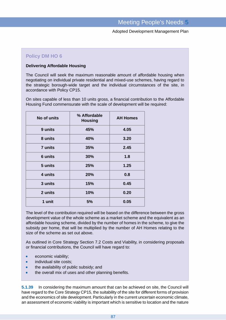
Policy DM HO 6
Delivering Affordable Housing
The Council will seek the maximum reasonable amount of affordable housing whennegotiating on individual private residential and mixed-use schemes, having regard tothe strategic borough-wide target and the individual circumstances of the site, inaccordance with Policy CP15.
On sites capable of less than 10 units gross, a financial contribution to the AffordableHousing Fund commensurate with the scale of development will be required:
AH Homes% Affordable
HousingNo of units
4.0545%9 units
3.2040%8 units
2.4535%7 units
1.830%6 units
1.2525%5 units
0.820%4 units
0.4515%3 units
0.2010%2 units
0.055%1 unit
The level of the contribution required will be based on the difference between the grossdevelopment value of the whole scheme as a market scheme and the equivalent as anaffordable housing scheme, divided by the number of homes in the scheme, to give thesubsidy per home, that will be multiplied by the number of AH Homes relating to thesize of the scheme as set out above.
As outlined in Core Strategy Section 7.2 Costs and Viability, in considering proposalsor financial contributions, the Council will have regard to:
economic viability;individual site costs;the availability of public subsidy; andthe overall mix of uses and other planning benefits.
5.1.39 In considering the maximum amount that can be achieved on site, the Council willhave regard to the Core Strategy CP15, the suitability of the site for different forms of provisionand the economics of site development. Particularly in the current uncertain economic climate,an assessment of economic viability is important which is sensitive to location and the nature
87
Meeting People's Needs 5Adopted Development Management Plan

of the existing use. Where affordable housing involves dwellings with larger numbers ofhabitable rooms per dwelling, or different sizes of habitable rooms with different tenures, itmay be more appropriate for the calculation of the affordable housing proportion to be interms of habitable rooms or floor space. The Council will nonetheless expect developers tohave taken into consideration any abnormal costs in developing a site before negotiating oracquiring land or an option.
5.1.40 The threshold is expressed in terms of the capability of the site, in order to overcomeattempts to evade thresholds. For example, these could be by lowering densities, failing toprovide the required mix of units, phasing development, submitting subsequent applicationson the same site or adjoining sites, or by incremental acquisition of sites.
Off-site Contributions from Small Sites
5.1.41 In the context of Richmond small sites make a significant contribution to housingsupply and the cumulative impact of these sites should contribute to affordable housingprovision. CP15 states that on sites below the threshold of ‘capable of ten or more unitsgross’, a financial contribution to the Affordable Housing Fund will be sought on sites involvingnew-build housing. Policy CP15 states the amount involved will be set out in this DPD andreviewed annually.
5.1.42 This policy sets out further details of the methodology for calculating the contribution:the amount is proportionate to strategic borough-wide target but applies a sliding scale thatdecreases with a decrease in total number of units proposed; the amount reflects local valuesand take account of other development costs, the focus is on achieving financial neutralityin terms of on or off-site provision; and contributions will only be spent on affordable housingthat would be in addition to affordable housing that would be provided anyway.The principleis to capture the difference which the developer would have put in, had the scheme beenentirely for affordable housing, applied to the sliding scale of contributions sought related tothe size of the scheme.
5.1.43 As a benchmark, the GLA/Three Dragons Toolkit has borough-wide benchmarkproperty prices for properties of different sizes and types. Variation may be applied on morelocation-specific values. Further detail including worked examples will be set out in AffordableHousing SPD.
5.1.44 Contribution will be secured via a legal agreement. All contributions made to thering-fenced Affordable Housing Fund are re-used for new affordable housing, or for bringingexisting private properties back into use as affordable housing, or for enhanced provisionthrough re-modelling existing affordable units or supported schemes, in pursuance of housingand planning objectives. The financial contribution will not be converted into the actualdelivery of units on an identified linked site, unless suitable, as it may be amalgamated todeliver affordable housing in the most effective way.
5.1.45 An annually updated schedule of costs will be published (as an appendix to thePlanning Obligations Strategy SPD or Affordable Housing SPD).
5.1.46 This cost should be factored into negotiations on land values in the borough. Theonus will be on developers to pay for viability assessments and any cost of independentassessment. The Council will only consider reducing planning obligations if fully justifiedthrough a financial appraisal model or other evidence. This will be the exception rather thanthe rule. The Council will expect this contribution in addition to any other requirements setout in the Planning Obligations Strategy SPD. If, due to viability, the Council will consider
88
5 Meeting People's NeedsAdopted Development Management Plan
accepting a reduction in contributions, consideration will be on a case by case basis as towhether to prioritise funding for affordable housing or other priorities such as education andtransport. As an alternative to financial contributions provision could be made on site.Conversions are recognised as different because development costs are usually higher thanwith new build.
5.1.47 If the Community Infrastructure Levy is introduced within the borough, this policywill be subject to review.
National:PPS 3: Housing (2010)Regional:London Plan (2011); policy 3.11London Plan Housing SPG, Interim Housing SPG (April 2010)Local:Core Strategy CP15 Affordable Housing
Policy Background
Core Strategy Indicator for CP15Proposed New Indicator: Contributions and spending from Affordable HousingFund.
Targets and Monitoring
5.2 Social Infrastructure Provision
5.2.1 Social Infrastructure can be defined as physical facilities for different individuals andcommunities, that can be provided by a range of organisations (public, private and voluntary),and are generally organised by place, age or a defining group such as children or the disabled.These types of facilities and services are often at the heart of local communities, whichcontribute to creating a sense of belonging and turn residential areas into sustainableneighbourhoods and communities. It covers a broad range of facilities, including thoseidentified in Core Strategy CP16, the London Plan and PPS 12 Local Spatial Planning. Itincludes public and private provision such as indoor recreation facilities. Elements of greeninfrastructure including open space and sport and recreation facilities are dealt with byspecific policies in Section 4 'Protecting Local Character'.
5.2.2 Core Strategy Policy CP16 sets out the overall strategic approach to ensure theprovision of services and facilities for the community. The Council, in working with otherpartners, will ensure the adequate provision of such services and facilities, especially inareas of relative deprivation, as set out in CP13.The strategic approach to health and socialcare facilities is set out in CP17 and to education and training facilities in CP18.
89
Meeting People's Needs 5Adopted Development Management Plan

Policy DM SI 1
Encouraging New Social Infrastructure Provision
Planning permission will be granted for new or extensions to existing social infrastructurewhere:
1. it provides for an identified need;2. where practicable is provided in multi-use, flexible and adaptable buildings or
co-located with other social infrastructure uses which encourage dual use andincrease public access;
3. it is in a location that is accessible by public transport, walking and cycling;4. is of high quality design providing inclusive access for all;5. it does not have a significant adverse impact on residential character and amenity;6. provision of car parking and effect on traffic movement and highway safety is in
accordance with Policy DM TP 8 'Off Street Parking - Retention and New Provision';and
7. is in accordance with other relevant policies.
Provision to meet local needs will be encouraged in areas of relative disadvantagewhich are identified in Core Policy 13.
5.2.3 There is a need for sufficient quality and quantity of social infrastructure to meet theneeds of users. This will be identified on the basis of evidential need and related to theCouncil’s and partners strategies and plans such as NHS Richmond’s forthcoming EstatesStrategy, Her Majesty's Court Service (London Region) emerging Magistrates' Court EstatesStrategy, the Metropolitan Police Authority's Estate Strategy and Asset Management Planfor the London Borough of Richmond Upon Thames. The LSP will also play an importantrole in taking a joined up approach and using resources effectively. The needs identified atthe time of writing the Core Strategy are largely consistent with the current position, whichwill continue to be kept under regular review and where appropriate sites will be identifiedin the Site Allocations DPD.
5.2.4 The emphasis should be on neighbourhood provision. Larger facilities that will bevisited regularly and by a greater number of people should be located in areas of good publictransport facilities or improvements will be made to existing public transport provision, andcould benefit from forming part of a mixed use scheme. Proposed large scale developmentsneed to ensure that sufficient contributions are made towards social infrastructure as thepopulation expands. Other facilities such as doctors' and dentists' surgeries may serve alocal catchment, which should normally be provided in existing centres, but exceptions maybe made for proposals affecting residential properties of an appropriate size and locationproviding there is no significant deterioration of highway conditions or undue adverse effecton neighbouring amenity. Some community uses such as police front counters will beacceptable in secondary shopping frontages if the proposal is in accordance with Policy DMTC 3 'Retail Frontages'. In accordance with CP16, new developments will be expected tocontribute to any additional infrastructure and community needs generated by thedevelopment. New development will have to take account of the requirements set out in thePlanning Obligations Strategy SPD.
90
5 Meeting People's NeedsAdopted Development Management Plan

5.2.5 Access for all is important including for the young, old and disabled.The Council willencourage high quality and sustainable design of social infrastructure including designingout crime, and measures to improve the actual, and perception of, accessibility.
5.2.6 Policy CP1 promotes dual use or co-location as a way to make efficient use of land.Dual use means, for example, that a school uses the school and playing fields during theschool day, during term time and by the community outside school hours i.e. evenings,weekends and during school holidays. Community use could be individuals, sports and artsclubs or private groups, and can range from informal/occasional bookings through to planned,professional activity. Dual use already exists in many forms within the borough. The Councilwill encourage and promote the dual use of premises including private schools and otherprivate or commercial facilities for sports and community purposes, subject to appropriatemanagement arrangements. It can be that dual-use facilities are configured on the samesite or within the same building.The combined impact of dual-use facilities needs to be takenaccount, including shared parking, hours of use, and the impact these may have on thecharacter and amenity of the are, as well as consideration as to how flexible spaces will beused e.g. sufficient storage for different users and security considerations.
5.2.7 The potential of re-using, refurbishing or redeveloping existing sites will be maximisedin accordance with Policy DM SI 2 'Loss of Existing Social Infrastructure Provision'.
National:PPS12: Local Spatial Planning (2008)Regional:London Plan (2011); policies 3.16, 3.17, 3.18, 3.19Local:Core Strategy CP16 Local Services/InfrastructureCP1 Sustainable DevelopmentCP18 Education and TrainingCP13 Opportunities for All (Tackling Relative Disadvantage)
Policy Background
Core Strategy Indicators for CP17 and CP13Targets and Monitoring
91
Meeting People's Needs 5Adopted Development Management Plan

Policy DM SI 2
Loss of Existing Social Infrastructure Provision
In accordance with the Core Strategy, the loss of social infrastructure will be resistedunless it can be shown that the facilities are no longer needed or that the service couldbe adequately re-provided in a different way or elsewhere in a convenient alternativelocation.Where a particular social infrastructure use ceases, the Council will encouragean alternative social infrastructure use. If no alternative social infrastructure uses aresuitable, residential development will normally be required (unless there is an opportunityfor mixed-use development), including affordable housing in accordance with PolicyCP15 and other relevant policies.
In considering applications involving the loss of social infrastructure the followingevidence will be required:
1. that the existing facilities are no longer needed or do not meet the needs of usersand cannot be adapted in any way; or
2. that the existing facilities are being adequately re-provided in a different way orelsewhere in a convenient alternative location, in accordance with Policy DM SI 1'Encouraging New Social Infrastructure Provision'; or that there are sufficientsuitable alternative facilities in the locality; and
3. the potential of re-using or redeveloping the existing site for the same or analternative social infrastructure use has been fully considered.
5.2.8 Development pressures and high land costs in the borough mean there is pressureto redevelop sites and it can be difficult to find new sites for community use, especially foruse by voluntary groups.There is a need to preserve a sufficient range and amount of socialinfrastructure across the borough. Where a property or land is declared surplus, the Councilwill require evidence that it is no longer an essential local facility. In some cases, changemight be inevitable or desirable, for example to meet the changing needs of users or throughdual-use to make provision more economically viable. Making more efficient use of land mayreduce the overall need for land in community use while maintaining the same level of serviceprovision.
5.2.9 To assess the loss of social infrastructure, the Council will require evidence to justifythe loss. This should be based on evidential need and related to the Council’s and partnersstrategies and plans, including their land disposal processes. Factors could include whetherexisting facilities can be made accessible to all, whether the location of the facilities is welllocated and sustainable. The LSP will play an important role in taking a joined up approachand using resources effectively, to assess whether alternative social infrastructure uses maybe appropriate. The Council will need to be satisfied that there are no reasonable prospectsof reuse by an alternative social infrastructure use i.e. evidence of disposal process ormarketing evidence.
92
5 Meeting People's NeedsAdopted Development Management Plan

National:PPS12: Local Spatial Planning (2008)Regional:London Plan (2011); policies 3.16, 3.17, 3.18, 3.19Local:Core Strategy CP16 Local Services/InfrastructureCP17 Health and Well-beingCP18 Education and Training
Policy Background
Core Strategy Indicator for CP16Targets and Monitoring
5.3 Employment
5.3.1 The borough provides an attractive location for business, with its high qualityenvironment and educated and skilled workforce.The thriving local economy is based largelyupon the service sector with a high proportion of small businesses and many self employedresidents.The policies seek to support the local economy and employment within the boroughand take forward policies CP19 and CP20 of the Core Strategy.
Policy DM EM 1
Development for Offices, Industrial, Storage and Distribution uses
Planning permission will normally be approved for appropriate employment development.The Council will take account of the following factors:
a) the accommodation should be flexible & suitable to meet future needs especially toprovide for the requirements of local businesses and small firms;
b) the scale, bulk and appearance of the proposal should be compatible with thecharacter of its surroundings;
c) the development must not significantly harm the amenities of nearby occupiers norcause adverse environmental impact on the surrounding area;
d) the scale of development should be compatible with the level of existing or potentialpublic transport accessibility, and the on-street parking situation. Where additionalinfrastructure is required due to the scale of the development, such a development willbe required to fund the necessary infrastructure to support it;
e) the development should comply with the Council's transport, access, servicing, carand cycle parking standards and policies.
In addition
Larger scale new B1a Office development should generally be within the five main towncentres.
Industrial, storage and distribution development, and improvement and expansion ofsuch premises will normally be permitted, subject to a)-e) above. However, in consideringsuch proposals the Council will take into account the need, if any, to improve the physicalenvironment of the area.
93
Meeting People's Needs 5Adopted Development Management Plan

5.3.2 The Council seeks to encourage development for employment uses that meet localneeds without causing undue environmental problems. The borough’s economy ischaracterised by many small businesses working out of relatively small-scale premises (250sq m or less). In support of this Core Strategy Policy CP19 seeks provision of small units toaccommodate a variety of local firms.
5.3.3 The Council is particularly keen to accommodate commercial needs in terms of floorspace within the borough for local businesses and small firms and afford the opportunity forresidents to set up their own enterprise and perhaps work closer to home. B1 office space,which is compatible with residential areas, should be flexible enough to be used for lightindustrial, research, studio and office purposes and adaptable enough to meet future needse.g. expansion of local firms. Scientific, innovation and research, provision of incubator unitsand laboratories will be supported.
5.3.4 Allowing firms to remain and expand within the borough helps to ensure that a varietyand choice of employment opportunities and services are maintained. At the same time theCouncil seeks to discourage the unnecessary redevelopment of premises, in order tomaximise the choice of resources and maintain a stock of cheaper accommodation. Smallerscale storage facilities that can provide jobs would be appropriate and can be shown tobenefit the local economy and local business if they are situated in relatively accessiblelocations. When considering proposals for rebuilding or expansion of existing industrial andstorage premises the Council will seek to secure improvements to the physical environmentsuch as landscaping and screening of unsightly buildings.
5.3.5 There are an increasing proportion of business start-ups and growing numbers ofpeople running part-time or full-time businesses from home.The Council supports new waysof working such as home working, or serviced office accommodation providing that it meetsthe criteria above so that no unacceptable harm results to the local amenity or environment.In many cases working from home will not constitute a material change of use requiringplanning permission. Live-work units are encouraged on suitable sites but they are notnormally appropriate on existing employment land where there is the expectation thatdedicated workspace is required.
5.3.6 The borough is home to nationally important scientific institutions, such as The RoyalBotanical Gardens at Kew, the National Physical Laboratory and head office of theGovernment Chemist (LGC), and other academic institutions with one university within andanother close to its borders. Appropriate non-residential development, expansion andinnovation such as provision of incubator units and laboratories will be supported.
5.3.7 This policy is concerned with uses within the B use class – however other usesimportant to local economy e.g. education, sports and leisure, arts, cultural, entertainment,creative, historic and river related uses that add to the overall economic diversity of theborough will be supported.Various leisure, cultural and historic sites such as Hampton CourtPalace and Marble Hill House, the River Thames and its tributaries, and Richmond Parkoffer opportunities for economic spin offs as well contributing to the high quality and uniqueenvironment. Tourism and visitor accommodation is promoted within Policy CP 20 of theCore Strategy.
94
5 Meeting People's NeedsAdopted Development Management Plan
National:PPS 1: Delivering Sustainable Development (2005)PPS 3: Housing (2011)PPS 4: Planning for Sustainable Economic Growth (2009)PPS 10: Planning for Sustainable Waste Management (2011)PPG 13: Transport (2011)Regional:The London Plan (2011); chapter 2, in particular policies 2.6, 2.7; chapter 4South London Sub-Regional Development FrameworkLondon Plan Industrial Capacity SPG (2008)Grant Thornton & The Leisure & Tourism Authority, (2006) Hotel Demand Study 2006,GLA, LondonLocal:Core Strategy CP19 Local Business and CP20 Visitors and Tourism
Policy Background
Core Strategy Indicator for CP19Targets andMonitoring
95
Meeting People's Needs 5Adopted Development Management Plan

Policy DM EM 2
Retention of Employment
The Council seeks to retain land, sites and buildings which were last used foremployment purposes, in employment use. The use of employment land for otherpurposes will only be permitted where:
(a) There is satisfactory evidence of completion over an extended period of time of afull and proper marketing exercise of the site at realistic prices both for the existing useand for redevelopment (if appropriate ) for other employment uses; or suitable alternativeevidence; and either
(b) A sequential approach has been applied to the development of the site as follows:
i) solely employment-based redevelopment;
ii) mixed-use or other alternative employment creating uses, where the employmentfloorspace is retained. Such sites should maximise the amount of affordablehousing provided as part of the mix;
iii) maximum provision of affordable housing in accordance with CP19;
Or (c): The location has such exceptionally severe site restrictions due to very pooraccess and servicing arrangements that its continued employment use would beinappropriate.
Proposals for Mixed Use schemes must maintain or improve the amount of employmentfloorspace on site. Each proposal will be considered on its merits and the Council willtake account of the following factors when considering mixed use applications:
i) the amount of employment floorspace;
ii) the type and mix of uses as existing and proposed;
iii) likely access, parking and traffic implications;
iv) compatibility with the policies for other land uses;
v) design quality;
vi) the type, size and tenure of residential provision which should be in accordancewith policies and guidance in order to maximise the amount of affordable housingprovision.
If the above steps have been applied and the Council accepts the site is unsuitable forcontinued employment or commercial use, or other employment generating uses thenaffordable housing should be maximised.
5.3.8 The Council’s approach to the local economy is set out in Core Policy CP19. Theborough has limited employment floor space, which is often found in many small sitesscattered across the mixed-use and residential areas, and relatively few industrial areas.
96
5 Meeting People's NeedsAdopted Development Management Plan

The policy aims to ensure that employment remains located close to residential areas toprovide local job opportunities and services easily accessed by residents. Cumulative lossof employment sites will have an adverse effect on business, employment and on thecharacter of the borough.
5.3.9 Given the length of economic and development cycles, a site should be marketedfor an extended period, normally a minimum of two years. The Council will decide if themarketing is sufficient and appropriate, and as a rule recommends inclusion of the subjectproperty to the South London Business property website www.southlondonbusiness.co.uk,which is free to view by prospective purchasers and tenants as well as other agencies. Themarketing of property should initially be for the site in existing use or for acceptable alternativeemployment uses, such as B1 offices and if these are not practicable then alternativeemployment generating uses for instance health clinics, nurseries and crèches, hotels andleisure facilities, or other uses identified for community purposes.
5.3.10 There may be some instances where other appropriate evidence relating to aparticular employment site or premises will be considered by the Council (instead of marketingevidence). These could include:
premises where changes are proposed to other employment generating uses such aseducation, day nurseries, medical and health services, community uses and veterinarypremises;upper floors above shops where these are already vacant and it is recognised thatresidential would be an acceptable alternative use;listed buildings where the original use was residential.
5.3.11 Employment land demand forecasting models predict a gradual decline in demandfor B2 uses and relatively flat demand for B8 uses in the period up to 2026. Due to the relativeshortage of employment land stock in the borough the release of employment land to otheruses should be restricted to land that is inherently unsuitable for employment uses. In timesof waning demand related to economic recession, employment land should not be releasedto other uses because this reduction in demand is likely to be relatively short term and theloss of employment land is in effect irreversible. The Council is mindful also of the need topreserve some industrial land for infrastructure, waste treatment and support services, suchas police bases.
5.3.12 There is a pressing need for future housing to be affordable as set out in CoreStrategy Policy CP15.This will be provided through on-site provision on larger sites. However,the high land values resulting from the demand for open market residential developmentmeans that some employment land at existing use value may present one of the only sourcesof cheaper land that would be financially viable for affordable housing provision. If the Councildeems that the retention of the site for employment use is not practicable and proposals foralternative employment generating uses are also not appropriate following marketing, thenexceptionally the Council may permit residential development which maximises affordablehousing above the normal requirements set out in Policy CP15. Where viability may be anissue, a financial viability assessment will be required taking account of paragraph 7.2.6 ofthe Core Strategy.
97
Meeting People's Needs 5Adopted Development Management Plan

5.3.13 The Council will seek to protect existing stock of industrial, storage and distributionpremises that meet local needs without causing undue environmental problems.The boroughis categorised as “Restrictive Transfer” in the GLA Industrial Capacity Supplementary PlanningGuidance, where the pressure of demand for industrial/warehousing land is high and thereforelittle, if any should be released for other uses.
5.3.14 Local service trades such as builders or car repairers provide useful services toresidents and other businesses in the borough as well as a source of local employmentopportunities. Small firms such as these often find it difficult to acquire suitable affordablepremises and the higher value of land for other uses creates pressure for redevelopmentfor higher quality and priced accommodation even though many starter businesses requirecheaper accommodation and small incubator units. Attempts to market poorer qualitypremises should be on the basis of their present condition, and not on their potential forredevelopment in other employment uses, or proposing housing as the only viable option.
5.3.15 There is potential for any surplus industrial land to help meet future strategic andlocal requirements for waste management, transport, and social infrastructure. It would beprudent to not release this scarce resource to competing land uses unless they appear tobe intrinsically unsuitable for such purposes.
5.3.16 River related industries that support the use of river, and waterborne transport andfreight contribute to the economy and distinct quality of the borough and their loss shall bestrongly resisted.
National:PPS 1: Delivering Sustainable Development (2005)PPS 3: Housing (2011)PPS 4: Planning for Sustainable Economic Growth (2009)PPS 10: Planning for Sustainable Waste Management (2011)PPG 13: Transport (2011)Regional:The London Plan (2011); chapter 2, in particular policies 2.6, 2.7; chapter 4South London Sub-Regional Development FrameworkLondon Plan Industrial Capacity SPG (2008)Grant Thornton & The Leisure & Tourism Authority, (2006) Hotel Demand Study 2006,GLA, LondonLocal:Core Strategy CP19 Local Business and CP20 Visitors and Tourism
Policy Background
Core Strategy Indicator for CP19Targets andMonitoring
5.4 Transport and Parking
5.4.1 The Development Management policies for Transport and Parking are designed totake forward Core Policy 5 and to complement the Borough’s Local Implementation Plan.The Core Policy (CP5), in line with National and Regional guidance and plans, seeks topromote sustainable travel by means of appropriate location, encouragement of the moresustainable modes of travel and other means to reduce the need to travel by private vehicle,with the aim of improving accessibility and reducing congestion and pollution.
98
5 Meeting People's NeedsAdopted Development Management Plan

5.4.2 The Development Management policies for Transport and Parking will be used whentaking decisions on new developments and schemes – policies seek to match developmentto transport capacity, require transport assessments or statements for new development,improve links, interchanges and provision for walking and cycling and to provide or retainoff street parking.
Policy DM TP 1
Matching Development to Transport Capacity
Higher trip generating development will only be permitted in areas which are, or at thetime of implementation are, easily accessible by transport other than the private car,and well located with respect to local services.
5.4.3 Such development includes larger offices, shopping and leisure facilities and mixeduse and higher density residential schemes where a large number of trips are generatedeach day. The spatial strategy aims to develop the potential of the 5 main town centres andCP1 directs developments to the town centres near to public transport to reduce the needto travel by car.This policy explains in more detail how accessibility will be determined whenassessing development proposals.
5.4.4 The usual measure of accessibility is the PTAL (public transport accessibility level)which takes account of the accessibility of a location to public transport, in six broad bands,level 6 being the most accessible. Whilst in general higher PTALs are achieved in areaswith good rail/tube connections, in this borough it is recognised that bus links are alsoimportant. Future improvements to accessibility will also be relevant, these might be plannedchanges by TfL, the Council, rail or bus companies or improvements which could be eitherdesigned into the new scheme or funded by the developer as part of a Section 106 agreement.There would need to be certainty that future improvements would be implemented in timeto serve the development and are sustainable in the longer-term.
5.4.5 The Council will therefore use the site’s PTAL as a starting point, but also considerthe highway capacity, the proximity of cycle and walking routes as well as future improvementswhen evaluating development proposals.
National:Traffic Management Act 2004PPS 1: Delivering Sustainable Development (2005)PPS 4: Planning for Sustainable Economic Growth (2009)PPG 13: Transport (2011)Disability Discrimination Act 1995 (Provision of Goods and Facilities)Regional:London Plan (2011); chapter 6, in particular policies 6.1, 6.3Mayor's Transport Strategy (2011)Sub-Regional Transport Plan South (2010)Local:Core Strategy CP5 Sustainable Travel
Policy Background
Indicator: Proportion of larger new developments of each use class in areas ofhigher PTAL (5 or above)Target: 95%of larger new developments of each use class in areas of higher PTAL
Targets and Monitoring
99
Meeting People's Needs 5Adopted Development Management Plan

Policy DM TP 2
Transport and New Development
The impact of new development on the transport network will be assessed against otherplan policies and transport standards. All planning applications for major developmentsshould be accompanied by a Transport Assessment and for smaller developmentsshould be accompanied by a Transport Statement. Matters to be included are set outin DofT/TfL guidance.
Developers should also take account of the Council’s SPD on Transport Standards.
5.4.6 It is necessary to consider the impact of any new development on the existing widerand local transport network for all modes, how it links to the network, impacts on highwaysafety, the impact of parking and servicing, and with larger developments what provision formovement and parking for cars, bicycles and coaches (if appropriate) is made within thedevelopment itself. London Plan policy 6.3 Assessing effects of Development on TransportCapacity deals with this issue and CP 5 requires all major developments to submit a TransportAssessment based on TfL’s Best Practice Guidance (major developments are defined asthose which exceed the thresholds of appendix B of the Department of Transport Circular02/2007 (Guidance on Transport Assessment).
5.4.7 For smaller developments the Transport Statement should include:
Existing road, public transport, cycle and pedestrian networksExisting on street and other relevant parking provision and usage, parking standardsExisting traffic and pedestrian flows, desire linesAdditional trip generation and modal shareServicing arrangements, including timingImpacts on road network, public transport and pedestrian routesTravel plan (may or may not be required, depending on size of development)
5.4.8 The information and standards which must be met with regard to new developmentis to be set out in a Transport Standards SPD. This will include Construction ManagementPlans and Delivery and Servicing Plans.
National:Traffic Management Act 2004PPS 1: Delivering Sustainable Development (2005)PPS 4: Planning for Sustainable Economic Growth (2009)PPG 13: Transport (2011)Disability Discrimination Act 1995 (Provision of Goods and Facilities)Regional:London Plan (2011); chapter 6, in particular policies 6.1, 6.3; Parking Addendum toChapter 6Mayor's Transport Strategy (2011)Sub-Regional Transport Plan South (2010)Local:Core Strategy CP5 Sustainable Travel
Policy Background
N/ATargets and Monitoring
100
5 Meeting People's NeedsAdopted Development Management Plan

Policy DM TP 3
Enhancing Transport Links
New developments will be expected to create or improve links with the local and widertransport networks, including links to the cycle and pedestrian networks.
All new developments must be designed to improve accessibility including:-
1. Maximise permeability, with safe, convenient, accessible and appropriate road,cycle and pedestrian routes within and in the immediate vicinity of the scheme, aswell as accessible walking and cycling links to the wider transport network includingto public transport nodes and key land uses, taking account of the need to connectpeople to jobs, to town centres and to schools.
2. Gated developments will not be permitted.3. Developments adjoining the River Thames must provide a public riverside walk.
5.4.9 The Council will support proposals which improve links within or between the Boroughand other areas. Enhancing transport links can refer to physical proposals such as a newbridge or path; improving existing links e.g. by creating a new gate into a park, or increasinguse of an existing link e.g. through the promotion of a route as a travel option through methodssuch as Smarter Travel and Legible London.
5.4.10 The London Plan encourages Councils to identify local links between and withinboroughs. Whilst there is generally a high level of transport accessibility, the Borough ischaracterised by a large number of features which can act to sever areas from each othere.g. railway lines and rivers. Specific improvements to transport links may also be identifiedin the Site Allocation DPD or in planning briefs for specific areas.
5.4.11 There is also the opportunity for new development to bring about considerableimprovements both within and close to the site. Developments should be integrated into theirsurroundings and existing local routes, for this reason gated developments which preventpermeability will not generally be permitted. Designers should consider how their schemelinks to local amenities such as shops, community facilities and open spaces and providedirect and easy to use road, cycle and pedestrian access routes within the development andfund improved linkages for cyclists and pedestrians in the vicinity, and bus stops or busstanding facilities if agreed with TfL, in line with the Planning Obligations Strategy or anysubsequent updates, including the Community Infrastructure Levy (CIL). New pedestrianroutes should be based on the TfL guidance Improving Walkability. Cycle provision shouldtake account of measures identified in the TfL Cycling Action Plan
5.4.12 The Council has secured considerable sections of public riverside walk over thelast 25 years, by requiring a public path to be provided wherever a development adjoins theRiver Thames, such a route should be secured with a section 106 agreement, even if thereis currently no public access to the route at either end.
101
Meeting People's Needs 5Adopted Development Management Plan

National:Traffic Management Act 2004PPS 4: Planning for Sustainable Economic Growth (2009)PPG 13: Transport (2011)Regional:London Plan (2011); chapter 6, in particular policies 6.1, 6.4Mayor's Transport Strategy (2011)Sub-Regional Transport Plan South (2010)Local:Core Strategy CP5 Sustainable Travel
Policy Background
Indicator: List enhancements to transport links associated with largerdevelopments (housing developments of ten or more units, commercialdevelopments of 250m2 or more).Target:: N/A
Targets and Monitoring
Policy DM TP 4
Integration of different types of Transport and Interchange Facilities
Developments will be expected to improve the quality and connectivity of transportinterchanges of any scale, particularly in terms of
Opportunities for interchange between different types of transport through theprovision of appropriate facilities and good information.Ease of access to interchange points (e.g. stations/ bus stops) by various typesof transport.Transport facilities which are well laid out and allow access to a wide range ofusers (e.g. level or with accessible lifts or ramps).Attractive and welcoming environment – well designed civic spaces, sun and rainshelter, high quality and well maintained hard and soft landscapeSafe and secure environment – e.g. good lighting, CCTV, ticket barriers
5.4.13 The need for improved quality and connectivity of transport interchanges to improvemovement in Outer London was identified in both the London Plan and by the Outer LondonCommission. In the local context “transport interchanges” refers to anywhere where morethan one type of travel interact, from train and bus stations to bus stops.
5.4.14 The Council will be examining main transport interchanges in consultation with theoperating companies and proposing improvements to be taken forward in the LIP and whereappropriate in the Site Allocations DPD, and/or in planning briefs. See also TfL’s InterchangeBest Practice Guidelines which identifies the necessary and desirable features that need tobe considered.
102
5 Meeting People's NeedsAdopted Development Management Plan

National:Traffic Management Act 2004PPS 1: Delivering Sustainable Development (2005)PPS 4: Planning for Sustainable Economic Growth (2009)PPG 13: Transport (2011)Disability Discrimination Act 1995 (Provision of Goods and Facilities)Regional:London Plan (2011); chapter 6, in particular policies 6.1, 6.4; and other policiesto improve public transportMayor's Transport Strategy (2011)Sub-Regional Transport Plan South (2010)Local:Core Strategy CP5 Sustainable Travel
Policy Background
N/ATargets and Monitoring
Policy DM TP 5
Taxis and Private Hire Vehicles
Taxi ranks should be conveniently located and accessible for all with adequate spacefor customers to queue, well lit and with good CCTV facilities. Ranks must not adverselyimpact on pedestrian movement or road safety.
The Council will consider applications for offices for private hire vehicles against relevantpolicies of the plan, and subject to them not having an adverse impact on other typesof transport including walking and cycling, on-street parking and highway safety orcausing disturbance to residents.
5.4.15 Taxis and private hire vehicles are an important part of transport provision. Blacktaxis generally use ranks which need to be positioned close to their customers, generally atthe busier stations or town centres. They should be located where there is sufficient spacefor customers to queue safely and conveniently without adversely affecting transportmovement.
5.4.16 Private hire vehicles are controlled from offices and the vehicles may or may notbe parked nearby. The presence of a private hire office open at night at a rail station oranywhere else, can improve security and add a measure of natural surveillance, which iswelcome in certain areas. However private hire offices can cause disruption to residentswith frequent traffic movements, impact on parking and late night noise and disturbance.These impacts will be controlled through the policy and conditions.
Regional:London Plan (2011); chapter 6Mayor's Transport Strategy (2011)Sub-Regional Transport Plan South (2010)Local:Core Strategy CP5 Sustainable Travel
Policy Background
N/ATargets and Monitoring
103
Meeting People's Needs 5Adopted Development Management Plan

Policy DM TP 6
Walking and the Pedestrian Environment
To protect, maintain and improve the pedestrian environment, the Council will ensurethat:-
1. New development and schemes protect, maintain and, where appropriate, improvethe existing pedestrian infrastructure, including the Rights of Way network.
2. New development does not adversely impact on the pedestrian environment andprovides appropriate pedestrian access (see Policy DM TP 3 'Enhancing TransportLinks').
3. New development and schemes improve the safety and security of the pedestrianenvironment where appropriate.
5.4.17 This is very important as nearly everyone is a pedestrian at some stage, for someor all of their journey. Civic space (i.e. public areas) should be accessible and inclusive, agood walking environment has been proved to be not only beneficial to an individual’s healthand social life, but also brings economic benefits to town centres.
5.4.18 By encouraging the provision of a range of uses within the local town centres theCore Policy aims to ensure that residents can easily reach the facilities they need withouttravelling long distance. For many this will mean walking for some or all of the journey, so itis important to ensure that the pedestrian environment is of a high standard.
5.4.19 Providing access from and within new development is also covered in TP 3. Whilstmost pedestrian journeys are on pavements, the Council has a network of 250 public rightsof way, most of these are public footpaths. In line with the Countryside and Rights of WayAct 2000 (CROW Act), the Council is producing a Rights of Way Improvement Plan, whichwill include measures to record, improve and promote the network.
5.4.20 A safe network means safety from other users such as busy traffic or cyclists aswell as actual and perceived security from crime and antisocial behaviour. Management ofother users including speed restrictions, sufficient widths, segregation where appropriateand well designed and positioned crossing facilities can reduce conflict between users. Welldesigned paths, natural surveillance, appropriate levels of lighting, CCTV and good levelsof maintenance can improve actual and perceived security. The Public Space Design Guideincludes advice with respect to the amenity of the pedestrian environment. Secured byDesign and Safer Places principles should be followed. Schemes to improve the networkare most likely to be implemented via Environmental or Transport Improvement Schemes,funded through TfL or section 106 funding.
5.4.21 The Council, as Highway Authority will regularly audit the existing pedestrian networkto identify areas for improvement in terms of links, signage, amenity, accessibility andpromoted routes in line with the Borough Walking Strategy, the Rights of Way ImprovementPlan, the Walking Plan for London and TfL guidance Improving Walkability.
104
5 Meeting People's NeedsAdopted Development Management Plan

5.4.22 The Council will ensure that there is signage and way marking of the three strategicwalking routes identified in the London Plan, which run through the borough – the ThamesPath National Trail, the Capital Ring and the London Loop, and the other promoted routes– the River Crane Walk and Beverley Brook Walk which together form a network of leisureroutes which most residents can reach.
National:Traffic Management Act 2004PPS 1: Delivering Sustainable Development (2005)PPS 4: Planning for Sustainable Economic Growth (2009)PPG 13: Transport (2011)Disability Discrimination Act 1995 (Provision of Goods and Facilities)Regional:London Plan (2011); chapter 6, in particular policies 6.1, 6.10Mayor's Transport Strategy (2011)Sub-Regional Transport Plan South (2010)Local:Core Strategy CP5 Sustainable Travel
Policy Background
Core Strategy Indicator for CP 5Targets and Monitoring
Policy DM TP 7
Cycling
To maintain and improve conditions for cyclists, the Council will ensure that newdevelopment or schemes do not adversely impact on the cycling network or cyclistsand provide appropriate cycle access and sufficient, secure cycle parking facilities, seePolicy DM TP 3 'Enhancing Transport Links' and Policy DM TP 8 'Off Street Parking -Retention and New Provision'.
5.4.23 Cycling is increasing in popularity and this borough has the highest proportion ofcyclists in London. There is potential for more use of cycling as an alternative to the car forshorter journeys in the Borough. By encouraging the provision of a range of uses within thelocal town centres the Core Policy aims to ensure that residents can easily reach the facilitiesthey need without travelling long distances, this will mean that some of these journeys couldbe made by cycling.
5.4.24 The Council will identify and implement high quality, direct, cycling routes, wherepossible segregated from motorised traffic, or on quieter routes, giving access to publictransport nodes, town centres and key land uses. Since 2006 Sustrans has been workingwith the borough on a network of Greenway walking and cycling routes. Where off road orsegregated routes are not possible, consideration could be given to traffic calming orsegregation from motor traffic at junctions. Cycle parking standards are covered in PolicyDM TP 8 'Off Street Parking - Retention and New Provision'. Where appropriate, largernon-residential development should provide on site changing and showering facilities toencourage cycling.
5.4.25 Schemes to improve the network are most likely to be implemented viaEnvironmental or Transport Improvement Schemes, funded through TfL or Section 106funding.
105
Meeting People's Needs 5Adopted Development Management Plan

5.4.26 A large part of encouraging cycling is new physical provision, the signage andpromotion of cycle routes and cycle safety training.
National:PPS 1: Delivering Sustainable Development (2005)PPS 4: Planning for Sustainable Economic Growth (2009)PPG 13: Transport (2011)Regional:London Plan (2011); chapter 6, in particular policy 6.3 (Cycle ParkingStandards)Mayor's Transport Strategy (2011)Sub-Regional Transport Plan South (2010)Local:Core Strategy CP5 Sustainable Travel
Policy Background
N/ATargets and Monitoring
Policy DM TP 8
Off Street Parking - Retention and New Provision
Developments, redevelopments, conversions and extensions will have to demonstratethat the new scheme provides an appropriate level of off street parking to avoid anunacceptable impact on on-street parking conditions and local traffic conditions.
A set of maximum car parking standards and minimum cycle parking standards are setout in Appendix Four - Parking Standards 'Appendix Four - Parking Standards'for alltypes of development, these take into account bus, rail and tube accessibility as wellas local highway and traffic conditions including demand for on-street parking. Thesestandards will be expected to be met, unless it can be shown that in proposing levelsof parking applicants can demonstrate that there would be no adverse impact on thearea in terms of street scene or on-street parking.
5.4.27 The borough has high levels of car ownership and use with fairly densely developedresidential areas with some narrow streets and many older houses without off street parking.This has led to high levels of on street parking, worsened in areas where there is a demandfor commuter parking. The standards set are maximum parking levels as required by theLondon Plan, car parking provision should not be at a level less than these standards, unlessan exceptional circumstance is demonstrated. The approach aims to ensure that sufficienton-site car parking is provided to meet the needs of the occupiers of the new development,but also to ensure that excessive parking demand is not created which could have an adverseimpact on the local highway/traffic conditions and street scene.
5.4.28 This policy covers the parking standards for new developments of all types. Parkingmust be sensitively located and designed and suitably landscaped to minimise visual intrusionand disturbance. Forecourt parking is covered in Policy DM TP 9 'Forecourt Parking'. Tomaintain sufficient parking space, with new development the parking provision will be expectedto be legally tied to the development that it serves. In areas controlled by a CommunityParking Zone, occupiers of new residential developments may not be eligible for on streetparking permits where existing levels of on street parking are very high, this restriction wouldbe secured by a section 106 agreement.
106
5 Meeting People's NeedsAdopted Development Management Plan

5.4.29 Developers may only provide fewer parking spaces, including car free schemes, ifthey can show that there would be no adverse impact on amenity, street scene, road safetyor emergency access in the surrounding area or a generation of unacceptable overspill ofon-street parking in the vicinity. In general it is expected that in low PTAL areas (1-4) the standards should be met, but in higher PTAL areas (5-6), such as Richmond and Twickenhamtown centres, parking provision at a level lower than the standard or a car free development,perhaps with a car club, may be appropriate in exceptional circumstances.
5.4.30 Within the town centres the standards reflect the approach of the Core Strategy inthat further expansion of car parking (particularly within Richmond and Twickenham) will belimited and that management policies will be used to help maintain viability and vitality ofthe centres. The Core Strategy also recognises that there is relatively limited public parkingwithin East Sheen and Whitton and this is reflected in the more generous standards wherethe parking is for the benefit of the centre as a whole. In these centres loss of off streetparking will be resisted, especially in relation to large supermarkets and pub or hoteldevelopments.
5.4.31 Car share facilities and car clubs will be encouraged, but these will not obviate theneed for adequate off street parking provision. Charging facilities for electric vehicles will bewelcomed where there is a demand and this does not affect overall viability.
National:Traffic Management Act 2004PPS 1: Delivering Sustainable Development (2005)PPS 4: Planning for Sustainable Economic Growth (2009)PPG 13: Transport (2011)Disability Discrimination Act 1995 (Provision of Goods and Facilities)Regional:London Plan (2011); chapter 6, in particular policy 6.13, table 6.2 (ParkingStandards) and table 6.3 (Cycle Parking Standards)Mayor's Transport Strategy (2011)Sub-Regional Transport Plan South (2010)LocalCore Strategy CP5 Sustainable TravelSPDCar Clubs and Car Free Development
Policy Background
Core Strategy Indicator for CP5Targets and Monitoring
107
Meeting People's Needs 5Adopted Development Management Plan
Policy DM TP 9
Forecourt Parking
The parking of vehicles in existing front gardens will be discouraged, especially where
this would result in the removal of architectural features such as walls, gates andpaving, or of existing trees and other vegetation or,where such parking would detract from the streetscape or setting of the propertyor,where the use of the access would create a road or pedestrian safety problem orwhere the width of the proposed entrance will be greater than the width of a normaldriveway.
For any proposal the area of impermeable paving should be minimised and softlandscaping maximised.
The Council will seek to restrict permitted development rights for forecourt parkingthrough Article 4 directions, where important townscape or surface water flooding issuesexist. The Council will have regard to the impact of forecourt parking in consideringproposals to extend or convert existing residential property.
5.4.32 There is increasing demand for forecourt parking, particularly where propertieshave no off street parking, often aggravated by the introduction of parking controls.This hasoften been achieved without consideration for its impact on the surrounding environment,both in terms of the loss of individual front garden features and in damaging the unity andcharacter of groups of houses and the streetscape in general, and the increase inimpermeable paved areas which cumulatively have an impact on surface water drainage.Recent changes to Permitted Development rights have increased controls over forecourtparking, and the Council will use its powers to the maximum extent subject to the establishedwishes of local communities.
5.4.33 The aim of any design for parking in front gardens should be to maintain as muchsense of enclosure as is practical, through the retention of existing walls or fences, theprovision of gates, and generous planting. Particular attention will need to be paid in topreserve the character within Conservation Areas.In order to minimise visual intrusion,crossovers must be constructed in materials that match surrounding paving.
5.4.34 In order to draw the public's attention to this matter and to encourage anenvironmentally acceptable solution to the problem the Council has produced planningguidance – “Front Garden and Other Off – Street Parking Standards” . In cases whereforecourt parking involves the creation of a vehicular access that requires planning permission,such applications would be refused where the use of the access is likely to adversely affectroad and pedestrian safety or where the proposal would be detrimental to the environment.Properties on the Transport for London Road Network (TLRN) are required to seek permissionfrom TfL for construction of crossovers, and there may be different requirements, for examplewith respect to gates on the TLRN.The Council may discourage extensions when this resultsin an unacceptable loss of existing off-street parking spaces. When forecourt parking isunavoidable as a result of the extension or conversion of large properties, the Council will
108
5 Meeting People's NeedsAdopted Development Management Plan

apply the guidelines in full. Regard must be taken of requirements set out in theSupplementary Planning Document which will be a material consideration in determiningplanning applications.
NationalPPS 1: Delivering Sustainable Development (2005)LocalCore Strategy CP 7SPD – Front Garden and other Off Street Parking Standards
Policy Background
N/AIndicators and targets
109
Meeting People's Needs 5Adopted Development Management Plan

Detailed Generic Policies 6Adopted Development Management Plan
110

6 Detailed Generic Policies
6.0.1 These policies are more detailed generic policies which will apply to most types ofdevelopment. They take forward the principles of many of the policies in the Core Strategy.They cover the Design Quality, Layout and Design of Mixed Use Schemes, Taller Buildings,Trees and Landscape, Neighbourliness/Sunlighting/Daylighting, Balconies and Upper FloorTerraces, Shopfronts and Shopsigns, Advertisements and Hoardings, and a PlanningApplication Checklist. Many of these policies refer to Supplementary Planning Documents,which provide much more detailed advice, as well as advice from the GLA and other relevantorganisations.
6.1 Detailed Generic Policies
Policy DM DC 1
Design Quality
New development must be of a high architectural and urban design quality based onsustainable design principles. Development must be inclusive, respect local characterincluding the nature of a particular road, and connect with, and contribute positively, toits surroundings based on a thorough understanding of the site and its context.
In assessing the design quality of a proposal the Council will have regard to the following:
compatibility with local character including relationship to existing townscape andfrontages, scale, height, massing, proportions and formsustainable development and adaptability, subject to aesthetic considerationslayout and accessspace between buildings and relationship to the public realmdetailing and materials
6.1.1 This policy is intended to encourage site specific design responses, for both buildingand landscape proposals, (including alterations and extensions) not to restrict design freedom.The Council does not wish to encourage a particular architectural style or approach butexpects each scheme to be justified as a result of a sound understanding of the site and itscontext. Schemes that are not of a high design quality, and will not result in the improvementof the area where they will be built or implemented, will not be acceptable, nor will schemeswhich depart from the coherent and predominant character of a road or neighbourhoodwhere this is of merit.
Design Guidance
6.1.2 The Council has adopted a Design Quality SPD which promotes high qualitysustainable architecture and urban design. It gives advice on how to deal with design at theearly stage of a proposal and the material the Council will expect to be submitted in supportof an application, including what should be included in a design and access statement. Itdescribes 12 distinct character areas within the borough and details how the Council willassess the architecture and urban design quality of a proposal in relation to the followingseven 'Principles of Good Design’:
111
Detailed Generic Policies 6Adopted Development Management Plan
CharacterContinuity and enclosurePublic realmEase of movementLegibilityAdaptabilityDiversity
Sustainable Development and adaptability
6.1.3 In line with PPS 1 and CP 1, the Council places importance on promoting sustainabledevelopment. The proposed uses and activities on the site are important and the Councilwill give consideration to the mix of uses proposed and how they will support and connectinto the local area (see also Policy DM DC 2 'Layout and Design of Mixed Use Schemes').Proposals should maximise the opportunities the site holds to generate a design which willminimise its environmental impact. Simple design decisions at an early stage, such as theorientation of a building, can reduce energy consumption through responding positively toclimatic conditions. The Council has adopted a Sustainable Construction Checklist SPDwhich gives further guidance on this and policy CP 2 deals specifically with renewable energysources, recycling and energy and water conservation. Within this DPD, also relevant arePolicy DM SD 1 'Sustainable Construction', Policy DM SD 3 'Retrofitting', and Policy DM SD4 'Adapting to Higher Temperatures and Need for Cooling'.
Local Character and Relationship to surroundings with respect to height, scale anddesign
6.1.4 The Council will generally be opposed to any development or re-development thatwill be out of scale with existing surrounding development. Given the built up nature of theborough it is anticipated that most new buildings will be in the form of redevelopment wherecompatibility with the existing urban fabric is a key consideration.
6.1.5 The Design Quality SPD identifies three main types of context within the borough -homogeneous, mixed and creative. Where the existing context is of merit and has characterand uniformity this will set the parameters for the design response. In other situations therewill be an opportunity to create an enhancement to the local character.
6.1.6 Where a building or plot is part of an existing pattern of development with anidentifiable and consistent form, there will be a presumption against its replacement with aunit or units which do not reflect the prevailing pattern of development and local character,including garden land. In established residential areas it will normally be expected that anynew development would be in the physical form of houses rather than blocks of flats. Thismay be expressed through maintaining characteristic plot or building sizes, the relationshipof plots including garden land or buildings to each other, and the relationship of buildings totheir plots, or all of these. This is particularly important when development is proposed onbackland sites which will normally be resisted. In exceptional cases, where such developmentis acceptable, it is expected to be more intimate and the height lower to reduce impact onthe character of the street and existing properties.
112
6 Detailed Generic PoliciesAdopted Development Management Plan

6.1.7 The purpose is to maintain an environment where residential streets have a clearidentity. The policy is intended to encourage analysis and sympathy with existing layout andmassing, while respecting important historical styles. New design does not have to imitatearchitectural forms or features, but should recognise the rhythm, height, proportion and plotrelationships of existing properties.
6.1.8 Where a street has no dominant pattern or form of development, or this has alreadybeen radically altered, new development should still generally reflect the pattern ofdevelopment of its wider context.
6.1.9 Development should respect the scale and alignment of the street of which it is part.This usually means building to the same frontage as the existing buildings, keeping anyangles which may reflect earlier subdivisions.Very good reasons would be needed to justifya substantial deviation from the existing building alignment. Building extensions may, however,be set back from the main building line to allow a clear visual break between existing buildingsand the new work.The harmony of space between buildings will be respected and flat roofedor hip to gable extensions which affect the existing roof line between detached orsemi-detached properties, that impact on the harmony of the street scene will be resisted.
6.1.10 Development should be in harmony with surrounding buildings. Elements such aswindows, roofs, shop-fronts, doors, etc. should relate to one another in such a way as tomaintain or complement the proportions of the surroundings, particularly as expressed inthe relationship between solids and voids. Skillful design is necessary to reduce the impactof the wide and low floors of new shops and offices so that they can be integrated with theproportions of surrounding development. Development should be in scale with the adjoiningbuildings and in proportion to the average street width as defined by building frontages.Where uniform building height is part of the character of a street it will not normally beappropriate to permit abrupt variations in the general roof line or eaves line, while in otherareas irregular building height might be encouraged.
6.1.11 See also Policy DM HO 2 'Infill Development', Policy DM HO 3 'BacklandDevelopment' and The Small and Medium Housing Sites SPD which give detail on how theCouncil will evaluate infill and backland housing schemes, see also Policy DM DC 5'Neighbourliness, Sunlighting and Daylighting'.
Layout and access
6.1.12 Where new routes are proposed it is important that these are welcoming,understandable and easy to use, including by disabled people. New access , including drivesto enable backland development, will not be acceptable where they visually disrupt thecharacter and appearance of an existing street frontage. New road layouts will need toprioritise safe, easy and direct pedestrian movement, generally gated developments will notbe encouraged. Further guidance is given in the Design Quality SPD. The Council willgenerally be opposed to any development where the layout is dominated by the requirementsof cars or service vehicles. Car free development may be acceptable in areas where thereis excellent public transport and the Council will expect new development to show how itrelates to existing public transport, pedestrian and cycle networks (at least two modes).
Space between buildings and relationship to the public realm
6.1.13 The design of the spaces between buildings, both private and public, are key tothe quality of the environment and the experience of those who use them.This includes hardand soft landscape, art/sculpture, floorscapes and planting as well as boundary treatments,
113
Detailed Generic Policies 6Adopted Development Management Plan

bin and cycle enclosures and lighting. Landscape design and the intended use of any openspaces must form an integral part of any proposals, considered in relation to the developmentas a whole at the start of a project. Particular attention needs to be given to the interfacebetween the public and private space and how an area will connect or relate to the wideropen space network.
Materials and Planting
6.1.14 The Council will expect the use of high quality materials, and planting, in all schemes.Materials should be appropriate to the local character of the area.Wherever possible materialsshould be from renewable sources or recycled, because of declining natural resources anddisposal problems of materials such as PVC, and should be selected to minimise energyuse in manufacture and the operation of the building. Inappropriate use of metal, PVC orglass will be discouraged where they would be out of character in residential areas.
Information to be provided
6.1.15 Applicants must show how a design has evolved from an understanding of the siteand provide illustrative material on how a proposal will relate to its context in the Design andAccess Statement. In order to safeguard design quality through the development processadequate material showing important detailed elements of the design will need to be submittedas part of the application. Adjoining buildings must always be shown, and accurately scaled,so that the effect of the proposed building in its setting can be judged. See the Design QualitySPD for further information.
6.1.16 In order to assist these objectives, the Council has issued a comprehensive rangeof Design Guidance.
National:PPS 1: Delivering Sustainable Development (2005)Regional:The London Plan (2011); policies 3.4,7.4,7.5, 7.6The London Plan - Interim Housing SPG (draft, 2010)London Housing Design Guide (2010)Local:Core Strategy CP 7
Policy Background
Core Strategy Indicator for CP7Targets and monitoring
114
6 Detailed Generic PoliciesAdopted Development Management Plan

Policy DM DC 2
Layout and Design of Mixed Use Schemes
Within appropriate areas, mixed use schemes will be permitted if they:
1. Include a suitable and compatible mix of uses
2. Add to the vitality and convenience of the area
3. Take account of any potential adverse impacts of the juxtaposition of uses throughthe layout, design and operation of the area
4. Make the best use of land by sharing facilities and areas such as for parking,servicing, entrance-ways and amenity space where appropriate
6.1.17 Appropriate areas for such schemes include Areas of Mixed Use (see Policy DMTC 2 'Local and Neighbourhood Centres and Areas of Mixed Use') and other areas wherenon residential uses might be acceptable, including airspace developments over existinguses such as retail.
6.1.18 Further advice will be given in the SPD on Design for Mixed Use Schemes (to beproduced). Suitable uses will depend on the location and could include a combination ofresidential, retail, office, leisure and entertainment uses. It is not always necessary to includeresidential within a mixed scheme, and in some circumstances the inclusion of residentialmight render the other uses inoperable. A well designed mixed scheme could add to theliveliness of an area by providing an active frontage at ground floor level and evening presencein the upper floors.
6.1.19 The design and layout should minimise conflict between uses and users and ensurethat noisy or polluting activities or features such as plant are positioned away from sensitiveareas to avoid environmental health, neighbourliness or amenity issues. Account should betaken of potential disabled occupiers or visitors. The sharing of facilities and areas isencouraged, arrangements for this together with insulation, fire safety and health and safetyissues should be addressed at application stage. Residential accommodation in mixeddevelopment should have a separate access, preferably from the front of the building.
6.1.20 Any proposals will need to conform with other policies, particularly those forneighbourliness and design quality and residential design standards.The density of proposalswill be assessed in accordance with other relevant policies. The provision of play/amenityspace is required in accordance with Policy DM HO 4 'Housing Mix and Standards'.
National:PPS 1: Delivering Sustainable Development (2005)Regional:The London Plan (2011); policies 3.4, 4.3, 7.4,7.5, 7.6The London Plan - Interim Housing SPG (draft, 2010)The London Plan - Sustainable Design and Construction SPGLondon Housing Design Guide (2010)Local:Core Strategy CP7
Policy Background
115
Detailed Generic Policies 6Adopted Development Management Plan

N/ATargets and Monitoring
116
6 Detailed Generic PoliciesAdopted Development Management Plan

Policy DM DC 3
Taller Buildings
Taller Buildings will be inappropriate in all areas of the borough except the identifiedareas within Twickenham and Richmond (Maps 2 and 3). Proposals for taller buildingswithin these areas will need to:
be well designed and to make a positive contribution towards the skyline and thesurrounding area;
respect, preserve and enhance the borough’s heritage assets, their significanceand wider historic environment including The Royal Botanic Gardens Kew WorldHeritage Site, Listed Buildings, Registered Parks and Gardens, ConservationAreas, Buildings of Townscape Merit, their settings and views of local and strategicimportance, including the view from Richmond Hill
respect the local context and character and to be designed in a way that relatesto the scale, height, mass, urban pattern and grain, materials, streetscape, openspaces and built form of an area, and the wider townscape, riverscape andlandscape, including the impact on parking
respect the amenity and privacy of nearby residential areas, including microclimateand overshadowing
demonstrate a high level commitment to sustainable design and construction
include a mix of uses, including functions that are accessible to the public,particularly at ground floor level (such as restaurants), in order to ensure successfulintegration into the surrounding area;
include safe, attractive, comfortable and accessible amenity/open spaces designedto support social interaction and engender a sense of place.
buildings will require a full design justification based on a thorough townscapeappraisal and historic area assessment, and will be evaluated using the criteriafor evaluation identified in CABE/ English Heritage Guidance 2007 and localguidance.
Twickenham (Supplementary Policy Document published with detailed design guidance):
On the station – buildings up to 4/5 storeys at the highest point and should stepdown to 2/3 storeys towards Cole Park Road;On the Sorting Office – buildings up to 4/5 storeys at the highest point and shouldstep down towards the west end of the site to 3 storeys and 2/3 storeys towardsHeatham House, whose setting should be conserved and enhanced;On Station Yard buildings should not exceed 3/4 storeys to prevent adverse impactson the residential context;On garages in Mary’s Terrace buildings should not exceed 2.5 storeys withdevelopment on the front of the site in line with existing houses in Mary’s Terrace
Richmond Station
117
Detailed Generic Policies 6Adopted Development Management Plan
New buildings up to 6 storeys in height on strictly limited parts of the site, steppingdown towards surrounding buildings
Any buildings or features taller than the above will only be acceptable subject to a fulldesign justification based on a comprehensive townscape appraisal and there beingsignificant local community support for the public benefits of the overall scheme.
6.1.21 CP7 was informed by the LBRuT Borough-wide Sustainable Urban DevelopmentStudy (2008) by Turley Associates. The recommendations are that that taller buildings maybe suitable in Richmond and Twickenham town centres close to the stations The studyidentifies the boundaries of these areas which are reproduced in Maps 2 and 3. Elsewhereit is considered that taller buildings would be out of character with the historic context andlocal distinctiveness of the borough and are therefore inappropriate outside of the designatedareas in Maps 2 and 3.
6.1.22 Taller buildings will need to have a design justification and will be assessed usingCABE/English Heritage Guidance on Tall Buildings (2007), and local guidance.Taller buildingsor features will only be acceptable subject to a full design justification based on acomprehensive townscape appraisal and there being significant local community support.The local guidance will include supplementary planning guidance for the Twickenham andRichmond Station areas.The levels within these areas may vary due to bridging over railwaylines, therefore for the avoidance of doubt, all heights referred to in this policy are measuredfrom ground level, and storey heights refer to conventional single storeys
6.1.23 Policies within PPS 5 seek to conserve and enhance all heritage assets and theirsettings including Conservation Areas (CA) and Listed Buildings. Views into and out of thearea should be considered when assessing development proposals. PPS 5 and the PPS5Practice Guide also emphasise that new development should make a positive contributionto the character and local distinctiveness of the historic environment – design considerationsshould include scale, height, massing, alignment, style materials and use.
6.1.24 The London Plan policy on Tall Buildings, policy 7.7, includes rigorous requirementsfor proposals for tall buildings, recognising that areas may be suitable, inappropriate orsensitive for tall buildings and includes criteria for assessing when proposals would beunacceptable.
National:PPS 1: Delivering Sustainable Development (2005)PPS 5: Planning for the Historic Environment (2010)PPS 5 Practice Guide (2010)CABE and English Heritage joint Guidance on Tall Buildings (2007)Regional:The London Plan (2011); policy 7.7Local:Core Strategy CP 7
Policy Background
N/ATargets and Monitoring
118
6 Detailed Generic PoliciesAdopted Development Management Plan
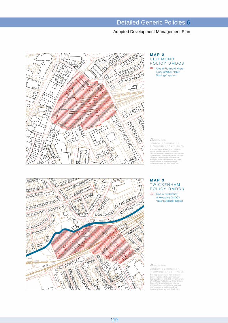
Wes
tmins
ter H
ouse
Community College
Northumbria Court
Richmond Station
Thames Link
St John's Church
LICHFIELD GARDENS
Orie
l Hou
se
Orange Tree
LARKFIELD ROAD
CH
UR
CH
ST JOHN'S ROAD
DRUMMONDS
PARK
SHO
T
KEW R
OAD
THE
QU
ADR
ANT
Wes
tmins
ter H
ouse
Community College
Northumbria Court
Richmond Station
Thames Link
St John's Church
LICHFIELD GARDENS
Orie
l Hou
se
Orange Tree
LARKFIELD ROAD
CH
UR
CH
ST JOHN'S ROAD
DRUMMONDS
PARK
SHO
T
KEW R
OAD
THE
QU
ADR
ANT
M A P 2R I C H M O N DP O L I C Y D M D C 3
L O N D O N B O R O U G H O F R I C H M O N D U P O N T H A M E S
Not To Scale
Area in Richmond where policy DMDC3 “Taller Buildings” applies
This map is reproduced from Ordnance Survey material with the permission of Ordnance Survey on behalf of the Controller of Her Majesty's Stationery Office © Crown Copyright. Unauthorised reproduction infringes Crown copyright and may lead to prosecution or civil proceedings. Licence/Account no. 100019441. 2011.
LONDO
N ROAD
LOND
ON RO
AD
WHITTON ROAD
COLE PARK ROAD
GRO
SVENOR RO
AD
STATION YARD
Twickenham Station
Regal House
Sorting Office
LONDO
N ROAD
LOND
ON RO
AD
WHITTON ROAD
COLE PARK ROAD
GRO
SVENOR RO
AD
STATION YARD
Twickenham Station
Regal House
Sorting Office
M A P 3T W I C K E N H A MP O L I C Y D M D C 3
L O N D O N B O R O U G H O F R I C H M O N D U P O N T H A M E S
Not To Scale
Area in Twickenham where policy DMDC3 “Taller Buildings” applies
This map is reproduced from Ordnance Survey material with the permission of Ordnance Survey on behalf of the Controller of Her Majesty's Stationery Office © Crown Copyright. Unauthorised reproduction infringes Crown copyright and may lead to prosecution or civil proceedings. Licence/Account no. 100019441. 2011.
119
Detailed Generic Policies 6Adopted Development Management Plan

Policy DM DC 4
Trees and Landscape
The boroughs trees and landscape will be protected and enhanced by:
The use of Tree Preservation Orders (TPOs) where appropriate;Planting and encouraging others to plant trees, clumps and thickets particularly inareas of deficiency as shown on the Proposals Map and of a type and species asset out in the Borough’s Tree Strategy.continuing to maintain trees in streets and public open spaces and of selectivelyclearing and replanting trees;requiring landscape proposals in submissions for new development, which retainexisting trees and other important landscape features where practicable and includenew trees and other planting. Where trees are removed, appropriate replacementplanting will normally be required. There will be a presumption against schemesthat result in a significant loss of trees, unless replacements are proposed andthere is good reason such as the health of the trees, public amenity, street sceneor restoration of an historic garden. Landscaping schemes should take account ofthe Borough’s Tree Strategy.
6.1.25 The abundance of trees in the borough is a great asset to its environment, softeningthe hardness of buildings and streets, adding life, colour and character to the urban landscapeand enhancing open spaces and the riverside landscape. Trees and other planting includingcontiguous gardens and green oases, also provide an important habitat for wildlife, andreduce levels of airborne pollution, and increase the supply of oxygen, they are also importantfor shade for streets, open areas and for buildings and may reduce the use of air conditioning.Landscape design can be used to reduce surface water run off rates (see Policy DM SD 7'Sustainable Drainage').
6.1.26 Many trees are already protected by Tree Preservation Orders (TPOs), and theCouncil will continue to make TPOs where trees of environmental importance are threatened.Trees in Conservation Areas are, with some exceptions, automatically protected, as sixweeks notice must be given in writing to the Council before any proposed works are carriedout. Unauthorised works to protected trees can result in substantial fines. Where trees arefelled, the Council will normally require that an appropriate replacement be planted. HistoricParks, Gardens and Landscapes are covered in Policy DM OS 4 'Historic Parks, Gardensand Landscapes'. It is recognised that in some historic restoration schemes there may besome removal of trees.
6.1.27 The areas shown on the Proposals Map are those in which the Council considersfurther planting is most needed, but planting will also be encouraged throughout the borough.In some woodland areas periodic thinning and clearing may be necessary to ensure theoverall health of the wood. In streets it is important that species are chosen that areappropriate to the scale of their surroundings and public amenity. Planting will be inconsultation with statutory undertakers to safeguard underground apparatus.
6.1.28 The term “landscape” is taken to refer to the design of all space between buildings,and includes walls and boundaries and paving materials, as well as planting. Theseconsiderations are often vital in creating an appropriate setting to new developments and in
120
6 Detailed Generic PoliciesAdopted Development Management Plan
integrating new development to its surroundings. Landscape design must form an integralpart of any proposals and needs to be considered in relation to the development as a wholeat the start of a project. It should also relate to the character of the area.
6.1.29 The Council has produced a Tree Strategy for the borough, covering detailedguidance on the implementation of this policy both on public and private land includinglandscaping schemes as part of new development. The Tree Strategy suggests appropriatespecies for each area to reinforce character and biodiversity and encourages the plantingof appropriate native trees and species which take account of present and future climate.London’s Tree and Woodland Management Framework is also use relevant. The Mayorintends to plant 10,000 street trees and an additional 2 million trees elsewhere in Londonby 2025 to help both with mitigation and adaptation to climate change – see also Policy DMSD 4 'Adapting to Higher Temperatures and Need for Cooling' which refers to the importanceof trees for shading and their contribution to counteracting the urban heat island effect. TheCouncil has set a target of 250 new trees to be planted per annum.
National:PPS 1: Delivering Sustainable Development (2005)Regional:The London Plan (2011); policy 7. 21Local:Core Strategy CP7Borough Tree Strategy (1999)
Policy Background
Indicator: Number of street trees planted per annumTarget: 250 trees per annum (target already agreed for Parks Dept)
Targets and Monitoring
Policy DM DC 5
Neighbourliness, Sunlighting and Daylighting
In considering proposals for development the Council will seek to protect adjoiningproperties from unreasonable loss of privacy, pollution, visual intrusion, noise anddisturbance.
To protect privacy, for residential development there should normally be a minimumdistance of 20 m between main facing windows of habitable rooms.
The Council will generally seek to ensure that the design and layout of buildings enablessufficient sunlight and daylight to penetrate into and between buildings, and that adjoiningland or properties are protected from overshadowing in accordance with establishedstandards.
6.1.30 This policy covers all development including extensions and alterations. The aimis to protect existing occupiers as far as possible from the unreasonable impacts of newdevelopment. Adverse impact on neighbouring properties, including on the most well usedpart of gardens, can include actual and perceived loss of light including on solar panels,overlooking, loss of privacy, alteration to micro-climate, pollution from noise or light andoverpowering or obtrusive development. This could be from the new development itself andalso from associated uses such as ancillary buildings, parking areas, access ways, gardensand hard and soft landscaping.Whilst there may be some impact from any new development,the test is one of reasonableness, and the impact on habitable rooms (all separate living
121
Detailed Generic Policies 6Adopted Development Management Plan
rooms and bedrooms, plus kitchens with a floor area of 13 square metres or more) will begiven the most weight. The suggested minimum distance of 20m between habitable roomswithin residential development is for privacy reasons, a greater distance may be required for other reasons, or a lesser distance may be acceptable in some circumstances, for examplewhere there is a historical street pattern of buildings closer together. Such exceptions willnot be permitted to allow backland development. See also Policy DM HO 2 'Infill Development',Policy DM HO 3 'Backland Development', Policy DM HO 4 'Housing Mix and Standards' andthe Residential Development Standards SPD.
6.1.31 With respect to light, the Council will be guided in general terms by the standardsset out in Site Layout, Planning for Sunlight and Daylight, and in Sun on Ground Indicators(BRE 1991); or any standards replacing them, to ensure this.
National:PPS 1: Delivering Sustainable Development (2005)Regional:The London Plan (2011); policies 3.4, 7.4The London Plan - Interim Housing SPG (draft, 2010)London Housing Design Guide (2010)Local:Core Strategy CP 7
Policy Background
Core Strategy Indicator for CP7Targets and Indicators
Policy DM DC 6
Balconies and Upper Floor Terraces
Purpose built, well designed and positioned balconies or terraces are encouraged wherenew residential units are on upper floors. They should be:
sufficiently deep to allow adequate access and circulation around furniture.preferably located next to a dining or living spacepreferably receive direct sunlightdesigned to provide some shelter and privacy to neighbouring properties, eitherby using screens or by setting the balcony back within the façadebalustrades designed to screen stored items from viewdesigned for security and safety
The addition of balconies and upper floor terraces to existing properties will not generallybe permitted unless the above apply and they do not adversely affect neighbourliness(see Policy DM DC 5 'Neighbourliness, Sunlighting and Daylighting').
6.1.32 Balconies and terraces are encouraged by the London Plan where access to agarden is not possible, and further information on appropriate design requirements for purposedesigned features is included within the London Plan SPD on Residential Design Standards.Purpose designed balconies should follow the guidance. They are particularly encouragedin higher density areas where there is proportionately less open space and for residents whodo not have access to private gardens, and can also provide space for food growing.
122
6 Detailed Generic PoliciesAdopted Development Management Plan

6.1.33 With existing properties the addition of such features is often problematic as theyvery often cause overlooking or unreasonable disturbance to neighbouring properties, inthese cases Policy DM DC 5 'Neighbourliness, Sunlighting and Daylighting' should alsoapply.
National:PPS 1: Delivering Sustainable Development (2005)Regional:The London Plan (2011)London Housing Design Guide (2010)Local:Core Strategy CP7
Policy Background
N/ATargets and Indicators
Policy DM DC 7
Shop fronts and shop signs
The Council will resist the removal of shop fronts of architectural or historic interest.
The Council will expect proposals for new shop fronts or alterations to existing shopfronts to demonstrate a high quality of design, which complements the original design,proportions, materials and detailing of the shop front, surrounding streetscene and thebuilding of which it forms part.
Blinds, canopies or shutters where acceptable in principle must be appropriate to thecharacter of the shop-front and its setting; external security grilles will not normally bepermitted; in sensitive areas, rigid and gloss finish blinds will generally be unacceptable;
Signage and illumination to shop fronts must demonstrate a high quality of design, whichcomplements the character and materials of the shop front and surrounding streetscene,and does not compromise public safety. Large illuminated fascias will not normally bepermitted, even if these are in the "house style" of a particular store.
New shop fronts must be designed to allow equal access for all users, and canincorporate flood protection measures where appropriate. Proposals should take accountof the Councils SPD on Shop fronts and Shop Signs.
The Council will welcome proposals from groups of shops to add character to the streetscene by the use of harmonious high quality design, colours and materials for their shopfronts.
6.1.34 Shop fronts of architectural or historic interest make an important contribution tothe character and appearance of the borough.The design of new shopfronts and alterationsto existing shopfronts is important both to the appearance of the individual property and tothe maintenance of the character and appearance of commercial areas. The use of craftedwoodwork and metalwork will be encouraged.
6.1.35 Poorly sited or badly designed shop signs, including projecting signs, and illuminationcan have a detrimental effect on the character and appearance of areas and may raiseissues of public safety.
123
Detailed Generic Policies 6Adopted Development Management Plan

6.1.36 Any change should improve accessibility and take into account the objectives ofthe Disability Discrimination Act 2005.Where areas have been identified (e.g. in the Borough’sStrategic Flood Risk Assessment) as being susceptible to flooding particularly from surfacewater, appropriately designed measures (which do not compromise accessibility) to preventinundation via shop doorways, will be encouraged.
6.1.37 The Council will pay due regard to the Supplementary Planning Document onShopfronts when assessing proposals concerning shop fronts and shop signs.
National:PPS 1: Delivering Sustainable Development (2005)Regional:The London Plan (2011); policies 7.4, 7.6Local:Core Strategy CP7Shop Fronts SPD (2010)
Policy Background
N/ATargets and Monitoring
Policy DM DC 8
Advertisements and Hoardings
The Council will exercise strict control over the design and siting of advertisement hoardings and other advertisements to ensure that the character of individual buildingsand streets is not demonstrably harmed, having regard to the interests of amenity andpublic safety, including for disabled people, and highway safety.
Powers will be used to remove any advertisement or hoarding erected without permissionand where appropriate and practical, to challenge existing hoardings and advertisementsthat cause substantial injury to visual amenity and public safety, including for disabledpeople.
6.1.38 Advertising is closely associated with urban life and can be one of the most dominantelements of the environment. It can enhance the appearance and vitality of a street but canalso cause considerable damage to visual amenity by cluttering the built environment anddetracting from the quality of the area. Advertisements (defined under AdvertisementRegulations) include not only hoardings, but blinds and canopies with lettering, flags withlogos, balloons etc. In considering proposals for an advertising hoarding or otheradvertisement, including blinds and canopies where relevant, or in deciding whether to takeaction to remove an existing advertisement, the Council will have regard to the followingcriteria:
1. hoardings should be of good design and in scale with their surroundings;2. any advertisement display must not have an adverse effect upon road traffic conditions,
public safety including for disabled people, or highway safety;3. advertising displays will not be permitted where they would have an adverse effect
upon:
a Conservation Area;Listed Buildings or Buildings of Townscape Merit;
124
6 Detailed Generic PoliciesAdopted Development Management Plan
views from or within open spaces or along the Thames riverside and its tributaries;predominantly residential areas;
4. high level, brightly illuminated, or flashing advertisements will not normally be permittedespecially where they might disturb residents.
6.1.39 As a general rule, advertisement displays will be restricted to shopping, commercial,industrial or transport locations where they comply with the above criteria and do not causeexcessive visual clutter. It must be borne in mind that the Council's level of control is limitedand that a number of advertisements do not require formal consent from the local authority.A-boards will be discouraged where the Council has powers to do so.
National:PPS 1: Delivering Sustainable Development (2005)The Town and Country Planning (Control of Advertisements) (England)Regulations 2007Regional:The London Plan (2011); policies 7.4, 7.5Local:Core Strategy CP7
Policy Background
N/ATargets and Monitoring
Statement 2
Telecommunications
All applications for telecommunications apparatus will be considered in accordance withPPG 8 Telecommunications and any other relevant present or subsequent nationalplanning policy guidance.
Policy DM DC 9
Planning Application Checklist
All applications for planning permission should include a planning application checklist,which shows how the submission complies with national and local requirements forvalidation.
6.1.40 The checklist, obtainable from the Planning Department, will be applicable to allapplications, including for extensions and changes of use. Completion and submission ofthe checklist will ensure that the following issues have been addressed, either within theplans or the Design and Access Statement;- effect on adjoining buildings, servicing, parking,storage, refuse, recycling, accessibility (in a wider sense), servicing, landscape designdesigning out crime etc.
125
Detailed Generic Policies 6Adopted Development Management Plan
National:PPS 1: Delivering Sustainable Development (2005)Local:Core Strategy CP 7
Policy Background
N/AIndicators and Targets
126
6 Detailed Generic PoliciesAdopted Development Management Plan

Appendix One - Saved UDPpolicies superseded
Adopted Development Management Plan
127

Appendix One - Saved UDP policies superseded
GENERAL APPROACH AND STRATEGIC POLICIES
STG 5 Mixed use developmentSTG 9 Recreation, culture and entertainmentSTG 14 Monitoring and review
IMPLEMENTATION
IMP 2 Mixed uses
OPEN ENVIRONMENT
ENV 1 Metropolitan open landENV 2 Green beltENV 2A Major Developed Site in the Green beltENV 3 Other open land of townscape importanceENV 5 Protection of views and vistasENV 6 Green chainsENV 7 Contaminated landENV 8 Cemeteries and crematoriaENV 9 Trees in town and landscapeENV 10 Historic parks, gardens and landscapesENV 11 Retention and improvement of public open spaceENV 13 Lighting including floodlightingENV 14 Sports stadia/spectator sportsENV 15 Retention of recreation facilitiesENV 16 BridlewaysENV 17 Retention and provision of allotmentsENV 18 Sites of special scientific interest and other sites of nature importanceENV 19 Nature conservation and development proposalsENV 20 Green corridorsENV 23 Aims for monitoring and liaising with other nature conservation authoritiesENV 24 Species protectionENV 25 Local nature reservesENV 26 Thames Policy AreaENV 27 Access to the river Thames and the Thames Path national trailENV 28 Encouragement of the recreational use of the river Thames, tributaries andriverbanksENV 29 Jetties and PontoonsENV 30 Passenger and hire boatsENV 31 Riverside usesENV 32 Permanent mooring of houseboats and other craftENV 33 Nature conservation on the riverENV 34 Protection of the floodplain and urban washlandsENV 35 Surface water run-offENV 36 Tidal defencesENV 37 Culverting of water courses
128
Appendix One - Saved UDP policies supersededAdopted Development Management Plan

ENV 38 Riverbank and water pollutionENV 39 Clean water, foul sewers and sewage treatmentENV 40 Quality of groundwater
THE BUILT ENVIRONMENT
BLT 1 Designation of conservation areasBLT 2 Protection and enhancement of conservation areasBLT 3 Preservation of listed buildings and ancient monumentsBLT 4 Protection of buildings of townscape meritBLT 5 Use of historic buildingsBLT 7 Archaeological sitesBLT 8 Evaluation of archaeological sitesBLT 9 Development of archaeological sitesBLT 10 Vernacular buildingsBLT 11 Design considerationsBLT 12 Accessible environmentBLT 13 Planning guidanceBLT 14 Landscape and developmentBLT 15 Daylighting and sunlightingBLT 16 'Un-neighbourliness'BLT 17 Crime and public safetyBLT 19 Provision of art schemes in new developmentBLT 20 Shop-fronts of architectural interestBLT 21 New and altered shop-frontsBLT 22 Signs and illuminationBLT 23 Advertisements and hoardingsBLT 24 TelecommunicationsBLT 25 Street furniture and townscape materialsBLT 28 Forecourt parkingBLT 29 Existing injurious usesBLT 30 Protection from pollution in new development
TRANSPORT
TRN 2 Transport and new developments TRN 4 Car and bicycle parking standards TRN 5 Retention of off-street parking TRN 6 Traffic management and road safety TRN 7 Pedestrian safety TRN 8 Pedestrian routes and securityTRN 9 Pedestrian environment TRN 10 Public rights of way TRN 11 CyclingTRN 12 Public transport improvements TRN 13 Public transport movement TRN 14 Transport interchanges TRN 17 Traffic congestion TRN 18 Highway improvement and safeguarding lines
129
Appendix One - Saved UDP policies supersededAdopted Development Management Plan

TRN 21 On-street parking TRN 22 Off-street parking TRN 23 Station parking TRN 27 Rail and waterborne freight
HOUSING
HSG 2 Existing housing HSG 3 Retention of residential use HSG 4 Residential areas HSG 5 Residential in areas of mixed use HSG 9 Supported housing HSG 10 Hostels and homes HSG 11 Residential density and mix HSG 12 Backland and infill development HSG 13 Conversions - suitability of property HSG 14 Conversions - design considerations HSG 15 Non self-contained accommodation HSG 17 Quality of the residential environment HSG 18 Additional residential standards HSG 19 Community facilities
EMPLOYMENT AND ECONOMIC ACTIVITY
EMP 1 New development EMP 2 Business developments EMP 3 Provision, improvement and expansion of industrial, and storage and distributionpremises EMP 4 Retention of employment uses EMP 5 Home working EMP 7 Small and growing businessesEMP 9 Hotels and guest houses
COMMUNITY, CULTURE AND ENTERTAINMENT
CCE 2 Provision of new public services CCE 3 Use of surplus sites and premises CCE 6 Location of doctors' and dentists' surgeries CCE 9 Dual use of facilities CCE 10 Children's play facilitiesCCE 11 Provision for early years CCE 12 Youth centres CCE 13 Nature study facilities CCE 14 Libraries CCE 15 Retention of indoor recreation, cultural and entertainment facilitiesCCE 16 Provision of new recreation facilitiesCCE 17 Provision of new arts facilitiesCCE 18 New or extended entertainment facilitiesCCE 19 Local studies museum CCE 20 Community centres and public halls
130
Appendix One - Saved UDP policies supersededAdopted Development Management Plan

CCE 21 Public conveniencesCCE 23 Recycling sites and kerbside collectionsCCE 24 Location, Design and landscaping of Recycling FacilitiesCCE 25 Anaerobic Digestion Schemes and Home Composting
TOWN CENTRES AND RETAILING
TC 2 New shopping development in Richmond and the four district centresTC 3 Development in small centres TC 4 Facilities in new retail developments TC 5 Key Shopping FrontagesTC 6 Change of use in secondary frontages TC 7 Isolated shops and small groups of shops serving local needs TC 8 Change of use in other shopping frontages TC 9 Other considerations and conditions for non-A1 usesTC 10 Motor vehicle sales and showrooms
Appendix A – Car Parking Standards
Appendix B – List of Key and Secondary Shopping Frontages
Appendix C - Highway Improvement Lines
Appendix D - Supplementary Planning Guidance
Glossary
131
Appendix One - Saved UDP policies supersededAdopted Development Management Plan

Appendix Two - CentresHierarchy
Adopted Development Management Plan
132
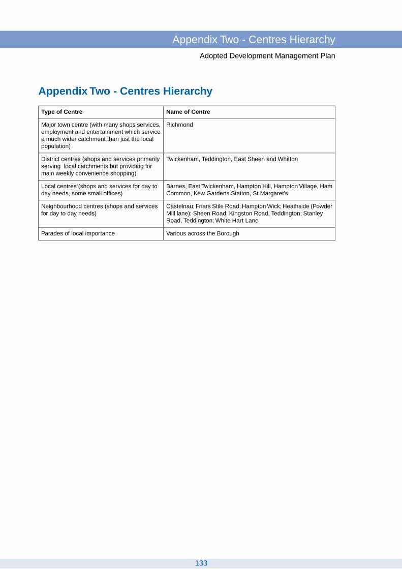
Appendix Two - Centres Hierarchy
Name of CentreType of Centre
RichmondMajor town centre (with many shops services,employment and entertainment which servicea much wider catchment than just the localpopulation)
Twickenham, Teddington, East Sheen and WhittonDistrict centres (shops and services primarilyserving local catchments but providing formain weekly convenience shopping)
Barnes, East Twickenham, Hampton Hill, Hampton Village, HamCommon, Kew Gardens Station, St Margaret’s
Local centres (shops and services for day today needs, some small offices)
Castelnau; Friars Stile Road; Hampton Wick; Heathside (PowderMill lane); Sheen Road; Kingston Road, Teddington; StanleyRoad, Teddington; White Hart Lane
Neighbourhood centres (shops and servicesfor day to day needs)
Various across the BoroughParades of local importance
133
Appendix Two - Centres HierarchyAdopted Development Management Plan

Appendix Three - List of Keyand Secondary Shopping
FrontagesAdopted Development Management Plan
134

Appendix Three - List of Key and Secondary ShoppingFrontages
Secondary FrontageKey Frontage
ASHBURNHAM ROAD
Ashburnham RoadNos. 171-185 (odd)
BARNES
Barnes High StreetNos. 1,1a,1b,1c,2, (consecutive)Nos. 65-69 (consecutive)Nos. 33-36a (consecutive)
Barnes High StreetNos. 3- 25 (consecutive)Nos. 51-64 (consecutive)
Church RoadNos. 125-145 (odd)Nos. 54-102 (even)Nos. 49-85 (odd)
Church RoadNos. 145a-175 (odd)
Rocks LaneNos. 1-9
CASTELNAU
CastelnauNos.174-202 (even)Nos.185-201 (odd)
EAST SHEEN
Sheen LaneNos. 105-135 (odd)Nos. 28-40 (even)Nos. 31-63 (odd)Nos. 65A-77 (odd)
Sheen LaneNos. 137-141 (odd)Parkway House
Upper Richmond Road WestNos. 220-254 (even)Nos. 256-296 (even)Nos. 341-361 (odd)Nos. 363-445 (odd)
Upper Richmond Road WestNos. 184-218 (even)Nos. 215-339 (odd)Nos. 298-318 (even)Nos. 447-501 (odd)Nos. 1- 10 Grand Parade (consecutive)
EAST TWICKENHAM
Richmond RoadNos. 359-387 (odd)Nos. 417-447 (odd) not including 439Nos. 332-342 (even)Nos. 382-428 (even)
Richmond RoadNos. 344-380 (even)
FRIARS STILE ROAD
Friars Stile RoadNos. 19-23A (odd)Nos. 36-56 (even)
135
Appendix Three - List of Key and Secondary Shopping FrontagesAdopted Development Management Plan

Secondary FrontageKey Frontage
FULWELL
Hampton RoadNos. 206-224 (even)
HAM STREET / BACK LANE
Back LaneNos. 4-14 (even)
Ashburnham RoadNos. 2-16 (even)
Ham StreetNos. 63-71 (odd)
HAM COMMON
Richmond RoadNos. 406-414a (even)
Upper Ham RoadParkleys Parade 1-6 (consecutive)Nos. 21-31 (odd)
Richmond RoadNos. 299-323 (odd)Nos. 414-432 (even)
HAMPTON HILL
High StreetNos. 73-83;101-111;131-143Nos. 185-201; 203-217(odd)Nos. 10-48; 118a-118eNos. 120-122 (even)
High StreetNos. 50-78 (even)Nos. 169-183 (odd)
HAMPTON NURSERY LANDS
Tangley Park RoadNos. 26-30 (consecutive)
HAMPTON VILLAGE
Milton RoadNos. 78-82 (even)
Milton RoadNos. 70-76 (even)
Ashley RoadNos. 27-37 (odd)
Station RoadNos. 70-82 (even)Nos. 92-100 (even)
Station ApproachNos. 4-9
Station ApproachNos. 1-3 (consecutive) Oldfield Road
Nos. 55-63 (odd)
Wensleydale RoadNos. 1-13 (odd) Percy Road
No. 31
Priory RoadNos. 33-41 (odd)
136
Appendix Three - List of Key and Secondary Shopping FrontagesAdopted Development Management Plan

Secondary FrontageKey Frontage
HAMPTON WICK
High StreetNos.32-48 (even)No. 56-58 (even)
HEATHSIDE
Hanworth RoadNos.646-670 (even)
Powder Mill LaneNos.222-226 (even)Nos.221-247 (odd)
HOSPITAL BRIDGE ROAD
Staines RoadNos.326-336 (even)
KEW GARDENS STATION
North RoadNos. 102-109 (consecutive)
Station ApproachNos. 1-9 (consecutive)
Royal ParadeNos. 1-9 (consecutive)
Station ParadeNos. 1-17 (odd)Nos. 2-18 (even)
KEW GREEN
Mortlake TerraceNos. 1-9 (consecutive)
KEW ROAD
Kew RoadNos. 101-145 (odd)Nos. 84-112 (even)
KINGSTON ROAD
Kingston RoadNos. 210-216 (even)
Kingston RoadNos. 149-161 (odd)Nos. 190-208 (even)
Bushy Park RoadNos. 1-5 The Pavement (consecutive)
LOWER MORTLAKE ROAD
Lower Mortlake RoadNos. 225-231 (odd)
Lower Mortlake RoadNos. 203-223 (odd)
NELSON ROAD
Nelson RoadNos.300-310 (even)Nos.314-322 (even)
RICHMOND TOWN
137
Appendix Three - List of Key and Secondary Shopping FrontagesAdopted Development Management Plan

Secondary FrontageKey Frontage
Duke StreetNos. 1-6 (consecutive)No. 8
Brewers LaneNos. 2-18 (even)Nos. 3-13 (odd)
Eton StreetNos. 1-3 (odd)
Bridge StreetNos. 1-2 (consecutive)
Nos. 2-18 (even)Dome BuildingsNos. 1-6 (consecutive)
Hill RiseNos. 1-17 (odd)George Street
Nos. 1-84 (consecutive)Kew RoadNos.1-61 (odd)Lower George Street
Nos. 1-8 (consecutive)Petersham RoadNos. 1-13 (odd)Church Court
Nos. 1-6 (even)The QuadrantNos. 19-32 (consecutive)Golden Court Parade
Nos. 1-9 (odd)premises adj. to 27-28 The Green & fronting GoldenCourt
Richmond HillNos. 6-26 (even)
The GreenNos. 13, 26-29 (consecutive)
Red Lion StreetNos. 10-32 (even)
Hill RiseNos. 2-32 (even)Nos. 40-86 (even)
Sheen RoadNos. 15-21 (odd)
Westminster HouseNos. 1-7 (consecutive)Hill Street
Nos. 1-23 (odd)Nos. 2-74 (even)
King StreetNos. 4-16 (consecutive)Nos. 19-19a, 20-26 (consecutive)
Lichfield Court Parade, Sheen RoadNos. 1-16 (consecutive)
The Passage
Paved CourtNos. 1-17 (consecutive)
The QuadrantNos. 1-18 (consecutive)Nos. 33-50 (consecutive)
Red Lion StreetNos. 1-3 (odd)Nos. 2-8 (even)
Sheen RoadNos. 1-13 (odd)Nos. 2-4 (even)
The Square
138
Appendix Three - List of Key and Secondary Shopping FrontagesAdopted Development Management Plan

Secondary FrontageKey Frontage
Nos. 1-4 (consecutive)Former public convenience
ST MARGARETS
Amyand Park RoadNos. 208, 210
Crown RoadNos. 2-24 (even)
Crown RoadNos. 26-32 (even)Nos. 35-43 (odd)Nos. 34-48 (even)
St. Margarets RoadNos. 125-155 (odd)Nos. 109-119 (odd)
St Margarets RoadNo. 123 Station KiosksNos. 116-126A (even)Nos. 157-165 (odd)
ST MARGARETS ROAD
St Margarets RoadNos. 379-391 (odd)
SANDYCOMBE ROAD
Sandycombe RoadNos.2 96-308 (even)
Sandycombe RoadNos. 293-303 (odd)
SHEEN ROAD
Sheen RoadNos. 80-94
Sheen RoadNos. 106-124 (even)
STANLEY ROAD
Stanley RoadNos. 186-192 (even)Nos. 139-147 (odd)
Stanley RoadNos. 176-184 (even)Nos. 91-121 (odd)
STRAWBERRY HILL
Tower RoadNos.50-56 (even)Nos.70-74 (even)Nos.39-45 (odd)
Wellesley ParadeNos.1-6 (consecutive)
TEDDINGTON
139
Appendix Three - List of Key and Secondary Shopping FrontagesAdopted Development Management Plan

Secondary FrontageKey Frontage
Broad StreetNos. 1-15 (odd) [including Oval Court]Nos. 2-6 (even)Nos. 74-86 (even)Church RoadNos. 1-13 (odd)Nos. 6-16 (even)
Broad StreetNos. 17-67 (odd)Nos. 8-72 (even)
High StreetNos. 6-42 (even)Nos. 70-98 (even)Nos. 19-67 (odd)Nos. 73-121 (odd) High Street
Nos. 100-160 (even)Station RoadNo. 1 The Causeway
Nos. 2-28 (even)Nos. 1-13 (odd)
TWICKENHAM GREEN
Staines RoadNos. 8-38a (even)
TWICKENHAM
Heath RoadNos. 46-164 (even)Nos. 1-85 (odd)Nos. 149-157 (odd)
Church StreetNos. 9-28 (consecutive)Nos. 31-58 (consecutive)
Heath RoadNos. 2-44 (even) King Street
Nos. 41-59 (odd)King StreetNos. 1-39 (odd)Nos. 2-62 (even)
London RoadNos. 11-65 (odd)
London RoadNos. 1-9 (odd)Nos. 2-50 (even)
York StreetNos. 4-18 (even)
York StreetNos. 1-19 (odd)No. 2
WALDEGRAVE ROAD
Waldegrave RoadNo. 189-195 (odd)
Waldegrave RoadNos. 150-158 (even)Nos. 197-207 (odd)
WHITE HART LANE
The BroadwayNos. 1-10 (consecutive)
White Hart LaneNos. 36-78 (even)Nos. 147-153 (odd)
White Hart LaneNos. 1-7 (odd)
Upper Richmond Road WestNos. 42-48 (even)
140
Appendix Three - List of Key and Secondary Shopping FrontagesAdopted Development Management Plan

Secondary FrontageKey Frontage
WHITTON
High StreetNos. 1-35 (including 35a) (odd)Nos. 105-113 (odd)Nos. 115-123 (odd)Nos. 16-22 (even)Nos. 108-114 (even)Nos. 120-136 (even)
High StreetNos. 24-58Nos. 60-106 (even)Nos. 37-103 (odd)
Bridge WayBridge Way House
Nelson RoadNos. 109-121 (odd)
WHITTON ROAD
Whitton RoadNos. 97-105 (odd)
141
Appendix Three - List of Key and Secondary Shopping FrontagesAdopted Development Management Plan

Appendix Four - ParkingStandards
Adopted Development Management Plan
142
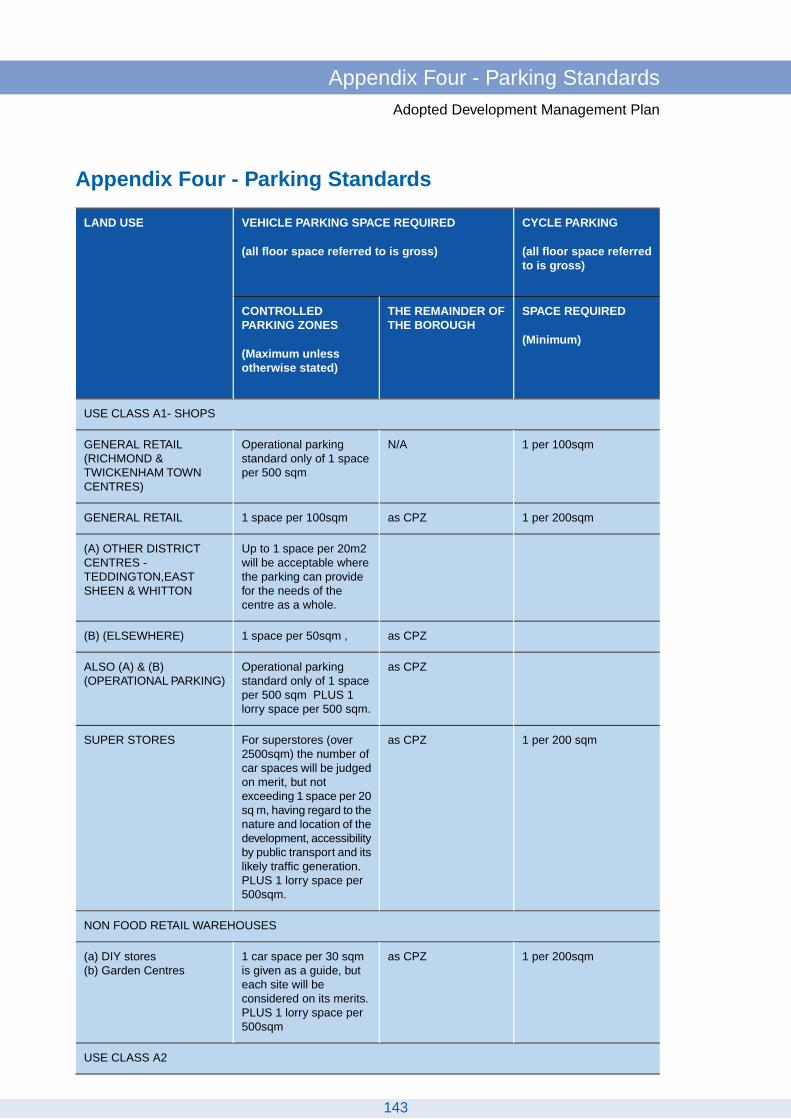
Appendix Four - Parking Standards
CYCLE PARKING
(all floor space referredto is gross)
VEHICLE PARKING SPACE REQUIRED
(all floor space referred to is gross)
LAND USE
SPACE REQUIRED
(Minimum)
THE REMAINDER OFTHE BOROUGH
CONTROLLEDPARKING ZONES
(Maximum unlessotherwise stated)
USE CLASS A1- SHOPS
1 per 100sqmN/AOperational parkingstandard only of 1 spaceper 500 sqm
GENERAL RETAIL(RICHMOND &TWICKENHAM TOWNCENTRES)
1 per 200sqmas CPZ1 space per 100sqmGENERAL RETAIL
Up to 1 space per 20m2will be acceptable where
(A) OTHER DISTRICTCENTRES -
the parking can provideTEDDINGTON,EASTSHEEN & WHITTON for the needs of the
centre as a whole.
as CPZ1 space per 50sqm ,(B) (ELSEWHERE)
as CPZOperational parkingstandard only of 1 space
ALSO (A) & (B)(OPERATIONAL PARKING)
per 500 sqm PLUS 1lorry space per 500 sqm.
1 per 200 sqmas CPZFor superstores (over2500sqm) the number of
SUPER STORES
car spaces will be judgedon merit, but notexceeding 1 space per 20sq m, having regard to thenature and location of thedevelopment, accessibilityby public transport and itslikely traffic generation.PLUS 1 lorry space per500sqm.
NON FOOD RETAIL WAREHOUSES
1 per 200sqmas CPZ1 car space per 30 sqm is given as a guide, but
(a) DIY stores(b) Garden Centres
each site will beconsidered on its merits.PLUS 1 lorry space per500sqm
USE CLASS A2
143
Appendix Four - Parking StandardsAdopted Development Management Plan
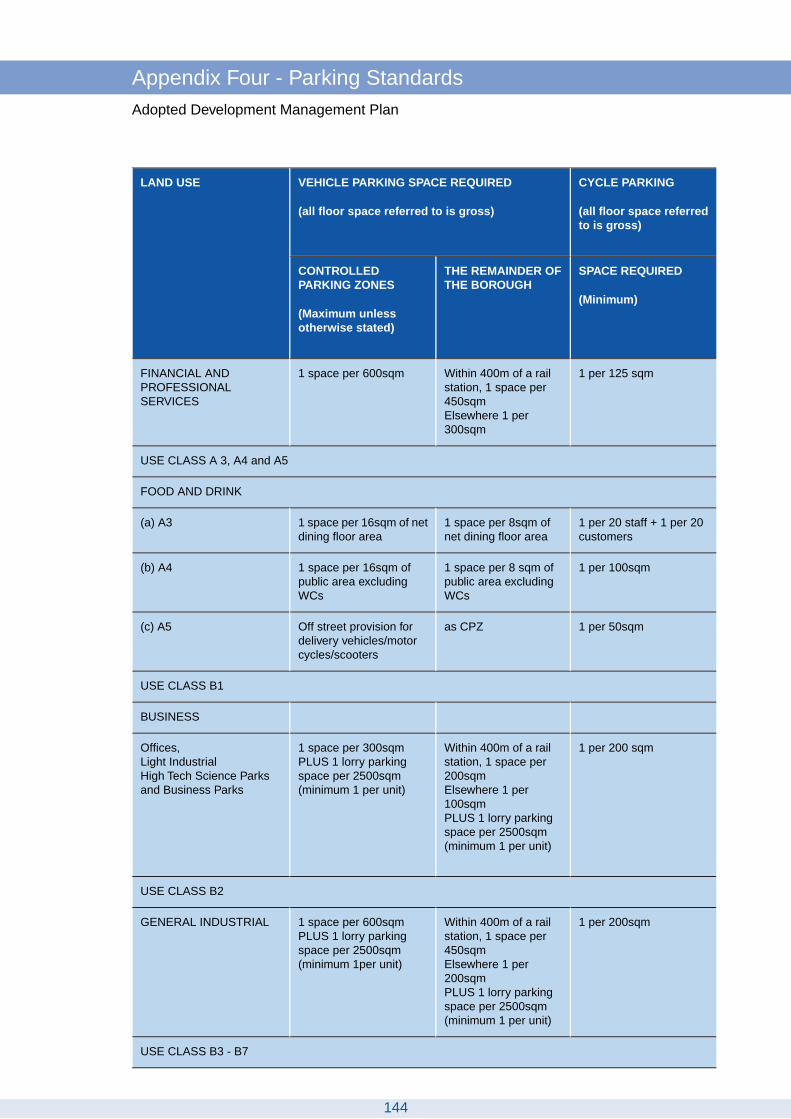
CYCLE PARKING
(all floor space referredto is gross)
VEHICLE PARKING SPACE REQUIRED
(all floor space referred to is gross)
LAND USE
SPACE REQUIRED
(Minimum)
THE REMAINDER OFTHE BOROUGH
CONTROLLEDPARKING ZONES
(Maximum unlessotherwise stated)
1 per 125 sqmWithin 400m of a railstation, 1 space per450sqmElsewhere 1 per300sqm
1 space per 600sqmFINANCIAL ANDPROFESSIONALSERVICES
USE CLASS A 3, A4 and A5
FOOD AND DRINK
1 per 20 staff + 1 per 20customers
1 space per 8sqm ofnet dining floor area
1 space per 16sqm of netdining floor area
(a) A3
1 per 100sqm1 space per 8 sqm ofpublic area excludingWCs
1 space per 16sqm ofpublic area excludingWCs
(b) A4
1 per 50sqmas CPZOff street provision fordelivery vehicles/motorcycles/scooters
(c) A5
USE CLASS B1
BUSINESS
1 per 200 sqmWithin 400m of a railstation, 1 space per200sqmElsewhere 1 per100sqmPLUS 1 lorry parkingspace per 2500sqm(minimum 1 per unit)
1 space per 300sqmPLUS 1 lorry parkingspace per 2500sqm(minimum 1 per unit)
Offices,Light IndustrialHigh Tech Science Parksand Business Parks
USE CLASS B2
1 per 200sqmWithin 400m of a railstation, 1 space per450sqmElsewhere 1 per200sqmPLUS 1 lorry parkingspace per 2500sqm(minimum 1 per unit)
1 space per 600sqmPLUS 1 lorry parkingspace per 2500sqm(minimum 1per unit)
GENERAL INDUSTRIAL
USE CLASS B3 - B7
144
Appendix Four - Parking StandardsAdopted Development Management Plan

CYCLE PARKING
(all floor space referredto is gross)
VEHICLE PARKING SPACE REQUIRED
(all floor space referred to is gross)
LAND USE
SPACE REQUIRED
(Minimum)
THE REMAINDER OFTHE BOROUGH
CONTROLLEDPARKING ZONES
(Maximum unlessotherwise stated)
1 per 200sqmas CPZParking requirement foruse within these
SPECIAL INDUSTRIAL
categories will beassessed on their merits
USE CLASS B8
1 per 200sqmWithin 400m of a railstation, 1 space per450sqmElsewhere 1 per200sqmPLUS 1 lorry parkingspace per 2500sqm(minimum 1 per unit)
1 space per 600sqmPLUS 1 lorry parkingspace per 2500sqm(minimum 1per unit)
STORAGE ANDDISTRIBUTION
USE CLASS C1
HOTELS AND HOSTELS
1 per 2 units of staffaccommodation
1 space per bedroom ,plus allowance for other
1 space per 5 bedrooms, plus allowance for other
(a) Hotels
facilities available to thefacilities available to thepublic based upon therelevant standards.
public based upon therelevant standards.
1 coach parking/settingdown space of 1space
1 coach parking/settingdown space of 1 space
per 100 bedrooms, alsoper 100 bedrooms, alsoallowance must beallowance must be made
for setting down by taxis made for setting downby taxis
1 per 2 occupantsas CPZ1 space per 4-6occupants depending ontype of hostel
(b) Residential Hostels
CYCLE PARKINGVEHICLE PARKING SPACE REQUIREDLAND USE
SPACE REQUIREDTHE REMAINDER OFTHE BOROUGH
CONTROLLED PARKINGZONES
USE CLASS C2
RESIDENTIAL INSTITUTIONS
145
Appendix Four - Parking StandardsAdopted Development Management Plan

CYCLE PARKING
(all floor space referredto is gross)
VEHICLE PARKING SPACE REQUIRED
(all floor space referred to is gross)
LAND USE
SPACE REQUIRED
(Minimum)
THE REMAINDER OFTHE BOROUGH
CONTROLLEDPARKING ZONES
(Maximum unlessotherwise stated)
0.5 spaces per unit ofstaff accommodation
as CPZ1 space per 5 residentsplus 0.5 spaces per unitof staff accommodation
(a) Residential Care Homesor Nursing Homes
1 per 200sqmas CPZ0.5-1.0 spaces per bed(b) Hospitals
0.5 spaces per bedroomas CPZ0.5 spaces per bedroom(c) Residential Colleges orEducational Centres
NOTE: Each case will be considered on its merits having regard to the nature of services being provided.
USE CLASS C3
In CPZs occupiers of new residential developments may not be eligible for onstreet parking permits where existing levels of on street parking are very high.
STANDARD RESIDENTIAL
(Blue Badge holders exempt) There are exceptions to this rule which are detailedin Policy DM TP 8. Garages will be treated as parking spaces.
1 space1-2 bedrooms1 space
1- 2 bedrooms1 space
1 space3 bedrooms3 bedroomsFor 1 unit, 2 spaces; fortwo or more units 1allocated space plus
For 1 unit, 2 spaces; fortwo or more units 1allocated space plussufficient unallocated
spaces to provide a totalof 1.5 spaces overall perunit
sufficient unallocatedspaces to provide atotal of 1.5 spacesoverall per unit
2 spaces4+ bedrooms2 spaces (negotiable)
4+ bedrooms2 spaces
To be assessed inaccordance with the
As CPZParking will be assessedin accordance with the
Conversion and/orextension of existingresidential units standards as specified
abovestandard for each size ofunit
RETIREMENT HOUSING
Optional figure of 1 spaceper 4 dwellings
as CPZ1 space per 2 dwellings(unassigned) . Subject to
Self contained units withsome communal facilities,
the future tenure and agebut without a residentwarden of prospective occupants.
146
Appendix Four - Parking StandardsAdopted Development Management Plan

CYCLE PARKING
(all floor space referredto is gross)
VEHICLE PARKING SPACE REQUIRED
(all floor space referred to is gross)
LAND USE
SPACE REQUIRED
(Minimum)
THE REMAINDER OFTHE BOROUGH
CONTROLLEDPARKING ZONES
(Maximum unlessotherwise stated)
Retired persons areconsidered to be over
SHELTERED HOUSING
1 space for residentwarden
as CPZ1 space per 4 dwellingsplus 1 space for resident
Self contained units withsome communal facilities,
wardens unit. All spacesbut without a residentwarden except the wardens unit
shall be unassigned
1 space per dwelling1 space per dwelling(unassigned)
REGISTERED PROVIDERDEVELOPMENT
USE CLASS D1
To be judged on its meritsas CPZThe variety of categoriesof use within this use are
NON RESIDENTIALINSTITUTIONS
such that it isinappropriate to definestandards. Eachapplication will thereforebe judged on its merits
1 per consulting room4 spaces per consultingroom
1 space per consultingroom
Clinics, Health Centres,Dentists/Doctors Surgeries
1 per 3 staff1 space per 4 staff1 per 4 staff plusadequate space for
Parent and toddler groups
delivery and collection ofchildren maximum
1 per 20 persons/seats1 space per 5 persons/seats
1 space per 10persons/seatsPLUS 1 coach space per50 persons/seats
Public Halls
1 per 20 seatsas CPZ1 per 10 seatsPlaces of Worship
1 per 3 staff1 space per 2 staff (fulltime equivalent)
1 space per 4 staff.Adequate setting down
Play groups and daynurseries
areas for cars shall beprovided atestablishments whichcater for more than 20children
147
Appendix Four - Parking StandardsAdopted Development Management Plan

CYCLE PARKING
(all floor space referredto is gross)
VEHICLE PARKING SPACE REQUIRED
(all floor space referred to is gross)
LAND USE
SPACE REQUIRED
(Minimum)
THE REMAINDER OFTHE BOROUGH
CONTROLLEDPARKING ZONES
(Maximum unlessotherwise stated)
5 spaces per classroomdepending on the natureof the school
1 space per 2 staff1 space per 2 staff.Arrangements must alsobe made for adequate
Schools
setting down areas andvisitor parking spacesAdequate facilities for thesetting down of coachesshall also be considered
USE CLASS D2
NOTE: The variety of facilities which may be offered are such that alternativesmay be justified. The following standards are reproduced for the guidance ofdevelopers:
ASSEMBLY AND LEISURE
1 per 50 persons1 space per 5 persons1 space per 10 persons(a) Places of entertainment,Theatres, Cinemas, BingoClubs, Dance Halls
1 per 50 seats1 space per 5 persons1 space per 10 persons PLUS 1 coach space per150 seats
(b) Conference Centres
1 per 200sqm1 space per 25 sq m1 space per 50 sqmPLUS 1 coach space per300sqm
(c) Exhibition Halls
(d) Sports and Leisure Complexes
1 per 10 staff + 1 per 20peak period visitors
1 space per 25 sq m1 space per 50 sqmAdequate setting downand parking facilities forcoaches
Leisure Centres &Swimming Pools
2 per court3 spaces per court1 space per courtTennis & Badminton Courts
1 per court2 spaces per court1 space per courtSquash Courts
OTHER USES
(a) Repair Garages
1 per 2 staffas CPZ1 per 4 staffPetrol Filling Stations
1 per 2 staffas CPZ6 spaces per repair bayRepair Workshops
1 per 2 staffas CPZ6 spacesMOT Testing Centres
148
Appendix Four - Parking StandardsAdopted Development Management Plan
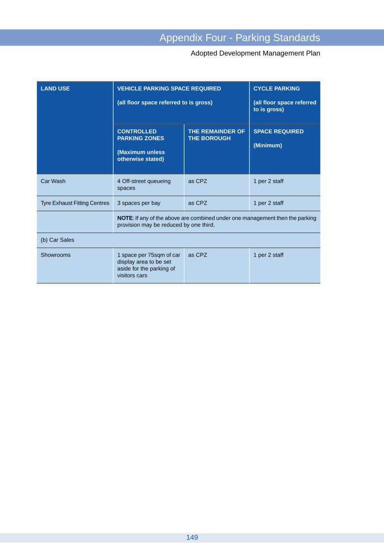
CYCLE PARKING
(all floor space referredto is gross)
VEHICLE PARKING SPACE REQUIRED
(all floor space referred to is gross)
LAND USE
SPACE REQUIRED
(Minimum)
THE REMAINDER OFTHE BOROUGH
CONTROLLEDPARKING ZONES
(Maximum unlessotherwise stated)
1 per 2 staffas CPZ4 Off-street queueingspaces
Car Wash
1 per 2 staffas CPZ3 spaces per bayTyre Exhaust Fitting Centres
NOTE: If any of the above are combined under one management then the parkingprovision may be reduced by one third.
(b) Car Sales
1 per 2 staffas CPZ1 space per 75sqm of cardisplay area to be set
Showrooms
aside for the parking ofvisitors cars
149
Appendix Four - Parking StandardsAdopted Development Management Plan

GlossaryAdopted Development Management Plan
150

Glossary
Affordable Housing
Housing subsidised in some way for people unable to rent or buy on the open housingmarket. PPS3 Housing defines affordable housing as follows: "Affordable housing includessocial rented and intermediate housing, provided to specified eligible households whoseneeds are not met by the market. Affordable housing should:
Meet the needs of eligible households including availability at a cost low enough forthem to afford, determined with regard to local incomes and local house prices.Include provision for the home to remain at an affordable price for future eligiblehouseholds or, if these restrictions are lifted, for the subsidy to be recycled for alternativeaffordable housing provision."
Article 4 Direction
A direction under Article 4(2) of the General Development Order, which may require approvalby the Secretary of State, bringing under the control of the local planning authority anyspecified developments normally permitted under the Town and Country Planning (GeneralPermitted Development) Order 1995.
Biodiversity
Literally the 'variety of life' - the innumerable species of animals and plants on earth, andthe wide range of urban and rural habitats where they live, including the links and interactionsbetween all of these.
Blue Ribbon Network
A spatial policy element of the London Plan covering London’s waterways and water spaces,including land alongside them. Aside from the River Thames, the other major componentsof the network within the borough of Richmond are the River Crane and Beverley Brook.
Building of Townscape Merit
Building or group of buildings that is not on the statutory list of buildings of special architecturalor historic interest but that contributes positively and significantly to the character andappearance of an area.
BREEAM
BREEAM (Building Research Establishment Environmental Assessment Method) is theleading and most widely used environmental assessment method for buildings within theUK. It sets the standard for best practice in sustainable design and has become the de factomeasure used to describe a building's environmental performance. It assesses theperformance of buildings in the following areas: management, energy use, health andwell-being, pollution, transport, land use and ecology, waste, materials and water.
Brownfield Site (see Previously Developed Land)
Code for Sustainable Homes
151
GlossaryAdopted Development Management Plan

The Code for Sustainable Homes is the national standard for the sustainable design andconstruction of new homes, which aims to reduce carbon emissions and create homes thatare more sustainable. It became operational in England in April 2007 and a Code rating fornew build homes became mandatory from 1 May 2008.The Code measures the sustainabilityof a new home against categories of sustainable design, rating the ‘whole home’ as acomplete package. The Code uses a 1 to 6 star rating system to communicate the overallsustainability performance of a new home.
Combined Heat and Power (also see Decentralised Energy)
Combined Heat and Power (CHP) is the use of a single piece of plant to generate both heatand electricity. In conventional power generation large quantities of energy in the form ofheat are wasted. The waste heat from the CHP plant’s engine is utilised for a heatingapplication such as making hot water or space heating.
Community Plan
An overall vision for the borough for the period 2007-2017, produced by the Local StrategicPartnership and covering 7 priorities:
Tackling disadvantage and inequalitiesBeing the greenest borough in LondonBeing the safest London borough for all our communitiesGrowing up in Richmond upon ThamesCreating a healthy and caring Richmond upon ThamesCreating a vibrant and prosperous Richmond upon ThamesImproving access and participation
Conservation Area
An area declared by a local planning authority in accordance with the Town and CountryPlanning Act 1990 (as amended), as being of special architectural, historical or landscapeinterest, the character or appearance of which it is desirable to preserve or enhance. Consentis required for the demolition or partial substantial demolition of unlisted buildings inConservation Areas. It is advisable to consult the Council before carrying out propertyalterations or tree pruning work within a Conservation Area.
Core Strategy DPD
The Core Strategy sets out the key elements of the planning framework for the area. It iscomprised of a spatial vision and strategic objectives for the area; a spatial strategy; corepolicies; and a monitoring and implementation framework with clear objectives for achievingdelivery. All other Development Plan Documents must be in conformity with the adoptedCore Strategy.
Decentralised Energy (also see Combined Heat and Power)
A Decentralised Energy (DE) scheme provides heat and/or power from a central source ator near the point of consumption to more than one building, dwelling or customer. It includeshigh efficiency co-generation or Combined Heat and Power (CHP), on-site renewable energysystems and/or energy recycling systems. It is an alternative to providing individual nationalgrid-connected systems to each dwelling. Schemes can vary in size from a few dwellings tocity-wide networks, and reduce costs for tenants and cut carbon dioxide emissions.
152
GlossaryAdopted Development Management Plan

Density (Residential)
As stated in PPS3 Housing: “Density is a measure of the number of dwellings which can beaccommodated on a site or in an area”. This document sets national indicative minimumdensities for new residential development of 30 dwellings per hectare (dph) net. Net dwellingdensity is calculated by including only those site areas which will be developed for housingand directly associated uses, including access roads within the site, private garden space,car parking areas, incidental open space and landscaping and children’s play areas, wherethese are provided.
Design and Access Statements
Design and Access Statements cover design concepts and principles as well as accessissues. They must be submitted for some types of planning application, and in somedesignated areas. The statutory requirements for design and access statements are set outin Article 4C of the GDPO.
Designated Shopping Frontage
Divided into 2 categories:
Key frontage: Shopping area which is to be retained primarily in retail use and from whichfurther non-shop uses will normally be excluded.
Secondary frontage: Area intended for shopping use where complementary non-retail usessuch as cafes, launderettes, estate agents etc. may be permitted.
Developer Contributions (see Planning Obligations)
Development
Defined and qualified by the Town and Country Planning Act 1990 (s.22) as the carrying outof building, engineering, mining or other operations in, on, over, or under land, or the makingof any material change in the use of any building or other land.
Development Plan Documents (DPDs)
The Local Development Framework is partly comprised of Development Plan Documents,which in turn comprise the Core Strategy, Site Allocations, Proposals Map, DevelopmentManagement Policies and sometimes Area Action Plans.
District Centre (East Sheen,Teddington,Twickenham, Whitton)
Ranging in size from 10,000 – 50,000 sqm of retail floorspace these centres provideconvenience and services for local customers with comparison shopping floorspace rarelyexceeding 50% of the total.The majority of people that use them are on foot, although accessby car and public transport needs to be provided for. Some have individual specialist functionsdue to their lower rent.
EcoHomes (see BREEAM and Code for Sustainable Homes)
153
GlossaryAdopted Development Management Plan

EcoHomes was a version of BREEAM for new, converted or renovated homes, coveringhouses, flats and apartments. In April 2007 the Code for Sustainable Homes replacedEcoHomes for the assessment of new housing in England, but it is continued to be used forrefurbished housing in England.
Employment Land / Site
Land/sites defined by the Local Planning Authority for employment uses. Includes, but is notexclusive to, land lawfully used for general industrial, light industrial, business, and officeuse, storage and distribution, business parks, specialist technology, research anddevelopment.
Environmental Impact Assessment (EIA)
EIAs are required by the European Directive 85/337/EEC. The procedures have beentransposed into UK legislation; in relation to planning, EIAs are covered by a separateRegulation: The Town and Country Planning (Environmental Impact Assessment) (Englandand Wales) Regulations 2011. These regulations set out when an EIA has to be carried outand submitted.
Examination
Undertaken on the ‘soundness’ of the Submission Local Development Framework Documents.The examination is held by an independent inspector appointed by the Secretary of State.The final report is binding on the Council. For Development Plan Documents an examinationis held even if there are no representations.
Evaporation
The physical process by which a liquid (i.e. water) is transformed to the gaseous state/vapour.
Evapo - transpiration
The sum of evaporation and transpiration, which means the discharge of water from theearth’s surface to the atmosphere by evaporation from surface water and soil surfaces andby transpiration from plants (plants emitting water vapour from their leaves).
Family housing
Family housing is generally defined as having three or more bedrooms, however if of asuitable size (meeting the required amenity standards) a two bedroom property can bedesigned for 3 or 4 persons and would be considered as family housing.
Green Belt
National policy designations that help to contain development, protect the countryside andpromote brownfield development, and assists in the urban renaissance. There is a generalpresumption against inappropriate development in the Green Belt.
Green Chains
A series of linked open spaces forming extended parkways for the public and wildlife corridorsin natural surroundings. These can cross borough boundaries.
154
GlossaryAdopted Development Management Plan
Green Corridor
Near continuous areas of open space that link Green Belt, Metropolitan Open Land andSites for Local Nature Conservation, which provide amenity, access, landscaping and conduitsfor plants and animals.
Habitable Rooms
Reception rooms, kitchens over 13 sqm and bedrooms
Health Impact Assessment (HIA)
HIAs are a method of estimating the potential health effects of the implementation of a planor programme; they may be required on larger schemes.
Historic Environment
All aspects of the environment resulting from the interaction between people and placesthrough time, including all surviving physical remains of past human activity, whether visibleor buried, and deliberately planted or managed fauna.
Listed Building
A building of special architectural or historic interest included on a statutory list. Permissionis required for their demolition or alteration.
Local Development Framework
Sets out, in the form of a 'portfolio’ or ‘folder’, the documents which collectively deliver thespatial planning strategy for the local planning authority's area. The Local DevelopmentFramework will be comprised of Development Plan Documents, Supplementary PlanningDocuments, the Statement of Community Involvement, the Local Development Scheme andthe Annual Monitoring Report.
Local Strategic Partnership (LSP)
Non-statutory, multi-agency partnerships which match local authority boundaries. LSPs bringtogether, at a local level, different parts of the public, private, community and voluntarysectors, allowing different services to support one another so that they can work moreeffectively together. LSPs are charged with developing Sustainable Community Strategiesand Local Area Agreements.
London Plan
The London Plan is the spatial development strategy for the Greater London area and theMayor of London is responsible for producing this planning strategy. It replaced the previousstrategic planning guidance for London (known as RPG3), issued by the Secretary of State.The London Plan deals with matters of strategic importance to the area. The plan was firstpublished by the Greater London Authority in 2004 and has been amended in 2008. Thecurrent adopted version is the London Plan 2011.
Main Windows
The primary window in a room, generally, but not always, in the front or rear elevations.
155
GlossaryAdopted Development Management Plan

Major Centre (e.g. Richmond, Chiswick, Putney)
Important shopping and service centres, but are typically smaller in scale and closer togetherthan those in the metropolitan category. They usually have at least 50,000 sqm of retailfloorspace and some may have developed specialist roles. With sizeable local catchmentareas, many of these centres have established cultural and entertainment facilities.
Metropolitan Open Land
An area of predominantly open land or water which is of significance to London as a whole,or to a part of London.The concept is described in detail in the Greater London DevelopmentPlan 1976 and shown approximately on the Key Diagram for subsequent definition onBorough Plan Proposals Maps.
Mixed Use Development
Development that combines a mix of uses either on a site or in individual buildings, such asflats or offices over shops. It can refer to a site or individual building with a mix of uses withinthe same building, or to a variety of uses in an area such as a neighbourhood, a town centreor an urban village. For a development to be viable and beneficial for the community, itshould be adequate to the scale of the site or development, taking into account its locationand its relationship with the surrounding area.
Other Open Land of Townscape Importance
Open areas, which are not extensive enough to be defined as Green Belt or MetropolitanOpen Land, but act as pockets of greenery of local significance, contribute to the localcharacter, and are valued by residents as open spaces in the built up area. These areascan include public and private sports grounds, some school playing fields, cemeteries,allotments, private gardens, areas of vegetation such as street verges and mature trees.
Open Space
Any open land that is used by the public or local community for outdoor recreation, whetherpublicly or privately owned and whether use is by permission, as of right, or de facto. Seethe Town and Country Planning Act 1971 Section 290 or 1990 Section 336. Open spacemeans any land laid out as a public garden, or used for the purpose of public recreation, orland which is a disused burial ground.
Planning Obligations
An additional feature of a privately-proposed development project, usually agreed throughnegotiation with the local planning authority, which complements that project and assists inmeeting the needs of the community. Examples include: providing open space, public rightof way or community facilities, affordable housing, housing infrastructure, bringing other sitesinto beneficial use, shared facilities, recreational uses, environmental or transportimprovements, or conservation of buildings or places of special historic or architecturalinterest.
Planning Policy Guidance note (PPG)
Statements of Government planning policy covering a range of issues. They are beingreplaced by Planning Policy Statements, which carry greater weight.
156
GlossaryAdopted Development Management Plan

Planning Policy Statement (PPS)
Statements of national policy and principles on aspects of the town planning framework.They apply to England only. They are legally binding and may be treated as materialconsiderations in the determination of planning applications. They were introduced underthe provisions of the Planning and Compulsory Purchase Act 2004 and are gradually replacingPPGs.
Previously Developed Land
Previously-developed land is that which is or was occupied by a permanent structure, includingthe curtilage of the developed land and any associated fixed surface infrastructure.
Proposals Map
An Ordnance Survey based map showing the location and extents of policies, site allocationsand constraints in Development Plan Documents, updated as necessary to reflect anychanges in such documents.
Public Open Space
Parks, recreation grounds and gardens provided by the local authority or central governmentfor public use even if they are closed at certain times. Public Open Space does not includeschool playing fields or the amenity areas associated with the development of homes or flatsor pedestrian precincts (Local Government Act 1966 Section 8). The River Thames towpathto which the public have unrestricted access is also considered locally to be Public OpenSpace.
Public Realm
That part of the built environment to which the public have free access, including streets,squares, parks, etc. Public realm issues embrace the social interaction and use of spacesas well as their servicing and management.
Public Transport Accessibility Levels (PTAL)
A measure of the relative accessibility of buildings and uses by public transport. The higherthe PTAL score, the better the accessibility.
SSSI (Site of Special Scientific Interest)
Protected area of land considered worthy of protection and of special interest by reasons ofany of its flora, fauna or geological features, under the Wildlife and Countryside Act 1981.
Registered Social Landlord (RSL) - see Registered Providers
Registered Providers
The technical name for social landlords, that are registered with the Tenant Services Authority- most are housing associations, but there are also trusts, co-operatives and companies,that own or manage affordable housing. From April 2010, the name has been replaced withRegistered Providers of social housing, which permits profit-making register providers, butthe term RSL continues to be commonly used.
157
GlossaryAdopted Development Management Plan

Renewable Energy/Renewables
Energy generated from sources that are non-finite or can be replenished, e.g. solar power,wind energy, power generated from waste, biomass etc.
Richmond Biodiversity Action Plan
A plan that sets objectives and actions for the conservation of biodiversity in Richmond, withmeasurable targets. The action plan also identifies priority species and habitats forconservation.
Site Allocations DPD
A DPD that sets out detailed proposals for the development of land in the area, with specificor mixed uses, locations and extents clearly shown.
Smaller Centre
A shopping centre that caters mostly for day-to-day needs, and for ‘topping-up’ betweenmain shopping trips.These centres vary considerably in size from over 100 shops to groupsof 6.
Strategic Environmental Assessment (SEA)
Required by European and UK law, SEA is a way of systematically identifying and evaluatingthe impacts that a plan is likely to have on the environment.The aim is to provide informationin the form of an Environmental Report that can be used to enable decision makers to takeaccount of the environment and minimise the risk of the plan causing significant environmentaldamage. Government guidance advises that where a plan requires both strategicenvironmental assessment and sustainability appraisal, that the former process should beintegrated into the latter one.
Strategic Flood Risk Assessment (SFRA)
Planning Policy Statement 25 (PPS25): Development & Flood Risk requires Local PlanningAuthorities to appraise the risk of flooding in their areas by undertaking a Strategic FloodRisk Assessment (SFRA). The aim is to avoid inappropriate development in areas at risk offlooding, and to direct development away from areas at highest risk. A Level 1 SFRA hasbeen carried out for the Council by Jacobs in June 2008 and it has been used as importantbackground evidence document for the Council's Local Development Framework, and inparticular for the Core Strategy. In August 2010, the London Borough of Richmond uponThames has completed the update to the 2008 SFRA. The Level 1 Update of the SFRA isa report which includes a series of maps that define areas of flooding in the borough accordingto various levels of risk and from the River Thames, its tributaries and other sources. TheLevel 1 SFRA Update supersedes the previous June 2008 SFRA. This SFRA will be usedto inform land allocations, to facilitate the application of the Sequential Test and in particular,advise Development Management, Emergency Planners and developers on flood risk matters.
Supplementary Planning Guidance/Documents (SPG/SPD)
Included in the LDF and forming part of the planning framework for the area. SPDs maycover a range of issues, both topic and site specific, which may expand policy or providefurther detail to policies in a DPD.
158
GlossaryAdopted Development Management Plan
Sustainability Appraisal (SA)
The Planning and Compulsory Purchase Act 2004 requires Local Development Documentsto be prepared with a view to contributing to the achievement of sustainable development.Sustainability Appraisal is a systematic appraisal process. The purpose of SustainabilityAppraisal is to appraise the social, environmental and economic effects of the strategiesand policies in a Local Development Document from the outset of the preparation process.This will ensure that decisions are made that accord with sustainable development.
Sustainable Communities
Communities which are economically and socially safe, vibrant, and thriving, whilst findinga balance with the surrounding environment.
Sustainable Community Strategy
Local authorities are required by the Local Government Act 2000 to prepare these, with aimof improving the social, environmental and economic well being of their areas. Through theSustainable Community Strategy, authorities are expected to co-ordinate the actions of localpublic, private, voluntary and community sectors.
Sustainable Transport
Sustainable transport is used to describe all forms of transport which minimise emissions ofcarbon dioxide and pollutants. It can refer to public transport, car sharing, walking and cyclingas well as technology such as electric and hybrid cars and biodiesel.
Sustainable Urban Drainage Systems (SuDS)
A sequence of management practices and control structures designed to drain surface waterin a sustainable way. SuDS aims to control surface water runoff as close to its origin aspossible, which involves moving away from traditional piped drainage systems to schemesthat mimic natural drainage regimes. SuDS have many benefits such as reducing flood risk,improving water quality, encouraging groundwater recharge and providing amenity andwildlife benefits.
Unitary Development Plan
Plans previously produced by each borough, which integrated strategic and local planningresponsibilities, through policies and proposals for the development and use of land in theirareas.
Urban Heat Island Effect
The urban heat island effect describes the characteristic warmth of the surfaces andatmosphere that urban areas often experience in comparison to the rural areas that surroundthem. On an average summer day, the fabric of the buildings and roads that make up theurban realm absorb solar energy. By early evening, the buildings and roads start to radiatethis stored energy as heat, which escapes slowly, especially in narrow or tall streets whereit is reabsorbed and re-radiated from the buildings that line the street. This absorption andretention of heat results in urban areas becoming warmer at night than rural areas and isknown as the urban heat island effect.
Urban Village
159
GlossaryAdopted Development Management Plan

A term which could be applied to all the town centres and many of the smaller centres withinthe borough. It refers to a centre with its own distinct character, which provides a range ofshops and service.
Zero Carbon(The following is subject to the Government's final definition for zero carbon.)
A zero carbon development is one whose net carbon dioxide emissions, taking account ofemissions associated with all energy use, is equal to zero or negative across the year. Thedefinition of 'energy use' will cover both energy uses currently regulated by the BuildingRegulations and other energy used in the home.s for the immediate local community.
160
GlossaryAdopted Development Management Plan

If you need this leaflet in Braille,
large print, audio tape,
or another language,
please contact us on
020 8891 7117
or minicom 020 8831 6001
Farsi
Arabic
Punjabi
Albanian
Gujarati
Urdu
Bengali

London Borough of Richmond Upon Thames
Environment Directorate
Policy & Design Section
Civic Centre
44 York Street
Twickenham
Middlesex TW1 3BZ
T 020 8891 7117
www.richmond.gov.uk