dgo gold limited
TRANSCRIPT
DGO Gold Limited Principal office: 27 General Macarthur Place ABN 96 124 562 849 Redbank Qld 4301 Australia
Postal address: P.O. Box 294 Carole Park Qld 4300 Australia
Telephone: + 61 7 3381 5368 Facsimile: + 61 7 3381 5365 Email: [email protected] Website: www.dgogold.com.au 24 October 2017 Company Announcements Office ASX Limited 20 Bridge Street SYDNEY NSW 2000 Dear Sirs, Pilbara Sediment Hosted Gold Exploration DGO Gold Limited’s (“DGO”) recent field activities at Mallina, 75 kilometres south east of Karratha in the Pilbara, and a literature review of the comparison of the Witwatersrand succession of South Africa with the Pilbara WA Fortescue Group has resulted in:
• The discovery of at least 4 kilometres of strike length of the basal contact position of the Mount Roe basalt with some conglomerate outcrop in the western part of EL47/3227 (Mallina).
• The finding of 2 gold nuggets by metal detecting at Scottie Well, weighing 12 grams and 1 gram respectively, within the first 2 days of field activities.
• Exploration licence applications totaling 2,655 square kilometres in five target areas around the margin of the Northeast Pilbara Sub-Basin to the east and southeast of Mallina.
• The company’s Pilbara land holdings now total 2,899 square kilometres subject to the applications being granted
Mallina Tenements, Pilbara, Western Australia
Mallina is located 75 kilometres east of Purdy’s Reward, where the Artemis Resources Limited (ASX: ARV) / Novo Resources joint venture has discovered gold nuggets in conglomerate, and 8 kilometres south west of Loudens Patch where recently gold nuggets were discovered by De Grey Mining Limited (ASX: DEG; “Gold nuggets confirm important new conglomerate discovery – Loudens Patch”, 26 September 2017) to be associated with a conglomerate at the base of the Mount Roe Basalt (See Figures 1 and 2).

Figure 1: DGO Mallina Tenure relative to the Novo and De Grey tenure
Figure 2: DGO Mallina Tenure with Significant Gold Deposits / Occurrences and Targets

Figure 3 – EL 47/3327 Geochemistry over Geology – Basal Conglomerate Highlighted
DGO’s recent field activity at Mallina has discovered 2 gold nuggets, of 12 grams and 1 gram respectively, (see Figure 4) at Scottie Well in EL 47/3227 where past exploration outlined a gold in soil anomaly over an area of approximately 2 square kilometres. This soil anomaly also overlaps the southern end of a near surface VTEM anomaly which resulted from interpretation of the helicopter borne VTEM survey conducted by Normandy Exploration in 2000.
Figure 4: 12g gold nugget found at Scottie Well within EL 47/3327

Field reconnaissance has identified a conglomerate at the base of the Mount Roe Basalt in the western area of EL47/3227 (see Figure 3), on the eastern flank of a broadly north – south trending ridge (see Figure 5). The Mount Roe Basalt dips at 10-25 degrees to the west. The basal contact, although largely obscured by basalt scree or alluvium, has a strike length of at least 4 kilometres within the company’s land. Past exploration by Aarex Resources NL in 1997 resulted in 2 modest soil anomalies 1 kilometre north of the outcropping basal contact of the Mount Roe Basalt in the northwest corner of EL 47/3227 (see Figure 3).
Figure 5: Ridge of Mt Roe Basalt – eastern scarp looking south – EL 47/3327
The conglomerate at the base of the Mt Roe Basalt is weakly to moderately foliated with sub-rounded to sub-angular cobble sized to coarse grained clasts. Clasts consist of quartz, chert, chlorite-sericite schist and possible basalt within a weakly chloritic groundmass (see Figure 6).
The significance of the gold nuggets remains to be determined. The nuggets are potentially related to an eastern extension (under cover of alluvium) of the conglomerate at the base of the Mount Roe Basalt 8 kilometres to the west, or to gold mineralisation in the underlying Mallina Formation.

Figure 6: Conglomerate at base of Mt Roe Basalt – western side of EL 47/3327
DGO has identified two other areas within the company’s exploration licence (EL 47/3327) with potential for the location of Mount Roe Basalt (see Figure 2) as a consequence of the important discovery by De Grey Mining Limited of Mount Roe Basalt outcrop and gold nuggets in the vicinity of outcropping conglomerate 8 kilometres to the northeast at Loudens Patch.
A comprehensive program of supervised metal detecting and geological reconnaissance is continuing at Mallina. A Program of Work incorporating air core and reverse circulation drilling and costeaning has been submitted to the Department of Minerals an Energy for approval.
New Land Applications, Pilbara, Western Australia
A total of 13 Exploration Licence applications covering 2,655 square kilometres have been lodged (see Figures 7 and 8) as a consequence of a literature review and comparison of the Fortescue Group of the Pilbara with the Witwatersrand Basin of South Africa.
The Novo-Artemis gold nugget discovery at Purdy’s Reward south of Karratha WA are associated with the Mount Roe Basalt and associated sedimentary units at the base of the Fortescue Group. The Mount Roe Basalt and the overlying Hardey Formation, Tumbiana Formation and the Jeerinah Formation overlap in geological age with the Witwatersrand Basin 2700-3000 Ma (see Figures 8 and 9). The Hardey, Tumbiana and the lower part of the Jeerinah Formations appear to have sedimentary components suitable for the development of sequence boundaries at which the gold “reefs” occur within the Witwatersrand Basin sediments. The Witwatersrand gold “reefs” are associated with distinctive thin conglomerate and sandstone horizons which occur at specific positions within the mid to upper part of the basin sediments.
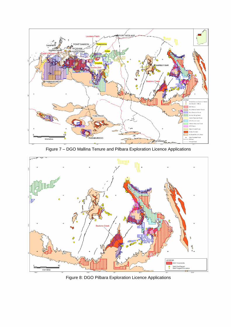
Figure 7 – DGO Mallina Tenure and Pilbara Exploration Licence Applications
Figure 8: DGO Pilbara Exploration Licence Applications

Figure 9: Fortescue Group Stratigraphic Column

Figure 10: Witwatersrand Stratigraphic column
Compilation of open file past exploration data and geological literature research has commenced.
The company now holds a total of 2,899 square kilometres of land in the Pilbara subject to the granting of the new licence applications.

DGO Gold
DGO’s exploration strategy is focused on the search for major sediment-hosted gold deposits in Australia. The company holds exploration land positions in the Pilbara WA, The Eastern Goldfields, WA, and the Adelaide Geosyncline in SA covering 7,321 km2.
The company’s strategy, led by veteran gold geologist, Executive Chairman Ed Eshuys is based on the extensive research of Distinguished Professor Ross Large, former Head of the Centre for Excellence in Ore Deposits (CODES) of the University of Tasmania. Professor Large is a member of DGO’s specialist consultant team that includes Professor Neil Phillips, former head of Minerals at CSIRO and a specialist in Witwatersrand basin gold mineralisation, Dr Stuart Bull a sedimentary basin specialist and Barry Bourne of Terra Resources, a highly experienced mineral exploration geophysicist.
Research undertaken by CODES has identified a concentration of the world’s major gold deposits during several distinct geological time frames coinciding with periods of higher than normal concentration of gold in the oceans. DGO’s landholdings have been acquired in favourable locations in sedimentary basins of analogous geological age.
Please contact the Company if you have further queries in relation to this announcement.
Yours faithfully DGO GOLD LIMITED EDUARD ESHUYS CHAIRMAN Competent person statement Exploration or technical information in this release has been prepared by Mr. Ian Prentice BSc, who is a consultant to DGO Gold Limited and a Member of the Australian Institute of Mining and Metallurgy. Mr. Prentice has sufficient experience which is relevant to the style of mineralisation under consideration and to the activity which he is undertaking to qualify as a Competent Person as defined in the 2012 Edition of the “Australasian Code for Reporting of Exploration Results, Mineral Resources and Ore Reserves” (the JORC Code). Mr. Prentice consents to the report being issued in the form and context in which it appears.

Appendix 1 – JORC Code, 2012 Edition – Table 1 Section 1 Sampling Techniques and Data (Criteria in this section apply to all succeeding sections.) Criteria JORC Code explanation Commentary Sampling techniques
• Nature and quality of sampling (eg cut channels, random chips, or specific specialised industry standard measurement tools appropriate to the minerals under investigation, such as down hole gamma sondes, or handheld XRF instruments, etc). These examples should not be taken as limiting the broad meaning of sampling.
• Include reference to measures taken to ensure sample representivity and the appropriate calibration of any measurement tools or systems used.
• Aspects of the determination of mineralisation that are Material to the Public Report.
• In cases where ‘industry standard’ work has been done this would be relatively simple (eg ‘reverse circulation drilling was used to obtain 1 m samples from which 3 kg was pulverised to produce a 30 g charge for fire assay’). In other cases more explanation may be required, such as where there is coarse gold that has inherent sampling problems. Unusual commodities or mineralisation types (eg submarine nodules) may warrant disclosure of detailed information.
• The two gold nuggets have been found using a handheld metal detector and traversing the target areas.
• Hand digging using a handheld pick was used to investigate metal detector signals returned.
• Nuggets were located at shallow depths of 5 to 30cm in soil and scree.
• Nugget locations were recorded with handheld GPS.
Drilling techniques
• Drill type (eg core, reverse circulation, open-hole hammer, rotary air blast, auger, Bangka, sonic, etc) and details (eg core diameter, triple or standard tube, depth of diamond tails, face-sampling bit or other type, whether core is oriented and if so, by what method, etc).
• No drilling undertaken.
Drill sample recovery
• Method of recording and assessing core and chip sample recoveries and results assessed.
• Measures taken to maximise sample recovery and ensure representative nature of the samples.
• Whether a relationship exists between sample recovery and grade and whether sample bias may have occurred due to preferential loss/gain of fine/coarse material.
• No drilling undertaken.
Logging • Whether core and chip samples have been geologically and geotechnically logged to a level of detail to support appropriate Mineral Resource estimation, mining studies and metallurgical studies.
• Whether logging is qualitative or quantitative in nature. Core (or costean, channel, etc) photography.
• The total length and percentage of the relevant intersections logged.
• Nuggets were found using handheld metal detector as part of a regional geological mapping program.
• Nuggets have been photographed.
Sub-sampling techniques and sample preparation
• If core, whether cut or sawn and whether quarter, half or all core taken. • If non-core, whether riffled, tube sampled, rotary split, etc and whether sampled
wet or dry. • For all sample types, the nature, quality and appropriateness of the sample
• The nuggets found are not considered to be representative as they were found in soil and scree adjacent to a gold in soil anomaly at the Scottie Well target area.
• The geological unit associated with the nuggets has yet to be

Criteria JORC Code explanation Commentary preparation technique.
• Quality control procedures adopted for all sub-sampling stages to maximise representivity of samples.
• Measures taken to ensure that the sampling is representative of the in situ material collected, including for instance results for field duplicate/second-half sampling.
• Whether sample sizes are appropriate to the grain size of the material being sampled.
tested in detail.
Quality of assay data and laboratory tests
• The nature, quality and appropriateness of the assaying and laboratory procedures used and whether the technique is considered partial or total.
• For geophysical tools, spectrometers, handheld XRF instruments, etc, the parameters used in determining the analysis including instrument make and model, reading times, calibrations factors applied and their derivation, etc.
• Nature of quality control procedures adopted (eg standards, blanks, duplicates, external laboratory checks) and whether acceptable levels of accuracy (ie lack of bias) and precision have been established.
• No assay data or laboratory testing has been completed on the nuggets.
Verification of sampling and assaying
• The verification of significant intersections by either independent or alternative company personnel.
• The use of twinned holes. • Documentation of primary data, data entry procedures, data verification, data
storage (physical and electronic) protocols. • Discuss any adjustment to assay data.
• No verification of sampling nor assaying has taken place due to the early stage and type of exploration completed.
Location of data points
• Accuracy and quality of surveys used to locate drill holes (collar and down-hole surveys), trenches, mine workings and other locations used in Mineral Resource estimation.
• Specification of the grid system used. • Quality and adequacy of topographic control.
• Location of data points was completed in GDA94 – Zone 50. • Accuracy of location data is approximately +/-5m based on
handheld GPS.
Data spacing and distribution
• Data spacing for reporting of Exploration Results. • Whether the data spacing and distribution is sufficient to establish the degree of
geological and grade continuity appropriate for the Mineral Resource and Ore Reserve estimation procedure(s) and classifications applied.
• Whether sample compositing has been applied.
• The sampling is non-systematic nor representative due to the nature and early stage of exploration work completed to date.
Orientation of data in relation to geological structure
• Whether the orientation of sampling achieves unbiased sampling of possible structures and the extent to which this is known, considering the deposit type.
• If the relationship between the drilling orientation and the orientation of key mineralised structures is considered to have introduced a sampling bias, this should be assessed and reported if material.
• Metal detecting was completed in an area adjacent to a gold in soil anomaly at the Scottie Well target area.
• Further detailed work is required to gain an understanding on the style of potential mineralisation.
Sample security • The measures taken to ensure sample security. • Samples were collected by personnel engaged by the company and have been stored by these personnel.

Criteria JORC Code explanation Commentary Audits or reviews
• The results of any audits or reviews of sampling techniques and data. • No audits or reviews have been undertaken.
Section 2 Reporting of Exploration Results (Criteria listed in the preceding section also apply to this section.) Criteria JORC Code explanation Commentary Mineral tenement and land tenure status
• Type, reference name/number, location and ownership including agreements or material issues with third parties such as joint ventures, partnerships, overriding royalties, native title interests, historical sites, wilderness or national park and environmental settings.
• The security of the tenure held at the time of reporting along with any known impediments to obtaining a licence to operate in the area.
• The metal detecting was completed on E47/3327. • The tenement forms part of DGO’s Mallina area, which
consists of E47/3327, E47/3328 and E47/3329. • The tenements are granted and held by Yandan Gold Mines
Pty Ltd, a wholly owned subsidiary of DGO.
Exploration done by other parties
• Acknowledgment and appraisal of exploration by other parties. • Previous exploration in the vicinity of the Scottie Well target area has consisted of stream sediment sample concentrate panning, two soil sampling programs and limited rock chip sampling.
• There has been no drilling at Scottie Well. • 8 of 29 panned concentrate samples contained visible gold and
the soil sampling identified discontinuous gold-in-soil anomalism.
• Exploration over the broader area of E47/3327 has consisted of regional soil sampling – generally along tracks and fence lines. There has been no drilling completed.
Geology • Deposit type, geological setting and style of mineralisation. • Mineralisation targeted is sediment hosted gold within the Mallina Formation and palaeo-placer conglomerate hosted gold at the base of the Mt Roe Basalt.
Drill hole Information
• A summary of all information material to the understanding of the exploration results including a tabulation of the following information for all Material drill holes: o easting and northing of the drill hole collar o elevation or RL (Reduced Level – elevation above sea level in metres) of the
drill hole collar o dip and azimuth of the hole o down hole length and interception depth o hole length.
• If the exclusion of this information is justified on the basis that the information is not Material and this exclusion does not detract from the understanding of the report, the Competent Person should clearly explain why this is the case.
• No drilling undertaken.
Data aggregation
• In reporting Exploration Results, weighting averaging techniques, maximum and/or minimum grade truncations (eg cutting of high grades) and cut-off grades
• The sampling is non-systematic nor representative due to the nature and early stage of exploration work completed to date.

Criteria JORC Code explanation Commentary methods are usually Material and should be stated.
• Where aggregate intercepts incorporate short lengths of high grade results and longer lengths of low grade results, the procedure used for such aggregation should be stated and some typical examples of such aggregations should be shown in detail.
• The assumptions used for any reporting of metal equivalent values should be clearly stated.
• Shallow near surface nuggets have been found only.
Relationship between mineralisation widths and intercept lengths
• These relationships are particularly important in the reporting of Exploration Results.
• If the geometry of the mineralisation with respect to the drill hole angle is known, its nature should be reported.
• If it is not known and only the down hole lengths are reported, there should be a clear statement to this effect (eg ‘down hole length, true width not known’).
• Shallow near surface nuggets have been found only. • Due to the nature and early stage of exploration work
completed to date the sampling is non-systematic nor representative.
Diagrams • Appropriate maps and sections (with scales) and tabulations of intercepts should be included for any significant discovery being reported These should include, but not be limited to a plan view of drill hole collar locations and appropriate sectional views.
• Maps showing tenement, geology and nugget locations is included in Figure 3.
• A photograph of the larger of the two nuggets is shown in Figure 4.
Balanced reporting
• Where comprehensive reporting of all Exploration Results is not practicable, representative reporting of both low and high grades and/or widths should be practiced to avoid misleading reporting of Exploration Results.
• Due to the nature and early stage of exploration work completed to date the sampling is non-systematic nor representative.
Other substantive exploration data
• Other exploration data, if meaningful and material, should be reported including (but not limited to): geological observations; geophysical survey results; geochemical survey results; bulk samples – size and method of treatment; metallurgical test results; bulk density, groundwater, geotechnical and rock characteristics; potential deleterious or contaminating substances.
• No other data available that is considered material.
Further work • The nature and scale of planned further work (eg tests for lateral extensions or depth extensions or large-scale step-out drilling).
• Diagrams clearly highlighting the areas of possible extensions, including the main geological interpretations and future drilling areas, provided this information is not commercially sensitive.
• The program of metal detecting and geological reconnaissance is continuing.
• Refinement of plans for costeaning and drilling of target areas is being completed as part of the current program.
• Approval of a Program of Work for the planned costeaning and drilling is required before any of this activity can take place.