digitalglobe incorporated civil commercial imagery ... · digitalglobe incorporated civil...
TRANSCRIPT
16 January 2007 1 DigitalGlobe An Imaging and Information Company
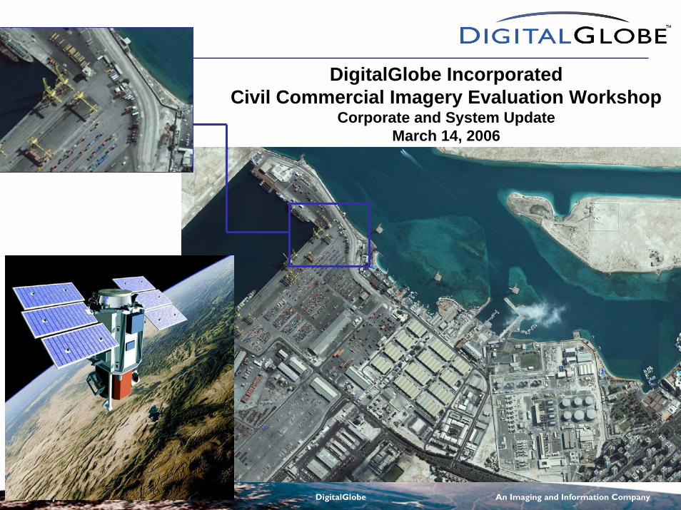
DigitalGlobe IncorporatedCivil Commercial Imagery Evaluation Workshop
Corporate and System UpdateMarch 14, 2006
https://ntrs.nasa.gov/search.jsp?R=20070038237 2020-04-29T11:58:11+00:00Z
16 January 2007 2 DigitalGlobe An Imaging and Information Company
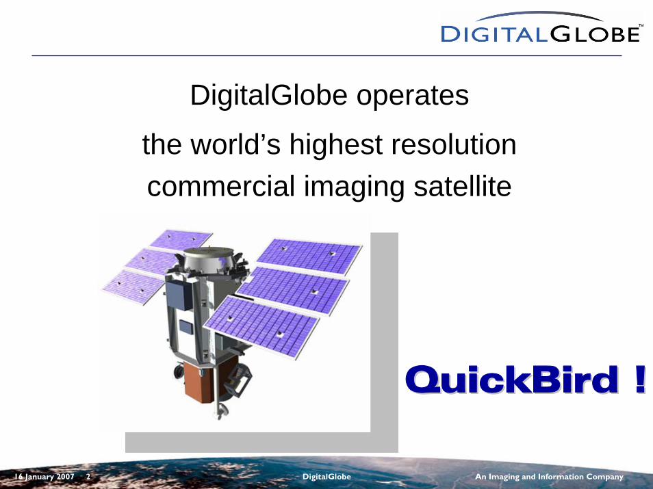
DigitalGlobe operates
the world’s highest resolution commercial imaging satellite
QuickBird !QuickBird !
16 January 2007 3 DigitalGlobe An Imaging and Information Company
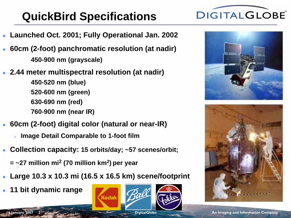
QuickBird SpecificationsLaunched Oct. 2001; Fully Operational Jan. 2002
60cm (2-foot) panchromatic resolution (at nadir)450-900 nm (grayscale)
2.44 meter multispectral resolution (at nadir)450-520 nm (blue)520-600 nm (green) 630-690 nm (red)760-900 nm (near IR)
60cm (2-foot) digital color (natural or near-IR)Image Detail Comparable to 1-foot film
Collection capacity: 15 orbits/day; ~57 scenes/orbit;
= ~27 million mi2 (70 million km2) per year
Large 10.3 x 10.3 mi (16.5 x 16.5 km) scene/footprint
11 bit dynamic range
16 January 2007 4 DigitalGlobe An Imaging and Information Company
QuickBird Imagery TypesQuickBird Imagery Types
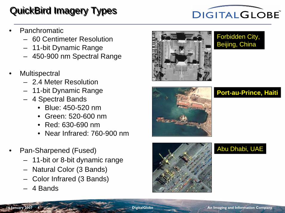
• Panchromatic– 60 Centimeter Resolution– 11-bit Dynamic Range– 450-900 nm Spectral Range
• Multispectral– 2.4 Meter Resolution– 11-bit Dynamic Range– 4 Spectral Bands
• Blue: 450-520 nm• Green: 520-600 nm• Red: 630-690 nm• Near Infrared: 760-900 nm
• Pan-Sharpened (Fused)– 11-bit or 8-bit dynamic range– Natural Color (3 Bands)– Color Infrared (3 Bands)– 4 Bands
Forbidden City, Beijing, China
Port-au-Prince, Haiti
Abu Dhabi, UAE
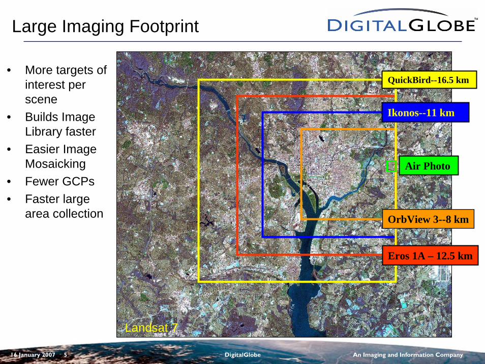
16 January 2007 5 DigitalGlobe An Imaging and Information Company
QuickBird--16.5 km
Ikonos--11 km
OrbView 3--8 km
Eros 1A – 12.5 km
Landsat 7
Large Imaging Footprint
• More targets of interest per scene
• Builds Image Library faster
• Easier Image Mosaicking
• Fewer GCPs• Faster large
area collection
Air Photo
16 January 2007 6 DigitalGlobe An Imaging and Information Company
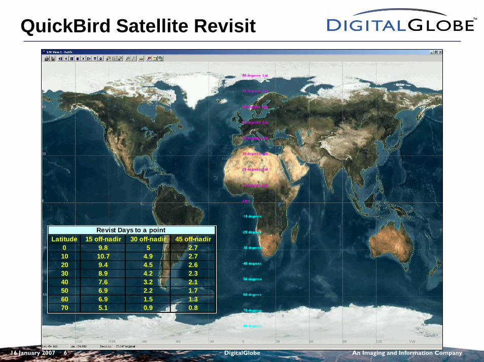
Latitude 15 off-nadir 30 off-nadir 45 off-nadir0 9.8 5 2.710 10.7 4.9 2.720 9.4 4.5 2.630 8.9 4.2 2.340 7.6 3.2 2.150 6.9 2.2 1.760 6.9 1.5 1.370 5.1 0.9 0.8
Revist Days to a point
QuickBird Satellite Revisit
16 January 2007 7 DigitalGlobe An Imaging and Information Company
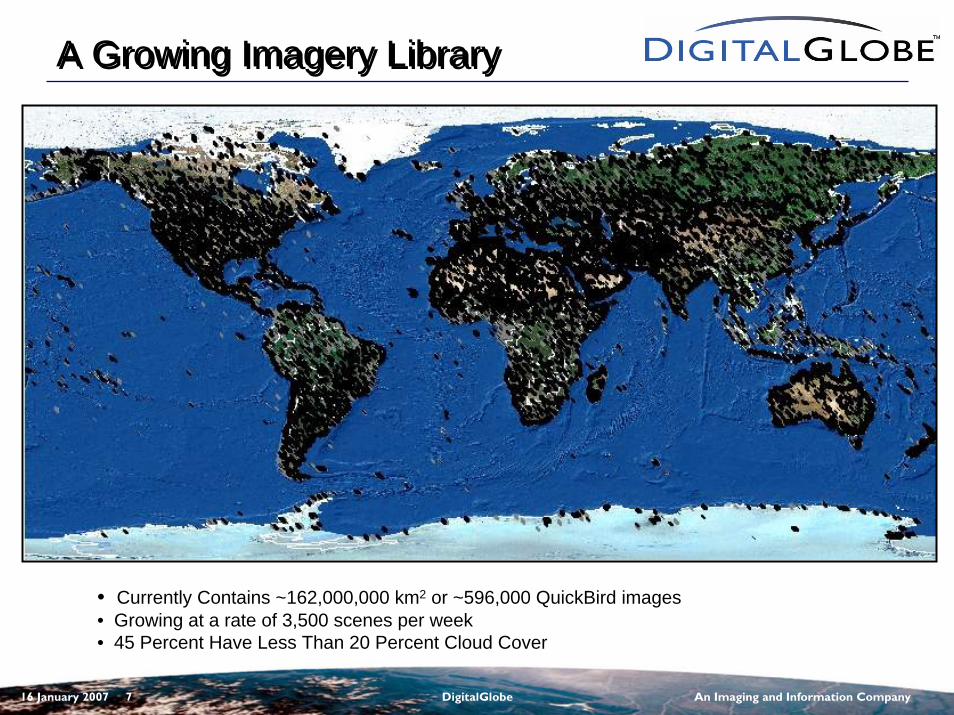
A Growing Imagery LibraryA Growing Imagery Library
• Currently Contains ~162,000,000 km2 or ~596,000 QuickBird images• Growing at a rate of 3,500 scenes per week• 45 Percent Have Less Than 20 Percent Cloud Cover
16 January 2007 8 DigitalGlobe An Imaging and Information Company
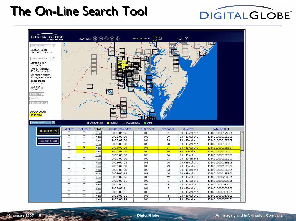
The On-Line Search ToolThe On-Line Search Tool
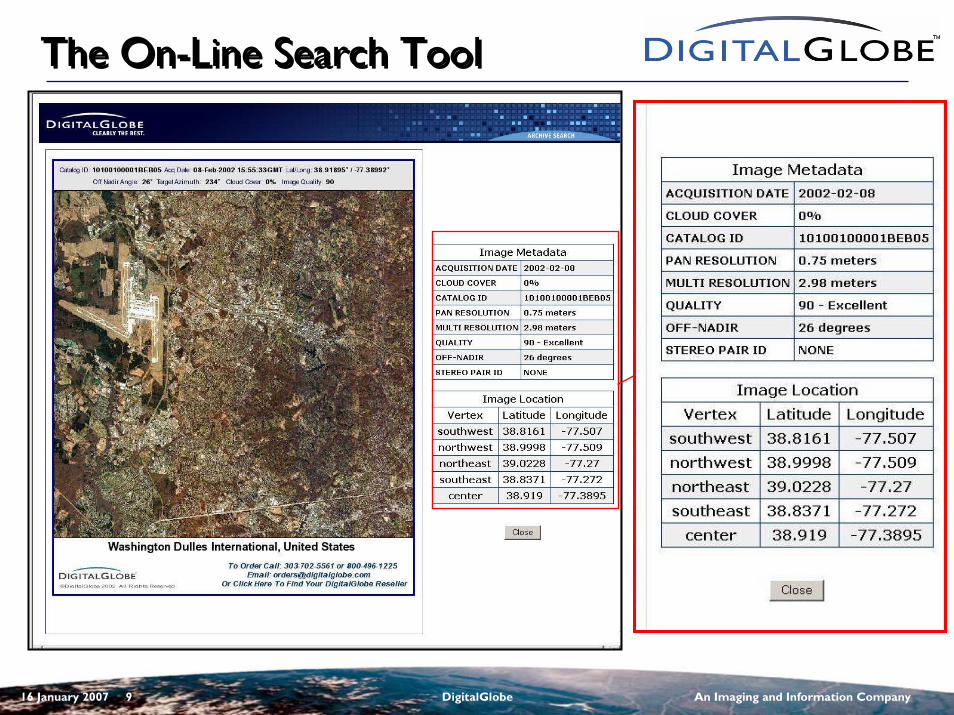
16 January 2007 9 DigitalGlobe An Imaging and Information Company
The On-Line Search ToolThe On-Line Search Tool
16 January 2007 10 DigitalGlobe An Imaging and Information Company
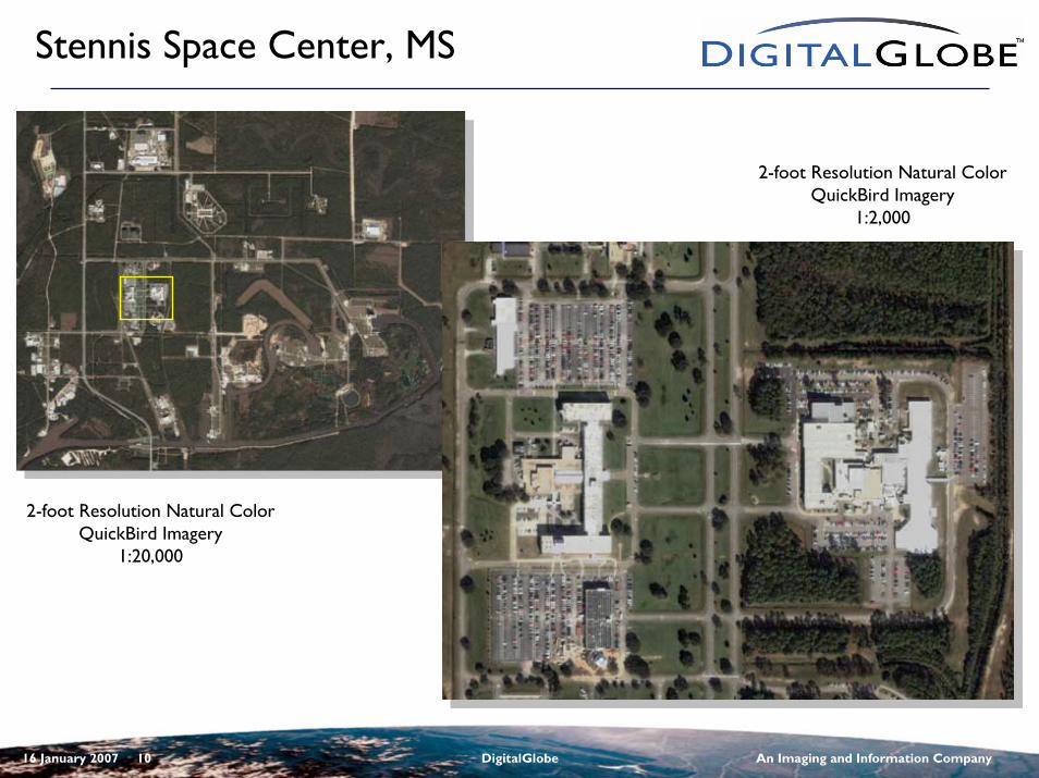
Stennis Space Center, MS
2-foot Resolution Natural ColorQuickBird Imagery
1:20,000
2-foot Resolution Natural ColorQuickBird Imagery
1:2,000
16 January 2007 11 DigitalGlobe An Imaging and Information Company
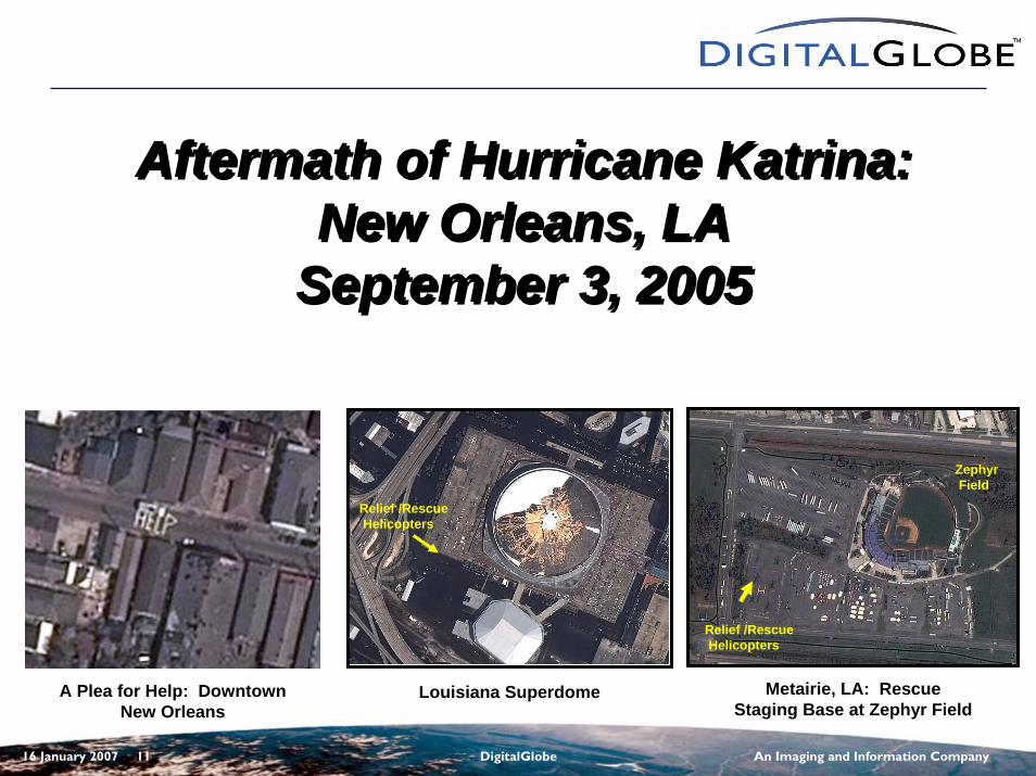
Aftermath of Hurricane Katrina: New Orleans, LA
September 3, 2005
Aftermath of Hurricane Katrina: New Orleans, LA
September 3, 2005
Louisiana Superdome
Relief /RescueHelicopters
Relief /RescueHelicopters
Metairie, LA: Rescue Staging Base at Zephyr Field
Zephyr Field
A Plea for Help: Downtown New Orleans
16 January 2007 12 DigitalGlobe An Imaging and Information Company
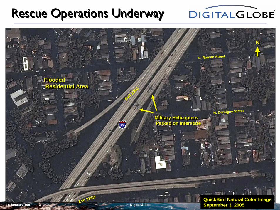
Rescue Operations UnderwayRescue Operations Underway
10
NN
N. Derbigny Street
N. Roman Street
Exit 23
6C
Exit 236B
Military HelicoptersParked on Interstate
Military HelicoptersParked on Interstate
Flooded Residential Area
Flooded Residential Area
QuickBird Natural Color ImageSeptember 3, 2005
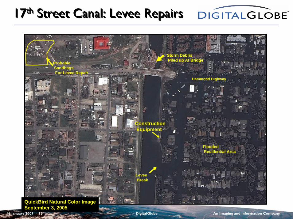
16 January 2007 13 DigitalGlobe An Imaging and Information Company
17th Street Canal: Levee Repairs17th Street Canal: Levee Repairs
QuickBird Natural Color ImageSeptember 3, 2005
Hammond Highway
Storm DebrisPiled up At Bridge
Levee Break
ConstructionEquipment
ProbableSandbags For Levee Repair
FloodedResidential Area
16 January 2007 14 DigitalGlobe An Imaging and Information Company
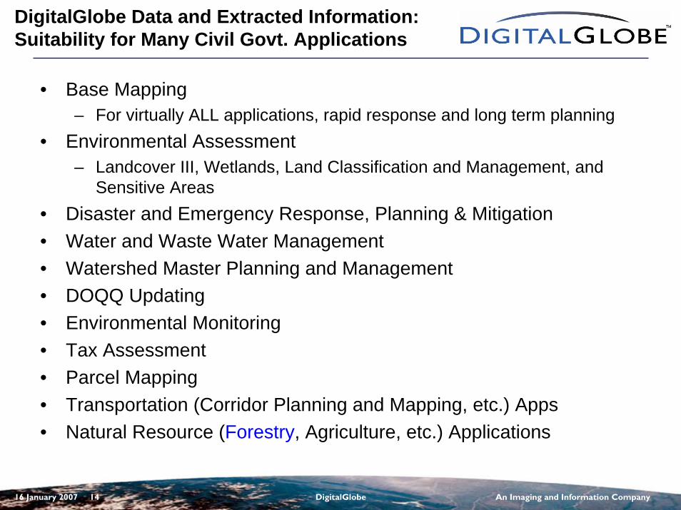
DigitalGlobe Data and Extracted Information:Suitability for Many Civil Govt. Applications
• Base Mapping– For virtually ALL applications, rapid response and long term planning
• Environmental Assessment– Landcover III, Wetlands, Land Classification and Management, and
Sensitive Areas• Disaster and Emergency Response, Planning & Mitigation• Water and Waste Water Management• Watershed Master Planning and Management• DOQQ Updating• Environmental Monitoring• Tax Assessment• Parcel Mapping• Transportation (Corridor Planning and Mapping, etc.) Apps• Natural Resource (Forestry, Agriculture, etc.) Applications
16 January 2007 15 DigitalGlobe An Imaging and Information Company
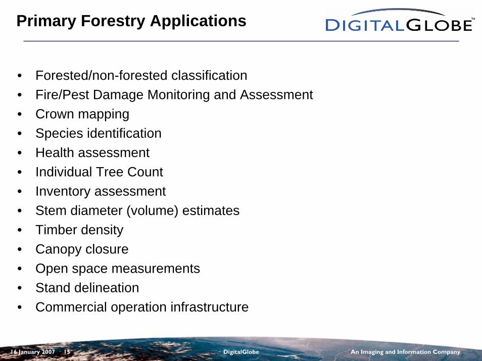
Primary Forestry Applications
• Forested/non-forested classification• Fire/Pest Damage Monitoring and Assessment• Crown mapping• Species identification• Health assessment• Individual Tree Count• Inventory assessment• Stem diameter (volume) estimates• Timber density• Canopy closure• Open space measurements• Stand delineation• Commercial operation infrastructure
16 January 2007 16 DigitalGlobe An Imaging and Information Company
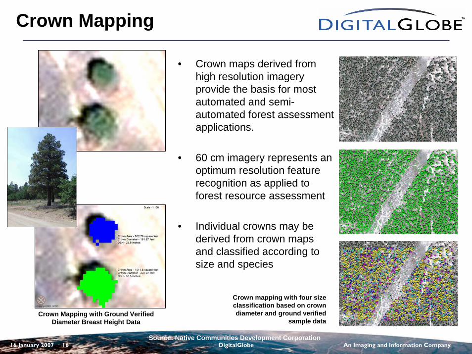
Crown Mapping
• Crown maps derived from high resolution imagery provide the basis for most automated and semi-automated forest assessment applications.
• 60 cm imagery represents an optimum resolution feature recognition as applied to forest resource assessment
• Individual crowns may be derived from crown maps and classified according to size and species
Crown Mapping with Ground Verified Diameter Breast Height Data
Crown mapping with four size classification based on crown diameter and ground verified
sample data
Source: Native Communities Development Corporation
16 January 2007 17 DigitalGlobe An Imaging and Information Company
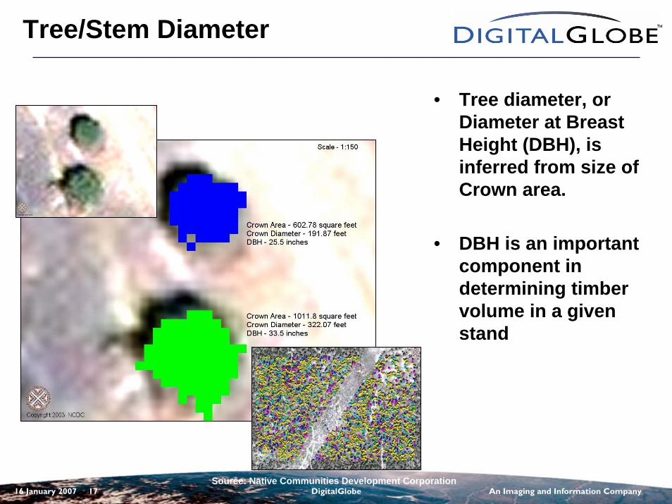
Tree/Stem Diameter
Source: Native Communities Development Corporation
• Tree diameter, or Diameter at Breast Height (DBH), is inferred from size of Crown area.
• DBH is an important component in determining timber volume in a given stand
16 January 2007 18 DigitalGlobe An Imaging and Information Company
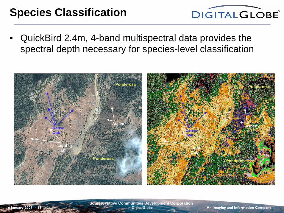
Species Classification
• QuickBird 2.4m, 4-band multispectral data provides the spectral depth necessary for species-level classification
Source: Native Communities Development Corporation
Aspen
Light Oak
Ponderosa
Ponderosa
Dense Oak
Aspen
Light Oak
Ponderosa
Ponderosa
Dense Oak
16 January 2007 19 DigitalGlobe An Imaging and Information Company
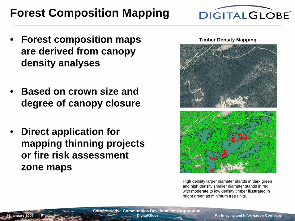
Forest Composition Mapping
• Forest composition maps are derived from canopy density analyses
• Based on crown size and degree of canopy closure
• Direct application for mapping thinning projects or fire risk assessment zone maps
Timber Density Mapping
High density larger diameter stands in dark green and high density smaller diameter stands in red with moderate to low density timber illustrated in bright green as minimum tree units.
Source: Native Communities Development Corporation
16 January 2007 20 DigitalGlobe An Imaging and Information Company
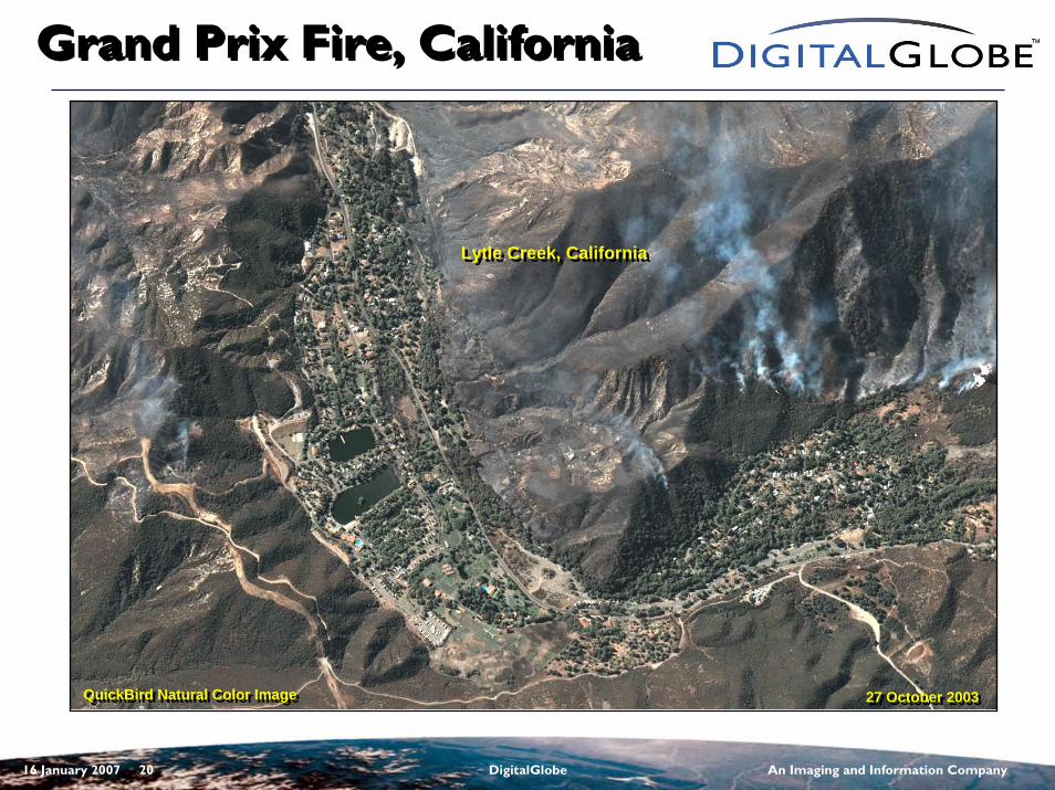
Grand Prix Fire, CaliforniaGrand Prix Fire, California
QuickBird Natural Color ImageQuickBird Natural Color Image 27 October 200327 October 2003
Lytle Creek, CaliforniaLytle Creek, California
16 January 2007 21 DigitalGlobe An Imaging and Information Company
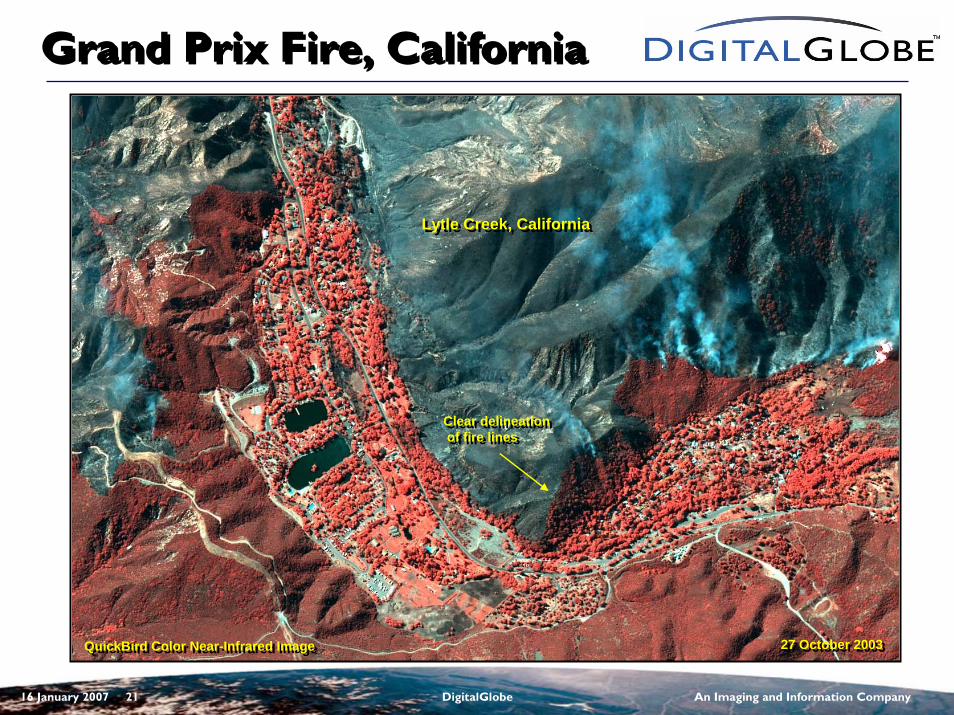
Grand Prix Fire, CaliforniaGrand Prix Fire, California
Lytle Creek, CaliforniaLytle Creek, California
QuickBird Color Near-Infrared ImageQuickBird Color Near-Infrared Image 27 October 200327 October 2003
Clear delineationof fire lines
Clear delineationof fire lines
16 January 2007 22 DigitalGlobe An Imaging and Information Company
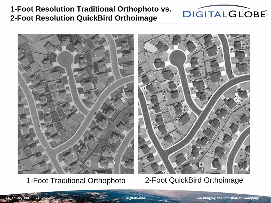
1-Foot Resolution Traditional Orthophoto vs. 2-Foot Resolution QuickBird Orthoimage
1-Foot Traditional Orthophoto 2-Foot QuickBird Orthoimage
16 January 2007 23 DigitalGlobe An Imaging and Information Company
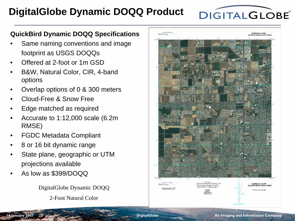
DigitalGlobe Dynamic DOQQ Product
QuickBird Dynamic DOQQ Specifications• Same naming conventions and image
footprint as USGS DOQQs• Offered at 2-foot or 1m GSD• B&W, Natural Color, CIR, 4-band
options• Overlap options of 0 & 300 meters• Cloud-Free & Snow Free• Edge matched as required• Accurate to 1:12,000 scale (6.2m
RMSE)• FGDC Metadata Compliant• 8 or 16 bit dynamic range• State plane, geographic or UTM
projections available• As low as $399/DOQQ
DigitalGlobe Dynamic DOQQ
2-Foot Natural Color
16 January 2007 24 DigitalGlobe An Imaging and Information Company
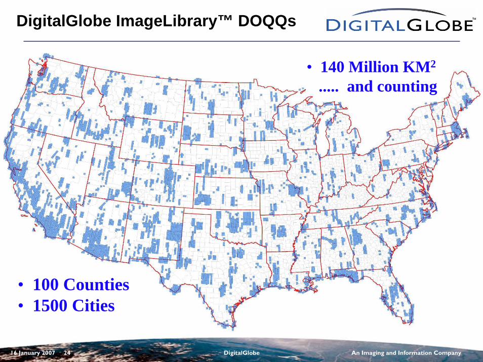
DigitalGlobe ImageLibrary™ DOQQs
• 100 Counties• 1500 Cities
• 140 Million KM2
..... and counting
16 January 2007 25 DigitalGlobe An Imaging and Information Company
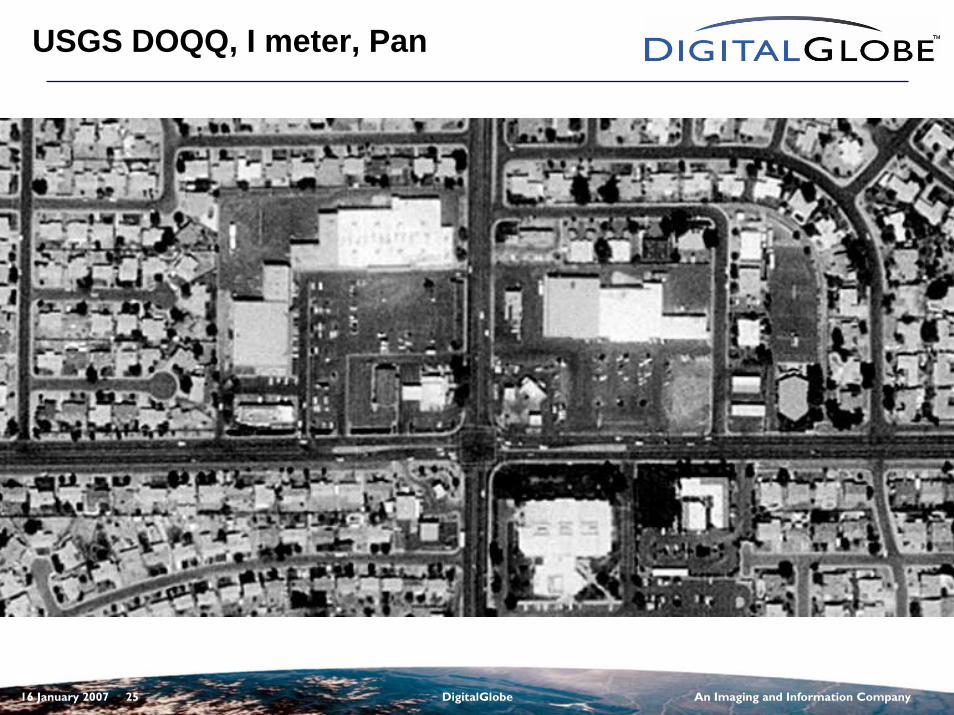
USGS DOQQ, I meter, Pan
16 January 2007 26 DigitalGlobe An Imaging and Information Company
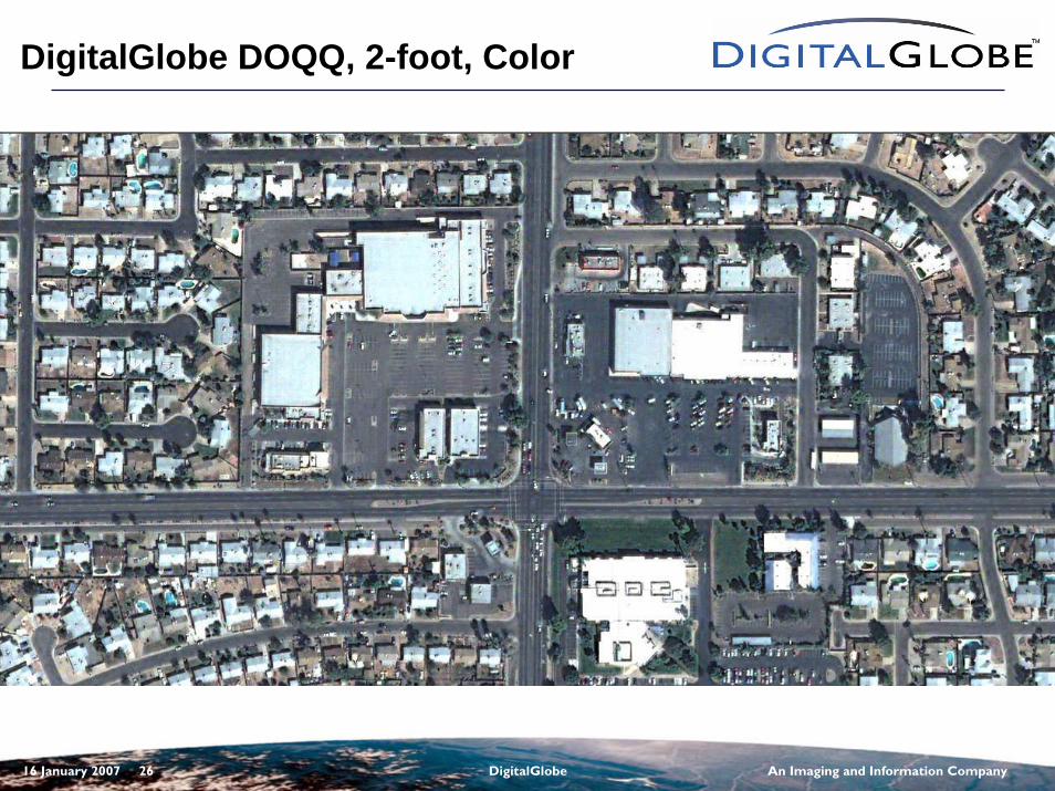
DigitalGlobe DOQQ, 2-foot, Color
16 January 2007 27 DigitalGlobe An Imaging and Information Company
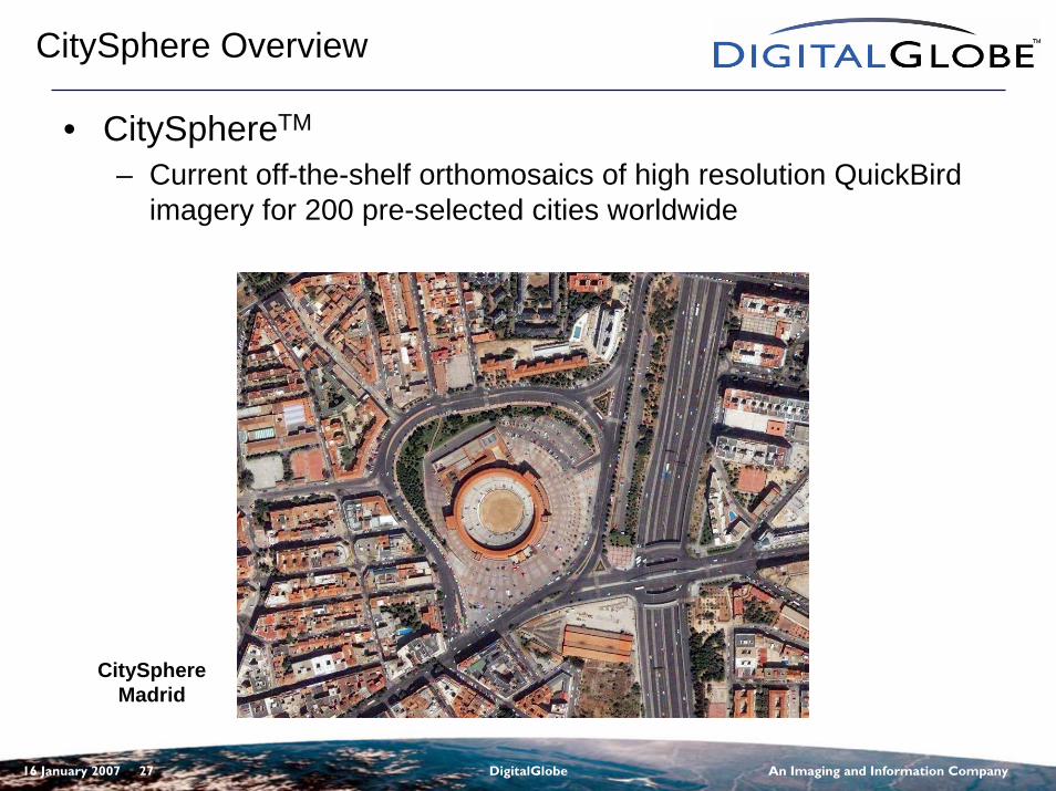
CitySphere Overview
• CitySphereTM
– Current off-the-shelf orthomosaics of high resolution QuickBird imagery for 200 pre-selected cities worldwide
CitySphereMadrid
16 January 2007 28 DigitalGlobe An Imaging and Information Company
What is CitySphereTM
• Pre-selected 200 Worldwide Cities– ~50 US and ~150 International
• GIS-ready imagery– High Resolution QuickBird data – 60 cm (2 foot)
resolution– Accurate – 1:4800 orthomosaics
• Two Product Options– Basemap GIS - Color (RGB), 8 bit– Basemap Advanced – 4 band (NRGB), 16 bit
• Repeatable, Consistent Coverage– Each city will be updated every year– Imagery no older than 24 months
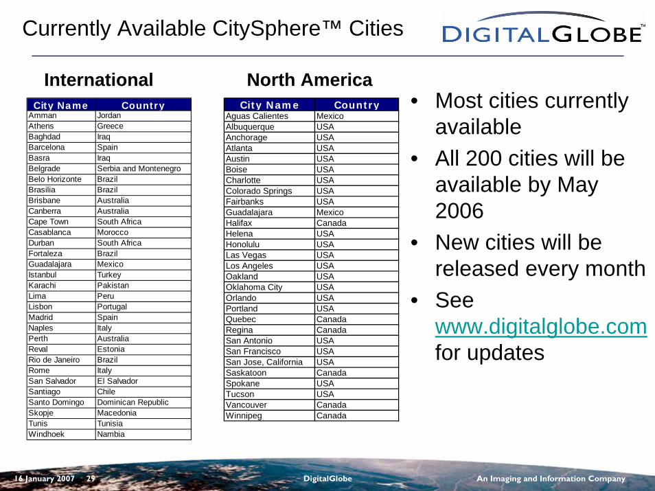
16 January 2007 29 DigitalGlobe An Imaging and Information Company
• Most cities currently available
• All 200 cities will be available by May 2006
• New cities will be released every month
• See www.digitalglobe.comfor updates
City Name CountryAguas Calientes MexicoAlbuquerque USAAnchorage USAAtlanta USAAustin USABoise USACharlotte USAColorado Springs USAFairbanks USAGuadalajara MexicoHalifax CanadaHelena USAHonolulu USALas Vegas USALos Angeles USAOakland USAOklahoma City USAOrlando USAPortland USAQuebec CanadaRegina CanadaSan Antonio USASan Francisco USASan Jose, California USASaskatoon CanadaSpokane USATucson USAVancouver CanadaWinnipeg Canada
City Name CountryAmman JordanAthens GreeceBaghdad IraqBarcelona SpainBasra IraqBelgrade Serbia and MontenegroBelo Horizonte BrazilBrasilia BrazilBrisbane AustraliaCanberra AustraliaCape Town South AfricaCasablanca MoroccoDurban South AfricaFortaleza BrazilGuadalajara MexicoIstanbul TurkeyKarachi PakistanLima PeruLisbon PortugalMadrid SpainNaples ItalyPerth AustraliaReval EstoniaRio de Janeiro BrazilRome ItalySan Salvador El SalvadorSantiago ChileSanto Domingo Dominican RepublicSkopje MacedoniaTunis TunisiaWindhoek Nambia
Currently Available CitySphere™ Cities
International North America
16 January 2007 30 DigitalGlobe An Imaging and Information Company
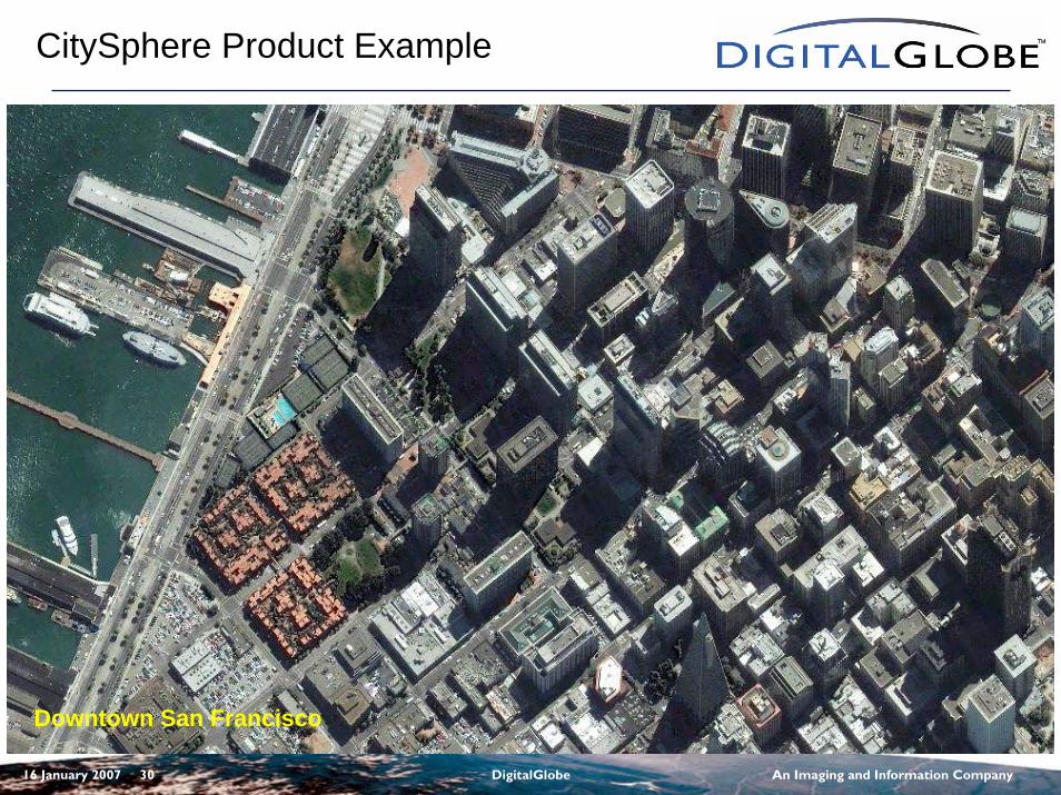
CitySphere Product Example
Downtown San Francisco
16 January 2007 31 DigitalGlobe An Imaging and Information Company
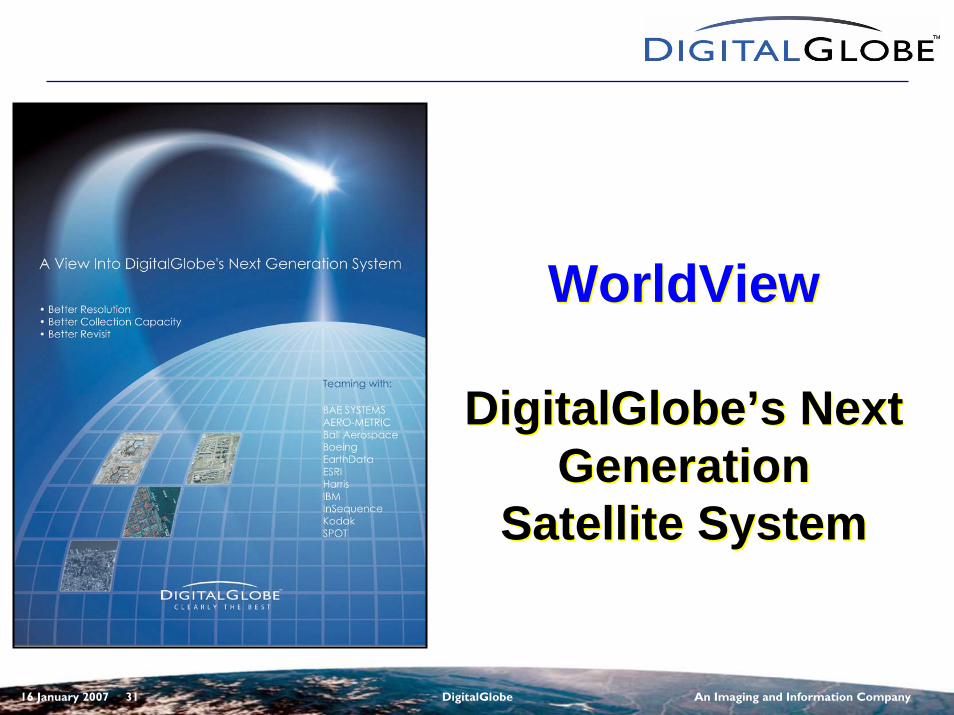
WorldView
DigitalGlobe’s Next Generation
Satellite System
WorldView
DigitalGlobe’s Next Generation
Satellite System
16 January 2007 32 DigitalGlobe An Imaging and Information Company
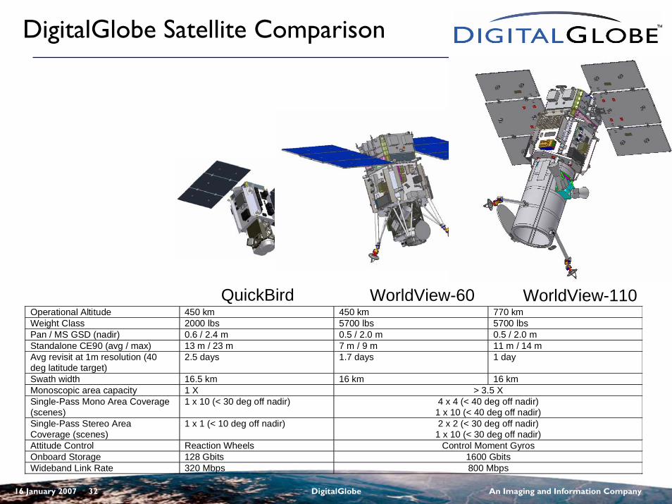
DigitalGlobe Satellite Comparison
Operational Altitude 450 km 450 km 770 kmWeight Class 2000 lbs 5700 lbs 5700 lbsPan / MS GSD (nadir) 0.6 / 2.4 m 0.5 / 2.0 m 0.5 / 2.0 mStandalone CE90 (avg / max) 13 m / 23 m 7 m / 9 m 11 m / 14 mAvg revisit at 1m resolution (40deg latitude target)
2.5 days 1.7 days 1 day
Swath width 16.5 km 16 km 16 kmMonoscopic area capacity 1 X > 3.5 XSingle-Pass Mono Area Coverage(scenes)
1 x 10 (< 30 deg off nadir) 4 x 4 (< 40 deg off nadir)1 x 10 (< 40 deg off nadir)
Single-Pass Stereo AreaCoverage (scenes)
1 x 1 (< 10 deg off nadir) 2 x 2 (< 30 deg off nadir)1 x 10 (< 30 deg off nadir)
Attitude Control Reaction Wheels Control Moment GyrosOnboard Storage 128 Gbits 1600 GbitsWideband Link Rate 320 Mbps 800 Mbps
QuickBird WorldView-60 WorldView-110
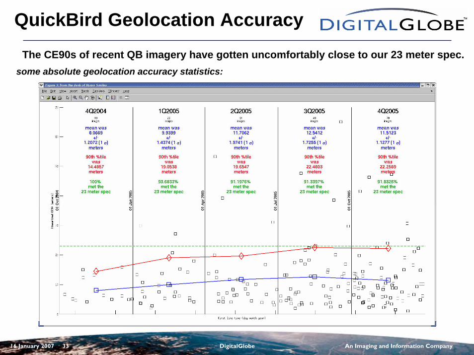
16 January 2007 33 DigitalGlobe An Imaging and Information Company
QuickBird Geolocation Accuracy
The CE90s of recent QB imagery have gotten uncomfortably close to our 23 meter spec.some absolute geolocation accuracy statistics:
16 January 2007 34 DigitalGlobe An Imaging and Information Company
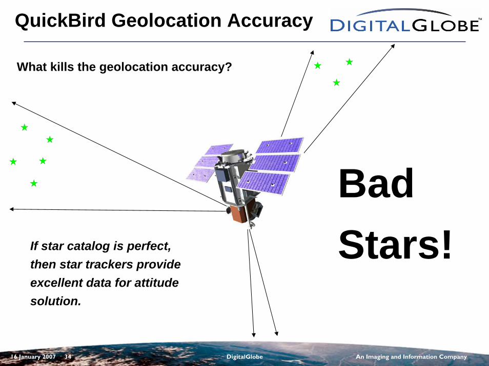
QuickBird Geolocation Accuracy
What kills the geolocation accuracy?
Bad Stars!If star catalog is perfect,
then star trackers provide excellent data for attitude solution.
16 January 2007 35 DigitalGlobe An Imaging and Information Company
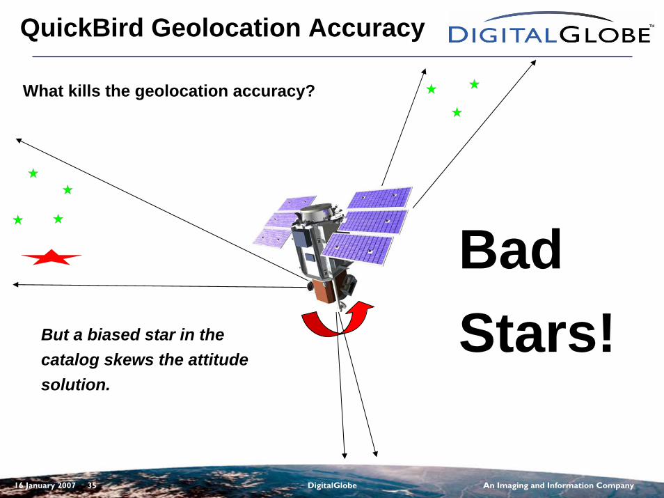
QuickBird Geolocation Accuracy
What kills the geolocation accuracy?
Bad Stars!But a biased star in the
catalog skews the attitude solution.
16 January 2007 36 DigitalGlobe An Imaging and Information Company
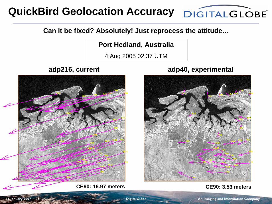
QuickBird Geolocation AccuracyCan it be fixed? Absolutely! Just reprocess the attitude…
adp216, current adp40, experimental
Port Hedland, Australia4 Aug 2005 02:37 UTM
CE90: 16.97 meters CE90: 3.53 meters
16 January 2007 37 DigitalGlobe An Imaging and Information Company
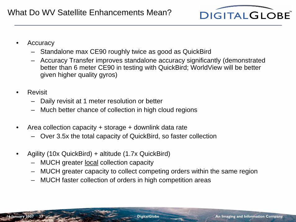
What Do WV Satellite Enhancements Mean?
• Accuracy– Standalone max CE90 roughly twice as good as QuickBird– Accuracy Transfer improves standalone accuracy significantly (demonstrated
better than 6 meter CE90 in testing with QuickBird; WorldView will be better given higher quality gyros)
• Revisit– Daily revisit at 1 meter resolution or better– Much better chance of collection in high cloud regions
• Area collection capacity + storage + downlink data rate– Over 3.5x the total capacity of QuickBird, so faster collection
• Agility (10x QuickBird) + altitude (1.7x QuickBird)– MUCH greater local collection capacity– MUCH greater capacity to collect competing orders within the same region– MUCH faster collection of orders in high competition areas
16 January 2007 38 DigitalGlobe An Imaging and Information Company
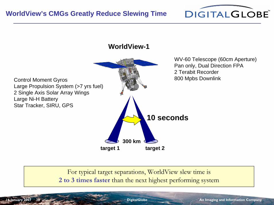
WorldView’s CMGs Greatly Reduce Slewing Time
300 km
10 seconds
WorldView-1
For typical target separations, WorldView slew time is2 to 3 times faster than the next highest performing system
target 1 target 2
Control Moment GyrosLarge Propulsion System (>7 yrs fuel)2 Single Axis Solar Array WingsLarge Ni-H BatteryStar Tracker, SIRU, GPS
WV-60 Telescope (60cm Aperture)Pan only, Dual Direction FPA2 Terabit Recorder800 Mpbs Downlink
16 January 2007 39 DigitalGlobe An Imaging and Information Company
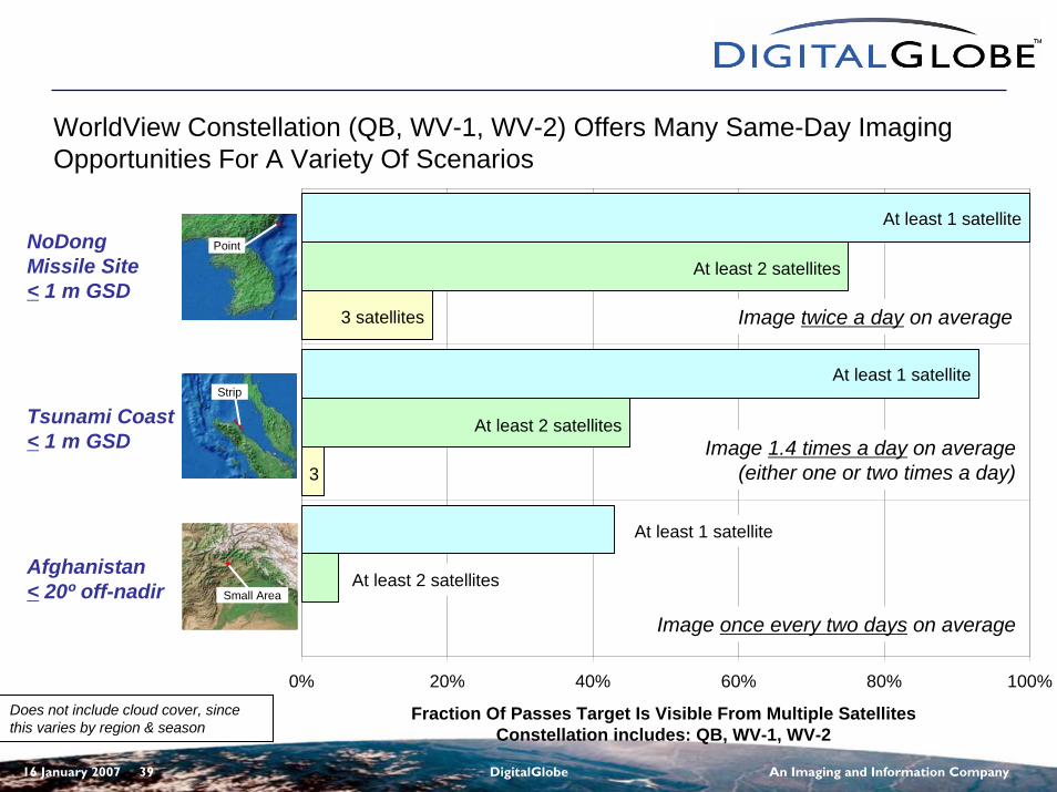
0% 20% 40% 60% 80% 100%
Fraction Of Passes Target Is Visible From Multiple SatellitesConstellation includes: QB, WV-1, WV-2
At least 1 satellite
At least 2 satellites
3 satellites
At least 1 satellite
At least 2 satellites
3
WorldView Constellation (QB, WV-1, WV-2) Offers Many Same-Day Imaging Opportunities For A Variety Of Scenarios
At least 1 satellite
At least 2 satellites
Does not include cloud cover, since this varies by region & season
NoDongMissile Site< 1 m GSD
Tsunami Coast< 1 m GSD
Afghanistan< 20º off-nadir
Point
Strip
Small Area
Image twice a day on average
Image 1.4 times a day on average(either one or two times a day)
Image once every two days on average
16 January 2007 40 DigitalGlobe An Imaging and Information Company
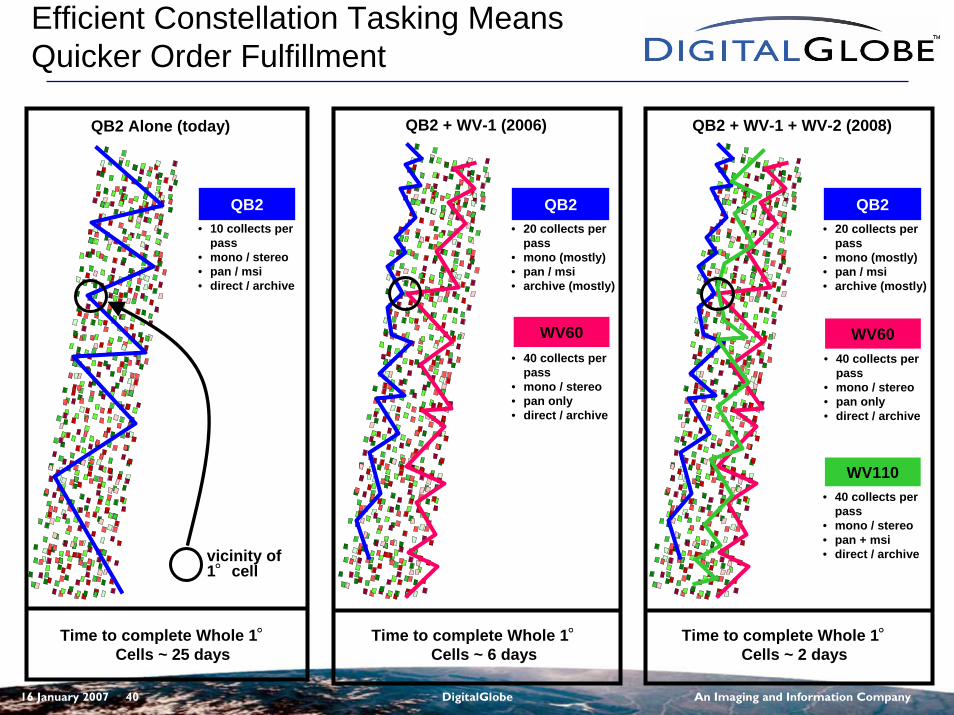
Efficient Constellation Tasking Means Quicker Order Fulfillment
QB2• 10 collects per
pass• mono / stereo• pan / msi• direct / archive
QB2 Alone (today)
Time to complete Whole 1°Cells ~ 25 days
QB2 + WV-1 (2006) QB2 + WV-1 + WV-2 (2008)
QB2 QB2
WV60
WV110
Time to complete Whole 1°Cells ~ 6 days
Time to complete Whole 1°Cells ~ 2 days
• 20 collects per pass
• mono (mostly)• pan / msi• archive (mostly)
• 40 collects per pass
• mono / stereo• pan only• direct / archive
• 20 collects per pass
• mono (mostly)• pan / msi• archive (mostly)
WV60• 40 collects per
pass• mono / stereo• pan only• direct / archive
• 40 collects per pass
• mono / stereo• pan + msi• direct / archivevicinity of
1°cell
16 January 2007 41 DigitalGlobe An Imaging and Information Company
Summary
• WorldView will offer dramatic improvements over current commercial satellite capability in:– Timeliness– Capacity– Agility– Accuracy– Multisourcing– Product Diversity– Integration with NGA Systems– Cost-effectiveness: a better product for a dramatically lower price
• The program is on schedule to support:– WorldView-60 launch by late-2006– WorldView-110 launch 12-18 months following WV1
16 January 2007 42 DigitalGlobe An Imaging and Information Company
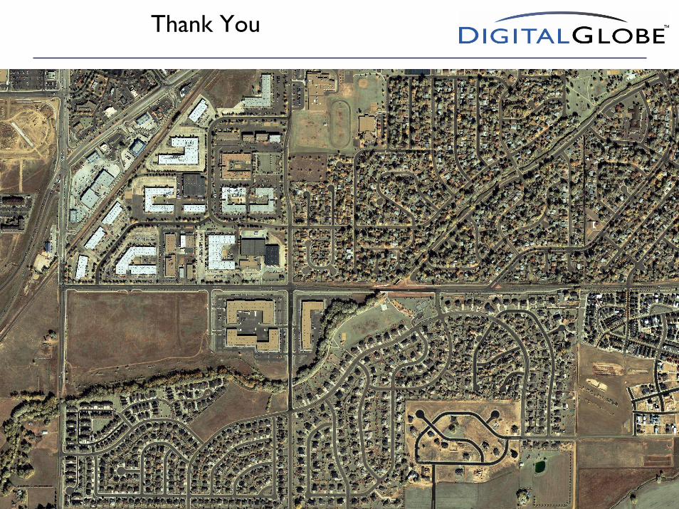
Thank You
16 January 2007 43 DigitalGlobe An Imaging and Information Company
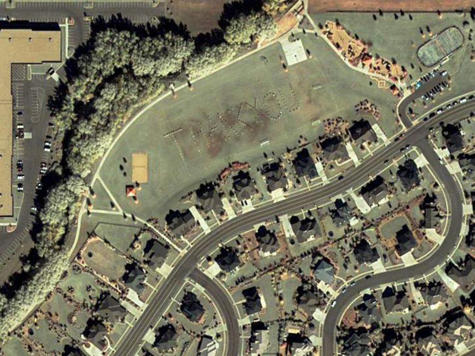
Thank You
16 January 2007 44 DigitalGlobe An Imaging and Information Company
For Additional Information:
Brett Thomassie
(985) 643-3652
(228) 688-1607
www.digitalglobe.com