digitalquest: a mixed reality approach to scavenger hunts...hunt the world has ever seen), a...
TRANSCRIPT
DigitalQuest: A Mixed Reality Approach to Scavenger HuntsMarco Cavallo∗ and Angus Graeme Forbes†
Electronic Visualization LaboratoryDeptartment of Computer Science
University Of Illinois At Chicago
ABSTRACT
This paper presents a novel approach for the design of creativelocation-based mixed reality applications. We introduce a frame-work called DigitalQuest that simplifies adding geolocated virtualcontent on top of real-world camera input. Unlike previous work,which relies solely on markers or image pattern recognition, we de-fine a “mirror world” that facilitates interactive mixed reality. Dig-italQuest consists of an editor that allows users to easily add theirown content as desired and a mobile application that loads contentfrom a server based on the location of the device. Each piece ofvirtual content can be organized through the editor so that it ap-pears only in certain circumstances, allowing a designer to deter-mine when and where a virtual object is attached to a real-worldlocation. We have used our editor to create a series of futuristicscavenger hunts in which participating teams must solve puzzlesin order to access new virtual context appearing in a mixed real-ity environment via a mobile phone application. In this paper, weintroduce our editor and present an example scavenger hunt game,Morimondo, that was built using it. Specifically, we describe ourtechnique to utilize camera and motion sensors on the mobile phoneto enable an appropriate level of user engagement within this game.We are able to obtain realistic augmentations with accurate posi-tioning by leveraging sensor fusion and through the use of filtersthat compensate for sensor noise, using image processing only forerror correction or in special situations. The initial success of thisproject leads us to believe that DigitalQuest could be used to designa wide range of creative multi-user mixed reality applications.
Index Terms: H.5.1 [Information interfaces and presentation (e.g.,HCI)]: Multimedia Information Systems—Artificial, augmented,and virtual realities; H.5.3 [Group and Organization Interfaces]:Collaborative computing—Games.
1 INTRODUCTION
Despite much progress and increased interest, mixed reality appli-cations are not yet in widespread use by the general public. Ourframework, DigitalQuest, facilitates the creation of mixed realityapplications, providing application designers with the ability to addcustom virtual content to the real world. Specifically it supportsthe creation of futuristic “scavenger hunts”, where multiple userssearch for virtual objects positioned in the real world, and whereeach object is related to a riddle or a challenge to be solved. Eachplayer can compete with the other participants by finding virtual ob-jects and solving puzzles, thereby unlocking additional challenges.Virtual objects are represented by animated 3D meshes locked toa determined position in the real world. The objects are activatedwhen a player gets within a proximity threshold and then taps theobject on the screen of his or her mobile phone. In our demonstra-tion application, configurable virtual content appears, followed by
∗e-mail: [email protected]†e-mail: [email protected], web: http://creativecoding.evl.uic.edu/
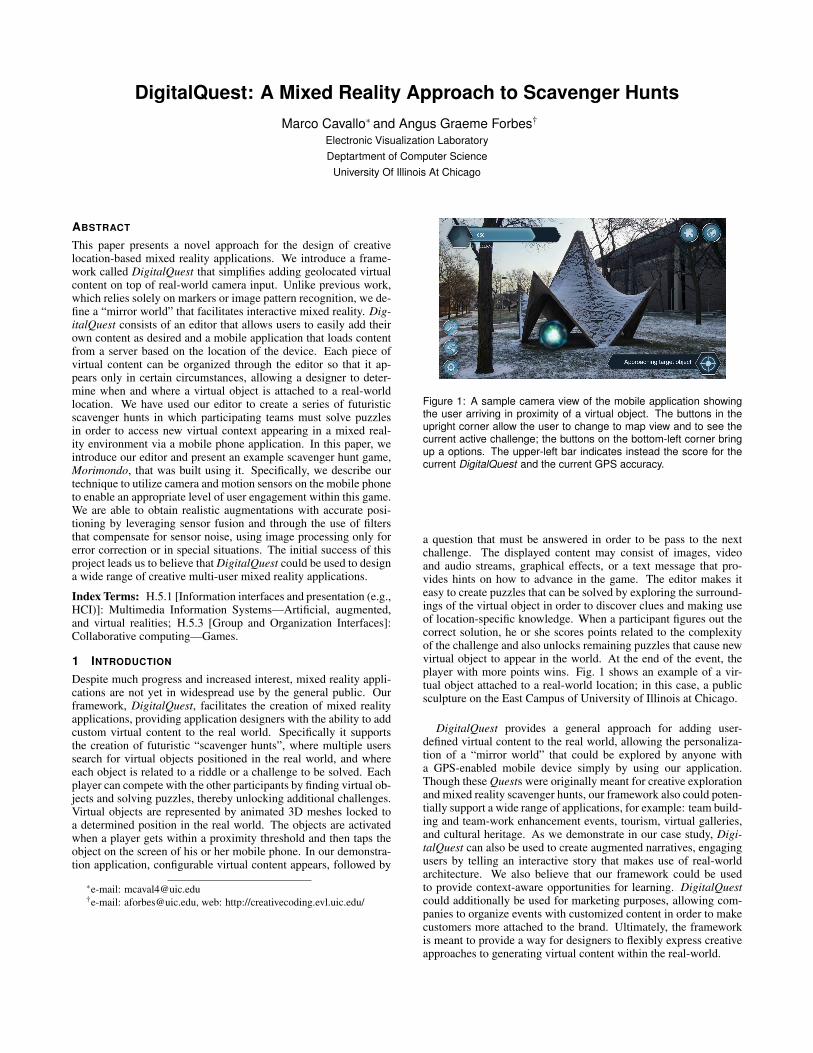
Figure 1: A sample camera view of the mobile application showingthe user arriving in proximity of a virtual object. The buttons in theupright corner allow the user to change to map view and to see thecurrent active challenge; the buttons on the bottom-left corner bringup a options. The upper-left bar indicates instead the score for thecurrent DigitalQuest and the current GPS accuracy.
a question that must be answered in order to be pass to the nextchallenge. The displayed content may consist of images, videoand audio streams, graphical effects, or a text message that pro-vides hints on how to advance in the game. The editor makes iteasy to create puzzles that can be solved by exploring the surround-ings of the virtual object in order to discover clues and making useof location-specific knowledge. When a participant figures out thecorrect solution, he or she scores points related to the complexityof the challenge and also unlocks remaining puzzles that cause newvirtual object to appear in the world. At the end of the event, theplayer with more points wins. Fig. 1 shows an example of a vir-tual object attached to a real-world location; in this case, a publicsculpture on the East Campus of University of Illinois at Chicago.
DigitalQuest provides a general approach for adding user-defined virtual content to the real world, allowing the personaliza-tion of a “mirror world” that could be explored by anyone witha GPS-enabled mobile device simply by using our application.Though these Quests were originally meant for creative explorationand mixed reality scavenger hunts, our framework also could poten-tially support a wide range of applications, for example: team build-ing and team-work enhancement events, tourism, virtual galleries,and cultural heritage. As we demonstrate in our case study, Digi-talQuest can also be used to create augmented narratives, engagingusers by telling an interactive story that makes use of real-worldarchitecture. We also believe that our framework could be usedto provide context-aware opportunities for learning. DigitalQuestcould additionally be used for marketing purposes, allowing com-panies to organize events with customized content in order to makecustomers more attached to the brand. Ultimately, the frameworkis meant to provide a way for designers to flexibly express creativeapproaches to generating virtual content within the real-world.
2 RELATED WORK
Scavenger hunts are an effective means to provide a continuousmixed reality engagement that mediates between a virtual environ-ment and the real world [6]. Traditionally, virtual content is de-livered through location-based applications, mostly used indoors,or via markers or image patterns, exploiting live input from a mo-bile phone camera. A recent example of a mixed reality scavengerhunts is HUNT [7], where users seek a set of objects and scan themwith the built-in camera on a smartphone, enabling the display ofassociated multi-media AR content that includes images and videosoverlaid on top of the real world view. Some scavenger hunts uti-lize game-based learning environments. For example, Loiseau etal. [6] propose an MMORPG videogame approach applied to thearchaeological domain aimed at raising awareness of cultural her-itage by providing relevant information in the virtual environment.They leverage Game-Based Learning (GBL) by immersing learnersin digital environments and rely on collaboration order to enhancelearning and motivation. Considering that digitalization, for betteror worse, is natural for children, Doong et al. [2] explore how edu-cational environments can enable individuals or groups of users toembark on a “quest for knowledge”. ARLearn [12] similarly adoptsa learning-oriented approach.
Scavenger hunts have also been used to orient people to newenvironments. Rogers et al. [10] exploit the use of pervasive aug-mented reality for the design of a serious game that teaches navi-gational skills in public environments. The University of Illinois atUrbana-Champaign proposed a similar idea for a team-based ori-entation activity that orients incoming freshmen in the Departmentof Computer Science, demonstrating how these types of game fos-ter a sense of community and effectively acclimate new students touniversity life [11].
Some works broaden the concept of augmented reality basedscavenger hunts by introducing new elements. Focusing on thegrowing trend of Internet of Things, TagHunt [4] allows smart-phones to interact with ordinary objects using additional technolo-gies such as NFC. This encourages the user to interact through “hy-perlinking” with the surrounding environment, asking them to lookfor clues in the game. Gonzales et al. [5] analyze the creative col-laboration environment in their GISHWES (The Greatest ScavengerHunt the World Has Ever Seen), a scavenger hunt where each itemconsists of a request for an image or a video with a focus on mak-ing the players produce art and/or helping others while attemptingcomplex, creative and time-limited collaborative tasks.
While most of the above works focus on enabling digital con-tent through the use of classical augmented reality (e.g. marker de-tection or pattern-based recognition), our framework concentrateson outdoor location-based mixed reality, making use of GPS andmobile sensors and resolving issues related to accuracy. Similarprojects include for instance Tidy City [13], where players physi-cally explore their city by interpreting clues to find the correct tar-get destination, or LMAC mobile application [9], where childrenare able to gather geo-referenced information to learn about the en-vironment in a playful way. Zund et al. [14] similarly proposes acity-wide gaming framework that overlays interactive elements ontop of the existing structure of buildings, parks, and roads.
A main issue regarding location-based mixed reality is that it isdifficult to ensure the accuracy of the position of virtual objects.Accuracy is greatly affected by the measurement errors generatedby the sensors of mobile devices. Our approach leverages the im-proved technology in current mobile phone sensors, mitigating pooraccuracy by enabling a sensor fusion approach to minimize the po-sitioning error. This allows us to conceive of scavenger hunts in anovel way and provides new creative opportunities. For instance,virtual objects can be represented as animated 3D meshes withoutusing computer vision techniques. Instead, their position is com-puted through the filtered measurements obtained from mobile sen-
sors, such as the accelerometer and gyroscope. A similar sensor-based approach is used in MIPos [3], which describes the detectionof movement and orientation of a user’s device by leveraging sensorfusion and filters to compensate sensor noise, thus avoiding exces-sive image processing. Using the sensors available on smartphonesallows us to define a virtual scene where all objects can be locatedat the same time, mirroring their position in the real world. Thissimplifies both content management (from the designer’s perspec-tive) and introduces new interaction possibilities (from the player’spoint of view).
Our framework provides an editor for creating Quests, advancingprevious work proposed by Wetzel [13] and Pirker [9]. In particu-lar, our version enables more sophisticated logic to control whenand where virtual objects appear. It also provides additional typesof triggers, enables the use of a 3D window for positioning objectsin space, and provides a preview mode for viewing the final appear-ance of virtual objects in the mobile application.
3 METHOD
The DigitalQuest framework is composed of two main applications:1) an editor for allowing users to add their own virtual content (text,multimedia, 3D objects) in specific locations; and 2) a mobile ap-plication that runs natively on both Android and iOS devices. Dig-italQuest currently relies on a client-server model. Once a Quest iscreated or updated from the editor, its information is encoded andstored on a server whose application logic responds to queries sentby the mobile clients.
3.1 The QuestEditor ApplicationThe editor itself consists of a user interface for defining and editinga Quest as well as a specific module for positioning virtual objectsin the real world. The editor can also be simply used for adding vir-tual content outside the context of a Quest, thus making it publiclyaccessible by anyone at anytime.
3.1.1 Quest Creation and EditingThe QuestEditor facilitates the definition of all the locations andevents in a Quest. Using this editor, a designer defines and posi-tions virtual objects within the Quest. Each object is represented bya 3D mesh that will appear on screen when the player approachesthe specified position. The designer defines the logic with whichthese object appear and what type of content is related to them. Forexample, we can define a trigger so that when a participant reachesa first object a textual indication of the position of a second objectwill pop up, that is, that causes the first object to disappear and “un-locks” the second one. The second object may instead ask the userto solve a riddle after having shown an image or having played anaudio, then unlocking the third and forth objects. Currently, textmessages, questions, images, audio streams, and video streams canbe combined and bound to objects. If not available by default, theeditor uploads the content to the server which takes care of stream-ing them to the mobile application when required. Objects may beset to be “visible” or “not visible” on the map view when unlocked.In other words, the accessibility of particular objects can be pro-grammatically defined to be dependent on how much of the Questhas been completed. The designer can explicitly control these de-pendencies in order to fully customize the experience.
A Quest can be imagined as a directed graph structure whereeach node corresponds to a virtual object and further is character-ized by a set of properties, such as: 3D mesh, map pointer, latitude,longitude, altitude, and scale. Based on object type, additional pa-rameters indicating specific behaviors or multimedia content (e.g.the link from which a video file needs to be streamed) are available.The main idea is to allow objects to be flexibly extended with newbehaviors, for instance to programmatically start a specific anima-tion or play an audio file whose volume is linearly related to the
distance of the player. By default, each object has three parameters:the message to be displayed when the object is reached (that oftencorresponds to a riddle), a set of possible correct answers, and amessage to be displayed after the challenge is solved (usually a hintto the next object). Those three attributes can also remain empty,thus enabling configurations where objects are used simply to rep-resent clues, without any puzzle that be solved. Again, regardingthe dependencies between objects, each node of the graph becomesunlocked when a configurable logical expression involving its an-cestors is satisfied For example, a fourth challenge could becomeavailable only if the player has completed puzzles one and two orpuzzle three, but has not yet solved challenge number five.
3.1.2 Positioning Objects in 3D Space
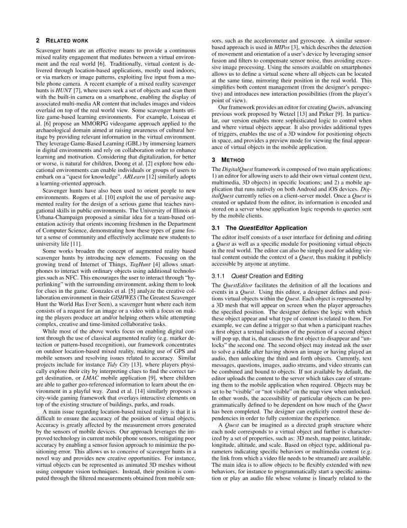
Each virtual object consists of a 3D mesh that can be chosen froma set of predefined meshes or that is manually uploaded through theeditor. The main properties of the object are related to its positionin the real world (using GPS coordinates), its scale, and its altitude.A dedicated module provides a precise and realistic positioning ofthe virtual object in the real world. The designer is prompted toinput an address or to select a location from Google Maps, and thenthe editor loads the closest Google Street View panoramic image,if available. By leveraging WebGL and Google APIs, the imageryis projected onto a sphere in order to obtain a spherical panoramaviewer. The user can then drag and drop the virtual object intothe scene in order to preview how the augmentation will look likewhen running on the mobile application. In order to place objectsinside the spherical projection, we need to retrieve the depth mapcorresponding to the current panorama in order to determine dis-tances and permitted positions. The Google Maps REST API pro-vides functionality to download a compressed JSON representationof the depth image, which contains the distance from the camerato the nearest surface at each pixel of the panorama. We obtain agrid of pixels after decoding the image from Base64 and convertingit to a more suitable data structure. Each of the pixels in this gridcorresponds to one of several planes, defined by its normal vectorand its distance to the camera. Therefore, in order to calculate thedepth at each pixel we have to determine the intersection point of aray starting at the center of the camera and the plane correspondingto the pixel. Iterating for all the planes, we can then populate ourdepth map which will have a representation similar to the one inFig. 2.
By considering the following correspondence between the pointsin the 2D texture and the points projected on the sphere we can cal-culate the 3D position of the objects (e.g. the walls of the buildings)that are present in the panoramic image. We can then restrict thepositions that are available for the virtual object to placed at. Bymapping the 3D scene distances with the real world ones, we canobtain the absolute coordinates, orientation, and dimensions of theobject as if it were a real object. This information is stored on theserver and loaded by the mobile application.
3.2 The DigitalQuest Mobile Application
Users can access the virtual content configured in the editor from amobile application, currently working on Android and iOS devices.The application first geolocalizes the user and then loads a map ofthe surroundings, allowing two possible views: the camera view,which shows the live camera input of the device along with theaugmented content; and the map view, which shows the position ofthe user with respect to available Quests or nearby virtual objects.When the user gets within a specified proximity of an object, heor she can interact with it by tapping its mesh on the display. Thisis generally followed by audiovisual feedback (i.e. an predefinedanimation), after which the intended virtual content is shown andthe behavioral logic previously defined in the editor is applied.
Figure 2: An example panoramic image (top) and its relative com-puted depth map (middle). The depth information is available in theQuest editor to allow a more precise positioning of the virtual ob-jects in the real world (bottom), which can simply be dragged into thescene and then moved, scaled or rotated.
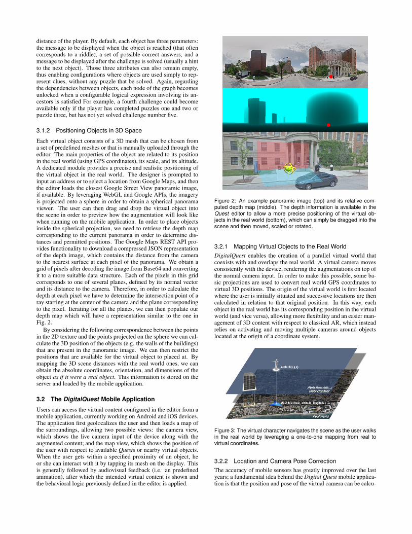
3.2.1 Mapping Virtual Objects to the Real WorldDigitalQuest enables the creation of a parallel virtual world thatcoexists with and overlaps the real world. A virtual camera movesconsistently with the device, rendering the augmentations on top ofthe normal camera input. In order to make this possible, some ba-sic projections are used to convert real world GPS coordinates tovirtual 3D positions. The origin of the virtual world is first locatedwhere the user is initially situated and successive locations are thencalculated in relation to that original position. In this way, eachobject in the real world has its corresponding position in the virtualworld (and vice versa), allowing more flexibility and an easier man-agement of 3D content with respect to classical AR, which insteadrelies on activating and moving multiple cameras around objectslocated at the origin of a coordinate system.
Figure 3: The virtual character navigates the scene as the user walksin the real world by leveraging a one-to-one mapping from real tovirtual coordinates.
3.2.2 Location and Camera Pose CorrectionThe accuracy of mobile sensors has greatly improved over the lastyears; a fundamental idea behind the Digital Quest mobile applica-tion is that the position and pose of the virtual camera can be calcu-

lated directly from the A-GPS sensor and the IMU. Through a com-bination of accelerometer, gyroscope, and compass—nowadayssupported by almost all new devices—it is possible to obtain a ro-tation vector that identifies the orientation of the camera in the 3Dspace. The camera can be moved in space by leveraging the lo-cation information gathered via GPS, WiFi, and cellular networktriangulation. The main drawback of this sensor-based approach isthe drift of the camera. Under certain circumstances, due to GPSinstability, the camera may move even if the device is stationary.Considering that GPS has a horizontal accuracy of approximately14 feet, in a worst case scenario a virtual object in front of a usercould suddenly be abruptly shifted. Thus we decided to apply thesensor fusion algorithms provided by the ROAMFREE frameworkin order to combine sensor data and remove outlier measurements.Originally meant to be used by robots, ROAMFREE provides a ro-bust odometry based on multisensor fusion and delivers out-of-the-box online 6DOF pose tracking and sensor parameters self calibra-tion. In particular, it represents measurements with graph-basedtime frames that take into account the different sample rates. Forexample, if the GPS position is not updating even though the user ismoving, ROAMFREE allows us to statistically compute the mean-time position with the remaining available sensors [1].
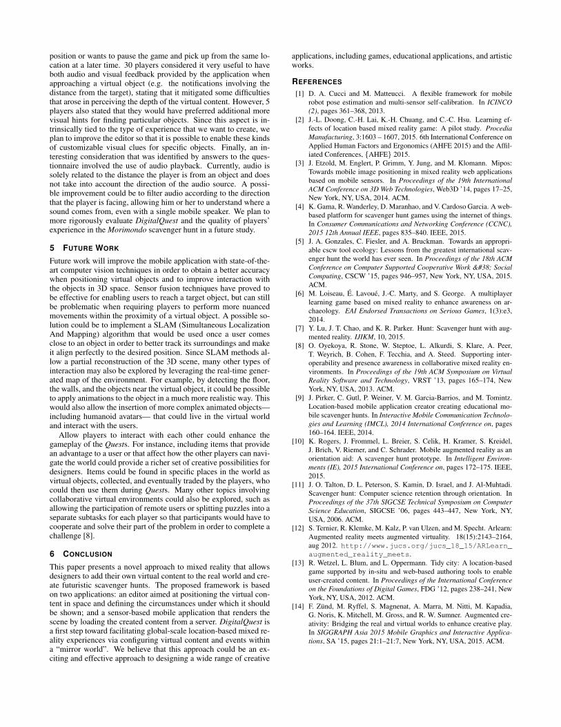
Figure 4: Sample map view showing the user approaching his nextchallenge, represented by an animation on the map (which differsfrom the virtual object that will be shown in the camera view). Thelight blue element on the upper-right corner is instead a virtual soundzone— a particular type of virtual object that emits a sound whoseintensity is proportional to the its distance from the player.
4 CASE STUDY: THE Morimondo SCAVENGER HUNT
Digital Quest was used to design a public mixed reality event inMorimondo, a small town in Italy that is admired for its Abbeyand beautiful landscapes. The aim of the event was to increase theawareness of people about the history of Morimondo and its culturaland artistic heritage. On August 9th, 2015, 32 participants gatheredat the entrance of the town and formed 10 teams with varying num-ber of players; each team logged into the DigitalQuest mobile ap-plication sharing a single device, which was used to view the virtualcontent, to solve puzzles, and to see their progress in comparison tothe competition (the other teams). At exactly 12 noon the Questbegan, and an indication was sent to all devices that the first puzzlewas available. The Morimondo Quest was composed of 19 virtualobjects, each one consisting of a puzzle that needed to be solved inorder to unlock one or more of the remaining objects. The puzzlewas organized around a simple narrative plot about the history ofMorimondo. For instance, the first object appeared in front of theplayers as a floating orb: when they touched the object on the screena popup window appeared (on their mobile device) that describeda legend about the town and its foundation and that then providednew instructions so that the players could continue the game. Inorder to unlock the next object, a player on the team needed to type
the answer to a simple question regarding the meaning of the nameMorimondo. After the correct solution was entered, the current ob-ject disappeared, points were added to the team’s scoreboard, anda message was sent to the other teams in order to foster a greatersense of competition.
For this specific Quest, players had to move by foot throughoutthe town. Each of the riddles involved real world items that couldbe found in proximity of the virtual object. For example, objectsincluded a gem hidden in an old mosaic and a Latin phrase that waslocated close to the Abbey, and the questions involved informationabout those items. Other puzzles involved exploring specific en-vironments, like an ancient ice house or a votive chapel hidden inthe woods, forcing the players to search for particular hints. Alter-natively, some challenges required teamwork, reasoning, or specialactions, such as asking a question directly to the owner of a shop(e.g., for the name of the saint represented in a sculpture) or query-ing online websites for specific information (e.g., the year in whichthe apsis of the Abbey was rebuilt). After the first few puzzles,solving the remaining puzzles unlocked multiple puzzles at once,allowing teams to go to different places and to choose a specificstrategy for solving them. After the time limit passed, the applica-tion stopped and all the teams were directed to gather at a certainlocation where the final ranking was announced and prizes wereawarded.
Figure 5: An example of a simple puzzle appearing on screen after ateam reaches a virtual object during the Morimondo scavenger hunt.
4.1 User Evaluation
As an initial step to gauging the interest of users and its effective-ness as a means to promote tourism, we provided a questionnaireto the 32 players who took part in the Morimondo Quest event. Allof them indicated that they enjoyed this experience, and 30 playersstated that they discovered new information about the town of Mo-rimondo, while 23 indicated that they would gladly revisit the townin the near future.
As for the performance of the application (which was tested pri-marily on Android devices without implementing the ROAMFREEerror correction), we registered an average GPS positioning accu-racy of 4 meters at the moment of reaching a virtual object, witha minimum of 2 and a worst case of 8 meters accuracy. However,considering that the Morimondo Quest made use of mainly open,outdoor spaces, the majority of players (28 out of the 32) statedthat the poor resolution did not negatively affect their experiencewhile playing.
All of the players agreed that it was important to have access to amap view and a menu for checking information related to both thecurrent and past Quests. Nearly half of the players took advantageof a feature that allowed them to highlight the position of a currentchallenge on a map, and all participants noted it that it would be anecessary feature in cases where a user strays far from the initial
position or wants to pause the game and pick up from the same lo-cation at a later time. 30 players considered it very useful to haveboth audio and visual feedback provided by the application whenapproaching a virtual object (e.g. the notifications involving thedistance from the target), stating that it mitigated some difficultiesthat arose in perceiving the depth of the virtual content. However, 5players also stated that they would have preferred additional morevisual hints for finding particular objects. Since this aspect is in-trinsically tied to the type of experience that we want to create, weplan to improve the editor so that it is possible to enable these kindsof customizable visual clues for specific objects. Finally, an in-teresting consideration that was identified by answers to the ques-tionnaire involved the use of audio playback. Currently, audio issolely related to the distance the player is from an object and doesnot take into account the direction of the audio source. A possi-ble improvement could be to filter audio according to the directionthat the player is facing, allowing him or her to understand where asound comes from, even with a single mobile speaker. We plan tomore rigorously evaluate DigitalQuest and the quality of players’experience in the Morimondo scavenger hunt in a future study.
5 FUTURE WORK
Future work will improve the mobile application with state-of-the-art computer vision techniques in order to obtain a better accuracywhen positioning virtual objects and to improve interaction withthe objects in 3D space. Sensor fusion techniques have proved tobe effective for enabling users to reach a target object, but can stillbe problematic when requiring players to perform more nuancedmovements within the proximity of a virtual object. A possible so-lution could be to implement a SLAM (Simultaneous LocalizationAnd Mapping) algorithm that would be used once a user comesclose to an object in order to better track its surroundings and makeit align perfectly to the desired position. Since SLAM methods al-low a partial reconstruction of the 3D scene, many other types ofinteraction may also be explored by leveraging the real-time gener-ated map of the environment. For example, by detecting the floor,the walls, and the objects near the virtual object, it could be possibleto apply animations to the object in a much more realistic way. Thiswould also allow the insertion of more complex animated objects—including humanoid avatars— that could live in the virtual worldand interact with the users.
Allow players to interact with each other could enhance thegameplay of the Quests. For instance, including items that providean advantage to a user or that affect how the other players can navi-gate the world could provide a richer set of creative possibilities fordesigners. Items could be found in specific places in the world asvirtual objects, collected, and eventually traded by the players, whocould then use them during Quests. Many other topics involvingcollaborative virtual environments could also be explored, such asallowing the participation of remote users or splitting puzzles into aseparate subtasks for each player so that participants would have tocooperate and solve their part of the problem in order to complete achallenge [8].
6 CONCLUSION
This paper presents a novel approach to mixed reality that allowsdesigners to add their own virtual content to the real world and cre-ate futuristic scavenger hunts. The proposed framework is basedon two applications: an editor aimed at positioning the virtual con-tent in space and defining the circumstances under which it shouldbe shown; and a sensor-based mobile application that renders thescene by loading the created content from a server. DigitalQuest isa first step toward facilitating global-scale location-based mixed re-ality experiences via configuring virtual content and events withina “mirror world”. We believe that this approach could be an ex-citing and effective approach to designing a wide range of creative
applications, including games, educational applications, and artisticworks.
REFERENCES
[1] D. A. Cucci and M. Matteucci. A flexible framework for mobilerobot pose estimation and multi-sensor self-calibration. In ICINCO(2), pages 361–368, 2013.
[2] J.-L. Doong, C.-H. Lai, K.-H. Chuang, and C.-C. Hsu. Learning ef-fects of location based mixed reality game: A pilot study. ProcediaManufacturing, 3:1603 – 1607, 2015. 6th International Conference onApplied Human Factors and Ergonomics (AHFE 2015) and the Affil-iated Conferences, {AHFE} 2015.
[3] J. Etzold, M. Englert, P. Grimm, Y. Jung, and M. Klomann. Mipos:Towards mobile image positioning in mixed reality web applicationsbased on mobile sensors. In Proceedings of the 19th InternationalACM Conference on 3D Web Technologies, Web3D ’14, pages 17–25,New York, NY, USA, 2014. ACM.
[4] K. Gama, R. Wanderley, D. Maranhao, and V. Cardoso Garcia. A web-based platform for scavenger hunt games using the internet of things.In Consumer Communications and Networking Conference (CCNC),2015 12th Annual IEEE, pages 835–840. IEEE, 2015.
[5] J. A. Gonzales, C. Fiesler, and A. Bruckman. Towards an appropri-able cscw tool ecology: Lessons from the greatest international scav-enger hunt the world has ever seen. In Proceedings of the 18th ACMConference on Computer Supported Cooperative Work & SocialComputing, CSCW ’15, pages 946–957, New York, NY, USA, 2015.ACM.
[6] M. Loiseau, E. Lavoue, J.-C. Marty, and S. George. A multiplayerlearning game based on mixed reality to enhance awareness on ar-chaeology. EAI Endorsed Transactions on Serious Games, 1(3):e3,2014.
[7] Y. Lu, J. T. Chao, and K. R. Parker. Hunt: Scavenger hunt with aug-mented reality. IJIKM, 10, 2015.
[8] O. Oyekoya, R. Stone, W. Steptoe, L. Alkurdi, S. Klare, A. Peer,T. Weyrich, B. Cohen, F. Tecchia, and A. Steed. Supporting inter-operability and presence awareness in collaborative mixed reality en-vironments. In Proceedings of the 19th ACM Symposium on VirtualReality Software and Technology, VRST ’13, pages 165–174, NewYork, NY, USA, 2013. ACM.
[9] J. Pirker, C. Gutl, P. Weiner, V. M. Garcia-Barrios, and M. Tomintz.Location-based mobile application creator creating educational mo-bile scavenger hunts. In Interactive Mobile Communication Technolo-gies and Learning (IMCL), 2014 International Conference on, pages160–164. IEEE, 2014.
[10] K. Rogers, J. Frommel, L. Breier, S. Celik, H. Kramer, S. Kreidel,J. Brich, V. Riemer, and C. Schrader. Mobile augmented reality as anorientation aid: A scavenger hunt prototype. In Intelligent Environ-ments (IE), 2015 International Conference on, pages 172–175. IEEE,2015.
[11] J. O. Talton, D. L. Peterson, S. Kamin, D. Israel, and J. Al-Muhtadi.Scavenger hunt: Computer science retention through orientation. InProceedings of the 37th SIGCSE Technical Symposium on ComputerScience Education, SIGCSE ’06, pages 443–447, New York, NY,USA, 2006. ACM.
[12] S. Ternier, R. Klemke, M. Kalz, P. van Ulzen, and M. Specht. Arlearn:Augmented reality meets augmented virtuality. 18(15):2143–2164,aug 2012. http://www.jucs.org/jucs_18_15/ARLearn_augmented_reality_meets.
[13] R. Wetzel, L. Blum, and L. Oppermann. Tidy city: A location-basedgame supported by in-situ and web-based authoring tools to enableuser-created content. In Proceedings of the International Conferenceon the Foundations of Digital Games, FDG ’12, pages 238–241, NewYork, NY, USA, 2012. ACM.
[14] F. Zund, M. Ryffel, S. Magnenat, A. Marra, M. Nitti, M. Kapadia,G. Noris, K. Mitchell, M. Gross, and R. W. Sumner. Augmented cre-ativity: Bridging the real and virtual worlds to enhance creative play.In SIGGRAPH Asia 2015 Mobile Graphics and Interactive Applica-tions, SA ’15, pages 21:1–21:7, New York, NY, USA, 2015. ACM.