dinaric alps
DESCRIPTION
Dinaric AlpsTRANSCRIPT

at SciVerse ScienceDirect
Quaternary Science Reviews 30 (2011) 3393e3412
Contents lists available
Quaternary Science Reviews
journal homepage: www.elsevier .com/locate/quascirev
The glacial history of the Dinaric Alps, Montenegro
P.D. Hughesa,*, J.C. Woodwarda, P.C. van Calsterenb, L.E. Thomasb
aQuaternary Environments and Geoarchaeology Research Group, Geography, School of Environment and Development, The University of Manchester, Manchester M13 9PL, UKbNatural Environment Research Council e Open University Uranium-Series Facility, Department of Earth and Environmental Sciences, The Open University,Milton Keynes MK7 6AA, UK
a r t i c l e i n f o
Article history:Received 1 May 2011Received in revised form17 August 2011Accepted 29 August 2011Available online 4 October 2011
Keywords:GlaciationBalkansPleistoceneFormer YugoslaviaPalaeoclimateRefugia
* Corresponding author. Tel.: þ44 161 2757876.E-mail address: [email protected] (
0277-3791/$ e see front matter � 2011 Elsevier Ltd.doi:10.1016/j.quascirev.2011.08.016
a b s t r a c t
Large areas of Montenegro were glaciated during the Pleistocene. This paper presents evidence from themassifs of central Montenegro, including Durmitor and Sinjajevina, Mora�cke Planine, Maganik, Pre-kornica and Vojnik. Glacial deposits have been subdivided on the basis of morphostratigraphy and soilweathering and 31 U-series ages from cemented tills provided a geochronological framework. The largestglaciation occurred before 350 ka when a series of conjoined ice caps over the massifs of central Mon-tenegro covered a total area of nearly 1500 km2. These formed during MIS 12 and correspond with thelargest Skamnellian Stage glaciations in Greece to the south. Later Middle Pleistocene glaciationsoccurred during the penultimate glacial cycle correlating with the Vlasian Stage in Greece (MIS 6) whenice caps covered an area of 720 km2 over central Montenegro. There is also geochronological evidence ofglacial deposits dating from the interval between MIS 12 and MIS 6, before the interglacial complex ofMIS 7. This glaciation appears to have been very similar in extent to that which occurred during MIS 6.The last glacial cycle in central Montenegro was characterised by valley and cirque glaciers coveringa total area of 49 km2. It is very likely that glaciers have been present in the mountains of centralMontenegro during every glacial cycle since a small glacier still survives today. The smaller glaciers of thelast glacial cycle are likely to have been associated with summer temperatures that were warmer thanthose of earlier cold stages. The striking contrast in the extent and thickness of ice cover during the coldstages of the Pleistocene has an important bearing on the geomorphological and biological evolution ofthe Balkans.
� 2011 Elsevier Ltd. All rights reserved.
1. Introduction
The nature of glaciations in the Mediterranean mountains hasbeen the subject of increasing research in recent years (see reviewsin Hughes and Woodward, 2008, 2009). This recent activity buildson a long history of research in the region (see review by Messerli,1967). Some of the earliest work in southern Europewas carried outin the Dinaric Alps of Montenegro and neighbouring countries,where evidence of widespread glaciation was noted by Jovan Cviji�c(Cviji�c, 1889) well over a century ago. This was followed bynumerous papers on glaciation in the Balkans (see references inSection 4.1). Cviji�c (1914) recognised that moraines in Montenegrowere of different ages and subdivided glacial deposits into old andyoung moraines (Altmoränen/Jungmoränen). Whilst several recentstudies have elaborated on the geomorphology of the differentmassifs (e.g. Milivojevi�c, 2004a,b; Milivojevi�c et al., 2008; Djurovi�c,
P.D. Hughes).
All rights reserved.
2009), the extent, timing and palaeoclimatic significance of glaci-ations remains unclear.
Recent research in the Balkans has focused on establishing thenumber and extent of glaciations and dating the glacial deposits.Moraines in northern Greece and coastal Montenegro have beendated using U-series techniques by Woodward et al. (2004) andHughes et al. (2006a, 2010), revealing evidence for glaciationduring at least three separate cold stages e the oldest occurringearlier than350ka. In themountainsof both coastalMontenegroandnorthwest Greece these glaciations have been correlated with coldstages duringMIS 12, 6 and 5d-2. There is also tentative evidence ofYounger Dryas glacier advances in both Greece and Montenegro(Hughes et al., 2006b, 2010). Today, in commonwith other southernEuropean mountains (Grunewald and Scheithauer, 2010), smallglaciers still exist in the highest parts of Montenegro and Albania,although these exist well below the regional snowline and survivebecause of strong local topoclimatic controls (Hughes, 2008, 2009).
On Mount Orjen, in the coastal mountains of Montenegro,a Middle Pleistocene ice cap covered an area of 165 km2 (Hugheset al., 2010). By comparison, on Mount Tymphi (2497 m a.s.l.) in
P.D. Hughes et al. / Quaternary Science Reviews 30 (2011) 3393e34123394
northwestern Greece, ice fields and valley glaciers covered an areaof just 60 km2 at their maximum extent (Hughes et al., 2006a,2007). However, early research by Cviji�c (1913, 1917) revealedthat some of the largest ice masses in the Balkans formed in themountains of central Montenegro and northern Albania.
Large Pleistocene glaciations have also been reported fromCroatia, with Marjanac et al. (1990) and Marjanac and Marjanac(2004) reporting glacial deposits near the Velebit Mountainsreaching down to sea level and ascribed to at least the MiddlePleistocene. Throughout the mountains of the Balkans, Late Pleis-tocene glaciers were largely restricted to cirques and valleys anddid not extend beyond the mountain centres to the piedmonts (e.g.Bognar and Prugove�cki, 1997; Veli�c et al., 2011). East of the DinaricAlps and Pindus Mountains, moraines in the cirques and valleys ofthe �Sara Mountains of Kosovo have been dated to the global lastglacial maximum (LGM) and no earlier Pleistocene moraines havebeen reported (Kuhlemann et al., 2009). The same is true in themountains of Turkey (e.g. Akçar et al., 2007, 2008; Sarıkaya et al.,2008, 2009; Zahno et al., 2009). However, on Mount Olympus innortheastern Greece the most extensive glacial deposits have beenascribed to the Middle Pleistocene (Smith et al., 1997, 2006) e incommon with the records in northwestern Greece, Montenegroand Croatia, as noted above.
This paper focuses on the evidence for the extent, timing andpalaeoclimatic significance of glaciations in the mountains ofcentralMontenegro. The principal objectives of this paper are: (1) topresent geomorphological evidence for the extent, stratigraphicalsuccession and relative-age of different glaciations; (2) to providea geochronological framework for glaciations using U-series datingof secondary carbonate cements, and; (3) to reconstruct glaciers ofdifferent ages using glaciological models and assess the implica-tions for understanding cold stage palaeoclimates.
2. Study areas
The six adjacent massifs of central Montenegro covered in thisstudy (Durmitor, Sinjajevina, Mora�cke Planine, Maganik, Prekornicaand Vojnik) extend over 70 km from Durmitor in the north toPrekornica in the south (Fig. 1). They form the southern end of theDinaric Alps, which continue southwards as the Albanian Alps andthen the Pindus Mountains of Greece. The mountains of centralMontenegro are formed in Triassic limestones and dolomites andCretaceous limestones and flysch with small outcrops of Triassicintrusive volcanics (Osnovna Geolo�ska Karta SFRJ, 1970, 1971;�Zivaljevi�c et al., 1981; Mirkovi�c and Vujisi�c, 1989). The area istectonically-active with significant earthquake activity in Mon-tenegro during the Quaternary (Maga�s, 2002). The highest peaks infour of the massifs (Durmitor, Sinjajevina, Mora�cke Planine, andMaganik) reach over 2000m a.s.l. and slightly less in the Prekornicaand Vojnikmassifs. Thesemountains provide the upper catchmentsfor some of the main rivers in Montenegro: the Mora�ca, Tara andthe Piva. TheMora�ca drains into the Adriatic Seawhilst the Tara andthe Piva drain to the Black Sea. At �Zabljak (1450 m a.s.l.), in thefoothills of the Durmitor massif, the mean annual precipitation is1494 mm with a mean annual temperature of 5.1 �C (�Curi�c, 1996;Kern et al., 2007). The annual precipitation in the upper catch-ments of the massif is estimated to be 2500e3000 mm, accordingto Bo�skovi�c and Bajkovi�c (2004).
3. Methods
3.1. Geomorphology
The field areas were explored on foot over a period of c. 20weeks between 2005 and 2010 and glacial and associated
landforms were mapped onto 1:25,000 base maps. Glacial depo-sitional landforms were mapped on the basis of morphostratig-raphy incorporating lithological and pedological criteria (cf.Hughes, 2010a). Lithological criteria included sediment propertiessuch as clast characteristics (e.g. size, lithology, shape, roundness,presence or absence of striae), clast fabric, matrix composition (e.g.particle size) and sedimentary structures. At selected sectionexposures at least 50 clasts were measured and described. Clastfabric data were analysed using the computer software Stereonet.Matrix samples (<2 mm fraction) were analysed using a MalvernMastersizer. Pedological criteria included the quantification of thedegree of development of surface soils using the Harden ProfileDevelopment Index (PDI) following methods presented in Harden(1982) and Birkeland (1999).
Stratigraphical units were defined at type areas on Durmitorthen applied to all other massifs based on correlation of the prop-erties described above according to the following criteria: (1)morphostratigraphical position; (2) soil weathering, and; (3) U-series ages. This differs from other approaches where strati-graphical units can be defined for each cirque-valley system (e.g. inthe Pindus Mountains, Greece; Hughes et al., 2006a).
3.2. Geochronology
Secondary carbonates (calcite) cementing the glacial sedimentswere dated using Uranium-series. In glacial systems, the subglacialtransport of carbonate rock debris produces abundant fine reactiveparticles (rock flour) which are susceptible to dissolution and re-precipitation as secondary carbonates (Fairchild et al., 1994).Secondary carbonates have been successfully utilised by variousworkers, including Kotarba et al. (2001), Woodward et al. (2004),Hughes et al. (2006a), Dehnert et al. (2010) and Hughes et al. (2010)to provide minimum ages for glacial deposits in the mountains ofcentral and southern Europe. In this study, samples were taken fromexposed sections using a hammer and chisel (or in the case of friablesediments, were sampled by using a trowel or by hand). Samplelocationswere spatially referencedusingGPSand thesedataaregivenin Table 1. Samples were cleaned, sub-sampled and crushed at theUniversity of Manchester following the methods as described inHughes et al. (2010). Chemical preparation and isotope measure-ments were then undertaken at the UK Natural EnvironmentResearchCouncilUranium-SeriesFacilityat theOpenUniversityusingstandard methods (cf. Edwards et al., 1987; van Calsteren andSchwieters, 1995; for details of procedure see Hughes et al., 2010).
All ages were corrected for the detrital contribution of U and Thto the samples. The detrital contribution used in this study assumesthat all 232Th measured is of detrital origin, that the detritus is insecular equilibrium, and that the ‘clays’ extracted to provide a Th/Uratio for the calculation were representative of the likely detritalcontamination for all samples. The 232Th/238U ratio of the detritusin samples from central Montenegro was derived from two sites,one from a moraine matrix at �Zabljak on Durmitor and anotherfrom amorainematrix at Kola�sin, east of Sinjajevina (Fig.1, Table 1).These sites are located in catchments typical of central Montenegro.The 232Th/238U ratio of the detrital samples at both �Zabljak andKola�sin were identical at 3.21. This value is higher than that forOrjen on the coast where detrital samples yielded and average232Th/238U ratio of 2.47. The higher value for the glaciated catch-ments of central Montenegro reflects the greater abundance ofnon-carbonate rocks (especially flysch and localised volcanicoutcrops) and the value of 3.21 is closer to the global mean value forcontinental crust (Th/U ¼ 3.9e4.3). Orjen, in contrast, is almostexclusively dominated by Cretaceous limestones and the lower232Th/238U ratio of the detrital samples reflects the lower quantitiesof non-carbonate minerals.

Fig. 1. Location map showing the maximum extent of glaciation in central Montenegro and locations referred to in the text. The map also illustrates the distribution of glacialdeposits mapped in this study and also in the maps of the Yugoslav Geological Survey (Osnovna Geolo�ska Karta SFRJ, 1970, 1971; �Zivaljevi�c et al., 1981; Mirkovi�c and Vujisi�c, 1989).Not all moraines are marked because of scale e this is especially the case in cirques e and the map is not intended to be a geomorphological map. All place names used in this paperare based on those marked on the military maps (Military Geographical Institute, Belgrade). Abbreviations: jez ¼ jezera (lake).
P.D. Hughes et al. / Quaternary Science Reviews 30 (2011) 3393e3412 3395

Table 1U-series isotope data from secondary calcites cementing moraines and 232Th/238U of the detritus at two sites in the central massifs of Montenegro.
Site name Labcode
238Uppm
(234U/238U) 234U ppm 230Th ppb 232Th ppb (230Th/232Th) (230Th/234U) (234U/238U) UncorrectedAGE years
%err2s
Corrected AGEyears
%err2s
�Zabljak, Jun�cev do M3 0.018648 1.257222 1.265E-06 0.000313 2.619805 23.5 0.814475 1.257222 166,235 162,70043.1509�N19.1269�E1455 m a.s.l.
err � 0.000188 0.018007 1.294E-05 3.060E-06 0.473571 1.0 0.008059 0.018007 þ5509�5616
3.3 þ7673�7883
4.78
�Zabljak, Jun�cev do M4 0.045490 1.155240 2.836E-06 0.000787 4.585399 32.4 0.915023 1.155240 234,631 231,88943.1509�N19.1269�E1455 m a.s.l.
err � 0.000102 0.004013 8.266E-09 6.869E-06 0.828884 1.3 0.007994 0.004013 þ11,832�12,403
5.2 þ16,390�17,504
7.31
Karlica M5 0.052565 1.068404 3.031E-06 0.000175 18.514026 1.9 0.190088 1.068404 22,970 10,85243.1302�N19.0787�E1890 m a.s.l.
err � 0.000089 0.005837 1.615E-08 1.623E-06 3.346701 0.1 0.001770 0.005837 þ466�467
2.0 þ315�315
2.90
�Zabljak, Jun�cev do M6 0.049960 1.133596 3.056E-06 0.000392 0.690405 109.7 0.422548 1.133596 59,216 58,79943.1509�N19.1269�E1455 m a.s.l.
err � 0.000071 0.003464 9.018E-09 3.630E-06 0.124802 4.6 0.003919 0.003464 þ1404�1412
2.4 þ1970�1985
3.36
Karlica M9 0.207591 1.038125 1.163E-05 0.000327 0.637250 99.3 0.092599 1.038125 10,605 10,50243.1265�N19.0752�E1900 m a.s.l.
err � 0.000503 0.005126 5.192E-08 2.843E-06 0.115193 4.1 0.000808 0.005126 þ193�193
1.8 þ270�270
2.57
Orun katun M11 0.141377 1.028713 7.848E-06 0.000280 1.188513 48.9 0.117772 1.028713 13,675 13,39043.1339�N19.0946�E1620 m a.s.l.
err � 0.000221 0.004349 3.221E-08 2.650E-06 0.214842 2.1 0.001115 0.004349 þ273�274
2.0 þ378�379
2.83
Kola�sin M12 0.021756 1.062030 1.247E-06 0.000378 13.349018 5.5 0.999183 1.062030 416,157 396,58242.8402�N19.5235�E940 m a.s.l.
err � 0.000062 0.006295 6.661E-09 3.217E-06 2.413047 0.2 0.008534 0.006295 þ51,095�64,403
13.9 þ64,629�87,233
19.15
Lijevno (Veliki Zebalac) M13 0.044730 1.116951 2.696E-06 0.000105 8.125729 2.9 0.127865 1.116951 14,904 9,09742.8826�N19.2390�E1860 m a.s.l.
err � 0.000083 0.009251 2.200E-08 1.052E-06 1.468877 0.1 0.001295 0.009251 þ318�318
2.1 þ277�277
3.04
Po�s�censka jezero M14 0.027919 1.127184 1.698E-06 0.000321 1.499558 42.3 0.624118 1.127184 104,139 102,52643.0909�N19.1006�E1570 m a.s.l.
err � 0.000040 0.004088 6.014E-09 2.875E-06 0.271069 1.8 0.005589 0.004088 þ2887�2919
2.8 þ4015�4077
3.95
Donja Ali�snica, Glava M17 0.021261 1.345349 1.543E-06 0.000298 13.442610 4.3 0.637175 1.345349 104,406 88,05543.1464�N19.0477�E2125 m a.s.l.
err � 0.000036 0.006694 7.453E-09 2.571E-06 2.429964 0.2 0.005506 0.006694 þ2700�2726
2.6 þ3312�3351
3.78
Ljevista, Aluga M20 0.027611 1.132419 1.687E-06 0.000201 11.380068 3.4 0.393345 1.132419 53,974 40,70742.8857�N19.2867�E1140 m a.s.l.
err � 0.000060 0.006191 8.690E-09 1.743E-06 2.057127 0.1 0.003416 0.006191 þ1149�1153
2.1 þ1241�1246
3.06
Karlica M22 0.049609 1.225071 3.280E-06 0.000093 1.515413 12.3 0.093548 1.225071 10,694 9825
P.D.H
ugheset
al./Quaternary
ScienceReview
s30
(2011)3393
e3412
3396

43.1259�N19.0746�E1900 m a.s.l.
err � 0.000071 0.003328 8.502E-09 8.617E-07 0.273937 0.5 0.000867 0.003328 207�207
1.9 þ269�269
2.74
Ljevista, Aluga M23 0.033581 1.120508 2.030E-06 0.000259 20.192639 2.5 0.421083 1.120508 59,011 38,81742.8857�N19.2867�E1140 m a.s.l.
err � 0.000046 0.005859 1.052E-08 2.304E-06 3.650135 0.1 0.003752 0.005859 þ1319�1326
2.2 þ1245�1250
3.21
�Zabljak, Pitomine M24 0.028334 1.101881 1.685E-06 0.000329 4.115647 17.3 0.643170 1.101881 109,989 105,44243.1620�N19.1190�E1470 m a.s.l.
err � 0.000067 0.003820 4.722E-09 3.486E-06 0.743986 0.7 0.006827 0.003820 þ3756�3812
3.4 þ5085�5188
4.87
Ninkovici, Orujak M25 0.055151 1.036274 3.084E-06 0.001048 10.986786 18.8 1.119790 1.036274 >350 ka >350 ka43.1705�N19.1731�E1325 m a.s.l.
err � 0.000119 0.016917 5.004E-08 1.011E-05 1.986038 0.8 0.011102 0.016917
�Zabljak, Crna jezero road M26 0.028925 1.098858 1.715E-06 0.000361 5.146201 14.9 0.693773 1.098858 125,750 120,16343.1542�N19.1164�E1430 m a.s.l.
err � 0.000065 0.003862 5.083E-09 3.829E-06 0.930267 0.6 0.007365 0.003862 þ4624�4709
3.7 þ6232�6388
5.25
Lijevno (Veliki Zebalac) M28 0.025805 1.123751 1.565E-06 0.000041 6.339843 2.5 0.086775 1.123751 9,896 2,00242.8826�N19.2390�E1860 m a.s.l.
err � 0.000053 0.003676 4.391E-09 6.102E-07 1.146042 0.1 0.001286 0.003676 þ306�306
3.1 þ88�88
4.40
Ninkovici, Orujak M30 0.056551 1.042535 3.181E-06 0.001054 10.732524 19.1 1.091770 1.042535 >350 ka >350 ka43.1705�N19.1731�E1325 m a.s.l.
err � 0.000128 0.003658 9.323E-09 9.951E-06 1.940077 0.8 0.010320 0.003658
Lijevno (Veliki Zebalac) M33 0.019975 1.099654 1.185E-06 0.000052 5.630975 3.3 0.145890 1.099654 17,179 7,87642.8826�N19.2390�E1860 m a.s.l.
err � 0.000051 0.004019 3.384E-09 6.698E-07 1.017906 0.2 0.001864 0.004019 þ471�472
2.7 þ307�308
3.90
232Th/238Udetritalmolecularratio
Central Montenegro[�Zabljak]
MD1 1.058730 0.719115 4.108E-05 0.015768 3486.2 0.8 1.265266 0.719115 3.21err � 0.002474 0.003211 1.638E-07 1.429E-04 630.2 0.04 0.011491 0.003211
Central Montenegro[Kola�sin]
MD2 1.058730 0.719115 4.108E-05 0.042597 3486.2 2.3 3.418039 0.719115 3.21err � 0.002474 0.003211 1.638E-07 3.889E-04 630.2 0.1 0.031259 0.003211
P.D.H
ugheset
al./Quaternary
ScienceReview
s30
(2011)3393
e3412
3397

P.D. Hughes et al. / Quaternary Science Reviews 30 (2011) 3393e34123398
3.3. Glacier-climate reconstruction
The lowermost limit of glacial deposits was used to delimit theformer ice cap margins. This was either marked by clear morainecrests, such as at Kola�sin, or the lowest outcropping of till expo-sures. Ice surface profiles were reconstructed using an iterativeflowline model (Schilling and Hollin, 1981; Benn and Hulton, 2010).This approach takes into account topographical irregularity belowthe former ice caps and is preferred to simpler models that assumea horizontal bed, such as the Nye (1952) model applied by Cowtonet al. (2009) and Hughes et al. (2010). The limited geomorpholog-ical evidence for the upper limit of the former ice caps in centralMontenegro, and the very irregular topography of most of thecentral massifs, meant that an iterative topographically-adjustedflowline model was essential. In this model a basal shear stress of50e100 kPawas applied. This produced a range of potential surfacealtitudes for the former ice masses and themost suitable end of thisrange (50 or 100 kPa) was constrained using geomorphologicalevidence of glacial erosion and deposition at certain altitudes.
Ice cap surfaces were separated into different sectors based onflow distributions (cf. Cowton et al., 2009), and then ELAs wereestimated by choosing the accumulation area ratio (AAR) with thelowest standard deviation in a sample of ice cap sectors (cf.Osmaston, 2002; Hughes et al., 2010). A similar approach wasadopted for discrete valley and cirque glaciers.
4. Results: geomorphology, stratigraphy and geochronology
The extent and distribution of glacial deposits in central Mon-tenegro is illustrated in Fig. 1 and the evidence for each massif isoutlined below.
Fig. 2. Locations of calcite samples taken from cemented moraines in the Durmitor massif: (and M6); (C.) �Zabljak Member, Donja Ali�snica, Glava (M17); (D.) MeCed Member, Orun Kat
4.1. Durmitor
Durmitor forms a classic glacial landscape that has been rec-ognised for over 100 years (e.g. Cviji�c, 1889, 1903a,b, 1914, 1917;Milojevi�c, 1937, 1950a,b, 1951; Messerli, 1967; Nicod, 1968;Marovi�c and Markovi�c, 1972; Menkovi�c et al., 2004; Djurovi�c,2009), although the existing stratigraphical subdivision of glacialdeposits lacks any relative-age (apart from morphostratigraphicalposition) or geochronological control. Deep valley troughs, sepa-rated by sharp arêtes, radiate outwards in all directions from thehighest central mountains of Durmitor, which culminate at Bobotovkuk (2523 m a.s.l.) (Fig. 1). Eighteen lakes are present in thesevalleys bounded by sediment ridges or bedrock in over-deepenedhollows. The highest valley areas are characterised by armchair-shaped hollows and perennial ice is present at the head of Karlica,below the peak of �Sljeme (Kern et al., 2007) and also in caves suchas Ledina Pe�cina (Veselinovi�c et al., 2001).
4.1.1. Ninkovi�ci MemberThe Ninkovi�ci Member refers to the lowest elevation glacial
deposits on Durmitor, which formed during the most extensiverecorded glaciation. The type area is situated northeast of �Zabljaknear the area known as Ninkovi�ci. Numerous gravel pits revealsubsurface sediments near the hill of Orujak (1364 m a.s.l.) (pitlocation: 43.1705�N, 19.1731�E, c. 1325 m a.s.l.) (Fig. 2A). The sedi-ments at this site comprise a diamict with a sandyesilty matrixencapsulating cobble- to boulder-sized clasts. These clasts arepredominantly subrounded (Angular [A]: 5%; Subangular [SA]: 25%;Subrounded [SR]: 60%; Rounded [R]: 10%) and many displayevidence of striae (40%). This gravel pit lies within an area mappedas glacial deposits andmoraine crests on the geological map for thisarea (Mirkovi�c and Vujisi�c, 1989). Moraine mounds are present in
A.) Ninkovi�ci Member, Orujak (M25 and M30); (B.) �Zabljak Member, Jun�cev do (M3, M4un (M11).

P.D. Hughes et al. / Quaternary Science Reviews 30 (2011) 3393e3412 3399
the form of undulating topography (formed in similar materials tothat in the Orujak pit) throughout the Ninkovi�ci area (Fig. 1) andextend several kilometres further down-valley with a lower limit atc. 1200e1300 m a.s.l., near the village of Vrela. Soils are welldeveloped on the surface of the Ninkovi�ci Membermoraines. At theOrujak pit, soils reach >1 m in thickness and yield a profiledevelopment index (PDI) of 43.7. The Orujak moraines are alsocemented in several places. Two separate samples (M25 and M30)yielded infinite U-series ages (>350 ka). These samples both dis-played a fine-grained spar fabric (micritic; crystal size <500 mm)and both had 230Th/232Th ratios of 18.8 and 19.1, respectively. Whencorrected for detrital contamination the 230Th/234U activity ratioswere still in equilibrium (�1) confirming the infinite ages.
The Ninkovi�ci Member deposits can be traced all around theDurmitor Massif and their lower limit occurs at a range of altitudes.The lowest glacial deposits occur between 600 and 700 m a.s.l. inthe south and west of the main massif, near the town of �Savnik andin valleys draining into the Piva reservoir, such as in Pirnido, severalkilometres down-valley from the village of Bori�cje. Elsewhere, thelower limit of glacial deposits occurs at approximately 1000m a.s.l.,such as in the Su�sica canyon in the north, and near Du�zi in thesouth. At their furthest, the lowest glacial deposits in the south near�Savnik are situated c. 20 km from the centre of the massif (Bobotovkuk). Elsewhere in the west and north, the lowest glacial depositsare situated between 10 and 15 km from the centre of the massif(Fig. 1).
In the east, glacial deposits are present all over the Jezeraplateau which separates Durmitor form neighbouring Sinjajevina.Here, large broad linear moraine crests are orientated northesouthwith lakes present in the intervening hollows (Riblje jezero, Vra�zje
Fig. 3. (A.) The Riblje jezero section on the Jezera plateau and a photograph of the site. Clast(2227 m a.s.l.) in the background, indicating ice movement from the Po�s�censka dolina (Fig.looking east from Bobotov kuk (2523 m a.s.l.) towards �Sljeme (2455 m a.s.l.). (C.) Ice-mouldperched subrounded boulders are present on these summits. Ice would have had a thickneextensive glaciation with ice movement from left-to-right (north-to-south). (D.) Lateral mo
jezero and Sevarita lokva). Thesewere first mapped by Cviji�c (1914).Detailed sedimentological analysis at roadside sections immedi-ately north of Riblje jezero (Fig. 3A) indicates a sandesilt diamictwith subrounded and striated clasts which have a strong clastfabric. These characteristics are reproduced in several sections cutin northesouth trending moraine ridges immediately north andwest of Riblje and Vra�zje jezero near the medieval tombstones ofGr�cko groblje. The clast fabric in the glacial sediments of this areaindicates a strong dip-direction towards the west. If clast dip-direction in these moraine sections is interpreted as indicative offormer ice flow direction, then this would be consistent with icemovement from the Po�s�censka dolina, containing the lake of Suvalovka east of Sedlena greda (2227 m a.s.l.). It is also consistent withan interpretation of the Riblje jezero moraines as termino-lateralmoraines of a large piedmont glacier (as mapped by Cviji�c, 1914).However, this piedmont glacier on the Jezera plateau appears topostdate an earlier phase of glaciationwhen ice reached past DonjaBukovica and as far as Tusinja (Fig. 1) and the entire Sinjajevinaplateau was ice-covered (see below). However, well-developedsoils have formed on the moraines of the Jezero plateau and yiel-ded an average PDI of 42.5, similar to those near Ninkovi�ci (43.7).The moraines in these two areas are therefore correlated. This issignificant because it means that moraine crests on the Jezeraplateau, which are well-within the maximum glacial limits andstratigraphically younger than lower moraines, still belong to theoldest recorded glaciation on Durmitor.
The vertical extent of ice at the maximum extent of glaciationassociated with the Ninkovi�ci Member is indicated by the presenceof ice-moulded bedrock and perched boulders (>1m diameter) andmoraines on interfluve crests in the central parts of the Durmitor
s have a prepared dip orientation towards the west, towards the peak of Sedlena Greda4) to the Jezera plateau. (B.) Ice-moulded bedrock in the centre of the Durmitor massif,ed bedrock south of the central Durmitor massif above Dobri do (see Fig. 1). Numerousss of 700e800 m over the basin just out of view to left of this photo during the mostraines on the eastern side of the Komarnica canyon at an altitude of c. 1000 m a.s.l.

P.D. Hughes et al. / Quaternary Science Reviews 30 (2011) 3393e34123400
massif (Fig. 2B and C). Perched boulders are present above 2100 mon �Stit (2236 m a.s.l.) and above 2050 m in the col (Sedleni do)between Sedlena Greda (2227 m a.s.l.) and near neighbour Zupci(2148 m a.s.l.)e both south of the highest peak Bobotov kuk (Figs. 1and 2). The most widespread high-level moraines are presentabove 2150 m on the col between the peaks of Planinica(2330 m a.s.l.) and Bezhimeni vrh (2487 m a.s.l.). Exposures ofdiamict with subrounded and striated clasts within a sandyesiltymatrix are revealed on the cliffs 600 m above �Skr�cko jezero. Thesesediments are deeply weathered and yielded a PDI of 48.4. Inaddition to sedimentological evidence for a high-altitude ice limit,many summits display remarkably smooth bedrock surfaces e
especially on �Sljeme (2455 m a.s.l.) in the central massif and thearea to the south of Dobri do (Fig. 3C).
4.1.2. �Zabljak MemberDistinctive concentrations of large arcuate moraine ridges are
present several kilometres up-valley of the lowest and mostextensive glacial deposits. The lower limits of these occur at a rangeof altitudes; as low as 1000 m a.s.l. in the Komarnica Canyon(Fig. 3D), althoughmore commonly between 1300 and 1500m a.s.l.Moraines at altitudes of c. 1400e1500 m a.s.l. at the town of �Zabljakprovide the type area for the �Zabljak Member deposits. Multiplemoraine crests several tens of metres high are present in this area.They are found in the town itself and also in nearby valleys, such asthe large linear moraine crest named Pitomine to the northwest ofthe town, which would have separated two large glaciersemanating from the Durmitor massif (Figs. 1 and 8). Sediments areexposed in pits and trenches dug for construction as well asnumerous road-cuttings, including in Jun�cev do on the side of theroad leading south out of the town (section location: 43.1509�N,19.1269�E, c. 1455m a.s.l.) (Fig. 2B). At this site, sediments consist ofdiamict with a sandyesilty matrix supporting cobble- to boulder-sized clasts. These clasts are predominantly subrounded (A: 10%;SA: 20%; SR: 60%; R: 10%) andmany display evidence of striae (50%).The sediments are strongly cemented and well-developedsecondary calcites cover and bond limestone clasts. Threesamples were dated using U-series. Two samples were taken fromthe top and bottom of a c. 10e15 mm-thick double-layered calcite(regular-shaped prismatic spar crystals) situated between twocobble-sized clasts. These samples (M4 and M3) yielded uncor-rected U-series ages of 234.6�12.4 and 166.2� 5.6 ka, respectively.Both samples had low levels of detrital contamination with230Th/232Th ratios of 32.4 (M4) and 23.5 (M3) and the correctedages are therefore within the errors of the uncorrected ages at231.9 � 17.5 and 162.7 � 7.9 ka, respectively. A third sample (M6)was taken from a separate cemented horizon in the same sectionface. This calcite formed irregular-shaped clean prismatic crystals c.2e5 mm in diameter and yielded an uncorrected U-series age of59.2 � 1.4 ka. The sample had a 230Th/232Th ratio of 109.7 andrepresented the cleanest of the central Montenegro calcites witha corrected age (58.8 � 2.0 ka) very close the uncorrected age. Soilsare well developed on the surface of the �Zabljak Member moraines.At Jun�cev do, near the cemented section described above, soilsreached 0.5e1 m in thickness and yielded a profile developmentindex (PDI) of 32.7.
Two further samples for dating were takenwest of �Zabljak town.Cemented sediments exposed in a section through amoraine on thewestern side of �Zabljak town were also sampled for secondarycalcites. The sectionwas revealed in constructionworkings in 2006,on the road to the Crna jezero (see Table 1 for location data for allsamples). This sample (M26) yielded aU-series ageof 125.8� 4.7 ka.The sample had a 230Th/232Th ratio of 14.9 and the corrected agewas120.2 � 6.4 ka. Another cemented section was sampled within thePitominemoraine northwest of the �Zabljak town. This sample (M24)
yielded a U-series age of 110.0 � 3.8 ka. This sample hada 230Th/232Th ratio of 17.3 and the corrected age was 105.4 � 5.2 ka.Whilst these U-series ages are younger than those on the southernmoraines of �Zabljak townat Jun�cevdo, all of these sites had strongly-weathered soils which yielded similar PDIs (Pitomine ¼ 33.1; Crnajezero road ¼ 29.8; Jun�cev do ¼ 32.7).
U-series dating was also applied at one further site correlatedwith the �Zabljak Member. This was at a trackside section inmoraines between the lakes of Suva lovka and Po�s�censka jezero.The sample (M14) yielded an uncorrected U-series age of104.1 � 2.9 ka. The sample was relatively clean with a 230Th/232Thratio of 42.3 and the corrected age is within error of the uncorrectedage at 102.5 � 4.1 ka.
High-level glacial deposits perched on interfluves are contig-uous with some �Zabljak Member moraines. The best example is inthe Donja Ali�snica valley, west of the Pitomine moraine. Cementeddiamict deposits containing predominantly subrounded and stri-ated cobble- and boulder-sized clasts are present perched c. 200 mabove the valley floor on a ridge named Glava at altitudes of c.2100e2200 m a.s.l. (Fig. 2C). These deposits are interpreted aslateral/medial moraines associated with a former ice cap thatdrained towards �Zabljak. A calcite sample (M17) within thiscemented till yielded a U-series age of 104.4 � 2.7 ka. This sampledisplays evidence of relatively high detrital contamination witha 230Th/232Th ratio of 4.3. The corrected age is therefore signifi-cantly younger at 88.1 � 3.4 ka (Tables 1 and 2).
Moraines at several other locations on Durmitor were correlatedwith the �Zabljak Member on the basis of morphostratigraphicalposition and the degree of soil development. These includedmoraines in the upper Komarnica canyon in the south, at the villageof Bori�cje in the west and between the lakes of �Skr�cko jezero andSu�sica jezero in the northwest. The U-series results from exposuresin the �Zabljak area may indicate that the moraines ascribed to the�Zabljak Member represent a palimpsest of closely-spaced morainesof different ages. However, these landforms are indistinguishable interms of surface weathering. Thus, the �Zabljak Member is consid-ered as a single unit for the purposes of glacier-climate recon-struction (Table 3).
4.1.3. MeCed MemberTerminal moraines are not present west of �Zabljak until one
reaches altitudes of c. 1600e1800 m a.s.l. in the valleys of Orunkatun and Indini dolovi, either side of the northern summit ofMeCed (2217 m a.s.l.). The twin lakes of Crna jezero, 2e3 km up-valley from �Zabljak and immediately northeast of MeCed, are notdammed by moraines but by an andesite sill (Mirkovi�c and Vujisi�c,1989). Clear arcuate terminal moraines above this lake, in the Orunkatun and Indini dolovi valleys, represent the type area for theMeCed Member. Soils formed on moraines in these valleys yieldedPDIs of 17.2 and 16.4, respectively. A calcite sample (M11) was takenfrom a cemented moraine section in Orun katun (Fig. 2D). Thiscalcite yielded an uncorrected U-series age of 13.7 � 0.3 ka. Thesample had a 230Th/232Th ratio of 48.9 and the corrected age is closeto and within the error of the uncorrected age at 13.4 � 0.4 ka.
Equivalent moraines at a comparable morphostratigraphicalposition and with similar soil properties to the MeCed Member canbe found in all the major valleys of central Durmitor and also on theupper slopes of the outlying peaks of Sedlena greda (2227 m a.s.l.),Ru�zica (2141 m a.s.l.) and Veliki Treskavac (2094 m a.s.l.) in thesouth of the massif. The morphostratigraphical sequence ofmoraines on Sedlena greda is illustrated in Fig. 4.
4.1.4. Karlica MemberThe next set of moraines up-valley of the MeCed Member
moraines in Orun Katun are situated at an altitude of c.

Table 2Summary of U-series dates from moraines in Montenegro including coastal mountains (Orjen) and the central massifs (Durmitor, Sinjajevina, Mora�cke Planine, Maganik,Prekornica and Vojnik). Stratigraphical Members are denoted in bold font.
Unit CorrectedU-seriesages (ka)
Soil PDI Moraine age Characteristics
6 Debeli namet Member(Durmitor þ Central Montenegro)
AD 1850 to present Modern glacier
5 Gornji do Member (Orjen) 9.6 � 0.88.0 � 0.2
Younger Dryas Cirque glaciers
Karlica Member(Durmitor þ Central Montenegro)
10.9 � 0.310.5 � 0.39.8 � 0.39.1 � 0.37.9 � 0.32.2 � 0.09
14.3 Valley and cirqueglaciers
4 Reovci Member (Orjen) 17.3 � 0.613.9 � 0.412.5 � 0.4
MIS 2 Valley and cirqueglaciers
MeCed Member(Durmitor þ Central Montenegro)
13.4 � 0.4 16.8 Valley glaciers
3 Crkvice Member (Orjen) 124.6 � 5.7124.5 � 3.5124.0 � 3.4102.4 � 3.1
MIS 6 Ice caps and valleyglaciers
�Zabljak Member(Durmitor þ Central Montenegro)
120.2 � 6.4105.4 � 5.2104.1 � 2.988.1 � 3.4
31.5 Ice caps and valleyglaciers
2�Zabljak Member(Durmitor þ Central Montenegro)Absent from orjen
231.9 � 17.5162.7 � 7.958.8 � 2.0
32.7 MIS 8 or 10 Ice caps and valleyglaciers
1 Kne�zlaz Member(Orjen)
>350>350309.3 � 42.4
MIS 12 Ice caps
Ninkovici Member(Durmitor þ Central Montenegro)
>350>350396.6 � 87.240.7 � 1.238.8 � 1.3
43.1 Ice caps
P.D. Hughes et al. / Quaternary Science Reviews 30 (2011) 3393e3412 3401
1800e1850m a.s.l. below the northeastern cliffs of Savin kuk and atc. 1850e1900 m a.s.l. just below the pass of Struga leading into theKarlica valley. The Savin kuk moraines are situated in a clear cirquebasin 200e300 m from the 450 m-high backwall cliffs. The Strugamoraines fill the lower Karlica valley where numerous prominentmoraine crests arc across the valley. Soils sampled on the innermostand outermost of these moraine crests yielded similar PDIs of 14.2and 14.4, respectively. Calcite samples were taken from cementedboulder-rich glacial sediments exposed in sections cut intomorainecrests. These yielded uncorrected ages of 23.0� 4.7 (M5), 10.7� 0.2(M22) and 10.6 � 0.2 ka (M9). Sample M5 was heavily contami-nated with a 230Th/232Th ratio of just 1.9. In contrast, the cleanestsample (M9) had a 230Th/232Th ratio of 99.3. Sample M22 hada 230Th/232Th ratio of 12.3. Thus, the corrected age for sample M9was closest to the uncorrected age at 10.5 � 0.3 ka. The othersamples were corrected to 10.9 � 0.3 (M5) and 9.8 � 0.3 ka (M22).
Table 3Ice cap and glacier characteristics for different Pleistocene glacial phases in central Momassifs).
Chronostratigraphy Number of glaciers Glacier area
Tymphian Stage (wMIS 5d-2) 56 49 km2
Vlasian Stage (wMIS 6)a 13 721 km2
Skamnellian Stage (wMIS 12) 6 1490 km2
a This glacial phase was similar in size to an earlier glaciation which occurred betweenonly possible using U-series in one area (�Zabljak) and it was not possible to distinguish
These corrected ages are consistent with ages obtained from the‘clean’ sample M9 supporting the choice of 232Th/238U ratio (3.21)in the correction technique.
4.1.5. Debeli namet MemberThe uppermost moraines in the Durmitor massif are found in
the highest cirques close to backwall cliffs. Moraines at eightdifferent locations have been dated to the 19th century usinglichenometry and a modern glacier still survives at Debeli namet inthe Karlica valley (Hughes, 2010b) (situated just south of MeCedsummit in Fig. 1). In the Karlica valley, the distance between theoutermost Debeli namet Member moraines and the outermostKarlica Member moraines is approximately 1.5 km. In this samevalley, the Debeli namet Member moraines are situated at c.2000 m a.s.l. In the 19th century at the end of the Little Ice Age theeight glaciers covered a total area of c. 0.74 km2 and had a mean
ntenegro (Durmitor, Sinjajevina, Mora�cke Planine, Maganik, Prekornica and Vojnik
ELA Characteristics
1872 m a.s.l. Localised ice fields, valley and cirque glaciers1784 m a.s.l. Separate ice caps, valley and cirque glaciers1607 m a.s.l. Conjoined ice caps and valley glaciers
MIS 12 and MIS 6. Differentiation between different closely-spaced glaciations wasbetween the different-aged moraines using soils.

Fig. 4. The morphostratigraphical sequence of moraines in the Po�s�censka dolinaviewed from the summit of Sedlena greda (2227 m a.s.l.). Based on correlations withother valleys the succession is interpreted as follows: (A.) Karlica Member (YoungerDryas); (B.) MeCed Member (Tymphian Stage, w MIS 5d-2); (C.) �Zabljak Member(Vlasian Stage, w MIS 6-10); (D.) Ninkovi�ci Member (Skamnellian Stage, w MIS 12).
P.D. Hughes et al. / Quaternary Science Reviews 30 (2011) 3393e34123402
equilibrium line altitude (ELA) of c. 2170 m a.s.l. A pronival rampartwas also identified on the north face of Minin bogaz (2387 m a.s.l.)(Hughes, 2010b). Soils are not present on the innermost morainesand soils on the outermost moraines are very thin and yieldeda mean PDI of just 2.6. The highest PDI (6.2) was calculated for theZupci moraines (for site location see Hughes, 2010b).
4.2. Sinjajevina
The Sinjajevina massif includes a large undulating plateau above1600 m a.s.l. (Fig. 5A) extending over 20 km southeast from theJezero plateau on Durmitor and includes the summits of Babin vrh(2013 m a.s.l.) and Veliki Starac (2022 m a.s.l.). The highest peaksare in the far southeast of this massif and culminate at Torna(2217 m a.s.l.). Nicod (1968) recognised evidence for a plateau icecap on the Sinjajevina plateau which was thick enough to feedvalley glaciers in the Tara canyon at Bistrica downstream of Moj-kovac: ‘Ce plateau a une morphologie glaciaire de fjell, et le glacier deplateau était suffisament épais pour alimenter une langue qui desen-dait vers le canyon de la Tara, à Bistrica, en aval de Mojkovac’ [p. 197].Glacial deposits are also recorded in several locations over theSinjajevina plateau and in valleys draining this plateau on geolog-ical maps (Osnovna Geolo�ska Karta SFRJ, 1970; �Zivaljevi�c et al.,
Fig. 5. (A.) The Sinjajevina plateau situated at an elevation of 1600e1800 m a.s.l. viewed fromtill and drains into several large valleys containing clear moraines as low as 800 m a.s.l. The pU-shaped Lipovo valley which drains eastwards from the Sinjajevina plateau. Moraines at K
1981; Mirkovi�c and Vujisi�c, 1989). The glacial deposits of the Sin-jajevina plateau, and indeed on all other massifs, can be subdividedand correlated with the stratigraphical units defined on neigh-bouring Durmitor (Table 2).
4.2.1. Ninkovi�ci MemberThe lowest glacial deposits on Sinjajevina correspond to the
Ninkovi�ci Member on Durmitor. These are present below1000 m a.s.l. at Bistrica in the north (c. 800 m a.s.l.), Kola�sin in theeast (c. 950m a.s.l.), Dragovi�ca Polje in the south (c. 700m a.s.l.) andat Boan in the southwest (c. 1000 m a.s.l.). Soils are well-developedon these moraines and produced PDIs of 39.6 and 44.4 at Kola�sinand Bistrica, respectively.
The moraines at Kola�sin were also mapped by Cviji�c (1914).These moraines area present at the end of the U-shaped Lipovovalley (Fig. 5B) at an altitude of c. 950m a.s.l. They form a 1 km-longarcuate crest on the west bank of the Tara River. The sediments ofthis moraine are cemented and these were sampled for secondarycarbonates. One sample (M12) yielded an uncorrected U-series ageof 416.2 � 64.4 ka. The 230Th/232Th ratio of this sample was 5.5 andthe corrected age is calculated at 396.6� 87.2 ka. The combined soiland U-series data support correlation with the Ninkovi�ci Membermoraines in the latter massif.
The 396.6 � 87.2 ka age from the Kola�sin moraines on Sinjaje-vina is consistent with calcite formation duringMIS 11 andmoraineformation during MIS 12. However, this age is at the limit of the U-series technique and involves a large counting error on the parentisotope 234U producing a large uncertainty on the age (19.15% onthe corrected age).
4.2.2. �Zabljak MemberIn the Lipovo valley, clear moraine ridges are present at Donje
Lipovoat c.1000ma.s.l., approximately6kmup-valleyof theKola�sinend moraines. However, at Bistrica in the north of the massif, clearend moraines are present only 1.5 km up-valley of the most exten-sive moraines at c. 850e900 m a.s.l. Soils on the Donje Lipovo andupper Bistrica moraines yielded PDIs of 28.7 and 30.5, respectively.These are significantly lower (by 25%) than for soils on the lowerNinkovi�ci Member moraines and are similar to those calculated for�Zabljak moraines on Durmitor. No U-series ages were obtained forthe Donje Lipovo and upper Bistricamoraines. Thus, thesemorainesare correlated with the �Zabljak Member moraines on Durmitor onthe basis of their stratigraphical position and soil PDIs.
4.2.3. MeCed MemberConcentrations of moraines are present in the upper valley areas
leading into cirques, such as at altitudes of c. 1390e1420 m a.s.l. in
the summit of Jablanov vrh (2203 m a.s.l.). This plateau contains numerous deposits oflateau supported ice caps during multiple Middle Pleistocene glaciations. (B.) The largeola�sin at the lower end of this valley contain calcite cements dated to 396.6 � 87.2 ka.

P.D. Hughes et al. / Quaternary Science Reviews 30 (2011) 3393e3412 3403
the north-facing valleys of Torna (2217 m a.s.l.) in the upper Lipovovalley. Similar moraines are present at altitudes of c. 1700e1800 mnear Katun Je�cmen do on the northern slopes of Gradi�sta(2215 m a.s.l.) and at altitudes of 1750e1850 m in the eastern andnortheastern cirques of Jablanov vrh (2203 m a.s.l.), includingaround the lake of Savina voda (42.8996�N, 19.4201�E). Soils on theTorna, Gradi�sta and Jablanov vrhmoraines yielded PDIs of 19.1, 20.2and 18.8, respectively. These moraines are correlated, on the basisof morphostratigraphical position and soil PDIs, with the MeCedMember moraines on Durmitor.
4.2.4. Karlica MemberThe highest moraines in the Sinjajevinamassif are found close to
north-facing cirque headwalls around the highest peaks of Torna,Gradi�sta and Jablanov vrh. The moraines are situated at altitudesbetween c. 1700 and 1750m a.s.l. on Torna and between c. 1900 and2000 m a.s.l. on both Gradi�sta and Jablanov vrh. They are repre-sented by very well-preserved arcuate ridges. Soils are poorly-developed on these moraines and PDIs of 12.5 and 10.8 wererecorded for moraine surfaces in the northern cirques of Torna andGradi�sta, respectively. The soil PDI data supports correlation ofthese moraines with the Karlica Member on Durmitor.
4.2.5. Debeli namet MemberThere are at least two sites where moraines exist above those
of the Karlica Member on Sinjajevina. One is present in thenorthern cirque of Gradi�sta at 42.8839�N, 19.3699�E, c.1925 m a.s.l. Another is present in the northern cirque of Torna(2217 m a.s.l.), the highest peak of this massif. Here, the moraineridge is situated at an altitude of c. 1850e1900 m a.s.l. (42.8679�N,19.3762�E). It was not possible to obtain U-series or soil PDI datafor these moraines. It is lower than the Debeli namet Membermoraines on Durmitor. A large snowfield was present in this sitein July 2006. Furthermore, the mean thalli diameter of the largest5 lichens on this moraine (from a sample size of 50 lichens) was78.5 mm; this corresponds to a surface age of 117 years based onthe lichen growth curve established for Durmitor (Hughes, 2007,2010b). These data indicate that the highest cirque moraine onTorna is equivalent to the Little Ice Age moraines of the Debelinamet Member on Durmitor.
4.3. Mora�cke Planine, Maganik and Prekornica massifs
TheMora�cke Planine form thewatershed and source theMora�ca(alternative spellings include Mora�cke and Moracha) River, whichdrains southwards towards Lake Skadar and the Adriatic Sea. Thenorthwest part of this massif is also known as ‘Lola’ on topo-graphical maps of the Vojnogeografski Institut (MilitaryGeographical Institute, Belgrade). The highest peak is Kapa Mor-a�cka (2226 m a.s.l., also known as Lastva). Maganik also forms thewestern watershed of the Mora�ca River and culminates at MeCeCivrh (2139 m a.s.l.). Prekornica (1927 m a.s.l.) lies 15 km to thesouthwest (Fig. 1).
Liedtke (1962) identified evidence for a large ice cap over thesemassifs and mapped moraines delimiting this ice cap west of theLukavica plateau (situated between Mora�cke Planine and Maganik)and in the Morakovo valley on Prekornica (Fig. 1). In common withCviji�c (1914), Liedtke mapped two sets of moraines and namedthese as Altmoränen and Würm, the latter referring to the last coldstage in the Alpine chronostratigraphy. However, as on Durmitorand Sinjajevina, the glacial stratigraphy is more complex than thisand the evidence is outlined below. Correlations are more tentativethan those made between Durmitor and Sinjajevina because soiland U-series datasets are not as extensive. Nevertheless,
correlations can be made based on comparisons with the detaileddatasets complied for Durmitor.
4.3.1. Ninkovi�ci MemberThe lowest glacial deposits occur at altitudes of c.
600e800 m a.s.l. in the east of the Mora�cke Planine, Maganik andPrekornica massifs. In the north, south and west the lowest glacialdeposits occur at altitudes of c. 800e1000 m a.s.l. At Grada�ckapoljana and west of Da�zník (1625 m a.s.l.) in the western Mora�ckePlanine, soils on the outermost moraines yielded PDIs of 47.2 and40.2, respectively, similar to soils on the Ninkovi�ci Memberdeposits on Durmitor and Sinjajevina.
These moraines can be traced northwards where they mergewith glacial deposits north of Vojnik, and southwards west of thevillage of Gvodz and summits of Da�zník (1625 m a.s.l.) and�Caplijeznica (1319m a.s.l.). Ice also reached the village of Oblatno inthe southwest, where the limit ofmoraines has been destroyed (andsections revealed) by a large quarry. Very large moraines (>50 m inheight) are also present in the Morakovo valley northwest of Pre-kornica.Moraines are alsowidespread invalleys southof thismassif.In the southeast the lowestmoraines are present invalleys above theMora�ca andMrvtica canyons. In the easternMora�cke Planine glacialdeposits are present in the Dragovi�ca Polje valley and in valleysdraining into this from the north face of Kapa Mora�cka(2226 m a.s.l.). Moraine ridges are particularly well-defined in theupper reaches of the Mora�ca River at Ljevista. Up-valley of themoraines at Aluga near Ljevista, cemented screes mantle over-steepened glaciated valley-sides. Two samples yielded U-seriesages of 54.0� 1.1 (M20) and 59.0� 1.3 ka (M23). These two sampleshad 230Th/232Th ratios of 3.4 and 2.5, respectively, and the correctedages are 40.7�1.2 and 38.8� 1.3 ka. These representminimumagesfor both the age of the screes and minimum ages for the glacierswhich formed this valley. Whilst these are much younger than theU-series ages from the Ninkovi�ci Member moraines on Durmitorand Sinjejvina, they are older than the U-series ages obtained fromtheMeCedMembermoraines onDurmitor. Basedon thedates alone,the Alugamorainesmust therefore be correlativewith theNinkovi�cior �Zabljak Member deposits on Durmitor. However, soils formed onthe Aluga moraines yielded PDIs of 45.3. Together, the presence ofsuch strongly-weathered soils and the fact that the Aluga morainesare the lowest in this area suggests a correlationwith the Ninkovi�ciMember deposits of Durmitor.
4.3.2. �Zabljak MemberEnd moraines up-valley of the Ninkovi�ci Member moraines in
the Mora�cke Planine, Maganik and Prekornica massifs are presentat altitudes between 1100 and 1500 m a.s.l. In the southwesternarea of the Mora�cke Planine these moraines are very close to thoseascribed to the Ninkovi�ci Member. These multiple limits weremapped by Liedtke (1962) but all were ascribed to the same glacialphase (Würm) in the Da�zník (1625 m a.s.l.) area. Soils on the innermoraines just to the south of this mountain yielded PDIs of 28.1 andsoils on lower moraines in the same valley yielded PDIs of 40.2(correlated with the Ninkovi�ci Member e see above). This suggeststhat these moraines are widely separated in age and the innermoraines are correlated with the �Zabljak Member moraines ofDurmitor. Elsewhere in the Mora�cke Planine, Maganik and Pre-kornica massifs moraines are correlated with the �Zabljak Membermoraines of Durmitor on the basis of morphostratigraphical posi-tion relative to the lowest, Ninkovi�ci Member, glacial deposits.Important type sites which helped to constrain the overall delim-itation for this member included clear end moraines southeast ofDonja Bijela and Boan in the northwest Mora�cke Planine, thenorthern valleys of Kapa Mora�cka (2226 m a.s.l.), south of Kapeta-novo jezero and on the plateau between Prekornica and Maganik.

P.D. Hughes et al. / Quaternary Science Reviews 30 (2011) 3393e34123404
4.3.3. MeCed MemberMoraines above those of the �ZabljakMember are restricted to the
highest valleys and cirques of the Mora�cke Planine, Maganik andPrekornica massifs at altitudes of 1600e1900 m a.s.l. The type sitefor these deposits in these massifs is at Kapetanovo jezero wheremoraines surround the southern end of the lake (Fig.1). Soil data arenot available for these moraines and correlations with the �ZabljakMember are made of the basis of morphostratigraphical position.
4.3.4. Karlica MemberCirque moraines in the Mora�cke Planine, Maganik and Pre-
kornicamassifs occur at altitudes between 1900 and 2000m a.s.l. inthe Mora�cke Planine andMaganik massifs. Equivalent moraines areabsent from Prekornica. The type sites for these moraines are sit-uated in the northern cirques of the Mora�cke Planine. Secondarycarbonate cements were revealed in stream sections cut througha clear arcuate moraine ridge bounding a small lake in the north-eastern cirque of Lijevno (2081m a.s.l.), c. 1.5 km northeast of VelikiZebalac (2129 m a.s.l.) (Fig. 6A). Three samples were dated using U-series. These samples (M13, M28 & M33) yielded uncorrected ages
Fig. 6. A. A moraine ridge containing cemented by secondary carbonates boundinga small lake in the northeastern cirque of Lijevno (2081 m a.s.l.), c. 1.5 km northeast ofVeliki Zebalac (2129 m a.s.l.) in the Mora�cke Planine (42.8826�N, 19.2390�E, c.1860 m a.s.l.). A U-series age of 9.1 ± 0.3 ka from calcite cementing the moraineprovides a minimum age for the landform and it is likely that this feature correlateswith the Karlica Member on Durmitor and the Younger Dryas Chronozone(12.9e11.7 ka). B. Many of the highest cirques of the in the Mora�cke Planine containsimilar moraines such as this one at 42.8654�N, 19.2309�E, c. 1825 m a.s.l. (bottom leftof the photograph).
of 14.9 � 0.3 ka, 9.9 � 0.3 ka and 17.2 � 0.4 ka. However, thesesamples were contaminated with 230Th/232Th ratios of 2.9, 2.5 and3.3, respectively. The corrected ages were 9.1 � 0.3 ka (M13),2.0 � 0.09 ka (M28) and 7.9 � 0.3 ka (M33). These minimum agesare important because they indicate that these moraines do notcorrelate with the Debeli namet Member moraines, which havebeen dated to the last few hundred years (Hughes, 2010b). Thus,these moraines are correlated with the Karlica Member moraineswhich yielded similar U-series ages (to sample M13) on Durmitor.Similarly-positioned moraines can be found in many of the highestcirques in the Mora�cke Planine, such as at (42.8654�N,19.2309�E, c.1825 m a.s.l.) (Fig. 6B).
4.3.5. Debeli namet MemberIn at least two of the highest cirques of Kapa Mora�cka
(2226 m a.s.l.) there are boulder ridges close to backwall cliffs, up-valley of the KarlicaMembermoraines at altitudes of c. 2000m a.s.l.In October 2005, these were situated in front of small snowfields. Itis possible that these correlate with the recent glacial deposits ofthe Debeli namet Member found on Durmitor and Sinjajevina.However, no lichen data were collected for these moraines and thiscorrelation remains tentative.
4.4. Outlying areas e Vojnik
Vojnik (1998 m a.s.l.) is situated northwest of Mora�cke Planine.Three generations of moraines are present in the northern valleysand cirques and these are correlated with the various membersfound on Durmitor on the basis of stratigraphical position. Thelowest moraines occur down to altitudes of 900e1200 m a.s.l. onthe northern slopes draining in to the Komarnica canyon. Morainesare also present in west-facing cirques of the highest Vojniksummit (1998 m a.s.l.). In the east of this massif, the lowestmoraines merge with glacial deposits of the Mora�cke Planine. Thelowest moraines all belong to the Ninkovi�ci Member. A younger setof moraines is present several kilometres up-valley of the lowestglacial deposits. These moraines were formed by small valleyglaciers emanating from the northern cirques of Vojnik. Extensivesections through the lowest of these moraines are revealed incuttings by the main road at c. 1050 m a.s.l. near to the hamlet ofMokro, to the southwest of �Savnik. These moraines are correlatedwith the �Zabljak Member deposits on Durmitor. The highestmoraines on Vojnik are found in the highest cirque dolines at c.1500e1600 m a.s.l. This third stratigraphical unit correlates withthe MeCed Member on Durmitor. Glacial deposits at higher eleva-tions are not present on Vojnik.
5. Results: glacier reconstruction
5.1. Ninkovi�ci Member ice masses (Skamnellian Stage,470e420 ka w MIS 12)
The largest glaciation in central Montenegro was characterisedby four conjoined ice caps covering an area of c. 1483 km2. Severalsmaller glaciers also formed on satellite mountains such as Vojnik(Fig. 7).
The AAR with the lowest standard deviation for 17 sectors of theformer ice caps was 0.8 e the same as that derived for the Orjen icecap on the Adriatic coast. This is consistent with the parabolicsurface profile of most ice caps which results in the largest surfaceareas at a relatively narrow range of altitudes towards the centre ofthe ice cap. However, for valley glaciers such as those on Vojnik, theAAR with the lowest standard deviation was 0.6, which is consis-tent with AARs observed on modern valley glaciers (Porter, 1975).

Fig. 7. Ice cap and glacier reconstructions for the most extensive recorded glaciation represented by the glacial deposits of the Ninkovi�ci Member, dated to >350 ka and correlatedwith MIS 12. The ice cap surface profiles were produced using an iterative flowmodel (cf. Benn and Hulton, 2010) and all of these ice masses passed the plausibility tests outlined inNg et al. (2010).
P.D. Hughes et al. / Quaternary Science Reviews 30 (2011) 3393e3412 3405

Fig. 8. Ice cap and glacier reconstruction associated with the glacial deposits of the �Zabljak Member. The deposits of this member may represent more than one glacial phase. Insome valleys moraines which appear to correlate with MIS 6 are situated in close proximity to older moraines dating to either MIS 8 or 10. It is possible that glaciers during at leasttwo separate cold stages over the period MIS 10-6 were similar in size. See Table 2 for U-series dates and text for details.
P.D. Hughes et al. / Quaternary Science Reviews 30 (2011) 3393e34123406
P.D. Hughes et al. / Quaternary Science Reviews 30 (2011) 3393e3412 3407
Thus, separate AARs were used to calculate ELAs on the ice caps(0.8) and the valley glaciers (0.6).
The mean ELA of the ice caps and glaciers in central Montenegrowas 1607 m a.s.l. However, there were large variations in the ELAsof different sectors of the ice caps and individual glaciers. Glacierswith the lowest ELAs formed in the Prekornica massif (ELAs:1500e1600 m a.s.l.) whilst glaciers with the highest ELAs formedon the northeastern flanks of Durmitor and Sinjajevina.
The large-scale geomorphology of valley systems on Durmitorsuggests that ice flowed radially outwards from the centre of themassif e as recognised by Djurovi�c (2009). The ice flow modelpredicts an ice surface altitude situated at c. 2500e2600 m. This isabove the altitude of the highest peaks and would have coveredmost peaks under 2500 m a.s.l. Ice would have had a thickness of700e800 m over Dobri do, an enclosed basin south of the massifcentre (Fig. 9). Ice radiated from an ice centre situated between�Sljeme (2455 m a.s.l.) and Bobotov kuk (2523 m a.s.l.) draining intolarge troughs between sharp-crested arêtes, such as �Stit(2236 m a.s.l.), Zupci (2309 m a.s.l.), Terzin Bogaz and MeCed(2252 m a.s.l.). Perched boulders situated on these arêtes indicatethat they were overridden by ice during the maximum extent ofglaciation, thus supporting the ice cap model. The only summits toremain ice-free were those of Bobotov kuk (2523 m a.s.l.) and Bez-himeni vrh (2487 m a.s.l.) and the intervening arête. These wouldhave formed nunataks situated slightlywest of the ice centre duringthe most extensive recorded glaciation.
Almost the entire Sinjajevina plateau was covered by an ice capwhen the Ninkovi�ci Member moraines were formed. The ice capreached a surface altitude of 2200e2300 m a.s.l. (above modernsea-level) and reached a thickness of c. 300e400 m at its centre.The highest summits (>2200m a.s.l.) in the east of the massif stoodabove the ice cap surface (Fig. 7).
The Sinjajevina and Mora�cke Planine ice caps were contiguousand the col between the upper Piva and Mora�ca catchmentsseparating these two massifs was characterised by an area of iceconfluence about 100 m thick. The centre of the Mora�cke Planinewas situated between the peak of Veliki �Zurim (2035 m a.s.l.) andthe lake of Kapetanovo jezero and stood at a surface altitude of c.2200 m a.s.l., and c. 400 m thick at its maximum. Away from the icecentre, several peaks above 2000 m a.s.l. would have stood abovethe ice cap as nunataks, including the main ridge of the KapaMora�cka (2226 m a.s.l.) that would have separated the ice cap fromcirque and valley glaciers on the northern slopes (Fig. 7). TheMora�cke Planine ice cap coalesced with an ice cap that formedbetween Maganik and Prekornica where ice reached an altitude ofc. 2200 m a.s.l. and drained radially to produce large valley glaciers
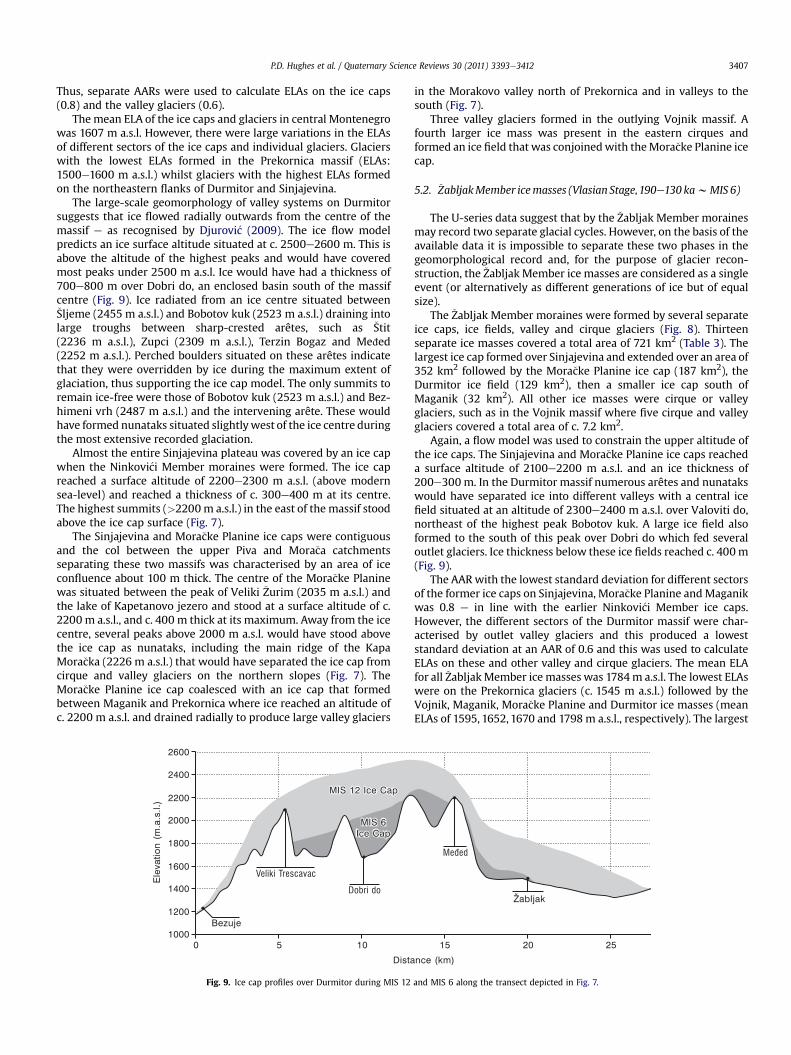
Fig. 9. Ice cap profiles over Durmitor during MIS 12
in the Morakovo valley north of Prekornica and in valleys to thesouth (Fig. 7).
Three valley glaciers formed in the outlying Vojnik massif. Afourth larger ice mass was present in the eastern cirques andformed an ice field that was conjoinedwith theMora�cke Planine icecap.
5.2. �ZabljakMember icemasses (Vlasian Stage,190e130 kawMIS 6)
The U-series data suggest that by the �Zabljak Member morainesmay record two separate glacial cycles. However, on the basis of theavailable data it is impossible to separate these two phases in thegeomorphological record and, for the purpose of glacier recon-struction, the �Zabljak Member ice masses are considered as a singleevent (or alternatively as different generations of ice but of equalsize).
The �Zabljak Member moraines were formed by several separateice caps, ice fields, valley and cirque glaciers (Fig. 8). Thirteenseparate ice masses covered a total area of 721 km2 (Table 3). Thelargest ice cap formed over Sinjajevina and extended over an area of352 km2 followed by the Mora�cke Planine ice cap (187 km2), theDurmitor ice field (129 km2), then a smaller ice cap south ofMaganik (32 km2). All other ice masses were cirque or valleyglaciers, such as in the Vojnik massif where five cirque and valleyglaciers covered a total area of c. 7.2 km2.
Again, a flow model was used to constrain the upper altitude ofthe ice caps. The Sinjajevina and Mora�cke Planine ice caps reacheda surface altitude of 2100e2200 m a.s.l. and an ice thickness of200e300 m. In the Durmitor massif numerous arêtes and nunatakswould have separated ice into different valleys with a central icefield situated at an altitude of 2300e2400 m a.s.l. over Valoviti do,northeast of the highest peak Bobotov kuk. A large ice field alsoformed to the south of this peak over Dobri do which fed severaloutlet glaciers. Ice thickness below these ice fields reached c. 400m(Fig. 9).
The AAR with the lowest standard deviation for different sectorsof the former ice caps on Sinjajevina, Mora�cke Planine andMaganikwas 0.8 e in line with the earlier Ninkovi�ci Member ice caps.However, the different sectors of the Durmitor massif were char-acterised by outlet valley glaciers and this produced a loweststandard deviation at an AAR of 0.6 and this was used to calculateELAs on these and other valley and cirque glaciers. The mean ELAfor all �ZabljakMember ice masses was 1784m a.s.l. The lowest ELAswere on the Prekornica glaciers (c. 1545 m a.s.l.) followed by theVojnik, Maganik, Mora�cke Planine and Durmitor ice masses (meanELAs of 1595, 1652, 1670 and 1798 m a.s.l., respectively). The largest
and MIS 6 along the transect depicted in Fig. 7.
P.D. Hughes et al. / Quaternary Science Reviews 30 (2011) 3393e34123408
ice cap, on Sinjajevina, had the highest ELAs with a mean of1842 m a.s.l.
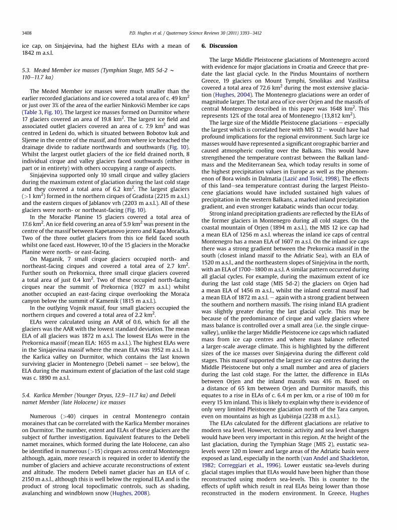
5.3. MeCed Member ice masses (Tymphian Stage, MIS 5d-2 w110e11.7 ka)
The MeCed Member ice masses were much smaller than theearlier recorded glaciations and ice covered a total area of c. 49 km2
or just over 3% of the area of the earlier Ninkovi�ci Member ice caps(Table 3, Fig. 10). The largest ice masses formed on Durmitor where17 glaciers covered an area of 19.8 km2. The largest ice field andassociated outlet glaciers covered an area of c. 7.9 km2 and wascentred in Ledeni do, which is situated between Bobotov kuk and�Sljeme in the centre of the massif, and fromwhere ice breached thedrainage divide to radiate northwards and southwards (Fig. 10).Whilst the largest outlet glaciers of the ice field drained north, 8individual cirque and valley glaciers faced southwards (either inpart or in entirety) with others occupying a range of aspects.
Sinjajevina supported only 10 small cirque and valley glaciersduring the maximum extent of glaciation during the last cold stageand they covered a total area of 6.2 km2. The largest glaciers(>1 km2) formed in the northern cirques of Gradista (2215 m a.s.l.)and the eastern cirques of Jablanov vrh (2203 m a.s.l.). All of theseglaciers were north- or northeast-facing (Fig. 10).
In the Mora�cke Planine 15 glaciers covered a total area of17.6 km2. An ice field covering an area of 5.9 km2 was present in thecentre of themassif between Kapetanovo jezero and KapaMora�cka.Two of the three outlet glaciers from this ice field faced southwhilst one faced east. However, 10 of the 15 glaciers in the Mora�ckePlanine were north- or east-facing.
On Maganik, 7 small cirque glaciers occupied north- andnortheast-facing cirques and covered a total area of 2.7 km2.Further south on Prekornica, three small cirque glaciers covereda total area of just 0.4 km2. Two of these occupied north-facingcirques near the summit of Prekornica (1927 m a.s.l.) whilstanother occupied an east-facing cirque overlooking the Mora�cacanyon below the summit of Kamenik (1815 m a.s.l.).
In the outlying Vojnik massif, four small glaciers occupied thenorthern cirques and covered a total area of 2.2 km2.
ELAs were calculated using an AAR of 0.6, which for all theglaciers was the AAR with the lowest standard deviation. The meanELA of all glaciers was 1872 m a.s.l. The lowest ELAs were in thePrekornica massif (mean ELA: 1655 m a.s.l.). The highest ELAs werein the Sinjajevina massif where the mean ELA was 1952 m a.s.l. Inthe Karlica valley on Durmitor, which contains the last knownsurviving glacier in Montenegro (Debeli namet e see below), theELA during the maximum extent of glaciation of the last cold stagewas c. 1890 m a.s.l.
5.4. Karlica Member (Younger Dryas, 12.9e11.7 ka) and Debelinamet Member (late Holocene) ice masses
Numerous (>40) cirques in central Montenegro containmoraines that can be correlated with the Karlica Member moraineson Durmitor. The number, extent and ELAs of these glaciers are thesubject of further investigation. Equivalent features to the Debelinamet moraines, which formed during the late Holocene, can alsobe identified in numerous (>15) cirques across central Montenegroalthough, again, more research is required in order to identify thenumber of glaciers and achieve accurate reconstructions of extentand altitude. The modern Debeli namet glacier has an ELA of c.2150 m a.s.l., although this is well below the regional ELA and is theproduct of strong local topoclimatic controls, such as shading,avalanching and windblown snow (Hughes, 2008).
6. Discussion
The large Middle Pleistocene glaciations of Montenegro accordwith evidence for major glaciations in Croatia and Greece that pre-date the last glacial cycle. In the Pindus Mountains of northernGreece, 19 glaciers on Mount Tymphi, Smolikas and Vasilitsacovered a total area of 72.6 km2 during the most extensive glacia-tion (Hughes, 2004). The Montenegro glaciations were an order ofmagnitude larger. The total area of ice over Orjen and the massifs ofcentral Montenegro described in this paper was 1648 km2. Thisrepresents 12% of the total area of Montenegro (13,812 km2).
The large size of the Middle Pleistocene glaciations e especiallythe largest which is correlated here with MIS 12 e would have hadprofound implications for the regional environment. Such large icemasseswould have represented a significant orographic barrier andcaused atmospheric cooling over the Balkans. This would havestrengthened the temperature contrast between the Balkan land-mass and the Mediterranean Sea, which today results in some ofthe highest precipitation values in Europe as well as the phenom-enon of Bora winds in Dalmatia (Lazi�c and To�si�c, 1998). The effectsof this landesea temperature contrast during the largest Pleisto-cene glaciations would have included sustained high values ofprecipitation in the western Balkans, a marked inland precipitationgradient, and even stronger katabatic winds than occur today.
Strong inland precipitation gradients are reflected by the ELAs ofthe former glaciers in Montenegro during all cold stages. On thecoastal mountain of Orjen (1894 m a.s.l.), the MIS 12 ice cap hada mean ELA of 1256 m a.s.l. whereas the inland ice caps of centralMontenegro has a mean ELA of 1607 m a.s.l. On the inland ice capsthere was a strong gradient between the Prekornica massif in thesouth (closest inland massif to the Adriatic Sea), with an ELA of1520 m a.s.l., and the northeastern slopes of Sinjejvina in the north,with an ELA of 1700e1800m a.s.l. A similar pattern occurred duringall glacial cycles. For example, during the maximum extent of iceduring the last cold stage (MIS 5d-2) the glaciers on Orjen hada mean ELA of 1456 m a.s.l., whilst the inland central massif hada mean ELA of 1872 m a.s.l. e again with a strong gradient betweenthe southern and northern massifs. The rising inland ELA gradientwas slightly greater during the last glacial cycle. This may bebecause of the predominance of cirque and valley glaciers wheremass balance is controlled over a small area (i.e. the single cirque-valley), unlike the largerMiddle Pleistocene ice capswhich radiatedmass from ice cap centres and where mass balance reflecteda larger-scale average climate. This is highlighted by the differentsizes of the ice masses over Sinjajevina during the different coldstages. This massif supported the largest ice cap centres during theMiddle Pleistocene but only a small number and area of glaciersduring the last cold stage. For the latter, the difference in ELAsbetween Orjen and the inland massifs was 416 m. Based ona distance of 65 km between Orjen and Durmitor massifs, thisequates to a rise in ELAs of c. 6.4 m per km, or a rise of 100 m forevery 15 km inland. This is likely to explainwhy there is evidence ofonly very limited Pleistocene glaciation north of the Tara canyon,even on mountains as high as Ljubi�snja (2238 m a.s.l.).
The ELAs calculated for the different glaciations are relative tomodern sea level. However, tectonic activity and sea level changeswould have been very important in this region. At the height of thelast glaciation, during the Tymphian Stage (MIS 2), eustatic sea-levels were 120 m lower and large areas of the Adriatic basin wereexposed as land, especially in the north (van Andel and Shackleton,1982; Correggiari et al., 1996). Lower eustatic sea-levels duringglacial stages implies that ELAs would have been higher than thosereconstructed using modern sea-levels. This is counter to theeffects of uplift which result in real ELAs being lower than thosereconstructed in the modern environment. In Greece, Hughes

Fig. 10. Ice field and glacier reconstruction for the maximum extent of glaciation during the last glacial cycle. This occurred sometime before 13.4 � 0.4 ka in the Durmitor massif.Smaller glaciers also existed during the Younger Dryas and one small glacier survives today in the Durmitor massif.
P.D. Hughes et al. / Quaternary Science Reviews 30 (2011) 3393e3412 3409
P.D. Hughes et al. / Quaternary Science Reviews 30 (2011) 3393e34123410
(2004, p. 226) calculated that reconstructed ELAs for the last glacialcycle were c. 100 m lower than the ‘real’ ELAs because of theinterplay of eustatic sea-levels and uplift. In contrast, for the largestMiddle Pleistocene glaciation (MIS 12) reconstructed ELAs mayoverestimate ‘real’ ELAs by 60e240m. However, providing accuratecorrections for Pleistocene ELAs taking into account uplift and sealevel change in the Balkans is difficult because of the locally-complex tectonics of this area. For example, most of Montenegrois currently experiencing uplift (up to 4 mm per year in someplaces) although exceptions include the area around the BokaKotorska near Mount Orjen which is undergoing subsidence(Djurovi�c and Petrovi�c, 2007). To compound the problem of esti-mating Pleistocene uplift rates there is the problem of subsidencecaused by isostatic loading by the large ice masses themselves. Dueto this complexity, no corrections to ELAs are attempted in thispaper.
In common with the records from Greece, throughout Mon-tenegro, Late Pleistocene glaciers were much smaller than MiddlePleistocene glaciers and this must be related to either warmersummer temperatures or drier winter conditions. For the PindusMountains of northern Greece and the coastal mountains of Mon-tenegro, Hughes et al. (2007, 2010) have argued that the glaciermaxima of the last cold stage (MIS 5d-2) were associated withhigher summer temperatures than during the equivalent phase ofMIS 12. If the reverse were true (i.e. colder last cold stage comparedwith the largest Middle Pleistocene glaciation, MIS 12), thenconditions must have been much wetter during MIS 12 to producesuch large and lower altitude ice masses. However, the long pollenrecord from Tenaghi Philippon in northern Greece suggests other-wise, with MIS 12 being characterised by severe moisture stresswith the lowest frequencies of arboreal pollen in the last 450 ka(Tzedakis et al., 2003; Tzedakis, 2005). Thus, if the most extensiveglaciation does correlate with MIS 12, then conditions at this timemust have been significantly colder than during the equivalentevent of the last cold stage.
The �Zabljak Member moraines appear to represent a complex ofdifferent-aged moraines that cannot be differentiated solely on thebasis of soil weathering characteristics. The moraines west of�Zabljak yielded calcites that date from MIS 5 (105.4 � 6.4 and120.2 � 6.2 ka). These ages are consistent with calcite formationduring the interglacial immediately after the formation of themoraines during the penultimate glacial cycle e named the VlasianStage in Greece (MIS 6) e and this is in good agreement with therecords from both Orjen in western Montenegro (Hughes et al.,2010) and the Pindus of northwestern Greece (Hughes et al.,2006a,b). However, the nearby Jun�cev do moraine on the southernedge of �Zabljak town contains a range of older and younger calcitecements, the oldest dating from MIS 7 (231.9 � 17.5 ka) with othercalcites dating fromMIS 6 (162.7� 7.9 ka) andMIS 4 (58.8� 2.0 ka).Thewide range of ages at this site is interpreted as being the result ofeither prolonged percolation of spring waters through the moraineor intermittent reactivation of spring waters at the same localityduring MIS 7, 6 and 4. The oldest calcites in the Jun�cev do moraineare very significant because these moraines are a long way (>5 km)up-valley of the lowest Ninkovi�ci Membermoraines. The soil on theJun�cev domoraine has the sameweathering characteristics as othermoraines in the �Zabljak area that contain younger calcites (that areno older than the Last Interglacial). Thus, as noted in the resultssection, this causes problems when attempting to subdividemoraines. In the case of the moraines ascribed to the �ZabljakMember, the available evidence favours the idea of a palimpsest ofclosely-spaced moraines but widely separated in age. In thisscenario the Jun�cev domoraines could have formed betweenMIS 12and 6, possibly duringMIS 8 or 10. The limiting age of 231.9�17.5 kasuggests MIS 8, but more ages are needed to confirm this.
At the Tenaghi Philippon long lacustrine site in northern Greece,the most extreme arboreal pollen minima are encountered duringthe glacial maximum of MIS 12, followed in order of decreasingextremity by those of MIS 6, MIS 2, MIS 10 and finally MIS 8(Tzedakis et al., 2003; Tzedakis, 2005). If arboreal pollen frequen-cies are taken to be representative of moisture supply then thiswould meanMIS 12 was the driest andMIS 8 the wettest. Given theimportance of both precipitation (winter) and temperatures(summer) in glacier mass balance (Hughes and Braithwaite, 2008),then it is entirely plausible that glaciers could have extended downto Jun�cev do during MIS 8. There is also evidence of cold and wetconditions during MIS 6 (Roucoux et al., 2011) which may haveproduced similar-sized glaciers to MIS 8. In this situation the MIS 6glaciers could have overridden and eroded earlier MIS 8 moraines.It may be the case that MIS 6 glaciers were larger than MIS 8glaciers in some localities but not in others resulting in a compli-cated record of MIS 8 and MIS 6 glaciations in different valleys. It isapparent from central Montenegro that the glacier history for theperiod MIS 10-6 is more complex than that recorded on the coastalmountains at Orjen (Hughes et al., 2010) and in the mountains ofnorthwest Greece (Hughes et al., 2006a). Further detailed work onthe nature of MIS 8 (and 10), like the Ioannina pollen recordrecently completed for MIS 6 by Roucoux et al. (2011), will helpconstrain the climatic combinations and associated glacieradvances during these glacial cycles. Moreover, a more precisegeochronology for glacial events is also needed in order to tie theglacial and long pollen (and other) records together.
The peninsulas of southern Europe are known to have beenimportant areas of refugia for plants and animals during cold stages(Bennett et al., 1991; Tzedakis, 1993; Hewitt, 2000, 2004). Moun-tainous areas of these peninsulas, in particular, are thought to havebeen important refugia because of sustained moisture supply whenconditions were during cold and arid in the lowlands (Tzedakis,1993). The effects of the major ice sheets of the Alps and northernEurope in driving biotic change and the role of the Mediterraneanpeninsulas in providing cold stage refugia has received considerableattention in the last decade, especially since the papers of Hewitt(2000, 2004). However, it is becoming clear that ice cover wasvery extensive even over the mountains of these peninsulas as isillustrated in the Balkans on Orjen and also in other peninsulas suchas Iberia (Cowton et al., 2009). Whilst the presence of extensive icemasses would have rendered large parts of the Mediterraneanmountains unsuitable for thermophilous species,whichwould havebeen restricted to low-altitude refugia, the mountains would haveprovided important refugia for cold-adapted species (Nève andVerlaque, 2009). As noted above, the strongest contender for thelargest glaciation is MIS 12. This interval has been identified byTzedakis (2005) as one ofmost severe of the last million years in theBalkans and Gamble (1999) identified this cold stage as a pivotalevent in the evolution of early humans (Neanderthals). It is likely,therefore, that glaciers exerted considerable influence not only ongeomorphological evolution of the Balkans (e.g. Woodward et al.,2008) but also on biological evolution too.
Given that the authors have found evidence of large glaciationsin numerous other parts of southeastern Montenegro not coveredin this paper, such as the Bieljasica, Komovi, Ku�ci (Fig. 1) and Pro-kletije massifs, amongst others, the total glaciated area of Mon-tenegro is likely to be much greater. Little is known about formerglacier extent in Bosnia, although it is clear that the mountains areextensively glaciated on the border mountains of Volujak, Bio�c andMagli�c (Milivojevi�c, 2004b). Further north in Croatia there isstratigraphical evidence that glaciers from a very large ice capreached the coast of Dalmatia during the Middle Pleistocene(Marjanac and Marjanac, 2004) and work is in progress in this areain order to establish the extent and timing of glaciations.

P.D. Hughes et al. / Quaternary Science Reviews 30 (2011) 3393e3412 3411
Across the Mediterranean mountains there appears to be majordifferences in the timings of glaciations. Understanding thesedifferences and what they mean for understanding cold stagepalaeoclimate in the Mediterranean basin is one of the mostpressing challenges for glacial research in this region and beyond(Hughes and Woodward, 2008; Thackray et al., 2008; Woodwardand Hughes, 2011). Robust geochronologies accompanied by glaci-ological modelling of the former glaciers and their associatedclimates is crucial in order for the glacier records to be comparedandintegratedwith other records of long-termenvironmental change inthe Mediterranean (cf. Tzedakis, 2007; Woodward, 2009).
7. Conclusions
Ice caps once covered large areas of the uplands in the Balkans.The largest ice cap in Montenegro covered an area of nearly1500 km2. This included the Durmitor, Sinjajevina, Mora�cke, Mag-anik and Prekornica massifs across the centre of the country, whilstvalley glaciers formed on satellite mountains such as Vojnik. Morethan 30 U-series dates from secondary carbonates cementing tillsacross Montenegro (including Orjen on the coast) providea geochronological framework for the glacial stratigraphy. Six agesindicate that the most extensive glaciation occurred before 350 kaduring the Middle Pleistocene, possibly correlating with a majorphase of glaciation in elsewhere in Europe during MIS 12 (c.470e420 ka). Later, less extensive, glaciations occurred during MIS10-6 (360e130 ka) and at least twodifferent glacial advances appearto be represented by closely-spaced moraines, with one correlatingwithMIS 6 and the other tentativelywithMIS 8. Ice fields and valleyglaciers formed during the last cold stage (MIS 5d-2) butweremuchsmaller than the earlier glaciations. Cirque and valley glaciers werealso present during the Younger Dryas (12.9e11.7 ka), whilst themost recent Holocene glaciers formed just a short distance up-valley. The magnitude of Middle Pleistocene glaciation in Mon-tenegro hints at extensive glaciation in nearby countries in thewestern Balkans, such as Albania, Bosnia-Herzegovina and Croatia.The Dinaric Alps represented one of the largest centres of ice accu-mulation during the Middle Pleistocene in Europe. Whilst muchsmaller in size than the ice masses of Fennoscandinavia, Britain-Ireland and the Alps, the Balkan ice caps are likely to have rivalledin size the icemasses over the Pyrenees andwere certainly amongstthe largest ice masses of the Mediterranean mountains.
Acknowledgements
This research was supported by a Peter Fleming Award from theRoyal Geographical Society (with IBG) awarded to Philip Hughes. TheU-series dating was supported by the UK Natural EnvironmentResearch Council award (IP/878/1105) to Hughes andWoodward. Allof the figures were drawn by Graham Bowden in the CartographicUnit in the School of Environment and Development at The Univer-sity of Manchester. We would like to thank the two anonymousreferees for their very helpful comments and recommendations.
References
Akçar, N., Yavuz, V., Ivy-Ochs, S., Kubik, P.W., Vardar, M., Schlüchter, C., 2007.Paleoglacial records from Kavron Valley, NE Turkey: field and cosmogenicexposure dating evidence. Quaternary International 164e165, 170e183.
Akçar, N., Yavuz, V., Ivy-Ochs, S., Kubik, P.W., Vardar, M., Schlüchter, C., 2008. A casefor a down wasting mountain glacier during Termination I, Verçenik Valley, NETurkey. Journal of Quaternary Science 23, 273e285.
Benn, D.I., Hulton, N.R.J., 2010. An Excel� spreadsheet program for reconstructingthe surface profile of former mountain glaciers and ice caps. Computers andGeosciences 36, 605e610.
Bennett, K.D., Tzedakis, P.C., Willis, K.J., 1991. Quaternary refugia of north Europeantrees. Journal of Biogeography 18, 103e115.
Birkeland, P.W., 1999. Soils and Geomorphology, third ed. Oxford University Press,New York.
Bognar, A., Prugove�cki, I., 1997. Glaciation traces in the area of the Risnjak mountainMassif. Geologica Croatica 50 (2), 269e278.
Bo�skovi�c, M., Bajkovi�c, I., 2004. Waters of Montenegro. BALWOIS: Water Observa-tion and Information System for Balkan Countries. Paper number: A-403.Available at: http://balwois.com/balwois/administration/full_paper/ffp-870.pdf(accessed 28.07.11.).
van Calsteren, P., Schwieters, J.B., 1995. Performance of a thermal ionisation massspectrometer with a deceleration lens system and post-deceleration detectorselection. International Journal of Mass Spectrometry and Ion Processes 146(147), 119e129.
Correggiari, A., Roveri, M., Trincardi, F., 1996. Late Pleistocene and Holoceneevolution of the north Adriatic Sea. Quaternario 9, 697e704.
Cowton, T., Hughes, P.D., Gibbard, P.L., 2009. Palaeoglaciation of Parque Natural Lagode Sanabria, northwest Spain. Geomorphology 108, 282e291.
�Curi�c, M., 1996. Climate of Durmitor national park. In: Lje�sevi�c, M. (Ed.), The Natureof National Park Durmitor, vol. 8. Faculty of Geographie, University of Belgrade,pp. 151e162. Special Editions.
Cviji�c, J., 1889. In: Glacijalne i morfolo�ske studije o planinama Bosne, Hercegovine iCrne Gore, vol. LVII 1/21. Glas Srpske Kraljevske Akademije Nauka, Beograd.
Cviji�c, J., 1903a. In: Novi rezultati o glacijalnoj eposi Balkanskog poluostrva, vol. LXV1/25. Glas Srpske Kraljevske Akademije Nauka, Beograd.
Cviji�c, J., 1903b. In: Balkanska, alpska i karpatska glacijacija, vol. 67. Glas SrpskeKraljevske Akademije Nauka, Beograd.
Cviji�c, J., 1913. In: Ledeno doba u Prokletijama i okolnim planinama, vol. XCI. GlasSrpske Kraljevske Akademije Nauka, Beograd, pp. 1e149.
Cviji�c, J., 1914. Eiszeitliche Vergletscherung der Gebirgsgruppen von Prokletije bisDurmitor. Maßstab 1:200,000. K.u.k. Militärgeographischen Institutes, Wien.
Cviji�c, J., 1917. L’époque glaciaire dans la péninsule des Balkanique. Annales deGéographie 26, 189e218.
Dehnert, A., Preusser, F., Kramers, J.D., Akçar, N., Kubik, P., Reber, R., Schlüchter, C.,2010. A multi-dating approach applied to proglacial sediments attributed to themost extensive glaciation of the Swiss Alps. Boreas 39, 620e632.
Djurovi�c, P., 2009. Reconstruction of the Pleistocene glaciers of Mt. Durmitor inMontenegro. Acta Geographica Slovenica 49 (2), 263e289.
Djurovi�c, P., Petrovi�c, A., 2007. Large canyons in Dinaric and Prokletije mountainregions of Montenegro. Geographica Pannonica 11, 14e18.
Edwards, R.L., Chen, H., Wasserburg, G.J., 1987. 238Ue234Ue230The232Th systematicsand the precise measurement of time over the past 500,000 years. Earth andPlanetary Science Letters 81, 175e192.
Fairchild, I.J., Bradby, L., Spiro, B., 1994. Reactive carbonate in glacial systems:a preliminary synthesis of its creation, dissolution and reincarnation. In: Dey-noux, M., Miller, J.M.G., Domack, E.W., Eyles, N., Fairchild, I.J., Young, G.M. (Eds.),Earth’s Glacial Record. International Geological Correlation Project 260. Cam-bridge University Press, pp. 176e192.
Gamble, C.S., 1999. The Palaeolithic Societies of Europe. Cambridge University Press,Cambridge, p. 505.
Grunewald, K., Scheithauer, J., 2010. Europe’s southernmost glaciers: response andadaptation to climate change. Journal of Glaciology 56, 129e142.
Harden, J.W., 1982. A quantitative index of soil development from field descriptions:examples from a chronosequence in central California. Geoderma 28, 1e28.
Hewitt, G.M., 2000. The genetic legacy of the Quaternary ice ages. Nature 405,907e913.
Hewitt, G.M., 2004. Genetic consequences of climatic oscillations in theQuaternary. Philosophical Transactions of the Royal Society, London B359,183e195.
Hughes, P.D., 2004. Quaternary Glaciation in the Pindus Mountains, NorthwestGreece. PhD Thesis. Darwin College, University of Cambridge. Available at:https://www.escholar.manchester.ac.uk/uk-ac-man-scw:16975 p. 341.
Hughes, P.D., 2007. Recent behaviour of the Debeli Namet glacier, Durmitor, Mon-tenegro. Earth Surface Processes and Landforms 10, 1593e1602.
Hughes, P.D., 2008. Response of a Montenegro glacier to extreme summer heat-waves in 2003 and 2007. Geografiska Annaler 90A, 259e267.
Hughes, P.D., 2009. Twenty-first century glaciers in the Prokletije mountains,Albania. Arctic, Antarctic and Alpine Research 41, 455e459.
Hughes, P.D., 2010a. The role of geomorphology in Quaternary stratigraphy: mor-phostratigraphy, lithostratigraphy and allostratigraphy. Geomorphology 123,189e199.
Hughes, P.D., 2010b. Little Ice Age glaciers in Balkans: low altitude glaciationenabled by cooler temperatures and local topoclimatic controls. Earth SurfaceProcesses and Landforms 35, 229e241.
Hughes, P.D., Braithwaite, R.J., 2008. Application of a degree-day model to recon-struct Pleistocene glacial climates. Quaternary Research 69, 110e116.
Hughes, P.D., Woodward, J.C., 2008. Timing of glaciation in the Mediterraneanmountains during the last cold stage. Journal of Quaternary Science 23,575e588.
Hughes, P.D., Woodward, J.C., 2009. Glacial and Periglacial environments. In:Woodward, J.C. (Ed.), The Physical Geography of the Mediterranean. OxfordUniversity Press, Oxford, pp. 353e383.
Hughes, P.D., Woodward, J.C., Gibbard, P.L., Macklin, M.G., Gilmour, M.A., Smith, G.R.,2006a. The glacial history of the Pindus mountains, Greece. Journal of Geology114, 413e434.
Hughes, P.D., Woodward, J.C., Gibbard, P.L., 2006b. The last glaciers of Greece.Zeitschrift für Geomorphologie 50, 37e61.

P.D. Hughes et al. / Quaternary Science Reviews 30 (2011) 3393e34123412
Hughes, P.D., Woodward, J.C., Gibbard, P.L., 2007. Middle Pleistocene cold stageclimates in the Mediterranean: new evidence from the glacial record. Earth andPlanetary Science Letters 253, 50e56.
Hughes, P.D., Woodward, J.C., van Calsteren, P.C., Thomas, L.E., Adamson, K., 2010.Pleistocene ice caps on the coastal mountains of the Adriatic Sea: palae-oclimatic and wider palaeoenvironmental implications. Quaternary ScienceReviews 29, 3690e3708.
Kern, Z., Surányi, G., Molnár, M., Nagy, B., Balogh, D., 2007. Investigation of naturalperennial ice deposits of Durmitor mts, Montenegro. In: Proceedings of the 2ndInternational Workshop on Ice Caves Demänská Dolina, Slovak Republic, May8the12th, 2006.
Kotarba, A., Hercman, H., Dramis, F., 2001. On the age of Campo Imperatore glaci-ations, Gran Sasso Massif, Central Italy. Geografia Fisica e Dinamica Quaternaria24, 65e69.
Kuhlemann, J., Milivojevi�c, M., Krumrei, I., Kubik, P.W., 2009. Last glaciation of the�Sara range (Balkan peninsula): increasing dryness from the LGM to the Holo-cene. Austrian Journal of Earth Sciences 102, 146e158.
Lazi�c, L., To�si�c, I., 1998. A real data simulation of the Adriatic Bora and the impact ofMountain height on Bora Trajectories. Meteorology and Atmospheric Physics66, 143e155.
Liedtke, H., 1962. Eisrand und Karstpoljen am Westrand Lukavica-Hochfläche.Erdkunde XVI, 289e298.
Maga�s, D., 2002. Natural-geographic characteristics of the Boka Kotorska area as thebasis of development. Geoadria 7 (1), 51e81.
Marjanac, L., Marjanac, T., 2004. Glacial history of the Croatian Adriatic and coastalDinarides. In: Ehlers, J., Gibbard, P.L. (Eds.), Quaternary Glaciations e Extent andChronology. Part I: Europe. Elsevier, Amsterdam, pp. 19e26.
Marjanac, T., Marjanac, L., Ore�ski, E., 1990. Glacijalni I periglacijalni sedimenti uNovigradskom moru. Geologica vjesnik 43, 35e42.
Marovi�c, M., Markovi�c, M., 1972. Glacijalna morfologija �sire oblasti Durmitora.Geolo�ski anali Balkanskog poluostrva 37, 37e48.
Menkovi�c, L., Markovi�c, M., Cupkovi�c, T., Pavlovi�c, R., Trivi�c, B., Banjac, N., 2004.Glacial morphology of Serbia (Yugoslavia), with comments on the Pleistoceneglaciation of Montenegro, Macedonia and Albania. In: Ehlers, J., Gibbard, P.L.(Eds.), Quaternary GlaciationsdExtent and Chronology. Part I: Europe. Elsevier,Amsterdam, pp. 379e384.
Messerli, B., 1967. Die eiszeitliche und die gegenwartige Vertgletscherung im Mit-telemeeraum. Geographica Helvetica 22, 105e228.
Milivojevi�c, M., Menkovi�c, L., �Cali�c, J., 2008. Pleistocene glacial relief of the centralpart of Mt. Prokletije (Albanian Alps). Quaternary International 190, 112e122.
Milivojevi�c, M., 2004a. Glacial morphology of Komovi. Glasnik Srpskog geografskogdru�stva 84, 45e60.
Milivojevi�c, M., 2004b. The Glacial Relief on Mt Volujak with Mt Bio�c and Mt Magli�c,vol. 68. Geographic Institute “Jovan Cviji�c” Serbian Academy of Science and Arts.Special Issues130.
Milojevi�c, B.�Z., 1937. Visoke planine u na�soj Kraljevini. Dr�zavna �stamparija Kralje-vine Jugoslavije, Beograd.
Milojevi�c, B.�Z., 1950a. O kanjonskoj dolini durmitorske Komarnice. Glas SrpskeKraljevske Akademije Nauka 196 (2) (Beograd).
Milojevi�c, B.�Z., 1950b. O kanjonskoj dolini durmitorske Su�sice. Radovi ZavodaJugoslavenske akademije znanosti i umjetnosti u Zadru 280 (Zagreb).
Milojevi�c, B.�Z., 1951. Durmitor e regionalno-geografska istra�zivanja. Zbornik radovae Srpska akademija nauka 9 (2) (Beograd).
Mirkovi�c, M., Vujisi�c, P., 1989. Osnovna geolo�ska karta Jugoslavije, Scale 1:100,000,�Zabljak, Sheet K34e27. Savezni geolo�ski zavod, Beograd.
Nève, G., Verlaque, R., 2009. Genetic differentiation between and among refugia. In:Habel, J.C., Assman, T. (Eds.), Relict species: Phylogeography and ConservationBiology. Springer-Verlag, Berlin Heidelberg, pp. 277e294.
Ng, F.S.L., Barr, I.D., Clark, C.D., 2010. Using the surface profiles of modern ice massesto inform palaeo-glacier reconstructions. Quaternary Science Reviews 29,3240e3255.
Nicod, J., 1968. Premières recherches de morphologie karstique dans le massif duDurmitor (Crna Gora:Montenegro). Meditérraneé 3, 187e216.
Nye, J.F., 1952. A method for calculating the thickness of ice sheets. Nature 169,529e530.
Osmaston, H., 2002. The nature, extents and climates of former Quaternary tropicalglaciers, with reference to the East African Mountains. In: Kaser, G.,
Osmaston, H. (Eds.), Tropical Glaciers. Cambridge University Press, Cambridge,pp. 149e192.
Osnovna Geolo�ska Karta SFRJ, 1970. �Savnik, Sheet K34e39, Scale 1:100,000.Saveznog geolo�skog zavoda, Beograd.
Osnovna Geolo�ska Karta SFRJ, 1971. Titograd, Sheet K34e51, Scale 1:100,000.Saveznog geolo�skog zavoda, Beograd.
Porter, S.C., 1975. Equilibrium-line altitudes of late Quaternary glaciers in theSouthern Alps, New Zealand. Quaternary Research 5, 27e47.
Roucoux, K.H., Tzedakis, P.C., Lawson, I.T., Margari, V., 2011. Vegetation history of thepenultimate glacial period (Marine Isotope Stage 6) at Ioannina, north-westGreece. Journal of Quaternary Science. doi:10.1002/jqs.1483.
Sarıkaya, M.A., Zreda, M., Çiner, A., Zweck, C., 2008. Cold and wet Last GlacialMaximum on Mount Sandiras, SW Turkey, inferred from cosmogenic datingand glacier modelling. Quaternary Science Reviews 27, 769e780.
Sarıkaya, M.A., Zreda, M., Çiner, A., 2009. Glaciations and paleoclimate of MountErciyes, central Turkey, since the Last Glacial Maximum, inferred from 36Cldating and glacier modeling. Quaternary Science Reviews 23e24, 2326e2341.
Schilling, D.H., Hollin, J.T., 1981. Numerical reconstructions of valley glaciers andsmall ice caps. In: Denton, G.H., Hughes, T.J. (Eds.), The Last Great Ice Sheets.Wiley, New York, pp. 207e220.
Smith, G.W., Nance, R.D., Genes, A.N., 1997. Quaternary glacial history of MountOlympus. Geological Society of America Bulletin 109, 809e824.
Smith, G.W., Nance, R.D., Genes, A.N., 2006. Pleistocene glacial history of MountOlympus, Greece: Neotectonic uplift, equilibrium line elevations, and implica-tions for climatic change. In: Dilek, Y., Pavlides, S. (Eds.), Postcollisionaltectonics and magmatism in the Mediterranean region and Asia. GeologicalSociety of America Special Paper 409, pp. 157e174.
Thackray, G.D., Owen, L.A., Yi, C., 2008. Timing and nature of late Quaternarymountain glaciaation. Journal of Quaternary Science 23, 503e508.
Tzedakis, P.C., 1993. Long-term tree populations in northwest Greece throughmultiple Quaternary climatic cycles. Nature 364, 437e440.
Tzedakis, P.C., 2005. Towards an understanding of the response of southern Euro-pean vegetation to orbital and suborbital climate variability. Quaternary ScienceReviews 24, 1585e1599.
Tzedakis, P.C., 2007. Seven ambiguities in the Mediterranean palaeoenvironmentalnarrative. Quaternary Science Reviews 26, 2042e2066.
Tzedakis, P.C., McManus, J.F., Hooghiemstra, H., Oppo, D.W., Wijmstra, T.A., 2003.Comparison of changes in vegetation in northeast Greece with records ofclimate variability on orbital and suborbital frequencies over the last 450,000years. Earth and Planetary Science Letters 212, 197e212.
van Andel, T.H., Shackleton, J.C., 1982. Late Paleolithic and mesolithic coastlines ofGreece and the Aegean. Journal of Field Archaeology 9, 445e454.
Veli�c, J., Veli�c, I., Kljajo, D., 2011. Sedimetary bodies, forms and occurrences in theTudorevo and Mirovo glacial deposits of northern velebit. Geologica Croatica 64(1), 1e16.
Veselinovi�c, D., Kova�cevi�c, D., Raj�si�c, S., Vurkmirovi�c, Z., Djordjevi�c, D., Stankovi�c, S.,Stankovi�c, A., 2001. The metal amounts in ce stalagmite of “ice cave” snow andwater at Durmitor mountains (Yugoslavia). Journal of Environmental Protectionand Ecology 2, 34e36.
Woodward, J.C. (Ed.), 2009. The Physical Geography of the Mediterranean. OxfordUniversity Press, p. 704.
Woodward, J.C., Hughes, P.D., 2011. Glaciation in Greece: a new record of cold stageenvironments in the Mediterranean. In: Ehlers, J., Gibbard, P.L., Hughes, P.D.(Eds.), Quaternary Glaciations e Extent and Chronology: A Closer Look. Elsevier,Amsterdam, pp. 175e198.
Woodward, J.C., Macklin, M.G., Smith, G.R., 2004. Pleistocene glaciation in themountains of Greece. In: Ehlers, J., Gibbard, P.L. (Eds.), Quaternary Glaciations eExtent and Chronology: Part 1. Elsevier, Amsterdam, pp. 155e173.
Woodward, J.C., Hamlin, R.H.B., Macklin, M.G., Hughes, P.D., Lewin, J., 2008. Glacialactivity and catchment dynamics in northwest Greece: long-term riverbehaviour and the slackwater sediment record for the last glacial to interglacialtransition. Geomorphology 101, 44e67.
Zahno, C., Akçar, N., Yavuz, V., Kubik, P., Schlüchter, C., 2009. Surface exposuredating of late Pleistocene glaciations at the Degegöl mountains (Lake Beysehir,SW Turkey). Journal of Quaternary Science 24, 1016e1028.
�Zivaljevi�c,M.,Vujisi�c, P.,Mirkovi�c,M.,Ðoki�c,V., �Cepi�c,M.,1981.Osnovnageolo�skakartaSFRJ, Ivangrad, Sheet K34-40, Scale 1:100,000. Savezni geolo�ski zavod, Beograd.