direct smaller drainages to inner mallets bay...
TRANSCRIPT
Appendix 7
1
Direct Smaller Drainages to inner Mallets Bay
Watershed Description
This bacteria TMDL summary applies to the entire stream and
tributary length of the direct smaller drainages to Inner Mallets
Bay, hereafter referred to as “the direct drainages.” The direct
drainages are comprised of Smith Hollow Brook and Crooked
Creek. The watersheds of these two small streams abut one
another and the streams drain into Malletts Bay only a quarter
mile apart. The streams begin in a wooded and agricultural area
to the east of Interstate 89 near Severance Road and Poor Farm
Road in the center of Colchester. Multiple smaller tributaries
enter the streams along their north westerly course under
Interstate 89 before draining into Malletts Bay near Lakeshore
Drive.
Colchester has a population of around 17,000 people and is one
of the largest municipalities in Vermont (CCRCP, 2006).
Protecting the streams draining into Malletts Bay and their
water quality is important to Colchester residents. The town is
37 square miles and it has almost 30 miles of shoreline on Lake
Champlain mostly in Malletts Bay (Colchester, 2002). Over the
last several decades the inner bay has been plagued by sporadic
outbreaks of high bacteria counts forcing beach closures
(Colchester, 2007).
The entire length of both Smith Hollow Brook and Crooked
Creek are considered bacteria impaired. Including all of the
tributaries that makes the total segment length nearly 18 miles
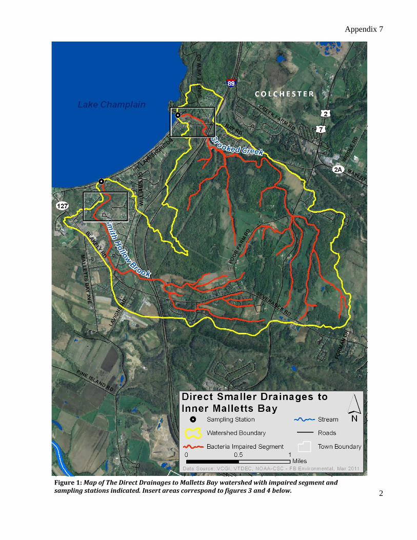
long (CCRCP, 2006). The combined watershed for the direct drainages (Figure 1) covers 3.5 square
miles, entirely in the town of Colchester. Overall, land use in the watershed is 59% forested, 23%
agricultural, 15% developed, and 3% wetland, as shown in Figure 2 (based on 2006 Land Cover Analysis
by NOAA-CSC).
Waterbody Facts (VT05-09)
Towns: Colchester
Impaired Segment Location: Entire length of both streams
Impaired Segment Length: 18 miles
Classification: Class B
Watershed Area: 7.5 square miles
Planning Basin: 5 – Northern Lake Champlain
Appendix 7
2
Figure 1: Map of The Direct Drainages to Malletts Bay watershed with impaired segment and sampling stations indicated. Insert areas correspond to figures 3 and 4 below.
Appendix 7
3
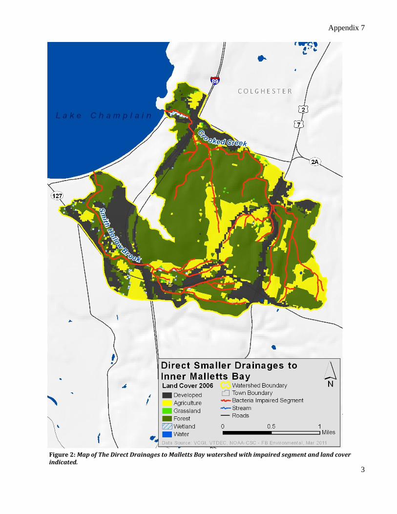
Figure 2: Map of The Direct Drainages to Malletts Bay watershed with impaired segment and land cover indicated.
Appendix 7
4
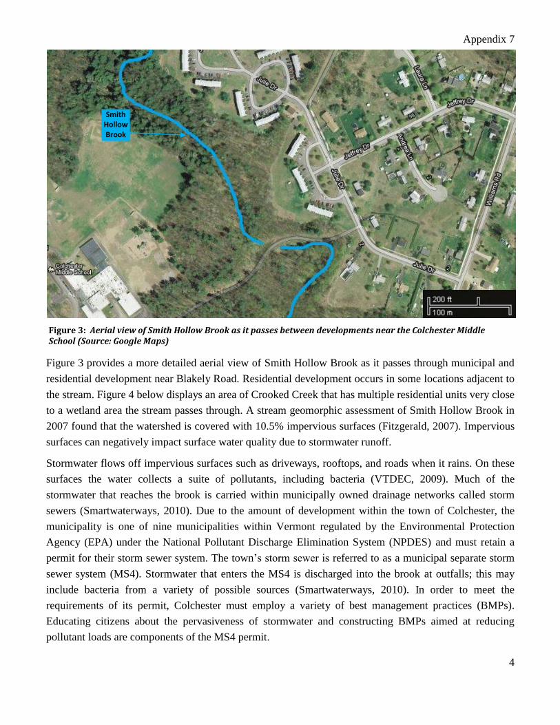
Figure 3 provides a more detailed aerial view of Smith Hollow Brook as it passes through municipal and
residential development near Blakely Road. Residential development occurs in some locations adjacent to
the stream. Figure 4 below displays an area of Crooked Creek that has multiple residential units very close
to a wetland area the stream passes through. A stream geomorphic assessment of Smith Hollow Brook in
2007 found that the watershed is covered with 10.5% impervious surfaces (Fitzgerald, 2007). Impervious
surfaces can negatively impact surface water quality due to stormwater runoff.
Stormwater flows off impervious surfaces such as driveways, rooftops, and roads when it rains. On these
surfaces the water collects a suite of pollutants, including bacteria (VTDEC, 2009). Much of the
stormwater that reaches the brook is carried within municipally owned drainage networks called storm
sewers (Smartwaterways, 2010). Due to the amount of development within the town of Colchester, the
municipality is one of nine municipalities within Vermont regulated by the Environmental Protection
Agency (EPA) under the National Pollutant Discharge Elimination System (NPDES) and must retain a
permit for their storm sewer system. The town’s storm sewer is referred to as a municipal separate storm
sewer system (MS4). Stormwater that enters the MS4 is discharged into the brook at outfalls; this may
include bacteria from a variety of possible sources (Smartwaterways, 2010). In order to meet the
requirements of its permit, Colchester must employ a variety of best management practices (BMPs).
Educating citizens about the pervasiveness of stormwater and constructing BMPs aimed at reducing
pollutant loads are components of the MS4 permit.
Figure 3: Aerial view of Smith Hollow Brook as it passes between developments near the Colchester Middle School (Source: Google Maps)
Smith Hollow Brook
Appendix 7
5
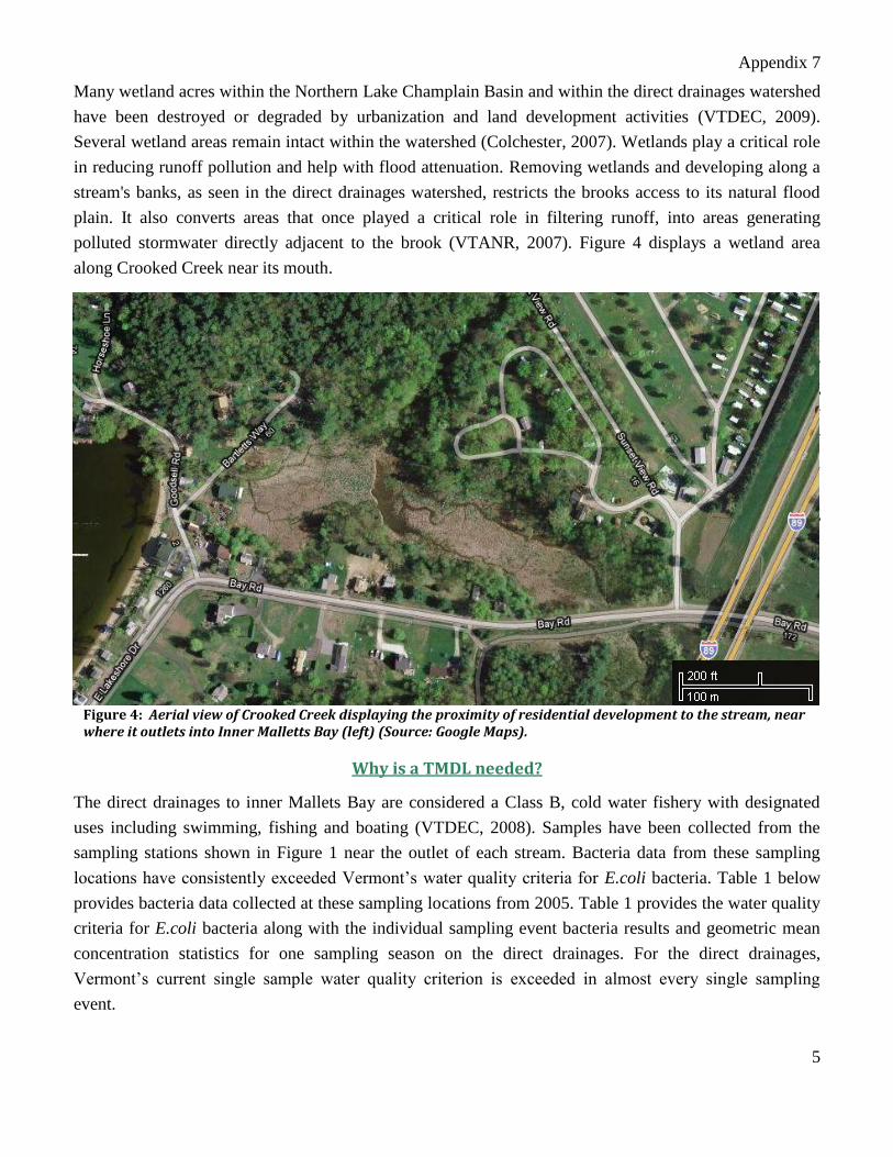
Many wetland acres within the Northern Lake Champlain Basin and within the direct drainages watershed
have been destroyed or degraded by urbanization and land development activities (VTDEC, 2009).
Several wetland areas remain intact within the watershed (Colchester, 2007). Wetlands play a critical role
in reducing runoff pollution and help with flood attenuation. Removing wetlands and developing along a
stream's banks, as seen in the direct drainages watershed, restricts the brooks access to its natural flood
plain. It also converts areas that once played a critical role in filtering runoff, into areas generating
polluted stormwater directly adjacent to the brook (VTANR, 2007). Figure 4 displays a wetland area
along Crooked Creek near its mouth.
Why is a TMDL needed?
The direct drainages to inner Mallets Bay are considered a Class B, cold water fishery with designated
uses including swimming, fishing and boating (VTDEC, 2008). Samples have been collected from the
sampling stations shown in Figure 1 near the outlet of each stream. Bacteria data from these sampling
locations have consistently exceeded Vermont’s water quality criteria for E.coli bacteria. Table 1 below
provides bacteria data collected at these sampling locations from 2005. Table 1 provides the water quality
criteria for E.coli bacteria along with the individual sampling event bacteria results and geometric mean
concentration statistics for one sampling season on the direct drainages. For the direct drainages,
Vermont’s current single sample water quality criterion is exceeded in almost every single sampling
event.
Due to the elevated bacteria measurements presented in Table 1, the direct drainages to Inner Mallets Bay
for their entire length, did not meet Vermont’s water quality standards, were identified as impaired and
placed on the 303(d) list. The 303(d) listing states that use of the direct drainages for contact recreations
(i.e., swimming) are impaired. The Clean Water Act requires that all 303(d) listed waters undergo a
TMDL assessment that describes the impairments and identifies the measures needed to restore water
Why is a TMDL needed?
The direct drainages to inner Mallets Bay are considered a Class B, cold water fishery with designated
uses including swimming, fishing and boating (VTDEC, 2008). Samples have been collected from the
sampling stations shown in Figure 1 near the outlet of each stream. Bacteria data from these sampling
locations have consistently exceeded Vermont’s water quality criteria for E.coli bacteria. Table 1 below
provides bacteria data collected at these sampling locations from 2005. Table 1 provides the water quality
criteria for E.coli bacteria along with the individual sampling event bacteria results and geometric mean
concentration statistics for one sampling season on the direct drainages. For the direct drainages,
Vermont’s current single sample water quality criterion is exceeded in almost every single sampling
event.
Figure 4: Aerial view of Crooked Creek displaying the proximity of residential development to the stream, near where it outlets into Inner Malletts Bay (left) (Source: Google Maps).
Crooked Creek
Appendix 7
6
Due to the elevated bacteria measurements presented in Table 1, the direct drainages to Inner Mallets Bay
for their entire length, did not meet Vermont’s water quality standards, were identified as impaired and
placed on the 303(d) list. The 303(d) listing states that use of the direct drainages for contact recreations
(i.e., swimming) are impaired. The Clean Water Act requires that all 303(d) listed waters undergo a
TMDL assessment that describes the impairments and identifies the measures needed to restore water
quality. The goal is for all waterbodies to comply with state water quality standards.
Potential Bacteria Sources
Both Smith Hollow Brook and Crooked Creek were identified as “hot spots” for bacterial contamination
to Inner Malletts Bay as far back as 1991 (Colchester, 2003). There are many possible sources of bacterial
contamination to the direct drainages including; failing septic systems, illicit discharges to Colchester’s
MS4, stormwater from developed areas, and wildlife.
E. coli is a bacteria naturally found within the intestinal tract and thus fecal matter of warm blooded
animals such as dogs, cows, birds, and humans. Its presence within surface water is a strong indication of
fecal matter contamination (USDA, 2000). One potential source of fecal matter contamination to surface
waters is sewage entering from failing or malfunctioning septic systems (VTDEC, 2009). Nearly all of
Colchester’s residents within the direct drainages watershed rely on onsite septic disposal systems to treat
their wastewater. Only a small portion of the watershed near the headwaters is serviced by sanitary sewer
(Colchester, 2007). A 1996 Wastewater Facility Planning Update for Colchester found there were
multiple areas of town where onsite systems were maintained infrequently or never. One of the areas
identified, around Lakeshore Drive, surrounds the outlets of both Smith Hollow Brook and Crooked
Creek (Colchester, 2003).
There may be a number of physical deficiencies for existing development within the drainages watershed
including non conforming septic disposal systems and marginally suited soils for septic disposal.
Furthermore, in 2007 many of the onsite disposal systems within town were found to be old and nearing
the end of their useful lives (Colchester, 2007). When systems are old, unmaintained, or placed on soils
with poor suitability they can malfunction and release bacteria to nearby surface waters (USEPA, 2002).
A microbial source tracking study conducted by the town of Colchester in 2001 attempted to identify
sources contributing bacteria to Malletts Bay. This study collected water samples from a variety of
locations, including the outlet of Smith Hollow Creek. E.coli bacteria in the samples were isolated and
their source organism was identified. While the study could not identify the major source of bacterial
contamination to Mallets Bay, samples from the outlet of Smith Hollow Creek did contain some E.coli
attributed to human sources (Colchester, 2003). These factors combine to make failing septic systems in
the drainages watershed a potential source of bacterial contamination.
Colchester’s Department of Public Works (DPW), attempts to locate illicit discharges to its storm sewer
as part of their MS4 permit. Illicit discharges are any discharge to the storm sewer or to streams that
Appendix 7
7
contain any substances other than stormwater. These discharges can include sanitary sewer pipes from a
residence or an under drain from a mechanics garage that are connected into the MS4 (Colchester, 2008).
Sometimes residents will make illicit connections to the MS4 sending their wastewater into the storm
sewer rather than a septic system or sanitary sewer, which is called a “direct discharge.” Also, “indirect
discharges” can occur when failing septic systems near the MS4 network leach sewage into the storm
sewer (Colchester, 2008). Both types of illicit discharges have the potential to contribute bacteria (and
other pollutants) to the MS4 which can reach the direct drainages at one of the MS4 outfalls on the
streams (Colchester, 2008). Smith Hollow Brook and Crooked Creek have been identified by the DPW as
high priority areas for Illicit Discharge Detection and Elimination (IDDE) testing. As of 2008, no illicit
discharges had been detected at MS4 outfalls on these streams.
Given the impervious surfaces within the drainages watershed, and the extensive MS4 network in
Colchester, stormwater is another potential source for bacterial contamination. There are a multitude of
possible sources for bacteria in stormwater. When animal waste is not disposed of properly and left near
the stream or on impervious surfaces that fecal matter can contaminate the stream. One of the most widely
documented and likely source of E. coli in stormwater from some urban areas is pet fecal matter,
specifically that of dogs. If residents are not properly disposing of their pet’s fecal matter or not picking
fecal matter up from streets where storm drains catch runoff, it can enter and contaminate the direct
drainages. This fecal matter can be a major source of bacterial contamination, especially in areas where
residential development is so prevalent around the drainages (Smartwaterways, 2010).
During a 2003 study of high bacteria levels within Inner Malletts Bay, wildlife sources were identified as
a possible cause of elevated bacteria levels (Colchester, 2003). Species such as deer, raccoons, birds, and
beavers are possible sources of E.coli to surface water when they live in large enough quantities on or
near the streams. There is a large section of town mapped as a deer wintering area within the drainages
watershed to the east of Interstate 89 (Colchester, 2007). The microbial source tracking done by the town
in 2001 identified deer, more than any other species, as the source of E.coli bacteria in water samples
(Colchester, 2003). The known concentration of deer and other animals within the watershed, as well as
the identification of deer during the microbial source tracking, makes wildlife another potential source of
bacterial contamination.
Recommended Next Steps
The town of Colchester has taken a proactive approach to dealing with the problems faced by the direct
drainages to Inner Mallets Bay. Colchester was Vermont’s first recipient of an EPA grant for the
development of an Integrated Water Resources Management Plan. The planning process has identified
many positive goals for water quality within Colchester including long-term sustainability, community
involvement, prioritization of pollutant problems, and public outreach (Colchesterwaters, 2011). The town
has also partnered with community organizations, stakeholders, and the other MS4 regulated communities
within Vermont to form the Regional Stormwater Education program (RSEP) in 2003. This collaborative
Appendix 7
8
works to encourage residents to get personally involved in reducing stormwater pollution. While the focus
has been centered on stormwater's other pollutants and nutrients, the town and its partners have worked to
address stormwater related bacterial issues as well (Smartwaterways, 2010). These programs are working
to address the problems faced by the direct drainages.
The Town of Colchester, local stakeholders, as well as other community and watershed based groups are
encouraged to continue implementing education and outreach programs, restoration programs, and the
identification of land use activities that might be influencing E. coli levels. Colchester could specifically
target education and outreach efforts to residential areas that surround Crooked Creek, with a special
focus on the Lakeshore Drive area near its outlet. This area was identified as a potential hot spot for septic
system failure (Colchester, 2003). However, it is important to note that readings from Smith Hollow
Brook still exceed Vermont’s water quality criteria on multiple occasions. The town has made funding
available for residents that wish to replace or update an existing onsite system in town. A focused effort
could be made in these areas to encourage residents to inspect their septic systems and remind them of the
town’s willingness to assist in replacing failing systems.
Citizens throughout the watershed, especially in residential areas near the drainages should be reminded
of the importance of picking up after pets. While the MS4 communities in Vermont are already
collaborating through RSEP, a focused marketing effort could be made in the greater Burlington area to
raise public awareness about bacteria in stormwater. Marketing campaigns and advertisements on TV, in
radio, and in print that display in a unique and compelling way the problems associated with improperly
disposed of pet waste would be beneficial. Funds are available to assist communities and organizations
with outreach and education from the Non Point Source Grant Program (319 Program), the Lake
Champlain Basin Program, and many other nonprofit, governmental, and private organizations.
An example of a successful outreach and education effort is the “Scoop the Poop Campaign.” This
collaborative effort between Burlington Eco Info and the Burlington Neighborhood Project which started
in the early 2000s provides information on how pet waste can impact water quality and can ultimately
lead to public health hazards and beach closures (EcoInfo). Efforts that make direct connections between
behaviors that are good for streams and recreational activities that people enjoy, such as swimming in
Lake Champlain, gives educational messages positive and lasting impact.
Additional bacteria data collection may also be beneficial to support identification of sources of
potentially harmful bacteria in the direct drainages watershed. For example, continued and expanded
sampling upstream and downstream of potential illicit discharges (a practice known as “bracket
sampling”) may be beneficial for identifying and quantifying sources. A potential location to undertake
“bracket sampling” is in the residential area around Crooked Creek, shown in figure 4, near East
Lakeshore Drive, Bay Road, and Sunset View Road. Since the sampling station on Crooked Creek is near
its outlet into Lake Champlain, sampling at various intervals upstream from the outlet and comparing the
results could help to locate a potential hot spot of bacteria loading to the creek. Sampling activities
focused on capturing bacteria data under different weather conditions (e.g., wet and dry) may also be
Appendix 7
9
beneficial in support of source identification. Field reconnaissance surveys focused on stream buffers,
stormwater runoff, and other source identification may also be beneficial.
Previous investigations and concerned groups (Smartwaterways, 2010; CCRPC, 2006; Colchester, 2003;
Colchester, 2007; Champlain, 1996) have recommended the following actions to support water quality
goals in the direct drainages to Inner Mallets Bay:
Stormwater – Continue and expand citizen education about the negative impacts of stormwater,
with a focus on the importance of picking up after one’s pet. Develop stronger enforcement
mechanisms to ensure the scooping and correct disposal of pet fecal matter. Continue to hold
workshops on new and simple ways to reduce the impact of stormwater from ones property with
BMPs such as rain barrels and rain gardens.
Illicit Discharges and Septic Malfunction – Expand testing for illicit discharges using a variety of
detection methods. Educate citizens on proper septic system maintenance and how to make sure
systems are functioning properly. Provide more cost sharing funds to the town from state or
federal agencies to help with septic system replacement or upgrades.
Riparian Corridor – Encourage landowners to install buffers, and other tools that protect shoreline
and/or riparian areas. Institute further controls on riparian buffers.
Several of the steps outlined above are ongoing and should be continued and enhanced to focus on the
goals of bacteria TMDL implementation. If implemented, these actions will provide a strong basis toward
the goal of mitigating bacteria sources and meeting water quality standards in the direct smaller drainages
to Inner Mallets Bay.
Bacteria Data
Vermont’s current criteria for bacteria are more conservative than those recommended by EPA. For Class
B waters, VTDEC currently utilizes an E. coli single sample criterion of 77 organisms/100ml. Although,
Vermont is in the process of revising their bacteria WQS to better align with the National Recommended
Water Quality Criteria (NRWQC) of a geometric mean of 126 organisms/100ml, and a single sample of
235 organisms/100ml. Therefore, in Table 1 below, bacteria data were compared to both the current
VTWQS and the NRWQC for informational purposes.
Appendix 7
10
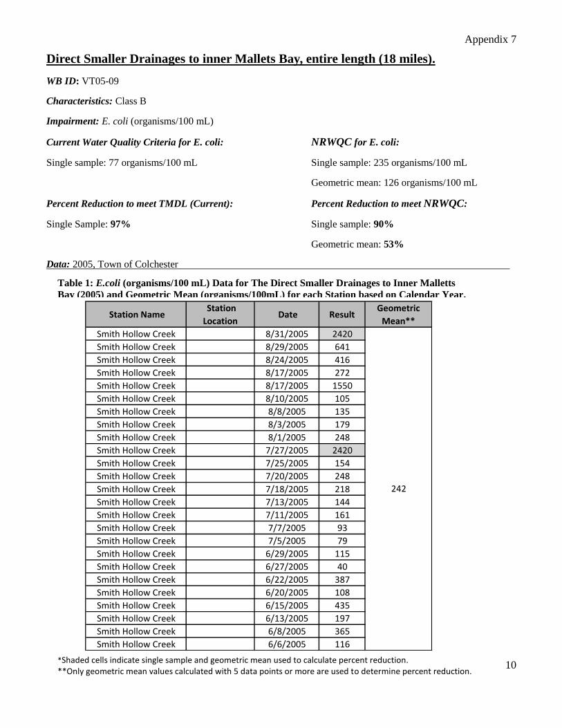
Direct Smaller Drainages to inner Mallets Bay, entire length (18 miles).
WB ID: VT05-09
Characteristics: Class B
Impairment: E. coli (organisms/100 mL)
Current Water Quality Criteria for E. coli: NRWQC for E. coli:
Single sample: 77 organisms/100 mL Single sample: 235 organisms/100 mL
Geometric mean: 126 organisms/100 mL
Percent Reduction to meet TMDL (Current): Percent Reduction to meet NRWQC:
Single Sample: 97% Single sample: 90%
Geometric mean: 53%
Data: 2005, Town of Colchester
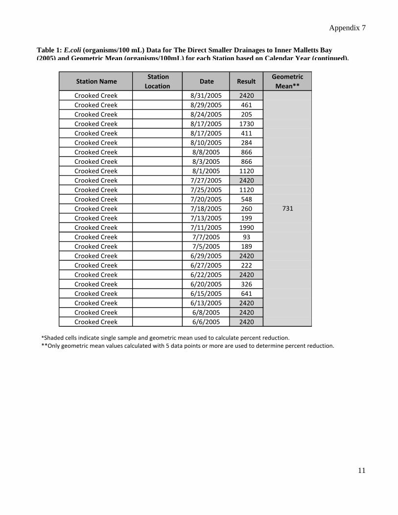
Table 1: E.coli (organisms/100 mL) Data for The Direct Smaller Drainages to Inner Malletts
Bay (2005) and Geometric Mean (organisms/100mL) for each Station based on Calendar Year.
(continued).
*Shaded cells indicate single sample and geometric mean used to calculate percent reduction. **Only geometric mean values calculated with 5 data points or more are used to determine percent reduction.
Station Name Station
Location Date Result
Geometric
Mean**
Smith Hollow Creek 8/31/2005 2420
Smith Hollow Creek 8/29/2005 641
Smith Hollow Creek 8/24/2005 416
Smith Hollow Creek 8/17/2005 272
Smith Hollow Creek 8/17/2005 1550
Smith Hollow Creek 8/10/2005 105
Smith Hollow Creek 8/8/2005 135
Smith Hollow Creek 8/3/2005 179
Smith Hollow Creek 8/1/2005 248
Smith Hollow Creek 7/27/2005 2420
Smith Hollow Creek 7/25/2005 154
Smith Hollow Creek 7/20/2005 248
Smith Hollow Creek 7/18/2005 218
Smith Hollow Creek 7/13/2005 144
Smith Hollow Creek 7/11/2005 161
Smith Hollow Creek 7/7/2005 93
Smith Hollow Creek 7/5/2005 79
Smith Hollow Creek 6/29/2005 115
Smith Hollow Creek 6/27/2005 40
Smith Hollow Creek 6/22/2005 387
Smith Hollow Creek 6/20/2005 108
Smith Hollow Creek 6/15/2005 435
Smith Hollow Creek 6/13/2005 197
Smith Hollow Creek 6/8/2005 365
Smith Hollow Creek 6/6/2005 116
242
Appendix 7
11
*Shaded cells indicate single sample and geometric mean used to calculate percent reduction. **Only geometric mean values calculated with 5 data points or more are used to determine percent reduction.
Station Name Station
Location Date Result
Geometric
Mean**
Crooked Creek 8/31/2005 2420
Crooked Creek 8/29/2005 461
Crooked Creek 8/24/2005 205
Crooked Creek 8/17/2005 1730
Crooked Creek 8/17/2005 411
Crooked Creek 8/10/2005 284
Crooked Creek 8/8/2005 866
Crooked Creek 8/3/2005 866
Crooked Creek 8/1/2005 1120
Crooked Creek 7/27/2005 2420
Crooked Creek 7/25/2005 1120
Crooked Creek 7/20/2005 548
Crooked Creek 7/18/2005 260
Crooked Creek 7/13/2005 199
Crooked Creek 7/11/2005 1990
Crooked Creek 7/7/2005 93
Crooked Creek 7/5/2005 189
Crooked Creek 6/29/2005 2420
Crooked Creek 6/27/2005 222
Crooked Creek 6/22/2005 2420
Crooked Creek 6/20/2005 326
Crooked Creek 6/15/2005 641
Crooked Creek 6/13/2005 2420
Crooked Creek 6/8/2005 2420
Crooked Creek 6/6/2005 2420
731
Table 1: E.coli (organisms/100 mL) Data for The Direct Smaller Drainages to Inner Malletts Bay
(2005) and Geometric Mean (organisms/100mL) for each Station based on Calendar Year (continued).
(continued).
Appendix 7
12
References
CCRPC (2006). Chittenden County Regional Planning Commission. Chittenden County Regional Plan,
adopted August, 2006. Available online at:
www.ccrpcvt.org/index.asp?Type=B_BASIC&SEC={378E3EB1-84D3-48AD-B30C-
26A22DA69B8C}, accessed online on February 14, 2011
Champlain (1996). Opportunities for Action. An Evolving Plan for the Future of the Lake Champlain
Basin. Pollution Prevention, Control & Restoration Plan – October 1996. Prepared by the Lake
Champlain Management Conference. Available online at: www.lcbp.org/THEPLAN.pdf, accessed
online on March 24, 2011.
Colchester (2002). Recent Literature on Water Quality in Colchester, Vermont: A Part of the Strategic
Water Quality Planning Process. August 6, 2002. Prepared for: Colchester Department of Public
Works, prepared by: Stone Environmental, Inc. SEI # 02 1278-W. Available online at:
http://colchestervt.gov/water/litrep.pdf, accessed online on March 22, 2011.
Colchester (2003). Colchester Strategic Water Quality Plan. August 25, 2003. Prepared for: Department
of Public Works. Prepared by: Stone Environmental, Inc. SEI # 02 1278-W. Available online at:
http://colchestervt.gov/water/FinalReport2003.08.25.pdf, accessed online on March 23, 2011.
Colchester (2007). Town of Colchester 2007 Town Plan. Adopted July 10, 2007. Prepared by: Town of
Colchester Planning and Zoning Department. Available online at:
http://colchestervt.gov/PlanningZ/plans/TownPlan.pdf, accessed online on March 25, 2011.
Colchester (2008). Town of Colchester 2007 Illicit Discharge Detection and Elimination Report. Prepared
for: Vermont Department of Environmental Conservation, Prepared by: Colchester Department of
Public Works. January 14, 2008.
Colchesterwaters (2011). Town of Colchester: Colchesterwaters.net. Information on Colchester’s
Integrated Water Resources Management Project. Copyright 2011. Available online at:
www.colchesterwaters.net/, accessed online on March 15, 2011.
EcoInfo (Undated). Burlington Eco Info, “Scoop the Poop Campaign,” (website)
www.uvm.edu/~empact/water/scoop_poop.php3, accessed online on May 3, 2011.
Fitzgerald (2007). Town of Colchester Phase I Stream Geomorphic Assessment Report. July 29, 2007.
Prepared for: Chittenden County Regional Planning Commission, prepared by: Fitzgerald
Environmental Associates, LLC. Available online at:
www.fitzgeraldenvironmental.com/Colchester.pdf, accessed online on March 22, 2011.
Mallin, et. al. (2007). Mallin, M.A., L.B. Cahoon, B.R. Toothman, D.C. Parsons, M.R. McIver, M.L.
Ortwine and R.N. Harrington. 2007. Impacts of a raw sewage spill on water and sediment quality
in an urban estuary. Mar. Pollution Bull. 54:81-88
Smartwaterways (2010). Chittenden County Regional Stormwater Education Program, Smartwaterways
(website). www.smartwaterways.org, last updated in 2010. Accessed online on: March 10, 2011.
Tavares et. al. (2009). Tavares, M.D., M.I.H. Spivey, M.R. McIver and M.A. Mallin. 2008. Testing for
Optical Brighteners and Fecal Bacteria to Detect Sewage Leaks in Tidal Creeks. University of
North Carolina Wilmington, Center for Marine Sciences. Available online at:
http://people.uncw.edu/hillj/classes/EVS595/Optical%20brightener%20paper%20for%20NCAS.p
df, accessed online on February 7, 2011.
Appendix 7
13
USDA (2000). Waterborne Pathogen Information Sheet, Principal Pathogens of Concern, Escherichia coli
(E. coli). United States Department of Agriculture, Natural Resources Conservation Service,
Watershed Science Institute. June 2000.
USEPA (2002). Onsite Wastewater Treatment Systems Manual – Office of Water, Office of Research and
Development – EPA/625/R-00/008. Available online at:
www.epa.gov/owm/septic/pubs/septic_2002_osdm_all.pdf, accessed online on January 27, 2011
VTANR (2007). Lake Champlain Basin Wetland Restoration Plan. December 31, 2007. Prepared for:
Vermont Agency of Natural Resources, Vermont Department of Forests, Parks and Recreation,
Lake Champlain Clean and Clear Action Plan. Prepared by: Pioneer Environmental Associates,
Llc., Arrowwood Environmental, Stone Environmental, Inc., Ice.Nine, Environmental Consulting.
VTDEC (2009). DRAFT Water Quality Management Plan for the Northern Lake Champlain Direct
Drainages. Agency of Natural Resources, Department of Environmental Conservation, Water
Quality Division. February 2009
VTDEC (2008). State of Vermont, 2008, 303(d) List of Waters, Part A – Impaired Surface Waters in
Need of TMDL, October 2008 (Approved by USEPA September 24, 2008). Prepared by: Vermont
Department of Environmental Conservation, Water Quality Division, Waterbury, VT.