directorate general of hydrocarbona 1 [type the...
TRANSCRIPT

Directorate General Of HydrocarbonA [Type the document title]
1
Basin Introduction:.
The Andaman-Nicobar basin, located in the southeastern part of the Bay of Bengal, occupies an area of 47,000 sq. km including deep waters(Index Map Of Andaman-Nicobar Basin). This basin forms a
part of Island Arc System which extends from Myanmar in the north to Indonesia in the south.
Directorate General Of HydrocarbonA [Type the document title]
2
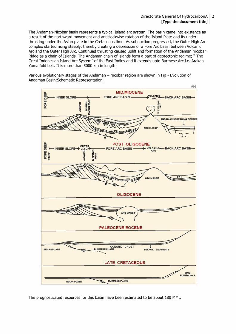
The Andaman-Nicobar basin represents a typical Island arc system. The basin came into existence as a result of the northward movement and anticlockwise rotation of the Island Plate and its under
thrusting under the Asian plate in the Cretaceous time. As subduction progressed, the Outer High Arc complex started rising steeply, thereby creating a depression or a Fore Arc basin between Volcanic
Arc and the Outer High Arc. Continued thrusting caused uplift and formation of the Andaman Nicobar
Ridge as a chain of Islands. The Andaman chain of islands form a part of geotectonic regime; “ The Great Indonesian Island Arc System” of the East Indies and it extends upto Burmese Arc i.e. Arakan
Yoma fold belt. It is more than 5000 km in length.
Various evolutionary stages of the Andaman – Nicobar region are shown in Fig - Evolution of
Andaman Basin:Schematic Representation.
The prognosticated resources for this basin have been estimated to be about 180 MMt.

Directorate General Of HydrocarbonA [Type the document title]
3
Tectonic History:.
The Andaman-Nicobar Basin has evolved through a complex history of tectonics associated with the
convergent plate boundaries between Indian plate and west Burmese plate. The Andaman-Nicobar basin was initiated with northward drift of Indian Plate with respect to Asia. The collision of
Indian/Eurasian plates initiated along the irregular boundary and occurred at the same time as the oceanic subduction beneath the southern Eurasia. The continental collision slowed down the oceanic
spreading rates in the Indian Ocean and slowed down the subduction velocity along the Sunda Arc
system. It resulted in a phase of extension in the adjacent Fore-Arc and Back-Arc areas.
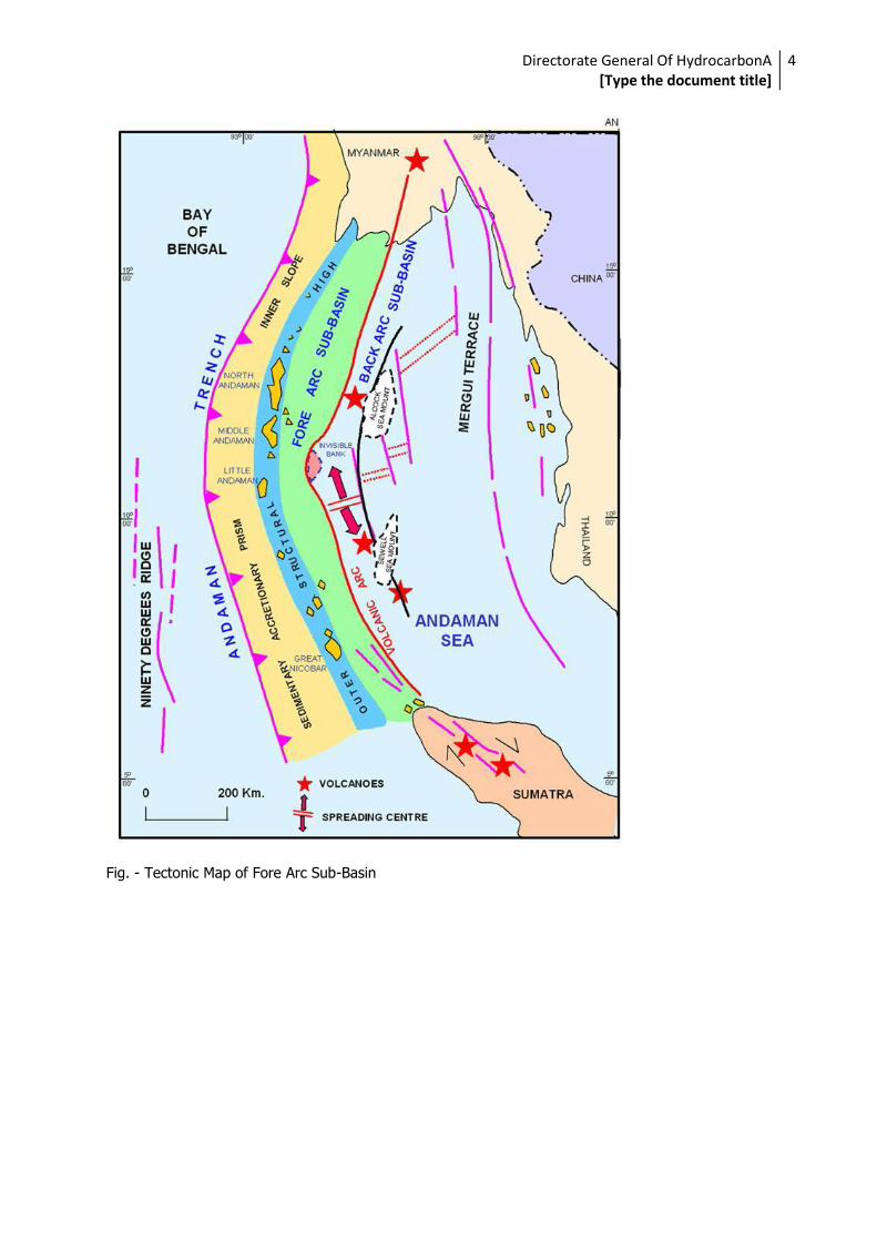
Major Tectonic elements of Andaman-Nicobar region are: Andaman Trench/Inner slope
Outer High/Trench slope break
Fore Arc Basin
Volcanic Arc
Back Arc Basin
Mergui Terrace
These Tectonic elements are shown in Figures:
Fig. - Schematic Cross Section across Andaman Sea at 11 degree North Latitude.
Fig. - Regional Tectonic Elements of the Andaman-Nicobar Region
Directorate General Of HydrocarbonA [Type the document title]
4
Fig. - Tectonic Map of Fore Arc Sub-Basin

Directorate General Of HydrocarbonA [Type the document title]
5
Fig. - Seismi-Geological Section Across Fore Arc Sub-Basin

Directorate General Of HydrocarbonA [Type the document title]
6
Fig. - Key Events in Development of Fore Arc Sub-Basin

Directorate General Of HydrocarbonA [Type the document title]
7
Generalised Stratigraphy:.
Habitat Of Oil and Gas Tectono-sedimentation studies carried out suggest presence of various petroleum systems in
Andaman basin :
1. Deeply buried thermogenic system in a ponded forearc. 2. Thermally induced petroleum system around the volcanic arc and
3. Biogenic/shallow gas system

Directorate General Of HydrocarbonA [Type the document title]
8
Basins associated with convergent plate margins are known to have good hydrocarbon potential if organic carbon content and thermal maturity are satisfied. The Andaman-Nicobar basin belongs to
this category. Mud volcanoes with associated oil and gas are reported from the outcrops of the Baratang Formation over the Middle and South Andaman. Gas has been discovered from Middle
Miocene limestone in well AN-1-1. Minor gas indications have also been observed from the Lower
Miocene vitric ash beds of well AN-32-1 (Lithostratigraphic Column of Well AN-32-1)
as well as from Cretaceous sandstone of AN-1-1 well Lithostratigraphic Column of Well AN-1-1.

Directorate General Of HydrocarbonA [Type the document title]
9
Sedimentary packages, specially in the Fore Arc basin, comprise strata of fluvial, shelf and deep
marine regime. Accumulation of significant organic matter is considered a strong possibility. Possible reefal growths within the Neogene section, further enhance the scope of enrichment of organic
matter. Proximity of the Fore Arc basin to the Volcanic arc is likely to ensure optimum heat flow for hydrocarbon generation.
The Inner slope has been the locale for Paleogene turbidite deposition that is known as collector of rich organic matter. Similarly, the Back Arc zone has been an area with significantly high heat flow
and thus considered favourable for hydrocarbon generation.
Geochemical analyses have indicated that Andaman-Nicobar region has organic rich sediments. The total organic carbon (TOC) ranges between 2.4% & 5.2% for Cretaceous to Oligocene Shales and
Claystones.
The most favorable source rock in the basin appears to be the Baratang Formation of the Late
Cretaceous-Late Eocene age, comprising of shale, silt, sand, carbonaceous shale, limestone with minor anhydrite and gypsum deposited in bathyal to shallow marine and open to restrictive euxinic
environments. The Pre-Neogene section in well AN-1-1 indicated presence of rich organic matter. The
Baratang Formation is in the early phase of maturation and lies within the principal phase of oil generation up to 5,000 m. Geochemical modeling has been carried out by M/s LARGE of Russia, using
data from drilled wells as well as pseudo wells generated in deep water area. A is shown

Directorate General Of HydrocarbonA [Type the document title]
10
in Representative Thermal & Maturation History in Deep Waters of Andaman-Nicobar Basin.
The Neogene sequence, though immature for any significant thermogenic generation of hydrocarbons, is of interest for biogenic gas (as observed in the limestone of Well AN-1-1).
Port Blair Formation, which is the main reservoir facies in the basin, shows variable properties. Over
the Andaman Islands, the reservoir rock is conglomeratic and pebbly at places, with alternating silty
sand and shale or fine to medium grained massive sand stone at other places. Sandstone reservoirs appear to be restricted to the Middle Miocene. Drilling results indicate that the main reservoir is
Carbonate. The major Carbonate platform shoal provinces of the Middle and Lower Miocene were generally located in periphery of the Central Uplift. The Paleogene section in the outcrops of the
Outer High and in the subcrops of the Fore Arc basins and Inner Slope contains turbidite deposits.
The presence of carbonate deposits at higher stratigraphic levels are associated with development of reefal characters in the Sumatra Fore Arc region.
In the Andaman – Nicobar basin, the inner slope has not been probed by much of exploratory drilling
so far. A large number of anticlinal structures within the Cretaceous-Oligocene sequence with fairly good source and reservoir facies, form excellent entrapment conditions (Fig.
Porosity pods within Tertiary limestones constitute excellent reservoirs in offshore Sumatra (Meulba-1) and in offshore Andamans (AN-1-1). To the east of south Andamans, onlapping sedimentary
sequences over the slope of magmatic arc provide ideal entrapment conditions for accumulation of sizeable hydrocarbons deposits. Porous facies in the carbonate section of Neogene is well developed
in the northern part of Andaman Fore Arc basin. Southward extension of this element harbours large
oil/gas fields in northern Sumatra (Arun gas field). Occurrence of fairly large anticlinal structures provides suitable entrapment conditions for hydrocarbon accumulation.
In the invisible bank area, the onlapping sedimentary sequences on the flanks are ideal locales for
pinchout / wedgeout features favouring entrapment.

Directorate General Of HydrocarbonA [Type the document title]
11
Anticlinal / Fault related structures are the principal type of traps for accumulation of hydrocarbons –
primarily gas – in Post Oligocene sediments. Stratigraphic traps like pinchouts, wedgeouts, reefs, turbidites etc. are considered to be potential traps for hydrocarbon accumulations (Wedgeouts in
Miocene Sequence).
A number of small size anticlinal structures with relief of 150m to 200m / fault related structures are
indicated at the level of Pre-Oligocene(Basement ?). These anticlinal features are reflected in Miocene sediments also (Structural Contour Map on top of Middle Miocene)

Directorate General Of HydrocarbonA [Type the document title]
12

Directorate General Of HydrocarbonA [Type the document title]
13
& (Structural Contour Map on top of Basement).
Stratigraphic Traps
Pinchout of Beds of Upper Miocene Sequence

Directorate General Of HydrocarbonA [Type the document title]
14
Possible Slump and Turbidite sands in Upper and Middle Miocene Sediments
Possible Carbonate Reefs (bioherms) in Middle Miocene sequence

Directorate General Of HydrocarbonA [Type the document title]
15
Shale Diapirism in Lower Miocene

Directorate General Of HydrocarbonA [Type the document title]
16
Some of the Hydrocarbon Prospects identified in Andaman-Nicobar Basin
The above work has helped in establishing of broad stratigraphic and structural framework of the
Andaman-Nicobar area. Over 3,000 m of sediments ranging in age from Cretaceous to Recent are
exposed. Three major unconformities have been identified. The main Andaman and Nicobar islands expose mostly rocks of Cretaceous-Oligocene age. The Neogene strata are exposed mainly in the
Ritchie’s Archipelago.Generalised Lithostratigraphy of Andaman Islands .

Directorate General Of HydrocarbonA [Type the document title]
17
The stratigraphy of onland basin has been derived from the surface geological mapping on various
islands along with data obtained from 14 shallow wells. The data obtained from 14 exploratory wells drilled in the offshore region has been considered for evolving the generalized stratigraphy of the
basin, which is shown in

Directorate General Of HydrocarbonA [Type the document title]
18
Fig. General Stratigraphic Correlation of Burma, Andaman and North Sumatra & Fig. Generalised Subsurface Stratigraphy of Andaman-Nicobar Basin.
Information on subsurface stratigraphy has been obtained by exploratory drilling of 11 wells in the eastern offshore and 1 in the western offshore. Out of these 12 wells, 8 wells ended in Pre-Neogene
section and remainig wells at different levels within the Neogene section. Well data indicate a wide variation in stratigraphy & lithological constituents.
Status of Exploration:.
Exploratory activities in the basin by ONGC commenced in 1959 with the initiation of geological mapping. Since then, 5433 sq.km of area has been covered by reconnaissance, semi-detailed and
detailed mapping, and 646 LKM by traversing. The geology of the islands is shown in Fig. Geological
Map of Northern part of Andaman-Nicobar Basin

Directorate General Of HydrocarbonA [Type the document title]
19
& Geological Map of Southern part of Andaman-Nicobar Basin

Directorate General Of HydrocarbonA [Type the document title]
20
. A Geological Section across the Andaman-Nicobar Basin.

Directorate General Of HydrocarbonA [Type the document title]
21
Geophysical surveys in the offshore areas of the Andaman-Nicobar Basin were initiated by ONGC in
1977. To start with, ONGC acquired 6,370 LKM of 24 fold CDP data through Dresser Olympic in 1977. This was followed by acquisition of 1,898 LKM of 24 fold data through M/s. GSI in 1979 and 10,039
LKM of 48 fold data through M/s. GSI in 1982 in Eastern and Western Andaman area. Thereafter,
2,426 LKM of 24 fold data in 1988 and 2,831 LKM of 72 fold data was acquired in 1990 in the areas East and South of Andaman through M/s. GECO. The surveys by GECO having high quality of seismic
data, helped in detailing of the Neogene prospects identified earlier and in mapping of additional prospects within the Pre-Neogene section.
DGH has acquired 7,906 LKM of high resolution seismic data during 1997–2001 through Western Geophysical and M/s. LARGE of Russia.
The quantum of geophysical data acquisition till date, by ONGC, OIL and DGH is 27356 LKM, 201 LKM
and 9,398 LKM respectively, totaling to 36,955 LKM.
In addition to the above 7,314 LKM of gravity data and 17,775 LKM of Magnetic data have also been
acquired.
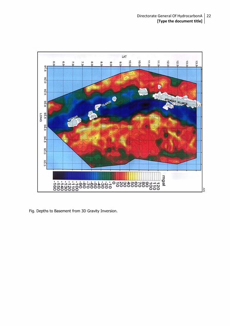
DGH, has carried out Satellite Gravity Survey over Andaman offshore area through M/s Petroscan, Germany, covering about 0.292 million sq. km. Derived Bouguer gravity map based on Satellite
Altimetry and depths to the base of sediments derived from the above gravity map are shown in Fig.
Derived Bouguer gravity map based on Satellite Altimetry : Andaman Offshore
Directorate General Of HydrocarbonA [Type the document title]
22
Fig. Depths to Basement from 3D Gravity Inversion.

Directorate General Of HydrocarbonA [Type the document title]
23
These maps depict the arcuate nature of fault zones, which is a reflection of the arcuate nature of
westerly subduction zone.
The first exploratory well AN-I-I, drilled in 1980, resulted in discovery of gas flowing @ 180, 000 m3 /
day from Middle Miocene limestone. A total of 15 exploratory wells have been drilled in the Neil and Havelock Islands., 1 of which lies in the western and the remaining are in the eastern Andaman
offshore. Indications of gas from Early Miocene sediments were recorded in a number of wells.
In 1988, 2,500 LKM of sniffer surveys have been carried out in the eastern Andaman offshore.
Interpretation of the results obtained from absorbed gas survey indicates the presence of wet gas in these recent sediments suggesting occurrence of reservoirs in the subsurface. Several positive
anomalies have been brought out by Geochemical sniffer surveys. Recent seismic data acquired in deep waters has revealed attractive exploration targets in carbonate buildups in Eocene – Miocene
sequences and turbidites & gas hydrates in Neogene sequence.
Two exploration blocks in deep waters, namely, AN-DWN-2002/1 & AN-DWN-2002/2 offered
under NELP-IV round have been awarded to Oil & Natural Gas Corpn. Ltd. (ONGC). Another two exploration blocks namely, AN-DWN-2003/1 and AN-DWN-2003/2 were offered under NELP-V
round. These blocks were awarded to ONGC and ENI-ONGC-GAIL consortium respectively. Under NELP-VII round one block is being offered in Eastern Andaman

Directorate General Of HydrocarbonA [Type the document title]
24
Fig. Exploration Blocks in Andaman-Nicobar Basin.
. Geophysical data acquisition carried out in these PSC blocks as on 31.05.2008 is tabulated below :
Block name 2D (LKM) 3D Q-marine (SKM) RP(2D LKM)
AN-DWN-2002/1 1400 2541 1400
AN-DWN-2002/2 2600 2702 2600
AN-DWN-2003/1 2900 205.5 1000
AN-DWN-2003/2 5141 2528 1066
Hydrocarbon Potential:.
Mud volcanoes with associated oil and gas shows are reported from the outcrops of the Baratang Formation of the Middle and South Andaman.

Directorate General Of HydrocarbonA [Type the document title]
25
Gas discovery from Middle Miocene limestone in well AN-1-1 proves that hydrocarbons have been
generated in the Inter-deep basin of east Andaman shelf. Minor gas indications have also been observed from the Early Miocene vitric ash beds of well AN-32-1 as well as from Cretaceous
sandstone of AN-1-1 well. The data from well AN-63C-1 indicate that good to mature organic matter
having Kerogen Type-II & III is present in the Pre-Neogene section. In the little Andaman Island, gas seepage is associated with Miocene sediments.
From the presence of commercial hydrocarbons in the adjoining basins of similar geological setting,
this basin is considered to have fairly rich hydrocarbon potential.
NELP-IV Block: AN-DWN-2002/1
Based on the interpretation of G & G data including extensive 2D seismic data over the area of 10,990 Sq. Km. of the block and subsequently 3D Q marine seismic data of 881 SKM data under Area
I of the block, few play types has been identified which arestructural, strati-structural and purely startigraphic plays. The prospects under different plays are mainly the carbonate platform,
carbonate build-ups, inversion within ponded fill areas and channel - levee - fan complexes. Few
prospects are shown below :
Seismic section along 3D line showing Platformal Carbonate.
Seismic line showing showing anticlinal feature with Possibility of fault closure.

Directorate General Of HydrocarbonA [Type the document title]
26
Structural inversion within ponded fill.
Major portion of the eastern part of the block AN-DWN-2002/2 is occupied by the volcanic Arc, whereas the SE part forms a back arc basin. Based on the interpretation of G & G data including
extensive 2D seismic data over the area of 12,495 Sq. Km. of the block and subsequently 3D Q marine seismic data of 1135 SKM data under Area I & II of the block, few prospects have been
identified and are shown below :
Seismic section showing rift fill and structural inversion.

Directorate General Of HydrocarbonA [Type the document title]
27
High amplitudes associated with fault and Fault aided anticline in the back arc setting.
N-S line confirms a four way closure.

Directorate General Of HydrocarbonA [Type the document title]
28
NELP-IV Block; AN-DWN-2003/1 Based on the interpretation of G & G data including extensive 2D seismic data over the area of 9970
Sq. Km. of the block, few prospects have been identified and are shown below :
A mound like feature showing good seismic anamoly

Directorate General Of HydrocarbonA [Type the document title]
29
An anticlinal prospect with structural inversion.
Series of seismic anomalies along N-S line.

Directorate General Of HydrocarbonA [Type the document title]
30
Seismic anomaly over basement arch.
Directorate General Of HydrocarbonA [Type the document title]
31
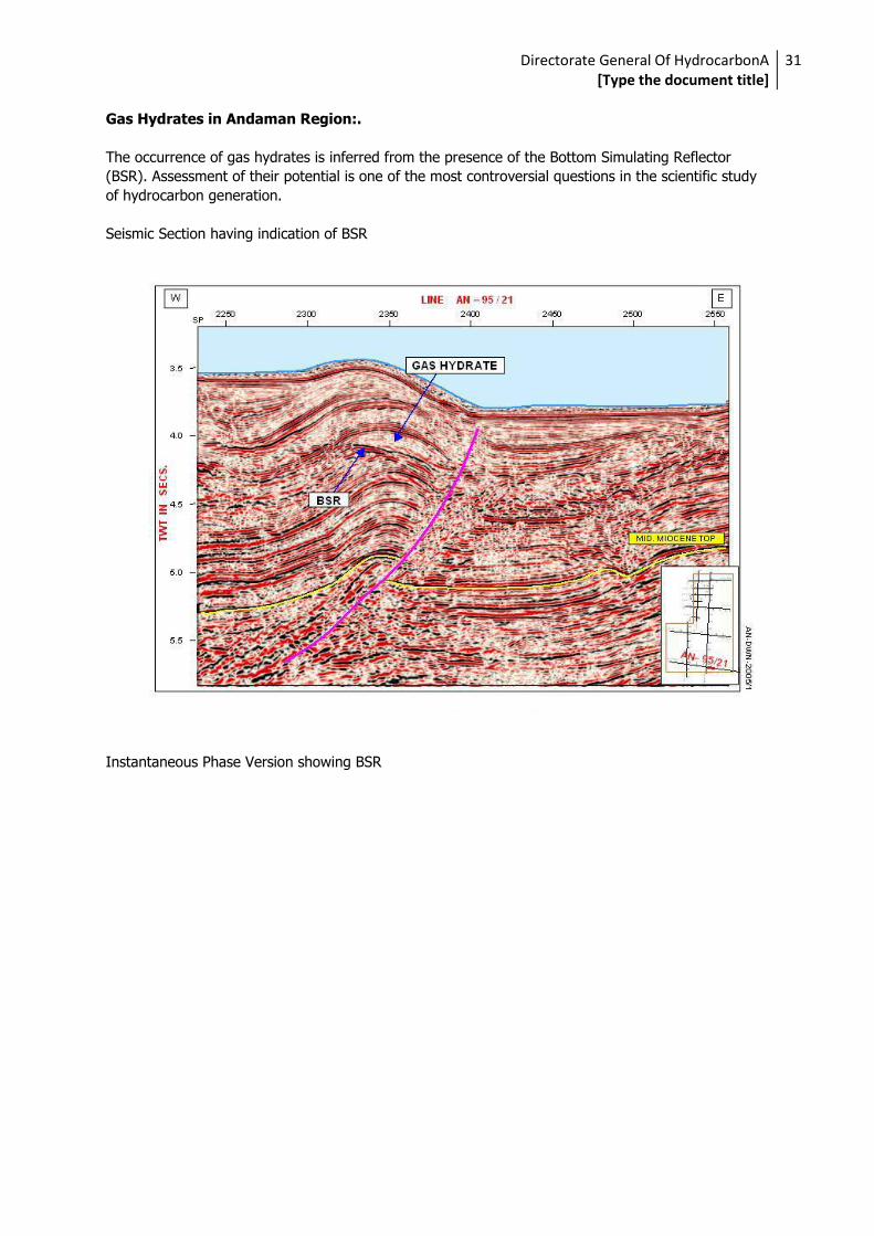
Gas Hydrates in Andaman Region:.
The occurrence of gas hydrates is inferred from the presence of the Bottom Simulating Reflector
(BSR). Assessment of their potential is one of the most controversial questions in the scientific study
of hydrocarbon generation.
Seismic Section having indication of BSR
Instantaneous Phase Version showing BSR

Directorate General Of HydrocarbonA [Type the document title]
32
Hydrate as a seal to free gas in the area East of South Andaman