director~/l.tt/dj/ {j - us epa · modeling guidance for demonstrating attainment of air quality...
TRANSCRIPT

MEMORANDUM
UNITED STATES ENVIRONMENTAL PROTECTION AGENCY
RESEARCH TRIANGLE PARK, NC 27711
DEC 03 21M OFFICE OF
AIR QUALITY PLANNING AND STANDARDS
SUBJECT: Draft Modeling Guidance for Demonstrating Attainment of Air Quality Goals for Ozone, PM2s, and Regional Haze
FROM: Richard Wayland, Division Director~/l.tt/d...J/ Air Quality Assessment Division {j ----
TO: Regional Air Division Directors, Regions 1-10
The Environmental Protection Agency (EPA) is providing a revised version of Modeling Guidance for Demonstrating Attainment of Air Quality Goals for Ozone, PMn. and Regional Haze to the state and local air agencies as well as the public for consideration, review, and comment. This document reflects the EPA's recommendations for how air agencies should conduct air quality modeling and related technical analyses to satisfy model attainment demonstration requirements for the 2008 ozone and 2012 PM2.s National Ambient Air Quality Standards (NAAQS), as well as for upcoming regional haze reasonable progress analyses. 1 This document updates the previous version of the modeling guidance which was released in April 2007.
This document does not substitute for provisions or regulations of the Clean Air Act (CAA), nor is it a regulation itself. As the term "guidance" suggests, it provides recommendations on how to implement the modeling requirements. Thus, it does not impose binding, enforceable requirements on any party, nor does it assure that the EPA will approve all instances of its application, as the guidance may not apply to a particular situation based upon the circumstances. Final decisions by the EPA regarding a particular State Implementation Plan (SIP) demonstration
will only be made based on the statute and applicable regulations, and will only be made following a final submission by air agencies and after notice and opportunity for public review
and comment.
1 This draft guidance will be revised, as needed, once the review of the current ozone standard is completed in October 2015.
Recycled/Recyclable •Printed wKh Vegetable Oil Based Inks on 100% Recycled Paper (40% Postconsumer)

2
There are several modeling guidance issues that are most appropriate to be addressed in a notice
and comment rulemaking such as the 2008 ozone and soon-to-be proposed 2012 PM2.5
implementation rules. As such, there are several details that have either been removed from the
draft guidance or are pending updates when the 2008 ozone and 2012 PM2.5implemenation rules
are finalized. These are specifically noted in the guidance (in some cases with placeholders).
The ozone implementation rule for the 2008 NAAQS was proposed in June 2013 and is expected
to be finalized in early 2015. The PM2.5 implementation rule for the 2012 NAAQS is expected to
be proposed in early 2015.
GUIDANCE UPDATES
Like the original 2007 version, the revised guidance is divided into two main sections. The first
part describes how to setup and apply a photochemical modeling platform (including
meteorological, emissions, and air quality modeling), and the second part describes how to use
the results of the air quality modeling to show whether future attainment of the ozone and/or
PM2.5 NAAQS is likely. The guidance also describes how to use photochemical grid modeling to
evaluate reasonable progress goals for regional haze.
Many of the updates to the guidance are in the form of updated and reorganized text. In addition,
numerous references have been updated and added. The attainment tests for the annual and 24-
hour average PM2.5 NAAQS are unchanged2, but the 8-hour ozone NAAQS attainment test has
been updated to better reflect the level and form of the 2008 ozone NAAQS . More details are
provided below.
Specific updates to the draft guidance include:
A complete reorganization of the document including removal of outdated language and
references.
The ozone attainment test has been updated to address the 2008 NAAQS.
o The revised test eliminates the initial concentration threshold (which was formally
85 ppb) and focuses the calculation of relative response factors (RRFs) to the ten
highest modeled 8-hour average daily maximum ozone days.
This potentially eliminates days in the RRF calculation that are well below
the base year observed design values.
o Elimination of the initial threshold concentration allows the test to be easily
applied to any level of the NAAQS. The revised guidance reflects
recommendations for the current 75 ppb NAAQS. Minimal (if any) changes to
the test will be needed to address potential future ozone NAAQS.
2 The 24-hour PM2.5 attainment test is unchanged from the version which is detailed in a June 2011
guidance memo. The attainment test from the June 2011 memo has been incorporated into this revised
version of the guidance.

3
The emissions modeling section has been extensively updated to account for new and
improved emissions models and input data. Additional information on SIP emissions
inventory requirements is contained in the draft Emissions Inventory Guidance for
Implementation of Ozone and Particulate Matter National Ambient Air Quality Standards
(NAAQS) and Regional Haze Regulations available at:
http://www.epa.gov/ttn/chief/eidocs/eiguid/2014revisedeiguidance.pdf. The draft
modeling guidance and the draft emissions inventory guidance have been carefully
coordinated.
The Weight of Evidence (WOE) section has been updated to include additional
information that may be appropriate for use in a WOE demonstration. The WOE section
includes discussions on emissions controls, modeling, and data analyses that have been
recommended by stakeholders for inclusion in a WOE demonstration.
The revised document is draft guidance for public review and comment. However, since the
revised guidance replaces and updates the existing modeling guidance document without making
major changes, EPA encourages states to follow the recommendations in this draft guidance until
an updated version is released. These recommendations will be updated, as needed, based on
comments received on this guidance and final decisions made in the implementation rules. States
with upcoming attainment demonstration deadlines should consult with their EPA Regional
Office to determine the appropriate course of action.
REVIEW AND COMMENT
The EPA will accept comments on the draft modeling guidance through the close of business on
March 13, 2015. This allows at least 90 days for consideration, review, and comment on the
material presented in the draft guidance. For convenience, the draft guidance document is
available electronically on the EPA’s SCRAM website,
http://www.epa.gov/ttn/scram/guidance/guide/Draft-O3-PM-RH-Modeling_Guidance-2014.pdf.
Comments should be electronically submitted to Brian Timin of EPA’s Air Quality Modeling
Group at [email protected]. EPA will also schedule a conference call in Mid-December with
state and local air agencies to summarize the guidance and allow for questions.
In preparing the final version of the guidance, the EPA will take into consideration comments
received on the draft modeling guidance, as well as decisions made in the final 2008 ozone
and/or 2012 PM2.5 implementation rules. As there are a number of issues that need to be
informed by these ozone and PM2.5 implementation rules, the timing for release of a final version
of the guidance depends on the timing of the implementation rules. Depending on the timing of
these final implementation rules (as well as any implementation rule that may be needed
following review of the current ozone NAAQS), the EPA will consider releasing a 2nd draft
version of the modeling guidance or clarification memos, as needed.

4
If there are any questions regarding the draft modeling guidance, please contact Brian Timin of
EPA’s Air Quality Modeling Group at (919) 541-1850 or [email protected].
cc: Steve Page
Mike Koerber
Anna Wood
Air Program Managers
Kristi Smith, OGC
Attachment

Modeling Guidance for Demonstrating Attainment of Air Quality Goals for Ozone, PM2.5, and Regional
Haze- December 2014 DRAFT
1
DRAFT December, 2014
Modeling Guidance for Demonstrating
Attainment of Air Quality Goals for
Ozone, PM2.5, and Regional Haze
NOTE: Ozone NAAQS implementation requirements are currently being assessed as part of the
Implementation of the 2008 National Ambient Air Quality Standards for Ozone: State
Implementation Plan Requirements; Proposed Rule (78 FR 34178, June 6, 2013) (Hereinafter,
“Proposed Ozone Implementation Rule”). Accordingly, the guidance provided in this document
addresses several options that were addressed in the Proposed Ozone Implementation Rule,
which may or may not be adopted in the final rule. To the extent that the Final Ozone
Implementation Rule takes a different approach than contained in this guidance, the Final Rule
will dictate what is required for air quality modeling. Once the Final Ozone Implementation
Rule is published, EPA will (if necessary) revise this guidance to reflect the regulations and
requirements adopted in the final rule.
In addition, PM NAAQS implementation requirements are currently undergoing review as part
of the planned proposed PM2.5 Implementation Rule. The guidance includes the use of “[PM
Implementation Placeholder]” text where necessary. Once that rule is finalized, this guidance
will be updated (if necessary) and the [PM Implementation Placeholder] text will be replaced
with the PM-specific guidance associated with that rule.

Modeling Guidance for Demonstrating Attainment of Air Quality Goals for Ozone, PM2.5, and Regional
Haze- December 2014 DRAFT
2
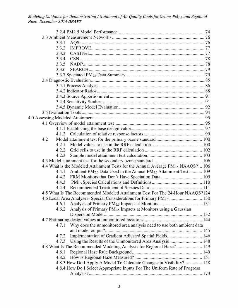
Table of Contents 1.0 Introduction ............................................................................................................................... 5
1.1 What Is The Purpose Of This Document? .............................................................. 6
1.2 Does The Guidance In This Document Apply To Me? ......................................... 6
1.3 Outline..................................................................................................................... 7
2.0 Building a Model Platform ....................................................................................................... 9
2.1 Conceptual Description ................................................................................................. 9
2.1.1 Example applications of conceptual models ................................................ 11
2.2 Modeling Protocol and Supporting Documentation ................................................... 12
2.2.1 Modeling protocol ........................................................................................ 12
2.2.2 Attainment Demonstration Documentation Package ................................... 13
2.3 Episode Selection ........................................................................................................ 14
2.3.1 Choosing Time Periods to Model ................................................................ 15
2.3.2 Future Year Selection ............................................................................... 17
2.4 Modeling Domain Selection ....................................................................................... 18
2.4.1 Domain Size .............................................................................................. 18
2.4.2 Vertical Layer Configuration .................................................................... 19
2.4.3 Horizontal Grid Cell Size .......................................................................... 20
2.5 Air Quality Model Selection ....................................................................................... 21
2.6 Meteorological Inputs ................................................................................................. 24
2.6.1 Developing base year meteorological fields ............................................. 24
2.6.2 Assessing Impacts of Future Year Meteorology ....................................... 28
2.6.3 Evaluation of base year meteorological fields ............................................. 29
2.7 How Are the Emission Inputs Developed? ................................................................. 31
2.7.1 What Emissions Inventory Years Should I use for Base and Future
Modeling? ................................................................................................. 32
2.7.2 What Base Year Emission Inventory Data Are Needed to Support Air
Quality Models? ........................................................................................ 32
2.7.3 What Pollutants Should Be Included in Base Year Inventories? ................. 33
2.7.4 What Temporal Resolution Should Be Used for Base Year Inventories? ... 33
2.7.5 What Spatial Coverage Is Need for Base Year Inventories? ....................... 34
2.7.6 How Can The National Emission Inventory by Air Agencies? ................... 35
2.7.7 How Should Base Year Emissions Be Created? .......................................... 36
2.7.8 What Other Data Are Needed to Support Emissions Modeling? ................ 44
2.7.9 How Are Inventory Data Converted Into Air Quality Model Input?........... 50
2.7.10 Other Emissions Modeling Issues .............................................................. 53
2.7.11 How Are Emissions Estimated for Future Years? ..................................... 56
2.8 Initial and Boundary Conditions ................................................................................. 58
3.0 Evaluating Model Performance .............................................................................................. 62
3.1 Overview of model performance evaluation............................................................... 62
3.2 Operational Evaluation ............................................................................................... 64
3.2.1 Metrics ......................................................................................................... 65
3.2.2 Plots.............................................................................................................. 68
3.2.3 Ozone Model Performance .......................................................................... 74
Modeling Guidance for Demonstrating Attainment of Air Quality Goals for Ozone, PM2.5, and Regional
Haze- December 2014 DRAFT
3
3.2.4 PM2.5 Model Performance .......................................................................... 74
3.3 Ambient Measurement Networks ............................................................................... 76
3.3.1 AQS........................................................................................................... 76
3.3.2 IMPROVE................................................................................................. 77
3.3.3 CASTNet................................................................................................... 77
3.3.4 CSN ........................................................................................................... 78
3.3.5 NADP ........................................................................................................ 78
3.3.6 SEARCH ................................................................................................... 79
3.3.7 Speciated PM2.5 Data Summary ................................................................... 79
3.4 Diagnostic Evaluation ................................................................................................. 85
3.4.1 Process Analysis .......................................................................................... 86
3.4.2 Indicator Ratios ............................................................................................ 88
3.4.3 Source Apportionment ................................................................................. 91
3.4.4 Sensitivity Studies ........................................................................................ 91
3.4.5 Dynamic Model Evaluation ......................................................................... 92
3.5 Evaluation Tools ......................................................................................................... 94
4.0 Assessing Modeled Attainment .............................................................................................. 95
4.1 Overview of model attainment test ............................................................................. 95
4.1.1 Establishing the base design value ............................................................... 97
4.1.2 Calculation of relative response factors .................................................... 99
4.2 Model attainment test for the primary ozone standard ....................................... 100
4.2.1 Model values to use in the RRF calculation ........................................... 100
4.2.2 Grid cells to use in the RRF calculation ................................................. 102
4.2.3 Sample model attainment test calculation............................................... 103
4.3 Model attainment test for the secondary ozone standard .......................................... 106
4.4 What is the Modeled Attainment Tests for the Annual Average PM2.5 NAAQS? ... 106
4.4.1 Ambient PM2.5 Data Used in the Annual PM2.5 Attainment Test ........... 109
4.4.2 FRM Monitors that Don’t Have Speciation Data ................................... 109
4.4.3 PM2.5 Species Calculations and Definitions ........................................... 110
4.4.4 Recommended Treatment of Species Data ............................................. 111
4.5 What Is The Recommended Modeled Attainment Test For The 24-Hour NAAQS? 124
4.6 Local Area Analyses- Special Considerations for Primary PM2.5 ............................ 130
4.6.1 Analysis of Primary PM2.5 Impacts at Monitors ..................................... 131
4.6.2 Analysis of Primary PM2.5 Impacts at Monitors using a Gaussian
Dispersion Model .................................................................................... 132
4.7 Estimating design values at unmonitored locations .................................................. 144
4.7.1 Why does the unmonitored area analysis need to use both ambient data
and model output? ................................................................................... 145
4.7.2 Implementation of Gradient Adjusted Spatial Fields.............................. 146
4.7.3 Using the Results of the Unmonitored Area Analysis ............................ 148
4.8 What Is The Recommended Modeling Analysis for Regional Haze? ...................... 149
4.8.1 Regional Haze Rule Background ............................................................ 149
4.8.2 How is Regional Haze Measured? .......................................................... 151
4.8.3 How Do I Apply A Model To Calculate Changes in Visibility? ............... 158
4.8.4 How Do I Select Appropriate Inputs For The Uniform Rate of Progress
Analysis? ................................................................................................. 173

Modeling Guidance for Demonstrating Attainment of Air Quality Goals for Ozone, PM2.5, and Regional
Haze- December 2014 DRAFT
4
4.9 “Weight of Evidence”- How Can Additional Analyses Be Used to Support the
Attainment Demonstration? ................................................................................ 179
4.9.1 What Types of Additional Analyses Should Be Completed as Part of the
Attainment Demonstration? .................................................................... 180
4.9.2 What Role Should Weight Of Evidence Play In Visibility-Related
Analyses? ................................................................................................ 187
4.9.3 Weight of Evidence Summary ................................................................... 190
References ................................................................................................................................... 192

Modeling Guidance for Demonstrating Attainment of Air Quality Goals for Ozone, PM2.5, and Regional
Haze- December 2014 DRAFT
5
1.0 Introduction
This document describes how to estimate if an emissions control strategy will lead to
attainment of the annual average and 24-hour average national ambient air quality standards
(NAAQS) for particles smaller than 2.5 μm in diameter (PM2.5) and the 8-hour NAAQS for ozone.
We also describe how to use modeled and monitored data to estimate visibility improvement in
Class I areas (e.g., national parks, wilderness areas) as part of a reasonable progress analysis.1
The document describes how to apply air quality models to generate the predictions used to
evaluate attainment and/or uniform rate of progress assessments. Modeling to show
attainment of the NAAQS primarily applies to nonattainment areas2 for which modeling is
required, or desired. Modeling to assess reasonable progress for regional haze applies to all
states.3
This guidance is designed to implement national policy on air quality modeling requirements as
embodied in the Clean Air Act (CAA), the Proposed Ozone SIP Requirements Rule (also called
the Proposed Ozone Implementation Rule)4, the PM2.5 Implementation Rule5, and the Regional
Haze Rule. This guidance is intended for use by the United States (U.S.) Environmental
Protection Agency (EPA) headquarters and regional offices; state, local and tribal air quality
management authorities; and the general public. This document does not substitute for
provisions or regulations of the CAA enumerated above, nor is it a regulation itself. As the term
“guidance” suggests, it provides recommendations on how to implement the modeling
1Modeling is not used to determine reasonable progress goals and does not determine whether
reasonable progress has been met. Modeling is one part of the reasonable progress analysis. The
modeling results are used to determine if future year visibility at Class I areas are estimated to be on a
(glide) path towards reaching natural background. This is called a uniform rate of progress analysis or
“glidepath” analysis. The uniform rate of progress analysis is described in more detail in section 4.8.
2While this guidance document is primarily directed at modeling applications in nonattainment areas, it
may also be useful as a guide for modeling to support NEPA analyses, maintenance areas or to support
other rules or provisions of the Clean Air Act.
3The Regional Haze rule assumes that all 50 states either contain a Class I area or impact visibility within
a Class I area. Therefore, a regional haze State Implementation Plan (SIP) is required for all states (40
CFR 50.308(b)).
4 Implementation of the 2008 National Ambient Air Quality Standards for Ozone: State Implementation
Plan Requirements; Proposed Rule (78 FR 34178, June 6, 2013)
5 Fine Particulate Matter National Ambient Air Quality Standards: State Implementation Plan
Requirements, proposed rule anticipated in 2015.

Modeling Guidance for Demonstrating Attainment of Air Quality Goals for Ozone, PM2.5, and Regional
Haze- December 2014 DRAFT
6
requirements. Thus, it does not impose binding, enforceable requirements on any party, nor
does it assure that the EPA will approve all instances of its application, as the guidance may not
apply to a particular situation based upon the circumstances.
The EPA and state, local, and tribal air agencies (hereinafter, referred simply as “air agency” or
“air agencies”) retain the discretion to adopt approaches on a case-by-case basis that differ
from this guidance where appropriate. Final decisions by the EPA regarding a particular SIP
demonstration will only be made based on the statute and applicable regulations, and will only
be made following a final submission by air agencies and after notice and opportunity for public
review and comment. Interested parties are free to raise questions and objections about the
appropriateness of the application of this guidance to a particular situation; the EPA and air
agencies should consider whether or not the recommendations in this guidance are appropriate
in that situation.
1.1 What Is The Purpose Of This Document?
This document has two purposes. The first purpose is to describe how to apply an air quality
model to produce results needed to support an attainment demonstration or a uniform rate of
progress analysis in a scientifically appropriate manner. The second is to explain how to
interpret whether results of modeling and other analyses support a conclusion that attainment
of the ozone and/or PM2.5 NAAQS, and/or uniform rate of progress for regional haze will occur
by the appropriate date for an area.
1.2 Does The Guidance In This Document Apply To Me?
This guidance applies to all locations required to submit a State Implementation Plan (SIP), or
Tribal Implementation Plan (TIP) revision with an attainment demonstration designed to
achieve attainment of the ozone and/or PM2.5 NAAQS. The guidance also applies to SIPs
developed to address regional haze rule requirements. Areas required to submit an attainment
demonstration and/or a reasonable progress demonstration are encouraged to follow the
procedures described in this document. Details on when a State is required to submit a
modeled attainment or reasonable progress demonstration can be found in the regional haze

Modeling Guidance for Demonstrating Attainment of Air Quality Goals for Ozone, PM2.5, and Regional
Haze- December 2014 DRAFT
7
rule6, the 8-hour ozone implementation rule7 and the PM2.5 implementation rule.8
1.3 Outline
Part 1 of the guidance provides an overview of the modeling and attainment demonstration
process. Part 2 describes how to build a “modeling platform” and apply air quality models. A
“modeling platform” consists of the building blocks of an air quality modeling demonstration.
This includes emissions modeling9, meteorological modeling, and the development of all other
inputs needed to run an air quality model. The model platform development process consists
of the following steps as outlined in Section 2:
Section 2.1 Development of a conceptual description of the problem to be addressed
Section 2.2 Develop a modeling protocol
Section 2.3 Select appropriate meteorological time periods to model
Section 2.4 Choose an appropriate area to model with appropriate
horizontal/vertical resolution
Section 2.5 Select an appropriate model to support the demonstration
Section 2.6 Generate meteorological inputs to the air quality model
Section 2.7 Generate emissions inputs to the air quality model
Section 2.8 Develop initial and boundary conditions that are suitable for the
application
Typically, the air quality model process starts with the development of base year emissions and
meteorology for input to an air quality run to evaluate model performance. Section 3 describes
the process for evaluating model performance and performing diagnostic analyses. After
evaluating the model and making any necessary input changes or adjustments, the model is run
for a future year, which corresponds to the appropriate attainment year for the area. The air
quality model outputs are then used to apply the modeled attainment test to support an
attainment demonstration, as described in Chapter 4 of the guidance. We explain what is
640 CFR 51.308
740 CFR 50.908 [to be updated when the ozone implementation rule update is finalized]
840 CFR 50.1007 [to be updated when the PM2.5 implementation rule update is finalized]
9 Additional emissions inventory requirements and details on emissions modeling are contained in
“Emissions Inventory Guidance for Implementation of Ozone and Particulate Matter National Ambient
Air Quality Standards (NAAQS) and Regional Haze Regulations” at:
http://www.epa.gov/ttn/chief/eidocs/eiguid/2014revisedeiguidance.pdf

Modeling Guidance for Demonstrating Attainment of Air Quality Goals for Ozone, PM2.5, and Regional
Haze- December 2014 DRAFT
8
meant by a modeled attainment demonstration, a modeled attainment test, and a weight of
evidence determination. Modeled attainment tests are described for the 8-hr ozone NAAQS,
the annual and 24-hour PM2.5 NAAQS, and a visibility assessment for regional haze.
Model applications require a substantial effort. Air agencies should work closely with the
appropriate U.S. EPA Regional Office(s) in executing each step of the modeling and attainment
demonstration process. This will increase the likelihood of approval of the demonstration at
the end of the process.

Modeling Guidance for Demonstrating Attainment of Air Quality Goals for Ozone, PM2.5, and Regional
Haze- December 2014 DRAFT
9
2.0 Building a Model Platform
2.1 Conceptual Description
The first step in developing an attainment demonstration should be to construct a conceptual
description of the problem that is being addressed. Conceptual descriptions, which are also
referred to as conceptual models, are comprehensive summaries of the “state of the
knowledge” regarding the influence of emissions, meteorology, transport, and other relevant
atmospheric processes on air quality in the area (Vickery, 2004). For a conceptual description
to be informative it should identify what processes and sources, in the generic sense, are most
responsible for the air quality issue being simulated. Well-constructed conceptual models can
substantially inform the design of the attainment demonstration modeling (e.g., episode
selection, choice of domain, emissions priorities, evaluation focus) and should be conducted in
advance of the development of a modeling protocol. It is worth noting that conceptual
descriptions can be valuable in other air quality planning efforts besides attainment
demonstrations. They can also be useful in determining nonattainment area boundaries,
investigating emissions control program impacts, and monitoring network design, among
others.
The following bullets describe some of the key building blocks in developing a conceptual
model. The process steps discussed below are meant to illustrate one possible template for
building a conceptual model to inform an air quality modeling demonstration; there may be
alternate approaches that better suit individual study areas or issues, which air agencies should
discuss with the appropriate EPA Regional Office.
• Introduce the general nature of the air quality problem addressed by the conceptual model:
o What are the pollutants of concern in the area?
o What are the current air quality levels in the area?
o What is the attainment/nonattainment status of the area?
o What is the geographical scope of poor air quality?
o What is the temporal scope of poor air quality?
o What are the air quality trends in the area? Is the problem getting better or worse?
o What are the suspected mechanisms for formation of poor air quality levels?
o What are the sources of emissions that may contribute to poor air quality?
o Are there unique meteorological influences on local air quality levels?

Modeling Guidance for Demonstrating Attainment of Air Quality Goals for Ozone, PM2.5, and Regional
Haze- December 2014 DRAFT
10
• Describe the ambient monitoring network used for the conceptual model:
o Develop a map of monitor sites and types (e.g., FRM, FEM, STN, IMPROVE, etc.)
o Describe characteristics of individual monitoring sites (scale, frequency, etc.)
• Describe the status and trends of air quality in the area:
o Summarize the relevant monitoring data for the air quality problem being studied.
o Identify locations that are in violation of the NAAQS
o Describe the spatial pattern in pollutant and precursor pollutant levels
o Describe the temporal pattern in pollutant and precursor pollutant levels
o Describe the annual trends in concentrations over the period of interest
o If appropriate, develop fused ambient/model surfaces to fill any gaps within the
monitoring network.
• Investigate possible relationships between emissions and air quality:
o Examine emissions estimates for the main sector/source categories
o Compare emission trends for annual and or seasonal/episodic periods to
corresponding air quality trends
o Identify key emission sources or source categories
o Assess the historical effectiveness of control programs
o Consider how future emissions growth or reductions may affect air quality
o List control programs that are in place or that will soon be implemented that may
impact emissions sources in the area
• Investigate possible relationships between meteorology and air quality (AQ):
o Describe meteorological characteristics on poor air quality days (e.g., wind
speed/direction, temperatures, relative humidity levels, inversion indicators, etc.)
o Identify any distinct meteorological phenomena that coincide with poor air quality
days
o Prepare pollution roses, HYSPLIT back-trajectories (Draxler, 1998) , or any other
relevant analysis needed to link poor air quality days to specific wind/transport
patterns
o Assess the impact from pollutant transport into area based on meteorological data
and ambient air quality data
• Synthesize all of the relevant information into a detailed conceptual model:
o Aggregate all elements of the conceptual model and provide the key findings
resulting from the analyses completed

Modeling Guidance for Demonstrating Attainment of Air Quality Goals for Ozone, PM2.5, and Regional
Haze- December 2014 DRAFT
11
o Characterize the potential factors that influence air quality in the area and where
possible the rank the importance of those influences
o Identify areas that require further investigation, either in terms of data collection or
chemical transport modeling.
o Discuss how the subsequent SIP modeling and associated protocol is impacted by
this conceptual description.
2.1.1 Example applications of conceptual models
The idea of developing a modeling protocol based upon a conceptual description of the sources
and processes that lead to poor air quality is well-established (USEPA, 2007). Numerous
excellent conceptual models of local and regional air quality issues have been developed over
the past decade. Table 2-1 provides a non-comprehensive list of example conceptual models
that have been developed since the last release of the guidance that may be useful in orienting
future SIP modeling applications.
Table 2.1: Examples of recently developed conceptual models
Air quality issue Reference
PM2.5 / Regional Haze (Northeast U.S.) Downs et al. (2012)
PM2.5 (Midwest U.S) LADCO (2009)
Ozone (Austin TX) McGaughey et al. (2010)
Ozone (Wyoming) Stoeckenius and Ma (2010)
PM2.5 (Southeast Michigan) Turner (2008)

Modeling Guidance for Demonstrating Attainment of Air Quality Goals for Ozone, PM2.5, and Regional
Haze- December 2014 DRAFT
12
2.2 Modeling Protocol and Supporting Documentation
As with any technical support document designed to inform air quality planning, an attainment
demonstration should be supported by documentation that sufficiently describes the
procedures used in the analysis. In order to facilitate the process of EPA Regional Office review
and approval, we recommend the preparation of two separate supporting documents: one
before the modeling analyses are initiated (modeling protocol) and one after the analyses have
been completed (attainment demonstration package).
2.2.1 Modeling protocol
Developing and implementing a modeling protocol is an important part of a modeled
attainment demonstration. The protocol should detail and formalize the procedures for
conducting all phases of the modeling study, such as describing the background and objectives
for the study, creating a schedule and organizational structure for the study, selection of
appropriate period(s) for modeling, developing the input data, conducting model performance
evaluations, interpreting modeling results, describing procedures for using the model to
demonstrate whether proposed strategies are sufficient to attain the NAAQS and/or regional
haze goals, and producing documentation to be submitted for EPA Regional Office review and
approval. The most important function of the modeling protocol is to serve as a blueprint for
planning how the modeled attainment demonstration will be performed. The protocol should
be a valuable communication device by which air agencies, EPA, and other stakeholders can
assess the applicability of default recommendations and develop area-specific alternatives,
where needed prior to conducting the work to build the modeling system. A suitable protocol
should lead to extensive participation by stakeholders in developing the demonstration. It
should also reduce the risk of spending time and resources on efforts which are unproductive
or inconsistent with EPA rules, policy, and guidance.
Meaningful protocols should fully communicate the expected scope of the analysis and provide
a blueprint for carrying out the needed analyses. There is no one-size-fits-all format for a
sufficient modeling protocol as different individual areas may require specific points of
emphasis. However, past attainment demonstrations have yielded several excellent protocol
examples that could serve as templates for any groups developing new modeling protocols.
While not exhaustive, potentially valuable protocol references include recent attainment
demonstration modeling efforts completed in the Dallas/Fort Worth area (Environ, 2003), the
Denver region (Morris, 2011), and the San Joaquin Valley (CARB, 2012). Based on past

Modeling Guidance for Demonstrating Attainment of Air Quality Goals for Ozone, PM2.5, and Regional
Haze- December 2014 DRAFT
13
experience, EPA recommends that the following topics be core elements of any modeling
protocol:
• Overview of the air quality issue being considered including historical background
• List of the planned participants in the analysis and their expected roles
• Schedule for completion of key steps in the analysis and final documentation
• Description of the conceptual model for the area
• Description of periods to be modeled, how they comport with the conceptual
model, and why they are sufficient
• Models to be used in the demonstration and why they are appropriate
• Description of model inputs and their expected sources (e.g., emissions, met, etc.)
• Description of the domain to be modeled (expanse and resolution)
• Process for evaluating base year model performance (meteorology, emissions, and
air quality) and demonstrating that the model is an appropriate tool for the intended
use
• Description of the future years to be modeled and how projection inputs will be
prepared
• Description of the attainment test procedures and (if known) planned weight of
evidence
• Expected diagnostic or supplemental analyses needed to develop weight of evidence
analyses
• Commitment to specific deliverables fully documenting the completed analysis
2.2.2 Attainment Demonstration Documentation Package
Where the modeling protocol describes the planned scope of the analysis, the final attainment
demonstration package summarizes the actual analysis conducted (including procedures used)
to show that an area will meet the NAAQS under a specific set of future conditions. This
document can follow the same basic outline as the modeling protocol, highlighting those
aspects of the modeling that may have changed from the original plans. Additionally, the
attainment demonstration package should have detailed information on any emission
reduction strategies that will be implemented as part of an attainment SIP. Ultimately, the
attainment demonstration package should provide a narrative fully describing the technical
rationale behind the projection of attainment of a specific air quality goal in an area. Based on
past experience, EPA recommends that the following topics be core elements of any attainment
demonstration package:

Modeling Guidance for Demonstrating Attainment of Air Quality Goals for Ozone, PM2.5, and Regional
Haze- December 2014 DRAFT
14
• Executive summary that provides an overview of the analysis and the key
conclusions
• Reference to the modeling protocol noting any major deviations from the original
plans
• List of the institutional participants in the attainment demonstration and their roles
• Description of air quality in the area and describe how that shaped the analysis
• Justification for the model, episodes, domain, and grid(s) used in the analysis
• Description of the development of the emissions inputs used in the base year
modeling, including tabular summaries by state/county, as appropriate.
• Description of the development of meteorological inputs used in the base year
modeling
• Description of all other base year modeling inputs
• Evaluation of base year model performance (meteorology, emissions, and air
quality), including a description of the observational database used in the evaluation
and any diagnostic or sensitivity tests used to improve the model
• Description of the strategy used to demonstrate attainment, including speciated
emissions summaries for the future year and identification of authority for
implementing these strategies
• Description of the attainment test results
• Description of any supplemental analyses designed to bolster the original
attainment test results
• Detailed summary of the entire analysis that leads to the conclusion that the
selected attainment demonstration strategy is likely to produce attainment of the
NAAQS and/or uniform rate of progress by the required date
2.3 Episode Selection
The modeled attainment test adjusts observed ambient concentrations during a base case
period (e.g., 2009-2013) to a future period (e.g., 2018) using model-derived “relative response
factors”. It is important that emissions used in the attainment modeling correspond with the
period reflected by the chosen baseline design value period (e.g., 2009-2013). Deviations from
this constraint will diminish the credibility of the relative response factors. The base year
inventory typically corresponds to the middle year of the baseline average design value period
(e.g. 2011 for a 2009-2013 average design value). The base emissions inventory is the inventory
that is projected to a future year. Alternatively, the base year emissions can reflect average
emissions from the base year period, but the emissions year or years should be representative
of the 5 year design value window.
Modeling Guidance for Demonstrating Attainment of Air Quality Goals for Ozone, PM2.5, and Regional
Haze- December 2014 DRAFT
15
There is no recommended default base year for modeling. However, it is recommended to use
a recent base year period. This ensures that the emissions projection period is as short as
possible and the base year ambient data is as current as possible. For example, projecting
emissions from 2011 to 2018 (using a 2009-2013 base year average design value) should be less
uncertain than projecting emissions from 2005 to 2018 (using a 2003-2007 base year average
design value). The most recent ambient design values reflect actual emissions changes that
have occurred over time. It is therefore better to use recent design values, which are actual
measurements, and modeled emissions changes to project future concentrations, than to use
older ambient data to estimate the change in design values. When selecting a base modeling
year, air agencies should review recent ambient data and consider the factors below.
2.3.1 Choosing Time Periods to Model
In the past, the choice of modeled episode days has been limited by the speed of computers
and the ability to store model output files. With the advancement in computer technology over
the past two decades, computer speed and storage issues are no longer an impediment to
modeling long time periods. In fact, the majority of recent regulatory assessment modeling
platforms have been inclusive of entire summers and/or full years (as appropriate) for ozone,
PM2.5, and regional haze (Boylan and Russell, 2006; Morris et al., 2006; Rodriguez et al., 2009;
Simon et al., 2012; Tesche et al., 2006; U.S. Environmental Protection Agency, 2011a, b).
Ozone based research has shown that model performance evaluations and the response to
emissions controls need to consider modeling results from relatively long time periods, in
particular, full synoptic cycles or even full ozone seasons (Hogrefe et al., 2000; Vizuete et al.,
2011). In order to examine the response to ozone control strategies, it may not be necessary to
model a full ozone season (or seasons), but, at a minimum, modeling “longer” episodes that
encompass full synoptic cycles is advisable. Time periods which include a ramp-up to a high
ozone period and a ramp-down to cleaner conditions allow for a more complete evaluation of
model performance under a variety of meteorological conditions.
Most model applications for the annual PM2.5 NAAQS have modeled a full year (Morris et al.,
2006; Tesche et al., 2006; U.S. Environmental Protection Agency, 2011a, b). This is a logical goal
since every monitored day of the year is included in the calculation of the annual NAAQS. The
annual PM2.5 NAAQS is unique because each and every ambient observation is included in the
average. It is therefore likely that a full year of modeled data is needed to adequately
represent the annual average PM2.5 standard.

Modeling Guidance for Demonstrating Attainment of Air Quality Goals for Ozone, PM2.5, and Regional
Haze- December 2014 DRAFT
16
Eight-hour ozone and 24-hour PM2.5 episode selection criteria are similar because both
standards are based on short term peak concentration periods. Regional haze calculations are
based on an average of 20 or more days per year (20% best and 20% worst days). Therefore,
regional haze episode selection will likely include more days throughout the year.
At a minimum, several criteria should be used to select time periods that are appropriate to
model:
• Model time periods that are close to the most recently compiled and quality assured
National Emission Inventory (NEI). These comprehensive inventories are typically
generated every 3 years (e.g. 2005, 2008, 2011, etc.) but often contain year specific data
for the intermediate years. Since NEI years will have a nationwide complete and
comprehensive inventory, selecting a base modeling year that is also an NEI year may
save resources. However, other factors should be considered when selecting a base
modeling year, such as observed ambient data, meteorology, and availability of special
study data. After consideration of all factors, the most appropriate base year may or
may not be an NEI year. See Section 2.7 for more information on base year inventory
selection issues.
• Model time periods in which observed concentrations are close to the appropriate base
year design value or level of visibility impairment and ensure there are a sufficient
number of days so that the modeled attainment test applied at each monitor violating
the NAAQS is based on multiple days (see sections 4.2 and 4.5).
• Model time periods both before and following elevated pollution concentration
episodes to ensure the modeling system appropriately characterizes low pollution
periods, development of elevated periods, and transition back to low pollution periods
through synoptic cycles.
• Simulate a variety of meteorological conditions conducive to elevated air quality.
Primary ozone (8-Hour Ozone) - Choose time periods which reflect a variety of
meteorological conditions that frequently correspond with observed 8-hour daily maxima
concentrations greater than the level of the NAAQS at monitoring sites in the nonattainment
area.
24-Hour PM2.5 - Choose time periods which reflect a variety of meteorological conditions
which frequently correspond with observed 24-hour average concentrations greater than the
level of the NAAQS at monitoring sites in the nonattainment area.

Modeling Guidance for Demonstrating Attainment of Air Quality Goals for Ozone, PM2.5, and Regional
Haze- December 2014 DRAFT
17
Annual PM2.5 - The best way to represent the meteorological variability within season and
over an entire year is to model an entire year that has meteorology generally conducive to
elevated PM2.5 concentrations.
Regional Haze - Choose time periods which reflect the variety of meteorological conditions
which represent visibility impairment on the 20% best and 20% worst days in the Class I areas
being modeled (high and low concentrations necessary). This is best accomplished by
modeling a full year.
Long-term or seasonal ozone – Since long-term (e.g. W126) ozone assessments are based on
accumulated ozone over 3 month periods during the ozone season the most appropriate way
to represent the variability in high and low ozone is to model an entire ozone season that is
representative of long term design values. [Note: This analysis is only applicable if the
upcoming final ozone NAAQS rule includes a seasonal secondary ozone NAAQS, such as
W126]
2.3.2 Future Year Selection
Future emissions should be projected to the attainment year or appropriate time period, based
on the area’s classification. The “Final Rule to Implement the 8-Hour Ozone National Ambient
Air Quality Standard, Phase 1" provides a schedule for implementing emission reductions
needed to ensure attainment by the area’s attainment date (40 CFR 51.908) [Note: when the
ozone implementation rule for the 2008 NAAQS is finalized, the draft guidance will be updated
to reflect the latest information]. Specifically, it states that emission reductions needed for
attainment must be implemented no later than the beginning of the ozone season immediately
preceding the area’s attainment date. The PM2.5 implementation rule contains similar
provisions. It states that emissions reductions should be in place no later than the beginning of
the year preceding the attainment date (40 CFR 51.1007) [Note: when the PM2.5
implementation rule for the 2012 NAAQS is finalized, this draft guidance will be updated to
reflect the latest information].
In addition to demonstrating attainment, air agencies are required to conduct a Reasonably
Available Control Measures (RACM) analysis to determine if they can advance their attainment
date by at least a year. A RACM analysis is also required for PM2.5 nonattainment areas. Since
areas are required to attain as expeditiously as practicable, results of the RACM analysis may
indicate attainment can be achieved earlier.
There are varying requirements related to attainment year and RACM analyses for ozone and
PM2.5 nonattainment areas, depending on classifications and other factors. Please see the

Modeling Guidance for Demonstrating Attainment of Air Quality Goals for Ozone, PM2.5, and Regional
Haze- December 2014 DRAFT
18
appropriate ozone and/or PM2.5 implementation rule for more details and information. [Note:
additional details on the RACM analysis will be added to this draft guidance when the ozone and
PM2.5 implementation rules are finalized.]
For regional haze assessments, the first progress goal review is for 2018, with subsequent
reviews every 10 years. The 2028 review will likely be based on monitored data from the 2023-
2027 period. Therefore, a logical future period to model for the 2018 review is the middle of
the five year review period (2025). However, the uniform rate of progress level can be
calculated for any year in the future. Unless there are reasons to the contrary, any of the years
between 2025 and 2028 can be considered to be representative of the regional haze future
planning period. The calculation of the uniform rate of progress should be consistent with the
emissions projection period. For example, if a future year of 2025 is modeled, the uniform rate
of progress calculation should be based on the number of years between the base period and
2025. Similarly, if a future year of 2028 is modeled, then the uniform rate of progress should be
based on the number of years between the base period and 2028.
2.4 Modeling Domain Selection
A modeling domain identifies the geographical bounds of the area to be modeled. Horizontal
resolution is the geographic size of individual grid cells within the modeling domain. Vertical
resolution is specified in terms of multiple layers of the atmosphere between the surface and
top of the model (usually near the tropopause).
2.4.1 Domain Size
The principal determinants of model domain size are the nature of the ozone, PM2.5 and/or
regional haze problem being modeled, and the spatial scale of the emissions which impact the
nonattainment or Class I area. The influence of boundary inflow concentrations should be
minimized to the extent possible by allowing for adequate space between the monitors, key
emissions sources, and the model boundaries. Minimizing boundary influence can be achieved
by using a large model domain and using the hourly output from a larger regional or global
modeling simulation to feed hourly boundary conditions (see section 2.7 for more information
on boundary conditions). The grid containing the key emissions sources and receptors needs to
be large enough to capture recirculation due to shifting wind directions. An alternative to using
a large domain to capture recirculation is to apply a chemical transport model with a smaller
fine grid nested inside a coarser grid with feedback between the grids (i.e., 2-way nesting). This

Modeling Guidance for Demonstrating Attainment of Air Quality Goals for Ozone, PM2.5, and Regional
Haze- December 2014 DRAFT
19
option allows pollutants from the fine grid to move into the coarser domain and back into the
fine grid depending on wind patterns.
Global models are routinely being used to supply regional chemical transport models
temporally and spatially variant boundary conditions. Since regional and urban model
applications for attainment demonstration purposes are typically less than or equal to 12 km
sized grid cells it may be worthwhile to apply the regional scale model at a coarser grid
resolution (e.g. 36 km) to downscale global model estimates to the regional model. The coarser
simulation results provide a better transition from the global simulation to the nested urban or
urban/region of interest both at the boundaries near the surface and in the free troposphere.
See section 2.8 for more information on using global and/or regional models to derive initial
and boundary conditions.
Isolated nonattainment areas that have limited impacts from regional transport of ozone
and/or PM2.5 and its precursors may be able to use a relatively small domain. The modeling
domain should be designed so that all major upwind source areas that influence the downwind
nonattainment area are included in the modeling domain. This is important to be able to
directly capture the impact of future year emissions increases or decreases from upwind areas.
In addition, all monitors that are currently or recently (within any of the years included in the
base year period) violating the NAAQS or close to violating the NAAQS in the nonattainment
area should be contained in the modeling domain far enough from the edge to minimize
complications associated with air mass recirculation and to minimize boundary influence.
Similarly, all Class I areas to be evaluated in a regional haze modeling application should be
sufficiently distant from the edge of the modeling domain.
2.4.2 Vertical Layer Configuration
There is no correct maximum or minimum number of vertical layers needed in attainment
demonstration modeling. However, the specification of the air quality model vertical layer
structure should closely match the vertical layer structure of the meteorological model used to
generate inputs for the air quality model. It is best to have an air quality model’s vertical layers
align with the layers in the meteorological model matching one-to-one. However, resource
constraints typically preclude direct vertical layer mapping. When vertical layer collapsing is
necessary, the highest resolution is most needed to capture the diurnal variability in mixing
heights. Recent air quality model applications considering the entire troposphere have used
anywhere from 14 to 35 vertical layers (U.S. Environmental Protection Agency, 2011a, b).

Modeling Guidance for Demonstrating Attainment of Air Quality Goals for Ozone, PM2.5, and Regional
Haze- December 2014 DRAFT
20
The top of the modeling domain should typically be set near the tropopause at the 50 or 100
millibar level. The lowest layer (surface layer) in the air quality model should be no more than
~40 meters thick. The vertical resolution between the surface layer and model top will vary
depending on the application. It is important that layer thickness monotonically increases as
altitude increases.
In view of the importance of carefully specifying the temporal variation in mixing height, high
precision below and near the anticipated maximum afternoon mixing height is ideal. In
addition, near-surface vertical resolution is important to capture overnight stable conditions.
Layers above the boundary layer are important for characterizing clouds and precipitation and
layers near the tropopause are important to create a realistic stratification of strongly variant
pollutant concentrations in the stratosphere and free troposphere (Emery et al., 2011).
There are some model applications which may not need to consider the full extent of the
troposphere. These applications typically use vertical domains which extend up to 4 or 5 km.
These types of applications may cover episodes of elevated pollutant concentrations associated
with strong surface-based inversions that occur in isolated areas. However, in almost all cases,
EPA encourages the use of full-scale one-atmosphere models which account for all atmospheric
processes throughout the extent of the troposphere.
2.4.3 Horizontal Grid Cell Size
Recent chemical transport modeling applications for ozone, PM2.5, and regional haze have
commonly used grid cell sizes ranging from 4 km to 12 km resolution (Morris et al., 2006;
Rodriguez et al., 2009; Simon et al., 2012; U.S. Environmental Protection Agency, 2011b;
Vizuete et al., 2010). Urban scale assessments have used chemical transport grid models at 1 to
2 km resolution (Vizuete et al., 2011). Intuitively, one would expect to get more accurate results
in urban applications with smaller grid cells (e.g., ~1 or 4 km) provided the spatial details in the
emissions and meteorological inputs support making such predictions. However, model
performance at 4 km resolution is not always better than 12 km resolution (Simon et al., 2012).
For coarse portions of the regional grids a grid cell size of 12km is generally recommended. For
urban areas it may be desirable to use grid cells sized ~1 to 4 km, but not larger than 12 km. The
relative importance of using a domain with grid cells as small as ~1 km should be weighed on a
case-by-case basis. It is likely that spatial gradients in concentrations are higher for primary
particulate matter than for secondary particulate matter because physical processes dominate
concentration rather than chemical processes. Although it is clear that spatial resolution of
primary PM2.5 will impact the predicted concentrations, it is not clear how it will impact the

Modeling Guidance for Demonstrating Attainment of Air Quality Goals for Ozone, PM2.5, and Regional
Haze- December 2014 DRAFT
21
relative change in concentrations due to controls. Areas that have large gradients in primary
PM2.5 may need to use finer resolution (approximately ~1 to 4 km) or may need to supplement
the grid modeling with dispersion modeling. This is particularly true if violating monitors are
strongly impacted by local sources of primary PM2.5 emissions.
The most important factor to consider when establishing grid cell size is model response to
emissions controls. Analysis of ambient data, sensitivity modeling, and past modeling results
can be used to evaluate the expected response to emissions controls at various horizontal
resolutions for both ozone and PM2.5 and regional haze. If model response is expected to be
different (and presumably more accurate) at higher resolution, then higher resolution modeling
should be considered. If model response is expected to be similar at both high and low(er)
resolution, then high resolution modeling may not be necessary. The use of grid resolution
finer than 12 km would generally be more appropriate for areas with a combination of complex
meteorology, strong gradients in emissions sources, and/or land-water interfaces in or near the
nonattainment area(s).
Sensitivity tests comparing relative response factors in predicted 8-hour daily maximum ozone
at sites in the eastern United States indicate relatively small unbiased differences (< .04, in 95%
of the comparisons) using a grid with 12 km vs. 4 km sized grid cells (Arunachalam, 2006). The
largest difference in the relative response of secondary pollutants at varying resolution is likely
to occur in oxidant limited areas (areas that are more sensitive to VOC reductions than NOx
reductions). In such areas, horizontal resolution may have a large impact on the spatial
distribution and magnitude of NOx “disbenefits” (i.e., ozone increases in oxidant limited areas
when NOx emissions are reduced).
2.5 Air Quality Model Selection
Chemical transport models address the physical processes and chemistry that form ozone and
PM2.5. Air quality models continue to evolve and each has their own strengths and weakness
(Galmarini et al., 2012; Pirovano et al., 2012; Russell, 2008; Simon et al., 2012). The most
commonly used chemical transport models for attainment demonstrations are the Community
Multiscale Air Quality Model (CMAQ; www.cmascenter.org ) (Byun and Schere, 2006; Foley et
al., 2010) and the Comprehensive Air Quality Model with Extensions (CAMx; www.camx.com)
(Baker and Scheff, 2007; Vizuete et al., 2011). The mention of CMAQ and CAMx is not intended
to be a comprehensive list of available chemical transport models and exclusion from this
discussion does not imply that an alternative model cannot be used to support a modeled
attainment demonstration or reasonable progress assessment. In the same way, inclusion in
this discussion does not imply that a model is “preferred” for a particular type of application.
Modeling Guidance for Demonstrating Attainment of Air Quality Goals for Ozone, PM2.5, and Regional
Haze- December 2014 DRAFT
22
A modeling based demonstration of the impacts of an emissions control scenario for
attainment of the ozone or PM2.5 NAAQS or as part of a regional haze assessment usually
necessitates the application of a chemical transport grid model. However, it is not necessary to
use a model which considers atmospheric chemistry in addressing changes in primary PM2.5
components. Either a numerical grid or a Lagrangian (such as a Gaussian dispersion) model or
other empirical techniques could potentially be used for this purpose. In general, modeling
primary PM2.5 components with a grid model is acceptable, but dispersion modeling may be
necessary in areas with large spatial gradients of primary PM2.5. Depending on the nature of
the problem, an air agency may choose to use a regional chemical transport grid model to
address both primary and secondary components of particulate matter or they may need to use
a chemical transport model to address secondary PM2.5 and regional primary PM and an inert
model applied over a more limited domain to address fine scale primary components of PM.
A model should meet several general criteria in order to be considered in an attainment
demonstration or reasonable progress assessment. These general criteria are consistent with
requirements in 40 CFR 51.112 and 40 CFR part 51, Appendix W (U.S. EPA, 2005a). 40 CFR Part
51 Appendix W does not identify a “preferred model” for use in attainment demonstrations of
the NAAQS for ozone or PM2.5 or reasonable progress assessments for regional haze.
Therefore, at this time, EPA is not recommending a specific model for use in ozone or PM2.5
attainment demonstrations or regional haze uniform rate of progress assessments. Models
used for these purposes should meet requirements for “alternative models” in 40CFR Part 51
Appendix W. Air agencies should use a non-proprietary model, which is a model whose source
code is available for free (or for a reasonable cost). Furthermore, the user should be able to
revise the source code to perform diagnostic analyses and/or to improve the model’s ability to
describe observations in a credible manner. Several additional prerequisites should be met for
a model to be used to support an attainment demonstration or reasonable progress
assessment (see 40 CFR Part 51 Appendix W §3.2.2(e)):
1) It should have received a scientific peer review.
An air quality model may be considered to have undergone “scientific peer
review” if each of the major components of the modeling system has been
described and tested, and the results have been documented and reviewed
by one or more disinterested third parties, and the model has been revised in
response to the review. This review is not the responsibility of US EPA. Air
agencies should reference this documentation to gain acceptance of an air
quality model for use in a modeled attainment demonstration.

Modeling Guidance for Demonstrating Attainment of Air Quality Goals for Ozone, PM2.5, and Regional
Haze- December 2014 DRAFT
23
2) It should be appropriate for the specific application on a theoretical basis.
o Prior to use of a selected model’s results in an attainment demonstration,
the model should be shown to perform adequately for the specific
application. The model should be scientifically appropriate and applicable
for the intended purpose.
3) It should be used with data bases which are available and adequate to support its
application.
4) It should be shown to have performed well in past modeling applications.
o If the application is the first for a particular model, then the air agency should
demonstrate that the new model is expected to perform sufficiently. For a
model to be used in an attainment demonstration, evidence should be
presented that it has been found acceptable for estimating hourly and eight-
hourly ozone concentrations and/or hourly and 24-hour average PM2.5 and
PM2.5 component concentrations. In addition to ozone and/or PM2.5, the
model should be acceptable for estimating precursor species, important
chemical intermediates, and in the case of PM2.5, the main chemical
constituents. Preference should be given to models exhibiting satisfactory
past performance under a variety of conditions.
5) It should be applied consistently with an established protocol on methods and
procedures.
In addition to the criteria in Appendix W, EPA also recommends that the following prerequisites
be met:
1) A user’s guide (including a benchmark example and outputs) and technical
description of the model should be available.
2) The advanced technical features available in a model could be a consideration when
other criteria are satisfied. Models are often differentiated by their available
advanced science features and tools. For example, some models include advanced
probing tools that allow tracking of downwind impacts from upwind emissions
sources. Availability of probing tools and/or science algorithms is a legitimate
reason to choose one equally capable model over another.

Modeling Guidance for Demonstrating Attainment of Air Quality Goals for Ozone, PM2.5, and Regional
Haze- December 2014 DRAFT
24
3) When other criteria are satisfied, resource considerations may be important. This is
a legitimate criterion provided the other listed criteria are met.
2.6 Meteorological Inputs
In order to solve for the pollutant concentrations over time and space, air quality models
require accurate meteorological inputs to properly simulate the formation, transport, and
removal of pollutant material. The required meteorological inputs can vary by air quality
model, but all models require parameters such as wind, vertical mixing, temperature, humidity,
and solar radiation. While model inputs can be created strictly from ambient measurements, a
more credible technical approach is to use off-line, dynamic, meteorological grid models to
provide the necessary inputs. When these models are applied retrospectively (i.e., for historical
time periods) they are able to blend ambient data with model predictions via four-dimensional
data assimilation (FDDA), thereby providing temporally and spatially complete data sets that
are grounded by actual observations.
This section provides recommendations for generating the meteorological data sets needed for
regional air quality modeling purposes. In many ways, the development of meteorological
inputs parallels the steps needed to conduct the air quality modeling. A meteorological model
platform (episodes, domain, model selection, model configuration, input data, etc.) must be
established and then evaluated. Because of the strong sensitivity of the eventual air quality
results to the input meteorology (Appel, 2007, Appel, 2010), it is recommended that air
agencies spend extensive effort in developing and evaluating the meteorological inputs.
2.6.1 Developing base year meteorological fields
The recommended approach for generating the base year meteorological data needed to
conduct the attainment demonstration is to apply off-line, dynamic meteorological models with
FDDA. These models use the fundamental equations of momentum, thermodynamics, and
moisture to determine the evolution of specific meteorological variables from a given initial
state. When modeling historic episodes, the use of data assimilation helps to "nudge" solutions
so that they do not diverge greatly from the actual observed meteorological fields. A major
benefit of using dynamic meteorological models is that they provide a way of consistently
characterizing conditions at times and locations where observations do not exist. Examples of
frequently used meteorological models are listed below:

Modeling Guidance for Demonstrating Attainment of Air Quality Goals for Ozone, PM2.5, and Regional
Haze- December 2014 DRAFT
25
• The Weather Research and Forecasting Model (WRF) (Skamarock, 2008),
• The Penn State University / National Center for Atmospheric Research mesoscale
meteorological model v5 (MM5) (Grell, 1994).
The WRF model is a community supported mesoscale numerical prediction model which
replaced the previous community supported MM5 model. The MM5 model is no longer being
updated or supported. Other meteorological models can be used as long as they are
appropriate for the situation being modeled and are properly evaluated. A number of recent
studies (Appel et al., 2010; de Meij et al., 2009; Gilliam et al., 2010) have compared the ability
of the WRF and MM5 models to reproduce past meteorological conditions and their suitability
for use in air quality modeling. Generally speaking, comparative evaluation efforts have shown
that the WRF model outputs represent equivalent or better statistical skill over a variety of
meteorological conditions. An additional advantage of the WRF model is that there is a large
community of WRF users and developers. As a result, the code is both maintained and
frequently updated as new science emerges. EPA recommends the use of a well-supported
gridded mesoscale meteorological model for generating meteorological inputs to regional air
quality model attainment demonstrations.
In some cases, however, there may be legitimate reasons for using an approach other than
well-supported gridded mesoscale meteorological models to provide the requisite
meteorological data. For instance, there may be long-standing local experience for a given
domain and/or episode with a different meteorological model. In other cases, dynamic
meteorological models may not adequately capture key meteorological elements of an
airshed's conceptual model (e.g., source-receptor transport vectors to key monitoring
locations). In rare cases such as these, it may be appropriate to blend the dynamic model data
with wind data from an objective analysis of observed wind fields. The guiding factor in
determining which meteorological model or approach to use should be an assessment of which
set of inputs will best capture the key meteorological conditions that led to poor air quality. It
is recommended that a description of the methods used to generate the meteorological fields
be included in the modeling protocol. For those cases in which an off-line prognostic
meteorological model is not used, it is recommended that a detailed description of the
alternate technique that will be used to generate the three-dimensional meteorological fields
be shared with the appropriate EPA regional office(s) prior to conducting the meteorological
analysis and air quality modeling analysis.
As with other parts of the air quality modeling system, choices made regarding how to
configure the meteorological modeling can affect the quality and suitability of the air quality
model predictions. Decisions regarding the configuration of complex dynamic meteorological

Modeling Guidance for Demonstrating Attainment of Air Quality Goals for Ozone, PM2.5, and Regional
Haze- December 2014 DRAFT
26
models can be particularly challenging because of the amount of flexibility available to the user.
The goal in establishing the proper configuration for meteorological modeling should be to
obtain the best possible meteorological model performance, especially for those parameters
identified as most important in the conceptual description. As part of the overall chemical
transport modeling system evaluation process, performance issues in the chemical transport
model can sometimes be explained by options chosen in the meteorological simulation.
Therefore, a feedback between the meteorological model evaluation and the air quality model
evaluation can be highly beneficial.
2.6.1.1 Selecting a Model Domain
The selection of the meteorological modeling domain should closely match the air quality
domain. The outermost grid should capture all upwind areas that can reasonably be expected
to influence local concentrations of ozone, and/or PM2.5. In terms of selecting an appropriate
meteorological modeling domain, one should extend the grid at least 3 to 6 cells beyond the
domains of each air quality modeling grid to avoid boundary effects. It is recommended that
the vertical and horizontal grid structures be generally consistent within the meteorological and
air quality models to minimize interpolation and aggregation issues associated with the post-
processing of meteorological model outputs into air quality model inputs.
2.6.1.2 Selecting Physics Options
Meteorological models have a suite of physics options that allow users to configure how a given
meteorological effect will be simulated. For example, there may be several options for
specifying the planetary boundary layer scheme or how sub-grid cumulus clouds will be
handled. In many situations, the "optimal" configuration cannot be determined without
performing an initial series of sensitivity tests which consider various combinations of physics
options over specific time periods and regions. While these tests may not ultimately conclude
that any one configuration is clearly superior at all times and in all areas, it is recommended
that these sensitivity tests be completed, as they should lead to a modeling analysis that is best-
suited for the domain and period being simulated. An optimal starting point of physics options
may be selected from another modeling application that has a similar set of meteorological
conditions that lead to elevated pollutant levels. Typically, the model configuration which
yields predictions that provide the best statistical match with observed data over the most
cases (episodes, regions, etc.) is the one that should be chosen, although other more qualitative
information can also be considered. Additionally, model configurations should be designed to
account for the pollutants and time periods that are of most interest, per the conceptual
description.

Modeling Guidance for Demonstrating Attainment of Air Quality Goals for Ozone, PM2.5, and Regional
Haze- December 2014 DRAFT
27
2.6.1.3 Use of Data Assimilation
As noted above, the use of FDDA helps to keep the model predictions from widely diverging
from what was actually observed to occur at a particular point in time/space. Studies have
shown that the incorporation of FDDA into atmospheric models improves meteorological
simulations (Otte, 2008a,b; Pleim and Gilliam, 2009; Gilliam and Pleim, 2010). In particular,
these studies have shown that better representation of the atmospheric fields aloft through
assimilation of data from nationwide atmospheric profiler networks can aid in reproducing
certain meteorological features (e.g., low-level jets) (Godowitch et al., 2011; Gilliam et al.,
2012). However, if used improperly, FDDA can significantly degrade overall model performance
and introduce computational artifacts (Tesche and McNally, 2001). Inappropriately strong
nudging coefficients can distort the magnitude of the physical terms in the underlying
atmospheric thermodynamic equations and result in "patchwork" meteorological fields with
strong gradients between near-site grid cells and the remainder of the grid. Additionally, if
specific meteorological features are expected to be important for predicting the location and
amount of pollution formed, based on an area's conceptual model, then the meteorological
modeling should be set up to ensure that FDDA does not prevent the model from forming these
features (e.g. lake/sea breeze circulations).
In general, analysis nudging strengths should be no greater than 3.0 x 10⁻⁴ for winds and
temperatures and 1.0 x 10⁻⁵ for water vapor mixing ratio. In the case of observation nudging
(i.e., FDDA based on individual observations as opposed to analysis fields), it is recommended
that the resultant meteorological fields be examined to ensure that the results over the entire
domain are still consistent. Further, based on past experience, we recommend against using
FDDA within the boundary layer for thermodynamic variables like temperature and water vapor
mixing ratio because of the potential for spurious convection. If the dynamic model is applied
without FDDA, it is suggested that the simulation durations be no longer than 24 hours. As with
selecting physics options, it is often valuable to conduct sensitivity testing of various FDDA
approaches to help determine the optimal nudging configuration for any specific case.
Along with application of the meteorological modeling, users should be careful when
translating the meteorological model outputs into air quality modeling inputs. A number of air
quality model pre-processors (which are meteorological model post-processors) exist to
conduct this off-line coupling, including the Meteorology-Chemistry Interface Processor (MCIP)
(Otte and Pleim, 2010) and WRF2CAMX (ENVIRON, 2011). These meteorological pre-processors
generate the complete set of meteorological data needed for the air quality simulation by
accounting for issues related to:
1) Data format translation
2) Conversion of parameter units

Modeling Guidance for Demonstrating Attainment of Air Quality Goals for Ozone, PM2.5, and Regional
Haze- December 2014 DRAFT
28
3) Extraction of data for appropriate window domains
4) Reconstruction of the meteorological data on different grid and layer structures
5) Calculation of additional variables
As noted above, most meteorological modeling applications should be set up to minimize the
influence of the pre-processing software. For instance, it is recommended that the horizontal
grid structures be consistent within the meteorological and air quality models to minimize
issues associated with interpolation and aggregation. While it is often not feasible to run the
air quality model with the same vertical layer structure as the meteorological model, it is
recommended that vertical layer collapsing between the models be minimized, to the extent
possible.
While the traditional approach for attainment demonstration modeling is to convert “off-line”
meteorological model outputs into air quality model inputs via specific pre-processing tools,
there have been recent efforts to couple “on-line” meteorological models within air quality
model applications (Grell et al., 2005; Davidson et al., 2007; Wilczak et al., 2009). The
advantage of an on-line meteorological model is that one can simulate impacts that air quality
changes might have on meteorological conditions (and vice versa) through direct and indirect
radiative feedback mechanisms. In most cases, EPA does not expect emissions reductions from
local SIP reductions to appreciably affect future meteorological conditions. Therefore, off-line
meteorological approaches, where the same meteorological fields are used for multiple
emissions scenarios, are expected to be sufficient for the majority of SIP modeling exercises.
2.6.2 Assessing Impacts of Future Year Meteorology
Traditionally, SIP meteorology simulations have not accounted for the impact of global
emissions of carbon dioxide and other climate forcers on future meteorological conditions.
Ozone concentrations have a high correlation with daily maximum temperatures over many
areas in the U.S. (Camalier et al., 2007), suggestive of a potential climate connection. Recent
research, taking into account temperature and other meteorological variables, indicates that in
substantial, populated regions of the country, climate change could lead to higher future ozone
concentrations (often called a “climate penalty”) (Jacob and Winner, 2009; Bloomer et al.,
2009; EPA, 2009; CARB 2010, Fiore, 2012). Assuming climate change does lead to higher ozone
concentrations, there could potentially be a need for more stringent emissions reductions to
counteract the higher ozone potential from warmer conditions. However, there are significant
uncertainties regarding the precise location and timing of climate change impacts on air quality.
Generally, climate projections are more robust for periods at least several decades in the future
because the forcing mechanisms that drive near-term natural variability in climate patterns

Modeling Guidance for Demonstrating Attainment of Air Quality Goals for Ozone, PM2.5, and Regional
Haze- December 2014 DRAFT
29
(e.g., El Nino, North American Oscillation) have substantially larger signals over short time spans
than the driving forces related to long-term climate change. In contrast, attainment
demonstration projections are generally for time spans of less than 20 years. Given the
relatively short time span between base and future year meteorology in most SIP
demonstrations, EPA does not recommend that air agencies explicitly account for long-term
climate change in attainment demonstrations. However, air agencies may want to consider
potential climate impacts in their specific areas, especially where and when these impacts are
believed to be, or are expected to become, potentially important.
2.6.3 Evaluation of base year meteorological fields
While the air quality models used in attainment demonstrations have consistently been
subjected to a rigorous performance assessment, in many cases the meteorological inputs to
these models have received less rigorous evaluation, even though this component of the
modeling is quite complex and has the potential to substantially affect air quality predictions
(Tesche, 2002). EPA recommends that air agencies devote appropriate effort to the process of
evaluating the meteorological inputs to the air quality model as we believe good meteorological
model performance will yield more confidence in predictions from the air quality model. One
of the objectives of this evaluation should be to determine if the meteorological model output
fields represent a reasonable approximation of the actual meteorology that occurred during the
modeling period. Further, because it will never be possible to exactly simulate the actual
meteorological fields at all points in space/time, a second objective of the evaluation should be
to identify and quantify the existing biases and errors in the meteorological predictions in order
to allow for an downstream assessment of how the air quality modeling results are affected by
issues associated with the meteorological data. To address both objectives, it will be necessary
to complete both an operational evaluation (i.e., quantitative, statistical, and graphical
comparisons) as well as a more phenomenological assessment (i.e., generally qualitative
comparisons of observed features vs. their depiction in the model data).
2.6.3.1 Operational Evaluation
The operational evaluation results should focus on the values and distributions of specific
meteorological parameters as paired with and compared to observed data. It is recommended
that the observation - model matching be paired as closely as possible in space and time.
Typical statistical comparisons of the key meteorological parameters will include: comparisons
of the means, mean bias, normalized mean bias, mean absolute error, normalized mean error,
and root mean square error. For modeling exercises over large domains and entire ozone
seasons or years, it is recommended that the operational evaluation be broken down into

Modeling Guidance for Demonstrating Attainment of Air Quality Goals for Ozone, PM2.5, and Regional
Haze- December 2014 DRAFT
30
individual segments such as geographic subregions and/or months/seasons to allow for a more
comprehensive assessment of the meteorological strengths and weaknesses. It may also be
useful to breakout model performance aloft, at the surface, during individual episodes (e.g.,
high ozone / PM2.5 days), over the diurnal cycle, and as a function of synoptic regime.
Modelers are also encouraged to set aside a portion of the ambient data strictly for evaluation
purposes (i.e., data not used in the FDDA). Examples of observed meteorological data sets
available for operational evaluations include (some of these data sets are not typically used in
FDDA and therefore may be serve as an “independent” source of evaluation data):
1. TDL U.S and Canada Surface Hourly Observations
(http://rda.ucar.edu/datasets/ds472.0)
2. Cooperative Agency Profilers (https://madis-data.noaa.gov/cap/)
3. NOAA Profiler Network (http://profiler.noaa.gov/npn/)
4. Individual State Climate Office Observation Networks
While these data are readily available, it is up to the air agency to determine if the data have
undergone appropriate QA/QC procedures through the provider.
It may be helpful when calculating domainwide and/or regional summary statistics to compare
the results against previously generated meteorological model performance "benchmarks"
(Emery et al., 2001). However, because of concerns about potentially misleading comparisons
of model performance findings across different analyses with differing model configurations
and FDDA strengths, EPA does not recommend using these benchmarks as a "pass/fail"
indicator of the acceptability of a model simulation. The benchmarks should only be used as a
means of assessing general confidence in the meteorological model data. Statistical results that
are outside the range of the compiled benchmarks may indicate a performance issue that
should be given further examination. In some cases, adjustment of input data and/or model
settings may be needed in order to improve model performance. The Atmospheric Model
Evaluation Tool (AMET) was designed for use in the assessment of meteorological and chemical
transport models. AMET provides a method of pairing observed and simulated and performing
common analysis techniques to evaluate the performance and suitability of atmospheric
models (CMAS, 2008).
2.6.3.2 Phenomenological Evaluation
As discussed in Section 2.1, it is recommended that a conceptual description of the area's air
quality problem be developed prior to the initiation of any air modeling study. Within the
conceptual description, it is recommended that the specific meteorological parameters that
influence air quality be identified and qualitatively ranked in importance. When evaluating
meteorological models or any other source of meteorological data, the focus of the
phenomenological evaluation should be on those specific meteorological phenomena that are

Modeling Guidance for Demonstrating Attainment of Air Quality Goals for Ozone, PM2.5, and Regional
Haze- December 2014 DRAFT
31
thought to strongly affect air pollution formation and transport within the geographic area of
interest. This event-oriented evaluation should summarize model performance in terms of
statistical metrics such as probability of detection and false alarm rate. As an example of a
potential phenomenological analysis, many regional air quality modeling exercises attempt to
assess the effects of transport of pollutants from one area to a downwind area with the intent
of establishing source-receptor relationships. For these types of analyses, accurate transport
wind trajectories are needed to properly establish these source-receptor linkages. A useful
event-based meteorological evaluation would be to compare model-derived trajectories versus
those based on ambient data to determine what error distance can be associated with the
model fields. Other examples of phenomenological evaluations would be the replication by the
model of low level nocturnal jets, cold pool conditions, fog events, or land/sea breezes.
2.7 How Are the Emission Inputs Developed?
Air quality modeling for 8-hour ozone, PM2.5, and regional haze requires emissions data for a
base year and future modeling years. While not explicitly a requirement of the implementation
rules, the emissions data for modeling are a necessary input to the modeling that is required by
the implementation rules as part of the modeled attainment demonstration.
A separate EPA guidance document describes the planning inventories that are specifically
required for SIPs and also provides an overview of all emission inventory requirements,
resources, and techniques. That guidance is the "Emissions Inventory Guidance for
Implementation of Ozone and Particulate Matter National Ambient Air Quality Standards
(NAAQS) and Regional Haze Regulations" (draft; U.S. EPA, 2014a), and it is used as a key
reference throughout this section. Many of the issues associated with the planning inventories
are also relevant for modeling inventories. We will refer to that guidance here as the “EI SIP
Guidance”.
Table 1 of the EI SIP Guidance provides a list of emissions estimation resources for emissions
inventories. In addition to the resources listed there, EPA also provides emissions data used in
modeling analyses in support of rulemakings. The current available "emissions platforms" are
based on 2007, 2008, and 2011 base years. These platforms are available publically on the
Emissions Modeling Clearinghouse at http://www.epa.gov/ttn/chief/emch/index.html. The
emissions modeling data and other data included in these platforms can be a starting point for
air agencies in developing their own capabilities for preparing emissions for use in air quality
models.

Modeling Guidance for Demonstrating Attainment of Air Quality Goals for Ozone, PM2.5, and Regional
Haze- December 2014 DRAFT
32
2.7.1 What Emissions Inventory Years Should I use for Base and Future
Modeling?
For the base year, the EPA does not require a particular year for 8-hour ozone or PM2.5 SIPs and
regional haze plans. However, for several reasons, it is technically appropriate to use a recent
year as the base year. Currently, the most recent base National Emissions Inventory (NEI) is
2011 (U.S. EPA 2014b) and NEI data are developed every three years (the next NEI year will be
2014). In most cases, the most recent NEI year will be the most appropriate year to use for
base case modeling. In some cases, other years (either before or after the most recent NEI
year) may be more appropriate for modeling in view of unusual meteorology, transport
patterns, exceptional events (i.e. large wildfires), lack of air pollution events, or other factors
that may vary from year to year. See Section 2.3.1 for more information on episode selection.
The choice of the base year should be discussed with the appropriate EPA regional office as part
of the SIP planning process for the attainment demonstration.
The choice of a future year for an inventory depends on the nonattainment classification of the
nonattainment area, as described in Section 2.3.2. For ozone and PM2.5, in most cases the
future modeling year will be the expected attainment year. Requirements for selecting
appropriate future years for modeling are provided in the ozone and PM2.5 NAAQS
implementation rules. For regional haze, the future year will depend on the date of the
planning period being examined.
2.7.2 What Base Year Emission Inventory Data Are Needed to Support Air
Quality Models?
Air quality models require hourly emissions of modeled species for each grid cell and model
layer in the modeling domain. For the base year, the inventories are called the base year
inventory for modeling. To meet the input requirements of models, the inventory must have
pollutants that are the scientific precursors (pollutants that impact the relevant chemistry) to
the ozone, PM2.5, and/or regional haze being addressed in the modeling demonstration. The
time frame of the emissions inventory must be consistent with the period being modeled. The
inventory must include states, counties, and tribes that are covered by the spatial extent of the
modeling domain. Additionally, the emissions sources included must be comprehensive,
including emissions from all source categories. As explained with additional detail below, this
includes point sources, nonpoint stationary sources, on-road and nonroad mobile sources, fires,
and biogenic sources.

Modeling Guidance for Demonstrating Attainment of Air Quality Goals for Ozone, PM2.5, and Regional
Haze- December 2014 DRAFT
33
2.7.3 What Pollutants Should Be Included in Base Year Inventories?
Because many sources emit more than one of the precursor pollutants, and because the
precursor pollutants have the potential to be transported across state boundaries, EPA
encourages air agencies to develop inventories for all pollutants where possible to support
integrated, regional-scale modeling, and control strategy development for ozone, PM2.5, and
regional haze. However, there are some considerations for which pollutants to include in
inventories for the purpose of supporting air quality modeling.
For 8-hour ozone NAAQS modeling, the pollutants to be inventoried are VOC, NOX, and CO. For
PM2.5 NAAQS modeling, the pollutants to be inventoried are primary emissions of PM2.5 and
PM10 (including both the filterable and condensable portions) and emissions of SO2, NH3, VOC,
NOX, and CO. While certain PM2.5 precursors may not be considered precursors for planning
purposes in some nonattainment areas10, inclusion of all precursors is a prerequisite for
appropriate application of air quality models for modeled attainment demonstrations. For
regional haze, the pollutants to be inventoried include all of the pollutants and precursor
pollutants identified for ozone and PM2.5. While CO does not need to be included in the
planning inventories associated with the SIP submission (as described in the EI SIP Guidance), it
should be included for modeling purposes because CO plays an important role in the modeled
atmospheric chemistry in air quality models.
2.7.4 What Temporal Resolution Should Be Used for Base Year Inventories?
The emissions inventories should cover the time periods associated with the modeled time
period. Different approaches to accomplishing this goal arise because of the nature of ozone,
PM2.5, and regional haze problems.
For ozone, the episodic nature of 8-hour ozone exceedances lead to inventories that reflect a
specific period being modeled. For this reason, the planning inventories should be provided as
an ozone season day inventory11 (as described in the EI SIP Guidance). For the nonattainment
area, the planning ozone season day inventories are also often used for modeling inventories.
However, modeling inventories also include areas outside the nonattainment area, for which
10 See the PM2.5 implementation rule for detailed information on the definition of “planning” precursors
for PM2.5 nonattainment areas. 11 The definition of “ozone season day” emissions specifies weekday emissions and is intended to reflect
the periods of emissions associated with monitored ambient ozone exceedances.

Modeling Guidance for Demonstrating Attainment of Air Quality Goals for Ozone, PM2.5, and Regional
Haze- December 2014 DRAFT
34
ozone season day emissions may not be readily available. In these instances, air agencies may
elect to start with an annual inventory and use an emissions model to adjust the annual
emissions to reflect the modeling period. This may not be advisable in every case; in particular,
mobile source emissions are highly variable with meteorology and day of the week, and are
often available on a monthly or even daily basis that reflects changes in temperature, traffic
patterns, and other factors. In addition, more detailed temporal data from electric generating
units (EGUs), biogenic sources, or other sources should be used when available to enhance the
technical quality of the modeled attainment demonstration.
For PM2.5, both annual and daily standards result in different inventory temporal possibilities
for the modeling episode, depending on which standard(s) a particular nonattainment area
must address in their SIP. [Note: This guidance will be updated (if necessary) when the PM2.5
implementation rule is finalized].
For regional haze, the use of annual emissions inventories is appropriate given the nature of the
regional haze problem. However, the same considerations apply for the inventory’s temporal
aspects as they do in the cases above: more detailed temporal data should be used as the
inventory starting point when it is available for the pollutants included in the inventory.
2.7.5 What Spatial Coverage Is Need for Base Year Inventories?
Modeling inventories must cover all areas of the modeling domain, which will include areas
outside of a nonattainment area and most often includes areas in neighboring states or tribes.
This subsection addresses areas within and outside the nonattainment area separately.
2.7.5.1 Areas within the nonattainment area
As mentioned above, the planning inventories include emissions within the nonattainment
area. The EPA expects that modeling inventories will be consistent with those planning
inventories; however, some exceptions may exist. Where possible, the planning inventories can
be a sum (for annual data) or average (for ozone season day data) of day-specific or hour-
specific data used for modeling. In some cases, however, this approach may not be sufficient
for modeling purposes. For example, greater spatial and temporal detail are needed for on-road
mobile modeling inventories as compared to the base year (planning) inventory for the
nonattainment area. For the planning inventory, one goal is to allow for the repeatability of the
approach in order to create average, seasonal, or annual inventories for use in rule
requirements, such as reasonable further progress or conformity demonstrations. That goal is
not necessarily compatible with the modeling need for spatial and temporal detail. In cases

Modeling Guidance for Demonstrating Attainment of Air Quality Goals for Ozone, PM2.5, and Regional
Haze- December 2014 DRAFT
35
where some differences are unavoidable, air agencies should attempt to promote consistency
where feasible.
2.7.5.2 Areas outside of the nonattainment area
For air quality modeling, emissions inventories are often needed for areas outside the
nonattainment area. Developing modeling inventories for these areas should be relatively
straightforward and can be included as part of the SIP planning inventories. For areas outside
of the air agency’s jurisdiction, however, it can be more difficult for air agencies to develop the
inventories themselves. In these cases, the EPA encourages participation in regional modeling
efforts which are designed to allow sharing of data and help promote consistent approaches
across state boundaries. When those organizations lack the needed inventories, EPA
recommends using the EPA’s publicly available emissions, as described in the next section.
2.7.6 How Can The National Emission Inventory by Air Agencies?
The EPA recommends that state, local, and tribal agencies start with available inventories
suitable for air quality modeling of the selected time period(s). If no such inventories are
available from a prior state or tribal effort, from regional modeling group, or from some other
source, air agencies may derive an inventory suitable for use with models from EPA-provided
information. Two sources of information are available, as described below. In both cases, the
EPA expects that air agencies will only use such data after additional review to ensure the
appropriate quality of the data for SIP planning purposes.
First, the National Emission inventory (NEI) provides criteria air pollutant and hazardous air
pollutant emissions as annual emissions totals for most (if not all) sources of emissions relevant
for ozone, PM2.5, and regional haze implementation purposes. Air agencies may use the most
recent public release of the NEI as a starting point for inventory development. The data and
documentation are available from the latest inventory page linked at
http://www.epa.gov/ttn/chief/eiinformation.html.
Additionally, the EPA provides emissions modeling "platforms" that are based on the NEI and
can be a starting point for air agencies. The modeling platform data provide additional
information not available from the NEI, such as daily EGU and fire emissions, monthly nonroad
emissions, biogenic emissions and/or input to biogenic emissions models, and inputs to mobile
source models. Furthermore, these modeling platforms usually include future-year emissions
projections. Both base and future-year data are provided in a format used by emissions models
and can therefore be more readily adopted by air agencies that need to process emissions for
use in air quality models. The data and documentation are available from the latest platform

Modeling Guidance for Demonstrating Attainment of Air Quality Goals for Ozone, PM2.5, and Regional
Haze- December 2014 DRAFT
36
release at the Emissions Modeling Clearinghouse
http://www.epa.gov/ttn/chief/emch/index.html).
The detail and accuracy of the EPA emissions may or may not be sufficient for use in SIPs. Air
agencies should review the emissions and associated documentation and make improvements
where deficiencies exist. Such improvements will often be necessary to demonstrate
appropriate model performance, as described in Section 3. Additional degrees of review are
needed for areas closer to the nonattainment area. For example, EPA data may be sufficient
for estimating emissions in states that are hundreds of kilometers upwind or downwind of the
nonattainment area, but may not be sufficient for estimating emissions closer to the
nonattainment area because those emissions can have a greater impact on the final results of
the attainment demonstration.
2.7.7 How Should Base Year Emissions Be Created?
Emission inventory data from at least five general categories are needed to support air quality
modeling: stationary point-source emissions, stationary area-source emissions (also called non-
point), emissions for on-road mobile sources, emissions for nonroad mobile sources (including
railroad and marine vessels), and biogenic/geogenic emissions. A sixth category of wildland fires
also exists and includes day-specific emissions from wildfires and prescribed burns. These fire
emissions are included as an “event” source in the NEI. Emissions inventories are expected to
include “all” sources of emissions; so if an air agency wishes to exclude a particular source (e.g.,
because it is a very small contributor), then the air agency should document the reasons such
omissions are acceptable. In addition, some “traditional” nonroad mobile sources (e.g., airports
and rail yards) can also be included in inventories as a point source. For example in the NEI,
airports and rail yards are included as point sources and railroad and marine vessel emissions as
part of the nonpoint data category.
The EI SIP Guidance (EPA, 2014a) addresses numerous details about emissions inventory
development. Readers are encouraged to refer to information in that document as a resource
for building base year emissions inventories. That guidance contains additional information on
the definitions of the data categories (point sources, nonpoint sources, etc.), provides more
information about emissions estimation for each data category, includes a process for
prioritization of inventory development, and includes quality assurance recommendations. All
of this information is highly relevant to inventories developed for air quality modeling. In the
remainder of this section, we provide a basic description of the data categories and their base
year emissions and additional information needed for their use in modeling applications where
appropriate.

Modeling Guidance for Demonstrating Attainment of Air Quality Goals for Ozone, PM2.5, and Regional
Haze- December 2014 DRAFT
37
2.7.7.1 Point Sources
Point sources are emissions sources that are attributed to specific facilities and emissions
release points within those facilities. The Air Emissions Reporting Rule (AERR)
(http://www.epa.gov/ttnchie1/aerr/) provides information on how to define which sources to
include as specific point sources in the inventory. More information on the relationship
between SIP inventories and the AERR and how that affects SIP inventories is available in the EI
SIP Guidance. For modeling inventories, data developers may include sources with emissions
smaller than the required reporting threshold, but should be careful to prevent double counting
with nonpoint source categories that may overlap with some of these smaller sources. This is
especially a concern when compiling point and nonpoint inventories from different sources,
because a nonpoint inventory is compiled using certain assumptions about what an associated
point source inventory includes. This issue is described as “nonpoint reconciliation” and is
discussed further in the EI SIP Guidance.
Point source inventories for modeling should be compiled at a minimum by country,
state/tribe, county, facility, unit, process or source category code (SCC) and by “release point”
or stack (see references below to point-source inventory development). The point source data
should include information on the location of the sources (e.g., latitude/longitude coordinates);
their stack parameters (e.g., stack diameter and height, exit gas temperature and velocity); and
operating schedules (e.g., monthly, day-of-week, and diurnal). Information on existing control
device types, measures and associated emissions reductions are also useful to identify sources
that might be further controlled and to prepare future year inventories.
For modeling needs, many point sources will also be post-processed for the estimation of
plume rise of the emissions vertically through layers of the atmosphere as modeled by the air
quality model. This plume rise depends on the stack parameters (listed above) and on
meteorological conditions. Plume rise can be calculated by emissions models but is more often
calculated as part of air quality models. In this latter case, inventory developers are responsible
only for identifying for which sources plume rise will be computed using tools available in
emissions models.
Also for modeling needs, hourly emissions data are usually a starting point for inventories of
electric generating units (EGUs). This is because such data are readily available from Continuous
Emissions Monitoring Systems (CEMS) installed as part of EPA trading programs12 and include
hourly emissions of NOX, SO2, CO2, and heat input. The heat input data can be used to estimate
12 CEM data are provided by EPA’s Clean Air Markets Division in a format suitable for use in emissions
processing at http://ampd.epa.gov/ampd/. From this page, click the “Prepackaged data” tab and scroll
to the bottom to download the data in a form that can be input into SMOKE.

Modeling Guidance for Demonstrating Attainment of Air Quality Goals for Ozone, PM2.5, and Regional
Haze- December 2014 DRAFT
38
hourly emissions of other pollutants (such of primary PM2.5 emissions) using facility-specific
emission factors or other emission factors. The EPA’s modeling platform also includes these
hourly data.
2.7.7.2 Nonpoint Sources
Nonpoint sources are also called “area sources”. These sources collectively represent individual
sources of emissions that have not been inventoried as specific point sources. The individual
sources within the nonpoint emissions county totals are typically too small, numerous, or
difficult to inventory using the methods for point sources. The nonpoint emissions data should
be compiled by country, state/tribe, county, and SCC, and are sometimes further specified by
emission type (e.g., hoteling and cruising for commercial marine emissions in the NEI).
2.7.7.3 On-Road Mobile
Emissions from on-road vehicles are the result of several emission processes, including the
combustion of fuel while vehicles are starting, idling, and moving, evaporation of fuel from the
fuel system and during refueling, and from brake wear and tire wear.
On-road mobile source emissions, including refueling, should be estimated with the latest EPA
on-road mobile model, which is currently the Motor Vehicle Emission Simulator (MOVES),
(http://www.epa.gov/otaq/models/moves/index.htm). For on-road emissions in California, the
most recent EPA-approved version of the EMission FACtors model (EMFAC) should be used
(http://www.arb.ca.gov/msei/modeling.htm). The Sparse Matrix Operator Kernel Emissions
(SMOKE) emissions modeling system (http://www.smoke-model.org/index.cfm) includes tools
that support the use of MOVES emission factors with SMOKE, and thereby allows modelers to
account for the sensitivity of on-road emissions to temperature. SMOKE uses county-specific
inputs and gridded hourly temperature and other meteorological information, which is typically
based on the same meteorological data used for air quality modeling.
The SMOKE-MOVES approach first generates emissions rates from MOVES by process (running,
start, vapor venting, refueling, etc.), vehicle type, road type, temperature, speed, and hour of
day, according to specified fuel parameters and other inputs. Then, subsequent steps apply the
appropriate MOVES emissions rates along with vehicle miles traveled (VMT) and vehicle
population data for the counties and grid cells in the modeling domain for each hour of the
modeling episode. Modelers should consider using the SMOKE-MOVES system or some
equivalent or additionally refined approach for use in emissions modeling needed for modeled
attainment demonstrations.

Modeling Guidance for Demonstrating Attainment of Air Quality Goals for Ozone, PM2.5, and Regional
Haze- December 2014 DRAFT
39
The MOVES model allows modelers to override default database settings to obtain a local-
specific on-road inventory, and the EPA strongly encourages data developers to develop and
use MOVES inputs databases that are specific to the states and counties within the modeling
domain. The MOVES Technical Guidance discusses when local data should be used in place of
model default data, as well as potential sources of local data.
For some input parameters, there is overlap with the inputs needed for other models, such as
the nonroad mobile models. For example, meteorology and fuels information is needed to drive
both the mobile and non-road emissions models. Efforts should be made to use the same
source of data across multiple categories when the inputs are shared by multiple models. Not
doing so calls into question the validity of one or both approaches. Air agencies should explain
the use of shared inputs, or reasons for not using them, as part of the documentation prepared
with their modeled attainment demonstration.
On-road emissions and VMT should be compiled at least at the country, state/tribe, county, and
SCC level. Vehicle population data by county and vehicle type should also be compiled as well
as idling hours, if available. For some inputs such as VMT, modelers may optionally compile and
use data for individual road segments (called “links”). Link approaches require starting and
ending coordinates for each road link. Link-based modeling is typically performed for fine scale
(i.e. 4-km or finer) modeling studies. Travel Demand Models (TDMs) can be a source of data
needed to develop link-based approaches. In regional scale modeling, county-level on-road
emissions can be allocated onto road links using spatial surrogates that are generated based on
link data and mapped into the modeling grid cells using appropriate weights.
2.7.7.4 Nonroad Mobile Equipment
Nonroad mobile equipment emissions result from the use of fuel in a diverse collection of
vehicles and equipment, and the EPA’s NONROAD emissions model estimates these emissions.
These nonroad emissions should be compiled as country, state/tribe, county and SCC totals.
The NONROAD model includes more than 80 basic and 260 specific types of nonroad
equipment and further stratifies equipment types by horsepower rating. Fuel types include
gasoline, diesel, compressed natural gas (CNG), and Liquified Petroleum Gas (LPG). NONROAD
supports many SIP-related inventory development needs, including support for partial counties
and seasonal emissions. The EPA provides the latest version of the NONROAD model and all
information related to its use for inventories at http://www.epa.gov/otaq/nonrdmdl.htm. Air
agencies should use NONROAD as a resource for estimating nonroad mobile emissions and
refer to the documentation on the NONROAD website for more information. The EPA is
currently in the process of incorporating NONROAD model capabilities into MOVES. When this

Modeling Guidance for Demonstrating Attainment of Air Quality Goals for Ozone, PM2.5, and Regional
Haze- December 2014 DRAFT
40
update is available, guidance on the transition to using MOVES for estimating nonroad
emissions will be included on the EPA’s MOVES and NONROAD web pages. NONROAD can
optionally be run using the National Mobile Inventory Model (NMIM) (see
http://www.epa.gov/otaq/nmim.htm).
Air agencies have the option of replacing default model inputs with more representative data.
Common input adjustments include equipment population, geographic allocations, and local
growth rates. If agencies make changes to default model values, the agency should submit the
input files to the EPA as well as a description of why the defaults were changed.
In some cases, air agencies have developed their own nonroad mobile modeling approaches.
For SIPs including these alternative approaches, air agencies should make available the details
and models for the EPA to consider and explain why their approaches are better than the EPA’s
NONROAD approach using custom inputs.
2.7.7.5 Nonroad Mobile: Commercial Marine Vessels, Locomotives, and Aircraft
Emissions from commercial marine vessels, locomotives, and aircraft are estimated in other
ways as described in detail in the EI SIP Guidance. These sources can be particularly important
for urban areas (especially in coastal areas) and therefore can be more important for
attainment demonstration modeling than for regional modeling. Thus, air agencies should
consider whether the contributions from these sources merit additional effort. The EI SIP
Guidance contains information about methods available to estimate emissions from these
sources.
Commercial marine vessel emissions can be a particular challenge for nonattainment areas that
include ports or are adjacent to major shipping lanes. While the level of emissions from these
vessels can be outside of the control of state air agencies (coming under national rather than
state jurisdiction), it is still important to accurately represent these emissions when they are
significant contributors in the vicinity of a nonattainment area. Vessels are divided into the
largest, ocean-going “category 3” (C3) vessels and the smaller “category 1” (C1) and “category
2” (C2) vessels such as tug boats, ferries, research vessels, fishing vessels, and others.
Commercial marine emissions include both in-port emissions and underway emissions, with
most (~90% of nationwide emissions) emissions associated with underway activity. For the
planning inventories covered by the EI SIP Guidance, air agencies need to include only those
emissions within state waters. For the modeling inventories, however, air agencies may also
need to include emissions in Federal waters when the modeling domains extend more than a
few miles offshore. This is especially important for coastal areas where offshore commercial

Modeling Guidance for Demonstrating Attainment of Air Quality Goals for Ozone, PM2.5, and Regional
Haze- December 2014 DRAFT
41
marine emissions may be an important contributor to ozone and/or PM in the nonattainment
area.
The current EPA methods for estimating commercial marine emissions uses top-down
approaches for C1, C2, and C3 vessels, with a different approach being used for C3 vessels since
the emissions are affected by international fuel agreements and more emissions occur far
offshore. The methods apportion national activities and emissions to counties and geographic
information system “shapes” that define waterways and offshore shipping lanes. These data
are available for use from the EPA’s modeling platform data if no other data are available.
Since such a top-down approach has high uncertainties, the EPA strongly encourages air
agencies preparing modeling inventories to seek out, develop, and use local-specific
information about their ports and waterway vessels to better compute emissions.
2.7.7.5 Biogenic Emissions
Biogenic sources are a subset of natural emissions sources that may be an important
component of the emissions inventory. Vegetation (i.e., forests and agriculture) is the
predominant biogenic source of VOC and is typically the only source that is included in a
biogenic VOC emissions inventory. Microbial activity in the soil contributes to natural biogenic
NOx and CO emissions.
Biogenic emissions from vegetation and soils are computed using a model which utilizes spatial
information on vegetation and land use and environmental conditions of temperature and solar
radiation13. The model inputs are typically horizontally allocated (gridded) data, and the outputs
are gridded biogenic emissions which can then be speciated and utilized as input to chemical
transport grid models. Several models exist, and are described more fully in section 2.7.9.2 and
the EI SIP Guidance.
2.7.7.6 Geogenic and Other Natural Sources
Geogenic emissions are primarily the result of oil or natural gas seeps, soil wind erosion, and
sea salt spray. In addition, lightning may also be an important contributor to natural NOX
emissions in an inventory area. Volcanoes and fumaroles (i.e., vapor or gas vents in a volcanic
region) can be additional sources of geogenic emissions. More information on these sources is
provided in the EI SIP Guidance. Of particular relevance for modeling inventories are soil wind
erosion, sea salt, and lighting emissions.
13 In most cases, ozone, PM, and regional haze modeling includes the emissions from vegetation and
soils, but not other potentially relevant sources such as volcanic emissions, lightning, and sea salt.

Modeling Guidance for Demonstrating Attainment of Air Quality Goals for Ozone, PM2.5, and Regional
Haze- December 2014 DRAFT
42
As a source of ozone precursor emissions, geogenic sources are usually less significant than
biogenic sources. However, geogenic wind erosion may contribute substantially to PM
emissions in an area. In 2012, the EPA released CMAQ v5.0 that includes a module that
dynamically estimates hourly natural emissions of fine and coarse dust particles due to wind
action over arid and agricultural land. This allows the contribution of this source to be included
in a modeled attainment demonstration without the need to prepare an emissions inventory
first. The windblown dust approach is based on the work of Tong et al. (2011) (see also the
CMAQ wiki at http://www.airqualitymodeling.org/cmaqwiki/
index.php?title=CMAQv5.0_Windblown_Dust). Air agencies using this feature should evaluate
the results of the CMAQ-based approach to determine if it provides a reasonable
representation of dust emissions in their modeling domain. Often times, CMAQ overestimates
ambient crustal matter concentrations without the addition of windblown dust and so adding
emissions may not be advisable.
The interaction of sea-salt particles in coastal environments with air chemistry can impact
concentrations of PM2.5 and gas-phase species in the atmosphere. The CMAQ model has been
updated to account for these emissions, so that emission inventory developers are able to rely
primarily on the air quality model to internally calculate sea-salt emissions. Additional
information for CMAQ is available in Kelly et al., (2010). Additional information on sea salt in
CAMx simulations is available in Athanasopoulou et al. (2008). If other models are used,
modelers should consider the possible need for including sea salt emissions data as an input to
the air quality model.
Lightning produces NO, which is oxidized to NO2 in the presence of ozone or in a
photochemically reactive atmosphere. The NO and NO2 is formed in the mid-upper
troposphere and can impact the vertical distribution of reactive nitrogen as well as ozone.
Because lightning is not a direct source of NO2, accounting for this source category is more
important for air quality modeling purposes than for SIP planning inventory purposes. The EPA’s
CMAQ v5.0 includes a parameterized approach to estimate NOX emissions and its vertical
distribution that is generated from lightning. The peer reviewed literature contains both a
description of the approach (Allen, 2012) and a model evaluation (Appel, 2010). More
information is available from the CMAQ v5.0 wiki (see
http://www.airqualitymodeling.org/cmaqwiki/index.php?title=CMAQv5.0_Lightning_NO).

Modeling Guidance for Demonstrating Attainment of Air Quality Goals for Ozone, PM2.5, and Regional
Haze- December 2014 DRAFT
43
2.7.7.7 Wildland Fires (Events)
Inventories used for ozone, PM2.5, and regional haze modeling purposes should include
emissions for fires. Thus, wildfire and prescribed fire emissions should be included in the
nonattainment area inventories when theese emissions occur within the modeling domain
during time periods being modeled. Detailed information about how the EPA develops
wildland fire inventories can be found in the latest version of an NEI Technical Support
Document, such as that provided with the 2011 NEI. EPA’s approach relies on a combination of
satellite detection of fires merged with on-the-ground observational data where available. The
EPA encourages the use of ground-based observations and local fuel information whenever
possible as these factors can have a large impact on the emissions.
Wildland fires (WLFs) are generally defined as any non-structure fire that occurs in the wild land
(an area in which development is essentially non-existent, except for roads, railroads, power
lines, and similar transportation facilities). The National Wildfire Coordinating Group has
identified the following two types of WLFs :
• Prescribed fire: Any fire ignited by management actions to meet specific objectives
(generally related to the reduction of the biomass potentially available for wildfires).
A written, approved prescribed fire plan must exist, and National Environmental
Policy Act requirements must be met (where applicable) prior to ignition.
• Wildfire: An unplanned, unwanted WLF including unauthorized human-caused fires,
escaped WLF use events, escaped prescribed fire projects, and all other WLFs where
the objective is to put the fire out.
Wildland fires are a unique source of emissions with respect to NAAQS attainment planning. For
ozone, PM2.5, and regional haze planning purposes, these fires are major sources of primary
PM2.5 and VOC and a moderate source of NOX. They can consequently impact the ambient PM2.5
and ozone; however, they have a number of unique properties:
• Depending on the fuel source and acreage burned, both prescribed and wildfires can
emit significant emissions, but emissions from prescribed fires are generally lower
due to the burning characteristics and the relative amounts of flaming and
smoldering emissions. In addition, prescribed fires can be used to prevent future
wildfires, which are generally larger, hotter, more dangerous, and more polluting.
• Wildfires are considered to be naturally occurring events for which the emissions are
generally not reasonable to prevent or control. As such, air agencies may request
that the EPA exclude from regulatory determinations ambient data influenced by
the wildfire if the request meets the criteria, schedule, and procedural requirements

Modeling Guidance for Demonstrating Attainment of Air Quality Goals for Ozone, PM2.5, and Regional
Haze- December 2014 DRAFT
44
for an exceptional event set forth in 40 CFR 50.14. In some cases, prescribed fires
can also be considered to be exceptional events (also subject to the criteria of 40
CFR 50.14).
• Fire emissions can rise very high in the atmosphere on plumes, and the pollutants
can be transported far beyond state boundaries. Fires occurring outside NAAs can
have impacts within NAAs both on days that have been determined to be
exceptional events and days that may not be determined to be exceptional events.
• Since wildfires and prescribed fires generally occur in forests and rangelands, they
are less likely to be within the boundaries of NAAs, which are usually urbanized
areas.
• Fires can also reduce ozone formation because their smoke can block sunlight that
otherwise would result in more ozone.
Since fire emissions can be a large source of emissions, the treatment of fires should be
discussed with the relevant EPA Regional Office(s) as part of the modeling protocol
development process.
2.7.8 What Other Data Are Needed to Support Emissions Modeling?
The emission inventories should be converted, through emissions modeling, from their original
resolution (e.g., annual emissions by point source or count) to input files for air quality models.
Air quality models generally require emissions inputs to be specified by model grid cell, hour,
and model chemical species. Modeling inventories also identify which point sources should
have their plume rise computed. This section describes the ancillary data that modelers should
collect and prepare to allow emissions models to convert the emission inventory data into air
quality model inputs.
2.7.8.1 Temporal allocation
Ancillary data for temporal allocation are necessary for stationary point, stationary area, and all
mobile sources. To facilitate temporal allocation of the emissions, factors called “temporal
profiles” should be created to convert annual emissions to specific months (i.e., monthly
profiles), average-day emissions to a specific day of the week (i.e., weekly profiles), and daily
emissions to hours of the day (i.e., hourly profiles). Additionally, a cross-reference file is
needed to assign the temporal profiles to the inventory records by SCC, facility, geographic area
such as state or county, or some other inventory characteristics. Where available, the
operating information that may be available from the point-source inventory should be used to
create inventory-specific temporal factors. The EPA provides a starting point for the temporal

Modeling Guidance for Demonstrating Attainment of Air Quality Goals for Ozone, PM2.5, and Regional
Haze- December 2014 DRAFT
45
profiles and cross-reference files as part of the latest modeling platforms (previously
described), available at http://www.epa.gov/ttn/chief/emch/index.html.
The EPA has developed a SMOKE utility program (Gentpro) that estimates temporal profiles for
residential wood combustion (RWC), agricultural NH3 from animals, and other generic (user-
defined) area sources by relating meteorology to air emission fluxes. Gentpro reads in hourly
gridded meteorological data (temperature and wind) from the Meteorology-Chemistry
Interface Processor (MCIP)14 and a gridded spatial surrogate to produce temporal profiles and
cross-reference data. Annual MCIP input data are required to calculate temporal profiles with
Gentpro and the spatial surrogates are needed to identify the grid cells for computing county-
averaged meteorology variables. The Gentpro program is described in the latest SMOKE User’s
Manual (http://www.smoke-model.org).
For RWC, Gentpro allocates emissions to specific days from annual totals based on a regression
equation that was developed by relating daily minimum temperatures and chemical tracers of
RWC. This approach results in more RWC emissions assigned to periods of colder temperatures
using a user-defined temperature threshold that restricts RWC emissions to days with morning
lows below a specific value. Air agencies that use EPA's emissions data for this category should
note that this approach has been used to temporally allocate the RWC emissions.
For agricultural NH3 from animals (i.e. from concentrated animal feeding operations- CAFOs),
Gentpro allocates annual, monthly or daily emissions to hourly based on empirical equations
derived from investigations of emissions from animal waste decomposition as a function of
temperature and wind speed. The resolution of emissions input to Gentpro for this sector
depends on the available data. Air agencies that use EPA’s emissions data for this category
should note that this approach has been used to temporally allocate agricultural NH3 emissions
from CAFOs.
For point sources, hourly CEMS data are recommended for use in base year emissions modeling
rather than temporal profiles, where such CEMS data are available. CEMS data are collected as
part of emissions trading programs. Because these programs require complete hourly data,
alternative emissions values are assigned to hours when CEMS devices are not functioning.
These alternative values can be extremely high values (compared to actual emissions rates), in
order to motivate CEMS operators to provide a complete data record to the extent possible. As
a result, CEMS data may have some anomalies and should be reviewed prior to use in a
14 MCIP is a meteorology postprocessing program. It is typically used to convert WRF meteorological
model output data to CMAQ input format. The latest version of MCIP can be found here:
http://www.cmascenter.org/index.cfm.

Modeling Guidance for Demonstrating Attainment of Air Quality Goals for Ozone, PM2.5, and Regional
Haze- December 2014 DRAFT
46
modeling study. The CEMS data fields include an emissions method code, which identifies the
hours with alternative values. Furthermore, CEMS data may be available for only part of a year;
therefore, for annual modeling, users should be careful to ensure CEMS data are used for the
appropriate periods and total annual emissions are temporally allocated to fill in the other
hours of the year.
For wildland fire emissions, the EPA recommends using daily, location-specific fire data such as
the NEI “events” sources. These sources can have a large impact on ambient levels of ozone,
PM2.5, and regional haze. Although emissions from these sources are largely uncontrollable, the
inclusion of all emissions sources (including biogenic and uncontrollable sources) is needed to
accurately predict pollutant concentrations and derive relative response factors for both PM
and ozone.
For future-year modeling there are two choices for representing EGU emissions derived from
CEMs data and wildfire emissions. Modelers can use day specific emissions for both the base
and future years, or a “typical year” temporal allocation (averaging) approach can be used to
create representative emissions. If a typical year approach is used, it should include similar
daily temporal variability as could be expected for any given year (in most cases, the daily
temporal variability also needs to be consistent with the base year meteorology). Care should
be taken to preserve the day-to-day variability in either the day specific or averaging approach,
with the exception of eliminating year-specific outages or other year-specific anomalies15 using
an averaging approach. Air agencies should discuss the temporal approach to fires and point
sources with the appropriate EPA regional office as part of the modeling protocol development
process.
2.7.8.2 Chemical speciation
The emissions models also need information about the chemical species of the VOC and PM2.5
emissions for all emissions sources. These data are used to disaggregate the total VOC and
PM2.5 emissions to the chemical species expected by the air quality model and are called
speciation “factors” or “profiles”. The EPA provides a starting point for the VOC and PM2.5
speciation data, which are available with the modeling platforms (previously described), at
http://www.epa.gov/ttn/chief/emch/. The speciation profiles are based on the SPECIATE
15The baseline inventory should contain emissions estimates that are consistent with emissions patterns which
might be expected in the future year(s). If unplanned outages or shutdowns at point sources occurred in the base
year, then it may not be appropriate to project those emissions to the future. Using a typical or average year
baseline inventory can provide an appropriate platform for comparisons between the base year and future years.
However, certain emissions strategies may depend on capturing temporal emissions patterns on days with peak
ambient concentrations. This should be considered when creating typical or average year inventories.

Modeling Guidance for Demonstrating Attainment of Air Quality Goals for Ozone, PM2.5, and Regional
Haze- December 2014 DRAFT
47
database, which is available at http://www.epa.gov/ttn/chief/software/speciate/. In addition
to the speciation profiles, a speciation cross-reference file assigns speciation profiles. The
default EPA speciation cross-reference assigns profiles to sources using SCCs.
For large or critical VOC and PM2.5 sources in the modeling domain, air agencies should consider
determining the individual chemical compounds contributing to the total VOC and PM2.5. If
collected, this information should then be used to compile speciation profiles for the critical
facilities or source categories. These speciation profiles should be assigned to the facilities by
updating the speciation cross-reference file to support a facility-specific or facility-SCC-specific
assignment.
Additionally, the EPA encourages the use of HAP emissions data when available to augment
VOC speciation; therefore, we suggest using the inventory HAPs where criteria air pollutants
(CAPs) and HAPs were provided by the same data source. When possible, the EPA’s modeling
platforms generally process the following HAPs rather than relying on VOC speciation:
benzene, acetaldehyde, formaldehyde and methanol. These 4 HAPs are collectively known as
“BAFM” and are removed from VOC speciation calculations for the remaining VOC HAPs
needed for the air quality models. Ethanol can also be added to this “VOC integration” process
where ethanol emissions are available. It is entirely up to the user to determine the
“integration” status of specific sources in each inventory. A simple test for possible integration
of VOC HAPs is the following. For each inventory unique source (i.e., a stack or
nonpoint/mobile FIPS+SCC): 1) confirm that VOC HAPs and VOC were reported by the same
data provider, and 2) compute VOC HAPs to ensure they are non-zero and less than inventory
VOC. A detailed methodology is provided in Section 3.2.1 of the 2011 emissions modeling
platform technical support document available at:
http://www.epa.gov/ttn/chief/emch/2011v6/outreach/
2011v6_2018base_EmisMod_TSD_26feb2014.pdf.
County-specific speciation profile combinations are also available for cases where user-defined
mixtures of two or more speciation profiles are needed. The “GSPRO_COMBO” feature in
SMOKE (http://www.smoke-model.org/version3.1/html/ch08s05s03.html) can be applied by
state and county and time period (e.g., month) and is currently used for on-road and nonroad
mobile and gasoline-related stationary sources where the emissions sources use fuels with
varying ethanol content (e.g., E0 and E10 profiles). Ethanol content varies spatially by state and
county via nonattainment areas or local programs, temporally (e.g., during ozone season
months), and by modeling year because future years have more ethanol. Certain source
categories will require more careful review of speciation assignments. For example, the oil and
gas sector (point, area and nonroad) inventories are generally constructed for specific drilling

Modeling Guidance for Demonstrating Attainment of Air Quality Goals for Ozone, PM2.5, and Regional
Haze- December 2014 DRAFT
48
areas (i.e. drilling basins) which may include multiple counties with unique production gas
characteristics. Knowledge of the type of gas (e.g., dry, wet, coal bed methane) or oil produced,
flared and vented in these basin inventories is helpful for developing basin specific speciation
assignments.
2.7.8.3 Spatial allocation
For all source sectors that are compiled at a county resolution, the emissions models also need
information about allocating the countywide emissions to individual grid cells that intersect the
county boundaries. Such sectors include stationary area, nonroad mobile, and (non-link) on-
road mobile sources. The spatial allocation process assigns fractions of county-total emissions
to the model grid cells intersecting the county based on a “surrogate” data type (e.g.,
population, housing data). The appropriate types of surrogate data to use for each SCC in the
inventories should be identified for this processing step. Spatial surrogates can be created
using Geographic Information Systems (GISs) to calculate the fraction of countywide emissions
to allocate to each grid cell based on the surrogate type. These calculations can also be made
using EPA’s Surrogate Tool (http://www.ie.unc.edu/cempd/projects/mims/spatial/), which is
based on the Multimedia Integrated Modeling System (MIMS) Spatial Allocator. In addition, all
SCCs needing spatial surrogates should be assigned a surrogate in a cross-reference file. Point
sources do not need spatial surrogates, since the emissions models assign the grid location
based on the latitude and longitude of the point sources. EPA provides spatial surrogates and
cross-references at http://www.epa.gov/ttn/chief/emch/index.html. The same spatial
surrogate data is normally used in both the base and future year modeling. However, emissions
developers can choose to alter the spatial surrogate data based on predicted changes in land
use patterns, population growth, and demographics, although the impact and utility of such
approaches are not well characterized39, so their use needs to be well documented and
explained.
2.7.8.3 Biogenic ancillary inputs
For biogenic emissions modeling, a biogenic emissions model (as described in Section 2.7.9.2)
must be used. These models come with some ancillary data, with exception of the meteorology
data and (in some cases) the gridded land-use data.
39At the time this document was written, tools to readily predict future-year land use patterns are not
readily available in a form for use in emissions modeling.

Modeling Guidance for Demonstrating Attainment of Air Quality Goals for Ozone, PM2.5, and Regional
Haze- December 2014 DRAFT
49
For biogenic emissions model inputs, the meteorological data should be consistent with the
data used for the air quality model. Biogenic emissions models are generally set up to use
gridded hourly meteorological data, so inventory developers should be able to convert their
meteorological inputs from air quality modeling inputs for use in their selected biogenics
emissions model.
Land use data can be created with the MIMS Spatial Allocator
(http://www.ie.unc.edu/cempd/projects/mims/spatial/), using raw Biogenic Emissions
Landcover Data (BELD), version 3 (http://www.epa.gov/ttn/chief/emch/biogenic/). Based on
inputs from the emissions developer, the Spatial Allocator will select the 1-km grid cells from
the BELD data that intersect the modeling domain and (if necessary) aggregate to the grid
resolution of the modeling domain. For future-year modeling, land use data is typically held
constant (same as the base case). Emissions developers can choose to change their land cover
data based on predicted changes in land use patterns, however, the impact and utility of such
approaches is not well characterized, so their use needs to be well documented and explained.
2.7.8.4 Other ancillary inputs
On-road emissions for fine-scale model grids (e.g., 4-km grid cells or smaller) may be based on a
link-based approach as mentioned in Section 2.7.7.3. The VMT and speed data needed for a
link-based approach can be provided using a Travel Demand Model (TDM). These models
require their own sets of inputs, which depend on the specific TDM used. Details on using
TDMs for link-based on-road mobile emissions are available from the EIIP document “Use of
Locality-Specific Transportation Data for the Development of Source Emission Inventories”
(http://www.epa.gov/ttn/chief/eiip/techreport/volume04/iv02.pdf). Additional information on
the use of TDMs can be found in “Use of Travel Demand Model Data to Improve Inventories in
Philadelphia” (http://www.epa.gov/ttnchie1/conference/ei15/session1/cook.pdf),
Emissions models have other input files that must be created. Previously we noted that for
point sources, emissions developers will have to identify which sources should be treated as
elevated sources by an air quality model. To do this, data developers will select criteria such as
stack height or a screening plume height value to allow an emissions model to flag point
sources as elevated sources. In the SMOKE modeling system for example, the Elevpoint
program can be used for this purpose.
The emissions models have a large number of files and settings which work together in fairly
complex ways; therefore users should be careful to select the appropriate files needed for the
emissions model, and to prepare all input files in a way that will support using the emissions
Modeling Guidance for Demonstrating Attainment of Air Quality Goals for Ozone, PM2.5, and Regional
Haze- December 2014 DRAFT
50
model for the specific air quality model application. A possible shortcut can be starting with the
emissions modeling scripts included with the EPA’s modeling platforms.
2.7.9 How Are Inventory Data Converted Into Air Quality Model Input?
Emissions models are used to convert inventory data to inputs for air quality modeling. As
described in Section 2.7.8, as part of the emissions modeling process, additional ancillary data
are needed to augment the raw emissions inventories. The emissions data for each of the six
emissions sectors (point, area, on-road mobile, nonroad mobile, biogenics, and wildland fires)
are temporally allocated, chemically speciated, and spatially allocated by the emissions model.
The resulting hourly, gridded, and speciated emissions from all sectors are then combined
before being used by an air quality model. In this section, we will provide information on
several emissions models and summarize some key issues with the application of emissions
models.
2.7.9.1 Emissions models
Several emissions models are available for use in developing SIPs. While no single model has
been specifically created for all situations, each model is generally capable of performing the
necessary emissions processing steps, including temporal, chemical, and spatial allocation.
Users of such models are responsible for ensuring that the emissions processing steps
transform the emission inventories as intended and are not changing the emissions in any
unexpected way. Each model has different capabilities, limitations, and nuances. Therefore,
when choosing an emissions model, it is worthwhile to discuss the choice with the developers
of these systems and/or with EPA to determine which model is best suited for a particular
application. Note that there are a number of programs that process emissions for individual
source sectors. These are discussed below in the sector-specific subsections. Currently, SMOKE
is the primary emissions model used to develop emissions data for input into chemical
transport grid models. Other emissions models can also be used, such as the Consolidated
Community Emissions Processing Tool (CONCEPT)).
SMOKE supports processing of criteria, mercury, and toxics inventories for stationary point,
stationary area, mobile, and biogenic emissions. This emissions model can create input files for
the CMAQ and CAMX air quality models. Applications of SMOKE have been presented at several
of the International Emissions Inventory Workshops (Houyoux, 2000; Strum, 2003, Zubrow,
2012, Baek, 2010, Adelman, 2008, Baek, 2007a, Baek, 2007b, Baek, 2006, Eyth, 2006, Pouliot,
2005). SMOKE is available for UNIX and Linux operating systems, but is not recommended for
use on PCs running Windows. It does not require third party software. The SMOKE software

Modeling Guidance for Demonstrating Attainment of Air Quality Goals for Ozone, PM2.5, and Regional
Haze- December 2014 DRAFT
51
and User’s Guide are available at http://www.smoke-model.org/index.cfm. Support for the
SMOKE system is available through the Community Modeling and Analysis System (CMAS) help
desk (http://www.cmascenter.org/html/help.html), hosted by the University of North Carolina
at Chapel Hill’s Institute for the Environment (http://www.ie.unc.edu).
Utilities for creating speciation profiles, biogenic land use, or spatial surrogates are not included
within SMOKE. However, the Speciation Tool can create speciation profile inputs for SMOKE
(Eyth, 2006), and biogenic land use and spatial surrogates can be built using the Multimedia
Integrated Modeling System (MIMS) Spatial Allocator Tool
(http://www.ie.unc.edu/cempd/projects/mims/spatial/) along with the related Surrogate Tools.
The CONCEPT emissions model was developed as an open source model written primarily in
PostgreSQL. The database structure of the model makes the system easy to understand, and
the modeling codes are documented to encourage user participation in customizing the system
for specific modeling requirements. The CONCEPT model structure and implementation allows
for multiple levels of QA analysis during every step of the emissions calculation process. Using
the database structures, an emissions modeler can trace a process or facility and review the
calculation procedures and assumptions for any emissions value. CONCEPT includes modules
for the major emissions source categories: area source, point source, on-road motor vehicles,
non-road motor vehicles and biogenic emissions, as well as a number of supporting modules,
including spatial allocation factor development, speciation profile development, growth and
control for point and area sources, and CEM point source emissions handling. Additional tools
include CEM preprocessing software, graphical QA tools, and an interface to the travel demand
models for estimating on-road motor vehicle emissions. Note that the CONCEPT website
(http://www.conceptmodel.org) has not been updated since 2005.
2.7.9.2 Biogenic emissions models
There are several available biogenic emissions models that can be used to develop biogenic
emissions for modeled attainment demonstrations. The most commonly used model by EPA is
the Biogenic Emission Inventory System (BEIS), version 3.14 (BEIS3.14) (Geron, et al., 1994 and
(http://www.cmascenter.org/conference/2008/slides/pouliot_tale_two_cmas08.ppt). BEIS
comes with all needed ancillary data, except the gridded land-use data and meteorology data
for a specific air quality modeling domain and grid resolution (as described previously in Section
2.6.1).
The BEIS3 model estimates CO, NOX, and VOC emissions from vegetation and soils in the
gridded, hourly, and model-species forms needed for air quality modeling. Guenther, et al.,

Modeling Guidance for Demonstrating Attainment of Air Quality Goals for Ozone, PM2.5, and Regional
Haze- December 2014 DRAFT
52
(2000) contains the technical development and review of BEIS3. Vukovich, et al., (2002)
summarizes input data and algorithms as implemented within SMOKE. Arunachalam, et al.,
(2002) presents the impact of BEIS3 emissions on ozone. For more detailed local estimates, air
agencies should review the biogenic emissions on a county basis and update the land use data
as needed. BEIS3.14 was the latest version of BEIS3 in use by EPA at the time this document
was written and is integrated directly into SMOKE v3.0 and later versions.
Other biogenic models such as Model of Emissions of Gases and Aerosols from Nature (MEGAN)
(http://acd.ucar.edu/~guenther/MEGAN/MEGAN.htm) can be used as well. In all cases, users
should demonstrate the suitability of the biogenic emissions model for the particular modeling
application (Baker, 2011).
2.7.9.3 Agricultural ammonia emissions
Ammonia emissions from agricultural operations can be estimated using standalone models. A
commonly used model to estimate ammonia from animals and fertilizer application is the
Carnegie Mellon University Ammonia Model (http://www.cmu.edu/ammonia/). Another
model is a process-based model developed by LADCO and other collaborators, most recently
summarized by:
http://www.ladco.org/about/general/2014%20Midwest%20Air%20Quality%20Workshop/Prese
ntations_files/B_Ammonia/McCourtney_Ammonia_Model.pdf.
In addition, recent improvements to the CMAQ model (v5.0) have included bi-directional NH3
flux computations directly from hourly meteorology and land use information.16 The CMAQ bi-
directional NH3 flux option only calculates emissions for fertilizer ammonia. Using this CMAQ
option requires the user to remove all anthropogenic NH3 fertilizer application emissions from
the emissions input to CMAQ when running the model with bi-directional flux. An evaluation of
the bidirectional NH3 exchange can be found here:
http://www.cmascenter.org/conference/2011/slides/bash_evaluation_bidirectional_2011.pdf.
2.7.9.4 Other methods
The Industrial Sector Integrated Solutions (ISIS) (EPA, 2010) model is under development by EPA
for specific industrial source categories. Currently, ISIS can be used to generate base and future
year emissions data for the Portland Cement industry. ISIS is also being developed for the Iron
and Steel sector as well as the Pulp and Paper sector. ISIS baseline and policy case emissions
16 The CMAQ ammonia bi-directional flux option calculates emissions only for fertilizer ammonia,
although the flux calculations consider all sources of ammonia.

Modeling Guidance for Demonstrating Attainment of Air Quality Goals for Ozone, PM2.5, and Regional
Haze- December 2014 DRAFT
53
are currently not provided in a SMOKE-ready format and therefore require some formatting
and data conversion preprocessing.
2.7.10 Other Emissions Modeling Issues
In addition to the emissions modeling process and tools described above, there are several other
important issues to consider. In the remainder of this section, we briefly address each of these
issues.
2.7.10.1 Elevated Point Sources
Point sources need to be assigned to an appropriate model layer17 (the vertical modeling
dimension). Depending on the air quality model that is being used, different emissions modeling
steps can be taken. Models such as CMAQ and CAMX expect input emissions files separately for
layer one emissions versus the elevated point-source emissions. Additionally, elevated point
sources may be flagged for treatment with a plume-in-grid (PinG) approach. Emissions modelers
must supply criteria for specifying which point sources will be treated as elevated and/or as PinG
sources18. For elevated sources, the air quality model calculates the plume rise of the point
source emissions when the model is run. For PinG sources, the model does additional
calculation for modeling the plume at a scale smaller than a grid cell, releasing the resulting
computed concentrations to the neighboring cells only after accounting for in-plume chemistry
and other sub-scale factors.
2.7.10.2 Treatment of Fires
For the purpose of model evaluation, the EPA recommends that detailed point-format day-
specific wildfire and prescribed burning emissions be used. These data are available using the
latest version of the Satellite Mapping Automated Reanalysis Tool for Fire Incident
Reconciliation (SMARTFIRE) system (Du et al., 2013; Sullivan, et al., 2008). Detailed information
on the SMARTFIRE system is available in Raffuse et al, 2007. Additional references and
17 Point sources generally comprise most of the elevated emissions (above layer 1), although other area
sources, such as fires and aircraft, may also have emissions assigned to elevated layers. 18 Plume rise is calculated based on point source stack parameters provided as inputs to the air quality
model. Stack parameter information (especially for large sources) should be reviewed in order to ensure
that emissions are placed in the correct vertical layer. In addition, stack parameters (such as stack
height, diameter, and exit velocity) can change over time due to re-configuration of the stack(s) after
installation of control devices such as scrubbers.

Modeling Guidance for Demonstrating Attainment of Air Quality Goals for Ozone, PM2.5, and Regional
Haze- December 2014 DRAFT
54
information are available as part of the 2011 NEI Technical Support Document,
http://www.epa.gov/ttn/chief/net/2011inventory.html#inventorydoc.
Due to the potential large local and regional impact from fires, for some modeling applications
it may be appropriate to reduce the acute temporal and spatial impacts of wildfires and
prescribed burning emissions by averaging them spatially and temporally. The EPA Fire
Averaging Tool (FAT) has been developed to convert one or more years of SMARTFIRE point and
day-specific fire inventories into daily nonpoint (county-level) inventories. The FAT user also
has the option to apply an averaging technique to further smooth wildfire and prescribed
burning emissions to a selected averaging period in days. For example, in the 2007v5 platform,
EPA created a 29-day averaging period with 7 years of available wildfire data
(http://epa.gov/ttn/chief/emch/2007v5/2007v5_2020base_EmisMod_TSD_13dec2012.pdf).
The techniques referenced above represent EPA’s treatment of “actual” and “average” fire
emissions in modeling to support EPA rules, but other techniques can be used to represent fire
emissions. Since fire emissions can be a large source of PM2.5 and VOC emissions, the
treatment of fires should be discussed with the appropriate EPA Regional Office(s) as part of
the modeling protocol development process.
2.7.10.3 Treatment of ‘atypical’ Sources of Emissions
In the NEI, there are several sources of emissions that are reported by only one state or a small
number of states. These sources typically have very low emissions, so their removal typically
has little or no impact on air quality modeling. Examples of these sources include domestic and
wild animal waste emissions (primarily NH3), human perspiration and cigarette smoke, and
swimming pools. In some inventories, large catastrophic/accidental releases are reported (e.g.,
car accidents, tire fires). It is generally considered inappropriate to include these sources in
emissions processing for air quality models. However, some source categories may be
important or unique to a particular area. Before removing seemingly unimportant source
categories, the relative importance (e.g. as a percentage of emissions in the area) of each
category should be evaluated.
In addition, air agencies should review and consider the EI SIP Guidance related to startup and
shutdown emissions from individual facilities. This guidance provides information on when
such emissions should be included in planning inventories. Since modeling inventories are
expected to be consistent with the planning inventories where possible, air agencies should
attempt to include any such emissions included in the planning inventories in their modeling

Modeling Guidance for Demonstrating Attainment of Air Quality Goals for Ozone, PM2.5, and Regional
Haze- December 2014 DRAFT
55
inventories as well. Such emissions may need a detailed temporal treatment to account for the
variable nature of the startups and shutdowns.
Similarly, air agencies should review and consider the draft EI SIP Guidance and the ozone
implementation rule regarding EGU emissions during High Electric Demand Day (HEDD) periods.
Such emissions can be crucial for having a complete understanding of relevant emissions
sources within a modeling domain. Where these emissions are important for assessing a
nonattainment problem, air agencies should consider the potential impact of HEDD emissions
when selecting time periods (e.g. episodes, season, year) to model.
2.7.10.4 Transport and Meteorology-based Reductions in Fugitive Dust Emissions
Fugitive dust emissions are another large source of primary PM2.5 emissions. Past modeling
experience has shown large modeled PM2.5 concentration over-predictions from these
emissions (Pouliot et al, 2010). Therefore EPA recommends reducing area-source fugitive dust
emissions prior to air quality modeling to account for “capture” by the terrain and removal by
meteorology (such as precipitation or frozen ground). These two components should be
accounted for when adjusting the inventory PM emissions from PM sources such as paved and
unpaved roads, construction, mining, agricultural activities, and industrial dust and other low-
level fugitive dust source categories. The “captured” portion of the reduction can be based on
gridded land use data such as vegetation and building characteristics. The EPA has developed a
methodology within SMOKE to adjust the fugitive dust emissions. The “meteorological”
component of the reduction requires intermediate SMOKE processing scripts to merge hourly,
gridded precipitation data and snow cover values to zero-out all fugitive dust emissions where
appropriate. To avoid double-counting the precipitation-based reduction, the user should
make sure that the inventory fugitive dust inventory does not already include a “MET-adjusted”
reduction prior to these manipulations. This combined transport and met-based reduction
approach is documented in Pouliot et al., 2010.
2.7.10.5 Quality Assurance
Quality assurance (QA) is a key component of any successful emissions modeling effort. A brief
synopsis of appropriate quality assurance (QA) approaches for emissions modeling is available
in Section 2.20 of the SMOKE manual (http://www.smoke-
model.org/version3.1/html/ch02s20.html). The purpose of QA for emissions modeling is to
ensure that the inventories are correctly processed using the information the modeler
intended. (It is assumed here that the inventory itself has already been QA’d and erroneous
outliers removed through inventory QA procedures, as described in the EI SIP Guidance .)

Modeling Guidance for Demonstrating Attainment of Air Quality Goals for Ozone, PM2.5, and Regional
Haze- December 2014 DRAFT
56
Emissions modeling QA includes such activities as:
• Reviewing log files for errors and warnings and addressing problems;
• Comparing emissions between each of the processing stages (e.g., data import,
speciation, temporal allocation) to ensure mass is conserved;
• Checking that the correct speciation, temporal allocation, and spatial allocation
factors were applied;
• Ensuring that emissions going into the air quality model are consistent with
expected results; and
• Reviewing the modeling-specific parameters such as stack parameters.
It is also useful to compare air quality modeling-ready summaries to previous emissions
modeling efforts to verify expected emissions changes by source category(s) and geographic
area(s) of interest. In addition, the process of running emissions inventories through emissions
models and air quality models often provides insights into the emission inventories themselves.
These insights can lead to inventory changes that improve the quality of inventories for
additional modeling iterations.
In general, this guidance also encourages the use of graphical analysis and Geographic
Information Systems (GIS) for improved QA of emissions data and processing. A commonly
used analysis tool for model-ready emissions data is the EPA sponsored Visualization
Environment for Rich Data Interpretation (VERDI) tool. The VERDI software package provides
for efficient, flexible and modular capabilities of overlaying meteorology, emissions and air
quality modeling data with GIS shapefiles. More information on VERDI is available here:
http://www.verdi-tool.org/index.cfm. VERDI can be downloaded from here:
https://www.cmascenter.org/verdi/. In addition to VERDI, the older Package for Analysis and
Visualization of Environmental Data (PAVE) tool is also available at
http://www.ie.unc.edu/cempd/EDSS/pave_doc/index.shtml.
2.7.11 How Are Emissions Estimated for Future Years?
Emissions estimates for future years are called “emissions projections”. The inventory
developed for modeled attainment demonstrations is called the attainment projected inventory
for modeling. These emissions projections include emissions changes (due to increased or
decreased activities), facility and/or unit-level shutdowns due to settlements (which can be due
to settlements, consent decrees, or ownership decisions), and emissions controls (which can be
due to regulations, settlements or fuel-switchings that reduce emissions in specific ways in the

Modeling Guidance for Demonstrating Attainment of Air Quality Goals for Ozone, PM2.5, and Regional
Haze- December 2014 DRAFT
57
future). The goal in making projections is to obtain a reasonable estimate of future-year
emissions that accounts for the key variables that will affect future emissions. Each air agency
is encouraged to incorporate in its analysis the variables that have historically been shown to
drive its economy and emissions, as well as the changes in growth patterns and regulations that
are expected to take place between the time of the base year and future years. Complete
guidance on emissions projections is provided in the EI SIP Guidance. In addition, several
additional issues are listed here for consideration for modeling inventories.
Emissions models (e.g., SMOKE) provide the capability to create future-year inventories using
base year inventories and projection information. Emissions modelers will need to convert the
projection data into specific formats for input to these models. Inventory developers should
determine which emissions model will be used to perform the calculations and make sure that
the type(s) of information needed by the model is being collected.
For EGUs, models are available that can not only estimate annual emissions, but also can
estimate summer/winter or even day-specific emissions. The EPA uses the Integrated Planning
Model (IPM) to model future electricity demand and emissions trading programs that now
dominate the prediction of future-year emissions from EGUs. More information on IPM is
available at (http://www.epa.gov/airmarkt/progsregs/epa-ipm/index.html). Additionally, IPM-
based emissions are posted by CAMD on the EPA’s website (http://ampd.epa.gov/ampd/).
Other future-year EGU emissions models can be used, and should include explanations
regarding the approaches taken and the expected improvements over the EPA-developed
approaches.
The mobile sources models (e.g., MOVES and NONROAD/NMIM) are designed to give different
results based on the output year selected. MOVES account for expected changes in vehicles
over time, with newer (more controlled) vehicles gradually replacing older vehicles and newer
nonroad engines replacing older ones. These models must be rerun for the future year
emissions using the same resolution as was used for the base year modeling inventories. It is
generally not appropriate to simply apply projection factors to these sources. For example, if
SMOKE-MOVES is used in the base year (with base year emission factors generated by MOVES),
then SMOKE-MOVES would need to be also run for the future year (using future-year emission
factors).
Ancillary input files for inputs to emissions models, such as spatial surrogates, temporal
allocation factors and especially speciation profiles may also need to be adjusted to reflect
conditions expected in the future. The EPA modeling platforms, for example, consider the

Modeling Guidance for Demonstrating Attainment of Air Quality Goals for Ozone, PM2.5, and Regional
Haze- December 2014 DRAFT
58
impact on speciation of fuels used in the future, which are expected to change over time due to
regulations.
Once a future-year inventory and other data have been created, it should undergo the same
steps as for the base-year modeling, including temporal allocation, speciation, spatial
allocation, elevated source selection, special on-road mobile processing, any other custom
processing steps (e.g. applying meteorology-based information to fugitive dust, agricultural NH3
and residential wood combustion), and quality assurance. Except where intentional, every
attempt should be made to use consistent approaches between the future year and the base
year for all of these modeling steps. Inconsistencies in approaches between the future-year
modeling and the base-year modeling can lead to artificial differences in air quality modeling
results that can affect conclusions19. Therefore, it is critical to avoid such differences whenever
possible. If inconsistent base and future year approaches are necessary, they should be well
documented and explained.
2.8 Initial and Boundary Conditions
The behavior of a dynamic system is strongly dependent upon its initial state. In order to solve
the requisite chemical and physical equations in space and time, air quality models require
specification of the initial state of the chemical conditions within the domain at the first time
step of the modeling period. This model input is typically referred to as the initial condition file.
Additionally, air quality models also require information regarding the time-varying chemical
state of the atmosphere just outside the edges of the modeling domain in order to properly
account for transport of material into the area of interest. This model input is typically referred
to as the boundary condition file. As with other model inputs, the establishment of the initial
and boundary condition (IC/BC) data should be guided by the conceptual model of the air
quality issue being simulated. For instance, more attention will be needed in developing
accurate boundary conditions for cases in which ambient data analyses (or previous modeling
scenarios) have indicated the potential for long-range transport of pollutant material,
compared to cases in which the air quality problem has been identified as largely local in
nature. Numerous studies have highlighted the importance of accurately representing
boundary conditions in optimizing model performance and identifying the most effective path
to attaining the NAAQS (Jacob et al., 1999; Tang et al., 2009; Hogrefe et al., 2011).
19 This is especially important due to the use of the “relative” change in modeled concentrations as part
of the modeled attainment test. An inconsistency in base and future year emissions may lead to a very
large modeled percent change in ozone and/or PM2.5 concentrations.

Modeling Guidance for Demonstrating Attainment of Air Quality Goals for Ozone, PM2.5, and Regional
Haze- December 2014 DRAFT
59
Given limitations in available ambient data, it is impossible to exactly specify the complex three-
dimensional chemical characteristics of the initial or boundary conditions. As a result, two basic
approaches to establishing these fields have been used within the modeling community. The
first approach is to attempt to minimize the impacts of the initial and boundary conditions by
configuring the domain and modeling period such that the air quality concentrations in the
locations and times of interest are largely unaffected by the IC/BC inputs. The second approach
is to characterize the IC/BC data as accurately as possible given the existing state of knowledge
about ambient conditions at those times and in those locations.
In most cases, it will be possible to minimize the impacts of the initial conditions data via the
use of a model “spin up” period. A spin up period is defined as some number of modeling days
that precede the time period of actual interest. The model outputs for this spin up period are
discarded from any analytical post-processing, as they are potentially affected by the uncertain
initial conditions. The length of the needed model spin up period will vary as a function of: the
domain size, prevailing meteorological conditions, and the chemical lifetimes of the pollutants
being simulated. It is a simple modeling exercise to test the sensitivity of the key time periods
to the initial conditions. Previous sensitivity modeling has determined that the initial
conditions are typically “washed out” of the system in as few as 3-5 days for a local-scale
modeling analysis; approximately 10 days for a regional-scale analysis; and on the order of six
months for a hemispheric-scale analysis (Berge et al., 2001; USEPA 2010; Anenberg et al.,
2011). If there is any question as to the appropriate length of the spin-up period, then
sensitivity modeling tests should be conducted. Otherwise, the above guidelines should be
sufficient for most ozone and PM2.5 attainment demonstrations and reasonable progress
assessments.
For the determination of base year boundary conditions, it will typically be a case-by-case
determination, guided by the conceptual model, as to whether “impact minimization” or
“accurate characterization” should the preferred approach. In some situations, it may be
possible to construct a modeling platform in which the boundary conditions will not
substantially influence the air quality issue under consideration. For instance, areas for which
there is no evidence of pollutant transport from the far edges of the model domain to the local
area may be able to demonstrate that the determination of boundary condition data will not
impact the eventual attainment demonstration. As with the initial conditions data, this
conclusion can be proven via simple sensitivity tests in which the boundary conditions are
modified from a base state and the results between the two runs are compared (e.g., Appel et
al, 2007). For situations in which alterations to the boundary condition data will not impact key
findings, it is acceptable to use simple generic profiles of species data in the boundary condition
file.

Modeling Guidance for Demonstrating Attainment of Air Quality Goals for Ozone, PM2.5, and Regional
Haze- December 2014 DRAFT
60
In other cases, it will not be feasible to build a large enough domain to minimize the impacts
from emissions outside the domain. For these cases, in which accurate characterizations of
boundary conditions are important, it will be necessary to downscale the requisite species
concentration data from well-performing, coarser-grid, larger domain modeling runs. (In rare
cases, it may be possible to assign boundary conditions from detailed field study species data,
but most domains will not have complete chemical profiles in space and time along the domain
edges.). These larger “parent” grids may be generated by the same regional scale model being
used for the attainment demonstration at coarser resolution; or they can be generated via
global or hemispheric models. In recent years, several global/hemispheric air quality models
have been used to generate regional boundary condition inputs. A list of these models include:
GEOS-Chem (Bey et al., 2001), the AM3 atmospheric component of the GFDL global coupled
model (Donner, et al., 2011), the Model for Ozone And Related Tracers (MOZART, Emmons et
al, 2010), the WRF-Chem model (Zhang, et al., 2012a), and the hemispheric CMAQ model (Byun
and Schere, 2006; Fu et al., 2012). EPA does not specifically recommend any one particular
global/hemispheric model. Each regional modeling exercise should individually assess whether
the chosen global/hemispheric or coarse regional model accurately captures inflow boundary
conditions.
For cases in which the boundary conditions will be extracted from larger-scale
regional/hemispheric modeling, EPA recommends two efforts to optimize the BC
characterizations. First, modelers should try to minimize any disconnects in the downscaling
process. Wherever possible, one should attempt to utilize the same species, chemical
mechanism, layer depths, and meteorological inputs in the regional/hemispheric model as are
being used in the finer-scale attainment demonstration modeling (Lam and Fu, 2009). This will
minimize the number of uncertain translations needed to convert coarse-scale outputs to finer-
scale BC inputs. In particular, careful consideration of the stratosphere in the two modeling
systems will be needed to ensure that regional/hemispheric ozone that is stratospheric in origin
is not excessively mixed down to the surface in the finer-scale modeling due to disconnects
between the two systems20. Second, there should be a comprehensive evaluation of the
regional/hemispheric model performance (Bey et al., 2001). While there may not be a detailed
20 In establishing the layer structure for both global and regional models, it is advisable to avoid selecting
upper model layers that span both the upper troposphere and lower stratosphere. It has been seen that
“hybrid” layers can allow for inappropriate diffusive mixing between those two generally decoupled
sections of the atmosphere. In cases where stratospheric intrusions are not expected to influence
ozone in the area, it may be appropriate to artificially cap stratospheric ozone concentrations to avoid
ozone performance issues. This should be a “last resort” fix, only applied after detailed assessments of
the vertical diffusion and vertical advection schemes within the model.

Modeling Guidance for Demonstrating Attainment of Air Quality Goals for Ozone, PM2.5, and Regional
Haze- December 2014 DRAFT
61
data set available for model evaluation along the domain boundaries in most cases,
consideration of model performance across the domain will provide a first-order indication of
the ability of the coarser-scale model to characterize air quality at the boundaries. Additionally,
it may also be possible to infer information about the quality of the coarse-model estimates via
comparisons with satellite data (Liu et al., 2006, Henderson et al., 2013).
Due to the potential impact of boundary conditions on model response to emissions controls, it
is important to accurately characterize the relative influence of boundary conditions versus
local emissions. For example, if the impacts of boundary conditions on local air quality are
overestimated, it will be more difficult to reduce design values from local controls. Conversely,
if the modeling system underestimates the role of inflow air quality, local emissions reductions
may appear more effective in the model than they will be in practice.
The selection of future year boundary conditions also has potentially important ramifications
on the relative response factors derived from the modeling for the various control scenarios.
If boundary conditions are known to impact local air quality, then attainment demonstration
modelers may need to consider how these contributions will change between the base year
and the attainment year (Adelman et al., 2011). Recent ambient trends analyses have
indicated that free tropospheric ozone levels above the western U.S. have increased by
approximately 0.5 ppb/year over the past two decades (Cooper et al., 2012; Cooper et al.,
2010). If these trends continue into the next decade, or were they to be reversed, they have
the potential to impact attainment of the NAAQS in some areas. It is left to the discretion of
the air agency to determine whether varying future boundary conditions are needed as part of
an attainment demonstration. This decision should consider both the length of the projection
period and the potential for significant air quality changes outside the modeling domain.
Additionally, careful consideration of upstream emissions will be needed as part of any
additional future-year regional/hemispheric modeling conducted to develop future boundary
conditions.
Modeling Guidance for Demonstrating Attainment of Air Quality Goals for Ozone, PM2.5, and Regional
Haze- December 2014 DRAFT
62
3.0 Evaluating Model Performance
3.1 Overview of model performance evaluation
The results of a model performance evaluation (MPE) should be considered prior to using
modeling to support an attainment demonstration or regional haze assessment. The objective
of the MPE is to demonstrate that the base case model can simulate observed pollution
concentrations during historical pollution episodes, and to develop confidence that the model
can reliably predict how future pollution levels will change in response to changes in emissions.
A particular concern in photochemical models is that compensating errors in the model can
cause the model to reproduce observed pollution concentrations in the base case while
incorrectly representing the emissions, dispersion and chemistry processes that control
pollution formation. Models that achieve good performance through compensating errors will
generally not be reliable for predicting how pollution levels will respond to future emissions
reductions. Thus, a key goal of the MPE is to demonstrate that the model is getting good results
for the right reason (Russell and Dennis, 2000). In addition, the MPE provides air agencies with
tools to identify and fix causes of poor model performance such as problems in the
meteorological, emissions, or boundary condition input files.
Dennis et al. (2010) describe an MPE framework that includes four different approaches that
can be used to evaluate air quality models:
1. Operational evaluation techniques include statistical and graphical analyses aimed at
determining whether the modeled simulated variables are comparable to
measurements.
2. Diagnostic evaluation focuses on process-oriented analyses that determine whether the
individual processes and components of the model system are working correctly, both
independently and in combination.
3. Dynamic evaluation assesses the ability of the air quality model to predict changes in air
quality given changes in source emissions or meteorology, the principal forces that drive
the air quality model.
4. Probabilistic evaluation attempts to assess the level of confidence in the model
predictions through techniques such as ensemble model simulations.
The goal of the operational evaluation is to determine how well the model replicates observed
concentrations of PM2.5 components, ozone and their precursors. Diagnostic and dynamic
evaluations are used to determine whether the model accurately represents the processes that
determine pollutant concentrations, including emissions, dispersion, chemical reactions, and

Modeling Guidance for Demonstrating Attainment of Air Quality Goals for Ozone, PM2.5, and Regional
Haze- December 2014 DRAFT
63
deposition, i.e., to determine if the model is getting good results for the right reason. For cases
in which the model performs poorly in the operational evaluation, the diagnostic and dynamic
evaluation can provide insights into the causes of the poor performance and to improve model
performance. Ultimately, the goal of these evaluation methods is to assess the degree of
confidence in the use of the model as a tool to inform the planning process, and more
specifically, to determine how reliably the model predicts the response of ozone and/or PM2.5
to changes in emissions. The modeled attainment tests use models to predict the response of
ozone and PM2.5 to changes in emissions and then applies the resulting relative response
factors (RRFs) to observed (rather than modeled) ambient data. Thus, while historically, most
of the effort has focused on the operational evaluation, the relative attainment test makes the
diagnostic and dynamic evaluation also important.
At a minimum, a model used in an attainment demonstration should include a complete
operational MPE using all available ambient monitoring data for the base case model simulation
period. Section 3.2 describes the types of metrics and plots that are typically developed as part
of an operational MPE, and Section 3.3 describes ambient data that is available through
continuously operating monitoring networks. If available, monitoring data from special field
studies and other research data should also be used in the operational MPE.
Where practical, the MPE should also include some level of diagnostic evaluation. The use of
sensitivity studies, process analysis, indicator ratios and source apportionment approaches for
diagnostic evaluation, including dynamic and probabilistic evaluations are described in Section
3.4. Given that air agencies might have limited resources and time to perform diagnostic and
dynamic evaluation, the use of these methods may be limited in scope in a typical SIP modeling
application. However, more comprehensive diagnostic testing of the model can be a valuable
component of the weight of evidence analysis used to support a SIP model attainment
demonstration.
It is clear that there is no single definitive test for evaluating model performance. All of the
tests mentioned here have strengths and weaknesses. Further, even with a single performance
test, it is not appropriate to assign “bright line” criteria that distinguish between adequate and
inadequate model performance. In this regard, EPA recommends that a “weight of evidence”
approach be used to determine whether a particular modeling application is valid for assessing
the future attainment status of an area. EPA recommends that air agencies conduct a variety of
performance tests and weigh them qualitatively to assess model performance. Provided
suitable databases are available, greater weight should be given to those tests which assess the
model capabilities most closely related to how the model is used in the modeled attainment
test (i.e. tests that provide insight into the accuracy of the model’s relative response to
emissions reductions). Generally, additional confidence should be attributed to model

Modeling Guidance for Demonstrating Attainment of Air Quality Goals for Ozone, PM2.5, and Regional
Haze- December 2014 DRAFT
64
applications in which a variety of the tests described here are applied and the results indicate
that the model is performing well. From an operational standpoint, EPA recommends that air
agencies compare their evaluation results against similar modeling exercises to ensure that the
model performance approximates the quality of other applications. A recent literature review
(Simon et al, 2012) summarized photochemical model performance for applications published
in the peer-reviewed literature between 2006 and 2012. This review may serve as a resource
for identifying typical model performance for state of the science modeling applications.
3.2 Operational Evaluation
An operational evaluation is used to assess how accurately the model predicts observed
concentrations. The underlying rationale is that if we are able to correctly characterize
historical concentrations of ozone, PM and their precursors for a variety of meteorological
conditions, this gives us some confidence that we can correctly characterize future
concentrations under alternative emissions levels. Typically, this type of evaluation is
comprised of statistical assessments of modeled versus observed data. Operational evaluations
are generally accompanied by graphical and other qualitative descriptions of the model's ability
to replicate historical air quality patterns. An operational evaluation provides a benchmark for
model performance and can therefore identify model limitations and uncertainties that may
require further model development/improvement and/or diagnostic evaluation
The robustness of an operational evaluation is directly related to the amount and quality of the
ambient data available for comparison. An operational evaluation for ozone should include
collocated measurements of ozone precursors NOx, CO and VOC, and ideally, vertical profile
measurements that can be used to determine the extent of vertical mixing of pollutants and the
concentration of O3 and precursors above the boundary layer.
An operational evaluation for PM2.5 and regional haze is similar to that for ozone, however, an
important difference is that PM2.5 consists of many component species and is typically
measured with a 24-hour averaging time. The individual components of PM2.5 should be
evaluated individually. In fact, in undertaking an operation assessment, it is more important to
evaluate the components of PM2.5 than to evaluate total PM2.5. Apparent “good performance”
for total PM2.5 does not indicate whether the model is predicting the proper mix of
components, which is important for the modeled attainment test. If performance of the major
components is good, then it follows that performance for total PM2.5 will also be good. In
addition to measurements of VOC and NOx, which are precursors for organic aerosols and
nitrate, a PM2.5 model evaluation should also include measurements of gaseous precursors SO2
Modeling Guidance for Demonstrating Attainment of Air Quality Goals for Ozone, PM2.5, and Regional
Haze- December 2014 DRAFT
65
and (where available) NH3. Due to the influence of initial conditions, model predictions from
the spin-up days should be excluded from the analysis of model performance.
3.2.1 Metrics
Operational evaluations quantify model performance through a variety of statistical metrics.
Recommended metrics are described below and shown in Table 3.1. It is important to include
multiple statistical measures in any operational evaluation to fully characterize model
performance. At a minimum, we recommend evaluating: Mean obs, Mean Model, Mean Bias,
Mean Error and/or Root Mean Square Error, Normalized Mean Bias and/or Fractional Bias,
Normalized Mean Error and/or Fractional Error, and the correlation coefficient. The equations
for calculating each of these metrics are given in Table 3.1.
Mean Obs: The time-averaged mean observed value (in ppb or µg/m3).
Mean Model: The time-averaged mean predicted value (in ppb or µg/m3) paired in time and
space with the observations.
Mean Bias (MB): This performance statistic averages the model/observation residual paired in
time and space. A value of zero would indicate that the model over-predictions and model
under predictions exactly cancel each other out. An advantage of this metric is the bias is
reported in the unit of measure (ppb or µg/m3) making interpretation simpler.
Mean (Gross) Error (ME/MGE): This performance statistic averages the absolute value of the
model/observation residual paired in time and space. A value of zero would indicate that the
model exactly matches the observed values at all points in space/time. An advantage of this
metric is the bias is reported in the unit of measure (ppb or µg/m3) making interpretation
simpler.
Root Mean Square error (RMSE): This performance statistic (in units of ppb or ug/m3) is a
measure of the average distance between predicted and observed values. It is calculated as the
standard deviation of the difference between modeled and observed values.
Normalized Mean Bias (NMB): This statistic (given in units of percent) normalized MB to the
average observed value. NMB values range from -100% to +infinity. Consequently, negative and
positive bias values using this metric are not symmetrical around 0. NMB is a useful model
performance indicator because it avoids over inflating the observed range of values

Modeling Guidance for Demonstrating Attainment of Air Quality Goals for Ozone, PM2.5, and Regional
Haze- December 2014 DRAFT
66
Normalized Mean Error (NME): This performance statistic (given in units of percent) is used to
normalize the mean error relative to the average observation. This statistic averages the
absolute value of the difference (model - observed) over the sum of observed values. NME
values range from 0 to +infinity. NME is a useful model performance indicator because it avoids
over inflating the observed range of values.
(Mean) Fractional Bias (MFB/FB): Fractional bias is determined by normalizing the MB by the
average of observed and modeled concentrations. Since normalized bias can become very
large when a minimum threshold is not used, fractional bias may be used as a substitute. The
range of FB is -200% to +200%. The fractional bias for cases with factors of 2 under- and over-
prediction are -67 and + 67 percent, respectively (as opposed to -50 and +100 percent, when
using normalized bias). Fractional bias is a useful indicator because it has the advantage of
equally weighting positive and negative bias estimates (underestimates and overestimates are
symmetrical around 0). The single largest disadvantage is that the predicted concentration is
found in both the numerator and denominator.
(Mean) Fractional Error (MFE/FE): Fractional error is determined by normalizing the ME by the
average of observed and modeled concentrations. Since normalized error can become very
large when a minimum threshold is not used, fractional error may be used as a substitute. The
range of values for FE is 0 to 200%. It is similar to the fractional bias except the absolute value
of the difference is used so that the error is always positive.
Correlation Coefficient (R2): This performance statistic measures the degree to which two
variables are linearly related. A correlation coefficient of 1 indicates a perfect linear
relationship; whereas a correlation coefficient of 0 means that there is no linear relationship
between the variables.
Table 3.1: Definitions of recommended statistical metrics
Abbreviation Term Definition
MB mean bias 1� �(�� − ��)
ME mean error 1� �|�� − ��|

Modeling Guidance for Demonstrating Attainment of Air Quality Goals for Ozone, PM2.5, and Regional
Haze- December 2014 DRAFT
67
RMSE root mean squared error �∑(�� − ��) �
FB fractional bias 100% × 2� � (�� − ��)(�� + ��)
FE fractional error 100% × 2� � |�� − ��|(�� + ��)
NMB normalized mean bias 100% × ∑(�� − ��)∑ ��
NME normalized mean error 100% × ∑|�� − ��|∑ ��
r2 coefficient of determination � ∑ �(�� − ��) × (�� − ��)����∑ (�� − ��) �� ∑ (�� − ��) �� �
Mi = modeled concentration i. Oi = observed concentration i. N = number of paired obs/model
concentrations. M = mean modeled concentration. O = mean observed concentration.
Observations and model predictions should initially be paired in time and space, matching the
temporal resolution of the raw observation data. The units of time associated with model and
observed concentrations can be 24-hour (usually for particulate matter and its species), hourly
(usually for species with continuous measurements, like ozone) or sometimes weekly (such as
for CASTNet filter pack measurements). Temporal averaging is appropriate when used to
match a relevant regulatory metric such as maximum 8-hr daily average ozone. As appropriate,
air agencies should then aggregate the raw statistical results into meaningful groups of sub-
regions or sub-periods. For example, examining model performance within and near the non-
attainment area(s) of interest may be more important than performance in other parts of the

Modeling Guidance for Demonstrating Attainment of Air Quality Goals for Ozone, PM2.5, and Regional
Haze- December 2014 DRAFT
68
modeling domain. For larger areas with more spatial variation, it may also be informative to
evaluate sub-regions within the non-attainment area. In addition to any spatially aggregated
statistics, model performance should also be evaluated at individual monitors within the
nonattainment area. Similarly, priority may be placed on examination of the days that are
potentially used in the attainment test (i.e. base period days with 8-hour ozone > 60 ppb). That
is not to say that model performance evaluations should ignore performance on lower ozone
days or in areas outside of the nonattainment areas. Model performance on lower
concentration days and in areas outside of the nonattainment area are still important, but it is
appropriate to give more attention to the model outputs that most directly impact the outcome
of the attainment test.
In terms of pairing model predictions with monitored observations, EPA recommends that the
grid cell value in which the monitor resides be used for the calculations. It would also be
acceptable to consider bi-linear interpolation of model predictions to specific monitoring
locations21. Air agencies should recognize that, even in the case of perfect model performance,
model-observed residuals are unlikely to result in exact matches due to measurement
uncertainty and differences between the model predictions which are volume averages and the
observations which are point values.
3.2.2 Plots
In addition to statistical summaries, graphical displays of data allow for a fuller characterization
of model performance. Therefore, plots play a key role in any model performance evaluation.
Below are examples of some types of plots which have been useful in past evaluations.
Time series plots of model and predicted hourly and/or daily (1-hour or 8-hour) maximum
ozone for each monitoring location in the nonattainment area, as well as key sites outside of
the nonattainment area. These plots can indicate if there are particular times of day or days of
the week when the model performs especially poorly.
21In certain instances, air agencies may also want to conduct performance evaluations using a “near the
monitor” grid cell array (i.e. the best match within a 3X3 grid cell array centered on the monitor). A
“near the monitor” analysis may be useful when strong ozone gradients are observed, such as in the
presence of a sea breeze or in strongly oxidant limited conditions.

Modeling Guidance for Demonstrating Attainment of Air Quality Goals for Ozone, PM2.5, and Regional
Haze- December 2014 DRAFT
69
Figure 3.2.1 Example time series plot of daily 1-hour maximum ozone concentrations
Scatter plots of predicted and observed concentrations at each site. These plots are useful for
indicating if there is a particular part of the distribution of observations that is poorly
represented by the model. It may also be useful to develop separate plots for individual time
periods or key sub-regions.
Figure 3.2.2 Example scatter plot of 8-hour daily maximum ozone concentrations

Modeling Guidance for Demonstrating Attainment of Air Quality Goals for Ozone, PM2.5, and Regional
Haze- December 2014 DRAFT
70
Density plots are a variation on scatter plots which are especially useful with large amounts of
data when individual points overlap on a scatter plot. Density plots color code each point on
the scatter plot based on the number of points falling in that location.
Figure 3.2.3 Example density ply of 8-hour daily maximum ozone concentrations
Box plots can be developed for model performance evaluation. These types of plots show the
distribution of observations, model estimates, or performance metrics, which can be grouped
in a variety of ways, most commonly by observed ozone concentration, month, or hour of the
day. Box plots show several quantities: the 25% to 75% percentiles, the median values, and
outliers. The monthly box plot can be used to quickly visualize model performance across the
entire year, highlighting the seasonal change in model performance. The hourly or “diurnal”
box plot is constructed using hourly data, and shows how the model predictions compare
against observations throughout an entire day.

Modeling Guidance for Demonstrating Attainment of Air Quality Goals for Ozone, PM2.5, and Regional
Haze- December 2014 DRAFT
71
Figure 3.2.4 Example box plots of (a) monthly average sulfate concentrations, (b) daily diurnal
average ozone concentrations, and (c) seasonal ozone bias binned by concentration range
(a) (b)
(c)

Modeling Guidance for Demonstrating Attainment of Air Quality Goals for Ozone, PM2.5, and Regional
Haze- December 2014 DRAFT
72
Daily gridded tile plots of predicted concentrations across the modeling domain with the actual
observations as an overlay. Plots should be prepared for relevant averaging time (i.e. 1-hour
maxima, daily 8-hour maxima, 24-hour average, etc.). These plots can reveal locations where
the model performs poorly. Superimposing observed concentrations on the predicted isopleths
reveals useful information on the spatial alignment of predicted and observed plumes.
Figure 3.2.5 Example gridded tile plot of daily maximum 1-hour ozone concentrations (with
overlaid observations)
Animations of predicted hourly concentrations for all episode days or for certain periods of
interest. Animations are useful for examining the timing and location of pollutant formation.
Animations may also reveal transport patterns (especially when looking at aloft layers).
Animations can also be used to qualitatively compare model outputs with the conceptual
model of particular pollution episodes. These plots may also reveal whether an important
feature was simulated but was spatially or temporally displaced.
The soccer plot (Tesche et al, 2006) is so named because the dotted lines illustrating
performance goals resemble a soccer goal. The plot is a convenient way to visualize model
performance of both bias and error on a single plot. As bias and error approach zero, the points
are plotted closer to or within the “goal”, represented by the dashed boxes.

Modeling Guidance for Demonstrating Attainment of Air Quality Goals for Ozone, PM2.5, and Regional
Haze- December 2014 DRAFT
73
Figure 3.2.6 Example soccer plot of sulfate normalized mean bias and error.
The bugle plot (Boylan and Russell, 2006; Tesche et al., 2006), named for the shape formed by
the criteria and goal lines, is another plot available for model performance evaluation. The
bugle plots are shaped as such because the goal and criteria lines are adjusted based on the
average concentration of the observed species. As the average concentration becomes smaller,
the criteria and goal lines become larger to adjust for the model’s ability to predict at low
concentrations.
Figure 3.2.7 Example bugle plot of sulfate normalized mean bias as a function of modeled
concentration.

Modeling Guidance for Demonstrating Attainment of Air Quality Goals for Ozone, PM2.5, and Regional
Haze- December 2014 DRAFT
74
3.2.3 Ozone Model Performance
It is recommended that, at a minimum, statistical performance metrics be calculated for hourly
ozone and 8-hourly maxima ozone for each day of the model simulation used to support the
attainment demonstration. EPA recommends that the metrics be calculated both for all pairs of
modeled and observed data and for pairs in which the hourly or 8-hr daily max values are above
60 ppb. Another acceptable approach would be to estimate averaged metrics binned by
observed ozone concentration. This would allow for a thorough evaluation of the model
tendencies to estimate ambient concentrations in different observed ranges of interest.
Wherever possible, these types of performance measures should also be calculated for ozone
precursors and related gas phase oxidants.
Ozone precursors and related gas-phase oxidants (partial list) are listed below.
• Total Volatile Organic Compounds (VOCs)
• Speciated VOC
• Nitric acid (HNO3)
• Nitric oxide (NO)
• Nitrogen dioxide (NO2)
• Peroxyacetyl nitrate (PAN)
• NOy (sum of NOx and other oxidized compounds)
• Carbon monoxide (CO)
3.2.4 PM2.5 Model Performance
Performance metrics for PM and regional haze are similar to those calculated for ozone.
Metrics should be estimated for components of PM2.5, and PM precursors. Since modeling for
PM2.5 and regional haze will likely require modeling different times of year, season-specific
statistics and graphical displays are helpful for evaluating and diagnosing model performance.
Statistics and graphics can be averaged for various time scales depending on the model
application. For example, statistical metrics and scatterplots can show daily averaged ambient-
modeled pairs or annual average pairs for attainment demonstration of the daily and annual
PM2.5 standards respectively. In addition, EPA recommends that daily pairs be grouped by
season or month and statistics be given for different times of the year since different processes
dominated PM2.5 formation and fate in different seasons. Note that in this case, pairings should
be performed on 24-hour average concentrations and statistics may then be reported for
subgroups (seasons, regions etc.) of this data. This is different than pairing monthly or
seasonally averaged data since statistics and plots tend to look “better” as the averaging time

Modeling Guidance for Demonstrating Attainment of Air Quality Goals for Ozone, PM2.5, and Regional
Haze- December 2014 DRAFT
75
increases from daily to monthly to quarterly to annual. As such, daily pairs should always be
examined to ensure a detailed look at model performance on the time scale of the FRM and
CSN measurements (24-hour average). Finally, air agencies may also want to subset the 20%
best and worst visibility days or the “high” modeled PM2.5 days (e.g. the 10% highest modeled
days in each quarter) to examine model performance on the days which will potentially be used
in the attainment test.
Because PM2.5 is a mixture, a meaningful performance evaluation should include an assessment
of how well the model is able to predict individual chemical components that constitute PM2.5.
Components of PM2.5 of interest include:
• Sulfate ion (SO4)
• Nitrate ion (NO3)
• Ammonium ion (NH4)
• Elemental Carbon (EC)
• Organic Carbon (OC) and/or Organic Carbon Mass22
• Crustal (weighted average of the most abundant trace elements in ambient air)
• Sea salt constituents (Na and Cl)23
There are a number of gas phase species that can be used to evaluate PM2.5. Their presence
may affect the formation of secondary PM and the response of secondary PM components to
emissions strategies. Also, the model's performance in predicting certain gaseous species may
provide diagnostic clues which help explain poor performance. Gas phase species of most
interest for performance evaluation due to being a direct precursor to secondarily formed PM2.5
are listed below.
• Nitric acid (HNO3),
• Ammonia (NH3)
• Sulfur dioxide (SO2)
• Volatile Organic Compounds (VOCs)
Other related gas-phase oxidants (partial list) that indirectly influence PM2.5 formation and
destruction are listed below.
22 For predicted/observed comparisons, organic carbon is preferred over organic carbon mass to allow
for transparency between model predictions and observed measurements. Ambient measurements will
generally only account for the carbon portion of organic carbon. Organic carbon mass may include
hydrogen, oxygen, and other components. 23 White (2008) recommends the use of 1.8xCl- to characterize ambient sea salt concentrations at coastal
IMPROVE sites due to uncertainty in the XRF Na measurements.

Modeling Guidance for Demonstrating Attainment of Air Quality Goals for Ozone, PM2.5, and Regional
Haze- December 2014 DRAFT
76
• Ozone (O3)
• Nitric oxide (NO)
• Nitrogen dioxide (NO2)
• Peroxyacetyl nitrate (PAN)
• NOy (sum of NOx and other oxidized compounds)
• Carbon monoxide (CO)
• Hydrogen peroxide (H2O2)
Some of the species listed above are currently available from either existing monitoring
network systems and/or special studies. However, it is important to note that many of the
species listed above are not routinely measured (e.g. H2O2, HNO3, and NH3) or co-located with
speciated PM measurements. Model performance can best be assessed using extensive data
bases, such as those obtained in major field studies. Where possible, model time periods can
be prioritized to correspond to periods when field study or special study data was collected.
However, it is recognized that many of the precursor species will not be available for every
model application.
3.3 Ambient Measurement Networks
Provided below is an overview of some of the various ambient air monitoring networks
currently available. Network methods and procedures are subject to change annually due to
systematic review and/or updates to the current monitoring network/program. Please note,
there are other available monitoring networks which are not mentioned here and more details
on the networks and measurements can be obtained from other sources, if necessary.
3.3.1 AQS
The Air Quality System (AQS) is a repository of ambient air pollution data and related
meteorological data collected by EPA, state, local and tribal air pollution control agencies from
tens of thousands of monitors (it is not an actual monitoring network). The monitoring data in
AQS are the result of the various Clean Air Act requirements to provide a national database of
ambient air pollution data. This information management system contains over 1000
pollutants from 1957 through the present day. AQS contains all the routine hourly gaseous
pollutant data collected from State and Local Air Monitoring Stations (SLAMS) and National Air
Monitoring Stations (NAMS) sites. SLAMS is a dynamic network of monitors for state and local
directed monitoring objectives (e.g., control strategy development) which consists of

Modeling Guidance for Demonstrating Attainment of Air Quality Goals for Ozone, PM2.5, and Regional
Haze- December 2014 DRAFT
77
approximately 4,000 monitoring stations. A subset of the SLAMS network, the NAMS has an
emphasis on urban and multi-source areas (i.e., areas of maximum concentrations and high
population density).
The AQS database includes criteria pollutant data (SO2, NO2, O3, CO, PM10, PM2.5 and Pb) and
speciation data of particulate matter (SO4, NO3, NH4, EC, OC, and crustal Material), air toxic
data, photochemical assessment data, and meteorological data. The data are measured and
reported on an hourly or daily average basis. The AQS system continues to expand to include
more ambient air pollutants. An overview of the AQS can be found at
http://www.epa.gov/ttn/airs/airsaqs/index.htm . For querying the database or viewing the
data one can use EPA's AirData website (http://www.epa.gov/airdata/ ) which is a collection of
user-friendly visualization tools for air quality analysts. The tools generate maps, graphs, and
data tables dynamically. An AQS User’s Guide is available at:
http://www.epa.gov/ttn/airs/airsaqs/manuals/docs/users_guide.html
3.3.2 IMPROVE
The Interagency Monitoring of PROtected Visual Environments (IMPROVE) network began in
1985 as a cooperative visibility monitoring effort between EPA, federal land management
agencies, and state air agencies (IMPROVE, 2011). Data are collected at Class I areas across the
United States mostly at National Parks, National Wilderness Areas, and other protected pristine
areas. Currently, there are approximately 181 IMPROVE sites that have complete annual PM2.5
mass and/or PM2.5 species data. There are 110 IMPROVE monitoring sites which represent air
quality at the 156 designated Class I areas. The 71 additional IMPROVE sites are “IMPROVE
protocol” sites which are generally located in rural areas throughout the U.S. These sites use
the IMPROVE monitoring samplers and collection routines, but are not located at Class I areas.
The website to obtain IMPROVE documentation and/or data is
http://vista.cira.colostate.edu/improve/. Data advisories are posted at:
http://vista.cira.colostate.edu/improve/Data/QA_QC/Advisory.htm.
3.3.3 CASTNet
Established in 1987, the Clean Air Status and Trends Network (CASTNet) is a dry deposition
monitoring network where PM data are collected and reported as weekly average data (U.S.
EPA, 2012a). In addition, this network measures and reports hourly ozone concentrations.
CASTNet provides atmospheric data on the dry deposition component of total acid deposition,
ground-level ozone and other forms of atmospheric pollution. The data (except for ozone) are
collected in filter packs that sample the ambient air continuously during the week. CASTNet

Modeling Guidance for Demonstrating Attainment of Air Quality Goals for Ozone, PM2.5, and Regional
Haze- December 2014 DRAFT
78
now comprises 90 monitoring stations across the United States. The longest data records are
primarily at eastern U.S. sites. More information can be obtained through the CASTNet website
at http://www.epa.gov/castnet/.
3.3.4 CSN
The Chemical Speciation Network (formerly known as STN: The Speciation Trends Network)
began operation in 1999 to provide nationally consistent speciated PM2.5 data for the
assessment of trends at representative sites in urban areas in the U.S. The CSN was established
by regulation and is a companion network to the mass-based Federal Reference Method (FRM)
network implemented in support of the PM2.5 NAAQS. As part of a routine monitoring
program, the CSN quantifies mass concentrations and PM2.5 constituents, including numerous
trace elements, ions (sulfate, nitrate, sodium, potassium, and ammonium), elemental carbon,
and organic carbon. There are currently 52 trends sites in the CSN nationally in operation. CSN
sites are largely static urban monitoring stations with protocols for sampling methods;
dedicated to characterizing aerosol mass components in urban areas of the U.S. to discern long-
term trends and provide an accountability mechanism to access effectiveness of control
programs. In addition, there are approximately 150 supplemental speciation sites which are
part of the CSN and are SLAMS sites. The CSN data at trends sites are collected 1 in every 3
days, whereas supplemental sites collect data either 1 in every 3 days or 1 in every 6 days.
Comprehensive information on the CSN and related speciation monitoring can be found at
http://www.epa.gov/ttn/amtic/specgen.html .
3.3.5 NADP
Initiated in the late 1970s, the National Acid Deposition Program (NADP) monitoring network
began as a cooperative program between federal and state agencies, universities, electric
utilities, and other industries to determine geographical patterns and trends in precipitation
chemistry in the U.S. NADP collects and reports wet deposition measurements as weekly
average data (NADP, 2013). The network is now known as NADP/NTN (National Trends
Network) with nearly 200 sites in operation. The NADP analyzes the constituents important in
precipitation chemistry, including those affecting rainfall acidity and those that may have
ecological effects. The NTN measures sulfate, nitrate, hydrogen ion (measure of acidity),
ammonia, chloride, and base cations (calcium, magnesium, potassium). Detailed information
regarding the NADP/NTN monitoring network can be found at http://nadp.sws.uiuc.edu/ .

Modeling Guidance for Demonstrating Attainment of Air Quality Goals for Ozone, PM2.5, and Regional
Haze- December 2014 DRAFT
79
3.3.6 SEARCH
The South Eastern Aerosol Research and Characterization (SEARCH) monitoring network was
established in 1998 and is a coordinated effort between the public and private sector to
characterize the chemical and physical composition as well as the geographical distribution and
long-term trends of PM2.5 in the Southeastern U.S (Edgerton, 2005; Hansen, 2003). SEARCH
data are collected and reported on an hourly/daily basis. A total of eight sites have historically
been operated by SEARCH, although only six are currently operating: Birmingham, Alabama
(urban), Centreville, Alabama (rural), Gulfport, Mississippi (urban), Jefferson Street, Atlanta,
Georgia (urban), Oak Grove, Mississippi (rural) (not operational as of 2010), Yorkville, Georgia
(rural) (not operational as of 2009), suburban Pensacola, Florida (suburban), and downtown
Pensacola, Florida (urban). Background information regarding standard measurement
techniques/protocols and data retrieval can be found at http://www.atmospheric-
research.com/studies/SEARCH/index.html .
3.3.7 Speciated PM2.5 Data Summary
Speciated PM2.5 data play an especially important role in performance evaluation, as the
deterministic models predict exact chemical components which can be compared to some of
the corresponding measured analytes. There are known positive and negative sampling
artifacts as well as analysis artifacts associated with FRM and speciation monitors (Frank, 2006).
Due to the complex nature of the measurements, a basic understanding of the various PM2.5
and speciation monitoring technology and measurements are needed before undertaking a
model evaluation.
Table 3.2: Known measurement artifacts for PM2.5 and speciated PM for different monitoring
networks.
Network
Measurement
Notes
Sampling Time
FRM
PM2.5
- Negative artifacts: ammonium nitrate,
organic carbon
- Positive artifacts: organic carbon,
water
24-hour average 1/3
days or 1/6 days (some
daily sites)
PM2.5

Modeling Guidance for Demonstrating Attainment of Air Quality Goals for Ozone, PM2.5, and Regional
Haze- December 2014 DRAFT
80
Network
Measurement
Notes
Sampling Time
CSN (formally
STN)
- Negative artifacts: ammonium nitrate,
organic carbon
- Positive artifacts: organic carbon,
water
-Note that positive and negative
artifacts for PM2.5 may be different
from artifacts for individual PM
components because the speciated
PM2.5 samples are collected on
different types of filters than are used
for total PM2.5 gravimetric
measurements
-CSN PM2.5 mass may be different from
FRM measurements due to differences
in handling procedures
24-hour average 1/3
days or 1/6 days
SO4
NO3
NH4
Organic Carbon
- Blank correction is needed to account
for positive artifact.24
- Before 2007, OC/EC split was
operationally defined using TOT
24 CSN OC measurements reported in AQS do not currently have any artifact correction applied, although
ambient data provided in MATS does already include a blank correction. Simultaneous with the switch
from TOT to TOR, CSN OC samplers were also updated so that the same artifact correction techniques
could be applied to measurements from CSN and IMPROVE networks. The OC artifact from CSN
monitors after the change in samplers is generally smaller than OC artifact from CSN monitors before
the change in samplers, although this difference has not been fully characterized at this point. Work by
Malm et al (2011) suggests that CSN OC from 2005 and 2006 (before the switch in samplers) likely had a
positive multiplicative bias of ~1.2 and a positive additive bias between 1.0 and 1.9 depending on the
time of year. Frank (2012) recommended updating artifact correction methodologies for both CSN and
IMPROVE. These recommendations have not yet been implemented. Until further network-wide
artifact policy has been put in place, we recommend adjusting uncorrected AQS OC data by subtracting
1.4 for measurement before the switch to IMPROVE-like measurements and by subtracting 0.12 from
measurements after the switch based on Frank (2012).
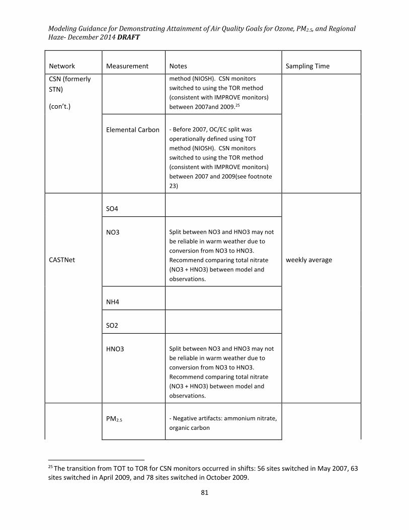
Modeling Guidance for Demonstrating Attainment of Air Quality Goals for Ozone, PM2.5, and Regional
Haze- December 2014 DRAFT
81
Network
Measurement
Notes
Sampling Time
CSN (formerly
STN)
(con’t.)
method (NIOSH). CSN monitors
switched to using the TOR method
(consistent with IMPROVE monitors)
between 2007and 2009.25
Elemental Carbon
- Before 2007, OC/EC split was
operationally defined using TOT
method (NIOSH). CSN monitors
switched to using the TOR method
(consistent with IMPROVE monitors)
between 2007 and 2009(see footnote
23)
CASTNet
SO4
weekly average
NO3
Split between NO3 and HNO3 may not
be reliable in warm weather due to
conversion from NO3 to HNO3.
Recommend comparing total nitrate
(NO3 + HNO3) between model and
observations.
NH4
SO2
HNO3
Split between NO3 and HNO3 may not
be reliable in warm weather due to
conversion from NO3 to HNO3.
Recommend comparing total nitrate
(NO3 + HNO3) between model and
observations.
PM2.5
- Negative artifacts: ammonium nitrate,
organic carbon
25 The transition from TOT to TOR for CSN monitors occurred in shifts: 56 sites switched in May 2007, 63
sites switched in April 2009, and 78 sites switched in October 2009.

Modeling Guidance for Demonstrating Attainment of Air Quality Goals for Ozone, PM2.5, and Regional
Haze- December 2014 DRAFT
82
Network
Measurement
Notes
Sampling Time
IMPROVE
- Positive artifacts: organic carbon,
water
-Note that positive and negative
artifacts for PM2.5 may be different
from artifacts for individual PM
components because the speciated
PM2.5 samples are collected on
different types of filters than are used
for total PM2.5 gravimetric
measurements
24-hour average 1/3
days
SO4 and S
-IMPROVE monitors measure both
elemental S (by XRF) and ionic SO4- by
ion chromatography. Generally either
measurement is reliable and may be
used for model evaluation purposes
although some caveats should be
noted.26
NO3
NH4
-Only available at a limited number of
sites for a limited number of years
Organic Carbon
- OC/EC split is operationally defined
using Thermal Optical Reflectance
(TOR) analysis.
- Blank corrections based on a median
measured positive OC artifact from
back-up filters at six sites are applied
on a month-specific basis to all data
before they are reported (Chow et al,
26 Hyslop et al (2012) report that XRF elemental sulfur measurements are somewhat affected by changes
in XRF methodologies over time. Also, prior to 2000, filters used to collect sulfate for ion
chromatography became clogged during high sulfate episodes. Changes in filter collection techniques
eliminated this problem after 2000. In addition, recent literature by Tolocka and Turpin (2012) suggests
that differences between XRF sulfur and ion chromatography sulfate are due to the presence of organic
sulfur in aerosol (which would be measured by XRF but not IC). If this is the case, than the IC sulfate
measurement is more appropriate for comparison with modeled sulfate which generally does not
include formation of organic sulfur compounds.

Modeling Guidance for Demonstrating Attainment of Air Quality Goals for Ozone, PM2.5, and Regional
Haze- December 2014 DRAFT
83
Network
Measurement
Notes
Sampling Time
IMPROVE
(con’t.)
2010; Watson et al., 2009). Frank
(2012) recommended changing blank
correction procedures for both
IMPROVE and STN OC measurements.
These recommendations have not yet
been implemented.
Elemental Carbon
- OC/EC split is operationally defined
using Thermal Optical Reflectance
(TOR) analysis.
Sodium
XRF analysis is not as sensitive to
sodium as other methods and
generally under-reports sodium
concentrations.
Silicon
XRF silicon measurements are
unreliable at high sulfur conditions
(when S/Si > about 7)
Aluminum
Elemental concentrations above the
MDL can go undetected. IMPROVE
has published an alternate soil
calculation which estimates Al
based on Si concentrations.27
In general, the speciated PM2.5 data can be directly compared to the model outputs. Of note,
care should be taken in examining issues with blank corrections for organic carbon (especially
when measured OC is low) as well as the EC/OC split. Prior to 2006, the CSN and IMPROVE
networks used different analysis techniques when estimating EC and OC (CSN monitor locations
switched to a similar method to IMPROVE between 2007 and 2009, depending on the monitor).
The EC/OC analysis method will generally have a larger impact on EC concentrations than OC
concentrations. The difference in OC/EC splits between the two techniques has been
investigated in depth in the literature and by IMPROVE staff (Chow, 2001, Chow, 2010, White,
27 Due to difficulties in detecting Al, IMPROVE sometimes uses an alternative SOIL calculation which does
not include Al: SOIL = 3.48*Si + 1.63*Ca + 2.42*Fe + 1.94*Ti
(http://vista.cira.colostate.edu/improve/publications/SOPs/ucdavis_sops/sop351_V2.pdf)

Modeling Guidance for Demonstrating Attainment of Air Quality Goals for Ozone, PM2.5, and Regional
Haze- December 2014 DRAFT
84
2007). It may not be appropriate to compare EC concentrations between networks for years
prior to 2009 (although the data can still be used to evaluate model performance).
Total PM2.5 mass measured gravimetrically at CSN and IMPROVE monitors is known to have
several measurement artifacts (both positive and negative) (Frank, 2006, Simon, 2011, Malm,
2011). Consequently, summing the mass of all PM2.5 species components is not likely to give
the same answer as the total measured PM2.5 mass from a Teflon filter. Therefore, model
evaluations should concentrate on comparisons with speciated PM2.5 components at these
sites, rather than total PM2.5 mass.
FRM monitors do not measure all of the PM2.5 in the air, and the speciation samplers don't
measure PM2.5 in the same way as the FRM monitors (Frank, 2006). Due to these positive and
negative artifacts, the FRM data may not be directly comparable with model outputs without
adjustment. The models predict PM species as they might be measured in the ambient air, but
the FRM measurements may not always measure what is in the air (due to known positive and
negative artifacts). As part of the PM2.5 attainment test we recommended default
methodologies to adjust speciation (CSN and IMPROVE) data to better approximate the FRM
data (see sections 4.4 and 4.5). A similar adjustment could be made to the model output data
to allow the direct comparison to FRM measurements. However, as noted earlier, there may
be limited value of information gained by evaluating daily average total measured PM2.5 mass
(as compared to PM2.5 components). More meaningful information may be gleaned from
continuous PM2.5 ambient data.
Another issue to consider when comparing modeled and observed PM concentrations is the
size definitions for PM. IMPROVE and CSN ambient monitors measure PM2.5 using inlets which
screen out any particles with aerodynamic diameters greater than 2.5 µm. Air quality models
use varying schemes to characterize particulate matter size distributions. The two most
comment modeling schemes are the sectional treatment and the modal treatment. The default
configuration for CAMx includes a sectional aerosol treatment while the default configuration
for CMAQ includes a modal aerosol treatment, although other versions of these models exist
with alternate aerosol treatments. Sectional aerosol modules split particles into bins defined
using discrete size cutpoints based on aerodynamic diameter (e.g. particles with aerodynamic
diameters between 1 µm and 2.5 µm). One common sectional set-up includes 2 bins, one
containing particles with aerodynamic diameters < 2.5 µm (fine PM) and one containing
particles with aerodynamic diameters > 2.5 µm (coarse particles). Other models have split the
fine PM into more than two bins (Nolte et al., 2008; Pandis et al., 1993). With sectional models,
the comparison to measured PM2.5 is straightforward so long as one of the PM bins has a cutoff
at an aerodynamic diameter of 2.5 µm (i.e. add up PM mass in all bins less than 2.5 µm). The
modal approach treats PM as occurring in distinct “modes”, each one having a lognormal

Modeling Guidance for Demonstrating Attainment of Air Quality Goals for Ozone, PM2.5, and Regional
Haze- December 2014 DRAFT
85
distribution. Each PM mode is characterized by the geometric mean diameter and the
geometric standard deviation of the diameter (the geometric mean and standard deviation can
be tracked for particle number, surface area, mass or all three). With modal aerosol treatment,
PM2.5 can be estimated in several ways. One method is to simply sum the mass in the modes
that generally contain fine PM. Another method would be to use the geometric mean and
standard deviation to calculate the fraction of PM mass in each mode which is associated with
particles less than 2.5 µm. However there are several complicating factors with taking the
second approach. First, the EPA’s National Emissions Inventory and many other inventories
define PM2.5 as being entirely less than 2.5 µm in diameter. If these primary emissions are
injected into a modal model (generally into a fine PM mode), they are instantaneously mixed
with existing aerosol mass in that mode. The tail of the fine PM mode will include particles
greater than 2.5 µm. Therefore, a fraction of the PM that was operationally defined as
primarily emitted PM2.5 (diameter < 2.5 µm) would be incorrectly distributed into the > 2.5 µm
size range based on the mode distribution. If primary emissions were quantified based on
modes versus a discrete cutpoint, then this would not be a problem. Secondly, some modal
models have been shown to over-predict the peak-concentration diameter and distribution
width of the fine PM mode (Kelly et al., 2011; Kelly et al., 2010). This would lead to under-
predictions of the PM2.5 fraction by increasing the mass fraction in the >2.5 micron diameter
range. Based on these two complications, at this time we do not recommend calculating the
fraction of PM mass in each mode below the 2.5 µm cutpoint unless air agencies have specific
analysis for their application to show that method to be more accurate than simply summing
mass over the fine PM mode(s).
Finally, although we recommend weighing performance of speciated PM components more
heavily than total PM, some additional insight can be gained by looking at FEM continuous
PM2.5 measurements. Since speciated measurements are generally derived from filters, these
measurements are usually taken as 24-hour averages. The FEM continuous measurements
provide a diurnal profile of PM2.5 concentrations that can be compared against hourly model
outputs to determine whether the model is replicating the measured temporal pattern.
3.4 Diagnostic Evaluation
The goal of a diagnostic model evaluation is to determine whether the model correctly
represents the physical and chemical processes that control the ambient concentrations of
precursors and secondary pollutants. It is possible that a model can incorrectly represent the
relative amount of primary emissions versus secondary production or that a model can

Modeling Guidance for Demonstrating Attainment of Air Quality Goals for Ozone, PM2.5, and Regional
Haze- December 2014 DRAFT
86
incorrectly represent the importance of dispersion, deposition or chemical reaction as a sink.
Thus, the ability of a model to accurately reproduce the observed concentration of a particular
pollutant does not guarantee that the model correctly simulated the processes that determine
the concentration of the pollutant. The goal of a diagnostic evaluation is to investigate the
processes that determine the ambient concentrations of ozone, PM2.5 and their precursors, and
to develop confidence that the model can accurately predict how these concentrations will
change in the future (e.g., Arnold et al., 2006). It is likely that research grade measurements
needed to perform a diagnostic evaluation will not be available in many SIP modeling studies,
however, it can still be valuable to perform diagnostic analyses and compare the results with
previous modeling research studies.
Several different tools and analysis methods are available for use in diagnostic model
evaluation including process analysis, indicator ratios, source apportionment methods, model
sensitivity studies, and retrospective studies.
3.4.1 Process Analysis
Both the CMAQ and CAMx models include a process analysis tool (Jeffries and Tonnesen, 1994)
that provides additional diagnostic information on the chemical reactions and physical
processes (e.g., emissions, deposition, advection, vertical mixing, and net change from
chemistry) that determine species concentrations. Chemical reaction data can be output either
as the hourly integrated reaction rate (IRR) for each reaction or as a summary of key reactions
in the chemical process analysis (CPA). Physical processes can be output as hourly
concentration changes in the integrated process rate (IPR) file. Detailed analysis off IRR and IPR
outputs have been demonstrated in research studies (Jang et al., 1995; Vizuete et al., 2008;
Henderson et al., 2011), however, significant time and effort are required to complete these
analyses. The CPA output provides a more limited set of chemical process information that is
more accessible and that can be visualized using the same tools used to analyze model
concentration output files. Minimal computational cost is required to produce the CPA files
and they are in the same format as the model concentration files and can be view using the
same visualization tools. Below are examples of these plots comparing modeled ozone
concentration, daily total Ox production, and net O3 production in NOx limited and oxidant
limited chemical regimes. The CPA tool can also provide information on the chemical reactions
of VOC, NOy and radical species.

Modeling Guidance for Demonstrating Attainment of Air Quality Goals for Ozone, PM2.5, and Regional
Haze- December 2014 DRAFT
87
Figure 3.4.1 Chemical process analysis plots showing modeled ozone concentration, daily
total Ox production, and net ozone production under VOC sensitive and NOx sensitive
conditions.

Modeling Guidance for Demonstrating Attainment of Air Quality Goals for Ozone, PM2.5, and Regional
Haze- December 2014 DRAFT
88
3.4.2 Indicator Ratios
One way to evaluate the response of the model is to examine predicted and observed ratios of
indicator species. Indicator species techniques have been developed for both ozone and
secondary PM species (in particular nitrate) (Sillman, 1995, 1998; Ansari and Pandis, 1998;
Blanchard et al., 2000; Tonnesen and Dennis, 2000a,b). If ratios of observed indicator species
are very high or very low, they provide a sense of whether further ozone or secondary PM2.5
production at the monitored location is likely to be limited by availability of NOx or VOC (or NH3
in the case of particulate nitrate). Agreement between paired observed and predicted ratios
suggests a model may correctly predict the sensitivity of ozone or secondary PM2.5 at the
monitored locations to emission control strategies. Thus, the use of indicator species aims to
validate the modeled chemical regime and may help to build confidence in the RRFs predicted
from the specific model application.
For ozone, measurements of certain “indicator species ratios” are a potentially useful way to
assess whether local ozone formation is VOC or NOx limited at any particular point in space and
time as well as, help reveal whether the model is correctly predicting the sensitivity of ozone to
VOC and/or NOx controls (e.g., comparisons between modeled and observed ratios: O3/NOy,
O3/HNO3) (Millford et al., 1994; Sillman, 1995, 1997, 1998, 2002; Lu and Chang, 1998).
Tonnesen and Dennis (2000a,b) distinguished between short lived indicators of instantaneous
rates of production of O3 (PO3) or odd oxygen (POx) versus long lived indicators of peak O3
concentration and found that the ratio of production of H2O2 to production of HNO3
(PH2O2/PHNO3) is strongly associated with POx sensitivity to VOC and NOx. Tonnesen and
Dennis also found that the ratio of formaldehyde to NO2 was useful as an indicator of O3
sensitivity, and this ratio can be evaluated using satellite data (Martin et al., 2004; Duncan et
al., 2010). For PM, such a comparison may reveal whether the model is predicting sensitivity of
secondary components of PM2.5 to changes in SO2, NH3, VOC and/or NOx controls correctly
(Ansari and Pandis, 1998; Blanchard et al., 2000; Pun and Seigneur, 1999, 2001). If a model
accurately predicts observed indicator species relationships, then one can conclude with
additional confidence that the predicted change in future year ozone or PM may be accurate.
Although ratios of indicator species have the potential to be quite useful, they should be used
with caution since different studies have identified different ranges of values to characterize
VOC and NOx limited regimes in different locations. Table 3.3 summarizes the range of values
determined for 10 indicator species or ratios in various studies. In cases where the NOx and
VOC limited ranges are broad or overlap, air agencies should attempt to use values from studies
in the local area. At a minimum, air agencies should be careful with respect to the use of
indicator species when the range of observed values for which the preferred direction of

Modeling Guidance for Demonstrating Attainment of Air Quality Goals for Ozone, PM2.5, and Regional
Haze- December 2014 DRAFT
89
control is not clear. When this occurs, agreement between predictions and observations does
not necessarily imply that the response to controls, as predicted by the model is correct
(especially for secondary particulate matter to changes in precursors). If a model predicts
observed values of indicator species relationships such that observed and predicted value fall
within the same range, this provides some confidence that the predicted change in ozone or
secondary particulate matter may be accurate.
A second precaution is that this method often requires more types of measurements than are
commonly available. In some cases, it may be difficult to calculate meaningful indicator ratios
from relatively imprecise measurements from routine monitoring networks. Finally, much of
the work done to date with indicator species has focused on peak concentrations of ozone.
Limited research has been conducted on development of indicator ratios for secondary PM.
Table 3.3: Ranges of indicator species/ratios that have been reported for VOC and NOx limited
regimes.
indicator median VOC-sensitive transition median NOx-sensitive
O3/NOy 1.6 - 8.8a,b,d,f-m 6 – 15c,d,m,n,q 8.8 – 26a,b,d,f-m
O3/NOz 5.8 – 16a,d,f,j-m 7 – 100c-f,n,q 10.1 – 35a,d,f,j-m
O3/NOx < 15 15 – 60n,o,q,t > 40
O3/HNO3 7 - 33.9a,d,j,k,m 12 – 25c,d 17.2 - 62.9a,d,j,k,m
H2O2/HNO3 0.3 - 1.5d,j-m 0.2 - 2.4c,e,h,n-q 0.4 - 3.6d,j-m
H2O2/NOz 0.2 - 1.1a,j 0.2 - 0.25c 0.6 - 1.3a,j
H2O2/NOy 0.2 - 0.4a,j 0.12 - 0.17c 0.6 - 1.0a,j
HCHO/NO2 < 1 1-2n,o,u > 2
NOz/NOy < .5 0.5-0.6f > 0.6
NOy 7.7 - 12.2j 5 -2 0c,e,f,n,r,s 3.2 - 5.7j
aCastell et al., 2009; bXie et al., 2011; cTorres-Jardon and Keener, 2006; dSillman and He, 2002; eSillman,
1995; f Lu and Chang, 1998; gStein et al, 2005; hSillman et al., 1997; iMartilli et al., 2002; jJimenez and
Baldasano, 2004; kTorres-Jardon et al, 2009; lChock et al, 1999; mSillman et al., 2003; nZhang et al, 2009;

Modeling Guidance for Demonstrating Attainment of Air Quality Goals for Ozone, PM2.5, and Regional
Haze- December 2014 DRAFT
90
oTonnesen and Dennis, 2000a; pHammer et al., 2002; qLiang et al., 2006; rMilford et al, 1994; sVogel et al,
1995; tTonnesen and Dennis, 2000b; uMartin et al., 2004
Blanchard et al., (2000) have examined how indicator species might be used to assess whether
particulate nitrate concentrations are limited by NOx or by ammonia emissions using
mechanisms which incorporate reactions dealing with secondary particulate matter. These
authors identify several indicators which appear potentially useful for identifying limiting
precursors for secondary nitrate particulate matter. The indicators include:
(1) excess NH3 defined in Equation 3-1 (values greater than zero indicate NOx limited regimes
and values less than 0 indicate ammonia limited regimes);
�������!" = [NH3(g)] + [NH4 + (a)]– 2 ∗ [SO42 − (a)] − [NO3 − (a)]–[HNO3(g)] − [HCl(g)] + 2 ∗ [Ca2+] + 2 ∗ [Mg2+] + [Na+] + [K+] + [Cl−]
[3-1]28
(2) The ratio of particulate to total nitrate. Values above 0.9 at high temperatures indicate NOx
limited regimes (values below 0.3 to 0.5 were indicative of ammonia limited regimes.)
Ansari and Pandis (1998) also have suggested the use of the gas ratio (GS), defined in equation
3-2, as an indicator of PM formation regimes.
45 = �6786�97: [3-2]29
Despite these precautions, comparing predicted and observed relationships of indicator species
provides a means of assessing a model's ability to accurately characterize the sensitivity of
predicted ozone and predicted secondary components of PM2.5 to changes in precursors.
Where observations are available, it is recommended that SIP modeling demonstrations show
reasonable agreement between observations and ratios of indicator species.
28Concentrations are in µmol/m3, (g) represent gas-phase and (a) represents aerosol phase. 29 NH3
F is free ammonia (total ammonia – 2*sulfate). HNO3T is total nitrate (gas + PM).

Modeling Guidance for Demonstrating Attainment of Air Quality Goals for Ozone, PM2.5, and Regional
Haze- December 2014 DRAFT
91
3.4.3 Source Apportionment
Source apportionment methods and model sensitivity studies are two complementary
approaches that can be used to identify emissions sources that contribute to high pollutant
concentrations. The CMAQ and CAMx models both include options to use source
apportionment tools to identify sources that contribute to the production of ozone (ENVIRON,
2014; Kwok et al, 2014) and some components of PM2.5 including sulfate, nitrate, ammonium
and primary emissions of PM2.5 (ENVIRON, 2014; Kwok et al., 2013). Source apportionment
tools employ a set of model tracers to attribute pollutant concentrations to user selected
emissions source sectors and geographic areas. This approach can be useful both as a
diagnostic tool to identify sources that contribute to ozone and PM2.5 and also as an aid in
regulatory analysis to identify emissions control measures that will be effective for attaining air
quality standards. An advantage of source apportionment approaches is that tracers attribute
the mass contribution from a source to a receptor, and therefore this approach is less
susceptible to the effects of non-linear chemistry that can complicate the interpretation of
model sensitivity simulations.
3.4.4 Sensitivity Studies
Model sensitivity simulations can be used to identify model inputs (IC/BC, meteorological data,
chemical reactions, and emissions) that have the greatest impact on model predicted
concentrations. The objective of sensitivity tests is to identify whether the inputs have a large
enough influence that errors in these inputs could be a driving influence on the model
predictions. In “brute-force” sensitivity simulations, the model input data is modified directly,
e.g., increasing or decreasing emissions in the model input file. Brute force simulations are
relatively easy to implement but are resource intensive when many different inputs must be
evaluated. The Direct Decoupled Method (DDM) is an approach that can be used to evaluate
the first order sensitivity to multiple model inputs in a single model simulation (e.g., Cohan et
al., 2005; Napelenok et al., 2006). Because of non-linearity in chemical reactions, first order
sensitivity is not always sufficient, and high-order DDM (HDDM) can be used to evaluate
second order sensitivities to inputs that are subject to non-linear chemistry (Zhang et al.,
2012b).
In cases where the model performs poorly in the base case, sensitivity simulation may be useful
to identify potential causes for poor model performance. However, caution should be used in
modifying inputs to achieve good model performance because arbitrarily “tuning” of model

Modeling Guidance for Demonstrating Attainment of Air Quality Goals for Ozone, PM2.5, and Regional
Haze- December 2014 DRAFT
92
input data to fit the observations can introduce compensating errors. For example, if a model
underestimates observed ozone because the meteorological data is overly dispersive, the
model performance could be improved by increasing emissions or BC concentrations, but this
model would not be reliable for predicting future concentrations because its good performance
in the base case was achieved through compensating errors in the input. An appropriate use of
sensitivity approaches is to identify each of the processes or inputs that has a large effect on
model predictions, and then perform additional analysis of those inputs to determine if they
are accurately represented in the base case model
3.4.5 Dynamic Model Evaluation
A second method for assessing a model's performance in predicting the sensitivity of ozone or
PM2.5 species to changes in emissions is to perform a retrospective dynamic analysis. This
involves comparing model predicted historical trends with observed trends. Retrospective
analyses provide potentially useful means for diagnosing why a strategy did or did not work as
expected. They also provide an important opportunity to evaluate model performance in a way
which is closely related to how models are used to support an attainment demonstration.
A dynamic evaluation uses various analyses to assess the accuracy of the model in
characterizing the sensitivity of ozone and/or PM2.5 to changes in emissions. Although dynamic
evaluation is always recommended, the measurements and resources needed for a dynamic
evaluation may not be readily available to many air agencies performing SIP modeling.
Additional challenges for retrospective analyses include identifying appropriate case studies for
which responses to emissions changes are large enough to be distinguished in ambient data,
developing or obtaining equivalent and appropriate emissions for multiple historical years, and
disentangling the confounding influences of year to year changes in meteorology and
emissions. Consequently, retrospective dynamic evaluations may be beyond the scope of many
SIP modeling demonstrations. Major challenges in evaluating indicator species include
variability in the characteristic ratios for VOC and NOx limited regimes in different locations and
the availability of ambient data. Where appropriate observational data are available, modelers
are encouraged to evaluate these indicators.
A retrospective analysis is intended to examine the ability of the model to respond to emissions
changes by comparing recent trends in observed ozone or PM2.5 concentrations to the model-
predicted trend over the same time period. The approach is a direct assessment of what is

Modeling Guidance for Demonstrating Attainment of Air Quality Goals for Ozone, PM2.5, and Regional
Haze- December 2014 DRAFT
93
most important in an attainment demonstration: does the model accurately predict changes in
air quality as a result of changes in emissions? As part of a retrospective the model is run for
(a) current episodes or time periods and (b) episodes in one or more historical time periods
using the emissions and meteorological inputs appropriate for each time period modeled.
While retrospective analyses may be useful, it may be difficult to obtain meteorological and
emissions inputs for the historical time period(s) that are calculated using techniques and
assumptions which are consistent with the calculation of these same inputs for the current time
period. Using inconsistent inputs will confound the interpretation of the predicted trend. One
method for ensuring consistent methodology for emissions estimates is to backcast emissions
from the most recent year to the earliest year. The model should respond in a predictable way
if the emissions changes are large enough. Hence, modeling an emissions change of only a few
percent would not be viable. However, if NOx or SO2 emissions have been reduced by a large
percentage (e.g. 30% or more) over a relatively short time period, then that may be a good time
period to test the response of the model.
Because differences in meteorology between years can confound the apparent change in
pollutants, a complete retrospective analysis could include multiple sensitivity runs using both
year-specific meteorology and constant meteorology. The year-specific meteorology would
allow the modeler to compare modeled and observed trends most accurately, and the constant
meteorology would help inform the analysis on what portion of the change in pollutant
concentrations were due to emissions versus meteorological differences.
Retrospective analyses are one of the few tools that can be used to determine if the model is
responding “adequately” to control measures. Retrospective analyses may be an important
tool to show that the models are responding “correctly” to emissions changes. Recent efforts
to perform this type of analysis have been undertaken by Zhou et al (2013), Gilliland et al
(2008), Godowitch et al (2010), Pierce et al. (2010) and (Foley et al, 2014). These published
analyses may be used to better understand the ability of certain models to properly capture
relationships between ambient pollution levels and emissions. However, since model response
is highly dependent on the meteorology and emissions inputs, past studies will not necessarily
provide insight on specific SIP demonstration modeling episodes which rely on independently
derived meteorology and emissions.
Another dynamic evaluation approach is to look at operational performance under varying
conditions, e.g., by day of the week, by season, and regionally (Marr and Harley, 2002; Murphy
et al, 2007; Harley et al, 2005). The mix of pollutants vary by day of the week and from city to
city so when a model shows good operational performance across these different chemical
environments, this supports the assertion that it will respond appropriately to changes in

Modeling Guidance for Demonstrating Attainment of Air Quality Goals for Ozone, PM2.5, and Regional
Haze- December 2014 DRAFT
94
emissions. Two recent studies have performed model evaluations that focused on the model’s
ability to capture weekend/weekday changes (CRC, 2011; Pierce et al, 2010)
3.5 Evaluation Tools
One available software tool to assist in model performance evaluations is the Atmospheric
Model Evaluation Tool (AMET) (Appel, 2011) (www.cmascenter.org). AMET is built on several
open-source software packages and uses the MySQL database software to store paired
observation and model output data. There are modules in AMET for evaluating both
meteorological and air quality model output. AMET provides a useful set of scripts for creating
various types of plots and statistics.

Modeling Guidance for Demonstrating Attainment of Air Quality Goals for Ozone, PM2.5, and Regional
Haze- December 2014 DRAFT
95
4.0 Assessing Modeled Attainment
A model attainment demonstration usually consists of two key components: a) analyses which
estimate whether a set of simulated emissions reductions will result in ambient concentrations
that meet the National Ambient Air Quality Standards (NAAQS) and b) an identified set of
control measures which will result in the required emissions reductions. This guidance focuses
on the first component of a model attainment demonstration, that is, the completion and
interpretation of analyses to estimate the amount of emission reduction needed to attain the
NAAQS.
Air agencies should estimate the amount of emission reductions needed to demonstrate
attainment of the NAAQS using the model attainment test. The model attainment test is a
technical procedure in which an air quality model is used to simulate base year and future air
pollutant concentrations for the purpose of demonstrating attainment of the relevant NAAQS.
The recommended test uses model estimates in a “relative” rather than “absolute” sense to
estimate future year design values. As explained in more detail in subsequent sections, the
fractional changes in air pollutant concentrations between the model future year and model
base year are calculated for all valid monitors. These ratios are called relative response factors
(RRF). Future ozone and/or PM2.5 design values are estimated at existing monitoring sites by
multiplying the modeled relative response factor for each monitor by the monitor-specific base
year design value. The resulting estimates of future concentrations are then compared to the
NAAQS. If the future estimates of ozone and/or PM2.5 design values do not exceed the NAAQS,
then this provides evidence that attainment will be reached.
In addition to the model attainment test, air agencies should also consider performing a set of
corroboratory analyses to further assess whether a proposed set of emission reductions will
lead to attainment of the NAAQS (or uniform rate of progress for regional haze). As discussed
later in this section (see section 4.9), the model attainment test and these supplemental
analyses should be aggregated into a weight of evidence determination to evaluate whether the
selected emissions reductions will yield attainment.
4.1 Overview of model attainment test
There are four reasons why the recommended model attainment test is based on application of
the model in a relative sense. First and foremost, this approach has the effect of anchoring the
future concentrations to a “real” measured ambient value, which is important given model bias

Modeling Guidance for Demonstrating Attainment of Air Quality Goals for Ozone, PM2.5, and Regional
Haze- December 2014 DRAFT
96
and error in the base year simulation(s). It is reasoned that factors causing bias (either under or
over-predictions) in the base case will also affect the future case. While good model
performance remains a prerequisite for use of a model in an attainment demonstration,
problems posed by imperfect model performance on individual days are expected to be
reduced when using the relative approach. An internal EPA analysis (USEPA, 2014b) considered
whether daily ratios of model future/current maximum daily 8-hour ozone averages (MDA8)
varied strongly as a function of site-specific base case model performance. This analysis was
completed using a national model simulation that projected 2020 ozone concentrations from a
2007 base case. The analysis determined that when modeled MDA8 ozone bias was relatively
small (e.g., less than +/- 20 ppb), the average response ratios were not a strong function of the
model MDA8 bias. This provides confidence that the model can detect the air quality response
in the midst of reasonable levels of absolute bias and error. Second, the relative model
attainment test allows for a future projection of 3-year average ozone and PM2.5 design values
without explicitly having to model a three-year period. Third, because PM2.5 concentrations
typically consist of a diverse mix of primary and secondary components, the relative model
attainment test decreases the possibility of choosing ineffective control strategies based on
inaccurate model estimations of PM2.5 composition by assessing component specific RRFs.
Fourth and finally, there is evidence, based on a retrospective modeling analysis of ozone
changes between 2002 and 2005 (Foley et al, 2014b) and 2002 and 2010 (Hogrefe et al, 2014),
that using the model in a relative sense provides better estimates of future ozone design values
than using the absolute future year simulation. The correlation between model-projected and
actual design values, as well as the accuracy of model projections of attaining a 75 ppb NAAQS
both appear to be slightly improved when a relative model attainment test is utilized.
Equation (4.1) describes the recommended model attainment test in its simplest form, as
applied for monitoring site i:
(DVF)> = (??@)� ∗ (ABC)� [4.1]
where DVF> is the estimated design value for the future year in which attainment is required at
monitoring site i; RRF> is the relative response factor at monitoring site i; and DVB> is the base
design value monitored at site i. Each of these terms is discussed in more detail below.
EPA has developed the Model Attainment Test Software (MATS) tool to enable completion of
the model attainment tests for PM2.5 and ozone, as well as for calculating changes in visibility in
Class I areas as part of the uniform rate of progress analysis for regional haze (Abt, 2014). This
tool can be found on EPA’s Support Center for Regulatory Atmospheric Modeling (SCRAM)
website in the section on “Modeling Guidance and Support”
http://www.epa.gov/scram001/modelingapps_mats.htm

Modeling Guidance for Demonstrating Attainment of Air Quality Goals for Ozone, PM2.5, and Regional
Haze- December 2014 DRAFT
97
4.1.1 Establishing the base design value
The base design value for each monitoring site (ABC�) is the anchor point for estimating future
year projected concentrations. Because the modeling is being used in a relative sense to
determine how the modeled emissions changes will affect air quality design values in an area, it
is important to match the base design value as closely as possible to the base year for which
future/base ratios will be assessed. That is, if one is estimating the expected air quality change
from emissions reductions between 2010 and 2020, it is important to establish an air quality
anchor that represents 2010 emissions levels as closely as possible. However, it is well-
established that inter-annual variability in meteorological conditions often leads to year-to-year
differences in design values, even with static emissions levels (USEPA, 2012). In addition, there
is also year to year variability in emissions due to economic factors (such as recessions) and
compliance with regulations. We therefore recommend using the base design value approach
described below.
For the model attainment tests for ozone and PM2.5, we recommend using the average of the
three design value periods which include the base emissions inventory year.30 This average is
expected to best represent the air quality resulting from base year emissions with some
consideration of meteorological and emissions variability. For example, if the model
attainment test uses base year emissions from 2011, then the base design value would be
calculated as shown in equation 4.2 for each site i:
30 EPA recommends using ambient design values that are consistent with the official design values as
calculated according to 40 CFR part 50 Appendix N (PM2.5 NAAQS) and Appendix P (8-hour ozone
NAAQS). This includes flagging and removing event-influenced data that meet the requirements set
forth in the Exceptional Events Rule (40 CFR 50.14). In general, air agencies flag data that they believe
may qualify for removal as an exceptional event and are then responsible for developing and providing
documentation to EPA to support these requests for exclusion. EPA Regional Offices review exceptional
events claims and decide whether to concur with each individual claim. Once EPA concurs with an air
agency’s request, the event-influenced data are officially noted and removed from the data set used to
calculate official design values. In some cases, historical ambient data may meet the requirements of
the Exceptional Events Rule, but remain in the data set used to calculate official design values. Air
agencies may or may not have flagged these data as being potentially influenced by exceptional events
or may have flagged these data, but not submitted the required documentation. Air agencies may not
closely examine potential event-influenced data that do not affect attainment/nonattainment
decisions. However, the influence of potential event-influenced data may affect future year
projections that are part of the modeled attainment demonstration. If potential exceptional event-
influenced data from the historical record may affect the outcome of the modeled attainment
demonstration, we encourage air agencies to consult with their EPA regional office to determine how
best to handle this situation.

Modeling Guidance for Demonstrating Attainment of Air Quality Goals for Ozone, PM2.5, and Regional
Haze- December 2014 DRAFT
98
(ABC)F = ((GH I��)JK(GH I� )JK(GH I�")J)" [4.2]31
This has the desired effect of weighting the projected ozone or PM2.5 base design values
towards the middle year of a five year period (2009-2013), in this example for a 2011 base
emissions inventory year. Additionally, an average of 3 design values will be more stable (less
year-to-year variability) than any single design value period. An EPA analysis of recent design
values data at 761 ozone monitors over the period between 2002 and 2011 concluded that the
median standard deviation of individual 3-year ozone design values was 5.3 ppb, whereas the
standard deviation of the average of multiple 3-year ozone design values was only 4.0 ppb.
In cases in which there are less than five years of valid monitoring data at a site, we recommend
that base design values be calculated only when there are at least three years of consecutive
valid data (i.e., at least one complete design value). If a location has less than three consecutive
years of data, then that site should not ordinarily be used in the attainment test32. An example
calculation for DVBi is shown in Table 4.1, and includes the number of significant digits to
include for ozone and each form of the PM2.5 standard.
Table 4.1: Example illustrating the calculation of base design values.
2011 DV 2012 DV 2013 DV DVB
O3 NAAQS (ppb)33 76 76 78 76.7
Annual PM2.5 NAAQS (µg/m3) 12.9 13.1 12.6 12.87
24-hour PM2.5 NAAQS (µg/m3) 32 33 32 32.3
The measured 3-year average design values use the rounding/truncation rules established in 40
CFR Part 50 Appendix P (8-hour ozone) and Appendix N (PM2.5). The resultant 5-year weighted
average base design value should carry one digit to the right of the decimal point for ozone and
24-hour PM2.5 and two digits to the right of the decimal for annual PM2.5. There are several
31 Note: for nomenclature purposes, the three-year design value is referred to by the last year of the
averaging period. That is, DV 2011 represents air quality data averaged over 2009, 2010, and 2011 for
ozone and PM2.5. 32 Monitoring sites with less than 3 years of data cannot ordinarily be used to determine attainment
status. Therefore, in most cases, those sites should not be used in the attainment demonstration.
However, there may be cases where a monitoring site with incomplete data indicates an area of high
ozone or PM concentration. Further examination of the monitoring data and modeled response (RRF) in
the area is recommended as part of either the monitor based attainment test or an unmonitored area
analysis, as appropriate. 33 The current ozone NAAQS is defined in units of ppm. For ease of use, this document will use ppb
units.

Modeling Guidance for Demonstrating Attainment of Air Quality Goals for Ozone, PM2.5, and Regional
Haze- December 2014 DRAFT
99
calculations in the modeled attainment test which carry the tenths digit or hundredths digit.
Prematurely rounding and/or truncating concentrations and RRFs can lead to an overestimate
or underestimate of the modeled impact of emissions controls. In some cases, a few tenths of
a ppb (or µg/m3) change (or a few tenths of a percent reduction) can affect the outcome of the
model attainment test. Rounding or truncating can make the change appear to be equal to a
full ppb (or 1%) or equal to zero change. For 8-hour ozone, it is recommended to round to the
tenths digit until the last step in the calculation when the final future design value is truncated.
For annual PM2.5 it is recommended to round to the hundredths digit until the last step when
the final future design value is rounded to the nearest tenths place. For daily PM2.5 it is
recommended to round to the tenths digit until the last step when the final future design value
is rounded to the nearest whole number.
In practice, the choice of the base design value can be critical to the determination of the
estimated future year design values (Cohan, 2006) and careful consideration should be given to
the calculation of base year values. There is no single methodology that can derive a “correct”
base design value, but the 5 year weighted average value establishes a relatively stable value
that is weighted towards the emissions and meteorological modeling year. In most cases, this
provides an appropriate anchor point in which to base the future year design value calculations.
Alternate, equally plausible, calculations of base design values may be considered as part of the
corroborating analyses that comprise the aggregate weight of evidence determination. For
instance, one may want to consider establishing the base design value on the highest of the
relevant design values to ensure that the emissions measures will yield attainment even in
periods with meteorological conditions especially conducive to poor air quality.
4.1.2 Calculation of relative response factors
The relative response factor for each monitoring site (??@)� is the fractional change in air
quality concentrations that is simulated due to emissions changes between a base and a future
year emissions scenario. The specific RRF calculation techniques vary by pollutant and are
described in more detail in the remainder of section 4 below. The most important
consideration associated with the RRF calculation is determining which model values are most
representative of the expected air quality change for a given location. This requires
consideration of all of the varying changes in hourly pollutant concentrations between the base
and future cases and a determination of the most appropriate summary (average) value to
apply to the base design value. As with the selection of a base design value, there may be
plausible alternative means of calculating the relative response factors that can differ from the
approaches recommended below (e.g., Kulkarni et al., 2014, Porter et al., 2014). Where

Modeling Guidance for Demonstrating Attainment of Air Quality Goals for Ozone, PM2.5, and Regional
Haze- December 2014 DRAFT
100
justified, alternate RRF calculation techniques can be included as corroborative analyses as part
of a weight of evidence determination.
4.2 Model attainment test for the primary ozone standard
The 8-hour ozone design value is currently calculated as the three-year average of the fourth
highest monitored daily 8-hour maximum value at each monitoring site. The standard is
considered to be attained if the observed design value does not exceed the level of the ozone
NAAQS.34 Similarly, the model attainment test is considered satisfied when the (DVF)> is less
than or equal to the current NAAQS level. The recommended test is described below.
4.2.1 Model values to use in the RRF calculation
Given the formulation of the model attainment test, it is important to identify which model
days are best suited for determining the expected air quality response resulting from a set of
emissions changes. On any given modeled day, meteorological conditions may or may not be
conducive to high concentrations at a particular monitor. If ozone predicted near a monitor on
a particular day is much less than the design value, the model predictions for that day could be
unresponsive to controls (e.g., the location could be upwind from most of the emissions in the
nonattainment area on that day). If these days are included in the RRF calculation, they will
likely lead to a higher RRF (closer to one) and a potential overestimation of the future design
value.
Internal EPA analyses (USEPA, 2014b) have shown that model response to decreasing emissions
is generally most stable when the base ozone predictions are highest. The greater model
response at higher concentrations is likely due to more “controllable” ozone at higher
concentrations. In addition, the high model days are selected individually for each monitor.
Meteorological conditions that lead to high ozone may differ between monitors in an area. For
example, monitors that are typically “upwind” or “downwind” of an area may experience high
ozone on different days, depending on the prevailing wind direction. In most urban areas, on
days with high ozone concentrations, there is a relatively high percentage of locally generated
ozone compared to days with low base case concentrations (U.S. EPA 2014c). Days with low
34 At the time of publication of this guidance, the ozone NAAQS was 0.075 ppm per 40 CFR Part 50.15.
Design values for the .075 ppm NAAQS are truncated to the 3rd decimal digit. Therefore, 0.0759 ppm
(75.9 ppb) is considered attainment and 0.0760 (76.0 ppb) is considered nonattainment. The same
rounding/truncation procedures should be applied to the modeled attainment test. A detailed
description of the methodology to calculate ambient ozone design values is provided in 40 CFR Appendix
P to Part 50.

Modeling Guidance for Demonstrating Attainment of Air Quality Goals for Ozone, PM2.5, and Regional
Haze- December 2014 DRAFT
101
ozone concentrations are more likely to have a high percentage of ozone due to background
and boundary conditions. Since the form of the standard is also focused on the highest days of
an ozone season (i.e., the fourth highest MDA8), the RRF calculation should also focus on days
when the model predicts the highest ozone concentrations.
As the ozone NAAQS has been lowered, a key question is whether the attainment test should
use an average RRF based on all modeled days that are greater than the NAAQS, as in the
previous guidance approach. In some areas of the country, this could lead to RRF calculations
that might include upwards of 100 days per ozone season (for the 75 ppb NAAQS). In these
cases, similar to RRFs based on low modeled concentrations, too many days in the RRF
calculation may lead to higher (closer to 1) RRFs. Using the highest modeled days at each
monitor is most likely to represent the response of the observed design value at a monitor.
Since the design value is based on the seasonal 4th high observed values, we recommend
selecting a set of modeled days that are likely to encompass a range of values that are
somewhat higher than and somewhat lower than the 4th high value. We therefore recommend
calculating the RRF based on the highest 10 modeled days in the simulated period (at each
monitoring site). We believe this balances the desire to have enough days in the RRF to
generate a robust calculation, but not so many days that the RRF does not represent days with
concentrations near the observed design values. In addition, use of the highest 10 days
(without an initial threshold) allows the attainment test to be easily adapted to any level of the
NAAQS with little or no change in the methodology. In support of the revised recommendation,
a recent assessment of modeled ozone changes between two ozone seasons (Foley et al., 2014)
suggests that the use of the highest 10 days in the mean RRF calculation yields a slightly better
estimate of the actual observed ozone change than the previous guidance approach.
EPA recommends that the ozone RRF calculations be based on the 10 highest days in the base
year modeling at the monitor location, as long as the base MDA8 values are greater than or
equal to 60 ppb for that day. In cases for which the base model simulation does not have 10
days with MDA8 values greater than or equal to 60 ppb at a site, then EPA recommends using
all days where MDA8 >= 60 ppb, as long as there are at least 5 days that meet that criteria. If
there are less than 5 days with MDA8 >= 60 ppb, EPA recommends that air agencies do not
calculate a DVF for the site.35 If the model attainment test is based on less than 10 days, then
other assessments in the aggregate weight of evidence demonstration will need to be more
rigorous to counter the reduced robustness of the model attainment test.
35 A scenario in which the 5th highest base model MDA8 values is less than 60 ppb either indicates an
extremely low ozone site or poor model performance. In either case, projections of DVF values are likely
not reliable.

Modeling Guidance for Demonstrating Attainment of Air Quality Goals for Ozone, PM2.5, and Regional
Haze- December 2014 DRAFT
102
In addition, as discussed by Vizuete et al. (2011), there can be days in which the modeled
source-receptor relationships may not yield a representative response for a particular cell or
array of grid cells. This can result from small inconsistencies between the model representation
of transport patterns (or chemical formation) and what actually occurred on that day. As part
of the weight of evidence demonstration, if there is compelling evidence to determine that a
particular day, while being among the 10 highest MDA8 values at a location, is not
representative of the expected source-receptor relationship at that location; then that day can
be considered for removal from the RRF calculation. Air agencies should document the
evidence that argues for the exclusion of any otherwise-eligible days. As noted earlier, poor
model performance on individual days can lead to ratios of future to base ozone that may be
biased on those days. For example, underprediction of ozone concentrations may lead to ratios
that are unresponsive to emissions controls. Air agencies may want to examine the day- and
site-specific model performance for days that are part of the RRF calculation. Where feasible, it
is recommended that days with model biases greater than +/- 20 percent be examined to make
sure that they can be appropriately used in calculating the expected response.
4.2.2 Grid cells to use in the RRF calculation
It is recommended that ozone RRF calculations consider model response in grid cells
immediately surrounding the monitoring site along with the grid cell in which the monitor is
located. There are two primary reasons why we believe it is appropriate to include predictions
from grid cells near a monitor rather than just the cell containing the monitor. First, limitations
in the inputs and model physics can affect model precision at the grid cell level. Allowing some
leeway in the precision of the predicted location of daily maximum ozone concentrations can
help assure that possibly artificial, fine scale variations do not inadvertently impact an
assessment of modeled ozone response. Second, some ozone monitors and important
emission sources may be located very close to the border of a grid cell. Considering multiple
cells near a monitor rather than the single cell containing the monitor diminishes the likelihood
of inappropriate results which may occur from the artificial geometry of the superimposed grid
system.
Based on the above considerations, it is recommended that the RRF be based on a 3 x 3 array of
cells centered on the location of the grid cell containing the monitor. This is a change from the
2007 guidance (USEPA, 2007) which pre-identified 15 km as an appropriate distance for grid cell
proximity to a monitor and therefore recommended the selection of RRF grid cells to be
contingent upon the chosen model grid resolution (i.e., a finer grid resolution considered a
larger array of grid cells to maintain the pre-identified 15 km distance). The revised approach
allows for small spatial differences in the response to be considered in the RRF calculation and

Modeling Guidance for Demonstrating Attainment of Air Quality Goals for Ozone, PM2.5, and Regional
Haze- December 2014 DRAFT
103
presumes that the chosen model grid resolution is able to appropriately capture model
response at the location of the monitoring site. Additionally, as described in section 4.2.3, the
guidance now recommends that the grid cell with the highest base year MDA8 ozone value in
the 3 x 3 array be used for both the base and future components of the RRF calculation, as
opposed to the 2007 guidance approach which recommended selecting the peak value in the
base and future cases, even if they were in different grid cells.
The selection of grid cells to use in the RRF calculation is especially important in “oxidant
limited” areas (i.e., areas where incremental NOx decreases may lead to ozone increases)
because these areas are likely to have grid cells that respond to VOC controls, with NOx
sensitive grid cells nearby (perhaps even in the same 3 x 3 array). The 3 x 3 array methodology
could lead to unrealistically small or large RRFs in these locations, depending on the specific
case. Internal EPA analyses with a 12 km grid resolution have shown that on average, model-
estimated future design values vary by less than 1 ppb when a single cell is used as opposed to
the recommended array, although higher variability can occur. (USEPA, 2014b).
While the use of a 3 x 3 array of cells is the recommended approach for the model attainment
test, air agencies are encouraged to consider the actual spatial scales of the monitors at which
the model attainment test is being applied. Most ozone monitors are generally sited to be
representative of an urban or neighborhood scale. In cases in which the spatial
representativeness of a monitoring location is much smaller or larger than the area covered by
the 3 x 3 array of cells, air agencies may consider assessing site-specific model response over an
alternative grid cell array as part of corroborative analyses that inform the aggregate weight of
evidence determination.
4.2.3 Sample model attainment test calculation
Once the appropriate RRF days are determined at each site, the calculation is straightforward.
Relative response factors are not calculated on a daily basis, but instead are based on the mean
8-hour daily maximum values on all eligible calculation days. At the last step in the process, the
final DVF should be calculated in accordance with the data handling conventions associated
with the NAAQS (e.g., truncated to the third decimal in ppm units as per current Appendix P).
An example is provided below for a 2011 base year and 2020 future year simulation based on
an annual model simulation. This hypothetical model attainment test considers an area with
three ozone monitors.
Step 1: Compute site-specific base year design values (DVBs) from observed data at all eligible
sites in the area by calculating the average of the design value periods which include the base

Modeling Guidance for Demonstrating Attainment of Air Quality Goals for Ozone, PM2.5, and Regional
Haze- December 2014 DRAFT
104
year inventory year. All averaged values should be rounded to the tenth of a ppb. See Table
4.2 for the calculation in this sample case. The base design value is the average of the 3-year
design values for 2011, 2012, and 2013.
Table 4.2: Ambient ozone base design values in example calculation.
Monitoring site 2011 DV (ppb) 2012 DV (ppb) 2013 DV (ppb) Base design value (ppb)
A 84 79 73 78.7
B N/A 67 83 75.0
C 86 76 80 80.7
Step 2: Compute site-specific relative response factors (RRFs) from modeled data at all eligible
sites (i.e., A, B, and C). This is done by first identifying the 10 days with the highest daily 8-hour
maximum ozone concentrations greater than 60 ppb (or subset of days if there are 5-9 days
greater than 60 ppb) in the base year. For each of these days, identify the grid cell with the
highest base year MDA8 ozone in the 3 x 3 cell array surrounding the monitor cell location and
use that value in the calculation of a multi-day average. 10-day averages (where possible)
should be calculated for both the base and future simulations. The future case average should
be based on MDA8 values paired to the same cell as used in the base average. Figure 4.1 below
shows an abbreviated subset of the RRF calculation for three days at a single sample site.
Model estimates of MDA8 (in ppb) should be calculated to at least two places to the right of the
decimal, with the last digit rounded.

Modeling Guidance for Demonstrating Attainment of Air Quality Goals for Ozone, PM2.5, and Regional
Haze- December 2014 DRAFT
105
Figure 4.1. Example demonstration of daily selections of 8-hour maxima to be used in RRF
calculation
Base
6/21/2011
60.24 68.15 66.20
73.41 76.26 71.27
67.62 74.02 73.24
6/26/2011
76.20 75.35 77.41
78.51 76.79 75.92
76.66 75.95 77.21
7/17/2011
50.22 58.55 56.22
53.47 56.22 51.28
57.76 59.10 53.29
Future
6/21/2011
56.89 59.22 58.05
63.69 68.46 63.39
61.86 67.16 66.80
6/26/2011
69.84 67.71 68.14
68.30 66.27 67.95
64.28 65.15 66.58
7/17/2011
46.80 49.27 48.55
51.91 50.41 50.34
53.62 54.10 50.62
Day 1 is straightforward. The daily
maximum 8-hour average is > 60
ppb and is in the same cell in both
the base and future case.
For day 2, the peak location shifts
from the base to another cell in the
array in the future (underlined cell).
However, the center left cell is used
for base and future values (paired
in space).
Day 3 would not be eligible for the
RRF calculation because there are
no base values > 60 ppb.
Step 3: Once the MDA8 values are selected for each appropriate day for each monitoring site,
they should be averaged together over the days while maintaining at least two places to the
right of the decimal (round to the last decimal digit). The RRF is the ratio of the average future
MDA8 values to the average base MDA8 values. Table 4.3 shows an example RRF calculation,
using the results from days 1 and 2 from Figure 4.1, plus the other eight (top 10) days in which
the daily model predictions were deemed appropriate for RRF calculation. RRF values should
be estimated to four decimal places (rounded to the 4th decimal digit).
Table 4.3. Relative response factor (RRF) calculation in example calculation.
Date Base (ppb) Future (ppb)
6/21/2011 76.26 68.46
6/26/2011 78.51 68.30
6/27/2011 75.22 65.43
6/28/2011 70.05 62.76
7/11/2011 76.33 68.18
7/12/2011 81.67 72.62
7/13/2011 78.31 64.52
8/02/2011 73.69 69.96
8/03/2011 75.83 65.05
8/21/2011 71.44 59.36
Average 75.73 66.46
RRFi 0.8776

Modeling Guidance for Demonstrating Attainment of Air Quality Goals for Ozone, PM2.5, and Regional
Haze- December 2014 DRAFT
106
The last step of the process is to multiply all of the site-specific RRFs by the corresponding site-specific
DVBs and compare the results against the current level of the ozone NAAQS. In the final step, as noted
in footnote 34, the design values are truncated to the integer ppb unit. Table 4.4 shows those results,
assuming that the sample RRF shown above is for site C in the example. The final DVF for this sample
site would be 70 ppb or 0.070 ppm. This would be considered a passing model attainment test for an
ozone NAAQS of 0.075 ppm.
Table 4.4. Calculation of DVFi for the three sites in the sample exercise.
Monitoring site Base design
value (ppb) RRF
Future design value,
pre-truncation (ppb)
Final Future design
value (ppb)
A 78.7 0.8933 70.3 70
B 75.0 0.9138 68.5 68
C 80.7 0.8776 70.8 70
Note: The “final” future year design value represents the truncated value to compare to the NAAQS.
However, it is recommended to retain the tenths (of a ppb) digit in all documentation, so that small
ozone changes can be gleaned from control strategy and sensitivity analyses.
4.3 Model attainment test for the secondary ozone standard
At the time this guidance document was written, the secondary ozone NAAQS is the same as
the primary NAAQS. However, in the past, EPA has considered setting a secondary ozone
NAAQS that is based on a cumulative measure of ozone concentrations, as opposed to the
three-year average of the annual fourth-highest daily maxima. If EPA were to establish a
distinct secondary standard, it is possible that air agencies would need to separately show that
the planned emissions reductions would be sufficient to meet both the primary and secondary
NAAQS. If a new secondary standard is subsequently developed, EPA will provide
supplemental guidance on how to assess attainment of that new standard at the time of its
promulgation.
4.4 What is the Modeled Attainment Tests for the Annual Average PM2.5
NAAQS?
Since PM2.5 consists of multiple PM species, the modeled attainment test for PM2.5 utilizes both
PM2.5 and individual PM2.5 component species. A separate RRF is calculated for each PM2.5
species. In order to perform the recommended modeled attainment test, air agencies should
divide observed mass concentrations of PM2.5 into 8 components (plus passive mass):

Modeling Guidance for Demonstrating Attainment of Air Quality Goals for Ozone, PM2.5, and Regional
Haze- December 2014 DRAFT
107
• Sulfates
• Nitrates
• Ammonium
• Organic carbon
• Elemental carbon
• Particle bound water
• Salt
• “Other” primary inorganic particulate matter
• Passively collected mass (blank mass)
To apply the attainment test, air agencies must first have outputs from air quality model
simulations for a base year and a future year emissions scenario. We recommend a modeled
attainment test which has 4 basic steps, as described in this section.
Step 1. Compute observed quarterly mean PM2.5 and quarterly mean composition for each
monitor.
Derive base year quarterly mean concentrations36 for each of the major components of PM2.5.
This is done by multiplying the monitored quarterly mean concentration of Federal Reference
Method (FRM) derived PM2.5 (40 CFR Part 53) by the monitored fractional composition of PM2.5
species for each quarter. (e.g., 20% sulfate x 15.0 µg/m3 PM2.5 = 3.0 µg/m3 sulfate).
Step 2. Using air quality model results, derive component-specific relative response factors
(RRF) at each monitor for each quarter.
Use the air quality model predictions to calculate the quarterly mean concentration for each
PM2.5 component for the base year and future year scenario. Take the ratio of future to base
year predictions for each component. The result is a component-specific relative response
36Concentrations should be calculated based on calendar quarters for two reasons. First, the NAAQS is
calculated for a calendar year, so the quarters need to fit evenly within a year. Second, the monitored
data used to calculate design values is averaged on a calendar quarter basis before calculating annual
averages.

Modeling Guidance for Demonstrating Attainment of Air Quality Goals for Ozone, PM2.5, and Regional
Haze- December 2014 DRAFT
108
factor (RRF).
The relative response factor for component j at a site i is given by the following expression:
(RRF)ij = [Cij, projected]/[Cij, base year] [4.3]
where Cij, base year is the quarterly mean concentration predicted at or near the
monitoring site37 with emissions characteristic of the period used to calculate the base
year design value for annual PM2.5.
Cij, projected is the future year quarterly mean concentration predicted at or near the
monitoring site.
(e.g., given model predicted base year sulfate of 10.12 µg/m3 and future year concentration of
8.23 µg/m3, then RRF for sulfate is 0.8132).
Step 3. Apply the component specific RRFs to observed air quality to obtain projected
quarterly species estimates.
For each quarter, multiply the base year quarterly mean component concentration (step 1)
times the component-specific RRF obtained in step 2. This leads to an estimated future
quarterly mean concentration for each component. (e.g., 3.0 µg/m3 sulfate x 0.8132 = future
sulfate of 2.44 µg/m3).
Step 4. Calculate a future year annual average PM2.5 estimate.
Sum the quarterly mean components to get quarterly mean PM2.5 values. Then average the
quarterly mean PM2.5 concentrations to get a future year annual average PM2.5 estimate for
each FRM site.
37 For greater than 12km grid resolution, use the single grid cell. For 12km or less grid resolution, use
the mean of the 3 x 3 array of the grid cells surrounding the monitor.

Modeling Guidance for Demonstrating Attainment of Air Quality Goals for Ozone, PM2.5, and Regional
Haze- December 2014 DRAFT
109
Compare the projected average annual arithmetic mean PM2.5 concentration obtained in Step 4
with 12.0 μg/m3. If all values are < 12.0 μg/m3, the test is passed.
4.4.1 Ambient PM2.5 Data Used in the Annual PM2.5 Attainment Test
PM2.5 data collected at FRM and FEM sites are used for nonattainment designations. Therefore
we recommend using FRM and FEM data as the base data for projecting future PM2.5
concentrations. As can be seen from the list of steps, the modeled attainment test is critically
dependent on the availability of species component mass at FRM sites. This raises several
issues. First, the majority of FRM sites do not have co-located chemical speciation network
(CSN38) samplers.39 And second, the FRM filter measurements and PM2.5 speciation
measurements do not always measure the same mass (Frank, 2006). There are numerous
known issues with positive and negative sampling artifacts. Both of these issues are addressed
below.
4.4.2 FRM Monitors that Don’t Have Speciation Data
Species concentration data and/or species fractions are needed in order to apply the PM2.5
attainment test. There are approximately 1200 FRM and FEM PM2.5 monitoring sites, but only
~200 urban speciation monitoring sites. This makes it difficult to apply the attainment test at
the majority of FRM/FEM sites. There are several possible ways to estimate species
concentrations at FRM monitors that lack speciation data. Among them are:
1) Use concurrent data from a nearby speciation monitor to estimate species
concentrations and/or fractions at one or more FRM sites.
2) Use representative speciation data (from a different time period) collected in an area to
estimates species data at FRM sites.
3) Use interpolation techniques to create spatial fields using ambient speciation data.
4) Use interpolation techniques to create spatial fields using ambient speciation data and
38References to CSN monitors in this document refers to the overall speciation network which includes
both trends sites and SLAMS sites.
39There are ~1100 FRM measurement sites and ~200-250 urban speciation sites (trends and SLAMS).

Modeling Guidance for Demonstrating Attainment of Air Quality Goals for Ozone, PM2.5, and Regional
Haze- December 2014 DRAFT
110
gridded model outputs to adjust the species concentrations based on the modeled
spatial gradients.
In general, we recommend using spatial interpolation techniques to estimate species
concentrations at FRM sites that do not have speciation data (numbers 3 and 4 above). But in
some cases, interpolating data from nearby sites may not be appropriate, may not be feasible,
or simply may not be necessary. In the EPA’s Model Attainment Test Software (MATS), a
relatively simple interpolation technique is used to estimate species concentrations at all FRM
sites in the country. The analysis uses a Voronoi Neighbor Averaging (VNA) technique. Other
interpolations have been done using Kriging and other more complicated methodologies such
as “Downscaler” (Berrocal, 2010a and 2010b). Air agencies are encouraged to explore
techniques that are most appropriate for their area and situation. EPA’s MATS software is
available for air agencies to use as a default technique.
For areas which contain one or more speciation sites, and where FRM sites exhibit very little
spatial gradients, it may be appropriate to assume that the speciation site is representative of
the entire area. Areas which exhibit strong spatial gradients in PM2.5 concentrations should
strongly consider using more sophisticated techniques to estimate species concentrations.
Combining ambient data with model output concentrations (number 4 above) may help adjust
concentrations in areas with strong gradients, but limited speciation data. This technique has
been used extensively to create spatial fields of PM2.5 concentrations for the purpose of
generating health benefits calculations, but it has generally not been used to generate species
fractions at FRM sites. The technique is further limited by uncertainties in the
representativeness of the model outputs and emissions inventories.
4.4.3 PM2.5 Species Calculations and Definitions
Data analyses (Frank, 2006) have noted that the FRM monitors do not measure the same
components and do not retain all of the PM2.5 that is measured by routine speciation samplers
and therefore cannot be directly compared to speciation measurements from the Chemical
Speciation Network (CSN).40 The FRM mass measurement does not retain all ammonium
40The information in this section applies to the most common samplers in the CSN. Some networks use
alternative special purpose samplers to collect both PM2.5 and PM2.5 speciation data. The characteristics
of the sampler and the analytical procedures used to produce chemical speciation data should be

Modeling Guidance for Demonstrating Attainment of Air Quality Goals for Ozone, PM2.5, and Regional
Haze- December 2014 DRAFT
111
nitrate and other semi-volatile materials (negative sampling artifacts) and includes particle
bound water associated with sulfates, nitrates and other hygroscopic species (positive sampling
artifacts). This results in FRM measured concentrations (and percent contributions to PM2.5
mass) which may be different than the ambient levels of some PM2.5 chemical constituents.
Because the FRM data are used to determine compliance with the NAAQS, it is critical to
estimate the species composition as measured on the FRM filters. In addition, for the purposes
of predicting changes in PM2.5 components, constructed PM2.5 mass should match the
composition of mass retained by the FRM.
The goal is to reconstruct the measured species components so that they add up to the
measured FRM mass. This concept can generally be represented by equation 4.4:
RCFMFRM = [Ammoniated Sulfate Mass] + [Retained Ammoniated Nitrate Mass] + [Retained
Carbonaceous Mass] + [Other Primary PM2.5] + [Other Components] [4.4]
In the above characterization, RCFMFRM equals reconstructed fine mass and all of the listed
chemical components reflect those retained during sampling and equilibration on the FRM’s
Teflon filter. Sulfate and nitrate mass include associated ammonium which may be different
than assumed ammonium sulfate and ammonium nitrate compounds. Carbonaceous mass
includes elemental carbon (EC), organic carbon (OC), and hundreds of different carbon
compounds which are not directly measured, and which may not match the carbon mass in
speciated measurement data. Also, sulfates, nitrates and carbonaceous mass includes particle
bound water associated with these hygroscopic aerosols. In this characterization, other primary
PM2.5 mass is intended to be a more general term that includes fine soil, and oxides that result
from other PM emissions.
4.4.4 Recommended Treatment of Species Data
We recommend an adjustment technique based on an FRM mass construction methodology
which results in reduced nitrates (relative to the amount measured by routine speciation
considered in determining which, if any adjustments are appropriate to make the data useful for
comparison to FRM data.

Modeling Guidance for Demonstrating Attainment of Air Quality Goals for Ozone, PM2.5, and Regional
Haze- December 2014 DRAFT
112
networks), higher mass associated with sulfates and nitrates (reflecting water included in
gravimetric FRM measurements) and a measure of organic carbonaceous mass which is derived
from the difference between measured PM2.5 and its non-organic carbon components (Frank,
2006). This characterization of PM2.5 mass also reflects “other” primary inorganic PM2.5 and
other minor constituents. Frank (2006) terms this approach “sulfate, adjusted nitrate, derived
water, inferred carbonaceous material balance approach (SANDWICH)”. The resulting
characterization provides a complete mass balance. It does not have any unknown mass which
is sometimes presented as the difference between measured PM2.5 mass and the characterized
chemical components derived from routine speciation measurements. The recommended
SANDWICH based characterizations should yield more accurate assessments of future PM2.5
concentrations as measured by FRM monitors, compared to using unadjusted CSN data.
4.4.4.1 Retained Nitrate Mass The first step in the procedure for identifying FRM mass components is to estimate the retained
nitrate mass on the FRM filters. The FRM does not capture all of the semi-volatile components
of the ambient air, such as ammonium nitrate. The retained amount of nitrate ion, however,
can be estimated by a simple thermodynamic model that involves 24-hr ambient nitrate
speciation concentrations (as measured by a standard speciation sampler using a nylon filter
preceded by a HNO3 denuder) together with hourly ambient temperature and humidity.
Atmospheric nitrates are highest during the cooler months. Retention on the FRM is also
higher during the cooler months and essentially all the nitrates are lost during the summer. The
retention does not appear to depend on ambient NH3 or HNO3 concentrations. More NO3 is
retained at low temperatures and high humidity, which varies by sampling location and time of
year.
Because nitrate retention varies by site and season, a simple ammonium nitrate equilibrium
model can be used to predict the amount of nitrates retained on the FRM Teflon filter. As used
by Hering (Hering, 1999; Zhang, 1992),
24
delta NO3 (µg/m3)= 745.7/TR* 1/24* Σ (Ki ½ ) [4.5]
i=1
where delta NO3 is the amount of volatilized nitrate mass, TR is the reference temperature for

Modeling Guidance for Demonstrating Attainment of Air Quality Goals for Ozone, PM2.5, and Regional
Haze- December 2014 DRAFT
113
the sampled air volume in degrees Kelvin and Ki is the dissociation constant for ammonium
nitrate evaluated at the ambient temperature and relative humidity for hour i. The nitrate loss
can be predicted for each day, based on hourly temperature and relative humidity data. It must
be subtracted from the NO3 measured at speciation sites to estimate the FRM retained nitrate.
The MATS software is populated with a speciation ambient data file with daily average retained
nitrate already calculated for all CSN and IMPROVE sites. The analysis uses National Weather
Service temperature and relative humidity data from the closest station. Other sources of
meteorological data may also be appropriate. Further details on the nitrate loss calculations
can be found in (Frank, 2006).
4.4.4.2 Ammonium Associated with Sulfates and Retained Nitrates There are several ways to estimate ammonium mass for use in attainment test. The most
direct way is to use measured ammonium concentrations from the CSN network (IMPROVE
does not measure ammonium ion). A second, more indirect method is to estimate the
ammonium associated with nitrate, and to calculate the ammonium associated with sulfate and
the degree of neutralization of sulfate (DON), and then use the resulting information to
calculate ammonium mass. Due to uncertainties associated with the ammonium
measurements and the lack of ammonium measurements in rural areas, this indirect method is
recommended as the default attainment test methodology.
To determine the mass associated with nitrates, we assume retained nitrate is all ammonium
nitrate. Thus, using the ratio of the molecular weight of ammonium to that of nitrate, the
ammonium associated with nitrates (NH4NO3) can be derived directly from the estimated
retained nitrate (NO3FRM) as:
NH4NO3 = 0.29 * NO3FRM [4.6]
The difference between total FRM NH4 (amount associated with nitrates and sulfates), termed
NH4FRM, and the measured NH4, termed NH4CSN, is needed to determine the ammoniated form
of sulfates as described by equation 4.4. A measurement study by Collett (Collett, 2004) shows
that NH4 may not be completely retained during collection on nylon filters preceded by a nitric
acid denuder, such as are used at CSN sites. At several FRM study sites, the CSN NH4 which is
adjusted for evaporated NH4NO3 tends to more closely correspond to the measured NH4 from
the FRM Teflon filter. However, for other sites, the measured CSN NH4 appears to agree with

Modeling Guidance for Demonstrating Attainment of Air Quality Goals for Ozone, PM2.5, and Regional
Haze- December 2014 DRAFT
114
FRM NH4.
The available information suggests that using measured ammonium (assuming none is
volatilized) may be the best assumption. We therefore recommend using unadjusted
ammonium, but further analysis of this issue is warranted.
To calculate the ammonium associated with sulfate, we recommend using the degree of
neutralization of sulfate (DON). This is defined as the ammonium associated with sulfate (i.e.,
total ammonium less the ammonium associated with nitrate), divided by sulfate. This reflects
the degree to which sulfate has been neutralized by ammonium. The ambient data is such that
almost all of the ammonium data is from urban sites (CSN), but the sulfate and nitrate data is
from both urban (CSN) and rural (IMPROVE) sites. This may lead to an overestimation of
ammonium concentration in rural areas when ammonium is directly interpolated. Therefore,
we recommend using calculated DON with SO4 and NO3FRM, and interpolating to each FRM site
to get quarterly average concentrations. The interpolated DON and species concentrations are
used to calculate NH4FRM using the following equation:
NH4FRM = DON * SO4 + 0.29*NO3FRM [4.7]
The indirect calculation of ammonium mass from interpolated fields tends to smooth out the
gradients in mass. This is deemed to be beneficial, due to the uncertainty in the
measurements.
4.4.4.3 Particle Bound Water Because ammoniated sulfate and ammonium nitrate are hygroscopic, the retained sulfate and
nitrate mass will include water. Particle bound water (PBW) can be estimated using an
equilibrium model. The recommended approach is to use the Aerosol Inorganic Model (AIM)
(Clegg, 1998) to calculate PBW. PBW is derived from quarterly average FRM concentrations of
sulfate, ammonium, and nitrate as described above. Estimated hydronium ion, H+, needed to
achieve ionic balance is derived from the latter values. The model enables the distribution of
water and ions to be calculated between liquid, solid and vapor phases for specific temperature
and relative humidity conditions. Typical FRM filter equilibration conditions of 35% RH and 22
deg C (295 deg K) temperature are used to estimate water concentrations at those conditions.

Modeling Guidance for Demonstrating Attainment of Air Quality Goals for Ozone, PM2.5, and Regional
Haze- December 2014 DRAFT
115
Application of AIM at the specified FRM filter equilibration conditions show that PBW is much
more dependent on sulfate concentration compared to nitrate and that the relationship varies
somewhat by season. There is proportionally less estimated PBW water for wintertime aerosol
which has higher NO3 and lower SO4. The PBW concentrations are also sensitive to the degree
of neutralization of the sulfate particles (determined by the relative concentration of NH4FRM).
We recommend calculating PBW as a component of PM2.5 mass. The AIM model (or other
equilibrium models) can be used, or a regression equation can be developed to simplify the
process. For computational convenience, EPA derived a polynomial regression equation fit to
the calculated water mass from AIM and the three input values to AIM (sulfate, nitrate and
ammonium). The polynomial equation is used in the MATS software to calculate PBW. See the
MATS User’s Guide for more details on the default PBW equation.
4.4.4.4 Salt In the PM2.5 attainment test methodology, salt is represented as a species which accounts
primarily for sea salt at sites near the oceans. The salt species is estimated using the CSN
measured Cl+ ion concentration multiplied by 0.56. The multiplier accounts for the sodium
contribution to the species. In areas distant from oceans, measured Cl+ may represent PM mass
that is not associated with salt water. For instance, there may be chloride emissions resulting
from various industrial processes. Therefore, the use of measured salt in the attainment test
calculations should be evaluated on an individual area/monitor basis.
Measured salt is included by default in the MATS species ambient data file. The inclusion of
modeled salt (and hence an RRF for salt) is optional and can be included if there are accurate
modeled salt concentrations. If modeled salt is not included in the MATS input files, an RRF of
1.0 used in the MATS calculations.
4.4.4.5 Other Primary PM2.5 The terms “crustal”, “fine soil”, “major metal oxides”, “inorganic particulates”, and “other PM”
are sometimes used interchangeably. For PM2.5 design value calculations we will refer to this
material as “other primary PM2.5"(OPP). For regional haze calculations, we will continue to
refer to this material as “fine soil”.

Modeling Guidance for Demonstrating Attainment of Air Quality Goals for Ozone, PM2.5, and Regional
Haze- December 2014 DRAFT
116
For the purposes of estimating OPP for the PM2.5 attainment test, all measured non-carbon
mass that is not organic in nature (not associated with sulfate and/or nitrate) should be
counted. As with the other PM2.5 components measured on the FRM filter, there is uncertainty
associated with this estimate. The “crustal” or “fine soil” definition from IMPROVE can be used
to estimate OPP41 or an alternative formula can be defined which better estimates the urban
nature of the FRM measurements. The IMPROVE definition of “fine soil” accounts for the
typical crustal components (and attached mass) that would be expected in remote Class I areas.
Fine soil is represented as five elements (Al, Si, Fe, Ti, and Ca) with coefficients to represent
various oxides and material which may be attached to or associated with the major elements.
In urban areas, inorganic PM which is not elemental carbon, or associated with sulfate or
nitrate, may come from many sources such as re-suspended dust or industrial sources (stack or
fugitives). It is generally “crustal” in nature (dominated by silicon), but urban PM is more likely
to contain heavy metals and industrial components.
Although the composition of inorganic PM may differ between urban and rural (remote) areas,
we recommend using an equation similar to the IMPROVE fine soil equation to estimate OPP
for the PM2.5 attainment test. The recommended equation is suggested by (Frank, 2006) and
uses only four elements. The equation removes aluminum (and accounts for associated mass
by increasing the coefficient for Si), due to the fact that aluminum is often missing from the
speciation measurements. This allows for more complete data.
The recommended equation is as follows:
Other primary PM2.5 mass = 3.73 × [Si] + 1.63 × [Ca] + 2.42 × [Fe] + 1.94 × [Ti] [4.8]
4.4.4.6 Blank mass The other quantifiable components of PM2.5 mass include passively collected mass, represented
by a field blank concentration of 0.3-0.5µg/m3 (U.S. EPA, 2002). This appears to constitute a
contamination of the filter resulting from handling or contact with the FRM cassette. This value
is deemed to be an important constituent of PM2.5 mass (it is assumed to not be dependent on
pollutant emissions). We recommend using a default nominal blank mass value of 0.5 µg/m3.
41IMPROVE estimates fine soil as: 2.2 × [Al] + 2.49 × [Si] + 1.63 × [Ca] + 2.42 × [Fe] + 1.94 × [Ti]

Modeling Guidance for Demonstrating Attainment of Air Quality Goals for Ozone, PM2.5, and Regional
Haze- December 2014 DRAFT
117
This value can be modified based on local FRM blank mass measurements. The blank mass is
assumed to remain constant through time (RRF=1.0).
4.4.4.7 Calculation of Carbonaceous Mass Organic carbon mass is typically estimated from blank corrected speciation data, where organic
carbonaceous mass is first estimated by multiplying the organic carbon concentrations by 1.4 or
alternative factors to account for the oxygen, hydrogen and other elements associated with
ambient carbon particles.
There are many uncertainties in estimating carbonaceous mass from carbon measurements
(Turpin, 2001; Chow, 2004). Uncertainties include differences in carbon measurement protocol
between urban and rural monitoring locations; a relatively “bumpy” surface of urban carbon
concentrations as derived from urban and rural organic carbon measurements; and lack of
carbon measurements at all FRM locations. We therefore recommend an alternative approach
to estimate the organic carbon contribution to PM2.5 mass.
The recommended attainment test approach estimates organic carbon by mass balance.
Precisely measured FRM PM2.5 mass (U.S. EPA, 2003) is compared to the sum of its non-organic
carbon components. The latter are sulfates, ammonium, nitrates, estimated particle bound
water, elemental carbon, estimated other primary PM2.5 material, salt, plus 0.5 µg/m3 blank
mass as discussed earlier.
This approach estimates retained organic carbon FRM mass and explicitly accounts for the
following important and difficult to estimate carbon mass properties: (1) regional and urban-
rural differences in the mix of carbonaceous aerosols, i.e. the amount of oxygen, hydrogen, etc;
(2) retained water associated with hygroscopic carbon compounds (Saxena, 1996; Yua, 2004);
(3) volatile carbonaceous material measured by speciation samplers, but not retained in FRM
mass; and (4) uncertainties associated with blank corrections of measured organic carbon.
Organic Carbon Mass by mass balance (OCMmb) is defined as,
OCMmb = PM2.5 - { [SO4] + [NO3FRM] + [NH4FRM] + [water] + [EC] + [OPP] + [salt] + [0.5] } [4.9]
In this expression, all of the above components represent the mass retained on FRM Teflon
filters.

Modeling Guidance for Demonstrating Attainment of Air Quality Goals for Ozone, PM2.5, and Regional
Haze- December 2014 DRAFT
118
This approach completely accounts for FRM mass42 and OCMmb is often greater than the
amount that would be derived directly from speciation measurements. Because of
uncertainties in speciation measurements and their estimates from interpolated surfaces,
setting a lower limit (floor) may be necessary so that the OCMmb is not unreasonably low. In
some cases, the OCMmb could be lower than the measured OC or OCM. Since measured OC
(without accounting for mass associated with OC) is a conservative minimum estimate of OC
mass, we recommend setting the OCMmb “floor” to be equal to measured OC.
There may also be situations where an OCMmb “ceiling” is needed. In remote urban areas
with relatively high FRM concentrations that may be surrounded by rural background
concentrations, the OC by mass balance technique may apportion 95%+ of the PM2.5 mass to
OCM. If this is not a reasonable assumption, then a ceiling may be needed to cap the OCM as a
percentage of PM2.5 mass. Based on measured data (FRM sites with co-located speciation
data), it appears that on a quarterly average basis, OCM is rarely more than 80% of total PM2.5
mass. This may be a reasonable default ceiling, but a lower value (or in rare circumstances a
higher value) may be more appropriate in some regions of the country.
4.4.4.8 Summary of PM2.5 Composition Calculations The terms of equation 4.10 reflect the final estimated composition of the particles measured by
the FRM (for each quarter). Quarterly average FRM mass is equal to the sum of the eight
species plus blank mass.
PM2.5FRM = { [OCMmb] + [EC] + [SO4] + [NO3FRM] + [NH4FRM] + [water] + [OPP] + [salt] + [0.5] } [4.10]
42The OC by mass balance technique assumes that all other mass is accounted for and therefore all
remaining mass is OCM. This may not always be a good assumption. The results of the technique
should be carefully evaluated to ensure that OC mass is not overestimated (and therefore other mass
components are underestimated). This may be an issue in areas that do not have nearby speciation
data and have relatively large concentrations of primary PM2.5. The OC by mass balance technique may
inadvertently apportion mass to organic carbon which may actually be EC or “other” primary PM2.5 mass
components (such as heavy metals). All available ambient data and modeling data should be used to
evaluate the species apportionment results.

Modeling Guidance for Demonstrating Attainment of Air Quality Goals for Ozone, PM2.5, and Regional
Haze- December 2014 DRAFT
119
The recommended order to generate the data is as follows:
1) Calculate adjusted nitrate using hourly meteorology and 24-hour average nitrate
measurements.
2) Calculate quarterly averages for adjusted nitrate, sulfate, elemental carbon,
ammonium (or degree of sulfate neutralization (DON)), OPP, salt, and measured OCM.43
3) Quarterly average ammonium is calculated from the adjusted nitrate, sulfate, and
DON values (if measured ammonium is not used directly).
4) Ammonium, sulfate, and nitrate concentrations are input into the polynomial water
equation to derive particle bound water concentrations.
5) Carbon mass by difference (OMCmb) is calculated from the PM2.5 mass, adjusted
nitrate, ammonium, sulfate, water, elemental carbon, salt, other primary PM2.5, and
blank mass values. The sum of the 8 species plus blank mass is equal to the FRM mass.
We illustrate application of the recommended test in example 4.4.1.
Example 4.4.1
Given: (1) Area “C” has 2 monitoring sites.
(2) Monitored FRM air quality data show the following average quarterly mean PM2.5
concentrations based on a 5 year weighted average of observations from 2005-2009 at each
site (values are in μg/m3 ).
43The measured OCM is only used to calculate the “floor” for OCMmb

Modeling Guidance for Demonstrating Attainment of Air Quality Goals for Ozone, PM2.5, and Regional
Haze- December 2014 DRAFT
120
Table 4.4.1 Quarterly average PM2.5 FRM mass at 2 example sites
Site
Quarter 1
Quarter 2
Quarter 3
Quarter 4
1
17.21 µg/m3
16.34
20.30
14.76
2
15.39
17.98
18.23
13.76
(3) The area has 1 urban speciation site which is co-located with FRM site 2. The speciation
data is available for the entire time period, but the species concentrations for the 2006-2008
time period have been deemed to be most representative of the 2005-2009 5 year weighted
average. Therefore, the species data for the average three year period (2006-2008) has been
interpolated to derive estimated species concentrations at each site. The species
concentrations are matched up with FRM data for the same 2006-2008 period to derive
representative species fractions. The average monitored air quality for the 3rd quarter of 2006-
2008 at site 1 is as follows44:
Table 4.4.2 Average monitored 3rd quarter ambient data at site 1
FRM
Mass
(µg/m3)
Blank
Mass
(µg/m3)
Non-
blank
Mass
(µg/m3)
Sulfate
(µg/m3)
Nitrate
(µg/m3)
Organic
Carbon
Mass
(µg/m3)
Elemental
Carbon
(µg/m3)
Water
(µg/m3)
Ammonium
(µg/m3)
Salt
(µg/m3)
OPP
(µg/m3)
22.92
0 .5
22.42
8.51
1.11
5.21
0.91
2.31
3.31
0.35
0.71
The blank mass is subtracted before species fractions are calculated because the blank mass is
held constant at 0.5 µg/m3 throughout the analysis. In the example, the measured FRM mass
for quarter 3 is 22.92 µg/m3. The non-blank FRM mass is 22.42 µg/m3. The mass of the eight
species add up to the non-blank mass.
44The species concentrations can be derived from co-located speciation data, nearby speciation data or
from interpolated spatial fields. FRM mass is not interpolated.

Modeling Guidance for Demonstrating Attainment of Air Quality Goals for Ozone, PM2.5, and Regional
Haze- December 2014 DRAFT
121
(4) Species fractions are calculated for each quarter for each species. In the example below, a
fraction of non-blank mass is calculated for each of the eight species. Blank mass remains fixed
at 0.5 µg/m3.
Table 4.4.3 3rd quarter average species fractions for 2006-2008 at site 1
FRM
Mass
(µg/m3)
Blank
Mass
(µg/m3)
Non-
blank
Mass
(µg/m3)
%
Sulfate
%
Nitrate
%
Organic
aerosol
%
Elemental
Carbon
%
Water
%
Ammonium
%
Salt
%
OPP
22.92
0 .5
22.42
37.96
4.95
23.24
4.06
10.30
14.76
1.56
3.17
The percentages in table 4.4.3 above are the relative composition for the 3rd quarter of 2006-
2008. It is assumed that these species fractions are representative of the 2005-2009 time
period.45
(5) The weighted quarterly average FRM design values are used as the base year FRM value for
each monitoring site (2005-2009). The species fractions from the 2006-2008 speciation data
were used to estimate the species concentrations for the base year FRM PM2.5 data. The
percentage compositions for 2006-2008 are applied to the quarterly weighted average design
values as shown in table 4.4.4. In the example below, the weighted average design value for
the 3rd quarter for the site from table 4.4.1 is 20.30 µg/m3. This leads to the following
concentrations of PM2.5 species:
45The default assumption is that the average of the middle three years of speciation data is
representative of the 5 year weighted average FRM data. However, other assumptions (number of
years of speciation data) can be used. It is generally assumed that the inter-annual variability of the
species fractions is small compared to the variability of species concentrations.

Modeling Guidance for Demonstrating Attainment of Air Quality Goals for Ozone, PM2.5, and Regional
Haze- December 2014 DRAFT
122
Table 4.4.4 Calculation of the “base case” species concentrations at site 1
Weighted
Avg.
FRM Mass
(µg/m3)
Blank
Mass
(µg/m3)
Non-
blank
Mass
(µg/m3)
Sulfate
(µg/m3)
Nitrate
(µg/m3)
Organic
aerosol
(µg/m3)
Elemental
Carbon
(µg/m3)
Water
(µg/m3)
Ammoni
um
(µg/m3)
Salt
OPP
(µg/m3)
20.30
0 .5
19.80
7.52
0.98
4.60
0.80
2.04
2.92
0.31
0.63
This procedure is repeated for each PM2.5 site and quarter to complete the calculation of base
year ambient concentrations used as the basis for future estimates of PM2.5 mass and its
components.
(6) Modeled results show the following relative response factors (RRF) for predicted mass of 5
components of PM2.5 for the 3rd quarter:46
Table 4.4.5 3rd quarter modeled RRFs for site 1
RRF
Sulfate
RRF
Nitrate
RRF
Organic
aerosol
RRF
Elemental
Carbon
RRF
Salt
RRF
OPP
0.876
0.943
0.971
0.932
1.0
1.042
(7) The quarterly mean RRFs from table 4.4.5 are multiplied by the weighted quarterly average
species concentrations from table 4.4.4 to derive future year concentrations.
46 The default assumption for the annual average PM2.5 NAAQS test is to calculate RRFs from the mean of the 3 X 3
matrix of grid cells surrounding each FRM monitoring site.

Modeling Guidance for Demonstrating Attainment of Air Quality Goals for Ozone, PM2.5, and Regional
Haze- December 2014 DRAFT
123
From the example above, the future year 3rd quarter concentrations are:
SulfateFuture = 7.52 * 0.876 = 6.58 µg/m3
NitrateFuture= 0.98 * 0.943 = 0.92 µg/m3
Organic carbon massFuture= 4.60 * 0.971 = 4.47 µg/m3
Elemental CarbonFuture= 0.80 * 0.932 = 0.75 µg/m3
SaltFuture=0.31*1.0 = 0.31 µg/m3
OPPFuture= 0.63 * 1.042 = 0.65 µg/m3
(8) The future year concentrations derived above are used to calculate the future year
concentration of ammonium (if the direct ammonium RRF is not used) and particle bound
water.
The future year ammonium concentrations are calculated from the sulfate, nitrate, and (base
year) DON values. Assuming that the DON is unchanged from the base year47, the ammonium
is calculated using the following formula:
NH4future = DON * SO4future + 0.29*NO3future, [4.7]
In the example above, assuming the base year DON is 0.336,
AmmoniumFuture= 0.336 * 6.58 + 0.29 * 0.92 = 2.48 µg/m3
The NH4future, SO4future, and NO3future concentrations can then be input into an equilibrium
47Due to the uncertainty in the ammonium measurements, by default, the DON is assumed to stay
constant through time. The water calculation is sensitive to the ammonium (and therefore the DON
value) concentrations. Holding the DON constant allows for the future year ammonium and water
values to be solely a function of the change in sulfate and nitrate concentrations. Otherwise, the water
concentration can go up when the sulfate and nitrate concentrations go down (and vice versa). This
may occur if sulfate becomes more neutralized in the future. It is a somewhat illogical outcome
(although scientifically possible) and is highly dependent on an uncertain measurement (ammonium).
Therefore, use of a constant DON creates a more stable set of calculations. If the measured and
modeled ammonium concentrations are believed to be accurate and respond in a reasonable way to
emissions controls, then it would be more scientifically credible to use the model predicted change in
ammonium. Otherwise, it is a reasonable assumption to keep the DON constant over time.

Modeling Guidance for Demonstrating Attainment of Air Quality Goals for Ozone, PM2.5, and Regional
Haze- December 2014 DRAFT
124
model (AIM or another alternative model) or through a polynomial regression equation to
predict future year particle bound water concentration (based on the default equation, the
future year water concentration in this case is 1.73 µg/m3).
(9) The future species concentrations at each FRM site are then summed over the eight species
plus blank mass to estimate the future quarterly average PM2.5 concentration.
In the example above, the total PM2.5Future=
6.58 + 0.92 + 4.47 + 0.75 + 0.65 + 2.48 + 1.73 + 0.5 = 18.08 µg/m3
(10) The same calculations are completed for the other 3 quarters to get a future year PM2.5
concentration for each quarter. The 4 quarters are then averaged to get a final future year
annual average PM2.5 concentration for each FRM site.
(11) The future year annual average concentration is compared to 12.0 µg/m348.
4.5 What Is The Recommended Modeled Attainment Test For The 24-
Hour NAAQS?
Our recommended modeled attainment test for the 24-hour NAAQS for PM2.5 is similar to the
previously described test for the annual NAAQS in that it uses model predictions in a relative
sense to reduce site-specific observations (averaged over 5 years). In the test, we are
interested in reducing the base year design values49 at each site to < 35 μg/m3 (the 2006 24
hour PM2.5 NAAQS).
Ideally, the modeled attainment test should reflect model results obtained for days in each
season having observed PM2.5 concentrations above the design value. Even though the 24-hour
48In the final step, the future year concentration should be rounded to the tenths digit. A (rounded)
value of 12.0 µg/m3 meets the NAAQS. A value of 12.1 µg/m3 or greater violates the NAAQS.
49The PM2.5 24-hour standard was lowered to 35 µg/m3 in 2006 (71 FR 61224) (40 CFR 50.13).

Modeling Guidance for Demonstrating Attainment of Air Quality Goals for Ozone, PM2.5, and Regional
Haze- December 2014 DRAFT
125
NAAQS is based on the single 98th percentile value of all days in the year, it is important to
perform the test on a seasonal basis, since PM2.5 consists of a mixture of pollutants whose
composition can vary substantially from season to season. There could be a substantial amount
of uncertainty associated with predictions on any single day. Thus, our test is most likely to be
reliable when relative response factors (RRFs) reflect composite responses from multiple days.
Therefore, we recommend modeling as many days as feasible where observed PM2.5 is greater
than 35 μg/m3. Alternatively, the test can focus on the high end of the distribution of days in
each quarter50 (e.g. the top 10% of PM2.5 days51) assuming that the high days are representative
of days that violate the NAAQS. As with the annual NAAQS (and for the same reasons), the
preferred approach is to develop RRFs which are season (i.e., quarter) specific.52
The 24-hour PM2.5 attainment test should be based on the same 5 year weighted average
methodology that was used for the annual standard, with some slight modifications. The 24-
hour design values are calculated from the 98th percentile value for each year. In the 24-hour
PM2.5 calculations, the 98th percentile value from each year is used in the final calculations.
Since the 98th percentile value can come from any day in the year, all quarters and years should
be carried through to near the end of the calculations. To calculate final future year design
50 Similar to the annual PM2.5 NAAQS, the default recommended procedures for the 24-hr. NAAQS
assume handling of the ambient data and model data on a calendar quarter basis. However, in some
nonattainment areas, 24-hr PM2.5 NAAQS exceedances may occur during a very limited time of the year
or season. Processing the data (both ambient and model) on a sub-quarterly basis may be appropriate
in certain circumstances.
51The top 10% of days may seem like a large number of days per quarter to use for an annual 98th
percentile based standard, but for sites with a 1 in 3 day sampling schedule, the top 10% of days is only
3 days per quarter. For most sites, the top 10% of monitored days per quarter will represent between 3
and 8 ambient measurement days.
52In some areas it may not be necessary to model and evaluate the 24-hour NAAQS for all quarters. For
example, if PM2.5 concentrations only exceed the NAAQS in the 1st and 4th quarters, and concentrations
in the 2nd and 3rd quarters are very low, then it may not be necessary to model the full year. But for
areas that have monitored violations (or high values that are close to the NAAQS) in all 4 seasons, the
entire year should be evaluated.

Modeling Guidance for Demonstrating Attainment of Air Quality Goals for Ozone, PM2.5, and Regional
Haze- December 2014 DRAFT
126
values, the 98th percentile day for each year is identified and then a five year weighted average
of the 98th percentile values for each site is calculated to derive the future year design value53.
In nonattainment areas that measure violations of the daily PM2.5 NAAQS in both the summer
and winter, the highest PM days can sometimes shift between seasons when days are projected
to the future. A consequence of this shift is that a base year 98th percentile winter day may
have a higher future year concentration than a summer day that started with a higher
concentration in the base year. Therefore, the recommended attainment test methodology
does not assume that the temporal distribution of high days in the base and future periods will
remain the same.
In the 24-hour attainment test methodology (described below), the eight highest ambient PM2.5
days in each quarter at each site are projected to the future (32 days per year) using species
specific quarterly relative response factors. After all 32 days are projected to the future, the
days are re-ranked to determine the future year 98th percentile day. 54 The rank of the future
year 98th percentile day is selected based on the rank of the 98th percentile day in the base year
ambient data. For example, at monitoring site A, if there are 120 observations in year 1 then
the 98th percentile day is the 3rd high observation day for the year. In that case, the future year
98th percentile day is selected as the 3rd high future day for the year (out of the 32 highest
days).
Similar to the annual PM2.5 attainment test, we recommend interpolation techniques for FRM
monitors that do not have co-located speciation data. Because the 24-hour standard is a 98th
percentile based value, the species composition on high concentration days may be highly
variable from day to day and from site to site. Therefore, while interpolation techniques may
be needed, we strongly recommend collecting speciation data at all FRM sites that violate the
24-hour NAAQS. A precise estimate of the PM2.5 components at violating sites will help reduce
uncertainty in projecting the future year concentration estimates.
53Similar to the annual average PM2.5 attainment test, design values are calculated for consecutive three
year periods. From the five year base period, three design values are calculated and then averaged
together to create a five year weighted average.
54 The observed 98th percentile day is always between the 1st and 8th high for the year, depending on the
sampling schedule. Therefore, projecting the 8 highest days in each quarter ensures that the observed
98th percentile day is always captured. More days could be projected, but a maximum of 32 days per
year is needed to guarantee that the 98th percentile observation day is projected to the future.

Modeling Guidance for Demonstrating Attainment of Air Quality Goals for Ozone, PM2.5, and Regional
Haze- December 2014 DRAFT
127
We recommend a modeled attainment test for the 24-hour PM2.5 NAAQS with the following
steps.
Step 1. Identify the high observed PM2.5 days at each FRM monitoring site for each year.
The first step in projecting the daily design value is to identify at each FRM site, the eight
highest observed 24-hour PM2.5 concentration days in each quarter for each year of the base
period (up to 5 years), and identify the day rank of the observed 98th percentile value for each
year based on the number of collected ambient samples (i.e. 3rd highest day of the year). This
results in a data set containing 32 days of data for each year (for up to 5 years) for each site.55
The test should be performed for each monitoring site that meets the data completeness
criteria for calculating a design value for the 24-hour NAAQS. There may not always be data
available for all four quarters and all five years. We recommend using eight days per quarter
because the 98th percentile day for a year is always one of the 8 highest days of the year.56 If all
of the high days occur in a single quarter, then using the 8 highest days from each quarter will
ensure that the actual 98th percentile day is always captured. This may result in processing
more days than necessary, but effectively limits the design value calculations to a reasonably
small number of days.
Step 2. Calculate “high days” species fractions for each quarter for each FRM monitor.
In this step, quarterly ambient species fractions on “high” days are calculated for each of the
major component species of PM2.5 (i.e. sulfate, nitrate, ammonium, elemental carbon, organic
carbon mass, particle bound water, salt, and blank mass). This calculation is performed by
multiplying the average monitored concentrations of FRM-derived total PM2.5 mass on the high
PM2.5 days at each site for each quarter, by the average monitored species composition on the
55 The methodology does not assume that the temporal distribution of high days in the base and future
periods will remain the same. We recommend projecting a larger set of ambient days from the base
period to the future and then re-rank the entire set of days to find the new future year 98th percentile
value (for each year).
56 If there are 365 samples in a year, then the 98th percentile is the eighth high day.

Modeling Guidance for Demonstrating Attainment of Air Quality Goals for Ozone, PM2.5, and Regional
Haze- December 2014 DRAFT
128
high PM2.5 days for each quarter.57 The default recommendation for identification of “high”
days is the top 10% of days in each quarter. This results in a relatively robust calculation which
typically uses between 3 and 9 days per quarter (depending on the sampling frequency). The
end result is a set of quarterly “high days” species fractions for each FRM site.
Step 3. Calculate species concentrations for each of the high ambient days.
Multiply the quarterly “high day” species fractions from step 2 by the PM2.5 mass concentration
for the 8 high days per quarter identified in step 1. This results in a set of species
concentrations for each of the 32 days per year identified in step 1.
Step 4. Calculate component specific RRFs for the high days in each quarter.
For each quarter, calculate the ratio of future year to base year modeled predictions for sulfate,
nitrate, elemental carbon, organic carbon, salt, and OPP for the top 10 percent of modeled
PM2.5 days based on modeled concentrations of 24-hour average PM2.5. The result is a set of
species-specific “high day” relative response factors (RRF) for each quarter.
The relative response factor for component j at a site i is given by the following expression:
(RRF)ij = ([Cj, projected]/[Cj, base year])i
where Cj, base year is the base year mean species concentration (for the high modeled
PM2.5 days for each quarter) predicted at the (single) grid cell which contains monitoring
sitei.
Cj, projected is the future year mean species concentration (for the high modeled days for
each quarter) predicted at the (single) grid cell which contains monitoring sitei.
57 Similar to the annual average calculations, for FRM sites that do not have co-located species data, we
recommend calculating the quarterly species fractions using interpolated species data. For the 24-hour
species interpolations, we recommend interpolating the average of the highest 10% of monitor days in
each quarter.

Modeling Guidance for Demonstrating Attainment of Air Quality Goals for Ozone, PM2.5, and Regional
Haze- December 2014 DRAFT
129
For example, assume that base year predicted sulfate mass on the 10 percent highest PM2.5
days for quarter 3 for a particular location is 20.0 µg/m3 and the future year modeled sulfate
concentration is 16.0 µg/m3, then the RRF for sulfate for quarter 3 is 16.0/20.0 or 0.80. Due to
potentially large spatial and temporal gradients, we recommend 24-hour PM2.5 NAAQS RRFs to
be calculated based on the modeled concentrations at the single grid cell where the monitor is
located.
Step 5. Apply the component specific RRFs to observed air quality by quarter.
For each of the 8 days in each quarter, multiply the daily species concentrations from step 3 by
the quarterly species-specific RRFs obtained in step 4. If there is one modeled base year, then
there will be four quarterly RRFs at each monitor. The modeled quarterly RRF for quarter 1 is
multiplied by the ambient data for quarter 1 (8 days in each year) for each of the 5 years of
ambient data. For example, for day A, 21.0 µg/m3 nitrate x 0.75 = future nitrate of 15.75
µg/m3. The same procedure is applied for the 8 high days per quarter in the other 3 quarters.
This leads to an estimated future concentration for each component for each day.
Step 6. Calculate remaining future year PM2.5 species.
The future year concentrations for the remaining species are then calculated for each of the
days.58 Similar to the annual PM2.5 attainment test, we recommend that the future year
ammonium is calculated based on the future year sulfate and nitrate concentrations, using a
constant value for the degree of neutralization of sulfate (from the ambient data). The future
year particle bound water concentration is then calculated from an empirical formula derived
from the AIM model. The inputs to the formula are the future year concentrations of sulfate,
nitrate, and ammonium calculated in step 5.
Step 7. Sum the species components to get total PM2.5 concentrations for each day.
Sum the species concentrations for each day to obtain total PM2.5 values for the 32 days per
year per site.
58 If salt is not explicitly modeled, then the salt RRF should be held constant. Blank mass is assumed to
be constant between the base and future year.

Modeling Guidance for Demonstrating Attainment of Air Quality Goals for Ozone, PM2.5, and Regional
Haze- December 2014 DRAFT
130
Step 8. Determine future year 98th percentile concentrations for each site year.
Sort the 32 days for each site for each year by total PM2.5 concentration. For each site year, the
monitored 98th percentile rank (for each year) is used to identify the 98th percentile rank for
each year. For example, if the base year 98th percentile value for year 1 was the 3rd high
concentration, then the future year 98th percentile concentration is identified as the 3rd high
future year PM2.5 concentration (out of the 32 days).
Step 9. Calculate future 5 year weighted average 24-hour design values and compare to the
NAAQS.
The estimated 98th percentile values for each of the 5 years are averaged over 3 year intervals
to create 3 year average design values (e.g. the 98th percentile values from year 1, year 2, and
year 3 are averaged. Then the 98th percentile values from year 2, year 3, and year 4 are
averaged, etc.). These design values (up to 3) are then averaged to create a future year 5 year
weighted average design value for each monitoring site.
The preceding steps for determining future year 24-hour PM2.5 concentrations are applied for
each FRM site. The 24-hour PM2.5 design values are truncated after the first decimal place. This
approach is consistent with the truncation and rounding procedures for the 24-hour PM2.5
NAAQS. Any value that is greater than or equal to 35.5 µg/m3 is rounded to 36 µg/m3 and is
considered to be violating the 24-hour NAAQS. Similarly, a value of 35.4 µg/m3 is rounded down
to 34 µg/m3 and is considered to be attaining the 24-hour NAAQS.
4.6 Local Area Analyses- Special Considerations for Primary PM2.5
Primary particulate matter does not undergo chemical transformation between being emitted
and its arrival at a receptor location. Thus, high concentrations of primary particulate matter
can occur without relatively lengthy travel times from source to receptor. Unlike secondary
particulate matter or ozone, we would expect concentrations of primary particulate matter to
increase the closer one gets to its source(s) of emissions. Therefore, if a designated
nonattainment area contains concentrated sources of primary particulate matter, we would
expect there to be relatively large spatial gradients near sources of the primary portion of the
organic carbon, elemental carbon and other particulate matter components of ambient PM2.5

Modeling Guidance for Demonstrating Attainment of Air Quality Goals for Ozone, PM2.5, and Regional
Haze- December 2014 DRAFT
131
(these localized areas of high concentrations are often called “hotspots”).
Note that the PM2.5 NAAQS ambient monitoring rule language59 indicates that some monitoring
locations may not be comparable to the annual PM2.5 NAAQS. PM2.5 measurement data from
monitors that are not representative of “area-wide” air quality but rather of relatively unique
micro-scale, or localized hot spot, or unique middle-scale impact sites are not eligible for
comparison to the annual PM2.5 NAAQS. The ambient air quality monitor siting rules define the
appropriate scales of influence for the PM2.5 monitoring network.60
4.6.1 Analysis of Primary PM2.5 Impacts at Monitors
The majority of FRM and FEM PM2.5 monitors are located at “urban scale” sites. These sites
tend to represent relatively large spatial scales and do not have large gradients compared to
other monitors in the area. Some sites are classified as “neighborhood” scale and may be
influenced by more local sources. For reasons stated above, local influences creating large
spatial gradients are likely to consist mostly of primary PM2.5 (OC, EC, and OPP). These sources
may be point sources, or they may be nearby roads or other mobile or area sources.
As part of the attainment demonstration modeling, it may be necessary to evaluate the local-
scale impacts of primary PM2.5 sources for contributions to the 24-hour and/or the annual
NAAQS. As stated earlier, for the purposes of determining attainment with the NAAQS, it may
not always be appropriate to compare ambient data from PM2.5 monitoring sites that are
dominated by point sources to the annual NAAQS. But there are numerous cases where local
source contributions may not be dominant, but are a sizable contributor to total PM2.5 (~10-
30% of total annual average PM2.5). In these cases, a more refined analysis of the contribution
of local primary PM2.5 sources to PM2.5 at the monitor(s) will help explain the causes of
nonattainment at and near the monitor and may lead to the more efficient ways to attain the
NAAQS by controlling emissions from local sources which may be important contributors to the
violating area.
There are several modeling tools that can be used to evaluate contributions of local PM2.5
5940 CFR part 58 subpart D 58.30
60 40 CFR part 58 Appendix E

Modeling Guidance for Demonstrating Attainment of Air Quality Goals for Ozone, PM2.5, and Regional
Haze- December 2014 DRAFT
132
sources. A grid model can be run at very high horizontal resolution (1 or 2 km or finer) or a
Gaussian dispersion model can be used. Grid based models simulate chemical transformation
and complex meteorological conditions, while dispersion models are generally more simplistic;
being limited to a local-scale, using Gaussian approximations with little or no chemistry.
Therefore, while dispersion models may not be an appropriate tool for determining secondary
PM2.5 or ozone concentrations, they work well for use in determining local primary PM2.5
impacts. The model(s) and model setup should be evaluated to determine the most
appropriate tools for a specific situation.
Regardless of which type of models are used to evaluate changes in primary PM2.5 at
monitoring locations, we recommend that the model results be used in a relative manner. This
is consistent with the already described attainment tests. If a grid model is used at very high
resolution, the attainment test as described in Sections 4.4 and 4.5 should be followed. If a
Gaussian dispersion model is used then the application of the attainment test will vary slightly.
The test will need to combine results from the chemical transport grid based modeled
attainment test and the results from local-scale dispersion modeling. If such an approach is
taken, the suggested variations on the attainment test are discussed in the following section.
4.6.2 Analysis of Primary PM2.5 Impacts at Monitors using a Gaussian
Dispersion Model
To apply a dispersion model in an attainment test, it is important to determine the local
component of primary PM2.5 at the monitor and the sources that are contributing to this
component. There is no single, simple method for quantifying this contribution, but detailed
analysis of ambient data and advanced data analysis techniques such as receptor modeling may
help quantify the contribution. EPA provides software and information on the CMB, UNMIX,
and PMF receptor models at: http://www.epa.gov/scram001/receptorindex.htm
The simplest method for identifying the local component of PM2.5 is to examine local ambient
PM2.5 concentrations. For this type of analysis, it is important to identify the local contributions
from as small a source area as possible. This will make it easier to identify contributing sources.
One aspect of this analysis is to examine monitored concentration differences between urban
monitors (with the highest concentrations) and more suburban measurements. This is likely to
provide a representative indication of the excess contribution from a relatively local area.

Modeling Guidance for Demonstrating Attainment of Air Quality Goals for Ozone, PM2.5, and Regional
Haze- December 2014 DRAFT
133
“Urban excess” calculations which pair an urban monitor with an appropriate rural background
monitor (U.S. EPA, 2004b) are likely to indicate “local” contributions that may be representative
of a metropolitan area. In most cases, the local component will include contributions from
more than one source.
Sources identified as contributing to the monitor through emissions analysis or data analysis
(such as receptor modeling) can then be modeled with a dispersion model (or alternatively, a
very high resolution grid model). 61 It is common practice to run dispersion models for a limited
number of major point sources in relatively small areas (out to a maximum distance of ~50 km).
Dispersion models can also be run for all sources of primary PM2.5 in a limited area (including
mobile, non-road, and area sources).
When applying a model to evaluate the impacts from emissions of primary PM2.5, one should
determine the PM2.5 species that make up the local primary particulate matter.62 We
recommend that the individual components of primary PM2.5 be tracked separately in the
dispersion model. This will allow for a more thorough evaluation of the dispersion modeling
results (comparing model output to speciated ambient data) and may aid in the development of
primary PM2.5 control strategies.
The majority of the primary PM2.5 will consist of the primary portion of the organic carbon
component, elemental carbon (EC), and the general category of “other primary particulate
matter” (OPP). Speciated PM2.5 measurements may be able to identify some of the more
important “other” inorganic components such as heavy metals or salt. In some cases, directly
emitted sulfate (and in rare cases nitrate) may also be a significant component of the local
primary PM2.5.
The dispersion modeling results should be evaluated to ensure adequate model performance.
Similar to grid modeling, the dispersion model results should be compared to ambient data to
61 This guidance only applies to demonstrating attainment of the PM2.5 NAAQS to satisfy requirements in
CAA Section 189. Other guidance documents and procedures are applicable for SO2, NO2, CO, and/or Pb
attainment demonstrations and PM2.5 permitting applications. 62The PM2.5 emissions should be broken out into individual species using the best information available.
Typically, SCC specific speciation profiles are used to “speciate” the PM into individual components.
Local, source specific information should be used whenever possible.

Modeling Guidance for Demonstrating Attainment of Air Quality Goals for Ozone, PM2.5, and Regional
Haze- December 2014 DRAFT
134
ensure that the model is providing concentration representative of observed values. Although
section 3 of this guidance is geared towards evaluating grid models, many of the same
statistical calculations can be made for primary PM2.5 and PM2.5 components predicted by a
Gaussian dispersion model. Since secondary PM2.5 is often a large component of total PM2.5
concentrations, it may be difficult to separate the primary and secondary components of
ambient PM2.5. EC and OPP should be considered to be primary PM2.5. Much of the rest of the
primary PM2.5 concentration will likely be primary OC.
As part of the local-source impact analysis, an estimated concentration of primary OC is
needed. There are several methods available for estimating the primary vs. secondary portion
of ambient OC. Among these are the EC tracer method and receptor modeling. The EC tracer
method is the most common method used to estimate secondary and primary OC
concentrations (Turpin, 1995), (Strader, 1999), (Cabada, 2004), (Chu, 2005), (Saylor, 2006). The
method uses measurements of OC and EC and calculated OC to EC ratios to identify periods
when OC is likely to be mostly primary. This information is then used to calculate the secondary
contribution to OC. Receptor models such as CMB and PMF have also been used to estimate
secondary organic concentrations (Na, 2004), (Yuan, 2006).
The following sections describe a suggested methodology for quantifying the impacts on PM
concentrations from local primary sources of PM for the Annual and 24-hour PM2.5 NAAQS.
Because each nonattainment area has unique emissions sources and source-receptor
relationships, air agencies should work closely with their EPA Regional Office in developing local
area analysis applications.
4.6.2.1 Methodology for the Annual PM2.5 NAAQS The suggested steps outlined below assume that the attainment test has been performed using
chemical transport modeling and that the annual DV has been computed as discussed in
Section 4.4.
(1) Identify local primary PM2.5 sources that are thought to be contributing to the violating
monitor(s) and causing non-attainment of the annual NAAQS.
(2) By quarter, identify at the monitor, primary versus secondary components of
PM2.5.

Modeling Guidance for Demonstrating Attainment of Air Quality Goals for Ozone, PM2.5, and Regional
Haze- December 2014 DRAFT
135
(3) Identify the percentage of total primary PM2.5 at the monitor due to the local sources
identified in step (1). Convert the percentage to an estimated concentration in µg/m3.
(4) Run a dispersion model to estimate base year and future concentrations from the identified
local sources.
-Place receptors at and near the monitor location(s).63
-The receptor spacing should be fine enough to get a representative picture of the
concentration at the monitor.
-Model the base year and future year annual average
-For both base and future year use the same 1 year of meteorological data – preferably
the same year as used for the chemical transport modeling (if available, use more than 1
year of meteorological data).
(5) From the modeling in step (4), calculate quarterly RRFs64 for total primary PM2.5 modeled
for the selected sources (using concentration values for receptors located at monitors).
(6) Multiply the primary PM2.5 identified in step (3) by the RRFs from step (5).
(7) Subtract the result in step (6) from the primary PM2.5 identified in step (3)
(8) For each quarter, subtract the amount in step (7) from the future year quarterly DV
obtained from the chemical transport modeling.
(9) Average the four quarters to get an annual average DV.
63Additional receptors should be placed near monitors to examine predicted concentration gradients.
Receptors should only be located in areas that are appropriate for placing FRM monitors for comparison
to the annual NAAQS (see EPA, 1997).
64RRFs should be calculated as a ratio of the base and future mean concentrations (a ratio of the means,
not a mean of the daily ratios).

Modeling Guidance for Demonstrating Attainment of Air Quality Goals for Ozone, PM2.5, and Regional
Haze- December 2014 DRAFT
136
Annual NAAQS Example:
Based on ambient monitoring data, for quarter 4, a monitor has a 5 year weighted mean
concentration of 17.0 µg/m3.
(1) Based on emissions and ambient data analysis, it has been determined that several steel
mills in the area are contributing to the local component of PM2.5 at a violating monitor.
(2) Based on comparisons to other monitors in the area, it is believed that the local PM2.5
component at the monitor for quarter 4 is 2 µg/m3.
(3) Using receptor modeling, it is determined that, on average, the steel mills are contributing a
local PM2.5 component in quarter 4 of approximately 1 µg/m3.
(4) Modeling with a dispersion model shows the following contribution at the monitor from the
identified local sources (steel mills):
Base year: 2.0 µg/m3
Future year: 1.5 µg/m3
(5) Quarter 4 RRF local = 1.5/2.0 = 0.750.
(6) 1 µg/m3 * 0.750 = 0.75 µg/m3.
(7) 0.75 µg/m3 - 1 µg/m3 = -0.25 µg/m3 (total Q4 reduction from identified local sources is 0.25
µg/m3)
(8) Quarter 4 New DV = 17.0 – 0.25 µg/m3 = 16.75 µg/m3
(9) Steps 1-8 are repeated for each quarter with similar results. The annual DV = (Q1 New DV +
Q2 New DV + Q3 New DV + Q4 New DV)/4
4.6.2.2 Methodology for the 24-Hour NAAQS
The suggested steps outlined below assume that the attainment test has been performed using
chemical transport modeling and that the quarterly DV’s have been computed as discussed in

Modeling Guidance for Demonstrating Attainment of Air Quality Goals for Ozone, PM2.5, and Regional
Haze- December 2014 DRAFT
137
Section 4.5. As with the annual design value, monitoring data for 5 years are used as the basis
for the projection.
(1) Using emissions and/or data analyses described above, determine the local primary PM2.5
sources that are thought to be contributing to the monitor for each of the 4 quarters.65
(2) For each of the four quarters, determine the primary versus secondary components of PM2.5
at the monitor on the high observed PM2.5 days (e.g. the high 10% of monitored days in each
quarter)
(3) Identify the percentage of total primary PM2.5 at the monitor due to the local sources
identified in step (1). Convert the percentage to an estimated concentration in µg/m3.
(4) Model with a dispersion model the base year and future concentrations of these local
sources using emissions that are representative of emissions on high PM2.5 days.
-Place receptors at and near the monitor location(s).66
-The receptor spacing should be fine enough to get an accurate picture of the
concentration at the monitor.
-Model the base and future year.
-For both base and future year use the same 1 year of meteorological data used for the
chemical transport modeling (if available, use more than 1 year of met data).
-Calculate the 24-hour average concentration for each day. Average the high days67
within each quarter to determine a modeled high concentration for each quarter in the
65The selection of these sources should be representative of the 5-year base period used to calculate the
5 year weighted average design values. If large emissions changes have occurred over the 5 year period
then the identification of the sources contributing to the monitor should be most influenced by the base
modeling year (the middle year of the 5 year period) since it is the year being modeled and it has the
strongest weighting in the design value calculations.
66Additional receptors should be placed near monitors to examine predicted concentration gradients.
Receptors should only be located in areas that are appropriate for placing FRM monitors for comparison
to the 24-hour NAAQS (see EPA, 1997).
67High days may be all days > 35 µg/m3 or the high end of the distribution of modeled days (i.e. top 10%
days).

Modeling Guidance for Demonstrating Attainment of Air Quality Goals for Ozone, PM2.5, and Regional
Haze- December 2014 DRAFT
138
base and future year.
(5) From the modeling in step (4), calculate quarterly “high days” RRFs68 for total primary PM2.5
modeled for the selected sources.
(6) Multiply the primary PM2.5 identified in step (3) by the RRFs from step (5).
(7) Subtract the result in step (6) from the primary PM2.5 identified in step (3)
(8) For each of the 5 years used to calculate the 5 year weighted average DV, subtract the result
from step (7) from each of the 8 high days per quarter, for each year. Re-sort the 32 high days
per year to get the new 98th percentile value for each year. Repeat for all 5 years of ambient
data.
(9) Average the annual 98th percentile concentrations to get 3 DVs and then average the 3 DVs
to get the final future year 5 year weighted average DV.
24 Hour NAAQS Example:
The base year design values are calculated from the 5 year base period centered around the
base emissions year. The dispersion model is run with emissions and meteorology for year 3
(the center year of the 5 year period).
(1) It is believed that several steel mills in the area are contributing to the local component of
PM2.5 at the monitor.
(2) Based on a comparison to other monitors in the area, it is believed that the local primary
component of PM2.5 at the monitor on high PM days is the following for each of the quarters in
Year 3:
Quarter 1: 15 µg/m3
Quarter 2: 13 µg/m3
68RRFs should be calculated as a ratio of the base and future mean concentrations (a ratio of the means,
not a mean of the daily ratios).

Modeling Guidance for Demonstrating Attainment of Air Quality Goals for Ozone, PM2.5, and Regional
Haze- December 2014 DRAFT
139
Quarter 3: 8 µg/m3
Quarter 4: 20 µg/m3
It is believed that this is representative of the other four years within the 5-year period.
(3) Using receptor modeling, it is determined that the steel mills are contributing a local
PM2.5 component (on high PM days) of the following for each of the quarters in Year 3:
Quarter 1: 8 µg/m3
Quarter 2: 4 µg/m3
Quarter 3: 4 µg/m3
Quarter 4: 5 µg/m3
It is believed that this is representative of the other four years within the 5-year period.
(4) A dispersion model was run for a base year and a future year. For each quarter, compute
the 24-hr average modeled concentration for each day and compute the mean of the high days
for each quarter to get the base and future year concentrations. The dispersion modeling
shows the following contribution at the monitor (on high days) from the identified local sources
(steel mills) for total primary PM2.5 in each of the quarters in Year 3:
Quarter 1: Base: 11.7 µg/m3 Future: 8.3 µg/m3
Quarter 2: Base: 6.3 µg/m3 Future: 4.4 µg/m3
Quarter 3: Base: 5.3 µg/m3 Future: 3.1 µg/m3
Quarter 4: Base: 8.3 µg/m3 Future: 6.2 µg/m3
(5) Based on the results from the modeling in (4), the RRF values are:
Quarter 1: 8.3/11.7 = 0.709
Quarter 2: 4.4/6.3 = 0.698
Quarter 3: 3.1/5.3 = 0.585
Quarter 4: 6.2/8.3 = 0.747
(6) Multiplying the primary PM2.5 identified in (3) by the RRFs from (5).
Quarter 1: 8 µg/m3 * 0.709 = 5.7 µg/m3
Quarter 2: 4 µg/m3 * 0.698 = 2.8 µg/m3
Quarter 3: 4 µg/m3 * 0.585 = 2.3 µg/m3
Quarter 4: 5 µg/m3 * 0.747 = 3.7 µg/m3

Modeling Guidance for Demonstrating Attainment of Air Quality Goals for Ozone, PM2.5, and Regional
Haze- December 2014 DRAFT
140
(7) Subtracting the result in (6) from the primary PM2.5 identified in (3)
Quarter 1: 5.7 µg/m3 - 8 µg/m3 = -2.3 µg/m3
Quarter 2: 2.8 µg/m3 - 4 µg/m3 = -1.2 µg/m3
Quarter 3: 2.3 µg/m3 - 4 µg/m3 = -1.7 µg/m3
Quarter 4: 3.7 µg/m3 - 5 µg/m3 = -1.3 µg/m3
(8) The results from (7) are subtracted from the future year concentration for each of the 8 days
per quarter (32 days per year) for each of the 5 years. Re-sort the 32 high days per year to get
the new 98th percentile value for each year. Repeat for all 5 years of ambient data.
Below is an example for the year 1 ambient data:
Quarter
Future year Concentration
(based on ambient data
projected to future year)
(µg/m3)
Modeled reduction
from dispersion
model (µg/m3)
Adjusted future year
concentration
(µg/m3)
1 45.57 -2.3 43.27
1 44.3 -2.3 42
1 39.58 -2.3 37.28
1 35.86 -2.3 33.56
1 34.87 -2.3 32.57
1 32.87 -2.3 30.57
1 31.87 -2.3 29.57
1 31.6 -2.3 29.3
Quarter
Future year
Concentration (µg/m3)
Modeled reduction
from dispersion
model (µg/m3)
Adjusted future year
concentration
(µg/m3)
2 14.06 -1.2 12.86
2 12.8 -1.2 11.6
2 12.51 -1.2 11.31
2 11.93 -1.2 10.73
2 10.86 -1.2 9.66
2 10.67 -1.2 9.47
2 10.18 -1.2 8.98
2 10.09 -1.2 8.89

Modeling Guidance for Demonstrating Attainment of Air Quality Goals for Ozone, PM2.5, and Regional
Haze- December 2014 DRAFT
141
Quarter
Future year
Concentration (µg/m3)
Modeled reduction
from dispersion
model (µg/m3)
Adjusted future year
concentration
(µg/m3)
3 37.92 -1.7 36.22
3 22.39 -1.7 20.69
3 21.92 -1.7 20.22
3 18.93 -1.7 17.23
3 16.12 -1.7 14.42
3 15.93 -1.7 14.23
3 15.28 -1.7 13.58
3 15 -1.7 13.3
Quarter
Future year
Concentration (µg/m3)
Modeled reduction
from dispersion
model (µg/m3)
Adjusted future year
concentration
(µg/m3)
4 52.79 -1.3 51.49
4 50.8 -1.3 49.5
4 45.73 -1.3 44.43
4 44.92 -1.3 43.62
4 44.65 -1.3 43.35
4 42.66 -1.3 41.36
4 42.21 -1.3 40.91
4 41.57 -1.3 40.27
The year one 98th percentile value for the monitoring site is the 3rd high value. Therefore the
adjusted “new” 98th percentile value for year 1 is 44.43 µg/m3 (the 3rd highest adjusted future
high day out of the 32 days for year 1).
The same calculations are completed for the other 4 years of data with the following result:
Year 1: 44.43
Year 2: 47.34
Year 3: 50.22
Year 4: 41.68
Year 5: 49.77

Modeling Guidance for Demonstrating Attainment of Air Quality Goals for Ozone, PM2.5, and Regional
Haze- December 2014 DRAFT
142
(9) Averaging the 3 design values:
DV1 = (44.43 + 47.34 + 50.22)/3 = 47.3
DV2 = (47.34 + 50.22 + 41.68)/3 = 46.4
DV3 = (50.22 + 41.68 + 49.77)/3 = 47.2
Averaging the 3 DV to get the final future year 5 year weighted average DV:
(47.3 + 46.4 + 47.2)/3 = 46.9 = 47 µg/m3
In the above examples, emissions reductions from steel mills were modeled with a dispersion
model, which provided additional reductions to the future 5 year weighted average annual and
24-hour design values. Changes in DVs derived from chemical transport modeling should be
examined to quantify the impact of emissions changes from the flagged steel mills. The change
in concentration in the chemical transport model from steel mill emissions controls may need
to be adjusted in order to ensure that there is no double counting of emission reductions (see
below).
4.6.2.3 Double Counting
The methodology discussed above may result in double counting of local emissions sources and
reductions. The change in emissions from local sources is accounted for in the chemical
transport modeling and again in the dispersion modeling. There are several ways to examine
this issue.
1) Run the chemical transport model with the primary PM2.5 emissions from the flagged
source(s) in the base case and hold the emissions from the flagged source(s) constant in
the future case(s).
2) Run the grid model with a source tagging approach. The flagged sources can be tagged
so that their contribution in the grid model can be explicitly tracked (Environ, 2006),
(Environ, 2014).
3) Employ a methodology to combine the results of the grid and dispersion models so that
double counting is eliminated or minimized. Several techniques have been developed
to do this (Isakov, 2007).
The potential for double counting can be evaluated by considering the grid resolution of the
chemical transport model and the number of flagged sources in the dispersion model. The finer

Modeling Guidance for Demonstrating Attainment of Air Quality Goals for Ozone, PM2.5, and Regional
Haze- December 2014 DRAFT
143
the resolution of the grid model, the more double counting will be a problem (because the local
sources will be more finely resolved). Additionally, the more sources that are flagged, the more
double counting will be a problem. If the grid cell size is relatively large (e.g. 12km) and the
primary emissions are relatively small, it may be possible to assume that double counting is
small enough to be ignored. But the nature of the issue should be evaluated on a case by case
basis.
The simplest way to evaluate the magnitude of the problem is to run the chemical transport
model with and without the flagged sources from the dispersion model. This will indicate the
maximum impact that the sources can have on the chemical transport modeling results. A very
small impact means that double counting is not a problem. A large impact indicates that a
more explicit analysis is needed in order to resolve double counting issues.
4.6.2.4 Analysis of Primary PM2.5 at Monitors- Quality Assurance
As with any modeling exercise, it is important to quality assure the model inputs and outputs.
In particular, we recommend focused quality assurance checks on emissions from sources
flagged for a dispersion modeling analysis. Prior to applying a model, air agencies should
review available information to ensure that there are no major discrepancies between modeled
estimates and nearby monitored data for particulate matter. The emission factors, activity
data, and speciation profiles of the PM2.5 emissions should also be analyzed for accuracy. If a
speciation monitor exists, the speciated data from the monitor can be compared to the
speciation profiles of the flagged sources. Receptor models can also be used as a QA tool.
Discrepancies between receptor modeling results (which are based on analyzing ambient data)
and speciated emissions may indicate a problem with the magnitude and/or the speciation of
the emissions sources. If discrepancies are found, those implementing the modeling protocol
(see section 2.1) should consult with the appropriate EPA regional office to reach agreement on
what, if any, adjustments should be made to the emissions estimates for the identified sources.
It is also important to quality assure the model outputs. Modeling each species of primary
PM2.5 separately within the dispersion model should aid in this analysis, especially if the
selected control strategies applied in the future year do not control each primary species to the
same degree. If a speciation monitor exists, the speciated data from the monitor may also help
quality assure the dispersion model results. However, the application of the dispersion model

Modeling Guidance for Demonstrating Attainment of Air Quality Goals for Ozone, PM2.5, and Regional
Haze- December 2014 DRAFT
144
results in a relative sense will help to reduce the impact of possible over- or under-estimations
by the dispersion model due to emissions, meteorology, or general selection of other model
input parameters.
4.7 Estimating design values at unmonitored locations
High ozone and/or PM2.5 concentrations can occur at (or near) existing monitors or in
unmonitored areas. The modeled attainment test is primarily a monitor based test. As such,
the focus of the attainment test is whether attainment can be reached at existing monitors.
An additional “unmonitored area analysis” can also be performed to examine ozone and/or
PM2.5 concentrations in unmonitored areas. The unmonitored area analysis is intended to be a
means for identifying high ozone and/or PM2.5 concentrations outside of traditionally
monitored locations, particularly in nonattainment areas where modeling or other data
analyses have indicated potential high concentration areas of ozone and/or PM2.5 outside of the
existing monitoring network. An unmonitored area analysis may also be more important in
areas where the ozone or PM2.5 monitoring networks just meet or minimally exceed the
minimum required network in a nonattainment area.
This review can help ensure that a control strategy leads to reductions in ozone or PM2.5 at
other locations which could have base case (and future) design values exceeding the NAAQS
were a monitor deployed there. This document describes how an unmonitored area analysis
can be performed for a particular area. See the respective ozone and PM2.5 implementation
rules (including the preamble and response to comments) for more information on when an
unmonitored area analysis is recommended or required.
We use the term “unmonitored area analysis” to describe an analysis that uses a combination
of model output and ambient data to identify areas that might exceed the NAAQS in areas that
not currently monitored. The unmonitored area analysis for a particular nonattainment area is
intended to address the potential for air quality problems within or near that nonattainment
area. The analysis should include, at a minimum, all nonattainment counties and counties
surrounding the nonattainment area, as appropriate. It is possible that unmonitored area
violations may appear in counties far upwind or downwind of the local area of interest. In
those cases, the distance to the nonattainment area and ability of the modeling to represent far

Modeling Guidance for Demonstrating Attainment of Air Quality Goals for Ozone, PM2.5, and Regional
Haze- December 2014 DRAFT
145
downwind areas should be evaluated on a case-by-case basis.
The spatial resolution of the unmonitored area analysis should be consistent with the
appropriate model resolution for the attainment demonstration. For example, if the
attainment demonstration for ozone or PM2.5 is conducted at 12km grid resolution, the
unmonitored area analysis should also be performed at the same horizontal resolution. [Note:
When the PM2.5 implementation rule for the 2012 NAAQS is finalized, this draft guidance will be
updated to reflect additional recommendations and/or requirements for near-road PM2.5
modeling].
4.7.1 Why does the unmonitored area analysis need to use both ambient data
and model output?
When performing an unmonitored area analysis, it is recommended to use interpolated spatial
fields of ambient data in combination with gridded modeled outputs (i.e. fused surfaces).
Ambient data can be interpolated to provide a set of spatial fields. The resultant spatial fields
will provide an indication of pollutant concentrations in monitored and unmonitored areas. But
interpolated ambient data cannot identify unmonitored areas with higher concentrations than
those measured at monitors. The interpolated concentration between monitors will generally
be the same or lower than the measured concentration at the monitors (assuming that more
sophisticated statistical techniques are not used). The interpolation technique does not
account for emissions or chemistry information that may be needed to identify high
concentrations in unmonitored areas.
In addition to interpolated surfaces, the gridded model output (absolute) concentrations can be
used to examine unmonitored area concentrations. The model provides an hourly
concentration for every grid cell. The concentrations can be analyzed to determine
unmonitored areas where the model predicts high values. But the absolute predictions from
the model may not be entirely accurate. But unlike the interpolated ambient data, the model
explicitly accounts for emissions, chemistry, and meteorology over the entire domain.
When considered together, interpolated ambient data and absolute model outputs both have
strengths and weaknesses. We can take advantage of the strengths of each dataset by
combining the two types of data. Interpolated spatial fields of ambient data provide a strong

Modeling Guidance for Demonstrating Attainment of Air Quality Goals for Ozone, PM2.5, and Regional
Haze- December 2014 DRAFT
146
basis for estimating accurate pollutant concentrations at and near monitor locations. The
model outputs can be used to adjust the interpolated spatial fields (either up or down) so that
more accurate estimates can be derived in the unmonitored areas.69 A recommended way to
use the modeling in the creation of fused surfaces is to adjust the ambient spatial fields using
the concentration gradients derived from the model predictions. It is preferable to assume that
the model is accurately predicting areas of generally high or low ozone or PM, rather than to
assume that the absolute predictions from the model are correct. For example, in unmonitored
areas where the model predicts relatively high ozone or PM concentrations, the spatial fields
can be adjusted upward. In unmonitored areas where the model predicts relatively low ozone
or PM concentrations, the spatial fields can be adjusted downward. In this way, it is be
possible to predict unmonitored areas that may have high concentrations. At the same time,
concentrations in rural areas, (which may be overly influenced by high monitored
concentrations near urban areas), may be adjusted downward. We refer to this combination
of interpolated spatial fields and modeled output as “gradient adjusted spatial fields”
4.7.2 Implementation of Gradient Adjusted Spatial Fields
Gradient adjusted spatial fields are first created for the base year. Future year estimates can
then be created by applying gridded RRFs to the gradient adjusted spatial fields. The basic
steps are as follows:
1) Interpolate base year ambient data to create a set of spatial fields.
2) Adjust the spatial fields using gridded model-based spatial gradients (base year values).
3) Apply gridded model-based RRFs to the gradient adjusted spatial fields.
4) Determine if any unmonitored areas are predicted to exceed the NAAQS in the future.
EPA’s “Modeled Attainment Test Software” (MATS) will spatially interpolate data, adjust the
spatial fields based on model output gradients, and multiply the fields by model calculated RRFs
(steps 1-3 above) (ABT, 2014). Air agencies can use the EPA-provided software or are free to
develop alternative techniques that may be appropriate for their areas or situations. Air
Agencies should consult with the appropriate EPA regional office to determine how an
69The accuracy of interpolated fields can be evaluated by removing data from monitors (either in groups
or one at a time) to see how well the interpolation scheme estimates known concentrations at ambient
monitoring sites. This is known as a cross validation.

Modeling Guidance for Demonstrating Attainment of Air Quality Goals for Ozone, PM2.5, and Regional
Haze- December 2014 DRAFT
147
unmonitored area analysis should be conducted (in cases where an unmonitored area analysis
is recommended or required).
Step 1
The first step in developing an unmonitored area analysis is to interpolate ambient data.
Ideally, design values should be interpolated. Either the 5 year weighted average design values
that are used in the monitor based model attainment test or a single design value period can be
used in the development of ambient spatial fields. Care should be taken so that the
interpolated fields are not unduly influenced by monitoring sites that do not have complete
data. Since the design values can vary significantly from year to year, it is important to use a
consistent set of data.
We are not recommending a single interpolation technique. EPA’s MATS uses the Voronoi
Neighbor Averaging (VNA) technique. Past analyses have used a Kriging interpolation
technique (U.S.EPA, 2004).
For ozone analyses, a single spatial field of ozone values is needed. But for the PM2.5 NAAQS,
we recommend creating interpolated spatial fields for PM2.5 (FRM) and for each component
species of PM2.5. For the annual PM2.5 NAAQS, a set of quarterly average spatial fields can be
created. The 4 quarters are averaged to get an annual average set of fields.
For the 24-hour PM2.5 standard, a spatial field can be created using the high end of the
distribution of 24-hour PM2.5 concentrations. This is best represented by interpolating the
measured high values from each quarter. For the PM2.5 component species, we recommend
interpolating the high PM2.5 days in each quarter. This can be based on the highest monitored
days in each quarter.
Step 2
The second step in the process involves the use of gridded model output to adjust the spatial
fields derived from ambient data. MATS uses the eVNA technique, where the basic VNA
interpolation is “enhanced” by adjusting the interpolated values based on the modeled ozone
or PM gradient. See the MATS user’s guide for more details (Abt, 2014). Other “model

Modeling Guidance for Demonstrating Attainment of Air Quality Goals for Ozone, PM2.5, and Regional
Haze- December 2014 DRAFT
148
adjusted” spatial fields techniques include Hierarchical-Bayesian (McMillan, 2010) and
“Downscaler” (Berrocal, 2010a and 2010b).
A specific metric is needed to determine the model predicted gradient in concentrations for
each of the NAAQS. For ozone, a logical metric is the 4th highest ozone prediction in each grid
cell.70 For the annual PM2.5 NAAQS, the model predicted quarterly mean concentrations for
PM2.5 and PM2.5 species can be used to adjust the ambient spatial fields. For the 24-hour PM2.5
NAAQS, the gradient adjusted fields can be derived from the high end of the distribution of
daily averages in each quarter. This could be for the top 10% of modeled days in each quarter
or for all days with 24-hour average concentration > 35 µg/m3 (or some other relatively high
value).
Step 3
The next step is to create future year fields by multiplying the base year gradient adjusted
spatial fields by model derived gridded RRFs. The RRFs for the unmonitored area analysis are
calculated in the same way as the monitored based attainment test (except that the grid cell
array is not used in the spatial fields based analysis). The future year concentrations are equal
to the base year concentration multiplied by the RRF in each grid cell. For ozone, a single
spatial field is multiplied by a single set of model derived RRFs. For PM2.5, the RRFs for each of
the species, for each quarter, are multiplied by the spatial fields for each species, for each year.
The future year gradient adjusted spatial fields are then analyzed to determine if any grid cells
are predicted to remain above the NAAQS.
4.7.3 Using the Results of the Unmonitored Area Analysis
States should consult with their EPA regional office to determine if an unmonitored area
analysis should be conducted for a particular nonattainment area, and how the results of an
unmonitored area analysis should be used. Note: The guidance will be updated to include
70The metric should approximate the measured design values at monitoring sites. Depending on the
days modeled, other metrics, such as the average of the top 4 modeled days may be a better proxy for
the design value.

Modeling Guidance for Demonstrating Attainment of Air Quality Goals for Ozone, PM2.5, and Regional
Haze- December 2014 DRAFT
149
additional information on the appropriate use of unmonitored area analysis results when final
decisions are made in the ozone and PM2.5 implementation rules.
4.8 What Is The Recommended Modeling Analysis for Regional Haze?
This document focuses on the modeling analysis required to assess future visibility
improvement relative to the uniform rate of progress or “glidepath” (for each Class I area) as
part of a reasonable progress analysis. In this section, we describe the recommended modeled
analysis to assess visibility improvement. The visibility analysis has many similarities to the
PM2.5 attainment tests described in sections 4.4 and 4.5. The recommended visibility analysis
and the attainment tests both use monitored data to define base year air quality. They divide
PM2.5 into major species, and component-specific relative response factors are multiplied by
base year monitored values to estimate future concentrations.
Section 4.8.1 provides background information on the requirements of the Regional Haze rule
and defines the components of a reasonable progress analysis. The rest of the section
describes the recommended modeling analysis that air agencies should perform as part of their
reasonable progress analysis.
4.8.1 Regional Haze Rule Background
Section 169A(a)(1) of the Clean Air Act states “Congress hereby declares as a national goal the
prevention of any future, and the remedying of any existing, impairment of visibility in
mandatory class I Federal areas which impairment results from manmade air pollution.”
Section 169B calls for EPA to “carry out the Administrator's regulatory responsibilities under
[section 169A], including criteria for measuring ‘reasonable progress’ toward the national goal.”
In response to these mandates, EPA promulgated the regional haze rule (RHR) on July 1, 1999.71
Under section 51.308(d)(1) of this rule, states must “establish goals (expressed in deciviews)
that provide for reasonable progress towards achieving natural visibility conditions for each
71 64 FR 35714 (codified at 40 CFR 51.300-309).

Modeling Guidance for Demonstrating Attainment of Air Quality Goals for Ozone, PM2.5, and Regional
Haze- December 2014 DRAFT
150
Class I area within a state.” These reasonable progress goals (RPGs) must provide for an
improvement in visibility for the most impaired days over the period of the implementation
plan and ensure no degradation in visibility for the least impaired days over the same period.72
RPGs, measured in deciviews, are interim goals that represent incremental visibility
improvement over time toward Congress’s goal of natural background conditions and are
developed in consultation with other affected air agencies and Federal Land Managers.73
In determining what would constitute reasonable progress, section 169A(g)(1) of the Clean Air
Act requires air agencies to consider the following four factors:
• The costs of compliance;
• The time necessary for compliance;
• The energy and non-air quality environmental impacts of compliance; and
• The remaining useful life of existing sources74
States must demonstrate in their SIPs how these factors are taken into consideration in
selecting the RPG for each Class I area in the state. More details on the setting of RPGs and the
appropriate use of the four factors is contained in “Guidance for Setting Reasonable Progress
Goals Under the Regional Haze Program” (U.S. EPA, 2007b).
As explained in the RHR, the baseline for each Class I area is the average visibility (in deciviews)
on the 20% most impaired days, or “worst days”, and on the 20% least impaired days, or “best
days,” for the years 2000 through 2004.75
The regional haze rule also establishes an additional analytical requirement in the process of
establishing RPG. States are required to determine the rate of improvement in visibility needed
72 40 CFR 51.308(d)(1).
73 40 CFR 51.308(d)(1)(iv) and 51.308(i).
74 42 U.S.C. § 7491(g)(1); 40 CFR 51.308(d)(1)(i)(A).
75 64 FR at 35730.

Modeling Guidance for Demonstrating Attainment of Air Quality Goals for Ozone, PM2.5, and Regional
Haze- December 2014 DRAFT
151
to reach natural conditions by 2064, and to set each RPG taking this “glidepath” into account.76
The glidepath is the amount of visibility improvement needed in each review period to stay on a
linear path towards visibility improvement to natural conditions by 2064. The glidepath
represents a linear or uniform rate of progress. Therefore, the amount of visibility
improvement needed to stay on the glidepath is also referred to as “uniform rate of progress”.
The terms “glidepath” and “uniform rate of progress” are used interchangeably in this
document.
This section does not address the process of calculating the glidepath or setting and evaluating
RPGs.77 The determination of reasonable progress goals is a multi-step process that assesses
the uniform rate of progress, the predicted rate of progress, and the four factor test. The RPGs
are determined by air agencies for each Class I area by considering the factors and the modeling
analysis. The results of the modeling analyses will be one of several components in the
determination of RPGs.
4.8.2 How is Regional Haze Measured?
Regional haze is measured by an extinction coefficient (bext) which represents light attenuation
resulting from scattering and absorption of light from ambient PM plus scattering of light due
to gas molecules in the air (i.e., Rayleigh scattering). Although bext can be estimated by several
different methodologies, the RHR requires that it be estimated using measured ambient PM.
This follows since, for a given set of meteorological conditions, visibility can be improved by
reducing concentrations of ambient PM. Thus, deriving bext in this manner provides a direct link
between regional haze and related pollutant concentrations. Equation (4.11) is applied for each
Class I area to estimate bext (IMPROVE, 2000). The equation reflects empirical relationships
derived between measured mass of PM components and transmissometer measurements of
bext at monitoring sites in Class I areas within the IMPROVE monitoring network.
bext = 3(f(rh))[SO4] + 3(f(rh))[NO3] + 4(f’(rh))[OC] + 10[EC] + 1[Fine Soil] + 0.6[CM] + brayleigh
[4.11]
76 40 CFR 51.308(d)(1)(i)(B).
77 For more details on calculating the glidepath and setting reasonable progress goals see (U.S. EPA
2007b, U.S. EPA 2003b and U.S. EPA 2003c).

Modeling Guidance for Demonstrating Attainment of Air Quality Goals for Ozone, PM2.5, and Regional
Haze- December 2014 DRAFT
152
where the numerical coefficients on the right hand side of the equation represent the light
scattering or absorption efficiency, m2/gm of the corresponding component of particulate
matter,
f(rh), f’(rh) are relative humidity adjustment factors applied to the light scattering efficiency (to
be described in greater detail shortly), dimensionless,
SO4 is the mass associated with sulfates, µg/m3,
NO3 is the mass associated with nitrates, µg/m3,
OC is the mass associated with organic carbon, µg/m3,
EC is the mass associated with elemental carbon, µg/m3,
Fine Soil is inorganic primary particulate matter (excluding primary sulfate and nitrate particles)
associated with soil components with aerodynamic diameter < 2.5 um, μg/m3,
CM is coarse PM with aerodynamic diameter > 2.5 um, but < 10 um, µg/m3,
brayleigh is light-scattering attributable to Rayleigh scattering, Mm-1 (i.e., inverse “mega-
meters”), assumed to be 10 Mm-1.
bext is the estimated extinction coefficient, Mm-1.
4.8.2.1 “Revised” IMPROVE Algorithm The IMPROVE program revised the IMPROVE algorithm in 2006 (Hand, 2006); (Pitchford, 2007).
The revised algorithm is intended to reduce biases in light extinction estimates compared to the
old algorithm. The revised algorithm, which is somewhat more complicated than the old
algorithm, is as follows:
bext ≈ 2.2 x fs(RH) x [Small Sulfate] + 4.8 x fL(RH) x [Large Sulfate]
+ 2.4 x fs(RH) x [Small Nitrate] + 5.1 x fL(RH) x [Large Nitrate]

Modeling Guidance for Demonstrating Attainment of Air Quality Goals for Ozone, PM2.5, and Regional
Haze- December 2014 DRAFT
153
+ 2.8 x {Small Organic Mass] + 6.1 x [Large Organic Mass]
+ 10 x [Elemental Carbon]
+ 1 x [Fine Soil]
+ 1.7 x fss(RH) x [Sea Salt]
+ 0.6 x [Coarse Mass]
+ Rayleigh Scattering (site specific)
+ 0.33 x [NO2 (ppb)] [4.12]
The total sulfate, nitrate and organic carbon compound concentrations are each split into two
fractions, representing small and large size distributions of those components. The organic
mass concentration used in the new algorithm is 1.8 times the organic carbon mass
concentration (changed from 1.4 times carbon mass concentration used for input into the old
IMPROVE algorithm). New terms have been added for sea salt (important for coastal locations)
and for absorption by NO2 (only used where NO2 data are available). Site-specific Rayleigh
scattering is calculated based on the elevation and annual average temperature of each
IMPROVE monitoring site.
The apportionment of the total concentration of sulfate compounds into the concentrations of
the small and large size fractions is accomplished using the following equations.
[Large Sulfate] = [Total Sulfate]/20 µg/m3 x [Total Sulfate], for [Total Sulfate] < 20 µg/m3
[Large Sulfate] = [Total Sulfate], for [Total Sulfate] ≥ 20 µg/m3
[Small Sulfate] = [Total Sulfate] - [Large Sulfate]
The same equations are used to apportion total nitrate and total organic mass concentrations
into the small and large size fractions.
Sea salt is calculated as 1.8 x [Chloride] or 1.8 x [Chlorine] if the chloride measurement is below
detection limits, missing or invalid. The algorithm also uses three new water growth
adjustment terms. They are for use with the small size distribution and the large size
distribution sulfate and nitrate compounds and for sea salt (fS(RH), fL(RH) and fSS(RH)
respectively).

Modeling Guidance for Demonstrating Attainment of Air Quality Goals for Ozone, PM2.5, and Regional
Haze- December 2014 DRAFT
154
Testing of the revised algorithm reveals that, in most regions of the country, the revised
equation gives somewhat higher light extinction, especially on the worst visibility days. But
compared to the old equation, the relative percentage of extinction attributed to the various
PM components is nearly unchanged (Hand, 206). Therefore, the revised equation is not
expected to make a large difference in the rate of visibility changes resulting from potential
control strategy simulations. However, the revised equation could lead to differences in the
relative change in light extinction predicted by the models. As of 2014, the IMPROVE program
has stopped reporting visibility data using the old IMPROVE equation. Therefore, due to the
improvements associated with the revised equation and unavailability of routine calculations
using the old equation, we recommend using the revised IMPROVE equation for all reasonable
progress related modeling calculations. If states want to use the old equation or a variation of
the revised equation, they should provide documentation concerning the reasons why an
alternative is more appropriate than the “revised” IMPROVE calculation.
4.8.2.2 Deciview Haze Index The RHR stipulates that reasonable progress is to be measured in terms of changes in a
deciview haze index or simply “deciviews”(dv). Deciviews are defined as the natural logarithm
of the ratio of the extinction coefficient to Rayleigh scattering (Pitchford and Malm, 1994)
Deciview = 10 ln(bext/10) [4.13]
Where the units of bext and light scattering due to Rayleigh scattering78 (i.e., the “10" in the
denominator of the logarithmic expression) are both expressed in Mm-1.
A change in deciviews, which is how progress is tracked is given by Equation (4.14). A one
deciview change is equivalent to ~10% change in bext.
78Even though the “revised” IMPROVE equation uses a site-specific Rayleigh scattering value, the
denominator in the deciview equation should always be 10. In this way, the deciview calculation will be
consistent across all Class I areas. Under very clean conditions, when the site-specific Ralyeigh
scattering is less than 10, the deciview value can be negative, but this should not be considered a
problem.

Modeling Guidance for Demonstrating Attainment of Air Quality Goals for Ozone, PM2.5, and Regional
Haze- December 2014 DRAFT
155
Δdv = dvfuture - dvbaseline [4.14]
A negative number indicates a reduction in deciviews, which is an improvement in visibility.
4.8.2.3 Estimating Mass Associated With Components of Particulate Matter All Class I areas either have on-site speciated PM2.5 measurements or have been assigned a
representative IMPROVE monitoring site with measurements.79 Therefore, it is generally not
necessary to interpolate measured PM2.5 species data to a site. The existing IMPROVE database
of PM2.5 measurements should be adequate to provide data for all Class I areas.80
FRM data is not used in the regional haze analysis. Therefore, it is not necessary for the sum of
species components to equal gravimetric measurements obtained with a Federal Reference or
equivalent method for measuring PM2.5. Therefore, for regional haze calculations, it is not
necessary to use the speciated data adjustment procedures introduced in Section 4.4 (the
“SANDWICH” adjustments).
Hand (2006) has developed a set of default assumptions for mass associated with each of the
components of PM for Equation (4.12). These are presented in Table 4.8.1. The components in
Table 4.8.1 are similar to those used in the modeled attainment demonstrations for the PM2.5
NAAQS. Notice however, that sulfate and nitrate mass are assumed to be fully neutralized
(therefore, ammonium is not needed as a separate component); organic carbon is assumed to
be equal to 1.8 times measured OC mass (1.4 times OC in the old IMPROVE equation); there is
no water component; and there is a term for coarse PM.
79See U.S. EPA 2003b, Appendix A, Table A-2.
80There are some IMPROVE sites that don’t have enough complete data to provide baseline condition
information for the 2000-2004 period. It may be necessary to substitute data from other monitoring
networks or to interpolate data to the site(s). Data substitution is discussed in (U.S. EPA 2007b).

Modeling Guidance for Demonstrating Attainment of Air Quality Goals for Ozone, PM2.5, and Regional
Haze- December 2014 DRAFT
156
Table 4.8.1. Default Assumptions Used To Derive Aerosol Species Concentrations for
Estimating Extinction Coefficients
(1)
Species
(2)
Formula
(3)
Assumptions
Sulfate
1.375 *measured SO4
Sulfate is assumed to be fully
neutralized (ammonium sulfate)
Nitrate
1.29 * measured nitrate
Denuder efficiency is ~100% & all
nitrate is from ammonium nitrate
EC
high + low temperature EC
All high temperature carbon is
elemental
OC
1.8 * organic carbon (or 1.4 * OC
for the old IMPROVE equation)
Average organic molecule is 56%
carbon
Fine Soil
2.2*Al + 2.49*Si + 1.63*Ca +
2.42*Fe + 1.94*Ti
(Soil K)=0.6(Fe), FeO & Fe2O3 are
equally abundant, a factor of 1.16 is
used for MgO, Na2O, H2O & CO3
Sea Salt
1.8*Cl-
Sea salt is 55% chloride ion by
weight
PM2.5
-Measured gravimetrically
-Represents dry ambient fine
aerosol mass for continental sites
CM
(coarse mass)
(PM10) - (PM2.5)
Consists only of insoluble soil
particles
Throughout this section we make every attempt to be consistent with the “Guidance for
Tracking Progress under the Regional Haze Program” (hereafter referred to as the “Tracking

Modeling Guidance for Demonstrating Attainment of Air Quality Goals for Ozone, PM2.5, and Regional
Haze- December 2014 DRAFT
157
Guidance”) (U.S. EPA, 2003b). It will be easier to interpret the modeling results and compare
them to future measured values if the data are calculated in a similar manner.
4.8.2.4 Normalizing trends in regional haze- f(rh) factors
It is clear from equations 4.11 and 4.12 that relative humidity can have a substantial effect on
estimated extinction coefficients, as well as the relative importance of changes in different
components of PM on trends in regional haze. Because of the importance of relative humidity
as a determinant of regional haze, it is necessary to normalize any apparent trend in the
estimated extinction coefficient for differences in relative humidity. This enables an
assessment of whether an emissions control strategy will reduce regional haze, without
confounding effects of different relative humidity during the base and future periods.
There are two possible approaches to normalize trends in visibility for changes in relative
humidity. The first is to assume that the same day to day changes in relative humidity which
were observed in the base period calculations will occur in future years. Thus, one would use
the relative humidity observations made on a specific day together with measured components
of particulate matter on that day to compute the day specific visibility extinction coefficient on
that day. However, the approach could lead to misleading conclusions if humidity observations
were missing for some days or if the humidity observations are atypical in some way. Further, if
an air agency wanted to perform visibility calculations in a number of Class I areas, they would
need to obtain hourly relative humidity data for each area.
The second approach is to review relative humidity data over a long period of record to derive
climatological estimates for relative humidity adjustment factors. These climatological
estimates would then be used in Equations 4.11 and/or 4.12 to estimate visibility extinction
coefficients. These estimates are more likely to reflect “typical” relative humidity at different
times of year and, thus, expected future visibility extinction.
The need to use climatological f(rh) data for tracking progress of measured data is obvious. The
measured relative humidity on the 20% worst days in a baseline period will be different than
the measured relative humidity in a future period. Therefore the only way to normalize for
relative humidity between the base years and the future is to use a single climatological value.
However, in the context of modeling, there is a choice. Either climatological data or modeled
(or measured) relative humidity data from a meteorological model can be used. Since the

Modeling Guidance for Demonstrating Attainment of Air Quality Goals for Ozone, PM2.5, and Regional
Haze- December 2014 DRAFT
158
meteorological data is held constant when predicting future year air quality, the modeled
relative humidity values would also be constant. This would be one way to normalize the data.
But since the Tracking Guidance recommends tracking visibility using climatological f(rh) values,
it will be easier to interpret the modeling results and compare them to future measured values
if the data are calculated in a similar manner. Therefore, we recommend using climatological
f(rh) values to calculate baseline and future visibility. Appendix A (Table A-1) from the Tracking
Guidance displays the relationship between relative humidity and f(rh) values. The f(rh) values
were calculated from data reported by Tang (1996). The f(rh) values are 1.00 up to 36% relative
humidity and grow to a maximum value of 7.40 at a relative humidity of 95%.81 The Tracking
Guidance contains monthly climatological average f(rh) values for each Class I area. These
values were calculated using 10 years of meteorological data.
For calculations with the revised IMPROVE equation, three separate f(rh) curves are needed.
These can be found in (Hand, 2006). The monthly f(rh) values for both the old and revised
IMPROVE equations have been incorporated into pre-calculated daily extinction and deciview
data that can be found on the IMPROVE website at:
http://vista.cira.colostate.edu/improve/Data/IMPROVE/summary_data.htm . The use of pre-
calculated f(rh) and visibility data makes it more simple for air agencies and regional
organizations to calculate visibility changes and will also provide for more consistency.
4.8.3 How Do I Apply A Model To Calculate Changes in Visibility?
The purpose of a regional haze modeling assessment is to project future visibility to determine
progress relative to the glidepath. In the procedures below, the observed visibility data should
be linked to the base modeling year. Similar to the ozone and PM2.5 attainment tests, the 5
year ambient data period should be centered about the base modeling year. For example, for a
base modeling year of 2011, the ambient IMPROVE data should be from the 2009-2013
period.82 However, unlike the ozone and PM2.5 attainment tests, the calculation is a 5 year
81For the regional haze calculations, the f(rh) factors have been capped at the f(rh) value associated with
95% relative humidity. Relative humidity value above 95% use the same value.
82 The base period for the regional haze program continues to be 2000-2004, and the uniform rate of
progress is calculated using that historical data. However, the modeled reasonable progress visibility
projections should use ambient data that corresponds to the modeled base year meteorological and
emissions data.

Modeling Guidance for Demonstrating Attainment of Air Quality Goals for Ozone, PM2.5, and Regional
Haze- December 2014 DRAFT
159
mean where each year counts equally (unlike the 5-year weighted average values for the ozone
and PM2.5 attainment test). This is consistent with the regional haze rule ambient data
calculations for the 20% best and worst days. The analysis we recommend has 6 steps.
1) For each Class I area, rank observed visibility (in deciviews) on each day using observed
speciated PM2.5 data plus PM10 data for each of the 5 years comprising the base period.
2) For each of the 5 years comprising the base period, calculate the mean deciviews for the
20% of days with worst and 20% of days with best visibility. For each Class I area,
calculate the 5 year mean deciviews for worst and best days from the 5 year-specific
values.
3) Use an air quality model to simulate base period emissions and future emissions. Use
the resulting information to develop relative response factors for each component of
PM identified on the right hand side of Equation (4.12).
4) Multiply the relative response factors by the measured species concentration data
during the base period (for the measured 20% best and worst days). This results in daily
future year species concentrations data.
5) Using the results in Step 4 and the IMPROVE algorithm (equation 4.12), calculate the
future daily extinction coefficients for the 20% best and worst visibility days in each of
the five base years.
6) Calculate daily deciview values (from total daily extinction) and then compute the future
average mean deciviews for the worst and best days for each year. Average the five
years together to get the final future mean deciview values for the worst and best days.
We describe each of these steps more fully below. The methodology follows the same basic
procedures outlined in the Tracking Guidance. Further details (for steps 1 and 2) can be found
in that document. We conclude this subsection with an example illustrating the recommended
modeled uniform rate of progress analysis.

Modeling Guidance for Demonstrating Attainment of Air Quality Goals for Ozone, PM2.5, and Regional
Haze- December 2014 DRAFT
160
Step 1. Using monitored data, rank baseline visibility for each day with PM10, PM2.5 and
speciated PM2.5 measurements within a Class I area
Ranking should be performed separately for each of the 5 years comprising the base period.83
The deciview (dv) should serve as the basis for ranking. Day-specific observations for mass
associated with SO4, NO3, OC, EC, soil, and CM, as defined in Table 4.7 or 4.8, should be used to
calculate bext for each day. The appropriate month- and area-specific climatological relative
humidity adjustment factor(s) (f(rh)) should be used. Total bext for all components should be
converted to deciviews for each day to get a daily deciview value.
Step 2. Calculate the average baseline deciviews for the 20% of days with worst and the 20%
days with best visibility.
For each of the 5 years in the base period, order all days considered in Step 1 from worst
(highest deciview value) to best (lowest deciview value) visibility. For each year, note the 20%
of days with worst and the 20% of days with best visibility. Calculate the arithmetic mean
deciview value for the identified 20% worst- and best visibility days in each year. Average the
resulting 5 yearly mean deciview values reflecting worst visibility. This represents the value
subject to improvement (i.e., reduction) to meet the glidepath for regional haze. Average the 5
yearly mean deciview values reflecting mean visibility on the days with best visibility.
Step 3. Estimate relative response factors (RRF) for each component of PM2.5 and for CM.
The RRFs should be determined using results from air quality modeling of base year and future
year emissions. These model simulations should be performed for a large number of days.84
The (temporal) arithmetic mean concentration for each PM2.5 component (and coarse mass)
computed near the Class I monitoring site from the future year modeling is divided by the
83Pre-calculated and ranked extinction and deciview calculations for all Class I areas is available on the
IMPROVE website at
http://vista.cira.colostate.edu/improve/Data/IMPROVE/summary_data.htm. This data can be
used to satisfy steps 1 and 2.
84How many and which days to simulate is discussed in Section 2.3.1.

Modeling Guidance for Demonstrating Attainment of Air Quality Goals for Ozone, PM2.5, and Regional
Haze- December 2014 DRAFT
161
corresponding arithmetic mean concentration for each component from the base year
modeling. The resulting ratios are the component-specific RRF’s. A separate set of RRF values
are calculated for the worst and best visibility days identified in step 2. The RRFs are calculated
using the identified 20% best and 20% worst visibility monitored days at each Class I area. This
will likely be a different set of days at each monitor.
Step 4. Using the RRFs and ambient data, calculate future year daily concentration data for the
best and worst days.
Multiply the relative response factors derived in Step 3 by measured daily concentration data
for each component of PM2.5 and CM to get future daily estimates of species concentrations for
PM2.5 components and CM on worst visibility and best visibility days. These multiplications
produce future concentration estimates for SO4, NO3, OC, EC, Soil and CM for each of the
previously selected worst and best visibility days. This calculation is performed for each best
and worst day for the five year period using an RRF for each PM component (a separate set of
RRFs for the best days and the worst days).
Step 5. Use the information developed in Step 4 to compute future year daily bext values for the
best and worst days.
Use the future year concentration data calculated in step 4 to calculate future year daily bext
values for each PM component for each of the best and worst days for the five year period.
This is accomplished by applying the IMPROVE visibility algorithm (equations 4.11 and 4.12).
Step 6. Use the daily total bext values from step 5 to calculate future mean deciview values for
the best and worst days.
The total daily bext for each day is converted to deciviews. This gives a future year daily
deciview value for each of the best and worst days.
Next, compute the arithmetic mean future deciview value for the worst and best visibility days
for each year. This leads to 5 future estimated mean deciview values for the worst and 5 future
estimated mean deciview values for the best visibility days. Compute the arithmetic mean of
the 5 mean values for deciviews on the worst days, and the arithmetic mean of the 5 mean

Modeling Guidance for Demonstrating Attainment of Air Quality Goals for Ozone, PM2.5, and Regional
Haze- December 2014 DRAFT
162
deciview values estimated for the best visibility days.
The resulting 5 year average mean values for deciviews on worst and best visibility days can be
compared to the baseline mean deciview values calculated in step 2. If the resulting change in
deciviews is a negative number (future - base), this represents an improvement in visibility. The
future year visibility values can also be compared to the glidepath to determine if the Class I
area is expected to be on, above, or below the glidepath in the future planning period.
Example 4.8.1
We use example 4.8.1 to illustrate the modeled uniform rate of progress assessment. For ease
of presentation, we assume there are only 10 speciated samples for PM in the 5 years
comprising the base period and the example uses the old IMPROVE equation.85 Since sampling
occurs every third day, a typical sample size is about 120 days per year. We illustrate the
calculations for the first base year and then furnish information regarding mean deciviews for
the other four base years to illustrate subsequent steps in the test. For simplicity sake, the
example uses the old IMPROVE algorithm. The procedure is the same for the revised IMPROVE
algorithm.
Given:
Ten days have measured components of PM in a Class I area during the first year of a 5-year
base period. Table 4.8.2 below shows the measurements (in μg/m3) for each of the 10 days.
Table 4.8.2 also shows the date of each measurement and the corresponding climatological
relative humidity adjustment factor (made up for this example) for the appropriate month and
area.
85 We recommend use of the revised IMPROVE equation. However, the old IMPROVE equation is used in the
example for simplicity.

Modeling Guidance for Demonstrating Attainment of Air Quality Goals for Ozone, PM2.5, and Regional
Haze- December 2014 DRAFT
163
Table 4.8.2 Example observed IMPROVE data at a Class I area
Day
Date
f(rh)
SO4
(μg/m3)
NO3
(μg/m3)
OC
(μg/m3)
EC
(μg/m3)
Soil
(μg/m3)
CM
(μg/m3)
Rayleigh
Scattering
(Mm-1)
1
2/15
1.7
4.53
2.23
3.37
0.89
0.32
7.33
10
2
3/15
2.9
5.12
1.78
2.92
0.78
0.44
9.17
10
3
4/15
3.5
5.67
1.25
2.44
0.54
0.43
10.25
10
4
5/15
3.7
6.59
1.12
2.86
0.50
0.66
9.80
10
5
6/15
4.3
7.47
0.93
3.49
0.61
0.98
10.99
10
6
7/15
4.6
8.33
0.79
3.50
0.69
1.08
11.38
10
7
8/15
4.4
9.22
0.89
3.24
0.67
0.89
10.78
10
8
9/15
4.1
8.05
0.97
3.12
0.73
0.71
8.25
10
9
9/30
4.1
6.84
1.15
3.21
0.85
0.42
8.82
10
10
10/30
2.7
5.32
1.41
3.26
0.76
0.64
8.11
10
Using the IMPROVE data for the Class I area and the estimated natural background values, the
uniform rate of progress on the 20% worst days for the future year has been calculated as 26.7
dv. In addition, the mean visibility on the 20% best visibility days should not deteriorate.
Find: Does the control strategy simulated in this model analysis lead to future year visibility
that is on, or below the glidepath in this Class I area?

Modeling Guidance for Demonstrating Attainment of Air Quality Goals for Ozone, PM2.5, and Regional
Haze- December 2014 DRAFT
164
Solution:
Step 1. Using monitored data, rank baseline visibility for each day with PM10, PM2.5 and
speciated PM2.5 measurements within a Class I area.
First, estimate the extinction coefficient for each day with the needed PM measurements.
This is done using the information in table 4.8.2 with Equation (4.11). For day 1 in year 1, the
current extinction coefficient is:
bext = (3)(1.7)[4.53] + (3)(1.7)[2.23] + (4)(1)[3.37] + (10)[0.89] + (1)[0.32] + (0.6)[7.33] + 10
bext = 71.6 Mm-1
Then convert extinction into deciviews:
dv = 10 * ln(71.6/10) = 19.7 dv
Base year extinction coefficients and deciviews for the remaining 9 days with monitored data in
year 1 are calculated in a similar manner. The days are then ranked. The day with the highest
deciviews (i.e., worst visibility) is given a rank of “1". The results of these calculations are
displayed in the table 4.8.3 below. Based on these rankings, days 6 and 7 comprise the 20% of
days with worst visibility. Days 1 and 10 comprise the 20% of days with best visibility
Table 4.8.3 Example observed IMPROVE extinction, deciviews, and rank at a Class I area
Day
Date
f(rh)
SO4
(Mm-1)
NO3
(Mm-1)
OC
(Mm-1)
EC
(Mm-1)
Soil
(Mm-1)
CM
(Mm-1)
bext
baseline
(Mm-1)
Decivi
ews
Rank
1
2/15
1.7
23.1
11.4
13.5
8.9
0.3
4.4
71.6
19.7
10
2
3/15
2.9
44.5
15.5
11.7
7.8
0.4
5.5
95.5
22.6
8

Modeling Guidance for Demonstrating Attainment of Air Quality Goals for Ozone, PM2.5, and Regional
Haze- December 2014 DRAFT
165
3
4/15
3.5
59.5
13.1
9.8
5.4
0.4
6.2
104.4
23.5
7
4
5/15
3.7
73.1
12.4
11.4
5.0
0.7
5.9
118.6
24.7
6
5
6/15
4.3
96.4
12.0
14.0
6.1
1.0
6.6
146.0
26.8
4
6
7/15
4.6
115.0
10.9
14.0
6.9
1.1
6.8
164.7
28.0
2
7
8/15
4.4
121.7
11.7
13.0
6.7
0.9
6.5
170.5
28.4
1
8
9/15
4.1
99.0
11.9
12.5
7.3
0.7
5.0
146.4
26.8
3
9
9/30
4.1
84.1
14.1
12.8
8.5
0.4
5.3
135.3
26.1
5
10
10/30
2.7
43.1
11.4
13.0
7.6
0.6
4.9
90.7
22.0
9
Step 2. Calculate the average base year deciviews for the 20% of days with worst visibility
and the 20% days with best visibility.
For year 1, mean worst visibility = (28.0 + 28.4) / 2 = 28.2 dv, and
mean best visibility = (19.7 + 22.0) / 2 = 20.9 dv
Mean worst and best visibility for years 2-5 is provided in table 4.8.4. Table 4.8.4 below
summarizes mean worst and best visibility for each of the 5 years in the base period.

Modeling Guidance for Demonstrating Attainment of Air Quality Goals for Ozone, PM2.5, and Regional
Haze- December 2014 DRAFT
166
Table 4.8.4 Example mean worst days visibility and best days visibility at a Class I area
Year
Mean dvcurrent,
Worst Visibility Days
Mean dvcurrent,
Best Visibility Days
1
28.2
20.9
2
29.1
20.4
3
30.2
18.7
4
27.8
19.1
5
28.5
19.5
The average mean base period worst and best visibility is obtained by taking the arithmetic
mean of the average worst and best visibility for the 5 years. Thus, the 5 year mean of the
average worst visibility is given by
dvbaseline = (28.2 + 29.1 + 30.2 + 27.8 + 28.5) / 5 = 28.8 dv
The average mean best visibility is
dvbaseline = (20.9 + 20.4 + 18.7 + 19.1 + 19.5) / 5 = 19.7 dv
Step 3. Apply a model to develop component specific RRF’s for SO4, NO3, OC, EC, Soil and CM.
Tables 4.8.5 and 4.8.6 show the procedure for calculating component-specific relative response
factors using an air quality model. The example shows the calculation of RRFs for the worst
days in the year modeled. The same calculation is repeated for the best days.

Modeling Guidance for Demonstrating Attainment of Air Quality Goals for Ozone, PM2.5, and Regional
Haze- December 2014 DRAFT
167
Table 4.8.5 Base year modeled species concentrations on worst days (in µg/m3)
Modeled
Output
SO4
NO3
OC
EC
Soil
CM
Day 1
2.12
6.54
3.56
0.87
1.23
5.43
Day 2
8.33
2.11
4.67
1.23
0.34
7.32
Day 3
9.33
1.23
6.32
1.45
0.87
8.21
Day 4
6.43
1.67
4.56
0.54
1.07
4.67
Day 5
10.53
0.57
4.12
0.69
1.54
10.32
Mean Base
Concentration
7.35
2.42
4.65
0.96
1.01
7.19
Table 4.8.6 Future year modeled species concentrations on worst days (in µg/m3)
Modeled
Output
SO4
NO3
OC
EC
Soil
CM
Day 1
2.01
4.23
3.45
0.77
1.21
5.75
Day 2
7.56
1.89
4.55
1.01
0.32
7.54
Day 3
6.54
1.11
5.99
1.09
1.02
8.71
Day 4
5.32
1.45
4.23
0.35
1.1
5.02

Modeling Guidance for Demonstrating Attainment of Air Quality Goals for Ozone, PM2.5, and Regional
Haze- December 2014 DRAFT
168
Day 5 7.23 0.43 3.99 0.45 1.51 10.47
Mean Future
Concentration
5.73
1.82
4.44
0.73
1.03
7.50
Table 4.8.7 Component specific RRFs for the 20% worst days
Worst days
RRF
SO4
NO3
OC
EC
Soil
CM
RRF (mean
future/mean
base)
0.780
0.752
0.956
0.768
1.022
1.043
Step 4. Multiply the relative response factors times the measured daily species concentration
data during the base period to compute future daily species concentrations.
In year 1, we previously identified days 6 and 7 as those included in the 20% of days with worst
visibility (i.e., see Step 1). Similarly, days 1 and 10 are the 20% of days with best visibility. In
this step, we estimate future concentrations for components of PM2.5 and for CM for these two
sets of days. This is done using information shown in tables presented in Steps 1 and 3 as well
as the best days RRFs given in table 4.8.8 below:
Table 4.8.8 Component specific RRFs for the20% best days
Best days
RRF
SO4
NO3
OC
EC
Soil
CM
RRF (mean
future/mean
base)
0.870
0.823
0.976
0.784
1.112
1.058

Modeling Guidance for Demonstrating Attainment of Air Quality Goals for Ozone, PM2.5, and Regional
Haze- December 2014 DRAFT
169
Worst Days
Day 6: [SO4]future = (RRF)SO4 [SO4]baseline = (0.780) [8.33] = 6.50 μg/m3
[NO3]future = (0.752) [0.79] = 0.59 μg/m3
[OC]future = (0.956) [3.50] = 3.35 μg/m3
[EC]future = (0.768) [0.69] = 0.53 μg/m3
(Soil)future = (1.022) [1.08] = 1.10 μg/m3
[CM]future = (1.043) [11.38] = 11.87 μg/m3
Day 7: [SO4]future = (0.780) [9.22] = 7.19 μg/m3
[NO3]future = (0.752) [0.89] = 0.67 μg/m3
[OC]future = (0.956) [3.24] = 3.10 μg/m3
[EC]future = (0.768) [0.67] = 0.51 μg/m3
(Soil)future = (1.022) [0.89] = 0.91 μg/m3
[CM]future = (1.043) [10.78] = 11.24 μg/m3
Best Days
Day 1: [SO4]future = (0.870) [4.53] = 3.94 μg/m3
[NO3]future = (0.823) [2.23] = 1.84 μg/m3
[OC]future = (0.976) [3.37] = 3.29 μg/m3
[EC]future = (0.784) [0.89] = 0.70 μg/m3
(Soil)future = (1.112) [0.32] = 0.36 μg/m3
[CM]future = (1.058) [7.33] = 7.76 μg/m3
Day 10: [SO4]future = (0.870) [5.32] = 4.63 μg/m3
[NO3]future = (0.823) [1.41] = 1.16 μg/m3
[OC]future = (0.976) [3.26] = 3.18 μg/m3
[EC]future = (0.784) [0.76] = 0.60 μg/m3
(Soil)future = (1.112) [0.64] = 0.71 μg/m3
[CM]future = (1.058) [8.11] = 8.58 μg/m3

Modeling Guidance for Demonstrating Attainment of Air Quality Goals for Ozone, PM2.5, and Regional
Haze- December 2014 DRAFT
170
Similar calculations (using the same model derived component specific RRFs) are performed for
each of the worst and best days in each of the other 4 years in the base period.86
Step 5. Using the results in Step 4, calculate the future year extinction coefficients for the 20%
best and 20% worst visibility days in each of the five base years.
Using future PM components obtained in Step 4, we can estimate future daily total bext.
For year 1
Worst Days
Day 6: bext = (3)(4.6)[6.50] + (3)(4.6)[0.59] + (4)[3.35] + (10)[0.53] + 1.10 + (0.6)[11.87] + 10 =
134.8 Mm-1
Day 7: bext = (3)(4.4)[7.19] + (3)(4.4)[0.67] + (4)[3.10] + (10)[0.51] + 0.91 + (0.6)[11.24] + 10 =
139.0 Mm-1
Best Days
Day 1: bext = (3)(1.7)[3.94] + (3)(1.7)[1.84] + (4)[3.29] + (10)[0.70] + 0.36 + (0.6)[7.76] + 10 =
64.6 Mm-1
Day 10: bext = (3)(2.7)[4.63] + (3)(2.7)[1.16] + (4)[3.18] + (10)[0.60] + 0.71 + (0.6)[8.58] + 10 =
81.4 Mm-1
86Unless multiple meteorological years are being modeled, the same mean RRFs (for each component)
are applied to the concentrations on all of the worst days for each of the 5 years of data. The mean
RRFs are derived from the modeled days. A separate set of RRFs are derived (in the same manner) for
the best days.

Modeling Guidance for Demonstrating Attainment of Air Quality Goals for Ozone, PM2.5, and Regional
Haze- December 2014 DRAFT
171
Step 6. Use the daily total bext values from step 5 to calculate future mean deciview values for
the best and worst days.
Calculate daily deciview values (from total daily extinction) and then compute the future
average mean deciviews for the worst and best days for each year. Then average the 5 years
together to get the final future mean deciview value for the worst and best days.
For Year 1
Worst days
Day 6: 134.8 Mm-1 = 10* ln(134.8/10) = 26.0 dv
Day 7: 139.0 Mm-1 = 10* ln(139.0/10) = 26.3 dv
Future mean visibility on worst days = (26.0 + 26.3) / 2 = 26.2 dv
Best Days
Day 1: 64.6 Mm-1 = 10* ln(64.6/10) = 18.7 dv
Day 10: 81.4 Mm-1 = 10* ln(81.4/10) = 21.0 dv
Future mean visibility on best days = (18.7 + 21.0) / 2 = 19.8 dv
Similar calculations are performed for previously selected worst and best days in each of years
2-5. To illustrate the uniform rate of progress assessment, assume these other calculations
yield the following estimates for future mean dv on worst and best visibility days.

Modeling Guidance for Demonstrating Attainment of Air Quality Goals for Ozone, PM2.5, and Regional
Haze- December 2014 DRAFT
172
Table 4.8.9 Future year mean deciviews on the worst and best days for each of the 5 years
Year
Future Mean dv On Worst
Visibility Days
Future Mean dv On Best
Visibility Days
1
26.2
19.8
2
27.3
19.3
3
27.6
17.6
4
25.9
18.3
5
26.1
18.6
Using results in table 4.8.9, we see that the estimated future average mean visibility for the
20% days with worst visibility is
dvfuture = (26.2 + 27.3 + 27.6 + 25.9 + 26.1) / 5 = 26.6 dv
The estimated future average mean visibility for the 20% days with best visibility is
dvfuture = (19.8 + 19.3 + 17.6 + 18.3 + 18.6) / 5 = 18.7 dv
The worst days results generated in step 6 can then be compared to the uniform rate of
progress for the particular future year for the Class I area. The future year best days are
compared to the base year best days to ensure that visibility on the best days is not forecast to
degrade.
The future year strategy leads to an estimated visibility impairment of 26.6 dv, which is lower
than the calculated uniform rate of progress value of 26.7 dv. Also visibility is not predicted to
deteriorate on the best days, and is in fact estimated to improve by 1.0 dv (from 19.7 dv in the
base year to 18.7 in the future year).

Modeling Guidance for Demonstrating Attainment of Air Quality Goals for Ozone, PM2.5, and Regional
Haze- December 2014 DRAFT
173
This information is used in the process of setting reasonable progress goals, in conjunction with
other analyses, as described in “Guidance for Setting Reasonable Progress Goals Under the
Regional Haze Program” (U.S. EPA, 2007). The other steps in the process are beyond this
modeling guidance. The modeling can be used to determine the predicted improvement in
visibility and whether the visibility levels are on, above, or below the glidepath. It cannot by
itself determine the reasonable progress goals or determine whether the reasonable progress
goal is met, and it does not satisfy the requirements for the statutory four factor analysis. See
the Regional Haze Rule and related guidance documents for more information on the four
factor analysis, including control strategy analysis for single sources.
4.8.4 How Do I Select Appropriate Inputs For The Uniform Rate of Progress
Analysis?
In Section 4.8.3, we described the recommended regional modeling analysis to evaluate future
year visibility relative to the glidepath. An important part of the analysis requires using
component-specific RRFs, obtained with models, to estimate future concentrations of these
components and, subsequently, future visibility. In this subsection, we address more details
concerning the calculation of visibility RRFs. Second, there are several assumptions inherent in
the recommended modeled uniform rate of progress analysis. We identify these in this
subsection and comment on their underlying rationale. More specifically, we address seven
issues:
1. How to estimate base period air quality in a Class I area without monitored data;
2. How to handle a base year without data or with a small sample size;
3. Use of the same days to estimate changes in visibility for the worst days and a different
set of same days to estimate changes in visibility for the best days;
4. Which predictions to use to derive relative response factors;
5. How many and what kind of days to use to develop RRF values;
6. RRFs when modeled species concentration are very low; and
7. Alternative RRF calculations

Modeling Guidance for Demonstrating Attainment of Air Quality Goals for Ozone, PM2.5, and Regional
Haze- December 2014 DRAFT
174
Estimating baseline worst and best visibility in a Class I area without monitors.
There are 156 officially designated Class I areas and 110 IMPROVE sites in or near Class I areas.
Therefore, approximately 46 Class I areas do not have co-located IMPROVE monitors. EPA’s
Tracking Guidance recommends using IMPROVE data from a nearby site to represent the
visibility at each Class I area that does not have ambient data. Table A-2 in Appendix A of the
Tracking Guidance lists the recommended monthly f(rh) values87 for each Class I area as well as
the representative site for each Class area. The representative IMPROVE site data will be used
to track regional haze progress for the Class I areas. Therefore, it follows that visibility
improvement for tracking purposes should be predicted at the location of the IMPROVE
monitor, not at the actual Class I area. For the purposes of deriving ambient data for modeling,
we recommend following the same representative site assignments contained in the Tracking
Guidance. In this way, the 20% worst and best days can be derived for each Class I area from
the network of 110 IMPROVE sites.88 Similarly, the modeling results should be extracted for the
location of the representative monitor, not the actual location of the Class I area.89
Considering a base year with little or no monitored particulate matter or missing data
The Tracking Guidance recommends calculating baseline visibility values for sites with at least 3
out of 5 complete years of data. It further contains recommendations for determining if a year
has complete data. In general, a site should have 50% data completeness in all quarters and
meet a 75% completeness criteria for the full year. There should be no periods with more than
30 consecutive days without data. The guidance assumes that all IMPROVE sites will have at
87The f(rh) values in the Tracking Guidance were developed for the “old” IMPROVE algorithm and should
not be used to calculate visibility using the “new” IMPROVE algorithm.
88Bering Sea Wilderness (Alaska) is the only Class I area that has no IMPROVE monitor and no
representative IMPROVE site. On-site IMPROVE or representative IMPROVE data can be found for the
other 155 sites.
89There may be other reasons to calculate visibility improvement at the actual Class I area. The MATS
provides options for calculating visibility changes at both the Class I area grid cell center and at the
representative IMPROVE monitoring site. It may be informative to compare model response at the
representative IMPROVE site versus the actual location of the Class I area. Large differences in the
model response may indicate that the “representative” site may not adequately represent visibility at
the Class I area.

Modeling Guidance for Demonstrating Attainment of Air Quality Goals for Ozone, PM2.5, and Regional
Haze- December 2014 DRAFT
175
least 3 complete years in the base period (which may or may not be true). The guidance also
contains procedures for filling in missing data as part of the calculation of the 20% best and
worst days.
There are several data completeness issues that may cause problems within the visibility
modeling analysis. First, a site may have less than 3 years of complete data. It is possible to
calculate visibility improvement based on as little as 1 year of ambient data. States should work
with their EPA Regional Office and Federal Land Managers to determine how to estimate
baseline visibility for these area(s).
Another issue that is a more specific problem for modeling analyses occurs when data is missing
during the meteorological time period that was modeled. It is likely that most air agencies will
only be modeling a single year of meteorology. Therefore it is possible that the ambient data at
one or more Class I areas is incomplete during that year. Without ambient data, it is impossible
to identify the 20% best and worst days which are used to calculate modeled RRFs.
Again, if this occurs, states should work with their Regional Office and FLMs to determine the
best way to calculate visibility on the best and worst days. Potential options are to use data
from another nearby IMPROVE site, use nearby data from a different ambient data network, or
interpolate ambient data to the site.
Using a constant sample of days to estimate baseline and future visibility
For a typical Class I area, there will be about 120 days per year having measurements needed to
estimate (dv)baseline with Equation (4.11) or (4.12). Thus, there should be about 24 worst and 24
best visibility days for each of the 5 years in the base period. It is conceivable that the identity
of these worst and best days could change if emissions were altered to reflect net effects of
controls and growth. The recommended test described in Section 4.8 assumes that the identity
of the worst and best days remains unchanged. This is done primarily to avoid having to
perform iterative analyses to identify future worst and best visibility days and to keep the test
relatively simple and more readily understood. This assumption could cause improvement in
visibility to be overestimated for the worst days and could also cause the test to overestimate
the difficulty in preventing deterioration of visibility on the best days. However, for the
reasons described below, we do not believe the effects of this assumption are substantial.

Modeling Guidance for Demonstrating Attainment of Air Quality Goals for Ozone, PM2.5, and Regional
Haze- December 2014 DRAFT
176
It is unlikely that there would be any wholesale change in the identity of worst or best days with
future vs. base year emissions. Analyses performed by Meyer, et al. (1997) have shown that
the predicted ranked severity of high ozone days is largely unaffected by simulated controls and
growth (i.e., highest days tend to remain the highest days after the effects of growth and
controls are simulated). There is no reason to expect a different outcome for other secondary
pollutants. If there are differences, we would expect these to occur near the borderline
between the worst days and more moderate days.
Because the uniform rate of progress analysis relies on mean visibility values on 20 or more
worst visibility days and most of these days are unlikely to change, we would expect little
difference in the outcome of the analysis. Further, because of the shape of the distribution of
extinction coefficients, the mean of the worst days is more heavily influenced by extreme days
rather than those on the borderline between worst and more moderate light extinction. There
could be differences in some best visibility days corresponding with pre- and post-control
emissions. However, because the differences in concentrations of particulate matter on such
days are likely to be relatively low, differences in the computed mean visibility for best days are
likely to be small. Further, any resulting difference in the progress analysis for best days is likely
to be protective of the environment. If our recommended procedure leads to suspected
problems in the outcome of a test, an air agency may perform a more rigorous version of the
analysis (in which the identity of pre-control and post-control days changes) as part of a weight
of evidence determination.
Selecting predictions to use in deriving RRF
Relative response factors should be developed for each Class I area. When a Class I area
contains a monitoring site, the RRF estimates should be derived using predictions which are
made “near” that site. For each day, daily average surface predictions of each component of
PM made near a monitor should be estimated. Similar to the annual PM2.5 NAAQS attainment
test, nearby grid cells should be averaged. For 12km or finer resolution, we recommend
averaging the modeled concentrations for a 3 x 3 array of grid cells surrounding the monitor.
Note that for cells larger than 12 km on a side, no spatial averaging is necessary—states should
just use the prediction in the cell containing the monitor. These nearby estimates should then
be spatially averaged to estimate a spatially representative daily concentration. Spatially
representative daily concentrations obtained for each modeled day with monitored data should
then be averaged. This final average should be used to compute the RRF. Thus, component-

Modeling Guidance for Demonstrating Attainment of Air Quality Goals for Ozone, PM2.5, and Regional
Haze- December 2014 DRAFT
177
specific RRF values for a Class I area with a monitor are the ratio of the temporally averaged
spatial mean of nearby concentrations predicted with future emissions to that predicted with
base year emissions.
Selecting days to derive RRF values
RRF values should be estimated by taking the ratio of future predictions averaged over at least
several days to base year predictions averaged over the same several days. It may often
happen that a planning organization or a group of states decides to model the visibility impacts
of a strategy for numerous Class I areas simultaneously. As we note in Section 2.3.1, this may
make it advisable to simulate (at least) a full year so that relative response factor (RRF) values
for each Class I area is based on a substantial number of observed best and worst days. For the
worst days in the chosen year, the RRF for a component of PM should be estimated as the ratio
of its arithmetic mean predicted value on the 20% worst days with future emissions to that with
base year emissions. Thus, the RRF should reflect values averaged over ~ 24 worst days in that
year. The same procedure is followed to derive RRFs over the ~24 best days in the year.
Since meteorological conditions and/or emissions may be markedly different on best visibility
vs. worst visibility days, we recommend calculation of a separate set of RRF values for best
visibility days. As with worst days, the preferred approach is to model an entire year and select
an RRF value for concentrations averaged over the 20% best visibility days for each Class I area.
The RRF values are the ratios of the future to base year modeled averages. The appropriate
RRF values should then be used in concert with each observed best day to estimate future
concentrations for each component on each identified best day.
RRFs when modeled species concentration are very low
In most cases, the RRFs derived for visibility components are either less than 1.0 or slightly
more than 1.0. However, large RRFs (much greater than 1.0) can occur when the mean
modeled concentration of a PM component on the 20% best or worst days is very small and the
concentration of that component increases in the future year case. This most often occurs with
the nitrate component. On both the 20% best and worst days, the modeled nitrate
concentrations at Class I areas can be very small (i.e. < .01 µg/m3). These low modeled
concentrations can sometimes increase in future year scenarios by orders of magnitude. This
occurs most often in ammonia limited areas when sulfate concentrations are reduced in the
future (due to SO2 emissions reductions) causing nitrate increases due to an increase in

Modeling Guidance for Demonstrating Attainment of Air Quality Goals for Ozone, PM2.5, and Regional
Haze- December 2014 DRAFT
178
available ammonia. Large RRFs should be closely examined to identify the cause of the issue.
In many cases, large RRFs are caused by poor model performance (i.e. underpredicted base
case nitrate concentrations) or instability in one or more model components (i.e. the nitrate
partitioning model). One solution is to cap the RRF at 1.0 or close to 1 in cases where nitrate
(or any other PM2.5 component) increases in the future by an unrealistic amount due to very
low modeled concentrations. Any adjustments to the default calculations should be
documented and discussed with the appropriate EPA regional office and the FLMs.
Alternative RRF calculations
The default analysis is relatively simple in that a single mean RRF is calculated for each PM
component (separate RRFs on worst and best days). A series of tests with more complicated
methods has shown that 1) the difference between various versions of the test are usually
small and 2) each of the alternative tests has limitations in its applicability (Environ, 2005).
Possible variations include the use of day specific RRFs, season (or quarter) specific RRFs, or
climatological based RRFs. In some cases, these more complicated techniques may provide
different answers, but sometimes not. There are specific limitations noted with each of these
alternatives. We have chosen to keep the single mean RRF test as the default
recommendation. States are encouraged to explore other methods for estimating RRFs if it is
thought that the default recommendation is too simplistic to accurately capture the change in
future visibility at any particular Class I area. The SIP demonstration should use the most
appropriate method of projecting future concentrations for the characteristics of each Class I
area.90 Alternative methods should be discussed in the modeling protocol and discussed with
the appropriate EPA Regional Office and FLMs.
90In particular, issues may arise when dealing with large visibility contributions from fires, coarse mass
and fine soil (from wind-blown dust), and international transport (and possibly other issues). Each of
these issues should be addressed in the modeling protocol and solutions should be discussed with the
appropriate EPA regional office(s) and FLMs on a case by case basis.
Modeling Guidance for Demonstrating Attainment of Air Quality Goals for Ozone, PM2.5, and Regional
Haze- December 2014 DRAFT
179
4.9 “Weight of Evidence”- How Can Additional Analyses Be Used to
Support the Attainment Demonstration?
By definition, models are simplistic approximations of complex phenomena. The modeling
analyses used to assess whether emission reduction measures will bring an individual area into
attainment for the NAAQS contain many elements that are uncertain (e.g., emission
projections, meteorological inputs, science formulations, etc.). These uncertain aspects of the
analyses can sometimes prevent definitive assessments of future attainment status. The
confidence in the representativeness of the quantitative results from a modeled attainment
test should be a function of the degree to which the uncertainties in the analysis were
minimized. In general, by following the recommendations contained within this guidance
document, EPA expects that the attainment demonstrations will mitigate the uncertainty as
much as is possible given the current state of modeling inputs, procedures, and science.
However, while air quality models represent the best tools for integrating emissions and
meteorological information with atmospheric chemistry, and no single additional analysis can
match the expected reliability of these models’ results, EPA believes that all attainment
demonstrations and reasonable progress assessments will be strengthened by additional
analyses that can supplement the modeling to enhance the assessment of whether the planned
emissions reductions are likely to result in attainment (or expected visibility progress).
Supplemental evidence should accompany all model attainment demonstrations. Generally,
those modeling analyses that show that attainment will be reached in the future with some
margin of safety will need more limited supporting material. For other attainment cases, in
which the projected future design value is closer to the NAAQS, more rigorous supporting
analyses should be completed. There may be some areas for which the supplemental evidence
is persuasive enough to support a conclusion that the area can expect to achieve timely
attainment despite failing the model attainment test, and other areas for which the modeled
attainment test demonstrates attainment but the supplemental evidence casts significant
doubt on that result. This section of the guidance will discuss some specific information and
additional analyses that can be used to supplement the model projections. Of particular
interest are analyses that help determine whether the modeling-based projections are likely to
provide a prediction of the air quality improvement that is likely to occur by the attainment
date. Air agencies should review these supplemental analyses, in combination with the
modeling analysis, in a “weight of evidence” assessment of whether each area is likely to
Modeling Guidance for Demonstrating Attainment of Air Quality Goals for Ozone, PM2.5, and Regional
Haze- December 2014 DRAFT
180
achieve timely attainment. Again, it should be noted that no single supplemental analysis can
serve as an adequate substitute for the air quality model; however, in aggregate, supplemental
analyses may provide information which may indicate a different outcome than the modeled
test.
In considering the use of supplemental analyses, an important factor is the time (number of
years) until the attainment date. In general, modeling and related analyses are the most useful
corroborative analyses for areas with attainment dates which are more than several years in
the future. In contrast, ambient data and emissions trends become more important (and hence
model results become less important) the closer the area is to their attainment date. For
example, if an area is only one or two years away from their attainment date, ambient data is in
most cases the best predictor of likely air quality levels in the near future. However, this may
not be true if there are large emissions reductions that are expected to occur in the near term
period. In that case, modeling is needed to estimate additional ozone and/or PM reductions
that are likely to occur due to the emissions controls in the short term. Similarly, if the
attainment date is 5 or 10 years or more in the future, modeling will likely be the most reliable
indicator of future year ozone, PM, and/or regional haze levels. Emission changes over a
relatively long time period are likely to overwhelm the influence of ambient data trends and
meteorological variability, making ambient data and emissions trends analyses relatively less
important.
4.9.1 What Types of Additional Analyses Should Be Completed as Part of the
Attainment Demonstration?
There are three basic types of analyses that are recommended to supplement the primary
modeling analysis. They are:
1) Additional modeling analyses
2) Analyses of trends in ambient air quality and emissions
3) Additional emissions controls/reductions

Modeling Guidance for Demonstrating Attainment of Air Quality Goals for Ozone, PM2.5, and Regional
Haze- December 2014 DRAFT
181
4.9.1.1 Modeling Analyses
The relative attainment tests described in sections 4.2, 4.4, and 4.5 are the primary modeling
tools used in an attainment demonstration. The application of a chemical transport grid model,
applied on a regional or local scale is the best tool available to judge the impacts of changes in
future year emissions on concentrations. In addition to this “primary” modeling analysis, there
are various other models, model applications, and tools that can be used to supplement the
results of the modeled attainment test. These include, but are not limited to:
• Available regional or national scale modeling applications that are suitable91 for the local
area. For example, modeling in support of EPA rulemakings or regional multi-jurisdictional
organization modeling that may be available for the appropriate future year of interest.
Modeling analyses may be available that used different models and/or inputs.
• Use of other appropriate local modeling that includes the nonattainment area of interest.
This may include applications using alternative models and/or inputs or research oriented
analyses.
• Use of photochemical source apportionment, DDM, and/or process analysis modeling tools
to help explain why attainment is (or is not) demonstrated.
• Use of multiple air quality models / model input data sets (e.g., multiple meteorological
data sets, alternative chemical mechanisms or emissions inventories, etc.). Multiple model
configurations can be used to estimate sensitivity and uncertainty of future year design
value predictions.
• For results to be most relevant to the way we recommend models be applied in
attainment demonstrations, it is preferable that such procedures focus on the
sensitivity of estimated relative response factors (RRF) and resulting projected
design values to the variations inputs and/or model formulations.
91 The resolution, emissions, meteorology, and other model inputs should be evaluated for applicability
to the local nonattainment area. Additionally, model performance of the regional modeling for the local
nonattainment area should be examined before determining whether the regional model results are
suitable for use in the local attainment demonstration.

Modeling Guidance for Demonstrating Attainment of Air Quality Goals for Ozone, PM2.5, and Regional
Haze- December 2014 DRAFT
182
• Application of the attainment test with alternative procedures compared to the default
recommendations in Sections 4.2, 4.4, and 4.5 of this guidance. Any alternate approaches
should be accompanied with a technical justification as to why the approach is appropriate
for the area in question and should be discussed with the appropriate EPA regional office.
� Alternative RRF calculations using non-default assumptions or more detailed temporal
and spatial analysis of RRFs at one or more monitoring locations. If a sound technical
argument can be made for why atypically high RRFs at any particular location are not
reasonable, then these types of supplemental analyses would suggest that attainment is
more likely to be achieved than the default modeling analysis alone would indicate.
� Alternate base year design values that may differ from the 5-year weighted average
value. Alternative values could include different methodologies for determining base
year design values or removal of potential exceptional events data (see footnote 30).
• Use of dispersion models to address primary PM2.5 contributions to PM2.5 concentrations. In
areas with large spatial gradients of primary PM2.5, dispersion models are best suited to
characterizing the change in primary PM2.5 in the future. A local area analysis may be useful
as a supplemental analysis (in either monitored or unmonitored areas, as appropriate) for
areas that at least partially rely on local primary PM controls to reach attainment and did
not otherwise perform and submit a local area analysis of part of the attainment
demonstration.
EPA has determined that the best approach to using models to demonstrate attainment of the
NAAQS is to use a model in a relative mode. However, some types of “absolute” model results
may be used to assess general progress towards attainment from the baseline inventory to the
projected future inventory.92 Example metrics include:
92 Care should be taken in interpreting absolute metrics if the model evaluation shows a large
underprediction or overprediction of ozone or PM2.5 concentrations. An underprediction of observed concentrations will make it artificially easy to show progress towards absolute attainment levels and an
overprediction will make it artificially difficult to show progress towards attainment.

Modeling Guidance for Demonstrating Attainment of Air Quality Goals for Ozone, PM2.5, and Regional
Haze- December 2014 DRAFT
183
• Percent change in total amount of ozone or PM2.5 >= NAAQS93 within the nonattainment
area
• Percent change in number of grid cells >= NAAQS within the nonattainment area
• Percent change in grid cell-hours (days) >= NAAQS within the nonattainment area
• Percent change in maximum modeled 8-hour ozone within the nonattainment area
While these metrics can be used to estimate the magnitude, frequency, and relative amount of
ozone or PM2.5 reductions from any given future emissions scenario, there are no threshold
quantities of these metrics that can directly translate to an attainment determination.
Generally, a large reduction in the frequency, magnitude, and relative amount of 8-hour ozone
nonattainment (i.e., >= 76 ppb) or PM2.5 nonattainment (24-hour and/or annual) is consistent
with a conclusion that a proposed strategy would meet the NAAQS. In the context of a weight
of evidence determination, these metrics could be used to suggest that a particular location
may be “stiff” or relatively unresponsive to emissions controls, while the rest of the modeling
domain/nonattainment area is projected to experience widespread reductions.
4.9.1.2 Analyses and Trends in Ambient Air Quality and Emissions
Generally, air quality models are regarded as the most appropriate tools for assessing the
expected impacts of a change in emissions. However, it may also be possible to evaluate
progress towards attainment of the ozone or PM2.5 NAAQS based on measured historical trends
of air quality and emissions. It may be possible to develop a relationship between past
emissions changes and historical and current air quality. Once the relationship between
past/present emissions and air quality is established, a response to the expected emissions
reductions from a particular control strategy can be estimated. There are several elements to
this analysis that are difficult to quantify. First, in most cases, the ambient data trends are best
assessed by normalizing to account for year-to-year meteorological variations. Second, one
must have an accurate accounting of the year-to-year changes in actual emissions (NOx, VOC,
and/or SO2 and NH3) for the given area and any surrounding areas whose emissions may impact
local concentrations. Third, one must have a solid conceptual model of how ozone or PM2.5 is
93For each of these metrics, the appropriate comparison to the level of the NAAQS is 75 ppb for 8-hour
ozone; 35 µg/m3 for 24-hour PM2.5; and 12 µg/m3 for annual PM2.5.
Modeling Guidance for Demonstrating Attainment of Air Quality Goals for Ozone, PM2.5, and Regional
Haze- December 2014 DRAFT
184
formed in the local area (e.g., influence of meteorology, NOx-limited, ammonia limited,
transport-influenced, etc.).
If available, meteorologically adjusted ozone and PM2.5 concentrations can be used to establish
air quality trends. There are several techniques that have been used to examine the influence
of meteorology on air quality. Among them are (a) statistical modeling (U.S. EPA, 2005b ); (b)
filtering techniques (Rao, 1995; Flaum, 1996; Milanchus, 1998; and Hogrefe, 2000), (c) using a
probability distribution of meteorological severity based on climatological data (Cox and Chu,
1993, 1996), (d) and using CART analysis to identify meteorological classes and selecting days
from each year so that the underlying frequency of the identified meteorological classes
remains the same (Deuel and Douglas, 1996). Most of this work has examined the relationship
between ozone and meteorology. Only recently have analyses examined the relationship
between meteorology and PM2.5. Additionally, compared to PM2.5, the established relationship
between ozone and meteorological variables is generally stronger (higher r-square values). In
the case of PM2.5, the relationship between concentration and meteorology is complicated by
the fact that PM2.5 components experience high concentrations at different times of the year
and for different reasons. This makes it more difficult to meteorologically adjust PM2.5
concentrations.
If a meteorologically adjusted trend in ozone or PM2.5 can be estimated, then the information
can be used to establish a link between emissions and air quality trends. This is not always
straightforward due to the multitude of emissions precursors that may lead to high ozone and
PM2.5 concentrations. A careful analysis of (meteorologically adjusted) air quality trends and
emissions trends of each of the ozone and PM precursors (as well as primary PM) is needed to
fully establish relationships. Detailed emissions information as well as a solid understanding of
the conceptual model of ozone or PM2.5 formation is needed. If a trend can be established
based on past emissions changes and air quality changes, then future year predicted emissions
levels can be used to extrapolate future air quality.
Meteorologically adjusted trends in ozone and/or PM2.5 attempt to adjust observed
concentrations to levels which would have been observed during average meteorological
conditions (Camalier, 2007). This makes it easier to observe trends primarily due to emissions
changes and also allows identification of years with above average or below average
meteorologically conducive conditions. Identification of “extreme” meteorological conditions

Modeling Guidance for Demonstrating Attainment of Air Quality Goals for Ozone, PM2.5, and Regional
Haze- December 2014 DRAFT
185
which are not likely to re-occur in a particular design value period can be used as part of a
weight of evidence analysis. For example, the presence of one or more “extreme” (high
concentration) meteorological years in either the base year period or the most recent design
value period may make it appear that an area is farther away from attaining the NAAQS than
would otherwise be the case if more typical meteorological conditions had occurred. It is
important to note that one or more years of meteorological conditions which are not conducive
to ozone formation will have the opposite effect. An area may appear to be on track to attain
the NAAQS (or close to attaining), but in reality may need substantial additional emissions
reductions in order to attain under average or above average meteorological conditions.
Meteorological adjusted concentration and/or design value calculations can help explain both
of these situations. More information on meteorologically adjusted trends can be found here:
http://www.epa.gov/airtrends/weather.html .
A simpler (and more uncertain) way to qualitatively assess progress toward attainment is to
examine recently observed air quality and emissions trends. Downward trends in observed air
quality and in emissions (past and projected) are consistent with progress towards attainment.
Strength of the evidence produced by emissions and air quality trends is increased if an
extensive monitoring network exists and if there is a good correlation between past emissions
reductions and current trends in ozone or PM2.5. Until recently, EPA prepared annual air quality
trends reports for all criteria pollutants. The latest trends report analyzes ambient data
through 2010 and can be found here:
http://www.epa.gov/airtrends/2011/report/fullreport.pdf. The formal trends reports have
been replaced by less formal annual updates which are contained on the Air Trends website.
Pollutant specific trends updates can be found here: http://www.epa.gov/airtrends/index.html
Weight given to trend analyses depends on several factors. Analyses that use more air quality
data and apply a greater variety of trend parameters provide more credible results. More
weight can be placed on the results if the procedure used to normalize the trend for
meteorological differences explains much of the variability attributable to these differences. In
addition, trend analysis is more believable if the extrapolation (as applicable) does not extend
very far into the future. Finally, trend analysis is most credible if the contemplated strategy is
similar to a past strategy (e.g., both strategies focus on reducing sulfates for PM or NOx for
ozone). For example, if a past strategy focused on reducing sulfates, but a future one envisions

Modeling Guidance for Demonstrating Attainment of Air Quality Goals for Ozone, PM2.5, and Regional
Haze- December 2014 DRAFT
186
controlling OC, there is no guarantee that ambient OC will respond similarly to changes in past
emissions.
In addition to ambient data trends, further analysis of ambient data can provide information on
ozone production efficiency, evidence of transport and assist in the QA of emissions inputs. In
particular, photochemical assessment monitoring station (PAMS) data, special study data,
research and non-routine ambient data (i.e. NOy, and VOC data) can provide insights into the
ozone and/or PM2.5 concentrations observed in the nonattainment area and can help assess the
accuracy of the modeling results and control strategies that are being relied upon for
attainment.
4.9.1.3 Additional Emissions Controls/reductions
Models are used to predict the future expected concentrations of ozone and/or PM2.5, based on
modeled emissions changes between a base year and future year. It is expected that emission
inventories are as accurate as possible and represent emissions changes (including growth and
controls) that are expected to occur. However, there may be various emissions sources and/or
controls that are difficult to represent in the modeling analysis and the effects of some
emissions controls may be difficult to quantify. Additionally, there may be uncertainty in how
emissions controls may be implemented either in the home state or in upwind regions which
may contribute ozone to the nonattainment area.
The following are some of the types of control measures that may be appropriate to include in
a weight of evidence demonstration:
• Measures that are difficult to quantify or may not be enforceable in the SIP. Examples
include:
o Energy efficiency or renewable energy (EE/RE) programs may be implemented
statewide (and in fact may be enforceable). But emissions reductions from such
programs are hard to quantify and it may be difficult to assign reductions to
particular utility sources. EPA has put together an “EE/RE Roadmap Manual”
which can be found here: http://epa.gov/airquality/eere/manual.html . The
roadmap includes a weight of evidence “pathway” for air agencies that want to
acknowledge the emissions benefits and potential reductions from EE/RE
measures, but are unable to accurately quantify the emissions reductions in their

Modeling Guidance for Demonstrating Attainment of Air Quality Goals for Ozone, PM2.5, and Regional
Haze- December 2014 DRAFT
187
SIP.
o Smart growth initiatives such as land use planning and transportation planning.
o Truck stop electrification.
o Emissions reductions from idling regulations which may not be quantified in the
mobile emissions modeling.
• Voluntary measures
o Air agencies may have numerous voluntary measures that are not enforceable in
the SIP. These could include measures such as “ozone action days”, voluntary no
burn days, telework programs, idling reduction initiatives, etc. Even though
these programs may be voluntary, they can still lead to positive actions in the
nonattainment area that can lead to lower emissions. Voluntary measures
should be documented to the fullest extent possible, including estimates of
emissions benefits, where possible.
• Regional/super-regional and/or national programs that may not have been accounted
for in the attainment demonstration.
o Federal measures which were not accounted for in the modeling because they
were proposed and/or finalized after the state modeling was completed.
o Upwind regional, state, and/or local measures which were not known or not able
to be quantified in the attainment demonstration due to timing or lack of
information.
4.9.2 What Role Should Weight Of Evidence Play In Visibility-Related
Analyses?
We believe a weight of evidence analysis is an appropriate option for air agencies to use when
examining visibility goals. In this subsection, we note some potential supplemental analyses
that may be used to examine visibility trends.
4.9.2.1 Additional air quality modeling
Sensitivity tests can be performed to see if conclusions about trends in the 20% worst and best
visibility days are robust. One example of such an analysis is applying a model with and without
a more finely resolved nested grid near source areas or near Class I areas. A purpose of this

Modeling Guidance for Demonstrating Attainment of Air Quality Goals for Ozone, PM2.5, and Regional
Haze- December 2014 DRAFT
188
would be to see whether conclusions are affected by the degree of detail in which nearby
sources are considered. A second example of an analysis would be to consider alternative
future emissions and/or differing growth rate assumptions. This may be a particular concern
for regional haze analyses because the emissions projection period is generally longer than for
most ozone and PM2.5 attainment demonstrations. Uncertainty in emissions and growth rates
become more important as the projection period is lengthened.
If trends in visibility for worst and/or best days are similar using sensitivity tests, alternative
models and/or alternative modeling approaches, this finding supports conclusions reached in
the uniform rate of progress analysis.
4.9.2.2 Review of trends
A review of trends generally involves a comparison, sometimes qualitative, between past
trends in reconstructed visibility and estimated changes in emissions (e.g., early ‘00’s to early
‘10's). This information could be used to confirm that more control measures on previously
reduced emissions of a component or its precursors is likely to be useful. It may also be used to
see whether certain PM components are becoming increasingly important sources of light
extinction.
4.9.2.3 Other models and tools
Trajectory models may be useful for identifying the types of meteorological conditions most
often corresponding to observed worst and best visibility in various Class I areas. This, in turn,
may enable air agencies to draw inferences about the orientation of areas containing sources
most likely to influence visibility in a Class I area on days with “poor” and “good” visibility. Grid
model based techniques such as DDM or source apportionment may also be useful in
identifying areas and emissions sources most responsible for visibility impairment on the worst
or best days.
4.9.2.4 Refinements to the recommended uniform rate of progress analysis
If a modeled control strategy appears generally successful, but the glidepath is not met in
certain Class I areas, states may consider refining the recommended modeling analysis in some
manner. Refinements are best made if they are based on local observations/analyses which
suggest that some of the underlying assumptions in the recommended assessment may not be

Modeling Guidance for Demonstrating Attainment of Air Quality Goals for Ozone, PM2.5, and Regional
Haze- December 2014 DRAFT
189
applicable. We list some potential refinements that could be considered. The list is intended to
illustrate types of additional analyses that could be performed.
• Use an alternative light extinction equation or an area-specific version.
• Available speciated data and other information may be reviewed to see whether the
outcome of the test is being influenced by including one or more days with
extraordinary events (e.g., a major wildfire lasting a number of days or transported dust
events). If convincing arguments can be made that the event is a “natural” one,
excluding these days from the calculations should be discussed with the appropriate
EPA regional office and FLMs.
• Daily component specific RRFs can be examined to determine if one or more days are
responding in a different way compared to the majority of the best or worst days.
Determining why days may be more or less responsive to emissions controls may lead to
conclusions regarding the suitability of particular days to be represented in the mean
response. It may be appropriate, in some cases, to re-calculate mean RRFs with suspect
days removed.
• Re-rank future estimated light extinction (i.e., bext values) for all days with current
measurements and re-compute mean future 20% best and worst visibility (i.e., do not
assume that the identity of baseline 20% best and worst days remains the same).
Concerns about modeling days with best visibility
In some parts of the United States, concentrations of the components of PM used in visibility
calculations may be very close to background levels on days with best visibility. Measurements
and model estimates may be subject to more relative uncertainty (i.e., lower signal to noise
ratio) on days where observed concentrations of PM are very low (and light extinction is also
low). The utility of a WOE determination is heightened in such cases. A state should see
whether a model’s inability to accurately predict one or more individual components of PM has
a substantial effect on the extinction coefficient calculated with Equation (4.12). If it does, and
diagnostic tests are unable to resolve a performance problem, a state may need to address the
goal for best visibility days in the particular Class I area(s) without using results from a grid
model.

Modeling Guidance for Demonstrating Attainment of Air Quality Goals for Ozone, PM2.5, and Regional
Haze- December 2014 DRAFT
190
4.9.3 Weight of Evidence Summary
A WOE determination examines results from a diverse set of analyses, including the outcome of
the primary attainment test, and attempts to summarize the results into an aggregate
conclusion with respect to whether a chosen set of control strategies will result in an area
attaining the NAAQS by the appropriate year. The supplemental analyses discussed above are
intended to be part of a WOE determination, although the level of detail required in a WOE
submittal will vary as a function of many elements of the model application (e.g., model
performance, degree of residual nonattainment in the modeled attainment test, amount of
uncertainty in the model and its inputs, etc.). Each WOE determination will be subject to area-
specific conditions and data availability. Area-specific factors may also affect the types of
analyses that are feasible for a nonattainment area, as well as the significance of each. Thus,
decisions concerning which analyses to perform and how much credence to give each need to
be made on a case by case basis by those implementing the modeling/analysis protocol. Air
agencies are encouraged to consult with their EPA Regional office (and FLMs, when
appropriate) in advance of initiating supplemental analyses to determine which additional
analyses may be most appropriate for their particular area.
The most useful supplemental analyses are those providing the best evidence as to how much
air quality improvement can be expected as compared to the improvement projected by the air
quality modeling analysis. Each analysis is weighed qualitatively, depending on: 1) the capacity
of the analysis to address the adequacy of a strategy and 2) the technical credibility of the
analysis. If the overall WOE produced by the combination of the primary modeling analysis and
the various supplemental analyses supports the attainment hypothesis, then attainment of the
NAAQS is demonstrated with the proposed strategy. The end product of a weight of evidence
determination is a document which describes analyses performed, data bases used, key
assumptions and outcomes of each analysis, and why an air agency believes that the evidence,
viewed as a whole, supports a conclusion that the area will, or will not, attain the NAAQS. In
conclusion, the basic criteria required for an attainment demonstration based on weight of
evidence are as follows:
1) A fully-evaluated, high-quality modeling analysis that projects future values that are
close to the NAAQS.

Modeling Guidance for Demonstrating Attainment of Air Quality Goals for Ozone, PM2.5, and Regional
Haze- December 2014 DRAFT
191
2) A description of each of the individual supplemental analyses, preferably from multiple
categories. Analyses that utilize well-established analytical procedures and are
grounded with sufficient data should be weighted accordingly higher.
3) A written description as to why the full set of evidence leads to a conclusive
determination regarding the future attainment status of the area that differs from the
results of the modeled attainment test alone.

Modeling Guidance for Demonstrating Attainment of Air Quality Goals for Ozone, PM2.5, and Regional
Haze- December 2014 DRAFT
192
References
Abt, 2014. Modeled Attainment Test Software: User’s Manual. MATS available at:
http://www.epa.gov/scram001/modelingapps_mats.htm
Adelman, Z., M. Fry, J.J. West, P. Dolwick, and C. Jang (2011): Background air quality in the
United States under current and future emissions scenarios, 10th Annual CMAS
conference, Chapel Hill NC, October 2011.
Allen, D.J., Pickering, K.E., Pinder, R.W., Henderson, B.H., Appel, K.W., and Prados, A., (2012),
Impact of lightning-NO on eastern United States photochemistry during the summer of
2006 as determined using the CMAQ model. Atmospheric Chemistry and Physics. 12:
1737-1758.
Anenberg S.C., K. Talgo, S. Arunachalam, P. Dolwick, C. Jang, and J.J. West, (2011), Impacts of
global, regional, and sectoral black carbon emission reductions on surface air quality and
human mortality, Atmos. Chem. Phys., 11, 7253-7267.
Ansari, A.S., and S.N. Pandis, (1998), Response of Inorganic PM to Precursor Concentrations,
Environ. Sci. Technol., 32, 2706-2714.
Appel, K. W., A. B. Gilliand, G. Sarwar, and R.C. Gilliam, (2007), Evaluation of the Community
Multiscale Air Quality (CMAQ) model version 4.5: sensitivities impacting model
performance, Atmos. Environ., 41, 9603–9615.
Appel, W., S. J. Roselle, R. C. Gilliam, and J. E. Pleim, (2010), Sensitivity of the Community
Multiscale Air Quality (CMAQ) model v4.7 results for the Eastern United States to MM5
and WRF meteorological drivers, Geoscientific Model Development 3, pp. 169-188.
Appel, K.W., Gilliam, R.C., Davis, N., Zubrow, A., Howard, S.C., (2011), Overview of the
atmospheric model evaluation tool (AMET) v1.1 for evaluating meteorological and air
quality models. Environmental Modeling & Software, 26(4), 434-443.
Arnold, J.R., R.L. Dennis, and G.S. Tonnesen, (2003), Diagnostic evaluation of numerical air
quality models with specialized ambient observations: Testing the Community
Multiscale Air Quality modeling system (CMAQ) at selected SOS 95 ground sites, Atmos.
Environ., 37, 1185-1198.
Arnold, J. R., and R. L. Dennis (2006), Testing CMAQ chemistry sensitivities in base case and
emissions control runs at SEARCH and SOS99 surface sites in the southeastern US,
Atmos. Environ., 40(26), 5027-5040.

Modeling Guidance for Demonstrating Attainment of Air Quality Goals for Ozone, PM2.5, and Regional
Haze- December 2014 DRAFT
193
Arunachalam, S., A. Holland, B. Do, and M. Abraczinskas, (2006), A Quantitative Assessment of
the Influence of Grid Resolution on Predictions of Future-Year Air Quality In North
Carolina, USA, Atmospheric Environment, 40 (26), 5010-5026.
Athanasopoulou, E., Tombrou, M., Pandis, S.N., and Russell, A.G., (2008). The role of sea-salt
emissions and heterogeneous chemistry in the air quality of polluted coastal areas.
Baker, K., Scheff, P., (2007), Photochemical model performance for PM2.5 sulfate, nitrate,
ammonium, and precursor species SO2, HNO3, and NH3 at background monitor
locations in the central and eastern United States. Atmospheric Environment 41, 6185-
6195.
Baker, K., and Carlton, A. (2011), Photochemical modeling of the Ozark isoprene volcano:
MEGAN, BEIS, and their impacts on air quality predictions. Environmental Science and
Technology. 45(10): 4438-4445.
Berge, E., H-C. Huang, J. Chang, and T-H. Liu, (2001), A study of the importance of initial
conditions for photochemical oxidant modeling, J. Geophys. Res., 106, 1347–1363.
Berrocal, V., Gelfand, A. E. and Holland, D. M. (2010a), A bivariate space-time downscaler under
space and time misalignment. The Annals of Applied Statistics 4, 1942-1975.
Berrocal, V., Gelfand, A. E., and Holland, D. M. (2010b), A spatio-temporal downscaler for
output from numerical models. J. of Agricultural, Biological,and Environmental Statistics
15, 176-197.
Bey, I., D.J. Jacob, R.M. Yantosca, J.A. Logan, B. Field, A.M. Fiore, Q. Li, H. Liu., L.J. Mickley, and
M. Schultz, (2001), Global modeling of tropospheric chemistry with assimilated
meteorology: Model description and evaluation, J. Geophys. Res., 106, 23,073-23,096.
Blanchard, C. L., (2000), Ozone process insights from field experiments- Part III: Extent of
reaction and ozone formation, Atmospheric Environment, 34, 2035-2043.
Blanchard, C.L., Lurmann, F.W., Roth, P.M., Jeffries, H.E. and Korc, M. (1999), The Use of
Ambient Data to Corroborate Analyses of Ozone Control Strategies. Atmos. Environ. 33:
369–381.
Blanchard, C.L. and Stoeckenius, T. (2001). Ozone Response to Precursor Controls: Comparison
of Data Analysis Methods with the Predictions of Photochemical Air Quality Simulation
Models. Atmos. Environ. 35: 1203–1215.
Bloomer, B. J., J. W. Stehr, C. A. Piety, R. J. Salawitch, and R. R. Dickerson, (2009), Observed
relationships of ozone air pollution with temperature and emissions. Geophys. Res.
Lett., 36, L09803, doi:10.1029/2009GL037308.

Modeling Guidance for Demonstrating Attainment of Air Quality Goals for Ozone, PM2.5, and Regional
Haze- December 2014 DRAFT
194
Boylan, J.W., Russell, A.G., (2006), PM and light extinction model performance metrics, goals,
and criteria for three-dimensional air quality models. Atmospheric Environment 40,
4946-4959.
Byun, D., Schere, K.L., (2006), Review of the governing equations, computational algorithms,
and other components of the models-3 Community Multiscale Air Quality (CMAQ)
modeling system. Applied Mechanics Reviews 59, 51-77.
Cabada, J.C., S. N. Pandis, R. Subramanian., A. L. Robinson, A. Polidori, and B. Turpin, (2004),
Estimating the Secondary Organic Aerosol Contribution to PM2.5 Using the EC Tracer
Method, Aerosol Science and Technology, 38, 140-155.
Camalier, L., Cox, W., Dolwick, P., (2007), The effects of meteorology on ozone in urban areas
and their use in assessing ozone trends. Atmospheric Environment 41, pp. 7127-7137.
CARB, (California Air Resources Board), 2010. Updated economic analysis of California's climate
change scoping plan, (March). Available
at: http://www.arb.ca.gov/cc/scopingplan/economics-sp/updated-
analysis/updated_sp_analysis.pdf .
Castell, N., Stein, A.F., Mantilla, E., Salvador, R. and Millan, M. (2009), Evaluation of the Use of
Photochemical Indicators to Assess Ozone-NOx-VOC Sensitivity in the Southwestern
Iberian Peninsula. J. Atmos. Chem. 63: 73–91.
Chock, D.P., Chang, t.Y., Winkler, S.L., Nanac, B.I., (1999), The impact of an 8h ozone air quality
standard on ROG and NOx controls in southern California. Atmos Environ, 33, 2471-
2485.
Chow, J. C., J. G. Watson, L.-W.A. Chen, J. Rice, and N. H. Frank (2010), Quantification of PM2.5
organic carbon sampling artifacts in U.S. networks, Atmos. Chem. Phys., 10, 5223-5339.
Chow, J.C., Watson, J.G., Crow, D., Lowenthal, D.H., Merrifield, T. (2001), Comparison of
IMPROVE and NIOSH carbon measurements, Aerosol Science and Technology, 34, 23-34.
Chu, S.-H., (2005), Stable estimate of primary OC/EC ratios in the EC tracer method,
Atmospheric Environment, 39, 1383–1392.
Clegg, S.L., P. Brimblecombe, and A. S. Wexler, (1998), Aerosol Inorganics Model; A
Thermodynamic Model of the System H+ - NH4+ - SO42- - NO3- - H2O at Tropospheric
Temperatures. J. Phys. Chem., 102A, 2137-2154.
http://www.aim.env.uea.ac.uk/aim/project.htm
CMAS, (Community Modeling and Analysis System), 2008, Atmospheric Model Evaluation Tool
(AMET) User’s Guide. Available at:
https://www.cmascenter.org/help/model_docs/amet/1.1/AMET_Users_Guide_V1.1.pdf

Modeling Guidance for Demonstrating Attainment of Air Quality Goals for Ozone, PM2.5, and Regional
Haze- December 2014 DRAFT
195
Cohan, D. S., Hakami, A., Hu, Y. T., and Russell, A. G., (2005), Nonlinear response of ozone to
emissions: Source apportionment and sensitivity analysis, Environ. Sci. Technol., 39,
6739–6748.
Cohan D.S., D. Tian, Y. Hu, and A.G. Russell, (2006), Control strategy optimization for attainment
and exposure mitigation: case study for ozone in Macon, Georgia, Environmental
Management, 38, 451-462.
Collett, Jeffrey, (2004), Technical note on IMPROVE study.
Cooper, O. R., R-S Gao, D. Tarasick, T. Leblanc, and C. Sweeney, (2012), Long term ozone trends
at rural ozone monitoring sites across the United States, J. Geophys. Res., 117.
Coordinating Research Council (CRC) final report for project A-69-1. Regional modeling of
weekday/weekend ozone change in the midwestern US. Prepared by Environ
International. May 19, 2011: http://www.crcao.com/reports/recentstudies2011/A-69-
1/CRCA-69-1_Final_Report_19May2011.pdf
Cox, W.M., and S. Chu, (1993), Meteorologically Adjusted Ozone Trends in Urban Areas: A
Probabilistic Approach, Atmospheric Environment, 27B, (4), 425-434.
Cox, W.M., and S. Chu, (1996), Assessment of Interannual Ozone Variation in Urban Areas from
a Climatological Perspective, Atmospheric Environment, 30, 2615-2625.
Davidson, J. P., McQueen, R. Mathur, R. Draxler, R. Wayland, N. Seaman, K. Carey, (2007).
NOAA-EPA's National Air Quality Forecast Capability: Testing Expanded Capabilities
Preprints, Ninth Conference on Atmospheric Chemistry American Meteorological
Society, San Antonio, TX.
De Meij, A., A. Gzella, P. Thunis, C. Cuvelier, B. Bessagnet, J. F. Vinuesa, and L. Menut, (2009),
The impact of MM5 and WRF meteorology over complex terrain on CHIMERE model
calculations. Atmospheric Chemistry and Physics 9, pp. 6611-6632.
Dennis, R., Fox, T., Fuentes, M., Gilliland, A., Hanna, S., Hogrefe, C., Irwin, J., Rao, S.T., Scheffe,
R., Schere, K., Steyn, D.A., Venkatram, A., (2010), A framework for evaluating regional-
scale numerical photochemical modeling systems, J. Environmental Fluid Mechanics,
471-489, http://dx.doi.org/10.1007/s10652-009-9163-2
Deuel, H.P., and S.G. Douglas, (1998), Episode Selection for the Integrated Analysis of Ozone,
Visibility and Acid Deposition for the Southern Appalachian Mountains, Draft Technical
Report Systems Applications International, Inc. (SYSAPP-98/07), prepared for the
Southern Appalachians Mountains Initiative.
Donner L.J., B.L. Wyman, R.S. Hemler, L.W. Horowitz, Y. Ming, M. Zhao, J-C Golaz, P Ginoux, S.J.
Lin, M.D. Schwarzkopf, J. Austin, G. Alaka, W.F. Cooke, T.L. Delworth, S.M. Freidenreich,
C.T. Gordon, S.M. Griffies, I.M. Held, W.J. Hurlin, S.A. Klein, T.R. Knutson, A.R.

Modeling Guidance for Demonstrating Attainment of Air Quality Goals for Ozone, PM2.5, and Regional
Haze- December 2014 DRAFT
196
Langenhorst, H-C Lee, Y. Lin, B.I. Magi, S.L. Malyshev, P.C.D. Milly, V. Naik, M.J. Nath, R.
Pincus, J.J. Ploshay, V. Ramaswamy, C.J. Seman, E. Shevliakova, J.J. Sirutis, W.F. Stern,
R.J. Stouffer, R.J. Wilson, M. Winton, A.T. Wittenberg, and F. Zeng, (2011), The
dynamical core, physical parameterizations, and basic simulation characteristics of the
atmospheric component AM3 of the GFDL global coupled model CM3. J Clim,
24(13):3484–3519.
Draxler, R.R., and G.D. Hess, (1998), An overview of the HYSPLIT_4 modeling system of
trajectories, dispersion, and deposition. Aust. Meteor. Mag., 47, 295-308. On-line model
available at: http://ready.arl.noaa.gov/HYSPLIT.php
Du Y., Raffuse S.M., and Reid S.B., (2013), Technical guidance for using SmartFire2 / BlueSky
Framework to develop national wildland fire emissions inventories. Draft user's guide
prepared for the U.S. Environmental Protection Agency, Research Triangle Park, NC,
Sonoma Technology Inc..
Duncan, B.N., et al., (2010), Application of OMI observations to a space-based indicator of NOx
and VOC controls on surface ozone formation, Atmospheric Environment 44: 2213-
2223.
Edgerton E.S., B.E. Hartsell, R.D. Saylor, J.J. Jansen, D.A. Hansen, and G.M. Hidy, (2005), The
Southeastern Aerosol Research and Characterization Study: Part II. Filter-based
measurements of fine and coarse particulate matter mass and composition, J. Air Waste
Mange. Assoc., 55, 1527-1542.
Emery, C., and E. Tai, (2001), Enhanced Meteorological Modeling and Performance Evaluation
for Two Texas Ozone Episodes , prepared for the Texas Near Non-Attainment Areas
through the Alamo Area Council of Governments”, by ENVIRON International Corp,
Novato, CA., http://www.tnrcc.state.tx.us/air/aqp/airquality_contracts.html#met01
Emery, C., Tai, E., Yarwood, G., Morris, R., (2011). Investigation into approaches to reduce
excessive vertical transport over complex terrain in a regional photochemical grid
model. Atmospheric Environment 45, 7341-7351
Emmons, L. K., S. Walters, P.G. Hess, J-F Lamarque, G.G. Pfister, D. Fillmore, C. Granier, A.
Guenther, D. Kinnison, T. Laepple, J. Orlando, X. Tie, G. Tyndall, C. Wiedinmyer, S.L.
Baughcum, and S. Kloster,(2010), Description and evaluation of the Model for Ozone
and Related chemical Tracers, version 4 (MOZART-4), Geosci. Model Dev., 3, 43-67.
Environ and TCEQ, (2003), Modeling Protocol – Development of Base Case Photochemical
Modeling to Address 1-hour and 8-Hour Ozone Attainment in the Dallas/Fort Worth
Area, http://www.tceq.texas.gov/assets/public/implementation/air/am/docs/dfw/sip-
bibliography/2003a_Environ_DFW_Modeling_Protocol_Draft_Final.pdf

Modeling Guidance for Demonstrating Attainment of Air Quality Goals for Ozone, PM2.5, and Regional
Haze- December 2014 DRAFT
197
ENVIRON International Corporation, (2006), Guidance for the Application of the CAMx Hybrid
Photochemical Grid Model to Assess Visibility Impacts of Texas BART Sources at Class I
Areas, Novato, CA. Prepared for Texas Commission on Environmental Quality (TCEQ)
(http://www.tceq.state.tx.us/assets/public/implementation/air/sip/bart/BART_TX_CAM
x_PSAT_Guid.pdf).
Environ, (2014). User's Guide Comprehensive Air Quality Model with Extensions. ENVIRON
International Corporation, Novato. Available at:
http://www.camx.com/download/default.aspx
Eyth, A., Ran, L., Partheepan, R, Yarwood, G., Jimenez, M., Rao, S. (2006): New Tools to
Generate Spatial Surrogate and Speciation Profile Inputs to SMOKE, International
Emission Inventory Conference, New Orleans, 2006.
Fiore, A.M., V. Naik, D.V. Spracklen, A. Steiner, N. Unger, M. Prather, D. Bergmann, P.J.
Cameron-Smith, I. Cionni, W.J. Collins, S. Dalsoren, V. Eyring, G.A. Folberth, P. Ginoux,
L.W. Horowitz, B. Josse, J.F. Lamarque, I.A. MacKenzie, T. Nagashima, F.M. O'Connor, M.
Righi, S.T. Rumbold, D.T. Shindell, R.B. Skeie, K. Sudo, S. Szopa, T. Takemura, and G.
Zeng, (2012), Global air quality and climate. Chem. Soc. Rev. 41, pp. 6663-6683.
Flaum, J. B., S.T. Rao, and I.G. Zurbenko, (1996), Moderating the influence of meteorological
conditions on ambient ozone concentrations, Journal of the Air and Waste Management
Association 46, 35-46.
Frank, N., (2006), Retained Nitrate, Hydrated Sulfates, and Carbonaceous Mass in Federal
Reference Method Fine Particulate Matter for Six Eastern U.S. Cities” J. Air Waste
Mange. Assoc., 56, 500-511.
Frank, N. Memo to PM NAAQS Review Docket EPA-HQ-OAR-2007-0492. Recommendations to
Users of CSN and IMPROVE Speciation Data regarding Sampling Artifact Correction for
PM2.5 Organic Carbon. June 14, 2012.
http://www.epa.gov/ttnnaaqs/standards/pm/data/20120614Frank.pdf
Foley, K.M., Roselle, S.J., Appel, K.W., Bhave, P.V., Pleim, J.E., Otte, T.L., Mathur, R., Sarwar, G.,
Young, J.O., Gilliam, R.C., Nolte, C.G., Kelly, J.T., Gilliland, A.B., Bash, J.O., (2010),
Incremental testing of the Community Multiscale Air Quality (CMAQ) modeling system
version 4.7. Geoscientific Model Development 3, 205-226.
Foley. K., P. Dolwick, C. Hogrefe, H. Simon, B. Timin, and N. Possiel, (2014), Dynamic Evaluation
of CMAQ Part II: Evaluation of relative response factor metrics for ozone attainment
demonstrations, in review.
Fu, J.S., X. Dong, K. Huang, and C. Jang: Using Hemispheric-CMAQ to provide initial and
boundary conditions for regional modeling, 11th Annual CMAS conference, Chapel
Hill NC, October 2012.

Modeling Guidance for Demonstrating Attainment of Air Quality Goals for Ozone, PM2.5, and Regional
Haze- December 2014 DRAFT
198
Galmarini, S., Rao, S.T., Steyn, D.G., (2012), AQMEII: An International Initiative for the
Evaluation of Regional-Scale Air Quality Models - Phase 1 Preface. Atmospheric
Environment 53, 1-3.
Gilliam, R., Pleim, J., (2010), Performance Assessment of New Land Surface and Planetary
Boundary Layer Physics in the WRF-ARW. J. Appl. Meteor. Climatol., 49, 760–774.
Gilliam, C. R., J. M. Godowitch, and S. T. Rao, (2012), Improving the Horizontal Transport in the
Lower Troposphere with Four Dimensional Data Assimilation. Atmospheric Environment
53, pp 186-201.
Gilliland, A.B., Hogrefe, C., Pinder, R.W., Godowitch, J.M., Foley, K.L., Rao, S.T., (2008), Dynamic
evaluation of regional air quality models: assessing changes in O3 stemming from
changes in emissions and meteorology, Atmospheric Environment, 42, 5110-5123.
Godowitch, J. M., R. C. Gilliam, and S. T. Rao, (2011). Diagnostic Evaluation of the chemical and
transport processes in a regional photochemical air quality modeling system,
Atmospheric Environment 45, pp. 3977-3987.
Godowitch, J.M., Pouliot, G.A., Rao, S.T.(2010), Assessing multi-year changes in modeled and
observed urban NOx concentrations from a dynamic model evaluation perspective,
Atmospheric Environment, 44, 2894-2901.
Grell, G. A., S. E. Peckham, R. Schmitz, S. A. McKeen, G. Frost, W. C. Skamarock, and B.
Eder, (2005), Fully coupled “online” chemistry within the WRF model, Atmospheric
Environment 39, pp. 6957–6975.
Grell, G.A., J. Dudhia and D.R. Stauffer, (1994), A Description of the Fifth-Generation Penn
State/NCAR Mesoscale Model (MM5), NCAR/TN-398+STR, 138 pp.
Geron, C., A. Guenther and T. Pierce, (1994), An Improved Model for Estimating Emissions of
Volatile Organic Compounds from Forests in the Eastern United States, J. Geophys. Res.,
99, 12,773-12,791.
Guenther, A., C. Geron, T. Pierce, B. Lamb, P. Harley, and R. Fall, (2000), Natural emissions of
non-methane volatile organic compounds, carbon monoxide, and oxides of nitrogen
from North America, Atmospheric Environment., 34, 2205-2230.
Hammer, M.-U., Vogel, B., Vogel, H., (2002), Findings on H2O2/HNO3 as an indicator of ozone
sensitivity in Baden-Wurttemberg, Berlin-Brandenburg, and the Po valley based on
numerical simulations. J. Geophys Res., 107(D22), 8190; doi:10.1029/2000JD00211.

Modeling Guidance for Demonstrating Attainment of Air Quality Goals for Ozone, PM2.5, and Regional
Haze- December 2014 DRAFT
199
Hand, J. L., and W. C. Malm (2006), Review of the IMPROVE equation for estimating ambient
light extinction coefficients, CIRA Report, ISSN: 0737-5352-71, Colo. State Univ., Fort
Collins.
http://vista.cira.colostate.edu/improve/Publications/GrayLit/016_IMPROVEeqReview/I
MPROVEeqReview.htm
Hansen, D.A., E.S. Edgerton, B.E. Hartsell, J.J.Jansen, N. Kandasamy, G.M. Hidy, and C.L.
Blanchard, (2003), The Southeastern Aerosol Research and Characterization Study:
Part 1 – Overview, J. Air Waste Mange. Assoc., 53, 1460-1471
Harley, R.A., Marr, L.C., Lehner, J.K. Giddings, S.N., (2005), Changes in motor vehicle emission
on diurnal to decadal time scales and effects on atmospheric composition,
Environmental Science and Technology, 39, 5356-5362, 2005.
Henderson, B.H.; Kimura, Y.; McDonald-Buller, E.; Allen, D.; Vizuete, W., (2011), Comparison of
Lagrangian Process Analysis Tools for Eulerian Air Quality Models. Atmospheric
Environment, 45, 5200-5211, doi:10.1016/j.atmosenv.2011.06.005
Hering, S. and G. Cass, (1999), The Magnitude of Bias in Measurement of PM2.5 Arising from
Volatilization of Particulate Nitrate from Teflon Filters. JAWMA 49:725-733.
Hogrefe, C., S.T. Rao, I.G. Zurbenko, and P.S. Porter, (2000), Interpreting the information in time
series of ozone observations and model predictions relevant to regulatory policies in the
eastern United States, Bull. Amer. Met. Soc., 81, 2083-2106.
Hogrefe C., W. Hao, E.E. Zalewsky, J-Y Ku, B. Lynn, C. Rosenzweig, M.G. Schultz, S. Rast, M.J.
Newchurch, L. Wang, P.L. Kinney, and G. Sistla, (2011), An analysis of long-term regional-
scale ozone simulations over the Northeastern United States: variability and trends,
Atmospheric Chemistry and Physics, 11, 567-582.
Hogrefe C., J. Xing, C Wei, R. Mathur, S. Roselle, S. Porter, S.T. Rao (2014), Evaluating the Impact
of Emission Changes on Observed and Simulated Ozone Concentrations: Learning from
the Past to Predict the Future, AWMA Annual Conference.
Hyslop, N.P., Trzepla, K., White, W.H., (2012), Reanalysis of Archived IMPROVE PM2.5 Samples
Previously Analyzed over a 15-Year Period, Environmental Science and Technology, 46,
10106-10113.
IMPROVE, (2000), Spatial and Seasonal Patterns and Temporal Variability of Haze and its
Constituents in the United States: Report III. Cooperative Institute for Research in the
Atmosphere. Available at:
http://vista.cira.colostate.edu/improve/publications/Reports/2000/2000.htm
IMPROVE, (2006), Revised IMPROVE Algorithm for Estimating Light Extinction from Particle
Speciation Data, January 2006,
http://vista.cira.colostate.edu/improve/Publications/GrayLit/gray_literature.htm

Modeling Guidance for Demonstrating Attainment of Air Quality Goals for Ozone, PM2.5, and Regional
Haze- December 2014 DRAFT
200
IMPROVE, (2011), Spatial and Seasonal Patterns and Temporal Variability of Haze and its
Constituents in the United States: Report V. Cooperative Institute for Research in the
Atmosphere. Available at:
http://vista.cira.colostate.edu/improve/publications/Reports/2011/2011.htm.
Isakov, V., J.S. Irwin, and J. Ching, (2007), Using CMAQ for exposure modeling and
characterizing the sub-grid variability for exposure estimates”, Journal of Applied
Meteorology and Climatology, 46(9): 1354-1371.
Jacob, D. J., Logan, J.A., and Murti, P.P., (1999), Effect of rising Asian emissions on surface ozone
in the United States, Geophys. Res. Lett., 26, 2175–2178.
Jacob, D.J., D.A. Winner, (2009), Effect of climate change on air quality, Atmospheric
Environment 43, pp. 51–63.
Jang, J.C., Jeffries, H.E., Tonnesen, S., (1995), Sensitivity of ozone to model grid resolution-II.
Detailed process analysis for ozone chemistry, Atmospheric Environment 29, 3101-3114.
Jeffries, H.E., (1994), Process Analysis for UAM Episode 287, memo to Brock Nicholson, NC
DEHNR, April 8, 1994,
ftp://airsite.unc.edu/pdfs/ese_unc/jeffries/projprpt/uammodpanel287.pdf .
Jimenez, P., Baldansano, J.M., (2004), Ozone response to precursor controls in very complex
terrains: Use of photochemical indicators to assess O3-NOx-VOC sensitivity in the
northeastern Iberian Peninsual. J Geophys Res., 109, D20309,
doi:10.1029/2004JD04985.
Kelly, J.T., Avise, J., Cai, C., Kaduwela, A.P., (2011), Simulating Particle Size Distributions over
California and Impact on Lung Deposition Fraction. Aerosol Science and Technology 45,
148-162.
Kelly, J.T., Bhave, P.V., Nolte, C.G., Shankar, U., Foley, K.M., (2010), Simulating emission and
chemical evolution of coarse sea-salt particles in the Community Multiscale Air Quality
(CMAQ) model. Geoscientific Model Development 3, 257-273.
Kulkarni S., D. Chau, J. Avise, J. DaMassa, and A. Kaduwela, (2014), An Extended Approach to
Calculate Relative Response Factors for use in the Attainment Demonstration of the
Ambient Air Quality Standards for 1-hour Ozone, Submitted to Journal of the Air &
Waste Management Association.
Kwok, R. H. F., Napelenok, S. L., & Baker, K. R., (2013), Implementation and evaluation of PM2.5
source contribution analysis in a photochemical model. Atmospheric Environment, 80,
398-407.

Modeling Guidance for Demonstrating Attainment of Air Quality Goals for Ozone, PM2.5, and Regional
Haze- December 2014 DRAFT
201
Kwok, R. H. F., Baker, K. R., Napelenok, S. L., & Tonnesen, G. S., (2014), Photochemical grid
model implementation of VOC, NOx, and O3 source apportionment. Geoscientific Model
Development Discussions, 7(5), 5791-5829.
Lake Michigan Air Directors Consortium (2009), Conceptual model of PM2.5 episodes in the
Midwest, LADCO PM Data Analysis Workshop,
http://www.ladco.org/reports/pm25/post08/pm25_conceptual_model.pdf
Lam, Y-F. and J. S. Fu, (2009), A novel downscaling technique for the linkage of global and
regional air quality modeling, Atmos. Chem. Phys. 9, 9169–9185, 2009.
Liang, J.-Y., Jackson, B., Kaduwela, A., (2006), Evaluation of the ability of indicator species ratios
to determine the sensitivity of ozone to reductions in emissions of volatile organic
compounds and oxides of nitrogen in northern California. Atmos Environ, 40, 5156-
5166.
Liu, X, K. Chance, C.E. Sioris, T.P. Kurosu, R.J.D. Spurr, R.V. Martin, T-M Fu, J.A. Logan, D.J. Jacob,
P.I. Palmer, M.J. Newchurch, I.A. Megretskaia, and R.B. Chatfield, (2006), First directly
retrieved global distribution of tropospheric column ozone from GOME: Comparison
with the GEOS-CHEM model, J. Geophys. Res., 111.
Lu, C.H., and J.S. Chang, (1998), On the Indicator-Based Approach to Assess Ozone Sensitivities
and Emissions Features, J. Geophysical Research, 103, 3453-3462.
Lui, X.-H., Zhang, Y., Xing, J., Zhang, Q., Wang, K., Streets, D.G., Jang, C., Wang, W.-X., Hao, J.-M.,
(2010), Understanding the regional air pollution over China using CMAQ, part II. Process
analysis and sensitivity of ozone and particulate matter to precursor emissions,
Atmospheric Environment, 44, 3719-3727.
Malm W.C., Schichtel B.A., Pitchford M.L. (2011), Uncertainties in PM2.5 gravimetric and
speciation measurements and what we can learn from them. J Air Waste Manag Assoc,
61(11): 1131-49.
Marr, L.C.; Harley, R.A., (2002), Spectral analysis of weekday-weekend differences in ambient
ozone, nitrogen oxide, and non-methan hydrocarbon time series in California, Atmos.
Environ, 36, 2327-2335.
Martilli, A., Neftel, A., Favaro, G., Krichner, F., Sillman, S., Clappier, A., (2002), Simulation of the
ozone formation in the northern part of the Po Valley. J Geophys Res, 107(D22), 8195.
Martin, R.V., Fiore, A.M., Donkelaar, A.V., (2004), Space-based diagnosis of surface ozone
sensitivity to anthropogenic emissions. Geophys Res Lett, L06120,
doi:10.1029/2004GL019416, 2004.

Modeling Guidance for Demonstrating Attainment of Air Quality Goals for Ozone, PM2.5, and Regional
Haze- December 2014 DRAFT
202
Meyer, E.L., K.W. Baldridge, S. Chu, and W.M. Cox, (1997), Choice of Episodes to Model:
Considering Effects of Control Strategies on Ranked Severity of Prospective Episode
Days, Paper 97-MP112.01, Presented at 97th Annual AWMA Meeting, Toronto, Ontario.
McGaughey G., C. Durrenberger, D. Allen, and E. McDonald-Buller, (2010), Conceptual model
for ozone for the Austin area, prepared for the Capital Area Council of Governments and
the Texas Commission on Environmental Quality,
http://www.capcog.org/documents/airquality/cac/2010/september2010/Austin_CM_v
er21.pdf
McMillan, N., Holland, D. M., Morara, M., and Feng, J., (2010), Combining Numerical Model
Output and Particulate Data Using Bayesian Space-Time Modeling Environmetrics 21,
48-65.
Milanchus, M. L., S.T. Rao, and I.G. Zurbenko, (1998), Evaluating the effectiveness of ozone
management efforts in the presence of meteorological variability, Journal of the Air and
Waste Management Association 48, 201-215.
Milford, J.B., Gao, D., Sillman, S., Blossey, P. and Russel, A.G., (1994), Total Reactive Nitrogen
(NOy) as an Indicator of the Sensitivity of Ozone to Reduction in Hydrocarbons and NOx
Emissions. J. Geophys. Res. D: Atmos. 99: 3533–3542.
Morris, R.E., Koo, B., Guenther, A., Yarwood, G., McNally, D., Tesche, T.W., Tonnesen, G.,
Boylan, J., Brewer, P., (2006), Model sensitivity evaluation for organic carbon using two
multi-pollutant air quality models that simulate regional haze in the southeastern
United States, Atmospheric Environment 40, 4960-4972.
Morris and Tai, (2011), Attainment Demonstration Modeling for the Denver 8-Hour Ozone SIP,
http://www.ozoneaware.org/postfiles/documentsandpresentations/modeling/docume
nts/Denver_Model_Protocol_Draft3_080211.pdf
Murphy, J.G., Day, D.A., Cleary, P.A., Wooldridge, P.J., Millet, D.B., Goldstein, A.H., Cohen, R.C.,
(2007), The weekend effect within and downwind of Sacramento – Part 1: Observations
of ozone, nitrogen oxides, and VOC reactivity, Atmos. Chem. Phys., 7, 5327-5339, 2007.
Na, K. S., A.A. Sawant, C. Song, and D.R. Cocker, (2004), Primary and secondary carbonaceous
species in the atmosphere of Western Riverside County, California, Atmospheric
Environment, 38, 1345–1355.
NAPD, (2013), National Acid Deposition Program 2013 Annual Summary. Available at:
http://nadp.sws.uiuc.edu/lib/data/2013as.pdf
Napelenok, S. L., Cohan, D. S., Hu, Y. T., and Russell, A. G., (2006), Decoupled direct 3D
sensitivity analysis for particulate matter(DDM-3D/PM), Atmos. Environ., 40, 6112–
6121.

Modeling Guidance for Demonstrating Attainment of Air Quality Goals for Ozone, PM2.5, and Regional
Haze- December 2014 DRAFT
203
Nolte, C.G., Bhave, P.V., Arnold, J.R., Dennis, R.L., Zhang, K.M., Wexler, A.S., (2008), Modeling
urban and regional aerosols – Application of the CMAQ-UCD aerosol model to Tampa, a
coastal urban site, Atmospheric Environment, 42, 3179-3191.
Otte, T.L., (2008a), The impact of nudging in the meteorological model for retrospective air
quality simulations. part I: evaluation against national observation networks. J. Appl.
Meteor. Climatol., 47, pp. 1853–1867.
Otte, T.L., (2008b), The impact of nudging in the meteorological model for retrospective air
quality simulations. part II: evaluating collocated meteorological and air quality
observations, J. Appl. Meteor. Climatology., 47, pp. 1868–1887.
Otte, T.L., J.E. Pleim, (2010), The meteorology-Chemistry interface processor (MCIP) for the
CMAQ modeling system. Geoscientific Model Development, 3, pp. 243–256.
Pandis, S.N., Wexler, A.S., Seinfeld, J.H., (1993), Secondary organic aerosol formation and
transport – II predicting the ambient secondary organic aerosol size distribution,
Atmospheric Environment, 27A, 15, 2403-2416.
Pitchford, M.L., and W.C. Malm, (1994), Development and Applications of a Standard Visual
lndex, Atmos. Environ., 28(5),1049-1054.
Pitchford, M., W. Malm, B. Schichtel, N. Kumar, D. Lowenthal and J. Hand, (2007), Revised
algorithm for estimating light extinction from IMPROVE particle speciation data, J. Air &
Waste Manage. Assoc., 57, 1326-1336.
Pierce, T., Hogrefe, C., Rao, S.T., Porter, P.S., Ku, J.-Y., (2010), Dynamic evaluation of a regional
air quality model: Assessing the emissions-induced weekly ozone cycle, Atmospheric
Environment, 44, 3583-3596.
Pirovano, G., Balzarini, A., Bessagnet, B., Emery, C., Kallos, G., Meleux, F., Mitsakou, C.,
Nopmongcol, U., Riva, G.M., Yarwood, G., (2012), Investigating impacts of chemistry and
transport model formulation on model performance at European scale. Atmospheric
Environment 53, 93-109.
Pleim, J.E., R. Gilliam, (2009), An indirect data assimilation scheme for deep soil temperature in
the Pleim–Xiu land Surface model, J. Appl. Meteor. Climatol., 48, pp. 1362–1376
Resources Conservation Commission, by ENVIRON, International Corp, Novato, CA
Porter S., S.T. Rao, C. Hogrefe, E. Grego, and R. Mathur (2014), Using Regional Air quality
Models in Ozone Attainment Demonstrations, 9th International Conference on Air
Quality, Garmisch-Partenkirchen Germany.

Modeling Guidance for Demonstrating Attainment of Air Quality Goals for Ozone, PM2.5, and Regional
Haze- December 2014 DRAFT
204
Pouliot, G., Simon, H., Bhave P., Tong, D., Mobley, D., Pace, T., and Pierce, T., Assessing the
Anthropogenic Fugitive Dust Emission Inventory and Temporal Allocation using an
Updated Speciation of Particulate Matter, 19th Annual International Emission Inventory
Conference, San Antonio, TX, September 27-30, 2010.
Pun, B. and C. Seigneur, (1999), Understanding particulate matter formation in the California
San Joaquin Valley: Conceptual model and data needs, Atmos. Environ., 33, 4865-4875.
Pun, B.K., and C. Seigneur, (2001), Sensitivity of Particulate Matter Nitrate Formation to
Precursor Emissions in the California San Joaquin Valley, Environ. Sci. Technol., 35 (14),
2979-2987.
Raffuse, S., D. Sullivan, L. Chinkin, S. Larkin, R. Solomon, A. Soja, (2007). Integration of Satellite-
Detected and Incident Command Reported Wildfire Information into BlueSky, June 27,
2007. Available at: http://getbluesky.org/smartfire/docs.cfm
Rao, S. T., E. Zalewsky, E., and I.G. Zurbenko, (1995), Determining temporal and spatial
variations in ozone air quality, Journal of the Air and Waste Management Association
45, 57-61.
Rodriguez, M.A., Barna, M.G., Moore, T., (2009), Regional Impacts of Oil and Gas Development
on Ozone Formation in the Western United States. J. Air Waste Manage. Assoc. 59,
1111-1118.
Russell, A., and R. Dennis, (2000), NARSTO critical review of photochemical models and
modeling, Atmospheric Environment, 34, 2283-2324
Russell, A.G., (2008), EPA Supersites Program-related emissions-based particulate matter
modeling: Initial applications and advances. J. Air Waste Manage. Assoc. 58, 289-302.
Saxena, P. and Hildemann, L, (1996), Water Soluble Organics in Atmospheric Particles: A Critical
Review of the Literature and Application of thermodynamics to Identify Candidate
Compounds, J. Atmos. Chem., 24:57-109.
Saylor, R. D., E. S. Edgerton, and B. E. Hartsell, (2006), Linear regression techniques for use in
the EC tracer method of secondary organic aerosol estimation, Atmospheric
Environment, 40, 7546-7556.
Seigneur, C., B. Pun, P. Pai, J. F. Louis, P. Solomon, C. Emery, R. Morris, M., Zahniser, D.
Worsnop, P. Koutrakis, W. White and I. Tombach, (2000), Guidance for the performance
evaluation of three-dimensional air quality modeling systems for particulate matter and
visibility, J. Air Waste Manage. Assoc., 50, 588-599.
Sillman, S., (1995), The Use of NOy, H2O2, and HNO3 as Indicators for O3-NOx-ROG Sensitivity in
Urban Locations, J. Geophys. Res. 100, 14175-14188.

Modeling Guidance for Demonstrating Attainment of Air Quality Goals for Ozone, PM2.5, and Regional
Haze- December 2014 DRAFT
205
Sillman, S., He, D., Cardelino, C., Imhoff, R.E., (1997),The use of photochemical indicators to
evaluate ozone-NOx-hydrocarbon sensitivity; Case studies from Atlanta, New York, and
Los Angeles, J. Air Waste Manage Assoc, 47, 642-652.
Sillman, S., (1998), Evaluating the Relation Between Ozone, NOx and Hydrocarbons: The
Method of Photochemical Indicators, EPA/600R-98/022,
http://www-personal.engin.umich.edu/~sillman/publications.htm
Sillman, S., He, D., (2002), Some theoretical results concerning O3-NOx-VOC chemistry and NOx-
VOC indicators, J Geophys Res, 107,D22, 4569; doi:10.1029/2001JD001123.
Sillman, S., Vautard, R., Menut, L., Kely, D., (2003), O3-NOx-VOC sensitivity and NOx-VOC
indicators in Paris: Results from Models and atmospheric pollution over the Paris Area
(ESQUIF) measurements. J Geophys Res, 108, 853, doi: 10.1029/2002JD001561.
Simon, H., Bhave, P.V., Swall, J.L., Frank, N.H., and Malm, W.C., (2011), Determining the spatial
and seasonal variability in OM/OC ratios across the US using multiple regression, Atmos.
Chem. Phys., 11, 2933-2949
Simon, H., Baker, K. R., Phillips, S, (2012), Compilation and interpretation of photochemical
model performance statistics published between 2006 and 2012, Atmos Environ, 61,
124-139.
Skamarock, W. C., J. B. Klemp, J. Dudhia, D. O. Gill, D. M. Barker, M. Duda, X.-Y. Huang, W.
Wang, and J.G. Powers, (2008), A Description of the Advanced Research WRF Version 3,
NCAR Technical Note http://www.mmm.ucar.edu/wrf/users/docs/arw_v3.pdf.
Stein, A.F., Mantilla, E., Millan, M.M., (2005), Using measured and modeled indicators to assess
ozone-NOx-VOC sensitivity in a western Mediterranean coastal environment, Atmos
Environ, 39, 7167-7180.
Stoeckenius T. and L. Ma, (2010), A conceptual model of winter ozone episodes in southwest
Wyoming, prepared for Wyoming Department of Environmental Quality, Cheyenne WY,
http://deq.state.wy.us/aqd/Ozone/WDEQ_03conceptModel_Report.pdf
Strader, R., F. Lurmann, and S.N. Pandis, (1999), Evaluation of secondary organic aerosol
formation in winter, Atmospheric Environment, 33, 4849–4863.
Sullivan D.C., Raffuse S.M., Pryden D.A., Craig K.J., Reid S.B., Wheeler N.J.M., Chinkin L.R., Larkin
N.K., Solomon R., and Strand T., (2008), Development and applications of systems for
modeling emissions and smoke from fires: the BlueSky smoke modeling framework and
SMARTFIRE: 17th International Emissions Inventory Conference, Portland, OR, June 2-5.
Available at: http://www.epa.gov/ttn/chief/conferences.html
Tang, I., (1996), Chemical and Size Effects of Hygroscopic Aerosols on Light Scattering
Coefficients, J.Geophysical Research 101 No.D14, pp.19,245-19,250.

Modeling Guidance for Demonstrating Attainment of Air Quality Goals for Ozone, PM2.5, and Regional
Haze- December 2014 DRAFT
206
Tang, Y.H., P. Lee, M. Tsidulko, H.C. Huang, J.T. McQueen, G.J. DiMego, L.K. Emmons, R.B.
Pierce, A.M. Thompson, H.M. Lin, D. Kang, D. Tong, S.C. Yu, R. Mathur, J.E. Pleim, T.L.
Otte, G. Pouliot, J.O. Young, K.L. Schere, P.M. Davidson, and I. Stajner, (2008), The
impact of chemical lateral boundary conditions on CMAQ predictions of tropospheric
ozone over the continental United States, Environ. Fluid Mech., 9(1), 43–58.
Tesche, T. W., and D. E. McNally, (2001), Evaluation of the MM5, RAMS, and SAIMM
Meteorological Model for the 6-11 September 1993 COAST and 25 August-1 September
2000 TexAQS2000 Ozone SIP Modeling Episodes, report prepared for the Business
Coalition for Clean Air-Appeals Group, prepared by Alpine Geophysics, LLC, Ft. Wright,
KY.
Tesche T. W., D.E. McNally, and C. Tremback, (2002), Operational evaluation of the MM5
meteorological model over the continental United States: Protocol for annual and
episodic evaluation. Submitted to USEPA as part of Task Order 4TCG-68027015. July
2002.
Tesche, T.W., Morris, R., Tonnesen, G., McNally, D., Boylan, J., Brewer, P., 2006. CMAQ/CAMx
annual 2002 performance evaluation over the eastern US. Atmospheric Environment 40,
4906-4919.
Tolocka, M.P., Turpin, B., (2012), Contributions of organosulfur compounds to organic aerosol
mass, Environmental Science and Technology, 46, 7978-7983.
Tonnesen, G.S., Dennis, R.L., (2000a), Analysis of radical propagation efficiency to assess ozone
sensitivity to hydrocarbons and NOx: 2. Long lived species as indicators of ozone
concentrations sensitivity, J Geophys Res, 105, 9227-9241, doi:10.1029/1999JD90372.
Tonnesen, G.S., Dennis, R.L., (2000b), Analysis of radical propagation efficiency to assess ozone
sensitivity to hydrocarbons and NOx: 1. Local indicators of instantaneous odd oxygen
production sensitivity, J Geophys Res, 105, 9213-9225, doi:10.1029/1999JD900371.
Torres-Jardon, R., Garcia-Reynosos, J.A., Jazcilevich, A., Ruiz-Suarez, L.G., Keener, T.C., (2009),
Assessment of the ozone-nitrogen oxide-volatile organic compound sensitivity of
Mexico City through an indicator-based approach: measurements and numerical
simulations comparison. J. Air Waste Manage, 59, 1155-1172.
Torres-Jardon, R., Keener, T.C., (2006), Evaluation of ozone-nitrogen oxides-volatile organic
compound sensitivity of Cincinnati, Ohio. J Air Waste Manage, 56, 322-333.
Turner J., (2008), A conceptual model for ambient fine particulate matter over southeast
Michigan: high concentration days, prepared for the Southeast Michigan Council of
Governments, Detroit MI,
http://www.semcog.org/uploadedfiles/Programs_and_Projects/Air/SEMOS_HighPM_Fi
nalReport_Version1.0.pdf

Modeling Guidance for Demonstrating Attainment of Air Quality Goals for Ozone, PM2.5, and Regional
Haze- December 2014 DRAFT
207
Turpin, B.J., and J.J Huntzicker, (1995), Identification of secondary organic aerosol episodes and
quantitation of primary and secondary organic aerosol concentrations during SCAQS,
Atmospheric Environment, 29, 3527–3544.
Turpin, B. J. and H-J Lim, (2001), Species Contributions to PM2.5 Mass Concentrations: Revisiting
Common Assumptions for Estimating Organic Mass, Aerosol Science and Technology 35:
602-610.
U.S. EPA, (1997), Guidance For Network Design and Optimum Site Exposure For PM2.5 and PM10,
OAQPS, Research Triangle Park, NC, EPA report no. EPA-454/R-99-022.
U.S. EPA, (2002), “3 Year Quality Assurance Report- Calendar Years 1999, 2000, and 2001-PM2.5
Performance Evaluation Program”.
U.S. EPA, (2003a), “Federal Reference Method Quality Assurance Report”.
U.S. EPA (2003b) Guidance for Tracking Progress Under the Regional Haze Rule, EPA-454/B-03-
004 (September 2003) available at:
www.epa.gov/ttn/oarpg/t1/memoranda/rh_tpurhr_gd.pdf,
U.S. EPA (2003c) Guidance for Estimating Natural Visibility Conditions Under the Regional Haze
Rule, EPA-454/B-03-005 (September 2003) available at:
www.epa.gov/ttn/oarpg/t1/memoranda/rh_envcurhr_gd.pdf.
U.S. EPA, (2004), “The Particle Pollution Report: Current Understanding of Air Quality and
Emissions Through 2003.” EPA 454/R-04-002.
http://www.epa.gov/air/airtrends/aqtrnd04/pm.html
U.S. EPA, (2005a), 40CFR, Part 51, Appendix W, Revision to the Guideline on Air Quality
Models, 68 FR 68235-68236, November 9, 2005.
http://www.epa.gov/scram001/guidance/guide/appw_05.pdf
U.S. EPA, (2005b), “Evaluating Ozone Control Programs in the Eastern United States: Focus on
the NOx Budget Trading Program, 2004”,
http://www.epa.gov/air/airtrends/2005/ozonenbp/
U.S. EPA (2007a), Guidance on the use of models and other analyses for demonstrating
attainment of air quality goals for ozone, PM2.5, and regional haze. EPA-454/B-07-002,
Office of Air Quality Planning and Standards, Research Triangle Park, NC.
U.S. EPA. (2007b), “Guidance for Setting Reasonable Progress Goals Under the Regional Haze
Program”, June 1, 2007. Available at:
http://www.epa.gov/ttn/naaqs/aqmguide/collection/cp2/20070601_wehrum_reasonab
le_progress_goals_reghaze.pdf

Modeling Guidance for Demonstrating Attainment of Air Quality Goals for Ozone, PM2.5, and Regional
Haze- December 2014 DRAFT
208
U.S. EPA (2010a), Technical Support Documentation: The Industrial Sectors Integrated Solutions
(ISIS) Model and the Analysis for the National Emission Standards for Hazardous Air
Pollutants and New Source Performance Standards for the Portland Cement
Manufacturing Industry. Research Triangle Park, NC, August 2010.
U.S. EPA (2010b), Air quality modeling technical support document: Light duty vehicle
greenhouse gas emissions standards final rule, EPA 454/R-10-003, Office of Air Quality
Planning and Standards, Research Triangle Park, NC, April 2010.
U.S. EPA, (2011a), Air Quality Modeling Final Rule Technical Support Document,
http://www.epa.gov/airquality/transport/pdfs/AQModeling.pdf, Research Triangle Park,
North Carolina.
U.S. EPA, (2011b), Air Quality Modeling Technical Support Document: Final EGU NESHAP (EPA-
454/R-11-009), Research Triangle Park, North Carolina.
U.S. EPA, (2012a): Clean Air Status and Trends Network (CASTNet), 2012 annual report.
Available at: http://epa.gov/castnet/javaweb/docs/annual_report_2012.pdf
U.S. EPA (2012b), Our nation’s air: status and trends through 2010, EPA-454/B-07-002, Office of
Air Quality Planning and Standards, Research Triangle Park, February 2012.
U.S. EPA (2014a), Emissions Inventory Guidance for Implementation of Ozone and Particulate
Matter National Ambient Air Quality Standards (NAAQS) and Regional Haze Regulations
http://www.epa.gov/ttn/chief/eidocs/eiguid/2014revisedeiguidance.pdf
U.S. EPA (2014b), EPA analyses to support revisions to the ozone attainment test, Office of Air
Quality Planning and Standards, Research Triangle Park, May 2014.
U.S. EPA (2014c), Policy Assessment for the Review of the Ozone NAAQS, Final Report. August.
Available at: http://www.epa.gov/ttn/naaqs/standards/ozone/data/20140829pa.pdf
Vickery, J. (2004), Conceptual models of PM for North American regions. In: Particulate Matter
Science for Policy Makers: A NARSTO Assessment, P.H. McMurry, M.F. Shepherd, J.S.
Vickery, eds., Cambridge University Press.
Vizuete W., B.U. Kim, H. Jeffries, Y. Kimura, D.T. Allen, M.A. Kioumourtzoglou, L. Biton, B.
Henderson, (2008), Modeling ozone formation from industrial emission events in
Houston, Texas, Atmospheric Environment, 42 (33), pp. 7641–7650.
Vizuete, W., Biton, L., Jeffries, H.E., Couzo, E., (2010), Evaluation of Relative Response Factor
Methodology for Demonstrating Attainment of Ozone in Houston, Texas. J. Air Waste
Manage. Assoc. 60, 838-848.

Modeling Guidance for Demonstrating Attainment of Air Quality Goals for Ozone, PM2.5, and Regional
Haze- December 2014 DRAFT
209
Vizuete, W., Jeffries, H.E., Tesche, T.W., Olaguer, E.P., Couzo, E., (2011), Issues with Ozone
Attainment Methodology for Houston, TX. J. Air Waste Manage. Assoc. 61, 238-253.
Vogel, B., Riemer, N., Vogel, H., Fiedler, F., (1999) Findings on NOy as an indicator for ozone
sensitivity based on different numerical simulations, J Geophys Res, 104, 3605-3620.
Vukovich, J.M., and T. Pierce, (2002), “The Implementation of BEIS3 within the SMOKE
modeling framework”, 11th Annual Emissions Inventory Conference of the U.S. EPA,
http://www.epa.gov/ttn/chief/conference/ei11/, Session 10, or
http://www.epa.gov/ttn/chief/conference/ei11/modeling/vukovich.pdf
Watson, J. G., J. C. Chow, L.-W.A. Chen, N. H. Frank (2009), Methods to assess carbonaceous
aerosol sampling artifacts for IMPROVE and other long-term networks, J. Air Waste
Manage. Assoc., 59, 898-911.
White, W. H.: IMPROVE data advisory: Shift in EC/OC split with 1 January 2005 TOR hardware
upgrade, 2007.
White, W.H. (2008), Chemical markers for sea salt in IMPROVE aerosol data, Atmospheric
Environment, 42, 261-274.
Wilczak, J. M., Djalaova, I., McKeen, S., Bianco, L., Bao, J. W., Grell, G., Peckham, S., Mathur, R.,
McQueen, J., Lee, P., (2009), Analysis of regional meterology and surface ozone during
the TexAQS II field program and evaluation of the NMM-CMAQ and WRF-Chem air
quality models. J. Geophys. Res. 114, pp. 1-22.
Xie, Y., Elleman, R., Jobson, T., Lamb, B., (2011), Evaluation of O3-NOx-VOC sensitivities
predicted with the CMAQ photochemical model using Pacific Northwest 2001 field
observations, JGR- Atmospheres, 116, D20303, doi: 10.1029/2011JD015801.
Yua, J. Z., H. Yanga, H. Zhanga, and A.K.H. Lau, (2004), Size distributions of water-soluble
organic carbon in ambient aerosols and its size-resolved thermal characteristics,
Atmospheric Environment 38,1061–1071.
Yuan., Z.B., J. Z. Yu, A. K. H. Lau, P. K. K. Louie, and J. C. H. Fung, (2006), Application of positive
matrix factorization in estimating aerosol secondary organic carbon in Hong Kong and its
relationship with secondary sulfate, Atmospheric Chemistry and Physics, 6, 25-34.
Zhang, X. and P. H. McMurry, (1992), Evaporative losses of fine particulate nitrates during
sampling, Atmospheric Environment, 26, 3305-3312.
Zhang, Y., Wen, X.-Y., Wang, K., Vijayaraghavan, K., Jacobson, M.Z., (2009), Probing into regional
O3 and particulate matter pollution in the United States: 2. An examination of formation
mechanisms through a process analysis technique and sensitivity study, JGR, 114,
D22305, doi:10.1029/2009JD011900.

Modeling Guidance for Demonstrating Attainment of Air Quality Goals for Ozone, PM2.5, and Regional
Haze- December 2014 DRAFT
210
Zhang, Y., P. Karamchandani, T. Glotfelty, D.G. Streets, G. Grell, A. Nenes, F. Yu, and R. Bennartz:
(2012a), Development and initial application of the global-through-urban weather
research and forecasting model with chemistry (GU-WRF/Chem), J. Geophys. Res., 117.
Zhang, W., S. L. Capps, Y. Hu, A. Nenes, S. Napelenok, and A. G. Russell, (2012b), Development
of the High-Order Decoupled Direct Method in Three Dimensions for Particulate Matter:
Enabling Advanced Sensitivity Analysis in Air Quality Models. Geoscientific Model
Development . Copernicus Publications, Katlenburg-Lindau, Germany, 5(2):355-368.
Zhou, W., Cohan, D.S., Napelenok, S.L., (2013), Reconciling NOx emissions reductions and ozone
trends in the U.S., 2002-2006, Atmospheric Environment, 70, 236-244.
Zubrow, A., Eyth, A., Michaels, H., Brzezinski, D., Allen, C., Baek, B.H., (2012), SMOKE-MOVES:
Description and Recent Enhancements", International Emission Inventory Conference,
Tampa, Florida 2012.