disaster resilience and anticipation: data, methods, and ... · 12/6/2012 · forecasting of...
TRANSCRIPT

Disaster resilience and anticipation:data, methods, and models, and emerging adaptation strategies
Yoshihiro KIZAWA , Toshiyuki HASHIMOTO, JAPAN
Meeting of Senior Officials of the Carnegie Group countries + WB & UNIn Brussels, 6 December 2012
1

Disasters in Japan
Typhoon
Heavy Rain
Heavy Snow
Tornado
Earthquake
Tsunami
Volcano
The ration on major natural disasters since 1900 (until 2010)
18% for Earthquakes and tsunamis (10 out of 55),9% for meteorological
disasters (5 out of 57)
Japan ranks No.5 in exposure to natural hazards, and No.35 in rank of suffering damage.
2

Asia 37%
Asia 88%
Asia 59%
Asia 45%
3

Risk Index of Natural DisasterWorld Risk Report 2011(UNU)
RankCountry Risk Index Rank Country Risk Index
1 Vanuatu 32.00 35 Japan 11.13
2 Tonga 29.08 71 India 7.68
3 Philippines 24.32 95 China 6.36
4 Solomon Islands 23.51 107 RSA 5.71
5 Guatemala 20.88 117 Italy 4.74
6 Bangladesh 17.45 133 USA 3.72
7 East Timor 17.45 138 UK 3.61
8 Costa Rica 16.74 139 Russia 3.56
9 Cambodia 16.58 150 Germany 2.96
10 El Salvador 16.49 155 France 2.76
159 Canada 2.57
Risk index = Exposure index X Vulnerability index
4
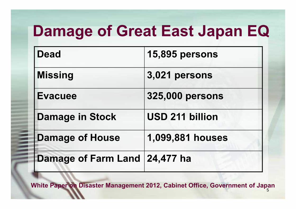
Damage of Great East Japan EQDead 15,895 persons
Missing 3,021 persons
Evacuee 325,000 persons
Damage in Stock USD 211 billion
Damage of House 1,099,881 houses
Damage of Farm Land 24,477 ha
White Paper on Disaster Management 2012, Cabinet Office, Government of Japan5

Importance of Disaster Prevention and Reduction using Science & Technology
○Japan’s Science and Technology Basic Policy (2011-2015)
Reduction of disasters is important. The contributions of S & T are expected.
Japan’s Science and Technology Basic Policy promotes Prediction and estimation based on observationsR & D of disaster prevention and reduction.
○Limitation of disaster prevention by S & T and necessity of interdisciplinary collaboration
Recognition of limitation of S & T Cooperation among relevant organization are effective
6
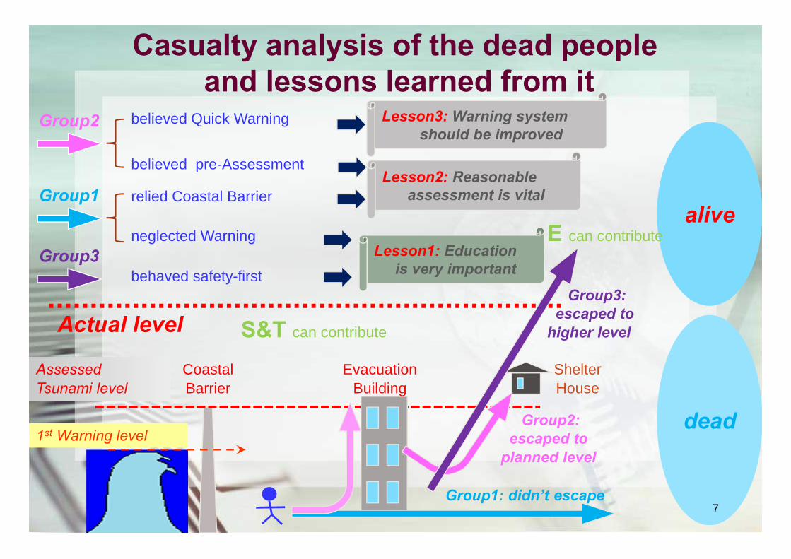
alive
dead
EvacuationBuilding
ShelterHouse
AssessedTsunami level
Actual level
CoastalBarrier
Group1: didn’t escape
Group2:escaped to
planned level
Group3:escaped to
higher level
neglected WarningLesson1: Education
is very important
Lesson2: Reasonableassessment is vital
Lesson3: Warning systemshould be improved
1st Warning level
Group1
Group2
Group3
relied Coastal Barrier
believed Quick Warning
believed pre-Assessment
behaved safety-first
Casualty analysis of the dead peopleand lessons learned from it
S&T can contribute
E can contribute
7

Limitations of Infrastructures
Incomplete Superーbank 864Km(98.8%) of 873km
The length of coast line with inadequate seismic resistance → 2,002km (36%) of 5544Km
The length of coast line lower than the predicted tsunami height → 812km(15%) of 5544Km
No earthquake resistance (Buildings of Nation) 3750 buildings (40%) of 9375
8

400t Crane×2 unitsMain Pump Unit
ExperimentalBuilding
OperationBuilding
PreparationBuilding
Hydraulic Unit Building
Main Accumulator
Shaking Table
Tokyo
completed in 2005at Miki City, Hyogo
Largest in the world
Size: 20m x 15m
Load: 1200ton
3-dimensional
Horizontal VerticalMax. Accel. >900cm/s/s >1,500cm/s/s
Max. Vel. 200cm/s 70cm/s
Max. Displ. ±100cm ±50cm
Reconstruction to earthquake resistance building - E-Defense
9

Example of an experiment
10

Liquefaction Countermeasure
Earthquake Resistant Joint Pipes
Earthquake Resistant Joint Pipes keep flexibility for water pipe network without disconnection caused by liquefaction deformation. Joint can move within the allowable clearance. To reconstruct resilient infrastructure, earthquake-resistant joints are used.
11

UrEDAS(Urgent Earthquake Detection & Alarm System)
As for the technology of railway safety, we introduce Urgent Earthquake Detection and Alarm System(UrEDAS). Just after 2:46p.m. when the Great East Japan earthquake occurred, UrEDAS detected P-wave, then one second after the alarm was sent, the system started operating and Tohoku-Sinkansen was stopped to transmit electricity, started the emergency brake to slow down and stopped automatically. Thanks to the system, the Tohoku-Sinkansen didn’t run off the tracks and overturn even in spite of its operating time.
12

0 100 200 300
南西諸島
400 500
km
防災科学技術研究所
F-net
Hi-net / KiK-net
K-NET
Broadband seismograph network(F-net)
Strong-motion seismograph networks (K-NET)
High-sensitivity seismograph network (Hi-net)
Seismic and volcanic observation networks (Hi-net, F-net, K-NET, KiK-net, and V-net)
13
Kiban-Kyoshin Net(KiK-net)
Volcanic observation network (V-net)
■ NIED● F-net● Hi-net / KiK-net● K-NET▲ V-net
13

Ocean bottom cabled network along Japan trench
N
It is expected more rapid and accurate warning of earthquake and
tsunami becomes possible
2012
20122013
2013
2013
2014
Pressure VesselSeismometer
Pressure Gauge
14

30-year possibility of offshore and inland earthquakes
2011 Tohoku Eq.
15

Difficulties and Limitations ofPrediction of Disasters
○Why scientists failed to forecast the giant earthquake?Preoccupied with a specific asperity model
○Lessons from the occurrence of the Great East Japan EQ The characteristics of slip along the plate boundary
○Limitations of earthquake forecasting researchLack of data
○Future challengeObservation and research on giant earthquake
16

Forecasting of Extreme Weather
The earth simulator
The Earth Simulator is utilized in various fields of research including earth sciences for such tasks as global-warming projection and solid earth interior dynamics research.
X-band MP radars
・Utilize 2 types waves (Vertical and Parallel) ・Can measure amount of rainfall・don’t have to correct by using rain gauge・can update information of rainfall in short interval of time
17

Conventional Radars
Tokyo Tokyo
MP-Radar
0 5km
2008/08/05 Local Heavy Rainfall Case
Accident occurred in the sewerage about 12:00JST
Nerima
Otemachi
Setagaya
Nerima
Otemachi
Setagaya
Zoshigaya Zoshigaya
500-m mesh, 5-min int.1-km mesh, 10-min int. 18

Frame Work of International Co-researches of Climate Change
GEOSS (Global Earth Observation System of Systems)
Disaster
Weather
Energy
Water
Climate
Agriculture
Eco-system
Health
Biodiversity
19
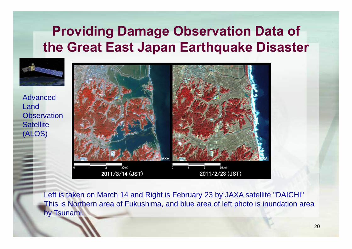
Providing Damage Observation Data of the Great East Japan Earthquake Disaster
Left is taken on March 14 and Right is February 23 by JAXA satellite "DAICHI"This is Northern area of Fukushima, and blue area of left photo is inundation area by Tsunami.
Advanced Land Observation Satellite (ALOS)
20

Kamaishi・Miracle
Importance of Education for Disaster Prevention
Stone Monument in Miyako City“Do not built houses below this point”
Movies about Kadonowaki elementary school in Ishinomaki City
Kamaishi city has been often hit by Tsunami so that they promote education for disaster prevention for a long time.Most of the approximately 3,000 students changed evacuation point and could escape more safety and higher land from preliminary evacuation area with a will of their own and it results in a 0.2% mortality rate.
21

Science and Technology Research Partnership for Sustainable Development (SATREPS)
—Partnering with developing countries for innovation—
International Joint Research
Research Institutions in Developing Countries
Research Institutions in Japan
ResearchPartnership
MOFA/JICA
MEXT/JST Collaboration
Technical CooperationR&DSupport
ODA
1.Enhancing Cooperation in Science & Technology 2. New Technology, New Knowledge3. Capacity Development4. Practical Utilization
Environment/EnergyBioresources
Natural Disaster PreventionInfectious Diseases Control
Research Period/Duration of Research: Funding split: Three to five (3-5) years JST: Approx. 36 million yen (0.45 million USD)Project Size: JICA: Approx. 60 million yen (0.75 million USD)Approx.100 million JPY (1.25 million USD) per pj/y 22