disaster risk reduction and climate change adaptation in the dili – ainaro road corridor...
TRANSCRIPT

Disaster Risk Reduction and Climate Change Adaptation in the Dili – Ainaro
Road Corridor
Supporting the Government of Timor Leste in Disaster
Risk Management & Climate Change Adaptation


We cannot stop natural disasters but we can arm ourselves with knowledge: so many lives and livelihoods across the World wouldn't have to be lost if there was enough disaster preparedness.


"whatever can happen will happen“
Murphy’s Law

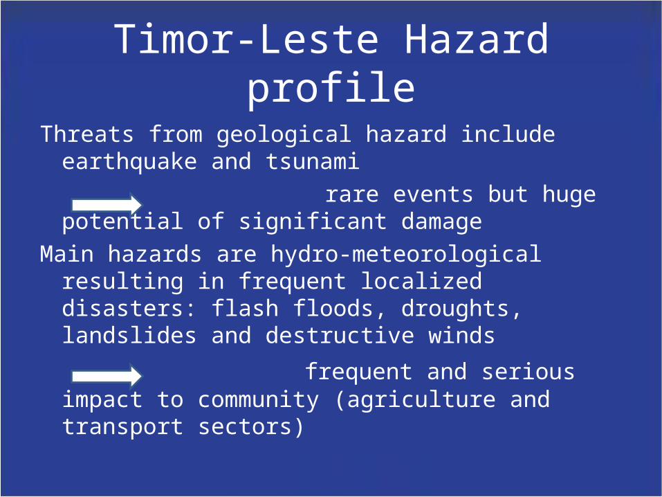
Timor-Leste Hazard profile
Threats from geological hazard include earthquake and tsunami
rare events but huge potential of significant damage
Main hazards are hydro-meteorological resulting in frequent localized disasters: flash floods, droughts, landslides and destructive winds
frequent and serious impact to community (agriculture and transport sectors)

According to a road condition survey in 2008, the national road network has almost entirely deteriorated and is no longer maintainable:
- 65% of national roads are in “very poor” condition- 96% of rural roads are in “very poor” condition
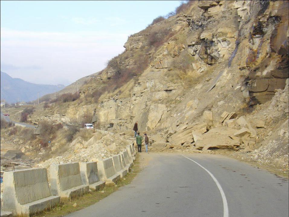
Due to the steep terrain, ground conditions and local climate, slope instability is a major problem and slips can result in significant damage to the road network and potential risk to road users.
In many cases roads have not been properly designed, lack sufficient drainage capacity and/or are structurally unsound.
A fragile road network is vulnerable to frequent localized disasters. Flash floods and landslides destroying roads further isolate communities and hamper disaster response efforts.


Loans and Grants

The World Bank Climate Resilient Road Project

• The project also includes feasibility studies for the upgrading of additional road segments linked to the Dili-Ainaro road.

However,…
• The Road’s Right of Way (RoW – the area in which the engineers work) extends only to 25m either side of the central line of the road
• Many of the causes and sources of road-impacting floods and landslides/slips begin outside of this 25m width.

therefore,…

TENTATIVE LEVEL AND SOURCE OF FUNDING
Activity Funding Timing
Component 1
Risk Assessment – Climate/Disaster vulnerability
Global Facility for Disaster Risk Reduction – ACP – EU (WB)
Jan 2014
Enabling improved climate and disaster risk management
Least Developed Countries Fund(UNDP)
Mid 2014
Component 2
Capacity Building at National and District level for
Mainstreaming Disaster Risk Management
PHRD – JICA(WB)
Strengthened climate and disaster risk planning,
budgeting and delivery
Least Developed Countries Fund(UNDP)
Mid 2014
Component 3
Community Based DRM Projects around Dili-Ainaro Corridor and Linked roads
PHRD –JICA(WB)
Investments in climate resilient community based
adaptation measures
Least Developed Countries Fund(UNDP)
Mid 2014
Total of tentative level of funding
WB: 3.6 Million (GFDRR and PHRD)UNDP: 5.25 Million (LDCF)

One joint programme on supporting the government strengthening disaster/climate resilience along the Dili-Ainaro corridor in Timor Leste supported and implemented through two projects:
• UNDP project, LDCF funded – approx. $5.7M• WORLD BANK project, GFDRR ACP-EU (approx.
US$0.9M) and PHRD funds (approx. US$2.7M)

The joint programme supported by UNDP and the WB aims at:
• Reducing climate change and natural disaster associated risks, and
• Minimizing losses to physical infrastructure arising from natural disasters and climate change

To do this the programme aims at:
a. Performing a RISK ASSESSMENT - Understand better the natural disaster risks and where they occur and communicate this to decision makers to influence future planning and budgeting
b. Developing capacity to manage disaster risks - influence sub-national and sectoral strategies
c. Strengthening climate and disaster risk planning, budgeting and delivery
d. Investing in climate resilient community based adaptation measures and implementing risk management activities to protect assets and livelihoods from disaster & climate risks.


In this way, the joint programme will secure the critical economic infrastructure in the Dili to Ainaro corridor which is increasingly at risk from climate change and disaster related impacts, including localised flooding, landslides and strong winds.

The joint programme is implemented through two projects with considerable cross over, both spatially and thematically.
This dictates that considerable coordination and synchronization needs to be built into the UNDP and WB supported projects from the design phase through to implementation of activities.

• In order to ensure the two projects coordinate adequately under the umbrella of a joint programme, a joint steering committee has been proposed. The Ministry of Social Solidarity would be the main ministerial focal point, and would likely appoint the NDMD as the primary National Directorate responsible for chairing the Steering Committee and implementing the Components of the Projects that will be Nationally/Recipient Executed.

Project management units
• It is likely that two separate project management units will need to be established
• Location
• ToRs
• Integrated Assessment Frameworks

As well as MSS, line-ministries will be closely involved in all Components
• Close coordination between MSS and line-ministries will also be required
• Inter-ministerial coordination will be an integral part of the success of the project as many of the activities will require other Ministries such as MPW, MSA, MCIE and MAF
• Where possible, Suco development planning process will be utilized

Timing
• January 2014 is likely to be the earliest that Component 1 of the WB’s DRM project will be operational
• UNDP’s project would likely come into operation in mid 2014.