discovering the world of geography: grades 5–6
TRANSCRIPT

© Mark Twain Media, inc., Publishers 1
Discovering the World of Geography: Grades 5–6
National Geography Standards
Teachers leading discussions while completing chapters and activities is a prerequisite for accomplishing the standards. inquiry discussion is important: What do you know? How are things alike and not alike? Why do you think that?
National Standard 1: How to use maps and other geographic representations, tools, and tech-nologies to acquire information.
This standard is addressed through the activities in a number of chapters.
National Standard 6: How culture and experience influence people’s perception of places and regions.
This standard may be addressed in Chapter 4 when students learn that the n ative ameri-can cultures varied, as did the cultures within the colonies.
National Standard 10: The characteristics, distributions, and complexity of Earth’s cultural mosaics.
Chapter 4 may be used for this standard. Chapter 18 could be used to address this standard through a student research of the cities of Miami, new york, new Orleans, and los angeles.
National Standard 13: How forces of cooperation and conflict among people influence the division and control of Earth’s surface.
Chapters 7 through 16 are appropriate to use to address this standard. each chapter can be approached from a different viewpoint, with respect to the cause of the conflict and how it was resolved. Chapters 7 through 11 are particularly appropriate for this standard, because the conflicts occurred in the United States, and students can make comparisons as to the causes of the conflicts.
national Geography Standards

© Mark Twain Media, inc., Publishers 2
name: Date:
Discovering the World of Geography: Grades 5–6
Chapter 1: Learning About the Physical Features of the United States
A. The Thirteen Colonies
Using Map 1 and an atlas , complete the following. you will need colored pens or pencils for this activity.
1. locate each of the physical features below by placing the corresponding letter on the map in the correct location.
a. Cape hatteras G. Delaware Bay M. Catskill Mountains B. Chesapeake Bay h. long island n. lake Champlain C. Potomac river i. adirondack Mountains O. Mt. Washington D. James river J. Green Mountains P. Susquehanna river e. hudson river K. Connecticut river Q. Blue ridge Mountains F. Cape Cod l. appalachian Mountains
2. Trace over the dotted line. 3. Color the area between the dots and the coast green. 4. label this area “atlantic Coastal Plain.”
large parts of the Thirteen Colonies were located in the area known as the Atlantic Coastal Plain . in the north it is narrow, but it becomes wider as it extends south and west along the Gulf of Mexico. along the coast, the elevation is 0 feet above sea level. along the dotted line on Map 1, the elevation is 600 feet above sea level. Because it is so near the atlantic Ocean, tides affect the rivers and low-lying plains near the coast. This was the region where many of the europeans first settled because it was nearest to europe and because of the indian popu-lation inland. The colonists found the region swampy, and in summer, there were many insects. The ocean tides resulted in swampy areas where the water was very brackish. Many colonists became sick and died from the contaminated drinking water and disease-bearing insects.
5. The atlantic Coastal Plain formed part of many of the original Thirteen Colonies. Circle the names of the colonies in the list below that are located on the atlantic Coastal Plain.
a) Virginia b) Vermont c) South Carolina d) north Carolina e) Georgia
a. The Thirteen Colonies

© Mark Twain Media, inc., Publishers 3
name: Date:
Discovering the World of Geography: Grades 5–6
Chapter 1: Learning About the Physical Features of the United States
A. The Thirteen Colonies (cont.)Map 1
a. The Thirteen Colonies

© Mark Twain Media, inc., Publishers 4
name: Date:
Discovering the World of Geography: Grades 5–6
Chapter 1: Learning About the Physical Features of the United States
A. The Thirteen Colonies (cont.)
6. Trace over the dashed line on Map 1. 7. Color the area between the dotted line and the dashed line red. 8. label this area “Piedmont Plateau.” 9. On the dotted line, write “Fall line.” This is the point where the rivers flow down from the
Piedmont Plateau to the coastal plain.
This region is known as the Piedmont Plateau . it is a region that is higher than the coastal plain. The Piedmont Plateau is at an elevation of 600 to 1,000 feet above sea level. The Piedmont Plateau begins at the Fall Line , where the rivers drop down to the much lower coastal plain. The Piedmont is not affected by the tides, so the colonists found the drinking water to be much improved over that found on the lower coastal plain. This region was hilly and a much better place in which to live. Colonists who moved to the Piedmont Plateau were less likely to become sick from disease-carrying insects and contaminated water.
10. The appalachian Mountains are shown inside the closed line. Color the area inside the closed line orange.
11. Using Diagram 1 below, complete the following. a. Color the region labeled “a” brown (elevation 3,000 to 5,000 feet). B. Color the region labeled “B” yellow (elevation 600 to 2,000 feet). C. Color the region labeled “C” green (elevation 400 to 0 feet). D. Color the region labeled “D” blue (elevation 0 feet = sea level).
Diagram 1
Scale: 1 inch = 75 miles
e. The scale of the map is inch equals miles. F. The elevation of the atlantic Coastal Plain is a) about the same as b) much higher than c) much lower than the Piedmont Plateau. G. The Fall line is the point where the atlantic Coastal Plain meets the a) Piedmont Plateau b) appalachian Mountains c) Blue ridge Mountains. h. When the colonists moved inland from the atlantic Coastal Plain to the Piedmont Pla-
teau, they were moving to a a) lower elevation b) higher elevation. i. The rising and falling tide from the atlantic Ocean most influenced the colonists who
lived a) on the atlantic Coastal Plain b) on the Piedmont Plateau.
a. The Thirteen Colonies
BAC D

© Mark Twain Media, inc., Publishers 5
name: Date:
Discovering the World of Geography: Grades 5–6
1
2 3
4 5
6
7 8
9
10 11
12 13
14
15
Chapter 1: Learning About the Physical Features of the United States
A. The Thirteen Colonies (cont.): Crossword Puzzle
Using the information you have learned in this section and other reference materials, complete the puzzle using the clues below.
ACROSS 5. river that flows into the Chesapeake Bay 6. Mountains in new york 8. The colony farthest south11. Coastal plain that extends from new york
south to the Gulf of Mexico14. river that flows into long island Sound15. river that flows into the Delaware Bay
DOWN 1. State bordered by the Connecticut r iver on
the east
2. Famous lake between Vermont and n ew york 3. Where the atlantic Coastal Plain meets the
Piedmont Plateau (two words) 4. Mountains in north Carolina and Virginia 7. Famous cape in Massachusetts (two words) 9. Plateau between the atlantic Coastal Plain
and the appalachian Mountains10. Famous cape near north Carolina12. river in new york13. Mountains in Vermont
a. The Thirteen Colonies
© Mark Twain Media, inc., Publishers 6
name: Date:
Discovering the World of Geography: Grades 5–6
Chapter 1: Learning About the Physical Features of the United States
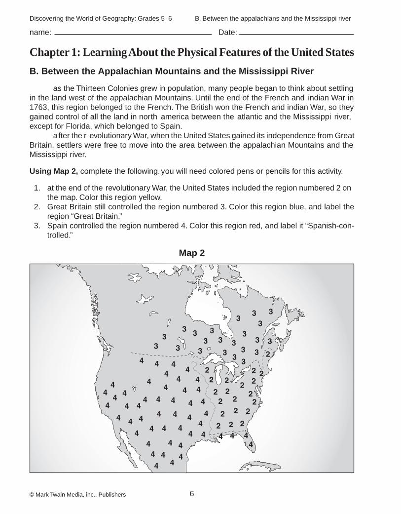
B. Between the Appalachian Mountains and the Mississippi River
as the Thirteen Colonies grew in population, many people began to think about settling in the land west of the appalachian Mountains. Until the end of the French and indian War in 1763, this region belonged to the French. The British won the French and indian War, so they gained control of all the land in north america between the atlantic and the Mississippi river, except for Florida, which belonged to Spain. a fter the r evolutionary War, when the United States gained its independence from Great Britain, settlers were free to move into the area between the appalachian Mountains and the Mississippi river.
Using Map 2, complete the following. you will need colored pens or pencils for this activity.
1. at the end of the revolutionary War, the United States included the region numbered 2 on the map. Color this region yellow.
2. Great Britain still controlled the region numbered 3. Color this region blue, and label the region “Great Britain.”
3. Spain controlled the region numbered 4. Color this region red, and label it “Spanish-con-trolled.”
Map 2
B. Between the appalachians and the Mississippi river

© Mark Twain Media, inc., Publishers 7
name: Date:
Discovering the World of Geography: Grades 5–6
Chapter 1: Learning About the Physical Features of the United States
B. Between the Appalachian Mountains and the Mississippi River (cont.)
Using Map 3, complete the following.
1. label the region with the number 1 as “appalachian Mountains.” Use upside down V’s to indicate mountains.
2. label the region with the number 2 as “Cumberland Plateau.” Use ( ) to indicate the plateau region.
3. The number 3 locates the Ohio river. label it. 4. The number 4 locates the Mississippi river. label it.
Map 3
B. Between the appalachians and the Mississippi river

© Mark Twain Media, inc., Publishers 8
name: Date:
Discovering the World of Geography: Grades 5–6
Chapter 1: Learning About the Physical Features of the United States
C. From the Mississippi River to the Pacific Ocean
Using Map 3 and an atlas, complete the following. Write the number from the map that indicates each feature on the blank beside the feature.
1. Mt. rainier 11. Great Central Valley of California
2. Mt. hood 12. The Missouri river
3. Mt. Shasta 13. The Mississippi river
4. The Cascade Mountains 14. The Great Basin
5. The Sierra nevadas 15. The Colorado river
6. The Columbia river 16. The rio Grande
7. The Snake river 17. The Mojave Desert
8. The Great Salt lake 18. The Mississippi Delta
9. The Coast ranges 19. The Quachita Mountains
10. Salton Sea 20. The Great Plains
D. Alaska and Hawaii
Alaska
Using Map 4 and an atlas, complete the following. you will need colored pens or pencils for
this activity.
1. The number locating the Brooks Mountain range is the number .
2. The number locating the alaska Mountain range is the number .
3. Use a blue line to show the yukon river.
4. The symbol ( ) locates a very high mountain. The mountain is
a) Mt. everest b) Mt. Whitney c) Mt. McKinley.
Hawaii
Using Map 5 and an atlas, complete the following.
5. The number 1 locates the island .
6. The number 2 locates the island .
7. The number 3 locates the island .
8. The number 4 locates the island .
9. The symbol ( ) locates two famous volcano peaks.
The volcanic peaks are Mauna and Mauna .
C. From the Mississippi river to the Pacific Ocean

© Mark Twain Media, inc., Publishers 9
name: Date:
Discovering the World of Geography: Grades 5–6
Chapter 1: Learning About the Physical Features of the United States
D. Alaska and Hawaii (cont.)
Map 4
Map 5
D. alaska and hawaii

© Mark Twain Media, inc., Publishers 10
name: Date:
Discovering the World of Geography: Grades 5–6
Chapter 1: Learning About the Physical Features of the United States
E. Reviewing Physical Features of the United States: Crossword Puzzle
Complete the puzzle using the clues below and an atlas.
e. reviewing Physical Features of the United States
ACROSS 1. Washington, D.C., is located on this river. 5. Great lake between new york and Canada 6. Famous river valley in new york 7. Mountains in new york10. Mountains in Tennessee and Virginia13. river that forms the border between Ohio, indiana,
and Kentucky16. The Potomac river flows into this bay.17. river that begins in Minnesota and flows south to
the Gulf of Mexico19. r iver that begins in Montana and flows through
north Dakota, South Dakota, Missouri, and into the Mississippi at St. louis
21. Famous canyon in arizona
DOWN 2. a cape in Massachusetts 3. river that forms the boundary between Mexico and
Texas 4. The ocean into which the Columbia river flows 8. The state in which Mt. rainier is located 9. This state is made up of over 100 volcanic and coral
islands.11. Great lake between Michigan and Wisconsin12. Mountain chain that runs south from Canada
through Montana, Wyoming, and Colorado14. The state in which Mt. Whitney is located15. Mountain chain in Oregon and Washington18. Famous inland sea in California20. State where the Great Salt lake is located22. in area, this is the largest state.
1 2 3 4
5
6
7
8 9 10 11 12
13
14 15
16
17 18
19 20
21 22