dispatch criteria and resource allocation for vegetation
TRANSCRIPT

Running head: DISPATCH CRITERIA AND RESOURCE ALLOCATION
Dispatch Criteria and Resource Allocation for Vegetation Fires in the City of San Diego
Colin T. Stowell
San Diego Fire-Rescue Department
San Diego, California

DISPATCH CRITERIA AND RESOURCE ALLOCATION 2
Certification Statement
I hereby certify that this paper constitutes my own product, that where the language of others is
set forth, quotation marks so indicate, and that appropriate credit is given where I have used the
language, ideas, expressions, or writings of another.
Signed: _________________________________________

DISPATCH CRITERIA AND RESOURCE ALLOCATION 3
Abstract
Dispatching appropriate levels of emergency resources to vegetation fires is critical to mitigating
hazards and limiting property damage. Assigning insufficient resources can be detrimental in
efforts to reduce fire spread and damage, yet assigning too many resources can result in
unwarranted costs and increased risks. Ideally, a commitment of initial resource levels should be
based on multiple factors which affect potential fire danger and risks to the public. San Diego
Fire-Rescue Department uses only two initial dispatch levels for vegetation fires with the
assigned level based solely on one factor, the geographic location of the incident. The research
questions for this study focused on (a) efficiency of assigned resources, (b) factors that better
predict fire danger and potential risk, (c) theoretical rationale that supported this dispatch
practice, and (d) and added costs and risks associated with dispatching resources based on a
single criterion. This study utilized a descriptive research methodology that included a review of
vegetation fire incident reports, interviews with senior department officers, a survey of
comparable fire departments, and an analysis of the costs and vulnerabilities associated with
units unnecessarily assigned. Results indicated significant inefficiencies, particularly in cases
involving the higher dispatch level. Further, multiple pre-incident factors can better predict the
potential fire risk and number of resources needed versus relying solely on geographic location.
A number of additional costs and risks were identified, most significantly the unavailability to
respond to other emergencies. Recommendations included (a) incorporate additional factors into
the dispatch criteria for vegetation fires to improve resource efficiency, (b) update geographic
and topographic information to reflect special response areas and target hazards, (c) include
remote weather stations that offer accurate information regarding the fire danger within the city,
and (d) establish incremental dispatch levels according to conditions and initial fire reports.

DISPATCH CRITERIA AND RESOURCE ALLOCATION 4
Table of Contents
Certification Statement 2
Abstract 3
Table of Contents 4
Introduction 5
Background and Significance 6
Literature Review 10
Procedures 18
Results 25
Discussion 36
Recommendations 42
References 45
Appendix A: SDFD Vegetation Fire Danger Rating System (Pre May 2009) 48
Appendix B: Vegetation Fire Response Area Map 49
Appendix C: Current SDFD Dispatch Matrix for Vegetation Fires 50
Appendix D: Weather Index Pocket Card 51
Appendix E: Sample Fire Incident Data Reports 52
Appendix F: Regional Vegetation Dispatch Survey Questions 54
Appendix G: Interview Questions 56

DISPATCH CRITERIA AND RESOURCE ALLOCATION 5
Introduction
San Diego Fire-Rescue Department (SDFD) staffs and operates its own Fire
Communication Center (FCC), dispatching emergency resources according to policies and
procedures set forth by management and dispatch review committees. Currently SDFD uses two
different dispatch levels for vegetation fires that determine the amount and type of resources sent
to a reported fire. The two dispatch levels are Vegetation-No Special Response (VNSR) and
Vegetation-Special Response (VSR) which are assigned solely by geographic location and do not
take other pre-incident factors or information (e.g., weather conditions, recent precipitation, fuel
moisture, or time of day) into consideration. The number of resources for the dispatch levels is
significantly different, as a VNSR assigns two units while a VSR assigns 13 units consisting of
39 emergency responders. Further, according to the Information Systems Analyst for SDFD, the
dispatch decisions are complicated by the fact the city’s designated geographic locations that
identify a response area as “No Special Response” or “Special Response” are based on outdated
topography information and field surveys compiled almost two decades ago (L. Brenner,
personal interview, October 8, 2012). The method of using only one criterion in determining the
resources to be dispatched to a vegetation fire often results in significantly more resources than
are needed to mitigate the incident. The problem is SDFD dispatches resources to all vegetation
fires based upon a single factor; geographic location. The purpose of this research project is to
identify if the current practice of dispatching resources to vegetation fires solely on the location
results in operational inefficiency and/or risks. This project uses a descriptive research
methodology reviewing dispatch data, current resource allocation criteria, surveys from other fire
departments, personal interviews with active and retired senior management chief officers, and
retrospective analysis of incident reports. The research questions to be answered by this project

DISPATCH CRITERIA AND RESOURCE ALLOCATION 6
are (a) using the current dispatch criteria, to what degree are the resources assigned to a
vegetation fire in San Diego being effectively and efficiently utilized, (b) what were the theories
and data used to support and implement the current dispatch levels for a vegetation fire in San
Diego, (c) what additional pre-incident conditions and information can be used by SDFD to
better predict fire behavior and potential risk of a reported vegetation fire, and (d) what are the
sacrifices, consequences, and costs associated with assigning unnecessary resources to a
vegetation fire in San Diego as a common practice?
Background and Significance
San Diego Fire-Rescue Department provides fire protection and emergency medical
services to more than 1.3 million people covering 331square miles of urban and suburban
communities. The department includes a workforce of 1,036 uniformed personnel staffing 47 fire
stations and nine permanent life guard stations with 47 engine companies, 12 truck companies,
and numerous cross staffed specialty apparatus including hazmat, heavy rescue, light and air,
water tenders, and 12 type III brush apparatus (http://www.sandiego.gov/fire/index/shtml).
Within the city there are over 500 linear miles of wildland urban interface (E. Villavicencio,
personal communication, October 25, 2012). In Fiscal Year 2012 (FY2012) the department
responded to 122,172 emergency incidents, of which 87% were medical responses, nearly 3%
fire responses, and the remainder including miscellaneous rescues, ringing alarms, and other
service calls (FY2012 Annual Report, 2012). Of the 3,565 fire related emergencies SDFD
responded to in FY2012, just over 15% (547) involved vegetation fires (FY2012 Annual Report,
2012).

DISPATCH CRITERIA AND RESOURCE ALLOCATION 7
Prior to May 2009, SDFD employed a dynamic three-level dispatch system when
assigning resources to a vegetation fire. The three dispatch levels were Low, Medium, and High
with weather conditions taken periodically throughout the day and factored into the dispatch
determination for these responses. Included in the levels was a geographic and topography factor
of canyon rim areas, both top and bottom which would assign different types of resources to the
appropriate location. The various dispatch levels were intended to align the amount and type of
resources to the potential and calculated fire danger, considering both weather conditions and
topography. The dispatch levels were determined by a software program developed by retired
Fire Captain Craig Nielsen using the 1972 version of the National Fire Danger Rating System
evaluating weather conditions, fuel model, and slope (Appendix A). Weather data was entered
into the program three times a day generating the fire danger rating and dispatch level
accordingly; information which was sent to all stations anytime the level changed. This
dispatching practice ended in May of 2009 primarily because of two challenging issues. First, the
process of routinely collecting weather data and inputting the measurements into a program to
determine the dispatch level proved to be inconsistent, time consuming, and the various dispatch
levels were difficult to manage by the multiple dispatchers. The weather data was not automated,
requiring manual input of the measurements into CAD, while at the same time geographic and
target hazard information needed to be collected prior to dispatching units. This multiple step
process and evaluation of changing conditions resulted in significant delays in response time.
According to Assistant Fire Chief Brian Fennessy, it was felt that “ too many variables were
being assessed before the actual dispatch could take place, at times taking up to 7-8 minutes to
finally dispatch the entire alarm assignment” (Fennessy, personal interview, 2012).

DISPATCH CRITERIA AND RESOURCE ALLOCATION 8
The second reason for the change was since San Diego had the potential for significant
fire danger throughout the year, there was the need to ensure adequate resources were assigned in
the early stages of a fire. The Cedar Fire in 2003 which burned 273,246 acres destroying 2,232
homes, and the Witch Fire in 2007 that burned 197,990 acres and destroyed 1,125 homes (Cal
Fire Incident Information, 2007) focused much attention and concern on providing enough
resources early to be effective and to protect structures being threatened. In an interview with
retired Deputy Chief of Operations Ken Malbrough, he explained how the Fire Chief had given
public statements following the devastating October 2007 Witch Fire that San Diego no longer
had a fire season because it was considered an ongoing threat (Malbrough, personal interview,
2012). Soon after, a more aggressive dispatch approach was implemented to ensure adequate
resources were sent to all fires regardless of variable conditions. Because of the difficulty in
coordinating the dynamic dispatch levels and the accompanied delays with this process,
combined with the goal to provide sufficient equipment and personnel early to all vegetation
fires that pose a threat to structures, SDFD changed its dispatch procedures and resource levels
assigned to vegetation fires.
On May 15, 2009, the SDFD changed its dispatch procedures to a more simplistic process
using two predetermined dispatch levels based on geographic location alone. Unit assignments
for vegetation fires are now based on whether the incident is located inside of or adjacent to a
designated special response area in the city (Appendix B). Depending on this designation, the
alarm is dispatched as Vegetation-Special Response (VSR) or Vegetation-No Special Response
(VNSR). The resource allocation for a VNSR is two engines and for a VSR is five engines, three
brush apparatus, two battalion chiefs, a water tender, a helicopter, and an ambulance for a total of
13 units (Appendix C). The designation of “Special Response” and “No Special Response” is
DISPATCH CRITERIA AND RESOURCE ALLOCATION 9
largely automated and determined by Computer Aided Dispatch (CAD) information which
considers previous dispatch identifiers and assigned response area subgroups such as “Canyon
Rim” or “Wildland” based field survey maps created in the late 1980’s (L. Brenner, personal
communication, October 8, 2012). Although some areas have been updated in CAD, the city as
whole has not been updated resulting in many inaccurate designators.
Another departmental change that occurred in May of 2009 was the utilization of the
National Fire Danger Rating System (NFDRS) burn index to provide situational awareness of the
potential for vegetation fires. The Burn Index (BI), which will be described in further detail later,
is communicated to all operations personnel daily at the beginning of shift and intended to
heighten their awareness of weather conditions and the possibility of fire danger based on the
index rating. Pocket cards with comparative information dating back to 1993 were distributed to
all personnel to be referenced for more details and significance in comparison to BI’s of past
years (Appendix D). This reference shows the relationship of the current BI to the 97th percentile
threshold in which some of the more devastating fires have occurred. Although SDFD recognizes
the burn index provides valuable situational awareness and a historical perspective of fire danger
in certain BI ranges, this index rating is not incorporated into procedures that influence the
dispatch levels of resources assigned to a vegetation fire.
The practice of dispatching a vegetation alarm assignment based on a single factor is
significant to SDFD because of the possible costs, risks and consequences of not considering
other influencing factors and conditions. It’s also significant since SDFD is in the small minority
of departments that do not consider other factors for vegetation alarm assignments. Although an
aggressive response to all fires of unknown magnitude is publicly popular, it is also important to
consider that such practices may be excessive, resulting unintended risks and costs.

DISPATCH CRITERIA AND RESOURCE ALLOCATION 10
This research paper is relevant to several objectives contained in Executive Development
curriculum including the units on Change Management and Organization Culture and Change
(Executive Development Student Manual, 2012, Chapter 5 & 7). In these units, the role of the
Executive Fire Officer as an agent of change was described, highlighting the essential need to
identify a problem first and for understand the purpose for change. The process of Analysis,
Planning, Implementation, and Evaluation (APIE) when evaluating a problem and making
change will be an important follow-up component to this paper. This paper also relates to two of
the United States Fire Administration’s strategic goals: (a) improve local planning and
preparedness, and (b) improve the fire and emergency services’ capability for response to and
recovery from all hazards (United States Fire Administration Strategic Goals, 2012, p. 14).
Literature Review
The literature review for this paper focused on four distinct areas; (a) industry standards
for efficiency and effectiveness at fire incidents, (b) data and influences that affected change to
the current SDFD dispatch criteria, (c) fundamental factors and indexes available to predict fire
danger and potential, and (d) the associated risks and costs with deployment of resources.
Although some of these areas lack national standards or prior research applicable across the fire
service, there was sufficient literature and data specific to the SDFD with quantitative
measurements applicable to this research project.
When evaluating the delivery of fire protection and service, there is a noted difference
between effectiveness and efficiency, and the two terms are not synonymous. A National Fire
Protection Administration (NFPA) report on performance standards defines efficiency in terms
of how well resources are used in providing services and notes that efficiency measures are most

DISPATCH CRITERIA AND RESOURCE ALLOCATION 11
often in reference to an economic criterion (Flynn, 2009). The same report refers to effectiveness
as how well a service is provided and makes note that “it’s important to look beyond immediate
output and determine the associated consequences of the output” (Flynn, 2009, p. 5).
Effectiveness is a quantitative measurement in comparison to established target rates and goals
set by individual departments based on service areas, public demands, political influence, and
industry guidelines making it difficult to compare from one department to another. Because of
the variations that exist in determining effectiveness and efficiency, the standard guidelines used
by SDFD as well as department specific goals and target rates were used for the purposes of
comparison and evaluation.
NFPA1710 specifies minimum criteria addressing efficiency and effectiveness of fire
operations. This national standard sets minimum staffing levels and response time goals for
career fire departments. One of these standards is to have an initial alarm assignment arrive at the
scene of all fires within eight minutes 90 percent of the time (Standard for the Organization and
Deployment of Fire Suppression Operations, 2004). This standard applies to fire suppression
involving structure fires and although the staffing level for an individual company is identified,
the standard does not cite a specific number of units included in a first alarm. NFPA 1710
qualifies this recommendation by stating that the first alarm should be sufficient to accomplish a
list of fire ground tasks necessary for mitigation. Included in NFPA 1710 is a recommended
standard for deployment for wildland fires, yet it also fails to specifically identify a minimum
number of units to respond. The standard calls for a sufficient number of vehicles to be deployed
in order to initiate a direct attack on the fire with ten minutes of the first arriving company and
capable of deploying two hand lines from two separate engines, staffed with two firefighters on
each line with an effective water flow of 30 gallons per minute (Standard for the Organization

DISPATCH CRITERIA AND RESOURCE ALLOCATION 12
and Deployment of Fire Suppression Operations, 2004). Based on the minimum staffing levels
in the same NFPA standard, a minimum of two engine companies would be required to meet the
above task level standards.
A 2005 Standards of Response Coverage Plan developed by SDFD for the Commission
on Fire Accreditation International frequently referenced NFPA 1710 as a national deployment
standard that very few departments can meet, as it does not recognize local issues, conditions,
service demands, or community needs (Standards of Response Coverage Plan - SDFD
Accreditation Report, 2005). The accreditation report also examined a hazard risk analysis for
wildland/urban interface that was conducted using spatial analysis tools and the city’s
Geographic Information Systems (GIS). Using NFPA Standards for Protecting Life and Property
from Wildfire (NFPA 1144) and the Wildland/Urban Interface Code Danger rating System,
geographic locations in the city were assigned a risk value based on accessible roads,
vegetation/cover class, fire hydrant location, slope severity, and five minute response plan data
(Standards of Response Coverage Plan - SDFD Accreditation Report, 2005). The data and risk
analysis from this study, which used GIS and field survey information now outdated, is still
currently used as dispatch criteria for assigning resources for vegetation fires within the city.
In November 2011, the San Diego City Council adopted the recommendations contained
in a Fire Service Standards of Response Coverage Deployment Study conducted by Citygate
Associates Inc. which completed a comprehensive analysis of the SDFD and its deployment
model. One of the recommendations made by Citygate was to deploy sufficient resources to
confine a fire near the room of origin and to stop wildland fires at fewer than three acres with a
“Multiple-Unit Effective Response Force” of at least 17 personnel within 10 minutes and 30
seconds of 911-call receipt, 90 percent of the time (Citygate Associates, LLC., 2011). Although
DISPATCH CRITERIA AND RESOURCE ALLOCATION 13
the “Effective Response Force” was intended for setting minimum resources and response time
targets for structure fires, it has been used as a comparison and referenced when defining the
resources currently allocated for Vegetation Special Response incidents (K. Malbrough, W.
Middelton, J. Carle, P. Peake, S. Infantino, & B. Fennessy, personal interviews, September,
2012).
Effectiveness and efficiency are subjective, agency specific objectives, and difficult to
define for emergency response to vegetation fires. During interviews with current and retired
operations chiefs for SDFD, the issue of how to best determine if a resource was effectively
utilized using dispatch information was addressed. Consensus from the group indicated that a
unit’s scene time, and specifically the threshold of a unit being at scene for two minutes or more,
was believed to be a conservative indication of the unit being assigned a task and utilized at the
incident (K. Malbrough, W. Middelton, J. Carle, P. Peake, S. Infantino, & B. Fennessy, personal
interviews, September, 2012).
Several known and scientific factors can provide valuable and predictive information in
regards to fire danger and fire behavior. The most commonly accepted definition of fire danger
is: “The resultant descriptor of the combination of both constant and variable factors which affect
the initiation, spread and difficulty of control of wildfires on an area” (Deeming, Lancaster,
Fosberg, Furman, & Schroeder, 1972, p. 165). Often associated with fire danger is the
assessment of fire behavior which is site specific dealing with an existing fire and describes the
speed, intensity, and combustion rate of that fire in its location and time. Fire danger rating is a
numerical rating reflective of the overall conditions in a general area and intended to assist the
fire manager in making day-to-day “fire business” decisions (National Wildfire Coordinating
Group, 2002, p. 4).

DISPATCH CRITERIA AND RESOURCE ALLOCATION 14
As described above, the National Fire Danger Rating System (NFDRS) became available
in1972 to create a mechanism to relate fire danger ratings to a specific geographic area for
planning purposes and has been updated in 1978 and 1988. ”The current system is based on the
physics of combustion and laboratory developed constants reflecting relationships between fuels,
weather, topography and risk conditions” (National Wildfire Coordinating Group, 2002, p. 5).
The NFDRS also tracks the effects on live and dead fuels that previous weather events had, and
makes adjustments based on predicted weather conditions. Two main purposes of the NFDRS
are to yield fire danger based on current weather conditions in relation to historical conditions,
and to use National Weather Service forecasts to predict fire danger the next day (Deeming,
Burgan, & Cohen, 1977). NFDRS output ratings and measurements deal with fire potential
which generate the Burn Index (BI). The BI is derived from a combination of Spread Component
(how fast a fire will spread) and Energy Release Component (how much energy will be
produced) and rates the fire danger in relation to potential flame length over a fire danger rating
area. This numerical value is related to potential flame length in feet multiplied by 10 (National
Wildfire Coordinating Group, 2002). The Spread Component and Energy Release Component
take into account current and predicted weather conditions, fuel types and moisture, and
historical fire data. The NFDRS is currently utilized by all federal and most state agencies to
assess fire danger conditions.
Two other fire danger rating systems that were reviewed were the Fire Behavior System
(FBS) developed in the 1970’s to compliment the NFDRS and the Fire Information Retrieval and
Evaluation System (FIRES). FBS deals with fire behavior of an existing fire in a specific
location and “was designed for high resolution, small scale application” (Bradshaw et al., 1983,
p. 41). FIRES was designed to evaluate the relationship between fire danger indexes and fire

DISPATCH CRITERIA AND RESOURCE ALLOCATION 15
activity to set intervals that could be used by fire managers in determining severity of fire
danger.
Effective May 15, 2009 SDFD began calculating and broadcasting the BI for situational
awareness at the same time the new dispatch procedures for vegetation fires were implemented
(SDFD Bulletin 09-055, 2009). SDFD calculates the BI for both inland and coastal zones of the
city using an average of BI readings collected at designated Remote Automated Weather Stations
(RAWS) and listed on the National Interagency Fire Center (NIFC) website (SDFD
Communication Procedures, 2009). Three readings are taken from each zone and averaged,
producing a Coastal BI and Inland BI. The index readings are then communicated to all on duty
personnel for reference with the SDFD Weather Index Pocket Cards to ensure appropriate
situational awareness (SDFD Operations Manual - Vegetation Fire Procedures, 2009). Although
these index readings do not have any influence on the dispatch levels to vegetation fires, the
intent was to have the 97th percentile serve as a trigger point to initiate discussions regarding
increased staffing levels and alternative deployment plans (Malbrough, personal interview,
2012).
Based on interviews with senior management and a review of past practices however, it
appears these intended discussions on staffing levels were not automatic when the critical
threshold was reached, involved a multitude of other variables, and rarely resulted in additional
staffing because of the BI rating (K. Malbrough, W. Middelton, J. Carle, P. Peake, S. Infantino,
& B. Fennessy, personal interviews, September, 2012). An interesting fact discovered through
this review was that the three RAWS used for the Inland BI (Goose Valley, Descanso, and
Valley Center) are all outside and significantly inland from the San Diego city limits. Similarly,
of the three coastal RAWS, only one station (San Miguel) is still in operation negating the

DISPATCH CRITERIA AND RESOURCE ALLOCATION 16
original intent to produce an average BI across all coastal areas. Because of the location of these
RAWS, the data produced a lack of specificity with respect to current conditions in many areas
of the city, which diminished the value of these readings as they were initially intended. The
reliance on incomplete or inaccurate information for planning and awareness is surprising given
that current data is available from other institutions. For example, according to San Diego Gas
and Electric (SDG&E) Meteorologist Brain D’Agostino, SDG&E has fully operational RAWS in
critical areas of the city (Mt. Soledad, Carmel Valley, and Mission Valley) that collect all the
necessary data to produce the BI for the coastal zone and is available via their website, but has
not yet been incorporated the fire danger analysis for SDFD (B. D’Agostino, personal
communication, November 2, 2012).
Over committing resources to an emergency response not only comes with added costs, it
results in additional risk to the personnel and public inherent to that response. For example,
NFPA reported that in 2011 there was an estimated 14,850 collisions involving fire department
vehicles responding to or returning from an emergency incident (Karter & Molis, 2012).
Although these collisions only accounted for about one tenth of one percent of total responses
nationwide, they resulted in 970 firefighter injuries, or 1.4 percent of all firefighter injuries. An
article in Firehouse magazine asserted that there was three times greater chance of being
involved in a vehicle accident while responding to an emergency incident and that responding
with lights and sirens increased a driver and crew’s chances of being injured or killed by 10
times (Wilbur, 1995). Data produced by the U.S. Fire Administration (USFA) and NFPA showed
that approximately 25 percent of all firefighter fatalities occurred in motor vehicle accidents,
which is second only to cardiovascular ailments as the leading cause deaths to on duty personnel
(Peterson, Amandus, & Wassell, 2009). Fire apparatus collisions are not only a hazard and risk

DISPATCH CRITERIA AND RESOURCE ALLOCATION 17
to the responding fire personnel; it is a tremendous risk to the same public being protected. The
incidence of emergency vehicle accidents is not just a problem but, it’s an “epidemic” writes Jeff
Clawson in an article for Public Management (Clawson, 2002, p. 2). Clawson points out that if
the same number of accidents and deaths attributed to fire responses were thought of as an
epidemic, the Center for Communicable Diseases would quickly address the issue and spend
millions to mitigate the problem. Clawson also discusses that in addition to the risk associated
with emergency responses; there is the significant liability and legal consequences of which most
public safety leaders are unaware. A study conducted by Glatfelter Insurance Group revealed that
of all fire service related claims made against their subsidiary, vehicle losses and damage
associated with lights and siren responses accounted for 62 percent of the claims paid out
(Glatfelter Insurance Group, 2000).
Research on national standards for fire apparatus operating costs proved impossible
because of the variables associated with these costs such as apparatus type, age, preventative
maintenance schedules, labor costs, and contracted services. Individual departments have
historical data on their fleets; however, the data wasn't comparable to SDFD in determining
operating costs. The City of San Diego’s Fleet Division does have a detailed rate-setting process
to determine Usage Rates for Operational Costs. The Usage Calculation is accomplished by
taking labor, parts, and fuel costs for each type of apparatus and applies certain inflation
percentages and “overhead” cost to arrive at an estimated operating expense for that apparatus
type (Usage Rates for Operational Costs, 2005).
Most research related to the areas of this study focused on national risks and costs
associated with emergency responses and operational demands. Although national statistics on
accident and injury rates have relevance and apply theoretically to San Diego, they do not give

DISPATCH CRITERIA AND RESOURCE ALLOCATION 18
accurate or reflective costs specifically to this department. No data was found on efficiency of
units or standards for dispatch levels on vegetation fires that could be directly compared to
response levels for SDFD. The most valuable data and comparable standards for efficiency were
obtained from previous reports pertaining to SDFD response plans and strategic goals. Relevant
and applicable comparisons could only be made using the SDFD incident report data obtained
specifically for this study along with the respective costs and accident rates provided by the
various city departments. Annual statistics and risk management reports provided the basis for
analysis and determination of costs represented in later sections.
Procedures
Methodology
Several procedures were employed to answer the questions and address the problem this
paper describes. Electronic surveys, personal interviews, review of internal policies and
procedures, incident reports and technical analysis of unit assignments and time allocation were
all used to answer the questions central for the purpose of this project.
In order to evaluate the level and efficiency of resources assigned to vegetation fires,
incident reports for all vegetation fires from May 15, 2009 to October 1, 2012 were obtained and
reviewed (Appendix E for Sample Data). The beginning date of May 15, 2009 coincides with the
change in dispatch procedures using the current criteria of geographical location only. The
incidents were separated and analyzed by type (VSR and VNSR) looking at the number of
resources assigned to each incident and whether the resources for each incident were cancelled
before arrival or before being assigned a task at scene. A consensus of current and retired Deputy
Chiefs of Operations indicated that an “at scene” time of less than two minutes could reasonably

DISPATCH CRITERIA AND RESOURCE ALLOCATION 19
be used as a standard for determining if a unit was utilized “efficiently” or not. This assessment
is based on the notion that a unit released within two minutes of arrival could not have
accomplished any task necessary to mitigate the incident and deemed not critical to the
operation. Although the two minute marker could be argued as an arbitrary time of determining
if a unit was “efficiently utilized” or not, it did provide a consistent benchmark and standard
evaluation against all the data reviewed. For comparison, the same report was run using a three
minute or less “at scene” to check for any significant deviation from the lesser time of two
minutes.
Understanding that there are numerous conditions and pre-incident information available
to predict fire behavior and potential risk, and many departments set dispatch levels according to
these factors, an electronic survey (Appendix F) was distributed to comparable fire departments
to assess variations in dispatch levels and criteria used. The survey questions were designed to
provide information related to the research questions proposed in this paper, which focus on
SDFD dispatch procedures. Each question was developed to answer one or more of the research
questions in comparison to the problem faced by SDFD, and to assess if other departments
struggle with similar problems or have different criteria in place. The survey evaluated the
percentage of departments that have various dispatch levels for vegetation fire responses, how
many different dispatch levels are in place, what criteria and factors are used in determining the
dispatch levels, whether the factors were based on objective (i.e., weather, incident location) or
subjective (i.e., reporting party information, familiarity of the location) data, and how many
resources are assigned to the lowest and highest levels of response. Before being distributed to
other departments, the survey was sent internally to 20 SDFD Chief Officers requesting feedback
on clarity, context, applicability, and relativity to this project which resulted in several revisions

DISPATCH CRITERIA AND RESOURCE ALLOCATION 20
before the survey was finalized. Using the California Fire Chiefs Association directory, the
survey was sent to the Fire Chiefs of 75 career California fire departments requesting that the
survey be forwarded to the most appropriate person in the organization to provide the responses.
The survey was distributed on September 16, 2012 and closed for responses on November 1,
2012. The population that received the survey was based on similarities to SDFD including
metropolitan departments, departments having wildland urban interface areas, multiple types of
apparatus available for responses, and being a career department.
With the BI already an institutional measurement accepted and used daily by the
department, procedures were examined on how this index is collected and incorporated into any
dispatch decisions or resource allocations. Recognizing that the BI does not influence dispatch
levels yet is accepted as an important piece of daily information communicated to all personnel
for situational awareness, Standard Operating Procedures used by FCC were reviewed to
examine the process of information gathering and dissemination. The different components that
make up the BI were compared to known scientific factors affecting fire danger to determine its
value in predicting potential risk. Archived BI values dating back to May 15, 2009 were obtained
from the U.S. Forest Service Cleveland National Forest and inputted into the incident reports
corresponding to each vegetation fire for the respective dates. The BI data from the San Miguel
RAWS (Station ID 045737) was used because of its consistency of daily reports, reliability of
measuring equipment, and proximity to the response areas for SDFD. The purpose was to
compare vegetation fire activity and unit utilization in relationship to the BI for that date.
Incident reports were also separated into daytime (0800-2000 hours) and nighttime (2000 – 0800
hours) to examine fire activity based on time of day to examine trends.

DISPATCH CRITERIA AND RESOURCE ALLOCATION 21
To address and understand the theories and data supporting the current dispatch criteria
and practices used for vegetation fires, personal interviews were conducted with six Senior
Management Officers to determine the rationale and goals of the new dispatch procedures. These
Officers, active and retired, were selected based on their intimate involvement with the policy
changes and rationale supporting the current system and the decisions surrounding the criteria.
The individuals interviewed consisted of two retired Assistant Chiefs of Operations, the current
Assistant Fire Chief of Support Services, two retired Deputy Chiefs of Operations, and the
current Communications Manager. Standard questions were presented in the interviews
(Appendix G) which lead to additional information and questions based on their specific role in
the changes in dispatch for vegetation fires. The development of the current dispatch levels for
vegetation fires was discussed and the theories supporting these levels explained. Questions
regarding how and why the BI was to be collected and disseminated was discussed and
compared to current practice and effectiveness in relation to the intended purpose.
To examine costs or risks associated with units responding to vegetation fires, several
internal documents were used including driver training records, risk management reports and
statistics, as well as CAD data obtained specifically for this report. Additionally, hourly
operating costs for fire apparatus were obtained through the Equipment Division as well as
operating costs for SDFD’s helicopter provided by the Air Operations Division. This information
was used for the purpose of costing out the units hourly costs, which were then compared to the
respective incident reports. Included in the determination of overall costs was information
regarding personnel risk and accidents. Apparatus accident statistics from the previous two fiscal
years were used to determine the hazard associated with emergency responses specific to SDFD,
DISPATCH CRITERIA AND RESOURCE ALLOCATION 22
and Risk Management reports for city claims last fiscal year along with Fleet Division reports
were used to determine property damage costs.
Using the incident reports and unit assignments for all vegetation fires since May 15,
2009, a separate report was reviewed to identify all the units that were assigned but not utilized
(cancelled or at scene less than 2 minutes) at the incident. Then another query was run for those
unit’s respective districts to identify any emergency incidents that took place during the time that
the home unit was briefly assigned to the vegetation fire. The purpose of this examination was to
determine how often a fire unit was unnecessarily assigned to a vegetation fire and subsequently
unavailable to respond to another emergency in their district. This only examined simultaneous
emergency calls in districts of units assigned to a vegetation fire but not utilized.
Limitations and Assumptions
Personal interviews involving recollections of operational decisions made over three
years ago by an individual are limiting and difficult to substantiate unless written documents by
that person exist to support their statements. Competing and vested interests in a current or
previous dispatch model would also influence and limit the information provided during an
interview. Although there were other SDFD personnel that could have provided information on
the history and theory behind the changes, it was assumed that the six individuals interviewed
would provide reliable and accurate information on the issues.
The electronic surveys were limited to departments in California but without any
knowledge of their dispatch system and what management controls the department has over the
dispatch center or its procedures. Whether a department has control over the dispatching of units

DISPATCH CRITERIA AND RESOURCE ALLOCATION 23
varies greatly, as does the dispatch levels due to the limited resources available to some of the
smaller departments.
There were significant limitations in finding any standard operating costs associated for
fire apparatus because of the variables involved in these calculations with different departments.
CAD data for the incident responses was limited to time parameters of each unit, so actual miles
traveled resulting in specific fuel costs could not be calculated. There is an assumption of risk
with any emergency response and a specific measurement of risk could not be quantified with a
relatively small number of incidents. This paper made the assumption that any time a unit
responds to an emergency there is an increase of risk to the crew and public even if it cannot be
reflected in a risk per mile or hour.
Burn Index readings are subject to accuracy and availability of measurements taken at
specific RAWS. Because these measurements are specific to an area, they may not always be an
accurate reflection of another area in the city experiencing a vegetation fire. Microclimates
within the city, both inland and coastal, may result in different fire and weather conditions than
represented by the BI for that zone. Occasionally readings are unavailable at certain RAWS
affecting the average for that zone.
The fire incident reports were limited to a three and a half year period and based on CAD
data. The limitation of time for this study did not allow for the review and inclusion of older
incident data using previous dispatch criteria to compare against current criteria and practice.
Lastly, when determining if a unit was efficiently utilized, a standard needed to be used
for comparison in the study. For the purposes of this study, the assumption was made that a unit
was not essential to the mitigation efforts at a vegetation fire and could not have been assigned a
critical task if it was at scene less than two minutes.
DISPATCH CRITERIA AND RESOURCE ALLOCATION 24
Definitions
Burn Index (BI). A number related to the contribution of fire behavior related to the overall
effort required to contain a fire and fire line intensity. The BI rates fire danger related to potential
fie flame length over a fire danger area.
Computer Aided Dispatch (CAD). The computer system and software used for selecting and
dispatching of fire units to an emergency. CAD is also the data base for incident reports and unit
assignment times.
RAWS. Remote Automated Weather Stations that collect weather and fuel moisture conditions
used in calculating the BI.
Unit. A single fire apparatus, vehicle, or aircraft.
Unit Efficiency. For the purpose of this study, relates to whether or not a fire unit is assigned to
an incident for two minutes or more. Units assigned to an incident for more than two minutes are
considered to be efficiently utilized with the assumption they performed a necessary task.
Vegetation-Special Response (VSR). A dispatch level assigning 13 units consisting of 39
emergency responders to a designated response area located inside or adjacent to a geographical
location determined to have significant risk or potential for canyon or wildland fire. Designated
Special Response locations in CAD are comprised of nine smaller response area subgroups.
Vegetation-No Special Response (VNSR). A dispatch level assigning two units consisting of
eight emergency responders to a designated response area not within or adjacent to a
geographical location with significant risk or potential for canyon/wildland fire.

DISPATCH CRITERIA AND RESOURCE ALLOCATION 25
Results
Using the current dispatch criteria, the efficiency of resources assigned to both VSR and
VNSR incidents were evaluated using a time marker of two minutes or less on scene to
determine utilization. Units cancelled before arrival or at scene less than two minutes were
categorized as “unnecessary” to the mitigation of the fire. Of the 1,637 vegetation responses
reviewed from May 15, 2009 through October 1, 2012, there were 1,244 (76%) VNSR and 393
(24%) VSR incidents. Figure 1 displays the utilization of units assigned to VNSR incidents and
shows that 57% of the incidents required less than the first alarm assignment of two units, while
30% utilized the full alarm assignment and only 13% of the incidents required additional
resources.
Figure 1. Percentage of Vegetation No Special Response (VNSR) Incidents by Resource Utilization, SDFD May 2009-October 2012 (N=1,244).
Source: SDFD Incident Report Data
In comparison, Figure 2 displays the utilization of units assigned to VSR incidents and
shows 86% of the 393 incidents required less than the equivalent alarm assignment of 13 units,

DISPATCH CRITERIA AND RESOURCE ALLOCATION 26
while only 7% of the incidents utilized the equivalent alarm assignment and the other 7%
required additional resources. Identical incident reports were examined using a three minute at
scene marker to compare unit utilization in identify any significant deviation from the standard
of two minutes used. Of the 8,683 units assigned to the examined vegetation fires, there was only
a 1.7% increase in units remaining at scene for three minutes or less as opposed to two minutes.
This indicates that the determination of a unit’s necessity to help mitigate the fire or given a task
is made early in the incident and does not change significantly with an additional minute at
scene.
Figure 2. Percentage of Vegetation Special Response (VSR) Incidents by Resource Utilization, SDFD May 2009-October 2012 (N=393).
Source: SDFD Incident Report Data
Figure 3 shows the VNSR incident totals and the respective utilization of resources by
month based on the equivalent alarm type of two units. The data show an obvious trend of
increased vegetation fire responses in the summer months of May through September with 63%
of VNSR and 79.6% of all VSR incidents during those months reflective of warmer temperatures
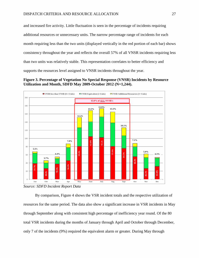
DISPATCH CRITERIA AND RESOURCE ALLOCATION 27
and increased fire activity. Little fluctuation is seen in the percentage of incidents requiring
additional resources or unnecessary units. The narrow percentage range of incidents for each
month requiring less than the two units (displayed vertically in the red portion of each bar) shows
consistency throughout the year and reflects the overall 57% of all VNSR incidents requiring less
than two units was relatively stable. This representation correlates to better efficiency and
supports the resources level assigned to VNSR incidents throughout the year.
Figure 3. Percentage of Vegetation No Special Response (VNSR) Incidents by Resource Utilization and Month, SDFD May 2009-October 2012 (N=1,244).
0
20
40
60
80
100
120
140
160
180
200
Jan Feb Mar Apr May June July Aug Sept Oct Nov Dec
VNSR less than VNSR (0-1 Units) VNSR Equivalent (2-Units) VNSR Additional Resources (3+ Units)
5.5%
3.7%
4.4%
7.0%
12.2%
13.5%13.9%
13.3%
10.1%
7.1%
5.0%4.3%
63.0% of ALL NVSR's
59.7
%
60.2
% 70.5
% 56.2
%
59.0
%
62.6
%
65.2
%
55.6
%
64.3
%
66.2
%
46.4
%
61.0
%
Source: SDFD Incident Report Data
By comparison, Figure 4 shows the VSR incident totals and the respective utilization of
resources for the same period. The data also show a significant increase in VSR incidents in May
through September along with consistent high percentage of inefficiency year round. Of the 80
total VSR incidents during the months of January through April and October through December,
only 7 of the incidents (9%) required the equivalent alarm or greater. During May through

DISPATCH CRITERIA AND RESOURCE ALLOCATION 28
September there were a total of 313 VSR incidents with 49 (16%) requiring the equivalent alarm
or more. Compared to the VNSR data, there is a greater fluctuation of units utilized throughout
the year for VSR incidents (displayed vertically in the red portion of each bar), and although all
the months show inefficiency with high percentages of unnecessary units assigned, slightly better
efficiency is seen in the summer months.
Figure 4. Percentage of Vegetation Special Response (VSR) Incidents by Resource Utilization and Month, SDFD May 2009-October 2012 (N=393).
Source: SDFD Incident Report Data
Because of the large number of resources dispatched to VSR incidents, it is difficult to
determine efficiency solely on whether the entire alarm assignment of 13 units was utilized or
not. Figure 2 and Figure 4 grouped VSR incidents into one of three categories: (a) less than, (b)
equivalent to, or (c) more than the first alarm assignment but does not represent the incremental

DISPATCH CRITERIA AND RESOURCE ALLOCATION 29
intervals between 1-13 units utilized. Figure 5 shows the number and percentage of VSR
incidents for each interval of utilized units at the incident, identifying the number of incidents for
the previous level of resources in red and the number of incidents requiring the additional unit
for that level in yellow. For example, there were 174 (44%) VSR incidents handled with just
three units or less, and there were an additional 33 (totaling 53% of all VSR) incidents that
required a fourth unit to be utilized.
Figure 5. Number and Percentage of Units Still Assigned to Vegetation Special Response (VSR) Incidents by Resource Utilization, SDFD May 2009-October 2012 (N=338).
Source: SDFD Incident Report Data
There were 49 of 75 electronic surveys returned from comparable departments seeking
information on dispatch criteria and resource levels assigned to vegetation fires. Responses from
the other departments show 71% have multiple initial alarm assignments for vegetation fires,
with 57% having three or more levels. The range of units assigned to the lowest dispatch level

DISPATCH CRITERIA AND RESOURCE ALLOCATION 30
was 1-11 units, and the group average for the lowest level was 3.3 units. The range of units
assigned to the highest dispatch level was 2-19 units with the group average of 8.1 units. The
VSR alarm assignment for SDFD falls within the range of the surveyed group, and is five units
above the average.
Figure 6. Factors Used by Other Fire Departments to Set Vegetation Fire Dispatch Levels, by Percentage.
72.7 68.2
47.7 47.7
13.6
29.5
0102030405060708090
100
GeographicLocation
Weather Informationfrom
ReportingParty
Fuel Moisture PreviousIncidents at
that Location
Other
Source: Comparable Department Surveys
Several conditions and information sources were found to be available that can better
predict fire behavior and potential risk of a reported vegetation fire. Of the departments with
different dispatch levels, 42% use only objective data in determining the level while 53% use a
combination of subjective and objective data. The remaining 5% determine the level solely on
subjective information and decisions made by a person of authority. Of those same departments,
71% adjust the dispatch level as needed during an operational period based on dynamic
conditions such as weather changes. Figure 6 displays the various factors used by other
departments in determining dispatch levels. Nearly 73% use geographic location followed by
68% of departments using weather conditions.

DISPATCH CRITERIA AND RESOURCE ALLOCATION 31
Figure 7. Vegetation Special Response (VSR) Incidents by Burn Index Range, SDFD May 2009-October 2012 (N=393).
Source: SDFD Incident Report Data
Weather conditions and Burn Index values are standard factors used by most fire
departments for determining the potential fire dangers. Although results did not show a direct
correlation of the BI to the number of reported vegetation fires, the BI did show a correlation to
the significance of the fire after its start and the resources required to manage the incident in the
higher BI ranges. Figure 7 shows the number of VSR incidents associated with the respective BI
ranges. The high numbers of VSR incidents (49.8% of all VSR incidents) occurred in the BI
range of 20-49 and can be explained by the fact that the majority of dates in San Diego had BI’s
falling in this range, and thus the majority of fires occurred within this restricted range. The
average number of units utilized for more than two minutes at scene remains constant up to a BI
point of 80, after which the average increases significantly. The average number of units required
at scene increases from five to nine when the BI reaches 80 and peaks in the ranges of 100-119.

DISPATCH CRITERIA AND RESOURCE ALLOCATION 32
The accuracy of the lower unit averages in the extremely high BI ranges is affected by the low
number of incidents that occurred in these ranges.
Figure 8. Vegetation Special Response (VSR) Incidents by Resource Utilization and Time of Day, SDFD May 2009-October 2012 (N=393).
Source: SDFD Incident Report Data
Another pre-incident factor which was examined for potential in predicting fire danger was
the time of day that the incident occurs. Of the 1,637 vegetation fires reviewed, 1,260 (77%)
occurred between the hours of 0800 – 2000 hours. Examination of just the VSR incidents shows that
318 (81%) of all VSR occurred during this 12 hour period. Figure 8 separates the VSR incidents by
time of occurrence and graphs them according to the utilization of an equivalent VSR alarm
assignment. Most significant in this analysis is 89% of all VSR responses that occur at night utilize
less than the equivalent alarm assigned, and only 4% required additional units be assigned to
manage the incident. The results clearly suggest that time of day is an influencing factor when
evaluating f ire potential and can help in determining the number of resources needed in when

DISPATCH CRITERIA AND RESOURCE ALLOCATION 33
setting resource levels.
The theories and data used to set current resource levels and assignments to vegetation
fires were found to be subjective decisions based on historical fire experiences and efforts to
strive towards the goal of committing sufficient resources to vegetation fires having potential
risk based on the incident location. Although NFPA 1710 does not identify an “effective fire
force” for vegetation fires but only the minimum operational tasks, SDFD set an alarm
assignment for VSR incidents based on the opinions of senior management and “worst case
scenarios”. No data or statistical reports were found to support the May 15, 2009 change in
dispatch criteria or resource levels. Personal interviews concluded that as a result of recent fire
disasters experienced in San Diego, the Fire Chief publicly embraced and supported an
aggressive and multi-unit response to any such threat.
Costs associated with resources that were unnecessarily assigned to incidents were
derived from department fiscal reports using average operating costs for various apparatus.
Figures based on FY2013 rates provided by the Fleet Division revealed an average hourly
operating cost of $34.56 per hour for type I engines and $15.68 per hour for type III brush
apparatus. Since apparatus/vehicle operating costs are represented in hourly costs, assignment-to-
available times associated with the responding units that were not utilized at a vegetation fire
were calculated to produce the costs. During the time period examined (5/15/09 – 10/1/12) there
were 9,990 minutes associated with units unnecessarily assigned to VNSR incidents and 32,640
minutes associated with units not utilized at VSR incidents. These calculations were based on the
assignment-to-available time for all units not utilized at the incident (canceled or at scene less
than two minutes). Using the operating costs provided by the Fleet Division, the total time
associated with units dispatched to a vegetation fire yet not utilized represents an average

DISPATCH CRITERIA AND RESOURCE ALLOCATION 34
estimated cost of $5,354 per year. Figures provided by the Air Operation Division of SDFD cite
a $3,855 per hour operating cost for the helicopter. For the time period examined, there were 54
incidents in which one or both helicopters were assigned to a vegetation fire and not utilized.
This resulted in 69 canceled missions, totaling 858 minutes. This unit assignment time represents
a theoretical cost of $55,126: however, the actual cost is difficult to calculate due to the fact that
the helicopter request is sometimes canceled before departing and incurring the flight time.
Quantifying risk directly correlated to resources which were unnecessarily assigned to a
vegetation fire in San Diego was insignificant. Numerous studies have produced statistical
results in relation to increased risk of injury as discussed above. Although national averages of
increased injury and accidents are published and used for reference, the specific risk percentages
for SDFD employees, equipment, and property are unavailable. Risk Management reported 79
apparatus/vehicle accidents in FY2011 and 73 accidents in FY2012, of which 30 (41%) of the
FY2012 accidents were related emergency responses (E. Baskin & R. Tong, personal
communication, November 21, 2012). The first quarter of FY2013 alone had 30 reported
accidents with nine being related to emergency incidents. Although the number of accidents
during emergency responses represents a small share of all responses (0.014%), the acuity and
significance of the accidents is impossible to measure. The City of San Diego realized $80,325 in
costs associated with repairs and replacements for fire vehicles/apparatus involved in accidents
during FY2012 (Fleet Repair Costs/Fire-FY2012, 2012), and paid out $40,631 in property
damage claims associated with these accidents (FY2012 Property Damage Claims-Fire, 2012).
With the findings that show any emergency response increases risk to the responders and the
public, SDFD realized 42,630 total minutes of unnecessary response time associated with
DISPATCH CRITERIA AND RESOURCE ALLOCATION 35
vegetation fires during the time period examined, which resulted in an average of 12,789 minutes
per year of increased risk.
One of the unfortunate but accepted consequences of units unnecessarily assigned to an
incident is the unit being unavailable to respond to another call in their home district. There were
163 incidents during the time period examined in which a unit was unavailable for a call in their
home district as a result of being assigned to a vegetation fire where they were not utilized, and
for which a unit from another district was required to respond. The disproportionate share of
these cross-district service calls were conducted while the home unit was assigned to a VSR
incident. Specifically, of the 163 incidents, 116 (71%) occurred in districts of units assigned to a
VSR, while only 47 (29%) occurred in the district of a unit assigned to a NVSR. Based on a total
of 393 VSR incidents, a subsequent emergency incident is missed by a unit unnecessarily
assigned on 29.5% of all VSR responses, as opposed to only occurring on 3.7% of all NVSR.
More units are assigned to a VSR incident resulting in more open districts, yet VSR incidents
only make up 24% of all vegetation fire responses. Looking at daytime versus nighttime data,
77% of all vegetation fires occurred during the daytime (0800-2000 hours) and 84% of the
emergency incidents where the home unit was unavailable occurred during the day. The
unavailability of the home unit not only resulted in delayed service, but also compounded the
challenges of meeting response time goals identified in the adopted Citygate report. Indeed the
single unit response time goal of 7 minutes and 30 seconds was only met by SDFD 77.2% of the
time, while the goal of a “Multi-Unit Effective Response Force” arriving within 10 minutes and
30 seconds of the call received was only met on 55.4% of the incidents (Citygate Associates,
LLC, 2011, p. 5).

DISPATCH CRITERIA AND RESOURCE ALLOCATION 36
Discussion
Defining efficiency in the fire service is not an easy task, as Flynn (2009) points out that
the term is most often offered in reference to financial costs in relation to an output or service
delivered. Because the cost of providing fire protection is an insurance policy for “worst case
scenarios,” the fiscal costs associated with excessive units being assigned yet not needed are
considered acceptable. Effectiveness of fire resources is easier to define because it’s a
quantitative measurement in relation to target rates and goals. Considering these two evaluative
terms in the fire service, it is obvious that a level of service or deployment model can be
extremely effective yet unclear as to how efficient they are delivered. NFPA 1710 sets minimum
recommended standards for staffing and effective fire force for structure fires, but not for
wildland fires. Since the only recommended standard for wildland fires defines the tasks
expected of arriving units (Standard for the Organization and Deployment of Fire Suppression
Operations, 2004), individual departments are left with the decision as to what resource level is
appropriate to accomplish the tasks. With only two dispatch levels employed by SDFD that
range from two units to 13 units respectively, there is frequent opportunity for resources to be
unnecessarily assigned. Of the 5,483 units assigned to VSR incidents, only 39% of the units were
utilized. By most industry standards, this would be considered inefficient and unacceptable. But
since the hazard remains undetermined at the time of dispatch, and only the potential based on
limited information is available, it can be argued that the current model subscribes to the notion
that “it is better to be safe than sorry.” Without intermediate dispatch levels to compare unit
utilization to the high and low levels used by SDFD, it’s difficult to determine what level is most
efficient for different conditions. Units are more efficiently utilized on VNSR incidents but that
is expected with only two units responding. The dispatch level of VSR incidents appears to be

DISPATCH CRITERIA AND RESOURCE ALLOCATION 37
generally inefficient, and even more so under specific conditions by not considering such factors
as time of day and month of the year.
One of the factors that decreases the efficiency of units assigned to a VSR incident is the
designation of the response area. Because a broad designation of “Special Response” or “No
Special Response” is determined using outdated GIS data as well as risk assessment values
conducted decades ago (Standards of Response Coverage Plan - SDFD Accreditation Report,
2005), a significant amount of resources are dispatched to areas that no longer pose a threat of
potential fire hazard. Many areas still showing as “Canyon-Rim” or “Wildland” response areas
have since been developed and little vegetation or fire danger still exists.
Rather than examining scene time and number of resources utilized to assess efficiency, a
more accurate assessment of the dispatch levels would be an evaluation of the size of each fire
and the necessity of each unit in order to contain it. This evaluation would better assess the
effectiveness of units assigned and could be compared to the recommendations in the Citygate
report and the goal of SDFD to limit vegetation fires to less than three acres 90% of the time
(Citygate Associates, LLC, 2011,). However, such an analysis of efficiency could not conducted
for the purpose of the present study due to the number of fires used in the report and the limited
NFIRS data available containing this information.
The literature review on the NFDRS showed that historical data, weather conditions, fuel
models, and other scientific measurements can be combined to provide rating values useful in
predicting fire danger and potential risk. One of the main purposes of NFDRS is to provide the
fire manager with information essential for planning and making operational decisions (National
Wildfire Coordinating Group, 2002). Because of the weather climate in San Diego, the majority
of the dates in the time period examined had relatively low BI readings, and as such most of the

DISPATCH CRITERIA AND RESOURCE ALLOCATION 38
vegetation fires occurred in these low ranges. Although the BI did not influence the number of
fires, it did correlate with the number of resources needed to manage the fires in the higher BI
ranges. This latter point is supportive of the importance role that the BI can play in predicting
fire danger and potential risk, particularly in the higher BI ranges which can be a useful tool in
setting and adjusting appropriate resource levels. This is not to suggest that the BI alone should
be used to determine a dispatch level, as several other factors such as time of day, as well as
geographic and topographic information can also help predict conditions and show value in
supporting resource level decisions.
The BI values produced using NFDRS data has been accepted by SDFD as valuable
situational awareness information and incorporated into daily notification procedures for all
operations personnel (SDFD Communication Procedures, 2009). However this valuable
information has not been included as a criterion for dispatching resources. These Communication
Procedures give authority to the Captain in FCC to reduce an alarm assignment based on
conditions (i.e. weather), though this option is rarely used since it comes with scrutiny from
ranking officers and added responsibility of the Captain. A majority of departments surveyed
(68%) use weather or burn index information in the process of determining dispatch levels, and
of the respondents that use weather as criteria, 98% prioritize relative humidity and wind as the
most important factors. While the BI is a comprehensive and all inclusive rating of the fire
danger, it is not recommended to be a sole criterion when determining resource levels. However,
significant wind events alone should be considered when setting dispatch levels because of its
independent influence on fire spread and historical fires experienced in southern California.
It is important to note that despite its value, the BI is also limited in a number of ways.
One of the deficiencies and challenges inherent with the current collection and reporting
DISPATCH CRITERIA AND RESOURCE ALLOCATION 39
procedures of the BI, is the specific RAWS locations used and the unreliability of consistent
reporting. The three inland RAWS locations are significantly inland from the city limits and are
not reflective of weather or fuel moisture conditions in the area served by SDFD. Coastal
influences of on shore winds and marine layers have a dominant effect on morning and evening
weather conditions and are not seen inland where the BI data is gathered. Furthermore, of the
three coastal RAWS locations that were initially used to produce a triangular average of
measurements, only one is still in operation (San Miguel). This has resulted in the Coastal BI
determined by the measurements taken at only this specific location and not truly a citywide
reflection of the conditions influencing fire danger. San Diego Gas & Electric has installed new
RAWS in the central and coastal areas of the city that report measurements every ten minutes
and better represent the various communities; however the measurements have not yet been
integrated with the other scientific components that produce a BI value.
Objective data that is quickly referenced is most desirable and effective to use when
determining the type and amount of resources allocated to a fire emergency. As explained during
a personal interview with the Assistant Fire Chief, the complicated and frequently changing
criteria used in the previous vegetation dispatch procedures caused significant delays and was
one of the main reasons prompting a change in 2009 (Fennessy, personal interview, 2012).
However the BI was not being collected by SDFD at that time and dispatch matrixes were not as
established in CAD at that time. Certainly any evaluation of data or conditions that may cause a
delay in dispatching units should be avoided, but it is important to use supplemental information
to support or modify initial alarm assignments. Other factors that were not examined in this
paper but should also be considered when setting dispatch levels are: (a) reporting party

DISPATCH CRITERIA AND RESOURCE ALLOCATION 40
information, (b) number of calls received at FCC, (c) familiarity with the reported location, and
(d) availability of resources due to other incidents in the area.
SDFD has historically been a data driven department when making operational decisions
or policy changes. Surprisingly the noted dispatch procedure change for vegetation fires in May
2009 was not based on studies or evaluations of the previous procedures or incident reports (K.
Malbrough, W. Middelton, J. Carle, P. Peake, S. Infantino & B. Fennessy, personal interviews,
September, 2012). Rather the current dispatch levels, while well intended given public concern
and recent fire disasters, were established based on professional opinions and experiences
without intermediate levels or objective mechanisms to alter a response. An aggressive approach
to any potential threat or area designated as having wildland topography regardless of other
conditions was deemed as the best practice for San Diego with a “year round fire season”
(Malbrough, personal interview, 2012) and the effects of recent fire disasters still present.
Although this is always the safe approach, the results from the present study reveal that this
practice has a number of unanticipated consequences. Arguably one of the most notable
consequences among them, is the large number of resources underutilized and challenges in
providing district coverage while home units have been unnecessarily assigned. Although this
report shows the majority of incidents do not utilize the equivalent alarm assignment and more
resources are cancelled than are used to mitigate the fire, this may very well have been the case
with the previous High, Medium, and Low dispatch levels. Without a similar analysis of the prior
dispatch levels and incident data, it is not known if the newer procedures and criteria of using
solely geographic location to determine resource levels are any less efficient than the previous
procedures.

DISPATCH CRITERIA AND RESOURCE ALLOCATION 41
In terms of the financial impact of resources unnecessarily assigned to vegetation fires,
the cost is quite small for SDFD, which has an operating budget of close to $200 million. More
pressing concerns are the associated risks and consequences that come as a result of inefficiency.
Considering that emergency responses increase the likelihood of being involved in an accident
by three times and ten times of being injured or killed (Wilbur, 1995), the additional 12,789
minutes of risk per year faced by SDFD crews carries the potential for serious and long lasting
consequences. While the report did not examine how many of the 30 accidents or claims against
the city in FY12 involved SDFD apparatus/vehicles unnecessarily responding to vegetation fires,
it can be concluded that any additional time on the road responding to emergencies equates to an
increased likelihood of risk of injury and property damage.
The Citygate study on response coverage deployment for SDFD identified that the City
of San Diego is deficient in coverage for 19 service areas in hard to serve neighborhoods
(Citygate Associates, LLC, 2011). Therefore, efficiency and keeping resources available is even
more important in order to provide a level of service expected and achieve response time goals.
A unit unavailable to respond to an emergency in their home district as a result of already being
committed to another incident is unfortunate but accepted as “first call–first serve” practice. Yet
when units are unavailable due to being assigned unnecessarily, which was the case for 163
incidents highlighted in this study; it calls into question the current dispatch practices and the
importance in examining whether adjustments to those policies are needed. Because nearly three
quarters of all missed calls under these circumstances occur during a VSR dispatch, it
underscores the necessity of reevaluating the efficiency of this dispatch level.
The purpose of this paper was not to identify all of the conditions and information that
should be considered when dispatching resources to a vegetation fire, nor was it intended to offer

DISPATCH CRITERIA AND RESOURCE ALLOCATION 42
definitive conclusions regarding the dispatch levels. The purpose of the study was to determine if
there are other conditions and pre-incident information available that would be valuable and
could better predict the potential danger and resources required to manage the fire. However,
since the results show that the current dispatch procedures and levels for vegetation fires are not
efficient and there are several factors that should be considered, both objective and subjective,
that could improve efficiency and reduce costs and risks; the recommendations in the following
section will be proposed to Senior Management Staff.
Recommendations
By using pre-incident information and data on conditions affecting fire danger, updating
current geographical information and maps, along with changes to dispatch procedures and
resource levels, SDFD can improve the utilization of resources and decrease the risks and costs
associated with the allocation of resources to vegetation fires. Based on the research and results
presented in this paper, the following recommendations are proposed:
1. Determine what pre-incident information is reliable and that impacts potential fire
danger and incorporate this information into revised dispatch procedures. Information
available such as BI values from updated RAWS, forecasted wind events, and
geographic location should determine initial dispatch levels for a particular incident
and will avoid any delay in dispatching resources. Additional subjective information
and decisions by the Emergency Resource Officer (ERO) in FCC should also be
considered for adjustments to these levels.
2. SDFD should avoid the complexities and delays experienced with past dispatch
procedures by setting initial levels in CAD based on objective data and known pre-

DISPATCH CRITERIA AND RESOURCE ALLOCATION 43
incident factors, and then develop supplemental criteria to adjust those levels as a
result of subsequent information or reports.
3. The GIS data and field surveys used to map and designate areas requiring a VSR or
VNSR response should be revisited to reflect development and topography changes
throughout the city. By updating this information, areas designated as posing a
significant threat and requiring a high number of resources can be adjusted
accordingly to reduce the number of units initially assigned to that area.
4. A smaller sample of VSR incident reports representative of the entire year should be
carefully evaluated, including a review of the NFIRS data and discussion with the
crews to confirm the fire size and resources required to manage the incidents during
different periods of the year. This information along with the unit efficiency results
presented in Figure 5 of this report will help to determine the average and most
efficient number of resources needed to mitigate VSR incidents throughout the year.
5. An automatic dispatch level of the closest two type I engines should be implemented
as the standard dispatch level to vegetation fires for initial attack and assessment of
fire conditions. SDFD should determine incremental levels of alarm assignments
based on conditions identified in recommendation #1 and rely on reported conditions
from the first arriving units for additional resource requests.
6. With the exception of periods experiencing extreme weather conditions and fire
danger, lower dispatch levels should be considered for nighttime vegetation fire
responses with additional resource assignments based on reports from arriving fire
units and informative decisions by the ERO.

DISPATCH CRITERIA AND RESOURCE ALLOCATION 44
7. The fire-rescue helicopter should only be automatically dispatched at the highest
dispatch level and fire danger conditions, and be notified to monitor lower level
incidents in preparation of being requested. Based on initial reports, the helicopter can
be added to responses for which it is not automatically assigned.
8. The RAWS locations used to determine the BI value for SDFD should be updated to
sites that better reflect the weather conditions and fire danger within the city.
Cooperative agreements with SDG & E should be developed include their Mission
Valley, Carmel Valley, and Mount Soledad RAWS in producing more geographically
appropriate values of the BI used by SDFD.
An evaluation of changes to vegetation fire dispatch criteria and procedures should be
conducted six months after implementation with individual audits of each vegetation response to
collect data on the utilization and effectiveness of resources.

DISPATCH CRITERIA AND RESOURCE ALLOCATION 45
References
Bradshaw, L. S., Deeming, J. E., Burgan, R. E., & Cohen, J. D. (1983). The 1978 national Fire
danger rating system [Technical Research INT-169]. Ogden, UT: U.S. Department of
Agriculture, Forest Service, Intermountain Research Station.
City of San Diego usage rates for operational costs. Unpublished manuscript. (2005).
Citygate Associates, LLC. (2011, February 14). Fire service standards of response coverage
deployment for the San Diego Fire-Rescue Department [Deployment Planning Study].
Folsom, CA: Citygate Associates, LLC.
Clawson, J. (2002, October). Unnecessary lights-and-siren use. Public Management.
Deeming, J. E., Burgan, R. E., & Cohen, J. D. (1977). The national fire danger rating system -
1978 (INT-39). Ogden, UT: U.S. Department of Agriculture, Forest Service,
Intermountain Research Station.
Deeming, J. E., Lancaster, J. W., Fosberg, M. A., Furman, R. W., & Schroeder, M. (1972). The
national fire danger rating system (RM-84). Ft. Collins, CO: USDA Forest Service,
Rocky Mountain Forest and Range Experiment Station.
Executive development student manual (4 ed.). (2012). Emmitsburg, MD: FEMA-National Fire
Academy.
FY12 Fire Vehicle Accident Claims [Claims Report]. (2012, December 7). San Diego, CA: City
of San Diego Risk Management Division.
FY12 Fleet Repair Costs/Fire [Work Order Summary]. (2012). San Diego, CA: City of San
Diego Fleet Management Division
FY2012 Annual Report [Annual Report]. (2012). San Diego Fire-Rescue Department: San Diego
Fire-Rescue Department.

DISPATCH CRITERIA AND RESOURCE ALLOCATION 46
Fennessy, B., Assistant Fire Chief (2012). Personal Interview/Interviewer: Colin Stowell. , San
Diego.
Fire Suppression - Vegetation fire procedures [Operations Manual Policy Section VIII]. (2009,
May 15). San Diego, CA: San Diego Fire-Rescue Operations Manual.
Flynn, J. D. (2009). Fire service performance measures. Quincy, MA: National Fire Protection
Administration.
Glatfelter Insurance Group. (2000). [Interdepartmental Audit]. Unpublished raw data.
Karter, M. J., & Molis, J. L. (2012). U.S. Firefighter Injuries in 2011. Retrieved from nfpa.org:
http://www.nfpa.org/assets/files//pdf.os.ffinjuries.pdf
Malbrough, K., Deputy Chief of Operations/Retired (2012). Personal Interview/Interviewer:
Colin Stowell. , San Diego.
National Wildfire Coordinating Group. (2002, July). Gaining an understanding of the national
fire danger rating system [ PMS 932]. Boise, Idaho: National Wildfire Coordinating
Group.
Peterson, K., Amandus, H., & Wassell, J. T. (2009, June 1). Reducing firefighter vehicle crash
fatalities. Fire Engineering, 162(6). Retrieved from
http://www.fireengineering.com/articles/print/volume-162/issue-6
SDFD Bulletin 09-055. (2009, April 2). Vegetation fire procedures [Department Bulletin 09-
055]. San Diego, CA: San Diego Fire-Rescue.
Standard Operating Procedures - San Diego Fire-Rescue Communications [Communications
Policy]. (2009, August 7). San Diego, CA: Fire Communications Center - SDFD.
Standard for the organization and deployment of fire suppression operations, emergency medical
operations, and special operations to the public by career fire departments [National Fire

DISPATCH CRITERIA AND RESOURCE ALLOCATION 47
Protection Administration - 1710]. (2004). Quincy, MA: National Fire Protection
Administration.
Standards of response coverage plan [SDFD Accreditation Report]. (2005). San Diego, CA: San
Diego Fire-Rescue Department.
State of California fire information [Statistical Report]. (2007). Retrieved from Cal Fire Incident
Information website: http://cdfdata.fire.ca.gov/incidents_details
United States Fire Administration. (2012). USFA strategic plan - fiscal years 2010-2014
[Strategic Goals]. Emmitsburg, MD: U.S. Department of Homeland Security.
Wilbur, M. (1995, January). Use and abuse of lights and sirens. Firehouse, 22, 20-23.

DISPATCH CRITERIA AND RESOURCE ALLOCATION 48
Appendix A
SDFD Vegetation Fire Danger Rating System (Pre May 2009)

DISPATCH CRITERIA AND RESOURCE ALLOCATION 49
Appendix B
Vegetation Fire Response Area Map

DISPATCH CRITERIA AND RESOURCE ALLOCATION 50
Appendix C
Current SDFD Dispatch Matrix for Vegetation Fires

DISPATCH CRITERIA AND RESOURCE ALLOCATION 51
Appendix D
Weather Index Pocket Card
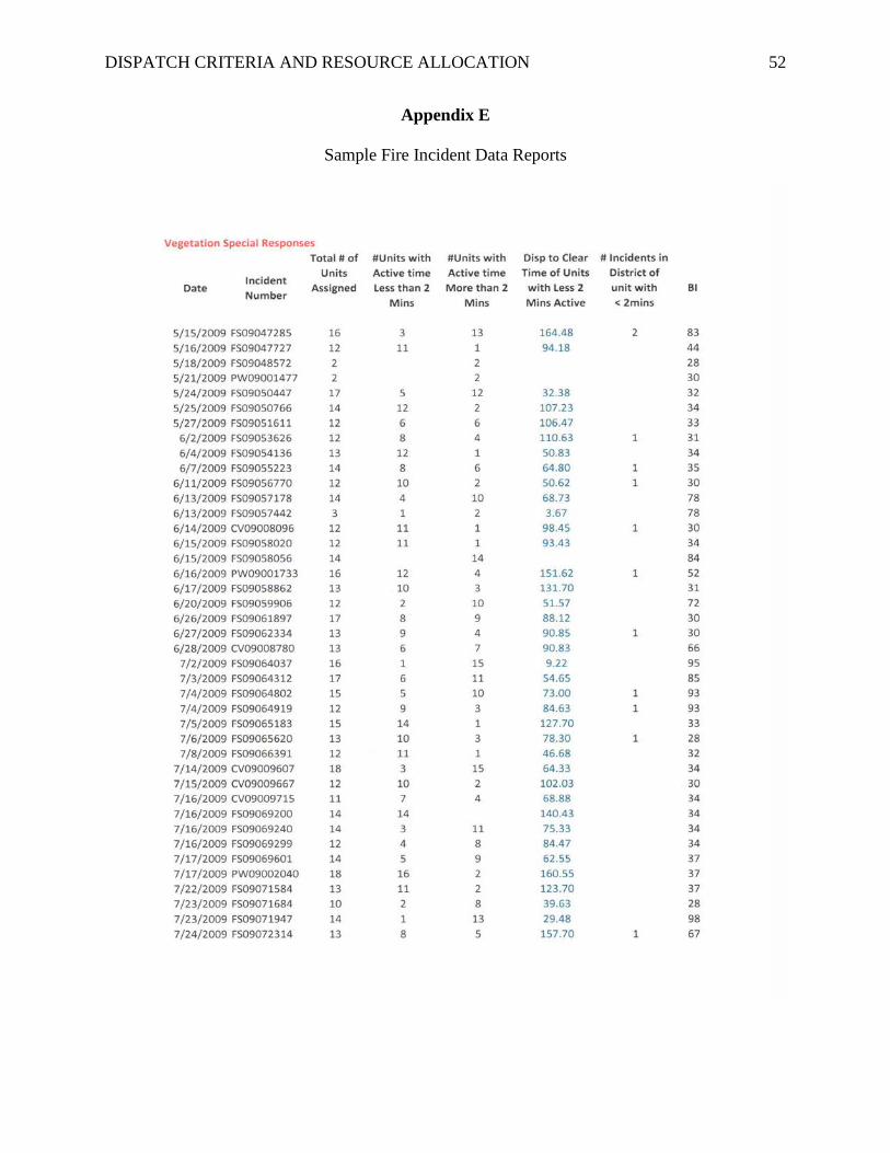
DISPATCH CRITERIA AND RESOURCE ALLOCATION 52
Appendix E
Sample Fire Incident Data Reports

DISPATCH CRITERIA AND RESOURCE ALLOCATION 53
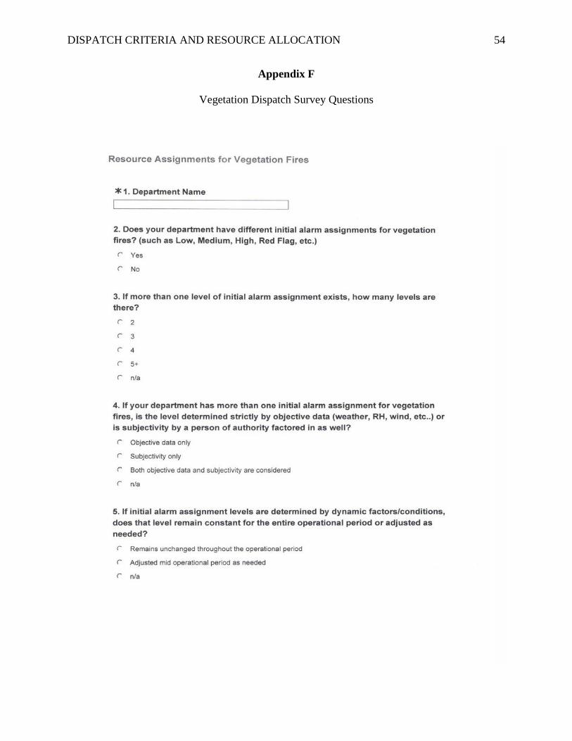
DISPATCH CRITERIA AND RESOURCE ALLOCATION 54
Appendix F
Vegetation Dispatch Survey Questions

DISPATCH CRITERIA AND RESOURCE ALLOCATION 55

DISPATCH CRITERIA AND RESOURCE ALLOCATION 56
Appendix G
Interview Questions
Interviews conducted with: Jeff Carle, Asssistant Fire Chief (Retired), Operations Brian Fennessy, Assistant Fire Chief, Support Service Susan Infantino, Communications Manager
Bill Middleton, Asssistant Fire Chief (Retired), Operations Ken Malbrough, Deputy Chief (Retired) Perry Peake, Deputy Chief (Retired)
1. What were the theories, discussions, and conditions that resulted in the May 2009 change to SDFD’s dispatching of resources to vegetation fires?
2. What criteria and data were used in determining the dispatch levels prior to the change? 3. Were the previous dispatch procedures effective and manageable? 4. What problems existed with the previous dispatch levels and procedures? 5. What research was done prior to making the dispatch change in 2009? 6. How were the amount and type of resources determined for each dispatch level? 7. What desired improvements and/or benefits were expected from the change? 8. Did the department recognize and gain the desired improvements? 9. What factors and conditions were considered when determining how to set the new
dispatch levels? 10. Were there any concerns with the change to the new level and using geographic location
as the sole factor determining resource assignments? 11. How was the Burn Index (BI) expected to be to incorporated into our dispatch procedures
and staffing models? 12. Was the BI intended to support and influence dispatch levels or staffing plans? 13. Was there a plan to evaluate the effectiveness of the dispatch change after any time frame
from implementation?