district council of the upper north heritage survey 2010 ... · district council of the upper north...
TRANSCRIPT

District Council of the Upper North Heritage Survey 2010 Recommendation: Local Heritage Places
Flightpath Architects Pty Ltd 111
5.0 Heritage Assessment Reports: Places of Local Heritage Value Places considered to be of local heritage value to the Northern Areas Council are detailed below. The level of documentation for each place is sufficient to allow the Council and community to support the inclusion of each place on the local heritage register under the Development Plan. A place may be designated as being of local heritage value if: (a) it displays historical, economic or social themes that are of importance to the
local area; or (b) it represents customs or ways of life that are characteristic of the local area; or (c) it has played an important part in the lives of local residents; or (d) it displays aesthetic merit, design characteristics or construction techniques of
significance to the local area; or (e) it is associated with a notable local personality or event; or (f) it is a notable landmark in the area. The following places within the Northern Areas Council are considered to meet these selection criteria and are recommended for entry into the local heritage register under the Development Plan. This recommendation is based upon the historical research, fieldwork and evaluation undertaken as part of the heritage survey of the Upper North Region. 5.1 Caltowie • Former Bank of Adelaide, Browne Street (NA:94) • Caltowie Hotel, Charles Street (NA:95) • Soldiers Memorial Institute Hall, Charles Street (NA:96) • Former Post Office & Residence, Charles Street (NA:97) • Former Police Station, Charles Street (NA:98) • Former Flour Mill Office, South Terrace (NA:99) 5.2 Georgetown • Catholic Church, 14 Hurtle Street (NA:12) • General Store, 35 Fisher Street (NA:13) • Georgetown Hotel, Fisher Street (NA:14) • Baptist Church, 19 Fisher Street (NA:15) • St George’s Anglican Church, Fisher Street (NA:16) • Former Bank of Adelaide, 25 Fisher Street (NA:100) • Former Courthouse, James Street (NA:101) • Former Police Station, James Street (NA:102) 5.3 Gladstone • Aldayne Shops, 28 - 34 Gladstone Street (NA:17) • Booyoolee Hotel, Port Street (NA:18) • Former Butter Factory, Bondowie Road (NA:19) • Commercial Hotel, Gladstone Street (NA:20) • Former Bank, 36 Gladstone Terrace (NA:21) • Freemasons Hall (former Methodist Church), 32 High Street (NA:22) • Gladstone Hotel, Bondowie Road (NA:23) • Silos, Gladstone Street (NA:24) • Kindergarten, James Street (NA:25)
Recommendation: Local Heritage Places District Council of the Upper North Heritage Survey 2010
112 Flightpath Architects Pty Ltd
• Primary School, 21 West Terrace (NA:26) • Railway Station, Gladstone Street (NA:27) • Scout Hall, James Street (NA:28) • Soldiers Memorial Hall, Cross Street (NA:29) • St Albans Anglican Church and Hall, 34 Sixth Street (NA:30) • St Peter's Catholic Church, 7 West Terrace (NA:31) • Factory (Trend Drinks), Sixth Street (NA:32) • Uniting Church and Hall, High Street (NA:33) 5.4 Gulnare • Gulnare Hotel, Railway Terrace (NA:34) • Memorial Institute, Railway Terrace (NA:35) • Primary School, 2 View Street (NA:36) • Silos, Railway Terrace (NA:37) • Uniting Church and Hall, Railway Terrace (NA:38) 5.5 Hornsdale • Horne's barn, Hornsdale to Appila Road (NA:78) • Kappowie Farm Complex, Hornsdale to Mannanarie Road (NA:82) 5.6 Jamestown • ANZ Bank, 55 Ayr Street (NA:39) • Bank SA Building, 61-63 Ayr Street (NA:40) • Art Gallery (former Courthouse), 53 Ayr Street (NA:41) • Dr Cockburn's House, Cnr. of Clifton Road and Cockburn Road (NA:42) • High School, Humphris Terrace (NA:43) • Jamestown Hotel, Allotment 101 Ayr Street (NA:44) • Memorial Hall, 73 Ayr Street (NA:45) • Primary School, 21 Doon Terrace (NA:46) • former Salvation Army Citadel, 10 Ayr Street (NA:47) • Silos, Adjacent Jamestown Railway Station/Museum (NA:48) • Railway Station/Museum, Railway Reserve, adjacent Mannanarie Road (NA:49) • Cemetery, South Terrace (NA:81) • Uniting Church of Jamestown, Irvine Street (NA:103) • Masonic Hall, 69 Irvine Street (NA:104) • St James Anglican Church, 76 Irvine Street (NA:105) 5.7 Jamestown (surrounds) • Yongala Homestead, Jamestown to Terowie Road (NA:87) • Yongala Reservoir, Yongala to Canowie Belt Road (NA:88) • Coolootoo Shepherds Hut, off Gilfillan Road (NA:106) 5.8 Laura • St John the Evangelist Anglican Church and Hall, East Terrace (NA:50) • Eastern Lutheran Church, Samuel Street (NA:51) • Emmanuel Uniting Church, Herbert Street (NA:52) • Flour Mill, 18 Mill Street (NA:53) • Creative Treasures Shop (Former Union Bank), Herbert Street (NA:54) • Guest House (former Brewery), 8 West Terrace (NA:55) • Shops, 31-37 Herbert Street (NA:56) • Freemasons Hall, 7 Hughes Street (NA:57) • Baptist Church, Victoria Street (NA:58) • Motor Garage, Herbert Street (NA:59) • Primary School, East Terrace (NA:60) • North Laura Hotel, Mill Street (NA:62) • Post Office, 23 Herbert Street (NA:63) • War Memorials, Herbert Street (NA:64)
District Council of the Upper North Heritage Survey 2010 Recommendation: Local Heritage Places
Flightpath Architects Pty Ltd 113
5.9 Mannanarie • Bradtke Tree Lot, Jamestown to Yongala Road (NA:77) • Mannanarie Homestead, Mannanarie to Hornsdale Road (NA:83) • Mount Nadjuri, (Peak on the Narien Range), west of Mannanarie (NA:84) 5.10 Spalding • Catholic Church of St Augustine, 26 Main Street (NA:107) • Spalding Hotel, 19 Main Street (NA:108) • Rural Youth Hall, 25 R.M Williams Way (NA:109) • Grandstand, Treyln Road (NA:110) 5.11 Spalding (surrounds) • Bundaleer Homestead and Woolshed, 10km NW of Spalding (NA:65) • Heathermoor Farmhouse, Jamestown to Spalding Road (NA:66) • Mundunney Stable Ruins, 18km NE of Spalding (NA:67) • Mundunney Homestead, 10km NE of Spalding (NA:68) • Old Mundunney Homestead Ruin, 9km E of Spalding (NA:69) • Wheal Sarah, 8km NW of Spalding (NA:85) 5.12 Stone Hut • Original Stone Hut, off Main North Road (NA:111) • Stone Hut Soldiers Memorial Hall, Cnr Borthwick Street & Main North road (NA:112) • Former School & Residence, Murray Street (NA:113) 5.13 Yacka • Institute, Hawker Street (NA:70) • Primary School, Beare Street (NA:71) • Soldiers Memorial and Garden, Hawker Street (NA:72) • St James Anglican Church, Broughton Road (NA:73) • State Bank, Hawker Street (NA:74) • Former Blacksmith, 12 Hawker Street (NA:75) • Uniting Church and Hall, Charles Street (NA:76) • Railway Bridge, Main North Road (NA:86)

Recommendation: Local Heritage Places District Council of the Upper North Heritage Survey 2010
114 Flightpath Architects Pty Ltd

RECOMMENDATION: LOCAL HERITAGE PLACES 5.1 CALTOWIE


Upper North Heritage Survey Recommendation: Local Heritage Places
Austral Archaeology Pty Ltd, Flightpath Architects and Historical Research Pty Ltd 117
FORMER BANK OF ADELAIDE BUILDING NA: 94 LOCATION: Caltowie Place Name and Address: Former Bank of Adelaide Building, Browne Street Caltowie, 5490 Land Description: Lot 403, Hundred of Caltowie Certificate of Title: CT 3795/587 OWNER: A.E & S.L Lang, PO Box 38, Caltowie, SA 5490 State Heritage Status: SHR File No.: Other Assessments: PHOTOGRAPHS:
Bank of Adelaide, Caltowie

Recommendation: Local Heritage Places Upper North Heritage Survey
118 Austral Archaeology Pty Ltd, Flightpath Architects and Historical Research Pty Ltd
FORMER BANK OF ADELAIDE BUILDING NA: 94 DESCRIPTION: A single storey building of stone construction with stone quoins, built in simple federation style. There is a dwelling attached to the eastern side, forming an ‘L’ shaped building. The main section of the building is symmetrical with a parapeted entrance portico with quoined pilasters and Dutch-gabled roof of corrugated iron. The attached dwelling consists of a hipped roof of corrugated iron and has a simply pitched verandah with timber posts. HISTORY: The Bank of Adelaide building was built in 1908 and is located next to the original bank on Browne Street (The first bank in Caltowie was The National Bank of Australasia and was opened in 1877). Before the current Bank of Adelaide building was constructed, the business (which opened on September 29th 1893) was located in the former National Bank of Australasia building. After the Bank of Adelaide building was built, the former bank building was sold to Mr. L Batten for residential purposes. The Bank of Adelaide traded with only a manager and teller until the 28th of April 1971, until the Branch was closed. Business was then conducted through an agency one afternoon a week from the Spalding Branch, which also ceased business soon after. The Bank of Adelaide Building was sold as a private residence, which now features in the KESAB judging and Open Garden Scheme. STATEMENT OF HERITAGE VALUE: The former Bank of Adelaide is significant to the local area as an example of economical growth in the developing pastoral town. It also displays aesthetic merit and design characteristics to the local area as a distinguishable building, with robust and imposing features. RELEVANT CRITERIA: (a) It displays historical and social themes that are of importance to the local area. (d) It displays aesthetic merit and design characteristics to the local area as a
robust commercial building. REFERENCES: Henderson, Doug, & Caltowie Memorial Hall and Progress Association Inc. ‘Caltowie Revisited’. Emm & Dee Publishing, Jamestown. 2006. P 66

Upper North Heritage Survey Recommendation: Local Heritage Places
Austral Archaeology Pty Ltd, Flightpath Architects and Historical Research Pty Ltd 119
CALTOWIE HOTEL NA: 95 LOCATION: Caltowie Place Name and Address: Caltowie Hotel, Charles Street Caltowie, 5490 Land Description: Lot 30 & 49, Hundred of Caltowie Certificate of Title: CT 5437/589 OWNER: Caltowie Nominees, PO Box 42, Caltowie, SA 5490 State Heritage Status: SHR File No.: Other Assessments: PHOTOGRAPHS:
Caltowie Hotel, Caltowie

Recommendation: Local Heritage Places Upper North Heritage Survey
120 Austral Archaeology Pty Ltd, Flightpath Architects and Historical Research Pty Ltd
CALTOWIE HOTEL NA: 95 DESCRIPTION: A double storey building of stone construction and stone quoins, it is rectangular in shape with four chimneys and hipped roof construction of corrugated iron cladding. Three pediments located at the centre and ends of the roof extend over the balcony. The centre pediment features a simple verandah timber constructed screen, with double timber columns. The balcony has timber railings with a bull-nose verandah. The front façade has multiple windows and two entry doorways. HISTORY: J. Inglis, also the first licensee, built the Caltowie Hotel (originally named the Commercial Hotel) in the mid 1870’s. The Laura Brewing Company owned the hotel from 1884 until 1903 when the South Australian Brewing Company took ownership. In 1958 the hotel changed its name to the Caltowie Hotel. In 1970, Mr. Graham Fraser free-holded the building and it has since had several owners and licensees. The Caltowie Hotel was used as the meeting place for town meetings until the Institute across the road was built. The Hotel also had its own ‘doctor’s room’ for consultations with the Jamestown doctor once a week. The stables for the patrons was located where the motor garage is now located, on the eastern side of the Hotel. The architecture of the building suggests that the second storey of the hotel was a later addition, as some parts of upper storey walls do not correspond with the load bearing walls below. In 1997 the hotel license was downgraded to a tavern license due to inadequate fire escapes in the upper storey. In 2002 the problem was rectified and the license was upgraded again to a full residential license. STATEMENT OF HERITAGE VALUE: The Caltowie Hotel is historically significant as it is the first hotel established in Caltowie and was often frequented by local farmers after a toiling day on the farm. Located on the main road running through Caltowie, the Caltowie Hotel is a notable landmark in the local area and is socially significant as many meetings and appointments were held here until the Memorial Institute was built. RELEVANT CRITERIA: (c) It has played an important part in the lives of the local residents, being a
frequent stopping place for local farmers and meeting place for the community. (f) It is a notable landmark in the area, being a prominent commercial building on
the main road, and also a well-known and frequent stopping place for local farmers.
REFERENCES: Henderson, Doug, & Caltowie Memorial Hall and Progress Association Inc. ‘Caltowie Revisited’. Emm & Dee Publishing, Jamestown. 2006. P 19-20

Upper North Heritage Survey Recommendation: Local Heritage Places
Austral Archaeology Pty Ltd, Flightpath Architects and Historical Research Pty Ltd 121
SOLDIERS MEMORIAL INSTITUTE HALL NA: 96 LOCATION: Caltowie Place Name and Address: Soldiers Memorial Institute Hall, Charles Street Caltowie, 5490 Land Description: Lot 397, Hundred of Caltowie Certificate of Title: CT 5830/769 OWNER: Caltowie Memorial Hall & Progress Association State Heritage Status: SHR File No.: Other Assessments: PHOTOGRAPHS:
Soldiers Memorial Institute Hall, Caltowie

Recommendation: Local Heritage Places Upper North Heritage Survey
122 Austral Archaeology Pty Ltd, Flightpath Architects and Historical Research Pty Ltd
SOLDIERS MEMORIAL INSTITUTE HALL NA: 96 DESCRIPTION: A single storey, Victorian style building, constructed of stone with stone quoins, it has a Dutch-gabled roof of corrugated iron. A pediment extends over the main entrance on the front façade. The main entrance has a three-tiered arch doorcase, and a cast iron gate, with hung windows on either side. Several additions have been constructed since the completion of the Hall in 1880. HISTORY: Foundations for the Institute began in 1878, with the first stone being laid by Mrs. Seikmam. The Hall was opened in January 1880, accompanied by a large celebration including a high tea, concert and ball. Mr. Roland Rees M.P was scheduled to perform the opening ceremony, but never arrived, so the Hall Committee President, Mr. Laurenti, had the honour. A Library room was added in 1883 and a supper room in 1904. At the end of the WWI, it was decided that Mr. S Wenham’s tender to finish the front of the Hall with another Library room, Billiard room and porch would be accepted. The foundation stone for these additions was unveiled on July 6th 1920 by the Governor Sir Archibald Weigall. In 1921 the Mid North Co-operative Soc Society tendered for the enlargement of the supper room. In 1926 the western wall was underpinned as a new exit door was required due to the ‘Places of Entertainment Act’. In 1954 a new ceiling, floor and stage curtain were installed, along with a Memorial Arch over the stage, which was unveiled by Premier Thomas Playford. The Library closed in 1974 and deeds for the Hall were transferred from the Institutes Association to the Caltowie Memorial Inc., which has since formed with the Progress Association to form the Caltowie Memorial Hall and Progress Association. The Hall and supper room have recently been re-roofed. STATEMENT OF HERITAGE VALUE: The Soldiers Memorial Institute Hall displays social themes as the venue for local events and the meeting place for several local organizations and groups. It is historically significant as a memorial to World War I & II. RELEVANT CRITERIA: (a) It displays historical and social themes that are of importance to the local area. (c) It has played an important part in the lives of the local residents, having been the
meeting place for several local groups (e) It is associated with a notable local event, as a memorial to the soldiers who
fought in both World War I & II. REFERENCES: Henderson, Doug, & Caltowie Memorial Hall and Progress Association Inc. ‘Caltowie Revisited’. Emm & Dee Publishing, Jamestown. 2006. P 14-15

Upper North Heritage Survey Recommendation: Local Heritage Places
Austral Archaeology Pty Ltd, Flightpath Architects and Historical Research Pty Ltd 123
FORMER POST OFFICE & RESIDENCE NA: 97 LOCATION: Caltowie Place Name and Address: Former Post Office & Residence, Charles Street Caltowie, 5490 Land Description: Lot 53, Hundred of Caltowie Certificate of Title: CT 5502/274 OWNER: D.L Robinson, PO Box 24, Caltowie, SA 5490 State Heritage Status: SHR File No.: Other Assessments: PHOTOGRAPHS:
Former Post Office & Residence, Caltowie
Recommendation: Local Heritage Places Upper North Heritage Survey
124 Austral Archaeology Pty Ltd, Flightpath Architects and Historical Research Pty Ltd
FORMER POST OFFICE & RESIDENCE NA: 97 DESCRIPTION: A single storey Victorian style building of stone construction with brick quoins. The Post Office is located on the south and the residence on the north. The office has a Dutch-gable, and the residence a hipped roof, both of corrugated iron. Chimneys feature brick corbels. The Post Office has an entry door to the right of the front façade and two windows, making it asymmetrical. Beneath the window to the left of the façade is where the post boxes were originally located. The parapet has been over-painted. The skillion verandah is of corrugated iron with timber posts. The Residence is symmetrical with double bay façade and multipane windows. The concave verandah is of corrugated iron with timber posts. HISTORY: The first Post Office in Caltowie was established in 1873 and was located in an iron shed across from the Town Hall. It remained there for 5 years before a residence was built on Charles Street to house the Post and Telegraph Station, which included letterboxes in the front window. In 1900 the residence was enlarged and postal boxes were relocated. The Post Office also offered other services including payment of child endowment, repatriation payments, military and naval allotment payments, age and invalid war pensions and various tax payments. It was also served as an agency for the Commonwealth Bank. In 1972 Mrs. F Cooper bought the Post Office and it became an unofficial office until 1988 when it ceased operation completely. STATEMENT OF HERITAGE VALUE: The former Post Office and Residence demonstrates the history and development of Caltowie as a thriving northern pastoral town. It is a good example of the associated functions of the local residents. RELEVANT CRITERIA: (a) It displays historical and social themes that are of importance to the local area. (c) It has played an important part in the lives of the local residents. REFERENCES: Henderson, Doug, & Caltowie Memorial Hall and Progress Association Inc. ‘Caltowie Revisited’. Emm & Dee Publishing, Jamestown. 2006. P 58-59
Upper North Heritage Survey Recommendation: Local Heritage Places
Austral Archaeology Pty Ltd, Flightpath Architects and Historical Research Pty Ltd 125
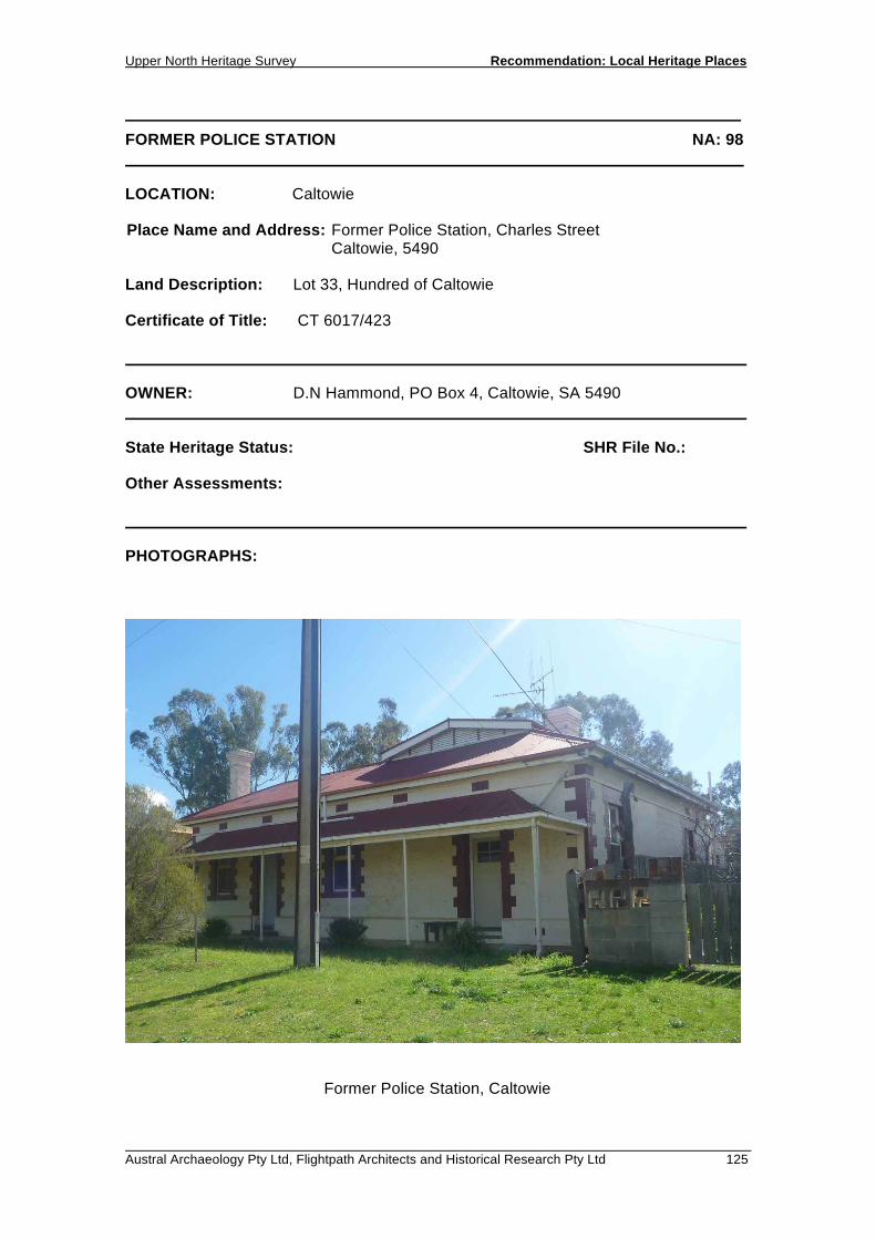
FORMER POLICE STATION NA: 98 LOCATION: Caltowie Place Name and Address: Former Police Station, Charles Street Caltowie, 5490 Land Description: Lot 33, Hundred of Caltowie Certificate of Title: CT 6017/423 OWNER: D.N Hammond, PO Box 4, Caltowie, SA 5490 State Heritage Status: SHR File No.: Other Assessments: PHOTOGRAPHS:
Former Police Station, Caltowie

Recommendation: Local Heritage Places Upper North Heritage Survey
126 Austral Archaeology Pty Ltd, Flightpath Architects and Historical Research Pty Ltd
FORMER POLICE STATION NA: 98 DESCRIPTION: A single storey Victorian style cottage of rendered stone construction with brick quoins. The hipped roof is of corrugated iron and has a stout chimney. The front façade has two entry points, one with windows on either side. The verandah is concave in profile and clad in corrugated iron with metal columns that have replaced the original posts. The roof line has been altered with an additional gable built above the hipped roof. HISTORY: The Police Station was built in 1882 to accommodate the Police Troopers who had been assigned to Caltowie over the previous five years. Prisoner cells were also constructed at the same time as the main building. A kitchen was added in 1924 and a sleep-out in 1946 by H.H Larsson. An early Caltowie District Map shows that there were paddocks located south of Caltowie, consisting of 52 acres, dedicted to the police horses. The paddocks were the property of the Caltowie Police up until 1899, and are currently owned by Peter Lehman. The Police Station was in full use up until October 1964, when the station was opened only half a day a week from Jamestown. The station finally closed on the 21st of February 1966. The Police Station is currently a private residence. STATEMENT OF HERITAGE VALUE: The former Police Station is a good example of the growth and development of the small pastoral town of Caltowie as a civic building located adjacent the post office. RELEVANT CRITERIA: (a) It displays historical and social themes that are of importance to the local area. REFERENCES: Henderson, Doug, & Caltowie Memorial Hall and Progress Association Inc. ‘Caltowie Revisited’. Emm & Dee Publishing, Jamestown. 2006. P 55-56

Upper North Heritage Survey Recommendation: Local Heritage Places
Austral Archaeology Pty Ltd, Flightpath Architects and Historical Research Pty Ltd 127
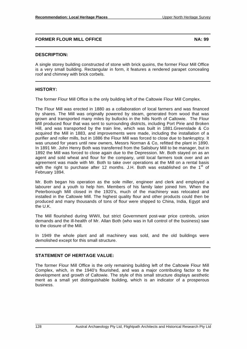
FORMER FLOUR MILL OFFICE NA: 99 LOCATION: Caltowie Place Name and Address: Former Flour Mill Office, South Terrace Caltowie, 5490 Land Description: Hundred of Caltowie Certificate of Title: CT 5795/587 OWNER: A.E & S.L Lang, PO Box 38, Caltowie, SA 5490 State Heritage Status: SHR File No.: Other Assessments: PHOTOGRAPHS:
Former Flour Mill Office, Caltowie
Recommendation: Local Heritage Places Upper North Heritage Survey
128 Austral Archaeology Pty Ltd, Flightpath Architects and Historical Research Pty Ltd
FORMER FLOUR MILL OFFICE NA: 99 DESCRIPTION: A single storey building constructed of stone with brick quoins, the former Flour Mill Office is a very small building. Rectangular in form, it features a rendered parapet concealing roof and chimney with brick corbels. HISTORY: The former Flour Mill Office is the only building left of the Caltowie Flour Mill Complex. The Flour Mill was erected in 1880 as a collaboration of local farmers and was financed by shares. The Mill was originally powered by steam, generated from wood that was grown and transported many miles by bullocks in the hills North of Caltowie. The Flour Mill produced flour that was sent to surrounding districts, including Port Pirie and Broken Hill, and was transported by the train line, which was built in 1881.Greenslade & Co acquired the Mill in 1883, and improvements were made, including the installation of a purifier and roller mills, but in 1886 the Flour Mill was forced to close due to bankruptcy. It was unused for years until new owners, Messrs Norman & Co, refitted the plant in 1890. In 1891 Mr. John Henry Both was transferred from the Salisbury Mill to be manager, but in 1892 the Mill was forced to close again due to the Depression. Mr. Both stayed on as an agent and sold wheat and flour for the company, until local farmers took over and an agreement was made with Mr. Both to take over operations at the Mill on a rental basis with the right to purchase after 12 months. J.H. Both was established on the 1st of February 1894. Mr. Both began his operation as the sole miller, engineer and clerk and employed a labourer and a youth to help him. Members of his family later joined him. When the Peterborough Mill closed in the 1920’s, much of the machinery was relocated and installed in the Caltowie Mill. The highest quality flour and other products could then be produced and many thousands of tons of flour were shipped to China, India, Egypt and the U.K. The Mill flourished during WWII, but strict Government post-war price controls, union demands and the ill-health of Mr. Allan Both (who was in full control of the business) saw to the closure of the Mill. In 1949 the whole plant and all machinery was sold, and the old buildings were demolished except for this small structure. STATEMENT OF HERITAGE VALUE: The former Flour Mill Office is the only remaining building left of the Caltowie Flour Mill Complex, which, in the 1940’s flourished, and was a major contributing factor to the development and growth of Caltowie. The style of this small structure displays aesthetic merit as a small yet distinguishable building, which is an indicator of a prosperous business.

Upper North Heritage Survey Recommendation: Local Heritage Places
Austral Archaeology Pty Ltd, Flightpath Architects and Historical Research Pty Ltd 129
FORMER FLOUR MILL OFFICE NA: 99 RELEVANT CRITERIA: (a) It displays historical and social themes that are of importance to the local area. (c) It has played an important part in the lives of the local residents. (d) It displays aesthetic merit and design characteristics as a small yet
distinguishable building. REFERENCES: Henderson, Doug, & Caltowie Memorial Hall and Progress Association Inc. ‘Caltowie Revisited’. Emm & Dee Publishing, Jamestown. 2006. P 28

Recommendation: Local Heritage Places Upper North Heritage Survey
130 Austral Archaeology Pty Ltd, Flightpath Architects and Historical Research Pty Ltd

RECOMMENDATION: LOCAL HERITAGE PLACES 5.2 GEORGETOWN


Upper North Heritage Survey Recommendation: Local Heritage Places
Austral Archaeology Pty Ltd, Flightpath Architects and Historical Research Pty Ltd 133
CATHOLIC CHURCH NA: 12 LOCATION: Georgetown Place Name and Address: Catholic Church, 14 Hurtle Street, Georgetown Land Description: Lot 11, Section 49, Hundred of Bundaleer Certificate of Title: 5855/434 OWNER: Catholic Diocese of Port Pirie Inc., 28 Norman Street, Port Pirie, 5540 State Heritage Status: SHR File No.: Other Assessments: PHOTOGRAPHS: FP23 - 16
Catholic Church, Georgetown

Recommendation: Local Heritage Places Upper North Heritage Survey
134 Austral Archaeology Pty Ltd, Flightpath Architects and Historical Research Pty Ltd
CATHOLIC CHURCH NA: 12 DESCRIPTION: A large sandstone building, cruciform in plan, consisting of a main body with front porch and rear naves. It features gable roofs, pointed arch windows and rendered buttresses. The prominence of the building is reinforced by its large and robust features such as a rusticated sandstone plinth, rendered buttresses and simple cement rendered crucifix finials and gable coping. HISTORY: A foundation stone reads: 'A.M.D.G. Hunc Lapidem Primarium Posuit. Rev. Mons. A Killian D. Oct 18th 1925.'. Notable are the highly detailed leadlight windows, the design of which incorporates flowers, a picture of the Blessed Virgin Mary and wording such as 'BVM', 'IHS' and 'PAX'. STATEMENT OF HERITAGE VALUE: Since 1925 the Catholic Church has had, and maintains, a significant presence both physically and in the lives of the local community. The largest of Georgetown’s three churches, the building is located in an elevated position overlooking the town’s main street to the east. The scale, proportions and detailing contribute to what is a very good example of such ecclesiastical architecture in the region. RELEVANT CRITERIA: (c It has played an important part in the life of local residents in having been the
town’s Catholic Church since 1925. (d) It displays aesthetic merit and design characteristics of significance to the local
area in being a substantial and well detailed example of ecclesiastical architecture in the region.
REFERENCES:
Upper North Heritage Survey Recommendation: Local Heritage Places
Austral Archaeology Pty Ltd, Flightpath Architects and Historical Research Pty Ltd 135
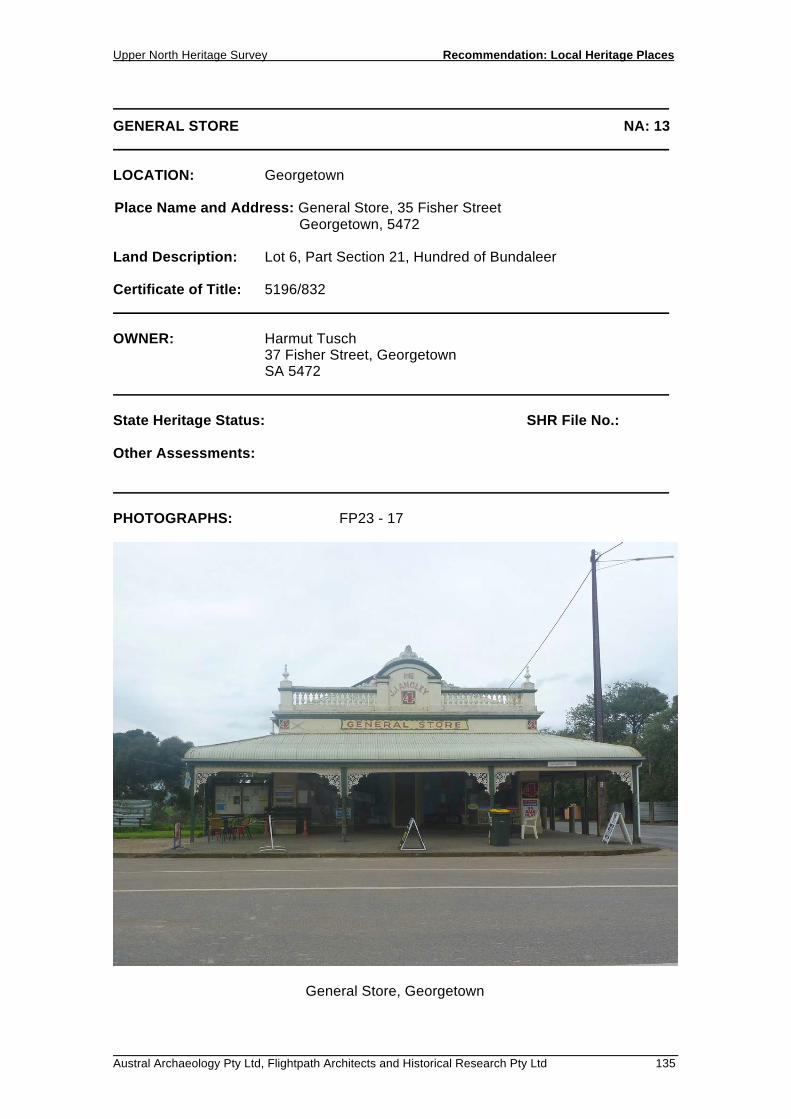
GENERAL STORE NA: 13 LOCATION: Georgetown Place Name and Address: General Store, 35 Fisher Street Georgetown, 5472 Land Description: Lot 6, Part Section 21, Hundred of Bundaleer Certificate of Title: 5196/832 OWNER: Harmut Tusch 37 Fisher Street, Georgetown SA 5472 State Heritage Status: SHR File No.: Other Assessments: PHOTOGRAPHS: FP23 - 17
General Store, Georgetown

Recommendation: Local Heritage Places Upper North Heritage Survey
136 Austral Archaeology Pty Ltd, Flightpath Architects and Historical Research Pty Ltd
GENERAL STORE NA: 13 DESCRIPTION: Large, single-storey corner building constructed of pointed sandstone, with a Dutch-gable roof concealed by a balustered parapet and pediment. The Fisher Street frontage features a twin-glazed shop front and prominent bullnose verandah with ornate lace brackets. Low-level windows on the Pitts Street elevation indicate a cellar. Internally, the building features a pressed metal ceiling and timber staircase to the basement. HISTORY: Lettering on the pediment reads: ‘1912 J.J. Ancley’ STATEMENT OF HERITAGE VALUE: The building makes a significant contribution to the character of the town. The integrity of the street façade in particular, plays an important part in the character of Fisher Street, the town’s main street. It is an excellent example of an early twentieth century retail building, notable for the highly detailed street façade. The balustered parapets, with pediment and masonry finials, are particularly interesting, as is the substantial verandah. RELEVANT CRITERIA: (d) It displays aesthetic merit and design characteristics of significance to the local
area, as an excellent example of an early twentieth century rural general store that makes significant contributions to the streetscape and character of the town.
REFERENCES:

Upper North Heritage Survey Recommendation: Local Heritage Places
Austral Archaeology Pty Ltd, Flightpath Architects and Historical Research Pty Ltd 137
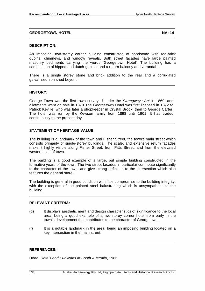
GEORGETOWN HOTEL NA: 14 LOCATION: Georgetown Place Name and Address: Georgetown Hotel, Fisher Street, Georgetown, 5472 Land Description: Lot 1, Section 29, Hundred of Bundaleer Certificate of Title: 5313/986 OWNER: Joseph Alvaro 24 Marlborough Street, Fulham Gardens SA 5024 State Heritage Status: SHR File No.: Other Assessments: PHOTOGRAPHS: FP23 - 18
Hotel, Georgetown
Recommendation: Local Heritage Places Upper North Heritage Survey
138 Austral Archaeology Pty Ltd, Flightpath Architects and Historical Research Pty Ltd
GEORGETOWN HOTEL NA: 14 DESCRIPTION: An imposing, two-storey corner building constructed of sandstone with red-brick quoins, chimneys, and window reveals. Both street facades have large painted masonry pediments carrying the words ‘Georgetown Hotel’. The building has a combination of hipped and dutch-gables, and a return balcony and verandah. There is a single storey stone and brick addition to the rear and a corrugated galvanised iron shed beyond. HISTORY: George Town was the first town surveyed under the Strangways Act in 1869, and allotments went on sale in 1870 The Georgetown Hotel was first licensed in 1872 to Patrick Keville, who was later a shopkeeper in Crystal Brook, then to George Carter. The hotel was run by the Kewson family from 1898 until 1901. It has traded continuously to the present day. STATEMENT OF HERITAGE VALUE: The building is a landmark of the town and Fisher Street, the town's main street which consists primarily of single-storey buildings. The scale, and extensive return facades make it highly visible along Fisher Street, from Pitts Street, and from the elevated western side of town. The building is a good example of a large, but simple building constructed in the formative years of the town. The two street facades in particular contribute significantly to the character of the town, and give strong definition to the intersection which also features the general store. The building is general in good condition with little compromise to the building integrity, with the exception of the painted steel balustrading which is unsympathetic to the building. RELEVANT CRITERIA: (d) It displays aesthetic merit and design characteristics of significance to the local
area, being a good example of a two-storey corner hotel from early in the town’s development that contributes to the character of Georgetown.
(f) It is a notable landmark in the area, being an imposing building located on a
key intersection in the main street. REFERENCES: Hoad, Hotels and Publicans in South Australia, 1986

Upper North Heritage Survey Recommendation: Local Heritage Places
Austral Archaeology Pty Ltd, Flightpath Architects and Historical Research Pty Ltd 139
BAPTIST CHURCH NA: 15 LOCATION: Georgetown Place Name and Address: Baptist Church, 19 Fisher Street, Georgetown 5472 Land Description: Lot 5, Part Section 53, Hundred of Bundaleer Certificate of Title: 5111/946 OWNER: L.J Frost PO Box 8020, Alice Springs NT 8020 State Heritage Status: SHR File No.: Other Assessments: PHOTOGRAPHS: FP23 - 15
Baptist Church, Georgetown

Recommendation: Local Heritage Places Upper North Heritage Survey
140 Austral Archaeology Pty Ltd, Flightpath Architects and Historical Research Pty Ltd
BAPTIST CHURCH NA: 15 DESCRIPTION: Symmetrical gable roof building with front entry porch and large corrugated galvanised iron extension to the side/rear. Construction is of pointed stone with rendered quoins, window reveals, parapet coping, pediment to central frontispiece, and corner spired buttresses. Windows are leadlight pointed arch. Two circular vents are evident on the street facade. HISTORY: A foundation stone indicates that the building was constructed in 1909, and reads: 'This stone was laid by Mrs C. E. King, November 17, 1909.' STATEMENT OF HERITAGE VALUE: The building is of both architectural and social significance. It has provided a place of congregation for the Baptist community since 1909, in what is an interesting and notable building. The style of the building distinguishes it from others in the town and region. It is well proportioned and has a high degree of ornamentation and detailing. Of particular value is the street facade which features masonry spires with wrought-iron finials, a masonry frontispiece with pediment, and leadlight windows. The building is in excellent condition and makes a significant contribution to the character of the town as one of Georgetown's better early buildings. RELEVANT CRITERIA: (c) It has played an important part in the life of local residents, as the Baptist
Church since 1909. (d) It displays aesthetic merit and design characteristics of significance to the local
area, being an ornate early twentieth century church building. REFERENCES:

Upper North Heritage Survey Recommendation: Local Heritage Places
Austral Archaeology Pty Ltd, Flightpath Architects and Historical Research Pty Ltd 141
ST GEORGE'S ANGLICAN CHURCH NA: 16 LOCATION: Georgetown Place Name and Address: St George's Anglican Church, Fisher Street, Georgetown, 5472 Land Description: Lot 818, Section 29, Hundred of Bundaleer Certificate of Title: 1523/139 OWNER: Synod of the Anglican Church of Australia (Diocese of Willochra), 2 Cross Street, Gladstone, 5473 State Heritage Status: SHR File No.: Other Assessments: PHOTOGRAPHS: FP23 - 14
St Georges Anglican Church

Recommendation: Local Heritage Places Upper North Heritage Survey
142 Austral Archaeology Pty Ltd, Flightpath Architects and Historical Research Pty Ltd
ST GEORGE'S ANGLICAN CHURCH NA: 16 DESCRIPTION: Small building with nave, sanctuary, and entry porch, each with gable roof. Constructed of pointed sandstone with red brick quoins, and plinth. Features pointed-arch leadlight windows. Stabilising steel girders are evident on the exterior of the building. HISTORY: The Nave and Sanctuary were built in 1889 to the design of William K Mallyon, a local amateur architect, and cost £162 . The entry porch was completed in 1899, and has an inscription on the foundation stone which reads: 'May 7th A. D. 1898', as well as ‘W.M.’. The church was opened by Bishop Kennion. STATEMENT OF HERITAGE VALUE The building is of both social and architectural value to the town. It has provided an important religious service to the Anglican community since 1889, in what is an elegant example of a church designed by William K Mallyon. Mallyon designed numerous notable church buildings in the region and is considered to have made a valuable contribution to the quality of this building type in the area. Whilst a modest building it is well- proportioned and identifiable with Mallyon’s other buildings. It positively contributes to the character of the town. RELEVANT CRITERIA: (c) It has played an important part in the life of local residents, as a church since
1889. (d) It displays aesthetic merit and design characteristics of significance to the local
area as an elegant, late-nineteenth century, ecclesiastical building, designed by William K Mallyon.
REFERENCES: Fenton, Maurice. W.K.Mallyon 1850 - 1933: a sketchbook of early church architecture in the mid-north, Libraries Board of South Australia, Adelaide, 1971. p62.
Upper North Heritage Survey Recommendation: Local Heritage Places
Austral Archaeology Pty Ltd, Flightpath Architects and Historical Research Pty Ltd 143
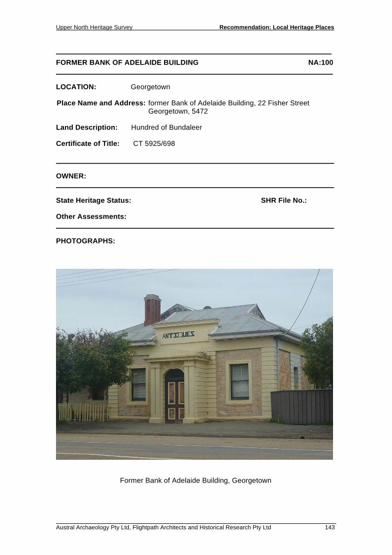
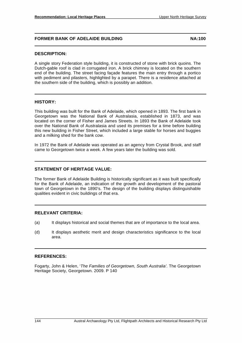
FORMER BANK OF ADELAIDE BUILDING NA:100 LOCATION: Georgetown Place Name and Address: former Bank of Adelaide Building, 22 Fisher Street Georgetown, 5472 Land Description: Hundred of Bundaleer Certificate of Title: CT 5925/698 OWNER: State Heritage Status: SHR File No.: Other Assessments: PHOTOGRAPHS:
Former Bank of Adelaide Building, Georgetown
Recommendation: Local Heritage Places Upper North Heritage Survey
144 Austral Archaeology Pty Ltd, Flightpath Architects and Historical Research Pty Ltd
FORMER BANK OF ADELAIDE BUILDING NA:100 DESCRIPTION: A single story Federation style building, it is constructed of stone with brick quoins. The Dutch-gable roof is clad in corrugated iron. A brick chimney is located on the southern end of the building. The street facing façade features the main entry through a portico with pediment and pilasters, highlighted by a parapet. There is a residence attached at the southern side of the building, which is possibly an addition. HISTORY: This building was built for the Bank of Adelaide, which opened in 1893. The first bank in Georgetown was the National Bank of Australasia, established in 1873, and was located on the corner of Fisher and James Streets. In 1893 the Bank of Adelaide took over the National Bank of Australasia and used its premises for a time before building this new building in Fisher Street, which included a large stable for horses and buggies and a milking shed for the bank cow. In 1972 the Bank of Adelaide was operated as an agency from Crystal Brook, and staff came to Georgetown twice a week. A few years later the building was sold. STATEMENT OF HERITAGE VALUE: The former Bank of Adelaide Building is historically significant as it was built specifically for the Bank of Adelaide, an indication of the growth and development of the pastoral town of Georgetown in the 1890’s. The design of the building displays distinguishable qualities evident in civic buildings of that era. RELEVANT CRITERIA: (a) It displays historical and social themes that are of importance to the local area. (d) It displays aesthetic merit and design characteristics significance to the local
area. REFERENCES: Fogarty, John & Helen, ‘The Families of Georgetown, South Australia’. The Georgetown Heritage Society, Georgetown. 2009. P 140

Upper North Heritage Survey Recommendation: Local Heritage Places
Austral Archaeology Pty Ltd, Flightpath Architects and Historical Research Pty Ltd 145
FORMER COURTHOUSE NA:101 LOCATION: Georgetown Place Name and Address: Former Courthouse, James Street Georgetown, 5472 Land Description: Lot 112, Hundred of Bundaleer Certificate of Title: CT 5167/546 OWNER: D.J Taylor, 40 Dickson Road, Windsor Gardens, SA 5087 State Heritage Status: SHR File No.: Other Assessments: PHOTOGRAPHS:
Courthouse, Georgetown

Recommendation: Local Heritage Places Upper North Heritage Survey
146 Austral Archaeology Pty Ltd, Flightpath Architects and Historical Research Pty Ltd
FORMER COURTHOUSE NA:101 DESCRIPTION: A single story building, rectangular in plan, with a vestibule to the front and eastern side. Similar to the Courthouses in Jamestown and Laura, the Georgetown Courthouse is constructed of rendered stone with proud rendered quoins, plinth and window and door reveals. The hipped roof is clad in corrugated iron. The front vestibule features a parapet with pediment. HISTORY: The Georgetown Courthouse was built alongside the Police Station in 1879. It cost £1077.1.10 to build. It served for quite a few years as a courthouse until it went up for sale and was bought by the Rural Youth Club in 1965. The Georgetown Courthouse was the first clubroom to be purchased by any Rural Youth Club. When the club closed in 1987, the Courthouse was sold to the Innes family. It eventually fell into disrepair and was threatened to be bull-dozed due to its dangerous condition. In 2005 Mr. Derek Taylor, who is an experienced carpenter and builder, purchased the Courthouse and restored the building to its former glory. Mr. Taylor now resides in the Courthouse. STATEMENT OF HERITAGE VALUE: The Courthouse is an important civic building. The authoritative nature of the building is reflected in its formal style, consistent with others in the region. As the first official clubrooms of the Rural Youth Club, the Courthouse played an important part in the lives of local residents. RELEVANT CRITERIA: (a) It displays historical and social themes that are of importance to the local area. (c) It has played an important part in the lives of the local residents as a meeting
place for local groups. (d) It displays aesthetic merit and design characteristics significance to the local
area as an important civic building. REFERENCES: S.A Archives 872 Index to letter book out Colonial Architect 1849-79, 4th May 1877. Tender accepted for Police Station, Hoar & Co., £479.10.0. Completed 17th October 1877. Fogarty, John & Helen, ‘The Families of Georgetown, South Australia’. The Georgetown Heritage Society, Georgetown. 2009. P 267
Upper North Heritage Survey Recommendation: Local Heritage Places
Austral Archaeology Pty Ltd, Flightpath Architects and Historical Research Pty Ltd 147
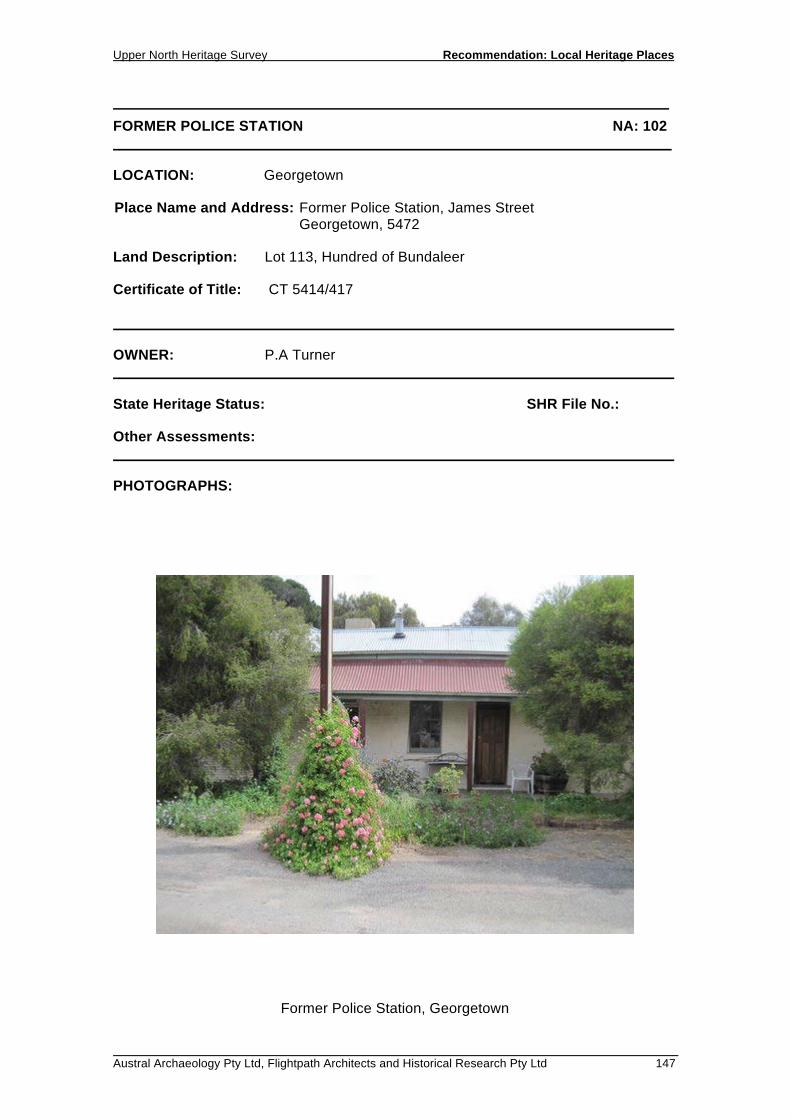
FORMER POLICE STATION NA: 102 LOCATION: Georgetown Place Name and Address: Former Police Station, James Street Georgetown, 5472 Land Description: Lot 113, Hundred of Bundaleer Certificate of Title: CT 5414/417 OWNER: P.A Turner State Heritage Status: SHR File No.: Other Assessments: PHOTOGRAPHS:
Former Police Station, Georgetown

Recommendation: Local Heritage Places Upper North Heritage Survey
148 Austral Archaeology Pty Ltd, Flightpath Architects and Historical Research Pty Ltd
FORMER POLICE STATION NA: 102 DESCRIPTION: A single storey cottage of rendered stone construction with a corrugated hipped roof and two rendered chimneys. The building is rectangular in form. The front façade is double fronted with two entry doors with windows on either side. A corrugated iron verandah runs along the front of the building and is supported by timber posts. HISTORY: Built alongside the Courthouse, the Police Station was completed on the 17th of October 1877. The tender was won by J. Hoar & Co for £179 and cost £479.10.0 to build. For a while before the Police Station was built, the Policemen, who were visiting police from neighboring towns, would reside in the Hotel and would chain prisoners to the hotel stables. Police cells were erected in 1855, which are located behind the Police Station. The coach house, also located behind the Police Station still exists. The former Police Station is now currently a private residence. STATEMENT OF HERITAGE VALUE: The former Police Station is an important civic building located adjacent to the original courthouse, which increases the heritage value of the place as it is a good example of a well organized civic precinct. RELEVANT CRITERIA:
(a) It displays historical and social themes that are of importance to the local area as an early authoritative civic building.
REFERENCES: S.A Archives 871 - Colonial Architect Out Letter Book, 10th May, 1875. P. 747,753. S.A Archives 872 Index to letter book (out) Colonial Architect 1849-79, 4th May 1877. P. 123 Fogarty, John & Helen, ‘The Families of Georgetown, South Australia’. The Georgetown
Heritage Society, Georgetown. 2009. P 267 The National Trust of South Australia, 3rd March 1966. ref. 497

RECOMMENDATION: LOCAL HERITAGE PLACES 5.3 GLADSTONE


District Council of the Upper North Heritage Survey 2010 Recommendation: Local Heritage Places
Austral Archaeology Pty Ltd, Flightpath Architects and Historical Research Pty Ltd 151
ALDAYNE SHOPS NA: 17 LOCATION: Gladstone Place Name and Address: Aldayne Shops, 28 - 34 Gladstone Street, Gladstone, 5473 Land Description: Lot 254, Plan 240301, Hundred of Booyoolie Certificate of Title: 219/239 OWNER: T.J & S Zander 27 High Street, Gladstone SA 5473 State Heritage Status: SHR File No.: Other Assessments: PHOTOGRAPHS: FP25 - 04
Aldayne Shops, Gladstone

Recommendation: Local Heritage Places District Council of the Upper North Heritage Survey 2010
152 Austral Archaeology Pty Ltd, Flightpath Architects and Historical Research Pty Ltd
ALDAYNE SHOPS NA: 17 DESCRIPTION: A painted stone and red-brick building with a rendered parapet and cantilevered verandah along the Gladstone Terrace frontage. A small porch on the Fourth Street facade protects an entry to the rear of the building. A symmetrical pediment and rendered parapet carrying the words 'ALDAYNE BUILDINGS' in relief conceals the dutch-gable roof beyond and presents a unified building to the street. This is consistent with other strip-shops in rural main streets. The building, specifically the shopfronts, are in excellent condition and maintain much of the buildings architectural integrity. HISTORY: Gladstone was surveyed and allotments were offered for sale in 1872. The town was on the route of the Port Pirie to Petersburg railway from 1876, and rapidly became a major commercial centre and an important railway junction. The shops date from Gladstone's commercial heyday. STATEMENT OF HERITAGE VALUE: The ‘Aldayne Shops’ present the best example of main street retail buildings in Gladstone. Of particular importance and value is the Gladstone Terrace facade which consists of four identical articulated shopfronts with display windows flanking the entrance with decorative black tiling to the otherwise rendered walls. RELEVANT CRITERIA: (d) It displays aesthetic merit and design characteristics of significance to the local
area as an excellent example of early twentieth century retail architecture in the main commercial street of Gladstone.
REFERENCES:
District Council of the Upper North Heritage Survey 2010 Recommendation: Local Heritage Places
Austral Archaeology Pty Ltd, Flightpath Architects and Historical Research Pty Ltd 153
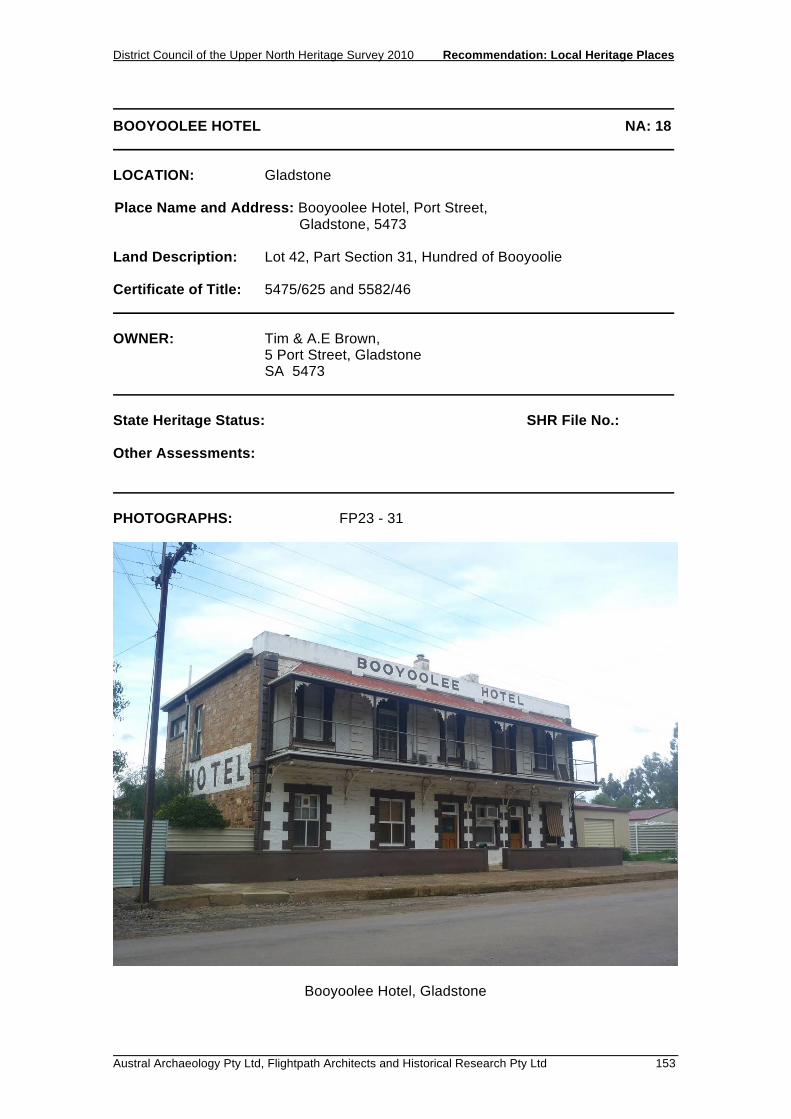
BOOYOOLEE HOTEL NA: 18 LOCATION: Gladstone Place Name and Address: Booyoolee Hotel, Port Street, Gladstone, 5473 Land Description: Lot 42, Part Section 31, Hundred of Booyoolie Certificate of Title: 5475/625 and 5582/46 OWNER: Tim & A.E Brown, 5 Port Street, Gladstone SA 5473 State Heritage Status: SHR File No.: Other Assessments: PHOTOGRAPHS: FP23 - 31
Booyoolee Hotel, Gladstone

Recommendation: Local Heritage Places District Council of the Upper North Heritage Survey 2010
154 Austral Archaeology Pty Ltd, Flightpath Architects and Historical Research Pty Ltd
BOOYOOLEE HOTEL NA: 18 DESCRIPTION: A two storey Federation-style building, constructed of sandstone with the front facade painted white with contrasting brown quoins, sills and keystones. It features a cantilevered balcony supported by ornate metal brackets, an upper level verandah with lacework trim, a rendered parapet, and rendered chimneys. At the rear of the hotel is a single storey lean-to section in matching unpainted stonework. HISTORY: The Booyoolee Hotel was built as a single storey building in 1873, indicated in the signage on the side of the building which reads: 'HOTEL EST. 1873' The first licensee was William C. Greenslade, followed by Patrick Blake. In 1880, Mr. Blake added the second storey. The hotel saw a number of long serving licensees, including Alice Amy Leverington, proprietor from November 1906 until January 1922. Some considerable changes have been made to the facade of the building with the original balustrading replaced with galvanised mesh fencing, and the entablature, dentals and pediment replaced with a simple rendered parapet with the following painted signage: 'Booyoolee Hotel'. STATEMENT OF HERITAGE VALUE: The Booyoolee Hotel is important for the continual social function it has provided since being built as the town’s first hotel in 1873. Its position relative to the railway line indicates the once vital role that the railway played in the town, and indeed the prosperity that the hotel enjoyed during the thriving years. RELEVANT CRITERIA: (c) It has played an important part in the life of local residents as a prominent and
important social venue since 1873. REFERENCES: Gladstone: a meeting of creeks, a breaking of gauges, Gladstone Centenary Committee, Gladstone, 1980.

District Council of the Upper North Heritage Survey 2010 Recommendation: Local Heritage Places
Austral Archaeology Pty Ltd, Flightpath Architects and Historical Research Pty Ltd 155
FORMER BUTTER FACTORY NA: 19 LOCATION: Gladstone Place Name and Address: Former Butter Factory, Bondowie Road, Gladstone, 5473 Land Description: Lot 1, Part Section 172, Hundred of Yangya Certificate of Title: 5505/523 OWNER: Gladstone Senior Citizens Club Inc., High Street, Gladstone, 5473 State Heritage Status: SHR File No.: Other Assessments: PHOTOGRAPHS: FP23 - 28
Former Butter Factory, Gladstone

Recommendation: Local Heritage Places District Council of the Upper North Heritage Survey 2010
156 Austral Archaeology Pty Ltd, Flightpath Architects and Historical Research Pty Ltd
FORMER BUTTER FACTORY NA: 19 DESCRIPTION: A substantial, symmetrical stone building of painted and limewashed stonework with rendered quoins and corrugated galvanised iron single storey skillion-roofed side extensions. The substantial parapet carries the following lettering: 'R.J. Finlayson Pty Ltd Butter Factory.' HISTORY: The building was originally used as a hall for roller skating until 1922 when it was purchased by R J Finlayson and converted to the butter factory. The business continued to operate as R J Finlayson Pty Ltd until 1965 when the majority shareholding was obtained by the South Australia Farmers Union and became known as R J Finlayson Pty and Dairy Merchants. Production apparently stopped some time before 1980. It now appears to be used as the Gladstone Senior Citizen’s Club and a paper depot. STATEMENT OF HERITAGE VALUE: The building is significant as evidence of a previously important economic activity in the town that operated from 1922. Whilst butter production was relatively common in the towns of the region, it is a service markedly different from the prevailing industries of today, and reflects the changing economic conditions of the town. RELEVANT CRITERIA: a) It displays economic themes that are of importance to the local area, in being
evidence of an important industry that served the town since 1922. REFERENCES: Gladstone: a meeting of creeks, a breaking of gauges, Gladstone Centenary Committee, Gladstone, 1980.

District Council of the Upper North Heritage Survey 2010 Recommendation: Local Heritage Places
Austral Archaeology Pty Ltd, Flightpath Architects and Historical Research Pty Ltd 157
COMMERCIAL HOTEL NA: 20 LOCATION: Gladstone Place Name and Address: Commercial Hotel, Gladstone Street, Gladstone, 5473 Land Description: Lot 501, Section 192, Hundred of Booyoolie Certificate of Title: 5114/314 OWNER: Rolf Heinz and Susan Gail Schack Commercial Hotel, Gladstone Street, Gladstone 5473 State Heritage Status: SHR File No.: Other Assessments: PHOTOGRAPHS: FP25 - 10
Commercial Hotel, Gladstone

Recommendation: Local Heritage Places District Council of the Upper North Heritage Survey 2010
158 Austral Archaeology Pty Ltd, Flightpath Architects and Historical Research Pty Ltd
COMMERCIAL HOTEL NA: 20 DESCRIPTION: A two-storey painted sandstone building with a return verandah and balcony, and a mitred corner housing the entrance. The hipped roof features several prominent rendered chimneys. On the Cross Street facade there is a two-storey, parapeted sandstone section with construction and fenestration matching the main building. Abutting the hotel on the Gladstone Terrace facade is a single storey building. The original facade of this building has been unsympathetically altered by the construction of a brown brick front wall with arched windows and door. The upper level balcony is a subsequent addition. HISTORY: The Commercial Hotel was built in 1879, opening in September under license to Heinrich Wilhelm Adolph Mueller. Mueller was proprietor until 1899, when the license was transferred to Edward Peter Coe, a native of Gladstone, having been born there in 1876. He was only proprietor for about three months, then the hotel passed into the hands of the Cook family, who ran it for thirteen years. The hotel has traded continuously to the present day. STATEMENT OF HERITAGE VALUE: The Commercial Hotel makes an important contribution to the built fabric of Gladstone. The prominent location on one of the town’s largest intersections, coupled with the substantial scale and form, position it as a major landmark. It defines what was the busy commercial precinct that capitalised on the presence of the railway opposite. Whilst the railway no longer operates, and the commercial role of the area is diminished, it still positively contributes to the existing streetscape, and toward an understanding of the operation of the town during previous times of prosperity. The building is a good example of a Victorian hotel, built of stone and featuring painted quoins and plinth course. Of particular value is the integrity of the street facades including the parapeted section on Cross Street, the rendered chimneys and the balcony and verandahs featuring decorative lacework and balustrading. RELEVANT CRITERIA: (d) It displays aesthetic merit of significance to the local area, as a good example
of a two-storey Victorian Hotel. (f) It is a notable landmark in the area, being a substantial building on an
important intersection in the town. REFERENCES: Gladstone: a meeting of creeks, a breaking of gauges, Gladstone Centenary Committee, Gladstone, 1980.

District Council of the Upper North Heritage Survey 2010 Recommendation: Local Heritage Places
Austral Archaeology Pty Ltd, Flightpath Architects and Historical Research Pty Ltd 159
FORMER BANK NA: 21 LOCATION: Gladstone Place Name and Address: Former Bank, 36 Gladstone Terrace, Gladstone, 5473 Land Description: Lots 200 and 253, Plan 240301, Hundred of Booyoolie Certificate of Title: 5669/287 OWNER: H.B Brunnett 36 Gladstone Street, Gladstone SA 5473 State Heritage Status: SHR File No.: Other Assessments: PHOTOGRAPHS: FP25 - 03
Former Bank, Gladstone

Recommendation: Local Heritage Places District Council of the Upper North Heritage Survey 2010
160 Austral Archaeology Pty Ltd, Flightpath Architects and Historical Research Pty Ltd
FORMER BANK NA: 21 DESCRIPTION: A single-storey sandstone building with a symmetrical facade fronting Gladstone Terrace. This facade is rendered and painted white, whilst the side walls are rough sandstone. To the rear of the building is a cottage of pointed sandstone, red-brick quoins and a hipped-roof. HISTORY: Gladstone was surveyed and allotments were offered for sale in 1872. The town was on the route of the Port Pirie-Petersburg railway from 1876, and rapidly became a major commercial centre and an important railway junction. The former bank expresses the commercial strength of Gladstone in its heyday. STATEMENT OF HERITAGE VALUE: The building plays an important role in defining the west side of Gladstone Terrace, currently and historically, the primary commercial precinct of the town. It is a small stone building which conveys a sense of importance and dignity through the robust, overscaled features such as the rendered pilasters and entablature, and is quite distinct from other buildings in the street. RELEVANT CRITERIA: (d) It displays aesthetic merit of significance to the local area as a robust
commercial building. REFERENCES:

District Council of the Upper North Heritage Survey 2010 Recommendation: Local Heritage Places
Austral Archaeology Pty Ltd, Flightpath Architects and Historical Research Pty Ltd 161
FREEMASONS' HALL (FORMER METHODIST CHURCH) NA: 22 LOCATION: Gladstone Place Name and Address: Freemasons Hall, 32 High Street, Gladstone, 5473 Land Description: Lot 85, Plan 240301, Hundred of Booyoolie Certificate of Title: 5309/656 OWNER: T.J & S Zander, 32 High Street, Gladstone SA 5473 State Heritage Status: SHR File No.: Other Assessments: PHOTOGRAPHS: FP25 - 16
Freemasons' Hall, Gladstone

Recommendation: Local Heritage Places District Council of the Upper North Heritage Survey 2010
162 Austral Archaeology Pty Ltd, Flightpath Architects and Historical Research Pty Ltd
FREEMASONS' HALL (FORMER METHODIST CHURCH) NA: 22 DESCRIPTION: A large, rectangular stone building on a significant rendered plinth, with an entry porch and extension to the rear, each with a gable roof. Quoins and window sills are rendered and painted white. Each side has three arched windows. The front porch has an arched entry that has been filled with sandstone, and the pre-existing steps to the elevated entry have since been removed. HISTORY: The Freemasons were first consecrated in Gladstone in 1912 as the Gladstone Lodge No 71 and originally met in the Church of England Parish Hall. On 10 May, 1919 they bought the present building from the Methodist Church. The building was constructed in 1875 and opened as the Bible Christian Church on Sunday 28 May 1876. Of note is the removal of the original masonry bell-cote, the blocking in of the front entry, and the substantial extension to the rear. STATEMENT OF HERITAGE VALUE: The simple, monumental building is consistent with other Masonic Halls in the region, and provides substantial physical evidence of the service that it has provided an important community group since 1919, as well as its role as a church since 1876. RELEVANT CRITERIA: (c) It has played an important part in the life of local residents, firstly as the Bible
Christian Church in 1876, and then as the meeting place for the Freemasons since 1919.
REFERENCES: Gladstone: a meeting of creeks, a breaking of gauges. Gladstone Centenary Committee, Gladstone, 1980.

District Council of the Upper North Heritage Survey 2010 Recommendation: Local Heritage Places
Austral Archaeology Pty Ltd, Flightpath Architects and Historical Research Pty Ltd 163
GLADSTONE HOTEL NA: 23 LOCATION: Gladstone Place Name and Address: Gladstone Hotel, Bondowie Road, Gladstone, 5473 Land Description: Lots 91/92/93 and 94, Part Section 172, Hundred of Yangya Certificate of Title: 5389/476 OWNER: Honen Management Pty. Ltd., PO Box 111, Cockatoo Valley SA 5351 State Heritage Status: SHR File No.: Other Assessments: PHOTOGRAPHS: FP23 - 27
Gladstone Hotel, Gladstone

Recommendation: Local Heritage Places District Council of the Upper North Heritage Survey 2010
164 Austral Archaeology Pty Ltd, Flightpath Architects and Historical Research Pty Ltd
GLADSTONE HOTEL NA: 23 DESCRIPTION: A two-storey stone building with return verandah and balcony. Features include a rendered parapet and painted stone walls with contrasting quoins. A single storey addition appears to the side of the building on the Bondowie Road elevation. HISTORY: The Gladstone Hotel was built in 1875. The Gladstone Hotel was built in 1875; the first licensee was Edward Martin. In 1879 the hotel then passed into the ownership of the father of C J Dennis, James Dennis, who in 1880 made significant internal changes to the building. He retained the license until 1892 when it passed to Evan McKay. Changes have since occurred to the balconies, balustrading, the parapet and the stone walls and quoins have been painted. The hotel has traded continuously to the present day. STATEMENT OF HERITAGE VALUE: The building has had a strong physical and social presence in the town since 1875, when it first offered its vital social service to the community. It is a substantial building located in a highly visible intersection within the town. It makes a significant contribution to the streetscape and is a landmark in a section of the town dominated by smaller-scale residential buildings. RELEVANT CRITERIA: (c) It has played an important part in the life of local residents as a social venue
since 1875. (f) It is a notable landmark in the area, prominently located on an important
intersection in the town. REFERENCES: Gladstone: a meeting of creeks, a breaking of gauges, Gladstone Centenary Committee, Gladstone, 1980.
District Council of the Upper North Heritage Survey 2010 Recommendation: Local Heritage Places
Austral Archaeology Pty Ltd, Flightpath Architects and Historical Research Pty Ltd 165
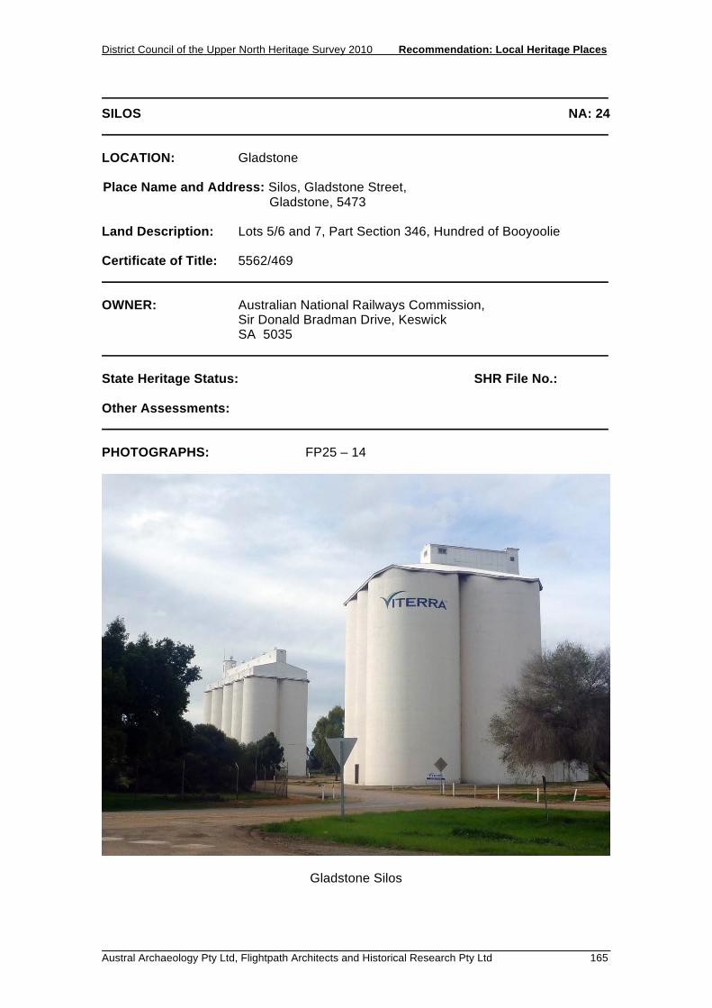
SILOS NA: 24 LOCATION: Gladstone Place Name and Address: Silos, Gladstone Street, Gladstone, 5473 Land Description: Lots 5/6 and 7, Part Section 346, Hundred of Booyoolie Certificate of Title: 5562/469 OWNER: Australian National Railways Commission, Sir Donald Bradman Drive, Keswick SA 5035 State Heritage Status: SHR File No.: Other Assessments: PHOTOGRAPHS: FP25 – 14
Gladstone Silos

Recommendation: Local Heritage Places District Council of the Upper North Heritage Survey 2010
166 Austral Archaeology Pty Ltd, Flightpath Architects and Historical Research Pty Ltd
SILOS NA: 24 DESCRIPTION: One silo consists of four large concrete chambers, and the other silo has ten smaller chambers. HISTORY: Strangely, South Australia was one of the last major wheat-producing regions in the world to adopt bulk grain handling. Whereas New South Wales, Western Australia and Victoria were doing away with bagged wheat from the 1920s onward, it was not until 1952 that the first silos were built at Ardrossan, and bulk handling began on a trial basis in the northern Yorke Peninsula and part of the Upper North. In 1955 South Australian Co-operative Bulk Handling Ltd was established to oversee the new technology. The first silos in the Upper North were built at Redhill and Gulnare in 1956, supplying the Ardrossan terminal. With the construction of bulk handling terminals at Wallaroo in 1956 and Port Pirie in 1957, the way was open for silos throughout the region. By 1962 there were silos at Andrews, Gladstone, Laura, Hallett, Jamestown, Caltowie, Yongala, Booleroo, Melrose, Orroroo and Wilmington. The new silos were towering landmarks; the tall white cylinders were the largest structures that had ever been built in the district and could be seen from every farm in the Hundred and beyond. STATEMENT OF HERITAGE VALUE: Located on the railway line and adjacent to the main commercial street in the town, the silo structures provide physical evidence of two important economic components of the region - the wheat industry and the railway. They are large, vertical elements in a relatively flat landscape, and are highly visible markers of the town. RELEVANT CRITERIA: (a) It displays economic themes that are of importance to the local area, providing
physical evidence of the importance of both the wheat industry and the railway.
(f) It is a notable landmark in the area as a substantial and highly visible
structure. REFERENCES: Lamshed, M., Grain is Better in Bulk, 1962

District Council of the Upper North Heritage Survey 2010 Recommendation: Local Heritage Places
Austral Archaeology Pty Ltd, Flightpath Architects and Historical Research Pty Ltd 167
KINDERGARTEN NA: 25 LOCATION: Gladstone Place Name and Address: Kindergarten, James Street, Gladstone, 5473 Land Description: Section 348, Plan 241400, Hundred of Yangya Certificate of Title: 24 1400/0348 OWNER: Minister for Education Children’s Services and Training, GPO Box 1047, Adelaide SA 5000 State Heritage Status: SHR File No.: Other Assessments: PHOTOGRAPHS: FP23 - 30
Kindergarten, Gladstone

Recommendation: Local Heritage Places District Council of the Upper North Heritage Survey 2010
168 Austral Archaeology Pty Ltd, Flightpath Architects and Historical Research Pty Ltd
KINDERGARTEN NA: 25 DESCRIPTION: The kindergarten consists of an elegant sandstone building with red brick quoins. Windows are in sets of three and have contrasting rendered and painted lintels and sills. Roof is a dutch gable with articulated red-brick chimneys. At the rear and side of the building is a mock weatherboard lean-to extension with pergolas. HISTORY: A foundation stone reads 'This stone was laid by The Hon. J. G. Bice M. L. C. Chief Secretary on 29th September 1913. STATEMENT OF HERITAGE VALUE: The building is important for the service it has provided to the community since 1913 as a kindergarten. The modest building is a simple, elegant example of an early twentieth century educational building, consistent with others in the region. It is in excellent condition with the original integrity generally intact, and contributes to the character of the town. RELEVANT CRITERIA: (c) It has played an important part in the life of local residents, providing education
to the community since 1913. (d) It displays aesthetic merit and design characteristics of significance to the local
area, as a good, early-twentieth century, educational building. REFERENCES:

District Council of the Upper North Heritage Survey 2010 Recommendation: Local Heritage Places
Austral Archaeology Pty Ltd, Flightpath Architects and Historical Research Pty Ltd 169
PRIMARY SCHOOL NA: 26 LOCATION: Gladstone Place Name and Address: Primary School, 21 West Terrace, Gladstone, 5473 Land Description: Sections 486/434/483 and 407, Plan 240300, Hundred of Booyoolie Certificate of Title: 5659/673, 24 0300/0483, 5628/704 and 24 0300/0486 OWNER: Minister for Education Children’s Services and Training, 31 Flinders Street, Adelaide SA 5000 State Heritage Status: SHR File No.: Other Assessments: PHOTOGRAPHS: FP23 - 21
Primary School, Gladstone
Recommendation: Local Heritage Places District Council of the Upper North Heritage Survey 2010
170 Austral Archaeology Pty Ltd, Flightpath Architects and Historical Research Pty Ltd
PRIMARY SCHOOL NA: 26 DESCRIPTION: Set among assorted school buildings, the early building is a simple, single storey, sandstone structure with red-brick quoins and rendered sills. It features an ornate rendered porch with pilasters, a dutch-gable roof and a linear arrangement of four brick chimneys with rendered capping. There is a sympathetic sandstone and brick extension to the north-east and the northern verandah has been enclosed with timber infill and glazing. HISTORY: Between 1875 and 1929 the Primary School operated from a building on James Street. On Friday 26 July 1929, the new building was opened by the Minister of Education, Mr M. McIntosh. It was built by Fricker Bros of Port Adelaide using stone from Mr S Ballantyne’s quarry. Other school buildings have subsequently been built on the site. STATEMENT OF HERITAGE VALUE: The building is a simple, elegant sandstone and red-brick structure that has provided an education service to the local and regional community since 1929. It is important for both its contribution to the social and physical development of the town. RELEVANT CRITERIA: (c) It has played an important part in the life of local residents, providing
educational opportunities to the community since 1929. (d) It displays aesthetic merit of significance to the local area, in being a good
example of early twentieth century school architecture. REFERENCES: Gladstone: a meeting of creeks, a breaking of gauges, Gladstone Centenary Committee, Gladstone, 1980

District Council of the Upper North Heritage Survey 2010 Recommendation: Local Heritage Places
Austral Archaeology Pty Ltd, Flightpath Architects and Historical Research Pty Ltd 171
RAILWAY STATION NA: 27 LOCATION: Gladstone Place Name and Address: Railway Station, Gladstone Street, Gladstone, 5473 Land Description: Lots 5/6 and 7, Part Section 346, Hundred of Booyoolie Certificate of Title: 5562/469 OWNER: Australian National Railways Commission, Sir Donald Bradman Drive, Keswick SA 5035 State Heritage Status: SHR File No.: Other Assessments: PHOTOGRAPHS: FP23 - 32
Railway Station, Gladstone

Recommendation: Local Heritage Places District Council of the Upper North Heritage Survey 2010
172 Austral Archaeology Pty Ltd, Flightpath Architects and Historical Research Pty Ltd
RAILWAY STATION NA: 27 DESCRIPTION: A combination of a long single storey section and a large two-storey section. The single storey building is painted stone with dutch-gable and gable roofs, and has two chimneys. A verandah runs along the platform to the west. The two-storey section is of matching painted stone and also features a mixture of dutch-gable and gable roofs. Many of the timber-framed windows have been smashed or covered with galvanised steel sheet. HISTORY: The railway line first began operating to Gladstone in 1877 and had a profound effect on the economic and physical development of the town. The current Railway Station replaced the original building(s) in 1927. STATEMENT OF HERITAGE VALUE: The building makes an important contribution to the main economic precinct in the town. It is a landmark building that is highly visible from the main street, which itself is located where it is as a result of the railway. The scale and presence of the station reflects a bygone time of prosperity in the town where the railways played a crucial role in the physical and economic development of the town. RELEVANT CRITERIA: a) It displays historical, economic and social themes that are of importance to the
local area, in being a direct indicator the importance of the railway, one of the major influences and contributors to the establishment of the town.
(f) It is a notable landmark in the area, being a substantial building located in a
prominent position opposite the main commercial street of the town. REFERENCES: Gladstone: a meeting of creeks, a breaking of gauges. Gladstone Centenary Committee, Gladstone, 1980.

District Council of the Upper North Heritage Survey 2010 Recommendation: Local Heritage Places
Austral Archaeology Pty Ltd, Flightpath Architects and Historical Research Pty Ltd 173
SCOUT HALL NA: 28 LOCATION: Gladstone Place Name and Address: Scout Hall, James Street, Gladstone, 5473 Land Description: Section 343, Plan 241400, Hundred of Yangya Certificate of Title: 24 1400/0343 OWNER: Northern Areas Council, PO Box 120, Jamestown, 5491 State Heritage Status: SHR File No.: Other Assessments: PHOTOGRAPHS: FP23 - 29
Scout Hall, Gladstone

Recommendation: Local Heritage Places District Council of the Upper North Heritage Survey 2010
174 Austral Archaeology Pty Ltd, Flightpath Architects and Historical Research Pty Ltd
SCOUT HALL NA: 28 DESCRIPTION: The building consists of two connected single-storey sections which form a hammer-head plan. Fronting James Street is a near-symmetrical sandstone hipped roof building of pointed sandstone with matching sandstone quoins and deep-set windows. Five roof vents are visible along the ridge. Perpendicular to this is a gable-roof building of rough sandstone construction with red-brick quoins. It features decorative timber barge boards and 8-pane windows. At the junction of the two masonry sections is a corrugated galvanised iron extension. HISTORY: The building was built as the Primary School in 1875. In 1876, Gladstone School was officially listed as a public school. Extensions were made to the building in 1878. In 1907, the Gladstone Continuation School formed and shared the Primary School building until the new High School was built in 1913. The building continued to serve as the Primary School until the construction of new facilities in 1929. It is currently used as the Gladstone Scout Hall and carries the signage '1st Gladstone'. STATEMENT OF HERITAGE VALUE: Having provided a formal education service as the Primary School and Secondary School, and then a social service as the Scout Hall, the building has played an important part of the lives of many local and regional residents since 1875. Whilst similar in scale and materials, the two elements of the building display distinct and interesting architectural styles. The section fronting James Street is an elegant, simple building with minimal embellishment. The section to the rear is more typical of other educational buildings of the era and region, and is a larger scale, more detailed form featuring decorative elements such as the timber barge boards and windows. Both buildings appear to be in reasonable condition and have maintained their integrity with the exception of a modest corrugated galvanised iron extension to the rear. RELEVANT CRITERIA: (c) It has played an important part in the life of local residents as an educational
and social venue for the community since 1875. (d) It displays aesthetic merit of significance to the local area, as a pairing of
elegant sandstone buildings. REFERENCES: Gladstone: a meeting of creeks, a breaking of gauges, Gladstone Centenary Committee, Gladstone, 1980.

District Council of the Upper North Heritage Survey 2010 Recommendation: Local Heritage Places
Austral Archaeology Pty Ltd, Flightpath Architects and Historical Research Pty Ltd 175
SOLDIERS' MEMORIAL HALL NA: 29 LOCATION: Gladstone Place Name and Address: Soldiers' Memorial Hall, Cross Street, Gladstone, 5473 Land Description: Lot 174, Plan 240301, Hundred of Booyoolie Certificate of Title: 5836/650 OWNER: Northern Areas Council, PO Box 120, Jamestown, 5491 State Heritage Status: SHR File No.: Other Assessments: PHOTOGRAPHS: FP25 - 13
Soldiers' Memorial Hall

Recommendation: Local Heritage Places District Council of the Upper North Heritage Survey 2010
176 Austral Archaeology Pty Ltd, Flightpath Architects and Historical Research Pty Ltd
SOLDIERS' MEMORIAL HALL NA: 29 DESCRIPTION: A large single-storey, gable roofed stone building located behind the Council chambers and District Hall (c.1960). The pointed sandstone structure is complimented with cement rendered parapet coping, mouldings and window reveals. The neo-classical street facade features an ornate entablature and a rendered pediment containing the words in relief: 'Soldiers Memorial Hall'. The entrance is marked by a rendered and painted corner portico featuring a balustered parapet. HISTORY: The Soldiers’ Memorial Hall was built in 1921, with a foundation stone beneath the Fifth Street window reading: 'This stone was laid Nov. 9th 1921 by the mothers of Gladstone Soldiers who fought in the Great War 1914 - 1918.' The unsympathetic adjoining concrete block Council buildings were built in 1960. STATEMENT OF HERITAGE VALUE: The building is significant for architectural and social reasons. It has provided a valuable community service as a Hall and currently as a Library, as well as providing the town’s primary memorial to local soldiers who died in the First World War. The building is valuable architecturally for the interesting neo-classical facade treatments which are relatively uncommon for such a building in the area. RELEVANT CRITERIA: (d) It displays design characteristics of significance to the local area, as one of
few such buildings featuring neo-classical facade elements. (e) It is associated with a notable local event, as a memorial to the local soldiers
who fought in the First World War. REFERENCES: Gladstone: a meeting of creeks, a breaking of gauges, Gladstone Centenary Committee, Gladstone, 1980.

District Council of the Upper North Heritage Survey 2010 Recommendation: Local Heritage Places
Austral Archaeology Pty Ltd, Flightpath Architects and Historical Research Pty Ltd 177
ST ALBAN'S ANGLICAN CHURCH AND HALL NA: 30 LOCATION: Gladstone Place Name and Address: St Albans Anglican Church and Hall, 34 Sixth Street,
Gladstone Land Description: Lot 22, Plan 240301, Hundred of Booyoolie Certificate of Title: 5802/191 OWNER: Synod of the Anglican Church of Australia (Diocese of Willochra), C1-PO Box 6, Georgetown, SA 5472 State Heritage Status: SHR File No.: Other Assessments: PHOTOGRAPHS: FP25 -19
St Albans' Anglican Church and Hall, Gladstone
Recommendation: Local Heritage Places District Council of the Upper North Heritage Survey 2010
178 Austral Archaeology Pty Ltd, Flightpath Architects and Historical Research Pty Ltd
ST ALBAN'S ANGLICAN CHURCH AND HALL NA: 30 DESCRIPTION: The church consists of a main body with side entry porch and large bell tower. Adjacent is the parish hall. Construction of each part is of sandstone with brick quoins, tower parapet, and reveals to gothic fenestration. HISTORY: Construction of St Alban’s Anglican Church was initiated at a meeting of eight local residents on February 18, 1876. In 1890 a chancel, transepts and Sanctuary were constructed to the design of William K Mallyon, a prominent local amateur architect who designed a considerable number of churches in the region. In 1894 Mallyon also designed the tower which ultimately was not erected until 1928. A foundation stone for the tower reads: 'A M + D G this tower was erected A. D. 1928 by members of the family in memory of Herbert Bristow Hughes, Laura Hughes, Herbert White Hughes, benefactors of this church. Requiescant in Pace.' In 1909, the Church Hall was built on the adjoining allotment. The foundation stone on the parish hall reads: 'St Albans Parish Hall this stone was laid by Helen Margaret Hughes 29 July 1908'. Fire significantly damaged the vestry and porch of the church in 1926, and then the hall in 1927. All damage was repaired and reopened in 1928. STATEMENT OF HERITAGE VALUE: Both the Church and Hall have architectural value. The Church is an elegant building with Gothic fenestration, typical of William K Mallyon’s designs found throughout the region. Of particular interest is the tower which features triple-lancet windows at the upper level and castellated parapet with corner turrets. The adjacent Church Hall is a relatively modest building constructed in materials consistent with the Church. The simple form and detailing is consistent with many early twentieth century halls. The pairing of buildings present a good example of a church that has continued to develop since the first building was constructed in 1876. In addition to the merits of the individual buildings, the pair makes a strong contribution to the character of the town. RELEVANT CRITERIA: (d) It displays aesthetic merit and design characteristics of significance to the local
area, being an elegant and distinct nineteenth century Church with elements designed by William Mallyon, and a complimentary twentieth century Church Hall.
REFERENCES: Gladstone: a meeting of creeks, a breaking of gauges, Gladstone Centenary Committee, Gladstone, 1980. Fenton, Maurice. W.K.Mallyon 1850 - 1933: a sketchbook of early church architecture in the Mid-north, Libraries Board of South Australia, Adelaide, 1971.

District Council of the Upper North Heritage Survey 2010 Recommendation: Local Heritage Places
Austral Archaeology Pty Ltd, Flightpath Architects and Historical Research Pty Ltd 179
ST PETER'S CATHOLIC CHURCH NA: 31 LOCATION: Gladstone Place Name and Address: St Peter's Catholic Church, 7 West Terrace, Gladstone, 5473 Land Description: Lots 1/2/3 and 4, Plan 240301, Hundred of Booyoolie Certificate of Title: 5668/137 OWNER: The Catholic Diocese of Port Pirie Inc., PO Box 247, Jamestown SA 5491 State Heritage Status: SHR File No.: Other Assessments: PHOTOGRAPHS: FP23 - 22
St Peter's Catholic Church, Gladstone
Recommendation: Local Heritage Places District Council of the Upper North Heritage Survey 2010
180 Austral Archaeology Pty Ltd, Flightpath Architects and Historical Research Pty Ltd
ST PETER'S CATHOLIC CHURCH NA: 31 DESCRIPTION: This church consists of a large nave, rear wing and detailed front porch, each with a parapeted gable roof clad in red corrugated steel sheet. Constructed of pointed sandstone, it has cement-rendered quoins, parapets, banding, buttresses and crucifix finials, and Gothic arch windows. HISTORY: Prior to the construction of St Peter’s Catholic Church, the local Catholic community was served by the Parish of Georgetown, which was formed in 1874. The original Church, demolished in 1951, was built on the site adjacent to the current building and served the parish prior to the construction of the new building in 1928. The foundation stone for the current building reads: '+ A M D G Junc Lapidem Primarium Posiut Rev. Mus. A. Killian. D. D Aprilis 22 1928'. STATEMENT OF HERITAGE VALUE: The building displays considerable architectural merit. It is a large, well proportioned building that displays a contrast between a robust form and construction, and intricate detailing to elements such as the stained-glass Gothic windows. The building is in good condition and minor additions and alterations have had only minor impact on the integrity of the building. RELEVANT CRITERIA: (d) It displays aesthetic merit and design characteristics of significance to the local
area, as a substantial and well detailed example of ecclesiastical architecture in the town.
REFERENCES: Gladstone: a meeting of creeks, a breaking of gauges, Gladstone Centenary Committee, Gladstone, 1980.

District Council of the Upper North Heritage Survey 2010 Recommendation: Local Heritage Places
Austral Archaeology Pty Ltd, Flightpath Architects and Historical Research Pty Ltd 181
FACTORY (TREND DRINKS) NA: 32 LOCATION: Gladstone Place Name and Address: Trend Drinks, 12 Sixth Street, Gladstone, 5473 Land Description: Lot 501, Section 35, Hundred Booyoolie Certificate of Title: 5121/902 OWNER: Lebessis Constandinos 75 Fiveash Drive, Pasadena SA 5042 State Heritage Status: SHR File No.: Other Assessments: PHOTOGRAPHS: FP23 - 24
Factory (Trend Drinks), Gladstone

Recommendation: Local Heritage Places District Council of the Upper North Heritage Survey 2010
182 Austral Archaeology Pty Ltd, Flightpath Architects and Historical Research Pty Ltd
FACTORY (TREND DRINKS) NA: 32 DESCRIPTION: A large corrugated steel, gable-roof shed with saw-tooth roof extensions fronting Sixth Street to the south. The wall sheeting is painted and carries signage associated with the business. HISTORY: In 1906, Gladstone Mineral Waters was established by Mr Wilson. In 1914 the business was bought by Mr F C Grubb and the name changed to Grubb’s Drinks, which traded under that name until the 1960’s when it became known as Trend Drinks. STATEMENT OF HERITAGE VALUE: A modest industrial building, the Trend Drinks factory and outlet is a building of heritage value as it provides physical evidence of a relatively unique industry that has operated in Gladstone since 1906. The company has established a reputation for its products and is known, and associated with Gladstone, throughout the mid-upper north region of South Australia. RELEVANT CRITERIA: a) It displays economic themes that are of importance to the local area, as a
small but relatively unique industry that has operated in the town since 1906, and has become widely known throughout the region.
REFERENCES: Gladstone: a meeting of creeks, a breaking of gauges, Gladstone Centenary Committee, Gladstone, 1980.

District Council of the Upper North Heritage Survey 2010 Recommendation: Local Heritage Places
Austral Archaeology Pty Ltd, Flightpath Architects and Historical Research Pty Ltd 183
UNITING CHURCH AND HALL NA: 33 LOCATION: Gladstone Place Name and Address: Uniting Church and Hall, High Street Gladstone, 5473 Land Description: Lot 271, Section 92, Hundred of Booyoolie Certificate of Title: 5490/867 OWNER: Uniting Church in Australia Property Trust (SA), PO Box 2145, Adelaide SA 5000 State Heritage Status: SHR File No.: Other Assessments: PHOTOGRAPHS: FP23 - 23
Uniting Church, Gladstone

Recommendation: Local Heritage Places District Council of the Upper North Heritage Survey 2010
184 Austral Archaeology Pty Ltd, Flightpath Architects and Historical Research Pty Ltd
UNITING CHURCH AND HALL NA: 33 DESCRIPTION: The Uniting Church presents strong gable ends to both street frontages, with entry porches to the north-east and north-west. To the south is a small, rectangular, gable roof hall, attached to main building with a gable roof link. The Church is constructed of rusticated, pointed sandstone with cement rendered plinth, quoins, sills and mouldings. It features prominent leadlight Gothic tracery windows to the main windows. A concrete block extension has been built on the west side of the building. The Hall is also of sandstone construction with red-brick quoins. A cement rendered fence exists around the site. HISTORY: The church, previously known as the Wesleyan Church, was constructed in 1876, and opened on Sunday 9 July 1876. In 1900 the Wesleyan Church amalgamated with the Bible Christian and Primitive Methodist communions to form the Methodist Church of Australia. The Wesleyan Chapel was retained for worship purposes. In 1919, the Methodist Church sold the former Bible Christian Church building to the Freemasons and used the funds to build the Sunday School rooms to the rear of the original Wesleyan Chapel. At the same time, it was identified that a new chapel was needed to meet the demands of the expanding Methodist community. The churchyard to the north of the original building was identified as suitable. Rev. Thomas Geddes Whyte, a former architect, who later served the church as minister, was invited to design the new building. The design was accepted and on 21 October 1921, the foundation stones were laid by two of the trustees, Mr William Coe, and Mr Joe Growden. The foundation stones read: 'To The Glory of God, This Stone Was Laid By John Growden, Oct. 21st 1921,' and 'To The Glory of God, This Stone Was Laid By William Coe , Oct. 21st 1921'. The same two men opened what was known as the ‘New Church’ on 19 February 1922. The enthusiasm and generosity of the community meant that the church opened free of debt. The main Gothic tracery window on the north facade commemorated the locals who gave their lives in the First World War. A plaque reads: 'This Window is in Memorium of F. Jeffrey and P. Sampson, Grandsons of R. Sampson and others who fell in the Great War'. In 1961, a concrete block addition was constructed to the west of the main church building to provide a kitchen. On 30 June 1977 the Methodists joined with the Congretional Union and some Presbyterian churches to become the Uniting Church of Australia.

District Council of the Upper North Heritage Survey 2010 Recommendation: Local Heritage Places
Austral Archaeology Pty Ltd, Flightpath Architects and Historical Research Pty Ltd 185
UNITING CHURCH AND HALL NA: 33 STATEMENT OF HERITAGE VALUE: The Church and Hall are significant for their architectural and social contributions to the town since 1876, when the now Church Hall served as the Wesleyan Chapel. The role that the building assumed was significantly increased when it became the place of congregation for the newly formed Methodist Church in 1900. The importance of the church to the community is reflected in the building of a relatively grand, and architect designed, church building in 1921. The excellent condition of the structures today confirm the pride and value that the Uniting Church community have in these buildings. Both buildings have considerable architectural value. The Hall is a simple but elegant stone structure with decorative barge boards. The Church is a substantial, distinguished building that is well proportioned and features excellent detailing, such as the leadlight tracery windows, the cement rendered mouldings and the rendered plinth. The buildings are in excellent condition and provide evidence of the social and architectural development of the town. RELEVANT CRITERIA: (c) It has played an important part in the life of local residents, providing a place of
worship for various religious groups in the community since 1876. (d) It displays aesthetic merit and design characteristics of significance to the local
area, as an excellent rural ecclesiastical building. REFERENCES: Gladstone: a meeting of creeks, a breaking of gauges. Gladstone Centenary Committee, Gladstone, 1980.

Recommendation: Local Heritage Places District Council of the Upper North Heritage Survey 2010
186 Austral Archaeology Pty Ltd, Flightpath Architects and Historical Research Pty Ltd

RECOMMENDATION: LOCAL HERITAGE PLACES 5.4 GULNARE


District Council of the Upper North Heritage Survey 2010 Recommendation: Local Heritage Places
Austral Archaeology Pty Ltd, Flightpath Architects and Historical Research Pty Ltd 189
GULNARE HOTEL NA: 34 LOCATION: Gulnare Place Name and Address: Gulnare Hotel, Railway Terrace, Gulnare, 5471 Land Description: Lot 11, Part Section 90, Hundred of Bundaleer Certificate of Title: 5161/432 OWNER: Constance Devine c/o Gulnare Hotel 18 Railway Terrace, Gulnare SA 5471 State Heritage Status: SHR File No.: Other Assessments: PHOTOGRAPHS: FP23 - 12
Gulnare Hotel, Gulnare

Recommendation: Local Heritage Places District Council of the Upper North Heritage Survey 2010
190 Austral Archaeology Pty Ltd, Flightpath Architects and Historical Research Pty Ltd
GULNARE HOTEL NA: 34 DESCRIPTION: Located on a prominent corner of Railway Terrace, the hotel is a single storey, sandstone building with painted quoins. It features four stone chimneys, a dutch-gable roof, and a verandah returning around the entrance corner. HISTORY: Gulnare was surveyed and allotments put on sale in 1874 The Gulnare Hotel began trading in June 1907 when the license was received by transfer from the Narridy Hotel at Narridy. It was first licensed to William Benjamin Creber, then to John Witty in 1913, and Alexander Arthurson in 1920. It has traded continuously to the present day. STATEMENT OF HERITAGE VALUE: The Gulnare Hotel has played an important role as a key social venue for the people in the town and the broader farming community. The hotel's built form and location make a positive contribution to the streetscape of the main, and arguably most important, street in the town. RELEVANT CRITERIA: (c) It has played an important part in the life of local residents as an important
social venue in what is a very small township. REFERENCES: Hoad, R., Hotels and Publicans in South Australia, 1986
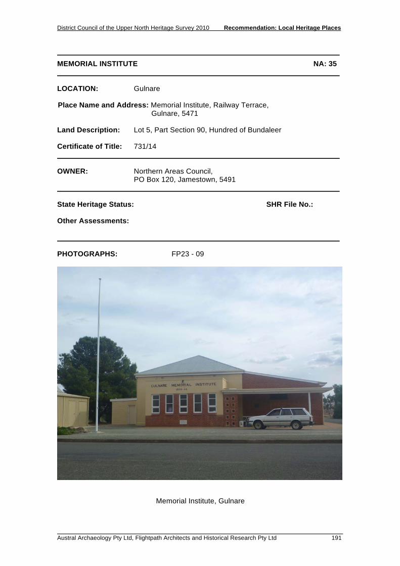
District Council of the Upper North Heritage Survey 2010 Recommendation: Local Heritage Places
Austral Archaeology Pty Ltd, Flightpath Architects and Historical Research Pty Ltd 191
MEMORIAL INSTITUTE NA: 35 LOCATION: Gulnare Place Name and Address: Memorial Institute, Railway Terrace, Gulnare, 5471 Land Description: Lot 5, Part Section 90, Hundred of Bundaleer Certificate of Title: 731/14 OWNER: Northern Areas Council, PO Box 120, Jamestown, 5491 State Heritage Status: SHR File No.: Other Assessments: PHOTOGRAPHS: FP23 - 09
Memorial Institute, Gulnare
Recommendation: Local Heritage Places District Council of the Upper North Heritage Survey 2010
192 Austral Archaeology Pty Ltd, Flightpath Architects and Historical Research Pty Ltd
MEMORIAL INSTITUTE NA: 35 DESCRIPTION: The main body of the Institute building is red-brick and rendered with a hipped-roof. To the south is a small, concrete block, toilet facility, and to the north is a substantial red brick extension with a skillion roof. The Railway Terrace facade features signage reading: 'GULNARE MEMORIAL INSTITUTE 1939 - 45'. HISTORY: Gulnare was surveyed and allotments put on sale in 1874. The main building carries a foundation stone reading: 'Gulnare Hall 1905'. The red brick and rendered entry wing to the east has a foundation stone which reads: 'This stone was laid by C. N. Jones Esq., 27th Batt. 1st A.I.F. on 18th April 1959'. STATEMENT OF HERITAGE VALUE: The building is important for historical and social reasons. It is associated with the Second World War and is important to the local community as a meeting place. RELEVANT CRITERIA: (c) It has played an important part in the life of local residents, serving as a
community meeting place since 1905. (e) It is associated with a notable event, in being a memorial to the Second World
War . REFERENCES:

District Council of the Upper North Heritage Survey 2010 Recommendation: Local Heritage Places
Austral Archaeology Pty Ltd, Flightpath Architects and Historical Research Pty Ltd 193
FORMER PRIMARY SCHOOL NA: 36 LOCATION: Gulnare Place Name and Address: Former Primary School, 2 View Street, Gulnare, 5471 Land Description: Lot 40, Part Section 90, Hundred of Bundaleer Certificate of Title: 5818/149 OWNER: S.P Shortt PO Box 23, Gulnare, SA 5471 State Heritage Status: SHR File No.: Other Assessments: PHOTOGRAPHS: FP23 - 08
Former Primary School, Gulnare

Recommendation: Local Heritage Places District Council of the Upper North Heritage Survey 2010
194 Austral Archaeology Pty Ltd, Flightpath Architects and Historical Research Pty Ltd
FORMER PRIMARY SCHOOL NA: 36 DESCRIPTION: A sandstone building featuring red brick quoins, and rendered sills, lintels, and chimney. The Dutch gable roof is extended on one side to encompass a simple lightweight lean-to extension. HISTORY: Gulnare was surveyed and allotments put on sale in 1874. Like many towns in the Upper North it soon had a State School made possible by the introduction of the Education Act 1875 STATEMENT OF HERITAGE VALUE: The modest stone building is a good example of a late nineteenth and early twentieth century rural school building, consistent with the prevailing type of building in the region, and presents a good example of a public building in a town where few such examples exist. Whilst not currently operating as a school, it has played an important educational and social role during the development of the town and community. RELEVANT CRITERIA: (c) It has played an important part in the life of local residents, providing an
education facility to the local community. (d) It displays aesthetic merit and design characteristics of significance to the local
area, in being a good example of an early twentieth century, rural school building.
REFERENCES:

District Council of the Upper North Heritage Survey 2010 Recommendation: Local Heritage Places
Austral Archaeology Pty Ltd, Flightpath Architects and Historical Research Pty Ltd 195
SILOS NA: 37 LOCATION: Gulnare Place Name and Address: Silos, Railway Terrace, Gulnare, 5471 Land Description: Lot Piece 91 and 92, Part Section 77, Hundred of Bundaleer Certificate of Title: 5305/64 OWNER: Ausbulk GPO Box 1568, Adelaide, SA 5001 State Heritage Status: SHR File No.: Other Assessments: PHOTOGRAPHS: FP23 - 13
Silos, Gulnare

Recommendation: Local Heritage Places District Council of the Upper North Heritage Survey 2010
196 Austral Archaeology Pty Ltd, Flightpath Architects and Historical Research Pty Ltd
SILOS NA: 37 DESCRIPTION: Located in the railyards and addressing the main street of the town, Railway Terrace, the silos feature two separate structures, one with six chambers and the other with four. Both are white painted concrete. HISTORY: Strangely, South Australia was one of the last major wheat-producing regions in the world to adopt bulk grain handling. Whereas New South Wales, Western Australia and Victoria were doing away with bagged wheat from the 1920s onward, it was not until 1952 that the first silos were built at Ardrossan, and bulk handling began on a trial basis in the northern Yorke Peninsula and part of the Upper North. In 1955 South Australian Co-operative Bulk Handling Ltd was established to oversee the new technology. The first silos in the Upper North were built at Redhill and Gulnare in 1956, supplying the Ardrossan terminal. With the construction of bulk handling terminals at Wallaroo in 1956 and Port Pirie in 1957, the way was open for silos throughout the region. By 1962 there were silos at Andrews, Gladstone, Laura, Hallett, Jamestown, Caltowie, Yongala, Booleroo, Melrose, Orroroo and Wilmington. The new silos were towering landmarks; the tall white cylinders were the largest structures that had ever been built in the district and could be seen from every farm in the Hundred and beyond. STATEMENT OF HERITAGE VALUE: The silos are the most prominent built, or geographical, feature of the town, and act as significant landmarks. They are visible from considerable range and identify the location of the town which is several kilometres from the main highway. The position of the silos in the town reinforce what was once the primary commercial, civic and social, street in the town. RELEVANT CRITERIA: (f) It is a notable landmark in the area. REFERENCES: Lamshed, M., Grain is Better in Bulk, 1962

District Council of the Upper North Heritage Survey 2010 Recommendation: Local Heritage Places
Austral Archaeology Pty Ltd, Flightpath Architects and Historical Research Pty Ltd 197
UNITING CHURCH AND HALL NA: 38 LOCATION: Gulnare Place Name and Address: Uniting Church and Hall, Railway Terrace, Gulnare, 5471 Land Description: Lot 6, Part Section 6, Hundred of Bundaleer Certificate of Title: 5467/927 OWNER: Uniting Church in Australia Property Trust (SA), PO Box 2145, Adelaide SA 5000 State Heritage Status: SHR File No.: Other Assessments: PHOTOGRAPHS: FP23 - 10, 11
Uniting Church, Gulnare

Recommendation: Local Heritage Places District Council of the Upper North Heritage Survey 2010
198 Austral Archaeology Pty Ltd, Flightpath Architects and Historical Research Pty Ltd
UNITING CHURCH AND HALL NA: 38 DESCRIPTION: The church is a symmetrical stone building consisting of the nave and an entry wing fronting Railway Terrace to the east. Both have a simple gable roof and timber barge boards and finials. The building is of stone with red brick quoins and a recently rendered plinth. A roofed walkway links the church to the associated hall. The hall is of similar stone construction as the church and features white rendered quoins and window mouldings, with a corrugated galvanised iron lean-to extension to the rear. HISTORY: A foundation stone on the church reads: 'Gulnare Methodist Church 1902', with an additional plaque reading: 'Memorial to Centenary of original Gulnare Methodist Church 1874 - 1974'. This later plaque possibly refers to a leadlight window in the front porch which has since been replaced with coloured glass. The Church Hall has a plaque reading'1931' set in render below the front eaves and a foundation stone which reads: 'To the Glory of God. This stone was laid by Mrs E. J. Thomas, Snr., on Tuesday, May 5, 1931.'. STATEMENT OF HERITAGE VALUE: As the only Church and Church Hall in the town, they have played an important part in the lives of the local people by providing a religious and social function for the community. The importance of these buildings to the community is reinforced by their position in the town. Addressing Railway Terrace, they make a significant contribution to the streetscape, which includes many of the other key civic buildings of the town. Whilst the buildings are of similar construction, materials and scale, they present two different styles of architecture that reflects the development of the Church over time. The Church itself is a modest building with little ornament. It features simple timberwork and regular arched windows on each facade. The Church Hall however demonstrates a higher level of detail such as decorative barge boards and finials, and ornate leadlight. Such detailing and the tall proportions of what is a small Hall distinguish it from other similar buildings in the region. RELEVANT CRITERIA: (c) It has played an important part in the life of local residents by providing a place
of congregation for the community. (d) It displays aesthetic merit and design characteristics of significance to the local
area, in being excellent examples of a rural Church and associated Hall. REFERENCES:

RECOMMENDATION: LOCAL HERITAGE PLACES 5.5 HORNSDALE


District Council of the Upper North Heritage Survey 2010 Recommendation: Local Heritage Places
Austral Archaeology Pty Ltd, Flightpath Architects and Historical Research Pty Ltd 201
HORNE’S BARN NA: 78 LOCATION: Hornsdale Place Name and Address: Horne's Barn, Hornsdale to Appila Road, Hornsdale 5490 Land Description: Section 195b, Hundred of Tarcowie Certificate of Title: 5646/716 OWNER: M J Noonan Hornsdale 5490 State Heritage Status: SHR File No.: Other Assessments: PHOTOGRAPHS: HR4 - 29 to 33
Horne’s Barn, Hornsdale

Recommendation: Local Heritage Places District Council of the Upper North Heritage Survey 2010
202 Austral Archaeology Pty Ltd, Flightpath Architects and Historical Research Pty Ltd
HORNE'S BARN NA: 78 DESCRIPTION: The barn is a two storey building with a loft. It is constructed of cement rendered limestone rubble and has a gabled corrugated galvanised iron (cgi) roof. The end gabled walls have parapets and there are slatted vents to the loft. The west side features a most unusual embellishment for a building of this type - a cantilevered timber verandah with a skillion corrugated galvanised iron roof to the first floor. There are centrally located doors to both the ground and first floors on the west side. The verandah is accessed by a set of stairs to the south. The north and south sides have skillion roofed lean-to additions. The northern one is a vehicle shed while the southern one features a short chimney - perhaps denoting a bread oven. The east side has a central window to the first floor. The lower portion of this wall has been repaired with a thick layer of applied concrete and was long ago strengthened by the addition of four lengths of upright railway line. The building was not inspected internally. HISTORY: The Hornsdale district was taken up in 1846 as part of the Pekina Run. It was settled by farmers in 1872 with its focus on a small crossroads township first known as Tarcowie East. William Horne arrived in 1874 and became a prosperous farmer with a 1,600 acre holding known as Peak Farm. Horne’s Barn was built about 1878 on Section 195 which he bought in 1874 as part of his growing farmstead. By 1881 he was the district’s first postmaster and eventually played a pivotal role in the life of the emerging community. The township was renamed Hornesdale in 1881 (since corrupted to Hornsdale). The large barn, built for housing stock and storing farm equipment, became a well known landmark in the neighbourhood and also became the social centre of the settlement of Hornsdale. STATEMENT OF HERITAGE VALUE: Of significance to Hornsdale as a building directly associated with William Horne, a prosperous early farmer in the locality who played a pivotal role in the development of the community. Horne’s Barn, with its highly unusual form for a South Australian farm building, was of great significance to the local community as a social centre. RELEVANT CRITERIA: (a) It displays historical and social themes that are of importance to the local area. (c) It has played an important part in the lives of the local residents. (d) It displays design characteristics and construction techniques of significance to
the local area. (e) It is associated with a notable local personality.

District Council of the Upper North Heritage Survey 2010 Recommendation: Local Heritage Places
Austral Archaeology Pty Ltd, Flightpath Architects and Historical Research Pty Ltd 203
HORNE'S BARN NA: 78 REFERENCES: Donnellan, T., Home of the East Wind: Hornsdale, 1995 Hornsdale History Committee, interpretive sign erected in 1996 Manning, G.,Manning's Place Names of South Australia, 1990
Recommendation: Local Heritage Places District Council of the Upper North Heritage Survey 2010
204 Austral Archaeology Pty Ltd, Flightpath Architects and Historical Research Pty Ltd

District Council of the Upper North Heritage Survey 2010 Recommendation: Local Heritage Places
Austral Archaeology Pty Ltd, Flightpath Architects and Historical Research Pty Ltd 205
KAPPOWIE FARM COMPLEX NA: 82 LOCATION: Hornsdale Place Name and Address: Kappowie Farm Complex, Hornsdale to Mannanarie Road Hornsdale Land Description: Section 216, Hundred of Tarcowie Certificate of Title: 5897/996 OWNER: D T and M Meaney Appila 5480 State Heritage Status: SHR File No.: Other Assessments: PHOTOGRAPHS: HR4 - 21 to 22
Kappowie Farm Complex, Hornsdale

Recommendation: Local Heritage Places District Council of the Upper North Heritage Survey 2010
206 Austral Archaeology Pty Ltd, Flightpath Architects and Historical Research Pty Ltd
KAPPOWIE FARM COMPLEX NA: 82 DESCRIPTION: The site consists of the ruins of a stone house, an intact shearing shed and a corrugated galvanised iron (cgi) machinery or implement shed. The house is built of stone and appears to only have ever been half completed; it has an 'M' style double gabled hipped corrugated galvanised iron roof and two brick chimneys. There is a partially demolished skillion style addition at the rear with its roof removed. The house is in ruinous condition with the windows, doors and gutters largely removed. The shearing shed (known as Sweasrse's Barn according to a local interpretation sign in the Hornsdale township site) is a stone building built in two distinct sections. One has a low gabled corrugated galvanised iron roof while the other has a much steeper corrugated galvanised iron roof. Both are of the typical shearing shed design ie a central gabled section with skillion roofs either side. The roofs have old style skylights fitted. Steel yards surround the shed. The implement or machinery shed is constructed completely from corrugated galvanised iron and has a shallow gabled roof of unequal pitch HISTORY: The locality of Kappowie is said to have been valued by Aboriginal people for two reasons: as a place where rocks were mined for pigments, and as the site of waterholes created by gouging indentations in the rock. It was perhaps the waterholes that attracted European settlers to this piece of land. Kappowie was occupied by European shepherds from the mid-1840s as an outstation of Pekina Run. Records suggest that at Kappowie there existed a more generous collection of buildings than was usually found, suggesting that it may have been the home of a family. The structures mentioned include a cellar, a fowl house and a garden. However, the buildings on site today date from the period of agricultural settlement of the region, from 1871 onwards, when the farm was taken up by the Sweasrse family. STATEMENT OF HERITAGE VALUE: Of heritage value to the Hornsdale area as the relics of early agricultural settlement, but also a place of heritage value for its associations with Aboriginal people and the pastoral phase of settlement, and hence displaying historical and economic themes important to the area. RELEVANT CRITERIA: (a) It displays historical and economic themes that are of importance to the local
area.

District Council of the Upper North Heritage Survey 2010 Recommendation: Local Heritage Places
Austral Archaeology Pty Ltd, Flightpath Architects and Historical Research Pty Ltd 207
KAPPOWIE FARM COMPLEX NA: 82 REFERENCES: Donnellan, Home of the East Wind: Hornsdale, 1995

Recommendation: Local Heritage Places District Council of the Upper North Heritage Survey 2010
208 Austral Archaeology Pty Ltd, Flightpath Architects and Historical Research Pty Ltd

RECOMMENDATION: LOCAL HERITAGE PLACES 5.6 JAMESTOWN


District Council of the Upper North Heritage Survey 2010 Recommendation: Local Heritage Places
Flightpath Architects Pty Ltd 211
FORMER ANZ BANK NA: 39 LOCATION: Jamestown Place Name and Address: Former ANZ Bank, 55 Ayr Street, Jamestown 5491 Land Description: Part Allotment 49, Hundred of Belalie Certificate of Title: 5265/271 OWNER: Wongaburra Family Trust c/o Jones, Lang Lasalle Level 21/25 Grenfell Street, Adelaide SA 5000 State Heritage Status: SHR File No.: Other Assessments: PHOTOGRAPHS: FP07 - 06
Former ANZ Bank, Jamestown

Recommendation: Local Heritage Places District Council of the Upper North Heritage Survey 2010
212 Flightpath Architects Pty Ltd
FORMER ANZ BANK NA: 39 DESCRIPTION: A substantial, classically detailed, detached two-storey stone building with contrasting render to quoins, plinth, and mouldings. Ground-level windows are arched, with rectangular upper-level windows with pediments. The central upper-level window has a Juliet balcony supported by ornate consoles and with a masonry balustrade. The balustered parapet carries a heavily moulded entablature, classical pediments are located above the upper level windows, and colonettes flanking the central window. HISTORY: The former ANZ Bank building was built in 1879 as the Bank of South Australia. It operated as the Union bank between 1903 and 1951 before becoming the ANZ Bank. STATEMENT OF HERITAGE VALUE: A significant early twentieth century building located prominently in the main commercial street, the building makes an important contribution to the character of the town. The symmetrical street facade has particular value as a substantial building that is well proportioned and features several classical details of note. The level of detail, scale, and proportions, of this street facade have significant integrity and are of considerable worth to the town. RELEVANT CRITERIA: (d) It displays aesthetic merit and design characteristics of significance to the local
area as a substantial, classically detailed building prominently located in the main street of the town.
REFERENCES: Cooper, Leith. Jamestown: a photographic survey. Corporation of Jamestown, Jamestown, 1978. p.35.

District Council of the Upper North Heritage Survey 2010 Recommendation: Local Heritage Places
Flightpath Architects Pty Ltd 213
BANK SA BUILDING NA: 40 LOCATION: Jamestown Place Name and Address: Bank SA Building, 61-63 Ayr Street Jamestown 5491 Land Description: Allotment 235, Part Section 49, Hundred of Belalie Certificate of Title: 5612/456 OWNER: Creedon & Creedon Pty Ltd 16 Akaroa Street. Greenwith SA 5125 State Heritage Status: SHR File No.: Other Assessments: PHOTOGRAPHS: FP07 - 07
Bank SA Building, Jamestown

Recommendation: Local Heritage Places District Council of the Upper North Heritage Survey 2010
214 Flightpath Architects Pty Ltd
BANK SA BUILDING NA: 40 DESCRIPTION: An imposing single storey, painted masonry building, the Bank SA has a symmetrical double-height street facade, featuring a classical portico and heavily moulded entablature and parapet. HISTORY: The Bank SA was previously known as the Savings Bank of South Australia. The building was built in 1928 on a site previously occupied by several small shops which were destroyed in fire in 1926. STATEMENT OF HERITAGE VALUE: A significant early twentieth century building located prominently in the main commercial street, the building makes an important contribution to the character of the town. The symmetrical street facade has particular value as a substantial building that is well proportioned and features several classical details of note. The dominant element is the entry portico which includes ionic columns, robust quoins, and a heavily moulded entablature. The plinth remains unpainted sandstone in contrast to the rest of the facade. The level of detail, scale, and proportions of this street facade are outstanding and have significant integrity of considerable worth to the town. RELEVANT CRITERIA: (d) It displays aesthetic merit and design characteristics of significance to the local
area as a substantial, classically detailed building prominently located in the main street of the town.
REFERENCES: Cooper, Leith. Jamestown: a photographic survey. Corporation of Jamestown, Jamestown, 1978. p.35.

District Council of the Upper North Heritage Survey 2010 Recommendation: Local Heritage Places
Flightpath Architects Pty Ltd 215
ART GALLERY (FORMER COURTHOUSE) NA: 41 LOCATION: Jamestown Place Name and Address: Art Gallery (Former Courthouse), 53 Ayr Street Jamestown, 5491 Land Description: Lot 501, Lot 42, Hundred of Belalie Certificate of Title: 5247/36 OWNER: Belinda Rowe PO Box 145, Jamestown SA 5491 State Heritage Status: SHR File No.: Other Assessments: PHOTOGRAPHS: FP07- 26
Former Courthouse, Jamestown
Recommendation: Local Heritage Places District Council of the Upper North Heritage Survey 2010
216 Flightpath Architects Pty Ltd
ART GALLERY (FORMER COURTHOUSE) NA: 41 DESCRIPTION: Single-storey building, rectangular in plan with a vestibule to the front and eastern side. Hipped corrugated galvanised iron roof with vents. Constructed of painted stone with proud rendered quoins, plinth, and window and door reveals. Keystones to arched windows and doors. The front vestibule has a pedimented parapet. HISTORY: The first allotments in the newly subdivided town of Jamestown were offered for sale in 1871. The town quickly became the principal inland commercial and administrative centre of the region. The court house, a standard government design of the time, was built in 1877. The building no longer functions as a court house. It is privately owned, and for some years was used as an art gallery. STATEMENT OF HERITAGE VALUE: The building is an important civic building constructed in the town’s formative years. The authoritative nature of the building is reflected in its formal style, and is a good example of this type of building, consistent with others in the region. The integrity of the building is good and consequently makes a positive contribution to the character of the town. RELEVANT CRITERIA: (d) It displays aesthetic merit of significance to the local area, as an excellent
example of a late nineteenth century civic building characterised by the proportions, robust detailing, and formal style.
REFERENCES: Cooper, Leith. Jamestown: a photographic study, Corporation of Jamestown, Jamestown, 1978. p96

District Council of the Upper North Heritage Survey 2010 Recommendation: Local Heritage Places
Flightpath Architects Pty Ltd 217
DR COCKBURN'S HOUSE NA: 42 LOCATION: Jamestown Place Name and Address: Dr Cockburn's House, Cnr. of Clifton Road and Cockburn
Road, Jamestown 5491 Land Description: Allotments 1 and 3, Part Section 454, Hundred of Belalie Certificate of Title: 5494/667 and 668 OWNER: W D and D J Davis 1 Clifton Road, Jamestown 5491 State Heritage Status: SHR File No.: Other Assessments: PHOTOGRAPHS: FP07 - 17
Dr Cockburn's House, Jamestown

Recommendation: Local Heritage Places District Council of the Upper North Heritage Survey 2010
218 Flightpath Architects Pty Ltd
DR COCKBURN'S HOUSE NA: 42 DESCRIPTION: A large sandstone house with hipped roof, stone chimneys, and a return verandah with stone columns. The house is set in an established garden. HISTORY: Dr John A Cockburn was nominated for Mayor at a public meeting to establish the Corporation of Jamestown held on 18 April 1878. The Corporation was proclaimed on the 25 July 1878 and Cockburn was sworn as Mayor on 29 July 1878. Cockburn came to Jamestown, aged 26, in January 1876 to replace the town’s first doctor. A Scot, Cockburn received his medical degree in London prior to immigrating to Australia. He remained Mayor for three and a half years before retiring in November 1881 to take a position of the North Midland Roadboard. In 1884 he stood as a House of Assembly candidate in the seat of Burra and won. On 16 June, 1885, he was made Minister of Education in the Government of Sir John Downer. During this time, a new town of Cockburn in rural New South Wales was named in his honour. In 1886 he left Jamestown to reside in Adelaide. Following a failed attempt at re-election to the seat of Burra in 1887, he successfully contested the seat of Mount Barker and returned to Parliament. He spent two years in the Government of Thomas Playford before becoming Premier for 14 months. During his time as Premier, Cockburn led a South Australian delegation to the first conference on Federation held in Melbourne during 1890. He later helped prepare the legislation that facilitated Federation in 1900. The most significant initiatives of his time in Parliament were the successful Bill allowing payment of Parliamentarians, and in 1898, the second reading of the Bill for the franchise of women in South Australia, the first in the world to do so. One of Cockburn’s other notable initiatives was the tree planting programme in Jamestown. In 1898 Cockburn left South Australia for London. He remained in England until he died in 1929. Cockburn built his house and surgery in 1880. The verandah was later added by Dr Swann who bought the house from Cockburn. Several other doctors lived and practiced there between 1886 and Swann’s purchase of the property in 1925. STATEMENT OF HERITAGE VALUE: The house was built and owned by Dr John Cockburn, the first mayor of the town. Cockburn was one of the important players in the development of the town, and went on to make significant contributions at a State level as well. The building is important for its association with Cockburn.

District Council of the Upper North Heritage Survey 2010 Recommendation: Local Heritage Places
Flightpath Architects Pty Ltd 219
DR COCKBURN'S HOUSE NA: 42 RELEVANT CRITERIA: (e) It is associated with a notable local personality or event, Dr John A Cockburn
who was a notable local and State identity. REFERENCES: Cooper, Leith. Jamestown: a photographic study, Corporation of Jamestown, Jamestown, 1975. p5-7.
Recommendation: Local Heritage Places District Council of the Upper North Heritage Survey 2010
220 Flightpath Architects Pty Ltd

District Council of the Upper North Heritage Survey 2010 Recommendation: Local Heritage Places
Flightpath Architects Pty Ltd 221
HIGH SCHOOL NA: 43 LOCATION: Jamestown Place Name and Address: High School, Humphris Terrace, Jamestown 5491 Land Description: Section 254 and 257, Hundred of Belalie Certificate of Title: 5592/580 OWNER: Minister for Education, Children’s Services and Training GPO Box 1072, Adelaide SA 5000 State Heritage Status: SHR File No.: Other Assessments: PHOTOGRAPHS: FP07 - 27
High School, Jamestown

Recommendation: Local Heritage Places District Council of the Upper North Heritage Survey 2010
222 Flightpath Architects Pty Ltd
HIGH SCHOOL NA: 43 DESCRIPTION: Substantial single-storey stone building with brick window surrounds and quoins. L-shaped in plan, with a gable end to the short arm of 'L' and a dutch-gable roof to the other section, ridge venting. The corners of the gabled wing feature painted pilasters. Windows are grouped in threes. HISTORY: In 1919, 3 1/4 acres of the north-east parklands were transferred to the Education Department for future development as a High School. This occurred in 1921 when the National Bank provided the required capital for the project to begin. The foundation stone for the building was laid by Mayor Robert Snodgrass on 23 November 1923, with the school opening in May 1924. The building originally consisted of four rooms. with an additional room added in 1937. Numerous other buildings have been built since the 1950s, and playing fields established in the mid 1960s. The enrolment at the school has fluctuated over time, with numbers at about fifty following the Second World War , and over two hundred at other times. STATEMENT OF HERITAGE VALUE: The building has been an important part of the town for the educational and social services it has provided since 1924. The built form is consistent with other school buildings of the era and in the region, and makes a positive contribution to the character of the town and the street. RELEVANT CRITERIA: (c) It has played an important part in the life of local residents, providing education
facilities to the community. (d) It displays aesthetic merit of significance to the local area, as a good example
of an early twentieth century school building. REFERENCES: Cooper, Leith. Jamestown: a photographic study. Corporation of Jamestown, Jamestown, 1978. p-58.

District Council of the Upper North Heritage Survey 2010 Recommendation: Local Heritage Places
Flightpath Architects Pty Ltd 223
JAMESTOWN HOTEL NA: 44 LOCATION: Jamestown Place Name and Address: Jamestown Hotel, Allotment 101 Ayr Street Jamestown 5491 Land Description: Allotment 101, Hundred of Belalie Certificate of Title: 5382/552 OWNER: Bend Hotels Pty Ltd c/o Aldinga Hotel 1 Old Coach Road, Aldinga Beach SA 5173 State Heritage Status: SHR File No.: Other Assessments: PHOTOGRAPHS: FP07 - 10 and FP09 - 11
Jamestown Hotel, Jamestown

Recommendation: Local Heritage Places District Council of the Upper North Heritage Survey 2010
224 Flightpath Architects Pty Ltd
JAMESTOWN HOTEL NA: 44 DESCRIPTION: Two storey pointed and painted stone hotel. Rendered plinth course, quoins, and door and window surrounds with keystones. Balcony and verandah to upper storey. A dutch-gable roof is concealed by a parapet with central pediment identifying the hotel, 'Jamestown Hotel established 1873'. Balustrading to balcony has been replaced with steel profile. A stone stable and various out-buildings are to rear of hotel. HISTORY: The Jamestown Hotel is one of the oldest buildings in the town, built in 1873, at a time of rapid development which saw up to 100 masons employed. It was constructed by Albert Trilling, with Hahn being the first licensee. In 1909, a second storey was built by FW Haese. The Hotel was used for many public meetings and social events, especially in the years before other public venues were established. The building has undergone several cosmetic changes since, with the stone being painted and the verandah and balcony detailing being replaced. STATEMENT OF HERITAGE VALUE: The building is one of the town’s first major buildings, built in 1873, and has provided a valuable social service as a hotel since that time. The built form has undergone some cosmetic changes but remains an important building that has played a part in lives of the local residents, and makes a positive contribution to the character of the town and street. RELEVANT CRITERIA: (c) It has played an important part in the life of local residents as a social venue
since 1873. REFERENCES: Cooper, Leith. Jamestown: a photographic study, Corporation of Jamestown, Jamestown, 1978. p36.

District Council of the Upper North Heritage Survey 2010 Recommendation: Local Heritage Places
Flightpath Architects Pty Ltd 225
MEMORIAL HALL NA: 45 LOCATION: Jamestown Place Name and Address: Memorial Hall, 73 Ayr Street, Jamestown 5491 Land Description: Lot 102, Section 50, Hundred of Belalie Certificate of Title: 5445/276 OWNER: Northern Areas Council, PO Box 120, Jamestown, 5491 State Heritage Status: SHR File No.: Other Assessments: PHOTOGRAPHS: FP07 - 07, 08, 09 and FP09 - 12
Jamestown Memorial Hall
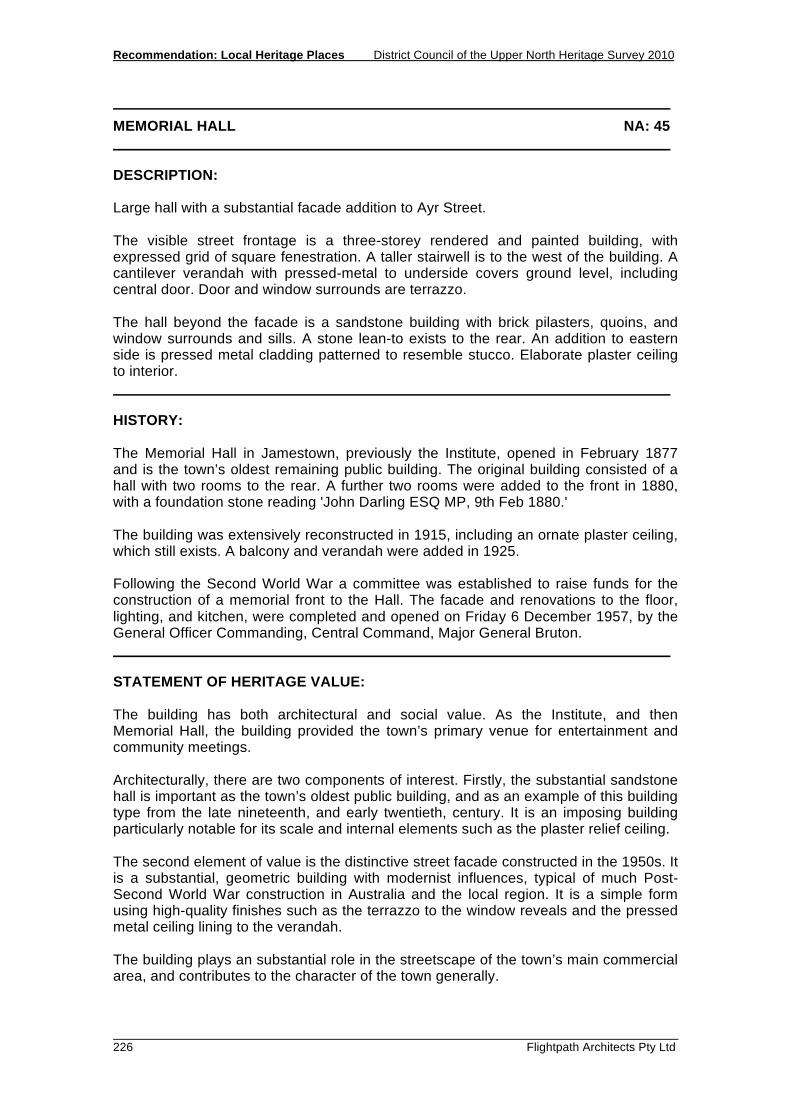
Recommendation: Local Heritage Places District Council of the Upper North Heritage Survey 2010
226 Flightpath Architects Pty Ltd
MEMORIAL HALL NA: 45 DESCRIPTION: Large hall with a substantial facade addition to Ayr Street. The visible street frontage is a three-storey rendered and painted building, with expressed grid of square fenestration. A taller stairwell is to the west of the building. A cantilever verandah with pressed-metal to underside covers ground level, including central door. Door and window surrounds are terrazzo. The hall beyond the facade is a sandstone building with brick pilasters, quoins, and window surrounds and sills. A stone lean-to exists to the rear. An addition to eastern side is pressed metal cladding patterned to resemble stucco. Elaborate plaster ceiling to interior. HISTORY: The Memorial Hall in Jamestown, previously the Institute, opened in February 1877 and is the town’s oldest remaining public building. The original building consisted of a hall with two rooms to the rear. A further two rooms were added to the front in 1880, with a foundation stone reading 'John Darling ESQ MP, 9th Feb 1880.' The building was extensively reconstructed in 1915, including an ornate plaster ceiling, which still exists. A balcony and verandah were added in 1925. Following the Second World War a committee was established to raise funds for the construction of a memorial front to the Hall. The facade and renovations to the floor, lighting, and kitchen, were completed and opened on Friday 6 December 1957, by the General Officer Commanding, Central Command, Major General Bruton. STATEMENT OF HERITAGE VALUE: The building has both architectural and social value. As the Institute, and then Memorial Hall, the building provided the town’s primary venue for entertainment and community meetings. Architecturally, there are two components of interest. Firstly, the substantial sandstone hall is important as the town’s oldest public building, and as an example of this building type from the late nineteenth, and early twentieth, century. It is an imposing building particularly notable for its scale and internal elements such as the plaster relief ceiling. The second element of value is the distinctive street facade constructed in the 1950s. It is a substantial, geometric building with modernist influences, typical of much Post-Second World War construction in Australia and the local region. It is a simple form using high-quality finishes such as the terrazzo to the window reveals and the pressed metal ceiling lining to the verandah. The building plays an substantial role in the streetscape of the town’s main commercial area, and contributes to the character of the town generally.

District Council of the Upper North Heritage Survey 2010 Recommendation: Local Heritage Places
Flightpath Architects Pty Ltd 227
MEMORIAL HALL NA: 45 RELEVANT CRITERIA: (c) It has played an important part in the life of local residents, providing a social
venue and community meeting place as the Institute, and then Memorial Hall, since 1877.
(d) It displays aesthetic merit and design characteristics of significance to the local
area, being a nineteenth century Institute with prominent, and distinctive, modernist facade.
REFERENCES: Cooper, Leith. Jamestown: a photographic study, Corporation of Jamestown, Jamestown, 1978. p 68-69.

Recommendation: Local Heritage Places District Council of the Upper North Heritage Survey 2010
228 Flightpath Architects Pty Ltd
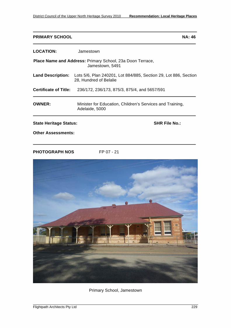
District Council of the Upper North Heritage Survey 2010 Recommendation: Local Heritage Places
Flightpath Architects Pty Ltd 229
PRIMARY SCHOOL NA: 46 LOCATION: Jamestown Place Name and Address: Primary School, 23a Doon Terrace, Jamestown, 5491 Land Description: Lots 5/6, Plan 240201, Lot 884/885, Section 29, Lot 886, Section
28, Hundred of Belalie Certificate of Title: 236/172, 236/173, 875/3, 875/4, and 5657/591 OWNER: Minister for Education, Children’s Services and Training, Adelaide, 5000 State Heritage Status: SHR File No.: Other Assessments: PHOTOGRAPH NOS FP 07 - 21
Primary School, Jamestown

Recommendation: Local Heritage Places District Council of the Upper North Heritage Survey 2010
230 Flightpath Architects Pty Ltd
PRIMARY SCHOOL NA: 46 DESCRIPTION: Sandstone L-shaped building with rendered and painted plinth course. Window surrounds painted white, rendered columns, quoins and circular vent to forward section of building. Brick quoins and window surrounds to rear section. Brick chimneys. Bellcast roof forms verandah to Doon Street. HISTORY: The first two rooms of the Primary School were built in 1877. Additions were undertaken in 1881 and again in 1889. The average number of enrolments at this time was 150 students. STATEMENT OF HERITAGE VALUE: Consistent with other schools of the time, the building is played an important part in the lives of many local residents as the Primary School. It is a modest stone building that contributes to the character of Jamestown. RELEVANT CRITERIA: (c) It has played an important part in the life of local residents, providing education
to the community as the Primary School since 1877. REFERENCES:

District Council of the Upper North Heritage Survey 2010 Recommendation: Local Heritage Places
Flightpath Architects Pty Ltd 231
FORMER SALVATION ARMY CITADEL NA: 47 LOCATION: Jamestown Place Name and Address: Former Salvation Army Citadel, 10 Ayr Street, Jamestown 5491 Land Description: Lot 121, Section 25, Hundred of Belalie Certificate of Title: 829/147 OWNER: Angela Roundhill 10 Ayr Street, Jamestown SA 5491 State Heritage Status: SHR File No.: Other Assessments: PHOTOGRAPHS: FP 09 - 09
Former Salvation Army Citadel, Jamestown
Recommendation: Local Heritage Places District Council of the Upper North Heritage Survey 2010
232 Flightpath Architects Pty Ltd
FORMER SALVATION ARMY CITADEL NA: 47 DESCRIPTION: Small painted stone building. Street facade features stepped parapet to gable, circular gable vent, side door with multi-pane fanlight. Parapet, quoins, and window reveals in contrasting paint. Spire ridge vents. The building is attached to the neighbouring, but unrelated, residence. HISTORY: The Salvation Army began in London as the Christian Mission in 1865, stressing social work among the underprivileged as much as worship. The first Australian meeting of the movement was held in Adelaide in September 1880. The Army soon became controversial both because its evangelism was in direct competition with the older Methodist chapels, and also because it was conspicuously active among drunkards, ex-prisoners, unmarried mothers and other 'less respectable' members of society. The Salvation Army quickly extended its activities into the copper mining towns and the frontier wheat towns. Captain and Mrs Llewellyn held the first Jamestown service, or 'opened fire' as they would have put it, on 7 March 1884. (Judell 1936) The Salvation Army first began using the site on 1886, occupying an iron building for their barracks. The Hall was constructed in 1909. The building was later sold to the Lions Club. STATEMENT OF HERITAGE VALUE: Important for its association with the Salvation Army, and as an interesting early twentieth century building. Of particular value is the street facade with unusual parapet detailing. RELEVANT CRITERIA: (a) It displays social themes that are of importance to the local area, as evidence
of the operation of the Salvation Army in Jamestown. (d) It displays aesthetic merit of significance to the local area, in being an unusual
and distinctive early twentieth century building. REFERENCES: Cooper, Leith, Jamestown: a photographic study, Jamestown 1978 Judell, L.M.W., Historical and Topical Review, Jamestown 1936 Sandall, Robert, History of the Salvation Army, London 1947-1968

District Council of the Upper North Heritage Survey 2010 Recommendation: Local Heritage Places
Flightpath Architects Pty Ltd 233
SILOS NA: 48 LOCATION: Jamestown Place Name and Address: Silos, adjacent Jamestown Railway Station/Museum, Jamestown Land Description: Section 756, Hundred of Belalie Certificate of Title: Plan 240200 CT 5989/207 OWNER: Australian National Railway Commission, Keswick 5035 State Heritage Status: SHR File No.: Other Assessments: PHOTOGRAPHS: FP 07 - 22
Silos, Jamestown

Recommendation: Local Heritage Places District Council of the Upper North Heritage Survey 2010
234 Flightpath Architects Pty Ltd
SILOS NA: 48 DESCRIPTION: Concrete silos, painted white, with a SACBH logo to one. Both have corrugated sheds to the top which surround the concrete towers. HISTORY: The South Australian Bulk Handling Co-operative was established in the 1960s, with the first four cell concrete silo opening in Jamestown in 1962. This silo was later duplicated and in 1976 a four cell barley silo was also added. STATEMENT OF HERITAGE VALUE: The silos provide a highly visible landmark both of the town, and of the presence of one of the regions primary industries, grain. RELEVANT CRITERIA: (f) It is a notable landmark in the area, as a large, highly visible structure located
within the town which consists of low-scale buildings. REFERENCES: Cooper, Leith. Jamestown: a photographic survey, Corporation of Jamestown, Jamestown, 1978. p103-104.

District Council of the Upper North Heritage Survey 2010 Recommendation: Local Heritage Places
Flightpath Architects Pty Ltd 235
RAILWAY STATION MUSEUM NA: 49 LOCATION: Jamestown Place Name and Address: Railway Station/Museum, Railway Reserve, Mannanarie RoadJamestown 5491 Land Description: Section 756, Hundred of Belalie Certificate of Title: Plan 240200 CT 5989/207 OWNER: Australian National Railways Commission, Keswick, 5035 State Heritage Status: SHR File No.: Other Assessments: PHOTOGRAPHS: FP07 - 24
Railway Station / Museum, Jamestown

Recommendation: Local Heritage Places District Council of the Upper North Heritage Survey 2010
236 Flightpath Architects Pty Ltd
RAILWAY STATION / MUSEUM NA: 49 DESCRIPTION: Freestanding gable-roofed sandstone building with painted brick quoins and verandahs to each long side. Gable ends feature decorative barge boards. Corrugated iron roof has been painted red and features several painted chimneys. Windows are timber, with stone sills and keystones. HISTORY: The railway line to Jamestown was completed in 1878 with the first goods train reaching the town on 25 June,1878. The first railway station built was a timber-framed weatherboard building which was deliberately burnt down in 1884. This was replaced with the stone building late in 1885 to cater for the forty trains per day, many of which were carrying ore from Broken Hill. The design of the building is notably similar to the Orroroo Railway Station. In the 1920s, the Jamestown Railway Station handled more livestock than any other station in the State with the exception of the Adelaide Abattoirs. In 1936, some 674 people arrived at Jamestown via train for the Jamestown Show. The station continued to be an important passenger and freight terminal until February 1970 when the narrow gauge line was replaced with standard gauge line and a new station built one mile north-east of the town. Following their closure, the Railway Station and Goods Shed were transferred to the Jamestown Branch of the National Trust and a museum was established. It was opened by the Hon. G J Gilfillan MLC on Sunday 10 October 1971. It continues to operate as a museum. STATEMENT OF HERITAGE VALUE: The railway line was one of the primary factors in the establishment and development of the town and region. It significantly improved the viability of the town’s agricultural industries and allowed the people of the town to travel to the City and neighbouring regions. The importance of this service to the community is reflected in what is a relatively substantial station building. Whilst no longer operating, the building is highly visible, physical evidence of the railway, and the previous prosperity of the town, which is further enhanced by the operation of the National Trust Museum. RELEVANT CRITERIA: (a) It displays historical, economic and social themes that are of importance to the
local area, as an integral part of the town’s infrastructure that accommodated the transport needs of industry and the community between 1885 and 1970.

District Council of the Upper North Heritage Survey 2010 Recommendation: Local Heritage Places
Flightpath Architects Pty Ltd 237
RAILWAY STATION / MUSEUM NA: 49 REFERENCES: Cooper, Leith. Jamestown: a photographic study, Corporation of Jamestown, Jamestown, 1978. p103-105.

Recommendation: Local Heritage Places District Council of the Upper North Heritage Survey 2010
238 Flightpath Architects Pty Ltd
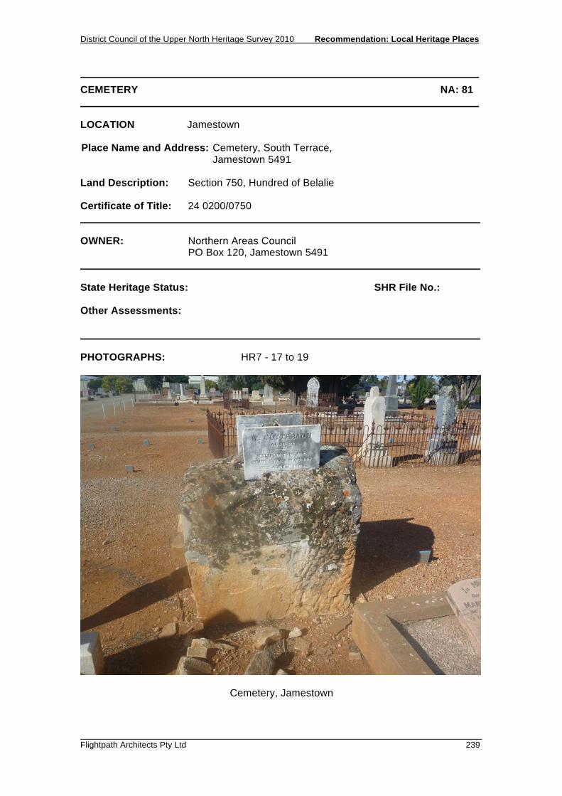
District Council of the Upper North Heritage Survey 2010 Recommendation: Local Heritage Places
Flightpath Architects Pty Ltd 239
CEMETERY NA: 81 LOCATION Jamestown Place Name and Address: Cemetery, South Terrace, Jamestown 5491 Land Description: Section 750, Hundred of Belalie Certificate of Title: 24 0200/0750 OWNER: Northern Areas Council PO Box 120, Jamestown 5491 State Heritage Status: SHR File No.: Other Assessments: PHOTOGRAPHS: HR7 - 17 to 19
Cemetery, Jamestown

Recommendation: Local Heritage Places District Council of the Upper North Heritage Survey 2010
240 Flightpath Architects Pty Ltd
CEMETERY NA:81 DESCRIPTION: The cemetery features a rather unusual headstone, which is a sad reminder of the great building boom of the 1870s. A large rock, more than a cubic metre in volume, marks the graves of G Nottebaum and WCA Vince, quarry employees, who was killed in a fall of rocks. Their names are on two marble plaques attached to the stone, which read, 'Killed by this and other stones in quarry 30th August 1878' HISTORY: The town of Jamestown arose from the Government’s usual policy of locating one township in every hundred that was surveyed prior to sale as agricultural land. In Jamestown’s case, the Hundred of Belalie came into being in 1870. Jamestown was planned, laid out and allotments were offered for sale in October 1871. The town plan was the usual one adopted, that of a rectangular grid of streets surrounded by a belt of parklands. Jamestown’s Cemetery was laid out off South Terrace, a perimeter road encircling the township and parklands. An area of land was also laid out for the hospital nearby. STATEMENT OF HERITAGE VALUE: As the burial ground for many of the citizens of Jamestown, the cemetery is significant and particularly notable for the well-known quarry workers memorial. RELEVANT CRITERIA: a) It displays historical and social themes that are of importance to the local area. c) It has played an important part in the lives of the local residents. REFERENCES: Cooper, Jamestown: a photographic study, 1978 Nicol, Cemeteries of South Australia, 1988

District Council of the Upper North Heritage Survey 2010 Recommendation: Local Heritage Places
Flightpath Architects Pty Ltd 241
UNITING CHURCH OF JAMESTOWN NA:103 LOCATION: Jamestown Place Name and Address: Uniting Church of Jamestown, Irvine Street Jamestown, 5491 Land Description: Lot 92, Hundred of Belalie Certificate of Title: CT 5748/453 OWNER: Uniting Church in Australia Property Trust State Heritage Status: SHR File No.: Other Assessments: PHOTOGRAPHS:
Uniting Church, Jamestown

Recommendation: Local Heritage Places District Council of the Upper North Heritage Survey 2010
242 Flightpath Architects Pty Ltd
UNITING CHURCH OF JAMESTOWN NA:103 DESCRIPTION: A large single storey Colonial Gothic church, rectangular in form with a lean-to located at the rear. The roof is of gable construction and clad in corrugated iron, concealed by a castellated parapet. The front façade features two main entry points with pointed arch motifs and wooden double doors. Belted pilasters run down the length of the building topped with four sided pinnacles. Arch windows are aligned at the centre of the façade. The foundation stone has an inscription, which reads ‘To the Glory of God, This stone was laid by Mrs. Richard Williams, Jamestown, August 1877’. HISTORY: Formerly known as the Methodist Church. The foundation stone was laid by Mrs. Richard Williams on August 1877. STATEMENT OF HERITAGE VALUE: The Uniting Church of Jamestown has played an important part in the lives of local people by providing a religious and social function for the community. The architecture of the church is typical of late nineteenth century religious places, and contributes to the character of the street, being located opposite the Jamestown Post Office. RELEVANT CRITERIA: (a) It displays historical and social themes that are of importance to the local area,
being a place of worship and providing a religious and social function for local people.
(d) It displays aesthetic merit, design characteristics and construction techniques of
significance to the local area, being a notable place of worship REFERENCES:

District Council of the Upper North Heritage Survey 2010 Recommendation: Local Heritage Places
Flightpath Architects Pty Ltd 243
MASONIC HALL NA:104 LOCATION: Jamestown Place Name and Address: Masonic Hall, 71 Irvine Street Jamestown, 5491 Land Description: Lot 205, Hundred of Belalie Certificate of Title: CT 5738/81 OWNER: Freemasons Society, Victoria Lodge No. 26 State Heritage Status: SHR File No.: Other Assessments: PHOTOGRAPHS:
Masonic Hall, Jamestown

Recommendation: Local Heritage Places District Council of the Upper North Heritage Survey 2010
244 Flightpath Architects Pty Ltd
MASONIC HALL NA:104 DESCRIPTION: This Federation style building is a single storey structure, rectangular in form and constructed of stone with rendered quoins. The roof is of gable form and clad in corrugated iron, with a chimney to the southern side of the building. The front façade is double fronted and features rendered triangular pediments over the two windows and centre door. There is no verandah. An addition is located on the southern side of the building. The Hall is well appointed and has the following dimensions: 5.45m x 7.3m x 5.45m. The retiring room to the front of the building measures 5.45m x 7.3m. HISTORY: The Masonic Hall was dedicated on August 28th 1909. There was a large attendance of brethren. The ceremony was performed by the R.W.D.G.M. Brother C.R J. Glover assisted by the grand chaplain, V.W Brother the Rev. M. Williams. STATEMENT OF HERITAGE VALUE: The Masonic Hall is a good example of social and architectural significance. It has provided valuable service to a prominent community group, the Freemasons, since 1909. This building displays architectural merit and is a good example of Masonic Lodge constructed in the early 20th century. The building makes a positive contribution to the streetscape and to the character of the town. RELEVANT CRITERIA: (c) It has played an important part in the lives of the local residents, as the
Masonic Hall since 1909. (d) It displays aesthetic merit and design characteristics of significance to the
local area, as a good example of an early twentieth century Masonic Hall, which positively contributes to the character of the town.
REFERENCES: ‘Masonic Dedication’ The Advertiser (Adelaide). Thursday, September 2nd 1909.
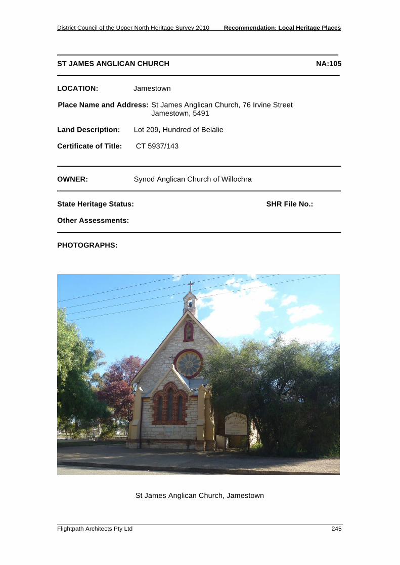
District Council of the Upper North Heritage Survey 2010 Recommendation: Local Heritage Places
Flightpath Architects Pty Ltd 245
ST JAMES ANGLICAN CHURCH NA:105 LOCATION: Jamestown Place Name and Address: St James Anglican Church, 76 Irvine Street Jamestown, 5491 Land Description: Lot 209, Hundred of Belalie Certificate of Title: CT 5937/143 OWNER: Synod Anglican Church of Willochra State Heritage Status: SHR File No.: Other Assessments: PHOTOGRAPHS:
St James Anglican Church, Jamestown

Recommendation: Local Heritage Places District Council of the Upper North Heritage Survey 2010
246 Flightpath Architects Pty Ltd
ST JAMES ANGLICAN CHURCH NA:105 DESCRIPTION: This single story Victorian styled church is constructed of local stone. The roof is a steeply pitched gable form of corrugated iron with a slight eaves overhang. A bell-tower sits at the peak of the roof. The front porch (a later addition) features three-arched windows, rendered quoins and a gabled roof. Above the porch is a circular window, with a small arched window above that. The building is in good condition. HISTORY: Foundation Stone laid on the 3rd February 1880 by Dr. John Cockburn, M.D., Mayor of Jamestown and the opening service took place on 26th July 1880. The builder was Mr. Muhr, and the cost was £510.0.0. Acetylene gas lighting was installed by J. Haskard in 1906 at the cost of £29.10.0. Electric light was installed in 1913 by Gerard & Goodman of Jamestown. The Porch was added in 1905 and the Chancel had its laying of foundation stone on the 25th of July 1907 by Mrs. Maslin. The first service using the new section took place on the 6th January 1909. The white Carrara Marble altar from Italy, with green onyx from Morocco, red Languedoc from France and rich brown stone from Brazil, was built by Mr. F. Hallet of Richmond, in Melbourne. It cost around £700.00 It was consecrated on the 13th of November 1938, and the marble altar rails on 4th April 1939. The Marble Pulpit was consecrated on the 13th of November 1939. They were gifts to the Church. St James Anglican Church was originally and currently owned by the Church of England. STATEMENT OF HERITAGE VALUE: The St James Anglican Church displays a good example of the historical and social themes that are important to the local area, being a church. The popularity and significance of the church is evident in the opulently decorated altar and exterior, and it’s association with the Mayor of Jamestown, Dr. Cockburn, demonstrates the significance of this building. RELEVANT CRITERIA: (a) It displays historical and social themes that are of importance to the local area. (c) It has played an important part in the lives of the local residents. (d) It displays aesthetic merit and design characteristics significant to the local
area, as elements within the church hold great value. (e) It is associated with a notable local personality, Dr. Cockburn, the Mayor of
Jamestown. REFERENCES: Catford, Mary. The Church of St James the Great, Jamestown 1873 – 1975. Northern Argus Print, Clare, 1975.

RECOMMENDATION: LOCAL HERITAGE PLACES 5.7 JAMESTOWN (SURROUNDS)


District Council of the Upper North Heritage Survey 2010 Recommendation: Local Heritage Places
Flightpath Architects Pty Ltd 249
YONGALA HOMESTEAD NA: 87 LOCATION: Jamestown Place Name and Address: Yongala Homestead, Jamestown to Terowie Road, Jamestown 5491 Land Description: Allotments Q192, Filed Plan D57887, Hundred of Whyte Certificate of Title: 5858/693 OWNER: DC and CA Humphris Pty Ltd, PO Box 232, Jamestown 5491 State Heritage Status: SHR File No.: Other Assessments: PHOTOGRAPHS: HR7 - 22 to 29
Yongala Homestead, Jamestown
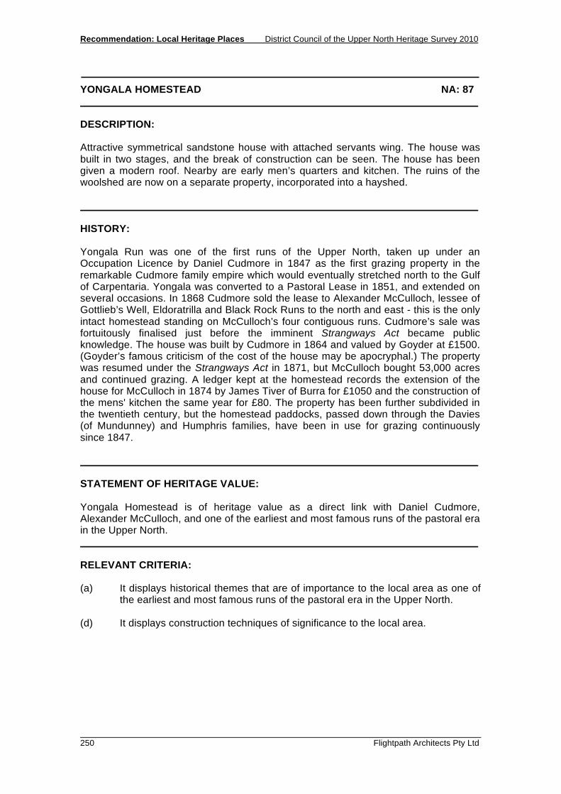
Recommendation: Local Heritage Places District Council of the Upper North Heritage Survey 2010
250 Flightpath Architects Pty Ltd
YONGALA HOMESTEAD NA: 87 DESCRIPTION: Attractive symmetrical sandstone house with attached servants wing. The house was built in two stages, and the break of construction can be seen. The house has been given a modern roof. Nearby are early men’s quarters and kitchen. The ruins of the woolshed are now on a separate property, incorporated into a hayshed. HISTORY: Yongala Run was one of the first runs of the Upper North, taken up under an Occupation Licence by Daniel Cudmore in 1847 as the first grazing property in the remarkable Cudmore family empire which would eventually stretched north to the Gulf of Carpentaria. Yongala was converted to a Pastoral Lease in 1851, and extended on several occasions. In 1868 Cudmore sold the lease to Alexander McCulloch, lessee of Gottlieb’s Well, Eldoratrilla and Black Rock Runs to the north and east - this is the only intact homestead standing on McCulloch’s four contiguous runs. Cudmore’s sale was fortuitously finalised just before the imminent Strangways Act became public knowledge. The house was built by Cudmore in 1864 and valued by Goyder at £1500. (Goyder’s famous criticism of the cost of the house may be apocryphal.) The property was resumed under the Strangways Act in 1871, but McCulloch bought 53,000 acres and continued grazing. A ledger kept at the homestead records the extension of the house for McCulloch in 1874 by James Tiver of Burra for £1050 and the construction of the mens' kitchen the same year for £80. The property has been further subdivided in the twentieth century, but the homestead paddocks, passed down through the Davies (of Mundunney) and Humphris families, have been in use for grazing continuously since 1847. STATEMENT OF HERITAGE VALUE: Yongala Homestead is of heritage value as a direct link with Daniel Cudmore, Alexander McCulloch, and one of the earliest and most famous runs of the pastoral era in the Upper North. RELEVANT CRITERIA: (a) It displays historical themes that are of importance to the local area as one of
the earliest and most famous runs of the pastoral era in the Upper North. (d) It displays construction techniques of significance to the local area.

District Council of the Upper North Heritage Survey 2010 Recommendation: Local Heritage Places
Flightpath Architects Pty Ltd 251
YONGALA HOMESTEAD NA: 87 REFERENCES: Cockburn, Pastoral Pioneers of South Australia, 1925 Glistak, The Lands of Yongala Station, 1986 Mattey, Deceptive Lands, 1968 Pastoral Lease Inspectors Notebook, 1864 Robinson, Change on Change, 1971 Information from Julie Humphris Yongala Run ledger 1868-1884

Recommendation: Local Heritage Places District Council of the Upper North Heritage Survey 2010
252 Flightpath Architects Pty Ltd

District Council of the Upper North Heritage Survey 2010 Recommendation: Local Heritage Places
Flightpath Architects Pty Ltd 253
YONGALA RESERVOIR NA: 88 LOCATION: Jamestown Place Name and Address: Yongala Reservoir, Yongala to Canowie Belt Road, Jamestown Land Description: Section 608, Hundred of Whyte Certificate of Title: 4363/328 OWNER: A M Clark 25 Highbury Drive, Highbury 5089 State Heritage Status: SHR File No.: Other Assessments: PHOTOGRAPHS: HR7 - 11, 12
Yongala Reservoir, via Jamestown

Recommendation: Local Heritage Places District Council of the Upper North Heritage Survey 2010
254 Flightpath Architects Pty Ltd
YONGALA RESERVOIR NA: 88 DESCRIPTION: The reservoir is a large shallow depression with walls constructed of earth and located in a shallow valley. The reservoir has a concrete fill way at the southern end while at the northern end it has a concrete pumping tower and a trestle constructed of segments of railway lines to support pipework. Outside the wall at the northern end are concrete machinery footings and an upright steel cylinder - possibly an air bleeder or pressure vent. HISTORY: The railway inland from Port Pirie reached Yongala in 1880 and Petersburg in January 1881. The following May, Petersburg became an important railway junction when the inland line from Burra reached it via Terowie. Water for steam locomotives could be supplied relatively easily in the coastal valleys closer to Port Pirie, but became scarce once the Black Rock Plain was reached. South Australian Railways took advantage of a natural depression in the plain just north of Yongala woolshed, and excavated an earth tank with a capacity of over 20 million gallons to catch rainfall runoff. From here, water was pumped 20km to Petersburg. The reservoir remained in use until rail transport was dieselised in the 1960s. STATEMENT OF HERITAGE VALUE: The Yongala reservoir is an important reminder of the infrastructure required to support steam railways in the arid rural landscape. RELEVANT CRITERIA: (a) It displays historical themes that are of importance to the local area. (f) It is a notable landmark in the area. REFERENCES: Donovan, Railway Heritage of South Australia, 1992
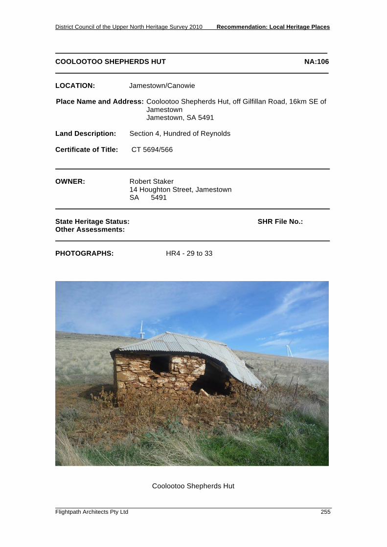
District Council of the Upper North Heritage Survey 2010 Recommendation: Local Heritage Places
Flightpath Architects Pty Ltd 255
COOLOOTOO SHEPHERDS HUT NA:106 LOCATION: Jamestown/Canowie Place Name and Address: Coolootoo Shepherds Hut, off Gilfillan Road, 16km SE of
Jamestown Jamestown, SA 5491 Land Description: Section 4, Hundred of Reynolds Certificate of Title: CT 5694/566 OWNER: Robert Staker 14 Houghton Street, Jamestown SA 5491 State Heritage Status: SHR File No.: Other Assessments: PHOTOGRAPHS: HR4 - 29 to 33
Coolootoo Shepherds Hut

Recommendation: Local Heritage Places District Council of the Upper North Heritage Survey 2010
256 Flightpath Architects Pty Ltd
COOLOOTOO SHEPHERDS HUT NA:106 DESCRIPTION: A small single storey structure constructed of local stone, it is a simple square form, with a hipped roof of corrugated iron. The entrance is a simple opening, as is the single window. An interior wall of stone separates the hut into two small rooms. The condition of the hut is dilapidated, but has potential to be restored. HISTORY: The Coolootoo Shepherds Hut was originally part of the Canowie Station (dating back to the 1850’s) and is located adjacent to the Brown Hill Range Stone Wall. George Goyder once stayed in the Hut during 1865 when surveying all the shepherd huts in the area. Goyder recorded directions to the Coolootoo Shepherds Hut in his diary. The Coolootoo Shepherds Hut is the only one left in the area that is in a restorable condition. STATEMENT OF HERITAGE VALUE: The Coolootoo Shepherds Hut is the only remaining example in the area of a Shepherds Hut dating to the early pastoral era. It is associated with George Goyder, an important figure in the development of South Australia. RELEVANT CRITERIA: (a) It displays historical and social themes that are of importance to the local
area, as an example of the pastoral pastimes of the Northern Areas. (e) It is associated with a notable local personality, George Goyder. REFERENCES: Robert Staker of Jamestown. 2010

RECOMMENDATION: LOCAL HERITAGE PLACES 5.8 LAURA


District Council of the Upper North Heritage Survey 2010 Recommendation: Local Heritage Places
Flightpath Architects Pty Ltd 259
ST JOHN THE EVANGELIST ANGLICAN CHURCH AND HALL NA: 50 LOCATION: Laura Place Name and Address: St John The Evangelist Anglican Church and Hall, East
Terrace Laura, 5480 Land Description: Lot 648, Part Section 1, Hundred of Booyoolie Certificate of Title: 3108/114 OWNER: Synod of the Anglican Church of Australia (Diocese of Willochra), 2 Cross Street, Gladstone, SA 5473 c/o Jan Crawford PO Box 6, Georgetown, SA 5472 State Heritage Status: SHR File No.: Other Assessments: PHOTOGRAPHS: FP25 - 28
St John the Evangelist Anglican Church and Hall, Laura
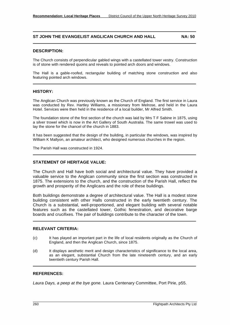
Recommendation: Local Heritage Places District Council of the Upper North Heritage Survey 2010
260 Flightpath Architects Pty Ltd
ST JOHN THE EVANGELIST ANGLICAN CHURCH AND HALL NA: 50 DESCRIPTION: The Church consists of perpendicular gabled wings with a castellated tower vestry. Construction is of stone with rendered quoins and reveals to pointed arch doors and windows. The Hall is a gable-roofed, rectangular building of matching stone construction and also featuring pointed arch windows. HISTORY: The Anglican Church was previously known as the Church of England. The first service in Laura was conducted by Rev. Hartley Williams, a missionary from Melrose, and held in the Laura Hotel. Services were then held in the residence of a local builder, Mr Alfred Smith. The foundation stone of the first section of the church was laid by Mrs T F Sabine in 1875, using a silver trowel which is now in the Art Gallery of South Australia. The same trowel was used to lay the stone for the chancel of the church in 1883. It has been suggested that the design of the building, in particular the windows, was inspired by William K Mallyon, an amateur architect, who designed numerous churches in the region. The Parish Hall was constructed in 1924. STATEMENT OF HERITAGE VALUE: The Church and Hall have both social and architectural value. They have provided a valuable service to the Anglican community since the first section was constructed in 1875. The extensions to the church, and the construction of the Parish Hall, reflect the growth and prosperity of the Anglicans and the role of these buildings. Both buildings demonstrate a degree of architectural value. The Hall is a modest stone building consistent with other Halls constructed in the early twentieth century. The Church is a substantial, well-proportioned, and elegant building with several notable features such as the castellated tower, Gothic fenestration, and decorative barge boards and crucifixes. The pair of buildings contribute to the character of the town. RELEVANT CRITERIA: (c) It has played an important part in the life of local residents originally as the Church of
England, and then the Anglican Church, since 1875. (d) It displays aesthetic merit and design characteristics of significance to the local area,
as an elegant, substantial Church from the late nineteenth century, and an early twentieth century Parish Hall.
REFERENCES: Laura Days, a peep at the bye gone. Laura Centenary Committee, Port Pirie, p55.
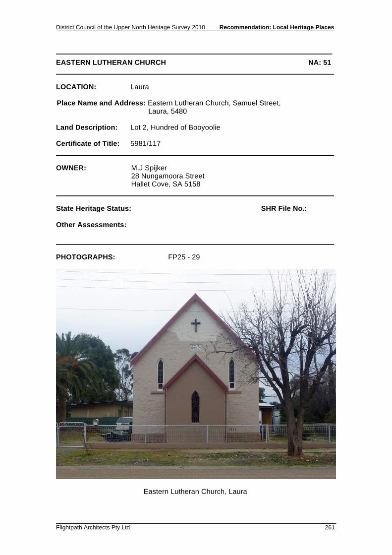
District Council of the Upper North Heritage Survey 2010 Recommendation: Local Heritage Places
Flightpath Architects Pty Ltd 261
EASTERN LUTHERAN CHURCH NA: 51 LOCATION: Laura Place Name and Address: Eastern Lutheran Church, Samuel Street, Laura, 5480 Land Description: Lot 2, Hundred of Booyoolie Certificate of Title: 5981/117 OWNER: M.J Spijker 28 Nungamoora Street Hallet Cove, SA 5158 State Heritage Status: SHR File No.: Other Assessments: PHOTOGRAPHS: FP25 - 29
Eastern Lutheran Church, Laura

Recommendation: Local Heritage Places District Council of the Upper North Heritage Survey 2010
262 Flightpath Architects Pty Ltd
EASTERN LUTHERAN CHURCH NA: 51 DESCRIPTION: Consists of a three-bay nave, a sanctuary, and vestry, each with gable roof. It is constructed of painted stone and features pointed arch windows. HISTORY: Early Lutheran families first attended the Appila Congregation for worship. As numbers increased in the 1880s, services were conducted in the Primitive Methodist Chapel in Laura. The Lutherans bought this building in 1904, however the stone-work began to deteriorate and it was later demolished. The foundation stone of the replacement church was laid on Tuesday 20 April, 1909. A porch has since been added and the stone painted. STATEMENT OF HERITAGE VALUE: The stone church has provided the Lutheran community a place of worship since construction in 1909. It is a simple building consistent with other ecclesiastical buildings in the region constructed in the early twentieth century. RELEVANT CRITERIA: (c) It has played an important part in the life of local residents as the Lutheran
Church since 1909. REFERENCES: Laura Days, a peep at the bye gone. Laura Centenary Committee, Port Pirie, p56.

District Council of the Upper North Heritage Survey 2010 Recommendation: Local Heritage Places
Flightpath Architects Pty Ltd 263
EMMANUEL UNITING CHURCH NA: 52 LOCATION: Laura Place Name and Address: Emmanuel Uniting Church, Herbert Street Laura, 5480 Land Description: Lot 61, Plan 240302, Hundred of Booyoolie Certificate of Title: 5580/130 OWNER: Redeemer Uniting Church in Australia Property Trust (SA) 11 North Terrace, Adelaide, 5000 State Heritage Status: SHR File No.: Other Assessments: PHOTOGRAPHS: FP25 - 34 and FP 40 – 07
Emmanuel Uniting Church, Laura

Recommendation: Local Heritage Places District Council of the Upper North Heritage Survey 2010
264 Flightpath Architects Pty Ltd
EMMANUEL UNITING CHURCH NA: 52 DESCRIPTION: Rectangular church of four buttressed bays with sanctuary to rear. Stone construction with rendered quoins, reveals, parapet coping and masonry pillars to Herbert Street fence. Symmetrical front facade with steps to central pointed-arch entry, rose window, and triple arched vents to gable-end. Pointed arch windows to side elevations. Gable roof with small vents. HISTORY: The Church was built in 1888 as the Wesleyan Church at a cost of £1100 by Mr Ben Shephard. STATEMENT OF HERITAGE VALUE: The building is important for the service it has provided various religious groups since establishment in 1888. The building is an excellent example of a late-nineteenth century church and is stylistically similar to other Uniting Churches in the region, characterised by the proportions, buttressing, and fenestration. The streetscape presence is enhanced by the scale, elevated floor level with plinth, dominant rose window and central entry with steps, and the presence of a complimentary masonry and steel fence. Consequently, the building is important to the character of Herbert Street, Laura's main street. RELEVANT CRITERIA: (c) It has played an important part in the life of local residents, providing a
religious service to the community initially as the Wesleyan Church in 1888, then the Methodist Church, and currently the Uniting Church.
(d) It displays aesthetic merit and design characteristics of significance to the local
area, as an excellent late-nineteenth century ecclesiastical building. REFERENCES: Laura Days, a peep at the bye gone. Laura Centenary Committee, Port Pirie, p54.

District Council of the Upper North Heritage Survey 2010 Recommendation: Local Heritage Places
Flightpath Architects Pty Ltd 265
FLOUR MILL NA: 53 LOCATION: Laura Place Name and Address: Flour Mill, 18 Mill Street, Laura 5480 Land Description: Lots 21 and 22, Section 153, Hundred of Booyoolie Certificate of Title: 5087/916 OWNER: Golden Plains Fodder Private Bag 4, Kadina SA 5555 State Heritage Status: SHR File No.: Other Assessments: PHOTOGRAPHS: FP 25 - 30 and FP 39 – 06
Flour Mill, Laura

Recommendation: Local Heritage Places District Council of the Upper North Heritage Survey 2010
266 Flightpath Architects Pty Ltd
FLOUR MILL NA: 53 DESCRIPTION: Multi-storey, painted stone rectangular building with gable roof, large stone chimney adjacent, and a complex of steel sheds and silos. Part of the mill was burnt down in October 2010, during the review of this report. HISTORY: In 1874 the Laura Mill was constructed by H W A Walter. On 11 January, 1878 the mill was destroyed by fire. The mill was rebuilt and taken over by a brother, Mr G E Walter. Various other owners implemented new equipment and systems before closing in 1911. The Laura Milling Company purchased the property in 1915 and following extensive modifications, re-opened in 1916 with Mr Kleinig as manager. In 1960, further extensions were completed, including storage cells for the holding of bulk grain. STATEMENT OF HERITAGE VALUE: The building is important evidence of an historically significant industry that operated in Laura since establishment in 1974. The flour and chaff industry was a major economic factor associated with the development of the township. The complex of buildings, specifically the stone shed and adjacent chimney stack, are highly visible evidence of this industry and as such are considered important. Whilst the steel sheds are equally evidence of the development of the industry, they are not considered to be of heritage value. RELEVANT CRITERIA: (a) It displays historical and economic themes that are of importance to the local
area, being evidence of the flour milling and chaff producing industry that has operated on the site since being established by Mr H W A Walter in 1874.
REFERENCES: Laura Days, a peep at the bye gone. Laura Centenary Committee, Port Pirie, p41-42.

District Council of the Upper North Heritage Survey 2010 Recommendation: Local Heritage Places
Flightpath Architects Pty Ltd 267
CREATIVE TREASURES SHOP (FORMER UNION BANK) NA: 54 LOCATION: Laura Place Name and Address: Creative Treasures Shop (Former Union Bank), Herbert
Street, Laura, 5480 Land Description: Lot 42, Plan 240302, Hundred of Booyoolie Certificate of Title: 5563/348 OWNER: John Melville and Kaye Elizabeth Schultz, PO Box 9, Laura, 5480 State Heritage Status: SHR File No.: Other Assessments: PHOTOGRAPHS: FP27 – 10
Former Union Bank, Laura

Recommendation: Local Heritage Places District Council of the Upper North Heritage Survey 2010
268 Flightpath Architects Pty Ltd
CREATIVE TREASURES SHOP (FORMER UNION BANK) NA: 54 DESCRIPTION: Symmetrical, banded masonry building with prominent parapet and entablature, with attached residence to rear. Central entry door with flat-arch, keystone, and fanlight, and a cantilevered canopy. Plinth course and window reveals in contrasting paint. HISTORY: In 1892 the Bank of South Australia was absorbed by the Union Bank of Australasia. The present banking chamber was added to the original building in 1922. The Union Bank merged with the Bank of Australasia to form the ANZ Bank in 1951. STATEMENT OF HERITAGE VALUE: A well proportioned, robust, and formal building typical of early twentieth century bank buildings in the region. The relatively tall scale arising from the substantial moulded parapet gives the building a strong presence on one of the town’s key intersections. Both street facades of the banking chamber strongly contribute to the streetscape and the character of the town generally. RELEVANT CRITERIA: (d) It displays aesthetic merit and design characteristics of significance to the local
area, being a good example of an early twentieth century bank building. REFERENCES: Laura Days, a peep at the bye gone. Laura Centenary Committee, Port Pirie, p38.

District Council of the Upper North Heritage Survey 2010 Recommendation: Local Heritage Places
Flightpath Architects Pty Ltd 269
GUEST HOUSE (FORMER BREWERY) NA: 55 LOCATION: Laura Place Name and Address: Guest House (Former Brewery), 8 West Terrace Laura, 5480 Land Description: Lots 88 and 106, Plan 240302, Hundred of Booyoolie Certificate of Title: 5269/188 OWNER: Laurence Barbalet 8 West Terrace, Laura SA 5480 State Heritage Status: SHR File No.: Other Assessments: PHOTOGRAPHS: FP25 - 23
Former Brewery, Laura

Recommendation: Local Heritage Places District Council of the Upper North Heritage Survey 2010
270 Flightpath Architects Pty Ltd
GUEST HOUSE (FORMER BREWERY) NA: 55 DESCRIPTION: A painted stone building consisting of single, two, and three-storey sections, with hipped and gable clay-tile roofs. The three-storey tower features a belvedere. Verandah to ground level. Windows are generally rectangular with round-arch windows to the third-storey. HISTORY: Construction was completed in 1874 and the building began operation as a Brewery. ‘Laura Brewers’ was registered in 1880. Substantial additions were undertaken and completed in 1889. In 1893 the building was bought by the SA Brewing Company. Brewing ceased the following year. For a short time in 1898 the building was leased by the Barrier Fresh Food and Produce Co. It was sold in 1904, and became a private residence in 1907. It currently operates as a guest house. STATEMENT OF HERITAGE VALUE: The building is a rare example of a nineteenth century industrial building in Laura and is evidence of brewery operations that were relatively common in the region at the time. The building’s integrity has been compromised by the painting and the installation of clay tile roofing, but remains valuable despite these changes. It is a highly visible landmark building that contributes to the character of the town. RELEVANT CRITERIA: (d) It displays aesthetic merit and design characteristics of significance to the local
area, as a nineteenth century industrial building, with notable tower. (f) It is a notable landmark in the area, being an imposing structure located in the
township dominated by single storey buildings. REFERENCES: Laura Days, a peep at the bye gone. Laura Centenary Committee, Port Pirie, p36.

District Council of the Upper North Heritage Survey 2010 Recommendation: Local Heritage Places
Flightpath Architects Pty Ltd 271
SHOPS NA: 56 LOCATION: Laura Place Name and Address: Four Shops, 31-37 Herbert Street, Laura 5480 Land Description: Lot 619/620, Section 68, Hundred of Booyoolie Certificate of Title: 5672/408 and 5432/87 OWNER: John Richard Kitto, PO Box 70, Laura SA 5480 State Heritage Status: SHR File No.: Other Assessments: PHOTOGRAPHS: FP27 - 06
Shops, Laura

Recommendation: Local Heritage Places District Council of the Upper North Heritage Survey 2010
272 Flightpath Architects Pty Ltd
SHOPS NA: 56 DESCRIPTION: Four attached shops, each with half-round arch pediment to parapet, articulated shopfront, and a continuous mono-pitch verandah. HISTORY: The town of Laura was surveyed in 1871 as part of the northern agricultural expansion with blocks being offered for auction in August 1872. With the sale of the land, Laura soon emerged as an important service and industrial centre and within two years a cluster of small businesses had established themselves in the town. The shops date from the establishment of Laura's commercial precinct in the 1870s. The shops are currently trading as follows: 29-35 - Country Electrical Discount and Video Store 37 - Richard Ivey Studio, Jeweller. STATEMENT OF HERITAGE VALUE: The group of four identical shopfronts is a good example of a once common type of building in such towns. Of particular importance and value is the Herbert Street facade which consists of four identical articulated shopfronts, each with parapet and pediment and large display windows flanking the entrances. The repetition of form, and the continuous verandah albeit a modern addition, provides a strong edge to the street and continues the prevalent built form. The street facade is integral to the character of the street and the character of the town. RELEVANT CRITERIA: (d) It displays aesthetic merit and design characteristics of significance to the local
area, being good examples of early multiple-shopfront retail architecture in the main commercial street of Laura.
REFERENCES: Laura Days, a peep at the bye gone. Laura Centenary Committee, Port Pirie.

District Council of the Upper North Heritage Survey 2010 Recommendation: Local Heritage Places
Flightpath Architects Pty Ltd 273
FREEMASON'S HALL NA: 57 LOCATION: Laura Place Name and Address: Freemasons' Hall, 7 Hughes Street, Laura, 5480 Land Description: Lot 3, Part Section 86, Hundred of Booyoolie Certificate of Title: 5507/145 OWNER: Northern Areas Council, PO Box 120, Jamestown, 5491 State Heritage Status: SHR File No.: Other Assessments: PHOTOGRAPHS: FP25 – 26
Freemasons' Hall, Laura

Recommendation: Local Heritage Places District Council of the Upper North Heritage Survey 2010
274 Flightpath Architects Pty Ltd
FREEMASONS' HALL NA: 57 DESCRIPTION: Stone building with dutch-gable roof and symmetrical street facade with rendered parapet and pediment, quoins, and arch window and door reveals. HISTORY: The Laura Lodge was consecrated on 22 February 1878, following preliminary meetings in 1877 conducted in the North Laura Hotel. Meetings were held in the Institute prior to the construction of the present building in 1908. The building was dedicated by Brother C J R Glover. STATEMENT OF HERITAGE VALUE: The building is of social and architectural significance. It has provided a valuable service to a prominent community group, the Freemasons, since 1908. The building is a good example of Masonic lodge constructed in the early twentieth century. It is simple, with a formal, symmetrical street facade, consistent with this type of building. In good condition, the building makes a positive contribution to the streetscape and to the character of the town. RELEVANT CRITERIA: (c) It has played an important part in the life of local residents, as the Masonic
Lodge since 1908. (d) It displays aesthetic merit and design characteristics of significance to the local
area, as a good example of an early twentieth century Masonic Hall which positively contributes to the character of the town.
REFERENCES: Laura Days, a peep at the by gone, Laura Centenary Celebrations, Port Pirie, 1972. p61-62.

District Council of the Upper North Heritage Survey 2010 Recommendation: Local Heritage Places
Flightpath Architects Pty Ltd 275
BAPTIST CHURCH NA: 58 LOCATION: Laura Place Name and Address: Baptist Church, 38 Victoria Street, Laura, 5480 Land Description: Lot 6 and 7, Section 153, Hundred of Booyoolie Certificate of Title: 229/33 and 211/104 OWNER: SA Baptist Union Inc., 38 Victoria Street, Laura SA 5480 State Heritage Status: SHR File No.: Other Assessments: PHOTOGRAPHS: FP25 - 31
Baptist Church, Laura

Recommendation: Local Heritage Places District Council of the Upper North Heritage Survey 2010
276 Flightpath Architects Pty Ltd
BAPTIST CHURCH NA: 58 DESCRIPTION: Tall gable-roof stone building with symmetrical, parapeted, street facade of pointed-arch windows and entry door. Features extension to rear of main hall and ornate fence of rendered masonry and steel to the street. HISTORY: Heinrich Wilhelm Alexander Walter, the district’s first settler, first began worship in a small iron room on his property north of the township. By 1872 he had built a small stone room which was offered to ministers for services. This fellowship developed into the Baptist Denomination with the Chapel opened in November 1875. By 1909 the Chapel had 120 members and 145 children enrolled in Sunday School. STATEMENT OF HERITAGE VALUE: The building is important for the service it has provided to the Baptist Parish since 1875, and as an example of one of the town’s early buildings. It is a simple stone building characteristic of the type of building from the late-nineteenth century. RELEVANT CRITERIA: (c) It has played an important part in the life of local residents, as the Baptist
Church since 1875. (d) It displays aesthetic merit and design characteristics of significance to the local
area, as an example of a simple nineteenth century church. REFERENCES: Laura Days, a peep at the bye gone. Laura Centenary Committee, Port Pirie, p54.

District Council of the Upper North Heritage Survey 2010 Recommendation: Local Heritage Places
Flightpath Architects Pty Ltd 277
MOTOR GARAGE NA: 59 LOCATION: Laura Place Name and Address: Motor Garage, 43 Herbert Street, Laura, 5480 Land Description: Lot 617, Section 67, Hundred of Booyoolie Certificate of Title: 5466/613 OWNER: Snevets Pty Ltd PO Box 15, Laura SA 5480 State Heritage Status: SHR File No.: Other Assessments: PHOTOGRAPHS: FP27 - 05
Motor Garage, Laura

Recommendation: Local Heritage Places District Council of the Upper North Heritage Survey 2010
278 Flightpath Architects Pty Ltd
MOTOR GARAGE NA: 59 DESCRIPTION: Timber framed building with pressed metal cladding. Street facade is rendered with prominent parapet. Features segmental arch shop window and vehicular entryway. HISTORY: Laura was surveyed and allotments offered for sale in 1872. Its position on the Main North Road gave it a thriving transport industry. The motor garage appears to have built as a coach house and stables in the nineteenth century and converted to motor repairs from the 1920s onward. STATEMENT OF HERITAGE VALUE: A good industrial / commercial building notable for the tall parapeted street facade with distinctive arched fenestration. The style of the building reflects its function and contributes to the diversity and character in what was, and continues to be, the town’s primary commercial and civic street. RELEVANT CRITERIA: (d) It displays aesthetic merit of significance to the local area, as an early
commercial / industrial building with a distinct and interesting street facade. REFERENCES:

District Council of the Upper North Heritage Survey 2010 Recommendation: Local Heritage Places
Flightpath Architects Pty Ltd 279
PRIMARY SCHOOL NA: 60 LOCATION: Laura Place Name and Address: Primary School, East Terrace, Laura, 5480 Land Description: Lot 15/16/17 and 18, Plan 240302, Hundred of Booyoolie Certificate of Title: 5529/69 OWNER: Minister for Education, Children’s Services and Training, GPO Box 1072, Adelaide, SA 5000 State Heritage Status: SHR File No.: Other Assessments: PHOTOGRAPHS: FP25 - 21, 22
Laura Primary School, Laura

Recommendation: Local Heritage Places District Council of the Upper North Heritage Survey 2010
280 Flightpath Architects Pty Ltd
PRIMARY SCHOOL NA: 60 DESCRIPTION: Consists of two main attached sections - a rectangular building with hipped-gable roof, and to the east an attached building with bellcast hipped roof with dormer windows. Construction is of stone with brick quoins and window reveals. HISTORY: The first public school in Laura began operating from the Wesleyan Methodist Chapel in 1874. In 1877 a new school and residence was constructed, with further additions occurring in 1883 and 1890. Enrolments reached approximately 300 students in the late 1880’s. The opening of a new school building in 1956 saw the original building used for offices, library, staff room, and craft. STATEMENT OF HERITAGE VALUE: The school is important for the educational service it has continued to provide to the community since construction in 1874. This value is reflected in the ongoing additions and alterations that have occurred. RELEVANT CRITERIA: (c) It has played an important part in the life of local residents, providing education
to the community as a school since 1874. REFERENCES: Laura Days, a peep at the bye gone. Laura Centenary Committee, Port Pirie, p46.
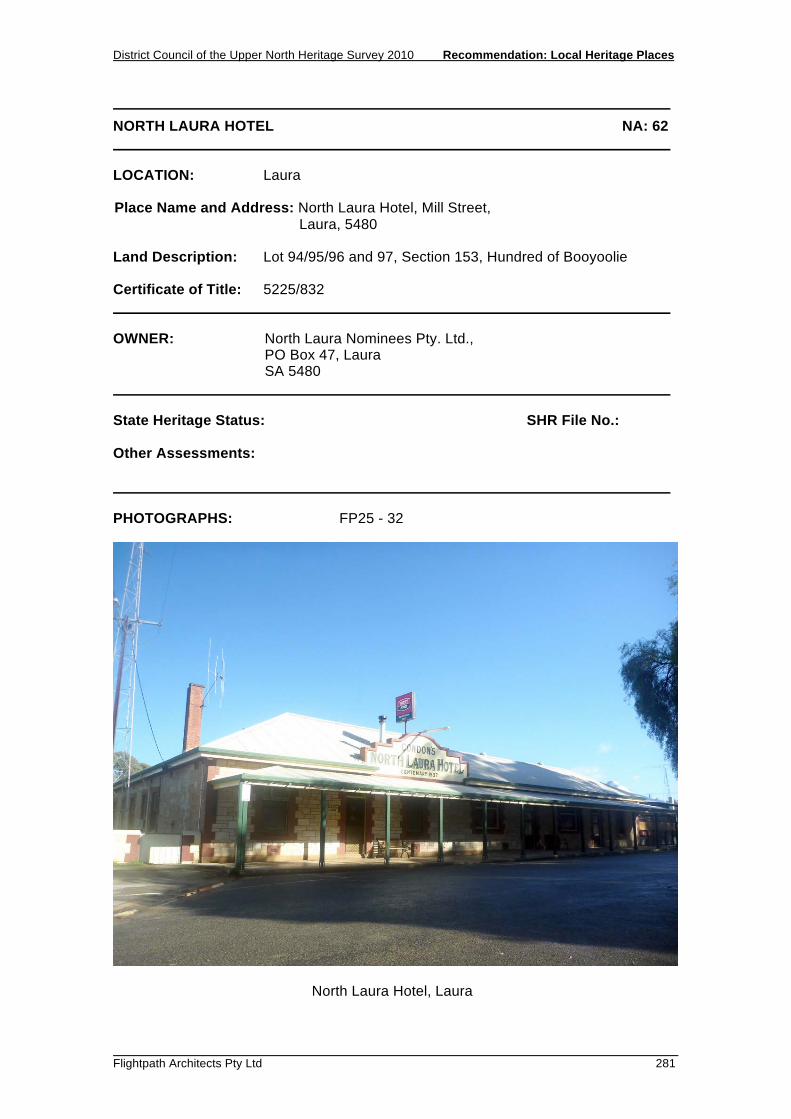
District Council of the Upper North Heritage Survey 2010 Recommendation: Local Heritage Places
Flightpath Architects Pty Ltd 281
NORTH LAURA HOTEL NA: 62 LOCATION: Laura Place Name and Address: North Laura Hotel, Mill Street, Laura, 5480 Land Description: Lot 94/95/96 and 97, Section 153, Hundred of Booyoolie Certificate of Title: 5225/832 OWNER: North Laura Nominees Pty. Ltd., PO Box 47, Laura SA 5480 State Heritage Status: SHR File No.: Other Assessments: PHOTOGRAPHS: FP25 - 32
North Laura Hotel, Laura

Recommendation: Local Heritage Places District Council of the Upper North Heritage Survey 2010
282 Flightpath Architects Pty Ltd
NORTH LAURA HOTEL NA: 62 DESCRIPTION: A single-storey building with hipped-roof and verandah, constructed of pointed stone with red-brick quoins, window reveals, chimney, and coping to rendered pediment. HISTORY: The original North Laura Hotel is believed to have been built shortly after 1876 by a Mr Ryles. This building was demolished and replaced by the present building in 1937. In 1938 the Condon family assumed the tenancy and it has since been known as Condon’s North Laura Hotel. STATEMENT OF HERITAGE VALUE: The North Laura Hotel has provided an important social service to the community since the original building was constructed in the 1870s, and in the current building since 1937. Prior to the establishment of dedicated premises for organisations such as the Freemasons, various community groups conducted meetings in the building in addition to the primary function of entertainment. The building is simple single-storey hotel building which is not exceptional but does positively contribute to the streetscape and character of the town. RELEVANT CRITERIA: (c) It has played an important part in the life of local residents, as a hotel since
1937, and as the site of the original hotel built in the 1870’s. REFERENCES: Laura Days, a peep at the bye gone. Laura Centenary Committee, Port Pirie, p35.

District Council of the Upper North Heritage Survey 2010 Recommendation: Local Heritage Places
Flightpath Architects Pty Ltd 283
POST OFFICE NA: 63 LOCATION: Laura Place Name and Address: Post Office, 23 Herbert Street, Laura, 5480 Land Description: Lot 202, Section 111, Hundred of Booyoolie Certificate of Title: 5154/547 OWNER: A.D McGowan 23 Herbert Street, Laura SA 5480 State Heritage Status: SHR File No.: Other Assessments: PHOTOGRAPHS: FP27 - 08
Post Office, Laura

Recommendation: Local Heritage Places District Council of the Upper North Heritage Survey 2010
284 Flightpath Architects Pty Ltd
POST OFFICE NA: 63 DESCRIPTION: Single storey, hipped roof building constructed of sandstone. Front facade is rendered. Two windows infilled with post boxes. Entry porch to south side. Verandah with timber fretwork and posts to street. HISTORY: The Laura Post Office was opened in 1872, providing a weekly mail service between Laura and Adelaide. By 1880 the mail service was daily and a telephone line was operating. STATEMENT OF HERITAGE VALUE: This relatively modest building is a good example of one of Laura's early buildings. It is a simple stone structure that contributes to the character of both the main commercial street and the town generally. RELEVANT CRITERIA: (d) It displays aesthetic merit of significance to the local area as a late nineteenth-
century building which contributes to the character of the main street of Laura. REFERENCES: Laura Days, a peep at the bye gone. Laura Centenary Committee, Port Pirie, p45.

District Council of the Upper North Heritage Survey 2010 Recommendation: Local Heritage Places
Flightpath Architects Pty Ltd 285
WAR MEMORIAL NA: 64 LOCATION: Laura Place Name and Address: War Memorial, Herbert Street, Laura, 5480 Land Description: Lot 118, Plan 240302, Hundred of Booyoolie Certificate of Title: 24 0302/0118 OWNER: The Crown, GPO Box, Adelaide, SA 5000 State Heritage Status: SHR File No.: Other Assessments: PHOTOGRAPHS: FP27 - 09
War Memorial, Laura
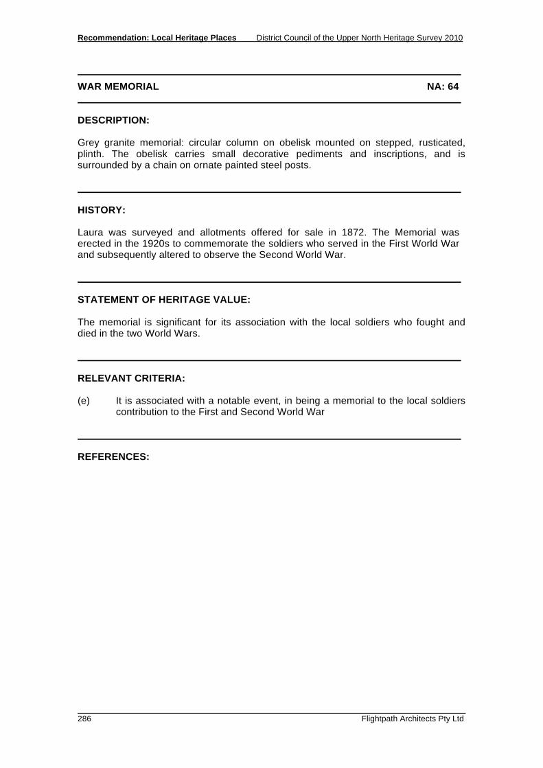
Recommendation: Local Heritage Places District Council of the Upper North Heritage Survey 2010
286 Flightpath Architects Pty Ltd
WAR MEMORIAL NA: 64 DESCRIPTION: Grey granite memorial: circular column on obelisk mounted on stepped, rusticated, plinth. The obelisk carries small decorative pediments and inscriptions, and is surrounded by a chain on ornate painted steel posts. HISTORY: Laura was surveyed and allotments offered for sale in 1872. The Memorial was erected in the 1920s to commemorate the soldiers who served in the First World War and subsequently altered to observe the Second World War. STATEMENT OF HERITAGE VALUE: The memorial is significant for its association with the local soldiers who fought and died in the two World Wars. RELEVANT CRITERIA: (e) It is associated with a notable event, in being a memorial to the local soldiers
contribution to the First and Second World War REFERENCES:
RECOMMENDATION: LOCAL HERITAGE PLACES 5.9 MANNANARIE


District Council of the Upper North Heritage Survey 2010 Recommendation: Local Heritage Places
Flightpath Architects Pty Ltd 289
BRADTKE TREE LOT NA: 77 LOCATION: Mannanarie Place Name and Address: Bradtke Tree Lot, Jamestown to Yongala Road Mannanarie Land Description: Section 56, Hundred of Mannanarie Certificate of Title: 5494/378 OWNER: K and P M Frost (Executors) c/- Austrust Ltd. 27-29 Currie Street, Adelaide 5000 State Heritage Status: SHR File No.: Other Assessments: PHOTOGRAPHS: HR9 - 26
Bradtke Tree Lot, Mannanarie

Recommendation: Local Heritage Places District Council of the Upper North Heritage Survey 2010
290 Flightpath Architects Pty Ltd
BRADTKE TREE LOT NA: 77 DESCRIPTION: Two or three hectares of sugar gum and other trees planted in rows beside the Jamestown to Yongala road, forming a conspicuous landmark in a mostly treeless landscape. HISTORY: In 1875 Ernst Bradtke of Mannanarie planted 11,000 gum trees and pines on 76 acres of his farm and surrounded them with a stone wall on the north and east as well as a wire fence. Eight acres of the garden were devoted to an orchard of apple, plum, apricot, almond and peach trees. Bradtke planted the trees in response to a program initiated by the 1873 Act to Encourage the Planting of Forest Trees, which distributed seedlings free of charge to farmers to encourage them to plant trees on their farms. An award of £2 per acre was paid to the farmer for the successful cultivation of the trees. The species selected for distribution were chosen largely by the Surveyor-General, George Goyder. Many mistakes were made with species selection, methods of planting and the care of the young trees so that vast numbers did not survive. The overall failure of the scheme prompted the creation of the Forest Board which established its own plantation and nursery at Bundaleer in 1876. Bradtke, however, prepared his soil thoroughly and his trees thrived. In 1880 he applied to the Forest Board for the award of £2 per acre which was duly made. Bradtke received £136 and his was the only plantation ever qualifying for the award under the provisions of the 1873 Act. Some 10 acres of Bradtke’s original plantation remain. STATEMENT OF HERITAGE VALUE: The Bradtke Tree Lot is significant as a surviving - and the most successful - example of the Government’s tree planting scheme in this region in the 1870s. The Government’s encouragement of farmers to grow trees as a crop is a highly unusual historic and economic theme that is characteristic of this region. The plantation is associated with the farmer Ernst Bradtke, the 1873 Act and George Goyder. RELEVANT CRITERIA: (a) It displays historical and economic themes that are of importance to the local
area. (b) It represents customs or ways of life that are characteristic of the local area. (e) It is associated with a notable local personality and event. (f) It is a notable landmark in the area.

District Council of the Upper North Heritage Survey 2010 Recommendation: Local Heritage Places
Flightpath Architects Pty Ltd 291
BRADTKE TREE LOT NA: 77 REFERENCES: Lewis, N., Hundred Years of State Forestry, 1975 Robinson, Change on Change, 1971 Robinson, Bend Down and Listen: folk tales from Mannanarie, 1974

Recommendation: Local Heritage Places District Council of the Upper North Heritage Survey 2010
292 Flightpath Architects Pty Ltd

District Council of the Upper North Heritage Survey 2010 Recommendation: Local Heritage Places
Flightpath Architects Pty Ltd 293
MANNANARIE HOMESTEAD NA: 83 LOCATION: Mannanarie Place Name and Address: Mannanarie Homestead, Mannanarie to Hornsdale Road Mannanarie Land Description: Allotment 119, Section 30, Hundred of Mannanarie Certificate of Title: 5613/527 OWNER: Boconnoc Park Pty Ltd Da Costa Building, 68 Grenfell Street, Adelaide 5000 State Heritage Status: SHR File No.: Other Assessments: PHOTOGRAPHS: HR8 - 4, 5 and HR 9 - 18 to 20
Mannanarie Homestead, Mannanarie
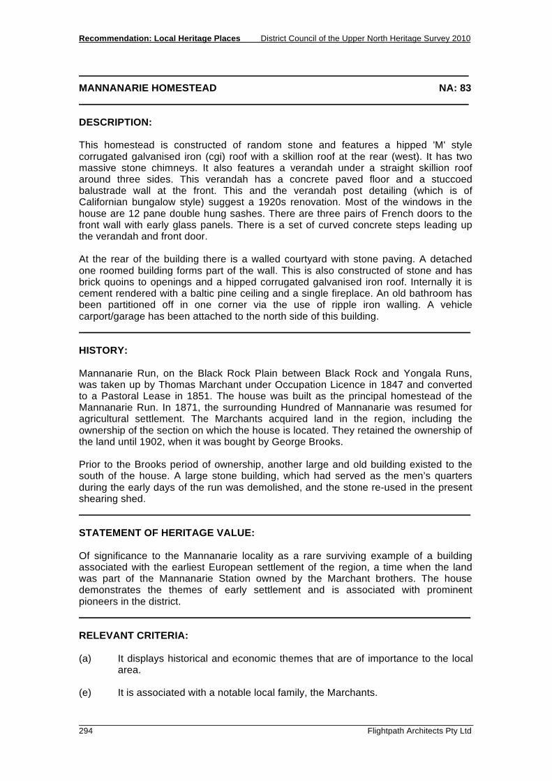
Recommendation: Local Heritage Places District Council of the Upper North Heritage Survey 2010
294 Flightpath Architects Pty Ltd
MANNANARIE HOMESTEAD NA: 83 DESCRIPTION: This homestead is constructed of random stone and features a hipped 'M' style corrugated galvanised iron (cgi) roof with a skillion roof at the rear (west). It has two massive stone chimneys. It also features a verandah under a straight skillion roof around three sides. This verandah has a concrete paved floor and a stuccoed balustrade wall at the front. This and the verandah post detailing (which is of Californian bungalow style) suggest a 1920s renovation. Most of the windows in the house are 12 pane double hung sashes. There are three pairs of French doors to the front wall with early glass panels. There is a set of curved concrete steps leading up the verandah and front door. At the rear of the building there is a walled courtyard with stone paving. A detached one roomed building forms part of the wall. This is also constructed of stone and has brick quoins to openings and a hipped corrugated galvanised iron roof. Internally it is cement rendered with a baltic pine ceiling and a single fireplace. An old bathroom has been partitioned off in one corner via the use of ripple iron walling. A vehicle carport/garage has been attached to the north side of this building. HISTORY: Mannanarie Run, on the Black Rock Plain between Black Rock and Yongala Runs, was taken up by Thomas Marchant under Occupation Licence in 1847 and converted to a Pastoral Lease in 1851. The house was built as the principal homestead of the Mannanarie Run. In 1871, the surrounding Hundred of Mannanarie was resumed for agricultural settlement. The Marchants acquired land in the region, including the ownership of the section on which the house is located. They retained the ownership of the land until 1902, when it was bought by George Brooks. Prior to the Brooks period of ownership, another large and old building existed to the south of the house. A large stone building, which had served as the men’s quarters during the early days of the run was demolished, and the stone re-used in the present shearing shed. STATEMENT OF HERITAGE VALUE: Of significance to the Mannanarie locality as a rare surviving example of a building associated with the earliest European settlement of the region, a time when the land was part of the Mannanarie Station owned by the Marchant brothers. The house demonstrates the themes of early settlement and is associated with prominent pioneers in the district. RELEVANT CRITERIA: (a) It displays historical and economic themes that are of importance to the local
area. (e) It is associated with a notable local family, the Marchants.

District Council of the Upper North Heritage Survey 2010 Recommendation: Local Heritage Places
Flightpath Architects Pty Ltd 295
MANNANARIE HOMESTEAD NA: 83 REFERENCES: Robinson (ed.), Bend Down and Listen: folk tales from Mannanarie, 1974

Recommendation: Local Heritage Places District Council of the Upper North Heritage Survey 2010
296 Flightpath Architects Pty Ltd

District Council of the Upper North Heritage Survey 2010 Recommendation: Local Heritage Places
Flightpath Architects Pty Ltd 297
MOUNT NADJURI NA: 84 LOCATION: Mannanarie Place Name and Address: Mount Nadjuri, Peak on the Narien Range, west of
Mannanarie Land Description: Section 239, Hundred of Mannanarie Certificate of Title: 5441/303 OWNER: M.F & J.L & D.P Clark PMB 19, Peterborough 5422 State Heritage Status: SHR File No.: Other Assessments: PHOTOGRAPHS: HR9-22
Mount Nadjuri Cairn, Mannanarie

Recommendation: Local Heritage Places District Council of the Upper North Heritage Survey 2010
298 Flightpath Architects Pty Ltd
MOUNT NADJURI NA: 84 DESCRIPTION: A cairn of stones located on top of Mount Nadjuri, the highest peak of the Narien Range. The peak has a spectacular view of the surrounding district. On a clear day, most of the Upper North region is visible from the summit. HISTORY: Mount Nadjuri is said to have been of particular significance to the Ngadjuri people of the region, as a source of water from nearby springs and a burial ground. The peak remained un-named until the early 1970s, when at the suggestion of Nancy Robinson, local historian and writer long associated with the Mannanarie area, the Geographical Names Board agreed to name it Mount Nadjuri after the Aboriginal clan that lived in the area. On Sunday 8 October 1972 a naming ceremony was held on the peak, and a time capsule was buried under a cairn of stones. STATEMENT OF HERITAGE VALUE: Of significance as a notable landmark in the area, named to respect the Ngadjuri people. The naming of the peak indicates the increasing regard paid to Aboriginal history in the later years of the twentieth century. The site is also associated with a prominent local resident and writer, Nancy Robinson. RELEVANT CRITERIA: (a) It displays historical themes that are of importance to the local area. (e) It is associated with a notable local personality . (f) It is a notable landmark in the area . REFERENCES: Robinson, Bend Down and Listen: folktales from Mannanarie, 1974.

RECOMMENDATION: LOCAL HERITAGE PLACES 5.10 SPALDING


District Council of the Upper North Heritage Survey 2010 Recommendation: Local Heritage Places
Flightpath Architects Pty Ltd 301
CATHOLIC CHURCH OF ST. AUGUSTINE NA:107 LOCATION: Spalding Place Name and Address: Catholic Church of St. Augustine, 26 Main Street Spalding, 5454 Land Description: Lot 21, Hundred of Andrews Certificate of Title: CT 5475/765 OWNER: Catholic Diocese of Port Pirie State Heritage Status: SHR File No.: Other Assessments: PHOTOGRAPHS:
Catholic Church, Spalding

Recommendation: Local Heritage Places District Council of the Upper North Heritage Survey 2010
302 Flightpath Architects Pty Ltd
CATHOLIC CHURCH OF ST. AUGUSTINE NA:107 DESCRIPTION: This simple Federation Romanesque styled building is single storey with rock face masonry construction. The corrugated iron roof is of gable form. The porch features a single arched window and gable roof with an iron cross, situated at the tip. Arched windows are located to both sides of the porch, and a small round window sits above the porch. A brass bell-tower is located next to the church. HISTORY: The foundation stone for the Catholic Church was laid in December of 1908. In July 1909 the Church was consecrated. The cost of the Church was £750. Other buildings within the Catholic Church complex include a Catholic Presbytery and Convent Building, located adjacent and to the rear of the church respectively. Mr. H.H. Grigg contracted the Catholic Presbytery building in 1916, and it was completed early 1917. The Convent Building was built in 1920-1921. Both are currently private residences. STATEMENT OF HERITAGE VALUE: The Catholic Church of St. Augustine is significant as it is a good example of social and historical themes that were of importance in a small pastoral community. The architecture of the building is a good example of typical early twentieth century churches. RELEVANT CRITERIA: (a) It displays historical and social themes that are of importance to the local
area. (c) It has played an important part in the lives of the local residents. (d) It displays aesthetic merit and design characteristics that are of significance
to the local area. REFERENCES: Trengove, Jan. Spalding History & Archive Group, Spalding. 2010

District Council of the Upper North Heritage Survey 2010 Recommendation: Local Heritage Places
Flightpath Architects Pty Ltd 303
SPALDING HOTEL NA:108 LOCATION: Spalding Place Name and Address: Spalding Hotel, 19 Main Street Spalding, 5454 Land Description: Lot 6, Hundred of Andrews Certificate of Title: CT 5399/910 OWNER: Tiller Catering Services Pty Ltd State Heritage Status: SHR File No.: Other Assessments: PHOTOGRAPHS:
Spalding Hotel, Spalding

Recommendation: Local Heritage Places District Council of the Upper North Heritage Survey 2010
304 Flightpath Architects Pty Ltd
SPALDING HOTEL NA:108 DESCRIPTION: A single storey building of stone construction and brick quoins with a Dutch-gable roof constructed of corrugated iron. The front façade has four entry points and 6 windows. A bull-nose verandah of corrugated iron and timber posts run the length of the street facing façade. The centre of the roof features a prominent gable, with two parapets either side. The hotel has been altered several times over the years, and it may be hard to determine the original extent of the Spalding Hotel. HISTORY: The Spalding Hotel is the first hotel to be built and licensed in the Spalding area. In 1877, Mr. John Ryles submitted plans to the Northern Licensing Bench in Clare, and the Hotel was built in that same year. In late 1879, Mr. Ryles was in a serious accident and the license for the hotel was transferred from Mr. John Cherry to Mr. J Bowles. The first renovations took place in February 1880, at the same time that Mr. E. A. Pluckrose secured the license. A billiard room and four bedrooms were added in 1914, and in 1921, 10 new rooms were added. STATEMENT OF HERITAGE VALUE: The Spalding Hotel has provided an important social service to the community since 1879. The continuous growth and alterations to the hotel over the years is a good example of the importance and frequent use of the Spalding Hotel in this area. The Hotel contributes to the character of Spalding as a prominent business place on the main street. RELEVANT CRITERIA: (a) It displays historical and social themes that are of importance to the local area. (c) It has played an important part in the lives of the local residents, having provided
services to the community. (d) It displays aesthetic merit and design characteristics significant to the local area
as a main social building on the main road of Spalding. REFERENCES: Trengove, Jan. Spalding History and Archive Group, Spalding. 2010

District Council of the Upper North Heritage Survey 2010 Recommendation: Local Heritage Places
Flightpath Architects Pty Ltd 305
RURAL YOUTH HALL (FORMER SCHOOL) NA:109 LOCATION: Spalding Place Name and Address: Rural Youth Hall (former School), 6 Main Street Spalding, 5454 Land Description: Lot 564, Hundred of Andrews Certificate of Title: CT 5817/74 OWNER: Northern Areas Council State Heritage Status: SHR File No.: Other Assessments: PHOTOGRAPHS:
Rural Youth Hall, Spalding

Recommendation: Local Heritage Places District Council of the Upper North Heritage Survey 2010
306 Flightpath Architects Pty Ltd
RURAL YOUTH HALL (FORMER SCHOOL) NA:109 DESCRIPTION: This simple single storey building is of stone construction with rendered brick quoins. The roof is of gable form with corrugated iron and one chimney. The street facing façade has a single arched door and no windows or verandahs. The northern façade features two original arched windows and a non-original rectangular window. This was most likely an early addition, as are the three similar rectangular windows on the rear façade. There is a lean-to addition on the southern side of the building. HISTORY: Construction of The Rural Youth Hall began in 1883 and was complete in 1884. The purpose of the building originally was to house the first school in Spalding. It only had one room at the time of construction. A lean to addition was constructed some time after. The Hall has since been used for a variety of purposes, including Catholic Mass. STATEMENT OF HERITAGE VALUE: The Rural Youth Hall has provided a place for various community meetings since its establishment in 1884, including the first school in Spalding, therefore playing an important role to the local residents. RELEVANT CRITERIA: (a) It displays historical and social themes that are of importance to the local area. (c) It has played an important part in the lives of the local residents. REFERENCES: Trengove, Jan. Spalding History & Archive Group, Spalding. 2010

District Council of the Upper North Heritage Survey 2010 Recommendation: Local Heritage Places
Flightpath Architects Pty Ltd 307
GRANDSTAND NA:110 LOCATION: Spalding Place Name and Address: Grandstand, Trelyn Road Spalding, 5454 Land Description: Lot 26, Hundred of Andrews Certificate of Title: CT 5783/824 OWNER: Northern Areas Council State Heritage Status: SHR File No.: Other Assessments: PHOTOGRAPHS:
Grandstand, Spalding
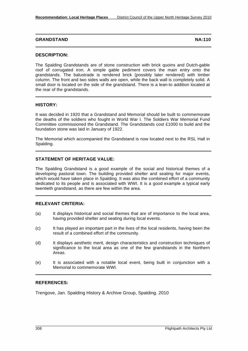
Recommendation: Local Heritage Places District Council of the Upper North Heritage Survey 2010
308 Flightpath Architects Pty Ltd
GRANDSTAND NA:110 DESCRIPTION: The Spalding Grandstands are of stone construction with brick quoins and Dutch-gable roof of corrugated iron. A simple gable pediment covers the main entry onto the grandstands. The balustrade is rendered brick (possibly later rendered) with timber column. The front and two sides walls are open, while the back wall is completely solid. A small door is located on the side of the grandstand. There is a lean-to addition located at the rear of the grandstands. HISTORY: It was decided in 1920 that a Grandstand and Memorial should be built to commemorate the deaths of the soldiers who fought in World War I. The Soldiers War Memorial Fund Committee commissioned the Grandstand. The Grandstands cost £1000 to build and the foundation stone was laid in January of 1922. The Memorial which accompanied the Grandstand is now located next to the RSL Hall in Spalding. STATEMENT OF HERITAGE VALUE: The Spalding Grandstand is a good example of the social and historical themes of a developing pastoral town. The building provided shelter and seating for major events, which would have taken place in Spalding. It was also the combined effort of a community dedicated to its people and is associated with WWI. It is a good example a typical early twentieth grandstand, as there are few within the area. RELEVANT CRITERIA: (a) It displays historical and social themes that are of importance to the local area,
having provided shelter and seating during local events. (c) It has played an important part in the lives of the local residents, having been the
result of a combined effort of the community. (d) It displays aesthetic merit, design characteristics and construction techniques of
significance to the local area as one of the few grandstands in the Northern Areas.
(e) It is associated with a notable local event, being built in conjunction with a
Memorial to commemorate WWI. REFERENCES: Trengove, Jan. Spalding History & Archive Group, Spalding. 2010

RECOMMENDATION: LOCAL HERITAGE PLACES 5.11 SPALDING (SURROUNDS)


District Council of the Upper North Heritage Survey 2010 Recommendation: Local Heritage Places
Flightpath Architects Pty Ltd 311
BUNDALEER HOMESTEAD AND WOOLSHED NA: 65 LOCATION: Spalding Place Name and Address: Bundaleer Homestead and Woolshed, 10km NW of
SpaldingSpalding Land Description: Part Allotments 2 - 6, Section 10N, Hundred of Bundaleer (Homestead) Part Allotments 109-111, Part Section 10S, Hundred of Bundaleer (Woolshed) Certificate of Title: 5508/549 (Homestead), 5376/809 (Woolshed) OWNER: D I E McPherson (Homestead) 41 Farrell Flat Road, Clare 5453 G E M Ashby (Woolshed) PO Box 17, Gulnare 5471 State Heritage Status: SHR File No.: Other Assessments: PHOTOGRAPHS: HR9 – 02
Bundaleer Woolshed

Recommendation: Local Heritage Places District Council of the Upper North Heritage Survey 2010
312 Flightpath Architects Pty Ltd
BUNDALEER HOMESTEAD AND WOOLSHED NA: 65 DESCRIPTION: The homestead is an early twentieth century design in sandstone construction with a gabled corrugated galvanised iron roof and verandahs to either side. The shearing shed is of typical rectangular design, constructed of stone with a gabled corrugated galvanised iron roof. It has fenced yards on two sides. HISTORY:
Bundaleer was the first sheep run taken up in the Upper North region, an area of over 300 square miles, stocked by John Bristow Hughes between 1841 and 1843. Soon after, his brothers took up the adjacent Booyoolee Run. Bundaleer's strategic position on the Gulnare Plains watered by Bundaleer and Yackamoorundie Creeks made it a highly successful property, and in 1854 Hughes sold it for £31,000 to Charles Brown Fisher, to become a central part of his merino breeding empire. Fisher in later years expressed the opinion that Bundaleer, Hill River, Canowie and Booborowie 'are the pick properties in Australia'. The Hundred of Bundaleer was declared in 1869, and much of the property was resumed for agricultural selection, although Fisher bought the core of the run to continue grazing. Financially over-extended, Fisher was forced to sell Bundaleer to Robert Barr Smith and John Maslin in 1875, and Maslin became sole owner in 1886. In 1898 he divided what remained of the run into Bundaleer South and Bundaleer North for his two sons. Although the names are still in use, the properties have been reduced to small farms. The original large Bundaleer (South) homestead complex was mostly demolished by the early twentieth century. The present house dates from after Maslin's division of the property. The existing woolshed may be a part of the very large woolshed built by Hughes or Fisher. Although Bundaleer is historically the pre-eminent sheep run of the region, its physical heritage today is much less significant than that of other early properties such as Booyoolee, Mount Remarkable or Canowie. In 1938 the Adelaide Steamship Company launched its last passenger steamer, and in keeping with its practice of giving its vessels rural South Australian names, called it SS Bundaleer. STATEMENT OF HERITAGE VALUE:
Bundaleer homestead and woolshed are of heritage value because of their connection with one of the oldest and most important grazing properties of the Upper North region. RELEVANT CRITERIA: (a) Displays historical themes of importance to the local area. (e) Associated with a notable local personality or event. REFERENCES: 'Bundaleer' and 'North Bundaleer', The Garden and Field October 1909 Cockburn, R., Pastoral Pioneers of South Australia, 1925 Journal of Herbert and Bristow Hughes, 1845-49 Robinson,N., Change on Change, 1971

District Council of the Upper North Heritage Survey 2010 Recommendation: Local Heritage Places
Flightpath Architects Pty Ltd 313
HEATHERMOOR FARMHOUSE NA: 66 LOCATION: 11km N of Spalding Place Name and Address: Heathermoor Farmhouse, Belalie East Road, Spalding Land Description: Section 140, Hundred of Reynolds Certificate of Title: 5349/325 OWNER: Thomas Edward Ashby PO Box 17, Gulnare SA 5471 State Heritage Status: SHR File No.: Other Assessments: PHOTOGRAPHS: HR Colour Print
Heathermoor Farmhouse, Spalding

Recommendation: Local Heritage Places District Council of the Upper North Heritage Survey 2010
314 Flightpath Architects Pty Ltd
HEATHERMOOR FARMHOUSE NA: 66 DESCRIPTION: This rectangular stone building is of the type known as a 'skillion roof cottage' and was designed to be the rear part of a villa or bungalow; the idea being the other (front) portion could be added when times improved. The otherwise featureless front wall has a single central door and remnants of a wall plate indicating a former verandah. The roof is of corrugated galvanised iron and there are windows at either end of the building. The building has a single chimney. HISTORY: This house is a good representative of a once-common building practice in the Upper North. A Victorian journalist visiting the Northern Areas in 1874 described: 'houses ... built skillion fashion (with the white stone already spoken of) evidently with the intention of adding a main building at the front by and by' (Dow 1874, p. 31). Many of the first generation of farmhouses were built as the rear section of what was to become a larger house, and were distinctive in appearance because of their single-pitched roof, which the journalist described as 'skillion fashion'. When the rest of the house was added, the building became completely orthodox in appearance. But in many cases, 'by and by' never arrived, and all over the region there are houses like this one, arrested in their first stage of construction. STATEMENT OF HERITAGE VALUE: This house is a good representative of a characteristic building practice associated with the agricultural settlement of the 1870s. RELEVANT CRITERIA: (a) Displays themes important to the local area. (d) Design characteristics and construction techniques significant to local area. REFERENCES: Dow, Agriculture in South Australia, 1874

District Council of the Upper North Heritage Survey 2010 Recommendation: Local Heritage Places
Flightpath Architects Pty Ltd 315
MUNDUNNEY STABLE RUINS NA: 67 LOCATION: Spalding Place Name and Address: Mundunney Stable Ruins, 18km NE of Spalding, Spalding Land Description: Allotment 173, Section 1, Hundred of Anne Certificate of Title: 5662/809 OWNER: The University of Adelaide / Prince Alfred College c/o Martindale Holdings PO Box 24, Mintaro SA, 5415 State Heritage Status: SHR File No.: Other Assessments: PHOTOGRAPHS: HR8 - 30 to 36
Mundunney Stable Ruins, Spalding
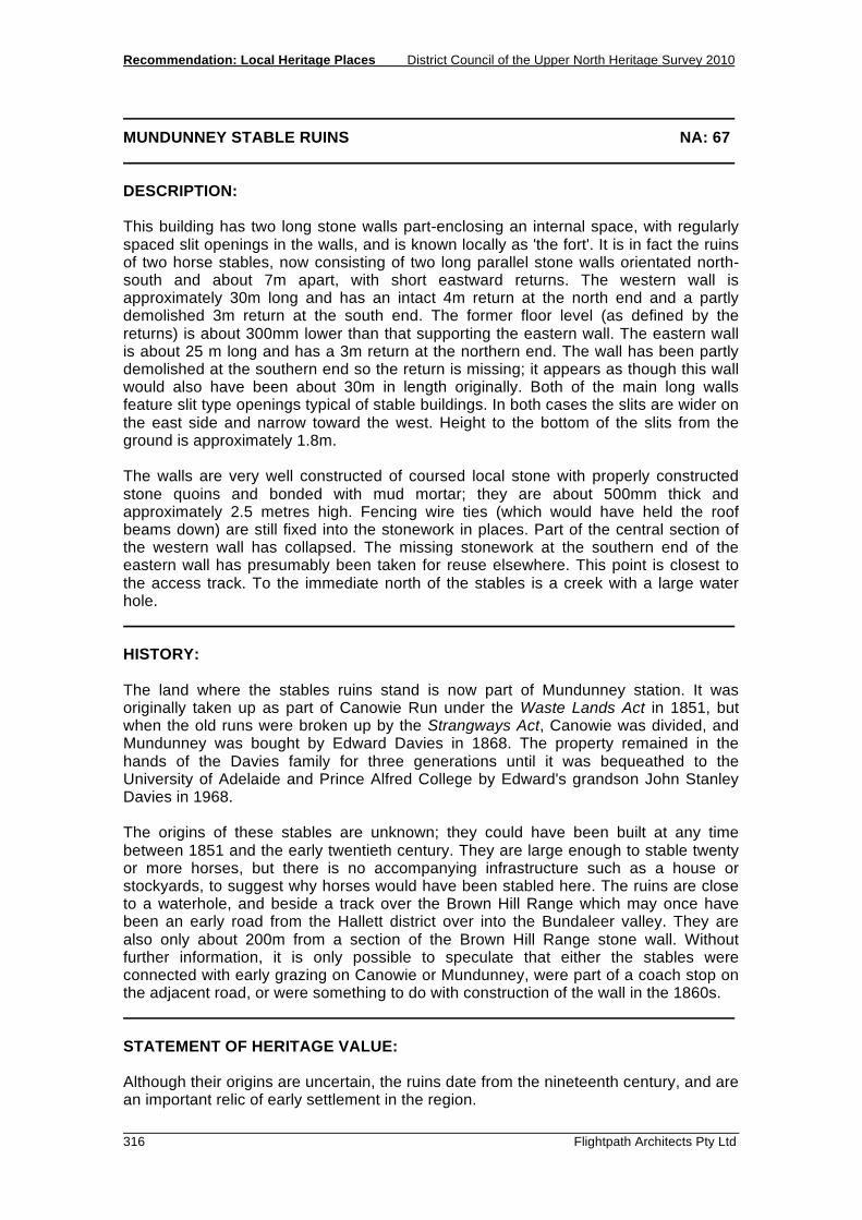
Recommendation: Local Heritage Places District Council of the Upper North Heritage Survey 2010
316 Flightpath Architects Pty Ltd
MUNDUNNEY STABLE RUINS NA: 67 DESCRIPTION: This building has two long stone walls part-enclosing an internal space, with regularly spaced slit openings in the walls, and is known locally as 'the fort'. It is in fact the ruins of two horse stables, now consisting of two long parallel stone walls orientated north-south and about 7m apart, with short eastward returns. The western wall is approximately 30m long and has an intact 4m return at the north end and a partly demolished 3m return at the south end. The former floor level (as defined by the returns) is about 300mm lower than that supporting the eastern wall. The eastern wall is about 25 m long and has a 3m return at the northern end. The wall has been partly demolished at the southern end so the return is missing; it appears as though this wall would also have been about 30m in length originally. Both of the main long walls feature slit type openings typical of stable buildings. In both cases the slits are wider on the east side and narrow toward the west. Height to the bottom of the slits from the ground is approximately 1.8m. The walls are very well constructed of coursed local stone with properly constructed stone quoins and bonded with mud mortar; they are about 500mm thick and approximately 2.5 metres high. Fencing wire ties (which would have held the roof beams down) are still fixed into the stonework in places. Part of the central section of the western wall has collapsed. The missing stonework at the southern end of the eastern wall has presumably been taken for reuse elsewhere. This point is closest to the access track. To the immediate north of the stables is a creek with a large water hole. HISTORY: The land where the stables ruins stand is now part of Mundunney station. It was originally taken up as part of Canowie Run under the Waste Lands Act in 1851, but when the old runs were broken up by the Strangways Act, Canowie was divided, and Mundunney was bought by Edward Davies in 1868. The property remained in the hands of the Davies family for three generations until it was bequeathed to the University of Adelaide and Prince Alfred College by Edward's grandson John Stanley Davies in 1968. The origins of these stables are unknown; they could have been built at any time between 1851 and the early twentieth century. They are large enough to stable twenty or more horses, but there is no accompanying infrastructure such as a house or stockyards, to suggest why horses would have been stabled here. The ruins are close to a waterhole, and beside a track over the Brown Hill Range which may once have been an early road from the Hallett district over into the Bundaleer valley. They are also only about 200m from a section of the Brown Hill Range stone wall. Without further information, it is only possible to speculate that either the stables were connected with early grazing on Canowie or Mundunney, were part of a coach stop on the adjacent road, or were something to do with construction of the wall in the 1860s. STATEMENT OF HERITAGE VALUE: Although their origins are uncertain, the ruins date from the nineteenth century, and are an important relic of early settlement in the region.
District Council of the Upper North Heritage Survey 2010 Recommendation: Local Heritage Places
Flightpath Architects Pty Ltd 317
MUNDUNNEY STABLE RUINS NA: 67 RELEVANT CRITERIA:
(a) Displays themes important to the local area.
REFERENCES: Keain, From Where the Broughton Flows, 1976

Recommendation: Local Heritage Places District Council of the Upper North Heritage Survey 2010
318 Flightpath Architects Pty Ltd

District Council of the Upper North Heritage Survey 2010 Recommendation: Local Heritage Places
Flightpath Architects Pty Ltd 319
MUNDUNNEY HOMESTEAD NA: 68 LOCATION: Spalding Place Name and Address: Mundunney Homestead, 10km NE of Spalding, Spalding Land Description: Section 130, Hundred of Reynolds Certificate of Title: 5731/417 OWNER: The University of Adelaide and Prince Alfred College C/- North Terrace, Adelaide 5000 State Heritage Status: SHR File No.: Other Assessments: PHOTOGRAPHS: HR8 - 14 to 27
Mundunney Homestead, Spalding

Recommendation: Local Heritage Places District Council of the Upper North Heritage Survey 2010
320 Flightpath Architects Pty Ltd
MUNDUNNEY HOMESTEAD NA: 68 DESCRIPTION: This homestead is constructed of ruled stone work with formal stone quoins and a gabled and hipped corrugated galvanised iron roof. The front (south) of the building is double storeyed and features bay windows and a verandah with lacework and a pressed metal ceiling. Some of the main doors and windows feature leadlight glass. There is a formal garden at the front of the house complete with a semi-circular driveway, plantings and hedges. According to the manager, there are extensive records such as Letter Books, Minute Books, Stud Books and other material pertaining to the history and development of the property stored in the basement. A large woolshed and shearers' quarters of stone and concrete also form part of the homestead complex. HISTORY: Mundunney was originally taken up as part of Canowie Run under the Waste Lands Act in 1851. When the old runs were broken up by the Strangways Act, Canowie was divided, and Mundunney was bought by Edward Davies in 1868 to run cattle and sheep. His first homestead was located close to a waterhole about 3km south of this point, but within a few years it was relocated to this more accessible position beside the Bundaleer to Booborowie Road. The homestead originally consisted of a single-storey stone cottage, but in 1913-14 Edward's son John Davies extended it down the slope into a grand - two storey Edwardian mansion. The plans for the extension, drawn by architects Cowell and Cowell of Adelaide, are framed in the dining room. The shearing shed and shearers' quarters also date from expansion of the property in the early twentieth century. Under John Davies' management, Mundunney became a noted Shorthorn and Hereford stud. The property remained in the Davies family until the death of Edward's grandson John Stanley Davies in 1968, when it was bequeathed to the University of Adelaide and Prince Alfred College. STATEMENT OF HERITAGE VALUE: The facade of the homestead is a fine example of Edwardian architecture, very unusual for this region. It is a nineteenth century homestead expanded over time, and shows the architectural styles of each period of expansion. RELEVANT CRITERIA: (a) Displays themes important to the local area. REFERENCES: Keain, From Where the Broughton Flows, 1976 Building plans held at Munduney Information from Julie Humphris

District Council of the Upper North Heritage Survey 2010 Recommendation: Local Heritage Places
Flightpath Architects Pty Ltd 321
OLD MUNDUNNEY HOMESTEAD RUIN NA: 69 LOCATION: Spalding Place Name and Address: Old Mundunney Homestead Ruin, 9km E of Spalding, Spalding Land Description: Allotments 98 - 102, Hundred of Andrews Certificate of Title: 5631/471 OWNER: The University of Adelaide and Prince Alfred College North Terrace, Adelaide 5000 State Heritage Status: SHR File No.: Other Assessments: PHOTOGRAPHS: HR8 - 28 to 29
Mundunney Homestead Ruin, Spalding
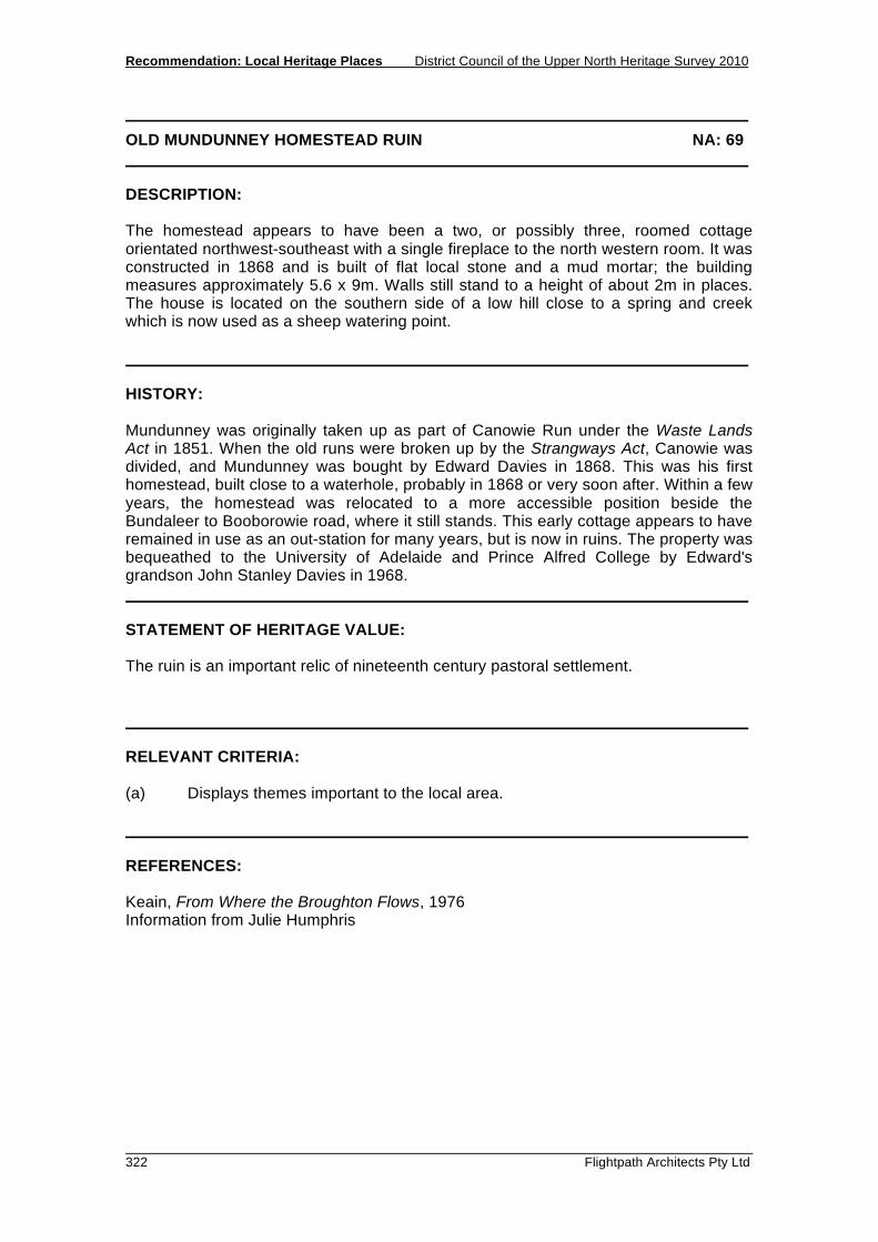
Recommendation: Local Heritage Places District Council of the Upper North Heritage Survey 2010
322 Flightpath Architects Pty Ltd
OLD MUNDUNNEY HOMESTEAD RUIN NA: 69 DESCRIPTION: The homestead appears to have been a two, or possibly three, roomed cottage orientated northwest-southeast with a single fireplace to the north western room. It was constructed in 1868 and is built of flat local stone and a mud mortar; the building measures approximately 5.6 x 9m. Walls still stand to a height of about 2m in places. The house is located on the southern side of a low hill close to a spring and creek which is now used as a sheep watering point. HISTORY: Mundunney was originally taken up as part of Canowie Run under the Waste Lands Act in 1851. When the old runs were broken up by the Strangways Act, Canowie was divided, and Mundunney was bought by Edward Davies in 1868. This was his first homestead, built close to a waterhole, probably in 1868 or very soon after. Within a few years, the homestead was relocated to a more accessible position beside the Bundaleer to Booborowie road, where it still stands. This early cottage appears to have remained in use as an out-station for many years, but is now in ruins. The property was bequeathed to the University of Adelaide and Prince Alfred College by Edward's grandson John Stanley Davies in 1968. STATEMENT OF HERITAGE VALUE: The ruin is an important relic of nineteenth century pastoral settlement. RELEVANT CRITERIA: (a) Displays themes important to the local area. REFERENCES: Keain, From Where the Broughton Flows, 1976 Information from Julie Humphris

District Council of the Upper North Heritage Survey 2010 Recommendation: Local Heritage Places
Flightpath Architects Pty Ltd 323
WHEAL SARAH NA: 85 LOCATION: Bundaleer Place Name and Address: Wheal Sarah, 8km NW of Spalding, Spalding Land Description: Allotment pieces 43 and 44, Hundred of Bundaleer Certificate of Title: 5642/862 OWNER: P.G & L.M & T.S Hammat 'Little Oakley', Spalding 5454 State Heritage Status: SHR File No.: Other Assessments: PHOTOGRAPHS: HR4 - 10 to12
Wheal Sarah, Bundaleer

Recommendation: Local Heritage Places District Council of the Upper North Heritage Survey 2010
324 Flightpath Architects Pty Ltd
WHEAL SARAH NA: 85 DESCRIPTION: This is a small mine site which consists of about 8 shallow shafts or pits dotted up the side and across the summit of a low hill. There is one open adit which is now used by the landowner as a sheep shelter in cold wet weather. There is a small, galvanized steel headframe over one of the shafts. This has a metal base plate with mounting bolts at one side - this presumably anchored a small electric winder. There are a few small piles of mullock associated with the shafts. The site is close to the Bundaleer homestead and reservoir, and overlooks one of the aqueducts. HISTORY: In 1858 a small deposit of copper ore was discovered near Bundaleer homestead. Specimens were exhibited in Adelaide, and experienced miners were recruited from Burra. The mine was called Wheal Sarah. It was worked for only a few years, and seems to have been abandoned in 1861. During that time, there must have been a small resident mining community, as Nancy Robinson records that several births were registered in Burra with the address given as 'Wheal Sarah mine, Bundaleer Station'. In the late 1870s a new company was floated in Jamestown to re-open the prospect, renamed the Belalie Mine, but little if any work was done. (Robinson 1971, p. 65) STATEMENT OF HERITAGE VALUE: Wheal Sarah is of heritage value as a good representative of the small unsuccessful mines scattered through the Upper North region which provided some economic diversity and incentive during the early decades of settlement. RELEVANT CRITERIA: (a) It displays mining themes important to the local area. REFERENCES: Brown, Record of the Mines of South Australia, 1908 Robinson, Change on Change, 1971

RECOMMENDATION: LOCAL HERITAGE PLACES 5.12 STONE HUT

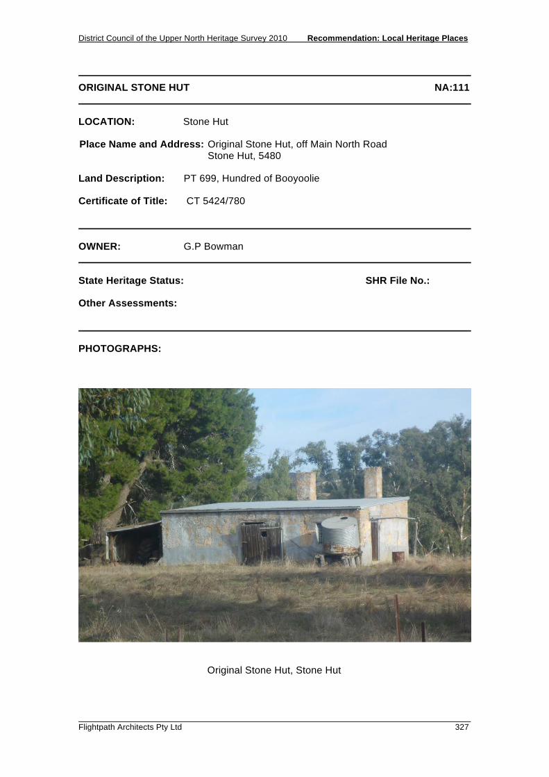
District Council of the Upper North Heritage Survey 2010 Recommendation: Local Heritage Places
Flightpath Architects Pty Ltd 327
ORIGINAL STONE HUT NA:111 LOCATION: Stone Hut Place Name and Address: Original Stone Hut, off Main North Road Stone Hut, 5480 Land Description: PT 699, Hundred of Booyoolie Certificate of Title: CT 5424/780 OWNER: G.P Bowman State Heritage Status: SHR File No.: Other Assessments: PHOTOGRAPHS:
Original Stone Hut, Stone Hut

Recommendation: Local Heritage Places District Council of the Upper North Heritage Survey 2010
328 Flightpath Architects Pty Ltd
ORIGINAL STONE HUT NA:111 DESCRIPTION: A simple single storey building constructed of stone. The roof, which once was a steeply pitched gable, is now an almost-flat skillion roof of corrugated iron. Two stone chimneys are located at the rear of the building. A water tank, located on the north-east corner of the building, obscures the view from the original window. The original window features 49 panes of glass, with an opening pane located to the centre of the window. A door is located at the centre of the front façade (next to the window) and there is a lean-to addition on the southern side of the building. The building is in a dilapidated state, but there is potential for restoration. Outbuildings are constructed of large vertical timber slabs and thatched roofs. HISTORY: The original Stone Hut was built in the 1850’s as an outstation at Charlton Run by stonemason Thomas Long. The first owners were Samuel Frederick and Edward White. It became a stopping place for teamsters carting wood from Whites’ forest to the Burra Mines. It was the first building to be erected in the small town of Stone Hut. The Stone Hut was run as a store by Messrs. Hall and Henderson, and it is said that the glass paned window was installed as a precaution against theft. When the town of Stone Hut was surveyed in 1874, Hall and Henderson relocated their store to the village. The current roof of the Original Stone Hut is quite flat and clad in corrugated iron, where as originally it was most likely much steeper. STATEMENT OF HERITAGE VALUE: The Original Stone Hut is a relic of the mailcoach days and was a stopping place for the wood carts from Whites Forest to the Burra Mines. It is a good example of social themes that were of importance to the pastoral settlers. It has also played an important part of the lives of local residents, being the first building established in the Stone Hut area. RELEVANT CRITERIA: (a) It displays historical and social themes that are of importance to the local area,
being a stopping place for travelling wood carts in the early pastoral days. (c) It has played an important part in the lives of the local residents as the first Stone
Hut. REFERENCES: ‘Laura Days’ Laura Centenary Celebreations Publication 1972. Stone Hut Heritage Walk, Stone Hut Development Committee. 2010 McLellan, Alan, ‘Our Place in the Sun’ Trans 1st July 1965 Pioneer Regional Building Techniques, D.W Berry & S.H Gilbert

District Council of the Upper North Heritage Survey 2010 Recommendation: Local Heritage Places
Flightpath Architects Pty Ltd 329
STONE HUT SOLDIERS MEMORIAL HALL NA:112 LOCATION: Stone Hut Place Name and Address: Stone Hut Soldiers Memorial Hall, Cnr. Borthwick Street &
Main North Road Stone Hut, 5480 Land Description: Lot 17, Hundred of Appila Certificate of Title: CT 5778/967 OWNER: State Heritage Status: SHR File No.: Other Assessments: PHOTOGRAPHS: HR4 - 29 to 33
Soldiers Memorial Hall, Stone Hut
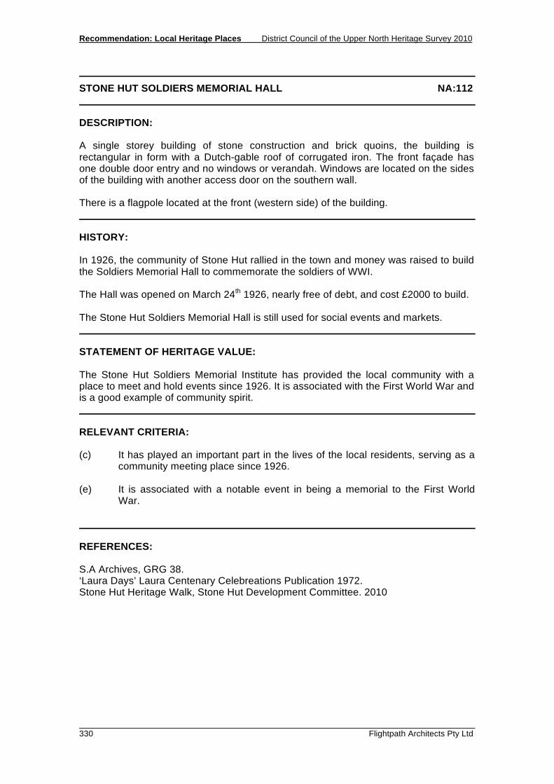
Recommendation: Local Heritage Places District Council of the Upper North Heritage Survey 2010
330 Flightpath Architects Pty Ltd
STONE HUT SOLDIERS MEMORIAL HALL NA:112 DESCRIPTION: A single storey building of stone construction and brick quoins, the building is rectangular in form with a Dutch-gable roof of corrugated iron. The front façade has one double door entry and no windows or verandah. Windows are located on the sides of the building with another access door on the southern wall. There is a flagpole located at the front (western side) of the building. HISTORY: In 1926, the community of Stone Hut rallied in the town and money was raised to build the Soldiers Memorial Hall to commemorate the soldiers of WWI. The Hall was opened on March 24th 1926, nearly free of debt, and cost £2000 to build. The Stone Hut Soldiers Memorial Hall is still used for social events and markets. STATEMENT OF HERITAGE VALUE: The Stone Hut Soldiers Memorial Institute has provided the local community with a place to meet and hold events since 1926. It is associated with the First World War and is a good example of community spirit. RELEVANT CRITERIA: (c) It has played an important part in the lives of the local residents, serving as a
community meeting place since 1926. (e) It is associated with a notable event in being a memorial to the First World
War. REFERENCES: S.A Archives, GRG 38. ‘Laura Days’ Laura Centenary Celebreations Publication 1972. Stone Hut Heritage Walk, Stone Hut Development Committee. 2010

District Council of the Upper North Heritage Survey 2010 Recommendation: Local Heritage Places
Flightpath Architects Pty Ltd 331
FORMER SCHOOL & RESIDENCE NA:113 LOCATION: Stone Hut Place Name and Address: Former School & Residence, Murray Street Stone Hut, 5480 Land Description: Lot 43, Hundred of Appila Certificate of Title: CT 5905/661 OWNER: M.J.T Stockwell & L.F Findlay State Heritage Status: SHR File No.: Other Assessments: PHOTOGRAPHS:
School, Stone Hut
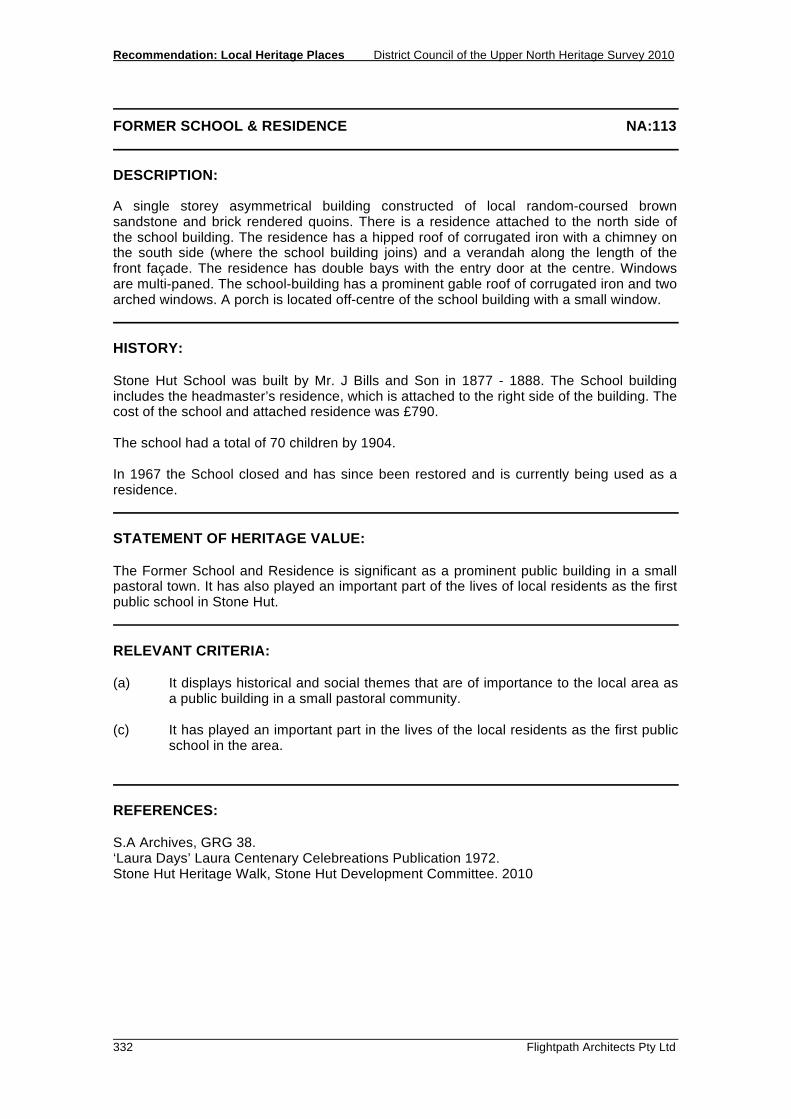
Recommendation: Local Heritage Places District Council of the Upper North Heritage Survey 2010
332 Flightpath Architects Pty Ltd
FORMER SCHOOL & RESIDENCE NA:113 DESCRIPTION: A single storey asymmetrical building constructed of local random-coursed brown sandstone and brick rendered quoins. There is a residence attached to the north side of the school building. The residence has a hipped roof of corrugated iron with a chimney on the south side (where the school building joins) and a verandah along the length of the front façade. The residence has double bays with the entry door at the centre. Windows are multi-paned. The school-building has a prominent gable roof of corrugated iron and two arched windows. A porch is located off-centre of the school building with a small window. HISTORY: Stone Hut School was built by Mr. J Bills and Son in 1877 - 1888. The School building includes the headmaster’s residence, which is attached to the right side of the building. The cost of the school and attached residence was £790. The school had a total of 70 children by 1904. In 1967 the School closed and has since been restored and is currently being used as a residence. STATEMENT OF HERITAGE VALUE: The Former School and Residence is significant as a prominent public building in a small pastoral town. It has also played an important part of the lives of local residents as the first public school in Stone Hut. RELEVANT CRITERIA: (a) It displays historical and social themes that are of importance to the local area as
a public building in a small pastoral community. (c) It has played an important part in the lives of the local residents as the first public
school in the area. REFERENCES: S.A Archives, GRG 38. ‘Laura Days’ Laura Centenary Celebreations Publication 1972. Stone Hut Heritage Walk, Stone Hut Development Committee. 2010
RECOMMENDATION: LOCAL HERITAGE PLACES 5.13 YACKA

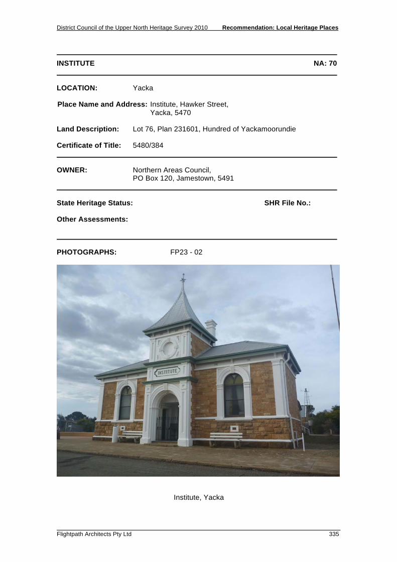
District Council of the Upper North Heritage Survey 2010 Recommendation: Local Heritage Places
Flightpath Architects Pty Ltd 335
INSTITUTE NA: 70 LOCATION: Yacka Place Name and Address: Institute, Hawker Street, Yacka, 5470 Land Description: Lot 76, Plan 231601, Hundred of Yackamoorundie Certificate of Title: 5480/384 OWNER: Northern Areas Council, PO Box 120, Jamestown, 5491 State Heritage Status: SHR File No.: Other Assessments: PHOTOGRAPHS: FP23 - 02
Institute, Yacka
Recommendation: Local Heritage Places District Council of the Upper North Heritage Survey 2010
336 Flightpath Architects Pty Ltd
INSTITUTE NA: 70 DESCRIPTION: A symmetrical building with a prominent entrance portico and tower, constructed of sandstone with rendered quoins and window and door treatments. A sympathetic extension addresses Charles Street to the north. HISTORY: The foundation stone of the Institute was laid by the Governor, Sir Anthony Musgrave, on 21 October, 1875. The building was officially opened at the same time as town’s first bridge across the Broughton River on 20 October 1876. In 1907, the square entrance portico with tower, and two adjoining rooms, were built. The new building was officially opened by the architect, Thomas Burgoyne, MP. In 1937, the Institute Hall was further renovated with improvements including the addition of a stage, dressing rooms and toilets. This work was opened on 28 May 1937. STATEMENT OF HERITAGE VALUE: The Institute is significant for the continual service it has provided to the community since opening in 1875. The different sections of the building reflect the optimism and prosperity of various periods of the town’s development. The scale and distinctive facade plays a crucial role in defining the main street. The importance of the building is evident in it being the largest and most ornate building in the street. The prominent entrance tower features an arched entry and a simple spire, quite distinct from other buildings in the town, and other Institute buildings in the region. Whilst original features such as the windows have been replaced, the integrity of the building remains. RELEVANT CRITERIA: (c) It has played an important part in the life of local residents by providing a
community venue meeting place since 1875. (d) It displays aesthetic merit and design characteristics of significance to the local
area, in that it features elements such as portico tower which distinguishes it from other Institute buildings in the region.
REFERENCES: Ellis, Julie-Ann, Hard Yacka: the story of a mid north town in South Australia, Yacka Historical Group, Yacka, 1995.

District Council of the Upper North Heritage Survey 2010 Recommendation: Local Heritage Places
Flightpath Architects Pty Ltd 337
PRIMARY SCHOOL NA: 71 LOCATION: Yacka Place Name and Address: Primary School, Beare Street, Yacka, 5470 Land Description: Lots 42/43/112/113 and 114, Part Section 24, Hundred of Yackamoorundie Certificate of Title: 5645/860 and 921/101 OWNER: J.E Fulton & L.R Yeats PO Box 15, Yacka SA 5470 State Heritage Status: SHR File No.: Other Assessments: PHOTOGRAPHS: FP 23 – 06
Yacka Primary School
Recommendation: Local Heritage Places District Council of the Upper North Heritage Survey 2010
338 Flightpath Architects Pty Ltd
PRIMARY SCHOOL NA: 71 DESCRIPTION: A simple rectangular building of sandstone construction with red brick quoins, and rendered sills and lintels. It has a gable roof with parapet ends featuring bevelled red brick copings. A lightweight, timber lean-to extension runs the length of the western elevation. HISTORY: The building was constructed in 1912 after the previous timber-framed building burnt down the previous year. STATEMENT OF HERITAGE VALUE: The now disused Primary School building is an important building due to the significant part that it has played in the lives of the local community since 1912. The building form is consistent with other school buildings of the same vintage in the region. Notable is the brickwork detailing and a large rendered chimney visible from the street. RELEVANT CRITERIA: (c) It has played an important part in the life of local residents, offering schooling
to the community’s children since 1912. REFERENCES: Ellis, Julie-Ann. Hard Yacka: the story of a mid north town in South Australia, Yacka Historical Group, Yacka, 1995.

District Council of the Upper North Heritage Survey 2010 Recommendation: Local Heritage Places
Flightpath Architects Pty Ltd 339
SOLDIERS MEMORIAL AND GARDEN NA: 72 LOCATION: Yacka Place Name and Address: Soldiers Memorial and Garden, Hawker Street Yacka, 5470 Land Description: Lot 106, Plan 231601, Hundred of Yackamoorundie Certificate of Title: 23 1601/0106 OWNER: Northern Areas Council, PO Box 120, Jamestown, 5491 State Heritage Status: SHR File No.: Other Assessments: PHOTOGRAPHS: FP29 - 03
Soldiers Memorial and Garden

Recommendation: Local Heritage Places District Council of the Upper North Heritage Survey 2010
340 Flightpath Architects Pty Ltd
SOLDIERS MEMORIAL AND GARDEN NA: 72 DESCRIPTION: A marble statue of an infantryman mounted on a white marble base carrying the following inscriptions: 'Erected by the public of Yacka, and surrounding District, 1921.' and the names of fallen soldiers from the First World War on the front of the plinth. The memorial is gated and surrounded by a low scale tended garden. HISTORY: The Yacka Soldiers Memorial was erected on government owned land in 1921 to recognise the sacrifice that locals made during the First World War. The base is constructed of Angaston Marble, with the finely sculptured statue imported from Italy. The memorial was unveiled to the public on the 5 August 1921, by Elizabeth Gale and Elizabeth Harvey, both locals who each lost two sons to First World War. On Sunday 9 November 1947, the Second World War memorial tablet was erected on the existing memorial and unveiled by the Premier, Thomas Playford. It commemorates the two local servicemen who died during the war and reads 'Lest We Forget. Erected in Honour and to the memory of our Heroes who fell in Second World War 1939 - 1945. Kenefick, William Laurence Peters, Max W. Their name liveth forever'. STATEMENT OF HERITAGE VALUE: The Soldiers Memorial is of heritage value to the local community as it represents the significant contribution that locals made to the war effort during the First and Second World War . It is the primary memorial to lost and returned serviceman and resulted from the patriotic and parochial support of the Post-War community. The position of the memorial adjacent to the most important civic building in the town reflects its value to the people of Yacka. Both the statue and the associated garden in which it is located continue to be enjoyed and maintained. It remains a recognisable landmark and contributes significantly to the Hawker Street streetscape. RELEVANT CRITERIA: (a) It displays historical and social themes that are of importance to the local area,
in memorialising the contribution made to the First and Second World War by the local soldiers, and by the town as a whole.
(f) It is a notable landmark in the area, being located in a prominent position on
Hawker Street, the main street of the town. REFERENCES: Ellis, Julie-Ann, Hard Yacka: the story of a mid north town in South Australia, Yacka Historical Group, Yacka, 1995.

District Council of the Upper North Heritage Survey 2010 Recommendation: Local Heritage Places
Flightpath Architects Pty Ltd 341
ST JAMES ANGLICAN CHURCH NA: 73 LOCATION: Yacka Place Name and Address: St James Anglican Church, Broughton Road Yacka, 5470 Land Description: Lots 95 and 96, Plan 231601 Certificate of Title: 240/137 OWNER: Synod of the Anglican Church of Australia (Diocese of Willochra), 2 Cross Street, Gladstone, SA 5473 c/o Jan Crawford PO Box 6, Georgetown, SA 5472 State Heritage Status: SHR File No.: Other Assessments: PHOTOGRAPHS: FP 23 - 07
St James Anglican Church, Yacka

Recommendation: Local Heritage Places District Council of the Upper North Heritage Survey 2010
342 Flightpath Architects Pty Ltd
ST JAMES ANGLICAN CHURCH NA: 73 DESCRIPTION: A simple sandstone building and entry porch, both featuring red brick quoins, window treatments and parapet copings. Pointed-arch, leadlight windows are present on the front and side elevations. HISTORY: Anglican services began in Yacka in 1884 in the Institute building, where they continued until the construction of the Church. On 25 July 1894, St James Day, Bishop Kennion laid the foundation stone for the building, and as a result the Church was then known as St James Anglican Church. Despite having already been designed, by W.K. Mallyon, construction did not begin for several years until funding was available. The Church was eventually completed in December 1900. The entry porch, which is similar in materials and construction but features a different roof pitch, is a subsequent addition. STATEMENT OF HERITAGE VALUE: The building has heritage value due to the valuable service it has provided an important group within the local community since 1900. It was constructed as a result of extended pressure from the Anglican community during the late 1890s, and when eventually completed offered a previously absent facility to the community. Whilst the proportions of the entry porch are not entirely cohesive with the original body of the church, the building generally maintains a level of integrity. Notable are the Gothic window treatments throughout, where red bricks have been used in rows of three to accentuate the pointed arch. Also noteworthy is the ornate leadlight glazing. The building was designed by William K Mallyon, an architect who designed numerous other churches in the region in the late nineteenth and early twentieth centuries. RELEVANT CRITERIA: (c) It has played an important part in the life of local residents, providing a service
to the Anglican community since 1900. (d) It displays aesthetic merit of significance to the local area, in being an elegant
building with well detailed fenestration. (e) It is associated with a notable local personality, namely William K Mallyon, the
architect responsible for numerous churches in the region. REFERENCES: Ellis, Julie-Ann, Hard Yacka: the story of a mid north town in South Australia, Yacka Historical Group, Yacka, 1995.

District Council of the Upper North Heritage Survey 2010 Recommendation: Local Heritage Places
Flightpath Architects Pty Ltd 343
FORMER STATE BANK BUILDING NA: 74 LOCATION: Yacka Place Name and Address: Former State Bank Building, Hawker Street, Yacka, 5470 Land Description: Lot 75, Plan 231601, Hundred of Yackamoorundie Certificate of Title: 5458/899 OWNER: Northern Areas Council, PO Box 120, Jamestown, 5491 State Heritage Status: SHR File No.: Other Assessments: PHOTOGRAPHS: FP23 - 01
State Bank, Yacka

Recommendation: Local Heritage Places District Council of the Upper North Heritage Survey 2010
344 Flightpath Architects Pty Ltd
FORMER STATE BANK BUILDING NA: 74 DESCRIPTION: A simple stone building, rectangular in plan, and featuring a gable roof concealed by a rendered, articulated parapet carrying the words 'STATE BANK OF SOUTH AUSTRALIA YACKA BRANCH'. Quoins are rendered, and original windows have been replaced with brown aluminium frames. HISTORY: The State Bank of South Australia Yacka Branch opened in 1929, after previously operating from the house of Beatrice Bradman on the corner of Broughton Road and Hawker Street. The bank service stopped in 1986, and is currently operating as a community-run banking facility. STATEMENT OF HERITAGE VALUE: The bank is the most significant example of a commercial building in a town where few other such buildings remain, and offers evidence of the former prosperity of the town. Whilst the simple stone and rendered parapeted street facade is relatively austere, it has a strong presence and provides definition to Hawker Street. Of particular value is the symmetrical Hawker Street elevation which features dentals that sit below a rendered, articulated parapet . RELEVANT CRITERIA: (d) It displays aesthetic merit and design characteristics of significance to the local
area, in being a good example of commercial architecture in a town where few other such examples exist.
REFERENCES: Ellis, Julie-Ann, Hard Yacka: the story of a mid north town in South Australia, Yacka Historical Group, Yacka, 1995.

District Council of the Upper North Heritage Survey 2010 Recommendation: Local Heritage Places
Flightpath Architects Pty Ltd 345
FORMER BLACKSMITH NA: 75 LOCATION: Yacka Place Name and Address: Former Blacksmith, 12 Hawker Street, Yacka, 5470 Land Description: Lot 85, Plan 231601, Hundred of Yackamoorundie Certificate of Title: 192/72 OWNER: Donald & Marjorie Allison Tilbrook, 12 Hawker Street, Yacka SA 5470 State Heritage Status: SHR File No.: Other Assessments: PHOTOGRAPHS: FP29 – 04
Former Blacksmith, Yacka
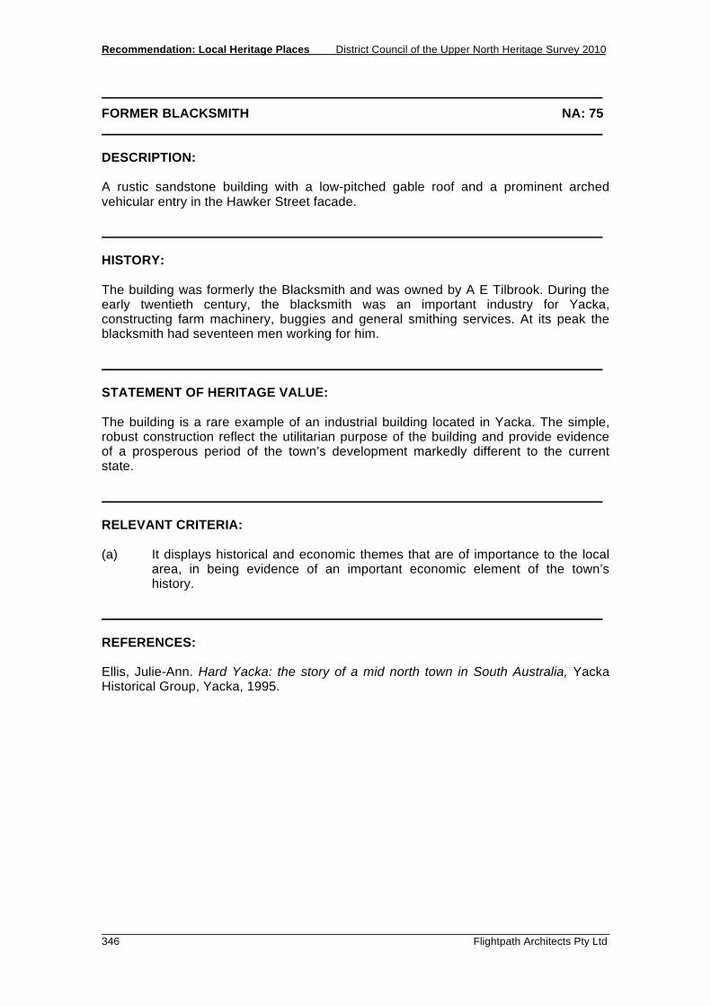
Recommendation: Local Heritage Places District Council of the Upper North Heritage Survey 2010
346 Flightpath Architects Pty Ltd
FORMER BLACKSMITH NA: 75 DESCRIPTION: A rustic sandstone building with a low-pitched gable roof and a prominent arched vehicular entry in the Hawker Street facade. HISTORY: The building was formerly the Blacksmith and was owned by A E Tilbrook. During the early twentieth century, the blacksmith was an important industry for Yacka, constructing farm machinery, buggies and general smithing services. At its peak the blacksmith had seventeen men working for him. STATEMENT OF HERITAGE VALUE: The building is a rare example of an industrial building located in Yacka. The simple, robust construction reflect the utilitarian purpose of the building and provide evidence of a prosperous period of the town’s development markedly different to the current state. RELEVANT CRITERIA: (a) It displays historical and economic themes that are of importance to the local
area, in being evidence of an important economic element of the town’s history.
REFERENCES: Ellis, Julie-Ann. Hard Yacka: the story of a mid north town in South Australia, Yacka Historical Group, Yacka, 1995.

District Council of the Upper North Heritage Survey 2010 Recommendation: Local Heritage Places
Flightpath Architects Pty Ltd 347
UNITING CHURCH AND HALL NA: 76 LOCATION: Yacka Place Name and Address: Uniting Church and Hall, Charles Street, Yacka, 5470 Land Description: Lot 63, Plan 231601, Hundred of Yackamoorundie Certificate of Title: 1082/116 OWNER: Uniting Church in Australia Property Trust (SA), PO Box 2145, Adelaide SA 5000 State Heritage Status: SHR File No.: Other Assessments: PHOTOGRAPHS: FP23 - 05
Uniting Church, Yacka

Recommendation: Local Heritage Places District Council of the Upper North Heritage Survey 2010
348 Flightpath Architects Pty Ltd
UNITING CHURCH AND HALL NA: 76 DESCRIPTION: The Uniting Church consists of the main church building and an adjoining Sunday School Hall. The church is a simple gable roofed building with front porch, whilst the hall, slightly lower in height, has a Dutch gable roof. Both buildings have the same setback from the street, and are sandstone with contrasting stone quoins and window treatments. HISTORY: The original church building, then the Yacka Methodist Church, was built in 1880 - 81, with the foundation stone reading: 'THIS STONE WAS LAID BY MRS JAS. ATKINSON, 21ST JULY 1880. - AMEN - J.A.'. The entry porch was added at a later date, and features an ornate leadlight window. A foundation stone marking this window reads: 'TO COMMEMORATE YACKA METHODIST (UNITING) CHURCH CENTENARY 1881 - 1981 TO THE GLORY OF GOD'. The Sunday School Hall adjacent to the building was built in 1925, and carries a foundation stone which reads: ' THIS STONE WAS LAID BY MRS W. C. ALLANSON ON AUG. 13TH 1925 TO THE GLORY OF GOD.'. In 1977, the Methodist Church became known as the Uniting Church. STATEMENT OF HERITAGE VALUE: Serving as the Methodist Church from 1885 to 1977, and then as the Uniting Church since 1977, the Church and Sunday School Hall have provided a valuable service to a prominent religious community group throughout the town’s history. The pairing of the Church and Hall, which are similar in construction, form and materials, makes a significant contribution to the streetscape and character of the town. RELEVANT CRITERIA: (c) It has played an important part in the life of local residents, offering a service
to group within the community since 1885. (d) It displays aesthetic merit and design characteristics of significance to the local
area in being an excellent pairing of Church and associated Hall which contribute well to the streetscape of Yacka.
REFERENCES: Ellis, Julie-Ann, Hard Yacka: the story of a mid north town in South Australia, Yacka Historical Group, Yacka, 1995.

District Council of the Upper North Heritage Survey 2010 Recommendation: Local Heritage Places
Flightpath Architects Pty Ltd 349
RAILWAY BRIDGE NA: 86 LOCATION: Yacka Place Name and Address: Railway Bridge, Main North Road, Yacka 5470 Land Description: Section 328, Hundred of Yackamoorundie Certificate of Title: 23 1600/0328 OWNER: Northern Areas Council, PO Box 120, Jamestown 5491 State Heritage Status: SHR File No.: Other Assessments: PHOTOGRAPHS: HR9 - 4
Railway Bridge, Yacka

Recommendation: Local Heritage Places District Council of the Upper North Heritage Survey 2010
350 Flightpath Architects Pty Ltd
RAILWAY BRIDGE NA: 86 DESCRIPTION: This bridge is constructed from two massive steel girders. It consists of six 24m spans supported on five concrete piers and has concrete abutments at either end. There are five escape alcoves which have tubular steel hand rails. The bridge is a conspicuous landmark to travellers on the Main North Road. HISTORY: The railway network of the Upper North was originally linked to Adelaide only by the route south from Petersburg through Terowie and Burra. Then in 1894 a new line was built north from Blyth through Georgetown, parallel with the Main North Road to join the Port Pirie-Broken Hill line at Gladstone. This line crossed the Broughton River at Yacka, one of the early Strangways towns, founded in 1870. The crossing of the deep channel of the Broughton River demanded the most impressive bridge on the line, a steel girder bridge supported on twelve cast iron cylindrical piers. In 1925 the bridge was completely rebuilt as part of an upgrading of the line, and the iron columns were replaced by five concrete piers. The bridge remained in use until the line was closed in 1990. STATEMENT OF HERITAGE VALUE: The Yacka Railway Bridge has cultural heritage value as an impressive engineering monument and an important relic of early rail transport in the Upper North region. RELEVANT CRITERIA: (a) It displays themes of rail transport important to the local area. (f) Is a notable landmark in the area. REFERENCES: Donovan, Railway Heritage of South Australia, 1992 Ellis, Hard Yacka, 1995 O’Connor, Spanning Two Centuries, 1985