district of columbia reagan national airport (dca ... national airport (dca) airplane noise...
TRANSCRIPT
District of Columbia
Reagan National Airport (DCA) Airplane Noise Assessment Project
HISTORICAL AIR TRAFFIC CONTROL PROCEDURES REPORT
1 OF 8
Prepared for: District of Columbia Department of Energy & Environment
Prepared by: Freytag & Associates, LLC

Report 1
Table of Contents
1.0 Terminology/keywords ..................................................................................................................... 2 2.0 Project Overview ............................................................................................................................... 3 3.0 Introduction ..................................................................................................................................... 3 4.0 History ............................................................................................................................................... 8 5.0 Pilot Procedures ................................................................................................................................ 8 6.0 DCA PART 150 Noise Study ............................................................................................................... 9
6.1 LAZIR SID ............................................................................................................................. 10 6.1.1 LAZIR TWO ............................................................................................................................ 9 6.1.2 LAZIR THREE ........................................................................................................................ 12 6.1.3 LAZIR FOUR ......................................................................................................................... 12 6.1.4 LAZIR FIVE ............................................................................................................................ 12 6.1.5 LAZIR SIX .............................................................................................................................. 12
7.0 Washington D.C. Metroplex Study (OAPM) .................................................................................... 12 7.1 OAPM SID’s ......................................................................................................................... 13 7.2 RADAR Vectoring ................................................................................................................. 15 7.3 Standard Terminal Arrival Routes (STAR’s) ......................................................................... 15 7.4 Instrument Approach Procedures (IAP’s) ........................................................................... 15 7.5 Standard Instrument Departure’s (SID’s) ............................................................................ 15
8.0 TARGETS AEDT Environmental Plug-in Report ................................................................................ 15 9.0 Recommendation Regarding DCA Procedures ............................................................................... 16 10.0 References ...................................................................................................................................... 17
List of Tables
Table A – Summary of ATC Changes at DCA, YR 2008 - 2017 ....................................................................... 7
List of Figures
Figure 1 – Pre- and Post-2011 Northbound DCA Departures ....................................................................... 6 Figure 2 – Areas Where FAA Impact Criteria Is Exceeded .......................................................................... 11 Figure 3 – Proposed OAPM Standard Instrument Departures ................................................................... 14 Figure 4 – Satellite Image Depicting NATIONAL SID and LAZIR SID ............................................................ 16
Page 1 of 17
Report 1
1. Terminology/keywords
The following section provides definitions for air traffic control terms used in this report. Standard Instrument Departures (SID’s) These procedures contain a preplanned Instrument Flight Rule (IFR) (i.e., air traffic control (ATC) departure) procedure printed for pilot/controller use in graphic form to provide obstacle clearance and a transition from the terminal area (i.e., around the airport) to the appropriate enroute structure. SID’s are primarily designed for system enhancement to expedite traffic flow and to reduce pilot/controller workload. ATC clearance must always be received prior to flying a SID. Standard Terminal Arrival Routes (STAR’s) These procedures contain a preplanned Instrument Flight Rule (IFR) (i.e., air traffic control (ATC) arrival) procedure published for pilot use in graphic and/or textual form. STAR’s provide transition from the enroute structure to a prescribed outer location, termed a fix or waypoint, or an instrument approach fix/arrival waypoint in the terminal (airport) area. Fixes/waypoints are designated by a five-letter sequence (e.g., LAZIR). Instrument Approach Procedures (IAP’s) These procedures contain a series of predetermined maneuvers for the orderly transfer of an aircraft under instrument flight conditions from the beginning of the initial approach to a landing or to a point from which a landing may be made visually. It is prescribed and approved for a specific airport by a competent authority. Area Navigation Procedures (RNAV) A method of Instrument Flight Rules (IFR) navigation that allows an aircraft to choose any course within a network of GPS fixes, rather than navigate using ground-based navigational aids. Performance Based Navigation (PBN) PBN is a navigation specification that includes an additional requirement for on-board navigation performance monitoring and alerting; this is referred to as a required navigation performance (RNP) specification. One not having such requirements is referred to as an area navigation (RNAV) specification. Compliance with the PBN specification is required for certain air traffic control (ATC) procedures. RNAV and PBN Difference Area navigation is based on performance requirements for aircraft operating along an Air Traffic System (ATS) route, on an instrument approach procedure or in a designated airspace. Performance requirements are expressed in navigation specifications (RNAV specification, RNP specification) in terms of accuracy, integrity, continuity, availability, and functionality needed for the proposed operation in the context of a particular airspace concept. Optimization of Airspace and Procedures in the Metroplex (OAPM) A systematic, integrated, and expedited approach to implementing PBN procedures and associated airspace changes. This generally refers to low power descents which minimize noise exposure to areas below.
Page 2 of 17
Report 1
RADAR Vectoring Provision of navigational guidance to aircraft in the form of specific headings, based on the use of radar. 2. Project Overview
This is the first in a series of reports conducted as a part of the DCA Airplane Noise Assessment project managed by the District’s Department of Energy and Environment (DOEE). Each of the reports is designed to address a separate aspect of flight operations, noise effects, public response, and mitigation alternatives The Final DCA Noise Report will be a compilation of the reports and will contain Air Traffic Control (ATC) recommendations to alleviate aircraft noise effects on District of Columbia residents. The reports for this project are:
I. Historical Summary Report – ATC Procedures II. Noise Monitoring Stations Report
III. Noise Complaint History Report IV. Noise Measurement, Sleep Disturbance & Classroom Disruption Report V. DCA Flight Track History Report
VI. DCA Noise Exposure History Report VII. Recommended Changes to DCA Air Traffic Procedures Report
VIII. Final DCA Noise Report 3. Introduction
This report summarizes the air traffic control (ATC) procedures for the Ronald Reagan Washington National Airport (DCA) since 2004. These procedures are published and administered by the Federal Aviation Administration (FAA). The history of changes in departure and arrival procedures affecting the District of Columbia are discussed along with the most probable noise effects on District communities. The changes and noise effects herein are solely from published procedures and do not incorporate information from actual monitored flight tracks or their noise impact on District communities. Often it is necessary for aircraft to deviate from published procedures at the direction of ATC; these deviations will affect the noise impact on these communities. Such deviations are from instructions termed vectors, and their effects will be addressed in subsequent reports (for instance, aircraft fly over the District below cloud levels at the direction of vectors assigned by ATC and not according to published procedures; therefore, such noise effects are not discussed in this report). There are NINE STAR’s that are published for the airport, seven are RNAV and two are legacy conventional type: FRDMM THREE RNAV / TRUPS THREE RNAV, RWY 19: The TRUPS STAR feeds the FRDMM STAR from the west, and intersects at the FRDMM waypoint at 8000,’ thence tracks to TGTHR and FERGI waypoints crossing the waypoint “above 3000 at 210 knots.” FERGI waypoint severs as the approach fix for both the RIVER VISUAL RWY 19 and RNAV (RNP) RWY 19 (IAPs) of which track the river (north to south) landing RWY 19 at DCA. There are two additional IAPs that feed DCA from the north, LDA Y RWY 19 / LDA Z RWY 19, both are Localizer-type directional aid (LDA) which is a NAVAID used for non-precision instrument approaches with utility and accuracy comparable to that a localizer and is not aligned with the runway. The
Page 3 of 17

Report 1
approach begins approximately 16.9 nautical miles northwest of the airport above 3000’ and proceeds southeast, over and adjacent to the river descending at a three-degree glide path, landing RWY 19. CAPSS TWO is an arrival from south of the airport, starting at 22,000’, proceeding north, terminating at PACKE waypoint (approximately 10 miles east of Dulles / 1.8 miles west of Tysons Corner) northwest of DCA at 6000.’ Aircraft landing RWY 19 at DCA can expect radar vectors to final approach. CLIPR ONE is an arrival from the north east, starting approximately 55 miles north east of Baltimore, above 11,000’ descending southwest to EYESS waypoint, thence to MEGGS, and terminating at NAYES waypoint at 4000.’ Aircraft landing RWY 19 at DCA can expect radar vectors to final. This procedure was developed for the Washington D.C. Metroplex, for those aircraft originating in the vicinity of the Richmond and Norfolk Airports to access an RNAV STAR and avoid leveling-off segments. SKILS THREE is an arrival from the northeast, similar to the CLIPR, starting in Lancaster, PA, above 1200’ tracking to EYESS, thence MEGGS (Silver Springs, MD), terminating at NAYES waypoint at 4000.’ Aircraft landing RWY 19 at DCA can expect radar vectors to final. DEALE TWO is an arrival from the east, starting above 11,000’, proceeding west and terminating at MEGGS waypoint (Silver Springs, MD) at 6000’. Aircraft landing RWY 19 at DCA can expect radar vectors. This procedure was developed for the Washington D.C. Metroplex, to replace the BILIT RNAV STAR. This procedure will integrate runway transitions to support north and south operations at DCA. A runway transition was added to support a north configuration at Ronald Reagan Washington National Airport (DCA) will eliminate the need to vector arrivals to the downwind reducing control task complexity for this arrival flow. The TIKEE THREE arrival was developed for the Washington D.C. Metroplex, to support aircraft transitioning from northwest of Washington Dulles International Airport (IAD) to the satellite airports west and south of IAD. This proposed procedure will begin at ESL VOR/DME (KESSEL, WV) and transition south to BBONE waypoint, then east to LURAY and TIKEE waypoints. The following satellite airports were incorporated to support the design:
• Culpeper Regional Airport (KCJR) • Leesburg Executive Airport (KJYO) • Manassas Regional Airport/Harry P. Davis Field (KHEF) • Upperville Airport (2VG2) • Warrenton-Fauquier Airport (KHWY) • Stafford Regional Airport (KRMN) • Indian Head Airport (K2W5) • Davison Army Airfield (KDAA) • Joint Base Andrews (KADW) • Washington Executive/Hyde Field (KW32) • Potomac Airfield (KVKX) • Freeway Airport (KW00) • Shannon Airport (KEZF) • Quantico Marine Corps Airfield (KNYG)
Page 4 of 17
Report 1
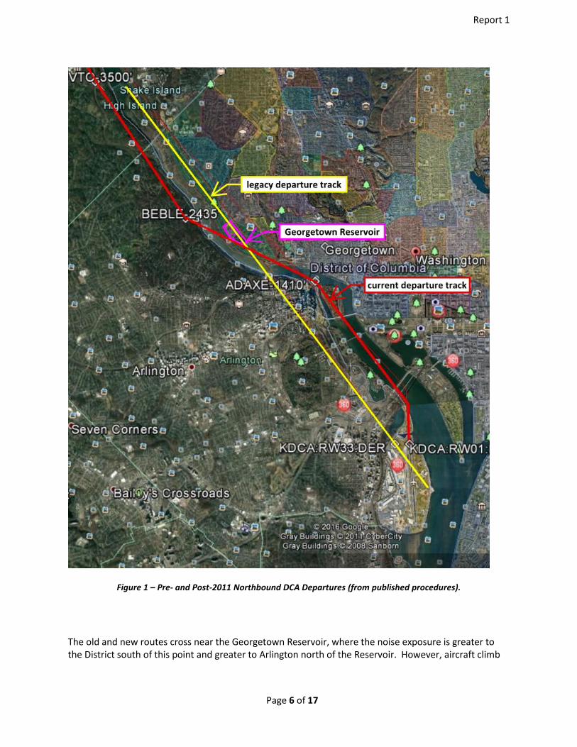
The IRONS SEVEN arrival is a conventional STAR arriving in Richmond, VA, above 8000’, proceeding on a northerly track descending to a point seven nautical miles south of DCA, thence a heading 320 degrees. Aircraft landing RWY 19 at DCA can expect radar vectors to final. The conventional STAR, NUMMY TWO, is an arrival beginning 40 nautical miles west of KESSEL, WV, above 17,000,’ east bound to descending to 6000,’ terminating at Herndon, VA, thence a vector heading of 070 degrees, for aircraft landing RWY 19 at DCA. A significant change in ATC departure procedures has affected aircraft noise impacts on District communities. This ATC change altered the departing northbound route from a straight-out departure to a route over the Potomac River. Before 2011, aircraft departing the northbound route from DCA climbed straight out on a runway heading (magnetic) of 328° (the 328 radial) termed the NATIONAL departure. The FAA Part 150 Airport Noise Compatibility Planning Study for DCA [2],i completed in 2008, recommended shifting northbound departures eastward over the River closer to the District to reduce noise impact to Arlington communities, and to provide more precise departure routing using advanced navigational technology. The DCA Part 150 Advisory Committee concluded that the increased noise to District communities along the River was not significant. Figure 1 illustrates the legacy NATIONAL departure track in yellow and the “over the River departure track,” originally proposed in 2008, in red.
Page 5 of 17
Report 1
Figure 1 – Pre- and Post-2011 Northbound DCA Departures (from published procedures).
The old and new routes cross near the Georgetown Reservoir, where the noise exposure is greater to the District south of this point and greater to Arlington north of the Reservoir. However, aircraft climb
Page 6 of 17

Report 1
throughout their departure and attain a higher altitude as they proceed north. The FAA did not consider northbound departures north of the Reservoir in their analyses because neither the Part 150 nor the FAA analyzed noise north of the Roosevelt Bridge. At the time of these analyses, only noise above 60 DNL was considered significant, and noise modeling below this level was not recommended. The new routing up the River was first implemented in 2011 by the LAZIR ONE Standard Instrument Departure (SID), and all subsequent routings follow the same departure. The new routing is directed by a series of fixes, also called waypoints. Subsequent changes to ATC procedures are summarized in Table A. Operational changes which affected aircraft noise exposure over the District will be discussed in subsequent reports, along with recommendations for mitigating the aircraft noise. No significant changes were made to DCA approaches from the north; they continue to follow the River. Only the departure routes have been modified.
Table A – Summary of ATC Changes at DCA, YR 2008 - 2017
Start Date End Date Procedure (SID’s or IAP’s) Action
9-Sep-99 RIVER VISUAL RWY 19 amdt.5 Enacted 5-Jul-07 LDA Z RWY19 Amended
10-Jan-08 DCA PART 150 UPDATE Enacted 8-Jan-10 LAZIR FIVE SID Canceled
10-Mar-11 LAZIR ONE SID Enacted 9-Feb-12 LAZIR TWO SID Enacted 26-Jul-12 30-Apr-15 OAPM -- FRDMM THREE RNAV Amended 20-Sep-12 LAZIR THREE SID Enacted 10-Jan-13 LAZIR FOUR SID Enacted 7-Jun-13 30-Apr-15 OAPM -- TRUPS THREE RNAV Amended 31-Dec-13 OAPM FONZI Enacted 25-May-14 RNAV RNP RWY 19 Amended 8-Jan-15 LAZIR FIVE SID Enacted 15-Jan-15 31-Mar-16 OAPM -- BOOCK SID Amended 30-Apr-15 31-Apr-16 OAPM -- DOCTR SID Amended 30-Apr-15 31-Mar-16 OAPM -- SOOKI SID Amended 30-Apr-15 LDA Y RWY19 20-Aug-15 15-Oct-15 LAZIR SIX SID Enacted 31-Dec-13 OAPM ROD / FONZI Enacted
Always Always RADAR vectoring
Page 7 of 17
Report 1
4. History
In the year 2000, the FAA and industry came together to solve some ATC problems and modernize the system. The result of their problem solving was The Vision 100 – Century of Aviation Reauthorization Act-passed by Congress in December of 2003. Next Generation Air Transportation System (NextGen) became the “umbrella plan”, covering a wide range of individual changes and programs which would become the sum of future aviation system for the Department of Transportation (DOT) in January 2004. This plan was further defined in the Integrated Plan for the ‘Next Generation Air Transportation System’ in December 2004. The phasing out of noisy and inefficient aircraft was part of this vision and future plan and a shift from ground based navigations/radar system with radio communication, to a satellite-based (GPS) system. NextGen is a multi-year plan which includes the shut-down of ground based navigational aids, aircraft upgrades for the industry, Performance Based Navigation (PBN) procedures and the modernization of the Air Traffic System. It is being implemented for more than 20 major airport areas throughout the U.S., termed Metroplexes, from 2012 to 2025. FAA Stated Benefits of NextGen:
• Creates shorter air routes • Saves time and fuel • Reduces air traffic delays • Increases air route capacity • Provide greater safety • Reduced controller workload • Reduced cockpit workload • Reduced communications • Reduced emissions • Reduced airspace congestion
Pre-NextGen connotes the general period prior to the year 2004. Post-NextGen begins around 2005 for the Washington, D.C. Metroplex. Actual, chronological, or approximate dates are used throughout this report in lieu of Pre- and Post-NextGen terminology. 5. Pilot Procedures
Prior to departing commercial, charter and most general aviation aircraft pilots file a flight plan specifying a SID, routing, STAR, and approach procedure. The requested flight plan is then generally approved by ATC prior to receiving departure clearance. If necessary, ATC will deny the requested routing and the pilot will then file an alternate route prior to departure clearance by ATC. The flight continues as filed until ATC directs a change to accommodate other air traffic. Changes in flight plans occur routinely, particularly when arriving at the destination airport. Pilots are often given “vectors” by ATC directing them to fly alternate routes for landing. Thus, published procedures are often not followed because of new direction given to the pilots by ATC, particularly at the arriving airport. This report, prepared before completion of actual routing and noise analyses, addresses only published ATC
Page 8 of 17

Report 1
procedures and their historical change. Future reports will address deviations from the published routing and their effects on community noise. 6. DCA PART 150 Noise Study
In the year 2002, DCA began holding “Public Meetings” as part of their outreach for input into an updated program that was approved by a FAA Record of Approval on June 2, 1997. The purpose of this update was to enhance the existing noise abatement program at the airport. The last noise abatement measure, recommended in the 1997 study, was to establish a program to monitor and report on aircraft performance over the river corridors. The results of this measure then flowed into the update as a “prime measure”, one expected to make a significant change in air traffic control. In the year 2004, DCA participated in a Federal Air Regulation (FAR) Part 150 study for airport Noise Compatibility Planning (NCP), completing the study in 2008, with submittal to the FAA. These studies are undertaken periodically at major airports to evaluate community noise exposure, collect community input, and develop noise abatement measures. Community participants included the District of Columbia, FAA, Department of the Interior (National Park Service) Arlington County, Prince George’s County, Air Transport Association, Montgomery County, U.S. E.P.A., City of Alexandria, Metropolitan Washington Airports Authority, Fairfax County, Airline Pilots Association, Department of the Interior (National Park Service) and Citizens for the Abatement of Aircraft Noise. This Part 150 study is the origin of our history of ATC changes at DCA. 14 CFR PART 150, §150.1 Scope and purpose, states:
This part prescribes the procedures, standards, and methodology governing the development, submission, and review of airport noise exposure maps and airport noise compatibility programs, including the process for evaluating and approving or disapproving those programs. It prescribes single systems for (a) measuring noise at airports and surrounding areas that generally provides a highly reliable relationship between projected noise exposure and surveyed reaction of people to noise; and (b) determining exposure of individuals to noise that results from the operations of an airport. This part also identifies those land uses which are normally compatible with various levels of exposure to noise by individuals. It provides technical assistance to airport operators, in conjunction with other local, State, and Federal authorities, to prepare and execute appropriate noise compatibility planning and implementation programs.
The DCA, Part 150 Noise Compatibility Update, Recommended Noise Abatement Measures, proposed the following in the NCP:
Noise Abatement Measure 1: Form a working group to develop advanced navigation procedures for arrivals and departures on all runways, encourage the use of advanced navigation technology by airlines to provide pilots the ability to follow more predictable and precise flight tracks along the center of the Potomac and Anacostia River corridors. (NCP Page VI-3)
The proposed measure:
Would form a working group to identify advanced navigation procedures that would provide a more predictable and precise flight track for aircraft to follow the center of the rivers. An
Page 9 of 17

Report 1
advanced navigation procedure could reduce the number of aircraft that stray off the river corridors, reducing noise exposure for along the river corridors. There are no residents or incompatible land uses located in the DNL 65 dB noise contour.
The members of the Part 150 advisory committee agreed to examine measures and options for improving the ability of pilots to navigate the center of the River. Thus, the advisory committee determined that new advanced navigation could provide the desired outcome of adherence to the center of the River and supported the development of new navigational procedures for DCA. This would result in reduced noise levels for residential land uses along the river corridors because the aircraft would follow the rivers on a tighter, narrower flight path. Some communities in Virginia would benefit from lower DNL’s while some of the District would incur higher DNL’s. The excerpt from the Part 150 Study states:
The use of advanced navigation technology was estimated to result in reduced noise levels for residential land uses along the river corridors because the aircraft would follow the rivers on a tighter, narrower flight path. For some communities in Virginia, the reduction in DNLs was estimated to be as much as 3 dBA. It was estimated that there would be an increase in DNL of 1 dBA east of the river, over part of Georgetown, as would be expected when aircraft stay closer to the centerline of the river rather than flying over the Virginia shoreline in Rosslyn. The Committee stated that the benefit to the neighborhoods in Virginia justified the increases in noise of lesser magnitude over part of Georgetown. An advanced navigation procedure would provide a more precise and predictable flight track for aircraft to follow during both instrument and visual approaches.
It was under this proposed measure that the FAA based the “purpose and need” for development of the LAZIR and HAMMI SID’s. FAA Orders 7100.9D and 8260.44A specified the design criteria to be used in developing RNAV procedures, including the fact that their main purpose was to improve safety, and not to be used solely for noise abatement. The FAA, Record of Approval (ROA), 14 CFR PART 150 Noise Compatibility Program, DCA, Arlington Virginia, was signed on January 10, 2008. 6.1 LAZIR SID
6.1.1 LAZIR ONE
The LAZIR SID was one of the outcomes of the Part 150 Study. Background and or procedural development documents from the FAA regarding LAZIR ONE are very limited or not available. Some documents are even being held by the FAA, exempt from the Freedom of Information Act (FOIA), by “Exemption 5 deliberative process privilege,” due to litigation. As a matter of processing an instrument procedure for publication and implementation, the FAA must complete an Environmental Review to ensure that the Federal action complies with the National Environmental Policy Act (NEPA) and its implementing regulations. Using the TARGETS INM Noise Plug-in tool, the FAA conducted a noise analysis of the LAZIR and HAMMI SID’s on September 30, 2010, in terms of the national standard ‘day-night average sound level’ (DNL) standard. The INM Plug-in is a program developed by the MITRE Corporation (proprietary to the FAA) to meet the criteria requirements of the NEPA. MITRE also built the input files for the
Page 10 of 17

Report 1
analysis. This assessment overlays new DNL noise exposure areas over previous areas to identify areas where FAA exceedance criteria thresholds (from FAA Order 1050.1E) are found. The TARGETS INM Plug-in output revealed two areas of noise increase. The areas of noise increase depicted are outlined in Figure 2. The larger area of noise increase is where an area at or below 60 DNL is increased by 5 dB or more; the smaller area is where an area above 65 DNL is increased by 1.5 dB or more.
Figure 2 – Areas Where FAA Impact Criteria Is Exceeded
The FAA Eastern-Region Service Center used the “Categorical Exclusion / Record of Decision-Short Form” for its declaration of a CATEX (categorical exclusion from NEPA). This declaration was signed by the Operations Support Group Environmental Specialist on January 26, 2011, citing FAA Order 1050.1E, Environmental Impacts: Policies and Procedures, §311p: “Establishment of new procedures that routinely route aircraft over non-noise sensitive areas.” Managerial signature review was not completed until August 5, 2011. This declaration appears to lack any degree of spatial awareness, competence, or diligence as a basis because they did not do x,y,z analyses which would have been a firm bedrock to based future FAA orders. After receiving “fast track” action by the PBN office, escaping FAA protocols and employing less than diligent quality assurance checks, the LAZIR ONE (RNAV) procedure was published on March 10, 2011: “Congressional interest per AJV-14 makes these AVN P1.”
6.1.1 LAZIR TWO Amended LAZIR ONE, only change was to add note: ATC ASSIGNED (no environmental impact).
Page 11 of 17

Report 1
6.1.2 LAZIR THREE
Amended LAZIR TWO, update on notes and produced no noise impact.
6.1.3 LAZIR FOUR
The SID designs used in the Washington D.C. Metroplex are of the same initial coding (identification and location) and waypoints as the published LAZIR4 RNAV SID to COVTO waypoint they hoped would provide a consistent departure and predictable track over the River utilizing PBN procedures to avoid Prohibited Area (i.e., Areas P-56A and P-56B). The amendment change charted fix OTTTO to west side of departure controller’s frequency box produced no noise impact. The “OTTTO” waypoint was established on the procedure (charted on various navigation charts) near the town of Nottingham, Maryland.
6.1.4 LAZIR FIVE
Published on January 08, 2015, and was then canceled on August 20, 2015, due to the LAZIR SIX implementation.
6.1.5 LAZIR SIX
Removed (canceled) on Oct 15, 2015. However, it was referred to for over a year by the FAA and MWAA in presentations, public workshops, outreach material and meeting documents, as though it existed. In review of MWAA Community Workgroup minutes, February 16, 2017, this practice of using LAZIR continues to date. Figure 3 below shows the LAZIR SIX SID. The LAZIR FIVE amendment added chart TOP ALTITUDE 5000 to additional flight data but produced no noise impact and replaced LON VORTAC with OTTO with additional flight data and fixes and NAVAIDS. This also caused no change in noise impact because it did not route aircraft closer to the District. 7. Washington D.C. Metroplex Study (OAPM)
Optimization of Airspace and Procedures in the Metroplex (OAPM) are special aircraft operating procedures to minimize noise exposure and increase efficiency. From Table A, Summary of ATC Changes at DCA, YR 2008 - 2017, OAPM was applied to six ATC procedures for DCA. These procedures require special on-board navigation performance monitoring and alerting systems (now typically found on most commercial aircraft) to adjust throttle conditions to minimize noise emission to ground receptors. In September 2009, the Federal Aviation Administration (FAA) received the Radio Technical Commission for Aeronautics (RTCA) Task Force 5 Final Report on Mid-Term NextGen Implementation containing recommendations concerning the top priorities for the implementation of NextGen initiatives. A key component of the RTCA recommendations is the formation of teams leveraging FAA and industry PBN expertise and experience to expedite implementation of optimized airspace and procedures. Historically aircraft taking off used the maximum rate of climb available (limited by the aircraft stall speed) to maximize altitude as soon as possible. This was the safest procedure because it affords the maximum time and distance to recover from an emergency condition such as engine or control malfunction. However, with the excellent engine reliability and redundancy of a second (or more) engine, new aircraft departure procedures allow for noise abated takeoffs. Minimizing takeoff noise is complex since reducing power lowers engine noise emissions but also lowers the climb profile bringing
Page 12 of 17

Report 1
the aircraft closer to the ground noise receptors. OAPM procedures are different for each aircraft type and automatically adjust throttle settings during takeoff to minimize noise to the community below. Similarly, OAPM for approaches also adjusts throttle settings to minimize noise to the ground noise receptors. Basically, OAPM for approaches maximizes the glide potential and energy management of the aircraft. In addition to reducing noise exposure, OAPM procedures also enhance fuel consumption, air safety and operational costs. Optimization of Airspace and Procedures in the Metroplex (OAPM) was developed in direct response to the recommendations from RTCA’s Task Force 5 on the quality, timeliness, and scope of Metroplex solutions. OAPM focuses on a geographic area, rather than a single airport. This approach considers multiple airports and the airspace surrounding a metropolitan area, including all types of operations, as well as connectivity with other metroplexes. OAPM projects have an expedited life-cycle of approximately three years from planning to implementation.
7.1 OAPM SID’s
The OAPM Study Team recommended the development of optimized PBN departure procedures and extensions to the LAZIR and HAMMI RNAV SID’s. These SID’s replaced the LAZIR RNAV SID and will extend further into the enroute environment. The SID designs used the same initial OAPM coding and waypoints as the published LAZIR4 RNAV SID to COVTO waypoint. These provide a consistent departure climb and track over the River utilizing PBN procedures to avoid the Capitol and White House (Prohibited Areas P-56A and P-56B). Figure 3 shows the OAPM SID designs.
Page 13 of 17

Report 1
Figure 3 – Proposed OAPM Standard Instrument Departures
The proposed OAPM SID’s are named as follows:
1. BUTRZ RNAV SID (CLTCH) 2. DIXXE RNAV SID (BOOCK) 3. DOCTR RNAV SID 4. HAFNR RNAV SID (JDUBB) 5. HORTO RNAV SID 6. POOCH RNAV SID (SCRAM) 7. REBLL RNAV SID 8. SOOKI RNAV SID 9. WYNGS RNAV SID
Each SID was to be integrated into the automated preferential departure routing (PDR) system to reduce control complexity for the DCA tower and the potential erroneous SID assignment. Of the nine new SID’s, all have a common initial leg and only three have full impact to the District when transitioning to the enroute traffic structure.
COMMON LEG USED BY OAPM
Page 14 of 17
Report 1
7.2 RADAR Vectoring
Those aircraft being RADAR vectored off the runway or arriving are flying a magnetic heading as directed by Air Traffic Control (ATC), Potomac Terminal Radar Approach Control (TRACON), DCA Air Traffic Control Tower (ATCT) and are not subject to strict navigational compliance or criteria as those assigned a SID as part of their flight plan clearance. Additionally, the traffic being vectored is not included in any environmental impact study conducted by the airport authority or the FAA. Both STAR’s and SID’s were developed to required Navigation Performance Level type RNP-1.
7.3 Standard Terminal Arrival Routes (STAR’s)
The specific routes analyzed are nine STAR’s. Of the nine published procedures, only two (FRDMM THREE RNAV and TRUPS THREE RNAV) feed the arrival routes north of the airport which transition to the arrival final landing south on Runway 19.
7.4 Instrument Approach Procedures (IAP’s)
DCA has twelve Instrument Approach Procedures (IAP’s). After preliminary review, only three have an impact on the District and will be tailored for impact: RNAV RNP RWY 19, LDA Y/Z RWY 19, and the RIVER VISUAL RWY 19.
7.5 Standard Instrument Departure’s (SID’s)
DCA has a total of ten SID’s for the airport. The NATION SEVEN is a legacy “conventional departure,” and the other nine are RNAV procedures developed through the DC OAPM. Of the nine, only three (BOOCK, DOCTR and SOOKI) have complete impact on the District and the remaining six share the initial “common leg” from the end of runways 01/33, to waypoint COVTO then proceed to enroute transitions to the west. See Figure 3 above. 8. TARGETS AEDT Environmental Plug-in Report
In May 2016, the FAA completed “TARGETS AEDT Environmental Plug-in Report” for DCA. A new group of nine SID’s were proposed for DCA in Arlington, VA. Using an FAA-approved noise screening tool, the Terminal Area Route Generation, Evaluation, and Traffic Simulation (TARGETS) Aviation Environmental Design Tool (AEDT) Environmental Plug-In, a noise modeling analysis was completed to screen for potential increases in noise resulting from implementation of the proposed procedures. Historic track data was obtained and modeled to establish a baseline scenario. After the baseline scenario was established, aircraft operations assigned to the proposed procedure were modeled as flying the proposed procedure instead of their historical tracks where the procedure was modified to establish an alternative scenario. Aircraft operation counts were adjusted to represent an average annual day (AAD), and the model was used to calculate the noise exposure for the baseline and alternative scenarios on that AAD. The baseline and alternative scenarios were then compared to determine whether the procedure would result in an increase in noise by the standards of the NEPA in the environment surrounding the airport. The results of the FAA TARGETS noise analysis indicated that no noise impact is expected because of implementation of this group of SIDs at DCA. However, none of the recommendations from the
Page 15 of 17
Report 1
TARGETS report have yet been implemented, so this remains an academic exercise. Following is our review of the report. 9. Recommendation Regarding DCA Procedures
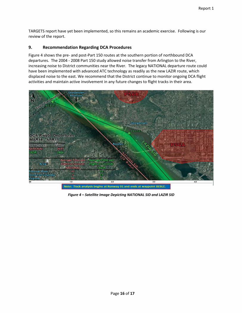
Figure 4 shows the pre- and post-Part 150 routes at the southern portion of northbound DCA departures. The 2004 - 2008 Part 150 study allowed noise transfer from Arlington to the River, increasing noise to District communities near the River. The legacy NATIONAL departure route could have been implemented with advanced ATC technology as readily as the new LAZIR route, which displaced noise to the east. We recommend that the District continue to monitor ongoing DCA flight activities and maintain active involvement in any future changes to flight tracks in their area.
Figure 4 – Satellite Image Depicting NATIONAL SID and LAZIR SID
Page 16 of 17

Report 1
10. References
[1] Air traffic control procedures are published periodically by the FAA to advise pilots of acceptable methods of aircraft operation in particular areas. These procedures include Standard Instrument Departures (SID’s), Standard Terminal Arrival Routes (STAR’s) and Instrument Approach Procedures (IAP’s). These procedures are available for purchase in paper or electronic form directly from the FAA or from several licensed resellers. [2] “Ronald Reagan Washington National Airport, FAR Part 150 Noise Exposure Maps and Noise Compatibility Program”, Ricondo Associates, et. al., November 2004.,
Page 17 of 17