diurnal circulations and rainfall in taiwan during sowmex
TRANSCRIPT

Diurnal Circulations and Rainfall in Taiwan during SoWMEX/TiMREX (2008)
JAMES H. RUPPERT JR. AND RICHARD H. JOHNSON
Department of Atmospheric Science, Colorado State University, Fort Collins, Colorado
ANGELA K. ROWE
Department of Atmospheric Sciences, University of Washington, Seattle, Washington
(Manuscript received 4 October 2012, in final form 22 May 2013)
ABSTRACT
The diurnal cycle of the local circulation, rainfall, and heat and moisture budgets is investigated in Taiwan’s
heavy rain (mei-yu) season using data from the 2008 Southwest Monsoon Experiment/Terrain-influenced
Monsoon Rainfall Experiment (SoWMEX/TiMREX). Comparisons are made between an undisturbed
(UNDIST; 22–29May) and disturbed period (DIST; 31May–4 June). Many aspects of the diurnal evolution
in surface flows and rainfall were similar during both periods. At night and during early morning hours, the low-
level southwesterly flow was deflected around Taiwan’s main topographic barrier, the Central Mountain Range
(CMR), with rainfall focused near areas of enhanced offshore confluence created by downslope and land-
breeze flows. During the day, the flow switched to onshore and upslope, rainfall shifted inland, and deep
convection developed along the coastal plains and windward slopes. Atmospheric budget analysis indicates
a day-to-evening transition of convective structure from shallow to deep to stratiform. Evaporation asso-
ciated with the evening/nighttime stratiform precipitation likely assisted the nocturnal katabatic flow.
Though the flow impinging on Taiwan was blocked during both periods, a very moist troposphere and
strengthened low-level oncoming flow during DIST resulted in more widespread and intense rainfall that was
shifted to higher elevations, which resembled a more weakly blocked regime. Correspondingly, storm cores
were tilted upslope during DIST, in contrast to the more erect storms characteristic of UNDIST. There were
much more lofted precipitation-sized ice hydrometeors within storms during DIST, the upslope advection of
which led to extensive stratiform rain regions overlying the CMR peaks, and the observed upslope shift in
rainfall.
1. Introduction
A strong diurnal pulsation of rainfall is connected to
coastal regions and areas of sloped topography in the
tropics and subtropics, which are attended by prominent
land–sea-breeze (LSB) and mountain–valley (MV) cir-
culations. In the mountainous subtropical island of
Taiwan, rainfall is controlled throughout the year by
such circulations, which cause a pronounced diurnal
oscillation in island-averaged low-level divergence
(Johnson and Bresch 1991; Chen et al. 1999; Kishtawal
and Krishnamurti 2001; Kerns et al. 2010; Lin et al.
2011). Great complexity is added to this system in
the presence of monsoon flow, which interacts with
Taiwan’s main topographic barrier, the Central Moun-
tain Range (CMR), to generate enhanced upstream
convergence, barrier jets, offshore rainbands, and lee
vortices (Sun and Chern 1993; Li and Chen 1998; Yeh
and Chen 2002; Chen et al. 2004; Alpers et al. 2007;
Yu and Lin 2008; Yu and Hsieh 2009). The manner in
which such features interact with the diurnal cycle needs
further investigation, as these two major aspects of
Taiwan’s meteorology have been studied quite sepa-
rately to date. Improved understanding of the diurnal
cycle of rainfall and its relationships with flow blocking
was a core focus of the SouthwestMonsoonExperiment/
Terrain-influenced Monsoon Rainfall Experiment
(SoWMEX/TiMREX; Jou et al. 2011), which was con-
ducted during the 2008 heavy rain season in Taiwan (the
mei-yu or ‘‘plum rain’’ season).
The mei-yu season in Taiwan covers the mid-May–
mid-June period in which the stable northeasterly
winter monsoon transitions to the convectively unstable
Corresponding author address: James H. Ruppert Jr., Dept. of
Atmospheric Science, Colorado State University, 1371 Campus
Delivery, Fort Collins, CO 80523.
E-mail: [email protected]
NOVEMBER 2013 RUP PERT ET AL . 3851
DOI: 10.1175/MWR-D-12-00301.1
� 2013 American Meteorological Society

southwesterly summer monsoon (Chen 1983, 1993; Ding
and Chan 2005). During this season, a pronounced zone
of low-level convergence and cyclonic shear will period-
ically develop where these flows meet (the mei-yu front),
in connection with a strengthened southwesterly low-
level jet, amplified upper-level flow pattern, and deep-
enedEastAsianmonsoon trough (Chen 1983; Chen 1993;
Chen et al. 2008). During such disturbed conditions, this
subtropical mei-yu frontal system, which typically forms
north ofTaiwan, can shift southward into theTaiwan area
and provide an effective triggering mechanism for co-
pious rainfall through mesoscale convective systems
(MCSs) that spawn and propagate eastward along
its;zonally oriented strip of barotropic vorticity (Chen
1983; Chen et al. 2008; Lai et al. 2011). Lai et al. (2011)
documented a case from SoWMEX/TiMREX in which
an MCS propagated offshore from southern China and
organized into an intense mesoscale convective vortex
(MCV), aided by stretching from deep convection along
the mei-yu frontal vorticity line. Vigorous convection
was favored downshear (east) of the MCV where
northward advection of unstable low-level air was en-
hanced, which caused heavy rainfall along the mei-yu
front and inland flooding as it propagated eastward
across southern Taiwan. Shallow, rain-generated
coastal boundaries unrelated to the mei-yu front can
also be important for heavy rainfall during the mei-yu
season (Davis and Lee 2012; Xu et al. 2012).While these
boundaries typically exhibit virtual temperature con-
trasts of only 28–38C (cooler over land), they enhance
nearshore and offshore convergence enough to in-
vigorate free convection in the moist impinging south-
westerly flow (Davis and Lee 2012; Xu et al. 2012).
Johnson and Bresch (1991) describe the diurnal cycle
characteristic of mei-yu undisturbed periods; periods
when the mei-yu front is either not present or is situated
north of Taiwan, rainfall is reduced, and relatively uni-
form southwesterly flow impinges on Taiwan. They used
observations from the 1987 Taiwan Area Mesoscale
Experiment (TAMEX; Kuo and Chen 1990), and found
that daytime sea breezes and anabatic flows strength-
ened in the late morning and early afternoon as deep
convection increased along the coastal plains and west-
ern foothills of the CMR. Convection transitioned to
stratiform rainfall by evening as evaporation-enhanced
katabatic flows and land breezes developed. Finally,
rainfall was maximized offshore during the overnight
and early morning hours. Subsequent studies have em-
ployed satellite data as well as the dense rain gauge
network in Taiwan to corroborate these findings and
extend the analysis to other seasons (Chen et al. 1999;
Kishtawal and Krishnamurti 2001; Kerns et al. 2010; Lin
et al. 2011). These and other studies have primarily
focused on undisturbed periods or seasonal means. It is
important to assess the role and character of the diurnal
cycle in more disturbed environments when conditions
are more conducive for heavy rainfall, such as when the
subtropical mei-yu front develops and shifts southward
over Taiwan.
A major factor in the distribution and intensity of
rainfall in Taiwan relates to the effects of topography.
Figure 1 provides a topographic map of Taiwan showing
the coastal plains in the west and the steep slopes of the
CMR. Note that the CMR slopes extend down nearly to
the eastern coastline, resulting in an east–west asym-
metry in the distribution of lowlands surrounding the
CMR. From theory, the Burger numberB can be used to
diagnose the ‘‘hydrodynamic steepness’’ of the moun-
tain barrier, where B 5 HNm/fL, H is the ridge height,
Nm is the subsaturated moist Brunt–V€ais€al€a frequency,
f is the Coriolis parameter, and L is flow-parallel moun-
tain half-width. When B � 1, the slope is mild and
the flow remains in quasigeostrophic balance, and when
B � 1, the slope is significant and ageostrophic flows
divert around the barrier (Baines 1987; Pierrehumbert
FIG. 1. Topography is gray shaded every 400m. The 2-km level is
contoured. Polygons denote 11 of the 13 rawinsonde stations
constituting the SoWMEX/TiMREX enhanced sounding network.
Sites not shown are Dongsha Island, located to the southwest
(shown in Fig. 8) and Laoag, Philippines, located south of Taiwan.
The plus sign denotes the S-Pol radar station, situated in coastal
Pingdong. The crisscrosses (3s) denote three surrounding GFS
data points incorporated in INTERP. The dashed line represents
the dividing line for an area average over western Taiwan (see the
appendix). The two solid lines north of Pingdong denote the
transects for two west–east-oriented radar cross sections discussed
later.
3852 MONTHLY WEATHER REV IEW VOLUME 141

and Wyman 1985; Smolarkiewicz et al. 1988; Overland
and Bond 1995). Using approximations for Taiwan [H;2km,L; 50km,Nm; 1022 s21, and f; 1024 s21; Li and
Chen (1998)], B 5 4, suggesting that the CMR is a hy-
drodynamically steep barrier that will block the flow. For
any characteristic wind speed U # 20ms21, the Froude
number Fr 5 U/NmH is subunity (using the approxima-
tions above), suggesting that the kinetic energy of the
flow is small relative to the potential energy required
to surmount the barrier; hence, the flow is diverted
(Smolarkiewicz et al. 1988). While utility of a saturated
Brunt–V€ais€al€a frequency is apt in saturated conditions
(e.g., Durran and Klemp 1982), saturation is limited to
the scale of individual cloud systems when the prevail-
ing upstream flow is subsaturated, as it was during
SoWMEX/TiMREX; therefore, Fr as defined above is
appropriate for diagnosing the predominate flow char-
acteristics around Taiwan (Baines 1987; Smolarkiewicz
et al. 1988; Carbone et al. 1995; Li and Chen 1998; Chen
and Lin 2005; Hughes et al. 2009; Miglietta and Rotunno
2009).
Blocked flows around Taiwan result in areas of en-
hanced low-level convergence and rainfall surrounding
the island; for example, quasi-stationary convective
rainbands frequently appear offshore of southeastern
Taiwan all year round in connection with flow blocking
(Yu and Jou 2005; Yu and Hsieh 2009; Alpers et al.
2010). The pre-mei-yu-frontal heavy rainfall events in
northwestern Taiwan offer another example of oro-
graphic rainfall enhancement (Li and Chen 1998; Yeh
and Chen 2002; Wang et al. 2005). The Big Island of
Hawaii provides a related example in which diurnal and
orographic processes interact to produce a prominent
arch-shaped rainbandupwindof the island (Smolarkiewicz
et al. 1988; Carbone et al. 1995). Initially, evaporative
cooling from diurnal rainfall in the elevated terrain
generates a nocturnal katabatic, offshore flow. The
rainband forms offshore where this flow converges with
the impinging stable trade wind. Finally, the rainband
moves onshore as daytime heating drives a reversal to
onshore, upslope flow. In addition to the general en-
hancement of rainfall by orography, rainfall distribution
can be complicated by the flow–microphysical inter-
actions that occur when widespread deep convection is
present (Jiang 2003; Chen and Lin 2005; Miglietta and
Rotunno 2009; Murphy and Businger 2011).
In the present study, the SoWMEX/TiMREX en-
hanced sounding network is employed to describe the
diurnal cycle of mesoscale diurnal circulations and heat
and moisture budgets (i.e., latent heating) over Taiwan,
with comparison between undisturbed and disturbed
conditions. Johnson and Bresch (1991) is the only prior
study to do a similar examination, though the sounding
network they employed (TAMEX) had marginal spatial
coverage and diurnal variability during disturbed pe-
riods was not discussed. New estimates of the vertical
and horizontal distributions of diabatic heating will
provide a basis for validation and comparison with nu-
merical simulations of the diurnal cycle over Taiwan.
2. Datasets and methodology
a. Gridded dataset
Previous studies have successfully employed objective
interpolation procedures to sounding datasets from
a number of tropical and monsoon field campaigns [e.g.,
the Tropical Ocean and Global Atmosphere Coupled
Ocean–Atmosphere Response Experiment (TOGA
COARE), the South China Sea Monsoon Experiment
(SCSMEX), andNorthAmericanMonsoonExperiment
(NAME)], and obtained reliable results confirmed by
the analysis of independent datasets (Lin and Johnson
1996; Johnson and Ciesielski 2002; Ciesielski et al. 2003;
Johnson et al. 2010). A similar approach is followed
in this study, which allows dynamical relationships to
emerge from observations with minimized influence
from model information.
A gridded analysis (denoted INTERP) is generated
on a 0.258 mesh from 188N, 1128E to 288N, 1248E with
40 vertical levels (surface and 1000–50hPa at 25-hPa in-
crements) by running observations through the multi-
quadric interpolation scheme of Nuss and Titley (1994).
The main sampling period of SoWMEX/TiMREX
(special observing period; SOP) spanned 15 May–
26 June 2008, during which time a dense network of ra-
winsondes, radars, wind profilers, and surface stations
was deployed in and around Taiwan (Jou et al. 2011).
The SoWMEX/TiMREX sounding network was com-
posed of 13 sites, including land stations in and border-
ing Taiwan and stations in the northern South China Sea
(SCS) and Taiwan Straight (Fig. 1). Six-hourly sound-
ings were taken at most sites during the SOP, with
3-hourly soundings during a roughly weeklong enhanced
observing period (EOP) during late May–early June.
During the EOP the mei-yu front amplified and shifted
southward into the northern SCS (Lai et al. 2011; Davis
and Lee 2012). Sixteen dropsondemissions (yielding 190
soundings) were also carried out during this EOP and
a later active period. Ciesielski et al. (2010) describe the
extensive SoWMEX/TiMREX sounding dataset and
quality control procedures, which resulted in substantial
improvements in the humidity field (removal of dry
biases).
The observations employed in INTERP are listed in
Table 1. Operational soundings fromChina are included
to supplement the SoWMEX/TiMREX sounding dataset
NOVEMBER 2013 RUP PERT ET AL . 3853

away from Taiwan (yielding a total of 32 sounding sites).
Quick Scatterometer (QuikSCAT) sea surface wind
data were filtered to 0.258 spacing prior to the inter-
polation, with all rain- and land-contaminated data ex-
cluded. Similar to previous studies employing this
technique (e.g., Johnson and Ciesielski 2002), inclusion
of data from operational 0.58 National Centers for En-
vironmental Prediction (NCEP) Global Forecast Sys-
tem (GFS) analyses at several points outside of the main
sounding network (Fig. 1) was necessary tominimize the
effects of extrapolation into data-sparse regions (par-
ticularly east of Taiwan, where flow blocking can sub-
stantially modify the far flow fields). The impacts were
primarily onmeanmagnitudes, while the day-to-day and
diurnal variabilities were primarily reflecting observa-
tions. This is discussed further in the appendix. Due to
sampling errors in sounding observations (Mapes et al.
2003), 3-day running means are applied to SOP time
series based on INTERP fields to increase the statistical
significance. Additional details of the multiquadric pro-
cedure can be found in Ciesielski et al. (2003).
b. Independent datasets
To diagnose characteristics of afternoon thunder-
storms during focal periods of the study, two cross sec-
tions are generated using data from the National Center
for Atmospheric Research (NCAR) S-band dual-
polarization Doppler radar (S-Pol) that was deployed
in southwestern coastal Taiwan during SoWMEX/
TiMREX (22.538N, 120.438E; Fig. 1). Full-volume 3608surveillance scans allowed for rain mapping to a maxi-
mum range of 150 km along the western slopes of the
CMR, enabling comparisons and coordination with the
neighboring Pingdong sounding station. Quality control
of the S-Pol dataset followed the methods of Lang et al.
(2007). The corrected suite of polarimetric variables (cf.
Rowe et al. 2011, 2012) was gridded to Cartesian co-
ordinates at 1-km horizontal and 0.5-km vertical grid
spacing using the program REORDER (Mohr et al.
1986). A hydrometeor identification (HID) algorithm
was applied to infer the dominant hydrometeor types at
each grid point, including drizzle (DZ), rain (RA), dry
snow (DS), wet snow (WS), vertical ice (IC), low-density
graupel (LG), high-density graupel (HG), and hail
(HA). This HID algorithm, which employed the gridded
polarimetric variables and temperature profiles from
the Pingdong sounding station (Fig. 1), is based on the
fuzzy-logic methodology of Liu and Chandrasekar
(2000), and is described in detail by Tessendorf et al.
(2005).
Rainfall from the Quantitative Precipitation Estimation
and Segregation Using Multiple Sensors (QPESUMS)
dataset is employed, which combines information from
Taiwan’s network of operational radars (i.e., not S-Pol)
and rain gauges operated by the Central Weather Bureau
of Taiwan, and is available hourly at 0.01258 spacing over
and immediately surrounding Taiwan. Taiwan’s opera-
tional rain gauge network is quite dense (Chen et al. 1999;
Kishtawal and Krishnamurti 2001; Kerns et al. 2010), thus
providing a good check on radar-derived rainfall. A con-
cern in theQPESUMS dataset is offshore negative rainfall
biases related to radar beam blockage, particularly near
southeasternTaiwan (Chang et al. 2009).Aswill be shown,
the resulting errors in southeastern Taiwan are often
obvious, particularly during rainy periods; the discount-
ing of data where this occurs is therefore straightforward.
The Tropical Rainfall Measuring Mission (TRMM;
Kummerow et al. 2000) 3B42v6 rainfall dataset (Huffman
et al. 2007) is also employed, which is available every 3h at
0.258 spacing. The TRMM 3B42v6 product (simply de-
noted TRMMhereafter) includes infrared (IR) brightness
temperature data to fill in time gaps, leading to erroneous
assignments of rainfall in areas of large nonraining high
clouds (Liu et al. 2007). This TRMM dataset is useful
for the study, however, in that it provides valuable in-
formation away from Taiwan where neither the rain
gauge network nor radars do so.
c. Diagnostic quantities
Following Yanai et al. (1973), vertical profiles of the
apparent heat source Q1 and apparent moisture sink Q2
are calculated, which enable diagnosis of precipitating
systems from large-scale soundingmeasurements. These
terms are defined as follows:
TABLE 1. Observations used for the SoWMEX/TiMREX interpolated analysis (INTERP).
Observation type Source
Approx quantity
per analysis
Daily frequency in INTERP
(during the EOP)
Standard upper air
(up- and dropsonde)
SoWMEX/TiMREX and operational
datasets (China and Taiwan)
10 000 (32 sondes) 4 (8)
Sea surface wind QuikSCAT 300–1150 2 (2)
Standard surface Taiwan’s CWB and Meteorological
Assimilation Data Ingest System (MADIS)
200 4 (8)
Vertical profiler wind CWB (operational) 60 4 (8)
3854 MONTHLY WEATHER REV IEW VOLUME 141

Q1 [›s
›t1 v � $s1v
›s
›p5QR1L(c2 e)2
›v0s0
›p, (1)
Q2[ 2L
�›q
›t1 v � $q1v
›q
›p
�5L(c2 e)1L
›v0q0
›p,
(2)
where s 5 cpT 1 gz is dry static energy, v is horizontal
wind, v is vertical pressure velocity, QR is radiative
heating, L is latent heat of vaporization, c is conden-
sation rate, e is evaporation rate, q is water vapor
mixing ratio, cp is specific heat of dry air, T is temper-
ature, g is gravitational acceleration, z is height, the
overbar denotes an area average, and the prime rep-
resents the eddy component. The Lagrangian tenden-
cies of heat s and moisture q [i.e., the left-hand sides
of (1) and (2)] are directly calculated from INTERP.
Then, Q1 and Q2 are divided by cp to express them in
temperature tendencies. Divergence d is vertically mass
balanced by assuming adiabatic flow at the tropopause
and using a constant divergence correction (O’Brien 1970),
and d is vertically integrated to diagnose v. The lower
boundary for v is determined by calculating the slope
flow (Luo and Yanai 1983).
Estimated rainfall rate is calculated for INTERP by
vertically integrating Q2 and adding surface latent heat
flux LH to close the moisture budget (Yanai et al. 1973).
LH estimates were obtained from the European Centre
for Medium-Range Weather Forecasts’ Year of Tropi-
cal Convection (YOTC) analyses (Waliser et al. 2012).
Inaccuracies in budget-derived rainfall can result from
errors inQ2 (the moisture and/or kinematic fields), poor
LH estimates from YOTC, and the neglect of water
vapor storage in clouds (McNab and Betts 1978; Johnson
1980).
3. SoWMEX/TiMREX overview
As demonstrated by a time series of daily mean
rainfall averaged over Taiwan (Fig. 2), rainfall varied
substantially through the SOP, with approximately
a week separating two rainy (disturbed) periods
(discussed below). INTERP exhibits wet biases
early and late in the SOP relative to QPESUMS
(i.e., ending ;18 May and beginning ;17 June, re-
spectively). During these periods, the SoWMEX/
TiMREX sounding network was not in full operation
(Ciesielski et al. 2010), and hence there was likely
poor sampling of the complex, blocked flow around
Taiwan. However, apart from the 1–2-day rainfall
delay relative to QPESUMS evident during the two
disturbed periods, INTERP properly captures the
rainfall magnitudes and general pattern of rainfall
evolution.
Figure 3 provides SOP time–pressure sections of daily
mean fields averaged over Taiwan from INTERP, in-
cluding zonal and meridional flows u and y and relative
humidity (RH). Onset of the low-level southwesterly
flow occurred around 22 May, which coincided with a
period of deep moisture following passage of a 200-hPa
trough (on ;19 May). Two subsequent moist periods
can be identified, with progressively drier periods sep-
arating them. Figure 4 provides SOP time–pressure
sections of d, v,Q1, andQ2. The three dry (undisturbed)
periods can be identified in Figs. 2–4 by reduced rainfall
and tropospheric RH, abated tropospheric flow, and
predominant subsidence (mid- to late-May, 6–12 June,
and 17–25 June). The third undisturbed period is an
exception, which exhibits weak rising motion, heating,
and drying in Fig. 4. With such dry conditions aloft
(Fig. 3) and negligible rainfall in QPESUMS (Fig. 2),
however, it can be assumed that the rising motion,
FIG. 2. SoWMEX/TiMREX SOP time series of rainfall (mmday21) averaged over Taiwan
from INTERP and the QPESUMS dataset. Rainfall is diagnosed for INTERP from the
moisture budget, as described in section 2c. The numbers in parentheses are SOPmeans. Gray
shading denotes undisturbed periods. Rainfall estimates were smoothed using a 3-day running
mean.
NOVEMBER 2013 RUP PERT ET AL . 3855

heating, and drying are likely erroneous. This demon-
strates that reductions in sounding frequency and
coverage during this period degraded the ability of the
SoWMEX/TiMREX sounding network to accurately
capture the environment. The third and driest un-
disturbed period coincides with a switch to 200-hPa
northeasterly flow, reflecting a northward shift of the
200-hPa Asian anticyclone.
The early and mid-June disturbed periods were
characterized by deep moisture, strengthened tropo-
spheric flow, and deep rising motion, heating, and
drying (Figs. 3 and 4). Low-level cooling (negativeQ1)
during the early June disturbed period indicates more
stratiform rainfall compared with that in mid-June,
which was apparently more convective in nature.
During the roughly weeklong period preceding the
early June disturbed period, strengthened westerly
momentum descended from the upper troposphere
(Fig. 3). Tropospheric moistening then commenced
(;29 May), suggesting the establishment of the south-
westerly moisture stream (Ding and Chan 2005). Heavy
rainfall developed in Taiwan around 2 June (Figs. 2 and
4), by which time the mei-yu front had developed and
shifted southward into the northern SCS, where it re-
mained through 5 June. Passage of a 200-hPa trough
(with u . 20m s21) can be noted during this disturbed
period (Fig. 3). Chen (1993) found that mei-yu fronts
during TAMEX were associated with an amplifying
wave pattern in which the Asian anticyclone shifted
northward over the Tibetan Plateau and the midlatitude
westerly jet shifted southward to the Taiwan area. As
discussed by Lai et al. (2011), an MCV spun up along
the mei-yu front during this active period and impacted
southern Taiwan on 5 June. The mid-June disturbed
period was unrelated to a mei-yu front. MCSs first
propagated across southern Taiwan, leaving a residual
cold pool (14–15 June). A quasi-stationary MCS then
developed offshore, where moist southwesterly flow
(Fig. 3) overrode this cold pool (15–16 June). Davis and
Lee (2012) and Xu et al. (2012) discuss this case
in detail.
Figure 5 provides time series of 3-hourly and daily
mean measurements of sensible heat (SH), T, LH,
and q from the National Taiwan University (NTU)
FIG. 3. SOP time–pressure sections averaged over Taiwan from INTERP (dates along the abscissa), including (top)
daily mean zonal wind u (m s21), (middle) meridional wind y (m s21), and (bottom) relative humidity RH (%), with
respect to ice where temperature T , 08C. Fields were smoothed using a 3-day running mean.
3856 MONTHLY WEATHER REV IEW VOLUME 141

experimental forest flux site at Pingdong (Fig. 1; note
that data are only available through mid-June). The
magnitude of the diurnal cycle in SH evolves in con-
cert with daily mean SH; for example, note decreases
in both in late May related to increasing cloud cover
with the southward-advancing mei-yu front (Davis
and Lee 2012). A similar evolutionary pattern can be
noted in T. Diurnal variability in T and SH persists
through the early June disturbed period, though it is
reduced relative to the undisturbed periods. There
is a steady increase in daily mean and 3-hourly LH
with the progression of the mei-yu season, reflect-
ing moistening soil and vegetation green up. Daily
mean q increases similarly, with notable jumps near
monsoon onset and the start of the early-June disturbed
period.
Provided in Fig. 6 are hourly T0 (Taiwan-averaged T
with the SOP mean removed) and slope flow USLOPE,
defined as the surface flow component parallel to the
surface height gradient, averaged over Taiwan (positive
values denote upslope).1 Values of T0 and USLOPE are
calculated using observations from 55 quality-controlled
surface stations in Taiwan, following multiquadric in-
terpolation (Nuss and Titley 1994) onto a 0.258 mesh.
FIG. 4. As in Fig. 3, but with (top) divergence d (1026 s21), (second from top) vertical pressure velocity
v (hPa h21), (third from top) apparent heat source Q1 (K day21), and (bottom) apparent moisture sink
Q2 (K day21).
1As described in section 2, USLOPE is directly proportional to
surface v.
NOVEMBER 2013 RUP PERT ET AL . 3857

Taiwan-averaged QPESUMS rainfall is also provided in
Fig. 6 in hourly and 3-day running mean forms.
Diurnal variation of USLOPE reflects the combined
LSB and MV circulations (Fig. 6). Morning and after-
noon perturbations to the regular diurnal cycle are likely
related to LSB fronts and convective outflows. Both T 0
and USLOPE reach maximum [;1300 local time (LT)]
and minimum (;0300 LT) near the same time each day.
Rainfall maximizes between 1500 and 1800 LT on most
days throughout the SOP, demonstrating the strong
coupling of rainfall to the diurnal cycle. There is a several-
hour offset between maximum T0 and USLOPE and
peak rainfall on many days (e.g., 26 May), as noted in
other studies (Johnson and Bresch 1991; Kerns et al.
2010). Similar toT and SH from the Pingdong flux tower
(Fig. 5), rainfall activity (i.e., smoothed rainfall) and the
magnitude of the diurnal cycle in T 0 and USLOPE are
inversely related. However, while the diurnal cycles in
T 0 and USLOPE are greatly reduced during the two June
disturbed periods, afternoon rainfall peaks are still ob-
served on most days. Furthermore, the early June dis-
turbed period exhibits a regular, albeit reduced, diurnal
cycle in T 0 and USLOPE.
4. Analysis of the diurnal cycle
Next, compositing is employed to compare the diurnal
cycles of two periods of the SOP (indicated in Fig. 6): an
undisturbed period (UNDIST) spanning 22–29 May
(8 days) and a disturbed period (DIST) spanning
31 May–4 June (5 days). The two June undisturbed pe-
riods were excluded from UNDIST composites because
very dry conditions aloft resulted in suppressed rainfall
(Figs. 3 and 6). The mid-June disturbed period was
FIG. 5. Time series of flux tower measurements from Pingdong (Fig. 1), with (top) SH
(Wm22), (second from top) T (8C), (third from top) LH (Wm22), and (bottom) water vapor
mixing ratio q (g kg21). Data are shown in both 3-hourly (thin) and daily mean (thick) forms.
Abscissa tickmarks indicate local midnight. The time series ends inmid-June, after which point
data are unavailable. (Data provided courtesy of Dr. P.-H. Lin.)
3858 MONTHLY WEATHER REV IEW VOLUME 141

excluded from DIST composites since it was charac-
terized by substantial synoptic variability (Fig. 6; Davis
and Lee 2012; Xu et al. 2012), offering poor persistence
for a composite analysis. In addition, 5 June is excluded
from DIST composites since much of the circulation
and rainfall activity on that day was related to the
propagation of an intense MCV across the island (Lai
et al. 2011).
UNDIST is a characteristic period of monsoonal moist
southwesterly flow in a subsidence-dominated, dry tro-
posphere (Figs. 2 and 3), with a pronounced diurnal cycle
in T, slope flows, and rainfall (Fig. 6). DIST is charac-
teristically different from UNDIST in that there is much
heavier rainfall (Fig. 2), strengthened southwesterly
monsoon flow overriding a mei-yu front in the northern
SCS, and deep moisture in connection with the upstream
moistening by frontal lifting and associated convection
(Fig. 3). Diurnal variability evidently persisted through
DIST (Fig. 6). The goal herein is to address how the
differing environmental characteristics between the two
periods are manifested in the diurnal cycle of rainfall and
circulations.
Compositing is performed by averaging variable time
series for UNDIST and DIST as a function of time of
day. Six-hourly composites are generated for UNDIST,
and 3-hourly composites for DIST, since it coincided
with the EOP. Figure 7 provides time series of diurnal
composite rainfall from INTERP and QPESUMS for
UNDIST and DIST. During UNDIST, QPESUMS
rainfall ramps up slowly through the morning, with in-
tensification around noon related to the onset of con-
vection (Johnson and Bresch 1991; Kishtawal and
Krishnamurti 2001; Kerns et al. 2010). With 6-hourly
sampling, INTERP cannot properly resolve this inten-
sification or the exact timing of the peak, though the
general evolution and maximum value have merit.
Afternoon rainfall in QPESUMS is doubled during
DIST (Fig. 7, bottom), with rainfall observed throughout
the day. QPESUMS rainfall intensifies around noontime,
similar to UNDIST, likely reflecting the onset of deep
convection. The absence of nighttime and morning rain-
fall in INTERP seems dubious. Evidence suggests that
themagnitudes of meanQ1 andQ2 in INTERPmay have
slight errors owing to difficulties in sampling the complex
orographically enhanced gradients in temperature and
moisture across theCMR (where there are little data; Fig.
1) and between Taiwan and the surrounding region. In
particular, horizontal gradients in s and q along the
coastal plain are not well represented owing to the lack of
sounding data over the interior of Taiwan, such that
FIG. 6. (top) Hourly time series ofUSLOPE (positive for upslope; m s21) and T 0 (8C). Both are
averaged over Taiwan and generated from surface stations. The 1300 and 0300 LT values are
traced out with dotted lines. (bottom) Hourly and smoothed (using a 3-day running mean)
QPESUMS rainfall (mmday21) averaged over Taiwan. Polygons denote the afternoon (1500–
1800 LT) maximum rainfall each day. Abscissa tick marks indicate local midnight. Gray
shading denotes undisturbed periods. Black vertical lines denote the bounds of the UNDIST
(22–29 May) and DIST (31 May–4 Jun) periods for compositing.
NOVEMBER 2013 RUP PERT ET AL . 3859

terrain-induced subsidence warming and drying are not
offset by horizontal advection (M. Toy 2012, personal
communication). However, INTERP properly captures
the diurnal rainfall evolution. Three-hourly sampling
during this period provides more detailed diurnal
structure. Morning intensification of and peak rainfall
occur slightly earlier than in QPESUMS (roughly one
time step in INTERP). This bias may be related to water
storage in developing clouds, which would be reflected as
rainfall in the moisture budget (McNab and Betts 1978;
Johnson 1980).
a. Undisturbed period (UNDIST): 22–29 May 2008
The flow is predominant southwesterly duringUNDIST,
according to a map of UNDIST mean surface stream-
lines and QPESUMS and TRMM rainfall (Fig. 8);
however, there is an area of diffluence and confluence
upstream and downstream of Taiwan, respectively, re-
lated to flow blocking by Taiwan (section 1). A mean
upstream sounding for UNDIST from Dongsha Island
(location indicated in Fig. 8; sounding not shown) indi-
cates that Fr ; 0.3 in the 700–950-hPa layer, with layer-
mean flow U; 8m s21; thus, the low-level ambient flow
is blocked by Taiwan. Consistent with a blocked-flow
regime, rainfall is maximized upstream of the terrain
peaks (i.e., along the coastal plains and lower CMR
slopes) and along and offshore of the northwestern coast
(Hughes et al. 2009). There is very little rainfall south-
west of Taiwan. With regard to the area of TRMM
rainfall east of Taiwan, which is barely hinted at by
QPESUMS, there are neither upper-air data nor other
observations to verify its existence; hence, it will not be
discussed in this study.
Figure 9 presents maps of UNDIST diurnal composite
rainfall (3 hourly) and surface flow patterns (6 hourly).
Diurnal surface flow anomalies (Fig. 9a) are generated
by removing the UNDIST mean from the diurnal com-
posites (Fig. 9b). The diurnal flow anomalies demon-
strate a pronounced reversal over Taiwan’s slopes and
over the Taiwan Strait, which reflects the oscillating LSB
and MV circulations (Fig. 6). The flows retaining the
composite mean (Fig. 9b) demonstrate how this evolu-
tion manifests in the low-Fr ambient flow. From 0200 to
0800 LT, streamlines are diverted around Taiwan, with
enhanced streamline confluence in the Taiwan Strait in
connection with nocturnal downslope and offshore flows
in Taiwan and China (Fig. 9a). At 0500 LT (near sunrise),
coastal rainbands can be noted around the island, with
a marked example near northwestern-coastal Taiwan
(Fig. 9a). This pronounced rainband resembles the oro-
graphically enhanced convective rainbands often ob-
served southeast of Taiwan (Yu and Jou 2005; Alpers
et al. 2007; Yu and Lin 2008) and the arc-shaped rain-
band observed in the blocked trade wind flow upstream
of the Big Island of Hawaii (Smolarkiewicz et al. 1988).
From 0500 to 1100 LT, showers move onshore and in-
crease in coverage over Taiwan as anomalous down-
slope and offshore flows weaken (Fig. 9a). By 1400 LT,
there is pronounced anomalous onshore and upslope
flow (Fig. 9a) and rainfall has increased in intensity and
FIG. 7. Time series of diurnal composite rainfall (mmday21)
averaged over Taiwan for (top) UNDIST and (bottom)DIST from
INTERP and QPESUMS. First numbers in parentheses are max-
imum values and second are samples per day.
FIG. 8. UNDISTmean surface streamlines from INTERP (mean
and maximum domain wind speed values provided at bottom) and
rainfall (mmday21). QPESUMS rainfall is shaded (color scale at
right), and TRMM rainfall is contoured at 5, 20, and 35mmday21
inside of the QPESUMS domain (gray rectangle) and shaded
surrounding it. The red crisscross (3) marks the Dongsha Island
sounding station. Terrain is gray shaded as in Fig. 1.
3860 MONTHLY WEATHER REV IEW VOLUME 141
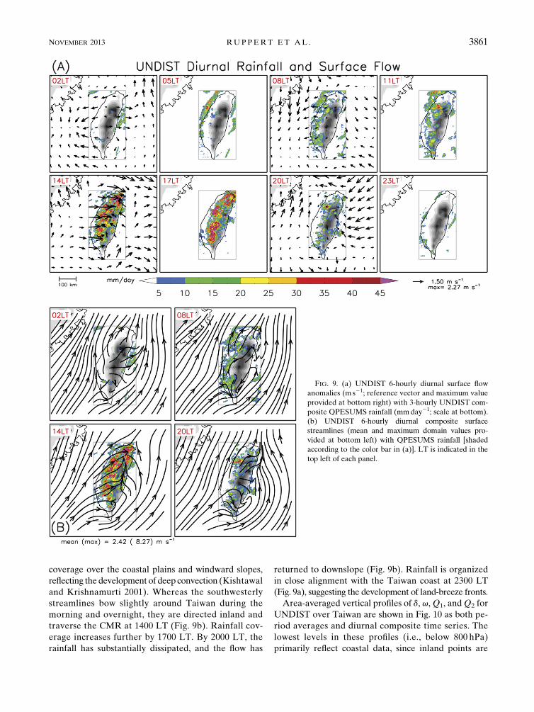
coverage over the coastal plains and windward slopes,
reflecting the development of deep convection (Kishtawal
and Krishnamurti 2001). Whereas the southwesterly
streamlines bow slightly around Taiwan during the
morning and overnight, they are directed inland and
traverse the CMR at 1400 LT (Fig. 9b). Rainfall cov-
erage increases further by 1700 LT. By 2000 LT, the
rainfall has substantially dissipated, and the flow has
returned to downslope (Fig. 9b). Rainfall is organized
in close alignment with the Taiwan coast at 2300 LT
(Fig. 9a), suggesting the development of land-breeze fronts.
Area-averaged vertical profiles of d, v,Q1, andQ2 for
UNDIST over Taiwan are shown in Fig. 10 as both pe-
riod averages and diurnal composite time series. The
lowest levels in these profiles (i.e., below 800 hPa)
primarily reflect coastal data, since inland points are
FIG. 9. (a) UNDIST 6-hourly diurnal surface flow
anomalies (m s21; reference vector and maximum value
provided at bottom right) with 3-hourly UNDIST com-
posite QPESUMS rainfall (mmday21; scale at bottom).
(b) UNDIST 6-hourly diurnal composite surface
streamlines (mean and maximum domain values pro-
vided at bottom left) with QPESUMS rainfall [shaded
according to the color bar in (a)]. LT is indicated in the
top left of each panel.
NOVEMBER 2013 RUP PERT ET AL . 3861

below ground. Also, since the CMR is displaced east of
center in Taiwan (Fig. 1), characteristics of the western
slopes dominate these averages. This spatial bias is dis-
cussed further in the appendix. In the mean there is
pronounced low-level divergence and midlevel con-
vergence, which is associated with subsidence from
;900 hPa to midlevels and weak rising motion aloft.
Lower-tropospheric divergence and sinking motion
are consistent with the upwind splitting of blocked,
low-Fr flow, as discussed earlier. The vertical patterns
in meanQ1, andQ2—warming and drying above cooling
and moistening—suggest that stratiform rain is the pre-
dominant form of precipitation (Houze 1982; Johnson
1984). However, evidence suggests that the magnitudes
of the meanQ1 andQ2 may have slight errors associated
with unresolved horizontal gradients in temperature and
moisture in and around Taiwan (see earlier discussion of
this topic). In spite of these potential errors, the diurnal
evolution depicted in Fig. 10 is sound and consistent
with previous studies of diurnal rainfall in Taiwan (e.g.,
Johnson and Bresch 1991; Kishtawal and Krishnamurti
2001). For example, upper-level divergence coincides
with rising motion, warming, and drying throughmost of
the column around 1400 LT, demonstrating that after-
noon precipitation is predominantly convective (Fig. 10,
bottom panels). The timing of deep convection is con-
sistent with the diurnal rainfall evolution during UNDIST
based on both INTERP and independent observations
(Figs. 7 and 9).
In the early morning (0200 LT), sinking motion and
low-level divergence can be noted, and are associated
with the land breeze and katabatic flow. By midmorn-
ing a shallow layer of convergence develops near the
surface associated with the sea breeze and anabatic flow,
which follows a low-level divergence maximum that
ascends with time into the afternoon. This convergence–
divergence pattern is consistent with the development of
a shallow cumulus field in response to island heating.
Similar results were found over the mountains of north-
western Mexico during the NAME (Johnson et al. 2010).
Low-level heating (0800 LT) precedes low-level rising
motion, presumably as a result of eddy heat flux con-
vergence in the boundary layer after sunrise. Deep
convection develops by 1400 LT, as indicated by
FIG. 10. UNDIST composite vertical profiles from INTERP averaged over Taiwan in (top)mean and (bottom) diurnal composite forms
(6-hourly sampling). (From left to right) d (1026 s21), v (hPa h21), Q1 (Kday21), and Q2 (Kday21). The 08C level is dashed. Abscissas
indicate (top) mean values and (bottom) LT. The 0200 LT values are repeated in diurnal profiles for continuity.
3862 MONTHLY WEATHER REV IEW VOLUME 141

divergence around 300 hPa and upper-level rising mo-
tion, heating, and drying. This coincides with the de-
velopment of upslope flow and inland rainfall (Figs. 9
and 10). A pronounced stratiform rainfall pattern de-
velops by afternoon (2000 LT), as indicated by strength-
ened upper-tropospheric divergence, convergence around
the 08C level, and lower- (upper-) tropospheric sinking
(rising) motion (Johnson and Bresch 1991; Kishtawal
and Krishnamurti 2001). In noting that this stratiform
rain transition coincides with the development of down-
slope flows (Fig. 9b), a connection can be inferred between
evening rainfall evaporation (i.e., lower-tropospheric
cooling and moistening) and the onset of a nocturnal
katabatic regime, similar to the Big Island of Hawaii
(Carbone et al. 1995).
b. Disturbed period (DIST): 31 May–4 June 2008
A map of mean surface streamlines and rainfall for
DIST (Fig. 11) clearly depicts the mei-yu front, which
separates the southwesterly summer monsoon flow from
the northeasterly flow to the north. There is a clear
concentration of rainfall along and south of the frontal
confluence line, which is largely associated with eastward-
propagating frontal MCSs (Chen 1983; Lai et al. 2011;
Davis and Lee 2012). Several southwesterly streamlines
can be noted inTaiwan, reflecting the shallownature of the
mei-yu front (Chen 1983). Because of more widespread
rainfall during DIST, the QPESUMS issue related to
radar beam blockage offshore of southern Taiwan is
clearly visible in Fig. 11.
In Taiwan, the rainfall is shifted higher along the
windward slopes relative to UNDIST (Figs. 8 and 11).
Based on a mean sounding for DIST from Dongsha
Island (not shown), Fr ; 0.6 over 700–950 hPa, with
U ; 14ms21 at that layer. The upslope shift in rainfall
relative to UNDIST is consistent with larger U and Fr,
which suggests reduced flow blocking [though Fr remains
,1; Hughes et al. (2009)]. With a very moist troposphere
(Fig. 3) and larger U and Fr, however, the atmosphere is
conducive to more vigorous and/or widespread deep
convection during this period. The importance of differ-
ing convective storm characteristics from UNDIST in
more weakly blocked flow will be assessed in section 5.
Figure 12 provides maps of diurnal composite rainfall
and surface flows (now 3 hourly) for DIST. In the
anomaly flows (Fig. 12a), there is a change from weak
downslope and offshore flow over Taiwan during the
night (most pronounced at 2300 LT) to upslope flow and
confluence in the CMR by midday (1400 LT), which
coincides with heavy inland rainfall (peak rainfall cov-
erage is again observed at 1700 LT). Similar to UNDIST,
rainfall appears to move inland from the west coast
throughout the morning (0800–1100 LT) before in-
tensifying substantially over the high terrain as after-
noon convection develops (1100–1700 LT; Fig. 7). The
flows with their composite mean retained (Fig. 12b)
depict interesting relationships between the mei-yu
northeasterly flow and diurnal flows in Taiwan. A cy-
clonic circulation pattern is evident at 2300 LT where
downslope and offshore flows drain into the northeast-
erly flow near southwestern Taiwan. This circulation
can also be noted from 0500 to 0800 LT, during which
period it shifts eastward in connection with rainfall
intensification over southwestern Taiwan (Fig. 12a).
This circulation no longer appears once the streamlines
around Taiwan transition to onshore and upslope by
afternoon.
To assess how persistent this circulation is, as well as
the other features in Fig. 12, Fig. 13 displays individual
morning (0500 LT) and afternoon (1700 LT) rainfall and
surface flow maps from six of the EOP days (31 May–
5 June; recall that DIST only includes 31 May–4 June).
While the day-to-day variability is indeed pronounced,
there is persistence in some of the features. On several
mornings, the aforementioned circulation appears with
confluence southwest of Taiwan, which resembles a lee
vortex in the northeasterly monsoon flow. In the after-
noons, in contrast, the flow is more often directed up-
slope, rainfall is increased over land, and the circulation
is usually absent (with the exception of the intenseMCV
on 5 June). No studies, to our knowledge, have docu-
mented a diurnal circulation feature during mei-yu dis-
turbed periods. Thus, the representativeness of these
composites needs to be tested by future studies.
Figure 14 presents Taiwan area-averaged diurnal
composite vertical profiles of d, v,Q1, andQ2 for DIST.
The mean profiles are qualitatively similar to those
FIG. 11. As in Fig. 8, but for DIST.
NOVEMBER 2013 RUP PERT ET AL . 3863

during UNDIST (Fig. 10), with stratiform-like structure
in vertical motion. As discussed previously, the magni-
tudes ofQ1 andQ2 may have small errors in their means
associated with unresolved gradients across the CMR
and between Taiwan and the surrounding region. The
diurnal evolution, however, depicts a sound evolution
that is consistent with previous studies (e.g., Johnson and
Bresch 1991) and the rainfall maps presented earlier. For
instance, note the strong afternoon (1400–1700 LT) deep
convection, as indicated by divergence near 200 hPa and
rising motion, warming, and drying throughout the col-
umn, which coincides with the peak rainfall over the
CMR (Figs. 7 and 12). Also note the separation of mid-
level Q1 and Q2 peaks, indicating the upward transport
of eddy heat flux and hence vigorous deep convection
(Yanai et al. 1973). An ascending divergence maximum
FIG. 12. As in Fig. 9, but for DIST. Note that the rainfall scale is doubled relative to Fig. 9. Also, diurnal flows are provided at 3-hourly
frequency during DIST since it coincided with the EOP. The magenta crisscross (3) in (b) marks a circulation center.
3864 MONTHLY WEATHER REV IEW VOLUME 141

FIG. 13. Surface streamlines and QPESUMS rainfall (mmday21, shaded) for morning (2100 UTC, 0500 LT the next day) and afternoon
(0900 UTC, 1700 LT) on 31 May–5 Jun. Dates are indicated at the top left of each panel, which pertain to UTC time.
NOVEMBER 2013 RUP PERT ET AL . 3865

can be noted (near 800 hPa at 0800 LT) in connection
with shallow rising motion and heating preceding
deep convection, indicating a deepening shallow cu-
mulus field throughout the morning. By afternoon
(2000 LT), a stratiform pattern of elevated rising mo-
tion, heating, and drying is evident. This diurnal evo-
lution from shallow cumulus to deep convection to
stratiform rain is qualitatively similar to the pattern
found during UNDIST (Fig. 10), though the signal of
afternoon deep convection is much more pronounced and
3-hourly sampling during the EOP provides improved
detail.
5. Discussion
In this study the diurnal cycle during two periods of
SoWMEX/TiMREX (2008) has been described: one
undisturbed (UNDIST, 22–29 May) and one disturbed
(DIST, 31 May–4 June). UNDIST was characterized by
relatively uniform southwesterly flow, a dry midtropo-
sphere (Fig. 3), and predominant subsidence (Fig. 4). In
association with reduced cloudiness (Fig. 5), there was
a strong diurnal cycle in slope flows and rainfall (Fig. 6),
with rain peaking in the afternoon over the coastal
plains and lower foothills of western Taiwan (Fig. 9).
The diurnal cycle in slope flows and rainfall remained
important during DIST (Figs. 7, 12, and 14), in spite of
strengthened southwesterly flow, a moist troposphere
(Fig. 3), and a nearby mei-yu front attended by heavy
rainfall (Fig. 11).
A contrasting aspect between DIST and UNDIST is
that peak rainfall was shifted upslope during DIST rel-
ative to UNDIST (Figs. 8 and 11). The Froude number
was larger during DIST in connection with stronger
oncoming lower-tropospheric flow, though Fr remained
,1 during both periods. Larger Fr is consistent with
reduced flow blocking, in which rainfall is expected to be
a stronger function of terrain slope (Hughes et al. 2009).
In the more disturbed environment during DIST,
however, flow–microphysical interactions might have
become important with more widespread convection
(Jiang 2003; Chen and Lin 2005; Miglietta and Rotunno
2009; Murphy and Businger 2011). Storm microphysical
characteristics are discussed next.
Figure 15 provides west–east radar cross sections of
reflectivity and hydrometeor identification (HID) for
FIG. 14. As in Fig. 10, but for DIST (with 3-hourly sampling).
3866 MONTHLY WEATHER REV IEW VOLUME 141
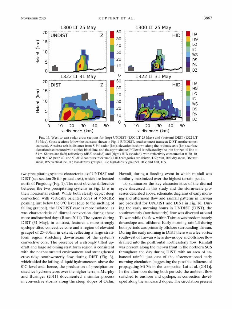
two precipitating systems characteristic of UNDIST and
DIST (see section 2b for procedures), which are located
north of Pingdong (Fig. 1). The most obvious difference
between the two precipitating systems in Fig. 15 is in
their horizontal extent. While both clearly depict deep
convection, with vertically oriented cores of $50 dBZ
peaking just below the 08C level (due to the melting of
falling graupel), the UNDIST case is more isolated, as
was characteristic of diurnal convection during these
more undisturbed days (Rowe 2011). The system during
DIST (31 May), in contrast, features a more strongly
upslope-tilted convective core and a region of elevated
graupel of 25–30 km in extent, reflecting a large strati-
form region stretching downstream of the system’s
convective core. The presence of a strongly tilted up-
draft and large adjoining stratiform region is consistent
with the near-saturated environment and strengthened
cross-ridge southwesterly flow during DIST (Fig. 3),
which aided the lofting of liquid hydrometeors above the
08C level and, hence, the production of precipitation-
sized ice hydrometeors over the higher terrain. Murphy
and Businger (2011) documented a similar process
in convective storms along the steep slopes of Oahu,
Hawaii, during a flooding event in which rainfall was
similarly maximized over the highest terrain peaks.
To summarize the key characteristics of the diurnal
cycle discussed in this study and the storm-scale pro-
cesses described above, schematic diagrams of early morn-
ing and afternoon flow and rainfall patterns in Taiwan
are provided for UNDIST and DIST in Fig. 16. Dur-
ing the early morning hours in UNDIST (DIST), the
southwesterly (northeasterly) flow was diverted around
Taiwan while the flowwithin Taiwan was predominately
downslope and offshore. Early morning rainfall during
both periods was primarily offshore surrounding Taiwan.
During the early morning in DIST there was a lee vortex
southwest of Taiwan where downslope and offshore flow
drained into the postfrontal northeasterly flow. Rainfall
was present along the mei-yu front in the northern SCS
throughout the day during DIST, with an area of en-
hanced rainfall just east of the aforementioned early
morning circulation [suggesting the possible influence of
propagating MCVs in the composite; Lai et al. (2011)].
In the afternoon during both periods, the ambient flow
switched to onshore and upslope, as convection devel-
oped along the windward slopes. The circulation present
FIG. 15. West-to-east radar cross sections for (top) UNDIST (1300 LT 25 May) and (bottom) DIST (1322 LT
31 May). Cross sections follow the transects shown in Fig. 1 (UNDIST, southernmost transect; DIST, northernmost
transect). Abscissa axis is distance from S-Pol radar (km), elevation is shown along the ordinate axis (km), surface
elevation is contoured with a thick black line, and the approximate 08C level is indicated by the thin horizontal line at
5 km. Shown are (left) reflectivity (dBZ, shaded) and (right) HID (shaded), with reflectivity contoured at 0, 30, 40,
and 50 dBZ (with 40- and 50-dBZ contours thickened). HID categories are drizzle, DZ; rain, RN; dry snow, DS; wet
snow, WS; vertical ice, IC; low-density graupel, LG; high-density graupel, HG; and hail, HA.
NOVEMBER 2013 RUP PERT ET AL . 3867

during earlymorning inDISTwas absent in the afternoon
after the flow switched to onshore and upslope.
Afternoon rainfall was focused along the coastal
plains and lower foothills during UNDIST, while rainfall
during DIST was maximized in the higher terrain
(Fig. 16). Strengthened flow during DIST resulted in
more weakly blocked flow, strongly upslope-tilted
convective storm cores, and more lofted precipitation-
sized ice hydrometeors. These ice hydrometeors were
advected over the higher terrain, leading to extensive
stratiform regions and the upslope shift in peak rain-
fall. UNDIST, in contrast, exhibited more isolated
convection and more strongly blocked flow, resulting
in rainfall peaking farther upstream of the high CMR
slopes.
6. Summary and conclusions
The diurnal cycle of mesoscale circulations and rain-
fall has been described during an undisturbed and
a disturbed period of the 2008 Terrain-influenced
Monsoon Rainfall Experiment (SoWMEX/TiMREX).
This study attempts to improve our understanding of
diurnal variability in the presence of steep terrain,
and the sensitivity of the diurnal cycle to the strongly
varying large-scale environment during Taiwan’s mei-
yu season. Results for DIST and UNDIST are gen-
erally consistent with previous studies of the diurnal
cycle in Taiwan (Johnson and Bresch 1991; Chen et al.
1999; Kishtawal and Krishnamurti 2001; Kerns et al.
2010; Lin et al. 2011). However, the enhanced sounding
network during the 42-day SoWMEX/TiMREX ex-
periment (13 sites, with 3–6-hourly sampling) allowed
us to examine these phenomena with unprecedented
detail.
The principal findings of the study are summarized as
follows:
d Interpolation of the SoWMEX/TiMREX observa-
tional datasets has yielded a detailed gridded analysis,
FIG. 16. Schematic depiction of the diurnal cycle looking northeast over Taiwan during the two SoWMEX/
TiMREX (2008) periods analyzed in this study. (left) The undisturbed period (22–29 May) was characterized by
relatively uniform southwesterly impinging flow, large-scale subsidence, and a dry mid-/upper troposphere over
Taiwan. (right) During the disturbed period (31May–4 Jun), a surfacemei-yu front was situated in the northern SCS,
the impinging southwesterly flow overriding the front was stronger and moister than UNDIST, and the afternoon
rainfall in Taiwan was heavier. Precipitation cores are schematically depicted to exemplify characteristics of after-
noon deep convection along the western-coastal plains and windward slopes. Orange, red, and magenta shading
patterns indicate radar reflectivity exceeding 30, 40, and 50 dBZ, respectively. Asterisks represent ice hydro-
meteors. The blue lines indicate rainfall. Surface streamlines are based on 0200 (0500) and 1400 (1700) LT diurnal
composites for morning and afternoon during UNDIST (DIST), respectively. Wind profiles are based on UNDIST
and DIST mean soundings from Dongsha Island (location indicated in Fig. 8; half and full barbs denote 2.5 and
5m s21, respectively). Vertical scale is exaggerated to emphasize terrain, and wind profiles and schematic clouds
are not to scale.
3868 MONTHLY WEATHER REV IEW VOLUME 141

from which a range of diagnostic analyses and model-
ing validation efforts can be carried out.d The diurnal cycle of atmospheric heating and moist-
ening over Taiwan and its vicinity indicates an evo-
lution from shallow cumulus to deep convection
(0800–1400 LT) to stratiform rain by evening (2000 LT).
This evolution is observed in both disturbed and un-
disturbed conditions.d While the amplitude of the diurnal circulations and
rainfall activity varies (inversely; Fig. 6) between un-
disturbed and disturbed conditions, the diurnal evolu-
tion in surface flow and rainfall patterns is similar.
During the day, offshore rainfall shifts eastward toward
the windward slopes of Taiwan as the flow switches to
onshore and upslope, and amplifies in the afternoon
(1400–1700 LT) along the windward slopes. In the
evening, the flow in Taiwan switches to downslope and
offshore, and rainfall redevelops in areas of offshore
confluence. The coincidence of the switch from up-
slope to downslope flow with the evening transition
to stratiform rain suggests that rainfall evaporation
may play a key role in the initiation of the nocturnal
katabatic flow, similar to the Big Island of Hawaii
(Carbone et al. 1995).d Although the amplitude of local diurnal circulations is
reduced during highly disturbed periods, more favor-
able characteristics for heavy rainfall make the envi-
ronment particularly sensitive to these circulations,
such that the diurnal variability in rainfall during those
periods remains large.d A circulation pattern resembling a lee vortex is noted
during the disturbed period when the ambient flow
around Taiwan is northeasterly. This circulation ap-
pears near southwestern Taiwan during the night and
morning, resembling a lee vortex in the northeasterly
flow. The vortex disappears once the flow switches
to onshore and upslope. The circulation–rainfall re-
lationship resembles that of an MCV.d The location of peak rainfall relative to the topogra-
phy is sensitive to both the nature of the convection
and the flow blocking. When the impinging flow is
strong (e.g., 15m s21) and the troposphere is condu-
cive to widespread, intense convective storms, greater
production of lofted ice hydrometeors and their sub-
sequent advection can lead to a shift in peak rainfall to
higher elevations than during undisturbed conditions.
While the results presented for an undisturbed period
are consistent with prior studies of the diurnal cycle
in Taiwan, few studies have analyzed the diurnal cycle
during disturbed summer monsoon conditions. Thus,
more years should be compiled to assess the represen-
tativeness of the disturbed period results present herein.
The sensitivity of the location of peak rainfall relative
to topographic barriers to ambient flow characteristics
(i.e., tropospheric flow strength and humidity) has very
important forecast implications for Taiwan, which is
a densely populated country characterized by frequent
landslides during the mei-yu season. More detailed anal-
ysis of the properties of raining systems during the mei-yu
season, such as their microphysical properties and evo-
lution, will enable improved understanding of these sen-
sitivities. The S-Pol radar deployed during SoWMEX/
TiMREX provides a great opportunity to do so. Better
understanding of the key controls on orographic rainfall
properties in this region will improve our ability to pre-
dict potentially life-threatening summermonsoon rainfall
events.
Acknowledgments. The authors acknowledge Paul
Ciesielski for operating the multiquadric interpolation
scheme, Dr. Po-Hsiung Lin of NTU for providing data
from the NTU experimental forest flux site at Pingdong,
and the Central Weather Bureau of Taiwan for pro-
viding QPESUMS data. Helpful comments from Paul
Ciesielski, Eric Maloney, V. Chandrasekar, Ben Jong-
Dao Jou, Steven Fletcher, Hsiao-Wei Lai, Jenny Sun,
and Hongli Wang are greatly appreciated. Three anony-
mous reviewers are also acknowledged for their com-
ments, which substantially improved the study. This
research was supported by National Science Foundation
Grant AGS-0966758.
APPENDIX
Interpolated Analysis and Taiwan Area Averages
Figure A1 provides UNDIST diurnal composite ver-
tical profiles of Q1 averaged over Taiwan from three
sources: INTERP, INTERP excluding GFS data, and
GFS. The most obvious feature in Fig. A1 is the gross
overestimation of heating by GFS (relative to INTERP),
which would be reflected as overestimated rainfall
through theQ1 budget (Yanai et al. 1973). Furthermore,
the diurnal evolution in GFS strongly differs from the
other two datasets. The two versions of INTERP are very
similar in diurnal evolution, exhibiting daytime shallow-
to-deep heating peaks followed by heating over cooling
during the evening, indicating stratiform rain.
Figure A2 provides mean and diurnal time–pressure
sections of divergence, vertical motion, Q1, and Q2 for
UNDIST. The only difference from Fig. 10 is that these
fields are averaged over western Taiwan instead of the
entire island (the dividing line is indicated in Fig. 1).
Comparison of Figs. 10 and A2 demonstrates that the
NOVEMBER 2013 RUP PERT ET AL . 3869

patterns in western Taiwan dominate the full Taiwan
averages. This owes to the geographical arrangement in
Taiwan, with themain geographic barrier being displaced
east of center (Fig. 1). A subtle difference between
Figs. 10 and A2 is that the afternoon convection (as seen
in rising motion, Q1, and Q2) is slightly stronger in
Fig. A2, which is consistent with Figs. 8 and 9 showing
greater rainfall in western Taiwan.
FIG. A1. UNDIST diurnal composite vertical profiles ofQ1 averaged over Taiwan from (left) INTERP, (middle) INTERP but excluding
GFS data points, and (right) GFS.
FIG. A2. As in Fig. 10, but fields are averaged over western Taiwan (dividing line indicated in Fig. 1).
3870 MONTHLY WEATHER REV IEW VOLUME 141

REFERENCES
Alpers, W., J.-P. Chen, I.-I. Lin, and C.-C. Lien, 2007: Atmo-
spheric fronts along the east coast of Taiwan studied by
ERS synthetic aperture radar images. J. Atmos. Sci., 64,
922–937.
——,——,C.-J. Pi, and I.-I. Lin, 2010:On the origin of atmospheric
frontal lines off the east coast of Taiwan observed on space-
borne synthetic aperture radar images. Mon. Wea. Rev., 138,
475–496.
Baines, P. G., 1987: Upstream blocking and airflow over moun-
tains. Annu. Rev. Fluid Mech., 19, 75–97.
Carbone, R. E., W. A. Cooper, and W.-C. Lee, 1995: Forcing of
flow reversal along the windward slopes of Hawaii.Mon. Wea.
Rev., 123, 3466–3480.
Chang, P.-L., P.-F. Lin, B. J.-D. Jou, and J. Zhang, 2009: An ap-
plication of reflectivity climatology in constructing radar hy-
brid scans over complex terrain. J. Atmos. Oceanic Technol.,
26, 1315–1327.
Chen, C.-S., W.-C. Chen, and W.-K. Tao, 2004: Characteristics of
heavy summer rainfall in southwestern Taiwan in relation to
orographic effects. J. Meteor. Soc. Japan, 82, 1521–1543.
Chen, G. T.-J., 1983: Observational aspects of the Mei-Yu
phenomenon in subtropical China. J. Meteor. Soc. Japan, 61,
306–312.
——, C.-C. Wang, and S.-W. Chang, 2008: A diagnostic case study
of mei-yu frontogenesis and development of wavelike frontal
disturbances in the subtropical environment.Mon. Wea. Rev.,
136, 41–61.
Chen, S.-H., and Y.-L. Lin, 2005: Effects of moist Froude number
and CAPE on a conditionally unstable flow over a mesoscale
mountain ridge. J. Atmos. Sci., 62, 331–350.
Chen, T.-C., M.-C. Yen, J.-C. Hsieh, and R. W. Arritt, 1999: Di-
urnal and seasonal variations of the rainfall measured by the
Automatic Rainfall and Meteorological Telemetry System in
Taiwan. Bull. Amer. Meteor. Soc., 80, 2299–2312.
Chen, Y.-L., 1993: Some synoptic-scale aspects of the surface fronts
over southern China during TAMEX. Mon. Wea. Rev., 121,
50–64.
Ciesielski, P. E., R. H. Johnson, P. T. Haertel, and J. Wang, 2003:
Corrected TOGA COARE sounding humidity data: Impact
on diagnosed properties of convection and climate over the
warm pool. J. Climate, 16, 2370–2384.——, and Coauthors, 2010: Quality controlled upper-air sounding
dataset for SoWMEX/TiMREX: Development and correc-
tions. J. Atmos. Oceanic Technol., 27, 1802–1821.Davis, C. A., and W.-C. Lee, 2012: Mesoscale analysis of heavy
rainfall episodes from SoWMEX/TiMREX. J. Atmos. Sci., 69,
521–537.
Ding, Y. H., and C. L. Chan, 2005: The East Asian summer mon-
soon: An overview. Meteor. Atmos. Phys., 89, 117–142.
Durran, D. R., and J. B. Klemp, 1982: On the effects of moisture
on the Brunt–V€ais€al€a frequency. J. Atmos. Sci., 39, 2152–
2158.
Houze, R. A., Jr., 1982: Cloud clusters and large-scale vertical
motions in the tropics. J. Meteor. Soc. Japan, 60, 396–410.
Huffman, G. J., and Coauthors, 2007: The TRMM Multisatellite
Precipitation Analysis (TMPA): Quasi-global, multiyear,
combined-sensor precipitation estimates at fine scales.
J. Hydrometeor., 8, 38–55.
Hughes, M., A. Hall, and R. G. Fovell, 2009: Blocking in areas of
complex topography, and its influence on rainfall distribution.
J. Atmos. Sci., 66, 508–518.
Jiang, Q., 2003: Moist dynamics and orographic precipitation.
Tellus, 55A, 301–316, doi:10.1034/j.1600-0870.2003.00025.x.
Johnson, R. H., 1980: Diagnosis of convective and mesoscale mo-
tions during phase III of GATE. J. Atmos. Sci., 37, 733–753.
——, 1984: Partitioning tropical heat and moisture budgets into
cumulus andmesoscale components: Implications for cumulus
parameterization. Mon. Wea. Rev., 112, 1590–1601.
——, and J. F. Bresch, 1991: Diagnosed characteristics of pre-
cipitation systems over Taiwan during the May–June 1987
TAMEX. Mon. Wea. Rev., 119, 2540–2557.
——, and P. E. Ciesielski, 2002: Characteristics of the 1998 summer
monsoon onset over the northern South China Sea. J. Meteor.
Soc. Japan, 80, 561–578.——, ——, T. S. L’Ecuyer, and A. J. Newman, 2010: Diurnal cycle
of convection during the 2004 North American Monsoon
Experiment. J. Climate, 23, 1060–1078.
Jou, B. J.-D., W.-C. Lee, and R. H. Johnson, 2011: An overview of
SoWMEX/TiMREX. The Global Monsoon System: Research
and Forecasts, 2nd ed. C.-P. Chang et al., Eds., World Scien-
tific, 303–318.
Kerns, J. B. W., Y.-L. Chen, and M.-Y. Chang, 2010: The diurnal
cycle of winds, rain, and clouds over Taiwan during themei-yu,
summer, and autumn rainfall regimes. Mon. Wea. Rev., 138,
497–516.
Kishtawal, C. M., and T. N. Krishnamurti, 2001: Diurnal variation
of summer rainfall over Taiwan and its detection using TRMM
observations. J. Appl. Meteor., 40, 331–344.
Kummerow, C., and Coauthors, 2000: The status of the Tropical
Rainfall Measuring Mission (TRMM) after two years in orbit.
J. Appl. Meteor., 39, 1965–1982.Kuo, Y.-H., and G. T.-J. Chen, 1990: The Taiwan Area Mesoscale
Experiment (TAMEX): An overview. Bull. Amer. Meteor.
Soc., 71, 488–503.
Lai, H.-W., C. A. Davis, and B. J.-D. Jou, 2011: A subtropical oce-
anic mesoscale convective vortex observed during SoWMEX/
TiMREX. Mon. Wea. Rev., 139, 2367–2385.
Lang, T. J., D. A. Ahijevych, S. W. Nesbitt, R. E. Carbone, S. A.
Rutledge, and R. Cifelli, 2007: Radar-observed characteristics
of precipitating systems during NAME 2004. J. Climate, 20,
1713–1733.
Li, J., and Y.-L. Chen, 1998: Barrier jets during TAMEX. Mon.
Wea. Rev., 126, 959–971.
Lin, P.-F., P.-L. Chang, B. J.-D. Jou, J. W. Wilson, and R. D.
Roberts, 2011: Warm season thunderstorm characteristics
under weak synoptic-scale forcing over Taiwan island. Wea.
Forecasting, 26, 44–60.
Lin, X., and R. H. Johnson, 1996: Kinematic and thermodynamic
characteristics of the flow over the western Pacific warm pool
during TOGA COARE. J. Atmos. Sci., 53, 695–715.
Liu, C., E. J. Zipser, and S. W. Nesbitt, 2007: Global distribution of
tropical deep convection: Different perspectives from TRMM
infrared and radar data. J. Climate, 20, 489–503.
Liu, H., and V. Chandrasekar, 2000: Classification of hydrometeors
based on polarimetric radar measurements: Development of
fuzzy logic and neuro-fuzzy systems, and in situ verification.
J. Atmos. Oceanic Technol., 17, 140–164.Luo, H., and M. Yanai, 1983: The large-scale circulation and heat
sources over the Tibetan Plateau and surrounding areas during
the early summer of 1979. Part I: Precipitation and kinematic
analyses. Mon. Wea. Rev., 111, 922–944.Mapes, B. E., P. E. Ciesielski, and R. H. Johnson, 2003: Sampling
errors in rawinsonde-array budgets. J. Atmos. Sci., 60, 2697–
2714.
NOVEMBER 2013 RUP PERT ET AL . 3871

McNab, A. L., and A. K. Betts, 1978: A mesoscale budget study of
cumulus convection. Mon. Wea. Rev., 106, 1317–1331.
Miglietta, M. M., and R. Rotunno, 2009: Numerical simulations of
conditionally unstable flows over a mountain ridge. J. Atmos.
Sci., 66, 1865–1885.
Mohr, C. G., L. J. Miller, R. L. Vaughan, and H. W. Frank, 1986:
The merger of mesoscale datasets into a common Cartesian
format for efficient and systematic analyses. J. Atmos. Oceanic
Technol., 3, 143–161.
Murphy, M. J., and S. Businger, 2011: Orographic influences on an
Oahu flood. Mon. Wea. Rev., 139, 2198–2217.
Nuss, W. A., and D. W. Titley, 1994: Use of multiquadric inter-
polation for meteorological objective analysis. Mon. Wea.
Rev., 122, 1611–1631.
O’Brien, J. J., 1970: Alternative solutions to the classical vertical
velocity problem. J. Appl. Meteor., 9, 197–203.
Overland, J. E., and N. A. Bond, 1995: Observations and scale
analysis of coastal wind jets. Mon. Wea. Rev., 123, 2934–
2941.
Pierrehumbert, R. T., and B. Wyman, 1985: Upstream effects of
mesoscale mountains. J. Atmos. Sci., 42, 977–1003.
Rowe, A. K., 2011: A polarimetric radar analysis of convection
observed during NAME and TiMREX. Ph.D. dissertation,
Colorado State University, 246 pp. [Available from CSU Li-
braries, http://lib.colostate.edu/etd.]
——, S. A. Rutledge, and T. J. Lang, 2011: Investigation of micro-
physical processes occurring in isolated convection during
NAME. Mon. Wea. Rev., 139, 424–443.
——, ——, and ——, 2012: Investigation of microphysical pro-
cesses occurring in organized convection duringNAME.Mon.
Wea. Rev., 140, 2168–2187.
Smolarkiewicz, P. K., R. M. Rasmussen, and T. L. Clark, 1988:
On the dynamics of Hawaiian cloud bands: Island forcing.
J. Atmos. Sci., 45, 1872–1905.
Sun,W.-Y., and J.-D. Chern, 1993: Diurnal variation of lee vortices
in Taiwan and the surrounding area. J. Atmos. Sci., 50, 3404–
3430.
Tessendorf, S. A., L. J. Miller, K. C. Wiens, and S. A. Rutledge, 2005:
The 29 June 2000 supercell observed during STEPS. Part I:
Kinematics and microphysics. J. Atmos. Sci., 62, 4127–4150.
Waliser, D. E., and Coauthors, 2012: The ‘‘year’’ of tropical
convection (May 2008–April 2010): Climate variability
and weather highlights. Bull. Amer. Meteor. Soc., 93, 1189–
1218.
Wang, C.-C., G. T.-J. Chen, T.-C. Chen, and K. Tsuboki, 2005: A
numerical study on the effects of Taiwan topography on a
convective line during themei-yu season.Mon.Wea. Rev., 133,
3217–3242.
Xu,W., E. J. Zipser, Y.-L. Chen, C. Liu, Y.-C. Liou,W.-C. Lee, and
B. J.-D. Jou, 2012: An orography-associated extreme rainfall
event during TiMREX: Initiation, storm evolution, and
maintenance. Mon. Wea. Rev., 140, 2555–2574.
Yanai,M., S. Esbensen, and J. H. Chu, 1973: Determination of bulk
properties of tropical cloud clusters from large-scale heat and
moisture budgets. J. Atmos. Sci., 30, 611–627.
Yeh, H.-C., and Y.-L. Chen, 2002: The role of offshore conver-
gence on coastal rainfall during TAMEX IOP 3. Mon. Wea.
Rev., 130, 2709–2730.
Yu, C.-K., and B. J.-D. Jou, 2005: Radar observations of the di-
urnally forced offshore convective lines along the southeast-
ern coast of Taiwan. Mon. Wea. Rev., 133, 1613–1636.
——, and C.-Y. Lin, 2008: Statistical location and timing of the
convective lines off the mountainous coast of southeastern
Taiwan from long-term radar observations. Mon. Wea. Rev.,
136, 5077–5094.
——, and Y.-H. Hsieh, 2009: Formation of the convective lines off
the mountainous coast of southeastern Taiwan: A case study
of 3 January 2004. Mon. Wea. Rev., 137, 3072–3091.
3872 MONTHLY WEATHER REV IEW VOLUME 141