diversity, complexity and dynamics: land use patterns · pdf filediversity, complexity and...
TRANSCRIPT
107
Diversity, Complexity and Dynamics: Land Use Patterns in the Central Himalayas of Kumaon, Northern India
Marcus Nüsser1 & Martin Gerwin2
Introduction
Natural resource use in high mountain areas is generally diverse as potentials, constraints and risks of agrarian practices are largely subjected to certain environmental conditions. Th e altitudinal zonation of climate and vegetation belts and the related ecological par-ticularities stipulate vertical and seasonal mobility patterns to increase the availability and variety of natural resources. Consequently, land use systems have predominantly been interpreted in the context of local adaptation strategies within given spatial dis-tribution and economic appraisal of natural resources. Th is proves especially true for peripheral mountain areas, where both land use and livelihood security primarily de-pend on subsistence farming, animal husbandry, and forest utilization (Bishop 1990, Stevens 1993, Uhlig 1995, Nüsser 1998). Even if off -farm income opportunities have increased in almost every part of the South Asian high mountain rim comprising the Hindu Kush, Karakorum and Himalayas, agro-pastoral land use still constitutes the economic backbone of mountain communities. Beyond common features of combined mountain agriculture (Ehlers & Kreutzmann 2000), regional agrarian practices vary between diff erent sections of the high mountain belt of South Asia. Nonetheless, the analysis of regional land use cannot be reduced solely to aspects of adaptation to natural resource potentials and management strategies to mitigate the impacts of losses due to environmental hazards. A better understanding of land use change in both production patterns and livelihood strategies strongly depends on the integration of socioecono-mic developments, cultural values, external infl uences, and the territorial dimensions of land tenure (Kreutzmann 2004). Especially in the context of common property regimes and community-based institutions, the interaction of local norms, formal and informal regulations, and external development interventions all must be taken into consideration. Although integrated approaches are often postulated, changing strate-gies of resource use are predominantly conceived as a one-way street in which local actors react more or less uniformly to external impulses and restrictions.
Th e purpose of this paper is to analyze the diversity, complexity and dynamics of land use patterns in Kumaon, the north-eastern portion of the Indian state Uttarakhand. Much like in adjacent high mountain regions, agrarian land use in this part of the Central Himalayas takes place within a context of combined mountain agriculture across diff erent altitudinal belts. Th e multiple territorial rights of access and natural resource utilization mainly results from ethnic segregation, settlement processes and external impacts. Most notably since the onset of British colonial rule in South Asia, the Central Himalayas have served as an eff ective barrier to the territorial expansion of diverse emperors. Nevertheless, the control over the vast natural resources of the moun-1 Ruprecht-Karls-Universität Heidelberg. Abteilung Geographie am Südasien-Institut,
D-69120 Heidelberg; [email protected] Ruprecht-Karls-Universität Heidelberg. Abteilung Geographie am Südasien-Institut,
D-69120 Heidelberg; [email protected].

108
tain belt, fi rst and foremost forests, have always been an important matter of interest for various state agencies. In the given regional context of Kumaon, the ethno-linguistic group of the Bhotiyas deserves particular attention. Apart from their agro-pastoral land use patterns, the Bhotiyas practiced trade with nomads of the Tibetan Plateau until the war between India and China in 1962 and the resulting sealing of the border. Th e traditional land use system of the Bhotiyas can be illustrated using the case of the Gori Valley, which originates in the Trans-Himalayas and crosses the main ridge of the Greater Himalayas over a distance of roughly 100 km. Prominent massifs like Nanda Devi (7816 m), Hardeol (7151 m) and Panchchuli (6913 m) frame the upper portions of this transversal valley.
It remains to be seen how land-use patterns and strategies of resource use of the Bhotiyas have changed during shifts in political power and subsequent socioeconomic restruc-turing of the region. Whether or not or to what extent new strategies of land use have arisen or the existing ones have been modifi ed remain open questions.
Fig. 1 The Central Himalayas of Uttarakhand, Northern India

109
Environmental Zonation
Th e Kumaon and Garhwal Himalaya constitute the Indian federal state of Uttarakhand (fi g. 1). Both regions span over several environmental zones with specifi c potentials and limitations regarding crop farming, forest and pasture use. Th e narrow belt of the Outer Himalayas arises from the northern parts of the Ganges Plains (Terai). Up to an altitude of approximately 1000 m this area is covered by tropical sub-humid Sal-forests (Shorea robusta), mostly reduced to steep slopes and almost exclusively protected as state-governed Reserved Forests. Without any visible disruption the range of the Lesser Himalayas, also known as Himanchal, follows in northern direction. Th is 70 to 100 km wide belt of mountains with an elevation of 1500 to 3000 m is dominated by Pinus roxburghii-forests. Th ese conifers have been tapped for turpentine extraction since the early 20th century (Agrawal 2005). In the vicinity of settlements nearly the entire available land is terraced and cultivated for double cropping with rice, wheat, millet and diff erent legumes.
Th e zone of the Greater Himalayas of Uttarakhand is about 30–50 km wide (Fig. 2). Th e scenery is dominated by glaciated mountain peaks, many of which exceed 6000 m and some 7000 m. Th e narrow transversal valleys are covered by montane forests and alpine grasslands, the former boasting a large variety of tree species. Evergreen oak forests, consisting of Quercus semecarpifolia, Qu. dilatata and Qu. leucotrichophora, alternate with areas dominated by conifers (Abies spectabilis, Cupressus torulosa) or deci-duous trees, such as Alnus nepalensis, Aesculus indica or diff erent species of maples (Acer spp.). Th e northernmost part of the transect is characterized by the Tibetan Himalayas. Located in the rain shadow of the main mountain range, the quantity of summer preci-pitation is rather low. During winter months however, the area is covered by thick and wet snow. Since the landforms have been shaped by glacial erosion processes, the valley
Fig. 2 Vertical Zonation and Traditional Mobility Patterns in Kumaon, Northern India

110
bottoms are relatively wide and shallow. Th ese localities are covered by alpine meadows and dwarf shrubs and are mainly used as pastures (photo 1).
Agro-Pastoral Resource Utilization and Trans-Himalayan Trade
Th e traditional system of agro-pastoral resource utilization of the Bhotiyas comprised pasturing, crop cultivation and forest use. Th eir seasonal transhumance linked all the aforementioned environmental zones to ensure an optimal use of all available fodder resources. Until the closure of the Indo-Tibetan border in 1962, they combined their agro-pastoral activities with Trans-Himalayan trade. Th eir winter migrations led them to the southern fringes of the mountain belt close to the Ganges Plain in search for valuable grazing grounds and trade markets (Hoon 1996). In this region, the towns of Ramnagar and Haldwani were already connected to the expanding railway system in the 1880s. During upward migration, the Bhotiyas drove their fl ocks to halting places (Paraos) in the montane belt in April and further up to the subalpine and alpine pa-stures between May and June. Th ey returned to their halting places between September and October and reached the foothills again in November. Th is agro-pastoral migration cycle between summer and winter settlements was organized over a horizontal distance of roughly 200 km (fi g. 2). Sheep and goats were the dominant animals for crossing the mountain passes to Tibetan trade markets during the summer months. Cattle and cross-breeds with yaks were suitable animals to deliver a suffi cient amount of manure and to provide draught power (Traill 1832).
Th is system of agro-pastoral resource utilization is, however, subject to constant change, similar to other regions of the Central Himalayas. Summer migration to the Bugyals
Photo 1 The transition zone between the montane and subalpine vegetation belts in the Gori Valley (M. Nüsser, October 2004)

111
for the purpose of high pasturing has reduced drastically. Apparently, due to the closure of markets for grain in Tibet, crop-farming in high altitude settlements is no longer profi table. During prosperous phases of trade crop-farming was conducted extensively and dominated by the growth of barley and buckwheat that were often irrigated due to the more arid conditions (Pant 1935). Presently, most of the buildings are abandoned and agricultural land is almost exclusively left fallow (photo 2).
Th e signifi cant decrease in sheep and goats as well as the parallel increase of cattle (Traill 1832, KBPF 1947, Government of Uttaranchal 2003) indicate the transfor-mation from transhumance towards sedentary agriculture. Nowadays cattle are the preferred species for agriculture in the middle sections of the High Himalayan valleys within the vicinity of the former trade depots. Since the montane forests often exhibit a herbaceous understorey, the forests also serve as important pastures for cattle, which is supplemented by stall-feeding during the winter months. Th is observation is reinforced by a considerable decline in the use of other transport animals, such as horses, ponies, and donkeys (KBPF 1947, Government of Uttaranchal 2003).
Downward migration to the lowlands and foothills is signifi cantly reduced in present days. Only professional shepherds take remaining sheep and goats of the Bhotiyas down to these areas during the cold period. Due to legal regulations the shepherds are allowed to use one pasture for 10-15 days only. Contrarily, foreign livestock owners come to the valleys to graze their animals, mainly buff alos, between May and September.
Photo 2 Abandoned houses in Milam (3440 m), the uppermost settlement of the Gori Valley (M. Nüsser, October 2004)

112
Socio-Cultural Landscapes
Th e mountain landscape of Kumaon and Garhwal is characterized by both its envi-ronmental and socio-cultural diversity (Ramakrishnan 2003). Since ancient times the region has been regarded as the abode of gods and deities. Examples of the sacredness of landscape elements include the source of the Ganges at the Gangotri Glacier, the Nanda Devi as the seat of a goddess or the important Hindu temple at Badrinath. Th e spiritual meaning of mountain peaks, rivers or forests strongly correlates with regulati-ons of natural resource use. Numerous sacred forest groves (photo 3) exhibit restrictions on the utilization of trees as fuel wood, building material or animal fodder. Traditional pilgrim routes not only lead to shrines of Uttarakhand, but connect the Himalayan valleys with the Tibetan Plateau, especially with Mount Kailash, the sacred mountain of Hindus and Buddhists.
Th e contact zone between the Hindu-dominated Indian Himalayas and the Buddhist-orientated Tibetan Plateau is an area where various cultural infl uences merge. Th e Bhotiyas, who live in this transition zone in Kumaon, Garhwal and in the northwestern parts of Nepal, are widely described as brokers (Traill 1832, Hoon 1996). Their eco-logical knowledge and their ability to communicate in Tibetan languages are viewed as the main reasons for their monopoly in regional Trans-Himalayan trade (Srivastava 1966, Brown 1984). Whereas, nowadays they characterize themselves as Hindus, former scholars and early explorers regularly emphasized their Tibetan origin and the Buddhist infl uences on their cultural practices to distinguish them from the major local Hindu population in these mountain valleys, the so-called Paharis (e. g. Atkinson 1882). More recent research, however, alludes to the uncertainties of their geographical origin and, instead, emphasizes the heterogeneity within the group itself (Saklani 1998).
Photo 3 Sacred birch forest above the village Martoli, Gori Valley (M. Nüsser, October 2004)

113
Development in a Contested Border Region: a Historical Perspective
A better understanding of regional land use patterns and development trajectories strongly depends on the integration of political processes and external infl uences in a historical perspective. Since the invasion of Kumaon and most parts of Garhwal by the Gorkhas in 1790, the area increasingly came to the fore of British strategic and econom-ic interests (fi g. 3). After the Gorkhas had been defeated by the British in 1815 and the fi rst direct access to the Indo-Tibetan border was ensured (Gill 2000), the trade activi-ties of the Bhotiya groups were reduced to the barter of locally needed products. Sugar, grain, and clothes from the Indian side were exchanged for salt, raw wool, animals, and borax from Tibet (Pant 1935, Joshi & Brown 1987). Th e more lucrative long dis-tance trade of pashmina wool, a raw material for Kashmir shawls, was then exclusively conducted via Ladakh (Lamb 1986). After the invasion of Ladakh by the Dogras, the British colonial rulers initiated an eastward shift of trade to the eff ect that the routes monopolized by the Bhotiyas increased in signifi cance (Rizvi 1999). Towards the end of the nineteenth century the reduction of taxes and transit duties by the British as well as the onset of mechanized wool production in the Indian plains pushed the Bhotiya’s trade volume to its highest rate (Atkinson 1882, Sherring 1906). Th e summer set-tlements in the subalpine and alpine belts were prospering places during this period of time. From the 1920s on, however, trade patterns in general and wool-related trade in particular declined, the main cause being construction of roads connecting the existing railheads with the Lesser Himalayas. Th ese infrastructural developments have been as-sociated with increasing imports of cheaper wool products from Europe and (sea-)salt from the Indian lowlands (Walton 1910, Fürer-Haimendorf 1975). Additionally, due to the discovery of new natural deposits of borax in other parts of the world as
200020002000
181518151815
194719471947
196219621962
1800
1850
1900
1950
2000
Livelihood Dynamics
Administrative Changes
Infrastructural Development Political Events
Enhancement of Enhancement of trans-Himalayan trans-Himalayan
trade trade
Enhancement of Trans-Himalayan
trade
Gradual decrease of Trans-Himalayan
trade
Breakdown of trans-Breakdown of trans-Himalyan trade and Himalyan trade and gradual reduction of gradual reduction of
transhumant transhumant migrations migrations
Breakdown of Trans-Himalyan trade and gradual reduction of
transhumant migrations
Cross-borderCross-bordertrade with aromatic trade with aromatic and medicinal plantsand medicinal plants
and tourism and tourism
Cross-bordertrade with aromatic and medicinal plants
and tourism
Reduction of taxes Reduction of taxes by the British by the British
Reduction of taxes by the British
Implementation of Implementation of ReReserved Forestserved Forests(Indian Forest Act(Indian Forest Act
of 1878)of 1878)
Implementation of Reserved Forests(Indian Forest Act
of 1878)
Official recognition Official recognition of village-based of village-based forest councilsforest councils
(van panchayats; van panchayats; 1931)1931)
Official recognition of village-based forest councils
(van panchayats; 1931)
Awarding of the Scheduled Tribe
status to the 'Bhotiyas'(1967)
Extension of railway Extension of railway network in the network in the foothills of the foothills of the
Himalayas Himalayas (1880-1905) (1880-1905)
Extension of railway network in the foothills of the
Himalayas (1880-1905)
Road-building program
(after 1962)
Gorkha regime(1790 - 1815)
Beginning of British Beginning of British rule in Uttarakhand rule in Uttarakhand
(1815 - 1947)(1815 - 1947)
Beginning of British rule in Uttarakhand
(1815 - 1947)
Chinese invasion of
Tibet (1950)
Re-opening of the Re-opening of the Lipu Lekh Pass Lipu Lekh Pass
(1992) (1992)
Re-opening of the Lipu Lekh Pass
(1992)
British defeat British defeat the Gorkhasthe Gorkhas
British defeat the Gorkhas
Sealing of Sealing of the borderthe border
(India/China)(India/China)
Sealing of the border
(India/China)
Gorkha rule
British colonial rule
Federal State of U
ttar Pradesh Federal State of
Uttarakhand
Infrastructural Development
Independence Independence of Indiaof India
Independence of India
StatehoodStatehoodof Uttarakhandof Uttarakhand
Statehoodof Uttarakhand
Fig. 3 Historical Events and Developments in Kumaon, Northern India

114
well as the availability of artifi cial substitutions of this mineral, the products traded and manufactured by the Bhotiyas became less competitive (Spengen 2000). The most im-portant factor leading to a signifi cant reduction and fi nally to the complete breakdown of Trans-Himalayan trade, however, was the Chinese invasion of Tibet in 1950 and the Indo-China war in 1962 (Srivastava 1966).
After the border war between India and China both nations continued to expand their presence in the contested border region. One of the crucial forms of intervention by the Government of India was a large road construction program, which has opened up the lower parts of most mountain valleys stretching towards Tibet for military purposes (Rawat & Sharma 1997). High altitude villages along the former routes were progres-sively abandoned as a result of the collapse of Trans-Himalayan trade and increased road accessibility of the main villages. Th e example of the village of Milam in the upper Gori Valley (fi g. 1) exemplifi es this development. Whereas a fi gure of 1,500 inhabitants was given for the early 19th century (Traill 1832) and 600 families were counted in the 1930s (Pant 1935), only 300 families were left in 1950 (Murray 1951) and the number was further reduced to only 18 families living in the village in 2004 (Nüsser 2006). Th e former winter settlement and trade depot of Munsiari gradually became the central municipality and administrative centre of the Gori Valley in the course of the 20th cen-tury. Infrastructural investments and funds allocated by the Indian Government, such as for the construction of school or the public administration, have further promoted this growing signifi cance with numerous non-farm employments. Th e Bhotiyas no lon-ger constitute the majority in the Gori Valley. Instead people who are administratively counted as Paharis have formed the majority of the population in more recent times (Government of India 2003). It is estimated that about three quarters of the Bhotiyas have re-settled in other areas of Uttarakhand or the Indian plains due to the changes in the valley (Pangtey, oral information). However, the shops at the market centre of Munsiari are almost exclusively in the hand of infl uential Bhotiya groups, who also dominate local politics. Quite clearly, these groups have been able to use their profi ts, prestige and education gained from trade and the associated dynamics of the borderland, but a further crucial point marks the awarding of the scheduled tribe status in 1967 for which the identifi cation of distinguishing socio-cultural features is vital (Bergmann et al. 2008). It was this status that guarantees them access to employment in government service, admission to universities, and reserved seats in the legislative bodies.
Additionally, new income sources have been opened up including the rise of tourism enterprises. Th e support and expansion of tourism to generate income is one strategy of the newly formed government of the hill state of Uttarakhand. Since this state was carved out of the most populated Indian state of Uttar Pradesh in 2000, the appointed government promised to take the specifi cities of the mountain environments and its inhabitants seriously (Rangan 2004). Local inhabitants may apply for credits to set up tourism projects, and especially in and around Munsiari new enterprises, such as hotels, offi ces and homestay arrangements have been established. However, the allocating of funding and the realization of business are matters of local politics and numerous dis-putes arise on this topic within the area. It is also anticipated to revitalize activities in the upper part of the valley such as mountaineering and trekking, which in turn require new forms of infrastructural investment and the regulation of natural resources.

115
Politics of Natural Resource Regulation in Historical Dimension
Environmental regulations and resource protection in Kumaon have a long history and are deeply interwoven with changes in land use patterns. Colonial and postcolonial measures of resource control intermingle with local land use patterns and livelihoods. From the mid-nineteenth century onward, the main focus of British politics in Kumaon shifted from the motives of trade control and geopolitical infl uence towards the extraction of biological resources. During this period administrative structures were implemented and strengthened in order to increase taxes from agricultural land, forests and livestock (Atkinson 1882; Political Department 1895). Apart from demarcations of government land and village boundaries for revenue purposes, numerous restric-tions were imposed on the use of forests and grasslands. Th ese regulations started in the foothills and Lesser Himalayas, where sal and pine forests had been protected for the generation of railway sleepers (Agrawal 2005). Th ese interventions directly inter-fered with the traditional transhumance patterns of the Bhotiyas. Examples include the assignment of certain market places, halting stages and winter habitations during the annual migration cycle (Forest Department 1905). After the British administration had extended its environmental interventions into the northern parts of Kumaon at the end of 19th century, most of the forest and grass areas were bordered either as Reserved Forests or as Civil Forests. In both cases strict rules were imposed on the local population and territorial rights of access and utilization were demarcated and assigned village-wise.
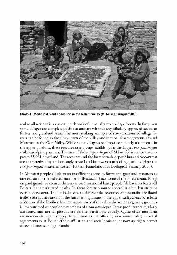
Th e constitution of van panchayats as village-based administrative bodies for the regula-tion of forest use in the year 1931 marks a milestone in the history of natural resource management in Kumaon, following massive protests of local groups against the repres-sive colonial interventions. Th ese decentralized councils are awarded a certain amount of freedom regarding the implementation of local rules for grazing, fuel wood and leaf litter collection in the areas assigned to them. As a matter of fact, these institutions rep-resent one of the oldest surviving examples of formally approved agreements between state authorities and local forest users (Agrawal & Ostrom 2001). Presently, there are around 12,500 of these councils in the entire Kumaon (Agrawal 2005). Although this system of resource control dates back to the time of colonial rule, most van panchayats were established after independence. More recently, the control over medicinal plant collection (photo 4) arises as a further challenge for these institutions.
Th e Uttar Pradesh Zamindari Abolition and Land Reforms Act of 1950, which was drafted with the intention of transferring agricultural land to the actual cultivator, is considered to be one of the far-reaching forms of government intervention in agrarian resource use (Rahul 1968, Government of Uttar Pradesh 1967). As a consequence of this land reform the Bhotiyas have almost completely lost their access to pastures and land in the foothills and the Lesser Himalayas and have therefore been forced to reduce their seasonal migrations (Nautiyal et al. 2003). Th e boundaries of the revenue villages were re-drawn and a new land and forest settlement has been carried out in the 1960s, also aff ecting the van panchayat areas (Government of Uttar Pradesh 1967). While the settlement act was designed to correct the colonial regulations, it was also infl uenced by local power relations. Th e result of this latest settlement, subsequent re-negotiations
116
and re-allocations is a current patchwork of unequally sized village forests. In fact, even some villages are completely left out and are without any offi cially approved access to forests and grassland areas. Th e most striking example of size variations of village fo-rests can be found in the alpine parts of the valley and the spatial arrangements around Munsiari in the Gori Valley. While some villages are almost completely abandoned in the upper portions, these resource user groups exhibit by far the largest van panchayats with vast alpine pastures. Th e area of the van panchayat of Milam for instance encom-passes 35,081 ha of land. Th e areas around the former trade depot Munsiari by contrast are characterized by an intricately nested and interwoven mix of regulations. Here the van panchayats measures just 20–100 ha (Foundation for Ecological Security 2003).
In Munsiari people allude to an insuffi cient access to forest and grassland resources as one reason for the reduced number of livestock. Since some of the forest councils rely on paid guards or control their areas on a rotational base, people fall back on Reserved Forests that are situated nearby. In these forests resource control is often less strict or even non-existent. Th e limited access to the essential resources of mountain livelihood is also seen as one reason for the summer migrations to the upper valley zones by at least a fraction of the families. In these upper parts of the valley the access to grazing grounds is less restricted or people are members of a van panchayat. Forest products are regularly auctioned and not all persons are able to participate equally. Quite often non-farm income decides upon supply. In addition to the offi cially sanctioned rules, informal agreements exist. Beside ethnic affi liation and social position, customary rights permit access to forests and grasslands.
Photo 4 Medicinal plant collection in the Ralam Valley (M. Nüsser, August 2005)

117
Conclusions
In spite of the various factors of transformation, the seasonally and spatially highly diversifi ed ‘combined mountain agriculture’ still plays a vital role for a large number of households in Kumaon. Land use patterns and livelihood strategies shall be diff erenti-ated not only as for environmental issues, but according to such factors as ethnic and socio-cultural affi liation and territorial rights of resource access. A better understanding of the diversity, complexity, and dynamics of regional land use systems requires iden-tifying and evaluating the historical dimension of human-environmental interaction. Changing land use structures and functions refl ect the supra-regional political and so-cioeconomic developments. Land use change, however, has evolved rather slowly and gradually. For instance, with regard to common property regimes and community-based institutions colonial and postcolonial forms of intervention are clearly visible in present day land use patterns and mountain livelihoods.
Th e case of the Bhotiyas demonstrates their fl exible response to changing political, eco-nomical and socio-cultural constellations in the borderlands of Kumaon. Th is includes the tangled relationship between strategies of agrarian subsistence production and non-agricultural employments. After the abandonment of the Trans-Himalayan trade, the upper valley sections have been transformed from transit corridors to new peripheries. Th is functional change has been refl ected in reduced land use intensity accompanied by new income options such as collection and cultivation of medicinal and aromatic plants. Th e administrative and economic centres exhibit a heterogeneous mix of liveli-hoods, institutions and resource use strategies. New forms of income such as mountain tourism or shop-keeping have arisen, accompanied by combined mountain agriculture in the vicinity of the permanent settlements. Th e latest development of trade relations, however, is characterized by the re-opening of the Lipu Lekh Pass in the northeastern corner of Kumaon.
ReferencesAgrawal, A. (2005): Environmentality. Technologies of Government and the Making of
Subjects. Durham.Agrawal, A; E. Ostrom (2001): Collective Action, Property Rights, and Decentralization in
Resource Use in India and Nepal. Politics & Society 29: 485–514.Atkinson, E. T. (1882): Th e Himalayan Gazetteer. Volume Two, Part One. (Originally
published under the title “Th e Himalayan Districts of the North Western Provinces of India”). Reprint 1996, Dehra Dun.
Bergmann, C.; M. Gerwin; M. Nüsser; W. S. Sax (2008): Living in a High Mountain Border Region: Th e Case of the ‘Bhotiyas’ of Uttarakhand, India. Submitted to Journal of Mountain Science.
Bishop, B. (1990): Karnali under Stress: Livelihood Strategies and Seasonal Rhythms in a Changing Nepal Himalaya. Geography Research Paper 228–229, Chicago.
Brown, C. W. (1984): Th e Goat is Mine, the Load is Yours: Morphogenesis of “Bhotiya-Shauka”, U.P., India. Lund Studies in Social Anthropology 1, Lund.
Ehlers, E.; H. Kreutzmann (2000): High Mountain Ecology and Economy: Potential and Constraints. In: Ehlers, E.; H. Kreutzmann (eds.): High Mountain Pastoralism in Northern Pakistan. Erdkundliches Wissen 132, Stuttgart, 9–36.

118
Forest Department (1905): Petition Received from Certain Bhotias Complaining of the Insuffi ciency of Grazing near Ramnagar, dated 25th April 1905. File 61/1903 – 1907, Commissioner Offi ce Records, Box 147. Regional Archives, Naini Tal.
Foundation for Ecological Security (2003): A Biodiversity Log and Strategy Input Document for the Gori Valley. Munsiari.
Fürer-Haimendorf, C. von (1975): Himalayan Traders: Life in Highland Nepal. London.Gill, B. G. (2000): India’s Trade with Tibet: Early British Attempts. Th e Tibet Journal
25: 78–82.Government of India (2003): Census of India 2001. District Pithoragarh, Uttaranchal. Offi ce
of the Registrar General and Census Commissioner. New Delhi. Government of Uttar Pradesh (1967): Uttar Pradesh Gazetter – Pithoragarh District.
Pithoragarh.Government of Uttaranchal (2003): Livestock Survey for the Tehsil Munsiari, 2001. Veterinary
Department of the District Pithoragarh. Pithoragarh (unpublished).Hoon, V. (1996): Living on the Move: Bhotiyas of the Kumaon Himalaya. New Delhi.Joshi, M. P.; C. W. Brown (1987): Some Dynamics of Indo-Tibetan Trade through
Uttarakhanda (Kumaon-Garhwal), India. Journal of the Economic and Social History of the Orient 30: 303–317.
KBPF (1947): Th e Report of the Kumaon Bhotiya Peoples’ Federation. Submitted Before the Minority Sub-Committee of the Constituent Assembly’s Advisory Committee on 17th April 1947. Kindly handed over by Dr. S. S. Pangtey (Sep. 2006).
Kreutzmann, H. (2004): Pastoral Practices and their Transformation in the North-Western Karakoram. Nomadic Peoples 8: 54–88.
Lamb, A. (1986): British India and Tibet, 1766 – 1910. London.Murray, W. H. (1951): Scottish Himalayan Expedition, 1950. London.Nautiyal, S.; Rao, K. S.; Maikhuri, R. K.; K. G. Saxena (2003): Transhumant Pastoralism
in the Nanda Devi Biosphere Reserve, India. A Case Study in the Buff er Zone. Mountain Research and Development 23: 255–262.
Nüsser, M. (1998): Nanga Parbat (NW-Himalaya): Naturräumliche Ressourcenausstattung und humanökologisches Gefügemuster der Landnutzung. Bonner Geographische Abhandlungen 97, Bonn.
Nüsser, M. (2006): Ressourcennutzung und nachhaltige Entwicklung im Kumaon-Himalaya (Indien). Geographische Rundschau 58: 14–22.
Pant, S. D. (1935): Th e Social Economy of the Himalayans. Based on a Survey in the Kumaon Himalayas. London.
Political Department (1895): Correspondence of J. V. Stuart, Esq., Deputy Commissionar Kumaon of Almora to Commissioner, Kumaon Division, dated 31th January 1895 (Proceedings for April 1895 Nos. 27–33 & 36). File 24/1896 – 1897, Commissioner Offi ce Records, Box 50. Regional Archives, Naini Tal.
Rahul, R. (1968): Th e Development Program in the Himalaya. Asian Survey 8: 666–677.Ramakrishnan, P. S. (2003): Th e Sacred Ganga River-based Cultural Landscape. Museum
International 55: 7–17.Rangan, H. (2004): Form Chipko to Uttaranchal: Th e Environment of Protest and
Development in the Indian Himalaya. In: Peet, R.; M. Watts (eds.): Liberation Ecologies: Environment, Development and Social Movements (second edition). London, 371–393.
119
Rawat, D. S.; S. Sharma (1997): Th e Development of a Road Network and Its Impact on the Growth of Infrastructure: A Study of Almora District in the Central Himalaya. Mountain Research and Development 17: 117–126.
Rizvi, J. (1999): Trans-Himalayan Caravans. Merchant Princes and Peasant Traders in Ladakh. New Delhi.
Saklani, D. P. (1998): Ancient Communities of the Himalaya. New Delhi.Sherring, C. A. (1906): Western Tibet and the British Borderland. Th e Sacred Country of
Hindus and Buddhists. With an Account of the Government, Religion and Customs of its Peoples. London.
Spengen, W. van (2000): Tibetan Border Worlds. A Geohistorical Analysis of Trade and Traders. London.
Srivastava, R. P. (1966): Tribe-Caste Mobility in India and the Case of Kumaon Bhotias. In: Fürer-Haimendorf, C. von (ed.): Caste and Kin in Nepal, India and Ceylon. Anthropological Studies in Hindu-Buddhist Contact Zones. New York, 161–212.
Stevens, S. F. (1993): Claiming the High Ground. Sherpas, Subsistence, and Environmental Change in the Highest Himalaya. Berkeley, USA.
Traill, G. W. (1832): Statistical Report on the Bhotiya Mehals of Kumaon. Reprinted in: Joshi, M. P.; A. C Fanger; C. W. Brown (eds.) [1991 – 1992]: Himalaya: Past and Present, Vol. II. Almora, 99–154.
Uhlig, H., edited by H. Kreutzmann (1995): Persistence and Change in High Mountain Agricultural Systems. Mountain Research and Development 15: 199–212.
Walton, H. G. (1910): British Garhwal. A Gazetteer, Volume XXXVI of the District Gazetteers of the United Provinces of Agra and Oudh. Reprint 1989, Dehra Dun.