division ii: zoning and overlay districts development/planning... · division ii: zoning and...
TRANSCRIPT

Division II: Zoning and Overlay Districts
Chapter 11.04 Zones and Districts ................................................................. II-1
11.04.010 Placetypes and General Plan Land Use Designations ................................... II-1
11.04.020 Zoning Districts .................................................................................................. II-2
11.04.030 Official Zoning Map and District Boundaries ............................................... II-4
11.04.040 Zoning Boundary Interpretations .................................................................... II-4
Chapter 11.05 Agricultural Districts............................................................... II-6
11.05.010 Purpose ................................................................................................................. II-6
11.05.020 Land Use Regulations ......................................................................................... II-7
11.05.030 Development Regulations ............................................................................... II-11
Chapter 11.06 Rural Community Districts ................................................... II-13
11.06.010 Purpose ............................................................................................................... II-13
11.06.020 Land Use Regulations ....................................................................................... II-13
11.06.030 Development Regulations ............................................................................... II-18
Chapter 11.07 Residential Districts .............................................................. II-20
11.07.010 Purpose ............................................................................................................... II-20
11.07.020 Land Use Regulations ....................................................................................... II-21
11.07.030 Development Regulations ............................................................................... II-22
11.07.040 Supplemental Regulations ................................................................................ II-25
Chapter 11.08 Commercial and Mixed-Use Districts .................................. II-30
11.08.010 Purpose ............................................................................................................... II-30
11.08.020 Land Use Regulations ....................................................................................... II-32
11.08.030 Development Regulations ............................................................................... II-35
11.08.040 Supplemental Regulations ................................................................................ II-40
Chapter 11.09 Industrial Districts ................................................................ II-43
11.09.010 Purpose ............................................................................................................... II-43
11.09.020 Land Use Regulations ....................................................................................... II-44
11.09.030 Development Regulations ............................................................................... II-47
Chapter 11.10 Special Purpose Districts ...................................................... II-50
11.10.010 Purpose ............................................................................................................... II-50
11.10.020 Land Use Regulations ....................................................................................... II-51
11.10.030 Development Regulations ............................................................................... II-52
11.10.040 Supplemental Regulations ................................................................................ II-54
Chapter 11.11 Natural Resource Districts ................................................... II-55
11.11.010 Purpose ............................................................................................................... II-55
11.11.020 Land Use Regulations ....................................................................................... II-56

Yuba County Development Code
II-ii
11.11.030 Development Regulations ............................................................................... II-58
11.11.040 Supplemental Regulations ................................................................................ II-59
Chapter 11.12 Planned Development ........................................................... II-61
11.12.010 Purpose ............................................................................................................... II-61
11.12.020 Applicability ....................................................................................................... II-61
11.12.030 Zoning Map Designation ................................................................................. II-61
11.12.040 Land Use Regulations ....................................................................................... II-61
11.12.050 Development Regulations ............................................................................... II-62
11.12.060 Procedures .......................................................................................................... II-62
11.12.070 Required Findings ............................................................................................. II-63
11.12.080 Conditions .......................................................................................................... II-64
11.12.090 Expiration and Renewal ................................................................................... II-64
11.12.100 Amendments of Approved Plans ................................................................... II-65
11.12.110 Status of Specific Plan ...................................................................................... II-66
11.12.120 Development Plan Review .............................................................................. II-66
Chapter 11.13 Airport Environs (AP) Overlay District ................................ II-67
11.13.010 Applicability ....................................................................................................... II-67
11.13.020 Purpose ............................................................................................................... II-67
11.13.030 Use Restrictions................................................................................................. II-68
11.13.040 Allowed Land Use ............................................................................................ II-68
11.13.050 Development Standards ................................................................................... II-68
11.13.060 Interior Noise Level Reduction ...................................................................... II-68
11.13.070 Height Limitations ............................................................................................ II-69
11.13.080 FAA Notification .............................................................................................. II-69
11.13.090 Avigation Easement Dedication ..................................................................... II-69
11.13.100 Overflight Notification .................................................................................... II-69
11.13.110 Non-conforming Uses ..................................................................................... II-70
Chapter 11.14 Floodplain (FP) Overlay District .......................................... II-71
11.14.010 Purpose ............................................................................................................... II-71
11.14.020 Applicability ....................................................................................................... II-71
11.14.030 Development in the FP Overlay District ...................................................... II-72
11.14.040 Development in Urban / Urbanizing Areas ................................................. II-72
Chapter 11.15 National Pollution Discharge Elimination System (NPDES)
Overlay District ..................................................................... II-73
11.15.010 Purpose ............................................................................................................... II-73
11.15.020 Applicability ....................................................................................................... II-73
11.15.030 Development in the NPDES Overlay District ............................................ II-73
Chapter 11.16 Planning Reserve (PR) Overlay District…………………..…………II-74 11.16.010 Purpose ............................................................................................................... II-74

Division II: Zoning and Overlay Districts
II-iii
11.16.020 Applicability ....................................................................................................... II-74
11.16.030 Plan Required..................................................................................................... II-74
11.16.040 Additional Required Findings for Approval ................................................. II-75
Chapter 11.17 Reserved ................................................................................ II-75
Chapter 11.18 Reserved ................................................................................ II-75

Yuba County Development Code
II-iv
This page left intentionally blank.

Division II: Zoning and Overlay Districts
II-1
Chapter 11.04 Zones and Districts
Sections:
11.04.010 Placetypes and General Plan Land Use Designations
11.04.020 Zoning Districts
11.04.030 Official Zoning Map and District Boundaries
11.04.040 Zoning Boundary Interpretations
11.04.010 Placetypes and General Plan Land Use Designations
The General Plan provides broad land use and design guidance through the designation of Land Use
Designations and Placetypes. General Plan policies on Placetypes relate to the form and placement of
buildings and the public realm, and guide planning, zoning, and development efforts. The General Plan
establishes the following Placetypes:
A. Rural Center. The General Plan provides for Rural Centers throughout the foothill and mountain
portions of the County. Land use, design, and location of Rural Centers would be the subject of new
or revised Rural Community Plans. The County’s intent for Rural Centers is to provide a variety of
activities and services needed or anticipated to be needed by the local population. The Rural Center
Placetype is located within the Rural Community General Plan Land Use Designation.
B. Neighborhood Center. The intent is to develop and redevelop neighborhoods in a way that allows
most residents to be within walking or bicycling distance of daily destinations (school, shops, parks,
etc.). To meet this goal, the County intends for higher-activity land uses, such as schools, parks, retail
and commercial services, offices, civic uses, and apartments to be clustered together in an area
serving the surrounding existing or planned neighborhood. Neighborhoods developed within the
Valley Growth Boundary will focus higher-density residences and destination land uses in
Neighborhood Centers. Neighborhood Centers will be developed in both infill and new growth
neighborhoods. The Neighborhood Center Placetype is located within the Valley Neighborhood
General Plan Land Use Designation.
C. Commercial Center. In the vicinity of the areas where a Commercial Center is identified, important
design features include bicycle lanes or pathways, sidewalks, and transit access, in addition to
vehicular access. The location of parking is important, in order to ensure multi-modal access, as is a
highly connected transportation network with shorter block lengths. The Commercial Center
Placetype is primarily located within the Commercial Mixed-use General Plan Land Use Designation.
D. Mixed-Use Corridor. There is a mix of residential, commercial, and civic uses along North Beale
Road, McGowan Parkway, Lindhurst Avenue, and Olivehurst Avenue where the County envisions
additional infrastructure improvements to encourage new development and redevelopment. The
County’s intent is to coordinate with transit providers, school districts, water and wastewater
providers, and other agencies to improve infrastructure capacity and public services in and around
these Mixed-Use Corridors, with a focus on providing high-quality bicycle, pedestrian, and transit
facilities. These public investments will be designed to support additional mixed-use development in
and around these corridors. The Mixed-Use Corridor Placetype is located within the Valley
Neighborhood General Plan Land Use Designation.
E. Employment Center. Employment Centers are intended to be located within areas designated
“Employment” on the County’s Land Use Diagram. Employment Village areas would also have one
or more Employment Centers, as well. The precise location and design of Employment Centers

Yuba County Development Code
II-2
depends on follow-on detailed planning and project entitlement review. There will be safe and
convenient bike, pedestrian, and transit access to and from Employment Centers and surrounding
planned development areas, and surrounding communities.
F. The following table identifies the General Plan Land Use Designation and Zoning Districts by
Placetype. These placetypes may also be created as part of a specific plan, community plan, area
plan, planned development or cluster development.
TABLE 11.04.010: GENERAL PLAN LAND USE DESIGNATION AND ZONING DISTRICT BY
PLACETYPE
Placetype
Land Use Designation
Rural Center Neighborhood Center
Commercial Center
Mixed Use Corridor
Employment Center
Rural Community
RR
RC
PF
RE
Valley Neighborhood
RM RM
RH RH
GC GC
NMX CMX
DC NMX
IL IL
PF PF
Commercial Mixed Use
GC
CMX
IC
PF
Employment EC
Employment Village SP SP SP
AI
11.04.020 Zoning Districts
The County shall be classified into districts or zones, the designation and regulation of which are set forth in
this Code and as follows.
A. Base Zoning Districts. Base zoning districts into which the County is divided are established as
shown in Table 11.04.020, Base and Overlay Zoning Districts.
B. Overlay Zoning Districts. Overlay zoning districts, one or more of which may be combined with a
base district, are established as shown in Table 11.04.020, Base and Overlay Zoning Districts.
TABLE 11.04.020: BASE AND OVERLAY ZONING DISTRICTS
Zoning District General Plan Land Use Designation(s) Previous Zoning
Agricultural Districts
AE Exclusive Agricultural Natural Resources AE
AR Agricultural/Rural Residential Natural Resources A/RR
AI Agricultural Industrial Natural Resources, Employment Village, Rural Community
N/A
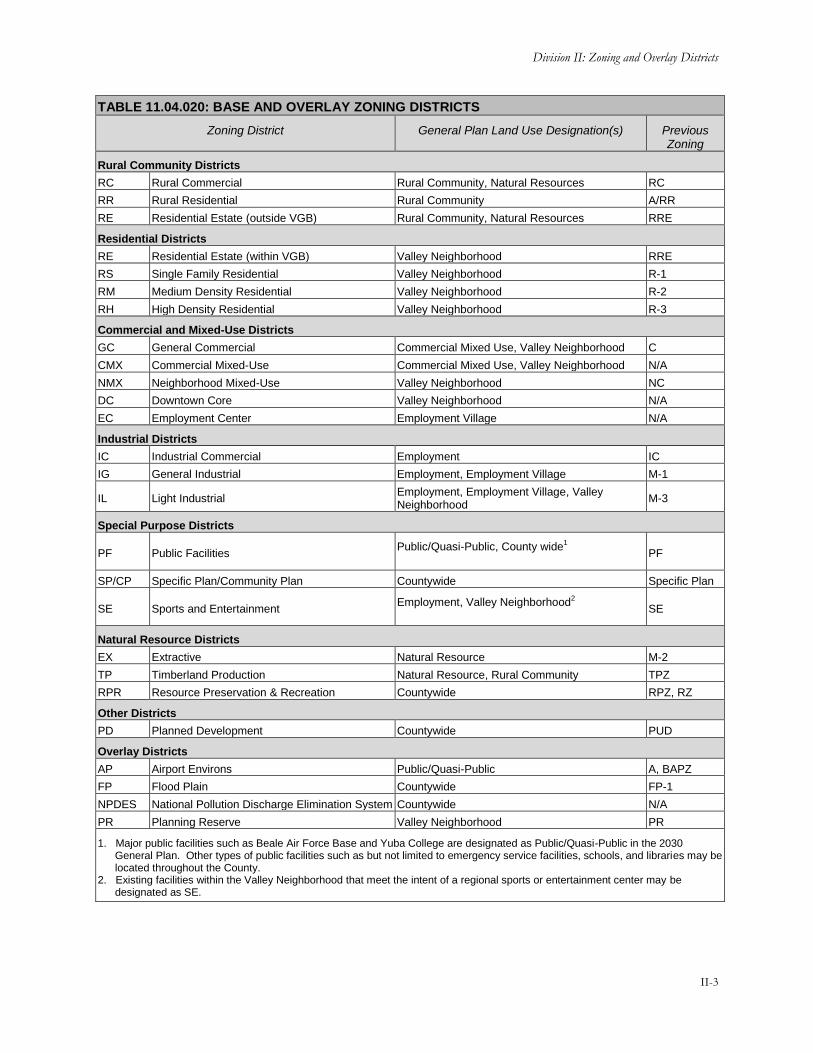
Division II: Zoning and Overlay Districts
II-3
TABLE 11.04.020: BASE AND OVERLAY ZONING DISTRICTS
Zoning District General Plan Land Use Designation(s) Previous Zoning
Rural Community Districts
RC Rural Commercial Rural Community, Natural Resources RC
RR Rural Residential Rural Community A/RR
RE Residential Estate (outside VGB) Rural Community, Natural Resources RRE
Residential Districts
RE Residential Estate (within VGB) Valley Neighborhood RRE
RS Single Family Residential Valley Neighborhood R-1
RM Medium Density Residential Valley Neighborhood R-2
RH High Density Residential Valley Neighborhood R-3
Commercial and Mixed-Use Districts
GC General Commercial Commercial Mixed Use, Valley Neighborhood C
CMX Commercial Mixed-Use Commercial Mixed Use, Valley Neighborhood N/A
NMX Neighborhood Mixed-Use Valley Neighborhood NC
DC Downtown Core Valley Neighborhood N/A
EC Employment Center Employment Village N/A
Industrial Districts
IC Industrial Commercial Employment IC
IG General Industrial Employment, Employment Village M-1
IL Light Industrial Employment, Employment Village, Valley Neighborhood
M-3
Special Purpose Districts
PF Public Facilities Public/Quasi-Public, County wide1
PF
SP/CP Specific Plan/Community Plan Countywide Specific Plan
SE Sports and Entertainment Employment, Valley Neighborhood2
SE
Natural Resource Districts
EX Extractive Natural Resource M-2
TP Timberland Production Natural Resource, Rural Community TPZ
RPR Resource Preservation & Recreation Countywide RPZ, RZ
Other Districts
PD Planned Development Countywide PUD
Overlay Districts
AP Airport Environs Public/Quasi-Public A, BAPZ
FP Flood Plain Countywide FP-1
NPDES National Pollution Discharge Elimination System Countywide N/A
PR Planning Reserve Valley Neighborhood PR
1. Major public facilities such as Beale Air Force Base and Yuba College are designated as Public/Quasi-Public in the 2030 General Plan. Other types of public facilities such as but not limited to emergency service facilities, schools, and libraries may be located throughout the County.
2. Existing facilities within the Valley Neighborhood that meet the intent of a regional sports or entertainment center may be designated as SE.

Yuba County Development Code
II-4
C. References to Classes of Base Districts. Throughout the Ordinance, the following references
apply:
1. “A district” or “Agricultural district” means one or more of the following zoning districts:
AE Exclusive Agricultural, AR Agricultural/Rural Residential, or AI Agricultural Industrial.
2. “Rural Community district” means one or more of the following zoning districts: RC Rural
Commercial, RR Rural Residential, or RE Residential Estate (located outside the Valley
Growth Boundary).
3. “R district” or “Residential district” means one or more of the following zoning districts: RE
Residential Estate (within the Valley Growth Boundary), RS Single Family Residential, RM
Medium Density Residential, or RH High Density Residential.
4. “Non-residential district” means any base zoning district except Residential districts, RR
Rural Residential, and RE Residential Estate (outside Valley Growth Boundary.
5. “MX district” or “Mixed-Use district” means one or more of the following zoning districts:
DC Downtown Core, EC Employment Center, CMX Commercial Mixed-Use or NMX
Neighborhood Mixed-Use.
6. “C district” or “Commercial district” means one or more of the following zoning districts:
GC General Commercial.
7. “I district” or “Industrial district” means one or more of the following zoning districts: IC
Industrial Commercial, IG General Industrial, or IL Light Industrial.
8. “NR district” or “Natural Resource district” means one or more of the following zoning
districts: EX Extractive, TP Timberland Production, or RPR Resource Preservation and
Recreation.
9. “S district” or “Special Purpose district” means one or more of the following zoning
districts: PF Public Facility, SP Specific Plan, CP Community Plan, or SE Sports and
Entertainment.
11.04.030 Official Zoning Map and District Boundaries
The boundaries of the zoning districts established by this Code are not included in this Code but are shown
on the Official Zoning Map maintained by the Planning Director. The Official Zoning Map, together with all
legends, symbols, notations, references, zoning district boundaries, map symbols, and other information on
the maps, have been adopted by the Board of Supervisors and are hereby incorporated into this Code by
reference, together with any amendments previously or hereafter adopted, as though they were fully included
here.
11.04.040 Zoning Boundary Interpretations
If an uncertainty exists as to the boundaries of any district shown on the Official Zoning Map, the following
rules shall apply:
A. Boundaries indicated as approximately following the centerlines of alleys, lanes, streets, highways,
streams or railroads shall be construed to follow such centerlines.

Division II: Zoning and Overlay Districts
II-5
B. Boundaries indicated as approximately following lot lines, county limits, city limits, or extraterritorial
boundary lines shall be construed as following such lines, limits or boundaries.
C. In the case of unsubdivided property or where a district boundary divides a lot and no dimensions
are indicated, the following shall apply.
1. Lots Greater than One Acre. The location of such boundary shall be determined by the
use of the scale appearing on the Official Zoning Map.
2. Lots Less than One Acre. The lot shall be deemed to be included within the zone which is
the more restrictive.
D. In the case of any remaining uncertainty, the Planning Director shall determine the location of
boundaries.
E. Where any public street or alley is officially vacated or abandoned, the regulations applicable to each
parcel of abutting property shall apply to that portion of such street or alley added thereto by virtue
of such vacation or abandonment.
F. Where any private right-of-way or easement of any railroad, railway, transportation or public utility
company is vacated or abandoned and said property is unclassified, said property shall be
automatically classified as being in the Public Facilities District.

Yuba County Development Code
II-6
Chapter 11.05 Agricultural Districts
Sections:
11.05.010 Purpose
11.05.020 Land Use Regulations
11.05.030 Development Regulations
11.05.010 Purpose
The specific purpose of the Agricultural Districts is to support, protect, and maintain a viable, long-term
agricultural sector in Yuba County.
A. Agriculture represents the single most important economic activity and most prevalent land use in
Yuba County. Agriculture directly contributes to the local economy through job development,
production, and exports.
B. Agricultural zoning strives to preserve productive agricultural land and the character and quality of
the rural environment by scaling roads and other public facilities to meet rural needs.
C. Agricultural zoning districts and standards can prevent the fragmentation of farms, prevent land-use
conflicts, and protect agricultural producers from nonfarm intrusion into agricultural areas. Further,
they can provide a mechanism to allow for support services and uses that are necessary and/or
complimentary to the long term sustainability of agricultural operations.
D. Agricultural zoning districts include foothill as well as valley areas of the County that are intended for
intensive and/or extensive agricultural uses such as but not limited to grazing lands, livestock raising,
dairies, orchards, row crops, and other types of commercial agriculture and where it is desirable to
retain agriculture as the primary land use.
E. Exclusive Agricultural (AE). The purpose of the AE district is to:
1. Eliminate the encroachment of land uses that are incompatible with the long term
agricultural use of land.
2. Preserve agricultural land in order to conserve the County's economic resources that are vital
for a healthy agricultural economy within the County.
3. Create standards for the AE district that maintain the vitality of the agricultural sector by
retaining parcel sizes necessary to sustain viable agricultural operations, protecting
agricultural practices and activities by minimizing land-use conflicts, and protecting
agricultural resources by regulating land uses and development intensities in agricultural
areas.
4. Prevent the unnecessary conversion of agricultural land to urban or other uses.
F. Agricultural/Rural Residential (AR). The purpose of the AR district is to:
1. Recognize parcels located within the Natural Resources General Plan designation that have
previously been subdivided into parcels less than 20 acres in size (AR-5 and AR-10) that are

Division II: Zoning and Overlay Districts
II-7
predominantly utilized for very low density rural residential uses and small agricultural
operations.
2. Allows for a 20 acre minimum district (AR-20) in foothill agricultural areas where smaller
parcels already exist or to serve as transition between rural community boundaries and other
natural resource uses.
3. Recognizes that these smaller agricultural parcels are a vital component of the County’s
overall agricultural economy by providing opportunities for specialty crops, boutique
farming, and agritourism.
4. Prevent further encroachment of residential and other incompatible uses into agricultural
and natural resource areas.
5. Serve as a transition between agricultural and natural resource lands and rural residential or
urban development.
G. Agricultural Industrial (AI). This zone district is primarily located within the Natural Resource
areas of the County and Employment Village, but is also an allowed zoning designation within Rural
Community districts consistent with the overall purposes of the AI designation. The purpose of the
AI district is to:
1. Protect, maintain, promote, and enhance agriculture as a viable, long-term economic sector
by accommodating agricultural uses or compatible industrial uses that directly support
agricultural activities within the County.
2. Create standards intended to allow most agricultural uses allowed in the AI district while also
encouraging new compatible support industries and operations, and to protect agricultural
and other neighboring land uses by minimizing conflicts.
H. Residential Estate (RE). The RE district recognizes parcels with the Natural Resources and Rural
Community General Plan designations that have been subdivided into parcels less than five (5) acres
in size. The regulations pertaining to these RE designated properties is located within Chapter 11.06,
Rural Communities as they have the same development requirements as RE designated properties
located within rural communities.
11.05.020 Land Use Regulations
Table 11.05.020 prescribes the land use regulations for Agricultural Districts. The table also notes additional
use regulations that apply to various uses. Section numbers in the right hand column refer to other sections of
this Code.
TABLE 11.05.020: LAND USE REGULATIONS—AGRICULTURAL DISTRICTS
Use Classification AE AR AI Additional Regulations
Residential Use Classifications
Residential Housing Types See subclassifications below
Second Dwelling Unit Z Z - See Section 11.32.240
Single-Unit Dwelling Detached P P A

Yuba County Development Code
II-8
TABLE 11.05.020: LAND USE REGULATIONS—AGRICULTURAL DISTRICTS
Use Classification AE AR AI Additional Regulations
Family Day Care See subclassifications below
Large - A - See Section 11.32.110
Small P P P(1)
Caretaker Residence - - A See Section 11.32.070
Employee Housing A A A See Section 11.32.100
Residential Boarding Facilities M M -
Residential Care & Social
Service Facilities See subclassifications below
General (more than 10 persons) - C -
See Section 11.32.230 General (7-10 persons) - M -
Limited (6 or fewer persons) P P P(1)
Home Occupation P P P See Section 11.32.130
Public & Semi-Public Use Classifications
Cemetery C C -
Colleges/Trade Schools - C C(2)
Community Assembly - C -
Community Garden/Urban Agriculture P P M(5)
Cultural Institutions - C -
Outdoor & Large Scale Cultural Institutions - C -
Day Care Centers - C -
Detention Facility C C C
Elderly/Long-Term Care - C -
Essential/Emergency Service Facilities M M M
Government Offices M M M
Park & Recreation Facilities; Public See subclassifications below
Passive Recreation P P P
Active Recreation M M M
Schools - C -
Commercial Use Classifications
Adult-Oriented Business - - -
Animal Care: Sales and Services See subclassifications below
Pet Sales & Associated Services M M -
Kennels A A - See Section 11.32.040
Veterinary Services - C -
Entertainment & Recreation See subclassifications below
Campground C C - See Section 11.32.060
Hunting/Fishing Club A M -
Incidental Hunting and Fishing P P P
Outdoor Entertainment M(3) C(3) -
Outdoor Sports & Recreation M(3) C(3) -
Temporary Uses & Special Events See Section 11.32.300

Division II: Zoning and Overlay Districts
II-9
TABLE 11.05.020: LAND USE REGULATIONS—AGRICULTURAL DISTRICTS
Use Classification AE AR AI Additional Regulations
Food & Beverage Sales See subclassifications below
Farmers Market See Section 11.32.120
Food Preparation - - A
Lodging See subclassifications below
Agricultural Homestays * * -
See Section 11.32.140 Bed & Breakfast * * -
Health Resort & Retreat Center C C -
Hotels & Motels - C -
Personal Services See subclassifications below
Instructional Services - M -
Retail Sales See subclassifications below
Building Materials & Services - - M See Section 11.32.170
Nurseries & Garden Centers M(4) M(4) M(4)
Vehicle Sales & Services See subclassifications below
Repair: Major - - M(2)
See Section 11.32.050
Service & Repair: Minor - - M(2)
Trucks & Heavy Equipment Sales, Service & Rental - - P
Service Station - - M
Towing & Impound - - M
Washing - - M(2)
Industrial Use Classifications
Construction & Material Yards - - P(2)
Custom Manufacturing - M M(2)
General Industrial - - C
Limited Industrial - - M
Warehousing, Storage & Distribution See subclassifications below
Auction Facilities P(5) - P(5)
Chemical, Mineral & Explosive Storage C - C
Outdoor Storage P(6) P(6) P(6) See Section 11.19.070
Personal Storage - M - See Section 11.32.180
Transportation, Communications & Utilities Use Classifications
Airports & Helicopters C C C
Agricultural Runways & Airport Facilities P P P
Communications Facilities See Section 11.32.290
Freight/Truck Terminals & Warehouses - - C
Major Utilities C C C
Minor Utilities A A P
On-site Biomass Facility Z8
A8
P8

Yuba County Development Code
II-10
TABLE 11.05.020: LAND USE REGULATIONS—AGRICULTURAL DISTRICTS
Use Classification AE AR AI Additional Regulations
Renewable Energy Systems See subclassifications below
Personal Hydro Energy System P P P
Personal Solar Energy System P P P
See Section 11.32.260 Large Solar Generation Facility C C C
Small Solar Generation Facility M M M
Personal Wind Energy System P P P
See Section 11.32.270 Large Wind Generation Facility C C C
Small Wind Generation Facility M M M
Agricultural & Extractive Use Classifications
Agricultural Labor Housing P P P See Section 11.32.030
Agricultural Processing M M P
Animal Raising - Imported Feed P P P See Section 11.32.040
Crop Production P P P
Custom Farm Services P A P
Dairy P M P
Farm Machinery & Equipment, Sales & Service M M P
Feed & Farm Supply Store M M P
Grazing (Animal Raising) P P P
Mining SMP SMP SMP See Section 11.32.280
Agricultural Packing & Storage See subclassifications below
On-site Products P P P
Off-site Products M M P
Produce Stand P P P See Section 11.32.200
Ranch Marketing See Section 11.32.210
Resource Protection & Restoration P(7) P(7) P(7)
Sales Lot, Feed Lot, Stockyard C C C
Slaughterhouse C C C
Wineries & Tasting Rooms See Section 11.32.320
Timber Production & Harvesting P P P
Timber Processing M M P
Specific Limitations: 1. When located within an existing legally permitted single family residence. 2. That are directly related to agricultural uses and processes including maintenance of associated equipment. 3. Recreation and entertainment uses directly related to agricultural and natural resource uses such as but not limited to equestrian
and rodeo facilities. 4. Wholesale nursery operations only. 5. Livestock & Farm Equipment Auctions only. Limited to 2 events per year not to exceed 3 days per event. Additional events
allowed through approval of a TUP. 6. Agricultural vehicles and equipment only and must be associated with on-site agricultural operation or business 7. Copies of any easements or land development restrictions shall be submitted to the Planning Department 8. When it will not impact on-site or adjacent agricultural operations.

Division II: Zoning and Overlay Districts
II-11
TABLE 11.05.020: LAND USE REGULATIONS—AGRICULTURAL DISTRICTS
Key To Permit Requirements
Principally Permitted Use P Conditional Use Permit Required C
Zoning Clearance Required Z Surface Mining Permit Required SMP
Administrative Use Permit Required A See Numbered Footnote For Additional Limitations (#)
Minor Conditional Use Permit Required M As Outlined In Additional Regulations Section *
Use Is Not Allowed -
11.05.030 Development Regulations
Table 11.05.030, Development Regulations—Agricultural Districts, prescribes the development standards for
Agricultural Districts. Additional regulations are denoted in the right hand column. Section numbers in this
column refer to other sections of this Code, while individual letters refer to subsections that directly follow
the table. The numbers in the “#” column refer to the numbers in Figure 11.05.030: Development
Regulations—Agricultural Districts.
FIGURE 11.05.030: DEVELOPMENT REGULATIONS—AGRICULTURAL DISTRICTS
TABLE 11.05.030: DEVELOPMENT REGULATIONS—AGRICULTURAL DISTRICTS
Standard AE AR AI Additional Regulations
#
40 80 5 10 20
Lot and Density Standards
Minimum Lot Area (acres) 40 80 5 10 20 5 (A)
Minimum Lot Width 120 120 120

Yuba County Development Code
II-12
TABLE 11.05.030: DEVELOPMENT REGULATIONS—AGRICULTURAL DISTRICTS
Standard AE AR AI Additional Regulations
#
40 80 5 10 20
Maximum Density 1 unit/ parcel (agricultural labor housing does not count towards density) (B)
No new primary residences allowed. (agricultural labor housing and caretaker units do not count towards density)
Building Form and Location Standards
Maximum Height (ft) 35 for residential structures, 50 otherwise 11.19.050 Height Exceptions
Minimum Setbacks (ft)
Front 30 11.19.090 Setbacks and Yards
Side Lots less than one acre: 25 or 10% of lot width, whichever is less, but not less than 5 Lots one acre or larger: 30
Rear 30
Minimum Separation between Buildings (ft)
6
Parking & Loading 11.25 Parking & Loading
Additional Development Regulations
A. Reduced Lot Area. Reduced lot area is allowed in the Agricultural Districts as follows:
1. Lot area in the AE-40 and AE-80 districts may be reduced by five percent of the required
minimum lot area to allow lot lines to correspond to natural or manmade features if the
Review Authority, based on information from the Agricultural Commissioner finds that the
proposed parcel sizes are of adequate size and design to ensure the long term protection of
agricultural resources.
2. To allow separation of Commercial or Industrial uses (i.e. creation of an agricultural
industrial park) and agricultural homesteads (subject to development deed restrictions parcel
sizes of less than five acres may be created providing the resulting parcels comply with all
other applicable provisions of the Yuba County Ordinance Code.
3. As allowed by Chapter 11.21, Clustered Development.
B. Density. Approved second dwelling units do not count towards the maximum density restrictions.

Division II: Zoning and Overlay Districts
II-13
Chapter 11.06 Rural Community Districts
Sections:
11.07.010 Purpose
11.07.020 Land Use Regulations
11.07.030 Development Regulations
11.06.010 Purpose
The purpose of the Rural Community Districts is to provide rural residential opportunities with supportive
services and agritourism oriented uses consistent with the General Plan and as defined in any adopted rural
community plan.
A. Rural Residential (RR). The purpose of the RR district is to:
1. Allow for the appropriate development of very low density, large-lot single family homes
and related uses in the rural community areas of the County.
2. Create standards to preserve and protect the character of existing rural residential areas and
ensure that future rural residential development is compatible with the surrounding
community and adjacent Natural Resources designated lands.
B. Residential Estate (RE). The purpose of the RE district is to:
1. Recognize parcels located within the Natural Resources and Rural Community General Plan
designations that have previously been subdivided into parcels less than five (5) acres in size
that are predominantly utilized for very low density rural residential uses.
C. Rural Commercial (RC). This zone district is primarily located within rural communities, but is also
an allowed zoning designation in the Natural Resource areas of the County when located along major
roadways consistent with the overall purpose of the Rural Commercial designation. The purpose of
the RC district is to:
1. Provide for the location of commercial uses within a limited and appropriate area of a rural
community.
2. Enhance rural community identity.
3. Create standards that increase rural residents’ access to retail products and services and
reduce the need for residents of remote communities to drive long distances to meet basic
needs.
11.06.020 Land Use Regulations
Table 11.06.020 prescribes the land use regulations for Rural Community Districts.
The table also notes additional use regulations that apply to various uses. Section numbers in the right hand
column refer to other sections of this Code.

Yuba County Development Code
II-14
TABLE 11.06.020: LAND USE REGULATIONS—RURAL COMMUNITY DISTRICTS
Use Classification
RE
Outside VGB RR RC
Additional Regulations
Residential Use Classifications
Residential Housing Types See subclassifications below
Second Dwelling Unit Z Z Z See Section 11.32.240
Single-Unit Dwelling Detached P P Z
Family Day Care See subclassifications below
Large A A A See Section 11.32.110
Small P P P(4)
Caretaker Residence - - A See Section 11.32.070
Employee Housing - A A See Section 11.32.100
Mobile Home Park - C C See Section 11.32.190
Residential Boarding Facilities M M M
Residential Care & Social Service Facilities See subclassifications below
General (more than 10 persons) - C C
See Section 11.32.230 General (7-10 persons) M M M
Limited (6 or fewer persons) P P P
Home Occupation P P P See Section 11.32.130
Public & Semi-Public Use Classifications
Cemetery - C C
Colleges/Trade Schools - C C
Community Assembly C C A
Cultural Institutions C C P
Outdoor & Large Scale Cultural Institutions C C C
Day Care Centers C C P
Elderly/Long-Term Care - C M
Emergency Shelter - - M
Essential/Emergency Service Facilities C M A
Government Offices - M P
Hospitals/Clinics See subclassifications below
Clinic - - P
Hospital - - C
Park & Recreation Facilities; Public See subclassifications below
Passive Recreation P P P
Active Recreation M M M
Parking: Public or Private - - P
Schools C C C
Commercial Use Classifications
Animal Care: Sales and Services See subclassifications below
Grooming - - P

Division II: Zoning and Overlay Districts
II-15
TABLE 11.06.020: LAND USE REGULATIONS—RURAL COMMUNITY DISTRICTS
Use Classification
RE
Outside VGB RR RC
Additional Regulations
Pet Sales & Associated Services - - P
Kennels C M M See Section 11.32.040
Veterinary Services - C A
Banks & Financial Institutions - - P
Bars & Drinking Establishments - - P
Business Services - - P
Drive-In & Drive Thru Facilities (retail establishments) - - Z
Entertainment & Recreation See subclassifications below
Campground - C C See Section 11.32.060
Indoor Entertainment & Recreation - - P
Hunting/Fishing Club - M -
Incidental Hunting and Fishing P P P
Outdoor Entertainment - C(1) C
Outdoor Sports & Recreation - C(1) C
Temporary Uses & Special Events See Section 11.32.300
Food & Beverage Sales See subclassifications below
Farmers Market See Section 11.32.120
General Grocery Market - - P
Liquor Stores - - P
Food Preparation - - P
Funeral Parlors & Internment Services - - A
Lodging See subclassifications below
Agricultural Homestays * * -
See Section 11.32.140 Bed & Breakfast * * *
Health Resort & Retreat Center - C C
Hotels & Motels - - P
Maintenance & Repair Services - - P
Manufactured Home Sales Lots - - M
Neighborhood Services A A P
Professional Services
Business & Professional - - P
Medical & Dental - - P
Personal Services See subclassifications below
General - - P
Instructional Services - - P
Tattoo or Body Modification Parlor - - P
Restaurants See subclassifications below
With Drive Thru - - M See Sections 11.32.080 & 11.32.160 Without Drive-Thru - - P
Retail Sales See subclassifications below

Yuba County Development Code
II-16
TABLE 11.06.020: LAND USE REGULATIONS—RURAL COMMUNITY DISTRICTS
Use Classification
RE
Outside VGB RR RC
Additional Regulations
Building Materials & Services - - P See Section 11.32.170
Convenience Retail - - P
General Retail - - P
Nurseries & Garden Centers - M(2) P
Vehicle Sales & Services See subclassifications below
Rentals, Sales, & Leasing - - P
Repair: Major - - M
See Section 11.32.050
Service & Repair: Minor - - P
Trucks & Heavy Equipment Sales, Service & Rental - - C
Service Station - - P
Towing & Impound - - M
Washing - - P
Industrial Use Classifications
Construction & Material Yards - - M
Custom Manufacturing - - A
Limited Industrial - - C
Recycling Facilities See subclassifications below
Recycling Collection Facility - - P
Recycling Processing Facility - - M
Research & Development - - M
Warehousing, Storage & Distribution See subclassifications below
Chemical, Mineral & Explosive Storage - - C
Outdoor Storage - - C
Personal Storage - C M See Section 11.32.180
Transportation, Communications & Utilities Use Classifications
Communications Facilities See Section 11.32.290
Light Fleet-Based Services - - M
Transportation Passenger Terminals - - C
Major Utilities - C C
Minor Utilities C M M
Renewable Energy Systems See subclassifications below
Personal Hydro Energy System - P P
Personal Solar Energy System P P P See Section 11.32.260
Large Solar Generation Facility - C C
Small Solar Generation Facility M M M
Personal Wind Energy System - P P See Section 11.32.270
Large Wind Generation Facility - C C
Small Wind Energy Generation Facility - M M

Division II: Zoning and Overlay Districts
II-17
TABLE 11.06.020: LAND USE REGULATIONS—RURAL COMMUNITY DISTRICTS
Use Classification
RE
Outside VGB RR RC
Additional Regulations
Agricultural & Extractive Use Classifications
Agricultural Labor Housing - A A See Section 11.32.030
Agricultural Processing - - M
Animal Raising - Imported Feed P P P(5) See Section 11.32.040
Crop Production P P P(5)
Custom Farm Services - A P
Farm Machinery & Equipment, Sales & Service - - P
Feed & Farm Supply Store - M A
Grazing (Animal Raising) P P P
Agricultural Packing & Storage See subclassifications below
On-site Products A A A
Off-site Products - C M
Produce Stand P P P See Section 11.32.200
Ranch Marketing See Section 11.32.210
Resource Protection & Restoration M (3) P(3) P(3)
Sales Lot, Feed Lot, Stockyard C - C
Slaughterhouse - - C
Wineries & Tasting Rooms See Section 11.32.320
Timber Production & Harvesting - P -
Specific Limitations: 1. Uses that are typically associated with rural communities such as but not limited to equestrian facilities and shooting/archery ranges
as determined by the Zoning Administrator. 2. Wholesale nursery operations only. 3. Copies of any easements or land development restrictions shall be submitted to the Planning Department. 4. When located within an existing legally permitted single family residence. 5. Permitted on parcels that are at least five acres in size unless a Waiver is approved.
Key To Permit Requirements
Principally Permitted Use P Conditional Use Permit Required C
Zoning Clearance Required Z Surface Mining Permit Required SMP
Administrative Use Permit Required A See Numbered Footnote For Additional Limitations (#)
Minor Conditional Use Permit Required M As Outlined In Additional Regulations Section *
Use Is Not Allowed -

Yuba County Development Code
II-18
11.06.030 Development Regulations
Table 11.06.030, Development Regulations—Rural Community Districts, prescribes the development
standards for Rural Community Districts. Additional regulations are denoted in the right hand column.
Section numbers in this column refer to other sections of this Code. The numbers in the “#” column refer to
the numbers in Figure 11.06.030: Development Regulations—Rural Community Districts.
FIGURE 11.06.030: DEVELOPMENT REGULATIONS—RURAL COMMUNITY DISTRICTS
TABLE 11.06.030: DEVELOPMENT REGULATIONS—RURAL COMMUNITY DISTRICTS
Standard RE RR RC Additional Regulations
#
Outside VGB 5 10
Lot and Density Standards
Minimum Lot Area (acres) 1(A) 5 10 0.46 (20,000 s.f.) (B)
Minimum Lot Width (ft) 120 (C) 120 (C) 120(C) 100
Maximum Density 1 unit/ parcel (D)
Maximum Floor Area Ratio (FAR)
N/A 0.5
Building Form and Location Standards
Maximum Height (ft)
Primary Structure 35 35 11.19.050 Height Exceptions
Accessory Structure 35 35
Minimum Setbacks (ft, measured from property line unless otherwise indicated)
Front or Street Side 30 15 (E) 11.19.090

Division II: Zoning and Overlay Districts
II-19
TABLE 11.06.030: DEVELOPMENT REGULATIONS—RURAL COMMUNITY DISTRICTS
Standard RE RR RC Additional Regulations
#
Outside VGB 5 10
Interior Side Lots less than 1 acre: 10 (E)
Lots 1 acre or larger: 20 (E)
5 (E) Setbacks and Yards
Rear Primary Structure 25 (E) 30 (E) 20 (E)
Rear Accessory Structure 20 (E) 25 (E) 20 (E)
Minimum Separation between Buildings (ft)
6
Maximum Lot Coverage Less than 1 acre: 40% Greater than 1 acre: 25%
15% N/A
Parking & Loading 11.25 Parking & Loading
Additional Regulations
A. No Further Subdivision. Parcels in the RE District within the Natural Resource land use
designation of the General Plan cannot be further subdivided. Parcels in the RE district located
within Rural Community Boundaries may be further subdivided consistent with the County’s sewage
disposal and water supply requirements. No parcels less than 1 acre in size shall be created and
average parcel size shall be consistent with other RE parcels within the Rural Community.
B. Sewage Disposal and Water Supply. Parcels between one acre and 2.5 acres in size shall provide
either a public sewer service or water supply as determined by the Environmental Health Director.
Setback requirements equivalent to those that would be required on a five acre parcel shall apply to
any parcel between one acre and 2.5 acres in size that has either a well or septic system. Parcels
smaller than one acre in size shall provide both a public sewer service and public water supply.
C. Lot Width. The lot width at the primary street frontage for cul-de-sac and knuckles may be reduced
to no less than 35 feet provided the minimum lot width for the zone district is met at the front yard
setback line. Flag lots shall also meet the minimum lot width at the front yard setback line.
D. Density. Additional regulations pertaining to the maximum density allowed by zone district are as
follows:
1. Second Dwelling Units. Where second dwelling units are permitted they do not count
towards the maximum density restrictions of the zone district.
2. Rural Commercial. A residential unit may be allowed on the second story of a commercial
building or on the back portion of the lot. The residential unit shall be ancillary to the
primary rural commercial use of the parcel.
E. Increased Setbacks in High Fire Severity Zone. Parcels located within a high fire severity zone
shall have a minimum setback of 30 feet from all property lines. Upon written clearance from the
Fire District the setback may be reduced to the zone district standard.

Yuba County Development Code
II-20
Chapter 11.07 Residential Districts
Sections:
11.07.010 Purpose
11.07.020 Land Use Regulations
11.07.030 Development Regulations
11.07.040 Supplemental Regulations
11.07.010 Purpose
The purpose of the Residential Districts is to promote healthful and convenient distribution of the County’s
population with sufficient densities to maintain a high standard of physical design and community service.
A. To provide for a variety of dwelling types and densities and to offer housing choices at various
economic levels. The intent is to further establish various densities of residential developments in
order to efficiently and effectively provide for necessary public services and facilities.
B. To provide appropriate space for those educational, religious, recreational, health, and similar
facilities that serve the needs of the nearby residents and do not create objectionable impacts.
C. To promote stability of residential development so as to protect the character of a district and the
suitability of particular uses; to conserve the values of land and buildings; and to protect the County's
tax revenues.
D. To provide for state authorized family care homes, foster homes, group homes, and
transitional/supportive housing as a residential use of property.
E. Residential Estate (RE). The purpose of the RE district is to:
1. Allow for larger lots within valley neighborhoods that would be conducive to the
development of custom and semi-custom homes.
2. Create standards that may allow limited numbers of horses and other livestock to be kept for
noncommercial purposes.
F. Single Family Residential (RS). The purpose of the RS district is to:
1. Allow for a mixture of housing types in a low density setting where public water and sewage
facilities are available. The predominant housing type consisting of single-unit dwellings.
2. Provide space for community facilities and neighborhood services needed to complement
residential areas and for institutions which require a residential environment.
G. Medium Density Residential (RM). The purpose of the RM district is to:
1. Allow for a diversity of housing types in a medium density setting where public water and
sewage facilities are available.
2. Provide space for community facilities and neighborhood services needed to complement
residential areas and for institutions which require a residential environment.
Division II: Zoning and Overlay Districts
II-21
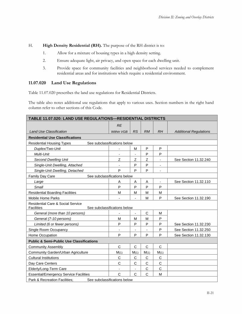
H. High Density Residential (RH). The purpose of the RH district is to:
1. Allow for a mixture of housing types in a high density setting.
2. Ensure adequate light, air privacy, and open space for each dwelling unit.
3. Provide space for community facilities and neighborhood services needed to complement
residential areas and for institutions which require a residential environment.
11.07.020 Land Use Regulations
Table 11.07.020 prescribes the land use regulations for Residential Districts.
The table also notes additional use regulations that apply to various uses. Section numbers in the right hand
column refer to other sections of this Code.
TABLE 11.07.020: LAND USE REGULATIONS—RESIDENTIAL DISTRICTS
Land Use Classification
RE
Within VGB RS RM RH Additional Regulations
Residential Use Classifications
Residential Housing Types See subclassifications below
Duplex/Two-Unit - M P P
Multi-Unit - - P P
Second Dwelling Unit Z Z Z - See Section 11.32.240
Single-Unit Dwelling, Attached - P P -
Single-Unit Dwelling, Detached P P P -
Family Day Care See subclassifications below
Large A A A - See Section 11.32.110
Small P P P P
Residential Boarding Facilities M M M M
Mobile Home Parks - - M P See Section 11.32.190
Residential Care & Social Service Facilities See subclassifications below
General (more than 10 persons) - - C M
See Section 11.32.230
General (7-10 persons) M M M P
Limited (6 or fewer persons) P P P P
Single Room Occupancy - - - P See Section 11.32.250
Home Occupation P P P P See Section 11.32.130
Public & Semi-Public Use Classifications
Community Assembly C C C C
Community Garden/Urban Agriculture M(1) M(1) M(1) M(1)
Cultural Institutions C C C C
Day Care Centers C C C C
Elderly/Long-Term Care - - C C
Essential/Emergency Service Facilities C C C M
Park & Recreation Facilities; See subclassifications below

Yuba County Development Code
II-22
TABLE 11.07.020: LAND USE REGULATIONS—RESIDENTIAL DISTRICTS
Land Use Classification
RE
Within VGB RS RM RH Additional Regulations
Public
Passive Recreation P P P P
Active Recreation M M M M
Schools C C C C
Commercial Use Classifications
Animal Care: Sales and Services See subclassifications below
Kennels C - - - See Section 11.32.040
Entertainment & Recreation See subclassifications below
Temporary Uses & Special Events See Section 11.32.300
Food & Beverage Sales See subclassification below
Farmers Market See Section 11.32.120
Lodging See subclassifications below
Bed & Breakfast * - - See Section 11.32.140
Neighborhood Services A A A A
Industrial Use Classifications
Warehousing, Storage & Distribution See subclassification below
Personal Storage C C C - See Section 11.32.180
Transportation, Communications & Utilities Use Classifications
Communications Facilities See Section 11.32.290
Minor Utilities C C C C
Renewable Energy Systems See subclassifications below
Personal Solar Energy System P P P P See Section 11.32.260
Agricultural & Extractive Use Classifications
Animal Raising - Imported Feed * See Section 11.32.040
Resource Protection & Restoration M M M M
Specific limitations: 1. Community Gardens/Urban Agriculture: as an interim land use on vacant property.
Key To Permit Requirements
Principally Permitted Use P Conditional Use Permit Required C
Zoning Clearance Required Z Surface Mining Permit Required SMP
Administrative Use Permit Required A See Numbered Footnote For Additional Limitations (#)
Minor Conditional Use Permit Required M As Outlined In Additional Regulations Section *
Use Is Not Allowed -
11.07.030 Development Regulations
Table 11.07.030, Development Regulations—Residential Districts, prescribes the development standards for
Residential Districts. Additional regulations are denoted in the right hand column. Section numbers in this

Division II: Zoning and Overlay Districts
II-23
column refer to other sections of this Code. The numbers in the “#” column refer to the numbers in Figure
11.07.030: Development Regulations—Residential Districts.
FIGURE 11.07.030: DEVELOPMENT REGULATIONS—RESIDENTIAL DISTRICTS
TABLE 11.07.030: DEVELOPMENT REGULATIONS—RESIDENTIAL DISTRICTS
Standard RE
Within VGB
RS RM RH Additional Regulations #
Lot and Density Standards
Minimum Lot Area (square feet) 21,000 6,000 6,000 10,000 11.07.040(C), Reduced Minimum Lot Size and Width
Minimum Lot Width (ft) 80(A) 60(A) 60(A) 100(A)
Density (units/acre)
Minimum 0.5(E) 3 6 15 11.07.030(B) and (E)
Maximum 2 8 17 30
Building Form and Location Standards
Maximum Height (ft)
Primary Structure 35 30 35 50(C) 11.19.050 Height

Yuba County Development Code
II-24
TABLE 11.07.030: DEVELOPMENT REGULATIONS—RESIDENTIAL DISTRICTS
Standard RE
Within VGB
RS RM RH Additional Regulations #
Accessory Structure 20 15 15 15 Exceptions
11.19.030, Accessory Structures
Minimum Setbacks (ft, measured from property line unless otherwise indicated)
Front or Street Side
Detached sidewalk: 10 ft from edge of sidewalk Attached sidewalk: 15 ft from edge of sidewalk No sidewalk: 15 ft from edge of ultimate right of way and 10 feet from edge of drainage ditch if present
11.19.090 Setbacks and Yards
Interior Side 10 5 (D) 5 (D) 5 (D)
Rear, Primary Structure 25 20 15 15
Rear, Accessory Structure 10 5 5 5 11.19.030, Accessory Structures
Garage A minimum 20 ft driveway apron shall be provided for front loaded garages
11.07.040(A), Residential Single Family Development
Parking, from street facing property line
n/a n/a 40 40 11.07.040(B), Residential Multi-Family Development
Parking & Loading 11.25 Parking & Loading
Minimum Distance Between Buildings (ft)
6 6 6 6
Additional Regulations
A. Lot Width. The lot width at the primary street frontage for cul-de-sac, knuckles, and irregular
shaped lots may be reduced to no less than 35 feet provided the minimum lot width for the zone
district is met at the front yard setback line. Flag lots shall also meet the minimum lot width at the
front yard setback line.
B. Second Dwelling Units. Where second dwelling units are permitted they do not count towards the
maximum density restrictions of the zone district.
C. Transitional Standards. When an RH District is adjacent to an RS District, the following standards
apply:
1. The maximum height is 30 feet within 40 feet of an RS District; and
2. The maximum height is 40 feet within 50 feet of an RS District.

Division II: Zoning and Overlay Districts
II-25
FIGURE 11.07.030(C): TRANSITIONAL STANDARDS—RESIDENTIAL DISTRICTS
D. Interior Side Yards, Attached Single-Family Dwellings. Required setbacks apply to the ends of
rows of attached single-family dwellings.
E. Additional Density. Within the Residential Estate zoning designation (within Valley Growth
Boundary) density is 0.5 to 2 units per acre. Additional density up to a maximum of 4 units per acre
may be approved with a minor conditional use permit. In addition to the findings for use permits in
Section 11.57.060, the following additional findings shall be made:
1. The increased density will not adversely affect adjoining uses and is compatible with the existing
neighborhood characteristics; and,
2. An adequate buffer is provided between the project site and the edge of the Valley Growth
Boundary.
11.07.040 Supplemental Regulations
A. Residential Single-Family Development. Residential single-family structures within the Valley
Growth Boundary shall be developed in accordance with the following standards.
1. Garage Frontage and Location.
a. Where garage doors face a street, garage width shall not exceed 60 percent of the
width of the front façade of the building.
b. Garages with three or more doors, at least one garage front must be separated from
the remaining garage fronts by at least two feet.

Yuba County Development Code
II-26
FIGURE 11.07.040(A)(1): RESIDENTIAL GARAGE FRONTAGE & LOCATIONS
2. Corner Lots. Dwellings on corner lots shall include windows on any façade facing a street.
No street-facing wall shall run in a continuous plane of more than 20 feet without a window
or a projection, offset, or recess of the building wall at least one foot in depth.
FIGURE 11.07.040(A)(2): RESIDENTIAL CORNER LOTS
B. Residential Multi-Family Development. Each multiple family residential project with four or
more dwelling units on a single lot shall be developed in accordance with the following standards.
1. Parking Setback. Parking shall be setback 40 feet from the street facing property line
except where a lesser setback is authorized with the approval of a Waiver by the Zoning
Administrator when all of the following findings can be made:

Division II: Zoning and Overlay Districts
II-27
a. The design incorporates habitable space built as close to the street facing property
line to the maximum extent feasible;
b. The parking area is well screened with a wall, hedge, trellis, and/or landscaping; and
c. The site is constrained such that parking located more than 40 feet from the street
frontage is not possible.
2. Building Entrances.
a. Orientation. All units located along public rights-of-way must have the primary
entrance facing this right-of-way. Exceptions to this requirement may be approved
for projects where multiple-family housing is located on four-lane streets carrying
high traffic volumes and/or streets that do not allow on-street parking. In such
cases, the project may be oriented around courtyards.
b. Projection or Recess. Building entrances must have a roofed projection (such as a
porch) or recess with a minimum depth of at least five feet and minimum area of 50
square feet when utilized by more than one unit. Entrances used exclusively by one
unit (i.e. townhouse) may be reduced to 30 square feet. Alternative designs that
create a enhance entry feature facing the street, such as a trellis or landscaped
courtyard entry, may be approved through the Design Review Permit process.
FIGURE 11.07.040(B)(2): MULTI-FAMILY RESIDENTIAL BUILDING ENTRANCES
3. Open Space. Residential open space may be provided as common or private open space.
Private areas typically consist of balconies, decks, patios, fenced yards, and other similar
areas outside the residence. Common areas typically consist of landscaped areas, walks,
patios, swimming pools, barbeque areas, playgrounds, turf, or other such improvements as
are appropriate to enhance the outdoor environment of the development. Landscaped
courtyard entries that are oriented towards the public street which create a welcoming entry
feature are also considered common areas. All areas not improved with buildings, parking,
vehicular access ways, trash enclosures, and similar items shall be developed as common
areas with the types of attributes described above.
a. Amount. A combination of private and common open space shall be provided
equivalent to 200 square feet/unit.

Yuba County Development Code
II-28
b. Minimum Dimensions. Open space shall have the following minimum dimensions in
order to count towards open space requirements:
i. Private Open Space. Private open space located on the ground level (e.g.,
yards, decks, patios) shall have no dimension less than eight feet. Private
open space located above ground level (e.g., balconies) shall have no
dimension less than five feet.
ii. Common Open Space. Minimum dimension of 25 feet.
iii. Required Setbacks and Walkways not Counted. Required front and street
side setback areas and walkways between buildings do not count towards
the minimum residential open space per unit requirements.
c. Usability. A surface shall be provided that allows convenient use for outdoor living
and/or recreation. Such surface shall be a combination of lawn, garden, flagstone,
wood planking, concrete, or other serviceable, dust-free surfacing. Slope shall not
exceed 10 percent.
d. Accessibility.
i. Private Open Space. The space shall be accessible to only one residential
unit by a doorway to a habitable room or hallway.
ii. Common Open Space. The space shall be accessible to all the residential
units on the lot.
C. Reduced Minimum Lot Size and Width. In the RS, RM, and RH districts, smaller lots with a
minimum area of 3,000 square feet, a minimum lot width of 35 feet, and a minimum lot depth of 60
feet may be approved with a Conditional Use Permit when the Planning Commission finds that the
lot size and configuration are consistent with the General Plan, does not exceed the maximum
density per acre of the zone district unless a density bonus is also approved, and will not adversely
affect adjoining uses. Deviations to the regulations in Sections 11.07.030 through 11.07.040(B) may
also be requested as part of the CUP application. In addition, projects that would result in five or
more lots shall provide the following required elements and the specified number of optional
elements.
1. Required Elements.
a. Variety of Lot Widths or Front Setbacks. A variety of lot widths and/or front setbacks
shall be provided to accommodate a variety of home styles, setbacks, and garage
placements. At least 30 percent of the lots shall vary from the "typical" (mode) lot
width in the development by at least 20 percent or shall have varied front setbacks
of at least four feet for every third lot on the same side of a street block.
b. Architectural Diversity. Projects with up to 20 lots shall have a minimum of three
unique elevations. Projects of between 21 and 100 lots shall have a minimum of
four unique elevations. Projects of 100 or more lots shall have a minimum of five
unique elevations.
c. Open Space. A minimum private open space area (including, but not limited to private
yards, porches, balconies, and patios) of 300 square feet shall be provided on each
lot. Projects that provide less than 500 square feet of private open space shall also

Division II: Zoning and Overlay Districts
II-29
provide common open-space areas equal to a total open space area of 500 square
feet per lot/unit that provide usable and accessible open space for the recreation
and/or outdoor enjoyment of the development’s residents and their guests. To
qualify as common open space, the area(s) shall be centrally located, have a
minimum usable width of 35 feet, and if located outdoors shall be at least 50 percent
open to the sky. Community buildings such as but not limited to club houses and
indoor pools may also count towards common open space requirements.
2. Required Findings:
a. The lot size and project density are consistent with the General Plan and do not
exceed the maximum density of the zone district;
b. The lots and associated development would not adversely affect adjoining uses;
c. Additional site and building design elements are in evidence; and
d. The lot size is acceptable considering site topography, public-street access,
availability of utilities, existing neighborhood characteristics, including the average
density of surrounding development.
Yuba County Development Code
II-30
Chapter 11.08 Commercial and Mixed-Use Districts
Sections:
11.08.010 Purpose
11.08.020 Land Use Regulations
11.08.030 Development Regulations
11.08.040 Supplemental Regulations
11.08.010 Purpose
The specific purpose of the Commercial and Mixed-Use Districts are to provide sufficient and convenient
locations throughout the County for a full range of commercial uses, serving the needs of local areas, the
larger community, and regional users and visitors.
A. Strengthen the County's economic base, and provide employment opportunities close to home for
residents of the County and surrounding communities.
B. Create suitable environments for various types of commercial uses and protect them from the
adverse effects of inharmonious uses.
C. Ensure that the appearance and effects of commercial buildings and uses are harmonious with the
character of the area in which they are located.
D. Provide opportunities for appropriate residential development on the site of commercial
development or on separate sites in certain commercial districts.
E. Ensure the provision of adequate off-street parking and loading facilities.
F. Provide sites for public and semi-public uses needed to complement commercial development or be
compatible with a commercial environment.
G. General Commercial (GC). The purpose of the GC district is to:
1. Strengthen the economic base of the County and to protect the County's tax revenues.
2. Allow for full range of commercial uses including businesses not permitted in the CMX or
EC districts because they have certain adverse impacts not conducive of a campus or mixed
use commercial environment due to potential noise generation or outdoor operations.
3. Provide the opportunity for light manufacturing uses that have impacts comparable to those
of permitted retail and service uses to occupy space not in demand for retailing or services.
H. Commercial Mixed Use (CMX). The purpose of the CMX district is to:
1. Allow for a full range of retail, service, and office uses to serve residents, workers and
visitors within convenient locations throughout the County.
2. Allow for a mixture of high density residential and commercial land uses located close to one
another, either within a single building, on the same parcel, or on adjacent parcels.

Division II: Zoning and Overlay Districts
II-31
3. Include development standards to reduce reliance on the automobile within the project and
to create pedestrian-oriented environments.
I. Neighborhood Mixed Use (NMX). The purpose of the NMX district is to:
1. Develop neighborhoods that meet all of the daily needs of the residents in their community.
Through “neighborhood centers,” where each community can find naturally convenient
locations to provide for activities and needs that create focal points for community
interaction.
2. Provide areas for small localized retail, eateries, office, and service businesses serving the
immediate surrounding area.
3. Allow for a mixture of residential uses and neighborhood services on a single parcel.
4. Protect surrounding residential properties against congestion and inappropriate land use by
locating neighborhood centers at or near intersections with at least one well-traveled
roadway.
5. Create standards that reduce the need to drive by providing everyday goods and services
close to where people live and work, and by allowing for centers of neighborhood activity
that support small, locally-owned businesses.
J. Downtown Core (DC). The purpose of the DC district is to:
1. Foster economic investment by encouraging development that is consistent with the desired
goal of a “small-town downtown commercial district” feel by focusing regulatory efforts
more heavily on building design and orientation.
2. Provide development standards that will create an inviting pedestrian environment and
incorporate “park-once” strategies.
3. Focus development on commercial and mixed use projects where residential uses are
predominantly included only as an ancillary use, such as ground floor commercial and upper
floor or rear of lot residential.
4. Locate high density residential projects in appropriate locations.
K. Employment Center (EC). The purpose of the EC district is to:
1. Encourage the attraction of a variety of uses including all office types, highly specialized and
technological industries, research and experimental institutions, support facilities, business
services, and support oriented hotels, retail and multi-family residential uses in a campus
style environment.
2. Develop performance standards to discourage offensive odors, noise, fumes, smoke, gases,
dust, vibrations and other similar objectionable development impacts.
3. Include development standards to reduce reliance on the automobile within the project and
to create pedestrian-oriented environments.
Yuba County Development Code
II-32
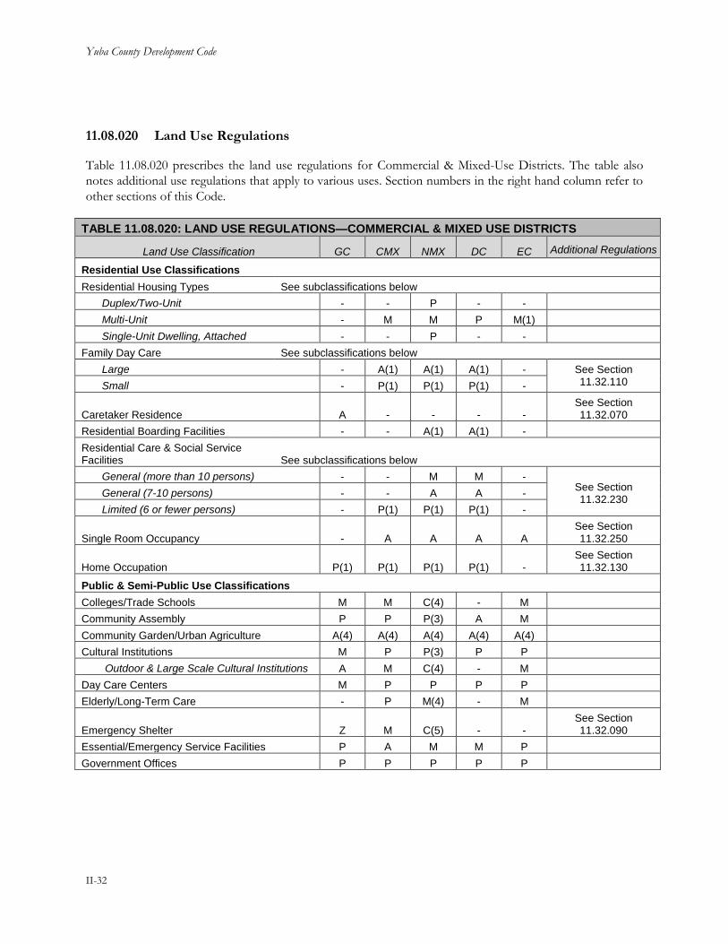
11.08.020 Land Use Regulations
Table 11.08.020 prescribes the land use regulations for Commercial & Mixed-Use Districts. The table also
notes additional use regulations that apply to various uses. Section numbers in the right hand column refer to
other sections of this Code.
TABLE 11.08.020: LAND USE REGULATIONS—COMMERCIAL & MIXED USE DISTRICTS
Land Use Classification GC CMX NMX DC EC Additional Regulations
Residential Use Classifications
Residential Housing Types See subclassifications below
Duplex/Two-Unit - - P - -
Multi-Unit - M M P M(1)
Single-Unit Dwelling, Attached - - P - -
Family Day Care See subclassifications below
Large - A(1) A(1) A(1) - See Section 11.32.110 Small - P(1) P(1) P(1) -
Caretaker Residence A - - - - See Section 11.32.070
Residential Boarding Facilities - - A(1) A(1) -
Residential Care & Social Service Facilities See subclassifications below
General (more than 10 persons) - - M M - See Section 11.32.230
General (7-10 persons) - - A A -
Limited (6 or fewer persons) - P(1) P(1) P(1) -
Single Room Occupancy - A A A A See Section 11.32.250
Home Occupation P(1) P(1) P(1) P(1) - See Section 11.32.130
Public & Semi-Public Use Classifications
Colleges/Trade Schools M M C(4) - M
Community Assembly P P P(3) A M
Community Garden/Urban Agriculture A(4) A(4) A(4) A(4) A(4)
Cultural Institutions M P P(3) P P
Outdoor & Large Scale Cultural Institutions A M C(4) - M
Day Care Centers M P P P P
Elderly/Long-Term Care - P M(4) - M
Emergency Shelter Z M C(5) - - See Section 11.32.090
Essential/Emergency Service Facilities P A M M P
Government Offices P P P P P

Division II: Zoning and Overlay Districts
II-33
TABLE 11.08.020: LAND USE REGULATIONS—COMMERCIAL & MIXED USE DISTRICTS
Land Use Classification GC CMX NMX DC EC Additional Regulations
Hospitals/Clinics See subclassifications below
Clinic P P A(3) P P
Hospital C C - - C
Park & Recreation Facilities; Public See subclassifications below
Passive Recreation P P P P P
Active Recreation M M M M M
Parking: Public or Private Z Z Z(3) A Z
Schools - M C - M
Commercial Use Classifications
Animal Care: Sales and Services See subclassifications below
Grooming P P P P P
Pet Sales & Associated Services P P P(3) A P
Kennels C - - - - See Section 11.32.040
Veterinary Services P(2) M P(2,4) - M
Banks & Financial Institutions P P P P P
Bars & Drinking Establishments P P A(3) A P
Business Services P P P P P
Drive-In & Drive Thru Facilities (retail establishment) Z Z Z(3) - Z
See Section 11.32.080
Entertainment & Recreation See subclassifications below
Indoor Entertainment & Recreation P P P(4) M P
Outdoor Entertainment - - - - C
Outdoor Sports & Recreation - - - - C
Temporary Uses & Special Events See Section 11.32.300
Food & Beverage Sales See subclassifications below
Farmers Market Z Z A A Z See Section 11.32.120
General Grocery Market P P P P P
Liquor Stores P P P(3) P P
Food Preparation P P P(3) M P
Funeral Parlors & Internment Services P A - - -
Lodging See subclassifications below
Bed & Breakfast - - P(1) P(1) - See Section 11.32.140
Health Resort & Retreat Center P P P(4) A P
Hotels & Motels P P M(4) A P
Maintenance & Repair Services P P P(3) P P
Manufactured Home Sales Lots M - - - -
Neighborhood Services P P P P P

Yuba County Development Code
II-34
TABLE 11.08.020: LAND USE REGULATIONS—COMMERCIAL & MIXED USE DISTRICTS
Land Use Classification GC CMX NMX DC EC Additional Regulations
Professional Services See subclassifications below
Business & Professional P P P P P
Medical & Dental P P P P P
Personal Services See subclassifications below
General P P P P P
Instructional Services P P P(3) P P
Tattoo or Body Modification Parlor P P P(4) P P
Restaurants See subclassifications below
With Drive-Thru P P P(4) - P See Section 11.32.080 & 11.32.160 Without Drive-Thru P P P(4) P P
Retail Sales See subclassifications below
Building Materials & Services P P P(4) - -
See Section 11.32.170
Convenience Retail P P P P P
General Retail P P P P P
Large Format Retail M M - - M
Nurseries & Garden Centers P P P(4) - -
Vehicle Sales & Services See subclassifications below
Rentals, Sales & Leasing P M C(4) - -
See Section 11.32.050
Repair: Major A - - - -
Service & Repair: Minor P M C(4) - -
Trucks & Heavy Equipment Sales, Service & Rental C - - - -
Service Station P P P(4) - P
Towing & Impound M C - - -
Washing P P A(4) - A
Industrial Use Classifications
Construction & Material Yards C - - - -
Custom Manufacturing P M C(4) - C
Limited Industrial P - - - C
Recycling Facilities See subclassifications below
Recycling Collection Facility Z A A - Z See Section 11.32.220 Recycling Processing Facility M - - - -
Research & Development M - - - P

Division II: Zoning and Overlay Districts
II-35
TABLE 11.08.020: LAND USE REGULATIONS—COMMERCIAL & MIXED USE DISTRICTS
Land Use Classification GC CMX NMX DC EC Additional Regulations
Warehousing, Storage & Distribution See subclassifications below
Auction Facilities C - - - -
Indoor Warehousing, Wholesaling & Distribution C - - - -
Outdoor Storage M - - - - See Section
11.19.070
Personal Storage P C C - - See Section 11.32.180
Transportation, Communications & Utilities Use Classifications
Communications Facilities See Section 11.32.290
Light Fleet-Based Services P M - - -
Transportation Passenger Terminals P M - - -
Major Utilities C C - - -
Minor Utilities M M C - M
Renewable Energy Systems See subclassifications below
Personal Solar Energy System P P P P P See Section 11.32.260
Large Solar Generation Facility C - - - C
Small Solar Generation Facility M M M M M
Agricultural & Extractive Use Classifications
Resource Protection & Restoration P(5) P(5) P(5) P(5) P(5)
Specific Limitations: 1. When located within an existing legally permitted residence. 2. Permitted when conducted entirely within a building. Outdoor kennels and dog runs requires approval of a Minor Conditional Use
Permit. 3. NMX properties located outside of a mixed-use corridor as identified in the General Plan or that do not front on an urban arterial or
collector road requires approval of a Minor Conditional Use Permit. 4. Only allowed within mixed-use corridors identified in the General Plan or properties that front on an urban arterial or collector road. 5. Copies of any easements or land development restrictions shall be submitted to the Planning Department. 6. Community Gardens/Urban Agriculture: as an interim land use on vacant property.
Key To Permit Requirements
Principally Permitted Use P Conditional Use Permit Required C
Zoning Clearance Required Z Surface Mining Permit Required SMP
Administrative Use Permit Required A See Numbered Footnote For Additional Limitations (#)
Minor Conditional Use Permit Required M As Outlined In Additional Regulations Section *
Use Is Not Allowed -
11.08.030 Development Regulations
Table 11.08.030, Development Regulations—Commercial and Mixed-Use Districts, prescribes the
development standards for Commercial and Mixed-Use Districts. Additional regulations are denoted in the
right hand column. Section numbers in this column refer to other sections of this Code. The numbers in the
“#” column refer to the numbers in Figure 11.08.030: Development Regulations—Commercial and Mixed-
Use Districts.

Yuba County Development Code
II-36
FIGURE 11.08.030: DEVELOPMENT REGULATIONS—COMMERCIAL & MIXED-USE DISTRICTS
TABLE 11.08.030: DEVELOPMENT REGULATIONS—COMMERCIAL AND MIXED USE DISTRICTS
Standard GC CMX NMX DC EC Additional Regulations
#
Lot and Density Standards
Minimum Lot Area (square feet) 10,000 10,000 6,000 6,000 43,560
Minimum Lot Width (feet) 100 100 60 60 100
Maximum Floor Area Ratio (FAR) 0.5 1.0 1.0 1.0 1.0
Density (units/acre) N/A 10-40 or 18-40 (A)
3-20 or 10 – 20 (A)
8-40 or
20-40 (A)
16-40 (A)
Building Form and Location Standards
Maximum Height (ft) 35 45(B) 35 45(B) 60(B) 11.19.050 Height Exceptions
Ground Floor Minimum, Nonresidential Uses
Ground Floor Height (ft) N/A 15 N/A 15 N/A
First Floor Ceiling Height (ft clear)
N/A 12 N/A 12 N/A
Minimum Setbacks (ft)
Front 5, 10 if there is no sidewalk (C)
5, 10 if there is no sidewalk (C)
5, 10 if there is no sidewalk (C)
5, 10 if there is no sidewalk (C)
50 along the perimeter of the site, 0 on interior roads
11.19.090 Setbacks and Yards
Side 0, 15 if adjacent to R district
0, 5 if adjacent to R district (B)
0, 5 if adjacent to R district (B)
0, 5 if adjacent to R district (B)
25 along the perimeter of the site, 0 on interior roads
11.19.090 Setbacks and Yards

Division II: Zoning and Overlay Districts
II-37
TABLE 11.08.030: DEVELOPMENT REGULATIONS—COMMERCIAL AND MIXED USE DISTRICTS
Standard GC CMX NMX DC EC Additional Regulations
#
Rear 0, 15 adjacent to R district
5, 10 adjacent to R district (B)
5, 10 adjacent to R district (B)
5, 10 adjacent to R district (B)
25 along the perimeter of the site, 0 on interior roads
11.19.090 Setbacks and Yards
Required Building Area (% of lot frontage)
N/A N/A N/A 50 50, applicable only on interior roads
Parking and Loading Standards
Parking Setback from Street Property Line (ft)
10 10 10 Located to side or rear of buildings
40 11.25 Parking & Loading
Access Location Side street or alley wherever possible
Curb Cuts Minimized and in area least likely to impede pedestrian circulation
Loading/Service Area Side or rear of lot
Open Space Standards
Minimum Residential Open Space (sq ft per unit)
N/A 100(D) 100(D) 50(D) 100(D)
Minimum Public Open Space (% of site)
10; applicable only to mixed-use and non-residential development on lots greater than 15,000 square feet
Additional Regulations
A. Density. Additional regulations pertaining to the minimum and maximum density allowed by zone
district are as follows:
1. Commercial Mixed Use. When residential uses are part of a mixed use project the density
range is 10-40 units per acre of portion affected. Residential only projects the density range
is 18-40 units per acre.
2. Neighborhood Mixed Use. When residential uses are part of a mixed use project the
density range is 3-20 units per acre of portion affected. Residential only projects the density
range is 10-20 units per acre.
3. Downtown Core. When residential uses are part of a mixed use project the density range is
8-40 units per acre. Residential only projects the density range is 20-40 units per acre.
4. Employment Center. Residential uses are only allowed when ancillary to a primary
employment use.
5. Reduction in Minimum Density Requirements. A reduction in the minimum density
requirement may be allowed in the NMX and DC districts when the site is already developed
or the parcel is less than one acre in size, thus making it unfeasible to meet the minimum
density requirement. Lower density may also be approved in the CMX, NMX, DC, and EC

Yuba County Development Code
II-38
districts with approval of an affordable housing agreement stipulating that a minimum of 75
percent of the units will be reserved for low-income households for a minimum of 25 years.
B. Additional Height and Setback Requirements.
1. Nonresidential Uses; Transitional Standards. Where a nonresidential use is adjacent to a
Residential District the following standards apply:
a. The maximum height is:
i. 35 feet within 40 feet of a Residential District;
ii. 45 feet within 50 feet of a Residential District; and
iii. 55 feet within 60 feet of a Residential District.
b. The building setback from a Residential District boundary shall be 15 feet for
interior side yards and 20 feet for rear yards.
FIGURE 11.08.030(B): TRANSITIONAL STANDARDS—COMMERCIAL AND MIXED-USE
DISTRICTS
2. Residential Uses; Required Side and Rear Yards. In order to provide light and air for
residential units, the following minimum setbacks apply to any building wall containing
windows and facing an interior side or rear yard:
a. For any wall containing windows, a setback of at least 5 feet shall be provided.
b. For any wall containing bedroom or living room windows, a setback of at least 10
feet shall be provided.
c. The required setbacks apply to that portion of the building wall containing and
extending three feet on either side of any window.

Division II: Zoning and Overlay Districts
II-39
FIGURE 11.08.030(B)(2): REQUIRED SIDE AND REAR YARDS—RESIDENTIAL USES
C. Build-to Line. Buildings shall be constructed within five feet of the required setback for the percent
of linear street frontage identified in Table 11.08.030. The area between the building and property
line shall be paved so that it functions as a wider public sidewalk, landscaped, or improved with
pedestrian amenities. This requirement may be modified or waived by the Zoning Administrator if:
1. Substantial landscaping is located between the build-to line and ground floor residential units
to soften visual impact of buildings;
2. Entry courtyards, plazas, entries, or outdoor eating and display areas are located between the
build-to line and building, provided that the buildings are built to the edge of the courtyard,
plaza, or dining area; or
3. The building incorporates an alternative entrance design that creates a welcoming entry
feature facing the street.
D. Residential Open Space. Residential open space may be provided as common or private open
space. Private areas typically consist of balconies, decks, patios, fenced yards, and other similar areas
outside the residence. Common areas typically consist of landscaped areas, walks, patios, swimming
pools, barbeque areas, playgrounds, turf, or other such improvements as are appropriate to enhance
the outdoor environment of the development. Landscaped courtyard entries that are oriented
towards the public street which create a welcoming entry feature are also considered common areas.
All areas not improved with buildings, parking, vehicular accessways, trash enclosures, and similar
items shall be developed as common areas with the types of attributes described above.

Yuba County Development Code
II-40
1. Minimum Dimensions. Open space shall have the following minimum dimensions in order
to count toward open space requirements.
a. Private Open Space. Private open space located on the ground level (e.g., yards, decks,
patios) shall have no dimension less than eight feet. Private open space located
above ground level (e.g., balconies) shall have no dimension less than five feet.
b. Common Open Space. Minimum dimension of 25 feet.
c. Required Setbacks and Walkways not Counted. Required front and streetside setback
areas and walkways between buildings do not count towards the minimum
residential open space per unit requirements.
2. Usability. A surface shall be provided that allows convenient use for outdoor living and/or
recreation. Such surface may be any practicable combination of lawn, garden, flagstone,
wood planking, concrete, or other serviceable, dust-free surfacing. Slope shall not exceed 10
percent.
3. Accessibility.
a. Private Open Space. The space shall be accessible to only one residential unit by a
doorway to a habitable room or hallway.
b. Common Open Space. The space shall be accessible to the residential units on the lot.
11.08.040 Supplemental Regulations
The following supplemental regulations apply to development projects within the Valley Growth Boundary.
A. Maximum Block Length. Block lengths shall not exceed 450 feet unless a mid-block pedestrian
connection is provided then block lengths of up to 600 feet are allowed. This interval does not apply
to development areas that are adjacent to limited access highways, freeways, expressways or other
areas where physical constraints or land use compatibility make connectivity infeasible or undesirable.
B. Building Orientation and Entrances.
1. Buildings shall be oriented to face public streets.
2. Building frontages should be generally parallel to streets, and the primary building entrances
shall be located on a public street or public plaza.
3. Building entrances shall be emphasized with special architectural and landscape treatments.
4. Entrances located at corners shall generally be located at a 45 degree angle to the corner and
shall have a distinct architectural treatment to animate the intersection and facilitate
pedestrian flow around the corner. Different treatments may include angled or rounded
corners, arches, and other architectural elements. All building and dwelling units located in
the interior of a site shall have entrances from the sidewalk that are designed as an extension
of the public sidewalk and connect to a public sidewalk.
5. Entrances to residential units shall be physically separated from the entrance to the
permitted commercial uses and clearly marked with a physical feature incorporated into the
building or an appropriately scaled element applied to the facade.

Division II: Zoning and Overlay Districts
II-41
FIGURE 11.08.040(B): COMMERCIAL & MIXED-USE BUILDING ORIENTATION AND ENTRANCES
C. Building Transparency; Required Openings for Non-Residential Uses in the CMX, NMX,
and DC Districts. Exterior walls facing and within 10 feet of a front or street side property line shall
include windows, doors, or other openings for at least 60 percent of the building wall area in the
NMX and DC districts and 40 percent in the CMX District located between three and seven feet
above the level of the sidewalk. No wall may run in a continuous plane for more than 25 feet without
an opening or minimum of a three foot deviation in the horizontal wall plane for a minimum
distance of eight feet.
1. Design of Required Openings. Openings fulfilling this requirement shall have transparent
glazing and provide views into work areas, display areas, sales areas, lobbies, or similar active
spaces, or into window displays that are at least three feet deep.
2. Exceptions for Parking Garages. Multi-level garages are not required to meet the building
transparency requirement of this subsection.
3. Alternatives through Design Review. Alternatives to the building transparency
requirement may be approved if the decision-making authority finds that:
a. The proposed use has unique operational characteristics with which providing the
required windows and openings is incompatible, such as in the case of a cinema or
theater; and
b. Street-facing building walls will exhibit architectural relief and detail, and will be
enhanced with landscaping in such a way as to create visual interest at the pedestrian
level.

Yuba County Development Code
II-42
FIGURE 11.08.040(C): COMMERCIAL & MIXED-USE BUILDING TRANSPARENCY
D. Pedestrian Access. On-site pedestrian circulation and access must be provided according to the
following standards.
1. Internal Connections. A system of pedestrian walkways shall connect all buildings on a site
to each other, to on-site automobile and bicycle parking areas, and to any on-site open space
areas or pedestrian amenities.
2. To Circulation Network. Within the Valley Growth Boundary, regular connections
between on-site walkways and the public sidewalk and other planned or existing pedestrian
routes shall be provided. An on-site walkway shall connect the primary building entry or
entries to a public sidewalk.
3. To Neighbors. Within the Valley Growth Boundary, direct and convenient access shall be
provided from commercial and mixed-use projects to adjoining residential and commercial
areas to the maximum extent feasible while still providing for safety and security.
E. Employment Center (zone district). The 2030 General Plan identified property along the
Highway 65 corridor as Employment Village to meet the future employment and housing needs of
the County. The majority of the area designated as Employment Village in the General Plan is
currently in agriculture or agricultural industrial uses. The Employment Center zone district along
with the 2030 General Plan policies establish the framework to allow this area to move from
agricultural to more intensive urban levels of employment. Therefore, no development may occur
within the EC District or any future EC district prior to the approval of a Master Plan. The Master
Plan will serve as a comprehensive program that identifies the parameters and standards for the uses,
design, and maintenance of all land within the EC District. The following provisions shall be
incorporated into the conditional use permit or imposed as conditions of approval:
1. Land Uses. A mix of primary land uses consistent with the allowances in Table 11.08.020:
Land Use Regulations—Commercial & Mixed Use Districts. Retail, services, and workforce
housing (and mixed-use with housing) may be permitted if they are ancillary to the primary
employment generating uses.
2. Circulation System. A circulation system to form convenient and safe access to serve the
primary employment-generating uses. Mixed-use and residential areas shall provide relatively
short block lengths and continuity of streets in order to facilitate convenient pedestrian,
bicycle, and vehicle movement.

Division II: Zoning and Overlay Districts
II-43
Chapter 11.09 Industrial Districts
Sections:
11.09.010 Purpose
11.09.020 Land Use Regulations
11.09.030 Development Regulations
11.09.010 Purpose
The purpose of the Industrial Districts is to provide for the development of varied industrial uses that would
supply needed employment opportunities for the County.
A. Industrial development has inherent characteristics that require special attention and protection.
Consideration must be given to industrial needs for adequate site locations with regard to: terrain,
parcel size, availability of water and sewer systems, transportation, and compatibility with
surrounding development.
B. Industrial Commercial (IC). The purpose of the IC district is to be applied to property designated
as industrial/commercial pursuant to Measure R (Yuba County Raceway) which can be used for, or
proposed to be used for, a mix of light industrial and commercial uses which are compatible with the
uses to be developed in the adjacent sports/entertainment district.
C. General Industrial (IG). The purpose of the IG district is to:
1. Reserve appropriately located areas for industrial plants and related activities; including
operations that necessitate the storage of large volumes of hazardous or unsightly materials,
or which produce dust, smoke, fumes, odors, or noise at levels that would affect surrounding
uses.
2. Protect areas appropriate for industrial use from intrusion by residential dwellings and other
conflicting uses.
3. Limited amounts of ancillary retail areas are permitted for the sale and or display of products
manufactured on-site.
D. Light Industrial (IL). The purpose of the IL district is to:
1. Provide for compatible land uses in areas of close proximity to residential areas and less
intense commercial areas.
2. Allow for light industrial and service commercial uses with limited potential to create noise,
odor, vibration, or other similar impacts to adjacent uses and surrounding areas. Uses may
include ancillary retail areas for the sale of products manufactured on-site.
3. Allow opportunity for other types of industrial uses by providing discretionary and
conditional approval of proposed industrial land uses where impacts to adjacent uses can be
mitigated.

Yuba County Development Code
II-44
4. Provide opportunities for industrial projects in a campus like environment where limited
amounts of retail, services, restaurants and pubic/ quasi-public uses are permitted to serve
on-site employees.
11.09.020 Land Use Regulations
Table 11.09.020 prescribes the land use regulations for Industrial Districts. The table also notes additional use
regulations that apply to various uses. Section numbers in the right hand column refer to other sections of
this Code.
TABLE 11.09.020: LAND USE REGULATIONS—INDUSTRIAL DISTRICTS
Land Use Classification IC1 IG IL Additional Regulations
Residential Use Classifications
Residential Housing Types See subclassifications below
Multi-Unit M(2) - -
Caretaker Residence A A A See Section 11.32.070
Single Room Occupancy M(2) - - See Section 11.32.250
Public & Semi-Public Use Classifications
Cemetery - - C
Colleges/Trade Schools C - M
Community Assembly - - M
Community Garden/Urban Agriculture - A(7) A(7)
Cultural Institutions - - M
Outdoor & Large Scale Cultural Institutions - - C
Day Care Centers M(2) - M
Detention Facility - C C
Emergency Shelter - - C See Section 11.32.090
Essential/Emergency Service Facilities M P P
Government Offices - - A
Park & Recreation Facilities; Public See subclassifications below
Passive Recreation P P P
Parking: Public or Private A P P
Commercial Use Classifications
Adult-Oriented Business - M M
Animal Care: Sales and Services See subclassifications below
Grooming - - A
Kennels - A A See Section 11.32.040
Veterinary Services - - P
Bars & Drinking Establishments Z(2) - -
Business Services Z(2) - P
Drive-In & Drive Thru Facilities (retail establishment) Z(2) - - See Section 11.32.080
Entertainment & Recreation See subclassifications below
Indoor Entertainment & Recreation M - M
Outdoor Entertainment M - -

Division II: Zoning and Overlay Districts
II-45
TABLE 11.09.020: LAND USE REGULATIONS—INDUSTRIAL DISTRICTS
Land Use Classification IC1 IG IL Additional Regulations
Outdoor Sports & Recreation M - -
Temporary Uses & Special Events See Section 11.32.300
Food Preparation - - P
Funeral Parlors & Internment Services - - P
Lodging See subclassifications below
Hotels & Motels P - - See Section 11.32.140
Maintenance & Repair Services M P P
Manufactured Home Sales Lots C P P
Professional Services See subclassifications below
Business & Professional M - M
Medical & Dental M - M
Personal Services See subclassifications below
General M - M
Instructional Services M - M
Tattoo or Body Modification Parlor M - M
Restaurants See subclassifications below
With Drive-Thru Z(2) - - See Section 11.32.080
& 11.32.160
Without Drive-Thru Z(2) - -
Retail Sales See subclassifications below
Building Materials & Services - A(3) A(3)
See Section 11.32.170
Convenience Retail Z(2) - -
General Retail Z(2) - -
Large Format Retail M - -
Nurseries & Garden Centers - A(3) A(3)
Vehicle Sales & Services See subclassifications below
Rentals, Sales & Leasing P(4) - M
See Section 11.32.050
Repair: Major P(4) A M
Service & Repair: Minor P(4) P A
Trucks & Heavy Equipment Sales, Service & Rental P(4) A M
Service Station P(4) P P
Towing & Impound - P M
Washing Z(5) P Z(5)
Industrial Use Classifications
Construction & Material Yards M P A
Custom Manufacturing M P P
General Industrial - P M
Intensive Industrial - C -
Limited Industrial C P P

Yuba County Development Code
II-46
TABLE 11.09.020: LAND USE REGULATIONS—INDUSTRIAL DISTRICTS
Land Use Classification IC1 IG IL Additional Regulations
Recycling Facilities See subclassifications below
Recycling Collection Facility Z(5) P(8) P(8) See Section 11.32.220
Recycling Processing Facility - P A
Research & Development P A P
Salvage & Wrecking - M C
Warehousing, Storage & Distribution See subclassifications below
Auction Facilities M A M
Chemical, Mineral & Explosive Storage - M C
Indoor Warehousing, Wholesaling & Distribution C P P
Outdoor Storage - P A See Section 11.19.070
Personal Storage M M P See Section 11.32.180
Transportation, Communications & Utilities Use Classifications
Airports & Helicopters - C C
Communications Facilities See Section 11.32.290
Freight/Truck Terminals & Warehouses - P A
Light Fleet-Based Services M P P
Transportation Passenger Terminals C A P
Major Utilities C M C
Minor Utilities P P P
Renewable Energy Systems See subclassifications below
Personal Hydro Energy System P P P
Personal Solar Energy System P P P
See Section 11.32.260 Large Solar Generation Facility C A M
Small Solar Generation Facility M M M
Personal Wind Energy System P P P
See Section 11.32.270 Large Wind Generation Facility - C -
Small Wind Generation Facility - M -
Agricultural & Extractive Use Classifications
Agricultural Processing - P M
Custom Farm Services C P P
Farm Machinery & Equipment, Sales & Service Z P M
Feed & Farm Supply Store - P(3) P(3)

Division II: Zoning and Overlay Districts
II-47
TABLE 11.09.020: LAND USE REGULATIONS—INDUSTRIAL DISTRICTS
Land Use Classification IC1 IG IL
Additional Regulations
Agricultural Packing & Storage See subclassifications below
Off-site Products - P A
Resource Protection & Restoration P(6) P(6) P(6)
Sales Lot, Feed Lot, Stockyard - C -
Slaughterhouse - C -
Timber Processing - P C
Specific Limitations: 1. All uses within the IC district must be consistent with Measure R. 2. Employee/workforce housing 16 to 40 units per acre & support services related to a permitted employment generating use. 3. Whole sale only. In addition, in the IL district must be conducted inside a building. 4. All repair, bodywork, and/or painting must be conducted inside a building. 5. When ancillary to a permitted or conditionally permitted use. 6. Copies of any easements or land development restrictions shall be submitted to the Planning Department. 7. Community Gardens/Urban Agriculture: as an interim land use on vacant property. 8. Recycling collection only permitted when associated with an approved recycling processing facility.
Key To Permit Requirements
Principally Permitted Use P Conditional Use Permit Required C
Zoning Clearance Required Z Surface Mining Permit Required SMP
Administrative Use Permit Required A See Numbered Footnote For Additional Limitations (#)
Minor Conditional Use Permit Required M As Outlined In Additional Regulations Section *
Use Is Not Allowed -
11.09.030 Development Regulations
Table 11.09.030, Development Regulations—Industrial Districts, prescribes the development standards for
Industrial Districts. Additional regulations are denoted in the right hand column. Section numbers in this
column refer to other sections of this Code. The numbers in the “#” column refer to the numbers in Figure
11.09.030: Development Regulations—Industrial Districts.

Yuba County Development Code
II-48
FIGURE 11.09.030: DEVELOPMENT REGULATIONS—INDUSTRIAL DISTRICTS
TABLE 11.09.030: DEVELOPMENT REGULATIONS—INDUSTRIAL DISTRICTS
Standard IC IG IL Additional Regulations #
Lot and Density Standards
Minimum Lot Area (square feet) 10,000 10,000 10,000
Minimum Lot Width (feet) 60 60 60
Maximum FAR .25 .5 .5
Building Form and Location Standards
Maximum Height (ft) 50 (A) 75 (A) 75 (A) 11.19.050 Height Exceptions
Minimum Setbacks (ft)
Front 0 (A) 0 (A) 0 (A) 11.19.090 Setbacks and Yards
Side 0 (A) 0 (A) 0 (A) 11.19.090 Setbacks and Yards
Rear 0 (A) 0 (A) 0 (A) 11.19.090 Setbacks and Yards
Parking & Loading 11.25 Parking & Loading
Additional Regulations
A. Transitional Standards. Where an Industrial District is adjacent to a Residential District or
Neighborhood Mixed Use District with existing residential uses, the following standards apply:
1. The maximum height is:
a. 30 feet within 40 feet of a Residential District or Neighborhood Mixed Use District
with existing residential uses;
b. 40 feet within 50 feet of a Residential District or Neighborhood Mixed Use District
with existing residential uses; and
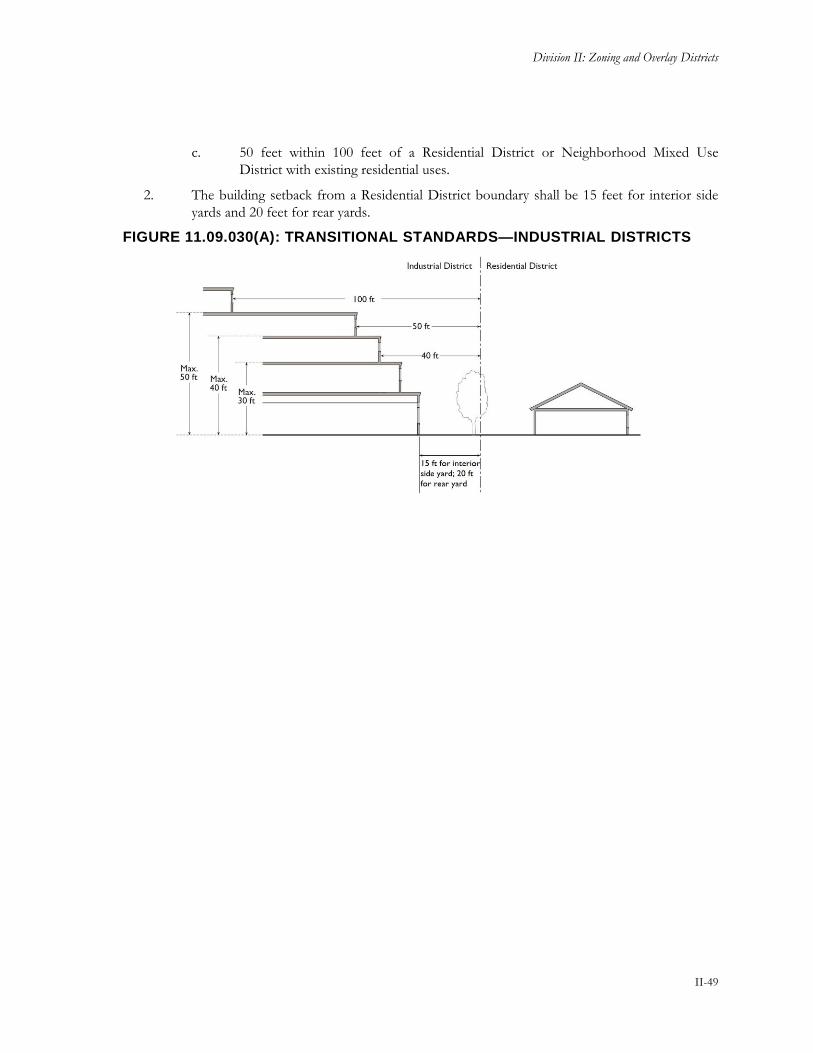
Division II: Zoning and Overlay Districts
II-49
c. 50 feet within 100 feet of a Residential District or Neighborhood Mixed Use
District with existing residential uses.
2. The building setback from a Residential District boundary shall be 15 feet for interior side
yards and 20 feet for rear yards.
FIGURE 11.09.030(A): TRANSITIONAL STANDARDS—INDUSTRIAL DISTRICTS

Yuba County Development Code
II-50
Chapter 11.10 Special Purpose Districts
Sections:
11.10.010 Purpose
11.10.020 Land Use Regulations
11.10.030 Development Regulations
11.10.010 Purpose
Special purpose zoning districts are established to accommodate unique uses or development types or to
address special development conditions.
A. Special purpose zoning districts are base zoning districts intended for a very specific application such
as but not limited to public facilities.
B. Public Facilities (PF). The purpose of the PF district is to:
1. Provide for the location of properties which are used for, or are proposed to be used for
public purposes or for specified public utility purposes.
2. Allow for quasi-public facilities that serve County residents and visitors and enhance the
quality of life within the county.
C. Plan Area: Specific Plan (SP) or Community Plan (CP). The purpose of the SP and CP districts
are to:
1. Identify the opportunity to create specific plans and/or community plans within the County,
along with the requirements and process for review and action.
2. As provided in this title, specific plans and community plans function as unique base zoning
district(s) for purposes of master planning areas of the County due to unique conditions,
issues, goals, needs, or other factors.
3. Any future specific plans or community plans shall be consistent with the County’s General
Plan and relevant state law.
D. Sports and Entertainment (SE). The purpose of the SE district is to:
1. Regulate the allowable uses of the property designated as sports/entertainment pursuant to
Measure R.
2. Regulate allowable uses of the raceway and flea market on Simpson Lane.
3. Provide for the development of a sports and entertainment district.
4. The development of ancillary and supportive uses that will enhance the function and
sustainability of the primary entertainment venues and facilities may be permitted.

Division II: Zoning and Overlay Districts
II-51
11.10.020 Land Use Regulations
Table 11.10.020 prescribes the land use regulations for Special Purpose Districts. The table also notes
additional use regulations that apply to various uses. Section numbers in the right hand column refer to other
sections of this Code.
TABLE 11.10.020: LAND USE REGULATIONS—SPECIAL PURPOSE DISTRICT
Land Use Classification PF SE1 Additional Regulations
Residential Use Classifications
Caretaker Residence A - See Section 11.32.070
Public & Semi-Public Use Classifications
Cemetery C -
Colleges/Trade Schools M -
Community Assembly M -
Community Garden/Urban Agriculture M(4) -
Cultural Institutions P -
Outdoor & Large Scale Cultural Institutions M -
Day Care Centers M -
Detention Facility C -
Elderly/Long-Term Care M -
Emergency Shelter Z - See Section 11.32.090
Essential/Emergency Service Facilities M -
Government Offices P -
Hospitals/Clinics See subclassifications below
Clinic P -
Hospital C -
Park & Recreation Facilities; Public See subclassifications below
Passive Recreation P -
Active Recreation M -
Parking: Public or Private Z -
Schools M -
Commercial Use Classifications
Animal Care: Sales and Services See subclassifications below
Veterinary Services M -
Bars & Drinking Establishments - Z(2)
Entertainment & Recreation See subclassifications below
Campground - Z(2) See Section 11.32.060
Indoor Entertainment & Recreation - Z
Outdoor Entertainment - Z
Outdoor Sports & Recreation - Z
Temporary Uses & Special Events See Section 11.32.300
Food & Beverage Sales See subclassifications below
Farmers Market Z - See Section 11.32.120

Yuba County Development Code
II-52
TABLE 11.10.020: LAND USE REGULATIONS—SPECIAL PURPOSE DISTRICT
Land Use Classification PF SE1 Additional Regulations
Lodging See subclassifications below
Hotels & Motels - Z See Section 11.32.140
Restaurants See subclassifications below
With Drive-Thru - Z(2) See Section 11.32.080
& 11.32.160
Without Drive-Thru - Z(2)
Industrial Use Classifications
Recycling Facilities See subclassifications below
Recycling Processing Facility C - See Section 11.32.220
Transportation, Communications & Utilities Use Classifications
Airports & Helicopters C -
Communications Facilities See Section 11.32.290
Transportation Passenger Terminals M -
Major Utilities C -
Minor Utilities P Z(2)
Renewable Energy Systems See subclassifications below
Personal Hydro Energy System P -
Personal Solar Energy System P P
See Section 11.32.260 Large Solar Generation Facility C -
Small Solar Generation M -
Personal Wind Energy System P P
See Section 11.32.270 Large Wind Generation Facility C -
Small Wind Energy System M -
Agricultural & Extractive Use Classifications
Resource Protection & Restoration P(3) -
Specific Limitations: 1. All uses within the Highway 65 SE district must be consistent with Measure R. 2. When associated with a permitted sports and entertainment facility 3. Copies of any easements or land development restrictions shall be submitted to the Planning Department. 4. Community Gardens/Urban Agriculture: as an interim land use on vacant property.
Key To Permit Requirements
Principally Permitted Use P Conditional Use Permit Required C
Zoning Clearance Required Z Surface Mining Permit Required SMP
Administrative Use Permit Required A See Numbered Footnote For Additional Limitations (#)
Minor Conditional Use Permit Required M As Outlined In Additional Regulations Section *
Use Is Not Allowed -
11.10.030 Development Regulations
Table 11.10.030, Development Regulations—Special Purpose Districts, prescribes the development standards
for Public Facilities and Sports and Entertainment Districts. Additional regulations are denoted in the right
hand column. Section numbers in this column refer to other sections of this Code. The numbers in the “#”

Division II: Zoning and Overlay Districts
II-53
column refer to the numbers in Figure 11.10.030: Development Regulations—Special Purpose Districts.
Development Regulations for SP and CP districts are established in the applicable Specific Plan or
Community Plan.
FIGURE 11.10.030: DEVELOPMENT REGULATIONS—SPECIAL PURPOSE DISTRICTS
TABLE 11.10.030: DEVELOPMENT REGULATIONS—SPECIAL PURPOSE DISTRICTS
Standard PF SE Additional Regulations #
Lot and Density Standards
Minimum Lot Area (acres) N/A 1
Maximum Floor Area Ratio (FAR)
0.5 0.25
Building Form and Location Standards
Maximum Height (ft) N/A N/A 11.19.050 Height Exceptions
Minimum Setbacks (ft)
Front 0, 20 adjacent to Residential district or use
0, 20 adjacent to Residential district or use
11.19.090 Setbacks and Yards
Side 0, 10 adjacent to Residential district or use
0, 10 adjacent to Residential district or use
11.19.090 Setbacks and Yards
Rear 0, 10 adjacent to Residential district or use
0, 10 adjacent to Residential district or use
11.19.090 Setbacks and Yards
Parking & Loading 11.25 Parking & Loading

Yuba County Development Code
II-54
11.10.040 Supplemental Regulations
A. Highway 65 Sports and Entertainment District. Development of the SE designated property located
along the west side of Highway 65 shall meet all requirements stipulated within Measure R, any
requirements stipulated in current or future adopted memorandum of agreements or development
agreements with the County, and any associated environmental documents for development within
the Highway 65 SE district.

Division II: Zoning and Overlay Districts
II-55
Chapter 11.11 Natural Resource Districts
Sections:
11.11.010 Purpose
11.11.020 Land Use Regulations
11.11.030 Development Regulations
11.11.040 Supplemental Regulations
11.11.010 Purpose
The primary purpose of the Natural Resource districts is to designate areas suitable for natural resource uses,
to prevent the encroachment of incompatible uses into natural resource lands, and to prevent the premature
conversion of such lands to non-resource uses. Natural resource uses include, but are not limited to: natural
habitat, watersheds, scenic resources, cultural resources, recreational amenities, agricultural lands, forest
resources, wetlands, woodlands, and minerals.
A. The standards are intended to define and conserve selected natural resources by minimizing adverse
impacts to them, thereby protecting the rights of the residents of Yuba County to sustainable use;
enjoyment; extraction; and the natural, scenic, historic and aesthetic values of the environment, as set
forth in the General Plan.
B. Extractive (EX). The purpose of the EX district is to:
1. Establish appropriate locations for the extraction, processing and distribution of minerals
occurring naturally such as sand, gravel, ores and precious metals, and under certain
permitted conditions blending said natural materials with imported materials.
2. Provide for public awareness of the potential for surface mining to occur and reduce
potential impacts from non-compatible uses.
3. Provide a mechanism to allow for support services and uses that are necessary and/or
complimentary to the long term sustainability of mining operations.
C. Resource Preservation and Recreation (RPR). This zone district is primarily located within the
Natural Resources areas of the County but is also an allowed zoning designation within Rural
Community districts and the Valley Growth Boundary consistent with the overall purposes of the
RPR designation. The purpose of the RPR district is to:
1. Preserve land containing natural or potential parkland for passive recreational activities and
nonstructural uses.
2. Identify lake recreation areas and to provide for use of these areas for active public
recreation purposes.
3. Preserve lands whose natural resources are of significant long range social, economic and
environmental importance.
4. Preserve open space and identify high quality plant areas, critical wildlife habitat, and critical
watershed lands in the County.

Yuba County Development Code
II-56
5. Preserve lands from residential development.
D. Timber Production (TP). This zone district is primarily located within the Natural Resources areas
of the County but is also an allowed zoning designation within Rural Community districts consistent
with the overall purposes of the TP designation. The purpose of the TP district is to:
1. Preserve valuable timber resources within the County and to protect both the economic and
environmental value of these lands.
2. Create standards that support the growing and harvesting of timber, pulp woods, and other
forestry products for commercial purposes.
3. Implement the California Timberland Productivity Act of 1982.
4. Provide a mechanism to allow for support services and uses that are necessary and/or
complimentary to the long term sustainability of timber operations.
11.11.020 Land Use Regulations
Table 11.11.020 prescribes the land use regulations for Natural Resource Districts. The table also notes
additional use regulations that apply to various uses. Section numbers in the right hand column refer to other
sections of this Code.
TABLE 11.11.020: LAND USE REGULATION—NATURAL RESOURCE DISTRICTS
Land Use Classification EX TP RPR Additional Regulations
Residential Use Classifications
Single-Unit Dwelling, Detached - P -
Caretaker Residence P - P See Section 11.32.070
Employee Housing A A A See Section 11.32.100
Home Occupation P(1) P(1) P(1) See Section 11.32.130
Public & Semi-Public Use Classifications
Cemetery - - C
Cultural Institutions - - C
Outdoor & Large Scale Cultural Institutions - - C
Essential/Emergency Service Facilities M M M
Park & Recreation Facilities; Public See subclassifications below
Passive Recreation P P P
Active Recreation - C C
Commercial Use Classifications
Entertainment & Recreation See subclassifications below
Campground - M M See Section 11.32.060
Hunting/Fishing Club M Z(4) Z(4)
Incidental Hunting and Fishing P P P
Outdoor Entertainment - M(2) M(2)
Outdoor Sports & Recreation - M(2) M(2)
Temporary Uses & Special Events See Section 11.32.300

Division II: Zoning and Overlay Districts
II-57
TABLE 11.11.020: LAND USE REGULATION—NATURAL RESOURCE DISTRICTS
Land Use Classification EX TP RPR Additional Regulations
Lodging See subclassifications below
Agricultural Homestays - - C See Section 11.32.140
Industrial Use Classifications
Construction & Material Yards P(3) P(3) -
General Industrial A(7) - -
Intensive Industrial A(7) - -
Research and Development A(7) - -
Transportation, Communications & Utilities Use Classifications
Agricultural Runways & Airport Facilities - M -
Communications Facilities See Section 11.32.290
Major Utilities C C C
Minor Utilities P P M
On-Site Biomass Facility - P(3) M(3)
Renewable Energy Systems See subclassifications below
Personal Hydro System P P P
Personal Solar Energy System P P P
See Section 11.32.260 Large Solar Generation Facility - C(3) -
Small Solar Generation Facility - M(3) M(3)
Personal Wind Energy System P P P
See Section 11.32.270 Large Wind Generation Facility - C(3) -
Small Wind Generation Facility - M(3) -
Agricultural & Extractive Use Classifications
Agricultural Labor Housing - P - See Section 11.32.030
Grazing (Animal Raising) P P P
Mining SMP - - See Section 11.32.280
Resource Protection & Restoration P(4) P(4) P(4)
Timber Production & Harvesting - P (5)
Timber Processing - M -
Specific Limitations: 1. Only when there is a pre-existing legally permitted residence or approved caretakers unit. 2. Only those types of entertainment & recreation uses that are compatible with the Natural Resources designation as determined
by Zoning Administrator 3. Only when associated with or will not negatively impact a permitted mining, extraction, timber operation, or other permitted use
as determined by Zoning Administrator. 4. Copies of any easements or land development restrictions shall be submitted to the Planning Department. 5. Less than 3 acres requires approval of a Zoning Clearance. Over 3 acres requires approval of an Administrative Use Permit. A
finding must be made that the harvesting of trees is necessary for the health and maintenance of the forest. 6. Single-unit dwellings are allowed as a “compatible use” as defined in Government Code Subsection 51104(h) of the Timber
Production Act and shall not be used as a mechanism to further subdivide timber lands. 7. General Industrial and Intensive Industrial uses ancillary to a permitted mining operation when a finding can be made that the
use will not be detrimental to adjacent mining operations or is inconsistent with the airport overlay zone.

Yuba County Development Code
II-58
TABLE 11.11.020: LAND USE REGULATION—NATURAL RESOURCE DISTRICTS
Key To Permit Requirements
Principally Permitted Use P Conditional Use Permit Required C
Zoning Clearance Required Z Surface Mining Permit Required SMP
Administrative Use Permit Required A See Numbered Footnote For Additional Limitations (#)
Minor Conditional Use Permit Required M As Outlined In Additional Regulations Section *
Use Is Not Allowed -
11.11.030 Development Regulations
Table 11.11.030, Development Regulations—Natural Resource Districts, prescribes the development
standards for Natural Resource Districts. Additional regulations are denoted in the right hand column.
Section numbers in this column refer to other sections of this Code. The numbers in the “#” column refer to
the numbers in Figure 11.11.030: Development Regulations—Natural Resource Districts.
FIGURE 11.11.030: DEVELOPMENT REGULATIONS—NATURAL RESOURCE DISTRICTS
TABLE 11.11.030: DEVELOPMENT REGULATIONS—NATURAL RESOURCE DISTRICTS
Standard EX TP RPR Additional Regulations #
40
Lot and Density Standards
Minimum Lot Area (acres) 80 160(B) 40
Maximum Density (units/parcel)
Caretaker and agricultural/workforce housing only

Division II: Zoning and Overlay Districts
II-59
TABLE 11.11.030: DEVELOPMENT REGULATIONS—NATURAL RESOURCE DISTRICTS
Standard EX TP RPR Additional Regulations #
40
Building Form and Location Standards
Maximum Height (ft) 50
11.19.050 Height Exceptions
Minimum Setbacks (ft)
Front 30
11.19.090 Setbacks and Yards
Side Lots less than one acre: 25 or 10% of lot width, whichever is less, but not less than 5 (A)
Lots one acre or larger: 30
11.19.090 Setbacks and Yards
Rear 25 (A)
11.19.090 Setbacks and Yards
Parking & Loading
11.25 Parking & Loading
11.11.040 Supplemental Regulations
A. Setbacks. Structures located within a high fire severity zone shall be setback a minimum of 30 feet
from all property lines.
B. Timberland Production District. All lands in the Timberland Production District are subject to all
of the provisions of the California Timberland Productivity Act of 1982 (Government Code §51000
et seq.) and the following.
1. District Applicability. The zoning of land in the Timberland Production District is to be
limited to those parcels within the County which:
a. Meet all of the requirements for inclusion in "List A" as defined in Government
Code §51110;
b. Meet all of the requirements for inclusion in "List B" as defined in Government
Code §51110.1; and
c. Meet the criteria for parcels of land to be considered for zoning as timberland under
the provisions of Government Code §51113 and this Code.
d. Land divisions that result in parcels less than 160 acres in size shall meet the
provisions defined in Government Code §51119.5 and this Code.
2. Rezoning. Any rezoning, immediate rezoning or removal from zone of any parcels zoned
Timberland Production shall conform to the requirements of Government Code Title 5,
Div. 1, Pt. 1, Ch. 6.7, arts. 3—5 (Government Code §51121 et seq.).
3. Criteria for Timberland Production Zoning. Pursuant to Government Code §51113(c)
and (d), the criteria for parcels of land to be considered for zoning as timberland under the
provisions of Government Code §51113(c) are as follows:
a. A map shall be prepared showing the legal description of the Assessor's parcel
number of the property desired to be zoned;

Yuba County Development Code
II-60
b. A plan for forest management must be prepared or approved as to content, for the
property by a registered professional forester. The plan shall provide for the
eventual harvest of timber within a reasonable period of time, as determined by the
preparer of the plan;
c. The parcel shall currently meet the timber stocking standards as set forth in Public
Resources Code §4561 and the forest practice rules adopted by the State Board of
Forestry and Fire Protection for the district in which the parcel is located, or the
owner must sign an agreement with the Board to meet such stocking standards and
forest practice rules by the fifth anniversary of the signing of such agreement. If the
parcel is subsequently zoned as timberland production under Government Code
§51113(a), the failure to meet such stocking standards and forest practice rules
within this time period provides the Board with a ground for rezoning of the parcel
pursuant to Government Code §51121.
Upon the fifth anniversary of the signing of an agreement, the Board shall
determine whether the parcel meets the timber stocking standards in effect on the
date the agreement was signed. Notwithstanding the provisions of Government
Code Title 5, Div. 1, Pt. 1, Ch. 6.7, Art. 4 (Government Code §51130 et seq.), if the
parcel fails to meet the timber stocking standards, the Board shall immediately
rezone the parcel and specify a new zone for the parcel which is in conformance
with the County General Plan and whose primary use is other than timberland.
d. The parcel shall be timberland, as defined in Government Code §51104(f).
e. The parcel shall be in compliance with the compatible uses established by this
Chapter pursuant to Government Code §51111.
f. The land area concerned shall be in ownership of one person, as defined in Revenue
and Taxation Code §38106, and shall be comprised of single or contiguous parcels
the total acreage of which must be at least 80 acres.
g. The land shall be of "Site III" Site Quality Class, as said term is defined and used
pursuant to said Act. Land shall be deemed to be "Site III" land if the average
quality of the land is Site III. "Average," for the purpose of this Subsection, means
that for every acre of land which is Site IV or Site V quality there must be at least
one acre, respectively, of Site II or Site I land to balance the lesser quality land to
create an exact Site III or better numerical average as to quality of acres to be
included.

Division II: Zoning and Overlay Districts
II-61
Chapter 11.12 Planned Development
Sections:
11.12.010 Purpose
11.12.020 Applicability
11.12.030 Zoning Map Designation
11.12.040 Land Use Regulations
11.12.050 Development Regulations
11.12.060 Procedures
11.12.070 Required Findings
11.12.080 Conditions
11.12.090 Expiration and Renewal
11.12.100 Amendments of Approved Plans
11.12.110 Status of Specific Plan
11.12.120 Development Plan Review
11.12.010 Purpose
The purposes of the Planned Development (PD) District are to:
A. Provide for greater flexibility in the design of the developments than is otherwise possible through
the strict application of zoning district regulations. It is the intent of this process to ensure
compliance with the General Plan and to provide various types of land use which can be combined
in compatible relationship with each other as a part of a totally planned development.
B. Promote creativity in building design and innovation in development concepts.
C. Planned unit development may be residential, commercial or industrial and may permit mixed uses
under certain circumstances.
11.12.020 Applicability
The procedures in this chapter shall apply to all proposals to establish a PD District.
11.12.030 Zoning Map Designation
A PD district shall be noted on the zoning map by the designation “PD,” followed by the number of the
Planned Development or Specific Plan based on order of adoption.
11.12.040 Land Use Regulations
No use other than an existing use is permitted in a PD district except in accord with a valid PD Plan or
Specific Plan. Any permitted or conditional use authorized by this chapter may be included in an approved
PD Plan or an adopted Specific Plan consistent with the General Plan land use designation(s) for the property.

Yuba County Development Code
II-62
11.12.050 Development Regulations
A. Minimum Area. The minimum area of a PD district shall be four contiguous acres. The Board of
Supervisors may approve a PD district that contains less than four acres, upon a finding that special
site characteristics exist.
B. Residential Unit Density. Except where a density bonus is granted in compliance with the
County's density bonus regulations for affordable housing and childcare (Chapter 11.30, Density
Bonus Incentive Program), the total number of dwelling units in a PD Plan shall not exceed the
maximum number permitted by the base zone density for the total area of the planned development
designated for residential use, excluding areas devoted to public and private streets.
C. Performance Standards. The Performance Standards prescribed by Chapter 11.26 apply.
D. Sewage Disposal/Potable Water. Parcels one acre or smaller in size shall provide both a public
sewer and public water supply. Parcels between one acre and 2.5 acres in size shall provide either a
public sewer or public water supply as determined by the Environmental Health Director
E. Other Development Regulations. Other development regulations shall be as prescribed by the PD
Plan.
11.12.060 Procedures
A. Decision-Making Authority. A PD District must be adopted by the Board of Supervisors. A public
hearing before the Planning Commission is required prior to Board of Supervisors review, and the
Planning Commission shall make a recommendation to the Board of Supervisors.
B. Review Procedures.
1. Rezoning. An application for rezoning to a PD District shall be processed as an amendment
to the Zoning Map, according to the procedures of Chapter 11.61, Amendments to
Development Code and Official Zoning Map, and shall include a Specific Plan processed
according to Chapter 11.64, Specific Plans and Amendments, or a PD Plan.
2. PD Plan. The PD Plan shall be accepted and processed concurrently with the rezoning, in
the same manner as a Conditional Use Permit application, pursuant to Chapter 11.53,
Common Procedures, and Chapter 11.57, Use Permits except that the Board of Supervisors
is the decision-making authority and additional information is required to be submitted in
order to determine that the intent of this Code and the General Plan will be fulfilled.
3. Tentative Subdivision Map. When a PD requires the submission of a tentative
subdivision map, this map and all supporting documents shall be prepared and submitted
concurrently with the application of the PD.
C. Initiation. An amendment to reclassify property to PD shall be initiated by a property owner or
authorized agent or a motion of the Planning Commission or the Board of Supervisors. If the
property is not under a single ownership, all owners must join the application, and a map showing
the extent of ownership shall be submitted with the application.
D. Application Content. An application for a PD, made on the prescribed form, shall be filed with the
Planning Department, accompanied by the required fee. Applications shall contain all of the
following:

Division II: Zoning and Overlay Districts
II-63
1. Legal Description. A legal description of the site and a statement of the number of acres,
or square feet if less than one acre, contained therein.
2. Title Report. A title report verifying the description and the ownership of the property.
3. Ownership Declaration. A declaration as to whether the site is to remain under the same
ownership and control or to be divided into small units during or after development and the
manner and method of the division.
4. Project Narrative. A generalized narrative describing the location of the site, its total
acreage, and the existing character and use of the site and adjoining properties; the concept
of the proposed development, including proposed uses and activities, development
standards, architectural design guidelines, proposed residential densities if appropriate, and
physical land alterations required by the development; and the relation of the proposed PD
to the Yuba County General Plan.
5. Development Schedule. A development schedule, including anticipated timing for
commencement and completion of each phase of development, tabulation of the total
number of acres in each separate phase and percentage of such acreage to be devoted to
particular uses, and an indication of the proposed number and type of dwelling units by
phase of development, if applicable.
6. Maps and Diagrams. Maps, diagrams, and other graphics necessary to establish the
physical scale and character of the development and demonstrate the relationship among its
constituent land uses, buildings and structures, public facilities, and open space.
7. Open Space and Landscaping Plan. An existing and proposed open space and
landscaping plan including landscape concepts and type of plant materials, recreation area,
parking, service and other public area used in common on the property and a description of
intended improvements to and maintenance of the open area of the property.
8. Other Information. Any other information deemed necessary by the Director to ascertain
if the project meets the required findings for a PD Plan and re-zoning.
11.12.070 Required Findings
A PD Plan and re-zoning shall only be approved if all of the following findings are made:
A. The proposed development is consistent with the General Plan and any applicable specific plan,
including the density and intensity limitations that apply;
B. The project is in compliance with any applicable Overlay Districts;
C. The subject site is physically suitable for the type and intensity of the land use being proposed;
D. Adequate transportation facilities and public services exist or will be provided in accord with the
conditions of PD plan approval, to serve the proposed development; and the approval of the
proposed development will not result in a reduction of traffic levels of service or public services so as
to be a detriment to public health, safety, or welfare;
E. The proposed development will not have a substantial adverse effect on surrounding land uses and
will be compatible with the existing and planned land use character of the surrounding area;

Yuba County Development Code
II-64
F. The development generally complies with applicable adopted design guidelines; and
G. The proposed development is demonstratively superior to the development that could occur under
the standards applicable to the underlying base district, and will achieve superior community design,
environmental preservation and/or substantial public benefit. In making this determination, the
following factors shall be considered:
1. Appropriateness of the use(s) at the proposed location.
2. The mix of uses and housing types.
3. Provision of units affordable to persons and families of low and moderate income or to
lower income households.
4. Provision of infrastructure improvements.
5. Provision of open space.
6. Compatibility of uses within the development area.
7. Creativity in design and use of land.
8. Quality of design, and adequacy of light and air to the interior spaces of the buildings.
9. Overall contribution to the enhancement of neighborhood character and the environment of
Yuba County in the long term.
11.12.080 Conditions
In approving a PD Plan and re-zoning, the Board of Supervisors may impose reasonable conditions deemed
necessary to:
A. Ensure that the proposal conforms in all significant aspects with the General Plan and with any other
applicable plans or policies that the County has adopted;
B. Achieve the general purposes of this Code or the specific purpose of the zoning district in which the
project is located;
C. Achieve the findings listed above; or
D. Mitigate any potentially significant impacts identified as a result of review conducted in compliance
with the requirements of the California Environmental Quality Act.
The Board of Supervisors may require reasonable guarantees and evidence that such conditions are being, or
will be, complied with.
11.12.090 Expiration and Renewal
A. Expiration.
1. PD Plan. A PD Plan shall expire on the same date as the associated tentative map for the
project. In instances where a tentative map is not required, the PD shall expire two years
after the effective date of the ordinance creating the PD unless actions specified in the
conditions of approval have been taken, or a building permit has been issued and
construction diligently pursued. An approved PD Plan may specify a development staging

Division II: Zoning and Overlay Districts
II-65
program exceeding two years. The official zoning map shall not be changed to reflect the PD
designation until such time as the PD has been effectuated.
2. Tentative Map. Where a tentative map has been approved in conjunction with a PD Plan,
the PD Plan shall expire upon the expiration of the tentative map.
3. Phased Development. In the event that the applicant intends to develop the project in
phases, and the Board of Supervisors approves phased development, the PD Plan shall
remain in effect so long as not more than one year lapses between the end of one phase and
the beginning of the next phase, unless a longer period is approved by the Board of
Supervisors.
B. Renewal. An approved PD Plan that has not been exercised may be renewed for a two-year period
approved by the Board of Supervisors after a duly-noticed public hearing. Application for renewal
shall be made in writing between 30 and 120 days prior to expiration of the original approval. The
Board of Supervisors may renew a PD Plan if it finds the renewal consistent with the purposes of
this chapter.
11.12.100 Amendments of Approved Plans
A. Changed Plans. Amendments to a PD District or PD Plan or Specific Plan may be requested by the
applicant or its successors. Amendments to the approved PD District or PD Plan or Specific Plan
shall be classified as major or minor amendments. Upon receipt of an amendment application, the
Director shall determine if the proposed amendment constitutes a major or minor amendment.
B. Major Amendments. Major Amendments to an approved PD District or PD Plan or Specific Plan
shall be considered by the Board of Supervisors at a duly noticed public hearing. An amendment will
be deemed major if it involves one or more of the following changes:
1. A change in the boundary of the PD District;
2. An increase or decrease in the number of dwelling units for the PD District that is greater
than the maximum or less than the minimum stated in the PD Plan or Specific Plan;
3. An increase or decrease in the floor area for any non-residential land use that results in the
floor area exceeding the minimum or maximum stated in the PD Plan or Specific Plan by 10
percent or more;
4. Any change in land use or density that is likely to negatively impact or burden public
facilities and utilities infrastructure as determined by the County Engineer;
5. Any change in land use or density that is likely to negatively impact or burden circulation
adjacent to the PD District or to the overall major street system, as determined by the
County Engineer; or
6. Any other proposed change to the PD Plan or Specific Plan or the conditions of approval
that substantively alters one or more of its components as determined by the Director.
C. Minor Amendments. Amendments not meeting one or more of the criteria listed in subsection B
above shall be considered minor if they are consistent with the original findings and conditions of
approval. Minor Amendments may be approved by the Planning Director. The Planning Director
may, at his/her discretion, refer any request for an amendment to a to a PD Plan that may generate

Yuba County Development Code
II-66
substantial public interest to the Planning Commission for a decision rather than acting on it
himself/herself.
11.12.110 Status of Specific Plan
A Specific Plan adopted by resolution of the Board of Supervisors shall be administered as prescribed by the
Supervisors, consistent with Government Code Section 65450.
11.12.120 Development Plan Review
Plans for a project in a PD District shall be accepted for planning and building permits or subdivisions only if
they are consistent with an approved PD Plan or Specific Plan and any conditions of approval. No project
may be approved and no building permit issued unless the project, alteration or use is consistent with an
approved PD Plan or Specific Plan.

Division II: Zoning and Overlay Districts
II-67
Chapter 11.13 Airport Environs (AP) Overlay District
Sections:
11.13.010 Applicability
11.13.020 Purpose
11.13.030 Use Restrictions
11.13.040 Allowed Land Use
11.13.050 Development Standards
11.13.060 Interior Noise Level Reduction
11.13.070 Height Limitations
11.13.080 FAA Notification
11.13.090 Avigation Easement Dedication
11.13.100 Overflight Notification
11.13.110 Non-conforming Uses
11.13.010 Applicability
The standards of this chapter apply to areas within the Airport Influence Area of the Yuba County Airport,
the Brownsville Airport, and the Beale Air Force Base. As used herein, “Airport” means the Yuba County
Airport, the Brownsville Airport, and the Beale Air Force Base.
11.13.020 Purpose
The Airport Environs (AP) Overlay District is established to:
A. Protect land uses around the airport from potential hazards of airport operations;
B. Identify a range of uses compatible with airport accident hazard and airport noise exposure;
C. Prohibit the development of incompatible uses that are detrimental to the general health, safety and
welfare and to existing and future airport operations;
D. Require noise attenuated construction within the airport environs;
E. Comply with Federal Aviation Administration (FAA) regulations; and
F. Implement the authority conferred by the Airport Approaches Zoning Law, to regulate the use of the
air space for the purpose of promoting the health, safety and general welfare of the inhabitants of the
County of Yuba by protecting the Yuba County Airport, Brownsville Airport and Beale Air Force
Base from non-compatible land uses and providing for the orderly growth of the area surrounding
these airports, safeguarding the general welfare of the inhabitants within the vicinity of the airports
and the public in general by protecting the public from the adverse effects of aircraft noise and
reducing the number of people exposed to airport-related hazards, and ensuring that no structures
affect navigable airspace.

Yuba County Development Code
II-68
11.13.030 Use Restrictions
Notwithstanding any other provisions of this chapter, no use may be made of land or water within the AP
Overlay District in such a manner that would:
A. Create a “Hazard to Air Navigation” as determined by the FAA;
B. Result in glare in the eyes of pilots using the airport;
C. Make it difficult for pilots to distinguish between airport lights and others;
D. Impair visibility in the vicinity of the airport;
E. Create steam or other emissions that cause thermal plumes or other forms of unstable air;
F. Create electrical interference with navigation signals or radio communication between the airport and
aircraft;
G. Create an increased attraction for wildlife. Of particular concern are landfills and certain recreational
or agricultural uses that attract large flocks of birds that pose bird strike hazards to aircraft in flight;
or
H. Otherwise in any way endanger or interfere with the landing, takeoff or maneuvering of aircraft
intending to use the airport.
11.13.040 Allowed Land Use
Those uses permitted in the base district, subject to the limitations and conditions set forth therein and
consistent with the applicable Airport Land Use Plan.
11.13.050 Development Standards
In addition to the development standards of the underlying district, development in the AP Overlay District
is subject to the requirements, limitations and conditions set forth therein and consistent with the applicable
Airport Land Use Plan.
11.13.060 Interior Noise Level Reduction
New development exposed to CNEL above 60 dB shall comply with the following standards:
A. Single-Unit Residential Dwellings. New single-unit dwellings shall incorporate the following noise
reduction design measures unless alternative designs that achieve and maintain an interior noise level
of CNEL 45 dB are incorporated and verified by a Board Certified Acoustical Engineer.
1. All facades must be constructed with substantial weight and insulation;
2. Sound-rated windows providing noise reduction performance similar to that of the façade
must be included for habitable rooms;
3. Sound-rated doors or storm doors providing noise reduction performance similar to that of
the façade must be included for all exterior entries;
4. Acoustic baffling of vents is required for chimneys, fans, and gable ends;

Division II: Zoning and Overlay Districts
II-69
5. Installation of a mechanical ventilation system affording comfort under closed-window
conditions; and
6. Double-stud construction, double doors, and heavy roofs with ceilings of two layers of
gypsum board on resilient channels.
B. Other Development. For new hotels, motels, apartment houses, and dwelling units except single-
unit dwellings, an acoustical study shall be prepared by a Board Certified Acoustical Engineer
demonstrating that the proposed structure or structures have been designed to meet the noise
reduction requirements and standards set forth in 21 CCR § 5012.
11.13.070 Height Limitations
A. The criteria for determining the acceptability of a project with respect to height shall be based upon
the standards set forth in Federal Aviation Regulations (FAR) Part 77, Subpart C, Objects Affecting
Navigable Airspace. Additionally, where an FAA aeronautical study of a proposed object is required
in accordance with FAR Part 77, Subpart C, the results of that study shall be taken into account by
the county.
B. No object, including a mobile or temporary object such as construction crane, shall have a height
that would result in penetration of any obstruction surface depicted in the applicable Airport Land
Use Plan.
C. Within the primary surface and beneath the approach or transitional surfaces, objects shall be limited
in height consistent with the airspace protection surfaces defined by FAR Part 77.
11.13.080 FAA Notification
Any person proposing construction or alteration within the AP Overlay District shall submit notification of
the proposal to the FAA if such construction or alteration exceeds an of the flowing height standards:
A. 200 feet above ground level.
B. The plane of an imaginary surface extending outward and upward at a slope of 100 to 1 for a distance
of 20,000 feet from the nearest point of any runway.
11.13.090 Avigation Easement Dedication
Shall be required as specified in the applicable Airport Land Use Plan.
11.13.100 Overflight Notification
If an avigation easement is not required, residential development within the primary or secondary overflight
area indicated in the applicable Airport Land Use Plan, an overflight notification consistent with the following
standards shall be recorded.
A. The notification shall contain the following language dictated by state law with regard to real estate
transfer disclosure.
NOTICE OF AIRPORT IN VICINITY: This property is presently located in the vicinity of an airport,
within what is known as an airport influence area. For that reason, the property may be subject to some of

Yuba County Development Code
II-70
the annoyances or inconveniences associated with proximity to airport operations (for example: noise,
vibration, or odors). Individual sensitivities to those annoyances can vary from person to person. You may
wish to consider what airport annoyances, if any, are associated with the property before you complete your
purchase and determine whether they are acceptable to you.
B. The notification shall be made evident to prospective purchasers of the property and shall appear on
the property deed.
11.13.110 Non-conforming Uses
Non-conforming land uses which were in existence prior to the effective date of this chapter may continue
pursuant to the requirements of the applicable Airport Land Use Plan.

Division II: Zoning and Overlay Districts
II-71
Chapter 11.14 Floodplain (FP) Overlay District
Sections:
11.14.010 Purpose
11.14.020 Applicability
11.13.030 Development in the FP Overlay District
11.13.040 Development in Urban / Urbanizing Areas
11.14.010 Purpose
The purpose of the Floodplain (FP) Overlay District is to promote public health, safety, and general welfare,
and to minimize the loss of life and property due to flooding in areas of the County that have been
determined to be subject to such an event. The FP Overlay District is also intended to:
A. Minimize expenditure of public money for costly flood control projects;
B. Minimize the need for rescue and relief efforts associated with flooding;
C. Minimize prolonged business interruptions;
D. Minimize flood damage to public facilities and utilities such as water and gas mains; electric,
telephone, and sewer lines; and streets and bridges located in areas of special flood hazard;
E. Maintain a stable tax base by providing for the second use and development of areas of special flood
hazard so as to minimize future flood blight areas;
F. Ensure that potential buyers are notified that property is in an area of special flood hazard;
G. Ensure that those who occupy the areas of special flood hazard assume responsibility for their
actions; and
H. Maintain eligibility for state disaster relief.
11.14.020 Applicability
The standards and regulations of this chapter apply to all lands within areas of special flood hazard identified
by the Federal Emergency Management Agency (FEMA) in the "Flood Insurance Study (FIS) for Yuba
County, California" dated February 18, 2011 or subsequent versions currently effective, with accompanying
Flood Insurance Rate Maps (FIRM's) and Flood Boundary and Floodway Maps (FBFM's), dated May 17,
1982 or subsequent versions currently effective, and all subsequent amendments and/or revisions, are hereby
adopted by reference and declared to be a part of this ordinance. In addition, the provisions of Chapter 11.14
of this Code applies to urban and urbanizing areas that have or are anticipated to have a population of 10,000
residents or more within ten years (baseline year is 2007) that also fall within a 200-year floodplain as
delineated on the most current available maps from the State of California or as adopted by the County of
Yuba.

Yuba County Development Code
II-72
This FIS and attendant mapping is the minimum area of applicability of this chapter and may be
supplemented by studies for other areas which allow implementation of this chapter and which are
recommended to the County of Yuba by the Floodplain Administrator.
11.14.030 Development in the FP Overlay District
All development in the FP Overlay District shall be in compliance with Chapter 10.30, Floodplain
Management, of the Yuba County Ordinance Code. In addition, prior to approving a tentative map or parcel
map located within a flood hazard zone, the decision-making authority shall make a finding that the flood
management facilities protect the property to the urban level of flood protection in urban/urbanizing areas or
to the National Federal Emergency Management Agency standard of flood protection in non-urbanized areas.
11.14.040 Development in Urban / Urbanizing Areas
This section applies to those areas within the unincorporated portions of the County of Yuba that that have or are anticipated to have a population of 10,000 residents or more within ten years that also fall within either locations of undetermined flood risk or the 200-year floodplain as delineated on the most current available maps from the State of California or as adopted by the County of Yuba. Prior to issuing any discretionary permit or adopting any subdivision map, the County must find one of the following:
(1) The facilities of the State Plan of Flood Control or other flood management facilities protect the property to the urban level of flood protection. The urban level of flood protection shall be as defined in the California Government Code Section 65007(l);
(2) Conditions imposed will protect the property to the urban level of flood protection; or
(3) The local flood management agency has made adequate progress on the construction of a flood protection system that will result in flood protection equal to or greater than the urban level of flood. Adequate progress shall be as defined in California Government Code Section 65007(a).

Division II: Zoning and Overlay Districts
II-73
Chapter 11.15 National Pollution Discharge Elimination System (NPDES) Overlay District
Sections:
11.14.010 Purpose
11.14.020 Applicability
11.14.030 Development in the NPDES Overlay District
11.15.010 Purpose
The purpose of the National Pollutant Discharge Elimination System (NPDES) Overlay District is to
promote public health, safety, and general welfare, enhance and protect the quality of waters of the state in
Yuba County by reducing pollutants in stormwater discharges to the maximum extent practicable and
controlling non-stormwater discharges to the storm drain system; to cause the use of best management
practices that will reduce the adverse effects of polluted runoff discharges on waters of the State.
The NPDES Overlay District is also intended to assist in the protection and enhancement of the water
quality of watercourses, water bodies and wetlands in a manner pursuant to and consistent with the Federal
Clean Water Act (33 U.S.C. Sections 1251 et seq.) and any subsequent amendments thereto, by reducing
pollutants in storm water discharges to the maximum extent practicable and by prohibiting non-storm water
discharges into the storm drain system. This chapter further assists in meeting the requirements of the
California State Water Resources Control Board Order No. 2013-0001-DWQ and any subsequent
amendments thereto.
11.15.020 Applicability
The standards and regulations of this chapter apply to all lands within the County of Yuba - Phase II
Municipal Separate Storm Sewer System (MS4) permit boundary as delineated on the most current permit
boundary map as approved by the California State Water Resources Control Board.
11.15.030 Development in the NPDES Overlay District
All development in the NPDES Overlay District shall be in compliance with Chapter 7.50, Stormwater
Quality Ordinance, of the Yuba County Ordinance Code

Yuba County Development Code
II-74
Chapter 11.16 Planning Reserve (PR) Overlay District
Sections:
11.16.010 Purpose
11.16.020 Applicability
11.16.030 Plan Required
11.16.040 Additional Required Findings for Approval
11.16.010 Purpose
The purpose of the Planning Reserve (PR) overlay district is to:
A. Reserve land within the County to meet the future needs for urban development, consistent with the
General Plan.
B. Allow for the continued use of lands designated PR as allowed by the underlying land use
designation.
C. Prevent premature development of areas designated for future urban development before necessary
public services would be available to those areas.
D. PR zones are to be applied in areas contiguous to existing urban development where urban
expansion is planned and in areas designated for future development.
E. Encourage the orderly conversion of parcels within the PR to urban development through the use of
specific plan, master plan or similar planning tools.
F. When consistent with the General Plan and its elements, and when adequate public facilities are or
can be made available, land in the PR may be rezoned, subject to the established procedures for
amending the land use plan map and zoning district map, and subject to the development limitations
set forth in General Plan.
11.16.020 Applicability
The standards of the underlying base district apply to all development within the Planning Reserve (PR)
Overlay District unless a Master Plan or Specific Plan specifies other requirements.
11.16.030 Plan Required
A. Plan Required. The County will not accept applications for subdivisions, allow urban land uses, or
approve re-zonings within a PR Overlay District until there is an adopted Master Plan or Specific
Plan in place. If there is no adopted Plan in place, development shall be in conformance with the
regulations of the base district.
An application for a Master Plan or Specific Plan in the PR Overlay District shall be submitted and
processed pursuant to the requirements of Chapter 11.64 (Specific Plans) or 11.65 (Master Plans).
Division II: Zoning and Overlay Districts
II-75
11.16.040 Additional Required Findings for Approval
In addition to any other findings required by this Code, the Board of Supervisors shall only approve a Master
Plan or Specific Plan in the Planning Reserve (PR) Overlay District if it makes all of the following findings:
A. The County determines that these lands are needed to fulfill either the County’s regional housing
needs allocation or accommodate job-generating developments needed to achieve the County’s jobs-
housing goals.
B. The Plan promotes the goals and is consistent with the polices of the Community Development
Element, Natural Resources Element, Housing Element, and Public Health & Safety Element of the
General Plan; and
C. The Plan is planned and designed to improve the match between local jobs and the local labor force,
consistent with the goal of accommodating 0.8 total local jobs for every member of the labor force;
and
D. Build out of the Plan will directly provide substantial basic (exporting) employment development
potential; and
E. The development of the Plan will include the construction of water, wastewater, and drainage
infrastructure that will serve future employment development. Mechanisms will be in place so that
project applicants are repaid on a fair-share basis.
Chapter 11.17 Reserved
Chapter 11.18 Reserved