division of coastal resources the east river blueway plan · welcome to the east river blueway...
TRANSCRIPT

March 2013
THE EAST RIVER BLUEWAY PLAN
Manhattan Borough President
Scott M. Stringer
New York State Assemblymember
Brian Kavanagh
New York State Department of State
Division of Coastal Resources

PREPARED FORManhattan Borough President Scott M. Stringer
New York State Assemblymember Brian Kavanagh
New York State Department of State
Division of Coastal Resources
PROJECT PARTNERSCommunity Board 3
Community Board 6
Lower East Side Ecology Center
PREPARED BYWXY architecture + urban design
CONSULTANT TEAMWXY architecture + urban design
AKRF
ARCADIS
Domingo Gonzalez Associates
eDesign Dynamics
HR&A Advisors
Judith Heintz
Philip Habib and Associates
S + M Studios
Weidlinger Associates
The East River Blueway Plan was prepared
for the New York State Department of State
with funds provided under Title 11
of the Environmental Protection Fund.
BiodiversityThe degree of variation
of species and a
measure of health of a
ecosystem
BioswaleGreen infrastructure
landscaping found
predominantly
alongside roadways
BrownfieldAbandoned or
underused industrial
and commercial
facilities whose
development is
complicated by real or
expected environmental
contaminations
Bulkhead
A retaining wall or
seawall to maintain
coastal land or beach
CSOCombined Sewer
Overflow is the
discharge of a sewer
system which combines
sanitary and stormwater
sewers into bodies of
water (rivers, canals,
the ocean, etc.)
CSO OutfallsPoints where CSOs
discharge
GIGreen Infrastructure,
generally incorporating
plants and soil in
designs to capture
stormwater runoff
and/or reduce CSO
discharges
Green roofVegetation covering
the roof of a building,
used primarily as green
infrastructure, as well
as to provide insulation
and lessen the urban
heat island effect
GreenwayA long, generally narrow
piece of land, where a
more natural environ-
ment is encouraged,
which is managed for
public recreation and
slow travel
Hold the LineEngineered strategies
to protect existing
coastal properties and
infrastructure
LidoPublic outdoor
swimming pool and
surrounding facilities
Managed RetreatAllowing the shoreline
to overtake developed
land, while relocating
existing buildings and
infrastructure
Raised TableA speed hump with a
flat section of several
feet between the
ramps on either end.
This traffic calming
measure is often used
as a crosswalk, and is
preferred option of
emergency responders
ResilienceDesign to minimize
damage to structures
from natural disasters
such as flooding. This
does not mean making
structures impervious
RiprapRocks and other
material used to protect
shorelines against
erosion
KEY TERMS AND ABBREVIATIONS
KEY CONSULTING AGENCIES AND ORGANIZATIONS
Con EdConsolidated Edison
Company of New York
DECNYS Department of
Environmental
Conservation
DCPNYC Department of City
Planning
DEPNYC Department of
Environmental
Protection
DPRNYC Department of
Parks & Recreation
DOTNYC Department of
Transportation
EDCNYC Economic
Development
Corporation
MWAMetropolitan
Waterfront Alliance
NYCHA Tenant AssociationsNYC Housing Authority
WayfindingAn organized system
of navigational
guidance, preferably
using coherent visible,
audible, or tactile cues

CONTENTS
FOREWORD
EXECUTIVE SUMMARY
INTRODUCTION
THE BLUEWAY WATERFRONT AREAS
PROTECTING THE WATERFRONT
BLUEWAY DESIGN
1 South Street Waterfront Area
2 East River Park Waterfront Area
3 Stuyvesant Cove / Waterside Plaza Waterfront Area
BLUEPRINT FOR THE BLUEWAY
APPENDIX
5
7
13
17
23
28
30
42
62
72
78

Rendering of bird’s-eye
view of proposed
East River Blueway Plan
from Stuyvesant Cove
to Brooklyn Bridge


View of the East River Esplanade
Man
hat
tan
Bo
roug
h P
resi
den
t Sc
ott
M. S
trin
ger,
Ass
emb
lym
emb
er B
rian
Kav
anag
h, N
YS D
epar
tmen
t o
f St
ate
Div
isio
n o
f C
oas
tal R
eso
urce
s

Dear Friends,
Welcome to the East River Blueway Plan, an ambitious new blueprint designed to
re-imagine a stretch of Manhattan’s precious waterfront—from the Brooklyn Bridge to
East 38th Street—and also to protect our beloved city from rising water levels and the
next great storm.
Ever since our offices undertook this project in 2010, our objective with the Blueway
Plan was to open up this under-appreciated waterfront area, creating beachfront
access, recreational activities, tree-lined walkways, and other amenities that would
bring people closer to the water. But we also knew that we had to fortify this low-lying
area against storms and flooding that are increasing dangers as the climate changes and
river levels rise.
When Hurricane Sandy hit in October 2012, it confirmed our worst fears about the need
to plan differently for the future. Now that the winds have died and the waters have
receded, we must get down to the job of making our coastal communities more resilient
through better infrastructure and ecological features that provide natural protection
from flooding.
As you will see in the following pages, our plan calls for natural beaches and other
recreational amenities along the shoreline, but also wetlands to catch and cleanse
storm water runoff and provide buffers against waves and flooding. We propose a
footbridge spanning the FDR Drive at East 14th Street that would not only improve
pedestrian access, but also protect the Con Ed power station from future floodwaters.
We believe the Blueway Plan offers a model of community engagement and planning
as New York now looks to revitalize storm-battered areas from Breezy Point and
Coney Island to Red Hook and the devastated shores of Staten Island. Developed with
Community Boards 3 and 6 and the Lower East Side Ecology Center as project partners,
and more than 40 other community-based organizations and countless local residents
who offered suggestions and feedback, this is a plan built by the community and for
the community.
We want to say thank you to all those community participants, to our fellow elected
officials who cosponsored the public workshops and whose support will be vital to
realizing this vision, to the city and state agency representatives who offered their
insights and technical expertise, and to our design team at W X Y architecture + urban
design who worked with all of us to distill our many ideas and aspirations into the
unified vision presented in this report.
The tremendous enthusiasm, creativity, and determination this community displayed
during the planning process—and of course the way so many New Yorkers bravely
weathered Hurricane Sandy—have convinced us more than ever that together we can
build a stronger, more resilient city.
Sincerely,
Scott M. Stringer
Manhattan Borough President
FOREWORD
FO
RE
WO
RD
Brian Kavanagh
New York State Assemblymember
5

Rendered view of proposed
saltwater marsh, fishing piers
and planted areas by the
FDR Drive downspouts in the
South Street Waterfront Area
Man
hat
tan
Bo
roug
h P
resi
den
t Sc
ott
M. S
trin
ger,
Ass
emb
lym
emb
er B
rian
Kav
anag
h, N
YS D
epar
tmen
t o
f St
ate
Div
isio
n o
f C
oas
tal R
eso
urce
s
6

EXECUTIVE SUMMARY
The East River Blueway Plan (Blueway
Plan) is a community-based waterfront
initiative that establishes a planning and
urban design framework for Manhattan’s
East River waterfront, from the Brooklyn
Bridge to East 38th Street. This study aims
to establish a unified and sustainable
vision for a stretch of waterfront with
the potential to provide new recreational
and educational opportunities, while
improving storm resiliency.
The study, funded by the New York
State Department of State Division of
Coastal Resources, was commissioned
by Manhattan Borough President
Scott M. Stringer and New York State
Assemblymember Brian Kavanagh, in
collaboration with Manhattan Community
Board 3, Manhattan Community Board 6,
and the Lower East Side Ecology Center.
The East River, once one of the most
polluted waterways in New York City, has
been transformed in recent decades
following the decline of industrial uses
along the waterfront and environmental
legislation of the 1970s. A river that was
once intolerable is now a sought-after
spot for millions of New Yorkers who
are eager for green space and who seek
respite by the water’s edge. Similar
transformations have taken place in cities
and towns across the country, leading
to the development of “blueways.”
These blueways are holistically designed
parks and open spaces that integrate
waterfronts into the life of a city.
With new waterfront development
throughout New York City—from the Bronx
River and Long Island City to Red Hook,
Saint George, and Hudson River Park—
New Yorkers are now starting to swim, fish
and boat in and around their surrounding
waters. Even the waterfront north of the
Blueway study area, from East 38th to
East 60th Street, should be getting an
esplanade following legislation authored
by Assemblymember Kavanagh. The
waterfront is at last being reincorporated
into the lives of New Yorkers.
However, the East River waterfront
from the Brooklyn Bridge to East 38th
Street has not received the same kind
of attention. Some challenges along
this four-mile stretch of the waterfront
include: fragmented uses, the foreboding
barrier of the FDR Drive, and the oversight
of multiple city and state agencies.
As a result, a clear and comprehensive
plan for this precious waterfront land
is needed; a plan that should take into
account the needs of the surrounding
communities and respond to the
challenges of extreme weather events and
gradual sea level rise. As Hurricane Sandy
underscored, developing such a plan is no
longer just a matter of improving public
access and beautifying the riverfront, it
is an urgent matter of public safety with
implications for the entire city.
Indeed, even as New Yorkers begin to
enjoy their waterfront, the city is facing
the new paradigm of climate change
and a growing awareness of the need
for environmental stewardship. The
unprecedented impact of Hurricane Sandy
has reinforced the need to strengthen
and protect our shoreline, critical
infrastructure, and neighborhoods.
The East River Blueway Plan is a model
for resiliency because it provides a vision
of an accessible and dynamic waterfront
that also addresses the urgency of climate
change and its effects.
EX
EC
UTI
VE
SU
MM
AR
Y
7

View of Waterside Plaza from East River Park
Bird’s-eye view of the East River along South Street
8
Man
hat
tan
Bo
roug
h P
resi
den
t Sc
ott
M. S
trin
ger,
Ass
emb
lym
emb
er B
rian
Kav
anag
h, N
YS D
epar
tmen
t o
f St
ate
Div
isio
n o
f C
oas
tal R
eso
urce
s

Moreover, the Blueway Plan is a model for
civic engagement as the local community
played a central role in shaping the vision.
The East River Blueway Plan represents
more than a year of public consultations
with suggestions and feedback gathered
from dozens of stakeholder meetings,
several public workshops, surveys, and
an interactive website.
This study also considered the many policy
developments, master planning initiatives,
and recently completed public and private
plans that have and will shape this section
of the East River waterfront in the years
to come. “Vision 2020,” published by
the New York City Department of City
Planning (DCP) in 2011, is a principal policy
document that has provided a foundation
for the Blueway Plan. The Blueway Plan
seeks to provide a design vision and more
specific detail to the guidance provided in
Vision 2020. The New York City Economic
Development Corporation’s (EDC)
“Transforming the East River Waterfront”
and the New York City Department of
Parks and Recreation’s construction at
Pier 42 are examples of work underway
that shaped the Blueway Plan approach
and will have an immediate impact on the
East River waterfront.
BLUEWAY PLAN GOALS
Through consideration of these plans and
an extensive public consultation process,
the following four goals were developed
for the Blueway Plan:
Engaging the RiverIdentify and design key points and
down-to-the-water sites to engage
with the East River from the water
and from the shore
Planning for Resilient NeighborhoodsCreate a long-term, sustainable
vision that takes into account climate
change, stormwater management,
technological developments,
and evolving transportation trends
Improving Community AccessPropose improvements to a series
of access routes linking East Side
communities to the redesigned
East River waterfront
Creating Waterfront ContinuityEstablish a network of waterfront sites
connected by continuous bikeways and
waterfront esplanades with improved
access to public transportation
Implementation of the Blueway Plan
will require prioritizing capital projects,
identifying a range of capital funding
sources, and outlining a strategy for
project initiation. The Blueway Plan’s
implementation must address both
community needs and environmental
resiliency, with funding for flood
protection as well as improvements in
accessibility and recreational amenities.
BLUEWAY PLAN PRIORITY PROJECTS
The concept design highlights six priority
projects and a range of advocacy efforts
that will lay the groundwork for the
East River Blueway Plan. The report does
not prioritize within the six projects as
each project will require multiple agency
approval and the identification of funding
sources. Each project could proceed
simultaneously or in phases based
on relevant input from stakeholders,
agencies and elected officials.
The six priority projects are:
The Blueway Crossing and Flood Barrier p.56
The Blueway Crossing and Flood Barrier
addresses the “pinch point” along the
East River Esplanade, where cyclists
and pedestrians are squeezed onto a
dangerously narrow path, by creating
a crossing that extends over the FDR Drive
to allow for a continuous esplanade. The
ramps connect the neighborhoods north
and south of East 14th Street and also
act as critical flood infrastructure to help
protect the Con Ed power station.
EX
EC
UTI
VE
SU
MM
AR
Y
9

Brooklyn Bridge Beach p.34
At the southern end of the Blueway,
the Brooklyn Bridge Beach project
establishes public access to a natural
beach beneath the historic bridge.
The beach creates a spectacular viewing
area, with terraced seating. Kayaks can
launch from here to explore surrounding
waters and a concession stand on the
esplanade provides oversight of the area.
Esplanade Freshwater Wetlands p.38
Further north, where the FDR Drive
viaduct overhangs the river (from Robert
F. Wagner Sr. Place to Market Slip),
freshwater wetlands are built out from the
esplanade bulkhead to catch and cleanse
stormwater runoff from the FDR Drive
which currently discharges directly into
the river. The freshwater wetlands project
would provide greenery along a section
of the esplanade that currently has no
plantings. If implemented in conjunction
with educational signage, the wetlands
would also provide a unique educational
experience, demonstrating how run-off
from the FDR Drive can be captured and
naturally treated before entering the
East River.
Corlears Hook Park Landscape Bridge p.46
Corlears Hook Bridge is a planted bridge
that seamlessly brings together two parks
—the Corlears Hook Park and the East
River Park—and provides visitors with
the experience of remaining within the
park as they cross the bridge. With
the amphitheatre on axis with the new
bridge, this connection creates a
dynamic gateway into East River Park.
Stuyvesant Cove Boat Launch p.66
The Stuyvesant Cove Boat Launch is a
floating dock adjacent to Solar One: New
York City’s only all-native species park and
first stand-alone solar-powered building.
Designed to be the first phase of a Solar
Two pier, the dock is engineered to rise
and fall with the tide. The boat launch will
provide opportunities for New Yorkers to
explore the river with kayaks, canoes, and
other human-powered craft, in a portion
of the river that is largely protected from
tidal currents. By placing a dock at this
location, the Manhattan side of the East
River will connect to water trails within
the New York Harbor.
10
Man
hat
tan
Bo
roug
h P
resi
den
t Sc
ott
M. S
trin
ger,
Ass
emb
lym
emb
er B
rian
Kav
anag
h, N
YS D
epar
tmen
t o
f St
ate
Div
isio
n o
f C
oas
tal R
eso
urce
s

Skyport Garage Rooftop Activation p.70
The Blueway Plan proposes to transform
the roof of the Skyport Garage, located at
East 23rd Street, into a garden with space
for food vendors. The revenue generated
by these vendors can help fund mainte-
nance of Stuyvesant Cove. The Blueway
Plan preserves the majority of the existing
structure and parking capacity, but
requires the re-cladding of the southern
facade with a public stairway to access
the roof.
BLUEWAY PLAN ADVOCACY EFFORTS
In addition to the priority projects,
the Blueway Plan sets out a number
of advocacy efforts that will underpin
the vision and provide significant
improvements to accessibility and
the environment. These changes can
be achieved by advocating for their
implementation with various New York
City and New York State agencies.
Crossings and Connections The FDR Drive determines the nature
of accessibility to the East River
waterfront. On South Street and service
roads beneath the FDR Drive viaduct,
additional road crossings and
calming methods are recommended,
including new traffic lights, bulb-outs,
crosswalks, and rumble strips. New
and improved pedestrian bridges
spanning the FDR Drive into East
River Park offer new gateways to the
waterfront that are ADA-compliant and
can house park amenities. Proposed
upland bicycle routes tie the East River
Greenway into the larger city bike
path network. Finally, the Blueway Plan
includes signage that directs people
to the waterfront and provides
information about the waterfront’s
history and biodiversity.
Green InfrastructureThe upland connections to the
waterfront are prime opportunities
for bioswales that can help manage
stormwater. Capturing rainwater before
it gets into the combined sewer system
is critical in preventing combined
sewer overflow (CSO) events that result
in sewage dumping into the East River.
The Blueway Plan highlights other
opportunities, such as storing
stormwater underneath ballfields
and capturing stormwater discharged
from the FDR Drive downspouts.
Environmental ImprovementsThe Blueway Plan includes continuous
lines of trees that improve water and
air quality while shielding park-goers
from noise and sun. This approach
re-imagines Robert Moses’ original
design for the FDR Drive (then East River
Boulevard), which included continuous
lines of trees on both sides of the road.
The Blueway Plan also provides for a
number of other streetscape improve-
ments, such as widened sidewalks on
South Street and additional lighting
underneath the FDR Drive viaduct.
Key to successful implementation of the
Blueway Plan is effective coordination
between New York City and New York
State agencies. Currently, oversight and
maintenance of the East River waterfront
is fragmented among several agencies
and, in the case of Stuyvesant Cove Park,
a not-for-profit group. The case
for a continuous Blueway requires
organizational coherence. To that end,
the creation of a single entity that can
coordinate maintenance, management
and development of the waterfront
should be considered.
EX
EC
UTI
VE
SU
MM
AR
Y
11

Wate
rsid
e P
laza
StuyvesantCove Park
East
Riv
er
Pa
rk
Jackso
n Stre
et
Williamsburg Bridge
E 14th Street
E 38th Street
Brooklyn Bridge
Manhattan Bridge
Lower East Side
Two Bridges
East Village
Stuyvesant Town/Peter Cooper Village
Kips Bay
Murray Hill
Chinatown
1South Street
Waterfront Area
2East River Park
Waterfront Area
3 Stuyvesant Cove
/ Waterside Plaza Waterfront Area
12
Man
hat
tan
Bo
roug
h P
resi
den
t Sc
ott
M. S
trin
ger,
Ass
emb
lym
emb
er B
rian
Kav
anag
h, N
YS D
epar
tmen
t o
f St
ate
Div
isio
n o
f C
oas
tal R
eso
urce
s

INTRODUCTION
The East River Blueway Plan (Blueway Plan) is an effort commissioned by Manhattan
Borough President Scott M. Stringer and New York State Assemblymember Brian
Kavanagh, with Manhattan Community Board 3, Manhattan Community Board 6, and
the Lower East Side Ecology Center, with funding from the New York State Department
of State Division of Coastal Resources. The Blueway Plan aims to create a unified
and sustainable vision for a stretch of waterfront with the potential to provide new
recreational and educational uses, while improving storm resiliency. The project
partners commissioned the WXY architecture + urban design team to develop a design
and planning framework that achieves the following goals:
Engaging the RiverIdentify and design key points and down-to-the-water sites to engage with the East
River from the water and from the shore
Planning for Resilient NeighborhoodsCreate a long-term, sustainable vision that takes into account climate change,
stormwater management, technological developments, and evolving
transportation trends
Improving Community AccessPropose improvements to a series of access routes linking East Side communities to
the redesigned East River waterfront
Creating Waterfront ContinuityEstablish a network of waterfront sites connected by continuous bikeways and
waterfront esplanades with improved access to public transportation
The Blueway Plan includes concept designs and guidelines for priority projects
as well as key areas to focus advocacy efforts. The Blueway Plan brings together
the endeavors of many elected officials, city agencies, institutions, stakeholder
groups, and community residents in order to guide future funding efforts.
The Blueway waterfront, extending from the Brooklyn Bridge to East 38th Street,
includes the eastern confines of Manhattan Community Board 3 and the southern
portion of Manhattan Community Board 6. In order to structure engagement with
the local community and to manage the analysis and design of such a large area,
the Blueway study area has been divided into three areas:
1 South Street Waterfront Area, which extends from the Brooklyn Bridge overpass
to Jackson Street
2 East River Park Waterfront Area, which encompasses the area of East River Park
from Jackson Street to East 14th Street
3 Stuyvesant Cove / Waterside Plaza Waterfront Area, which extends from the north
end of East River Park to the north end of Glick Park at East 38th Street
Each area has unique site conditions that prevent residents from accessing the
waterfront, and the Blueway Plan proposes specific recommendations for each access
point in need of improvement. The Blueway Plan examines these opportunities to
determine how the redesign can meet multiple goals.
INTR
OD
UC
TIO
N
13

Workshop table from one of six community meetings
Pages from the East River
Blueway Plan’s website
(www.eastriverblueway.org)
14
Man
hat
tan
Bo
roug
h P
resi
den
t Sc
ott
M. S
trin
ger,
Ass
emb
lym
emb
er B
rian
Kav
anag
h, N
YS D
epar
tmen
t o
f St
ate
Div
isio
n o
f C
oas
tal R
eso
urce
s

Solutions within these areas were developed after considerable deliberation and
consultation with the community. The WXY team developed analysis and designs over
the course of a 14–month-long process starting in November 2011. The study’s three
phases were:
which examined environmental, social and economic conditions
along the waterfront and adjacent neighborhoods, including an historical overview of
the waterfront
which identified the goals of the study and analyzed the opportunity
sites for waterfront improvements
which expanded on the Blueway Plan and presented the
design vision for the East River waterfront
Each phase included extensive stakeholder engagement and public consultation,
including six public meetings and four Project Advisory Committee (PAC) presentations.
In addition, special one-on-one and small group meetings were set up for key city
agencies, such as New York City Department of Transportation (DOT), New York
City Department of Parks and Recreation (DPR), and the New York City Economic
Development Corporation (EDC). Attendees at the public meetings and PAC
presentations included elected representatives, representatives from city agencies,
neighborhood residents, representatives of more than 20 local tenants associations
and community groups, more than 10 city-wide environmental, transportation and
waterfront stakeholder groups, and institutions such as hospitals and utility companies.
To assess community priorities and to encourage ongoing participation with citizens
and stakeholders throughout the entire planning and design process, the Blueway Plan
used a number of additional methods to gather opinions and solicit feedback. These
included one-on-one interviews with stakeholders, questionnaires, and a Blueway
website that includes an interactive mapping system to gather information about the
study area.
The website (www.eastriverblueway.org) has been used to provide information about
the Blueway Plan through video interviews and relevant articles, to post progress
reports, and to announce upcoming events. In concert with the website, the East River
Blueway Plan used a number of social media platforms, such as Twitter, Facebook and
Instagram, to boost community awareness of and participation in the planning process.
The Blueway Plan takes into account the concerns, insights, and aspirations the
community has for the East River waterfront. These are incorporated in the following
sections:
which places the waterfront neighborhoods into an
historical context while describing current diversity of the study area
which sets out how the Blueway Plan can begin to address
extreme weather events, sea level rise and climate change
which describes the design and planning framework for the Blueway
study area
Blueprint for the Blueway, which considers the implementation of the Blueway Plan
which provides additional information such as groups who participated in
the public workshops
INTR
OD
UC
TIO
N
15

Map of the Lower East Side, 1776
East River swimming pool house, 1870
Lillian Wald and Jacob Riis NYCHA housing along
East River Park, 1949
16
Man
hat
tan
Bo
roug
h P
resi
den
t Sc
ott
M. S
trin
ger,
Ass
emb
lym
emb
er B
rian
Kav
anag
h, N
YS D
epar
tmen
t o
f St
ate
Div
isio
n o
f C
oas
tal R
eso
urce
s

BLUEWAYWATERFRONT AREAS
A common concern among residents and
stakeholders is access to activities at the
river’s edge. This concern speaks to the
physical challenges of creating a dynamic
waterfront along this stretch of the East
River. The range of ideas gathered—from
fishing areas and swimming beaches,
to kayak launches and environmental
education areas—is indicative of
the diversity of populations in these
neighborhoods, yet are all towards a
common goal. In order to create a plan
that values these diverse ideas while
respecting the physical challenges, it is
necessary to understand how we arrived
at the waterfront we know today.
HISTORY OF WATERFRONTDEVELOPMENT
The physical landscape along the four-
mile length of the Blueway study area has
undergone dramatic change over the last
several centuries.
The East River waterfront was once a
soft natural edge with large stretches of
saltwater marshes teeming with animal
and plant life. However, as far back as the
1820s, the protected shoreline of the East
River transformed as a hub for the fast-
growing shipbuilding industry.
Gradually, manufacturing and tenement
housing pushed the shipping industry and
its auxiliary activities further out in the
New York City harbor. By the early 20th
century, factories and railroad yards were
positioned along the riverfront, right
alongside recreational sites for residents
of Lower Manhattan, who came to swim
in the river and to enjoy the riverside
bathhouses.
From the late 1800s to the early 1900s,
several bathhouses and river pools fed
directly by river water operated throughout
Manhattan. Eventually, concerns over river
pollution led to the decommissioning of
the floating baths in the 1930s and the
discouragement of swimming in the river.
In addition, the government began to
address dangerous and long-standing
conditions in overcrowded tenements
throughout the city and in particular, the
Lower East Side. As a result of a wave of
“urban renewal” programs, the middle
of the 20th century brought a near-total
reconstruction of the Blueway study area.
The urgent social demands for affordable
housing, Robert Moses’ obsession
with transforming waterfront areas into
multi-lane highways, and the desire for
institutional uses in the area resulted in a
series of major projects. These included
the construction of large-scale housing
developments across the east side of
Manhattan below 28th Street; the creation
of East River Park and the East River
Boulevard (to be renamed the FDR Drive);
the development of the United Nations
International School; and the continued
expansion of the medical centers in
the area.
BLU
EW
AY
WA
TER
FR
ON
T A
RE
AS
17

Bird’s-eye view of the South Street Waterfront Area
Bird’s-eye view of the East River Park Waterfront Area
Bird’s-eye view of the Stuyvesant Cove / Waterside Plaza Waterfront Area
18
Man
hat
tan
Bo
roug
h P
resi
den
t Sc
ott
M. S
trin
ger,
Ass
emb
lym
emb
er B
rian
Kav
anag
h, N
YS D
epar
tmen
t o
f St
ate
Div
isio
n o
f C
oas
tal R
eso
urce
s
IMPACTS OF HISTORICDEVELOPMENT
The changes of the 20th century made
the East River waterfront increasingly
inaccessible. The combination of major
housing developments, institutions, and
infrastructure erased the Manhattan
street grid that had once connected
people directly to the river. Most notably,
the construction of the FDR Drive made
access to the river dependent on its
entrance and exit ramps.
In addition, the slips and shipping piers
that once underpinned a dynamic
working waterfront on the East River
were replaced by a hard bulkhead and
pile foundations. As a result, few easy
opportunities exist for actually getting
down to the river.
And yet demand from the current
neighborhoods to use the waterfront
is tremendous.
The South Street Waterfront Area today
remains culturally dynamic. Within the
Blueway Plan site area, it has the highest
percentage both of people under 18
and over 65 years of age. As a result,
concerns about access and activities
vary tremendously within the area. The
younger population has expressed a
significant desire for educational and
recreational activities, while the older
population has vocalized a need for
improved access and enhancements
such as lighting and shading.
The East River Park Waterfront Area
is defined by a combination of public
housing and private co-ops by the park
and the historic tenements of the East
Village further upland. The residents
in this area have placed a high priority
on quality access to the park and the
waterfront.
The Stuyvesant Cove / Waterside Plaza
Waterfront Area combines a residential
neighborhood with large and expanding
hospitals. As a result, the demands for
waterfront access here are not just from
residents but also from people working in
the area. Moreover, the new reliance on
ferries has meant that many people now
arrive from the water at East 34th Street
and require safe street crossings and
transportation connections to get to their
final destinations.
The rebirth of activity along the East River
and the desire for waterfront access
provides the community with a profound
and historic opportunity to create a vision
for the varying needs of these three areas.
In creating this plan, community voices
and aspirations were the driving force
behind a dynamic design process, not just
an afterthought to larger urban demands
of the day.
BLU
EW
AY
WA
TER
FR
ON
T A
RE
AS
19

“Whether it’s a hurricane or rising sea water,
as an island, we have to constantly maintain
an eye out to the sea. I am very respectful of
the water. I think the softening of the edges
is crucial. If we had maintained the eco-
system well, there might not be the kind of
massive erosion caused by storms. We need
to go from hard edges to soft edges.”
Wellington Chen, Executive Director of
Chinatown Partnership
“I was born about three blocks from the
East River on James Street. The impression
we had of the East River growing up was
that it was a pretty daring place to go,
forbidding. But we also knew that the older
guys used to go swimming in the East River.
And it wasn’t considered so dangerous then.
But my generation just avoided it.”
Victor Papa, President and Director of
Two Bridges Neighborhood Council
VOICES OF THE BLUEWAY
“After being familiar with the parks on
the Upper West Side and Chelsea, my
impression of the East River Park [is that
it] offered only sports. There [are] no
programs that would include Youth or
Seniors. True, there is the [amphitheatre]
—however I have not seen any ongoing
programs or events promoted since I have
lived in the area—more than ten years...
The park is a wonderful place that could
offer many projects of culture, education
and quiet places to creatively work.”
Luther T. Stubblefield, Member of GOLES /
member of (and former Vice President of)
Baruch Houses Tenant Association
20
Man
hat
tan
Bo
roug
h P
resi
den
t Sc
ott
M. S
trin
ger,
Ass
emb
lym
emb
er B
rian
Kav
anag
h, N
YS D
epar
tmen
t o
f St
ate
Div
isio
n o
f C
oas
tal R
eso
urce
s

“You can see the whole history of New York
unfold along the East River. There are still
places where it’s very natural, you see the
industrial past, the working waterfront, a lot
of infrastructure, the roads, the highways,
the sewage treatment plants, you see a lot
of old and new residential development,
and then you see so much of New York’s
recreational infrastructure like Brooklyn
Bridge Park across the way, East River Park,
and Stuyvesant Cove Park. So it’s really the
focal point for New York. You have Queens,
Manhattan, and Brooklyn all right there.”
Director of the Energy Connections
Program at Solar One
“I feel the biggest need for the river is to
somehow figure out how to improve the
combined sewer overflows, the CSOs,
because with just a small half inch of rain,
the waste from housing, from bathrooms,
combines with rainwater and it all flows right
out into the East River. And the capacity is
not there. The holding areas can’t hold it all.
So if that could be improved through green
streets, through better infrastructure, that’s
the main idea I’d like to see.”
Joy Garland, Executive Director Emerita of
the Stuyvesant Cove Park Association
“Because of the FDR Highway it’s difficult to
get to the river in some spots. Not to
mention, the closest subway is eight blocks
from the river. Access, that’s what I’d like to
see change. That’s what we try to do with
our fishing clinic. I’m teaching people how
to fish and teaching them about the ecology
of the river, but just getting them there is
a great way to make people care about the
river, and seeing it as a resource...”
Dan Tainow, Educational Director of
the Lower East Side Ecology Center
BLU
EW
AY
WA
TER
FR
ON
T A
RE
AS
21

E. 14th Street
Transformer Explosion
Blueway Site
Source: The New York Times,
October 31, 2012
Queens
Brooklyn
Staten Island
Bronx
Man
hat
tan
Locations and Severities of Power Outages in New York City after Hurricane Sandy
22
Man
hat
tan
Bo
roug
h P
resi
den
t Sc
ott
M. S
trin
ger,
Ass
emb
lym
emb
er B
rian
Kav
anag
h, N
YS D
epar
tmen
t o
f St
ate
Div
isio
n o
f C
oas
tal R
eso
urce
s

PROTECTING THE WATERFRONT
Hurricane Sandy was a devastating blow
to New York City. The storm crippled our
transportation system, directly caused
46 deaths in the city, and left New York
with economic losses estimated at $18
billion. The record storm surge of nearly
14 feet swamped subways and tunnels
and extended well beyond the 100–year
flood plain.
Hurricane Sandy was also a wake-up
call. The storm exposed the urgent need
to implement a comprehensive plan to
protect the city from sea level rise and
future storm events related to the effects
of climate change. Climate scientists
predict an increase in the frequency
of extreme storm events, particularly
hurricanes, for the North American
Atlantic Coast, along with a rise in sea
level by as much as two feet by the end
of the 21st century. This section of the
report addresses how the Blueway study
area should be considered as part of a
regional plan for storm surge protection.
The Blueway Plan can become a model
for more resilient and livable waterfront
communities.
Cities must consider both regional
and local scales when confronting the
prospect of flooding and storm surges.
Regional actions are those located further
out in the harbor than the immediate
East River Blueway area. This includes
flood defense systems such as the Delta
Works in Rotterdam, Netherlands, a series
of tidegates and levees that protect the
low-lying city.
Whether New York City should pursue
the construction of a large-scale
flood barrier is a decision to be made by
state, city and federal officials following
additional debate and study. Such a
large study is outside the scope of
this plan; however, given the expected
increase in frequency of these events,
a regional plan should be undertaken
immediately. Regardless of what regional
storm surge protection systems are
ultimately pursued, they need to be
coupled with secondary flood proofing
systems at regional and local scales. The
rationale behind these investments is to
both protect critical infrastructure and
vulnerable high-density housing, and to
mitigate frequent weather events that
cause stormwater management issues.
The Blueway site, which lies within the
highest risk hurricane evacuation zone
(Zone A) and the 100–year flood plain,
contains a significant number of critical
infrastructure sites. These include the
Con Ed power station, Bellevue Hospital
and NYU Medical Center, and public and
private housing developments. During
Sandy, the Con Ed facility at East 14th
Street experienced an explosion that left
much of Lower Manhattan in the dark.
Patients at both Bellevue Hospital and
NYU Medical Center had to be evacuated
due to power outages caused by flooding.
Nearby public and private housing
residents, many of them elderly, were
stranded in high-rise buildings in the dark
with no water, power or heat for days.
Clearly, this stretch of waterfront must
be further fortified as a matter of public
safety, and to protect vital infrastructure
from the next great storm surge. The
Blueway Plan presents a framework
for integrating local approaches with
neighborhood recreational and access
needs. It also takes the view that flood
prevention measures must be
multi-purpose and multi-dimensional.
PR
OTE
CTI
NG
TH
E W
ATE
RF
RO
NT
23

EEE HoHoHouuuuussstttooonnn SSStt..
GGGGGGGGGGrrraaaannddd SSSSSttt.
DDDeeee
uuunnn
eeevvvvAAAAAAA
CCCeee
uuuunnn
eeevvvvAAA
CCCCChhhhhhheeeeeeeeeeeerrrrrrrrrrrrryyyy y SSSSSttttt....
CCCCCooooooo
lllllluuuuuummmmm
bbbbbiiiiiaaaa
aaaa
SSStttt..
EEEssssss
ex
ex
ex
SSSttt..
AAAllllllee
nnSSSttt.
AAAAAeeeee
uuuuuunnnnn
eeeeevvvvvvvAAAAA
..eeeevvvv
AAAAAtttttssss11111
..eevv
AAAdddd
nn222
DDDeeelllaaannccceeey yy y SStt.
CCCCCCaaaaannnnnaaalll SSSttttt..
..eevv
AAAdddddrr
333
BBBooo
wwweee
rrry ySSSttt.
PPiitt
t tSStt.
EEE 111444ttthhh SSSttt..
EEE 222333rddrd SSSttt.
EEE 3334444ttthhh SSSttt..
BBBBBrroooookkkkkllyyynn BBBrriidddgggggee
MMaannnhhhhhaaaattttttttaan nBBrriidddddggggeee
Willlliiiiamsbbburgg BBriidddggge
MMooonnnttgogo
mmeerrrry y SStttt....
PiPiPikkkeee--AAAlllllleeen n SSSSSStt.
E.EE. BBBBrrrroooo
aaaaddddddwwwwwaaaayyyy
Evacuation Zone A
(High risk for flooding)
Evacuation Zone B
(Moderate risk for flooding)
Evacuation Zone C
(Possible risk for flooding)
Hurricane Sandy Flood Line
10ft Elevation Line
Hurricane Evacuation Zones, 2012
Sources: New York City Office
of Emergency Management,
eDesign Dynamics, Federal
Emergency Management Agency,
and U.S. Geological Survey
0’
200’
500’
1000’
24
Man
hat
tan
Bo
roug
h P
resi
den
t Sc
ott
M. S
trin
ger,
Ass
emb
lym
emb
er B
rian
Kav
anag
h, N
YS D
epar
tmen
t o
f St
ate
Div
isio
n o
f C
oas
tal R
eso
urce
s

Flooding at Stuyvesant Cove after Hurricane Irene Flooding on the FDR Drive after Hurricane Sandy
The Blueway Plan combines resilience and
livability through several design concepts
that will be explored in the next section
of the report. Although some experts
have called for a “managed retreat” that
removes buildings near the waterfront in
order to create an intermediate zone of
saltwater marsh, dunes, and other coastal
habitat, this approach is not viable in Lower
Manhattan given the density of buildings
and existing infrastructure along the
water. Instead, the Blueway Plan proposes
strategies along the water’s edge, including
the construction of saltwater marshes
outward from the East River bulkhead
adjacent to the South Street Waterfront
Area and adjacent to Stuyvesant Town.
This wetland construction, which could be
integrated with a system of seawalls, can
help dissipate wave energy from storm
surges as well as reduce the amount of
bulkhead, resulting in greater biodiversity
and habitat in the East River. The Blueway
Plan highlights a conceptual design
for the constructed marsh. The size
and precise location would need to be
considered in relation to emerging plans
for other natural and artificial systems
throughout the harbor.
The Blueway Plan also proposes that critical
infrastructure, such as the Con Ed power
station, be better protected from flooding.
At East 14th Street, the Blueway Plan envi-
sions a new pedestrian bridge crossing the
FDR Drive to connect the neighborhoods
and parks north and south of the Con Ed
facility, simultaneously providing a long
flood barrier to protect the power station.
This multi-use approach highlights how
storm surge protection can also facilitate
social needs by greatly improving pedestrian
access and flow at what is now the
narrowest pedestrian path or “pinch point”
in the study area.
Finally, the Blueway Plan proposes a layer of
secondary protection through the construc-
tion of plentiful green infrastructure upland
from the waterfront. Building bioswales and
green roofs will improve the East River’s
water quality by reducing CSO events that
release raw sewage into the river during
heavy rainfalls.
The Blueway’s embrace of green infrastruc-
ture will soften the hard edge between the
East River and Manhattan, providing both
a glimpse of what Manhattan was like 400
years ago and a new sense of what a 21st
century urban waterfront can be:
accessible, enjoyable, resilient, and diverse
in natural and constructed features. While
many of these projects would require
significant funding and consultation with
local, state, and federal regulators, they are
feasible with current technology.
Hurricane Sandy wreaked havoc on New
York, but it also gives the city an opportu-
nity to address climate change and rising
sea levels in a thoughtful, holistic way. The
Blueway Plan is a blueprint for integrated
waterfront planning that protects the city’s
waterfront neighborhoods, while allowing
New Yorkers to enjoy nature’s beauty.
PR
OTE
CTI
NG
TH
E W
ATE
RF
RO
NT
25

E Houston St.Houston S
E uston SHouE
Grand St.Gra Stnd SG t.nd SGraGGraGra
Ave
nu
e D
e D
ue
DA
ven
ue
ven
uA
vAAAAA
ven
ue
Cu
e C
ue
Cve
nu
ven
uA
vA
vA
ven
ue
C
Cherry S
t.
Cherry S
t
rry S
t
Cheehe
St.
her
Co
lum
bia
St.
Co
lum
bia
St.
olu
mb
ia S
t.C
oolu
mb
ia S
t.
Ess
ex
St.
sex
St.
sex
St.
Es
Es
Alle
n S
t.e
nSt.
nSt
All
All
Ave
nu
e A
ue
Au
e A
ven
uve
nu
Av
Av
1st
Ave
.1s
t A
ve.
eA
ve1s
t
2n
dA
ve.
2n
d A
ve.
ved
Av
2n
Delancey St.y St.nceelaD yceyelaD
Canal St. Canal SttCCCananan
3rd
Ave
.e
.e
d A
vd
Av
33rd
Bo
we
ry S
t.y
St
ySt
ySt.
Bo
we
yB
ow
er
Bo
we
r
Pit
t St.
itt
St.
Pi
E 14th St.E 14 h St
E 23rd St.d StE 23E 23rd St.rd St
E 34th St.StthE 34 St
Brooklyn Bridge
B
Bl B d e
Brooklyn Bridge
oo k y lri ge
Brooklyn Bridge
Brooklyn Bridge
Manhattan Bridge
att na
e
Manhattan Bridge
MnaM
ntann
Bn
Manhattan Bridge
Manhattan Bridge
Williamsburg BridggggWilliamsburg BridgeWilliamsburg Bridge
Montgo
mery St.
on
Monntgo
mom
eryry St.
Pike-Allen St.
PPPikePike
t
-Alle
Al en StSt.
E. Bro
adway
adwayway
roadw
Bro
E. BE. Badwadwa
Hurricane Sandy Flood Line
Proposed Green Infrastructure
Flooding Barrier Line
Salt marsh for wave attenuation
Sources: eDesign Dynamics,
Federal Emergency Management
Agency, and WXY architecture +
urban design
Map of Storm Protection Strategies
0’
200’
500’
1000’
26
Man
hat
tan
Bo
roug
h P
resi
den
t Sc
ott
M. S
trin
ger,
Ass
emb
lym
emb
er B
rian
Kav
anag
h, N
YS D
epar
tmen
t o
f St
ate
Div
isio
n o
f C
oas
tal R
eso
urce
s

Con Ed
Surround Utility
Flood Barriers
East River
Critical infrastructure flood protection
FDR Drive
East RiverSouth Street
Salt Marsh
Wave Attenuation
Salt marsh for wave attenuation
Green infrastructure for common events
Bioswale
The Blueway Plan Storm Protection Strategies
Conceptual design of a sea barrier in the Verrazano
Narrows by ARCADIS, 2012
The Blueway consultant team engaged with the
Dutch engineering firm ARCADIS which has been
responsible for flood planning in the Netherlands
and in post-Katrina New Orleans. The New Orleans
system was successfully tested in the fall of 2012 by
Hurricane Isaac, when the floodwalls held despite
storm surge levels that were only slightly lower than
those experienced during Katrina. At a 2010
workshop, ARCADIS and other firms proposed a
flood barrier in the Verrazano Narrows (see image
above) as one option for addressing New York City
storm surges.
Delta Works in Rotterdam, The Netherlands
There are several examples of large-scale “holding
the line” projects such as MOSE in Venice, Italy and
Deltaworks in Rotterdam, The Netherlands. In each
of these low-lying cities, a series of levees and tide
gates were installed to keep storm surges and
higher than normal tides from inundating cities and
developments. A study has also been performed by
the SUNY Marine Science Resources center for the
New York Metropolitan Area exploring the
effectiveness of a specific layout of tide gates
located at three strategic points around New York
Harbor and The Long Island Sound.
PR
OTE
CTI
NG
TH
E W
ATE
RF
RO
NT
27
The Blueway Design section of the report
lays out a vision for each of the three
identified waterfront areas: the South
Street Waterfront Area, the East River
Park Waterfront Area, and the Stuyvesant
Cove / Waterside Plaza Waterfront
Area. This section sets out distinct
design proposals to move forward the
key principles established by the NYC
Department of City Planning’s Vision 2020
document to guide the activation of the
city’s waterfront.
The following pages describe the design
and advocacy efforts that the Blueway
Plan proposes based on the project’s
four goals:
Engaging the RiverIdentify and design key points and
down-to-the-water sites to engage with
the East River from the water and from
the shore
Planning for Resilient NeighborhoodsCreate a long-term, sustainable vision
that takes into account climate
change, stormwater management,
technological developments,
and evolving transportation trends
Improving Community AccessPropose improvements to a series
of access routes linking East Side
communities to the redesigned
East River waterfront
Creating Waterfront ContinuityEstablish a network of waterfront sites
BLUEWAY DESIGN
connected by continuous bikeways and
waterfront esplanades with improved
access to public transportation
In addition to proposing specific capital
projects, the Blueway Plan addresses
shared challenges that unify the
community vision for this section of the
East River. Primary among these are:
building a truly continuous, publicly
accessible, and attractive waterfront
esplanade and bikeway; addressing green
infrastructure (GI) and landscaping; and
improving pathways to the waterfront and
wayfinding systems. To meet the goals
of creating access, design solutions are
needed to reconnect paths and enable
activities to better coexist along the
waterfront throughout the Blueway Plan
study area. The Blueway Plan proposes a
variety of design solutions to the physical
and perceived barriers experienced by
residents and visitors that were identified
in the community workshops. In addition,
the Blueway Plan’s design solutions
include incremental improvements
that would ease overall congestion and
improve the quality of public space up and
down the East River for those people on
foot or on bicycle.
Community members showed
overwhelming support for initiatives
that would address climate change, as
well as for initiatives that would increase
public awareness of the East River’s
Man
hat
tan
Bo
roug
h P
resi
den
t Sc
ott
M. S
trin
ger,
Ass
emb
lym
emb
er B
rian
Kav
anag
h, N
YS D
epar
tmen
t o
f St
ate
Div
isio
n o
f C
oas
tal R
eso
urce
s
28

water quality. For this site, designing
a sustainable landscape includes the
following tactics:
Restoration of significant bird habitats,
including the former tree-lined East
River Boulevard along the FDR Drive and
increasing the tree canopy at locations
all along the waterfront esplanade
Implementation of green infrastructure
by creating rain gardens on upland sites
Softening of the water’s edge by
constructing freshwater wetlands, salt
marshes, and riprap edges in order to
increase aquatic habitat and minimize
wave and water impacts
Resiliency strategies often have multiple
impacts. Landscape initiatives contribute
to environmental benefits that will in the
long term help reduce the heat island
effect, and in the short term improve
air quality and attenuate automobile
and urban noise. Additional shade and
seating areas also have positive social
impacts on the health and well-being of
neighborhood residents. Softened edges,
riverfront, and riprap increase
the potential for recreational uses.
The inclusive planning process
demonstrated community interest in
embedding place-specific knowledge
in the public space and in creating
waterfront continuity. Information about
environmental conditions could be shared
through art, lighting and new approaches to
information signage. The Blueway signage
should work on three levels, including:
Wayfinding signage, which helps guide
people to the waterfront and specific
access points
Continuity signage, which creates a
consistent identity for the Blueway along
the waterfront and helps orient people
using maps that show the extent of the
Blueway, specific destinations, and
important markers
Interpretive signage, which raises
awareness about the area’s history and
environmental issues
Illustrated above are examples of signage
elements that could be integrated into
paving and sidewalk edges.
The following subsections of the Blueway
Design provide a combination of
recommended approaches, such as
street crossing improvements and green
infrastructure insertions, and specific
design proposals that have been developed
to create a dynamic and coherent vision
across a long stretch of waterfront that
has been previously addressed in a
piecemeal fashion. The vision for each of
the three waterfront areas utilize the four
Blueway goals to structure the description
of proposed projects and guidelines.
BLU
EW
AY
DE
SIG
N
Historical flood markers in White’s Ferry, Maryland Rendering of wayfinding signage highlighting the flood line of
Hurricane Sandy
29
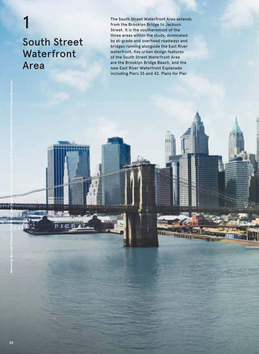
1South Street Waterfront Area
The South Street Waterfront Area extends
from the Brooklyn Bridge to Jackson
Street. It is the southernmost of the
three areas within the study, dominated
by at-grade and overhead roadways and
bridges running alongside the East River
waterfront. Key urban design features
of the South Street Waterfront Area
are the Brooklyn Bridge Beach, and the
new East River Waterfront Esplanade
including Piers 35 and 42. Plans for Pier
Man
hat
tan
Bo
roug
h P
resi
den
t Sc
ott
M. S
trin
ger,
Ass
emb
lym
emb
er B
rian
Kav
anag
h, N
YS D
epar
tmen
t o
f St
ate
Div
isio
n o
f C
oas
tal R
eso
urce
s
30
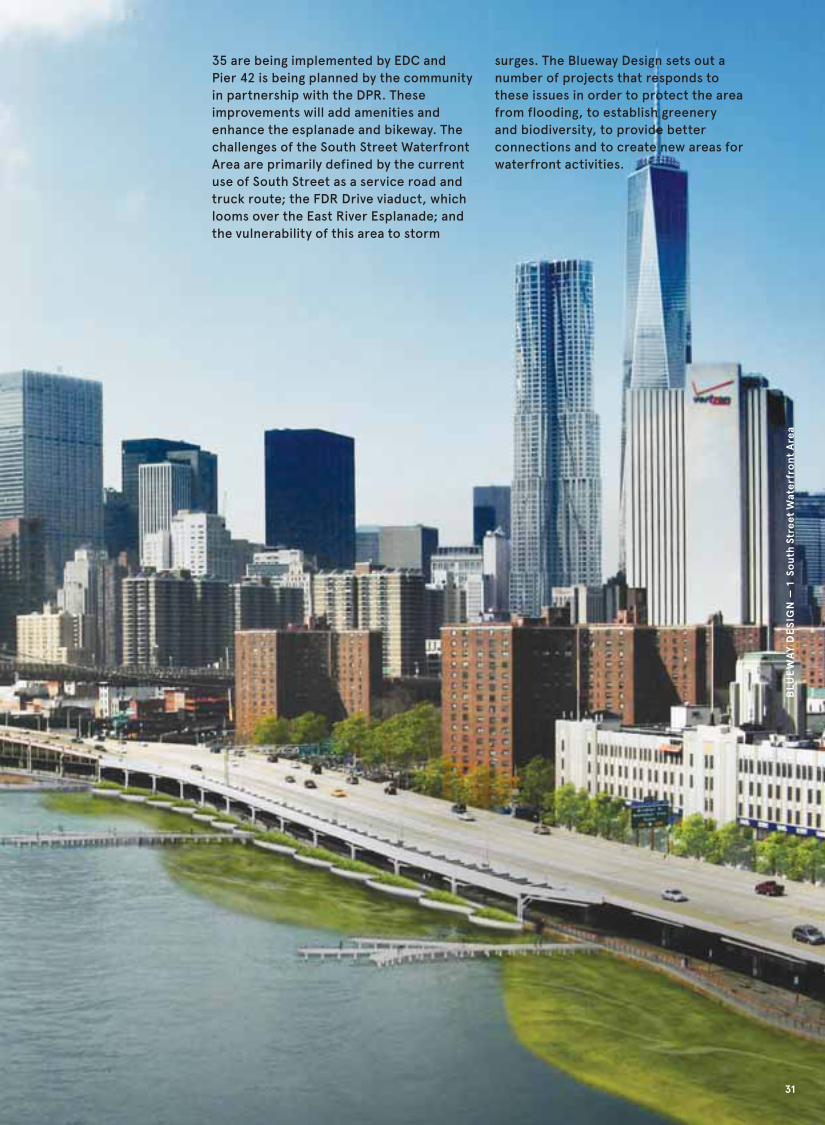
35 are being implemented by EDC and
Pier 42 is being planned by the community
in partnership with the DPR. These
improvements will add amenities and
enhance the esplanade and bikeway. The
challenges of the South Street Waterfront
Area are primarily defined by the current
use of South Street as a service road and
truck route; the FDR Drive viaduct, which
looms over the East River Esplanade; and
the vulnerability of this area to storm
surges. The Blueway Design sets out a
number of projects that responds to
these issues in order to protect the area
from flooding, to establish greenery
and biodiversity, to provide better
connections and to create new areas for
waterfront activities.
BLU
EW
AY
DE
SIG
N —
1 S
out
h St
reet
Wat
erfr
ont
Are
a
31

Blueway Design for the South Street Waterfront Area outlines 9 key projects and guidelines
1
5
5
5
2
3
4
4
6
6
6
7
7
8
9
10
Catherine Slip
U.S. P
ierh
ead Lin
e
U.S. Bulkhead Line
Market Slip
Robert F. Wagner Sr. Pl.
Blueway Design
Other Proposed or Planned Projects
Bikeway
Historic Shoreline
32
Man
hat
tan
Bo
roug
h P
resi
den
t Sc
ott
M. S
trin
ger,
Ass
emb
lym
emb
er B
rian
Kav
anag
h, N
YS D
epar
tmen
t o
f St
ate
Div
isio
n o
f C
oas
tal R
eso
urce
s

BLU
EW
AY
DE
SIG
N —
1 S
out
h St
reet
Wat
erfr
ont
Are
a
5
6
7
8
8
9
9
4. Treat Runoff From The FDR Drive Through Planting StrategiesThis captures runoff
from the FDR Drive
downspouts in
constructed freshwater
wetlands, which
currently runs into
the East River.
Construct Additional PiersThis creates three
fishing and lookout piers
and two piers (Pier 19,
north of the South
Street Seaport and at
Pier 35) that could be
used as ferry landings.
6. Complete Streets ProgramThis program empha-
sizes new street trees
and bioswale bump-outs
to improve stormwater
management.
7. Construct and Bring Back Salt Marshes And Habitat Restoration This incorporates
constructed saltwater
marsh and smaller
interventions like reef
balls.
8. Safe Crosswalks At All Blocks Along South Street and New Bikeway ConnectionsThis provides a new
crosswalk and light at
Robert F. Wagner Sr.
Place and a bikeway
extended down Clinton
Street to the Esplanade.
9. South Street Building FrontageThis widens sidewalks
and street trees and
encourages new
buildings in the long
term to have entrances
directly on South Street.
Other Proposed or Planned Projects(10) New bikeway part of
the EDC East River
Waterfront Plan; (11)
Rutgers Pavilion, EDC
East River Waterfront
Plan; (12) Crossing at
Rutgers Slip and South
St. Intersection, DOT
Planned project; (13)
New raised table to
calm traffic exiting the
FDR Drive; (14) Improved
wayfinding from E.
Broadway F train; (15)
Package 3 of the EDC
East River Waterfront
plan; (16) New Center
for Palliative Care,
Private project; (17) Pier
35 / Eco Park, EDC East
River Waterfront Plan
1. Restore Shoreline and Decrease Bulkhead ConditionsThis creates steps down
to the Brooklyn Bridge
Beach and a riprap edge
along the beach.
2. Add Buffers To Slow Water Speed and Wave ActionThis includes saltwater
marsh planters in the
area around the
Brooklyn Bridge Beach.
3. Create Safe Access and Improve Beach Area For Boat Landing and SwimmingThe Brooklyn Bridge
Beach makes kayak
landings and wading
pools using filtered
river water publically
accessible, and
provides oversight of
the beach and pools
with a lido building.
11
12 1513
16
17
14
33
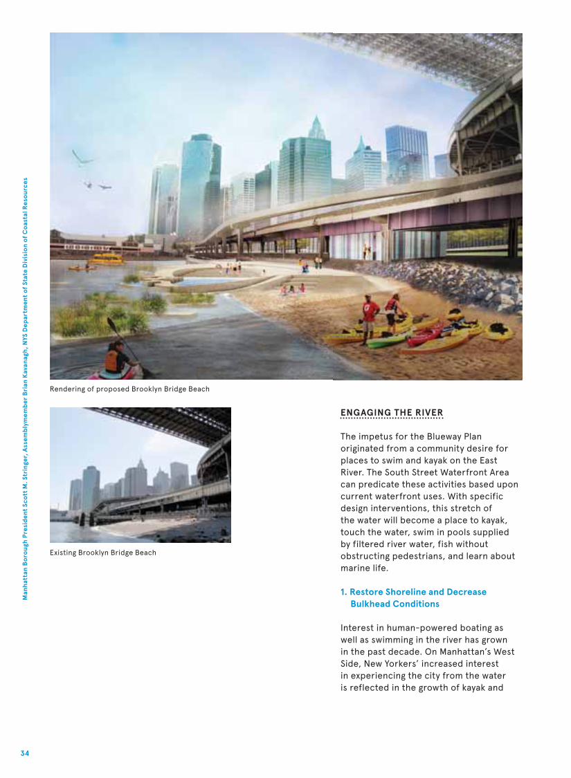
Rendering of proposed Brooklyn Bridge Beach
Existing Brooklyn Bridge Beach
ENGAGING THE RIVER
The impetus for the Blueway Plan
originated from a community desire for
places to swim and kayak on the East
River. The South Street Waterfront Area
can predicate these activities based upon
current waterfront uses. With specific
design interventions, this stretch of
the water will become a place to kayak,
touch the water, swim in pools supplied
by filtered river water, fish without
obstructing pedestrians, and learn about
marine life.
1. Restore Shoreline and Decrease Bulkhead Conditions
Interest in human-powered boating as
well as swimming in the river has grown
in the past decade. On Manhattan’s West
Side, New Yorkers’ increased interest
in experiencing the city from the water
is reflected in the growth of kayak and
34
Man
hat
tan
Bo
roug
h P
resi
den
t Sc
ott
M. S
trin
ger,
Ass
emb
lym
emb
er B
rian
Kav
anag
h, N
YS D
epar
tmen
t o
f St
ate
Div
isio
n o
f C
oas
tal R
eso
urce
s

canoe launches at Hudson River and
Riverside Parks. While there are eight
kayak launch sites in Manhattan along
the Hudson River, only two are available
along the East River, neither of which
are in Manhattan. Today, there are few
possibilities for swimming near the East
River. More than 94% of the area’s shoreline
is hard bulkhead and pile foundation,
creating barriers to accessing the water.
Brooklyn Bridge Beach, the only naturally
occurring beach along the site, is in high
demand from the community as an access
point into the water and has similarly been
pinpointed by the boating community as a
natural kayak launch site. While this sandy
area is a permitted kayak landing site, it is
not publicly accessible due to reasonable
concerns around the East River’s strong
currents and wave action, which are at
times unsafe for swimmers and kayakers.
2. Create Safe Access and Improve Beach Area For Boat Landing and Swimming
Preserving the beach and making it publicly
accessible as a designated landing and
launch site for human-powered boats, as
well as a place for walking on sand and
touching the water requires designing
ways to maintain and supervise this
access. The concept design combines
railing and gates with amphitheatre-style
steps from the esplanade to the beach
that function as both seating and landing
for kayaks. Brooklyn Bridge Beach offers
the opportunity to create a launch site
without having to build a dock or any other
complicated infrastructure. Challenges and
potential health risks relate to the proximity
to a combined sewer overflow (CSO) outfall,
a Coast Guard security zone, and an active
navigation channel, and washed up debris
impairing safe access.
The waterfront area adjacent to the natural
beach would benefit from access to safe
outdoor swimming and wading. Shallow
wading pools utilizing filtered river water
can be places for sunning, water play and
education about water safety. To ensure
the active management and supervision
of the site, the project proposes an urban
beach concession, a lido, under the FDR
Drive viaduct adjacent to the pools. This
affordable amenity for the public would
include restrooms, showers, changing
areas, lockers, facilities to rent towels, and
a place to buy snacks. The lido operator
would manage access and supervision to
the wading pools, the facilities and beach.
3. Add Buffers to Slow Water Speed and Wave Action
The East River’s tides and currents are of
concern when proposing programs that
promote human activity on and in the
water. Depending on the time of day or
month, weather, and nearby boat use, tidal
and current patterns vary widely, but can
be predicted nonetheless. Periods of lower
flow, known as slack tides, are relatively
safer than peak flow. These patterns can
inform planning decisions, identifying when
conditions are safer for waterborne activity
to occur. Because of safety considerations,
informational signage on currents and
slack tide patterns should be provided for
recreational boaters in conjunction with
making the beach publicly accessible.
Placement of salt marsh planters in the
river will reduce the wave action for
incoming kayakers and be part of a buffer
system to prevent large debris from
reaching the beach.
Additional Piers
Community support is strong for bringing
back piers for recreation and waterborne
transit. Three fishing piers are proposed
between Robert F. Wagner Sr. Place
and Market Slip. Rebuilding Pier 19 and
encouraging a ferry use at Pier 35 would
allow for the transportation of people and
goods by boat in the future. Fishing is an
important activity in the area, although
currently many fishermen prefer to do
their fishing north of Market Slip to avoid
their lines getting caught in the beams
overhanging the FDR Drive. Creating piers
south of Market Slip will facilitate fishing
and minimize conflicts between fishing
activities, joggers and other pedestrians
by providing more space for different
uses along the esplanade. Finger piers
can accommodate all these uses while
minimizing their footprint over the water.
BLU
EW
AY
DE
SIG
N —
1 S
out
h St
reet
Wat
erfr
ont
Are
a
35

PLANNING FOR RESILIENTNEIGHBORHOODS
The main contributors to contamination
in the East River are CSOs and direct
stormwater runoff from roadways. The
construction phases of the The East
River Esplanade project may include
sustainable stormwater management. The
implementation of green infrastructure
(GI) systems with the primary goal of
minimizing CSO events would also
significantly improve water quality
along the Blueway and incrementally
along the river. GI not only helps to
manage stormwater, it also plays a role
in improving air quality, enhancing
biodiversity, and beautifying the
environment.
5. Treat Runoff From FDR Drive Through Planting Strategies
The FDR Drive between the Brooklyn
Bridge and Market Slip contains
downspouts that discharge directly
into the East River through the East
River Esplanade. Proposed freshwater
wetlands that attach to and extend the
esplanade will capture and filter the FDR
Drive’s surface runoff, thereby helping
to minimize its impact on the East River
Bikeway South StreetSidewalk New
Trees
Proposed section at FDR Downspouts
Widened
Waterfront
Esplanade
water quality. The long-term care of the
freshwater wetland requires stewardship
and provides an opportunity for educating
the community on the local and regional
marine ecology. The wetland would also
soften the otherwise hard bulkhead edge
by adding plantings. This transformed
bulkhead could become a model for
multi-functional edge treatments for
similar areas along the city’s shoreline.
6. Complete Streets Program
Green infrastructure along South
Street, between the Brooklyn Bridge
and Montgomery Street would also
improve East River water quality.
Street and sidewalk storm detention
and infiltration such as vegetated
bioswales and permeable surfaces tied
to subgrade storage would capture and
filter stormwater diverted from the
public right-of-way on South Street. If
the existing wastewater infrastructure
does not connect to a combined sewer,
GI facilities would prioritize treatment of
polluted surface runoff. New guidelines
and goals for water quality are proposed
for the public right-of-way, as set forth
in the New York State Department of
Environmental Conservation’s (DEC)
Stormwater Management Design Manual,
36
Man
hat
tan
Bo
roug
h P
resi
den
t Sc
ott
M. S
trin
ger,
Ass
emb
lym
emb
er B
rian
Kav
anag
h, N
YS D
epar
tmen
t o
f St
ate
Div
isio
n o
f C
oas
tal R
eso
urce
s

Salt marsh and construction and pier removal at
Brooklyn Bridge Park
New York City Department of Design and
Construction’s (DDC) High Performance
Infrastructure Guidelines, and New
York City Department of Environmental
Protection’s (DEP) storm discharge
requirements.
7. Construct Salt Marshes and Habitats
Habitat restoration efforts contribute to
the recovery of key target species, which
is a process that helps improve river
water quality. Due to habitat elimination,
over-fishing, and contamination, large
populations of marine life have been
depleted from the East River estuary. The
Blueway Plan targets the water’s edge in
supporting new habitat creation. Native
to the Northeast, the creation of salt
marshes from Robert F. Wagner Sr. Place
to Pier 35 will increase biodiversity. Salt
marshes are one of the most biologically
productive ecosystems that can be
created along the East River shoreline;
they are homes to filter-feeding oysters
and mussels, establish habitat that
attracts foraging birds, provide breeding
and hatching grounds for fish, and
promote the growth of stable riverbed
(benthic) communities that extend well
beyond the marsh footprint. Salt marshes
also sequester pollutants from the
Constructed Eco-systems
Freshwater wetland—
captures and filters downspout runoff
Tidal pool—large rocks provide habitat
Salt marsh
Tidal channel
river, and provide breeding and feeding
grounds for harbor herons, raptors and
migratory birds along the Atlantic Flyway.
Incorporating a salt marsh along this
stretch would have the added benefit of
dissipating wave energy from the East
River, thereby minimizing the kind of
damage caused by storm surges.
In order to simulate the conditions of
a protected cove, a low barrier marsh
is constructed and backfilled on the
landward side to raise grades to the
proper elevation for inter-tidal marsh.
The constructed marsh could be
integrated with proposals for seawalls
and other harbor-wide storm surge
protection strategies.
In addition to the salt marsh, reef balls
placed adjacent to the bulkhead along
the bottom of the East River south of the
Brooklyn Bridge Beach represent another
opportunity for habitat construction.
Reef balls are small concrete structures
that are designed with varying sized
holes to provide hiding places for
small crabs and fish, and have solid
surfaces for mussels, oysters, clams,
barnacles, and vegetation to attach to.
The presence of mussels and oysters
improves water quality and sediment
quality, and generates additional habitat
and foraging grounds for other marine
species. Pilot studies would aid in the
evaluation of these techniques’ tradeoffs
by the Department of Environmental
Conservation. This comparison with the
current East River habitat is essential for
any changes proposed in the East River.
BLU
EW
AY
DE
SIG
N —
1 S
out
h St
reet
Wat
erfr
ont
Are
a
37

Existing esplanade along South Street underneath the FDR Drive,
with downspouts emptying into the East River
IMPROVING AND EXPANDINGNEIGHBORHOOD ACCESS
The community workshops and project
analysis led to recommendations about
improving intersections along the East
River Blueway study area, where pedestrian
and cyclist accidents and fatalities have
occurred. They recognized that in order to
have an active waterfront, improving the
ways people get there is imperative.
There are particular challenges where
pedestrians and bicyclists are crossing
underneath the FDR Drive viaduct. The
South Street Waterfront Area has four
existing at-grade access points. One of the
communities’ most immediate concerns
was safe access to the waterfront. This
includes new crosswalks and pedestrian
signals at popular intersections, as well as
incorporating traffic calming measures to
slow down traffic, using South Street as an
alternate to the FDR Drive, and placing
better wayfinding signage throughout the
area.
8. Safe Crosswalks At All Blocks Along South Street
Because of its proximity to the East
Broadway subway station and the planned
Pier 35 Eco Park, the Rutgers Slip and
South Street intersection was identified in
community meetings as a priority site for a
new crosswalk and traffic light. DOT is
planning a crosswalk and signal at this
intersection. More traffic calming
38
Man
hat
tan
Bo
roug
h P
resi
den
t Sc
ott
M. S
trin
ger,
Ass
emb
lym
emb
er B
rian
Kav
anag
h, N
YS D
epar
tmen
t o
f St
ate
Div
isio
n o
f C
oas
tal R
eso
urce
s

Rendering of proposed East River Esplanade
measures such as a raised table, similar to
a low and wide speed bump, could slow
down cars speeding down South Street.
New neighborhood wayfinding can direct
people from the East Broadway subway to
the waterfront.
Other intersections where new crosswalks
are needed along South Street include
Robert F. Wagner Sr. Place and Clinton
Street. A crosswalk at Robert F. Wagner Sr.
Place would allow residents from Alfred E.
Smith houses, which houses approximately
4,300 residents, to easily access the
Brooklyn Bridge Beach and wading pool.
Data shows that the intersection at Robert
F. Wagner Sr. Place has experienced over
eight accidents and one fatality from 1995
to 2009. Safe access at this intersection
needs to be ensured to avoid any future
tragedies. A crosswalk at Clinton Street is
proposed where none exists today. While
this pedestrian intersection is not as high
demand today as compared to Rutgers Slip
or Robert F. Wagner Sr. Place, this will
change over time. Clinton Street can
become an important bicycle connection
between the Williamsburg Bridge bicycle
and pedestrian access point and the South
Street waterfront. Located between Pier
35 and Pier 42, this intersection will only
increase in use as these piers are
developed for public use in the near
future. To improve this link, the new
two-way bike lane recently installed on
Clinton Street between Delancey Street
and Grand Street should extend down to
the waterfront.
BLU
EW
AY
DE
SIG
N —
1 S
out
h St
reet
Wat
erfr
ont
Are
a
39

CREATING WATERFRONT CONTINUITY
While a continuous esplanade exists along
the East River in this section of the Blueway
study area, the South Street corridor is
not attractive. Without regular crossings
at each intersection on South Street,
people travelling to the East River must
walk along South Street for a number
of blocks before getting to a safe crossing.
As a result, creating a better environment
along South Street was noted by community
residents and is an important corollary
to creating strong waterfront continuity.
9. South Street Building Frontage
South Street’s current condition is
reinforced by heavy truck use and it being
a popular alternative route to the FDR
Drive. Long-distance tour buses park
on South Street and create another barrier
to the river. The positioning of the existing
PPP
Enforce
no bus
parking
Lighting
Bikeway South StreetSidewalk New
Trees
and
BioswaleProposed section at Market Slip
40
Man
hat
tan
Bo
roug
h P
resi
den
t Sc
ott
M. S
trin
ger,
Ass
emb
lym
emb
er B
rian
Kav
anag
h, N
YS D
epar
tmen
t o
f St
ate
Div
isio
n o
f C
oas
tal R
eso
urce
s

Fishing and Lookout Pier adjacent to
Salt Marsh and Riprap
Riprap Salt marsh
Wave attenuation wall—
top elevation greater
than MHHW
buildings, with few front doors opening
onto South Street, and the current land
uses, dominated by parking lots and
lack of retail uses, further reinforce
the perception that South Street is not
for people. The public realm does little
to encourage pedestrian use. Narrow
sidewalks, unattractive lighting, and the
lack of street trees create unpleasant
conditions for people.
Transforming South Street which fronts on
to the East River Esplanade from a service
road to a waterfront boulevard is seen as
a two-pronged strategy. In the long term,
the community review process should
encourage development sites along South
Street to have a stronger front door
presence to the East River, and systemic
approaches to make South Street less of
a service road. The nearer term approach
considers street crossings (discussed
earlier), methods for improving the
public realm by widening the sidewalk
and adding street trees and planting.
Management approaches include
charging fines for layovers to discourage
charter and tour buses from forming a
wall of buses along South Street.
One of the simplest and most effective
ways to create a safe, continuous, and
attractive waterfront is to improve the
lighting under the FDR Drive Viaduct.
Lighting the underside of FDR Drive and
approach roads will make these areas
more inviting. Vertical surfaces painted
to reflect light could also help draw
people to the water’s edge and make the
underpass less foreboding. By providing
the appropriate electrical infrastructure,
this area also has the potential for art
installations and seasonal displays that
will add to the area’s street activity.
Widened
Waterfront
Esplanade
BLU
EW
AY
DE
SIG
N —
1 S
out
h St
reet
Wat
erfr
ont
Are
a
41

Man
hat
tan
Bo
roug
h P
resi
den
t Sc
ott
M. S
trin
ger,
Ass
emb
lym
emb
er B
rian
Kav
anag
h, N
YS D
epar
tmen
t o
f St
ate
Div
isio
n o
f C
oas
tal R
eso
urce
s
42

The East River Park Waterfront Area is a
57–acre New York City public park that
extends along the East River from Jackson
Street to East 14th Street. Key urban design
features are the large-scale public and
private housing developments, the FDR
Drive and East River Park with its many
features including; playing fields, an
amphitheatre, a promenade, the East River
Greenway as well as the five pedestrian
bridges connecting the community with the
waterfront. The challenges of the East River
Waterfront Area are primarily defined by
the current use of the East River Greenway
as a park road and the limited connections
bridging over the FDR Drive to the water.
The Blueway Design sets out a number of
projects that responds to these issues in
order to protect the area from flooding,
provide a sustainable model for pedestrian
and bicycle access to and from East River
Park and create new activities to facilitate
enjoyment of the natural environment.
BLU
EW
AY
DE
SIG
N —
2 E
ast
Riv
er P
ark
Wat
erfr
ont
Are
a
2 East River ParkWaterfront Area
43

Blueway Design for the East River Park Waterfront Area outlines 9 key projects and guidelines
1
2
6
7
7 8
Blueway Design
Other Proposed or Planned Projects
Bikeway
Historic Shoreline
44
Man
hat
tan
Bo
roug
h P
resi
den
t Sc
ott
M. S
trin
ger,
Ass
emb
lym
emb
er B
rian
Kav
anag
h, N
YS D
epar
tmen
t o
f St
ate
Div
isio
n o
f C
oas
tal R
eso
urce
s

BLU
EW
AY
DE
SIG
N —
2 E
ast
Riv
er P
ark
Wat
erfr
ont
Are
a
5
3
4
9
4. Provide New Vantage Points and Functionality for the East 6th Street BridgeThis expands the bridge
to accommodate many
users, and provides new
opportunities for
experiencing East River
Park.
East 10th Street Bridge to the WaterThis widens the already
popular bridge while
incorporating direct
access to the water.
6. Capture Stormwater in Recreation Field Detention BasinsThis utlitizes the
ballfields’ large area
and underground space
to minimize sewage
discharge into the East
River.
7. Develop “Green Fingers” as Guides to Waterfront Access PointsThis increases the
attractiveness of the
entryways to East River
Park, while filtering
runoff.
8. Elevate East River Park Greenway for Infrastructure and Mode SeparationThis entices park users
to use the inner
pathway, simultaneously
providing space for
infrastructure.
9. Create the Blueway Crossing to Eliminate Esplanade Bottlenecks and Protect Critical InfrastructureThis provides new, safer
north-south and
east-west linkages,
while incorporating
flood protection.
1. Connecting Two Parks—Corlears Hook Park and East River Park This seamlessly
connects Corlears Hook
and East River Parks
with greenery and
plantings, bringing new
users to both parks.
2. Connect the East River to the Growing Neighborhood at Delancey StreetThis bridge welcomes
the growing Lower East
Side community into
East River Park.
3. Reduce Pedestrian-Car Conflicts with Traffic Calming on the East Houston Street OverpassThis extends the street
grid into East River
Park, providing a safe
gateway for pedestrians
and cyclists.
6
6
6
7
7
8
8
45

Vancouver Land Bridge, Washington State The Green Bridge in Mile End Park, London, UK
IMPROVING COMMUNITY ACCESS
During the Blueway community
workshops, area residents and park users
made clear that access to East River
Park is a top concern. The distances
between the five neighborhood access
points to the park are substantial with
confusing and low quality crossings.
All of the overpasses are in need of
significant rehabilitation. Most are not
ADA-compliant and do not provide
sufficient width to comfortably
accommodate combined bicycle and
pedestrian crossing. Reconsidering the
design of these access points will improve
connections to the East River Park and
integrate existing activity spaces with the
adjacent neighborhoods. The redesigned
crossings will act as dynamic gateways
to the East River, and they will more
comprehensively link the communities
upland from the FDR Drive to the
water’s edge.
1. Connecting Two Parks— Corlears Hook Park and East River Park
Corlears Hook Bridge is the southernmost
pedestrian bridge into East River
Park. It connects Corlears Hook Park,
located between the FDR Drive and
the intersection of Cherry and Jackson
Streets, to East River Park. While Corlears
Hook Park is almost half the size of
Tompkins Square Park and in close vicinity
to residential neighborhoods, it is largely
underused. Corlears Hook Park is tucked
away behind large housing developments,
with portions of its edge facing a parking
lot. The park’s lack of visibility and
wayfinding signage lead to low level use
of the Corlears Hook Bridge, which takes
pedestrians into the East River Park
amphitheatre.
Despite being the widest of all the
pedestrian bridges into East River
Park, Corlears Hook Bridge has the
lowest pedestrian usage (based on this
study’s pedestrian counts). The lack
of activities and minimal programming
at the amphitheatre further adds to
the general neglect of the bridge. The
2,500–seat amphitheatre, just south of
the Williamsburg Bridge in East River Park,
sits between the East River and the FDR
Drive. The amphitheatre underwent some
restoration in December of 2011 after
falling into disrepair in previous decades.
To activate this portion of East River Park,
Corlears Hook Park must become more
visible from Grand Street, the park’s
main access road. To achieve greater
connectivity from Grand Street, Corlears
Hook Park would be extended north on
the west side of the FDR Drive along the
median between FDR Drive and its service
road. The eastern edge of Grand Street
would be landscaped with trees and
plantings to guide pedestrians and cyclists
46
Man
hat
tan
Bo
roug
h P
resi
den
t Sc
ott
M. S
trin
ger,
Ass
emb
lym
emb
er B
rian
Kav
anag
h, N
YS D
epar
tmen
t o
f St
ate
Div
isio
n o
f C
oas
tal R
eso
urce
s

into the park, and provide a visual barrier
to the FDR Drive.
The East River Park’s amphitheatre is
greatly underutilized. To encourage more
day-long and year-round programming,
step lights and infrastructure for
enhanced event lighting should be
incorporated into the amphitheatre’s
design. The bridge provides another
opportunity for distinctive lighting to
illuminate paths between trees and
encourage safe nighttime use.
The connection to East River Park
at Corlears Hook also presents an
opportunity to re-conceive the bridges
along the park as higher performance
structures. Green roof technology could
be implemented to reduce stormwater
run-off into the combined sewers, and
decrease the heat island effect. This
emphasis on stormwater management
would tie into a larger vision for the
area being driven by the Lower East Side
Ecology Center’s plans for a constructed
wetland south of the amphitheatre.
A vegetated green bridge, like those
pictured on the previous page, would
seamlessly blend the two parks,
transforming the pedestrian and cyclist
experience across the bridge into one
continuous park. With the amphitheatre
lying on the same axis as the bridge, this
connection would act as an important
gateway into the park. Designated bicyclist
routes over the bridge and on Jackson
Street, along with new wayfinding signage
on Grand Street, would also contribute to
the bridge’s role as a prominent access
point to East River Park.
I
C
B
E
F
Grand St.
Jackson St.
Cherry St.
FDR Drive
FD
R D
rive
J
A
Proposed continuous landscaped connection between Corlears Hook and East River Park
(A) New street trees; (B) New bike lane on Jefferson St.; (C) Permeable pavers; (D) Bioswale bump-outs;
(E) New planted Bridge; (F) New amphitheatre programming; (G) Ballfield stormwater storage;
(H) Extended Corlears Hook Park with street visibility; (I) Lower East Side Ecology Center constructed
wetland, planned; (J) Development of Pier 42
D
G
H
A
A
Blueway Design
Other Proposed or Planned Projects
Bikeway
Historic Shoreline
BLU
EW
AY
DE
SIG
N —
2 E
ast
Riv
er P
ark
Wat
erfr
ont
Are
a
47

2. Connect the East River to the Growing Neighborhood at Delancey Street
Community members expressed
significant interest in improving Delancey
Street, west of Clinton Street, as an
important pedestrian connection point
to the waterfront. The eastern end of
Delancey Street is currently dominated
by parking areas, with an overpass to the
park that is not ADA-compliant on one
side. In addition, the overpass abutment
sticks out slightly over the East River
Greenway and was the cause of death for
one cyclist who did not see it and struck
it while riding by.
The planned development of the Seward
Park Urban Renewal Area (SPURA), a nine
block mixed-used development plan along
Delancey Street, presents an opportunity
to provide a whole new community with
good access to the water’s edge. Delancey
Street is relatively wide to the east of
Clinton Street, particularly alongside the
Williamsburg Bridge, which offers space
for public realm improvements that would
extend down to the East River.
Improved streetscapes with trees and
plazas would establish a more beautiful
and accessible gateway to the waterfront.
This East River link should include an
ADA-compliant bridge near current bus
stops, allowing people to take public
transit almost to the water’s edge. The
bridge would be an extension of the
improved Delancey streetscape, with
seating areas and ornamental tree
planters, connecting Delancey Street
across the park road to the East River
Esplanade.
Grand St.
FDR D
rive
Delancey St.
Man
gin
St.
Bar
uch
Pl.
Proposed reconceived Delancey Street Bridge into East River Park
(A) New street trees; (B) New bridge from 12–30 ft. wide; (C) New green space at the end of crosswalks;
(D) Connection to SPURA development; (E) New crosswalk at Baruch Pl. to connect to north side
of Delancey; (F) New street trees and promenade; (G) Steps to waterfront promenade; (H) Overlook;
(I) New grilling area at Dance Circle
A
B
C
D
C
E
F
HG
I
J
Blueway Design
Bikeway
Historic Shoreline
48
Man
hat
tan
Bo
roug
h P
resi
den
t Sc
ott
M. S
trin
ger,
Ass
emb
lym
emb
er B
rian
Kav
anag
h, N
YS D
epar
tmen
t o
f St
ate
Div
isio
n o
f C
oas
tal R
eso
urce
s

3. Reduce Pedestrian-Car Conflicts with Traffic Calming on The East Houston Street Overpass
The East Houston Street overpass is one
of the most important entry points to the
East River waterfront parks. The overpass
is unique for the neighborhood in that it is
not a pedestrian bridge, but an extension
of the street grid above the park, with
ramps extending down to the park’s level.
The redesigned overpass is envisioned as a
gateway, prioritizing safe green spaces for
pedestrians and cyclists.
The NYC Department of Transportation is
in the process of installing traffic lights and
pedestrian signals at this intersection, which
is currently very difficult to cross. In addition
to this necessary work, other traffic calming
strategies should be implemented to ensure
that traffic from the FDR Drive off-ramp
slows before reaching the East Houston
Street intersection. Enlarging the traffic
island median to prevent direct access
to the FDR Drive and service road would
help to calm traffic. This traffic island
could be developed as a rain garden and
incorporate commemorative features.
Additionally, replacing pavement at
crossings in this area with cobblestone
pavers would slow down cars because of
the rough surface, creating a safer zone
for pedestrians. Permeable paving would
add stormwater management benefits.
Finally, a shaded overlook on the East
River ballfields can be integrated into
the crossing. This shade structure is en-
visioned with solar panels, a concession
stand for snacks and public restrooms
tucked under the overlook platform.
E. Houston St.
FDR Drive
Proposed pedestrianized East Houston Street Overpass
(A) New street trees; (B) Bike path; (C) Food concession under widened overlook; (D) Ballfield stormwater
storage; (E) Widened entry; (F) Cobbles, slow down cars with rough surface, creates precinct; (G) Shade
structure with solar panels; (H) Stormwater retention; (I) Join medians; (J) Cars loop around to access the
FDR Drive Service Road; (K) New planting; (L) Traffic light and pedestrian signal
A
F
H
I
G
E
B
C
D
A
K
K
L
J
Blueway Design
Other Proposed or Planned Projects
Bikeway
Historic Shoreline
BLU
EW
AY
DE
SIG
N —
2 E
ast
Riv
er P
ark
Wat
erfr
ont
Are
a
49

ENGAGING THE RIVER
East River Park offers residents of the
Lower East Side and the city a tremendous
array of ballfields and courts for active
recreation. The park’s design, with large
areas of playing fields surrounded by
fencing, and with pedestrian bridges that
ramp down the greenway at the edge of
the FDR Drive, makes it very difficult for
visitors to reach the East River Esplanade.
The re-design of the pedestrian bridges,
particularly at East 6th Street, East 10th
Street and as described at Delancey
Street, would allow visitors to have a path
leading directly to the river.
4. Provide New Vantage Points and Functionality for the East 6th Street Bridge
At around six feet wide, the current
East 6th Street Bridge is too narrow to
accommodate both pedestrians and
cyclists. The bridge has little visible
presence on East 6th Street. Despite
these physical disadvantages, data
collected at this bridge suggests that it is
a popular access point to East River Park
during the weekends. Relatively high
usage could be due to the bridge’s close
proximity to the track house, a popular
landmark in East River Park.
To increase the bridge’s visibility from
East 6th Street, a new and wider (12-foot)
bridge should be constructed, starting
on East 6th Street and forking into two
paths on the east side of FDR Drive. The
bridge is envisioned as two integrated
paths: one path descending to the
greenway, and the other continuing as
a tree “canopy walk.” The descending
greenway ramp could provide space
for a café and bike rental conveniently
adjacent to the existing track house.
E. 6th St.
FDR D
rive
Proposed extension of the East 6th Street Bridge into the East River Park treetops
(A) New street trees; (B) Rain gardens; (C) Tree canopy walk; (D) Overlook and steps to waterfront
promenade; (E) Bioswale bump-outs; (F) Visible from E. 6th St.; (G) New bridge 12 ft. wide; (H) Cafe and
bike rental with green roof; (I) Solar panels on track house roof; (J) Ballfield stormwater storage
A
C
I
H
J
B
G
E
F
D
Blueway Design
Bikeway
50
Man
hat
tan
Bo
roug
h P
resi
den
t Sc
ott
M. S
trin
ger,
Ass
emb
lym
emb
er B
rian
Kav
anag
h, N
YS D
epar
tmen
t o
f St
ate
Div
isio
n o
f C
oas
tal R
eso
urce
s

Rendering of proposed East 6th Street Tree Canopy Walk
Tree Canopy, UPenn, Philadelphia, PA
Existing view of treescape at East 6th Street in
East River Park
The “canopy walk” is inspired by
community desires to integrate more
passive recreational activities into
the East River Park, which is currently
dominated by organized sports space.
The thick tree canopy in this area of the
park, just south of the field and track, is
striking. With such a beautiful array of
mature trees, there is an opportunity to
create an elevated “canopy walk” that
snakes through these trees, offering
new and unexpected views of the river.
A space for passive recreation in a park
defined by its active recreation would
diversify the types of activity in the park.
At the end of the canopy walk would
be an overlook that juts out over the
existing inlet cove, with stairs to access
the promenade directly. The canopy walk
section of the bridge could be secured
with a gate after the park hour without
closing off the rest of the bridge.
BLU
EW
AY
DE
SIG
N —
2 E
ast
Riv
er P
ark
Wat
erfr
ont
Are
a
51

Bridge to the Water
Similar to the East 6th Street Bridge, the
East 10th Street Bridge is highly active
due to the popular activities nearby in the
Park. Pedestrian counts data gathered
in this study indicates the East 10th
Street Bridge had the highest pedestrian
counts of any bridge or crossing during
the study period. This is not surprising
since the East 10th Street area is the
only park location with a playground and
picnic areas with grills and tables. During
community workshops, it became evident
that demand for these grills is high.
Creating a second grilling area within the
currently underused dance circle between
Delancey Street and East Houston Street
would help alleviate some of this demand.
A new, wider pedestrian bridge is needed
given the popularity of the East 10th
Street area among nearby residents.
The bridge could also integrate new and
existing amenities. For example, instead
of separate restrooms and baseball
bleachers, the new East 10th Street Bridge
consolidates these functions as well as
a new food vendor within the bridge
structure itself.
E. 10th St.
FDR D
rive
Aven
ue D
East 10th Street Bridge into East River Park integrated with amenities
(A) New street trees; (B) Ballfield stormwater storage; (C) Bleacher seating;
(D) Concession and restrooms; (E) New bridge 12–40 ft. wide; (F) Bioswale
A
E
F
B
C
D
F
AF
Blueway Design
Bikeway
52
Man
hat
tan
Bo
roug
h P
resi
den
t Sc
ott
M. S
trin
ger,
Ass
emb
lym
emb
er B
rian
Kav
anag
h, N
YS D
epar
tmen
t o
f St
ate
Div
isio
n o
f C
oas
tal R
eso
urce
s
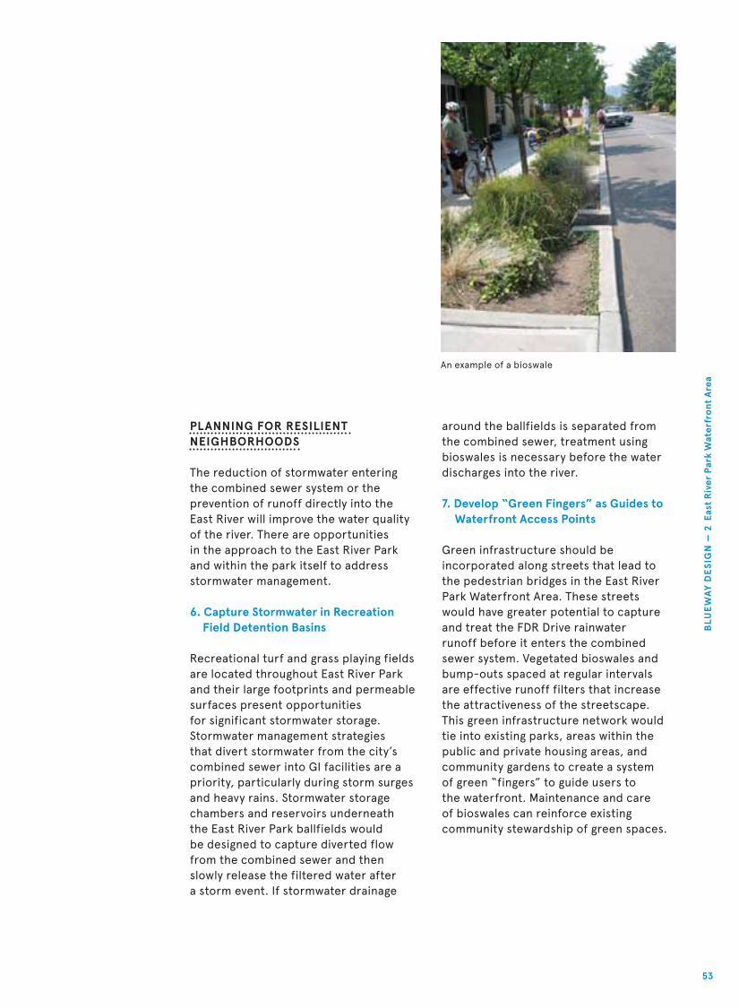
An example of a bioswale
PLANNING FOR RESILIENT NEIGHBORHOODS
The reduction of stormwater entering
the combined sewer system or the
prevention of runoff directly into the
East River will improve the water quality
of the river. There are opportunities
in the approach to the East River Park
and within the park itself to address
stormwater management.
6. Capture Stormwater in Recreation Field Detention Basins
Recreational turf and grass playing fields
are located throughout East River Park
and their large footprints and permeable
surfaces present opportunities
for significant stormwater storage.
Stormwater management strategies
that divert stormwater from the city’s
combined sewer into GI facilities are a
priority, particularly during storm surges
and heavy rains. Stormwater storage
chambers and reservoirs underneath
the East River Park ballfields would
be designed to capture diverted flow
from the combined sewer and then
slowly release the filtered water after
a storm event. If stormwater drainage
around the ballfields is separated from
the combined sewer, treatment using
bioswales is necessary before the water
discharges into the river.
7. Develop “Green Fingers” as Guides to Waterfront Access Points
Green infrastructure should be
incorporated along streets that lead to
the pedestrian bridges in the East River
Park Waterfront Area. These streets
would have greater potential to capture
and treat the FDR Drive rainwater
runoff before it enters the combined
sewer system. Vegetated bioswales and
bump-outs spaced at regular intervals
are effective runoff filters that increase
the attractiveness of the streetscape.
This green infrastructure network would
tie into existing parks, areas within the
public and private housing areas, and
community gardens to create a system
of green “fingers” to guide users to
the waterfront. Maintenance and care
of bioswales can reinforce existing
community stewardship of green spaces.
BLU
EW
AY
DE
SIG
N —
2 E
ast
Riv
er P
ark
Wat
erfr
ont
Are
a
53

Ballfield Stormwater StorageBicycle
Only
New
Trees
Pedestrian
Only
New
Trees
New
Trees
FDR Drive
Raised greenway for
flood protection
Battery Park City PromenadeAllegheny Riverfront Park, Pittsburgh, PA
Proposed section at East River Park
54
Man
hat
tan
Bo
roug
h P
resi
den
t Sc
ott
M. S
trin
ger,
Ass
emb
lym
emb
er B
rian
Kav
anag
h, N
YS D
epar
tmen
t o
f St
ate
Div
isio
n o
f C
oas
tal R
eso
urce
s

Inner
Walkway
Waterfront
Promenade
Ballfield Stormwater Storage New
Trees
New
Trees
CREATING WATERFRONT CONTINUITY
The East River Park Greenway is a bikeway
/walkway along the East River Park that
spans from Jackson Street to East 14th
Street. The greenway is widely used by
joggers, recreational cyclists, bicycle
commuters, and people accessing East
River Park. The path itself is in critical
need of attention. Potholes, uneven
surfaces, and cracks in the pavement
create an overall unpleasant experience.
Poor drainage causes pools of rainwater.
Proximity to the FDR Drive creates noise
issues. Service and maintenance vehicles
occasionally drive on the path, making the
route dangerous at times. Current plans
are underway to improve the quality of the
greenway. These can be expanded in ways
that combine various infrastructural and
logistical needs.
8. Elevate East River Park Greenway for Infrastructure and Mode Separation
A long-term solution to improve the
greenway is raising it above the current
at-grade level. By doing so, the greenway
could support infrastructure enhancements
as well as improved experience of the
park. The greenway could integrate utilities
and infrastructure under the path; more
effectively drain stormwater runoff (both
from the greenway itself and the FDR
Drive); create an effective storm surge
barrier for FDR Drive and adjacent
housing; and act as a noise attenuation
barrier for the park. Currently, there is
very little shade along the water’s edge
in East River Park. Rows of trees along
the wide promenade would provide this
shade and create different pedestrian
zones: a more shaded inner walkway
and an outer waterfront promenade
with plenty of sun. Similar to the Battery
Park City promenade, these zones would
separate pedestrian traffic with differing
elevations. Raising the inner walkway just
a couple of feet above the waterfront
promenade would also offer distinctive
variation in views of the river.
A new smooth and even path would
further encourage bicyclists, especially
commuters, to use the greenway as
opposed to the waterfront esplanade,
making this a much safer environment
for pedestrians. Separating pedestrian
and bicycle traffic on the greenway
would further improve safety. Wayfinding
signage and public maps throughout the
park would facilitate easier access to the
park and its amenities from the greenway.
Key sites for this type of signage would
be at the entrances to the park closest
to the overpasses.
BLU
EW
AY
DE
SIG
N —
2 E
ast
Riv
er P
ark
Wat
erfr
ont
Are
a
55

Rendering of the proposed Blueway Crossing looking north
Views of the pinch point looking north
56
Man
hat
tan
Bo
roug
h P
resi
den
t Sc
ott
M. S
trin
ger,
Ass
emb
lym
emb
er B
rian
Kav
anag
h, N
YS D
epar
tmen
t o
f St
ate
Div
isio
n o
f C
oas
tal R
eso
urce
s

Aerial view rendering of the Blueway Crossing
9. Create the Blueway Crossing to Eliminate Esplanade Bottlenecks and Protect Critical Infrastructure
A key crossing bottleneck exists between
the East River Park and Stuyvesant Cove /
Waterside Plaza Waterfront Areas.
The East River Blueway Plan proposes
the construction of a new crossing to
provide better connections along the
Blueway and to secure vital New York
City infrastructure.
At East 14th Street the greenway narrows
to approximately four feet wide to
accommodate the Con Ed power station
facilities and screen house. This narrow
width is dangerous for pedestrians and
cyclists that share the path, increasing
opportunities for collisions. Elevating the
greenway in this section to fly over the
FDR Drive presents the most feasible
solution to achieve a path wide enough
to accommodate both pedestrians and
cyclists. The Blueway Crossing’s X-shaped
bridge creates both a north-south and an
east-west connection. The bridge is a link
between the Jacob Riis Houses and East
10th Street, the East River Park, Murphy
Park and Avenue C, and Stuyvesant Cove.
This elevated structure would also offer
views of the water otherwise blocked by
the Con Ed facility. An elevated path
would also minimize pedestrian and
bicyclist exposure to the noise of the
highway below.
As Hurricane Sandy illustrated, the
proximity of the Con Ed facility to the
East River presents a critical
infrastructure weakness for the city.
This vulnerability can impact the city’s
power supply with tremendous cost.
The Blueway Crossing could act as a
flood barrier to protect this critical
infrastructure.
Concerns about the security of this
facility arose in community workshops
and conversations with Con Ed officials.
The Blueway Crossing provides a solution
by using the median of FDR Drive to
support an elevated pathway for
pedestrians and bicycles, separated from
the cars below. In addition to enhanced
public connection to the water, this
overpass structure would separate the
public from Con Ed’s facilities.
BLU
EW
AY
DE
SIG
N —
2 E
ast
Riv
er P
ark
Wat
erfr
ont
Are
a
57

Bird’s-eye view of existing pinch point looking west
Elevated Esplanade FDR Drive
Proposed section north of the Con Ed facility
58
Man
hat
tan
Bo
roug
h P
resi
den
t Sc
ott
M. S
trin
ger,
Ass
emb
lym
emb
er B
rian
Kav
anag
h, N
YS D
epar
tmen
t o
f St
ate
Div
isio
n o
f C
oas
tal R
eso
urce
s

Rendered Bird’s-eye view of the proposed Blueway Crossing
Elevated Esplanade Salt Marsh and Riprap
Riprap Salt marsh Wave attenuation wall—
top elevation greater
than MHHW
FDR Drive
BLU
EW
AY
DE
SIG
N —
2 E
ast
Riv
er P
ark
Wat
erfr
ont
Are
a
59

Rendering of the Blueway
Crossing and Flood Barrier,
salt marsh and pools
Man
hat
tan
Bo
roug
h P
resi
den
t Sc
ott
M. S
trin
ger,
Ass
emb
lym
emb
er B
rian
Kav
anag
h, N
YS D
epar
tmen
t o
f St
ate
Div
isio
n o
f C
oas
tal R
eso
urce
s
60

BLU
EW
AY
DE
SIG
N —
2 E
ast
Riv
er P
ark
Wat
erfr
ont
Are
a
61

Man
hat
tan
Bo
roug
h P
resi
den
t Sc
ott
M. S
trin
ger,
Ass
emb
lym
emb
er B
rian
Kav
anag
h, N
YS D
epar
tmen
t o
f St
ate
Div
isio
n o
f C
oas
tal R
eso
urce
s
62

The Stuyvesant Cove / Waterside Plaza Waterfront Area
spans from East 14th Street at the southern end to East
38th Street. It is the northernmost of the three areas
and sits entirely within the boundaries of Community
District 6. Its range of uses include hospitals, high-rise
housing developments, schools, marinas, heliports and
a waterfront restaurant. Key urban design features along
the water include Stuyvesant Cove, the Skyport Garage
and Skyport Marina, the United Nations International
School and Waterside Plaza, the East 34th Street Ferry
Terminal, and Glick Park. The challenges of the area are
primarily defined by the limits to continuity of the
bikeway and waterfront esplanade, the hard bulkhead
edge, the FDR Drive viaduct; and the vulnerability of
the area to storm surges. The Blueway Design sets out
a number of projects that responds to these issues in
order to protect the area from flooding, to establish
greenery and biodiversity, to provide better connections
and to create new areas for waterfront destinations.
3 Stuyvesant Cove/ Waterside Plaza Waterfront Area
63
BLU
EW
AY
DE
SIG
N —
3 S
tuyv
esan
t C
ove
/ W
ater
sid
e P
laza
Are
a

Blueway Design for theStuyvesant Cove / Waterside Plaza Area outlines 8 key projects and guidelines
Avenue C
E. 20th St.
E. 23rd St.
U.S. Pierh
ead Line
E. 25th St.
1
1
1
1
4
4
4
4
4
2
2
3
3
3
33
5
5
6
7
7
9
Blueway Design
Other Proposed or Planned Projects
Bikeway
Historic Shoreline
64
Man
hat
tan
Bo
roug
h P
resi
den
t Sc
ott
M. S
trin
ger,
Ass
emb
lym
emb
er B
rian
Kav
anag
h, N
YS D
epar
tmen
t o
f St
ate
Div
isio
n o
f C
oas
tal R
eso
urce
s

E. 34th St.
U.S. Pierhead Line
E. 36th St.
E. 37th St.
1. Create Areas for Both Human-Powered and Historic Vessels in Stuyvesant CoveThis provides a launch
that could be
implemented in the
short-term future
by Solar One and
reinstalled at a later
phase by the wading
pools, and a reconfig-
ured landing for
historic vessels and the
Skyports Seaplane.
2. Enlarge Marina to Create Space for Public Access to Boating FacilitiesThis creates space on
the upland side for
pedestrians and a UNIS
layby while carving out
more marina space
outboard for Skyport
Garage.
3. Support Safe Swimming and BoatingThis incorporates
wading pools using
filtered river water,
a lido to provide
amenities and oversight
of the pools, boat
storage and a kayak
landing area.
4. Restoring Intertidal Salt Marsh and Managing Stormwater With Complete StreetsThis includes
constructed salt marsh
with walkways in
Stuyvesant Cove and
upland stormwater
management measures
such as street trees,
bioswales and
permeable pavers.
5. Create a Continuous Waterfront Esplanade at The Marina Connecting to Waterside Plaza’s EsplanadeThis is facilitated by a
public walkway
wrapping around
Skyport Garage, the
marina, UNIS and
Waterside Plaza.
6. Create a Public Garden and Eatery at Skyport Garage RoofThis establishes public
access to the Skyport
Garage with new
amenities on the
rooftop.
7. New and Improved At-Grade Pedestrian Crossings Beneath the FDR Drive ViaductThis offers a series of
new and improved
crossings all along this
area from below East
20th Street to East
37th Street.
1
4
4
4 4
3
5
5
7
7
7
8
8
10
11
8. Increase and Enhanced Access to Glick ParkThis enables a bike
route connection, an
improved crossing and
lighting enhancements
in the underpass
entrance to Glick Park.
Other Proposed or Planned Projects (9) Solar 2, planned; (10)
34th St. ferry terminal
improvements, ongoing;
(11) Planned park at
former Con Ed site
65
BLU
EW
AY
DE
SIG
N —
3 S
tuyv
esan
t C
ove
/ W
ater
sid
e P
laza
Are
a

ENGAGING THE RIVER
Stuyvesant Cove Park is located between
East 18th Street and East 23rd Street.
A decade ago it was built from the
ground up through the hard work of
many dedicated community members
and organizations who transformed a
contaminated waterfront site into an
ecologically responsible public space.
Cherished by the community and
managed by the nonprofit organization
Solar One, this park is a testament to the
community-driven process that restored
a brownfield and developed a strategy
for maintenance. Located at a natural
inlet along the East River, the cove
benefits from slower currents than in
other parts of the study area, and
the community has advocated
for access to recreational boating
and other water activities here.
1. Create Areas for Both Human-Powered and Historic Vessels in Stuyvesant Cove
Stuyvesant Cove has the potential
to accommodate a wide variety of
recreational water activities on a
regular basis. The support for ongoing
waterfront activities requires creating
piers and accessible edges and separating
human-powered boating from larger,
non-motorized boats and marina
operations. These initiatives include a
human-powered boat launch, a boat
house, protected river pools with an
accompanying lido, an expanded publicly
accessible beach with steps, a mooring
area for non-motorized public boats,
and a dock for historic vessels.
In August 2012, human-powered boaters
and public water access advocates
convened at Stuyvesant Cove for an
afternoon of free public kayaking. The
event was a success, drawing a range of
people, from novice kayakers to boating
enthusiasts. This is paralleled by the
strong interest in a human-powered boat
launch in the near term, which could be
located alongside Solar One in the short-
term future. This launch could potentially
be shifted or supplemented by an
additional pier in a later phase nearer the
wading pools by the rocky outcropping.
Planning a public mooring area for other
non-motorized vessels is also strongly
supported. This mooring area could be
demarcated by a permanent educational
pier, located between Solar 2 to the
south and Skyport Garage to the north.
2. Enlarge Marina to Create Space for Public Access to Boating Facilities
Located at East 23rd Street, the Skyport
Garage offers an opportunity for an
Floating dock in Riverside Park, a potential interim human-powered boat launch
66
Man
hat
tan
Bo
roug
h P
resi
den
t Sc
ott
M. S
trin
ger,
Ass
emb
lym
emb
er B
rian
Kav
anag
h, N
YS D
epar
tmen
t o
f St
ate
Div
isio
n o
f C
oas
tal R
eso
urce
s
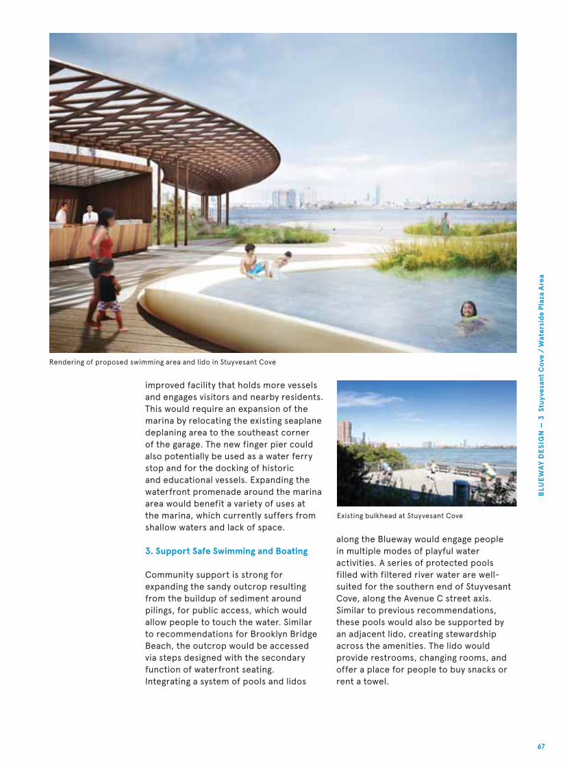
Rendering of proposed swimming area and lido in Stuyvesant Cove
Existing bulkhead at Stuyvesant Cove
along the Blueway would engage people
in multiple modes of playful water
activities. A series of protected pools
filled with filtered river water are well-
suited for the southern end of Stuyvesant
Cove, along the Avenue C street axis.
Similar to previous recommendations,
these pools would also be supported by
an adjacent lido, creating stewardship
across the amenities. The lido would
provide restrooms, changing rooms, and
offer a place for people to buy snacks or
rent a towel.
improved facility that holds more vessels
and engages visitors and nearby residents.
This would require an expansion of the
marina by relocating the existing seaplane
deplaning area to the southeast corner
of the garage. The new finger pier could
also potentially be used as a water ferry
stop and for the docking of historic
and educational vessels. Expanding the
waterfront promenade around the marina
area would benefit a variety of uses at
the marina, which currently suffers from
shallow waters and lack of space.
3. Support Safe Swimming and Boating
Community support is strong for
expanding the sandy outcrop resulting
from the buildup of sediment around
pilings, for public access, which would
allow people to touch the water. Similar
to recommendations for Brooklyn Bridge
Beach, the outcrop would be accessed
via steps designed with the secondary
function of waterfront seating.
Integrating a system of pools and lidos
BLU
EW
AY
DE
SIG
N —
3 S
tuyv
esan
t C
ove
/ W
ater
sid
e P
laza
Are
a
67

PLANNING FOR RESILIENTNEIGHBORHOODS
Several environmental challenges
are associated with programming at
Stuyvesant Cove. The park is located
near multiple CSOs, and sits adjacent
to an active navigation channel. Area
subsurface soils have been found to
contain contaminated sediment from
a former Manufactured Gas Plant site
at East 21st Street, under what now
constitutes about two-thirds of Peter
Cooper Village. Contamination has been
detected in groundwater, in Stuyvesant
Cove Park, and in sediments extending
500 feet deep into the riverbed of the
East River. However, no contamination
was detected in the surface water.
Any projects that contemplate piles
or below-grade work must consider
these findings and coordinate with Con
Existing riverwalk south of Stuyvesant Cove
Ed and the New York State Department
of Environmental Conservation. Due to
these environmental quality challenges,
active management, signage, and health
risk education are essential for any public
activities in the water.
4. Restoring Intertidal Salt Marsh and Creating Complete Streets to Help Manage Stormwater
The water’s edge along Stuyvesant Cove
Park presents a unique opportunity.
Historically, Stuyvesant Cove extended
much further into the island of Manhattan
and was predominantly wetlands. Creating
intertidal marsh has the potential to
improve water quality and habitat
conditions, while reducing open water
zones by only a small amount. A low
sea barrier would be constructed and
filled in the space next to the shoreline,
68
Man
hat
tan
Bo
roug
h P
resi
den
t Sc
ott
M. S
trin
ger,
Ass
emb
lym
emb
er B
rian
Kav
anag
h, N
YS D
epar
tmen
t o
f St
ate
Div
isio
n o
f C
oas
tal R
eso
urce
s

raising grades to the proper inter-tidal
marsh elevation. When designed and
constructed correctly, decomposed salt
marsh cordgrass (Spartina alterniflora)
provides a habitat and food source for a
myriad of organisms: amphipods, crabs,
snails, shellfish and small fish. These
organisms support a broad food chain to
establish a revived ecosystem.
A series of walkways through this cove
environment would accommodate
pedestrians and cyclists. The salt marsh
in conjunction with appropriate academic
signage or programing would provide
opportunities to educate the public
about local ecology and marine life. These
walkways would replace the current
esplanade that sits atop pilings between
East 14th Street and Stuyvesant Cove. The
edge would be transformed with riprap
edge to soften the current hard bulkhead.
Rendering of proposed riverwalk south of Stuyvesant Cove
The current esplanade configuration
suffers from issues of noise control.
Positioning the salt marsh walkways
farther into the water increases the
buffer between pedestrians and the
noisy highway. The esplanade should
include multiple paths to separate
pedestrians and cyclists. The innermost
path (closest to the FDR Drive) could be
the path for cyclists, while the longer
paths, meandering into the marshes,
would be the slow paths for pedestrians.
In addition, the Blueway Design
continues to emphasize “Complete
Streets” design that sets out guidance
for street trees and bioswales to help
improve stormwater management.
BLU
EW
AY
DE
SIG
N —
3 S
tuyv
esan
t C
ove
/ W
ater
sid
e P
laza
Are
a
69

CREATING WATERFRONT CONTINUITY
The Stuyvesant Cove / Waterside Plaza
Waterfront Area combines tremendous
opportunities for public activity with chal-
lenges to the continuity of the walkway/
bikeway along the waterfront between
service roads, parking and building edges.
Stuyvesant Cove Park, anchored by Solar
One, has the potential to blossom as a new
public space focused on environmental
education and recreation. As usage along
the waterfront increases, the areas further
north of Stuyvesant Cove will require careful
strategies that help the esplanade and bike
path users to navigate their ways amidst
the many other demands in the area.
5. Create a Continuous Waterfront Esplanade at the Marina Connecting to Waterside Plaza’s Esplanade
North of Stuyvesant Cove, at East 23rd
Street, the dedicated bike lane abruptly
ends, forcing cyclists into the road with
buses and cars. The two separate service
roads adjacent to Waterside Plaza on East
Bird’s-eye view of existing Skyport marina
Rendering of proposed Skyport marina and piers
70
Man
hat
tan
Bo
roug
h P
resi
den
t Sc
ott
M. S
trin
ger,
Ass
emb
lym
emb
er B
rian
Kav
anag
h, N
YS D
epar
tmen
t o
f St
ate
Div
isio
n o
f C
oas
tal R
eso
urce
s

25th Street make it difficult for bicyclists
to understand where to go. Clear signage
and the creation of a dedicated bicycle
lane are currently being tested and should
be extended along The Water Club
Restaurant, the 34th Street Heliport,
and the NYU Medical Center parking lot.
The waterfront esplanade is discontinuous
and confusing north of Stuyvesant Cove.
Continuous access to the water’s edge
is a priority to create a cohesive Blueway.
Waterside Plaza, a housing development
adjacent to the river, has a semi-public
esplanade along its edge and the UN
International School (UNIS), which
is south of Waterside Plaza, does not
provide public access along its waterfront
edge. As a result, access to the Waterside
Plaza esplanade requires walking along a
service road between UNIS and Waterside
Plaza or an alternate route from the
northern end.
A new waterfront promenade can be
created by expanding the width of the
esplanade from the end of Stuyvesant
Cove to UNIS and wrapping it around the
Skyport Garage along the way. Under this
scenario space along the waterfront
would be exchanged for a much needed,
designated drop-off/pick-up zone for
the school. The ultimate goal is to
create continuous waterfront access,
continuing around UNIS and connecting
to the Waterside Plaza esplanade.
These proposals would require further
discussion with UNIS and Waterside Plaza.
6. Create a Public Garden and Cafe at Skyport Garage Roof
Adding new waterfront destinations
within the Stuyvesant Cove Area enhances
access to the water and making the river’s
edge attractive and lively. A public space
for a roof top garden at the Skyport
Garage, could contribute revenue towards
the maintenance of Stuyvesant Cove.
Skyport Garage in the near term could
preserve the majority of the existing
structure and parking capacity,
potentially improving the exterior,
adding a public staircase and elevator
for access to the roof.
IMPROVING AND EXPANDINGCOMMUNITY ACCESS
7. New and Improved At-Grade Pedestrian Crossings Beneath the FDR Drive Viaduct
Improving community access in the area is
as much about safety as access, with crash
data indicating that many of the Blueway’s
most dangerous crossings are along this
stretch, most notably at the intersection
of East 34th Street and the FDR Drive.
Crossing to the waterfront here, where
the FDR Drive is raised, means that most
crossings are at street level and would
benefit from specific design interventions.
Lighting under the viaduct would make
the spaces more welcoming. The crossing
of the FDR Drive and Avenue C could be
improved by removing the fence that
currently block views of the park, installing
bike-specific signals to avoid pedestrian
and bicyclist conflicts, and adding
pedestrian signals at the northbound FDR
Drive exit lane crossing below the FDR
Drive Viaduct. Extending and widening
the existing medians along northern
crosswalks at both Avenue C and East 23rd
Street intersections would increase safety
by providing pedestrian refuge areas.
8. Increase and Enhanced Access to Glick Park
Both access points to Glick Park require
attention. With the ferry terminal, the
East 37th Street crossing at the FDR
Drive Service Road, Glick Park’s southern
entrance should be more visible. Proposed
improvements include an elevated
shoulder or bulb-out adjacent to the FDR
Drive ramp structure, providing street-
crossing protection for pedestrians and
bicyclists. Prominent wayfinding signage
would increase the connections to the
waterfront. Exciting and attractive lighting
and safety mirrors in the underpass would
make this crossing safer and a true portal
to the East River. This area would also be
an appealing site for public art programs.
Lastly, because the greenway ends at East
38th Street, a clear redirection of bicycle
traffic at this intersection is needed to
improve safety.
BLU
EW
AY
DE
SIG
N —
3 S
tuyv
esan
t C
ove
/ W
ater
sid
e P
laza
Are
a
71

Williamsburg Bridge
Manhattan Bridge
Brooklyn Bridge
Grand St.
Delancey St.
E. Houston St.
E. 6th St.
E. 10th St.
Ave
nu
e C
E. 20th St.
E. 34th St.
E. 35th St.
E. 36th St.
E. 37th St.
E. 23rd St.
E. 25th St.
Clin
ton St.
Ru
tgers Slip
Robert F. Wagner Sr. Pl.
E. 14th St.
BLUEPRINT FOR THE BLUEWAY
72
Man
hat
tan
Bo
roug
h P
resi
den
t Sc
ott
M. S
trin
ger,
Ass
emb
lym
emb
er B
rian
Kav
anag
h, N
YS D
epar
tmen
t o
f St
ate
Div
isio
n o
f C
oas
tal R
eso
urce
s

Create a raised shoulder or bulb-out; for pedestrians,
add lighting to the Glick Park underpass entrance
Add traffic light, crosswalk, and signal; install traffic
calming features
Add crosswalk and signal on south side of intersection
Add crosswalk, signal, and median on the south side
intersection of E. 34th St.
Improve lighting; widen northern median
to accommodate pedestrians
Lighting under FDR Drive viaduct from E. 18th St. to E. 23rd St.
East River Park ballfield stormwater storage
Provide traffic calming features such as rumble strips
Existing Public Park
Existing Con Ed Facility
Existing or Planned At-Grade Crossing
Existing Pedestrian Bridge
New/Improved At-Grade Crossing
New/Improved Pedestrian Bridge
Lighting Under FDR Drive Viaduct
Green Infrastructure
Salt Marsh for Wave Attenuation
Ballfield Stormwater Storage
New Street Trees
Existing Features
Advocacy Efforts
Add traffic light; add crosswalk and pedestrian signal;
provide traffic calming features such raised tables;
add two-way bike lane on Clinton St. from Grand St.
to the waterfront
Lighting under FDR Drive viaduct from the Brooklyn
Bridge to Montgomery St.
Add traffic light; add crosswalk and pedestrian signal
Remove fence; install bike signals; add pedestrian
signal at the northbound FDR Drive exit lane crossing;
extend existing median at northern crosswalk
Lighting under FDR Drive viaduct from E. 30th St. to E. 37th St.
Skyport Garage Rooftop Activation
Stuyvesant Cove Human-Powered Boat Launch
The Blueway Crossing
Corlears Hook Park Landscape Bridge
Esplanade Freshwater Wetland
Brooklyn Bridge Beach
Funding Opportunity Projects:the client team would seek
public funds, can be implemented
within the short-term
Advocacy Efforts: to be built into city agency
annual budgets
BLU
EP
RIN
T F
OR
TH
E B
LUE
WA
Y
73

The priority projects identified below are strongly supported by local organizations
and can leverage financing from both private and public sources to increase waterfront
access, achieve environmental goals, and provide long-term benefits that far exceed
the up-front costs. As discussed in previous sections, these projects can reduce the
financial impacts of significant storms and have the potential to reduce long-term
maintenance costs. This section lays out each priority project, potential financing
strategies, and next steps for implementation, including long-term goals as well as
short-term strategies and initial considerations for ongoing operations and
maintenance needs.
FUNDING FOR WATERFRONTS AND PARKS
Urban waterfronts and parks transform neighborhoods and generate economic benefits
to their nearby communities. These spaces:
spending
sales, and employment
Great ideas supported by great designs—like those envisioned by the community for
the East River Blueway—paired with popular and institutional support, have significant
capacity to attract capital funds from local, state, and federal governments. Further,
investment from local institutions and businesses interested in playing a role in the
Blueway experience may also support capital needs. Similarly, signature projects like
the Blueway are ripe for investments from individuals, foundations, and not-for-profit
organizations.
CONSIDERATIONS FOR OPERATIONS AND MAINTENANCE
Similar to capital expenses, operating expenses and maintenance costs for the
projects outlined below will require a combination of public and private funding.
While operations and maintenance will continue to rely on current public funds
dedicated to maintaining the existing greenway along the East River, the proposed
enhancements will necessitate additional funding for this same purpose. Many
parks throughout the city already receive considerable funding for operations and
maintenance through philanthropy and corporate sponsorship; the East River Blueway
should be no different. In addition, the redevelopment of the Blueway itself provides
opportunities for new revenue streams, which are described below. Concessions
(restaurant/other food and beverage), retail, paid parking, and event or activity
rentals are examples of ways in which each of the priority capital projects can help
fund, operate, and maintain themselves.
In the future, as the Blueway continues to establish itself as a local and regional
destination, the Blueway Plan envisions increased recognition from New York City
agencies, particularly in the form of increased or dedicated staffing. For instance,
the Department of Parks and Recreation could appoint a Blueway or East River
Administrator who focuses on the entire site area, providing an in-house champion
for the continued renewal and revitalization of this singular resource.
74
Man
hat
tan
Bo
roug
h P
resi
den
t Sc
ott
M. S
trin
ger,
Ass
emb
lym
emb
er B
rian
Kav
anag
h, N
YS D
epar
tmen
t o
f St
ate
Div
isio
n o
f C
oas
tal R
eso
urce
s

The Blueway Crossing and Flood Barrier
The Blueway Crossing is an elevated greenway that spans the FDR Drive near Con Ed’s
facilities at East 14th Street. The Crossing will solve the pinch-point issue, and act as a
flood barrier for Con Ed’s facilities. Investment in this infrastructure will create greater
access to East River Park while its support structures help to mitigate the impacts of
future floods.
Advocates for the project might include pedestrians, runners, and cyclists who stand to
benefit from access improvements, as well as Con Ed, the beneficiary of hardened
flood protection. By fortifying critical city infrastructure, the Crossing would also serve
to meet post-Sandy resilience objectives.
The Blueway Crossing can leverage outside funding sources to support capital costs,
both from public sources focused on infrastructure improvement, pedestrian
accessibility and waterfront protection, and from not-for-profit advocacy groups.
Local, state, and national funding opportunities should be pursued. Public sector
programs include New York City’s Green Infrastructure Grants, the New York State
Department of State Environmental Protection Fund, New York State’s Empire State
Economic Development Fund, the U.S. Department of Transportation’s Transportation
Enhancement Program, and programs from the Environmental Protection Agency.
Numerous existing programs support enhancing walkability and cycling, as well as
providing environmental improvements. Infrastructure funds dedicated to improving
storm surge and flooding resilience developed post-Sandy might also be leveraged.
The next steps for moving this project forward include meetings with area advocates
and stakeholders, including continued discussion with Con Ed to review how the project
would provide critical protection for its facilities. Provided the project meets Con Ed’s
security concerns, the project would then need to advance to review by city agencies.
Brooklyn Bridge Beach
At the southern end of the Blueway, the Brooklyn Bridge Beach project establishes
public access to a natural beach beneath the historic span. The beach will offer a
spectacular viewing area, with terraced seating envisioned beneath the landmark
bridge. Kayaks will be available to explore surrounding waters and a concession stand
on the esplanade will enliven and activate the area.
This site sits at a pivotal juncture between the developed sections of the esplanade in
heavily-commercial Lower Manhattan and the residential communities of the Lower
East Side. With the appropriate treatment and design, the Brooklyn Bridge Beach will
encourage and draw pedestrians and bicyclists to explore further north beyond South
Street Seaport. Brooklyn Bridge Beach can become a spectacular destination, and at
the same time, an important recreational amenity to nearby residents.
The city has previously funded projects beneath the Brooklyn Bridge, such as the New
York City Waterfalls project in 2008, and the annual New York City Swim event across
the East River that currently departs from Brooklyn Bridge Beach. The site would be an
ideal candidate for EDC’s Illuminate Lower Manhattan Program, which is an initiative
developed to increase Lower Manhattan’s exposure, expand its appeal and spur more
diverse business activity by creating a landmark for the neighborhood. Advocates,
agencies and elected officials seeking to realize the beach should continue to pursue
7575
BLU
EP
RIN
T F
OR
TH
E B
LUE
WA
Y

city funds for this area to enable proper public access to the beach and to turn it into a
permanent destination. The project also has the potential for on-site income
generation through a concession stand(s), which will add to the vibrant atmosphere at
the beach.
Esplanade Freshwater Wetlands
Further north, where the FDR Drive viaduct overhangs the river (from Robert F. Wagner
Sr. Place to Market Slip), the Blueway Plan envisions the construction of freshwater
wetlands. Built out from the esplanade bulkhead, freshwater wetlands will catch and
cleanse stormwater runoff, which currently discharges from the FDR Drive directly into
the river.
The freshwater wetlands project would provide greenery along a section of the
esplanade that currently has no plantings. If implemented in conjunction with
educational signage previously discussed, the wetlands would also provide a unique
educational experience, demonstrating how run-off from the FDR Drive can be
captured and naturally treated before entering the East River. Funding through New
York City’s Green Infrastructure Grant program and the New York State Department of
State Environmental Protection Fund may be appropriate.
Because the FDR Drive viaduct overhangs the East River along this stretch of the
esplanade, the wetlands structure would not create much additional shadowing of the
river, thereby reducing regulatory concerns from agencies such as the NYS Department
of Environmental Conservation.
Corlears Hook Park Landscape Bridge
Corlears Hook Bridge is a planted bridge that seamlessly brings together two parks—
Corlears Hook Park and East River Park—and provides visitors with the experience of
remaining within continuous parkland as they cross the bridge. The existing Corlears
Hook Bridge has the lowest pedestrian usage, despite being the widest of all the
pedestrian bridges into East River Park. This lack of usage is partly due to its poor
visibility and a lack of wayfinding to the crossing.
There is an opportunity to re-conceive the crossing as a dramatic new gateway to
East River Park that is on axis to the amphitheatre. Today, planted bridges are in place
around the world, from urban bridges such as Mile End Park Bridge in London to
planted crossing bridges over highways for wildlife in rural areas. The success of these
bridge projects demonstrates the feasibility of constructing and maintaining
a planted bridge. With New York City’s emphasis on green roofs, the creation of
a highly visible “green bridge” would be an important addition to the city’s ecological
infrastructure landscape.
The Blueway Plan’s long-term vision for the bridge is one that would make the structure
more sustainable and less expensive to maintain. The bridge’s existing structure will be
maintained, while its deck will be replaced with plantings. To make it a truly pedestrian
experience, vehicles would continue to be prohibited from using the bridge.
The critical source of funding for this project would be the NYC Department of
Transportation, which has a bridge maintenance and replacement program.
76
Man
hat
tan
Bo
roug
h P
resi
den
t Sc
ott
M. S
trin
ger,
Ass
emb
lym
emb
er B
rian
Kav
anag
h, N
YS D
epar
tmen
t o
f St
ate
Div
isio
n o
f C
oas
tal R
eso
urce
s

Stuyvesant Cove Boat Launch
A human-powered boat launch introduces recreational boating to Stuyvesant Cove
on a floating dock to be installed adjacent to Solar One’s facilities. The project has
local support from the community, Metropolitan Waterfront Alliance (MWA), EDC, and
Solar One.
The human-powered boat launch project is a low-budget capital project that promotes
access to the waterfront and requires limited funds for ongoing maintenance.
The Blueway Plan envisions management of the facility by partnering organizations.
In addition to leveraging public and private funding sources for capital costs, the
project has the long-term potential for some on-site income generation, should the
boat launch provide an opportunity for boat rentals. Fundraising efforts may be driven
by organizations interested in managing the site in pursuit of city, state and federal
grants and/or private funds.
The next steps for this project would be to work with MWA to confirm management
capacity with Solar One and human-powered boating groups, and to secure capital
financing, and work with EDC to ensure safe access to the waterfront that does not
interfere with existing boating routes.
Skyport Garage Rooftop Activation
Skyport Garage is a four-story, paid-parking facility on the waterfront at Stuyvesant
Cove owned by New York City and managed by EDC. The Blueway Plan calls for activating
the garage’s rooftop with a limited-service dining or event venue, and public access to
the waterfront on this segment of the East River where none currently exists.
The project promotes connectivity to the waterfront by increasing opportunities for
activities and events in the area without requiring significant additional capital funds.
In addition, the project could be self-funding and/or a revenue generator.
EDC will be soliciting requests for a new operator for the garage in the near future, and
the solicitation should be consistent with the Blueway Plan’s recommendation of
incorporating a dining/event space on the Skyport Garage roof. In the longer term, this
site will provide an opportunity for future redevelopment given its accessibility and its
proximity to existing waterfront multifamily residential buildings. Catalyzing
redevelopment in the area may provide additional resources which can be used for
ongoing operations and maintenance costs in Stuyvesant Cove or elsewhere in the park.
CONCLUSION
The priority projects represent six projects distributed across the entire Blueway site
area, which include short- and long-term, small-scale and ambitious proposals. These
projects address all four goals in terms of allowing people to engage with the river,
plan for resiliency, and improve both access to and continuity along the East River.
The Manhattan waterfront has been transformed enormously over the past 15 years
through a combination of public and private efforts. This stretch of the East River is
one of the last remaining areas in need of a comprehensive vision and a plan for
implementation that will make it an accessible, vibrant and resilient waterfront for
nearby residents and people from across the city.
77
BLU
EP
RIN
T F
OR
TH
E B
LUE
WA
Y

IMAGE CREDITS
Rendering of new fishing piers and salt marshes looking west
from the Manhattan Bridge.
Altered Flickr image. Whitaker, Ed. Brooklyn Bridge. Available
from: Flickr. JPG Digital Image, http://www.flickr.com/photos/
edwhitaker/3400392330/sizes/l/ (accessed November 16, 2012).
Page 6
1776 Map of the Lower East Side.
A plan of the city and environs of New York in North America. JPG
Digital Image, http://maps.bpl.org/details_14193/ (accessed
January 11, 2012). Page 16
East River swimming pool house, 1870.
JPG Digital Image, http://blog.nyhistory.org/wp-content/
uploads/2011/08/nyhs_pr020_65_bathhouse-300.jpg (accessed
January 5, 2012). Page 16
NYCHA housing along East River Park.
Jacob Riis Projects. JPG Digital Image, http://theageofnepotism.
com/2010/04/robert-moses-and-the-rise-of-new-york-part-2/
(accessed November 11, 2012). Page 16
Video stills from interviews.
Ewald, Sarah. Page 20, 21
Flooding at Stuyvesant Cove after Hurricane Irene.
O’Leary, Marianne. Stuyvesant Cove flooding from East River
surge. JPG Digital Image, http://www.flickr.com/photos/
marianne_oleary/6088647497/ (accessed December 5, 2011).
Page 25
Flooding on the FDR Drive after Hurricane Sandy.
Shankbone, David. Hurricane Sandy NYPD FDR Flood 2012. JPG
Digital Image, http://www.flickr.com/photos/shank-
bone/8139676602/ (accessed December 21, 2011). Page 25
Conceptual design of a sea barrier in the Verrazano Narrows by
ARCADIS.
JPG Digital Image, http://www.ryot.org/scientists-sea-barrier-
could-have-stopped-surge-in-nyc/ (accessed November 16,
2012). Page 27
Deltaworks in The Netherlands.
vtveen, JPG Digital Image, http://www.flickr.com/photos/
vtveen/8330422488/ (accessed January 3, 2013). Page 27
Previous Flood Lines Water Marks at White’s Ferry.
JPG Digital Image, http://www.mymcmedia.org/whites-ferry-
prepares-for-flooding-photos/189079_397719006966384_133802
936_n/ (accessed January 4, 2013). Page 29
APPENDIX
Rendering of new fishing piers and salt marshes looking west from
the Manhattan Bridge.
Altered Flickr image. Edwhitaker. Brooklyn Bridge. Available from:
Flickr. JPG Digital Image, http://www.flickr.com/photos/edwhita-
ker/3400392330/sizes/l/ (accessed November 16, 2012). Page 31
Vancouver Land Bridge, Washington State.
Muñoz, Alicia. This aerial of the Land Bridge at Fort Vancouver
Historic Reserve was taken at the 2007 dedication.
JPG Digital Image, http://artworks.arts.gov/?tag=maya-lin
(accessed on May 3, 2012). Page 46
Mile End Park, London, UK.
JPG Digital Image, http://www.bdonline.co.uk/comment/piers-
goughs-inspiration-the-barbican-by-chamberlin-powell-and-
bon/3162951.article (accessed on June 14, 2012). Page 46
Tree canopy, UPenn, Philadelphia, PA.
JPG Digital Image, http://www.archdaily.com/95781/morris-
arboretum-tree-adventure-metcalfe-architecture-design/
morris-arboretum-by-metcalfe-architecture-design/ (accessed on
July 25, 2012). Page 51
An example of a “bioswale.”
JPG Digital Image, http://www.miabirk.com/blog/wp-content/
uploads/2011/01/Green-Street-Feature-225x300.jpg (accessed on
January 25, 2013). Page 53
Allegheny Riverfront Park, Pittsburgh, PA.
JPG Digital Image, http://ballistamagazine.com/wp-content/
uploads/2011/01/MVVA-Allegheny-Riverfront-620x616.jpg
(accessed on August 28, 2012). Page 54
Battery Park City promenade.
JPG Digital Image, http://www.walkingoffthebigapple.
com/2012/04/walk-on-battery-park-esplanade-and-ride.html
(accessed on August 28, 2012). Page 54
Floating dock in Riverside Park.
Garcia, Robert, The City Project. Available from: Flickr. JPG Digital
Image, http://www.flickr.com/photos/cityprojectca/5785386556/
(accessed on December 21, 2012). Page 66
Unless listed above, renderings were created by
WXY architecture + urban design. Aerial and site photography by
Albert Vecerka/Esto.
78
Man
hat
tan
Bo
roug
h P
resi
den
t Sc
ott
M. S
trin
ger,
Ass
emb
lym
emb
er B
rian
Kav
anag
h, N
YS D
epar
tmen
t o
f St
ate
Div
isio
n o
f C
oas
tal R
eso
urce
s

PREPARED BYWXY architecture + urban design
Principals: Adam Lubinsky, Claire Weisz, Mark Yoes
Project team members: Adriel Mesznik, Alice Shay,
Chat Travieso, Jacob Dugopolski, Justine Ala, Kennedy Howe,
Maiko Shimizu, Marcus Hooks, Mia Pears, Paul Salama,
Shachi Pandey, Stephanie Koltun
Graphic design for publication/website: Yeju Choi
The Blueway Plan is an effort led by Manhattan Borough President Scott M. Stringer and New York State Assemblymember Brian Kavanagh, in collaboration with Manhattan Community Board 3, Manhattan Community Board 6, and the Lower East Side Ecology Center, with funding from the New York State Department of State Division of Coastal Resources. This report relies heavily on the cooperation of many
individuals representing a wide range of organizations and interests. The authors would like to thank those
individuals for sharing their experience and insight into the East River area:
ELECTED OFFICIALSOffice of Congresswoman Carolyn Maloney
Office of Congresswoman Nydia Velazquez
Office of State Senator Daniel Squadron
Office of State Senator Liz Krueger
Office of State Senator Tom Duane
Office of Speaker Sheldon Silver
Office of Councilmember Daniel Garodnick
Office of Councilmember Margaret Chin
Office of Councilmember Rosie Mendez
GOVERNMENT AGENCIESNYS Department of Environmental Conservation
NYS Department of State Division of Coastal
Resources
NYC Department of City Planning
NYC Department of Environmental Protection
NYC Department of Parks & Recreation
NYC Department of Transportation
NYC Economic Development Corporation
NYC Housing Authority
CITY-WIDE ENVIRONMENTAL GROUPSAsian Americans for Equality
City Parks Foundation
Going Coastal
Green Team
Metropolitan Waterfront Alliance
Neptune Foundation
NY Harbor School
NYC Soil and Water Conservation District
NYC Water Trail Association
Partnerships for Parks
Transportation Alternatives
Urban Swim
INSTITUTIONSCon Ed
Chinatown Partnership
East Midtown Plaza
Friends of Stuyvesant Cove Pier
Good Old Lower East Side
Gouverneur Gardens
Hamilton Madison House
Hester Street Collaborative
Jacob Riis Houses
LaGuardia Houses
Lillian Wald Houses
Lower Eastside Girls Club
NYU Langone Medical Center
Solar One
Two Bridges Neighborhood Council
University Settlement
Vladeck Houses
Waterside Plaza Management
TENANT AND RESIDENT ASSOCIATIONS Baruch Houses Tenant Association
Campus Plaza Tenant Association
Smith Houses Tenant Association
Stuyvesant Town-Peter Cooper Village
Tenant Association
Tudor City Neighborhood Association
Two Bridges Tenant Association
Waterside Plaza Tenants Association
INTERESTED ORGANIZATIONSBillie Cohen LTD
Civitas / Community Board 8
Green Map
Jonathan Kirschenfeld Architect PC
New York Water Taxi / The Durst Organization Inc.
Rickenbacker + Leung / Urban Data Design
THE EAST RIVER BLUEWAY PLAN
Manhattan Borough President
Scott M. Stringer
New York State Assemblymember
Brian Kavanagh
New York State Department of State
Division of Coastal Resources