docente: gambardella alfonsinaprimonocera.gov.it/attachments/article/1005/clil water around us...
TRANSCRIPT

II ISTITUTO COMPRENSIVO NOCERA INFERIORE VIA A. GRAMSCI, 21 – 84014 NOCERA INFERIORE (SA) Tel./Fax 081 926717
C.M. SAIC8BT004 C.F. 94076710659 [email protected] [email protected]
Docente: GAMBARDELLA ALFONSINA
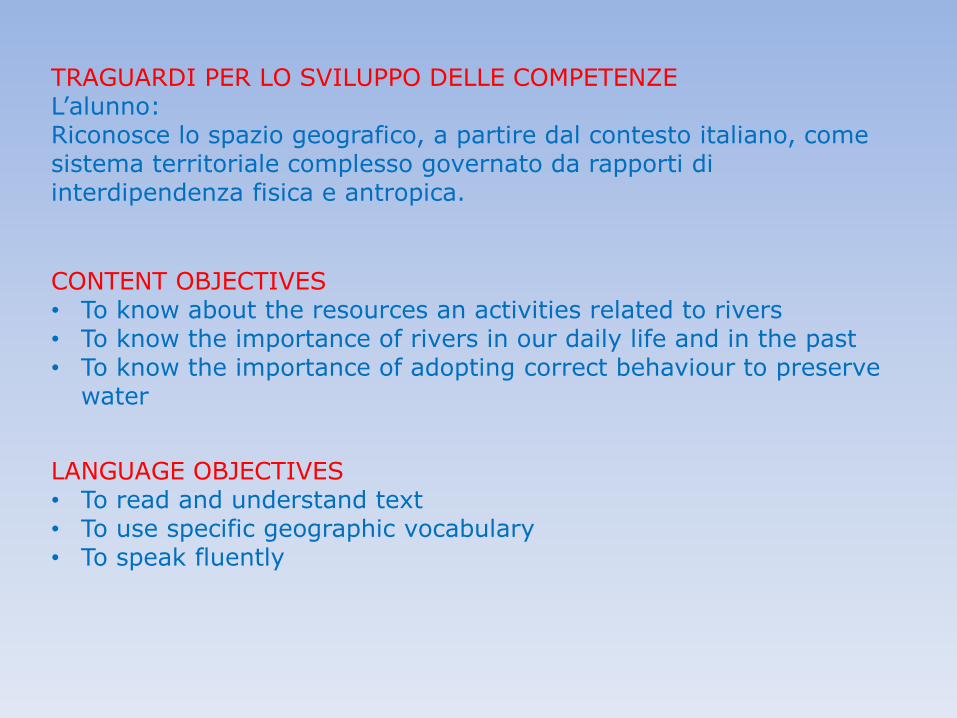
TRAGUARDI PER LO SVILUPPO DELLE COMPETENZE L’alunno: Riconosce lo spazio geografico, a partire dal contesto italiano, come sistema territoriale complesso governato da rapporti di interdipendenza fisica e antropica.
CONTENT OBJECTIVES • To know about the resources an activities related to rivers • To know the importance of rivers in our daily life and in the past • To know the importance of adopting correct behaviour to preserve
water
LANGUAGE OBJECTIVES • To read and understand text • To use specific geographic vocabulary • To speak fluently


FIND THE WORDS, WRITE THE CODE AND SPEAK ABOUT SCRIVERE IL CODICE PER INDIVIDUARE LE PAROLE CHIAVE POI ESPORRE TUTTO QUELLO CHE SI CONOSCE SULL’ARGOMENTO INTRODOTTO DA CIASCUNA PAROLA CHIAVE
PRINCIPI DI CODING UTILIZZATI: ESECUZIONE IN SEQUENZA, SELEZIONE, CONDIZIONI
ENGLISH GEOGRAPHY
CARDS
COMPITO/INSTRUCTIONS


WATER IS THE BASE OF FOOD PYRAMID


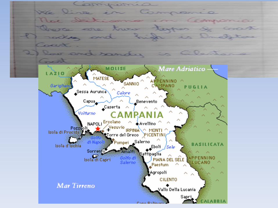
Coastline – linea costiera /Lagoons – lagune /Land – terra /Marshes – paludi Regions – regioni /Rocky – roccioso /Sandy – sabbioso /Soil - terreno
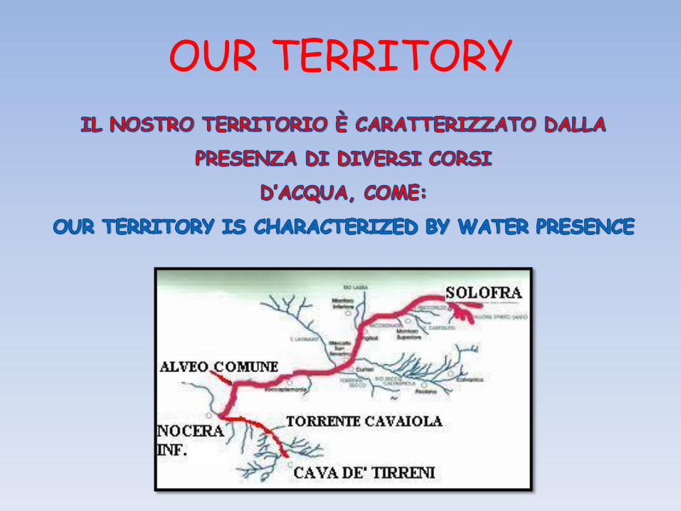
OUR TERRITORY

ALVEO COMUNE NOCERINO
THE RIVER SARNO
1 2
3

AFFLUENT TORRENT CAVAIOLA TORRENTE CAVAIOLA,
WHICH HAS ORIGIN IN THE MUNICIPALITY OF CAVA
CHE HA ORIGINE IN COMUNE DI
CAVA DE’TIRRENI
AFFLUENT TORRENT SOLOFRANA TORRENTE SOLOFRANA,
WHICH HAS ORIGIN IN THE MUNICIPALITY OF SOLOFRA
CHE HA ORIGINE IN COMUNE DI
SOLOFRA
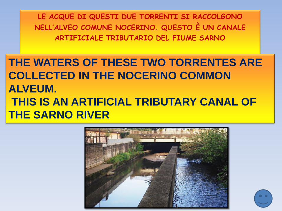
LE ACQUE DI QUESTI DUE TORRENTI SI RACCOLGONO
NELL’ALVEO COMUNE NOCERINO. QUESTO È UN CANALE ARTIFICIALE TRIBUTARIO DEL FIUME SARNO
THE WATERS OF THESE TWO TORRENTES ARE
COLLECTED IN THE NOCERINO COMMON
ALVEUM.
THIS IS AN ARTIFICIAL TRIBUTARY CANAL OF
THE SARNO RIVER


Sarno River Basin is located to the south of the Somma-Vesuvius volcanic complex in south Italy. It covers an area of about 450 kmq and is drained by the Sarno river (a short watercourse of about 24 km) and its tributaries: Cavaiola and Solofrana. In the south and in the east it is flanked by the Apennine mountain range and in the west opens to the Tyrrhenian Sea near the cliff of Rovigliano (also called Rock of Hercules), between two cities: Castellammare di Stabia and Torre Annunziata. Il bacino del fiume Sarno è ubicato a sud del complesso vulcanico Monte Somma-Vesuvio, nell’Italia meridionale. Ricopre una superficie di circa 450 kmq su cui scorrono il corso principale, il fiume Sarno (lungo circa 24 km) e i suoi affluenti: Cavaiola e Solofrana. A sud e ad est è costeggiata dall’Appennino e ad ovest si apre verso il Mar Mediterraneo nei pressi dello scoglio di Rovigliano (chiamato anche Rocce di Ercole), tra due città: Castellammare di Stabia e Torre Annunziata.

ALVEO COMUNE NOCERINO
THE RIVER SARNO
1 2
3

The initial stretch of the Sarno river, at one time, was fed by numerous springs, but from the middle of the last century, the main
courses were used to power up the Campano Aqueduct.
The Sarno river is still powered by waters of three sources: ATTUALMENTE IL FIUME SARNO E’ ALIMENTATO DA TRE SORGENTI:
SORGENTE
DENOMINATA
FOCE
CHE SI TROVA
A NORD-OVEST
DELLA CITTA’
DI SARNO
the Outfall, at north-west of the town of Sarno and from which also originated the Canal FOCE of Sarno
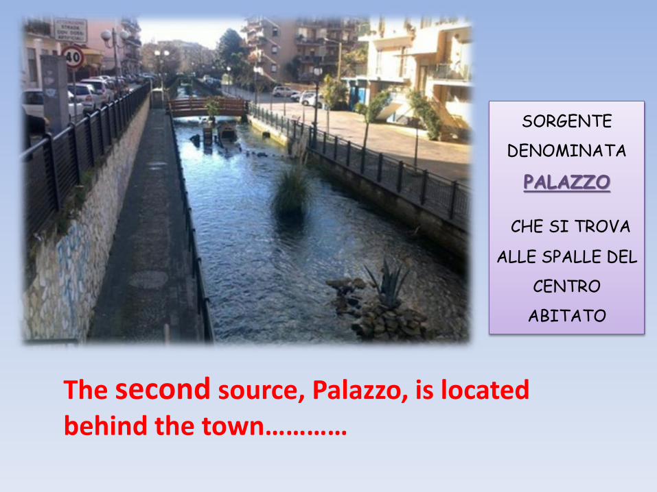
SORGENTE
DENOMINATA
PALAZZO
CHE SI TROVA
ALLE SPALLE DEL
CENTRO
ABITATO
The second source, Palazzo, is located behind the town…………

SORGENTE
DENOMINATA
SANTA MARINA
CHE SI TROVA A
LAVORATE,
FRAZIONE DI
SARNO
…..and the third, San Marino, near the municipality of Lavorate

The area of Sarno River Basin has been densely populated and urbanized since the Middle Bronze Age, as testified by the presence of numerous archeological sites, including ancient Pompeii town. The Sarno River has been used as an active, navigable waterway since ancient times, thanks to capacity and regularity of its flow. L’area del bacino del fiume Sarno è stata densamente popolata e urbanizzata fin dalla prima metà dell’età del Bronzo, come testimonia la presenza di numerosi siti archeologici, tra cui l’antica città di Pompei. Il fiume Sarno è stato usato fin dai tempi antichi come via navigabile, grazie alla capacità e regolarità del suo corso.

Also, thanks to the reliable navigability of much of its course, the use of its waters for irrigating the surrounding lands, the Sarno was extremely important for the economic life of this part of Campania region. Indeed it was personified and honored almost as a divinity. Vesuvian wall painting contain depictions in which the Sarno assumes the usual aspect of a river god.
Il fiume Sarno è stato usato fin dai tempi antichi come via navigabile, grazie alla capacità e regolarità del
suo corso. Inoltre, grazie alla affidabile navigabilità di gran parte
del suo percorso, all’uso delle acque per irrigare i campi circostanti, il
Sarno è stato estremamente importante per la vita economica di
questa parte della regione Campania.
Infatti, il fiume Sarno era impersonificato e adorato come una divinità.
Pitture murali contengono rappresentazioni in cui il Sarno assume l’aspetto usuale di un
dio fluviale.

Rappresentazione del dio Sarno; Fonte Helvius, Comune di Sant'Egidio del Monte Albino, I secolo a.C.

Currently, the Sarno river, still partially used for irrigation, is affected by an extreme environmental degradation as a result of uncontrolled outflow of industrial waste. Pollution is commonly attributed to the waste product of the tomato industries (108 settled mainly along Sarno river), to the chemical processing of animal skin (184 leather tanneries principally along Solofrana tributary) . Many other small and medium factories are also present in the area. The situation is worsening by large-scale dumping of untreated agricultural, urban and other industrial wastes into the river. Attualmente, il fiume Sarno, ancora parzialmente usato per l’irrigazione, è interessato da un forte degrado ambientale risultato di scarichi industriali incontrollati. L’inquinamento è generalmente attribuito agli scarti di lavorazione delle industrie di pomodori (108 sono ubicate principalmente lungo il fiume Sarno), ai processi chimici di lavorazione delle pelli animali (184 concerie di pelli sono localizzate prevalentemente lungo un affluente del Sarno, la Solofrana) Inoltre, nell’area sono presenti molte altre piccole e medie industrie. La situazione sta peggiorando su larga scala per lo scarico nel fiume di rifiuti agricoli, urbani e industriali non trattati.
Dumps – discariche / Ill – malato /No bathing – divieto di balneazione / Refineries – raffinerie / Soil – terreno Waste – rifiuti

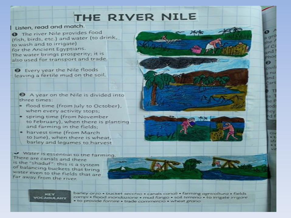
The river Nile provides food (fish, birds, etc.) and water (to drink, to wash and to irrigate) for the Ancient Egyptians. The water brings prosperity; it is also used for transport and trade

Every year the Nile floods leaving a fertile mud on the soil.
A year on the Nile is divided into three times: ● flood time (from July to October), when every activity stops; ● spring time (from November to February), when there is planting and farming in the fields; ● harvest time (from March to June), when there is wheat, barley and legumes to harvest

Water is essential to the farming. There are canals and there is the “shaduf”: this is a system of balancing buckets that bring water even to the fields that are far away from the river.
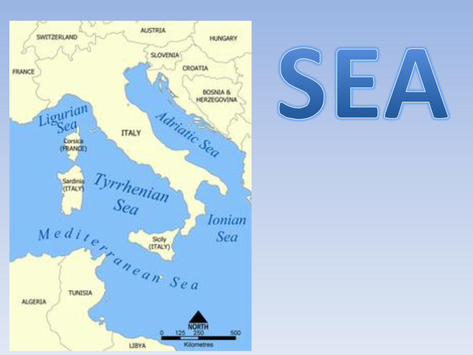

THERE ARE VARIOUS TYPES OF COASTS Ci sono vari tipi di coste


WATER IS PRECIOUS
Close the tap while brushing your teeth Chiudi il rubinetto mentre lavi i denti

Choose to have a shower, not a bath Scegli di fare la doccia, NO il bagno .

HERE ARE SOME RULES YOU SHOULD RESPECT
Beaches are for everyone! Take home your rubbish after a picnic: don’t leave it on the beach!

Don’t throw plastic containers into the sea: they are indestructible. Plastic bags are terrible for sea life. You can find them on the beach, on the bottom of the sea… even in whales’ stomachs!

Don’t hunt for fish underwater! It’s more fun to watch them with a mask!

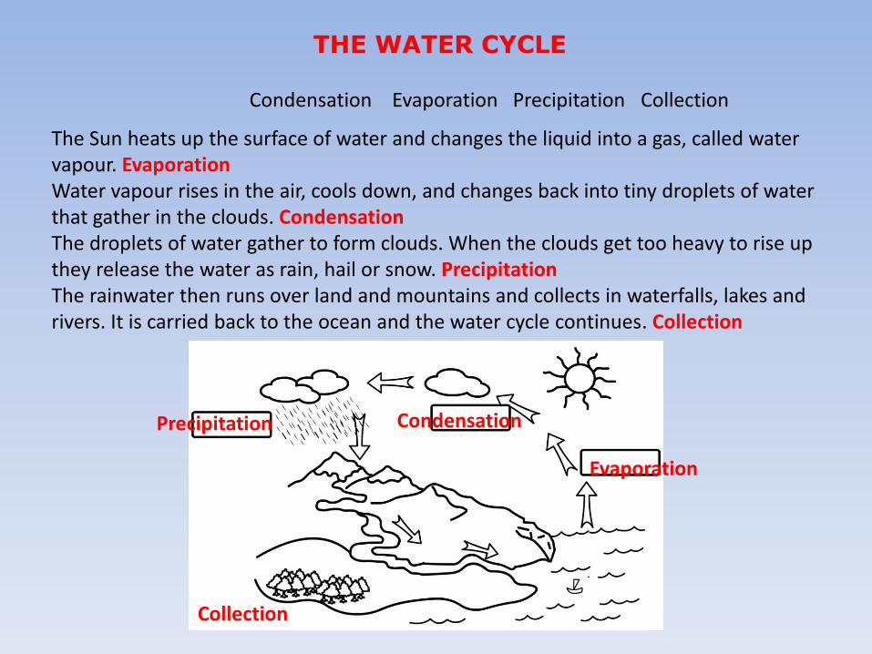
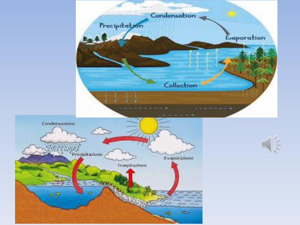
THE WATER CYCLE
Condensation Evaporation Precipitation Collection
The Sun heats up the surface of water and changes the liquid into a gas, called water vapour. Evaporation Water vapour rises in the air, cools down, and changes back into tiny droplets of water that gather in the clouds. Condensation The droplets of water gather to form clouds. When the clouds get too heavy to rise up they release the water as rain, hail or snow. Precipitation The rainwater then runs over land and mountains and collects in waterfalls, lakes and rivers. It is carried back to the ocean and the water cycle continues. Collection
Evaporation
Condensation Precipitation
Collection