documentary study byram cemetery and lyon …
TRANSCRIPT
DOCUMENTARY STUDY
BYRAM CEMETERY
AND LYON CEMETERY
BYRAM DOCK STREET AND
BYRAM SHORE ROAD GREENWICH, CT
Documentary Study Byram Cemetery and Lyon Cemetery Byram Dock Street and Byram Shore Road Greenwich, CT Prepared For: Town of Greenwich Conservation Commission 101 Field Point Road Greenwich, CT 06830 Prepared By: Historical Perspectives, Inc. P.O. Box 529 Westport, CT 06881 Research: Dawn Brown, MA, RPA Faline Schneiderman, MA, RPA Author: Faline Schneiderman, MA, RPA November, 2014, Revised March, 2015, January 2016
Documentary Study, Byram Cemetery and Lyon Cemetery, Greenwich, CT
i
EXECUTIVE SUMMARY In August, 2014 it came to the attention of the Town of Greenwich, Connecticut, that there was an encroachment on a parcel of land historically known as the Byram and/or Lyon Cemetery on Byram Dock Street near the intersection of Byram Shore Road in Greenwich. The cemetery, designated as CT SHPO Site A89.71 in a Historic Resources Inventory form completed for the site, is topographically divided into three sections. The upper section is elevated and is located immediately east of Byram Shore Road and parallels the south side of Byram Dock Street. This section of the cemetery bears headstones with the names of those interred, and has historically been referred to as the Byram Cemetery, and more recently the Gamecock Cemetery. Along the south side and elevated slightly below the main cemetery is a relatively smaller section referred to as the Lyon Cemetery. Headstones here have the names of members of the Lyon family. The third section is immediately to the east of the main cemetery, closer to Byram Harbor. It is separated from the major block of the Byram Cemetery by a massive rock outcrop and lies at a distinctly lower elevation. This section of the cemetery has no headstones, but has historically been labeled on maps and plans as the “Colored Cemetery,” and will hereafter be referred to as the Byram African-American Cemetery. The Byram African-American Cemetery is believed to have been used by enslaved African-Americans and their descendants for the interment of their deceased. It is here, east of the bedrock outcrop, that recent land disturbance has occurred in the form of grade cutting, retaining wall installation, rock face removal, and soil stockpiling for the improvement of an existing accessway to the rear of the private dwelling at 11 Byram Dock Street (Figures 1 and 2). Because of the sensitive nature of the site, the Town of Greenwich contacted the Office of State Archaeology (OSA) for guidance and subsequently retained Historical Perspectives, Inc. (HPI) to review the property and develop a course of action for investigation and preservation of the entire Cemetery, with a focus on specific actions pertaining to the Byram African-American Cemetery. An Archaeology Recommendations Memorandum was completed by HPI on September 5, 2014 and was submitted to the Greenwich Conservation Commission, who in turn submitted it to Dr. Brian Jones, Connecticut State Archaeologist for approval (see attached Appendix A). Dr. Jones concurred with recommendations put forth in the memo. One of the recommendations was to complete a more exhaustive documentary study of the cemetery. Documentary studies to date by multiple researchers have found many deeds and maps reporting or depicting the presence of Byram Cemetery on Byram Dock Street and Byram Shore Road in Greenwich, but have not been successful in finding a deed directly relating to the ownership of the cemetery. It may be that the parcel was part of the original Greenwich Lots that were never owned by individuals, or that it was in the collective memory of the Lyon family and relatives as their family plot that required no specific deed since it was directly related to their family from the seventeenth through the late nineteenth centuries. While the Byram African-American Cemetery has no standing headstones and none were reported in 1908 when the adjacent Byram Cemetery was surveyed, this is not unusual at burying grounds used by enslaved peoples or their descendants. Indeed many cemeteries in the Northeast lack such headstones. African traditions transported to the New World often involved placing items of importance on graves, but not headstones; this is a European custom that was not often assumed by the enslaved population (Viet and Nonestied 2014). Wooden markers may have also been placed at the site, but no evidence of them remains. Furthermore, there is no assumption of the duration of the active use of the burial ground or that interments were limited to enslaved

Documentary Study, Byram Cemetery and Lyon Cemetery, Greenwich, CT
ii
individuals related to the Lyons and/or Banks family. Free residents of color may have been buried here, too. The historical record is very clear that the Lyon and Banks families held slaves during the years that they lived on Byram Neck, and for the Banks family, this included both African-American and Native-American peoples. It is quite likely that a burial plot was established for this population, which was not an uncommon practice. Thomas Lyon, being a Quaker, and his immediate descendants, may have believed that it was a just and fair thing to do – to provide their slaves with a specific burying ground. Later generations would have likely followed suit. The recommendations of the memo prepared by HPI in September 2014 (Appendix A) are still valid. Some of the recommendations have been accomplished, and some are being addressed through actions of the Town of Greenwich. Of utmost importance are the tasks of permanently protecting and commemorating the cemetery. As numerous studies attest to the diminished recollection of slavery as part of the New England historical landscape (e.g., Cruson 2007, Farrow 2014, Mead 1995), the commemoration of the enslaved population and potentially their descendants that lived and died in Greenwich, and particularly on Byram Neck, is imperative. Fencing that is appropriate to a historic cemetery should be considered to prevent further intrusions, but this should be completed in a way that has the least possible impact below grade so as to avoid disturbing any potential human remains. Monumentation should also be undertaken in a manner that will actively seek to reverse the invisibility on the landscape invoked by the lack of headstones and obvious markers, and to celebrate the lives of so many who worked on the farms and in the houses of Greenwich, and who had a large impact on the creation of the community and the landscape that it is today. Any fencing or preservation plans should be created in consultation with Dr. Brian Jones, Connecticut State Archaeologist, with input from local historic preservation groups, particularly the Greenwich Preservation Trust.

Documentary Study, Byram Cemetery and Lyon Cemetery, Greenwich, CT
iii
TABLE OF CONTENTS
1.0 INTRODUCTION ............................................................................................................... 1
2.0 RESEARCH GOALS AND METHODOLOGY................................................................. 1
3.0 SITE HISTORY ................................................................................................................... 2
3.1 The Lyon Family and Byram Neck .................................................................................. 2
3.2 African-American Cemetery ............................................................................................ 5
3.3 Cartographic Overview .................................................................................................... 6
4.0 CONCLUSIONS AND RECOMMENDATIONS .............................................................. 8
5.0 BIBLIOGRAPHY .............................................................................................................. 11
FIGURES
PHOTOGRAPHS
APPENDIX A: ARCHAEOLOGICAL RECOMMENDATIONS MEMORANDUM, 9/5/2014
APPENDIX B: TIMELINE OF LAND OWNERSHIP, BYRAM CEMETERY
APPENDIX C: BYRAM CEMETERY HEADSTONE INVENTORIES
Documentary Study, Byram Cemetery and Lyon Cemetery, Greenwich, CT
iv
LIST OF FIGURES
Figure 1. Cemetery Site on Glenville, Connecticut 7.5 Minute Topographical Quadrangle
(U.S.G.S. 2014). Figure 2. Cemetery site on Town of Greenwich Tax Map 183, Vol. 3. Figure 3. Detail of ca. 1750 map showing Byram Neck and approximate location of Byram
Cemetery. Figure 4. Detail of 1788 Webb map showing Byram Neck and approximate location of
Byram Cemetery. Figure 5. Cemetery site on Clark’s map of Fairfield County, Connecticut. Clark, 1856. Figure 6. Cemetery site on Town of Greenwich, Fairfield County, Connecticut. Beers,
1867. Figure 7. Cemetery site on Map of the Estate of Daniel Lyon, Greenwich, Conn. Minor,
1887. Figure 8. Cemetery location on Map #39, Greenwich Land Records. 1888. Figure 9. Cemetery location on Road and Property Map showing the Towns of Greenwich
and Stamford Connecticut. Robbins, 1890. Figure 10. Cemetery location on Map #154, Greenwich Land Records. Minor, 1901. Figure 11. Cemetery location on Map of the Public Dock, Cemetery, and Road at Byram
Shore in the Town of Greenwich. Minor, 1911. Figure 12. Cemetery location on Byram Dock, Property of the Town of Greenwich,
Connecticut. Minor, 1941. Figure 13. Cemetery location on Town of Greenwich, Fairfield County, CT. Franklin, 1938. Figure 14. Cemetery site on Town of Greenwich, Fairfield County, CT. Greenwich Land
Records, 1970.
Documentary Study, Byram Cemetery and Lyon Cemetery, Greenwich, CT
v
LIST OF PHOTOGRAPHS Photograph 1: Byram African-American Cemetery Site in 2012. Facing west from the east end
of Byram Dock Street toward the bedrock outcrop at the west end of the cemetery and the house at 11 Byram Dock Street (courtesy of Google Maps).
Photograph 2: Byram African-American Cemetery Site with accessway crossing western end by bedrock outcrop in 2012. Facing south from Byram Dock Street toward the house at 11 Byram Dock Street (courtesy of Google Maps).
Photograph 3: Byram African-American Cemetery Site in August 2014. Facing south from Byram Dock Street toward the house at 11 Byram Dock Street. Note that two tiered stone retaining walls have been created above the cemetery site.
Photograph 4: Byram African-American Cemetery Site with accessway crossing western end by bedrock outcrop in 2014. Facing south from Byram Dock Street toward the house addition at 11 Byram Dock Street. Note that the rock face has been cut back and a small retaining wall erected.
Photograph 5: Byram African-American Cemetery Site after back dirt pile was hand removed and before seeding was undertaken. October 20, 2014. Facing west from east end of Byram Dock Street. Note that two tiered stone retaining walls remain above the cemetery site.
Photograph 6: Byram African-American Cemetery Site after back dirt pile was hand removed and before seeding was undertaken. October 20, 2014. Facing south from Byram Dock Street.

Documentary Study, Byram Cemetery and Lyon Cemetery, Greenwich, CT
1
1.0 INTRODUCTION
In August, 2014 it came to the attention of the Town of Greenwich, Connecticut, that there was an encroachment on a parcel of land historically known as the Byram and/or Lyon Cemetery on Byram Dock Street near the intersection of Byram Shore Road in Greenwich. The cemetery, designated as CT SHPO Site A89.71 in a Historic Resources Inventory form completed for the site, is topographically divided into three sections. The upper section is elevated and is located immediately east of Byram Shore Road and parallels the south side of Byram Dock Street. This section of the cemetery bears headstones with the names of those interred, and has historically been referred to as the Byram Cemetery, and more recently the Gamecock Cemetery. Along the south side and elevated slightly below the main cemetery is a section referred to as the Lyon Cemetery. Headstones here have the names of members of the Lyon family. The third section is immediately to the east of the main cemetery, closer to Byram Harbor. It is separated from the major block of the Byram Cemetery by a massive rock outcrop and lies at a lower elevation. This section of the cemetery has no headstones, but has historically been labeled on maps and plans as the “Colored Cemetery,” and will hereafter be referred to as the Byram African-American Cemetery. The Byram African-American Cemetery is believed to have been used by enslaved African-Americans and their descendants for the interment of their deceased. It is here, east of the bedrock outcrop, that recent land disturbance has occurred in the form of grade cutting, retaining wall installation, rock face removal, and soil stockpiling for the improvement of an existing accessway to the rear of the dwelling at 11 Byram Dock Street (Figures 1 and 2).
Because of the sensitive nature of the site, the Town of Greenwich contacted the Office of State Archaeology (OSA) for guidance and subsequently retained Historical Perspectives, Inc. (HPI) to review the property and develop a course of action for investigation and preservation of the entire Cemetery, with a focus on specific actions pertaining to the Byram African-American Cemetery. An Archaeology Recommendations Memo was completed by HPI on September 5, 2014 and was submitted to the Greenwich Conservation Commission, who in turn submitted it to Dr. Brian Jones, Connecticut State Archaeologist for approval (see attached Appendix A). Dr. Jones concurred with recommendations put forth in the memo. One of the recommendations was to complete a more exhaustive documentary study of the cemetery; the result is this report.
2.0 RESEARCH GOALS AND METHODOLOGY
It is the goal of this documentary study to establish the historical use of the entire cemetery and to establish cemetery boundaries, if feasible. Extensive documentary research pertaining to the cemetery has been previously completed by the Greenwich Preservation Trust and the Greenwich Historical Society, and their studies are incorporated into this report. A title search for the 11 Byram Dock Street property was completed in June, 2013 by Sheri L. Mount of Norwalk, Connecticut and was reviewed for this study. HPI has also undertaken research at the Greenwich Historical Society, the Greenwich Town Hall, various on-line repositories, and has interviewed researchers in Fairfield County that focus on enslaved African-American history, as well as former Greenwich resident Nils Kerschus who has undertaken extensive research on the cemetery and adjacent parcels. Thomas Lyon descendent Laureen M. Taylor of Virginia has also contributed information on the family and her research as well.

Documentary Study, Byram Cemetery and Lyon Cemetery, Greenwich, CT
2
3.0 SITE HISTORY
3.1 The Lyon Family and Byram Neck Although Dutch and English vessels brought settlers and cargo to coastal Fairfield County in the early part of the seventeenth century, the first European purchase of land from the native inhabitants did not occur until July 18, 1640. For "twentie five coates,” Robert Feake, his wife Elizabeth, and Daniel Patricke acquired Monakewago or Manakaway (Elizabeth's own purchase and today’s Greenwich Point) and Sioascock (roughly the land that is now Old Greenwich) between the Stamford border and Riverside (Knapp 1966). Following this initial land purchase, a group calling themselves "the twenty-seven Proprietors," purchased a parcel of land called Horseneck (now central Greenwich west of the Mianus River) from the Miosehassky band of Native Americans in 1672. Located along Long Island Sound at what is now the border between Connecticut and New York, Byram is an unincorporated village in the Town of Greenwich. Also historically known as East Portchester, the first European settler to the area was reportedly Thomas Lyon, Sr. (1621-1690) (RKA 1978). On February 13, 1676, Lyon and John Banks Sr. of Fairfield acquired the title to roughly 60 acres in Greenwich east of the Byram River. Records indicate that prior to this, the town had also granted land at what is now Byram Neck, then spelled “Byarum,” to Thomas Lyon’s attorney, John Banks Sr. That parcel was reportedly on the lower end of Byram Neck and was roughly 300 acres including what is now Hawthorne Beach at the southwest end of Byram Shore Road. Thomas Lyon Sr. came to America in 1638, emigrating from England to New Haven. He was in what is now Stamford by 1647, and his brother Richard settled in Fairfield in 1649 (Lyon 1907). Thomas married first Martha Johanna Winthrop, daughter of Elizabeth Fones Winthrop Feake and granddaughter of Governor John Winthrop of the Massachusetts Bay Colony, and after her death ca. 1653 married Mary Hoyt of Stamford. The families of Thomas and Richard Lyon and John Banks of Fairfield, and later Byram, were intimately related. Abigail, daughter of Thomas Lyon, married John Banks, Jr. while Elizabeth, daughter of Richard Lyon, married John’s brother Benjamin (Ibid.). The Lyon family in Greenwich was Quaker, and there is some speculation that this is why there are few records of their involvement in town civics at the time (Hewett 2014). Early letters written by both Thomas and his first wife Martha to John Winthrop of the Massachusetts Bay Colony, indicate that the couple struggled due to ostracism and punishments enacted by the Church. Land and livestock were taken from them because of their religious beliefs (Lyon 1967). In Greenwich, they were tantamount to heretics at the time. The name Lyon Point, written also as Lions Point, was given to the spit of land at the mouth of the Byram River and was in use by the Lyon family as early as 1683. By 1688 when the town of Greenwich (then Horseneck) had only 300 inhabitants, Thomas Lyon Sr. and Thomas Lyon Jr. were both listed as landowners (Lyon 1907). The extant Thomas Lyon House, built in Byram ca. 1690 either by Thomas Lyon Sr. or his son Thomas Jr., is currently recognized as one of the oldest standing houses in Greenwich and is listed on the National Register of Historic Places
Documentary Study, Byram Cemetery and Lyon Cemetery, Greenwich, CT
3
(NRHP). The Thomas Lyon House, relocated from its original location, is not in the immediate neighborhood of Byram Shore Road or Lyon Point. At his death in 1690, Thomas left his son Thomas Jr. the home lot “lying up the Byram River above the country road…” (Fairfield County Probate Records, Vol. 4, pp. 13, 13a, 13b). He left his sons Samuel and Joseph all of his lands below the Country Road, including “the salt meddow” (Ibid.). More specifically, his will states the following:
I Thomas Lyon Senior ... give and bequeath as ffoloweth...I give unto my son Thomas Lyon my homelot lying up Byram River above the Country Road & half my upermost percell of Land Lying up ye same River with two Byram Ridge Lots, ye one which I Bought of John Coe & ye other of Robert Bloomer with a small percell of Land which I bought of Steven Sherwood Joyning to these Lots… And also I give my son Samuell Tenn pounds which I Will [that] it be paid out to my son Joseph Lyons portion. I give unto my sonn Joseph Lyon my dwelling house & Barn & homelott & ye northward part of ye orchard & a pasture Lying on the East side of the highway that goes into the neck but I will [that] his Mother have Liberty to Live in ye house so long as she Lives & Remains my widow. ffurther, I give unto my sons Samuell Lyon & Joseph Lyon all my Lands below ye Country Road with half ye Salt Meddow [that] I Bought of John Coe & ye half of ye uppermost percell of Land [that] I have on Byram River, to be equally divided between them for [them] & Either of them to Receive when they shall com to age & then to pay unto theire mother each of them four bushels of Indian Corn and two bushels of wheat yearly soe Long as she Lives and Remains my Widdow. I give unto all my four sonns all my Rights & priviledges in undivided Lands belonging to Greenwich and Rye to be Equally divided amonhgst them. Except one grant of Lands to me from ye Town of Greenwich [which] I doe give unto my son Thomas Lyon And Lykewise unto my Aforesd four sons I, do Give All my rights & priviledges in Lands at ffairfeild for them to dispose of as they see best.... I have set my hand and seale this sixth day of Dec. [1689] Wit: Thomas Brown Thomas Lyon.
It is unclear exactly where the cemetery fell in his landholdings since there is no mention of a burying ground in this will or associated deeds, but it may well be part of the parcel that Thomas passed to his son Joseph, a minor at the time of his death (1677-1761), “lying on the east side of the highway that goes into the neck…” which would place it east of what is now Byram Shore Road. Alternatively, it may have been part of his “undivided lands belonging to Greenwich” that was split between his four sons. The Connecticut State Historic Site Inventory form for the Byram Cemetery, as well as other historical records, indicates that Thomas Sr. was buried in what is now the Byram Cemetery when he died in 1690. It is unknown if he was buried in the main cemetery or the separate Lyon Cemetery as there are no extant headstones from this early date. By 1697 there were 66 names on the Greenwich Grand List, including several Lyons (Knapp 1966). In 1714 John Lyon, Sr. passed all his land on Byram’s neck not already given to his son, John Lyon Jr. to Daniel Lyon (1688-1752). Daniel received his father’s “dwelling house and home lot with all his lands and meadows on ‘Byrum Neck’” (Lyon 1907).
Documentary Study, Byram Cemetery and Lyon Cemetery, Greenwich, CT
4
Because there are so many Lyon and Banks family deeds on file in the Greenwich Town Hall which reference long-gone landmarks on Byram Neck, a timeline of land transfers is provided as Appendix B of this report. These clearly show that there were multiple subdivisions, bequests, transfers, mortgages, and quite claims of land in the vicinity of the cemetery, but it is not until 1752 that the deeds reviewed for this study reference the cemetery as a boundary to an adjacent parcel.
Thus it appears that by 1714 the land that likely included the cemetery had passed from Thomas Lyon Sr. to his son Joseph Lyon, and was then was purchased by John Lyon Sr. who passed it to his son, John Lyon Jr. upon his death. The early deeds accounting for these land transfers, on file in the Greenwich Town Clerk’s Office, are very nondescript and reference landmarks that no longer exist (e.g., trees and fences). None dating prior to 1752 that were reviewed for this study were found to have a specific reference to a burying ground; however hundreds of “Lyon” deeds exist for this time period, so it was not feasible to thoroughly read each and every one for this study.
By the mid-eighteenth century, settlement in Greenwich had increased, as roads were laid out and houses were built. A 1750 map of Greenwich shows Byram Shore Road laid out and terminating roughly near the location of what is now Byram Dock Street (Figure 3). A map surveyed by Charles Webb sometime between 1757 and 1773 shows more development in the area, with two dwellings on Byram Point Road, one near Byram Dock Street, on the east side of the road, and another further south on the west side of the road (Webb 1788, Figure 4).
The first mention of the cemetery in the reviewed deeds held at the Greenwich Town Clerk’s Office dates to 1752 when a parcel of land was quit-claimed from the estate of John Lyon Jr. (1690-1749) to his brother James. The deed referenced the cemetery as forming the northeastern boundary of the parcel (Greenwich Land Records Vol. 13:691; see Appendix B). This was part of the tract that had belonged to their father, John Lyon Sr., who bequeathed the parcel to his sons. James was reportedly the owner of the house at 37 Byram Shore Road, immediately west of the Byram Cemetery (Nils Kerschus personal communication, November 10, 2014).
The James Lyon house and land next to the cemetery was bequeathed to his son Benjamin Woolsey Lyon in 1804 when James died. Benjamin passed in 1826, leaving his parcel to Thomas Lyon, who then passed it to his son Daniel Lyon (Appendix B).
With the construction of the railroad in the 1840s, Byram became desirable for urban real estate development. By the 1850s through the 1880s, the farm land was subdivided into small residential lots. Names such as East Port Chester, Lyonsville, Meadville, New Lebanon and Meadlawn were given to these developments. The land along the Byram Shore, however, remained as large estate properties. By 1876 Byram contained 500 residents (RKA 1978), and by 1888, when Daniel Lyon died, the land in the vicinity of the cemetery had been lotted and shortly thereafter these lots were developed.

Documentary Study, Byram Cemetery and Lyon Cemetery, Greenwich, CT
5
3.2 African-American Cemetery Because the earliest date of potential burials in this cemetery is unknown, a review of the Lyon family and its relationship to the enslaved African-American community is provided, as is a contextual overview of enslavement in Connecticut, and more specifically in Greenwich. Slaves were first recorded in Hartford as early as 1639 and were recorded in New Haven by 1644. Despite the fact that many people think of the North as a “slave free” environment, nothing could be further from the truth. Like their southern brethren, northern farmers relied on enslaved African-Americans and Native Americans to act as household servants and to work the fields, though not on the same scale as on the large plantations of the south (Cruson 2007). Greenwich maintained a population of enslaved peoples, albeit a relatively small one compared to some other Connecticut communities. In 1774 Connecticut lawmakers passed a law to halt the importation of slaves, but it was not until 1784 that a bill for the gradual emancipation of slaves was passed. This bill provided that black and mulatto children born after March 1, 1784 would become free at age 25. An act of 1797 reduced that age to 21, bringing the age of emancipation of slaves in line with the age that one would end an apprenticeship, though slaves did not receive money, clothes and professional standing at the end of their servitude as apprentices did. Connecticut finally abolished slavery entirely in 1848 (http://slavenorth.com/connecticut.htm). Some of the early settlers in southern New England and the adjacent County of Westchester in New York were indeed slaveholders. Not only did some residents enslave African-Americans, but Native Americans as well. The 1685 will of John Banks Sr., a substantial landholder in Byram by 1670, passed 150 acres at Byram to his son, John Banks Jr., and “two Indian boys [and] one negro woman” to his wife Mary, among other objects he counted among his estate (Schenck 1889). Indeed many seventeenth through early nineteenth century probate records, newspaper accounts, diaries, and historical accounts attest to the enslavement of African-Americans and Native Americans in Greenwich. Upon the death of John Lyon in 1749, grandson of progenitor Thomas Lyon, he left to his son James “Mary’s Hill on Byram Neck and…also my negro boy Hector.” To his son Roger, he left land on Calves Island, and his “negro Mack which lives with him.” He further accounted for “the negroes that Treadwell and Bush have at their respective houses to be deemed and accounted as part of my moveable estate” and stated that “my old negro Betty [is] to be maintained during her life out of the estate” (Lyon 1907). In 1770 when Thomas Lyon (the third) passed away, he left his wife all his worldly goods “and my negro woman Phillis” (New-York Historical Society 1899). In 1762 it was reported that there were just over 2000 whites in Greenwich, and 52 blacks, whereas 30 years later there were just over 3100 whites and 80 blacks (Mead 1995). The 1790 Census of Greenwich reported that James Lyon III held one slave, as did members of the Banks (one), Brown (one) and Merritt (four) families (U.S. Census 1790). In April of 1800, Benjamin Woolsey Lyon, one-time owner of the James Lyon house on Byram Shore Road, emancipated his “negro girl Peg” (Mead 1995). In addition, the Greenwich Vital Records report the following slave ownership or associations for the Lyon Family:

Documentary Study, Byram Cemetery and Lyon Cemetery, Greenwich, CT
6
• Benjamin Woolsey, had negroes Platt, b Nov 1, 1798 & Anthony, b Dec 3, 1795 • Sarah, colored, had children Henry, b Oct 25, 1808; John, b Feb 19, 1809;
Tamour, b Nov __, 1811; Deborah, b Mar 3, 1814; Margarett, b Feb 3, 1818, & Charles, b May 13, 1820
Clearly the Lyon family, despite once having been Quakers, enslaved African-Americans when they held land on Byram Neck in Greenwich, as did the Banks family. Of potential relevance, Albro Lyons in New York City is referenced as one of the Black Elite inhabitants in the nineteenth century (Berlin and Harris 2005). Albro was a freed African-American activist throughout the Draft Riots of July 1863, and was a respected member of the community. It is quite possible that one of his ancestors took the sir-name of the family that enslaved him, Lyon, as was not uncommon (Cruson 2007). As to the burying places of enslaved men and women in Greenwich, historical patterns in the Northeast have shown that often they were located within or near the boundaries of an established burying ground, overlooking water if feasible (Adams and Pleck 2009; Fitts 1998; Historical Perspectives Inc. 2013). Slaves were not buried with their masters, who were typically interred on family plots on their farms or homesteads, but were relegated to a separate plot nearby, physically separated by a fence, hedges, stone wall, or topographical demarcation. An exception to this is the report that one indentured servant or emancipated slave in Greenwich, Massy Pomroy (1742-1839), who was buried in the Palmer family cemetery in northern Cos Cob (Mead 1995). Regardless, early slave burials typically lacked any headstones or demarcation, which was one way of reaffirming their inequality to their masters. The isolation or marginalization of the enslaved population in both life and death, with their burying ground laid out behind the bedrock, down the hill, and closer to the water, echoes prevailing attitudes throughout the Northeast (Viet and Nonestied 2014). By the mid-nineteenth century, Greenwich had established a centralized burying ground for the African-American population. In November 1851, Robert Mead deeded three acres of the Union Cemetery owned by the Second Congregational Church for the burial of the poor, strangers and "people of color.” Only one emancipated slave had a headstone erected in the cemetery - Candice Bush who had one made for her mother and herself. Unmarked stones are also present, but no other marked stones have been identified as was not uncommon for the poor, enslaved, or otherwise marginalized community (Mead 1995). An exhaustive search of deeds in Greenwich did not encounter any land transfers specifically pertaining directly to the Byram Cemetery, the Lyon Cemetery, or the Byram African-American cemetery, although many deeds reviewed referenced the “cemetery” or “burying ground” as serving as a boundary for an adjacent lot (see Appendix B).
3.3 Cartographic Overview Numerous maps, atlases and plot plans were reviewed for this study. In the following discussion of the review results, all three cemeteries are referenced as “the cemetery” due to their proximity, unless otherwise indicated. In the 1750s, Byram Point had one house depicted on it somewhere near or north of the cemetery, on what is now Byram Shore Road. However, the degree of inaccuracy with early maps renders it difficult to establish the dwelling’s precise location (Figure 3). When a survey of Greenwich was completed between 1757 and 1773, at least two houses

Documentary Study, Byram Cemetery and Lyon Cemetery, Greenwich, CT
7
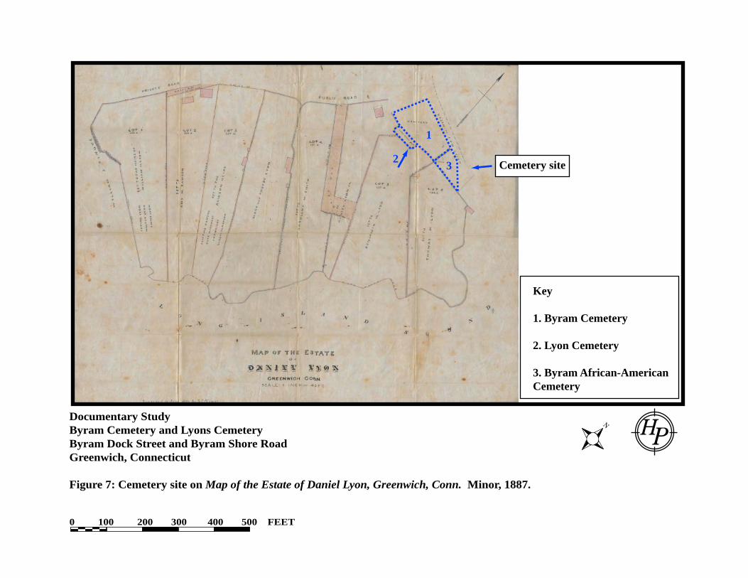
were mapped on Byram Neck; one again near the shoreline, near or north of the site of the cemetery on the southeast side of Byram Shore Road, and a second further south on the northwest side of the road (Webb 1788; Figure 4). Both the 1856 Clark map and the 1859 Clark and Tackabury survey show two houses on Byram Shore Road; one on the northwest side belonging to I. Mead, and one on the southeast side belonging to D. (presumably Daniel) Lyon (Clark 1856; Figure 5). The earliest cartographic source found for this study that depicts the cemetery dates to 1867, and is not considered to have the degree of accuracy of later professionally surveyed plot plans (Beers 1867; Figure 6). At that time, the cemetery is mapped as a large rectangle southeast of a bend on Byram Shore Road, and it is bisected by a lane that is presumably now Byram Dock Street. The site is labeled “Cem” and immediately to the north on the east side of Byram Shore Road are three dwellings belonging to W. H. Lyon and W. Ritch. D. Lyon owns a house on the south side of Byram Shore Road, west of the cemetery, but there are no structures immediately adjacent to the cemetery (Ibid.). An 1887 map of the estate of Daniel Lyon was surveyed and prepared by S. E. Minor, and shows much greater detail of the land in the vicinity of the cemetery. At the time of his death, Daniel owned land on the southeast side of what is now Byram Shore Road, south of Byram Dock Street (Minor 1887; Figure 7). Three lots directly bordered the south side of the cemetery; an unnumbered lot owned by Daniel Lyon Jr., Lot 5 given to Benjamin W. Lyon, and Lot 6 given to Thomas M. Lyon (Figure 7). Byram Cemetery was labeled as just “cemetery” and the Lyon Cemetery was labeled as the “Lyon Burial Plot.” What is now designated as the Byram African-American Cemetery is unlabeled, but the stone outcrop that demarcates its western boundary is shown and Byram Dock Street is labeled “Drift Way to Water.” The cemetery does not appear to extend to the north onto the opposite side of Byram Dock Street as was depicted in 1867 (Beers 1867; Figure 6). Map #29 on file with the Greenwich Land Records (GLR), dating to 1888, more precisely maps the Lyon Burial Plot as measuring 57.7’ on its south side, and 23’ on its east side. The cemetery is generically labeled to the north and its northern boundary is roughly 121.7’ in length (Figure 8). No other boundaries or measurements are depicted. When the Byram Cemetery was mapped in 1890, the cemetery was depicted as a roughly triangular shaped parcel at the intersection of Byram Shore Road and Byram Dock Street (Figure 9). Neither the Lyon Cemetery nor the Byram African-American Cemetery were individually depicted. By 1901, Map #154 of the GLR includes the Byram African-American Cemetery, labeled “Colored Cemetery,” with its western boundary measuring 65’ in length (Figure 10). The Byram Cemetery is labeled simply as “Cemetery,” but the Lyon Cemetery is not depicted (Figure 10). A barn is shown on the north side of Byram Dock Street, which is labeled as a Public Road extending down to Byram Harbor. GLR Map #1980, dating to 1911, shows the Byram Cemetery with a southern boundary measuring 172’ in length, and the “Colored Cemetery” with a southern boundary measuring 65’ in length. The rock outcrop demarcating the separation between the two cemeteries is shown, as is the new public dock at the east end of Byram Shore Road (Figure 11). Both a 1929 aerial photograph on file at the Greenwich Historical Society and a 1934 aerial photograph of the site (Fairchild Aerial Survey 1934) show a small building immediately southwest of the Byram Cemetery, and an accessway across the west end of the Byram African-American Cemetery allowing passage to what was historically Lot 5, and is now occupied by a

Documentary Study, Byram Cemetery and Lyon Cemetery, Greenwich, CT
8
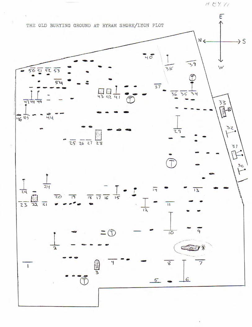
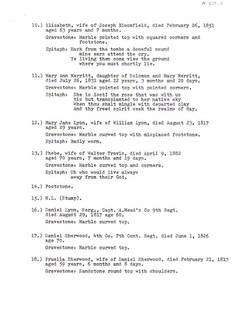
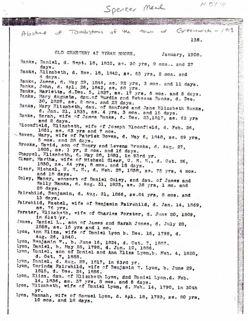
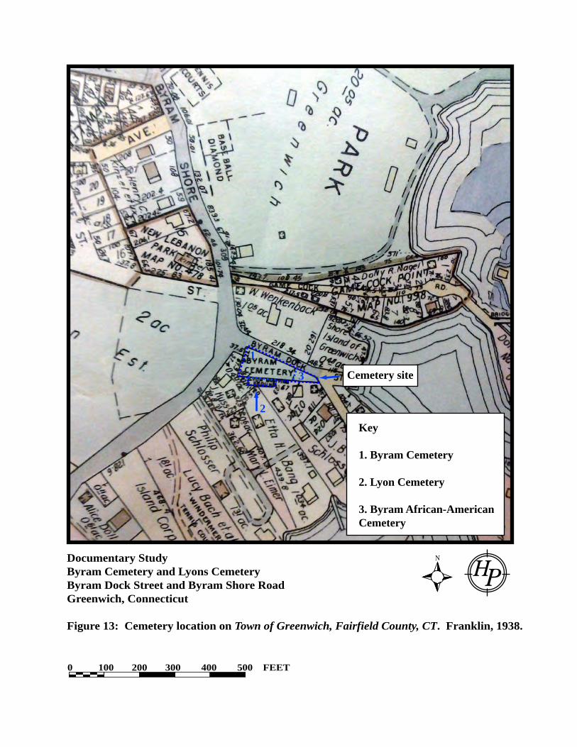
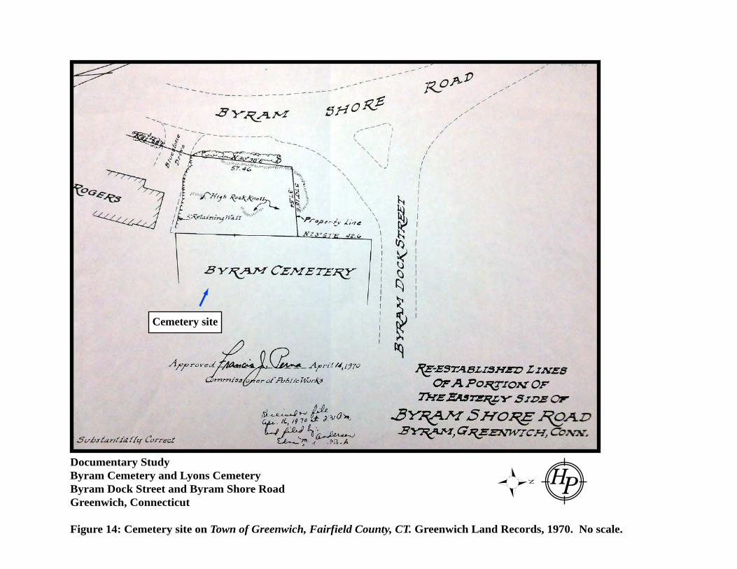
dwelling at 11 Byram Dock Street. By 1941 when a survey was completed for the recently restored Town Dock at the east end of Byram Dock Street, the very eastern end of the Byram African-American Cemetery is delineated and labeled “Byram Cemetery” (GLR Map Byram Dock, Figure 12). A 1938 atlas of Greenwich shows the full extent of the Byram Cemetery, the Byram African-American Cemetery, and the Lyon Cemetery (Franklin 1938; Figure 13). In addition, a survey plan dating to 1970 for the reestablished lines of a parcel on Byram Shore Road, depicts the Byram Cemetery along Byram Dock Street, but does not extend east far enough to include the location of the Byram African-American Cemetery (Figure 14). Two additional aerial photographs on file at the Greenwich Town Hall and dating to 1959 and 1963 were reviewed, but neither had the level of detail necessary to elucidate cemetery boundaries. A 1989 inventory of “The Old Burying Ground at Byram/Lyon Plot” by Jeffrey Mead and on file at the Greenwich Historical Society recorded at least 54 standing head or foot stones and nine displaced headstones, none of which were located in the Byram African-American Cemetery. Indeed, documentary research to date has not found reference to any headstones in this section of the cemetery, which is not uncommon given the marginalized population. Appendix C of this report includes this survey plan and an associated list of legible headstones in 1989, a 1934 inventory of the “Lyon-Rawson Cemetery” by Earle F. Kepler, and a 1908 listing of headstones at the “Old Cemetery at Byram Shore” (Mead 1913).
4.0 CONCLUSIONS AND RECOMMENDATIONS Documentary studies to date by multiple researchers have found many deeds and maps reporting or depicting the presence of Byram Cemetery on Byram Dock Street and Byram Shore Road in Greenwich, but have not been successful in finding a deed directly relating to the ownership of the cemetery. It may be that the parcel was part of the original Greenwich Lots that were not owned by individuals, or that it was in the collective memory of the Lyon family and relatives as their family plot that required no specific deed since it was directly related to their family from the seventeenth through the early twentieth centuries. While the Byram African-American Cemetery has no standing headstones and none were reported in 1908 when the adjacent Byram Cemetery was surveyed, this is not unusual at burying grounds used by enslaved peoples or their descendants. Indeed many cemeteries in the Northeast lack such headstones. African traditions transported to the New World often involved placing items of importance on graves, but not headstones; this is a European custom that was not often assumed by the enslaved population (Viet and Nonestied 2014). Wooden markers may have also been placed at the site, but no evidence of them remains. Furthermore, there is no assumption of the duration of the active use of the burial ground or that interments were limited to enslaved individuals related to the Lyons and/or Banks family. Free residents of color may have been buried here, too. The historical record is very clear that the Lyon and Banks families held slaves during the years that they lived on Byram Neck, and for the Banks family, this included both African-American and Native American peoples. It is quite likely that a burial plot was established for this population, a practice not uncommon. Thomas Lyon, being a Quaker, and his immediate descendents, may have believed that it was a just and fair thing to do – to provide their slaves with a specific burying ground. Later generations would have likely followed suit.
Documentary Study, Byram Cemetery and Lyon Cemetery, Greenwich, CT
9
The recommendations of the memo prepared by HPI in September 2014 (Appendix A) are still valid. Some of the recommendations have been accomplished, and other recommendations are being addressed. The table on the following page provides a list of those recommendations and their status as of the completion of this report (November, 2014). Of utmost importance are the tasks of permanently protecting and commemorating the cemetery. As numerous studies attest to the diminished recollection of slavery as part of the New England historical landscape (e.g., Cruson 2007, Farrow 2014, Mead 1995), the commemoration of the enslaved population and potentially their descendants that lived and died in Greenwich, and particularly on Byram Neck, is imperative. Fencing that is appropriate to a historic cemetery should be considered to prevent further intrusions, but this should be completed in a way that has the least possible impact below grade so as to avoid disturbing any potential human remains. Monumentation should also be undertaken in a manner that will actively seek to reverse the invisibility on the landscape invoked by the lack of headstones and obvious markers, and to celebrate the lives of so many who worked on the farms and in the houses of Greenwich, and who had a large impact on the creation of the community and the landscape that it is today. Any fencing or preservation plans should be created in consultation with Dr. Brian Jones, Connecticut State Archaeologist, with input from local historic preservation groups, particularly the Greenwich Preservation Trust.

Documentary Study, Byram Cemetery and Lyon Cemetery, Greenwich, CT
10
Recommendations and Status Table for Byram African-American Cemetery, November 15, 2014 RECOMMENDATION STATUS 1 The Town of Greenwich (Town) establish the
cemetery boundaries and flag these boundaries in a permanent way accordingly.
Underway. The boundaries have a temporary marker but should be permanently marked in as non-invasive a way as possible.
2 The Town formally acquire the property, establishing an easement for a Right-of-Way (ROW) immediately at the base of the rock outcrop, allowing access to the parcel at 11 Byram Dock Street.
Underway. The Town should establish the easement as no more than XX feet out and east of the rock outcrop, where testing established shallow bedrock. Further to the east would be potentially imposing on the burying ground.
3 No further excavations or improvements to the ROW, including compaction, paving, etc. should be undertaken to ensure that potential human remains immediately beneath the drive are not disturbed.
Completed. Excavations have been halted and no paving or laying of any surface other than gravel is recommended.
4 The back dirt pile should be removed from the cemetery site under the supervision of a professional archaeologist to ensure that potential human remains immediately beneath the surface are not disturbed
Completed. Archaeologists from HPI monitored the hand-removal of all back dirt from on top of the cemetery on September 17 and 20, 2014. The site was left with the retaining walls intact.
5 Upon removal of the back dirt pile, the Cemetery should be landscaped and reseeded with grass. A planting schedule should be developed in conjunction with the State Archaeologist to ensure that the design is appropriate to a cemetery and that plantings do not inadvertently disturb any burials
Underway. Requires confirmation by the Greenwich Zoning Enforcement Officer.
6 An interpretive panel documenting the historic character and age of the cemetery should be installed on the property in a fashion so as not to encourage looting but to celebrate the lives of the African-Americans who are interred there
To be completed.
7 A professional archaeologist should undertake limited subsurface investigations in the form of one-inch hand auguring to establish subsurface conditions. If this proves to be too small a sample size to adequately determine subsurface conditions, then narrow shovel tests (STs) should be completed in a linear transect across the cemetery from west to east, with no more than five STs completed
Completed. Archaeologists tested around the perimeter of the site where new retaining walls do not exist to establish subsurface conditions. Testing showed disturbed strata and was halted due to concern over disturbing potential burials.
8 The results of the subsurface investigation and the documentary study should be compiled into a compendium of information documenting the known history of the site and filed with both the Town and the Greenwich Historical Society
Completed. To be distributed.
9 The Town should develop a maintenance plan to ensure that the Byram Cemetery, Lyon Cemetery, and “Colored Cemetery” are maintained appropriately in perpetuity
To be completed.
Documentary Study, Byram Cemetery and Lyon Cemetery, Greenwich, CT
11
5.0 BIBLIOGRAPHY Adams, Catherine and Elizabeth Pleck 2009 Love of Freedom: Black Women in Colonial and Revolutionary New England. Oxford
University Press, Oxford. Beers, Frederick W. 1867 Town of Greenwich, Fairfield County, Connecticut. Beers, Ellis, & Soule, New York. Berlin, Ira and Leslie M. Harris 2005 Slavery in New York. The New York Historical Society, New York. Clark, Richard 1856 Clark’s map of Fairfield County, Connecticut. Richard Clark, Philadelphia. Clark, Richard and George and Robert Tackabury 1859 Clark and Tackaburys New Topographical Map of the State of Connecticut. Richard
Clark, George and Robert Tackabury, Philadelphia. Fairchild Aerial Survey 1934 Fairchild Aerial Survey. Photo No. 03988 http://cslib.cdmhost.com/custom/aerials.php Site accessed October 5, 2014. Farrow, Anne 2014 The Logbooks: Connecticut’s Slave Ships and Human Memory. Wesleyan University
Press, Middletown, Connecticut. Cruson, Daniel 2007 The Slaves of Central Fairfield County. History Press, Charleston. Fitts, Robert K. 1998 Inventing New England's Slave Paradise: Master/slave Relations in Eighteenth-century
Narragansett, Rhode Island. Garland Publishing, New York. Franklin Survey Company 1938 Town of Greenwich, Fairfield County, CT. Volume 1, Plate 9. Philadelphia. Greenwich Historical Society (GHS) 1929 Aerial Photograph. On file at the Greenwich Historical Society. nd. Vertical files. Greenwich Land Records (GLR) 1970 Town of Greenwich, Fairfield County, CT. 1986 Property survey map. Provided by the Greenwich Preservation Trust.
Documentary Study, Byram Cemetery and Lyon Cemetery, Greenwich, CT
12
Greenwich Preservation Trust 2014 Information provided on the history of the Thomas Lyon House and the James Lyon
House, family and property ,www.greenwichpreservationtrust.org. Greenwich Probate Court (GPC) 1863 Probate records on file, Greenwich, Connecticut. Greenwich Town Hall, Inland Wetlands and Watercourses Agency 1959 Aerial Photograph, Greenwich Town Hall. 1963 Aerial Photograph, Greenwich Town Hall. Greenwich Vital Records (GVR) nd Greenwich, Fairfield Co., CT Vital Records From Barbour 1640-1848. Transcribed
And Contributed By Coralynn Brown. http://www.ctgenweb.org/county/cofairfield/pages/greenwich/greenwich_a-e.htm
Hewett, Michael 2014 A Most Remarkable Family: A History of the Lyon Family from 1066 to 2014.
Authorhouse, United Kingdom. http://slavenorth.com/connecticut.html. Site accessed November 4, 2012. Historical Perspectives, Inc. 2013 Phase IA Archaeological Assessment, Replacement Of 126th Street Bus Depot, 2460
Second Avenue, Block 1803, Manhattan, New York. Prepared for the Metropolitan Transit Authority, City of New York.
Knapp, Daniel 1966 Muskets and Mansions: the Greenwich Story. Fairview Printers, Greenwich. Lyon, Albert B. 1907 Lyon Memorial, New York Families Descended From The Immigrant Thomas Lyon, Of
Rye With Introductory Chapter By Dr. G. W. A. Lyon On The English Lyon Families With Maps And Facsimile Reproductions Of Interesting Ancient Manuscripts. Robert B. Miller, ed. Detroit, Michigan.
Lyon, Charles 1967 Excerpts from the Descendents of Thomas Lyon of Rye and the Journals of Elizabeth
Lyon by Charles Lyon, Vol. 1 by Charles Lyon. Mead, Jeffrey 1995 Chains Unbound: Slave Emancipations in the Town of Greenwich, Connecticut. Gate
Press, Baltimore. Mead, Spencer P. 1911 Ye Historie of Ye Town of Greenwich, County of Fairfield and State of Connecticut,
Miller Robbins & Co., The Knickerbocker Press.

Documentary Study, Byram Cemetery and Lyon Cemetery, Greenwich, CT
13
Mead, Spencer P. (con’t.) 1913 Abstract of Tombstones of the Town of Greenwich. On file at the Greenwich Historical
Society. Minor, S. E. 1887 Map of the Estate of Daniel Lyon, Greenwich, Conn. Surveyed by S. E. Minor. On file
at the Stamford Probate Office. 1901 Map of the Cemetery and Road in the Town of Greenwich, Conn. Greenwich Land
Records Map #154. 1911 Map of the Public Dock, Cemetery, and Road at “Byram Shore” in the Town of
Greenwich. Greenwich Land Records Map #1980. 1941 Byram Dock, Property of the Town of Greenwich, Connecticut. New-York Historical Society 1899 Abstracts of the New York Historical Society 1899. Abstracts of Wills on file in the
Surrogates Office in the City of New York. Vol. VII. New-York Historical Society. RKA (Renee Kahn Associates) 1978 Byram Connecticut: An Historic Resources Inventory. Greenwich Public Library. Robbins, Miller Jr. 1890 Road and Property Map showing the Towns of Greenwich and Stamford Connecticut.
Miller Robbins Jr. and Company, New York. Schenck, Elizabeth Hubbell Godfrey 1889 The History of Fairfield, Fairfield County, Connecticut, from the Settlement of the Town
in 1639 to 1818: 1639-1700. Elizabeth Hubbell Godfrey Schenck, Fairfield, Connecticut.
United States Census Bureau 1790 Federal Census Records for Greenwich, Fairfield County. USGS (United States Geological Survey) 2013 Mamaroneck, New York-Connecticut. 7.5 Minute Series. 2014 Glenville, Connecticut Quadrangle. 7.5 Minute Series. Viet, Richard and Mark Nonestied 2014 Born a Slave Died Free: Antebellum African-American Commemoration in a Northern
State. Paper delivered at the Council for Northeastern Historical Archaeology Annual Conference, Long Branch, New Jersey, November 9, 2014.
Webb, Charles 1788 A Map of the Township of Greenwich and the Purchases of said town by a survey
thereof October 1757 and April 1773 by Charles Webb. Greenwich Historical Society.

Documentary Study Byram Cemetery and Lyons CemeteryByram Dock Street and Byram Shore RoadGreenwich, Connecticut
Figure 1: Cemetery Site on Glenville, CT-NY and Mamaroneck, NY-CT 7.5 Minute Topographical Quadrangles (U.S.G.S. 1986).
0 250 500 750 1000 1250 FEET
Cemetery site

Documentary Study Byram Cemetery and Lyons CemeteryByram Dock Street and Byram Shore RoadGreenwich, Connecticut
Figure 2: Cemetery site on Town of Greenwich Tax Map 183, Vol. 3.
0 100 200 300 400 500 FEET
Cemetery site
Key
1. Byram Cemetery
2. Lyon Cemetery
3. Byram African-AmericanCemetery
1
2
3

Documentary Study Byram Cemetery and Lyons CemeteryByram Dock Street and Byram Shore RoadGreenwich, Connecticut
Figure 3: Detail of ca. 1750 map showing Byram Neck and approximate location of Byram Cemetery.
No scale.
Cemetery site

Documentary Study Byram Cemetery and Lyons CemeteryByram Dock Street and Byram Shore RoadGreenwich, Connecticut
Figure 4: Detail of 1788 Webb map showing Byram Neck and approximate location of Byram Cemetery.
No scale.
Cemetery site

Documentary Study Byram Cemetery and Lyons CemeteryByram Dock Street and Byram Shore RoadGreenwich, Connecticut
Figure 5: Cemetery site on Clark’s map of Fairfield County, Connecticut. Clark, 1856.
No scale.
Cemetery site

Documentary Study Byram Cemetery and Lyons CemeteryByram Dock Street and Byram Shore RoadGreenwich, Connecticut
Figure 6: Cemetery site on Town of Greenwich, Fairfield County, Connecticut. Beers, 1867.
No scale.
Cemetery site
Documentary Study Byram Cemetery and Lyons CemeteryByram Dock Street and Byram Shore RoadGreenwich, Connecticut
Figure 7: Cemetery site on Map of the Estate of Daniel Lyon, Greenwich, Conn. Minor, 1887.
0 100 200 300 400 500 FEET
Cemetery site
Key
1. Byram Cemetery
2. Lyon Cemetery
3. Byram African-AmericanCemetery
1
2 3

Documentary Study Byram Cemetery and Lyons CemeteryByram Dock Street and Byram Shore RoadGreenwich, Connecticut
Figure 8: Cemetery location on Map #39, Greenwich Land Records. 1888.
0 20 40 60 80 100 FEET
Cemetery site
Key
1. Byram Cemetery
2. Lyon Cemetery
3. Byram African-AmericanCemetery
1
2
3

Documentary Study Byram Cemetery and Lyons CemeteryByram Dock Street and Byram Shore RoadGreenwich, Connecticut
Figure 9: Cemetery location on Road and Property Map showing the Towns of Greenwich and Stamford Connecticut. Robbins, 1890.
No scale.
Cemetery site

Documentary Study Byram Cemetery and Lyons CemeteryByram Dock Street and Byram Shore RoadGreenwich, Connecticut
Figure 10: Cemetery location on Map #154, Greenwich Land Records. Minor, 1901.
0 50 100 150 200 250 FEET
Cemetery site
Key
1. Byram Cemetery
2. Lyon Cemetery
3. Byram African-AmericanCemetery
1
2
3

Documentary Study Byram Cemetery and Lyons CemeteryByram Dock Street and Byram Shore RoadGreenwich, Connecticut
Figure 11: Cemetery location on Map of the Public Dock, Cemetery, and Road at Byram Shore in the Town of Greenwich. Minor, 1911.
0 50 100 150 200 250 FEET
Cemetery site
Key
1. Byram Cemetery
2. Lyon Cemetery
3. Byram African-AmericanCemetery
1
2
3

Documentary Study Byram Cemetery and Lyons CemeteryByram Dock Street and Byram Shore RoadGreenwich, Connecticut
Figure 12: Cemetery location on Byram Dock, Property of the Town of Greenwich, Connecticut. Minor, 1941. No scale.
Cemetery site
Documentary Study Byram Cemetery and Lyons CemeteryByram Dock Street and Byram Shore RoadGreenwich, Connecticut
Figure 13: Cemetery location on Town of Greenwich, Fairfield County, CT. Franklin, 1938.
0 100 200 300 400 500 FEET
Cemetery site
Key
1. Byram Cemetery
2. Lyon Cemetery
3. Byram African-AmericanCemetery
1
2
3
Documentary Study Byram Cemetery and Lyons CemeteryByram Dock Street and Byram Shore RoadGreenwich, Connecticut
Figure 14: Cemetery site on Town of Greenwich, Fairfield County, CT. Greenwich Land Records, 1970. No scale.
Cemetery site
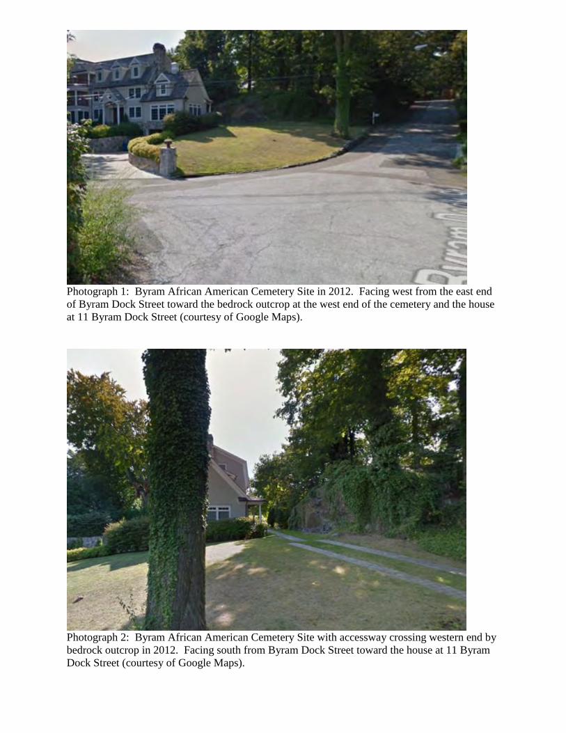
Photograph 1: Byram African American Cemetery Site in 2012. Facing west from the east end
of Byram Dock Street toward the bedrock outcrop at the west end of the cemetery and the house
at 11 Byram Dock Street (courtesy of Google Maps).
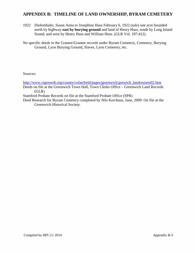
Photograph 2: Byram African American Cemetery Site with accessway crossing western end by
bedrock outcrop in 2012. Facing south from Byram Dock Street toward the house at 11 Byram
Dock Street (courtesy of Google Maps).

Photograph 3: Byram African American Cemetery Site in August 2014. Facing south from
Byram Dock Street toward the house at 11 Byram Dock Street. Note that two tiers of stone
retaining walls have been created above the cemetery site.
Photograph 4: Byram African American Cemetery Site with accessway crossing western end by
bedrock outcrop in 2014. Facing south from Byram Dock Street toward the house addition at 11
Byram Dock Street. Note that the rock face has been cut back and a small retaining wall erected.

Photograph 5: Byram African American Cemetery Site after back dirt pile was hand removed
and before seeding was undertaken. October 20, 2014. Facing west from east end of Byram
Dock Street. Note that two tiers of stone retaining walls remain on top of the cemetery site.
Photograph 6: Byram African American Cemetery Site after back dirt pile was hand removed
and before seeding was undertaken. October 20, 2014. Facing south from Byram Dock Street.

APPENDICES


APPENDIX B: TIMELINE OF LAND OWNERSHIP, BYRAM CEMETERY
Timeline of Land Transfers for property on Byram Neck, Town of Greenwich, Connecticut:
1676: Lyon, Thomas, February 13, 1676, granted a parcel of land lying along the Byram River. 1676: Banks, John, granted a parcel of land along the Byram River as well as Calves Island. 1685: Banks, John (will) to John Banks Jr. leaves 150 acres at Byram River. 1690: Lyon, Thomas, (will) leaves parcels of land at Byram to sons Daniel, Thomas, Joseph and
John. 1706: Lyon, Samuel, 1706, granted a parcel of land. 1712: Lyon, Joseph, and others, March 22, 1712, granted parcel of land. 1714: Lyon, John, Jr., Sept. 1714, bought land of William Hubbard. 1715: Banks, Samuel, Aug. 25, 1715, bought land of Deliverance Brown, Jr., and his wife
(Mercy Lyon Banks - daughter of John Lyon and Abigail Banks). 1718: Lyon, John, Sr. and others, Nov. 5, 1718, Proprietors of Byram Neck. 1722: Lyon, Thomas Jr. bought of Joseph Lyon all his right, title, and interest in the estate of
Samuel Lyon, deceased. 1728: Lyon, Jonathan, and others, July 26, 1728, bought land of his father, Thomas Lyon Jr. 1728: Lyon, Elizabeth, and others, July 26, 1728, bought land of Samuel Mead and others. 1728: Lyon, David, Aug. 20, 1728, bought land of Thomas Lyon Jr. 1732: Lyon, Joseph, Feb. 22, 1732, bought land of his father, Thomas Lyon Jr. 1732: Lyon, Thomas Jr., Feb. 22, 1732, deeded land to his sons, Joseph and Jonathan. 1733: Lyon, Thomas Jr., Feb. 13, 1733, deeded land to his son, Thomas Lyon. 1737: Lyon, Daniel, May 2, 1737, bought land of Samuel Banks (son of John Banks). 1738: Banks, Samuel, March 29, 1738, sold to Samuel Brown part of his father's, John Banks
estate in Byram. 1742: Lyon, Caleb, May 18, 1742, bought land of Joseph Reynolds and John Ferris. 1742: Lyon, Gilbert, March 22, 1742, bought land of Jabez Sherwood. 1749: Lyon, John, August 16, 1749, (will) to son James Lyon “Mary’s Hill” in Byram Neck and
“Samuel Banks Lot.” And half his land in Byram Neck. Executed March 25, 1752. The “Samuel Banks Lot” includes the house at what is now 47 Byram Shore Road adjacent to the Lyons cemetery (personal communication Nils Kerschus, November 9, 2014). John Lyon’s wife at the time of his death is Hannah, widow of Joseph Banks.
1751: Lyon, Daniel, quit claimed parcel to Thomas Lyon (GLR Vol. 7:254). 1752: Lyon, John Jr., (estate) March 25, 1752. Quite claimed to James Lyon 5.5 acres bounded
northeast by the burying place and water, southeast by water, south by land of Daniel Lyon, and west by “the way left to us by the waterside” (SPR Vol. 13:691).
1826: Lyon, Benjamin Woolsey (estate) August 9, 1826. Will to Daniel Lyon 10 acres bounded north by a burying ground and a garden of 16 rods, bounded north by Jonas Mead, all other sides by a highway, east by the sea, south by Jonas Mead, and west by the Road and Jonas Mead (SPR Vol. 13:157).
1838: Lyon, Thomas September 24, 1838. Quit claim to Daniel Lyon, 16 acres on Long Island Sound south of Byram Road (GLR Vol. 23:422).
1863: Lyon, Thomas, August 27, 1863. Estate sold to William H. Lyon a tract of land in the town of Greenwich at a placed “called Marys [sic] Hill containing about two ac[res] with a barn thereon standing, and bounded northerly on land of William & Thomas Ritch, Easterly on the sea or bay, southeasterly on the highway and burial ground and westerly by highway” (GLR Vol. 31:432-433).
Compiled by HPI 11/ 2014 Appendix B-1

APPENDIX B: TIMELINE OF LAND OWNERSHIP, BYRAM CEMETERY
1866: Lyon, John, May 24, 1866. Quit claimed to Daniel Lyon 12 acres bounded north by highway and a burying ground, east by the waters of Long Island Sound, southerly and westerly by the land of Jonas Mead. Release of mortgage granted May 15, 1856 (GLR Vol. 33:900).
1887: Lyon, Daniel, June 2, 1887. Daniel deeded one acre bounded northerly by highway, easterly by burying ground and land of estate of Daniel Lyon, deceased, southerly by Long Island Sound, and westerly by Land of said estate, said westerly boundary being a fence now existing westerly of the hose on the tract thereby conveyed. Reserving and excepting there from a right of way for a public or private way fifty feet in width across said tract running above or near the southerly side of a stone fence no existing, and also reserving an excepting a right of way to and from the family burial ground on the east of the tract hereby conveyed (GLR Vol. 58:15-16).
1887: Lyon, Daniel, June 9, 1887 to Daniel Lyon parcel of land bounded north by highway, east by burying ground and estate of Daniel Lyon, south by Long Island Sound (GLR Vol. 58:15).
1887: Lyon, Daniel, August 1, 1887 probate to Benjamin W. Lyon (son) Lot number 5 of Daniel’s subdivided land, described as a 1.57 acre parcel “bounded northerly by said land sold to Daniel Lyon Jr. by land of Lyons burial plot and by cemetery, as shown on said map; easterly by said Lyons burial plot and Cemetery and lot, southerly in part by Lot no. 6 and by waters of Long Island Sound and westerly by said land sold to Daniel Lyon as shown on said map no. 6 on said map…and also a right to use for travel an open private way 30 ft. wide on and over the easterly side of the lot no. 4…” (SPR Vol. 13: 37).
1888: Lyon, Daniel (estate) November 24, 1888. Willed to Hannah Lyon one acre bounded north by highway, east by burying ground, south by Long Island Sound. (SPR Vol. 14:319).
1888: Lyon, Thomas September 20, 1888. Sells to Ellen Waterman Lot 5. Bounded as follows: “beginning at the northwesterly corner of the premises herein conveyed adjoining the grave yard, thence running easterly along the grave yard as the fence now stands, eighty two feed (82) to highway thence southeasterly along the highway near the water a distance of thirty five feet as fence now stands to other land of Thomas Lyon, thence southwesterly along said last mentioned land, one hundred and nineteen feet to land of Lewis Tyler, thence northwesterly along land of Lewis Tyler as the fence now stands a distance of seventy-one feet six inches (76 6/12) thence in a more northerly direction a distance of eighty two feet and two inches (82 2/12) to the said graveyard and the point of beginning. Right of way from the northeast side of the premises measuring 35 feet is given to the water” (GLR Vol. 78:67).
1902 Lyon, Hannah May 14, 1902. Sells one acre bounded north by highway east by burying ground and land of Henry Huss, south by Long Island Sound, and west by Henry Huss and William Huss (GLR Vol. 92:93).
1902 Kervan, Lawrence May 14, 1902. Sells to William Huss (sale) one acre bounded north by highway east by burying ground and land of Henry Huss, south by Long Island Sound, and west by Henry Huss and William Huss (GLR Vol. 92:118).
1911 Huss, William H. November 6, 1911. Sells to Susan Anna Diefenthaler one acre bounded north by highway east by burying ground and land of Henry Huss, south by Long Island Sound, and west by Henry Huss and William Huss (GLR Vol. 132:257).
Compiled by HPI 11/ 2014 Appendix B-2
APPENDIX B: TIMELINE OF LAND OWNERSHIP, BYRAM CEMETERY
1922 Diefenthaler, Susan Anna to Josephine Huss February 6, 1922 (sale) one acre bounded north by highway east by burying ground and land of Henry Huss, south by Long Island Sound, and west by Henry Huss and William Huss. (GLR Vol. 187:412).
No specific deeds in the Grantor/Grantee records under Byram Cemetery, Cemetery, Burying Ground, Lyon Burying Ground, Slaves, Lyon Cemetery, etc.
Sources:
http://www.ctgenweb.org/county/cofairfield/pages/greenwich/grnwich_landowners02.htm Deeds on file at the Greenwich Town Hall, Town Clerks Office – Greenwich Land Records
(GLR) Stamford Probate Records on file at the Stamford Probate Office (SPR) Deed Research for Byram Cemetery completed by Nils Kerchaus, June, 2009. On file at the
Greenwich Historical Society.
Compiled by HPI 11/ 2014 Appendix B-3

APPENDIX C: BYRAM CEMETERY HEADSTONE INVENTORIES