dolphin geotechnical drilling finalv2
TRANSCRIPT

ASX: KIS Market Capitalisation $20.8 million Shares on Issue 244.5 million 52 Week High 13.5 cents 52 Week Low 3.5 cents Share Price 8.5 cents
Board of Directors
Johann Jacobs Chairman
Allan Davies Director
Chris Ellis Director
King Island Scheelite Limited (KIS)
through its 100% Dolphin Project on King Island, Tasmania is one of the world’s richest tungsten deposits and could meet a significant proportion of the world’s tungsten requirements over a minimum 13 years.
Tungsten price
Metal Pages APT USD 277.50 / mtu (18 Sept 2018)) King Island Scheelite Limited ABN 40 004 681 734
Level 26, 259 George Street Sydney NSW 2000 GPO Box 5154 Sydney NSW 2001 P. +61 2 8622 1402 Email: [email protected]
www.kingislandscheelite.com.au
DOLPHIN GEOTECHNICAL DRILLING
UPDATE
HIGHLIGHTS
The Dolphin mining development plan is based on expanding
the current void eastwards
Two-hole geotechnical drilling programme recently completed
Geotechnical results will be used to finalise the ultimate pit
design
Core from the holes was also analysed for WO3 content
Laboratory analysis of first hole KI064 now received;
B Lens 122.6 – 124.6 2.0m @ 0.7% WO3
C Lens 152.5 – 159.9 7.4m @ 1.4% WO3
C Lens 159.9 – 175.5 15.6m @ 0.4% WO3
3 October 2018
Johann Jacobs
Chairman
Tim Callaghan – Resource and Exploration Geology
3 October 2018 ASX and Media Release
DOLPHIN GEOTECHNICAL DRILLING
HIGH GRADE SCHEELITE SKARN MINERALISATION
King Island Scheelite Limited (ASX: KIS) is pleased to announce the results from the first of a two hole geotechnical drilling program, testing the Eastern wall of the proposed Dolphin Open Pit, in the Grassy District of King Island. In its current redevelopment plan, KIS proposes to extend the existing open pit eastwards to access remnant resources for the production of scheelite concentrate.
The Dolphin deposit contains a remnant Indicated Resource of 9.6mt at 0.90% WO3 yielding 86,400t WO3 above a cutoff of 0.2% WO3. The proposed open pit contains a Probable Reserve of 3.14Mt @ 0.73% WO3 above a cutoff of 0.2% WO3 (refer KIS ASX report 24/4/2015). The resource and reserve are based on historic geological information acquired during the operation of the mine prior to its closure in 1990, verified by significant additional drilling during 2014/5. The information from these sources enabled the Company to classify its Reserves and Resources in accordance with the guidelines of the 2012 edition of the JORC Code.
Although primarily intended to provide geotechnical information on the proposed open cut extension, geotechnical drill hole KI064 also intersected high grade skarn mineralisation. Pleasingly, the mineralised intersections reconcile well with the geological and interpolated WO3 grade, providing confidence in the historic information the current resource and reserve are based on.
KI064 B Lens 122.6 – 124.6 2.0m @ 0.7% WO3
C Lens 152.5 – 159.9 7.4m @ 1.4% WO3
C Lens 159.9 – 175.5 15.6m @ 0.4% WO3
The second geotechnical drill hole, KI070 also intersected high grade mineralisation before ending in historic underground workings. Results of the second hole will be reported when analyses are returned from the laboratory. Geotechnical evaluation is ongoing and is anticipated to be completed by December 2018.

Tim Callaghan – Resource and Exploration Geology
Figure 1. Regional Geology of the Grassy District.

Tim Callaghan – Resource and Exploration Geology
TECHNICAL REPORT
KING ISLAND SCHEELITE GEOTECHNICAL DRILLING
SEPTEMBER 2018
A two-hole geotechnical diamond drilling program was completed by King Island Scheelite Limited (KIS) in August 2018. The objective of the program was to investigate the geotechnical properties of the eastern wall of the proposed Dolphin Open Pit. The drillhole also intersected mineralisation of B and C lens supporting the geological information used for earlier resource estimation.
The Dolphin Mine operated as an open cut between 1917 and 1970 before a decline accessed underground mine was established in the 1970’s to access the deeper eastern end of the deposit. The underground operation recorded a total production of 2.6Mt @ 1.0% WO3 up to 1990 before low tungsten prices ceased operations. King Island Scheelite (KIS) propose to redevelop the mine by extending the existing open pit. The Dolphin deposit contains a remnant Indicated Resource of 9.6mt at 0.90% WO3 yielding 86,400t WO3 above a cutoff of 0.2% WO3. The proposed open pit contains a Probable Reserve of 3.14Mt @ 0.73% WO3 above a cutoff of 0.2% WO3 (refer KIS ASX report 24/4/2015). The majority of the resource is located east of the historic Dolphin Pit.
The Dolphin Mine is hosted in calcareous volcaniclastic sediments near the base of the Grassy Group. Scheelite mineralisation is associated with calcareous skarn developed adjacent to the contact of the Lower Grassy Group and the Grassy Granodiorite. Mineralisation is localized in and around two main carbonate horizons termed B lens and C Lens as well as occurring in calcareous sediments known as the Banded Footwall Beds. Mineralisation is best developed in the C Lens where it is in proximity to faults. C Lens has three principal mineralized horizons, the most significant of which is the high grade Upper C-Lens garnet hornfels. The Lower C-Lens consists of lower grade banded pyroxene-garnet hornfels. At the top of C Lens is a pyroxene-garnet hornfels (PGH) that contains less consistent scheelite mineralization.
The host sequence dips shallowly south east, steepening in proximity to the Decline Fault. The deposit is bound to the south by the Grassy Granodiorite, the north by the northern boundary fault and the east by the Grassy River Fault. The Decline Fault is
Tim Callaghan – Resource and Exploration Geology
a brittle-ductile shear which has attenuated and down warped the Grassy Group on its eastern margin. Mineralisation extends over 1150m in strike length by 750m in width and extends from 80m above sea level in the west plunging to -380m in the east. B lens mineralisation is between 3 and 30m in width and C lens 3 and 40m in width. Near mine resource extension is limited in the far southern and western areas but may have significant potential between the Decline Fault and Grassy Fault to the south where the faults diverge.
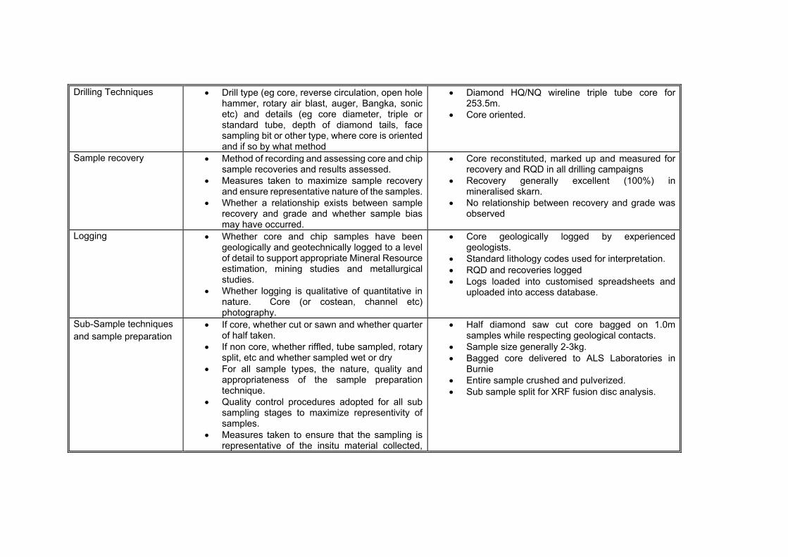
Drilling was completed by E Drill contract diamond drilling with a truck mounted diamond drill rig. All holes were drilled HQ/NQ triple tube diamond core with very good recoveries from the skarn mineralisation.
Drill collars were surveyed by licensed surveyor with downhole surveys completed every 30m with an Eastman Single Shot down hole camera.
Drill core was logged in the KIS core facility in Grassy. All core is stored in the Grassy core compound. Logging was completed on excel spreadsheets and loaded into an access database. A low wavelength ultraviolet lamp was used to delineate zones with significant scheelite mineralisation. Areas with strong fluorescence were marked for sampling. Whole drill core samples were taken on 1m lengths from mineralised zones whilst respecting geological boundaries. Drill core was bagged on site, sealed in poly-weave bags and sent to ALS Laboratories in Burnie for analysis. Samples were analysed for WO3 by fusion disc XRF. Results were received electronically and loaded onto log sheets and uploaded to the KIS drilling database.
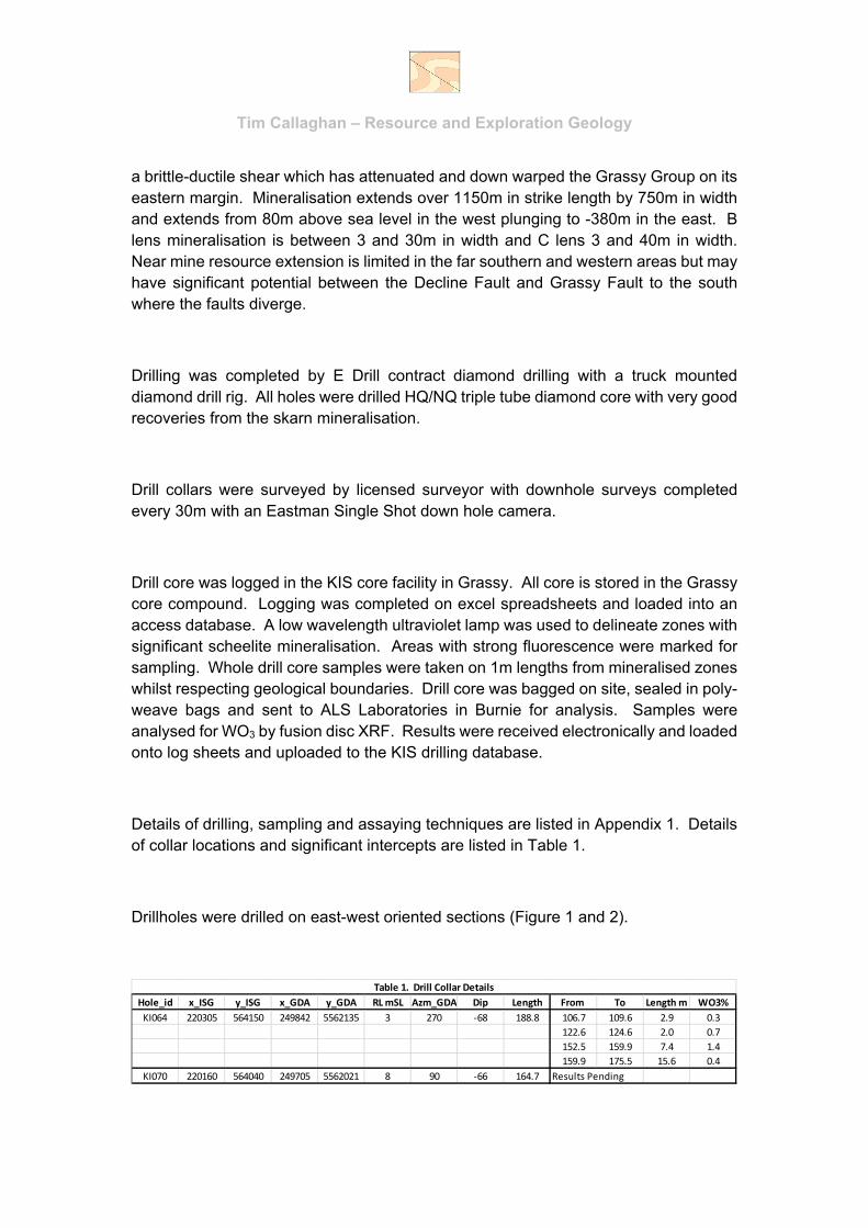
Details of drilling, sampling and assaying techniques are listed in Appendix 1. Details of collar locations and significant intercepts are listed in Table 1.
Drillholes were drilled on east-west oriented sections (Figure 1 and 2).
Hole_id x_ISG y_ISG x_GDA y_GDA RL mSL Azm_GDA Dip Length From To Length m WO3%
KI064 220305 564150 249842 5562135 3 270 ‐68 188.8 106.7 109.6 2.9 0.3
122.6 124.6 2.0 0.7
152.5 159.9 7.4 1.4
159.9 175.5 15.6 0.4
KI070 220160 564040 249705 5562021 8 90 ‐66 164.7 Results Pending
Table 1. Drill Collar Details
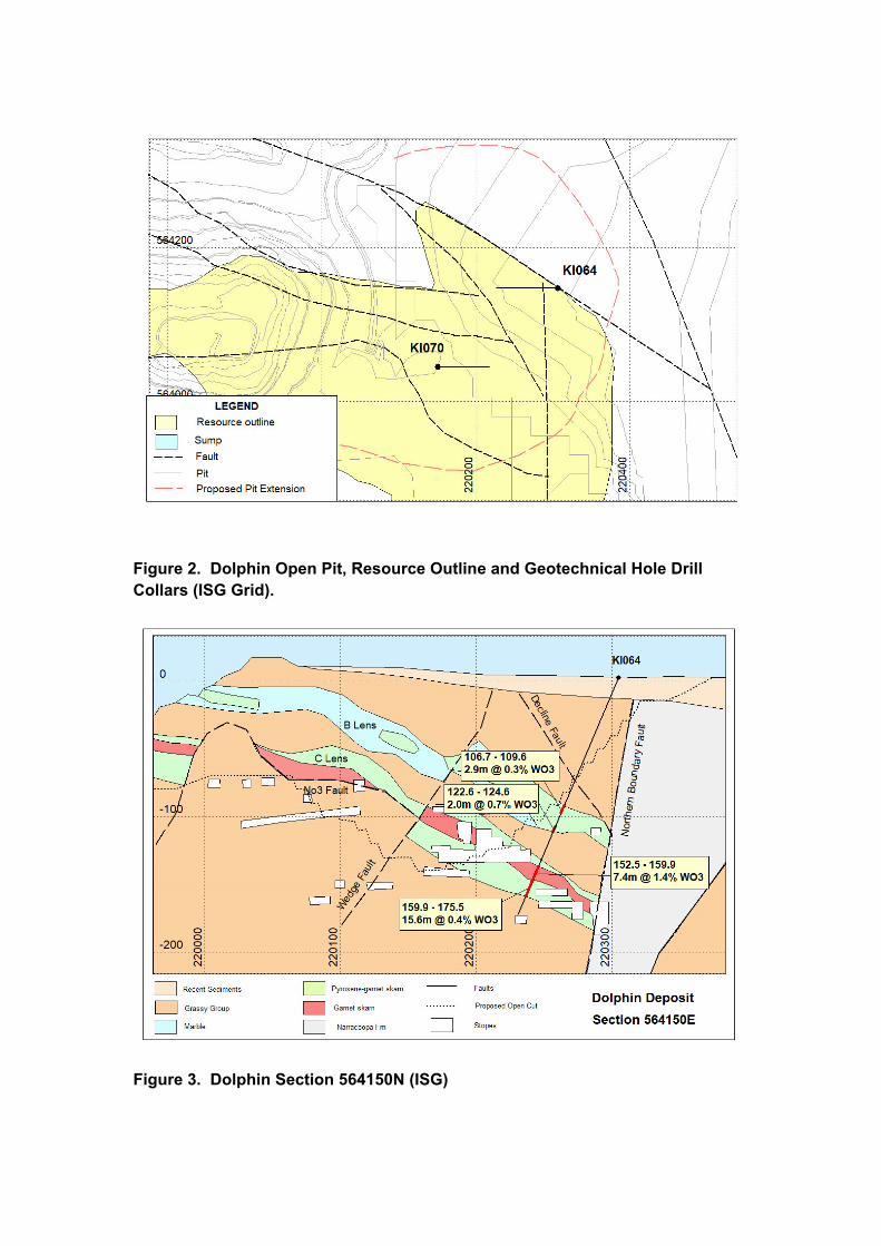
Figure 2. Dolphin Open Pit, Resource Outline and Geotechnical Hole Drill Collars (ISG Grid).
Figure 3. Dolphin Section 564150N (ISG)

Appendix 1. JORC (2012) Table 1 report
Section 2 Reporting of Exploration Results
Section 1. Sampling Techniques and Data
Criteria JORC Code Explanation Commentary
Sampling Techniques Nature and Quality of sampling (eg cut channels, random chips or specific specialized industry standard measurement tools appropriate to the minerals under investigation, such as downhole gamma sondes, or hand held XRF instruments etc).
Include reference to measures taken to ensure sample representivity and the appropriate calibration of any measurement tools or systems used.
Aspects of the determination of mineralisation that are Material to the Public Report. In cases where ‘industry standard’ work has been done this would be relatively simple (eg ‘reverse circulation drilling was used to obtain 1m samples from which 3kg was pulverized to produce 30g charge for fire assay’). In other cases more explanation may be required, such as where there is coarse gold that has inherent sampling problems. Unusual commodities or sampling types (eg submarine nodules) may warrant disclosure of detailed information.
The 2018 geotechnical drilling consisted of HQ and NQ wire-line diamond drilling.
2 wire-line HQ/NQ diamond drill holes completed for 253.5m
Approximately 1m samples of 2-3kg were taken from diamond saw cut drill core whilst respecting geological boundaries.
Drilling Techniques Drill type (eg core, reverse circulation, open hole hammer, rotary air blast, auger, Bangka, sonic etc) and details (eg core diameter, triple or standard tube, depth of diamond tails, face sampling bit or other type, where core is oriented and if so by what method
Diamond HQ/NQ wireline triple tube core for 253.5m.
Core oriented.
Sample recovery Method of recording and assessing core and chip sample recoveries and results assessed.
Measures taken to maximize sample recovery and ensure representative nature of the samples.
Whether a relationship exists between sample recovery and grade and whether sample bias may have occurred.
Core reconstituted, marked up and measured for recovery and RQD in all drilling campaigns
Recovery generally excellent (100%) in mineralised skarn.
No relationship between recovery and grade was observed
Logging Whether core and chip samples have been geologically and geotechnically logged to a level of detail to support appropriate Mineral Resource estimation, mining studies and metallurgical studies.
Whether logging is qualitative of quantitative in nature. Core (or costean, channel etc) photography.
Core geologically logged by experienced geologists.
Standard lithology codes used for interpretation. RQD and recoveries logged Logs loaded into customised spreadsheets and
uploaded into access database.
Sub-Sample techniques and sample preparation
If core, whether cut or sawn and whether quarter of half taken.
If non core, whether riffled, tube sampled, rotary split, etc and whether sampled wet or dry
For all sample types, the nature, quality and appropriateness of the sample preparation technique.
Quality control procedures adopted for all sub sampling stages to maximize representivity of samples.
Measures taken to ensure that the sampling is representative of the insitu material collected,
Half diamond saw cut core bagged on 1.0m samples while respecting geological contacts.
Sample size generally 2-3kg. Bagged core delivered to ALS Laboratories in
Burnie Entire sample crushed and pulverized. Sub sample split for XRF fusion disc analysis.

including for instance results of field duplicate/second half sampling.
Whether sample sizes are appropriate to the grain size of the material being sampled
Quality of assay data and laboratory tests
The nature, quality and appropriateness of the assaying and laboratory procedures used and whether the technique is considered partial or total.
For geophysics tools, spectrometers, hand held XRF instruments, etc, the parameters used in determining the analysis including instrument make and model, reading times, calibration factors applied and their derivation etc.
Nature of quality control procedures adopted (eg standards, blanks, duplicates, external laboratory checks) and whether acceptable levels of accuracy (ie lack of bias) and precision have been established.
All samples analysed by fusion disc XRF at ALS Laboratories Burnie.
No QAQC program was implemented.
Verification of sampling and assaying
The verification of significant intersections by either independent or alternative company personnel
The use of twinned holes Documentation of primary data, data entry
procedures, data verification, data storage (physical and electronic) protocols
Discuss any adjustment to assay data
Primary assay data was received electronically and stored by consultant geologist.
All electronic data uploaded to access database Historic data loaded onto spreadsheets and
uploaded to Access database. Data validation with Surpac software, basic
statistical analysis and comparison with historic plans and sections.
Negative results for below detection limit assay data has been entered as detection limit
Location of data points Accuracy and quality of surveys used to locate drill holes (collar and downhole surveys) trenches, mine workings and other locations used in mineral resource estimation
Specification of grid system used Quality and accuracy of topographic control.
2018 exploration hole collar surveys located by licensed surveyor.
All coordinates in GDA94 Zone 55/3 or local ISG mine grid
RL’s as MSL
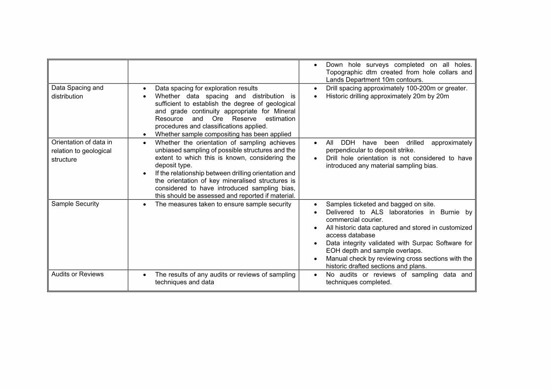
Down hole surveys completed on all holes. Topographic dtm created from hole collars and Lands Department 10m contours.
Data Spacing and distribution
Data spacing for exploration results Whether data spacing and distribution is
sufficient to establish the degree of geological and grade continuity appropriate for Mineral Resource and Ore Reserve estimation procedures and classifications applied.
Whether sample compositing has been applied
Drill spacing approximately 100-200m or greater. Historic drilling approximately 20m by 20m
Orientation of data in relation to geological structure
Whether the orientation of sampling achieves unbiased sampling of possible structures and the extent to which this is known, considering the deposit type.
If the relationship between drilling orientation and the orientation of key mineralised structures is considered to have introduced sampling bias, this should be assessed and reported if material.
All DDH have been drilled approximately perpendicular to deposit strike.
Drill hole orientation is not considered to have introduced any material sampling bias.
Sample Security The measures taken to ensure sample security Samples ticketed and bagged on site. Delivered to ALS laboratories in Burnie by
commercial courier. All historic data captured and stored in customized
access database Data integrity validated with Surpac Software for
EOH depth and sample overlaps. Manual check by reviewing cross sections with the
historic drafted sections and plans. Audits or Reviews The results of any audits or reviews of sampling
techniques and data No audits or reviews of sampling data and
techniques completed.
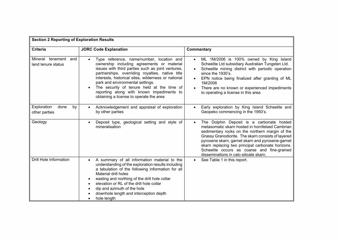
Section 2 Reporting of Exploration Results
Criteria JORC Code Explanation Commentary
Mineral tenement and land tenure status
Type reference, name/number, location and ownership including agreements or material issues with third parties such as joint ventures, partnerships, overriding royalties, native title interests, historical sites, wilderness or national park and environmental settings.
The security of tenure held at the time of reporting along with known impediments to obtaining a license to operate the area
ML 1M/2006 is 100% owned by King Island Scheelite Ltd subsidiary Australian Tungsten Ltd.
Scheelite mining district with periodic operation since the 1930’s.
EPN notice being finalized after granting of ML 1M/2006
There are no known or experienced impediments to operating a license in this area
Exploration done by other parties
Acknowledgement and appraisal of exploration by other parties
Early exploration by King Island Scheelite and Geopeko commencing in the 1950’s.
Geology Deposit type, geological setting and style of mineralisation
The Dolphin Deposit is a carbonate hosted metasomatic skarn hosted in hornfelsed Cambrian sedimentary rocks on the northern margin of the Grassy Granodiorite. The skarn consists of layered pyroxene skarn, garnet skarn and pyroxene-garnet skarn replacing two principal carbonate horizons. Scheelite occurs as coarse and fine-grained disseminations in calc-silicate skarn.
Drill Hole Information
A summary of all information material to the understanding of the exploration results including a tabulation of the following information for all Material drill holes
easting and northing of the drill hole collar elevation or RL of the drill hole collar dip and azimuth of the hole downhole length and interception depth hole length
See Table 1 in this report.
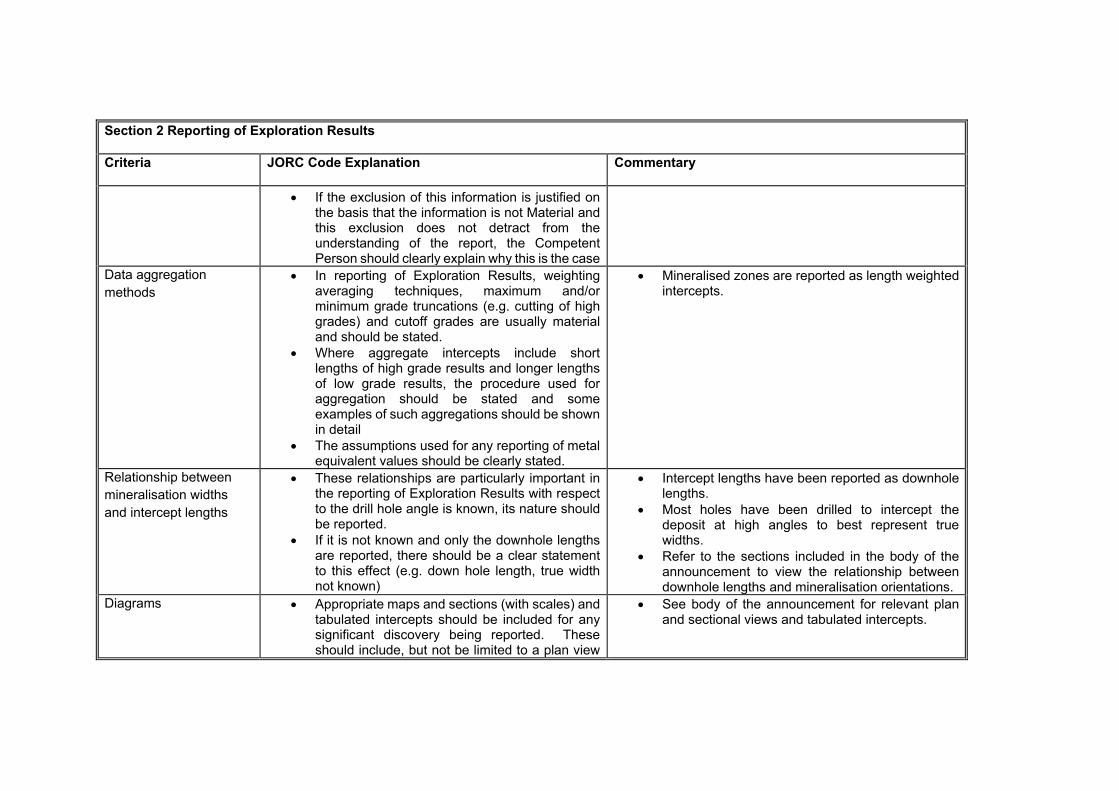
Section 2 Reporting of Exploration Results
Criteria JORC Code Explanation Commentary
If the exclusion of this information is justified on the basis that the information is not Material and this exclusion does not detract from the understanding of the report, the Competent Person should clearly explain why this is the case
Data aggregation methods
In reporting of Exploration Results, weighting averaging techniques, maximum and/or minimum grade truncations (e.g. cutting of high grades) and cutoff grades are usually material and should be stated.
Where aggregate intercepts include short lengths of high grade results and longer lengths of low grade results, the procedure used for aggregation should be stated and some examples of such aggregations should be shown in detail
The assumptions used for any reporting of metal equivalent values should be clearly stated.
Mineralised zones are reported as length weighted intercepts.
Relationship between mineralisation widths and intercept lengths
These relationships are particularly important in the reporting of Exploration Results with respect to the drill hole angle is known, its nature should be reported.
If it is not known and only the downhole lengths are reported, there should be a clear statement to this effect (e.g. down hole length, true width not known)
Intercept lengths have been reported as downhole lengths.
Most holes have been drilled to intercept the deposit at high angles to best represent true widths.
Refer to the sections included in the body of the announcement to view the relationship between downhole lengths and mineralisation orientations.
Diagrams Appropriate maps and sections (with scales) and tabulated intercepts should be included for any significant discovery being reported. These should include, but not be limited to a plan view
See body of the announcement for relevant plan and sectional views and tabulated intercepts.

Section 2 Reporting of Exploration Results
Criteria JORC Code Explanation Commentary
of drill collar locations and appropriate sectional views.
Balanced reporting Where comprehensive reporting of all Exploration Results is not practicable, representative reporting of both low and high grades and/ or widths should be practiced to avoid misleading reporting of Exploration Results
Not applicable
Other substantive exploration data
Other exploration data, if meaningful and material, should be reported including (but not limited to); geological observations, geophysical survey results, geochemical survey results, bulk samples – size and method of treatment, metallurgical results, bulk density, groundwater, geochemical and rock characteristics, potential deleterious or contaminating substances.
Further work The nature and scale of planned further work (e.g. test for lateral extensions or depth extensions or large scale step out drilling)
Diagrams clearly highlighting the areas of possible extensions, including the main geological interpretations and future drilling areas, provided this information is not commercially sensitive.
Continuing exploration drilling on the Grassy Group- Grassy Granodiorite contact.

COMPETENT PERSONS’ STATEMENT
The information in this report that refers to Exploration Results and Mineral Resource Estimations is based on information compiled by geology consultant Mr. Tim Callaghan who is a Member of The Australasian Institute of Mining and Metallurgy (“AusIMM”). Mr Callaghan has sufficient experience that is relevant to the style of mineralisation and type of deposit under consideration and to the activity being undertaken to qualify as a Competent Person as defined in the 2012 Edition of the Australian Code for Reporting Exploration Results, Mineral Resources and Ore Reserve. Mr Callaghan consents to the inclusion in the report of matters based on his information in the form and context it appears.
MINERAL RESOURCES
The Information in this announcement relating to Mineral Resources for Dolphin and Bold Head is extracted from the report entitled Updated Resources Statement created on 24/4/15 and is available to view on the Company’s website www.kingislandscheelite.com.au. The company confirms that it is not aware of any new information that materially affects the information included in the original market announcement and that all material assumptions and technical parameters underpinning the estimates in the relevant market announcement continue to apply and have not materially changed. The Company confirms that the form and context in which the Competent Person’s findings are presented have not been materially modified from the original market announcement.
FORWARD LOOKING STATEMENTS
Some statements in this announcement regarding estimates or future events are forward-looking statements. They involve risk and uncertainties that could cause actual results to differ from estimated results. Forward looking statements include but are not limited to, statements concerning the Company’s exploration program, outlook, target sizes and mineralised material estimates. They include statements preceded by words such as “expected”, “planned”, “target”, “scheduled”, “intends”, “potential”, “prospective” and similar expressions.