domestic waterborne freight: 2017: notes and definitions
TRANSCRIPT

Domestic Waterborne Freight Technical Notes- Page 1
Domestic Waterborne Freight:2017: notes and definitions
IntroductionThis publication provides
information on freight traffic moved
within the UK by water transport,
known as ‘domestic waterborne
freight’. The statistics are based
on re-analysis of the domestic
element of the port freight statistics
combined with a survey of inland
waterway operators.
All maritime statistics are
published through the maritime
and shipping series on the DfT
statistics web page: https://www.
gov.uk/government/collections/
maritime-and-shipping-statistics.
Last updated: August 2018
Data SourcesThe principal sources of the data are:
• Survey of barge operators, carried out by Department forTransport (DfT).
• Port traffic statistics produced by DfT from returns supplied byshipping lines or their agents and port authorities as required by an EU Maritime Statistics Directive;
• Ship arrivals data supplied by Lloyd’s List Intelligence
There are important changes to the way that some of the information in the publication has been derived from 2000 onwards, principally affecting foreign, coastal and one-port traffic and also inland waters penetration of such traffic. More details about the new collection system are given below.
In this publicationData sources.........................p1
Definitions ............................p1
Inland Waters ......................p2
Coastwise Traffic..................p5
One-Port Traffic....................p6
Cargo...................................p6
Ship Arrivals.........................p6
Notes on Tables ..................p7
Data collection from 2000....p7
Geographical coverage ......p8
The statistics in this publication cover freight carried on inland waters and around the coast of the United Kingdom, measured either in terms of “goods lifted” (defined as the tonnage of goods transported), or “goods moved” (defined as the tonnage of goods lifted multiplied by the distance travelled and expressed in terms of tonne kilometres). There are three main elements to waterborne transport in the UK:
• Inland waters traffic: traffic carried by both barges and seagoingvessels along inland waters. Inland waters traffic can be further categorised into non-seagoing traffic (internal traffic) which is wholly within inland waters and seagoing traffic which crosses into inland waterways from the sea (and which can be further classified as coastwise, foreign or one port traffic).
• Coastwise traffic: traffic carried around the UK coast.
• One-port traffic: traffic to and from UK offshore installations andsea dredging/dumping.
Each of these elements is discussed in more detail below.
Definitions

Domestic Waterborne Freight Technical Notes- Page 2
• Total traffic: the sum of coastwise traffic, one port traffic and the internal and foreign componentsof inland waters traffic. This avoids double counting (eg. counting coastwise and one-port traffic entering inland waters as both (i) coastwise or one-port traffic and (ii) as inland waters traffic). See Technical notes.
Traffic is measured both in terms of “goods lifted” (the tonnage of goods transported) and “goods moved” (the tonnage of goods lifted multiplied by the distance travelled and expressed as tonne-kilometres).
Inland waters
The definition of inland waters was devised for the first survey of waterborne transport carried out in 1980. The definitions were produced from the perspective of measuring freight traffic travelling on inland waters which could travel by another surface mode within the UK. There are two boundary definitions used to measure the amount of traffic:
• Inland waters: all waters within the Maritime and Coastguard Agency (MCA) outermost limit ofinland waters classification (MCA category D – tidal rivers and estuaries where significant wave height could not be expected to exceed 2 metres at any time, called the smooth water line or SWL)1.
• Inland waterways: all water areas available for navigation that lie inland of a boundary definedas the most seaward point of any estuary which might reasonably be bridged or tunnelled - this is taken to be where the width of water surface area is both less than 3 km at low water and less than 5 km at high water on spring tides. This is called the inland waterways boundary (IWB) and is generally much further upstream of the smooth water line.
For the purpose of estimating tonnes and tonne-kilometres all non-seagoing traffic, ie. all traffic wholly within inland waters (internal traffic) is counted. Tonnes are then simply tonnes lifted, and tonne-kilometres are tonnes lifted multiplied by the distance travelled.
Seagoing traffic which crosses the inland waters boundary and which also goes upstream of the inland waterways boundary is counted as well. Tonnes are tonnes lifted, and tonne-kilometres are tonnes lifted multiplied by the distance travelled (but calculated from the point at which the vessel crosses the inland waterways boundary).
There is one major exception to the counting of sea going traffic in inland waters - traffic which is essentially seagoing traffic to and from major seaboard ports is specifically excluded from inland waters traffic estimates. These ports are listed in the tables and many are also shown in the maps of Geographical Coverage below.
Figure 1, below, gives a diagrammatic representation of inland waters traffic. It shows all the separate elements i.e. internal traffic, coastwise traffic which crosses the IWB, one-port traffic which crosses the IWB and foreign traffic which crosses the IWB. Inland waters traffic thus includes: all traffic which is wholly within the SWL (internal) e.g. movements from port A to port B, C, or D, and movements between ports C and D; traffic upstream of the IWB which is seagoing.
1 The categorisation of waters in the UK is set out in Merchant Shipping Notice MSN 1776 (M), available online here

Domestic Waterborne Freight Technical Notes- Page 3
FIGURE 1: DIAGRAM OF INLAND WATERS TRAFFIC
Inland waters traffic comprises the following components:
• internal traffic - all non-seagoing traffic between ports and wharves which remains wholly with-inthe SWL
• coastwise traffic - inwards seagoing traffic coming from UK sea ports and unloaded at portsand wharves upstream of the IWB; and outwards seagoing traffic loaded at ports and wharves upstream of the IWB and going to UK sea ports
• one-port traffic - inwards seagoing traffic coming from offshore installations or sea dredgedag-gregates unloaded at ports and wharves upstream of the IWB; and outwards seagoing traffic loaded at ports and wharves upstream of the IWB and going to offshore installations or being dumped at sea
• foreign traffic - inwards seagoing traffic coming from foreign countries and unloaded at portsand wharves upstream of the IWB; and outwards seagoing traffic loaded at ports and wharves upstream of the IWB and going to foreign countries.

Domestic Waterborne Freight Technical Notes- Page 4
For example, movements from port A, B to the sea (classified under coastwise/foreign/one-port headings as appropriate) assuming that the port is not a major seaboard port. It should be noted that traffic from ports C and D which is seagoing is excluded from inland waters traffic (classified as coastwise or one port traffic).
In practice, inland water traffic can be considered from the point of view of the type of vessel involved. Vessels without load lines can only trade within inland waters whilst those with load lines can trade within or outside inland waters. Inland waters traffic then includes:
• All traffic which is carried by inland waterway vessels without load lines (except lighter-ageentirely within a single dock complex).
• All traffic by vessels with load lines (which can trade within or outside inland waters) wherethe traffic is wholly within inland waters.
• Traffic by vessels with load lines which cross the inland waters boundary and which al-so goupstream of the inland waterway boundary (excluding certain short inland pene-tration by ships).
In order to be able to exclude certain short inland penetration by ships and also shipping movements which are essentially seagoing traffic to and from major seaboard ports, the following classification of inland waterways has been devised:
A > 9 m draught
B 4.5 to 9.0 m draught
C 3.0 to < 4.5 m draught
D Less than 3m draught, barges 551-850 tonnes.
E Less than 3m draught, barges 351-550 tonnes.
F Less than 3m draught, barges 151-350 tonnes.
G Less than 3m draught, barges 51-150 tonnes
Shipping movements in foreign, coastwise and one-port trades are then excluded from inland water traffic estimates as follows:
On A class waterways where the penetration upstream of the inland waterway boundary is less than 25 km;
On B class waterways where the penetration upstream of the inland waterway boundary is less 15 km;
On C class waterways where the penetration upstream of the inland waterway boundary is less than 5 km.

Domestic Waterborne Freight Technical Notes- Page 5
This end result of this approach is to exclude all shipping movements from inland waters traffic estimates which are essentially sea going traffic to and from major seaboard ports eg. sea going traffic to such ports as Tilbury, Southampton, Mersey Docks or Hull. All coastwise shipping movements of 5 km or more are separately analysed in order to avoid a misleading distortion by including coastwise ‘barge’ traffic but excluding coastwise ‘ship’ traffic.
All traffic on inland waterway vessels is included, except for very small amounts of traffic on barges less than 51 tonnes and less than 3m draught, which falls outside the above classification. However, in practice if there is significant traffic which falls outside the classification this is also included in the inland waters estimates.
Finally, the following exclusions from inland waters traffic estimates should be noted:
• Lighterage entirely within a single dock complex: for example, a barge movement entirely withinthe Hull dock complex would not be recorded (but barge movements from docks to wharves along the River Humber would be recorded).
• Bunkering: this activity, by definition, is not classified as inland waters traffic.
• Freight carried on passenger and passenger vehicle ferry services within the smooth water line:this means that traffic on crossing movements (e.g. the Tilbury-Gravesend ferry) and coastwise ferries within smooth water limits (e.g. Loch Ryan in Scotland or the Solent for the Isle of Wight) is excluded.
Coastwise traffic
Coastwise traffic is defined to include all freight moved between ports in Great Britain, Northern Ireland, the Isle of Man and Channel Islands (excluding traffic between a UK port and either the sea bed or off shore installations).
Since 2000, coastwise traffic estimates have been based on information from a new data collection system introduced to meet the requirements of an EU Maritime Statistics Directive. In this system, traffic for major ports is collected so that both the port of load/unload and the “remote” port is identified. Such traffic constitutes 97 per cent of all UK ports traffic. For minor ports traffic is recorded as loaded/unloaded at the port but no details are collected of the remote port. This means that estimates have to be made of the proportions of minor port traffic, which is coastwise, foreign, or one-port movements. The traffic data is combined with port-to-port distances from Admiralty Distance Tables to produce tonne-km estimates (‘goods moved’).
There will inevitably be some directional imbalances in the coastwise data because of some under reporting of traffic by shipping lines and agents. These are reflected in different totals in historical coastwise traffic tables DWF0301 and DWF0302, where loading (outward) and discharge (inward) totals are given separately. The higher of the two estimates in any given year is regarded as more representative of actual traffic carried and this higher figure has been taken to derive coastwise total values for other tables (i.e. Tables PORT0704 and PORT0705).

Domestic Waterborne Freight Technical Notes- Page 6
Where the remote port is missing, reference is made to the ship arrivals data supplied by Lloyd’s Marine Intelligence Unit to determine its most probable location. Since data is not collected for the Channel Islands or the Isle of Man, their coastwise movements are calculated by their appearance as the remote port on mainland port movements.
One-port traffic
One port traffic is traffic travelling between UK offshore oil and gas installations and a UK port or dredged sand and gravel from the seabed. For one-port traffic the main data source from 2000 is the Maritime Statistics Directive data collection system. Admiralty Distance Tables are used to produce tonne-km estimates (‘goods moved’).
Cargo categories
The cargo categories used in the report distinguish between liquid bulk, dry bulk, container and roll-on (unitised) traffic, forestry products and other general cargo.
Ship arrivals
The ship arrivals data used in the compilation of waterborne freight statistics are supplied by Lloyd’s Marine Intelligence Unit.
The data relate to arrivals of all sea-going vessels of 100gt and over at UK ports (including previous port of call and vessel descriptions) with the exception of the following:
i) Inter-island movements of freight on the services of Caledonian MacBrayne in Scotland;
ii) Vessels employed in supply, dredging or dumping at sea;
iii) Traffic moving within dock systems, such as repositioning of ships or multi-berth discharges;
iv) Regular domestic ferries crossing estuaries and other movements of less than two kilometres.

Domestic Waterborne Freight Technical Notes- Page 7
Notes on Tables
Table PORT0701 (a) Waterborne transport within the United Kingdom, goods lifted (tonnes)
Coastal or offshore traffic which starts or finishes at a point upstream of the inland waterways boundary is included twice – once in 'UK inland waters traffic' (in the coastwise or one-port components of seagoing traffic by route) and once in 'Coastwise traffic between UK ports' or 'One-port traffic of UK ports'. This is done to ensure that all traffic on inland waterways is included in the statistics even if the traffic started or finished outside inland waters. To avoid double counting when calculating total waterborne freight transport in the UK in terms of goods lifted, only the internal and foreign components of inland waters traffic are added to the coastwise traffic and one port traffic totals to derive the overall totals.
Table PORT0701 (b) Waterborne transport within the United Kingdom by cargo category, goods moved (billion tonne-kilometres)
To avoid double counting of goods moved in Table PORT0701 (b) from 2000 onwards, only the internal and foreign components of inland waters traffic are added to the coastwise traffic and one-port traffic totals to derive overall totals of waterborne freight transport in the UK in terms of goods moved.
Table PORT0702: Waterborne transport within the United Kingdom by cargo category
The row totals in both Table PORT0702 (a) and Table PORT0702 (b) are the sum of coastwise and one-port traffic, together with the internal and foreign components of inland waters traffic.
In releases prior to 2009, the inland waterway components of 'Coastwise traffic between UK ports' and 'One-port traffic of UK ports' in terms of goods moved were excluded to avoid double counting, but in this release they are included for consistency with the treatment in the rest of the report. Double counting of total traffic is still avoided by the method described in the previous paragraph.
Data Collection System for Maritime Traffic From 2000
From 2000 onwards, the data source used to produce coastal and one-port traffic estimates in this report, and inland waters penetration of such traffic (including inland waters penetration of foreign traffic), is the new Maritime Statistics Data collection system. This system was introduced in order to comply with an EU Maritime Statistics Directive (Council Directive 95/64/EC on statistical returns in respect of the carriage of goods and passengers by sea). The way traffic figures were derived changed significantly in 2000 compared with previous years.
Up to 1999, all freight information was collected from ports annually. Major ports (generally those with cargo volumes of at least 2 million tonnes per year) were asked for detailed information on the weight of traffic travelling in and out of their ports, identifying cargo categories (eg. liquid bulk, dry bulk, containers, Ro-Ro, etc.) and whether they were foreign, coastwise or one port cargoes. Other minor ports were required to provide only the total weight of cargo inwards and outwards.

Domestic Waterborne Freight Technical Notes- Page 8
In the new collection system most of the detailed freight information is collected from shipping lines, operators or shipping agents, which are required to supply detailed returns of their inwards and out-wards traffic at each major port for each ship, on each route. Major ports (now including ports with cargo volumes of at least 1 million tonnes of cargo a year) are only required to supply summary information, whilst other minor ports provide only the total weight of cargo inwards and outwards.
Much of the detailed information required by the Directive is therefore provided by shipping lines, operators or agents. The information includes more detail from ports on unitised weight than re-ceived previously but less commodity detail on non-unitised traffic. The ports figures are taken as control totals to estimate missing values from shipping lines and agents in order to obtain complete estimates.
The new collection arrangements produce more reliable data on origins and destinations and also where aggregated into coastwise, one-port and foreign traffic summaries. Previously this information was estimated by ports with varying degrees of accuracy; particularly for crude oil traffic which means that origin and destination crude oil data before 2000 is approximate. For example, in the previous system, ports or refinery operators would not necessarily have been able to tell whether crude oil was shipped directly from a UK offshore installation, piped to a land terminal such as Sullom Voe and then shipped out from the land terminal, or imported from a North Sea country or other foreign crude oil producer. As a consequence, it is likely that before 2000 coastwise crude oil estimates have been overestimated and one-port traffic underestimated.
Inland waters traffic: geographical coverage
Maps
The UK map (Map 1) shows all of the larger and many of the smaller ports in the UK, the thirteen port groupings used in the compilation of port and waterborne freight statistics and the rivers and other waterway routes that carry freight in the UK.
The next four maps (Maps 2 to 5) cover the five estuarial areas in the UK with the largest inland waters freight traffic in 2007. The maps include the majority of the major inland waterway routes in the UK and show the relevant Smooth Water Lines (SWL) and effective Inland Waterways Boundaries (IWB) and the most important ports and wharves along those routes. See Geographical Coverage, below, for definitions.
Tables
The two tables show all the ports and wharves with freight traffic on inland waters sorted by port group. Table 1 lists the wharves on inland waters handling internal non-seagoing freight traffic of 20,000 tonnes or more in 2009, together with their port names (as used in published statistics of UK port traffic) or their inland waterway routes. Table 2 lists UK sea ports with seagoing freight traffic, which is either included in or excluded from inland waters traffic estimates in 2009. Where a port appears in both columns, an indication is given as to which part of the port has inland waters traffic.

Domestic Waterborne Freight Technical Notes- Page 9
MAP 1: Map of UK showing ports, port groups, rivers and other waterway routes used for freight

Domestic Waterborne Freight Technical Notes- Page 10
MAP 2: River Thames and River Medway major inland waterway routes
MAP 3: River Mersey and Manchester Ship Canal major inland waterway routes

Domestic Waterborne Freight Technical Notes- Page 11
MAP 4: River Clyde and River Forth major inland waterway routes
MAP 5: River Humber major inland waterway routes

Domestic Waterborne Freight Technical Notes- Page 12
TABLE 1: Wharves with internal inland waters freight traffic of 20,000 tonnes and over as of 2009
Port Group Wharves with internal traffic which also handled seagoing traf-fic (sea ports in
brackets)
Wharves with internal traffic and no sea-going traffic (waterways in
brackets)
Bristol Channel
Humber
Lancs & Cumbria
Sussex & Hants
Thames & Kent
Immingham (Grimsby & Immingham) Hull (Hull), Goole (Goole)
Liverpool (Liverpool), Eastham (Manchester), Garston (Liverpool), Manchester (Manchester), Partington (Manchester), Seaforth (Liverpool), Stanlow (Manchester)
Cowes (Cowes), Fawley (Southampton)
Barking (London), Coryton (London), Dagenham (London), Erith (London), Fingringhoe (River Colne), Gillingham (Medway), Greenwich (London), Isle of Grain (Medway), Northfleet (London), Purfleet (London), Ridham Dock (Medway), Silvertown (London), Tilbury (London)
Ryall (River Severn),Ripple (River Severn)
Girton (River Humber), Whitwood (Aire & Calder), Leeds (River Humber), Rix’s Fountain Road Wharf (River Hull), Besthorpe Quarry (River Trent), Rotherham (Sheffield and South Yorks.), Cargills Wharf (River Hull), King George V Dock (Hull), Oak Road Wharf (River Hull)
Gladstone Dock (Liverpool), Brocklebank Dock (Liverpool)
Cringle Dock, Battersea (River Thames, Mucking Wharf (River Thames), Poplar (River Thames), Smugglers Way Wharf, Wandsworth (River Thames), Walbrook Wharf, London EC4 (River Thames), Deptford (River Thames), Hole Haven (London), Hoo Island (Medway), Cringle Wharf, Battersea (River Thames)

Domestic Waterborne Freight Technical Notes- Page 13
TABLE 2: UK sea ports with seagoing traffic included in or excluded from inland waters traffic estimates as of 2009.
Port Group Sea ports with seagoing traffic cross-ing into inland waters (this traffic is included in inland waters traffic esti-
mates)
Seaboard ports with seagoing traffic which is excluded from inland waters
traffic estimates
Bristol Channel
Haven
Humber
Lancs & Cumbria
North East
Northern Ireland
Scotland (East Coast)
Bideford
Bridgwater, Sharpness
Ipswich, Mistley
Goole, Rivers Hull & Humber (excluding Tetney terminal), River Ouse, River Trent
Lancaster, Manchester (upstream of Eastham on the Manchester Ship Canal)
Forth (Grangemouth and upstream on the River Forth), Perth
Appledore,
Barry, Bristol, Burry Port, Cardiff, Neath, Newport, Port Talbot, Swansea
Felixstowe, Harwich
Hull, Grimsby & Immingham, Rivers Hull & Humber (Tetney terminal)
Barrow, Fleetwood, Garston, Heysham, Liverpool, Manchester (Eastham only), Silloth, Workington
Berwick, Blyth, Seaham, Sunderland, Tees & Hartlepool, Tyne
Ballylumford, Belfast, Coleraine, Kilroot, Larne, Londonderry, Warrenpoint
Aberdeen, Buckie, Cromarty Firth, Dundee, Forth (downstream of Grangemouth on the River Forth), Fraserburgh, Inverkeithing, Inverness, Kirkwall, Lerwick, Macduff, Montrose, Peterhead, Scrabster, Sullom Voe, Wick.
Domestic Waterborne Freight Technical Notes- Page 14
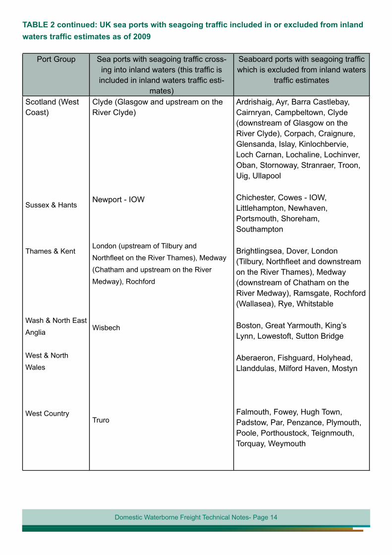
TABLE 2 continued: UK sea ports with seagoing traffic included in or excluded from inland waters traffic estimates as of 2009
Port Group Sea ports with seagoing traffic cross-ing into inland waters (this traffic is included in inland waters traffic esti-
mates)
Seaboard ports with seagoing traffic which is excluded from inland waters
traffic estimates
Scotland (West Coast)
Sussex & Hants
Thames & Kent
Wash & North East Anglia
West & North Wales
West Country
Clyde (Glasgow and upstream on the River Clyde)
Newport - IOW
London (upstream of Tilbury and Northfleet on the River Thames), Medway (Chatham and upstream on the River Medway), Rochford
Wisbech
Truro
Ardrishaig, Ayr, Barra Castlebay, Cairnryan, Campbeltown, Clyde (downstream of Glasgow on the River Clyde), Corpach, Craignure, Glensanda, Islay, Kinlochbervie, Loch Carnan, Lochaline, Lochinver, Oban, Stornoway, Stranraer, Troon, Uig, Ullapool
Chichester, Cowes - IOW, Littlehampton, Newhaven, Portsmouth, Shoreham, Southampton
Brightlingsea, Dover, London (Tilbury, Northfleet and downstream on the River Thames), Medway (downstream of Chatham on the River Medway), Ramsgate, Rochford (Wallasea), Rye, Whitstable
Boston, Great Yarmouth, King’s Lynn, Lowestoft, Sutton Bridge
Aberaeron, Fishguard, Holyhead, Llanddulas, Milford Haven, Mostyn
Falmouth, Fowey, Hugh Town, Padstow, Par, Penzance, Plymouth, Poole, Porthoustock, Teignmouth, Torquay, Weymouth