dorchester-on-thames on thames... · this is the final version of the dorchester-on-thames...
TRANSCRIPT

DORCHESTER-ON-THAMES
NEIGHBOURHOOD DEVELOPMENT PLAN 2017 to 2033
Submission Document August 2017

Contents
1. EXECUTIVE SUMMARY
2. INTRODUCTION2.1 What are Neighbourhood Development Plans? 5
2.2 What is in this document? 6
2.3 Project timetable and next steps 6
2.3.1 Village presentations and feedback 62.3.2 Publicity and feedback 62.3.3 The main issue 92.3.4 The next steps 9
3. DORCHESTER-ON-THAMES3.1 Overview 10
3.1.1 Snapshot of the village 103.1.2 Vision and objectives 123.1.3 SWOT analysis 13
3.2 Environment 14
3.3 History 15
3.4 Literature 16
3.5 Our population 17
4. THE THEMES FOR THE PLAN4.1 Historic environment 18
4.1.1 Objective 184.1.2 Designations 184.1.3 Analysis of the village outside the conservation areas 194.1.4 Conservation Area Character Studies 204.1.5 Archaeology 214.1.6 Proposals 224.1.7 Evidence base for the Proposals 234.1.8 Policies 25
4.2 Natural environment, wildlife and biodiversity 26
4.2.1 Objectives 264.2.2 Background 274.2.3 Wildlife 284.2.4 Policies 29
4.3 Housing 36
4.3.1 Objectives 364.3.2 Background 364.3.3 Policy justifications 404.3.4 Housing policies 454.3.5 Community Infrastructure Levy (CIL) 48
4.4 Tourism and leisure 49
4.4.1 Objectives 494.4.2 Background 494.4.3 Policies 51
4.5 Economy 52
4.5.1 Objective 524.5.2 Background 524.5.3 Policies 53
5. SUMMARY OF POLICIES 5.1 Historic environment 54
5.2 Natural environment, wildlife and biodiversity 55
5.3 Housing 56
5.4 Tourism and leisure 58
5.5 Economy 58
6. MONITORING AND REVIEW
7. APPENDICES
8. DIGITAL MAPS
DORCHESTER-ON-THAMES NDP ~ SUBMISS ION DOCUMENT | 32 | DORCHESTER-ON-THAMES NDP ~ SUBMISS ION DOCUMENT AUGUST 2017 AUGUST 2017
1. Executive Summary 2. Introduction
The Dorchester-on-Thames Neighbourhood Development Plan has been developed to set out the strategic
direction, themes and resulting policies for the village until 2033 and is consistent with Government’s current
approach to planning, which is intended to involve local communities more directly in planning decisions
which affect them.
The plan has been the responsibility of Dorchester-on-Thames Parish Council and has been produced by
an approved sub-committee comprising village residents. Every effort has been made to communicate
and consult with residents throughout the process, including public meetings and monthly progress reports
in “Dorchester News”, with the intention of ensuring that the final document incorporates and reflects the
views and aspirations of the majority of Dorchester residents.
Dorchester is a very special village which is loved and enjoyed by all those who live here as well as the
many who visit. It is steeped in history, is surrounded by beautiful countryside and includes the majestic
Dorchester Abbey among its historic buildings. The Plan seeks to recognise the importance of the village’s
heritage and natural environment but does also take account of the need to support appropriate
economic development and respond to the call for additional housing provision.
The Plan contains policies which deal with all of the key themes identified. Through the consultation process
the main issue that has emerged has been the question of housing, particularly affordable housing. While
the Plan envisages and encourages an increase in the housing stock through a limited number of small
developments, it does not identify or allocate sites for additional housing. This conforms to national planning
policy and recognises Dorchester ’s green belt status.
This final version of the Plan is now ready for submission to the local planning authority for a final review,
then for independent examination, before being put forward for referendum within the Parish and formal
adoption.
2.1 What are Neighbourhood Development Plans?
From April 2012, local communities have been given new legal powers under the Localism Act 2011 to
take part in Neighbourhood Development Planning for their areas.
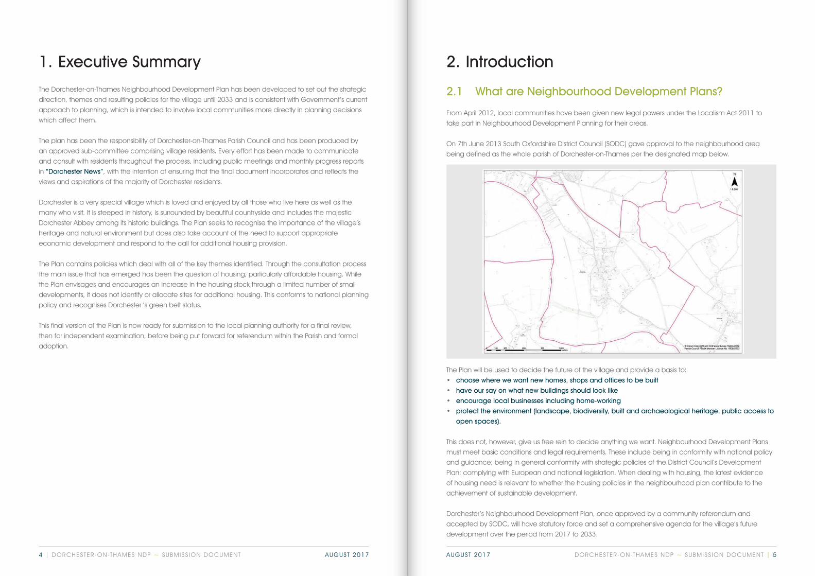
On 7th June 2013 South Oxfordshire District Council (SODC) gave approval to the neighbourhood area
being defined as the whole parish of Dorchester-on-Thames per the designated map below.
The Plan will be used to decide the future of the village and provide a basis to:
• choose where we want new homes, shops and offices to be built
• have our say on what new buildings should look like
• encourage local businesses including home-working
• protect the environment (landscape, biodiversity, built and archaeological heritage, public access to
open spaces).
This does not, however, give us free rein to decide anything we want. Neighbourhood Development Plans
must meet basic conditions and legal requirements. These include being in conformity with national policy
and guidance; being in general conformity with strategic policies of the District Council’s Development
Plan; complying with European and national legislation. When dealing with housing, the latest evidence
of housing need is relevant to whether the housing policies in the neighbourhood plan contribute to the
achievement of sustainable development.
Dorchester’s Neighbourhood Development Plan, once approved by a community referendum and
accepted by SODC, will have statutory force and set a comprehensive agenda for the village’s future
development over the period from 2017 to 2033.
DORCHESTER-ON-THAMES NDP ~ SUBMISS ION DOCUMENT | 54 | DORCHESTER-ON-THAMES NDP ~ SUBMISS ION DOCUMENT AUGUST 2017 AUGUST 2017

2.2 What is in this document?
This document sets a shared vision for Dorchester on Thames and policies for the Built Environment, Natural
Environment, Housing, Economy, Tourism and Leisure. The background and issues related to each of these
are considered under paras. 4.1 to 4.5. These lead separately to a number of policy proposals, and these
are summarised in paras. 5.1 to 5.5.
This is the final version of the Dorchester-on-Thames Neighbourhood Plan which takes account of feedback
from residents and other interested parties including SODC, following the six week consultation period which
ended in May of this year. The qualifying body submitting the Neighbourhood Plan is Dorchester-on-Thames
Parish Council and the plan is now submitted for formal review and independent examination before being
presented in final form for referendum and, if accepted, implementation.
2.3 Project timetable and next steps
2.3.1 Village presentations and feedback
Opportunities for the village community to make its wishes known and to comment on plans and proposals
prior to the formal six week consultation period came through a series of public meetings in the Village
Hall. These were on 20.10.2012 (80 attendees), 15.05.13 (before the Parish Council APM), 31.01.2015, and
14.01.2016 regarding the possibility of the Demesne field being removed from the Green Belt (150 attendees).
2.3.2 Publicity and feedback
Every effort has been made to engage with the community throughout the process, including:
Kick-offIn 2012 the Parish Council conducted an internal review of the 2005 Parish Plan which was published in
the Dorchester News and distributed to all 500 households in the village at the time. Various issues were
still being progressed by the parish council, but wider development issues were also being raised, and the
council looked into the possibility of producing an updated village plan.
A public meeting on 20th October 2012 was facilitated by Anton Nath from Oxfordshire Rural Community
Council (now called Community First Oxfordshire) and was advertised via ORCC leaflets inserted in the
parish magazine (Dorchester News) and A4 posters throughout the village.
80 attendees were introduced to the concept of Neighbourhood Planning and invited to participate in an
interactive questionnaire by sticking post-it notes on “Issue” boards which arose from the old Parish Plan and
the subsequent work by the parish council. These were then carefully collated and summarised. The results
indicated housing (affordability, size and location) and the environment (rural and built) to be the main
issues, plus many other items that were being addressed, first by the Parish Plan, and subsequently by the
Parish Council.
Attendees (and afterwards the wider village) were asked to volunteer and a new project Steering
Committee was formed, with their first meeting on 12th December 2012.
The Committee comprised 14 members, 7 of whom were from the parish council. As village planning
had changed since the old Parish Plan, there was a choice between a Community Led Plan (CLP) and
Neighbourhood Development Plan (NDP). In view of the different areas of focus, it was decided to initiate
both a CLP and a NDP, with the steering committee split into two, with the NDP committee being chaired by
Councillor Mark Stevenson.
A community engagement strategy set out the main communication activities that would be undertaken
during the preparation of the Plan, and the stakeholders that should be addressed, including:
• residents;
• businesses;
• developers;
• local government; and
• community groups.
In the light of the NDP having legal status which the CLP did not, it was eventually recognised that it would
be impracticable to move both projects along at the same time, that priority should be given to the NDP
and that effectively work on CLP be formally deferred with a number of the projects being progressed
individually. It was decided to formally apply to SODC to register a NDP. This update was discussed at a
public meeting on 15th May 2013, prior to the Parish Council Annual Parish Meeting.
DORCHESTER-ON-THAMES NDP ~ SUBMISS ION DOCUMENT | 76 | DORCHESTER-ON-THAMES NDP ~ SUBMISS ION DOCUMENT AUGUST 2017 AUGUST 2017

First LookConsiderable feedback came from the 31.01.2015 meeting which opened with a poster display and a PowerPoint presentation of the plan including draft policies for each subject area. The feedback was drawn together in detail and summary form to provide the basis for careful review and further modifications to the Plan. Photographs of attendees at the meeting indicate the level of interest.
Demesne FieldAttendance at the meeting called to consider the 35 acre Demesne field issue (14.01.2016) was 99% against the suggestion that it should be removed from the Green belt. That being the case, the committee felt it should move towards obtaining formal approval of the Plan as quickly as possible.
Dorchester NewsDorchester News has carried regular updates (by way of a reserved special green high profile page in each issue) reporting the NDP’s progress in between the village meetings.
Village WebsiteThe website has carried updates and draft versions of the plan at: www.dorchester-on-thames.co.uk/information/neighbourhood-planning/
PresentationsNDP members have attended some useful formal consultations:• CPRE (Didcot) - ‘Neighbourhood plans – Getting started workshop; • 11.12.13, Eland House, London, Department for Communities and Local Government
(well attended by NDP groups from all over the country); • 23.04.2013 Brookes University workshop on Neighbourhood Planning.
These have all offered sensible guidance (e.g. be brief, be positive, keep the local community fully
informed, interact with District Council staff) and provided good opportunities for networking.
SODC has maintained a close interest as the draft Plan has evolved, attending many of the NDP meetings
and providing suggestions for improved content and presentation, with particular regard to conformation
with existing National and Local plans. NDP members’ personal networks have provided information from
other villages (e.g. Great Coxwell, Woodcote) and specialist bodies (e.g. Dorchester’s Hurst Water Meadow
Trust, Earth Trust, Environment Agency, Historic England etc.).
Statutory ConsultationsThe Neighbourhood Plan Steering Group finalised the Draft NDP in March 2016 and the Regulation 14
Pre-Submission Consultation ran for a six-week period from 30th March 2016 to 11th May 2016. There was
subsequent discussion with SODC over the issue of nominating potential development sites in a village
that was entirely in the Green Belt and it was eventually decided to remove said sites from the plan. The
committee felt that this was such a significant change that it was appropriate to re-run the Pre-Submission
Consultation, which ran for a six-week period from 27th March 2017 to 8th May 2017. Useful feedback was
received not only from SODC but also bodies such as Thames Water, The Environment Agency, Natural
England, Oxfordshire County Council as well as a number of local residents. This feedback was carefully
reviewed and the draft plan modified as appropriate.
Further detail and supporting documentation for the consultation process is available in the separate
Consultation Statement.
2.3.3 The main issue
Dorchester on Thames is located entirely within the Green Belt and has been designated a small village
with no specific housing allocation. However, without question the main issue has been housing (how much,
where, when, size, affordability?) complicated by changes in perceived requirements.
The emerging SODC Local Plan 2033 – Second Preferred Options has as its vision that South Oxfordshire will
remain a beautiful and prosperous place to live; an attractive place for people to work and spend their
leisure time. It includes in its objectives:
• the delivery of a wide range of housing options to cater for the housing needs of the community,
• support for the regeneration of housing and facilities to strengthen communities and address identified
poverty and social exclusion,
• support for the County as a whole in meeting its overall economic and housing needs.
This has led to a series of draft and redrafted housing policies as the NDP has sought to meet each
demand. It is believed that the housing policies as now presented will fully meet SODC requirements as well
as fully respecting national policy on the Green Belt.
2.3.4 The next steps
This plan is now being formally submitted to SODC for referral for independent inspection and then SODC
approval. Subject to any further changes which may arise from this process, it will then be presented to the
Parish community for referendum and, if successful, adoption.
DORCHESTER-ON-THAMES NDP ~ SUBMISS ION DOCUMENT | 98 | DORCHESTER-ON-THAMES NDP ~ SUBMISS ION DOCUMENT AUGUST 2017 AUGUST 2017

3. Dorchester-on-Thames
• It is steeped in history, its origins dating back 6,000 years, and much of its evolution is still clearly in
evidence in the landscape today.
• It is surrounded by beautiful countryside, including both the River Thames and the River Thame,
Wittenham Clumps and the Hurst Water Meadow, all of which are easily accessible to residents and
visitors alike and provide almost unlimited opportunities to walk and explore. The Thames Path, a national
trail, passes close by. Access to open spaces is valued by villagers and visitors.
Dyke Hills and Wittenham Clumps
3.1 Overview
3.1.1 Snapshot of the village
Dorchester-on-Thames is a small village in South Oxfordshire which is loved and enjoyed by those who live
there as well as by its many visitors. Despite having a resident population of a little over 1,000 people, it is
considered by many to be a dynamic village with a diverse range of community activities that enrich the
lives of its inhabitants.
• It boasts a number of interesting and varied buildings in and around the picturesque High Street,
including the majestic Dorchester Abbey and the adjoining accredited Museum.
• Commercial facilities include a village shop, hotels and restaurants, tea-rooms, hair salon, and other
business premises, including a variety of enterprises at Queenford Farm to the north of the village.
• Community run facilities include the village hall, allotments, a large recreation ground with a sports
pavilion, tennis courts and children’s play area. Recreational activities are also enjoyed on the rivers
Thame and Thames.
• It offers its residents and visitors a range of cultural and recreational leisure facilities through its many
clubs and associations.
• Its pre-school and primary school, and other facilities for young families, provide the opportunity for
children to begin their development and early education without the need to travel outside the village.
• People like living in Dorchester. If they move they tend to do so within the village. Residents who remain
here through their retirement appreciate the range of facilities suitable for their particular age group.
Dorchester Abbey
Abbey Guest House
The Co-Op
‘Hair’ of Dorchester
DORCHESTER-ON-THAMES NDP ~ SUBMISS ION DOCUMENT | 1110 | DORCHESTER-ON-THAMES NDP ~ SUBMISS ION DOCUMENT AUGUST 2017 AUGUST 2017

3.1.2 Vision and objectives
Dorchester will retain its unique character by
continuing to evolve as a supportive, lively,
economically active community that respects
and enhances its historic and natural environment.
We will meet this vision by attaining the following
objectives across these themes:
• Historic and Natural Environment: To nurture
and protect the natural and built environment
of the village for future generations to enjoy.
• Housing: To ensure new housing, extensions
and other residential development respect the
character of the village, to promote a range
of housing size and type to meet the needs of
residents and to encourage high standards of
environmental performance in all residential
development.
• Tourism and Leisure: To promote and manage
sustainable tourism to enhance the cultural
and economic well-being of the village, to
retain and promote recreational facilities for all
members of the community and to preserve
the character and nature of the village for
its residents and visitors; having appropriate
regard for the potential conflict between
vehicular traffic and the safety of residents,
cyclists and pedestrians.
• Economy: To support enterprises providing
employment in the village and promote small
businesses contributing to the economic well-
being of the community.
The allotments
Play area and tennis courts
The Pavilion
3.1.3 SWOT analysis
Strengths: Weaknesses:
• Attractive village, many listed buildings
• Dorchester Abbey, major tourist attraction,
largest public building in South Oxfordshire for
public events
• Dorchester Abbey Museum, accredited by the
Arts Council
• Locations for episodes of Midsomer Murders
and other television or film productions
• Good hotels, tea-rooms and small supermarket
• The Fleur de Lys pub and the former site of the
Post Office registered as community assets
• Distinctive landscape character of the River
Thames and its valley; excellent vistas
• Good area for walking and cycling; footpath
network
• Managed wildlife sites
• Strong community spirit with high level of
voluntary activities
• Interest groups helping to protect and preserve
the integrity of the village environment
• Few premises for small businesses and retail
units
• Limited public transport
• Inadequate parking
• Uncoordinated promotion of tourism
• Vulnerability of conservation areas and nearby
green areas to inappropriate development
• Lack of affordable accommodation
Opportunities: Threats:• Collaborate with the Environment Agency and
other environmental organisations to sustain
and protect the natural environment
• Support the Hurst Water Meadow Trust in
maintaining, enhancing and extending wildlife
sites, especially along the Thame
• Smaller housing units will meet the needs of the
young and the elderly
• Improved facilities for leisure and recreation will
give better quality of life for all ages
• More parking spaces will ease congestion and
encourage visitors
• Work with University of Oxford Institute of
Archaeology and like-minded organisations to
understand and protect archaeological sites
• Explore the potential for hydro-electric power
• Support efforts to retain open spaces that are
important to the community
• Loss of employment due to commercial
premises change of use to domestic dwellings
• Risk of flooding to low-lying houses
• Risk of further gravel extraction which will
bring more traffic and damage the local
environment
• Risk of coalescence with Berinsfield
• Risk of damage to important unprotected
archaeology by development
• Loss of open spaces
DORCHESTER-ON-THAMES NDP ~ SUBMISS ION DOCUMENT | 1312 | DORCHESTER-ON-THAMES NDP ~ SUBMISS ION DOCUMENT AUGUST 2017 AUGUST 2017
3.2 Environment
• Dorchester-on-Thames is a village of outstanding character set on slightly higher ground between the
open floodplains of the River Thames and its tributary the River Thame. Its visible history extends back into
the Iron Age and includes the nationally important Dorchester Abbey, founded as a cathedral in 635.
From medieval times the focus of the settlement has been along the High Street, part of the principal
route between Henley and Oxford.
• The two Conservation Areas include most of Dorchester and the hamlet of Overy with its rural setting. The
Abbey is a Grade I listed building, and many other buildings are listed Grade II or Grade II*. There are
five Scheduled Ancient Monuments, including the Iron Age Dyke Hills, much of the centre of the village
(site of the Roman town) and a stretch of farmland.
• The whole parish lies within the Oxford Green Belt.
• Oxfordshire’s Biodiversity Action Plan aims to protect vulnerable species and habitats listed as UK
Biodiversity Action Plan priorities. The plan has defined 36 Conservation Target Areas of which no.27
includes all the flood meadows in the parish, the gravel pit lakes and the banks of the River Thame as
far as the A4074. It also extends south across the parish boundary to the Little Wittenham Special Area of
Conservation, the Wittenham Woods Site of Special Scientific Interest, and the Wittenham Clumps hillfort
giving exceptional views across Dorchester to the Chilterns and the Oxford Heights.
• The underlying geology is Upper Greensand and Gault clay overlain with gravel and alluvium.
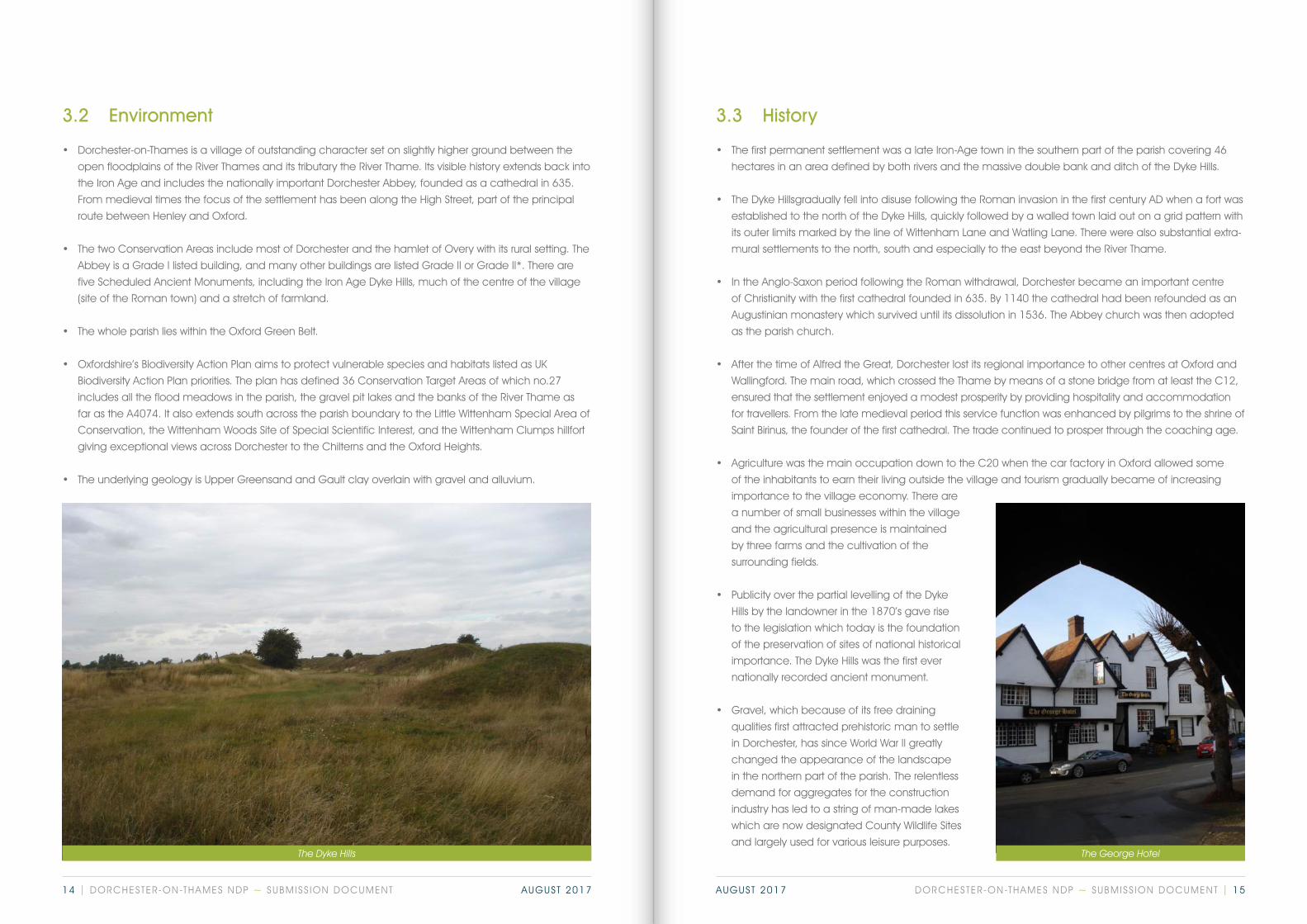
The Dyke Hills
3.3 History
• The first permanent settlement was a late Iron-Age town in the southern part of the parish covering 46
hectares in an area defined by both rivers and the massive double bank and ditch of the Dyke Hills.
• The Dyke Hills gradually fell into disuse following the Roman invasion in the first century AD when a fort was
established to the north of the Dyke Hills, quickly followed by a walled town laid out on a grid pattern with
its outer limits marked by the line of Wittenham Lane and Watling Lane. There were also substantial extra-
mural settlements to the north, south and especially to the east beyond the River Thame.
• In the Anglo-Saxon period following the Roman withdrawal, Dorchester became an important centre
of Christianity with the first cathedral founded in 635. By 1140 the cathedral had been refounded as an
Augustinian monastery which survived until its dissolution in 1536. The Abbey church was then adopted
as the parish church.
• After the time of Alfred the Great, Dorchester lost its regional importance to other centres at Oxford and
Wallingford. The main road, which crossed the Thame by means of a stone bridge from at least the C12,
ensured that the settlement enjoyed a modest prosperity by providing hospitality and accommodation
for travellers. From the late medieval period this service function was enhanced by pilgrims to the shrine of
Saint Birinus, the founder of the first cathedral. The trade continued to prosper through the coaching age.
• Agriculture was the main occupation down to the C20 when the car factory in Oxford allowed some
of the inhabitants to earn their living outside the village and tourism gradually became of increasing
importance to the village economy. There are
a number of small businesses within the village
and the agricultural presence is maintained
by three farms and the cultivation of the
surrounding fields.
• Publicity over the partial levelling of the Dyke
Hills by the landowner in the 1870’s gave rise
to the legislation which today is the foundation
of the preservation of sites of national historical
importance. The Dyke Hills was the first ever
nationally recorded ancient monument.
• Gravel, which because of its free draining
qualities first attracted prehistoric man to settle
in Dorchester, has since World War II greatly
changed the appearance of the landscape
in the northern part of the parish. The relentless
demand for aggregates for the construction
industry has led to a string of man-made lakes
which are now designated County Wildlife Sites
and largely used for various leisure purposes. The George Hotel
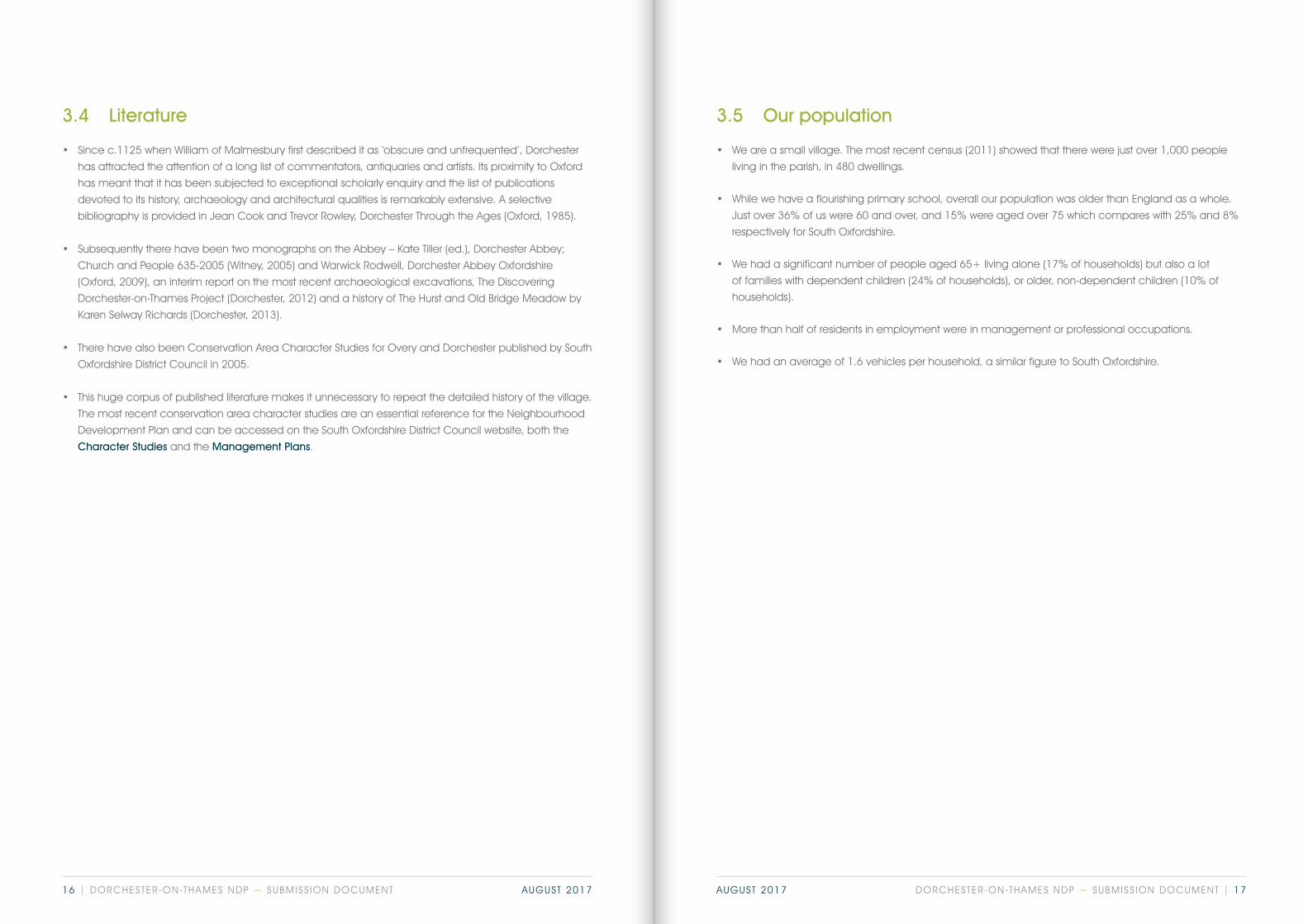
DORCHESTER-ON-THAMES NDP ~ SUBMISS ION DOCUMENT | 1514 | DORCHESTER-ON-THAMES NDP ~ SUBMISS ION DOCUMENT AUGUST 2017 AUGUST 2017
3.5 Our population
• We are a small village. The most recent census (2011) showed that there were just over 1,000 people
living in the parish, in 480 dwellings.
• While we have a flourishing primary school, overall our population was older than England as a whole.
Just over 36% of us were 60 and over, and 15% were aged over 75 which compares with 25% and 8%
respectively for South Oxfordshire.
• We had a significant number of people aged 65+ living alone (17% of households) but also a lot
of families with dependent children (24% of households), or older, non-dependent children (10% of
households).
• More than half of residents in employment were in management or professional occupations.
• We had an average of 1.6 vehicles per household, a similar figure to South Oxfordshire.
3.4 Literature
• Since c.1125 when William of Malmesbury first described it as ‘obscure and unfrequented’, Dorchester
has attracted the attention of a long list of commentators, antiquaries and artists. Its proximity to Oxford
has meant that it has been subjected to exceptional scholarly enquiry and the list of publications
devoted to its history, archaeology and architectural qualities is remarkably extensive. A selective
bibliography is provided in Jean Cook and Trevor Rowley, Dorchester Through the Ages (Oxford, 1985).
• Subsequently there have been two monographs on the Abbey – Kate Tiller (ed.), Dorchester Abbey;
Church and People 635-2005 (Witney, 2005) and Warwick Rodwell, Dorchester Abbey Oxfordshire
(Oxford, 2009), an interim report on the most recent archaeological excavations, The Discovering
Dorchester-on-Thames Project (Dorchester, 2012) and a history of The Hurst and Old Bridge Meadow by
Karen Selway Richards (Dorchester, 2013).
• There have also been Conservation Area Character Studies for Overy and Dorchester published by South
Oxfordshire District Council in 2005.
• This huge corpus of published literature makes it unnecessary to repeat the detailed history of the village.
The most recent conservation area character studies are an essential reference for the Neighbourhood
Development Plan and can be accessed on the South Oxfordshire District Council website, both the
Character Studies and the Management Plans.
DORCHESTER-ON-THAMES NDP ~ SUBMISS ION DOCUMENT | 1716 | DORCHESTER-ON-THAMES NDP ~ SUBMISS ION DOCUMENT AUGUST 2017 AUGUST 2017
4. The themes for the plan
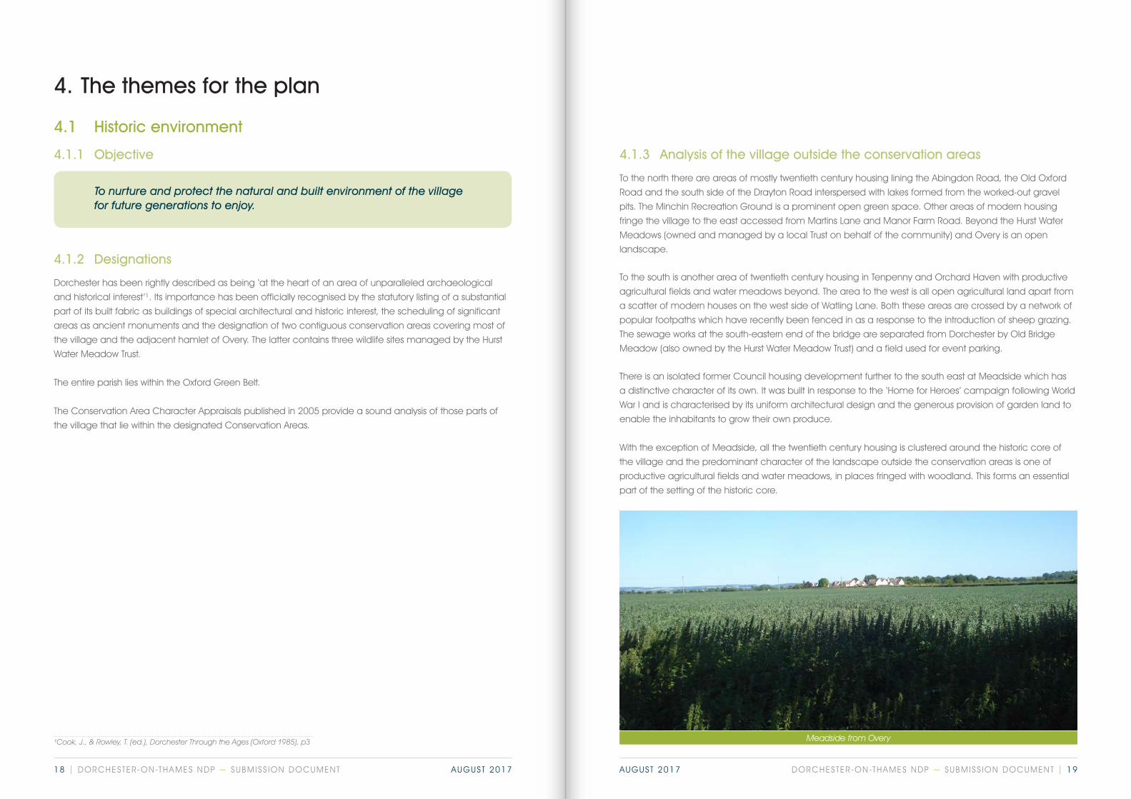
Meadside from Overy¹Cook, J., & Rowley, T. (ed.), Dorchester Through the Ages (Oxford 1985), p3
4.1.3 Analysis of the village outside the conservation areas
To the north there are areas of mostly twentieth century housing lining the Abingdon Road, the Old Oxford
Road and the south side of the Drayton Road interspersed with lakes formed from the worked-out gravel
pits. The Minchin Recreation Ground is a prominent open green space. Other areas of modern housing
fringe the village to the east accessed from Martins Lane and Manor Farm Road. Beyond the Hurst Water
Meadows (owned and managed by a local Trust on behalf of the community) and Overy is an open
landscape.
To the south is another area of twentieth century housing in Tenpenny and Orchard Haven with productive
agricultural fields and water meadows beyond. The area to the west is all open agricultural land apart from
a scatter of modern houses on the west side of Watling Lane. Both these areas are crossed by a network of
popular footpaths which have recently been fenced in as a response to the introduction of sheep grazing.
The sewage works at the south-eastern end of the bridge are separated from Dorchester by Old Bridge
Meadow (also owned by the Hurst Water Meadow Trust) and a field used for event parking.
There is an isolated former Council housing development further to the south east at Meadside which has
a distinctive character of its own. It was built in response to the ‘Home for Heroes’ campaign following World
War I and is characterised by its uniform architectural design and the generous provision of garden land to
enable the inhabitants to grow their own produce.
With the exception of Meadside, all the twentieth century housing is clustered around the historic core of
the village and the predominant character of the landscape outside the conservation areas is one of
productive agricultural fields and water meadows, in places fringed with woodland. This forms an essential
part of the setting of the historic core.
4.1 Historic environment
4.1.1 Objective
To nurture and protect the natural and built environment of the village for future generations to enjoy.
4.1.2 Designations
Dorchester has been rightly described as being ‘at the heart of an area of unparalleled archaeological
and historical interest’¹. Its importance has been officially recognised by the statutory listing of a substantial
part of its built fabric as buildings of special architectural and historic interest, the scheduling of significant
areas as ancient monuments and the designation of two contiguous conservation areas covering most of
the village and the adjacent hamlet of Overy. The latter contains three wildlife sites managed by the Hurst
Water Meadow Trust.
The entire parish lies within the Oxford Green Belt.
The Conservation Area Character Appraisals published in 2005 provide a sound analysis of those parts of
the village that lie within the designated Conservation Areas.
DORCHESTER-ON-THAMES NDP ~ SUBMISS ION DOCUMENT | 1918 | DORCHESTER-ON-THAMES NDP ~ SUBMISS ION DOCUMENT AUGUST 2017 AUGUST 2017

4.1.4 Conservation Area Character Studies
The conservation area character studies were approved by SODC on 2 September 2004. They have stood
the test of time and provide a comprehensive analysis of the intrinsic character of Dorchester and Overy.
Apart from a few minor alterations to take account of subsequent changes and discoveries, the text and
the policies remain an essential tool in the positive management of the historic environment. A number of
the potential enhancement schemes set out in the associated Management Plans approved by SODC
on 16 June 2005 have been implemented and these have been deleted from the proposed updated
Management Plans. It is hoped that the Local Planning Authority will incorporate the minor amendments to all
four documents when they next review the conservation areas. The revisions are set out in the Supplementary
Documents and have been made available to the conservation team at South Oxfordshire District Council.
Dorchester and Overy Heritage AreaFollowing an assessment of the conservation areas, two areas outside the designated boundaries have
been identified as worthy of inclusion within a defined heritage area. This Dorchester and Overy Heritage
Area is shown in Appendices 1 and 2 and is explained below.
The appraisal maps which accompanied the character studies for the designated conservation area of
Dorchester and Overy sought to show important views, walls, trees, open spaces and buildings of local note
as well as listed buildings and the conservation area boundary. However, in our view the maps are deficient
in that they omit some significant views and do not include the boundaries of the Scheduled Ancient
Monuments which are such an important part of the historic character of Dorchester (Appendix 3). Although
the text of the character study emphasises the importance of boundary walls to the appearance of the
village, many of them are not marked on the maps. These features are identified on the Dorchester and
Overy Heritage Area Maps (Appendices 1 and 2).
There is some confusion about the status of the undesignated buildings which are marked as of ‘local note’
on the appraisal maps. We have compiled Appendix 5 to give their addresses and a brief statement of
their interest and marked them on the revised maps. Appendix 5 also includes those buildings outside the
conservation areas which are of local interest and which should be treated as undesignated heritage assets.
4.1.5 Archaeology
Given the history of settlement outlined in the introduction, it is clear that the whole area covered by
the plan is of unparalleled archaeological potential. The areas protected by the Scheduled Ancient
Monuments designations (Appendix 3) are mainly open but it is recognised that the whole built fabric and
the domestic gardens of the village conceal underlying archaeological deposits. In the spring of 2016,
Historic England sponsored a pilot survey of the whole parish to assess its archaeological potential. At the
time of writing this plan the results of the survey have not been published but they should inform any future
decisions on development. It is expected that where developments require planning permission the County
Archaeologist will be consulted as a matter of course and it should be a requirement that an appropriate
investigation should be undertaken by a professionally qualified archaeologist prior to determination in
order that proposals can be designed in a way that avoids harm to any identified archaeology. Where
works would affect a scheduled monument they will, of course, require scheduled monument consent.
Since the last revision to the boundary of the Overy conservation area in 2004 it has emerged that the
field between Overy Lane and the A4074 contains important archaeological evidence for an extensive
extra-mural suburb of Roman Dorchester (Abingdon Archaeological Geophysics 2013: see Dorchester-
on-Thames: a walk through 10,000 years of Archaeology, 2014). The Demesne Field, which is currently
outside the Dorchester conservation area, also contains evidence for important underlying archaeological
remains (Appendix 4). These two areas have been included within Dorchester and Overy Heritage Area (see
Appendices 1 and 2).
A Cob wall Archaeology on the allotments
DORCHESTER-ON-THAMES NDP ~ SUBMISS ION DOCUMENT | 2120 | DORCHESTER-ON-THAMES NDP ~ SUBMISS ION DOCUMENT AUGUST 2017 AUGUST 2017
4.1.7 Evidence base for the Proposals
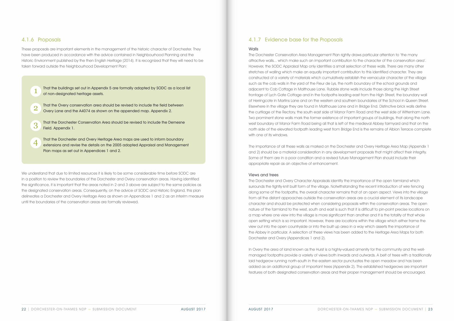
WallsThe Dorchester Conservation Area Management Plan rightly draws particular attention to ‘the many
attractive walls... which make such an important contribution to the character of the conservation area’.
However, the SODC Appraisal Map only identifies a small selection of these walls. There are many other
stretches of walling which make an equally important contribution to this identified character. They are
constructed of a variety of materials which cumulatively establish the vernacular character of the village
such as the cob walls in the yard of the Fleur de Lys, the north boundary of the school grounds and
adjacent to Cob Cottage in Malthouse Lane. Rubble stone walls include those along the High Street
frontage of Lych Gate Cottage and in the footpaths leading east from the High Street, the boundary wall
of Herringcote in Martins Lane and on the western and southern boundaries of the School in Queen Street.
Elsewhere in the village they are found in Malthouse Lane and in Bridge End. Distinctive brick walls define
the curtilage of the Rectory, the south east side of Manor Farm Road and the west side of Wittenham Lane.
Two prominent stone walls mark the former existence of important groups of buildings, that along the north
west boundary of Manor Farm Road being all that is left of the medieval Abbey farmyard and that on the
north side of the elevated footpath leading west from Bridge End is the remains of Albion Terrace complete
with one of its windows.
The importance of all these walls as marked on the Dorchester and Overy Heritage Area Map (Appendix 1
and 2) should be a material consideration in any development proposals that might affect their integrity.
Some of them are in a poor condition and a revised future Management Plan should include their
appropriate repair as an objective of enhancement.
Views and treesThe Dorchester and Overy Character Appraisals identify the importance of the open farmland which
surrounds the tightly-knit built form of the village. Notwithstanding the recent introduction of wire fencing
along some of the footpaths, the overall character remains that of an open aspect. Views into the village
from all the distant approaches outside the conservation areas are a crucial element of its landscape
character and should be protected when considering proposals within the conservation areas. The open
nature of the farmland to the west, south and east is such that it is difficult to pin-point precise locations on
a map where one view into the village is more significant than another and it is the totality of that whole
open setting which is so important. However, there are locations within the village which either frame the
view out into the open countryside or into the built up area in a way which asserts the importance of
the Abbey in particular. A selection of these views has been added to the Heritage Area Maps for both
Dorchester and Overy (Appendices 1 and 2).
In Overy the area of land known as the Hurst is a highly-valued amenity for the community and the well-
managed footpaths provide a variety of views both inwards and outwards. A belt of trees with a traditionally
laid hedgerow running north-south in the eastern sector punctuates the open meadow and has been
added as an additional group of important trees (Appendix 2). The established hedgerows are important
features of both designated conservation areas and their proper management should be encouraged.
4.1.6 Proposals
These proposals are important elements in the management of the historic character of Dorchester. They
have been produced in accordance with the advice contained in Neighbourhood Planning and the
Historic Environment published by the then English Heritage (2014). It is recognized that they will need to be
taken forward outside the Neighbourhood Development Plan:
That the buildings set out in Appendix 5 are formally adopted by SODC as a local list
of non-designated heritage assets.
That the Overy conservation area should be revised to include the field between
Overy Lane and the A4074 as shown on the appended map. Appendix 2.
That the Dorchester Conservation Area should be revised to include the Demesne
Field. Appendix 1.
That the Dorchester and Overy Heritage Area maps are used to inform boundary
extensions and revise the details on the 2005 adopted Appraisal and Management
Plan maps as set out in Appendices 1 and 2.
1
2
3
4
We understand that due to limited resources it is likely to be some considerable time before SODC are
in a position to review the boundaries of the Dorchester and Overy conservation areas. Having identified
the significance, it is important that the areas noted in 2 and 3 above are subject to the same policies as
the designated conservation areas. Consequently, on the advice of SODC and Historic England, this plan
delineates a Dorchester and Overy Heritage Area as shown on Appendices 1 and 2 as an interim measure
until the boundaries of the conservation areas are formally reviewed.
DORCHESTER-ON-THAMES NDP ~ SUBMISS ION DOCUMENT | 2322 | DORCHESTER-ON-THAMES NDP ~ SUBMISS ION DOCUMENT AUGUST 2017 AUGUST 2017
DoT 3: Views and Vistas Development should preserve those views
and vistas which contribute to the significance
of Dorchester and Overy and the heritage
assets within them, as shown on the maps at
Appendices 1 & 2.
Development proposals should identify how a
scheme has been informed by these important
views and proposals which would preserve
these views and the contribution they make to
the important setting of a number of heritage
assets will be looked on favourably.
DoT 1: Historic EnvironmentDevelopments which maintain or enhance the historic environment as identified in chapters 3 and
4 of this document and within the SODC Appraisals and Management Plans (2005) attached in the
supporting documents as contributing to the established character of the Dorchester and Overy
Heritage Area as set out in Appendices 1, 2, 3, and 4 of this Plan will be supported.
DoT 2: Buildings of InterestDevelopment proposals that affect properties identified in the amended local list of buildings of
interest (Appendix 5) will be required to demonstrate that their significance as heritage assets,
including their contribution to the character and appearance of Dorchester and Overy, has been
understood and that the proposals have sought to avoid or minimize harm to their significance.
Any harm to the significance of these buildings should be clearly justified by the public benefits
delivered by the proposals. Development proposals should include a full assessment of the
significance of the asset and an analysis of the effects of the proposal on that significance.
Explanation
As the NDP proposes amendments to the appraisals and plans, this policy is necessary until such time as the
local authority formally adopts the proposals. The evidence base for the amendments is described in 4.1.6.
Explanation
As the NDP proposes additions to the local list this policy is necessary until such time as the amended list is
formally adopted by the local authority. The evidence base for inclusion on the list is contained within the
Appendix.
Buildings of local noteThe justification for adding further buildings of local note is set out in Appendix 5. It includes three buildings
outside the conservation area and provides a reasoned explanation for those buildings which were
previously simply identified on the Appraisal Maps. Having provided this additional information it is hoped that
the District Council will formally adopt the Appendix as a list of undesignated heritage assets. These assets are
considered to be non-designated heritage assets in line with the assessment criteria in the Historic England
Advice Note 7: Local Heritage Listing, and are a material consideration under paragraph 135 of the NPPF.
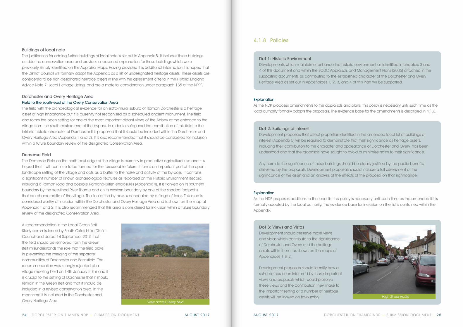
Dorchester and Overy Heritage AreaField to the south-east of the Overy Conservation Area
The field with the archaeological evidence for an extra-mural suburb of Roman Dorchester is a heritage
asset of high importance but it is currently not recognised as a scheduled ancient monument. The field
also forms the open setting for one of the most important distant views of the Abbey at the entrance to the
village from the south eastern end of the bypass. In order to safeguard the contribution of this field to the
intrinsic historic character of Dorchester it is proposed that it should be included within the Dorchester and
Overy Heritage Area (Appendix 1 and 2). It is also recommended that it should be considered for inclusion
within a future boundary review of the designated Conservation Area.
Demense FieldThe Demesne Field on the north-east edge of the village is currently in productive agricultural use and it is
hoped that it will continue to be farmed for the foreseeable future. It forms an important part of the open
landscape setting of the village and acts as a buffer to the noise and activity of the by-pass. It contains
a significant number of known archaeological features as recorded on the Historic Environment Record,
including a Roman road and possible Romano-British enclosures (Appendix 4). It is flanked on its southern
boundary by the tree-lined River Thame and on its western boundary by one of the shaded footpaths
that are characteristic of the village. The line of the by-pass is concealed by a fringe of trees. This area is
considered worthy of inclusion within the Dorchester and Overy Heritage Area and is shown on the map at
Appendix 1 and 2. It is also recommended that this area is considered for inclusion within a future boundary
review of the designated Conservation Area.
A recommendation in the Local Green Belt
Study commissioned by South Oxfordshire District
Council and dated 14 September 2015 that
the field should be removed from the Green
Belt misunderstands the role that the field plays
in preventing the merging of the separate
communities of Dorchester and Berinsfield. The
recommendation was strongly rejected at a
village meeting held on 14th January 2016 and it
is crucial to the setting of Dorchester that it should
remain in the Green Belt and that it should be
included in a revised conservation area. In the
meantime it is included in the Dorchester and
Overy Heritage Area.
4.1.8 Policies
View across Overy field
High Street traffic
DORCHESTER-ON-THAMES NDP ~ SUBMISS ION DOCUMENT | 2524 | DORCHESTER-ON-THAMES NDP ~ SUBMISS ION DOCUMENT AUGUST 2017 AUGUST 2017
4.2 Natural environment, wildlife and biodiversity
4.2.1 Objectives 4.2.2 Background
Dorchester lies entirely within the Oxford Green Belt and the flood meadows adjacent to the River Thames
and the River Thame are included in the Oxfordshire Conservation Target Area (no. 27), the objective is to
preserve, maintain and conserve the extent and biodiversity of this important riverside village.
Located within the Oxford Green Belt, Dorchester-on-Thames (and the adjoining hamlet of Overy) is a
noticeably green village. It is surrounded by flood meadows, gravel pit lakes and farmland, and includes
a number of green spaces within the built-up area (recreation ground, allotments, cemetery, road-side
verges, private gardens, public footpaths through green spaces).
Dorchester is a largely open village and much of the land not yet developed is farmland. There are no
significant areas of woodland within the immediate vicinity.
The River Thames forms the southern and south-western borders of the parish, and the River Thame flanks
Dorchester and the hamlet of Overy on the east; both rivers are subject to flooding. Both settlements are
located in Conservation Areas.
The River Thames and its valley with its scattered settlements, meadows on neutral soil, and the Dorchester
lakes give the landscape its distinctive character.
The Thame has a wide catchment area including Thame, Aylesbury and the Chilterns. Its flood levels can
rise in Dorchester when flood water backs up from the Thames when that is in flood. The risk of backing-up
from the Thames may rise when the planned river Flood Relief schemes upstream are implemented.
Gravel extraction is an important industry in the Thames Valley, and plans to increase quotas for Oxfordshire
are under review. Until now Dorchester had been excluded as a potential source of further extraction of
gravel on grounds of archaeology, but may not always be the case. This could affect the fields between
the village and the A4074. Meanwhile PAGE (Parishes Against Gravel Extraction), with specialist advice, has
submitted powerful arguments questioning the fundamental basis of quota calculations.
To preserve, conserve and protect the terrestrial and aquatic life in the River Thames and River Thame flood meadows.
To preserve, protect and enhance the footpaths, Thames path and green lanes, green spaces and verges throughout the village and surrounding countryside.
To ensure that developments on land adjoining the Community Meadows owned by the Hurst Water Meadow Trust does not adversely impact on the biodiversity of these areas.
To retain the highest category of agricultural land for employment and the rural character of the village.
1
2
3
4
DORCHESTER-ON-THAMES NDP ~ SUBMISS ION DOCUMENT | 2726 | DORCHESTER-ON-THAMES NDP ~ SUBMISS ION DOCUMENT AUGUST 2017 AUGUST 2017

DoT 4: River ImpactAny developments or change of use of land likely to have an impact on the River Thames or River
Thame should:
• Protect and/or enhance biodiversity;
• Be located 20m away from banks of the river; and
• Preserve the tranquillity and enjoyment of the natural environment for the public, where possible.
DoT 5: Community MeadowsDevelopment proposals on sites likely to have an impact on the identified Community Meadows on
the Policy Map should make a positive contribution to the ecology of those sites.
DoT 6: Green Infrastructure Development should retain, protect and enhance for future generations to enjoy, local green
infrastructure (green spaces and verges) including all bridleways and footpaths as identified on the
Policy Map.
DoT 7: Agricultural Land Use Alternative land uses in the areas shown in the Policy Map, representing the most versatile and highest
quality agricultural land in the Parish should be protected for agricultural employment opportunities
and protect the non-renewable land resource except as allowed in the Local Plan.
4.2.3 Wildlife
Dorchester is fortunate in lying in an area where the importance of biodiversity is recognised. On the opposite
(south) side of the River Thames, in Wittenham Woods, is a Special Area of Conservation (SAC), set up to protect
a major site for the crested newt, and Wittenham Woods and the surrounding area are a Site of Special
Scientific Interest (SSSI). In 1994 the UK Biodiversity Action Plan (BAP) was published, which led the Oxfordshire
County Council to identify 36 Conservation Target Areas, one of which (no. 27) comprises the Thames flood
meadows between Clifton Hampden and Shillingford. It also includes those next to the River Thame up to the
A4074 and the gravel lakes north of Dorchester. Also on the south side of the Thames is the River of Life project,
a major wildlife and wetland development managed by the Earth Trust based at Little Wittenham. The North
Wessex Area of Outstanding Natural Beauty lies on the opposite side of the River Thames contiguous with the
Dorchester NDP area boundary from Shillingford in the south to a point opposite to the Bishops Court Farm
lakes in the north.
All the flood meadows in the parish, the gravel pit lakes, existing and planned Hurst Water Meadow Trust
properties lie within the Oxfordshire Conservation Target Area no.27.
The area includes a wide variety of wildlife habitats, including: pasture, arable, woodland, wet woodland,
hedgerows, reed beds, riverine vegetation, scrub, gardens, fast and slow-moving water, ponds and lakes, etc.
Together these provide habitat for many hundreds of different species of mammals, birds, fish, amphibians,
reptiles and invertebrates (especially insects). The Thames Valley Environmental Records Centre (TVERC) lists
approximately 500 species of interest in the immediate area, some of BAP Priority status.
The Hurst Water Meadow Trust owns three flood meadows; The Hurst and Old Bridge Meadow, together
occupying 21 acres on the east bank of the River Thame, and a further 4 acres (called Overy Mead Piece)
between Old Bridge Meadow and the confluence of the Thame and the Thames. The object is for the Trust,
with the active collaboration of the community, to manage these meadows and the rivers for biodiversity,
wildlife, public education and informal recreation, and in particular to create a riverine wildlife corridor up the
Thame from Wittenham Woods to the A4074.
Note that Environment Agency Guidance recommends a buffer of at least 10m between any development
and the banks of a river, in this case the River Thame and River Thames.
4.2.4 Policies
Hurst Hedge Hurst Classroom
Map 1
Thames and Thame Floodplains (from Environment Agency Flood Zone Map)
Map 4
Green Spaces, Footpaths and Bridleways
Map 3
Oxfordshire Conservation Target Area 27 and North Wessex Area of Natural Beauty
Map 6
Agricultural Land Categories
Map 2
Community Meadows
Map 5
Farms and Farmland
DORCHESTER-ON-THAMES NDP ~ SUBMISS ION DOCUMENT | 2928 | DORCHESTER-ON-THAMES NDP ~ SUBMISS ION DOCUMENT AUGUST 2017 AUGUST 2017

Environment Agency Flood Zone 2
Environment Agency Flood Zone 3
MAP 1: THAMES AND THAME FLOODPLAINS (from Environment Agency Flood map)
0 500m
© Crown copyright and database rights 2017 Ordnance Survey 0100031673
For original data and further detail please refer to the following link:https://cnp16.maps.arcgis.com/apps/View/index.html?appid=d620077dad7149f0abc65dda816c18e6
Overy Mead Piece
Old Bridge Meadow
Hurst Water Meadow
MAP 2: COMMUNITY MEADOWS
WATERMEADOWS
0 500m
© Crown copyright and database rights 2017 Ordnance Survey 0100031673
For original data and further detail please refer to the following link:https://cnp16.maps.arcgis.com/apps/View/index.html?appid=d620077dad7149f0abc65dda816c18e6
Map 1: Thames and Thame Floodplains (from Environment Agency Flood Zone Map) Map 2: Community Meadows
DORCHESTER-ON-THAMES NDP ~ SUBMISS ION DOCUMENT | 3130 | DORCHESTER-ON-THAMES NDP ~ SUBMISS ION DOCUMENT AUGUST 2017 AUGUST 2017

MAP 3: OXFORDSHIRE CONSERVATION TARGET AREA 27AND NORTH WESSEX AREA OF NATURAL BEAUTY
Oxfordshire Conservation Target Area 27
0 1km
© Crown copyright and database rights 2017 Ordnance Survey 0100031673
For original data and further detail please refer to the following link:https://cnp16.maps.arcgis.com/apps/View/index.html?appid=d620077dad7149f0abc65dda816c18e6
North Wessex Area of Natural Beauty
Cemetery
Minchin Recreation Ground
Allotments
Green verge
0 500m
© Crown copyright and database rights 2017 Ordnance Survey 0100031673
For original data and further detail please refer to the following link:https://cnp16.maps.arcgis.com/apps/View/index.html?appid=d620077dad7149f0abc65dda816c18e6
MAP 4: GREEN SPACES, FOOTPATHS AND BRIDLEWAYS
Bridleway
Footpath
Map 3: Oxfordshire Conservation Target Area 27 and North Wessex Area of Natural Beauty Map 4: Green Spaces, Footpaths and Bridleways
DORCHESTER-ON-THAMES NDP ~ SUBMISS ION DOCUMENT | 3332 | DORCHESTER-ON-THAMES NDP ~ SUBMISS ION DOCUMENT AUGUST 2017 AUGUST 2017

MAP 5: FARMS AND FARMLAND
Bishops Court Farm
Demesne Field
Queenford Farm
Townsend Farm
Cooks Farm
0 500m
© Crown copyright and database rights 2017 Ordnance Survey 0100031673
For original data and further detail please refer to the following link:https://cnp16.maps.arcgis.com/apps/View/index.html?appid=d620077dad7149f0abc65dda816c18e6
MAP 6: AGRICULTURAL LAND CATEGORIES
Excellent
Very Good
Poor
Very Poor
AGRICULTURAL LAND CLASSIFICATION
0 500m
© Crown copyright and database rights 2017 Ordnance Survey 0100031673
For original data and further detail please refer to the following link:https://cnp16.maps.arcgis.com/apps/View/index.html?appid=d620077dad7149f0abc65dda816c18e6
Map 5: Farms and Farmland Map 6: Agricultural Land Categories
DORCHESTER-ON-THAMES NDP ~ SUBMISS ION DOCUMENT | 3534 | DORCHESTER-ON-THAMES NDP ~ SUBMISS ION DOCUMENT AUGUST 2017 AUGUST 2017
4.3 Housing
4.3.1 Objectives
2South Oxfordshire Core Strategy, Para 7.293Oxfordshire Strategic Housing Market Assessment: April 2014, Table 50, p1144ibid, Table 555Ibid, Para 6.796Dorchester Housing Needs Survey Report. Anna Kennedy, Oxfordshire Rural Community Council, October 2012 7/8Dorchester Housing Needs Survey Report. Anna Kennedy, Oxfordshire Rural Community Council, October 2012
To increase the housing stock through a limited number of small developments, providing affordable housing, smaller dwellings, and dwellings suitable for older people, in order to meet the identified needs of local residents and allow the village to maintain a balanced community.
To ensure that new housing, extensions and other residential development respect and enhance the setting and special character of the village.
To encourage high standards of environmental performance in all residential development.
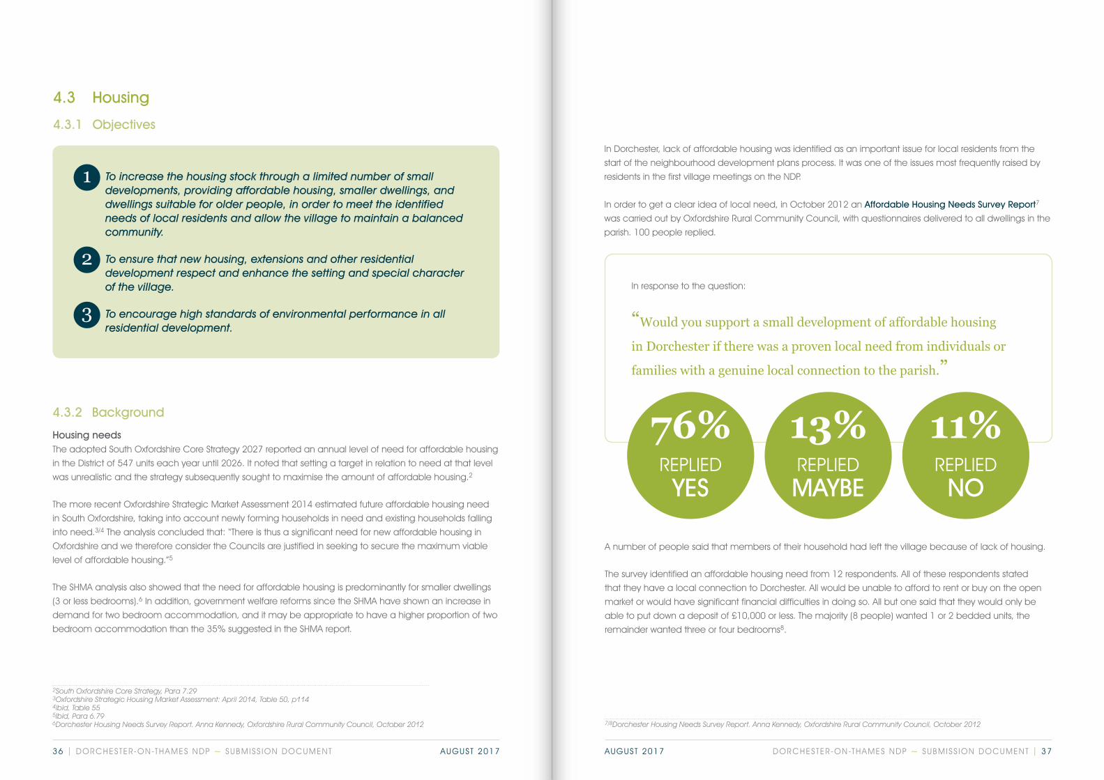
In response to the question:
“Would you support a small development of affordable housing
in Dorchester if there was a proven local need from individuals or
families with a genuine local connection to the parish.”
1
2
3
76%YES
REPLIED
13%MAYBEREPLIED
11%NO
REPLIED
4.3.2 Background
Housing needsThe adopted South Oxfordshire Core Strategy 2027 reported an annual level of need for affordable housing
in the District of 547 units each year until 2026. It noted that setting a target in relation to need at that level
was unrealistic and the strategy subsequently sought to maximise the amount of affordable housing.2
The more recent Oxfordshire Strategic Market Assessment 2014 estimated future affordable housing need
in South Oxfordshire, taking into account newly forming households in need and existing households falling
into need.3/4 The analysis concluded that: “There is thus a significant need for new affordable housing in
Oxfordshire and we therefore consider the Councils are justified in seeking to secure the maximum viable
level of affordable housing.”5
The SHMA analysis also showed that the need for affordable housing is predominantly for smaller dwellings
(3 or less bedrooms).6 In addition, government welfare reforms since the SHMA have shown an increase in
demand for two bedroom accommodation, and it may be appropriate to have a higher proportion of two
bedroom accommodation than the 35% suggested in the SHMA report.
In Dorchester, lack of affordable housing was identified as an important issue for local residents from the
start of the neighbourhood development plans process. It was one of the issues most frequently raised by
residents in the first village meetings on the NDP.
In order to get a clear idea of local need, in October 2012 an Affordable Housing Needs Survey Report7
was carried out by Oxfordshire Rural Community Council, with questionnaires delivered to all dwellings in the
parish. 100 people replied.
A number of people said that members of their household had left the village because of lack of housing.
The survey identified an affordable housing need from 12 respondents. All of these respondents stated
that they have a local connection to Dorchester. All would be unable to afford to rent or buy on the open
market or would have significant financial difficulties in doing so. All but one said that they would only be
able to put down a deposit of £10,000 or less. The majority (8 people) wanted 1 or 2 bedded units, the
remainder wanted three or four bedrooms8.
DORCHESTER-ON-THAMES NDP ~ SUBMISS ION DOCUMENT | 3736 | DORCHESTER-ON-THAMES NDP ~ SUBMISS ION DOCUMENT AUGUST 2017 AUGUST 2017
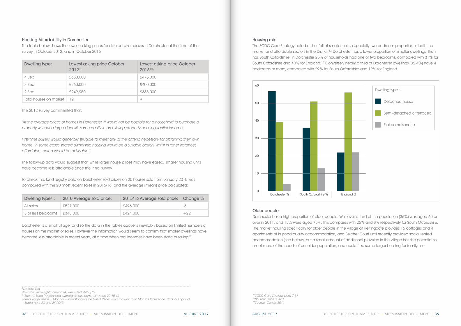
Dwelling type: Lowest asking price October 20129:
Lowest asking price October 201610:
4 Bed £650.000 £475,000
3 Bed £260,000 £400.000
2 Bed £249,950 £385,000
Total houses on market 12 9
Dwelling type11: 2010 Average sold price: 2015/16 Average sold price: Change %
All sales £527,000 £496,000 -6
3 or less bedrooms £348,000 £424,000 +22
Housing Affordability in DorchesterThe table below shows the lowest asking prices for different size houses in Dorchester at the time of the
survey in October 2012, and in October 2016
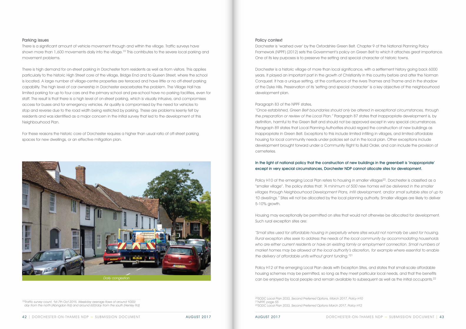
Housing mixThe SODC Core Strategy noted a shortfall of smaller units, especially two bedroom properties, in both the
market and affordable sectors in the District.13 Dorchester has a lower proportion of smaller dwellings, than
has South Oxfordshire. In Dorchester 25% of households had one or two bedrooms, compared with 31% for
South Oxfordshire and 40% for England.14 Conversely nearly a third of Dorchester dwellings (32.4%) have 4
bedrooms or more, compared with 29% for South Oxfordshire and 19% for England.
Older peopleDorchester has a high proportion of older people. Well over a third of the population (36%) was aged 60 or
over in 2011, and 15% were aged 75+. This compares with 25% and 8% respectively for South Oxfordshire.
The market housing specifically for older people in the village at Herringcote provides 15 cottages and 4
apartments of in good quality accommodation, and Belcher Court until recently provided social rented
accommodation (see below), but a small amount of additional provision in the village has the potential to
meet more of the needs of our older population, and could free some larger housing for family use.
Dorchester is a small village, and so the data in the tables above is inevitably based on limited numbers of
houses on the market or sales. However the information would seem to confirm that smaller dwellings have
become less affordable in recent years, at a time when real incomes have been static or falling12.
The 2012 survey commented that:
“At the average prices of homes in Dorchester, it would not be possible for a household to purchase a property without a large deposit, some equity in an existing property or a substantial income.
First-time buyers would generally struggle to meet any of the criteria necessary for obtaining their own home. In some cases shared ownership housing would be a suitable option, whilst in other instances affordable rented would be advisable.”
The follow-up data would suggest that, while larger house prices may have eased, smaller housing units
have become less affordable since the initial survey.
To check this, land registry data on Dorchester sold prices on 20 houses sold from January 2010 was
compared with the 20 most recent sales in 2015/16, and the average (mean) price calculated:
9Source: Ibid10Source: www.rightmove.co.uk, extracted 20/10/1611Source: Land Registry and www.rightmove.com, extracted 20.10.1612Real wage trends. S Machin - Understanding the Great Recession: From Micro to Macro Conference, Bank of England, September 23 and 24 2015
13SODC Core Strategy para 7.3714Source: Census 201115Source: Census 2011
60
50
40
30
20
10
0Dorchester % South Oxfordshire % England %
Dwelling type15
Detached house
Semi-detached or terraced
Flat or maisonette
DORCHESTER-ON-THAMES NDP ~ SUBMISS ION DOCUMENT | 3938 | DORCHESTER-ON-THAMES NDP ~ SUBMISS ION DOCUMENT AUGUST 2017 AUGUST 2017

16National Planning Policy Framework (NPPF), Para 50: “mixed and balanced communities” 17Dorchester Housing Needs Survey Report. Anna Kennedy, Oxfordshire Rural Community Council, October 2012 18SODC Local Plan 2033, Second Preferred Options, March 2017, Policy CF 1
4.3.3 Policy justifications
Infill developmentsThe policies in the plan aim to support infill development only where it is appropriate to its existing
surroundings and which helps to maintain a balanced housing mix within the village. This would include
small family homes in suitable locations, or homes suitable for older people, with a predominance of
smaller homes to meet the established demand
Dorchester is well known for its old and beautiful buildings - exceptional architecture is part of the character
of the village. The quality of new buildings should continue to be of an exceptional standard to meet the
demands of the present and future, something that has not always been observed in the past.
Affordable HousingDorchester has changed in recent years, and as noted above is proportionally a village of older people
and larger houses. The danger is that if this continues the village will become less of a sustainable,
balanced and mixed community.16
In particular, Dorchester has very little “affordable” or social housing.
The need for affordable housing, both within South Oxfordshire and locally in Dorchester, is set out in para
4.3.2 above. The purpose of policies in this plan is to ensure that housing constructed within Dorchester LDP
area, and therefore within the green belt, meets the NPPF criteria of providing: “limited affordable housing
for local community needs” (NPPF para 89), and that it continues to do so into the future. Affordable
housing for local needs was one of the key issues emerging from the initial consultations, and was
supported in the Dorchester Housing Needs Survey.17
Affordable housing sites should be within reasonable walking distance of the local facilities of the village.
A substantial element of social housing, in the village is the SOHA Housing Association development at
Belcher Court, which provides 10 units of accommodation for older people. SOHA wishes to redevelop the
site for saleable properties and the current tenants have been decanted by SOHA.
In 1968 the then local authority compulsorily purchased the land on which Belcher Court stands in order to
provide social housing for older people in the village and local area. It has continued to do this for the last
50 years.
This provision can be considered a ‘Community Facility or Service’, as defined in the Emerging Local Plan.18
As such it needs to be safeguarded because it is an ‘essential community facility or service’, and ‘one of a
limited number of that nature’ in the area.
The site is virtually the only space in the built up area of the village, which is potentially suitable and
available for affordable or social housing for local people, and which was publicly acquired for this
purpose. The Parish Council would wish to see a significant element of such housing in any redevelopment.
Post-war development
Post-war development
Environmental issuesMuch of Dorchester’s housing stock has a relatively poor environmental performance, having high energy
requirements and little regard to water management. The Housing policies in this plan aim to improve the
performance quality of homes and reduce running costs by encouraging a thoughtful approach to design as
a whole. It is not difficult to exceed the minimum requirements for sustainability set by Building Regulations and
the Core Strategy, and there are good examples of homes across the country that have done so.
Building regulations and local planning policy set minimum requirements for the environmental
performance of new buildings, but these are only minimum standards, not targets. There are an increasing
number of zero-carbon homes in the UK and this policy seeks to encourage the design principles needed
to significantly improve the overall quality of the building stock within the village. Development applications
will be enhanced if they show a clear commitment to this principle.
DORCHESTER-ON-THAMES NDP ~ SUBMISS ION DOCUMENT | 4140 | DORCHESTER-ON-THAMES NDP ~ SUBMISS ION DOCUMENT AUGUST 2017 AUGUST 2017
Policy contextDorchester is ‘washed over’ by the Oxfordshire Green Belt. Chapter 9 of the National Planning Policy
Framework (NPPF) (2012) sets the Government’s policy on Green Belt to which it attaches great importance.
One of its key purposes is to preserve the setting and special character of historic towns.
Dorchester is a historic village of more than local significance, with a settlement history going back 6000
years. It played an important part in the growth of Christianity in this country before and after the Norman
Conquest. It has a unique setting, at the confluence of the rivers Thames and Thame and in the shadow
of the Dyke Hills. Preservation of its ‘setting and special character’ is a key objective of the neighbourhood
development plan.
Paragraph 83 of the NPPF states,
“Once established, Green Belt boundaries should only be altered in exceptional circumstances, through the preparation or review of the Local Plan.” Paragraph 87 states that inappropriate development is, by
definition, harmful to the Green Belt and should not be approved except in very special circumstances.
Paragraph 89 states that Local Planning Authorities should regard the construction of new buildings as
inappropriate in Green Belt. Exceptions to this include limited infilling in villages, and limited affordable
housing for local community needs under policies set out in the local plan. Other exceptions include
development brought forward under a Community Right to Build Order, and can include the provision of
cemeteries.
In the light of national policy that the construction of new buildings in the greenbelt is ‘inappropriate’
except in very special circumstances, Dorchester NDP cannot allocate sites for development.
Policy H10 of the emerging Local Plan refers to housing in smaller villages20. Dorchester is classified as a
“smaller village”. The policy states that: “A minimum of 500 new homes will be delivered in the smaller villages through Neighbourhood Development Plans, infill development, and/or small suitable sites of up to 10 dwellings.” Sites will not be allocated by the local planning authority. Smaller villages are likely to deliver
5-10% growth.
Housing may exceptionally be permitted on sites that would not otherwise be allocated for development.
Such rural exception sites are:
“Small sites used for affordable housing in perpetuity where sites would not normally be used for housing. Rural exception sites seek to address the needs of the local community by accommodating households who are either current residents or have an existing family or employment connection. Small numbers of market homes may be allowed at the local authority’s discretion, for example where essential to enable the delivery of affordable units without grant funding.”21
Policy H12 of the emerging Local Plan deals with Exception Sites, and states that small-scale affordable
housing schemes may be permitted, so long as they meet particular local needs, and that the benefits
can be enjoyed by local people and remain available to subsequent as well as the initial occupants.22
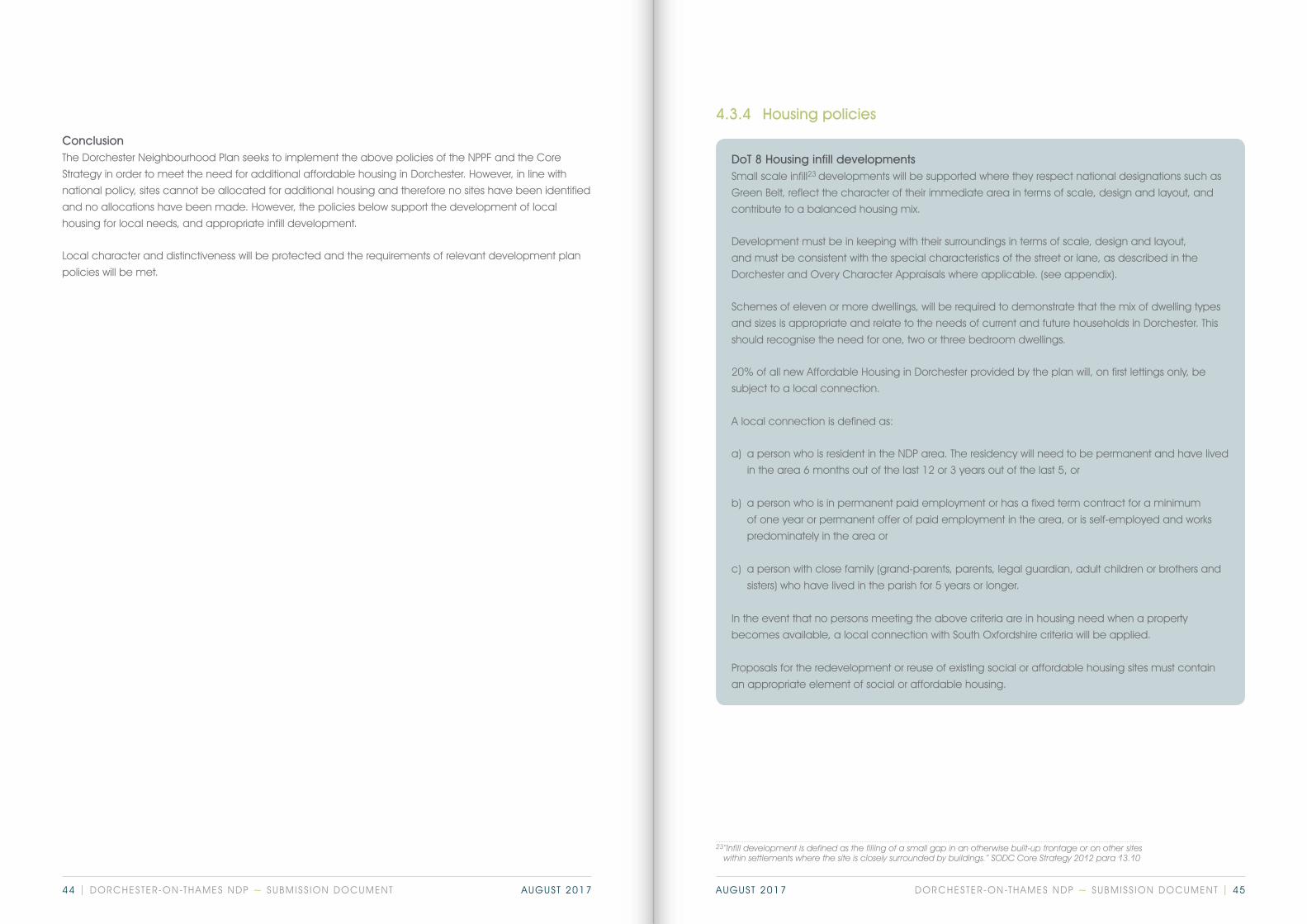
Parking issuesThere is a significant amount of vehicle movement through and within the village. Traffic surveys have
shown more than 1,600 movements daily into the village.19 This contributes to the severe local parking and
movement problems.
There is high demand for on-street parking in Dorchester from residents as well as from visitors. This applies
particularly to the historic High Street core of the village, Bridge End and to Queen Street, where the school
is located. A large number of village-centre properties are terraced and have little or no off-street parking
capability. The high level of car ownership in Dorchester exacerbates the problem. The Village Hall has
limited parking for up to four cars and the primary school and pre-school have no parking facilities, even for
staff. The result is that there is a high level of on-street parking, which is visually intrusive, and compromises
access for buses and for emergency vehicles. Air quality is compromised by the need for vehicles to
stop and reverse due to the road width being restricted by parking. These are problems keenly felt by
residents and was identified as a major concern in the initial survey that led to the development of this
Neighbourhood Plan.
For these reasons the historic core of Dorchester requires a higher than usual ratio of off-street parking
spaces for new dwellings, or an effective mitigation plan.
Daily congestion
19Traffic survey count, 1st-7th Oct 2015. Weekday average flows of around 1000/ day from the north (Abingdon Rd) and around 600/day from the south (Henley Rd)
20SODC Local Plan 2033, Second Preferred Options, March 2017, Policy H10 21NPPF, page 5522SODC Local Plan 2033, Second Preferred Options March 2017, Policy H12
DORCHESTER-ON-THAMES NDP ~ SUBMISS ION DOCUMENT | 4342 | DORCHESTER-ON-THAMES NDP ~ SUBMISS ION DOCUMENT AUGUST 2017 AUGUST 2017
DoT 8 Housing infill developmentsSmall scale infill23 developments will be supported where they respect national designations such as
Green Belt, reflect the character of their immediate area in terms of scale, design and layout, and
contribute to a balanced housing mix.
Development must be in keeping with their surroundings in terms of scale, design and layout,
and must be consistent with the special characteristics of the street or lane, as described in the
Dorchester and Overy Character Appraisals where applicable. (see appendix).
Schemes of eleven or more dwellings, will be required to demonstrate that the mix of dwelling types
and sizes is appropriate and relate to the needs of current and future households in Dorchester. This
should recognise the need for one, two or three bedroom dwellings.
20% of all new Affordable Housing in Dorchester provided by the plan will, on first lettings only, be
subject to a local connection.
A local connection is defined as:
a) a person who is resident in the NDP area. The residency will need to be permanent and have lived
in the area 6 months out of the last 12 or 3 years out of the last 5, or
b) a person who is in permanent paid employment or has a fixed term contract for a minimum
of one year or permanent offer of paid employment in the area, or is self-employed and works
predominately in the area or
c) a person with close family (grand-parents, parents, legal guardian, adult children or brothers and
sisters) who have lived in the parish for 5 years or longer.
In the event that no persons meeting the above criteria are in housing need when a property
becomes available, a local connection with South Oxfordshire criteria will be applied.
Proposals for the redevelopment or reuse of existing social or affordable housing sites must contain
an appropriate element of social or affordable housing.
ConclusionThe Dorchester Neighbourhood Plan seeks to implement the above policies of the NPPF and the Core
Strategy in order to meet the need for additional affordable housing in Dorchester. However, in line with
national policy, sites cannot be allocated for additional housing and therefore no sites have been identified
and no allocations have been made. However, the policies below support the development of local
housing for local needs, and appropriate infill development.
Local character and distinctiveness will be protected and the requirements of relevant development plan
policies will be met.
23“Infill development is defined as the filling of a small gap in an otherwise built-up frontage or on other sites within settlements where the site is closely surrounded by buildings.” SODC Core Strategy 2012 para 13.10
4.3.4 Housing policies
DORCHESTER-ON-THAMES NDP ~ SUBMISS ION DOCUMENT | 4544 | DORCHESTER-ON-THAMES NDP ~ SUBMISS ION DOCUMENT AUGUST 2017 AUGUST 2017
DoT 9 Affordable Housing – Exception SitesPlanning applications for small scale affordable housing sites will be supported, providing that the
criteria for the provision of such sites set out in Emerging Local Plan Policy are met.
Any such proposals must be supported by an up to date local housing needs assessment.24
Such developments must reflect the character of their immediate surroundings in terms of scale,
design and layout, and contribute to a balanced housing mix. Such housing should not compromise
the purposes of the Green Belt.
Within this framework, support will be given to schemes with a predominance of one, two or three
bedroom dwellings.
All new homes provided in this way must be subject to a planning obligation to restrict their
occupancy to people with a local connection.25 *The application of a legally binding local
occupancy clause will be expected in perpetuity.
A local connection is defined as:
a) a person who is resident in the NDP area. The residency will need to be permanent and have lived
in the area 6 months out of the last 12 or 3 years out of the last 5, or
b) a person who is in permanent paid employment or has a fixed term contract for a minimum
of one year or permanent offer of paid employment in the area, or is self-employed and works
predominately in the area or
c) a person with close family (grand-parents, parents, legal guardian, adult children or brothers and
sisters) who have lived in the parish for 5 years or longer.
In the event that no persons meeting the above criteria are in housing need when a property
becomes available, a local connection with South Oxfordshire criteria will be applied.
DoT 10 Environmental issuesApplications for new buildings will be encouraged to achieve excellent environmental performance,
unless it can be demonstrated to adversely affect the viability of the development. Developers are
encouraged to use the Home Quality Mark to rate proposals on the dimensions of living costs for
occupants, health and wellbeing, and environmental footprint.
Developments should:
• Incorporate sustainable drainage
• Consider the net increase in water and waste water demand to serve their developments and
also any impact the development may have off-site further down the network if no/low water
pressure and internal/external sewerage flooding of property is to be avoided.
• Incorporate energy efficiency measures and use renewable energy resources where appropriate.
• Protect trees, hedges and other valuable ecological features of the site.
DoT 11 Conservation Area Development - ParkingProposals for all new homes to be built within the Dorchester Conservation Area must provide an
effective plan to mitigate the impact of additional on-street parking.
24‘Up to date’ means within the last 3 years 25‘Up to date’ means within the last 5 years
DORCHESTER-ON-THAMES NDP ~ SUBMISS ION DOCUMENT | 4746 | DORCHESTER-ON-THAMES NDP ~ SUBMISS ION DOCUMENT AUGUST 2017 AUGUST 2017

4.3.5 Community Infrastructure Levy (CIL)
South Oxfordshire District Council has adopted a Community Infrastructure Levy (CIL) scheme. For
developments approved after 1st April 2016, a landowner or developer has to pay CIL if the development
adds at least 100m2 of additional floor space to an existing building or is less than 100m2 but creates a
new building.
The CIL scheme provides that 25% of the money raised goes to the parish in areas with an adopted
neighbourhood plan where the development is located – (15% in areas without an adopted
neighbourhood plan). Affordable, self-build and charitable dwellings are subject to relief from CIL.
The list below indicates initial areas where Dorchester would wish to invest any CIL monies received:
1 Improvement and refurbishment to the sports pavilion
The pavilion does not have adequate changing provision for female users, and this restricts the
opportunities for women and girls to engage in sports on the village recreation ground. Use of CIL monies
will enable adaptations to be made to remedy the situation.
2 Outdoor gym
Maintaining physical fitness is important for people of all ages. Provision of an outdoor gym for adults will
increase opportunities for the whole adult population to remain active. We will also consider the possibility
of making provision specifically for children.
3 Refurbishment of Village Hall and Parish Clerk’s office
The Village Hall, a Giles Gilbert Scott building built in 1872, requires adaptations to enable it to be used
more flexibly, so that it can continue to meet modern needs. In addition, the parish clerk currently operates
from his own home. This is not a satisfactory situation in the long term, and a parish clerk’s office needs to
be provided. There are opportunities to do so as part of adaptations to the Village Hall.
4 Additional parking provision
The village has a significant parking problem, both from residents and from visitors. We will continue to look
for additional parking spaces that can be provided within the framework of this NDP.
5 Additional cemetery capacity
The existing village cemetery is likely to be near or at capacity before the end of the plan period. We will
look for opportunities to provide additional capacity.
4.4 Tourism and leisure
4.4.1 Objectives
Jubilee Celebrations
To promote and manage sustainable tourism to enhance the cultural and economic well-being of the village.
To retain and promote recreational facilities for all members of the community.
To preserve the character and nature of the village for its residents and visitors.
1
1
2
3
4
5
2
3
4.4.2 Background
Tourism is diverse and well established. The River Thames brings boats and walkers. The Abbey brings visitors
and concert goers. Proximity to Oxford brings tourists exploring the wider area. The history of Dorchester and
its historic buildings attracts tourism. The Museum is a popular visitor attraction. Countryside walkers and
cyclists visit or pass through the village.
More recently, tourism has been markedly increased through the international popularity of “Midsomer
Murders”. Additionally, Dorchester benefits from being close to the Earth Trust at Little Wittenham. Annual
events such as Arts Week also bring visitors.
Tourism can place an additional strain and burden on the resources of the village. Visitor parking is limited
to the public car park in Bridge End plus on-street parking, with the latter having the obvious adverse impact
on the village’s outward appearance and attractiveness.
DORCHESTER-ON-THAMES NDP ~ SUBMISS ION DOCUMENT | 4948 | DORCHESTER-ON-THAMES NDP ~ SUBMISS ION DOCUMENT AUGUST 2017 AUGUST 2017
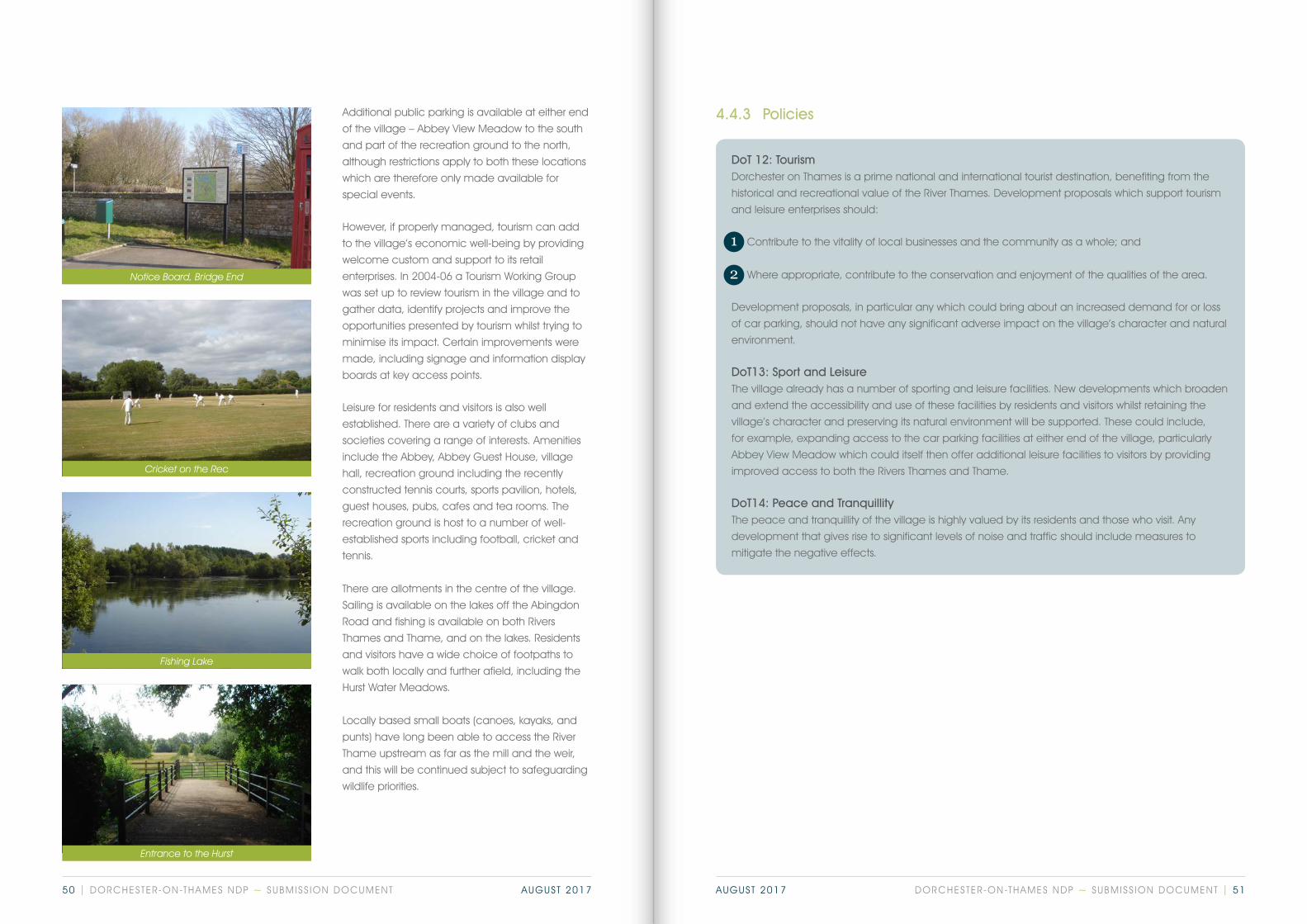
DoT 12: Tourism Dorchester on Thames is a prime national and international tourist destination, benefiting from the
historical and recreational value of the River Thames. Development proposals which support tourism
and leisure enterprises should:
1 Contribute to the vitality of local businesses and the community as a whole; and
2 Where appropriate, contribute to the conservation and enjoyment of the qualities of the area.
Development proposals, in particular any which could bring about an increased demand for or loss
of car parking, should not have any significant adverse impact on the village’s character and natural
environment.
DoT13: Sport and LeisureThe village already has a number of sporting and leisure facilities. New developments which broaden
and extend the accessibility and use of these facilities by residents and visitors whilst retaining the
village’s character and preserving its natural environment will be supported. These could include,
for example, expanding access to the car parking facilities at either end of the village, particularly
Abbey View Meadow which could itself then offer additional leisure facilities to visitors by providing
improved access to both the Rivers Thames and Thame.
DoT14: Peace and TranquillityThe peace and tranquillity of the village is highly valued by its residents and those who visit. Any
development that gives rise to significant levels of noise and traffic should include measures to
mitigate the negative effects.
Additional public parking is available at either end
of the village – Abbey View Meadow to the south
and part of the recreation ground to the north,
although restrictions apply to both these locations
which are therefore only made available for
special events.
However, if properly managed, tourism can add
to the village’s economic well-being by providing
welcome custom and support to its retail
enterprises. In 2004-06 a Tourism Working Group
was set up to review tourism in the village and to
gather data, identify projects and improve the
opportunities presented by tourism whilst trying to
minimise its impact. Certain improvements were
made, including signage and information display
boards at key access points.
Leisure for residents and visitors is also well
established. There are a variety of clubs and
societies covering a range of interests. Amenities
include the Abbey, Abbey Guest House, village
hall, recreation ground including the recently
constructed tennis courts, sports pavilion, hotels,
guest houses, pubs, cafes and tea rooms. The
recreation ground is host to a number of well-
established sports including football, cricket and
tennis.
There are allotments in the centre of the village.
Sailing is available on the lakes off the Abingdon
Road and fishing is available on both Rivers
Thames and Thame, and on the lakes. Residents
and visitors have a wide choice of footpaths to
walk both locally and further afield, including the
Hurst Water Meadows.
Locally based small boats (canoes, kayaks, and
punts) have long been able to access the River
Thame upstream as far as the mill and the weir,
and this will be continued subject to safeguarding
wildlife priorities.
4.4.3 Policies
Notice Board, Bridge End
Cricket on the Rec
Fishing Lake
Entrance to the Hurst
1
2
DORCHESTER-ON-THAMES NDP ~ SUBMISS ION DOCUMENT | 5150 | DORCHESTER-ON-THAMES NDP ~ SUBMISS ION DOCUMENT AUGUST 2017 AUGUST 2017
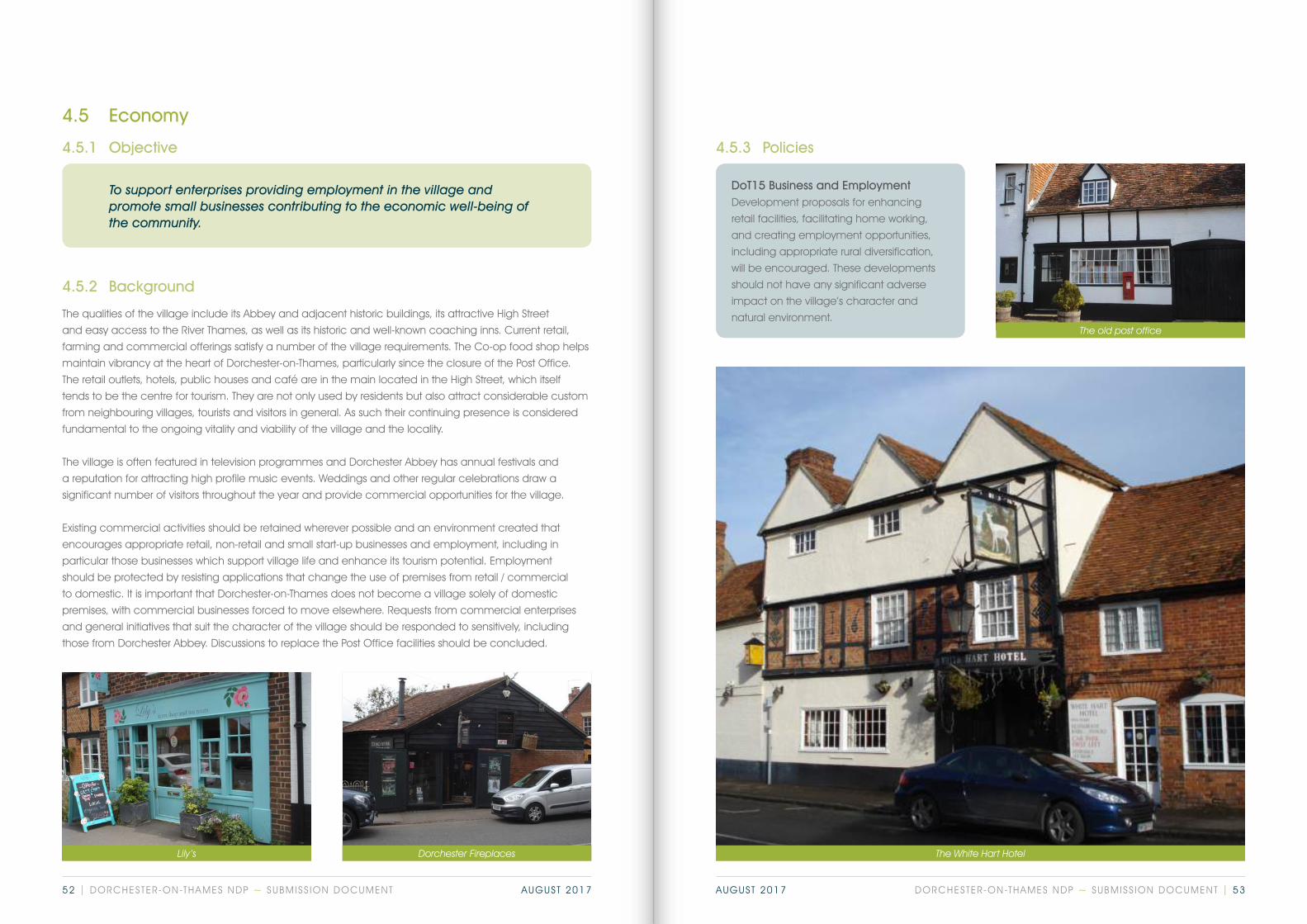
DoT15 Business and EmploymentDevelopment proposals for enhancing
retail facilities, facilitating home working,
and creating employment opportunities,
including appropriate rural diversification,
will be encouraged. These developments
should not have any significant adverse
impact on the village’s character and
natural environment.
4.5 Economy
4.5.1 Objective
To support enterprises providing employment in the village and promote small businesses contributing to the economic well-being of the community.
4.5.2 Background
The qualities of the village include its Abbey and adjacent historic buildings, its attractive High Street
and easy access to the River Thames, as well as its historic and well-known coaching inns. Current retail,
farming and commercial offerings satisfy a number of the village requirements. The Co-op food shop helps
maintain vibrancy at the heart of Dorchester-on-Thames, particularly since the closure of the Post Office.
The retail outlets, hotels, public houses and café are in the main located in the High Street, which itself
tends to be the centre for tourism. They are not only used by residents but also attract considerable custom
from neighbouring villages, tourists and visitors in general. As such their continuing presence is considered
fundamental to the ongoing vitality and viability of the village and the locality.
The village is often featured in television programmes and Dorchester Abbey has annual festivals and
a reputation for attracting high profile music events. Weddings and other regular celebrations draw a
significant number of visitors throughout the year and provide commercial opportunities for the village.
Existing commercial activities should be retained wherever possible and an environment created that
encourages appropriate retail, non-retail and small start-up businesses and employment, including in
particular those businesses which support village life and enhance its tourism potential. Employment
should be protected by resisting applications that change the use of premises from retail / commercial
to domestic. It is important that Dorchester-on-Thames does not become a village solely of domestic
premises, with commercial businesses forced to move elsewhere. Requests from commercial enterprises
and general initiatives that suit the character of the village should be responded to sensitively, including
those from Dorchester Abbey. Discussions to replace the Post Office facilities should be concluded.
Lily’s Dorchester Fireplaces The White Hart Hotel
The old post office
4.5.3 Policies
DORCHESTER-ON-THAMES NDP ~ SUBMISS ION DOCUMENT | 5352 | DORCHESTER-ON-THAMES NDP ~ SUBMISS ION DOCUMENT AUGUST 2017 AUGUST 2017

5. Summary of policies
All the policies in this plan will be considered against the prime objective as set out in paragraph 4.1.1:
‘To nurture and protect the natural and built environment of the village for future generations to enjoy’.
The sensitive management of the exceptional historic and natural environment of Dorchester should
underpin all development decisions in order to provide for a sustainable future for the village. The
enjoyment and understanding of this unique community will be dependent on a robust strategy for periodic
monitoring of ways by which this objective can be achieved and it demands that the Parish Council should
set up a quinquennial review for the duration of the plan.
5.1 Historic environment
DoT 1
Developments which maintain or enhance the historic environment as identified in chapters 3 and 4 of
this document and within the SODC Appraisals and Management Plans (2005) attached in the supporting
documents as contributing to the established character of the Dorchester and Overy Heritage Area as set
out in Appendices 1, 2, 3, and 4 of this Plan will be supported.
DoT 2
Development proposals that affect properties identified in the amended local list of buildings of interest
(Appendix 5) will be required to demonstrate that their significance as heritage assets, including their
contribution to the character and appearance of Dorchester and Overy, has been understood and that
the proposals have sought to avoid or minimize harm to their significance.
Any harm to the significance of these buildings should be clearly justified by the public benefits delivered by
the proposals. Development proposals should include a full assessment of the significance of the asset and
an analysis of the effects of the proposal on that significance.
DoT 3
Development should preserve those views and vistas which contribute to the significance of Dorchester and
Overy and the heritage assets within them, as shown on the maps at Appendices 1 & 2.
Development proposals should identify how a scheme has been informed by these important views and
proposals which would preserve these views and the contribution they make to the important setting of a
number of heritage assets will be looked on favourably.
5.2 Natural environment, wildlife and biodiversity
DoT 4
Any developments or change of use of land likely to have an impact on the River Thames or River Thame
should:
• Protect and/or enhance biodiversity;
• Be located 20m away from banks of the river; and
• Preserve the tranquillity and enjoyment of the natural environment for the public, where possible.
DoT 5
Development proposals on sites likely to have an impact on the identified Community Meadows on the
Policy Map should make a positive contribution to the ecology of those sites.
DoT 6
Development should retain, protect and enhance for future generations to enjoy, local green infrastructure
(green spaces and verges) including all bridleways and footpaths as identified on the Policy Map.
DoT 7
Alternative land uses in the areas shown in the Policy Map, representing the most versatile and highest
quality agricultural land in the Parish should be protected for agricultural employment opportunities and
protect the non-renewable land resource except as allowed in the Local Plan.
DORCHESTER-ON-THAMES NDP ~ SUBMISS ION DOCUMENT | 5554 | DORCHESTER-ON-THAMES NDP ~ SUBMISS ION DOCUMENT AUGUST 2017 AUGUST 2017
5.3 Housing
DOT 8
Small scale infill developments will be supported where they respect national designations such as Green
Belt, reflect the character of their immediate area in terms of scale, design and layout, and contribute to a
balanced housing mix.
Development must be in keeping with their surroundings in terms of scale, design and layout, and must be
consistent with the special characteristics of the street or lane, as described in the Dorchester and Overy
Character Appraisals where applicable. (see appendix).
Schemes of eleven or more dwellings, will be required to demonstrate that the mix of dwelling types and
sizes is appropriate and relate to the needs of current and future households in Dorchester. This should
recognise the need for one, two or three bedroom dwellings.
20% of all new Affordable Housing in Dorchester provided by the plan will, on first lettings only, be subject to
a local connection.
A local connection is defined as:
a) a person who is resident in the NDP area. The residency will need to be permanent and have lived in the
area 6 months out of the last 12 or 3 years out of the last 5, or
b) a person who is in permanent paid employment or has a fixed term contract for a minimum of one year
or permanent offer of paid employment in the area, or is self-employed and works predominately in the
area or
c) a person with close family (grand-parents, parents, legal guardian, adult children or brothers and sisters)
who have lived in the parish for 5 years or longer.
In the event that no persons meeting the above criteria are in housing need when a property becomes
available, a local connection with South Oxfordshire criteria will be applied.
Proposals for the redevelopment or reuse of existing social or affordable housing sites must contain an
appropriate element of social or affordable housing.
DoT 9
Planning applications for small scale affordable housing sites will be supported, providing that the criteria for
the provision of such sites set out in Emerging Local Plan Policy are met.
Any such proposals must be supported by an up to date local housing needs assessment.26
Such developments must reflect the character of their immediate surroundings in terms of scale, design
and layout, and contribute to a balanced housing mix. Such housing should not compromise the purposes
of the Green Belt.
Within this framework, support will be given to schemes with a predominance of one, two or three bedroom
dwellings.
All new homes provided in this way must be subject to a planning obligation to restrict their occupancy
to people with a local connection.27 The application of a legally binding local occupancy clause will be
expected in perpetuity.
A local connection is defined as:
a) a person who is resident in the NDP area. The residency will need to be permanent and have lived in the
area 6 months out of the last 12 or 3 years out of the last 5, or
b) a person who is in permanent paid employment or has a fixed term contract for a minimum of one year
or permanent offer of paid employment in the area, or is self-employed and works predominately in the
area or
c) a person with close family (grand-parents, parents, legal guardian, adult children or brothers and sisters)
who have lived in the parish for 5 years or longer.
In the event that no persons meeting the above criteria are in housing need when a property becomes
available, a local connection with South Oxfordshire criteria will be applied.
DoT 10
Applications for new buildings will be encouraged to achieve excellent environmental performance, unless
it can be demonstrated to adversely affect the viability of the development. Developers are encouraged
to use the Home Quality Mark to rate proposals on the dimensions of living costs for occupants, health and
wellbeing, and environmental footprint.
Developments should:
• Incorporate sustainable drainage
• Consider the net increase in water and waste water demand to serve their developments and also
any impact the development may have off-site further down the network if no/low water pressure and
internal/external sewerage flooding of property is to be avoided.
• Incorporate energy efficiency measures and use renewable energy resources where appropriate.
• Protect trees, hedges and other valuable ecological features of the site.
DoT 11
Proposals for all new homes to be built within the Dorchester Conservation Area must provide an effective
plan to mitigate the impact of additional on-street parking.
26‘Up to date’ means within the last 3 years 27SODC Local Plan 2033, Second Preferred Options, March 2017, Policy H12 Para 5.47
DORCHESTER-ON-THAMES NDP ~ SUBMISS ION DOCUMENT | 5756 | DORCHESTER-ON-THAMES NDP ~ SUBMISS ION DOCUMENT AUGUST 2017 AUGUST 2017

5.4 Tourism and leisure
DoT 12
Dorchester on Thames is a prime national and international tourist destination, benefiting from the historical
and recreational value of the River Thames. Development proposals which support tourism and leisure
enterprises should:
1 Contribute to the vitality of local businesses and the community as a whole; and
2 Where appropriate, contribute to the conservation and enjoyment of the qualities of the area.
Development proposals, in particular any which could bring about an increased demand for or loss
of car parking, should not have any significant adverse impact on the village’s character and natural
environment.
DoT 13
The village already has a number of sporting and leisure facilities. New developments which broaden
and extend the accessibility and use of these facilities by residents and visitors whilst retaining the village’s
character and preserving its natural environment will be supported. These could include, for example,
expanding access to the car parking facilities at either end of the village, particularly Abbey View Meadow
which could itself then offer additional leisure facilities to visitors by providing improved access to both the
Rivers Thames and Thame.
DoT 14
The peace and tranquillity of the village is highly valued by its residents and those who visit. Any
development that gives rise to significant levels of noise and traffic should include measures to mitigate the
negative effects.
5.5 Economy
DoT 15
Development proposals for enhancing retail facilities, facilitating home working, and creating employment
opportunities, including appropriate rural diversification, will be encouraged. These developments should
not have any significant adverse impact on the village’s character and natural environment.
1
2
6. Monitoring and ReviewThe sensitive management of the exceptional historic and natural environment of Dorchester should
underpin all development decisions in order to provide for a sustainable future for the village. The
enjoyment and understanding of this unique community depends on a robust strategy for periodic
monitoring of ways by which this objective can be achieved:
Where significant changes or amendments are thought to be needed, full public consultation will be
undertaken.
The Neighbourhood Plan will be reviewed every five years throughout the plan period. Review of
policies will be led by the Parish Council. The purpose of review will be primarily to assess the extent to
which the objectives have been achieved in practice and the contribution of the policies contained
within it towards meeting those objectives; and secondly to rectify any errors and omissions.
The Dorchester on Thames Neighbourhood Development Plan will be reviewed two years after its
adoption by the parish council and a reconvened Neighbourhood Plan Steering Group. The purpose
of review will be primarily to assess the extent to which the Plan objectives are being implemented
in practice, and the contribution the policies are making towards meeting the Neighbourhood Plan
objectives; and secondly, to rectify any errors and omissions.
DORCHESTER-ON-THAMES NDP ~ SUBMISS ION DOCUMENT | 5958 | DORCHESTER-ON-THAMES NDP ~ SUBMISS ION DOCUMENT AUGUST 2017 AUGUST 2017

7. Appendices
Appendices
Map of Dorchester Heritage Area
Map of Overy Heritage Area
Map of Scheduled Ancient Monuments
Maps of identified archaeological remains under Demesne Field and to the south east of Overy
Local list of non-designated heritage assets
1
2
3
4
5
Links for supporting documents
NDP Supplementary Documents
https://www.dorchester-on-thames.co.uk/ndp/2017/supplementarydoc
Consultation Statement
https://www.dorchester-on-thames.co.uk/ndp/2017/consultationstatement
Basic Conditions Statement
https://www.dorchester-on-thames.co.uk/ndp/2017/basicconditionsstatement
Neighbourhood Development Plan
https://www.dorchester-on-thames.co.uk/ndp/2017/neighbourhooddevelopmentplan
Map of Dorchester Heritage Area
APPENDIX 1 APPENDIX 1
Dorchester Conservation Area
Proposed addition to Dorchester Conservation Area
Additional important views
Additional important walls0 500m
© Crown copyright and database rights 2017 Ordnance Survey 0100031673
For original data and further detail please refer to the following link:https://cnp16.maps.arcgis.com/apps/View/index.html?appid=d620077dad7149f0abc65dda816c18e6
DORCHESTER-ON-THAMES NDP ~ SUBMISS ION DOCUMENT | 6160 | DORCHESTER-ON-THAMES NDP ~ SUBMISS ION DOCUMENT AUGUST 2017 AUGUST 2017

APPENDIX 2Map of Overy Heritage Area Map of Scheduled Ancient Monuments
APPENDIX 3APPENDIX 2
Overy Conservation Area
Proposed addition to Overy Conservation Area
Additional important views
Additional important trees0 500m
© Crown copyright and database rights 2017 Ordnance Survey 0100031673
For original data and further detail please refer to the following link:https://cnp16.maps.arcgis.com/apps/View/index.html?appid=d620077dad7149f0abc65dda816c18e6
DORCHESTER-ON-THAMES NDP ~ SUBMISS ION DOCUMENT | 6362 | DORCHESTER-ON-THAMES NDP ~ SUBMISS ION DOCUMENT AUGUST 2017 AUGUST 2017
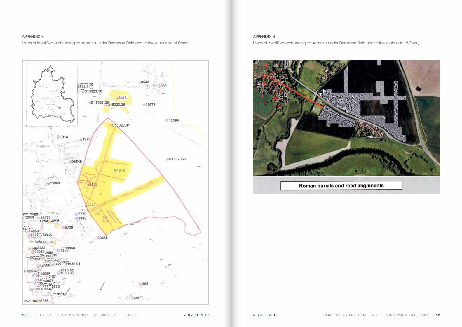
APPENDIX4Archaeologicalrem
ainsatOveryandtheDem
enseField
Maps of identified archaeological remains under Demesne Field and to the south east of Overy
APPENDIX 4Maps of identified archaeological remains under Demesne Field and to the south east of Overy
APPENDIX 4
APPENDIX4ArchaeologicalremainsatOveryandtheDemenseField
DORCHESTER-ON-THAMES NDP ~ SUBMISS ION DOCUMENT | 6564 | DORCHESTER-ON-THAMES NDP ~ SUBMISS ION DOCUMENT AUGUST 2017 AUGUST 2017

Local list of undesignated heritage assets (As identified on the Conservation Area Maps as ‘buildings of local note’)Local list of undesignated heritage assets (As identified on the Conservation Area Maps as ‘buildings of local note’)
APPENDIX 5APPENDIX 5
BRIDGE END
No. on Map
Address Description/historic details Justification
1 No 4 House of red brick with yellow brick dressings. Clay tile roof. Attached carriage house with timber doors and a hay loft above.
Dated by inscription 1909. The house originally functioned as a sweet shop and tea room on the ground floor.
2 No 6The Old Castle
Brick and clay tile with a rendered and timbered upper storey.
Early C20 in an arts & crafts idiom. Former public house for Halls Brewery of Oxford.
3 No 7 Cottage of coursed clunch with a tiled roof.
One and a half storeys high with a central entrance and two dormer windows. Roof possibly original thatched.
4 Plumtree Cottage Rubble stone with brick dressings and a clay tiled roof. Gable end onto the road.
One and a half storeys high with a single dormer and a later lean-to along the length of the entrance elevation.
5 Loreto Cottage Loreto Cottage. Partly timber framed with a thatch roof. Gable end onto the road.
One and a half storeys high.
6 No 15 Rubble stone and brick with a clay tile roof. Gable end onto the road.
Rubble stone and brick with a clay tile roof. Gable end onto the road.
All four cottages (numbers 3-6 on map) are of modest size and were probably built on the waste after the demolition of the medieval bridge in 1816.
7 No 25 Brick with a tiled roof. Modern rebuild of a cottage that formed part of a terrace with the adjacent timber framed and thatched No 23 (listed). Group value.
8 No 17 The cob single storey building with a slate roof attached to the south of the cottage.
Built as the Primitive Methodist chapel and schoolroom in 1839. Despite its modern windows it is of great importance in understanding nonconformist worship in the village in the C19.
9 No 22 Brick with a slate roof. Originally only one room deep with a rear outshot. Characteristic of modest C19 labourer’s cottage.
31
33
34
19
1718
16
153536
30
32
23
2425
26
22 28
29
27
212010
11
1312
14
34 5
67
9
8
2
1
APPENDIX 5: UNDESIGNATED HERITAGE ASSETS
0 200mUndesignated Heritage Assets
1
© Crown copyright and database rights 2017 Ordnance Survey 0100031673
For original data and further detail please refer to the following link:https://cnp16.maps.arcgis.com/apps/View/index.html?appid=d620077dad7149f0abc65dda816c18e6
DORCHESTER-ON-THAMES NDP ~ SUBMISS ION DOCUMENT | 6766 | DORCHESTER-ON-THAMES NDP ~ SUBMISS ION DOCUMENT AUGUST 2017 AUGUST 2017

MALTHOUSE LANE
No. on Map
Address Description/historic details Justification
20 Cob Cottage Two storeyed cottage of cob with a slate roof parallel to the lane.
Mid C19 cottage providing evidence of the continued use of cob as a building material at that period.
21 Garage to No 3A Simple cob building with pitched roof and doors in gable end.
C19. The last surviving structure of the forge which originally occupied the yard.
MARTIN’S LANE
No. on Map
Address Description/historic details Justification
22 Jemmetts Row Brick-built terrace of vitrified headers with a clay tile roof. At right angles to the lane.
C19 terraced housing. The rubble stone gable end fronting the lane shows evidence for the incorporation of an earlier house.
QUEEN STREET
No. on Map
Address Description/historic details Justification
23 Village Hall Distinctive Gothic building in English Bond brickwork with stone dressings. Gable end to the street with two pointed windows surmounted by a rose window.
Designed by Sir Giles Gilbert Scott as the Girls’ and Infants’ school and built in 1871.
24 No 11The Old School
More restrained design in brick with segmental arched windows and a bell cote in the gable end facing the street.
Built in 1896 as the Boys’ school. The design reflects the shift from gothic to Queen Anne at the end of the century.
25 No 12 Timber and brick cottage with a clay tile roof.
Probably early C18 with later additions.
26 Nos 14-16 Brick built semi-detached pair of two storeys with vitrified headers and a slate roof.
Indicative of C19 housing away from the medieval High Street of a slightly higher status than the developments in Watling Lane.
27 Nos 18-20 Brick built semi-detached pair of two storeys with a clay tile roof and a central chimney stack.
Part of a group with 14-16 and 22-4.
28 Nos 22-4Abbey Cottages
Brick-built semi-detached pair with stone dressings and a clay tile roof with decorative ridge tiles. Decorative key stones to the windows.
Dated 1889 by inscription. Part of a group of semi-detached houses with 14-16 and 18-20.
Local list of undesignated heritage assets (As identified on the Conservation Area Maps as ‘buildings of local note’)
APPENDIX 5Local list of undesignated heritage assets (As identified on the Conservation Area Maps as ‘buildings of local note’)
APPENDIX 5
WATLING LANE
No. on Map
Address Description/historic details Justification
10 No 17 Painted brick cottage at right angles to the lane with a slate roof and a central entrance.
Early C19 two storeyed cottage along the roadside waste with later extensions to the rear.
11, 12,13
Port House Large detached house of brick set back from the lane with its outbuildings.
A C19 gentleman’s house of a distinctive designed architectural character. The cob summerhouse with gothic windows is listed but there are two other outbuildings which contribute to the ensemble – a brick workshop parallel to the lane to the north and a gardener’s bothy of brick adjacent to the house.
14 Nos 47-9 Semi-detached pair of brick cottages facing on to the allotments.
Simple two-storeyed C19 workers’ cottages.
15 No 51 Rendered and slate roofed cottage adjoining 47-9 above.
A detached two-storeyed cottage with a modest extension.
16 Nos 52-4 Semi-detached pair of brick and tiled cottages parallel to the lane.
C19 workers’ cottages. Two storeys with a lean to service area fronting onto the lane and the main aspect facing the open countryside to the south west.
17 No 62 Brick cottage in header bond with a slate roof.
Part of the group of C19 workers’ cottages running along the south side of the lane.
18 Peppers Plot Brick cottage with a slate roof. C19 with a later extension to the west.
All three groups (numbers 16-18 on map) lie parallel to the lane and wereprobably built on the roadside waste to provide accommodation for the labouring workforce. They are present on the 1846 Tithe Map as are Nos 47-51 above (numbers 14 and 15 on map). They represent tangible evidence for the provision of ordinary housing in the village at that period.
19 No 69The Old Cottage
Brick with some timber and a thatched roof. Parallel to the lane.
One and a half storeys high with a central entrance and a lean-to outshot. Of late C17 or early C18 date and probably the earliest surviving labourer’s cottage in the village.
DORCHESTER-ON-THAMES NDP ~ SUBMISS ION DOCUMENT | 6968 | DORCHESTER-ON-THAMES NDP ~ SUBMISS ION DOCUMENT AUGUST 2017 AUGUST 2017
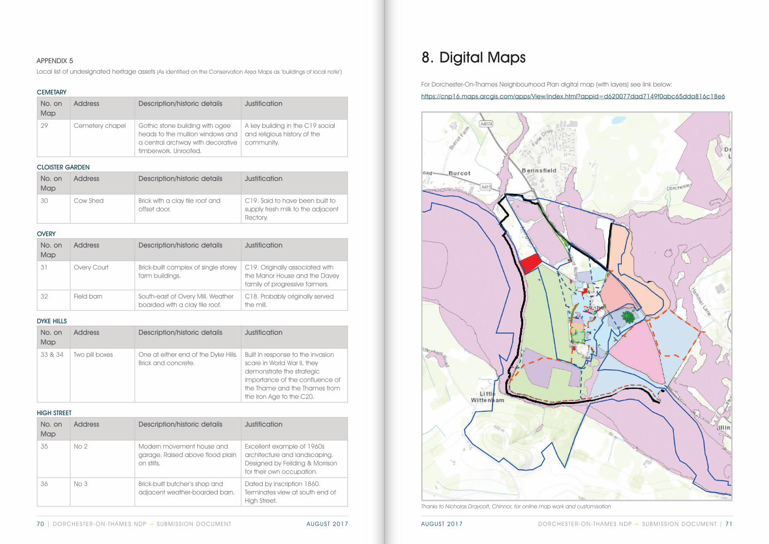
8. Digital Maps
For Dorchester-On-Thames Neighbourhood Plan digital map (with layers) see link below:
https://cnp16.maps.arcgis.com/apps/View/index.html?appid=d620077dad7149f0abc65dda816c18e6
CLOISTER GARDEN
No. on Map
Address Description/historic details Justification
30 Cow Shed Brick with a clay tile roof and offset door.
C19. Said to have been built to supply fresh milk to the adjacent Rectory.
HIGH STREET
No. on Map
Address Description/historic details Justification
35 No 2 Modern movement house and garage. Raised above flood plain on stilts.
Excellent example of 1960s architecture and landscaping. Designed by Feilding & Morrison for their own occupation.
36 No 3 Brick-built butcher’s shop and adjacent weather-boarded barn.
Dated by inscription 1860. Terminates view at south end of High Street.
OVERY
No. on Map
Address Description/historic details Justification
31 Overy Court Brick-built complex of single storey farm buildings.
C19. Originally associated with the Manor House and the Davey family of progressive farmers.
32 Field barn South-east of Overy Mill. Weather boarded with a clay tile roof.
C18. Probably originally served the mill.
CEMETARY
No. on Map
Address Description/historic details Justification
29 Cemetery chapel Gothic stone building with ogee heads to the mullion windows and a central archway with decorative timberwork. Unroofed.
A key building in the C19 social and religious history of the community.
DYKE HILLS
No. on Map
Address Description/historic details Justification
33 & 34 Two pill boxes One at either end of the Dyke Hills. Brick and concrete.
Built in response to the invasion scare in World War II, they demonstrate the strategic importance of the confluence of the Thame and the Thames from the Iron Age to the C20.
Local list of undesignated heritage assets (As identified on the Conservation Area Maps as ‘buildings of local note’)
APPENDIX 5
Thanks to Nicholas Draycott, Chinnor, for online map work and customisation
DORCHESTER-ON-THAMES NDP ~ SUBMISS ION DOCUMENT | 7170 | DORCHESTER-ON-THAMES NDP ~ SUBMISS ION DOCUMENT AUGUST 2017 AUGUST 2017

DORCHESTER-ON-THAMES
NEIGHBOURHOOD DEVELOPMENT PLAN