downeast region management plan - maine.gov · downeast region management plan . schoodic mountain...
TRANSCRIPT

Downeast Region Management Plan
Schoodic Mountain from Partridge Peninsula Campsite on Tunk Lake Donnell Pond Unit
Maine Department of Conservation Bureau of Parks and Lands
March 2007

Table of Contents
I. Executive Summary.................................................................................................................... 3 II. Components of the Resource Management System.................................................................. 5 III. The Downeast (“Down East”) Region of Maine ...................................................................... 9
Regional Context......................................................................................................................... 9 Tourism within the Downeast-Acadia Region ............................................................................ 9 Summary of Natural and Geological Resources within the Region ......................................... 10 Summary of Historic and Cultural Resources within the Region ............................................. 12 Summary of Fisheries and Wildlife Resources within the Region ............................................ 13 Summary of Recreational Resources within the Region ........................................................... 14 Summary of Timber and Renewable Resources within the Region........................................... 17
IV. Resources and Management Issues in the Downeast Plan Area............................................. 19 DONNELL POND UNIT ......................................................................................................... 19
1. Character of the Landbase ............................................................................................... 19 2. Resources and Management Issues................................................................................. 22 3. Resource Allocations and Management Recommendations........................................... 39
ROCKY LAKE UNIT .............................................................................................................. 45 1. Character of the Landbase .............................................................................................. 45 2. Resources and Management Issues................................................................................. 46 3. Resource Allocations and Management Recommendations........................................... 52
CUTLER COAST UNIT .......................................................................................................... 55 1. Character of the Landbase ............................................................................................... 55 2. Resources and Management Issues................................................................................. 56 3. Resource Allocations and Management Recommendations............................................ 64
THE GREAT HEATH.............................................................................................................. 67 1. Character of the Landbase ............................................................................................... 67 2. Resources and Management Issues.................................................................................. 68 3. Resource Allocations and Management Objectives (see map GH-1)........................... 72
OSBORN, NORTH AND SOUTH LOTS................................................................................ 74 T24 MD..................................................................................................................................... 75 NUMBER 14 TOWNSHIP, NORTH AND SOUTH LOTS.................................................... 77 NUMBER 21 TOWNSHIP, NORTH AND SOUTH LOTS.................................................... 78
V. Appendices.............................................................................................................................. 79 A. Resource Allocation Maps .............................................................................................. 80 B. Glossary........................................................................................................................... 97 C. References ..................................................................................................................... 103 D. Public Advisory Committee Members.......................................................................... 104 E. Summary of Written Public Comments ........................................................................ 105 F. Technical Appendices – Timber and Renewable Resources......................................... 113
2

I. Executive Summary This is a fifteen-year Management Plan for Public Reserved Land properties in the Downeast Region of Maine managed by the Bureau of Parks and Lands (the Bureau). The properties include the Donnell Pond, Rocky Lake, and Cutler Coast Units, along with the Great Heath; and public lots in Osborn Plantation, T24 MD, Number 14 Township, Number 21 Township, and Marion Township (see map on following page). This Plan meets the statutory requirements for development of multiple-use management plans in Title 12 MRSA § 1847 (2), and is prepared in accordance with guidelines described in the Integrated Resource Policy adopted in December 2000. These laws and policies direct the Bureau to identify and protect important natural, ecological, and historic attributes; enhance important fisheries and wildlife habitat; provide opportunities for a variety of quality outdoor recreation experiences; and maintain a sustained yield of forest products by utilizing forest management techniques and silvicultural practices that enhance the forest environment. The Plan is a commitment to the public that these lands will be managed in accordance with the Bureau’s mission and goals as stated in the Integrated Resource Policy, and within its prescribed mandates. This Plan also serves as guidance to Bureau staff by providing management recommendations, along with a degree of flexibility in achieving the stated objectives. The Plan includes summaries of resources, issues, and management recommendations for each Unit or parcel, and provides information about the broader geographic region as context. This document is not, however, a plan of operations. The planning process included broad interdisciplinary and public review, and the resulting document reflects consideration of comments and input received. Although the Plan is applicable for the next fifteen-year period, a review and update process will be undertaken every five years, which will include a discussion with the Advisory Committee at that time on the management recommendations stated in this document. If amendments to the Plan are then proposed, there will be an opportunity for public review and comment prior to their adoption. The Bureau recognizes that some resources and management issues will undergo unanticipated change over time, making it necessary to amendment this Plan prior to the periods of scheduled review. Additionally, some of the stated objectives will require longer than the Plan period to achieve. The Bureau acknowledges the helpful participation of the Downeast Region Advisory Committee (listed in Appendix D) and members of the public who contributed to the process and development of this Plan. Continued public interest and participation will be necessary to achieve the management objectives as outlined, and the Bureau of Parks and Lands looks forward to working with those individuals towards its accomplishment.
3

Parcels within the Downeast Region Plan Area
No 21 Twp N & S Lots
Marion Twp (Patrick Lk)
Rocky Lake
No 14 Twp N & S Lots
Osborn N & S Lots
Coast
T24 MD
4

II. Components of the Resource Management System Summary of the Planning Process The Bureau of Parks and Lands is required by statute to develop management plans for all Reserved and Non-reserved Land properties across the state. The criteria, planning methodologies, and resource management policies described in the Bureau’s Integrated Resource Policy provided the necessary guidance towards the development of this Plan. For the Bureau’s relatively large and expanding landbase, management planning is now conducted on a regional basis. The selection of properties to be included as part of the regional plan area is based on several factors, including: geographic proximity, relation to certain cultural regions of the state, and placement within certain resource-related technical data. The parcels in this Plan area are largely within the Downeast (or “Down East”) portion of Maine, which includes much of the coastal and coastal interior areas of both Hancock and Washington Counties. These properties also fall within the East Coastal and Eastern Interior “biophysical” regions (pictured right), used to distinguish areas having similar natural resource attributes. With minor exceptions, these lands are also within the same Sustainable Harvest Unit (SHU), a geographic grouping of timberlands that share similar forest conditions. The regional planning method also provides opportunities to look at the supply of resources within a broader area, including lands owned or managed by others. The relationship between the Bureau lands and the region as a whole was an important consideration in developing the management commitments described in this document.
Early in the development of the Downeast Region Plan, Bureau staff conducted a thorough review of the resources and resource issues in the Plan area, a step known as the Preliminary Planning phase. Resource professionals from the Department updated information for all resources on lands managed by the Bureau, including those having natural and geological, historic and cultural, fisheries and wildlife, recreation, and timber and renewable resource significance. Mapping and GIS-related information was also updated as part of this phase. A variety of forums where conducted to better understand the management issues to be addressed in the Plan. These forums included internal scoping sessions with land management staff, a Public Scoping Session to hear from stakeholders and members of the general public; and local focus
groups to address more specific concerns that addressed management of the Route 182 Blackwoods Scenic Byway; motorized trail needs; and a resource allocation proposal from the
Downeast Region Management Plan
Preplan Draft
Maine Department of Conservation Bureau of Parks and Lands
Revised 9/2/04
5

Northern Forest Alliance. Valuable input was obtained at these meetings, used to further identify and understand the important management issues, and to develop the management recommendations in the Plan. After resource inventories and issues scoping sessions were completed, a Preliminary Planning document (Preplan) summarized these findings was distributed for public comment. A Public Advisory Committee was then convened to assist the Bureau in reviewing documents and drafts, and to provide input on a variety of plan-related topics. Committee members were selected on the basis of their resource expertise, and their local and regional knowledge of the lands in the Plan area. A first full draft of the Plan, including management recommendations, was then developed after receiving this input, and again distributed for public comment. Refinements were made after this review, with a final draft prepared and circulated for discussion at a Public Meeting. After considering this input a Final Plan was submitted to the Bureau Director and Department Commissioner for adoption. Summary of the Resource Allocation System The Resource Allocation System is a land and resource management planning tool first developed in the 1980’s and further refined in a public process completed in 2000. The resulting Integrated Resource Policy provides land management guidance for all resource areas. The system defines a hierarchy of natural, historic, and cultural resource attributes found on the Bureau-managed lands and prescribes the type of management that will be applied where these attributes exist. Resources are ranked from those that are most sensitive to management activities to those that are less so. For example, a natural, undisturbed landscape may be more appropriately managed for dispersed recreation opportunities rather than developing the same area for intensive day use or camping. Timber management may be considered the “dominant use” in a productive forest area where conflicts with other uses are otherwise minimal. The following is a summary of the Resource Allocation System categories and resource attributes
MAINE DEPARTMENT OF CONSERVATION
Bureau of Parks and Lands
INTEGRATED
RESOURCE
POLICY
For Public Reserved and Nonreserved Lands, State Parks, and State Historic Sites
December 18, 2000
6

INTEGRATED RESOURCE MANAGEMENT RESOURCE ALLOCATION SYSTEM
Multiple Use - Dominant Use - Secondary Uses
SPECIAL PROTECTION AREAS natural areas, historic/cultural areas, ecological reserves
BACKCOUNTRY RECREATION AREAS
non-mechanized and motorized recreation areas
WILDLIFE-DOMINANT AREAS essential habitat, significant habitat, specialized habitat areas and features
REMOTE RECREATION AREAS
trail corridors, shorelines, areas with dispersed recreation opportunities
VISUAL CONSIDERATION AREAS foreground and background views
DEVELOPED RECREATION AREAS
facilities that support dispersed recreation, day use, and camping areas
TIMBER MANAGEMENT AREAS areas actively managed for its timber resources
7

Plan Monitoring 1) Plan Recommendations. The Bureau routinely develops a schedule for implementing and accomplishing management plan recommendations. These recommendations provide the basis for determining work priorities and program budgets on an annual basis. 2) Easements. The Bureau holds a variety of easements across the state, serving a variety of conservation and recreation purposes. In each case, the landowner continues as fee owner, but certain specific rights and responsibilities, e.g., management of recreation uses, are conveyed to the Bureau. Monitoring protocols normally developed to guide the ongoing management of these easements and will be used to ensure that easement objectives and conditions are being met. 3) Public Use. Prior to the development of this Plan, public use monitoring was conducted to provide information on use patterns on the more frequently visited Units within the Plan area, including the Donnell Pond and the Rocky Lake Units. The Cobscook Trails Coalition also tracks public use for the Cutler Coast Unit. Efforts to further evaluate use and use patterns will be ongoing throughout the Plan period. 4) Post harvest Monitoring. The Bureau has developed a post harvest monitoring plan to assist forest planners and managers in assessing harvest outcomes in comparison to forest management objectives identified during harvest planning. The monitoring plan also addresses and tracks outcomes of water quality and Best Management Practices (BMP’s) implemented during harvest activities. 5) Wildlife. The Bureau routinely conducts a variety of species monitoring activities across the state. Within the Plan area, waterfowl brood counts will be conducted and raptor nesting areas monitored. Monitoring of other species will occur as conditions warrant. 6) Ecological Reserves. Ecological Reserves are largely undisturbed areas having ecological significance due to the presence of exemplary (common or uncommon) plant communities. The primary value of these areas is their suitability as benchmarks for ongoing scientific study and research. A contract with the Maine Natural Areas Program has been established to collect baseline data on all designated Ecological Reserves. Baseline data has been completed for the reserves within the Plan area and will be periodically revisited or updated as part of the ongoing reserve monitoring program. A variety of allowed uses within these reserves has also been determined, and is described in the Plan. Monitoring of these activities will take place on an ongoing basis to ensure their compatibility with the ecological attributes being protected and studied.
8

III. The Downeast (“Down East”) Region of Maine
Regional Context This section provides a summary of important resources throughout the Downeast Region of Maine. The discussion includes a description of resources on lands other than those managed by the Bureau, but makes no recommendation regarding those lands. The information, however, was important in providing a context for developing management recommendations for the Bureau lands.
Tourism within the Downeast-Acadia Region Many of the lands within the regional plan area are in close proximity to the Route 1 corridor, which provides the primary centers of commerce in Hancock and Washington Counties. The plan area parallels the Down East & Acadia Region, one of eight areas designated by the Maine Office of Tourism for marketing purposes. This region is reported in the 2003-2008 Statewide Comprehensive Outdoor Recreation Plan (SCORP) as being the third most visited region in the State, the vast majority of those visits occurring in the Bar Harbor/Ellsworth area, home of Acadia National Park. The remaining portion of the region, especially Washington County, is working to find a niche in the tourism industry. There are several on-going and complimentary efforts to “brand” the experiences that the traveling public can expect in different parts of the region through the designation of travel corridors or loops. These efforts include creation of sub-regional committees of local business owners, resource management professionals, conservationists, and residents to properly identify the loops or corridors that can serve the economic and social priorities of their communities. They also include support from the Maine Department of Transportation to map these loops and corridors, link them to similar efforts in adjacent regions and identify infrastructure needs that will ensure that visitors can find their way, enjoy their experience, and support local economies without harming fragile resources. The third effort is a Governor-sponsored initiative that provides the expertise of a nationally recognized nature-based tourism consultant to the Downeast region (and two other regions in Maine). Finally, the Vacationland Resources Committee of the Down East Resource Conservation and Development district has completed an update to the Down East Sustainable Tourism Initiative (DESTINY) for 2010, and is actively working on implementing its highest priority recommendations including package tour opportunities, a sustainable tourism Resource Guide, and thematic trail development. The region is host to three Scenic Byway corridors, the Acadia All American Road on Mount Desert Island, the Schoodic National Scenic Byway along the western shore of Frenchman’s Bay and the Blackwoods Scenic Byway along Route 182, connecting the villages of Franklin and Cherryfield along 12.5 miles of forests, ponds, lakes, rocky hills and blueberry barrens. This Byway provides access to the Donnell Pond Unit, and management recommendations for the Byway and the Unit will be closely linked. Scenic Byway designation is accomplished along transportation corridors that showcase outstanding historic and cultural, archeological, recreational, natural, and scenic resources. These attributes are well established along the designated byways in the Downeast region.
9

Many visitors who travel to the Downeast region seek out motorized trail riding, hiking, camping, boating, etc., and otherwise look to avoid the overcrowding they find in the premier destination of Acadia National Park and surrounding development. More dispersed recreation opportunities are provided on Bureau lands in the Downeast region, including a variety of remote experiences, along with opportunities to experience scenic, undeveloped coastlines. Linked to these experiences are historic villages rich in cultural expressions of past eras and continuing reliance on the sea and land for such delights as lobster and blueberry pie. The recently approved conversion of the historic Calais Branch rail line to a multi-use trail (now the Down East Sunrise Trail) will provide further enhancements to this tourism opportunity, providing “community connections” from Ellsworth to Eastport. The Downeast region is also considered the “the blueberry capitol of the world,” producing more than 90% of the world’s supply of wild blueberries. Many of the properties considered in this plan are near or within areas where the commercial management of blueberries takes place.
Summary of Natural and Geological Resources within the Region The Downeast region is characterized by mixed forests and relatively young spruce-fir, with a history of fire, budworm damage, and timber harvesting. The region also supports many of the largest bogs and fens in Maine, including the Great Heath. In particular, coastal bogs like those on the Cutler Coast Unit are restricted to eastern Maine and are among the most ecologically notable wetlands in the state. Physical Landscape: Geology, Soils, Hydrology, and Wetlands. West of the Great Wass archipelago (Jonesport and Beals), coarse-grained granite dominates the landscape, including the hills around Tunk Lake and Donnell Pond. East of Great Wass Island, including the Cutler Coast and Rocky Lake Units, bedrock is dominated by more erodable, fine-grained volcanic and metamorphic rock, and weathering of these bedrock types has resulted in a low, relatively flat terrain. Gabbro, diorite, and volcanic rocks dominate the landscape here.
Except for a broad, elevated peninsula around Tunk Mountain, most of the Downeast region was submerged during the most recent glaciation, when the ocean reached inland through the major river valleys. Consequently, much of the area is underlain by ice-contact glaciofluvial and glaciomarine sediments. Over the last 13,000 years, the coast has taken on its current form due to uplift following glacial retreat. Maine's “Ice Age” Trail. A recently published map entitled "Maine's Ice Age Trail: Map and Guide" highlights various points throughout Hancock and Washington Counties that illustrate Maine's geologic history. Harold Borns, University of Maine professor emeritus of earth sciences and the University of Maine Climate Change Institute, has developed the scientific aspects of the project, which features a trail visitors can follow through Hancock and Washington Counties. By following the trail and stopping at various designated points, all accessible from main roads, one can learn about the Ice Age, climate change in general, and the record of the Ice Age in central Maine. The Pineo Ridge barrens around the Great Heath in Columbia, Cherryfield, Deblois, and T18 MD represent one of the state's largest examples of a glaciomarine delta. This delta is composed of coarse-grained sand and gravel, with poorly drained peats occurring in kettleholes and pockets along the margins of the delta. West of the Pineo Ridge delta, glacial till is the dominant
10

surficial deposit. Further to the east, finer-grained glaciomarine deposits cover much of the lowlands. Ridge tops, rocky headlands, and exposed islands support excessively drained, thin soils where glacial action and subsequent weathering has removed much of the surface material. Several major rivers cross the Downeast landscape, including the Union, Narraguagus, Pleasant (which bisects the Great Heath), Machias, East Machias (which bisects Rocky Lake), and Dennys. The latter five rivers have been targeted for enhancement and restoration through the state's Atlantic Salmon Conservation Plan. According to National Wetlands Inventory maps, wetlands account for about one quarter of the Downeast landscape, with nearly half of the inland wetlands being forested wetlands. Schoodic Bog (pictured), The Frenchman Bay Conservancy recently acquired 500 acres along the southern boundary of the Donnell Pond Unit. This parcel contains an important 135-acre bog-wetland complex known as Schoodic Bog, and offers spectacular views of Schoodic Mountain. The property is open to the public, and can be accessed via the Down East Sunrise Trail (formally the Calais Branch rail corridor) which passes through it. A parking area for this purpose is available within the Donnell Pond Unit along the access road to Flanders Pond; however, current access consists of walking along the old rail bed, which is planned for conversion to a multi-use trail. Uncommon Natural Communities. Coastal Plateau Bogs are restricted to the Downeast region of Maine, where they reach their southern limit. In these peatlands, like those found in the Great Heath and Cutler Coast Unit, a cool and wet year-round climate create favorable conditions for a high diversity of peat moss (Sphagnum) species. The cool climate also enables colonization by boreal plants such as black crowberry (Empetrum nigrum) and baked appleberry (Rubus chamaemorus), otherwise restricted to alpine and sub-alpine areas in Maine. Numerous "Coastal Headland Ecosystems" occur in the region, including the outcropping on the Cutler Coast Unit. Characteristic plants of these coastal headlands include mountain cranberry (Vaccinium vitis-idea) and black crowberry. Some rare or uncommon plants near their southern range limits in this region include marsh-felwort (Lomatogonium rotatum), blinks (Montia fontana), Hookers's iris (Iris setosa v. canadensis), bird's eye primrose (Primula laurentiana), roseroot (Sedum rosea), and baked appleberry. Large tidal marshes are uncommon in the region and virtually absent from Bureau lands, in part because the granitic coastline has not allowed coastal drainages to erode into low, broad embayments. Tidal rivers such as the Narraguagus, Machias, Pleasant, Dennys, and St. Croix support a network of tidal wetlands and extensive tidal flats. Salt marshes are most developed in the Narraguagus Bay/Pleasant Bay estuary. Many of these marshes provide important nesting, feeding, and staging areas for shorebirds and waterfowl, and important nurseries for anadromous fish. Ecological Reserves. Ecological Reserves are largely undisturbed areas having ecological significance due to the presence of exemplary (common or uncommon) plant communities. The primary value of these areas is their s suitability as benchmarks for ongoing scientific study and research. The identification of exemplary natural community types within the Plan area led to the designation of 18,367 acres of Ecological Reserves in 2001, comprising more than 40% of the Bureau’s landbase in the Downeast Region.
11

Unit Ecological Reserve Location Reserve Acres Donnell Pond Black Mt./Caribou Mt. 1,940 Donnell Pond Spring River Lake/Tunk Mt. 4,010 Great Heath Great Heath 5,681 Cutler Coast North Lot 3,145 Cutler Coast South Lot 2,075 Rocky Lake East Machias River 1,516
Total 18,367
State lands currently provide the only supply of formally designated ecological reserve lands in the region; however, The Nature Conservancy (TNC) owns 1,500 acres on Great Wass Island in the Town of Beals that is being managed consistent with Reserve principles. In 2005, TNC acquired an additional 9,934 acres in the northern portion of T10 SD which abuts the northern boundary of the Bureau’s Spring River Lake parcel within the Donnell Pond Unit. This acquisition extends to the Spring River and West Branch of the Narraquagus River in T16 MD. It is the Conservancy’s intention to manage this property in part as an Ecological Reserve. The property may be deeded to the State at some point in the future. Federal lands at Moosehorn and Petit Manan Wildlife Refuges, and certain areas of Acadia National Park contain ecological reserve attributes, although they are not being specifically managed for that purpose. Other smaller, privately owned properties with these attributes have been identified as well
Summary of Historic and Cultural Resources within the Region The term Downeast or “Down East,” has been applied in various ways since the earliest settlements in this part of the state. Its origin is described in Down East Magazine:
"When ships sailed from Boston to ports in Maine (which were to the east of Boston), the wind was at their backs, so they were sailing downwind, hence the term 'Down East.' And it follows that when they returned to Boston they were sailing upwind; many Mainers still speak of going 'up to Boston,' despite the fact that the city lies approximately 50 miles to the south of Maine’s southern border."
Although there is no general agreement as to its precise meaning beyond its nautical use, it has been defined broadly in geographic terms as the coastal shoreline and environs from Penobscot Bay to the Canadian border. In its narrowest sense, it has applied only to the coastal communities of Washington County. More commonly, it refers to all of the coastal and nearby communities in the two-county area. Principal Downeast towns include Calais, Eastport, and Machias. Bar Harbor, Blue Hill, and Ellsworth have also been considered among the Downeast communities. The region has been home to Native American people for thousands of years. Petroglyphs and archaeological research show that the Machias Bay area, in particular, was the site of significant Native American activity, along with the Meddybemps area near Calais. Native Americans continue to live in the area, most notably the Passamaquoddy communities at Pleasant Point on Passamaquoddy Bay and Indian Township near the St. Croix River.
12

Early European exploration of North America brought numerous forays to the coast here, most notably by Samuel de Champlain in 1608, with the possibility that Viking exploration of this region took place as early as the 13th century. During the American Revolution the region was contested between settlers loyal to the British and those loyal to the American cause, as illustrated by British raids and ensuing successful American defenses in the Machias area. In the last two centuries, the region has been known primarily for its fisheries, timber, agriculture, and recreation resources. Of significance is the wild blueberry industry, considered the largest in the world. Jasper Wyman, a well-known blueberry processor, owned the blueberry barrens on Bureau lands near Schoodic Nubble in Franklin. A cable operation was set up in the 1950’s for transporting the crop from these and adjacent fields to a railroad loading area. At its peak, the field below the mountain produced upwards of 50,000 pounds of blueberries annually.
Summary of Fisheries and Wildlife Resources within the Region Wildlife. The region in general is home to a well-established and significant number of bald eagles. However, a combination of low soil fertility, fire, and past land uses has resulted in fair to poor habitat quality for wildlife species known to the Downeast region. Most of the species common to Maine can be found here, including black bear, red fox, ruffed grouse, and red squirrel, but in lower numbers than in other parts of the state. Some notable exceptions are island-nesting birds and the bald eagle. Island nesting seabirds such as terns and eiders are thriving, and habitat acquisition efforts spearheaded by the Petit Manan National Wildlife Refuge have provided for permanent protection of sensitive habitat. American woodcock are numerous throughout the region due an abundance of reverting farm fields, extensive wetlands, meadows, and blueberry barrens. Extensive habitat research on the woodcock has been conducted at the Moosehorn National Wildlife Refuge. This is the only National Wildlife Refuge dedicated to woodcock research. The Cutler Coast Unit is home to a bluejoint meadow-grassland complex that is unique to the Downeast region of the state, providing habitat for several rare bird species. Wildlife Resources within the Downeast Region Plan Area Habitat Type* Donnell Pond Rocky Lake Cutler Coast Great Heath Essential Bald Eagle Nest Bald Eagle Nest (2) none Significant Wetlands Wetlands Wetlands
(uncommon bird species)
Wetlands
Waterfowl and wading bird hab.
Deer Wintering Area
Waterfowl and wading bird hab.
Specialized Riparian Areas Riparian Areas Riparian Areas Riparian Areas Atl. Salmon River Atl. Salmon River
*see Glossary
13

Fisheries. The overarching fisheries concern in the Downeast area is the Atlantic salmon restoration project taking place on seven rivers within the region. The U.S. Fish and Wildlife Service has provided a salmon recovery plan that focuses on riparian management strategies to protect shoreline and upland areas important to the rivers. The Pleasant, Narraguagus, East Machias and Dennys Rivers, and portions of their watersheds, are found on Bureau lands throughout the region. Coordination with ongoing restoration activities conducted by the Atlantic Salmon Commission and other organizations will be an important consideration in the Bureau’s wildlife program. Opportunities to conduct in-stream habitat improvements in support of this project will be pursued. Regional Fisheries and Wildlife Goals. The wildlife habitat gis to increase the amount of softwood cover, where feasible, to benefit deer. Due primarily due tospruce budworm damage and changes in the forest products market, past timber management has dramatically reduced the spruce/fir stocking throughout the region. Most areas are seeing significant regeneration; however, these areas are still 30 years away from having harvestablesize trees. Forest management will be focused on retaining much of the mature softwood while encouraging the growth of the younger softwood.
oal for managing these properties
An equally important goal will be in restoring or protecting upland habitat to support the threatened Atlantic salmon population. The Bureau manages significant shoreline and watershed areas for the Pleasant, Narraguagus, East Machias and Dennys Rivers, and can lead by example in protecting the water quality and habitat critical to Atlantic salmon, and also to the eastern brook trout. An additional goal of the wildlife program will be to manage for significant amounts of both multi-age and mature forests, thereby providing a wide range of species habitat across the region.
Summary of Recreational Resources within the Region The Downeast region provides a wide variety of recreational opportunities ranging from developed State Parks to remote recreation areas, and includes both motorized and non-motorized uses. The region is the eastern terminus of the Maine Island Trail, a 350-mile waterway that extends along the coastline from Portland to Machias (Daniels Island pictured). This nationally recognized water trail offers camping and day use opportunities for small boaters on coastal islands and mainland sites. Forty-two Bureau-owned islands and several State Parks are part of this water trail which is stewarded by the Maine Island Trail Association.
14

The Plan area contains over 600 lakes and ponds, and 3,800 miles of rivers, brooks and streams, providing a wide variety of fishing opportunities. These resources are important to the quality of life that people in the region expect. They are also vital to the eco-tourism base and are an important part of the state's $450 million sport fisheries industry in Maine. A number of popular canoe touring routes traverse the rivers and lakes of the region. These include the St. Croix, East Machias, and Machias Rivers. Opportunities for sea kayaking, sailing, and other water sports also abound along the many miles of coastline. The Maine Water Sports Network began in Washington County to reestablish a lifestyle of reliance on Washington County's water resources with the goal to building a stronger economy and healthier communities. The Maine Water Sports Network seeks to make the region a world leader in providing these opportunities. The Blackwoods Scenic Byway, a 12.5-mile corridor along Route 182 (pictured in red below), passes between the towns of Franklin and Cherryfield, and through a 6-mile portion of the Donnell Pond Unit. The Byway provides a scenic and shorter alternative to Route 1, and
Planning Commission and the Washington County Council of Governments developed the plan forMaine Department ofTransportation, which describes the resources and opportunities, within thimportant scenic corridOne of the objectives within the Downeast Region Management Plan is to work collaborativwith the Byway intereaccomplishing its short andlong term visions. As part of the corridor plan
implementation committee, the Bureau will be working with its members to provide corridoenhancements that are also consistent with management objectives for the Donnell Pond Unit.
provides recreational access to much of the Unit and surrounding area. The Hancock County
the
is or.
ely sts in
r
ithin the region are the properties managed for recreation by the Cobscook Trails Coalition.
he Downeast Region is home to five staffed State Parks: Cobscook Bay and Lamoine offer re
WUnder the leadership of the Quoddy Regional Land Trust, a number of public and nonprofit landowners have joined together to manage their properties to provide nature tourism opportunities and the benefits of shared management costs. Tovernight camping and day use facilities; Roque Bluffs, Shackford Head, and Quoddy Head aopen for day use only. The Cobscook Bay State Park property is part of the Moosehorn NationalWildlife Refuge lands, and is leased to the state. The recently-acquired St. Croix River shoreline provides excellent canoeing and camping opportunities along a 50-mile conservation corridor
15

that includes Spednic Lake to the north managed by Inland Fisheries and Wildlife. The St. Croix International Waterway Commission provides stewardship along the river. There are aa number of undeveloped State Park properties and historic sites within the region:
lso
BP&L MgmtCty REG Name Interest Agcy Location Acres Major UseHA N Battery Gosselin Fee BP&L Castine 0 historicHA N Branch Lake Fee BP&L Ellsworth 1,273 undevelopedHA N Eden Ease BP&L Bar Harbor 13 open spaceHA N Fort George Fee TOWN Castine 3 historicHA N Holbrook Island Sanctuary Fee BP&L Brooksville 1,343 trails, nature interp.HA N Lamoine Fee BP&L Lamoine 55 camp, picnicHA N Lamoine Beach Fee TOWN Lamoine 13 swimHA N Tennis Preserve Fee BP&L Deer Isle 148 trailsHA N Thrumcap Island Ease BP&L Islesboro 1 open spaceHA N Tidal Falls Ease BP&L Hancock 4 scenicWS N Eastern Head Fee BP&L Trescott Twp 263 undevelopedWS N Fort O'Brien Fee BP&L Machiasport 6 historicWS N Foster Island Ease BP&L Harrington 400 open spaceWS N Gaddis Pool Fee BP&L East Machias 2 river access WS N Gleason Point Fee TOWN Perry 100 boat accessWS N Goods Point Fee BP&L Steuben 0 undevelopedWS N Pleasant River Lake Fee BP&L Beddington 491 undevelopedWS N Quoddy Head Fee BP&L Lubec 541 trails, picnic, scenicWS N Roque Bluffs Fee BP&L Roque Bluffs 274 swim, picnicWS N Shackford Head Fee BP&L Eastport 87 trails, scenicWS N Spednic/St Croix Fee SCIWC Vanceboro, Dyer,Lamb L,Fowlr 2,040 canoe,camp
20 Areas Total Acres 7,057KeyFee = Acres owned in feeEas = Conservation Easement acresReg = State Parks Regional Administrative Office (North or South)
Downeast Region State Parks, Historic Sites & Undeveloped Park Lands Administered or Managed by the Maine Department of Conservation, Bureau of Parks & Lands, by County
30-Apr-04
here are more than 80,000 acres of federally owned lands within the Downeast-Acadia area,
y roadless
he Downeast region is the locus of a designated 700-mile interconnected ATV trail system that
f the n
the
Tincluding Acadia National Park (36,000 acres), Moosehorn National Wildlife Refuge (28,751 acres), and Petit Manan National Wildlife Refuge (3,335) providing a wide variety of recreational opportunities. The Moosehorn NWF also contains 7,392 acres of primarilareas, and is a federally designated wilderness area, allowing for foot access only. Another 3,125 acres of federal wilderness is proposed for much of the Petit Manan NWR. Textends from Eddington to Calais and from Cutler to Grand Lake Stream. The system was established as a cooperative effort by International Paper Company (now GMO RenewableResources), Wagner Timberlands, area watershed councils, seven ATV clubs, and other landowners in an effort to organize and control trail use. The system lies north and east oDonnell Pond Unit and the Great Heath, and crosses the Rocky Lake Unit and the upland portioof the Cutler Coast Unit. Other connections where this system would tie into the Down East Sunrise Trail (former Calais Branch rail corridor) are being explored. The region also has approximately 663 miles of state-supported snowmobile trails, of which 150 miles is withinstate’s Interconnected Trail System (ITS). The trails overlap the ATV system in a number of locations. The snowmobile trail on the Rocky Lake Unit is the only groomed trail on Bureau lands within the Plan area. Snow conditions throughout the region vary greatly from year to
16

year, limiting trail use compared with other areas of the state. When snow cover is adequate, the season is typically less than two months.
The Department of Transportations’ abandoned Calais Branch railroad corridor from Ellsworth to Ayers Junction in Dennysville (highlighted in green) has been approved for development as a multi-use trail, and will support both motorized and non-motorized trail uses, including ATVing,
bicycling, and horseback riding. This new trail, called the Down East Sunrise Trail, is being developed with respect to its potential for future rail use, should this once again become viable. The corridor passes through the southern portion of the Donnell Pond Unit along with the southeastern corner of the Rocky Lake Unit. The use of the corridor as a means to provide an off-road trail connection between communities in Hancock and Washington Counties is expected to provide significant economic benefits to those areas, as well as provide additional trail access opportunities on the state lands and other areas along the trail. The Bureau’s Off-Road Vehicle Division will provide management oversight for the trail, and work with various trail groups and interested parties to address access needs and issues in a way that meets the goals of the trail corridor and public lands within the Plan area.
Summary of Timber and Renewable Resources within the Region The Downeast Region is mostly forested, with a high percentage of land in relatively infertile soils. The Plan area is characterized by mixed forests and relatively young spruce-fir, with a history of fire, budworm damage, and extensive timber harvesting. A comparison of the statewide forest inventory conducted by the Maine and U.S. Forest Services show that Washington County has the lowest net timber growth in the State.
Timberland Volumes (cords) per Acre – BP&L and USDA Forest Service All regulated Acres Plan Area
BP&L 19.44 cd/ac 15.76 cd/ac Statewide* Washington County
USDA FS 14.54 cd/ac 11.38 cd/ac *”Statewide” is limited to the seven northerly “regions” used for the USDA Forest Service inventory, omitting the Capitol and Casco Bay regions. Data is from the 1995 report. Hancock County has produced better growth, but the lands closer to the seacoast tend toward the more infertile soils. Spruce budworm was cause for heavy mortality among fir and spruce in the
17

1970s and early 1980s, with salvage harvesting further reducing timber inventories. Except for the smaller lots, most lands within the Plan area were acquired by the State after the budworm damage had passed. Only a small amount of budworm salvage was conducted under the Bureau’s management. However, due to both site quality and history, this area holds lower timber volume per acre than any other region. Most soils on lands within the plan area are excessively to poorly drained with comparatively little moist and fertile (mesic) land. Exposed boulders abound, complicating access for timber harvesting. As is common with well-drained sites, fire history is extensive and early successional forest types are common. The Bureau’s parcels have a greater proportion of this age class than anywhere in the state. Although the fertility and timber volumes are lower than on most other Bureau lands, the Downeast forests still hold significant amounts of valuable timber. In the short term, these lands will be supplying local mills with mainly low quality products as management strives to further improve the timber resource. In the long term, high value products will be available as the abundant young and mid-aged trees mature.
18

IV. Resources and Management Issues in the Downeast Plan Area
DONNELL POND UNIT 1. Character of the Landbase The Donnell Pond Unit encompasses 15,384 acres located in the townships of T7 SD, T9 SD, T10 SD; and the towns of Franklin and Sullivan. The Unit is best regarded for its array of mountain peaks and numerous lakes and ponds in close proximity to the coastline. The original acquisition of the Donnell Pond Unit took place in 1988 through a complex, five-way land trade and purchase transaction. Previous owners of the property were Prentiss and Carlisle, Diamond Occidental Corporation, and the Bryan family. In 1994, the Bureau acquired 6,915 additional acres from the Pierce family, including much of the frontage and adjacent lands to Spring River Lake, the southern slopes of Tunk Mountain, and frontage on the north and eastern shore of Tunk Lake. Separate transactions in 1998 and 2001 with the Noyes family and the Fiery Mountain Trust resulted in the acquisition of the Card Mill boat launching site, and the Fiery Mountain/Little Pond area. An additional transaction with International Paper in 2003 resulted in the acquisition of the so-called “Tilden Block,” a 274-acre in-holding north of Spring River Lake and east of Tilden Pond. Lastly, a 4.5-acre parcel located across from Partridge Peninsula along the southwest shoreline of Tunk Lake in T7 SD was acquired from the Guy P. Gannett Trust. This property came with deed development restrictions and will be used primarily for primitive recreation.
Acreage Breakdown by Town/Township Town/Township Acres
Franklin 1,219 Sullivan 963 T7 SD 214 T9 SD 1,459
T10 SD 11,529 Total 15,384
In addition to the fee lands, there are two Bureau-held conservation easements within the Unit totaling 468 acres; including 344 acres in T9 SD, part of the original 1988 acquisition, and a later acquisition of an abutting 124-acre easement in Franklin. The easements include approximately 3.4 miles of frontage on Donnell Pond, and functions to protect scenic values as seen from within the Unit. There are no provisions for public access or recreation on these properties. The Unit is adjacent to two parcels of private land owned by the Bryan family, containing 1,400 acres in conservation easements held by the Maine Department of Inland Fisheries and Wildlife. These parcels protect frontage on the west side of Tunk Lake and encompass the summit of Catherine Mountain. The Department of Inland Fisheries and Wildlife holds six other easements on nearby private lands, which likewise provide protection for viewsheds and lakeshore quality.
19

The terrain on the Unit is generally rolling to mountainous, with much of the lowlands being wetlands and open water. Approximately 91% of the Unit is forested, with most of the remainder being open wetland and high elevation ledge outcroppings. Wizard Pond, with its associated wetland, is considered a high elevation water body (830 feet) in the Black Mountain area; similar wetland types are found throughout the Unit. The highest peaks in the Unit are found on Black Mountain (1,049 and 1,094 feet). The summit of Tunk Mountain (1,140) is on private land. Mountain Tops and Elevations
Mountain Elevation Schoodic 1060
Black (west peak) 1, 049 Black (east peak) 1.094
Caribou 960 Tunk* 1,140
Catherine* 962 Round 592 Fiery 553
* Note: The summits of Tunk and Catherine Mts. are on private land Donnell Pond has exceptional recreational and scenic resource values. The Land Use Regulation Commission's "Wildlands Lake Assessment" (Chapter 10 Appendix C, Land Use Districts and
Standards) rates the Pond's fisheries, scenic quality, and shoreline character as outstanding. Donnell Pond (pictured left, from Schoodic Mt.), Spring River Lake, and Tunk Lake (with its notable clear waters, sand beaches, coves, and forested shorelands) were given the hresource rating; Rainbow Pond, and Wizard Pond are pictureremote ponds in the Black Mountain/Caribou Mounta
which flow into Tunk Lake. Shillalah Pond (pictured right) iremote pond which flows into Donnell Pond.
ighest
sque
in area, s a
wetland area having significanhe
The Spring River Lake parcel north of Route 182 includes a number of remote small ponds in close proximity to Tunk Mountain, including Little Long Pond, Mud Pond, Salmon Pond
(pictured left), Tilden Pond, the southern third of Anderson Pond. Except for a seasonal camp on Anderson Pond and one on the Tilden block east of Tilden Pond, there is no development within this portion of the Unit with the exception of an abandoned road system connecting Spring River Lake, Tilden Pond, Anderson Pond, and areas on the west side of Downing Bog. Towards the north and east of Spring River Lake is Downing Bog, an extensive t ecological and wildlife habitat value. When water levels are
adequate, Tunk Stream provides an adventuresome upstream paddle to Spring River Lake. Tacquisition of the Spring River Lake parcel also included much of the frontage on Tunk Lake with its notable clear waters. Nearby Long Pond is entirely within the parcel, as well as the northern one-half of Round Pond.
20

Little Pond in the Town of Franklin (pictured right) is an undeveloped pond offering outstanding views of Schoodic Mountain and Schoodic Nubble. With the exception of an old hunting camp there is no development along this pond. State Route 183 provides the primary roaded access to the Unit and to Donnell Pond, along with access to the Schoodic, Black, and Caribou Mountain trail systems. The road system is also the primary access for camp and home owners along Flanders Pond south of the Unit.
Lakes and Ponds in the Donnell Pond Unit
Lake/Pond Town/Township Total Acres
Shoreline within the Unit (miles)
% shoreline within the Unit
Donnell Pond (fee) Franklin/T7 SD 1,120 8 66 Donnell Pond (easement) T7 SD 3.4 20
Shillalah Pond T10 SD 17 1.5 100 Tunk Lake T10 SD 2,010 7 50
Rainbow Pond T10 SD 17 1 100 Wizard Pond T10 SD 3 .25 100
Spring River Lake T10 SD 704 7 66 Tilden Pond T10 SD 36 1.5 100
Little Long Pond T10 SD 55 2.5 100 Mud Pond T10 SD 8 .50 100
Salmon Pond T10 SD 10 .75 100 Anderson Pond T10 SD 39 .5 33
Long Pond T10 SD 205 5 100 Round Pond T10 SD 205 1.5 25 Little Pond Franklin 40 1.5 100
Total 3,349 41.9 66%
21

2. Resources and Management Issues NATURAL AND GEOLOGICAL RESOURCES The mountains and lakes of this region form a distinctive landmark in the east coastal region of the state. The Unit lies at the center of a 70 square-mile area known as the Tunk Pluton, a granite intrusion rich in quartz and feldspar that over time weathers to coarse acidic soils. The soils are generally thin, and tend to be moderately to excessively well-drained. The combination of topography, bedrock geology, and shallow soils has produced a fire-prone environment; producing a diverse mosaic of natural communities. In areas with moderate soil accumulation, the post-fire forest type is typically aspen and birch. Where thin soils occur in the higher terrain on open balds that have burned, black and red spruce are the dominant species. The vegetation is transitional between that of the spruce-fir/northern hardwoods typical of northern Maine, and the more temperate forest characteristic of southern Maine. A number of species are near their range limits, including common juniper, golden heather, and highbush blueberry. In addition, red oak, which is abundant on the Unit, rarely forms large stands to the north or east. A 21-acre old growth spruce stand southeast of Wizard Pond, located in the saddle of Black Mountain, has been given special protection status for a number of years. Adjacent to Little Pond in Franklin is a120-acre area that includes an extensive blueberry barren, which had been actively managed until 1999. The soils on the high ground portion of the barren are thin and fragile, and not currently suitable for management. The lower portions of the barren have been productive in the past, but are in need of maintenance.
The unique combination of features and factors described above led to the original designation of two noncontiguous areas as Ecological Reserves, totaling 5,950 acres, and containing 17 exemplary natural communities as identified by the Maine Natural Areas Program. Ecological Reserves are areas of ecological significance where the primary management activity is scientific research. One area (1,940 acres, pictured left) lies east of
Donnell Pond, and encompasses much of the terrain of Black and Caribou Mountains. Black Mountain also supports two species of rare sandworts, which are on Maine’s list of endangered and threatened plants. Special protection efforts will need to be implemented in this area due to the high volume of recreational use. The second area (4,010 acres, pictured right) lies north of Spring River Lake, and includes the southern slope of Tunk Mountain, the adjacent small ponds, and the extensive wetlands of Downing Bog to the east. In addition to the original designation of the 4,010 acres north of Spring River Lake, the acquisition of the 274-acre Tilden Block will also be added to the Reserve inventory. The property boundary along the T10 SD and Cherryfield town line to the
22

east lies close to this wetland area, and is not well delineated making it vulnerable to encroachment. A third area (550 acres) being considered for possible inclusion in the Reserve inventory is located between the eastern lakeshore of Donnell Pond and the current Black-Caribou Mountain Ecological Reserve. This area is bounded to the north by Redman Brook and extends to an area parallel to the southern end of the pond. The area was heavily harvested prior to state ownership and includes a northern hardwood stand that may be under represented in the Downeast Ecological Reserves. This area would expand the existing Reserve to include the full elevational gradient from lakeshore to summit. A similar configuration is found on the Tunk Mountain-Spring River Lake Ecological Reserve. The Bureau will be compiling a list of potential additions to the Ecological Reserve inventory as management plans are completed throughout the state over the next five years. During that period, the Maine Natural Areas Program will be completing the initial round of data collection on the Reserves designated in 2000, and will have a better understanding on where the greater need exists for natural community and geographic representation. Baseline data for the Reserves designated on the Unit in 2000 has already been collected. In addition to the Reserves, rare plants and an exemplary Low Summit Bald community have been discovered on the summit of Schoodic Mountain, which includes the two species of rare sandworts found on Black Mountain. Special protection efforts will need to continue in this area due to the high volume of recreational use. The Unit boundary currently includes only one-half of the summit of Schoodic Mt.; the other being in private ownership. Another rare plant species, Wiegand’s sedge, has been found on the edge of Wizard Pond and within the wet woods near Downing Bog. The summit of Round Mountain also supports an exemplary Low Summit Bald community, where recent evidence of disturbance from recreational use was in evidence. The close proximity of the five ponds within the Tunk Mountain Watershed (Mud, Salmon, Tilden, Little Long, and Anderson) has provided an ideal area for acid rain research. Investigators participated in a Long Term Monitoring Program conducted by the U.S. Environmental Protection Agency from 1983-1990 that involved these ponds. An evaluation of acid disposition and its effects on Maine waters was carried out, with significantly low pH levels determined on these ponds. The relationship between acid precipitation, associated metals, and aquatic and terrestrial resources was also studied during the same period. Because these ponds are within the Ecological Reserve, the impacts from acid precipitation will be an important component of the ongoing monitoring program for the Reserve. The Natural Resource Inventory for the Unit was updated in 2003, which incorporated findings from the original 1991 inventory; a subsequent inventory of the Spring River Lake/Tunk Lake parcel completed in 1994, and new inventory information for the Fiery Mountain/Little Pond parcel.
23

Summary of Management Issues and Concerns • The open balds on Schoodic and Black Mountains include exemplary Low Summit Bald
natural communities and rare plants (mountain sandwort), which is of concern due to the significant recreational activity on the mountains.
• In addition to areas within Ecological Reserves, important community types were also identified on Round Mountain, and in a wetland on the southeastern portion of Spring River Lake. Round Mountain is receiving motorized recreational use that could impact the natural communities identified there.
• Expansion of the Ecological Reserve system has been proposed by the Northern Forest Alliance, as recommended in the 1998 McMahon Report. Of particular interest is the 550-acre area east of Donnell Pond, which provides a gradient connection from the pond to the summits of Black and Caribou Mountains; and a northern hardwood stand that may be underrepresented on Ecological Reserves in the region.
• The township line along the east side of the Spring River Lake Ecological Reserve is difficult to find, making it vulnerable to encroachment from abutting landowners.
• Impacts from acid rain will be an important component of the ongoing monitoring on the Ecological Reserve north of Spring River Lake.
HISTORIC AND CULTURAL RESOURCES The historic/cultural resources on the Donnell Pond Unit constitute a blend of past land use activities that contribute to the unique character of the Downeast region. These uses include the presence of Native Americans, logging, milling, nineteenth century settlements, recreation, and other activities of cultural importance. The formal designation of the Blackwoods Scenic Byway along Route 182 is significant as many of the historic and cultural resources in the Unit are located along the corridor. Nomenclature. Little is known about the place names associated with the Donnell Pond Unit. The word “schoodic” is Abenaki (Malecite) and means “trout place” or “point of land.” Two of the water features—Tilden Pond and the Card Mill Stream—were named for 1881 landowners. The word “Tunk” is Abenaki for “the principal stream.” References to “Black,” such as Blacks Woods and Black Mountain refer to a Colonel John Black who had built a family fortune in this region following the War of 1812. He was one of the first to realize the economic potential of Maine’s forests. He managed land for wealthy Philadelphia investor William Bingham, who owned vast amounts of largely uninhabited land in the Downeast area. Native American Sites. Archaeologists from the Maine Historic Preservation Commission have taken surveys of the area. Despite the high probability that Native Americans occupied or utilized certain areas within the Unit, nothing of significance has yet been discovered. Shorelines, in particular, are likely sites of early human activity. Catherine Mountain. During the nineteenth century, attempts were made to extract gold, silver, and molybdenum from Catherine Mountain with little success, the evidence of this activity barely visible today. Remnants of an associated farmhouse and prohibition era dance hall have not been found. A legend of a woman who became lost one evening after leaving the dance hall, and dying of exposure as a result, has become local folklore. Alleged sightings of this woman, seen at night wandering the state highway, have added significantly to that lore.
24

Tunk Lake. For nearly two hundred years before the advent of refrigeration, ice from the lake was harvested during the winter and stored in sawdust-filled icehouses. A lakeside fish hatchery near the current Inland Fisheries and Wildlife boat landing supplied small “fry” fish for sport fishing until the 1970’s. The lake was also a favorite summer recreation getaway for noted Maine humorist Marshall Dodge, made famous by his “Bert and I” recordings. Many visitors from the recent past reached the lake by floatplane. Dynamite Brook - Dynamite Brook Road. Long before the Bureau acquired the property, state employees, while upgrading the road, discovered old dynamite in the nearby brook, undoubtedly left over from the mining era. This led to the commonly accepted name for the previously unnamed brook and road. About 200-300 yards west of the bridge along the north side of the road was an old logging camp, of which only the well remains today. Wickyup Estate - Tunk Lake. Located on the southern shoreline of Tunk Lake is the site of the former “Wickyup Estate,” which from 1937 was the summer home of pioneer aviator and polar explorer Admiral Richard E. Byrd and his family. Admiral Byrd had planned three of his Antarctic expeditions and drafted what became the “Antarctic Treaty of 1959” while at the estate. He also dictated his widely read book Alone to his secretary while sitting on the dock with his dog, Igloo. The estate was originally developed by the Eagle Mountain Lake Club in the late 1920’s. Its members were Florida millionaires who wished to vacation in Maine during the summer. The main structure was completed in 1929. Admiral Byrd and his wife first visited the estate in 1933 as guests of a friend. As a result of the Great Depression and the insolvency of some of the club members, the property became available for purchase, and Byrd secured it with a mortgage. Designated as a National Historic Landmark in 1970, Wickyup was destroyed by fire in July 1984, and its landmark was withdrawn. Only the four chimneys of the main house remain. Summary of Management Issues and Concerns • Spring River and Tunk Lakes, along with the Long and Round Pond shorelines are likely
areas used as Native American encampments. Any soil disturbance in these areas will require further consultation with the Maine Historic Preservation Commission.
• The Blackwoods Byway provides access to much of the history and culture of the area, and an opportunity for interpretation.
FISHERIES AND WILDLIFE RESOURCES The combination of acidic bedrock, infertile soils, and abrupt topography provide habitats evaluated as being of poor to fair quality in this region of the state. Vegetative diversity is rather limited, with extensive burns having taken place in the Caribou Mountain - Rainbow Pond area in the late 1940's. Higher elevations on the Unit support most of the softwood forest stands, with hardwood forest cover predominating at the lower elevations. Steep slopes, lack of extensive lower elevation softwood cover, and generally poor vegetative diversity are major limitations to wildlife populations of deer, bear, ruffed grouse, and red squirrels.
25

Several aerial surveys have so far indicated no presence of wintering deer anywhere on the Unit during restrictive snow conditions. However, the softwood area within Redman Brook Valley east of Donnell Pond provides the best potential for this, although no active management has taken place to encourage its use. Because this area is being considered for future inclusion in the Black-Caribou Mountain Ecological Reserve, no management will take place until its status has been determined. The lakes and ponds throughout the Unit support diverse populations of both warm and cold water fish. The Maine Department of Inland Fisheries and Wildlife has surveyed many of the ponds on the Unit and has published summaries containing fisheries, water depth, and water quality information. Invasive aquatics continue to be of concern to the Bureau’s habitat management program. The Bureau will work closely with IF&W and local groups to help monitor and manage this important issue. Within the Donnell Pond Unit the Maine Dept. of Inland Fisheries & Wildlife has identified the following waters as "high value" habitat for wild eastern brook trout populations: Northwestern tributary to Long Pond, Redman's Beach Brook a tributary to Donnell Pond, Tunk Spring tributary that flows across Rainbow Beach on Tunk Lake, Little Pond and it's outlet, Little Long Pond, Downing Bog and it's outlet, and Downing Bog Stream. The Maine Dept. of Inland Fisheries & Wildlife has also identified the following streams as "high value" landlocked salmon habitat: The outlet of Tunk Lake between Tunk and Spring River Lakes provides high value spawning and nursery habitat for landlocked salmon. The outlet of Donnell Pond (Card's Mill Stream) and gravel area immediately above the Donnell Pond Dam also provides high value spawning and nursery habitats for landlocked salmon.
Three notable wetlands are found on the Unit adding a high degree of habitat diversity. Downing Bog (pictured left), the more significant of the wetlands, lies north and east of Spring River Lake and supports several important plant community types. Gill Bog, immediately north of Shillalah Pond and south of the Route 182 Scenic Byway, supports habitat for waterfowl and wading birds. A large wetland to the southwest of Rainbow Pond supports a beaver population.
Several loon nesting sites occur on Donnell Pond. A water access campsite on the shoreline of Martin Ridge Cove, constructed after adoption of the 1991 Plan, was discontinued due its proximity to one of these sites, but still receives occasional camping use. Loons can be found on several other water bodies throughout the Unit. Bald eagle and osprey sightings are common. An osprey nest on the shore of Donnell Pond is protected by the riparian buffer around the pond. The eagle nest located in Downing Bog is mapped and protected under Maine’s Essential Habitat law. Recent eagle nesting along the southern shoreline of Spring River Lake west of the day use area is currently under evaluation by the Maine Department of Inland Fisheries and Wildlife.
26

Summary of Fisheries and Wildlife Management Issues and Concerns • A loon nesting site on the northeast side of Donnell Pond in Martin Ridge Cove needs to be
monitored because of its proximity to a recently closed campsite that continues to receive occasional use.
• The potential deer wintering area in Redman Brook Valley is within an area identified for possible inclusion in the Black-Caribou Mountain Ecological Reserve.
• Management considerations need to be made for nesting of eagles along the southern shoreline of Spring River Lake near Tunk Stream.
• Invasive plants pose an ongoing threat to lakes and ponds within the Plan area. RECREATION AND VISUAL RESOURCES The Donnell Pond Unit offers excellent opportunities for remote and semi-remote recreational experiences. The quality of the lakes and ponds, along with its miles of undeveloped shoreline, sand beaches, hiking trails, and campsites in scenic surroundings combine to make this Unit of high recreational value for a variety of users. The recreation management goal for the Unit has been to maintain it’s remote to semi-remote natural character, while developing and maintaining facilities and opportunities that best take advantage of these attributes. The extensive sand beaches of Donnell Pond (Schoodic Bpictured right) make this area an increasingly populardestination for day users and campers. A combinatscenic surroundings and the pond’s popularity for boprovide an attractive setting for camping and day use, agive this area a quality and experience often sought aftwithin Maine’s State Park system.
each
ion of ating
nd er
Day Use and Camping. Designated areas for swimming, picnicking, and camping are located at Schoodic and Redmans Beach on Donnell Pond, and for day use at the end of the old “Hay Rack Road” off from the Route 182 Byway on Spring River Lake - all accessed by foot or by water. Schoodic Beach, a half-mile walk from a parking area and three-mile boat ride from the Card Mill Landing in Franklin, is by far the most popular site on the Unit. Until recently, the Schoodic Beach area was largely unsupervised, becoming the locus for significant amounts of vandalism and negative uses. Commitments to increase supervision have helped to deter these negative
impacts in recent years, along with ongoing efforts to further delineate the day use areas from the camping areas. A similar situation occurs on Redmans Beach (left), which is primarily used for camping. This area
has become popular with summer camp groups, who have often monopolized sites intended for
27

smaller parties. Efforts have been ongoing to further delineate the day use and camping areas on Redmans Beach, and provide some limited space for groups. Locating an alternative site for this use has also been discussed. A trail located at the end of the Dynamite Brook Road provides foot access to the Redmans Beach camping and day use area. A total of fourteen water-accessible campsites are located on Donnell Pond and four on Tunk Lake. Walk-to campsites are also located on the small ponds off the Tunk Mountain trail system. The day use area on Spring River Lake (old Hay Rack Road) is a 150-yard walk from the Route 182 parking area, and was designed as a hand carry boat launching site. The site, with its small sand beach, however, is used primarily for swimming and picnicking, and receives little use for launching of boats, due to the trail’s slope from the parking lot. Boat Launching Sites. The Bureau manages several boat launching areas around the Unit, including the Card Mill site on the west side of Donnell Pond (pictured) - a graveled site suitable for trailered launching. It is not unusual during the spring, summer, and fall seasons to see overflow parking along the access road to this site. Acquisition and site improvements to this site took place in 2000. Another boat access site is located on Long Pond off from the Route 182 Byway. The driveway and launching area are mostly within the State Department of Transportation right-of-way, and has been a significant traffic safety hazard for many years. Only suitable for trailering small boats, it has been considered for relocation since the Bureau’s acquisition of the property around the Pond. Long Pond is also listed in the state’s “Strategic Plan for Providing Public Access to Maine Water for Boating and Fishing” because of its fishery. These listings are also a primary focus for the Bureau’s Boating Facilities Division. Nearby Round Pond is also on this list, although two-wheel vehicle access to the pond has not been possible since well before state ownership. No designated area has been available for the public launching of trailered boats on Spring River Lake, with motor boat use being limtied to private campowners on the lake. The lake has also been identified in the “Strategic Plan for Providing Public Access to Maine Waters for Boating and Fishing” as a priority for providing better access to the general public (listed in Appendix B-2 and B-4, with a rating of 6, with 12 being the highest). There is a site used for informal trailered launching, located just west of the Hay Rack Road day use area, which has been under a private camping use agreement since before state ownership. With its short, easy access from the Route 182 Byway, this has been cause for occasional conflict between the lessee and members of the public who wish to use the site. This site has been identified as the best location within the state ownership to provide trailered boat access, although shallowness and size of the site would limit the size and number of boats that could use it. The boat launching facility and day use area on Tunk Lake along the Route 182 Byway is owned and managed by Inland Fisheries and Wildlife, although the Bureau has provided limited maintenance assistance from time to time. It is also one of the areas being looked at by the Scenic Byway Committee as providing potential as a way stop for byway users. Hiking. A developed network of hiking trails can be found throughout the Unit, with the central hub being the Schoodic Beach parking and public use area. The summit of Schoodic Mountain is one of the more popular trail destinations, being a relatively short one-mile hike from the Schoodic parking area. Black Mountain is also a popular destination, and is hiked from either the Schoodic parking area (2 miles) or from a trailhead off from the Black Mountain Road (1.2
28

miles). From these locations one can undertake a 10-mile loop that includes Rainbow Pond and Caribou Mountain. The trailheads to these destinations often overflow, with parking taking place along the access roads. However, access to this system can also be made from Redmans Beach, and from an informal trail off the Dynamite Brook Road. A small parking area has been provided at the intersection of the Flanders Pond Road and the Down East Sunrise Trail, providing a trailhead for
visitors to nearby Schoodic Bog, an area owned and managed by the Frenchman Bay Conservancy. This parking will also provide a general access to the trail corridor once it is developed as a multi-use trail. Catherine Mountain is also within the Black-Caribou trail system, but is on private lands, and is accessed primarily from private land along the Route 182 Byway. The informal trail on the Dynamite Brook Road also provides a spur trail to the summit of Catherine Mountain. Tunk Mountain and the collection of small ponds near its southern slopes north of Spring River Lake are accessed from a primitive trailhead, located along the Route 182 Byway opposite the Dynamite Brook Road. This informal trail system was in place prior to state ownership, and includes portions of an old road system between Anderson Pond and Spring River Lake. There is also trail access to the Downing Bog area. Improvements to this system to address environmental and aesthetic concerns will need to be made prior to its official designation. The hiking trail system throughout the Unit has significant expansion and connectivity potential, with opportunities to include Round Mountain (see description below), Catherine Mountain, Schoodic Nubble, and the Fiery Mountain/Little Pond area. A multi-day backpacking trip could also be undertaken, although this currently would require the use of adjacent private lands, and crossing the Route 182 Scenic Byway in two locations. In all there are more than 15 miles of designated trails, with the potential for an additional 15 miles. An old logging road system that connects the Black Mountain Road to the Dynamite Brook Road near the east shore of Donnell Pond has been used historically for a variety of motorized and non-motorized uses. This area in general has been the location of intensive fire events and past logging practices. A 550-acre portion (pictured in red) from Redmans Brook to the southeast end of Donnell Pond has been managed specifically for non-motorized uses since the Bureau acquired the property in 1988, at which time the Bureau discontinued the use of the road for vehicle traffic. Prior to acquisition the road provided an important connection between Routes 182 and 183. The area includes a section of the hiking trail
29

network that links Schoodic Mountain, Schoodic Beach, Redmans Beach, and the Black-Caribou Mountain area. This area also abuts the Black-Caribou Mountain Ecological Reserve, and has been identified for possible inclusion to the Reserve (see the previous discussion on Ecological Reserves in the Natural and Geological Resource section). Because of its potential the Bureau will continue to manage for non-motorized uses only. Timber harvesting activities will be deferred until a final decision on its status has been determined. Other Potential Recreation Use Areas. Three areas that could provide additional recreational opportunity on the Unit are the Tunk Stream outlet on Spring River Lake, Round Mountain, and the Fiery Mountain/Little Pond area. The outlet (pictured left) is an easy one-mile walk along an old logging road from Route 182 west of Long Pond. The site has received some informal
camping and fishing use, and otherwise makes a pleasant streamside picnic spot. Round Mountain provides some unique and attractive views (pictured right), with its summit located only one-half mile from Route 182, east of Long Pond. No trailhead or trail system has been in place to take advantage of this relatively easy
hike, although there was ATV use of the property prior to its conveyance to the state. The Fiery Mountain-Little Pond area also contains a system of old roads, where informal camping and hand carry boat launching have taken place at the southwest corner of the pond Shared Use Roads. There have been no designated ATV, snowmobile, or horseback riding trails on the Unit, except along public use and management roads designated as “Shared Use.” However, the current inventory of Shared Use Roads within the Unit are not intended to provide through-trail opportunities for recreational vehicles, as these were designed primarily to lead visitors to foot access only recreation areas. Shared Use Road designations have been applied to the Schoodic and Black Mountain public use roads off from Route 183, the short section of the Myrick Pond Road west of Fox Pond off from Route 182, and the Thousand Road off from Route 182.
Portions of an old road network in the Spring River Lake parcel receives use by ATV’s, in particular for access to camp leases on Anderson Pond and to a camp east of Tilden Pond; ATV’s have also been used to access various fishing an hunting destinations throughout the parcel. These uses pre-existed the Bureau’s ownership of the property. The compatibility with this use as it relates to the Ecological Reserve designation has been an area of ongoing discussion since the Reserve designations took place in 2001. There is also significant motorized use of the existing trails to and near Fiery Mountain and Little Pond, much of which is in
conjunction with use of the former Calais Branch rail corridor (now the Down East Sunrise
30

Trail) which passes through the southern portion of the Unit. This use, in combination with beaver activity, has caused considerable damage to portions of the old road system, and to upper portions of the adjacent state-owned blueberry barren. The Department of Transportation’s (DOT) legislative oversight committee approved the conversion of an 87-mile portion of the abandoned Calais Branch rail corridor (now the Down East Sunrise Trail) to a multi-use trail suitable for a variety motorized and non-motorized trail uses. Much of this system is proposed to be included as part of the East Coast Greenway, a bicycling corridor from Key West to eastern Maine. The Bureau has been active in the planning of this conversion by participating in the development of a corridor management plan developed by DOT. The Bureau’s Off-road Vehicle Division will manage the trail when it is built. The trail will be important in connecting communities from Ellsworth to Dennysville, and will provide new trail access points onto the Unit; in particularly where it passes along the state-owned blueberry barren in Franklin (pictured left), and where it crosses the access road to Flanders Pond to the east. The Bureau constructed a small parking area at this crossing, for visitors to the Schoodic Bog parcel owned by Frenchman Bay Conservancy, and will provide a general access point for future users of trail. Fiery Mountain and Little Pond are very near the blueberry barren, and are potential destinations for users of the trial corridor. The Bureau has expressed an interest in providing in some limited fashion, access to this area from the corridor, in recognition of the long-standing motorized use problems that has occurred on this parcel long before it was acquired. Blackwoods Scenic Byway. The Department of Transportation adopted a Blackwoods Scenic Byway corridor management plan in June 2005, which identifies important scenic, natural, cultural, and recreation resources and opportunities along a 12.5 mile portion of Route 182 between Franklin and Cherryfield. Approximately 6 miles of the byway passes along or through the state ownership between these two towns. There are a number of areas along the byway that provide access to day use and camping destinations within the Unit. The Bureau’s ongoing involvement with the Byway Plan Implementation Committee will ensure that the objectives for utilizing the resources along the byway are consistent with the objectives stated in this management plan. Several of these involve developing picnic sites and scenic vistas, improving access to the lakes, ponds, and trail systems, and providing educational materials on the area’s history and natural resources. One of the more significant challenges in regards to providing these enhancements is the traffic safety issue associated with Route 182 in general. The topography and curvature of the road, in conjunction with high speeds and the use of the road as a shorter alternative to Route 1, will be of primary concern while working with byway stewards. The Dynamite Brook Road, although originally constructed for forest management purposes, holds promise as an area that could be utilized to accomplish several of these goals. Visual Considerations. The scenic quality throughout the Unit is a valuable resource (pictured
left, Spring River Lake from Tunk Mt.). Management for any purpose takes into consideration its importance with respect to the visual integrity of the surrounding area. Most of the Unit can also be viewed from the ridgelines. There are also distant views of coastal bays and islands, lakes, ponds, cliffs, and forestland well beyond the Unit. The views from the sand beaches on Donnell Pond are primarily of undeveloped shorelines and
surrounding tree covered slopes. The conservation easements located on the northwest side of the pond were acquired to help protect its visual integrity.
31

Summary of Recreation and Visual Resource Management Issues and Concerns Day Use and Camping • Vandalism on Schoodic Beach (picnic tables, privies, and kiosks) and other negative activity,
including illegal ATV use, has been of primary concern to the Bureau. • The popularity of Schoodic Beach for day use and camping, as well as other areas around the
Unit, has required significant staff time be spent on operational and maintenance needs. • There is need to delineate a group use camping area separate from the smaller, family sites
on Donnell Pond. Summer camps and other large groups are monopolizing camping areas on Redmans Beach in particular.
• Camping setups on popular beach camping areas are often left for longer than the permitted stay established by rule (14 days in a 45 day period).
• There may be need or opportunity to provide additional water access campsites on Tunk Lake, Spring River Lake, and Long Pond.
• The Shillalah Pond campsite proposal identified in the 1991 Management Plan has been of low priority, and was never constructed.
• The designated day use area on Spring River Lake off from the Route 182 Scenic Byway was originally designed for hand carry launching of boats, although it is rarely used for that purpose due to the steepness of the trail and distance from the parking area.
• There is interest in providing a general day use area where the Long Pond tent platform rental sites are currently located.
Boating and Boat Launching • The Card Mill boat launching area receives a high level of use, with the parking area often
overflowing onto the access road. • There is no designated trailered boat launching site on Spring River Lake, although it does
occur at the location of a seasonally rented campsite. There are ongoing conflicts between public users and the rentee as a result of this, as well as environmental issues with the access road to the site.
• The existing trailered boat launching area on Long Pond off from Route 182 is unsafe and needs to be relocated.
• There is interest in providing a boat launching area on Round Pond, although road access suitable for two-wheel drive vehicles is currently not suitable. The road also crosses onto an abutting private camp at the Unit boundary near the pond.
• The Bureau needs to coordinate with IF&W regarding the future management of the boat-launching/day use site on Tunk Lake; Bureau staff have provided ccasional maintenance of the site.
• There is interest in pursuing horsepower limits on various ponds on the Unit, including Shillalah, Rainbow, Long, Little Long, Salmon, and Tilden Pond, as well as Spring River Lake.
Recreational Trails • Parking at the popular Big Chief trailhead on the Black Mountain road often overflows onto
the road; the Schoodic parking and trailhead area often overflows as well. • Trail renovations or relocation are needed along some sections of the informal Spring River
Lake/Tunk Mt. hiking trail system, and along the spur trail from the Dynamite Brook Road to the summits of Caribou and Catherine Mountains. This is needed to address various
32

environmental and treadway concerns, and enhance or maximize the aesthetic quality of the trail system.
• There is an opportunity to link together the trail systems on the Unit and to develop a multi-day backpacking trip; this would require the use of private abutting land to make the necessary connections, and cross the Route 182 scenic byway in two locations.
• There is interest in using the trails on the Unit for horseback riding (its use currently limited to “shared use” roads).
• The Down East Sunrise Trail is proposed for inclusion in the East Coast Greenway system. • The old logging road near the east shore of Donnell Pond, from the Dynamite Brook Road to
the Black Mt. public use road receives occasional mountain bike and ATV use. The trail is not designated or authorized for motorized uses, a portion of which is within an area being considered for inclusion in the Ecological Reserve system.
• Motorized vehicles (ATVs, jeeps, snowmobiles) are able to access the summit of Schoodic Mt. from abutting private land, which may negatively impact fragile areas identified, by the Maine Natural Areas Program.
• ATVs are accessing the summit of Round Mountain from abutting private land; its continued, indiscriminate use will impact fragile areas identified by the Natural Areas Program.
• There is snowmobile and ATV trail use of the Spring River Lake/Tunk Lake parcel. ATV’s are also used to access the camp leases, and to access fishing and hunting areas.
• Many of the current “shared use” roads lead to foot access only destinations, and do not provide through-trail opportunities for ATV’s.
• There is considerable interest in developing a motorized trail that connects the ATV trail system on former International Paper lands north of the Unit to the Down East Sunrise Trail (former Calais Branch rail corridor) on the south side of the Unit.
• The Down East Sunrise Trail will be developed as a multi-use trail for ATV, snowmobile, bicycle, horseback riding, and other uses. A portion of this corridor passes through the Unit near Fiery Mt./Little Pond, and crosses the Flanders Pond Road further east. These areas will provide a new trail access points to the Unit.
Blackwoods Scenic Byway • The Route 182 Scenic Byway Plan identifies public use opportunities on the Bureau lands
within the corridor. The Byway currently lacks needed enhancements such as signage and information, privies, vistas, trailheads, picnic sites, and cultural interpretation.
Potential Recreation Areas • The outlet of Tunk Stream on Spring River Lake receives some camping and day use from
fishermen and others. • No designated trail system exists to the summit of Round Mountain. • No designated trail system exists to the summit of Fiery Mountain or to Little Pond. • Little Pond provides potential for camping and picnicking, and hand carry boat launching. • There is interest in providing a multi-use trail to a parking area near the summit of Fiery
Mountain and southwest shoreline of Little Pond. These areas are considered destination areas for future users of the Down East Sunrise Trail.
33
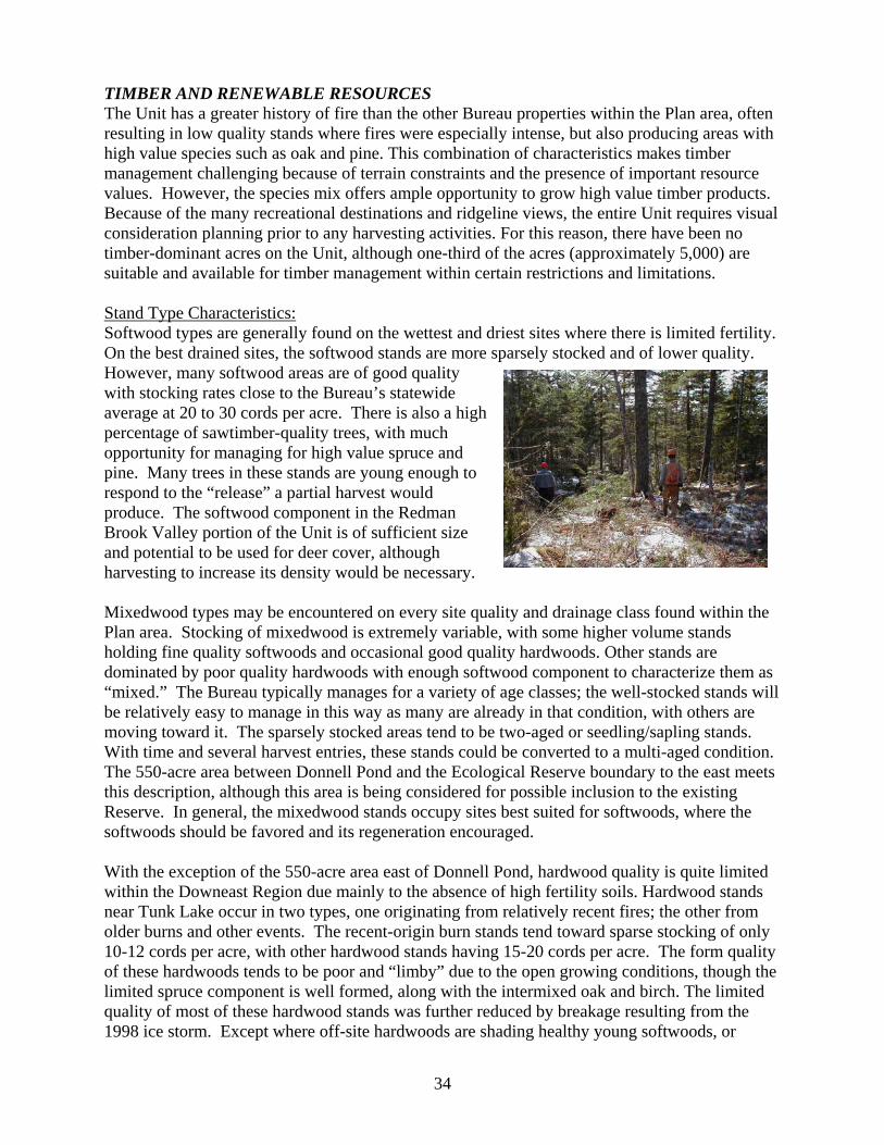
TIMBER AND RENEWABLE RESOURCES The Unit has a greater history of fire than the other Bureau properties within the Plan area, often resulting in low quality stands where fires were especially intense, but also producing areas with high value species such as oak and pine. This combination of characteristics makes timber management challenging because of terrain constraints and the presence of important resource values. However, the species mix offers ample opportunity to grow high value timber products. Because of the many recreational destinations and ridgeline views, the entire Unit requires visual consideration planning prior to any harvesting activities. For this reason, there have been no timber-dominant acres on the Unit, although one-third of the acres (approximately 5,000) are suitable and available for timber management within certain restrictions and limitations. Stand Type Characteristics: Softwood types are generally found on the wettest and driest sites where there is limited fertility. On the best drained sites, the softwood stands are more sparsely stocked and of lower quality. However, many softwood areas are of good quality with stocking rates close to the Bureau’s statewide average at 20 to 30 cords per acre. There is also a high percentage of sawtimber-quality trees, with much opportunity for managing for high value spruce and pine. Many trees in these stands are young enough to respond to the “release” a partial harvest would produce. The softwood component in the Redman Brook Valley portion of the Unit is of sufficient size and potential to be used for deer cover, although harvesting to increase its density would be necessary. Mixedwood types may be encountered on every site quality and drainage class found within the Plan area. Stocking of mixedwood is extremely variable, with some higher volume stands holding fine quality softwoods and occasional good quality hardwoods. Other stands are dominated by poor quality hardwoods with enough softwood component to characterize them as “mixed.” The Bureau typically manages for a variety of age classes; the well-stocked stands will be relatively easy to manage in this way as many are already in that condition, with others are moving toward it. The sparsely stocked areas tend to be two-aged or seedling/sapling stands. With time and several harvest entries, these stands could be converted to a multi-aged condition. The 550-acre area between Donnell Pond and the Ecological Reserve boundary to the east meets this description, although this area is being considered for possible inclusion to the existing Reserve. In general, the mixedwood stands occupy sites best suited for softwoods, where the softwoods should be favored and its regeneration encouraged. With the exception of the 550-acre area east of Donnell Pond, hardwood quality is quite limited within the Downeast Region due mainly to the absence of high fertility soils. Hardwood stands near Tunk Lake occur in two types, one originating from relatively recent fires; the other from older burns and other events. The recent-origin burn stands tend toward sparse stocking of only 10-12 cords per acre, with other hardwood stands having 15-20 cords per acre. The form quality of these hardwoods tends to be poor and “limby” due to the open growing conditions, though the limited spruce component is well formed, along with the intermixed oak and birch. The limited quality of most of these hardwood stands was further reduced by breakage resulting from the 1998 ice storm. Except where off-site hardwoods are shading healthy young softwoods, or
34

where harvesting in nearby stands makes entry feasible, little timber management is needed in these hardwood areas in the near future. Harvesting by the Bureau since the 1990’s has been limited to areas adjacent to the Dynamite Brook Road, which took place in 2003 and 2004, and in an area ato the Thousand Road near Long Pond in 2006. A total of 518 acres were treated in these areas, with more than halfthe volume being low quality hardwood sent to the Domtar
pulp mill in Baileyville. This volume qualified as “green certified wood” under the Forest Stewardship Council program.
djacent
Summary of Management Issues and Concerns • Careful planning will be needed prior to any harvesting due to the challenging terrain and the
visual resources found throughout the Unit. • The sparsely stocked areas on the Unit tend to be two-aged or seedling/sapling stands. With
time and several harvest entries, these stands could be converted to a multi-aged condition.
35

TRANSPORTATION AND ADMINISTRATIVE CONSIDERATIONS Public Use and Management Roads, Gates, and Road Control. Public access to and within the Unit is accomplished in a variety of ways: 1) The Card Mill boat launching area provides public boat access to Donnell Pond from the west. The launching area is accessed from the Donnell Pond Road off from Route 182 in Franklin. The Tunk Lake boat landing is an IF&W managed site which provides boat access to remote campsites along the lakeshore. 2) Improvements to 2¼ miles of public access/shared use road (Schoodic Beach Road) from Route 183 in Sullivan to the southeast portion of the Unit have been made since the adoption of the 1991 Plan. A parking lot at the end of this road provides foot access to the Schoodic Beach camping and day use area and the nearby mountains. There are boulders across the north side of the parking lot to prevent motorized access to Schoodic Beach. 3) An additional 1½ miles of public access/shared use road (Black Mountain Road) has been improved off the Schoodic Beach Road to a parking lot trailhead to the summits of Black Mountain. Beyond this point, the road continues as a management road towards a timber prescribed area near Partridge Peninsula on the southwest portion of Tunk Lake. This road also provides access to abutting private lands. 4) There has been vehicle access onto the Unit via the town-owned Punkinville Road off from Route 1. This road leads to the Flanders Pond area across private lands, then on to the Schoodic Beach Road. This section has been maintained somewhat by the private campowners on Flanders Pond, the predominant users of the road. The road; however, is in need of upgrading. The Bureau does not intend to manage this road for public access beyond Flanders Pond. The Down East Sunrise Trail also crosses this road north of Flanders Pond, where a small vehicle parking area has been made available for visitors to the abutting Schoodic Bog property owned by the Frenchman Bay Conservancy, and for future users of the trail corridor in general. 5) Approximately 6 miles of the 12.5 mile stretch of state Route 182 between Franklin and Cherryfield passes through or along the Unit in T10 SD. Also known as the Blackwoods Scenic Byway, this important corridor provides recreational access points to the Unit. 6) The Thousand Road is a management and shared use road located south of Route 182 between Long Pond and Tunk Lake, which provides vehicle access to the tent platform rental sites along the west shoreline of Long Pond, and to timber management areas. From Long Pond the road becomes impassible by two-wheel vehicles, where it continues for another one-half mile to the west side of Round Pond. The Thousand Road continues beyond the Long Pond spur for approximately one mile to the Unit boundary, then onto abutting private land. Upgrades to this road will be accomplished through agreements with the abutting landowner resulting from timber management activities. Use of the roads beyond the Unit boundary is at the discretion of the landowner. 7) The two-mile long Dynamite Brook Road, located south of Route 182 across from the west corner of Spring River Lake is a management road, but no longer designated as a shared use
36

road. This road was constructed through a joint agreement with the abutting landowner to facilitate the transportation of forest products from both private and public lands. The road provides two wheeled vehicle access to non-motorized use areas east of Donnell Pond, including Redmans Beach and the Black Mountain/Caribou Mountain trail system. 8) A 1/4 to 1/2-mile stretch of management/shared use road begins on the north side of Route 182 on the Myrick Pond Road west of Fox Pond, and continues onto former Haynes land now owned by The Nature Conservancy. Use of the road beyond this point is by permission of the abutting land owner. Leases and Agreements 1) The Bureau manages three residential camplot leases on the Unit, all in T10 SD. In each case, the leases were in place prior to acquisition by the Bureau; with the Bureau continuing them under its Camplot Leasing Program. One is located on Long Pond with road access from the Route 182 Byway; another is located on the southwest shoreline of Anderson Pond on the Spring River Lake parcel, with access from private land north of the camp; and a third located east of Tilden Pond within the Tilden Block, with access from private land similar to the Anderson Pond lessee. In the latter two cases, ATV’s have been used to provide access beyond a parking area on private land. A trail from the north shore of Spring River Lake leads to both camps. 2) The Bureau manages seven “tent platform” rental sites in T10 SD, established by the previous landowner. One of these is located on the south shore of Spring River Lake with drive-to access from the Route 182 Byway. This site has continued under the previous rental agreement, although the customary tent platform and privy are no longer there. Through the years, various members of the public have also used this site for informal boat access or day use. The rental agreement allows for use of the assigned site for camping from May 1st through November 30th, and is renewable on a year-to-year basis. The rentee is responsible for condition of the site. Road access from the Byway is rough, with the rentee historically keeping the road in a passable condition. The six other sites are along Long Pond, equipped with tent platforms and privies, with drive-to access from the Thousand Road located off the Route 182 Byway. These rental agreements allow for use of the assigned sites for camping from May 1st through November 30th, and are renewable on a year-to-year basis. Rentees are responsible for maintenance of the existing structures. Road access from the Thousand Road is rough, with rentees historically keeping the road in a passable condition. The bounds of the use areas have not been firmly established. 3) A 100-acre blueberry barren south of Little Pond was actively managed prior to its acquisition by the Bureau in 2001. A blueberry specialist from the University of Maine Cooperative Extension Service surveyed the field and assessed its condition and management history during the summer of 2004. The report indicated an issue with thin soils on the upper portion of the field in need of recovery, and the need to perform maintenance on the lower fields to enhance productivity. A recommendation to permit the continuance of blueberry harvesting also came from that assessment. Boundary Lines Most of the Unit boundary lines have been established or reestablished; however, the lines that are also township and county lines will require additional work, particularly the T10 SD and
37

Cherryfield town line along the east side of the Unit where encroachment onto the Ecological Reserve is likely. Fire Control The Bureau’s Integrated Resource Policy states “Wildfires occurring on or spreading to Bureau lands will be controlled” (pages 12-17). The Bureau will continue to coordinate with the Maine Forest Service in planning for the prevention and control of forest fires on the lands that it manages. Such efforts will be undertaken on a regional basis, to ensure Bureau staff can respond adequately and quickly to fire emergencies. Administrative Structures The abandoned camp near Schoodic Beach (Camp Chaos as it has been known) was used by seasonal work crews developing the hiking trail system during the 1990’s, and has not been used administratively since. The camp is too dilapidated to be restored. Another camp located on Little Pond, receives informal use, although it is also in relatively poor condition. Both camps were in place when the State acquired the properties, and no record of current or previous agreements for use of the camps now exist. Summary of Transportation and Administrative Management Issues • Updated road maintenance agreements (Card Mill, Flanders Pond) are needed to meet future
repair and maintenance needs. • The tent platform rental sites on Long Pond and Spring River Lake are in areas where there
are also recreational use interests from members of the public. The public/private use conflict is particularly of concern on the Spring River Lake site.
• It is unclear as to the bounds of the tent platform rental area on Long Pond. • The blueberry barren near Little Pond was once commercially managed; the lower portion of
the fields are now in need of maintenance; the upper portion is fragile and in need of protection to restore the soils.
• The old camp buildings near Schoodic Beach and Little Pond are in disrepair and have not been authorized for use. The camps have little administrative value.
• The T10 SD/Cherryfield boundary line along the east side of the Ecological Reserve on the Spring River Lake parcel needs to be reestablished to deter encroachment.
38

3. Resource Allocations and Management Recommendations The following resource allocation categories are listed in the order they appear in the allocation summary on page 10 in the Integrated Resource Policy and page 5 of this document. SPECIAL PROTECTION AREAS (see map DP1) Special Protection as a Dominant Use. The Special Protection allocation as a dominant use will apply to the following areas: • The original designation in 2000 of Ecological Reserves around Black Mountain and Caribou
Mountain and north of Spring River Lake • An additional designation of 274 acres of Ecological Reserve north of Spring River Lake on
the Tilden Block • The Low Summit Bald plant communities on Schoodic Mountain (92 acres) and Round
Mountain (136 acres) • The dwarf shrub bog between Spring River Lake and Long Pond (106 acres) • Eagle nesting sites There are no historic or cultural resources within this Unit that require Special Protection status. Secondary Uses Within Special Protection Areas. The areas designated as Ecological Reserves are also suitable for Non-mechanized Backcountry Recreation, an allowed secondary use within Reserve areas. Recreation activities include hiking, primitive camping, and boating. Hunting, fishing, and trapping are allowed uses in these areas. Special Use Permits will be issued to the two residential camplot owners on the Spring River Lake parcel for the purpose of allowing and limiting ATV access to and from the camps on the existing trail system. The use of ATV’s for any other purpose will not be permitted on this parcel. Management Recommendations • Designate the 274-acre Tilden Block north of Spring River Lake as an Ecological Reserve. • Include the 550-acre area between the east shore of Donnell Pond and the Black-Caribou
Mountain Ecological Reserve on a statewide list of potential areas to be considered for addition to the Ecological Reserve inventory. Once this list is completed, a decision on its inclusion will be made at that time.
• Monitor recreational uses within the Ecological Reserves and other special protection areas for potential conflicts with and impacts to the values and resources being protected. A Special Use Permit will be issued for access to camplots within the Ecological Reserve on Anderson Pond and east of Tilden Pond, and for no other purpose.
• Efforts will be made to prevent ATV use on the summit of Schoodic and Round Mountains to protect the rare plant communities.
39

BACKCOUNTRY RECREATION AREAS (see map DP2) Backcountry Recreation as a Dominant Use. The Non-mechanized Backcountry Recreation allocation as a dominant use has been applied to a 257-acre area where it abuts the northern boundary of the Ecological Reserve on Caribou Mt., to near the 600 foot contour line and the LURC-zoned P-RR. Backcountry Recreation as a Secondary Use. The Non-mechanized Backcountry allocation as a secondary use allocation will be applied to the acres within the Black/Caribou Mt. Ecological Reserve and the Spring River Lake/Tunk Mt. Ecological Reserve (including the 274-acre Tilden Block) north of Spring River Lake. Management Recommendations • Expand the original 1,940-acre Non-mechanized Backcountry Recreation Area in Black and
Caribou Mountains to include the north slope of Caribou Mountain to the 600’ contour, adding an additional 257 acres.
• Expand the Non-mechanized Backcountry Recreation Area north of Spring River Lake to include the 274-acre Tilden Block.
• Allow the continuance of the existing camplots on Anderson Pond and the Tilden Block. Allow the continuance of ATV access to the camps on a permit basis only.
• Incorporates the Backcountry Recreation Areas with other adjacent areas for the purpose of developing a multi-day backpacking opportunity. This network would include Tunk, Black, and Caribou Mts., Schoodic, and Fiery Mountains. Work with abutting landowners regarding hiking use of Catherine Mountain, Schoodic Nubble, and portions of Tunk Mt. as part of that network. Develop and utilize partnerships in managing and maintaining this system.
• Adopt the existing Spring River Lake/Tunk Mountain trail system; implement environmental improvements and aesthetic enhancements where necessary.
• Explore opportunities to provide additional campsites along the ponds, lakes, and trails within the Backcountry Recreation Areas as the need arises.
40

WILDLIFE MANAGEMENT AREAS (see map DP3) Wildlife Management as a Dominant Use. The Wildlife allocation as a dominant use has been applied to the shoreline of rivers, streams, brooks, and certain wetland areas not already allocated as Special Protection. This includes 75 foot or 330 foot riparian zones along the shorelines. Secondary uses within Wildlife Dominant Areas. These uses include primitive or remote recreation activities, such as hiking, camping, hunting, fishing, and wildlife watching. Timber management is an important secondary use, and will be permitted in areas where it will enhance or encourage the development and maintenance of the natural forest habitat. Management Recommendations • Monitor the Downing Bog wetland complex for waterfowl, wading birds, and bald eagles. • Monitor the Tunk Mountain area for nesting raptors. • Manage eagle nesting areas as essential habitat. • Consult with the IF&W Regional Biologist regarding recent bald eagle nesting activity on the
southern shore of Spring River Lake, near the inlet from Tunk Lake. • Manage riparian areas to maintain or establish multi-aged forest stands as habitat, and to
protect the shoreline and travel corridors for the wide variety of wildlife species dependant on these areas.
• If the Redman Brook Valley area east of Donnell Pond does not become included in the Ecological Reserve, encourage its potential as a deer wintering area by enhancing the softwood component along the brook and upland areas.
REMOTE RECREATION AREAS (see map DP2) Remote Recreation as a Dominant Use. The Remote Recreation allocation as a dominant use has been applied to: the area from the east shoreline of Donnell Pond to the boundary of the Black-Caribou Mt. Ecological Reserve/Backcountry area, Round Mountain and its northern slope, Schoodic Mountain and its associated hiking trail network, the Fiery Mountain/Little Pond area with the exception of the west boundary and the blueberry barren. Remote Recreation as a Secondary Use. The Remote Recreation allocation as a secondary use has been applied to the shorelines of Donnell Pond, Tunk Lake, Spring River Lake (and the Tunk Stream Outlet), Shillalah Pond, Round Pond, Long Pond, and Little Pond. This allocation compliments the wildlife riparian zones that have been allocated as dominant use along these shorelines. Secondary Uses within Remote Recreation areas. These uses include timber management where it meets the objectives of the wildlife management program, is compatible with restoring or enhancing the natural forest landscape, or where it addresses safety issues within public use areas.
41

Management Recommendations • Manage the 550-acre area east of Donnell Pond to the boundary of the Ecological Reserve as
a Remote Recreation area. Because of its importance to the hiking trail network, and to its possible inclusion in the Black-Caribou Mountain Ecological reserve, this area will be managed for nonmotorized uses only. Snowmobile and ATV use will not be allowed. Timber management in this area will be deferred until a decision as to its Reserve status is determined.
• Look for ways to incorporate the Remote Recreation areas into a multi-day backpacking network on the Unit. Develop a hiking trail to the summits of Round and Fiery Mountains as a part of that system.
• Look for ways to better accommodate large group use that reduces monopolization of the Redmans Beach area.
• Prevent unauthorized motorized use of the road system in the Fiery Mt./Little Pond area; correct environmental issues where they exist on these roads.
• Provide primitive, walk-to facilities for camping and day use on Little Pond, and a walk to trail along the summit of Fiery Mountain.
• Provide a primitive, walk-to camping and day use area on the Tunk Stream outlet. • Explore providing biking and horseback riding trails on the Unit as demand warrants. VISUAL CONSIDERATION AREAS Visual Class II (background views) will apply throughout the Unit with respect to the Unit’s visibility from high ground areas. Visual Class I (foreground views) will apply to all public use roads and public use areas. Timber harvesting and facilities improvements throughout the Unit will be with respect to Visual II considerations on all acres where these activities are permitted.
42

DEVELOPED RECREATION AREAS (see map DP2) Developed Recreation as a Dominant Use. The Developed Class I allocation (where more developed or concentrated recreation facilities may be found) as a dominant use has been applied to the following areas: • All public use roads within the Unit • The Schoodic Beach parking, trailhead, and beach area • The Big Chief trailhead on the Black Mountain Road • The day use/hand-carry launching site on Spring River Lake • The abutting corridor along the Route 182 Blackwoods Scenic Byway • Boat launching sites on Spring River Lake and Long Pond • The Card Mill boat launching site on Donnell Pond • The west boundary of the Fiery Mountain/Little Pond parcel Management Recommendations • Continue to manage the public use areas on Schoodic Beach for walk-to access only.
Maintain the current barrier in its current location at the Schoodic Beach parking area. • Provide supervision of the popular public use areas as needed to deter the negative uses that
have occurred. Appropriate operational considerations will be applied to the Schoodic and Redmans Beach areas to manage the current level of use. This will be undertaken with respect to the more dispersed and primitive forms of recreation that takes place in other areas of the Unit. This allocation does not imply further development of facilities on Schoodic Beach, or improvements to access to this area.
• Further delineate the public use areas on Schoodic Beach to eliminate camping on the beach itself, and to accommodate day use of the beach in a more efficient manner.
• Explore opportunities to provide enhancements along the Route 182 Scenic Byway consistent with the goals of the Blackwoods Scenic Byway Plan and with the management goals for the Donnell Pond Unit. This includes looking for ways to provide sanitation, access to trail systems and water bodies, picnic areas, scenic overlooks, and interpretive materials. Utilize Scenic Byway partners (landowners, local and county governments, trail groups, etc.) to assist in accomplishing this goal.
• Develop or improve boat launching opportunities on Long Pond and Spring River Lake that provide a level of access consistent with historic use. This includes the relocation of the existing launch site on Long Pond to eliminate the ongoing traffic safety hazards, and the establishment of a trailered launching area along the south shoreline of Spring River Lake that eliminates past conflicts and environmental issues at the campsite rental site.
• Monitor and make improvements as needed to the Card Mill boat launching site to address safety and environmental concerns. Improvements to this area will not include expansion of the current facilities.
• Monitor access issues and impacts resulting from the development and use of the Down East Sunrise Trail. Work with the Bureau’s Off-Road Vehicle Division and trail interests in the ongoing management of the trail corridor with regard to those impacts.
• Look at the feasibility of developing a multi-use trail along the west boundary of the Fiery Mountain/Little Pond parcel from the Down East Sunrise Trail to a parking area near the summit of Fiery Mountain and shoreline of Little Pond. Utilize trail groups and trail clubs to assist in the development and management of this opportunity.
43

• Work with trail groups and abutting landowners in developing or locating a motorized
connecter trail from the Down East Sunrise Trail to points north of the Unit. Look at the feasibility of locating a portion of this trail along the west boundary of the Fiery Mountain/Little Pond parcel to accomplish this goal.
TIMBER MANAGEMENT AREAS (see map DP4) Timber Management as a Dominant Use. No areas within the Donnell Pond Unit are allocated as Timber Dominant. Timber Management as a Secondary Use. With respect to the Visual I, II, and higher allocations, approximately one-third of the total acres within the Unit will be available for timber management as a secondary use. Management Recommendations • Timber management in the 550-acre area between the east shore of Donnell Pond and the
Black-Caribou Mountain Ecological Reserve will be deferred until a decision is made regarding its future addition to the abutting Reserve.
• Timber management where allowed should favor high value trees and longer lived species such as pine, spruce and oak. Where soils are more fertile, maple, ash, hemlock, and beech will be given consideration.
• Timber management objectives will include maintaining the visual integrity of the Unit in general and enhancing the diversity of wildlife habitat.
TRANSPORTATION AND ADMINSTRATIVE CONSIDERATIONS Management Recommendations • Update the road use and maintenance agreements with the Flanders Pond and Donnell Pond
campowners. • Remove the old camp at Schoodic Beach; determine the use and status of the Little Pond
camp. • Correct environmental issues with the road from the Route 182 Byway to the campsite rental
area on Spring River Lake. • Further delineate the tent platform rental area on Long Pond; work with rentees in upgrading
the privies. • Develop a lease with an organic blueberry grower for management of the barrens adjacent to
the Down East Sunrise Trail near Little Pond, to include restoration of the thin soils in the upper portion of the barren.
• Reestablish the property/township boundary line along the east side of the Ecological Reserve on the Spring River Lake parcel to help prevent encroachment by abutting landowners.
44

ROCKY LAKE UNIT
1. Character of the Landbase The 11,121-acre Rocky Lake Unit is located approximately 11 miles north of East Machias on Route 191, and is comprised mostly of the southern half of T18ED BPP in southern Washington County. The property came to the state through several land trade and acquisition transactions in 1977-78 with International Paper Company and St. Regis Paper Company, and in 1984-85 with Georgia-Pacific Paper Company. Two additional parcels were acquired in 2004, including a 59-acre island in Rocky Lake, and a 70-acre parcel (known as “the mitten”) abutting the East Machias River near the outlet of Second Lake. Both parcels were acquired from International Paper Company. Embedded in the Unit are the original public lots for T18 ED, encompassing an area between the west shore of Rocky Lake and the east shore of Second Lake. The Management Unit also includes two parcels on the southwestern shore of Patrick Lake in Marion Twp. located three miles east of Rocky Lake on Route 86; a 115-acre parcel acquired from Baskahegan Company in 1984, and an abutting 2-acre parcel acquired in 2004 used primarily as a boat access site. The larger parcel contains a parking area and footpath to the lakeshore, and has been managed primarily for day use.
The Unit is typical of Eastern Maine glacial landscapes with rocky, jagged-edged lakes, divided by low ridges that provide some relief to the otherwise level landscape. Meandering streams and rivers are bordered by abundant natural wetlands. Rocky Lake (1,555 acres), Second Lake (pictured, 332 acres), and Patrick Lake (275 acres), all warm water lakes - along with the East Machias River - are the principal features on the Unit. Rocky Lake and Second Lake are separated by Rocky Lake Ridge and are connected off the Unit by Rocky Lake Stream,
which flows north and west into the East Machias River. The Unit includes many public islands on Rocky Lake, while others remain in private ownership. One of the principal uses of this Unit is public recreation in conjunction with the lakes and river, and includes activities such as fishing, boating, swimming, canoeing, camping, hunting, trapping, picnicking, and bird watching. Portions of the road system have been designated for ATV and snowmobile trail use, providing which important regional trail connections. The timber resource on the Unit contains a high percentage of young trees. The area was extensively harvested from the 1950's through 1977, when it was acquired by the State. In the late 1970's and early 1980's, the spruce budworm infestation caused extensive mortality and defoliation of the softwoods, which have since naturally regenerated with young fir, spruce, and white pine. Wildlife species found on this Unit are numerous. The abundant natural wetlands provide habitat for waterfowl and furbearers; the lakes provide warm water fisheries, and the dense young softwood growth provides key habitat for snowshoe hare, bobcat, deer, and coyote. Also found in lesser numbers are fisher, moose, and bear.
45

The Unit is bounded primarily by industrial forestlands. GMO Renewable Resources (formally International Paper) is the principle owner to the north, with Wagner Forest Management a significant abutter to the east. A management plan for the Rocky Lake Unit was first developed and adopted in 1989. 2. Resources and Management Issues NATURAL AND GEOLOGICAL RESOURCES Upland forests within the Unit are typical of the region, with nearly all areas showing past evidence of timber harvesting, fire, and spruce budworm damage. Mid-successional softwoods (spruce and fir, with pockets of cedar) are dominant throughout the Unit. On a large knoll east of the Machias River, early and mid-successional hardwoods (poplar, red maple) are transitioning into an oak-pine forest. Approximately 68% of the Unit is forested upland, while the remainder is forested wetland (20%), non-forested wetland (10%), and open water (2%). Notable natural areas on the Unit include two small well-formed, raised Sheep Laurel-Dwarf Shrub Bogs on the east side of Second Lake. A large wetland complex on the western shore of Rocky Lake consists of Spruce-Larch Wooded Bogs and Northern White Cedar Woodland Fens with a small Sheep Laurel-Dwarf Shrub Bog in an open area of the wetland. A 1,500-acre wetland-dominated area along the East Machias River was designated as an Ecological Reserve in 2001. In the south-central portion of the Unit, a Tussock Sedge Meadow dominates a wetland complex controlled by beavers. The surrounding forest was harvested a few decades ago; however, several very large red maples and a white pine 39 inches in diameter were found near the southern portion of the meadow. The largest exemplary natural community on the Unit, a Streamshore ecosystem (emergent marsh) covering several hundred acres, is located along the East Machias River within the Ecological Reserve. No rare plants, however, have been discovered on Unit. The first Natural Resource Inventory for the Unit was completed in 2004. HISTORIC AND CULTURAL RESOURCES Cultural Resources. No formal archaeological studies have been conducted on the Rocky Lake parcel; however, access by canoe from other waterways makes it a likely source of archaeological resources remaining from Native American periods. Nomenclature. Smith Mill Pitch on the East Machias River was named for the Smith family who once operated a mill in the area; Wigwam Riffles on the East Machias River near Second Lake was named as a result of a nearby Native American encampment. Summary of Management Issues and Concerns • The shorelines of Rocky Lake, Second Lake, and the East Machias River are areas likely to
have been used by Native Americans for campsites; any active management will require consultation with and cooperation from the Maine Historic Preservation Commission.
46

FISHERIES AND WILDLIFE RESOURCES The peninsula between Northern Inlet and South Bay on Rocky Lake contains two active eagle nests. Eagles are common throughout the Unit and utilize the superstory white pines along rivers and lakeshores for nesting, roosting, and perching. Shallow wetlands provide ideal foraging areas. Another eagle nest is located on private land just across the river near Second Lake. The ¼ mile circle around this nest encompasses part of the recently acquired “mitten” west of Second Lake. Although the bald eagle, as a species, is scheduled to be removed from the threatened status, protecting habitat and nest sites on public land will be important in maintaining eagle productivity in the future. Many of the tributaries that flow into the main stem of the East Machias River and into the three warm-water lakes in the Unit support high value habitat for the wild eastern brook trout and should be protected. These tributaries include: Cook Meadow Brook, Scott Brook, Northern Inlet, Southern Inlet, Gooch Brook and the main stem of the East Machias River. The Rocky Lake Unit contains extensive wetlands, many of which provide important wading bird habitat mapped by the Maine Department of Inland Fisheries and Wildlife. The three lakes in the Unit support a warm water fishery of bass, pickerel, and perch. A 205-acre zoned Deer Wintering Area is located along the eastern shoreline of Rocky Lake, although there has been no documented use by deer within the last 10 years. The East Machias River and Second Lake provide important Atlantic salmon habitat. Most of the shoreline on both sides of the river is designated as an Ecological Reserve. The river segments include salmon rearing and spawning habitat (riffle areas) mapped by the U.S. Fish and Wildlife Service. Brook floater mussels, a species of special concern, and Tomah mayflies, a globally rare species, have been found on the East Machias River below Rocky Lake Stream. Though both of these locations are north of the Plan area, similar habitat is found within the Unit. Summary of Management Issues and Concerns • There has been no documented deer use of the LURC-zoned DWA on the southeast shore of
Rocky Lake in the last 10 years. • The East Machias River and Second Lake have been identified as important Atlantic salmon
habitat. • Although floater mussels and Tomah mayflies have been located on abutting lands, similar
habitat has been found on the Unit. RECREATION AND VISUAL RESOURCES Rocky Lake, Second Lake, the East Machias River, and Patrick Lake are the principal recreation features on the Unit; visitors enjoying fishing, boating, ATV riding and snowmobiling, swimming, camping, hunting, trapping, picnicking, and wildlife watching in conjunction with these lakes. Second Lake and the East Machias River also form part of a popular 39-mile canoe
47

trip from Pocomoonshine Lake to Hadley Lake – 4 miles of which are within the Unit. Several side trips are possible along this route, including one to Rocky Lake along Rocky Lake Stream. Camping and Day Use Areas Two areas on the Rocky Lake Unit provide vehicle access to recreation facilities. One is located on Rocky Lake at the South Bay public use area, and includes 4 campsites with fire ring, picnic table, and privy. The area also includes facilities for picnicking and boat access. Public use of this area has been heavy at times, occasionally resulting in vandalism and the indiscriminate cutting of live trees for firewood. Another public use area is located at Mud Landing on the Northern Inlet of Rocky Lake (pictured), and includes facilities for a single-party campsite, picnicking, and boat access. Fire permits are not required at these locations. General improvements to these areas to correct safety, ease-of-use issues, and increasing demand are needed. There is also a small day use area adjacent to the boat landing on Patrick Lake, located a short walk from a parking area along side of Route 86 in Marion Twp. Single-party, water-access campsites with no facilities are found at two locations on Second Lake, and one location on the East Machias River. Campfires are allowed on these sites provided a fire permit from the Maine Forest Service is obtained in advance. A site used for hand launching of small boats located on the south end of Second Lake has also been used for camping. Several other informal campsites, often used by canoeists, are located on the shoreline of Second Lake and along the river. Fire permits are not issued for these sites. A single-party, water-access campsite is located at Loose Rock on the southwest shore of Rocky Lake. This site has a fire ring, two picnic tables, privy, and an Adirondack shelter constructed by the Maine Conservation Corps in 1981. Four campsites with table, fire ring, and backcountry toilet are located along other areas of the lake and islands. These sites are authorized for campfire use without obtaining a permit. Further development or upgrading of recreation facilities along the shorelines of the lakes and river will be difficult due to poor soil suitability, particularly for sanitary facilities. Multiple Use/Motorized Trails Snowmobiling and ATVing constitute the principal trail uses of the Unit, with 17 miles of Shared Use Roads and approved motorized trails. The snowmobile trail is a groomed trail, and eventually connects to ITS 84, a major east-west trail north of the Air Line (Route 9). Snow conditions in the region vary from year to year, limiting snowmobile opportunities in comparison
to other areas of the state. In years where cover is sufficient, a 6-week use season is typical. Both the ATV and snowmobile trail systems provide important connections to regional destinations, including the 700-mile ATV trail system on private lands nearby. In the past, the Bureau has worked with local trail groups on the location and maintenance of the trails, and to address ongoing issues with safety, connectivity, and use conflicts. Providing trail-side campsites for motorized users has also been discussed relative to the future management of the
48

Unit, with an area near Mud Landing on the Southern Inlet providing a potential opportunity. The former Calais Branch rail corridor, approved for development by the Maine Department of Transportation as a multi-use trail (now the Down East Sunrise Trail) for both motorized and non-motorized uses, passes through the southeast corner of the Unit east of Route 191, where it crosses the Southern Inlet (pictured left). The corridor will provide a new multi-use trail access point to the Unit. The Bureau will need to coordinate the development and management of this trail with managers of the trail corridor. In the past, demand for bicycling and horseback riding areas has not been significant; although there is growing interest in providing opportunities for these uses. Boat Access Boat access takes place on four areas within the Unit; a graveled site in need of upgrading on the Northern Inlet of Rocky Lake, suitable for trailered launching; a graveled site on Rocky Lake at the South Bay recreation area, where the launching of trailered boats has been difficult due the
rockiness and shallowness of the site; a graveled site on Patrick Lake suitable for trailered launching; and a walk-to hand carry site on the southern shoreline of Second Lake. This site, located at the end of an old road to the lake from the Diamond Match Road (pictured left), is nsidered for relocation to the old
“Doc Henry” camp site (pictured right) due to long-standing environmimpacts resulting from indiscriminate use of this road. Relocating the uarea would further protect Atlantic salmon habitat. Boat launching on
Patrick Lake takes place off from Route 86 on a graveled site suitable for trailered boats.
being coental se
Management activities typically consider visual resources when planned
ummary of Management Issues and Concerns lities at Mud Landing on the Northern Inlet
ay on Rocky Lake, along with the
tivity and safety concerns with the motorized trail
riding and bicycling opportunities on the Unit.
Visual Considerations. and implemented. The scenic quality of the Rocky Lake Unit is valued by visitors to the area, particularly as viewed from public use areas, trail corridors, and the various waterbodies withinthe Unit. Timber management and facility improvement activities take into consideration both foreground and background views in protection of the areas scenic quality and character. S• The parking, boat launching, and camping faci
require upgrades to improve safety and convenience. • Indiscriminate use of the camping facilities at South B
cutting of live trees, has negatively impacted the area, both environmentally and socially.• Recent improvements to the Diamond Match now provide public vehicle access to areas
beyond the South Bay recreation area. • There is a need address ongoing connec
system, and to look at possible campsite areas on the Unit. • The Bureau has been asked to consider providing horseback
49

• The location of the designated hand carry site on Second Lake presents ongoing environmental issues – mostly caused by indiscriminate vehicle access; an alternative site
n of this corridor passes through the Unit near the entrance to the it.
IMBER AND RENEWABLE RESOURCES e Rocky Lake Unit in general is less hilly than elsewhere in the Plan area, with the major
erous wetlands and occasional boulder fields. ut
needs to be established. • The Down East Sunrise Trail will be developed as a multi-use trail motorized and non-
motorized uses. A portioDiamond Match Road on Route 191, and will provide a new trail access point to the Un
. TThconstraints to timber management being the numImpacts from the budworm infestation and resulting salvage harvests were substantial here, bthere is significant regeneration occurring. The younger trees include an abundance of spruce and pine, ready to respond to release from overstory competition. A large portion of the Unit is well suited for long-term timber management for this reason Stand Type Characteristics Softwood types are found mainly on dry sites or in
ve higher densities of spruce e
e
uch f this is on land better suited to softwoods - where the softw
ent is mostly low quality,
lly of
nit, although much of is area was mixedwood or softwood prior to the
n, le) o
ities here include the same hardwood
wetlands. The drier areas haand hemlock, and are mixed with significant pine; thwetter sites are mostly dominated by poor quality cedar, with some areas having greater densities of spruce and hemlock. One of the management objectives for the Unithas been to ensure growing space for high quality sprucand pine, along with hemlock on the more fertile areas. Mixedwood types occupy almost 60% of the Unit, but mo oods were either harvested or killed by spruce budworm 20-30 years ago. The hardwood compondominated by red maple and white (or hybrid white/gray) birch. The softwood portion of these mixedwood stands is mainly spruce/fir and hemlock with significant pine, and is generabetter quality than the hardwoods. Improvements in the hardwood pulp market at the time of themore recent harvests offered the chance to preferentially remove the poorly formed stems and favor quality softwoods in the remaining stands. Hardwoods cover only 10% of the Uthbudworm infestation. These stands contain poorly formed maples and birches that in most areas overtop fine softwood-dominated seedlings and saplings. There is a small hardwood area that does not fit this descriptiobeing either true Northern Hardwoods (birch-beech-mapgenerally the best quality hardwood. Timber opportunremovals as in mixedwood, favoring oak where it occurs.
r holding significant oak, which is
50

Since 2003, approximately 940 acres have been treated, with nearly ½ the harvest volume being
ummary of Management Issues. the Unit provides a challenge in that the much of the
RANSPORTATION AND ADMINISTRATIVE CONSIDERATIONS
ublic Use and Management Roads, Gates and Road Control st Machias town line provides the
e
he Northern Inlet Road, just over a mile north of the entrance to the Diamond Match Road on
gate is located on a management road east of Second Lake, which prevents vehicle use of this
eases and Agreements camplot leases on the Rocky Lake Unit, located on the west shore of
d
ire Control Integrated Resource Policy states “Wildfires occurring on or spreading to Bureau
spond
low-quality hardwood sent to the Domtar pulp mill in Baileyville. This volume also qualified under the Forest Stewardship Council’s “green-certified wood” program. S• Management of the forest within
merchantable trees in the overstory are of low quality, whereas the younger trees in theunderstory tend to be of higher quality.
T PThe Diamond Match Road from Route 191 just north of the Eaprimary access into the interior of the Unit. The one and one-half mile section of road from Route 191 to South Bay is designated as a public use road. The remainder of the road, into thSecond Lake area and beyond, is classified as a management road, although improvements to this road were made in preparation for winter harvesting activities in 2004. TRoute 191, provides access to the Northern Inlet boat launching and camping area. This road is also designated as a public use road. The Nineteen Road, just north of the Northern Inlet Road, is used as a motorized trail, and provides vehicle access to the northeast corner of the Unit whereit then passes onto private land. Aroad designated for motorized trail use. LThere are six residential Rocky Lake, near the southwest segment of the East Machias River, and in the interior of the Unit east of the river. Another camplot is located on the island in Rocky Lake recently acquirefrom International Paper Company in 2004. The Bureau has a statutory obligation to continue these leases provided the terms and conditions are met. FThe Bureau’slands will be controlled.” (pages 12-17). The Bureau will continue to coordinate with the MaineForest Service in planning for the prevention and control of forest fires on the lands that it manages. Such efforts will be undertaken on a regional basis, to ensure Bureau staff can readequately and quickly to fire emergencies.
51

3. Resource Allocations and Management Recommendations SPECIAL PROTECTION AREAS (see map RL-1) Special Protection as a Dominant Use. The Special Protection allocation as a dominant use will apply to the 1,500-acre wetland-dominated area along the East Machias River by virtue of its designation as an Ecological Reserve. Secondary Uses Within Special Protection Areas. The portion of the Ecological Reserve along the East Machias River is suitable for Remote Recreation activities, which is an allowed secondary use within this designation. Use of this area primarily involves canoeing on the river, as well as hunting, fishing, and trapping. Timber harvesting is not permitted in the Ecological Reserve. Management Recommendations • Monitor recreational uses within the Ecological Reserve area along the East Machias River
for compatibility with the values and resources being protected. WILDLIFE MANAGEMENT AREAS (see map RL-2) Wildlife Management as a Dominant Use. The areas within 1320 feet of 2 bald eagle nests (outlet of Second Lake and the tip of the peninsula in Rocky Lake) and the deer wintering area on Rocky Lake have been allocated as Wildlife Dominant Areas. A riparian area 75 feet or 330 feet of rivers, streams or brooks have been allocated as Wildlife Dominant except where higher allocations apply. The management objective in these areas is to maintain or establish multi-aged forest stands as habitat and as travel corridors for wildlife; in particular where it supports Atlantic salmon preservation efforts. Secondary Uses within Wildlife Dominant Areas. Recreation and timber management are allowed secondary uses in Wildlife Dominant Areas. There may be seasonal limitations on certain recreational activities and timber harvesting during critical nesting periods. Management Recommendations • Continue efforts to establish or encourage softwood growth on suitable softwood sites
throughout the Unit. • Explore and implement ways to enhance the habitat conditions within the Rocky Lake deer
wintering area, and monitor for future use. • Continue to look for ways to protect and enhance Atlantic salmon habitat.
52

RECREATION AREAS (see map RL-3) Remote Recreation as a Secondary Use. Remote Recreation has been allocated as a secondary use along the shorelines of Rocky, Second, and Patrick Lakes, as well as the shoreline of the East Machias River, and a section of the Northern Inlet. The primary recreational activities in these areas include canoeing, boating, primitive camping, fishing, and hunting. Developed Recreation as a Dominant Use. The Developed Class I allocation (where more intensely-developed or a concentration of recreation facilities may be found) as a dominant use have been applied to: • Public use roads, including portions of the Diamond Match Road, the Northern Inlet Road,
and the Nineteen Road • Other motorized trail corridors, including the Diamond Match Road to Second Lake, the
gated trail east of Second Lake to where it abuts private land near Munson Rips • A connector trail to the Down East Sunrise Trail corridor • South Bay public use area on Rocky Lake • Mud Landing public use area on the Northern Inlet • The boat launching area on Patrick Lake Management Recommendations • The Diamond Match Road beyond Second Lake will remain a management road, but will be
maintained to permit vehicle access to a public parking area near the former “Doc Henry” camp on Second Lake. This site will also be used to relocate a hand carry boat launch area.
• Continue working with local trail clubs towards managing and improving the motorized trail network in the Unit. Trail relocations will be considered to minimize safety issues, enhance connectivity, and minimize conflicts with other users.
• Destinations within the Unit for motorized trail users will be explored, including the use of an existing campsite along the west shore of Rocky Lake and a campsite near Mud Landing on the Sorthern Inlet.
• Improvements to the South Bay boat landing will be explored to enhance its capacity to launch trailered boats.
• A means to deter vandalism and other negative impacts from use of the South Bay and Mud Landing recreational areas will need to be implemented.
• Improvements to the Mud Landing public use area will be made to better accommodate day use, camping, boat launching, and parking.
• Additional opportunities for remote camping on the lakes and the river within the Unit will be explored.
• Work with the Bureau’s Off-Road Vehicle Division on the development and management of the Down East Sunrise Trail where it passes through the southwest corner of the Unit; including developing a multi-use connector trail from this corridor to the Unit.
Visual Areas as a Dominant Use. A Visual Class I designation will apply on lands adjacent to all public use roads, public use areas, and motorized trails throughout the Unit to address foreground aesthetics within these corridors. Visual Class II designations will apply along shorelines and upland view shed areas as seen from the lakes and river.
53

TIMBER MANAGEMENT AREAS (see map RL-4) Timber Management as Dominant Use. Much of the Rocky Lake Unit has been allocated as Timber Dominant. Timber Management as a Secondary Use. Areas allocated for Wildlife, Remote Recreation, and Visual Areas provide for timber management as a secondary use. Further limitations may apply on Second Lake due to its importance for Atlantic salmon habitat. Any management in this area will focus on maintaining stand integrity in support of this habitat. Management Recommandations • Manage for high value softwoods (spruce, pine, and hemlock on the more fertile sites) and
for deer winter cover. True Northern Hardwood type (birch/beech/maple) should be retained wherever the soils are fertile enough to support its growth. Oak should be retained and encouraged wherever possible.
54

CUTLER COAST UNIT 1. Character of the Landbase The 12,234-acre Cutler Coast Unit is located along Route 191, primarily in the Town of Cutler. The northwest portion of the Unit is within the Town of Whiting. The original 2,174-acre Bold Coast parcel was acquired from The Conservation Fund in 1989 through the Land for Maine's Future program. A Management Plan for this parcel was adopted in 1993. A subsequent 5-acre parcel was acquired in 1995, which provided a parking area and trailhead adjacent to Route 191 for foot access to the parcel. In 1997, the Conservation Fund, along with its managing partner the Maine Coast Heritage Trust, donated to the state a 9,485-acre parcel on the north side of Route 191, with the Bureau purchasing an additional 570 acres, thus completing the 10,055-acre acquisition. This newer parcel is primarily forested, and contains an important complex of grasslands and heaths designated as an Ecological Reserve. Much of the area is well suited for a variety of recreational trail uses. The Unit’s most striking features are the steep, jagged bedrock cliffs jutting into the Atlantic Ocean. Standing on the shore, visitors are dwarfed by the cliffs, which present views of basalt columns, overhangs, and massive igneous intrusions lying at unusual angles. Sheltered within the craggy shoreline are the eastern portions of Almore Cove, and all of Long Point and Black Point Coves, each ringed with cobbled beaches. Between Almore Cove and Long Point is Fairy Head, a popular remote camping area. A “blowhole” or “spouting horn” can be found seen on the shoreline under certain surf conditions, where wave pressure forces water through the roof of a sea cave and into the air. From early summer to early fall, Humpback, Northern Right, Finback, and Minke whales can occasionally be seen from the cliffs. The first three are federally and state-listed endangered species. Most of the 2,179 acres along the Bold Coast side are located on a plateau rising up to 220 feet above sea level. The property is drained by Schooner Brook and Black Point Brook, both bordered by extensive wetland areas. Although there is little elevation change within the upland portion of this parcel, the terrain is nonetheless diverse.
55

2. Resources and Management Issues NATURAL AND GEOLOGICAL RESOURCES The majority of the Cutler Coast Unit is forested upland (70%), while the remainder is a combination of non-forested wetland (16%), non-forested upland (8%), and forested wetland (6%). The total acreage includes approximately 5,216 acres of Ecological Reserves designated in 2001, located on both the north and Bold Coast parcels. This plan includes a management recommendation to modify those acres to better represent the important community types identified prior to its designation. The Bold Coast parcel includes four and a half miles of rocky coastline. The wind, fog, and cool summer temperatures along the Downeast coast create a short growing season, providing a unique habitat for vegetation. Because of this cool climatic influence, some natural community types are similar in structure and composition to sub-alpine areas found inland or boreal areas much further to the north. Consequently, the Unit has a number of exemplary natural communities. The Open Headland community type is found on the exposed bedrock cliffs, where hearty boreal plants, such as black crowberry and creeping juniper, grow in narrow fissures in the rock or other areas where small amounts of organic matter accumulate. The Maritime Spruce-Fir Forest natural community, also found close to the coast, is characterized by balsam fir, heart-leaved paper birch, and mountain ash. The poor growing conditions result in few trees greater than 12 inches in diameter. With shallow, organic soils on bedrock, “tip-ups” are common, and dead wood is prevalent. In addition, balsam woolly adelgid is causing fir mortality, and contributing to an abundance of blow downs and decaying wood, which in turn create habitat for insects and birds. Upland forests on the remainder of the Unit, particularly those in the northern parcel, have a lengthy history of fire and heavy harvesting, resulting in a dominance of balsam fir and early-successional hardwoods, including poplar and birch. There are 85 acres of commercially operated blueberry barrens that abuts the Reserve area to the north and west. Five outstanding Bluejoint Meadows on the Unit form dense mats of grassy vegetation, which have been periodically “control burned,” most recently in April of 2004. The largest of these grasslands, encompassing over 1,300 acres, lies along the upper reaches of East Stream in the northern portion of the Unit. Many believe that periodic burning is needed to maintain the grassland, which is viewed as providing important habitat for wildlife (as recommended in 1993 management plan). However, recent research from the University of Maine (Dieffenbacher-Krall 1996) suggests that these periodic burns may not be mimicking a natural fire regime and, may not be necessary for maintaining the quality of the grassland community. Further research will need to be conducted on this issue. A number of small bogs on the Unit provide additional openings in the forest cover, including two Huckleberry Crowberry bogs. One of these harbors the rare shrub, northern comandra, and the rare crowberry blue butterfly, which feeds exclusively on black crowberry. One exemplary Sheep Laurel Dwarf Shrub Bog occurs in the north portion of the Unit. The Natural Resource Inventory for the Unit was updated in 2005 and includes a revision of the original 1992 inventory work completed for the Bold Coast.
56

Ecological Reserve Modification The original 5,216-acre Ecological Reserve designation in 2001 included portions of the north and Bold Coast parcels. After review of this area by staff and the Maine Natural Areas Program, it was recommended that the Reserve be modified to more accurately reflect the important community types identified prior to its designation. This modification includes (pictured in green) adding the remaining 288 acres on the southwest end of the Bold Coast parcel and 57-acre area along Route 191, and a 172-acre area on the northeast end of the north parcel. A 512-area on the north parcel, where it abuts the East Stream Road (pictured in red/orange), will be undesignated. This modification enlarges the maritime spruce-fir component as part of the Reserve inventory, and makes available an area better suited for active forest and recreational trail use. This modification will result in an increase of 5 acres to the current Ecological Reserve inventory on the Unit
Summary of Natural and Geological Management Issues • Modifications to the Ecological Reserve boundaries were determined after a field analysis
was conducted. • The importance of burning the grasslands south of Route 191 is not entirely known. Further
research of all of the grasslands needs to be done to verify if they are of natural origin. • Commercial management/maintenance of the blueberry barrens could impact the surrounding
ecological reserve and East Stream; of concern is the use of fertilizers and burning necessary to enhance blueberry production over time. The use of herbicides and fungicides are already prohibited as a condition of the lease.
• There are significant amounts of blowdown and dead wood throughout the Bold Coast parcel.
57

HISTORIC AND CULTURAL RESOURCES The history and culture of this area are easily reflected in the place names common to Cutler Coast area: Nomenclature. The town of Cutler was named for Joseph Cutler, a proprietor from Newburyport, Massachusetts. Ackley Stream, on the southwest corner of the upland parcel, was named for Oliver Ackley who owned land surrounding Ackley Pond. Bother Brook, located in this same area, was so named because it was a “bother” for woodsman to cross. Bagley Brook, which crosses the Whiting town line into Cutler at the blueberry barren, is named for a man who was a nearby resident in 1881. Compass Rock, just east of the blueberry barren, is so named because of a large rock with navigational marks carved by hunters. Cocoa Mountain is said to be named after a group of hunters who took cocoa wine with them on a hunting trip, with some getting lost on the mountain. French Ridge on the north parcel is named for a man named French who once lived there, Harmon Heath for the Harmon family, and Holmes Cove for a local lobsterman. Local lore suggests that Fairy Head should be spelled as "Ferry Head." because ferry boats navigating the Grand Manan Channel used the prominent headland as a landmark to help find their way into Cutler Harbor. Cultural Resources. The coastline running from Long Point to Sandy Point and encompassing Long Point Cove is known to contain significant Native American archaeological resources, including stone tools excavated in 1984. Summary of Historic-Cultural Management Issues • The management and public use of Long Point Cove
along the Bold Coast Trail needs to be in consideration of the likely presence of archeological resources known to occur in this area.
FISHERIES AND WILDLIFE RESOURCES While there is a diversity of habitat types on the Unit, low site productivity on the coastal portion -- due primarily to thin soils and fire -- has resulted in more limited habitat conditions for most species. The unique grasslands on the Unit contain ideal habitat for certain species of uncommon or rare bird species such as merlin, short-eared owl, yellow rail, and sedge wren. The sedge wren is a rare species - a very small brown bird with a short, slim bill and a slim, cocked tail. It is typically found in grassy wetlands but is difficult to find due to its small size and secretive nature. The yellow rail is also rare - a shy, sparrow-sized, yellow-brown bird with dark brown stripes on its back. Its habitat preferences include freshwater marshes and wet meadows. Several years ago, a yellow rail was sighted just east of the coastal portion of the Unit. The Cutler Coast Unit has many miles of brooks and streams with a large percentage containing high value wild eastern brook trout populations and habitat that should be protected. These waters include: East Stream, West Branch of East Stream, Micah Brook, Eastern Marsh Brook, Spring Brook, Bother Brook, Bagley Brook, and the outlet and inlet of Ackley Pond.
58

The broad forest types are approximately 60% softwood, 30% mixedwood, and 10% hardwood. The hardwoods are generally small, of poor quality, and are frequently comprised of noncommercial species such as pin cherry and mountain ash, the fruits of which are an important wildlife food.
Most wildlife species indigenous to the region are found on the Unit, with habitat conditions being quite favorable for bobcat. Snowshoe hare is its primary prey, although their populations tend to be naturally cyclical. Extensive patches of young softwood, the preferred habitat for snowshoe hare, occur throughout the Unit. The hare population appears on the increase, which should enhance the bobcat population, provided other habitat requirements for escape cover, travel, and den nesting are present.
There are bogs (heaths), wetlands, and old beaver flowages scattered throughout the Unit, connected by sluggish streams such as East Stream (pictured) that support a brook trout fishery in the spring. Nearly all of these areas contain well-defined game trails. Several important wetland types with the potential to harbor unusual or rare species occur on the property. Of significance are the peatland areas, which have pitcher plants and other varieties typical of bog areas. There are also extensive stream-wide emergent meadows on the property. Extensive grassland barrens occur on both the north and south sides of the Unit; with most being within the designated Ecological Reserves. These barrens are dominated by blue-joint grass, flat-topped aster, alder, and meadowsweet. Brambles are found on the upland sites in areas lacking wetland hydrology and soils. In the absence of fire, the grasslands may revert to alder dominated shrub communities, and eventually to birch and mixed forests. Natural succession of the grasslands to shrub or birch and mixed forest communities would reduce the diversity of wildlife habitat on the property. The coastal cliff community along the rocky headland is a unique type within the range of mainland properties managed by the Bureau, providing ideal nesting habitat for seabirds along the ledges. Ravens have been observed nesting on the ledges near Holmes Cove. The coastal bluffs are also a good location to observe migrating whales during the fall season. Summary of Wildlife Management Issues • Future decisions regarding management and burning of the grassland areas will have a direct
impact on other wildlife habitat values on the Unit. • Encouraging periodic regeneration of softwood to maintain early successional habitat will be
important in retaining hares, bobcat, and other species that depend on that habitat.
59

RECREATION AND VISUAL RESOURCES Considering its relatively small size, the coastal portion of the Unit imparts a sense of solitude in a relatively undisturbed surrounding. The remote nature of the Bold Coast portion is further enhanced by the difficulty in landing boats, except during calm sea conditions. The diverse terrain and topography, stunted vegetation, and small bogs and barrens also make the coastal portion of the Unit aesthetically unique. The character of the northern parcel is pforested except for the barrens and wetland areas. Much of the area is well suited for a variety of recreational trail uses. There are 19.5 miles of shared use roads and designated ATV trails withithis parcel, many of which are maintained by the East Stream Trail Riders ATV Club, includiportions of the East Steam and Cocoa Mountain Roads. A portion of this system passes through the Ecological Reserve, with a bridge recently constructed to protect a small section of grasslwithin the Reserve. An overnight backpacking opportunity could be developed utilizing pof the trail system on the north parcel in connection with the trails on Bold Coast parcel. More work will be needed to determine if this is feasible.
rimarily
n ng
and ortions
The northern parcel also contains opportunities for other trial uses, including horseback riding and mountain biking, and efforts will be made to manage for these uses should there be continued interest. The coastal portion of the Unit is accessible via a trailhead and 12-car parking lot located on Route 191, offering hiking trips of 5 to 10 miles, including the popular “coast and back” 3 mile hike. The parking area commonly fills, with overflow parking occurring along Route 191. Three primitive campsites are located along the coastline approximately four to five miles from the trailhead, with several sites located a short distance inland. These campsites, along with the trails, receive considerable use, with notable compaction occurring in various places. There may be some limited opportunity to increase the number of campsites to address this. No further expansion of the hiking trail system on the coastal parcel has been contemplated. One area of concern are the frequent blowdowns due to heavy tree mortality within the coastal parcel, which could cause temporary closure of certain trail segments. This situation will need to be monitored, although preventive management will be limited due to its location within the Ecological Reserve. Stewardship on the coastal portion of the Unit is accomplished in part through a partnership with the Cobscook Trails Coalition; a coalition of public and private conservation landowners (The Nature Conservancy, Maine Coast Heritage Trust, U.S. Fish and Wildlife Service, Maine Dept. Inland Fisheries and Wildlife, Quoddy Regional Land Trust, area businesses, and the Bureau of Parks and Lands). The Coalition was founded to provide nature tourism opportunities in the Cobscook Bay region. Quoddy Regional Land Trust manages the partnership and employs a trail steward to assist with visitor information and routine trail maintenance. Bureau staff provide assistance for trail improvements and non-routine maintenance.
60

Visual Considerations. The coastline, with its cliffs, coves, pebble and cobble beaches and crashing waves, along with expansive views of the ocean, is the primary scenic attribute on the Unit. The inland terrain, with its diverse topography and vegetation, is also aesthetically important. Several bald knolls accessed by the hiking trail system offer views of the surrounding heath, bog, and forest. Views from Route 191 include expansive wetlands, grasslands, and blueberry barrens against a backdrop of low hills. Summary of Recreation Management Issues • The trails and campsites to and along the Bold Coast receive significant use throughout the
hiking season. The parking area commonly lot fills, with overflow parking taking place along Route 191.
• Expanding the hiking trail system to include the north parcel could provide an overnight backpacking opportunity.
• Heavy tree mortality on the coastal parcel could cause temporary closure of certain trail segments.
• Heavy public use has resulted in moderate amounts of compaction (areas impacted beyond the established treadway) along the coastal trail, and at overlook and campsite locations.
• A portion of the designated 2-mile ATV connector trail on the north parcel passes through a portion of the Ecological Reserve; its use predating Reserve designation, and was constructed in partnership with a local ATV club.
TIMBER AND RENEWABLE RESOURCES While the Cutler Unit has only modest changes in elevation, those changes tend to be very steep, especially seaward of Route 191, where no timber management has occurred since acquisition of the property. The sites and climate here are growth limiting, to the point that only half as many tree species were tallied during a1999 inventory as were tallied at either the Rocky Lake or Donnell Pond Units. The forest attributes are found in combination with the grassland complex and presence of maritime spruce-fir. As a result, the only acres suitable for timber management occur on the northern parcel. The Unit and surrounding area received considerable budworm damage and salvage harvesting in the 1980’s, yet numerous mid-aged stands (between saplings and mature forest) can be found - more so than anywhere in the region. Portions of the Unit have also been popular for “tipping” - the collecting of fir boughs for Christmas wreaths and other decorations. Permits for this activity have been issued in the past. A 512-acre area, part of the original Ecological Reserve on the north parcel (where it abuts the East Stream Road), has been removed from the Reserve inventory and redesignated as a timber management area. An important wetland area within this parcel will continue to be protected. The 288-acre area on the west side of the Bold Coast parcel, where it abuts the Ecological Reserve, has been designated, and is now part Ecological Reserve. These once “regulated” timber acres have not been harvested by the Bureau, and was determined to have more value to the abutting Reserve. Stand Type Characteristics: Softwood types are mainly found on the drier sites that are either sand/gravel or thin to ledge, though there is some occurrence in wetland areas. The dry site softwoods are spruce-fir, with
61

most being pole timber size (trees mainly 5-10” in diameter). The wet sites have very poor cedar with occasional spruce-fir. Some areas contain fir that is mature and ready to harvest, while the pole timber would benefit from thinning. Mixedwood types occupy about two-thirds of the forested area, and was converted to mixedwood by past preferential cutting of spruce and fir. Like the Rocky Lake Unit, much of this type is on land better suited to softwoods. The hardwood component contains low quality red maple and white birch, some of which is well formed though the low fertility will limit their sawlog potential. The softwood portion of these stands is mainly spruce-fir, and is generally of much better quality than the hardwoods. There is less opportunity to do stand improvements here as overall volumes are the lowest of any Bureau-managed property in the state. Hardwood types cover only 4% of this Unit, and are either aspen/white birch or red maple/white birch, all of limited quality. There is no Northern Hardwood type; in fact, two of the three key species in that type, namely sugar maple and beech, are nearly absent. Management of the existing hardwood may be limited to maintaining species diversity. Summary of Timber Management Issues • Income from timber harvesting will be limited during the Plan period due to stand
improvement needs throughout the Unit. • Modifications to the Ecological Reserves were determined to benefit both the Reserve and
the timber management programs. TRANSPORTATION AND ADMINSTRATIVE CONSIDERATIONS Leases and Agreements 1) The Bureau administers one residential camplot lease on the Unit, located off the Cocoa Mountain Road. The camp, within the Ecological Reserve area, existed at the time the north parcel was acquired by the Bureau. 2) A commercial lease for the management of approximately 85 acres of blueberry barren at the end of the East Stream is a continuation of a lease granted by the previous landowner. The lease stipulates organic methods for the management and harvesting of blueberries in order to protect water quality and resource values. The use of pesticides and herbicides are not permitted; mechanical methods for controlling brush, etc. are also required. Public Use and Management Roads, Gates and Road Control No “public use roads” are designated on the Unit. A parking lot/trailhead is located on Route 191 on the coastal parcel which provides foot access to the Bold Coast trail system. The Cocoa Mountain and East Stream Roads are unimproved “management roads,” providing limited vehicle access to interior portions of the north parcel. There is a gate on private lands on the west side of the coastal parcel; its use is for administrative purposes only, including fire control. Fire Control The Bureau’s Integrated Resource Policy states “Wildfires occurring on or spreading to Bureau lands will be controlled.” (pages 12-17). The Bureau will continue to coordinate with the Maine Forest Service in planning for the prevention and control of forest fires on the lands that it
62

manages. Such efforts will be undertaken on a regional basis, to ensure Bureau staff can respond adequately and quickly to fire emergencies. Controlled burns are an activity that takes place on the grasslands within the Ecological Reserves and on the blueberry barren on the north parcel. The Maine Forest Service will be consulted and will provide guidance on this activity.
63

3. Resource Allocations and Management Recommendations SPECIAL PROTECTION/HISTORIC AREAS (see map CC-1) Special Protection as a Dominant Use. The entire coastal portion, with the exception of the trailhead and parking area along Route 191, has been designated an Ecological Reserve. A portion of the inland parcel where it encompasses important grassland communities has also been designated as an Ecological Reserve. In addition to these areas, two snmaller areas on the inland parcel containing bluejoint meadows and a maritime spruce-fir-larch forest will be allocated as Special Protection. The Long Cove area along the coastline has been allocated as an important historic-cultural resource as a result of its past use by Native Americans. Secondary Uses Within Special Protection Areas. The Ecological Reserve within the coastal portion is suitable for Non-mechanized Backcountry Recreation; activities such as hiking and primitive camping are allowed secondary uses within this designation. An approved ATV club trail on the north parcel is partially within the Ecological Reserve. The trail existed prior to its designation, and is located mostly on old roads. An ATV bridge to protect a grassland area was constructed in 2003. Special Protection Management Recommendations • Modify the Ecological Reserve boundary to include all of the coastal parcel, except for the
parking lot and trailhead adjacent to Route 191; add additional acres in the northern parcel adjacent to the Cocoa Mountain Road to include the maritime spruce-fir community type in this area; remove a 512-acre area adjacent to the East Stream Road on the northern parcel for inclusion in the timber management program.
• Monitor existing uses near or within the Ecological Reserves and special sites for potential impacts to the values and resources being protected. This includes activities relating to hiking, camping, ATV riding, the camp lease on the Cocoa Mountain Road, and management of the commercial blueberry barren.
• Conduct further studies and research on the effectiveness and importance of prescribed burns in the grassland areas.
WILDIFE MANAGEMENT AREAS (see map CC-2) Wildlife Management as a Dominant Use. Unless otherwise allocated, riparian areas (330’ and 75’) along brooks and streams are the primary Wildlife Dominant areas on the Cutler Unit. Upland areas adjacent to wetlands are considered riparian areas. Secondary Uses within Wildlife Dominant areas. Hiking, hunting, fishing, and timber management are allowed secondary uses in Wildlife Dominant areas. There may be a need to limit certain activities (such as timber harvesting) during critical nesting periods.
64

Prescribed Burns. The Cutler Unit has a significant fire history dating back to the time of European settlement. The grasslands community requires fire periodically to prevent the invasion of woody plants. Through history, these burns occurred indiscriminately at times to improve deer habitat, or as a result of spring burning of the blueberry barrens. The natural frequency of fires needed to maintain the grasslands is not known but monitoring plots to study the natural succession of the grasslands have been established south of Route 191. Additional study and research to better understand its importance should be undertaken. Prescribed burning along Route 191 should still be undertaken to minimize impacts from the disposal of cigarette butts and other arson-related problems resulting from highway traffic. Wildlife Management Recommendations • Work closely with the Maine Natural Areas Program (MNAP) in monitoring the grassland
communities on the Unit. • Work closely with MNAP and the Forest Protection Division of the Maine Forest Service in
conducting/continuing prescribed burns to meet both grassland management goals and to prevent arson-related fires.
• Encourage softwood growth on suitable sites. • Monitor the rocky headlands for seabird nesting activity. • Look for ways to maintain or enhance early successional habitat that favor hares, bobcat, and
other species dependent on this habitat. RECREATION AREAS (see map CC-3) Recreation as a Dominant Use. The parking lot on Route 191 and the motorized trail system on the north parcel (where not in the Ecological Reserve) will be allocated as Developed Class I Recreation Areas. Recreation as a Secondary Use. The Non-mechanized Backcountry Recreation Area allocation will be applied to the entirety of the coastal parcel, with the exception of the parking area along Route 191. Allowed uses of the Backcountry Area include hiking, cross country skiing, and primitive camping. Hunting, fishing, and trapping are also permitted uses in this area. A portion of the Developed Class I/ATV trail on the north parcel where it passes through the Ecological Reserve is an existing use that will be managed as a secondary use to the Reserve. Recreation Management Recommendations • Expand the current trailhead parking area on Route 191 (currently designed for 12 vehicles)
to better accommodate the increasing use of the trail system and primitive campsites, and to minimize overflow parking on the highway.
• Monitor hiking and camping use on the coastal portion to address compaction and the proliferation of “social trails.” Look for ways to mitigate this impact.
• Explore the feasibility of expanding the hiking trail network to include areas on the north parcel. Explore the feasibility of this becoming an overnight backpacking opportunity.
• Review the current arrangement with the Cobscook Trails Coalition in providing stewardship for the trail system and campsites.
65

• Monitor the hiking trail system on the south parcel in regards to maintenance issues resulting from blowdowns that could interrupt trail use.
• Look for opportunities to provide additional campsites on the coastal portion of the Unit. • Look for opportunities to provide trails for horseback riding and mountain biking on the
north parcel, should there be sufficient interest. • Monitor recreational use of the ATV trail system on the northern parcel; continue to work
with the local ATV club in providing stewardship and protection for the Ecological Reserve and other areas within the Unit.
Visual Areas Public use areas, hiking trails, and the ATV trail system on the northern parcel will be managed with respect to abutting foreground views (Visual Class I). Background views (Visual Class II) will be managed where there is site distance along the Bold Coast trail, from the higher elevations on the Cocoa Mountain Road, and from other high ground areas within the Unit. Timber harvesting and facilities improvements in general will be planned with respect to the visual resources and character of the Unit. TIMBER MANAGEMENT AREAS (see map CC-4) Timber Management as a Dominant Use. Timber Dominant areas have been allocated on the north parcel of the Unit. The 288 acres on the southwest portion of the Bold Coast parcel, once allocated for timber management, will be designated for inclusion within the abutting Ecological Reserve. The 512-acres once part of the Ecological Reserve on the northern parcel, where it abuts the East Steam Road, will be reallocated as a Timber Dominant area. The wetland area within this area will continue to receive protection as before. The combined effect of these modifications provides for consolidation and quality enhancements to both the Reserve inventory and the timber management program for the Unit. Timber Management as a Secondary Use. Timber management as a secondary use is permitted in areas allocated as Wildlife Dominant (riparian zones), Visual Class II (background views seen from the Cocoa Mountain Road), and along the ATV trail system Timber Management Recommendations • Timber management will consist mainly of light removals of low-quality hardwoods and
commercial thinning. Should markets allow, some removal of low quality hardwoods to benefit spruce and fir would be recommended, and some careful thinning of dense softwoods would be desirable. This latter should favor spruce wherever possible.
• Tipping will be allowed by Special Use Permit, where the activity does not conflict with other resources or values being managed or protected.
66

THE GREAT HEATH
1. Character of the Landbase The publicly owned portion of the Great Heath (5,837 acres) is located entirely within T18 MD in Washington County. The system of bogs and wetlands that comprises the 7,000-acre peatland complex (or heath) also extends onto privately owned lands in the Town of Columbia, where it is within a Resource Protection District established by the Town. This RPD protects Atlantic salmon habitat, significantly limits development, and provides incentives to landowners who have an interest in the permanent protection of their lands within the heath. The Town’s effort in this regard, along with the efforts of local land trusts, makes for a nice complement to the Bureau’s effort in managing and preserving the portion of the Heath on state lands. Most of the publicly-owned lands came to the State through tax delinquency in 1933, as recorded in the State Archives in Augusta. A 128-acre parcel in the east-central portion of the property is what remains of the “original reservation lands” (minister, ministry, and school lots) within the township; the remainder were conveyed in a land exchange with Down East Timberlands Division (Pejepscot Paper Co.) in 1988 for a 2,662-acre parcel. A 40-acre blueberry barren on Crebo Flat on the north side of the property has been commercially managed by Cherryfield Foods, who retained pre-existing rights to manage the blueberries (dating back to 1917) when the property was conveyed to the state. In addition to the fee lands, the Bureau accepted an 88-acre Conservation Easement from Cherryfield Foods along the southeastern boundary of the Heath. Cherryfield Foods, as part of a cranberry project proposal (with the Department of Environmental Protection and the Land Use Regulation Commission), donated this easement in 1998.
67

2. Resources and Management Issues NATURAL AND GEOLOGICAL RESOURCES One of the largest peatland systems in Maine, the Great Heath is an impressive and vast collection of different peatland types that “grade” into one another. For this reason, the entirety of the state-owned portion of the Heath was designated as an Ecological Reserve in 2001. It is an excellent example of a domed bog ecosystem; supporting an intact array of peatland types that form distinct raised domes, some with secondary pools (small, shallow depressions with standing surface water within the bog). Both the quality and the quantity of peatland types in the Great Heath Unit led to its Reserve designation. However, the 40-acre blueberry barren on Crebo Flat on the north side of the property (pictured), with its deeded blueberry rights owned by Cherryfield Foods, was also included as part of this designation.
The various types of bogs and fens within the Great Heath have been described and mapped by a number of researchers -- most thoroughly in 1987. The sheep laurel - dwarf shrub bogs in the northeast and central areas of the property are notable for their hummocks and hollows. Both areas contain sparse, small black spruce, larch, and/or white pine. In wetter areas, the sheep laurel-dwarf shrub bog in the northeast grades into an area of leatherleaf boggy fen. This area has scattered larch and black spruce and is bordered by a northern white cedar woodland fen. The southeast portion of the Great Heath supports a huckleberry-crowberry bog with secondary pools. This huckleberry-crowberry bog peatland type is uncommon (ranked S3) in Maine and typically restricted to the cool climate of the Downeast coast. A second huckleberry-
crowberry bog is in the northeast quadrant of the Great Heath, and a third is in the northwest portion. A bluejoint meadow grassland occurs at the confluence of the Pleasant River and Taylor Branch. Though bluejoint grass is dominant, tussock sedge is also prominent on the silty floodplain soils. Beaver activity is frequent along the Pleasant River and the Taylor Branch within and outside the state ownership, resulting in impacts to streamside vegetation considered part of the natural processes of the Heath. Geologically, the Great Heath Unit is underlain by granite bedrock but is probably more influenced by its surficial geology. The Unit borders Pineo Ridge, an area famous for its glaciomarine delta deposits. Coarse sand and gravel were deposited on top of marine silts and clays as the last glacial advance melted and sediment washed into the ocean nearly 13,000 years ago. Most of the coarse sediment areas are now cultivated blueberry barrens, while the silts and clays most likely form a relatively impermeable layer under the bog. An average of three meters of peat now sits atop the marine clays and silts, and some areas of the Great Heath have accumulated eight meters of peat. Several rare plants are known to the Unit. Wiegand’s sedge was found along the northeast edge, in the woods that border the bog. Bog bedstraw grows near the confluence of the Pleasant River
68

and Taylor Branch. Maine’s only population of Jacob’s ladder, a globally rare plant, grows in the southeast portion of the Unit. One dragonfly of special concern, the war-paint emerald, has been found in the Great Heath and several other peat bogs in Maine, although it may be under-surveyed. A Natural Resource Inventory for the Great Heath conducted in 2003 includes a revision of the original inventory from 1982. Summary of Natural and Geological Resource Management Issues • The commercially managed Crebo Flat blueberry barren is within the Ecological Reserve
area; its current deeded use for commercial purposes is not consistent with Ecological Reserve management guidelines.
HISTORIC AND CULTURAL RESOURCES The historic/cultural resources on the Great Heath Unit constitute a blend of past land use activities that contribute to the unique character of the Downeast region. These uses include the presence of Native Americans (though archaeological study has yet to be undertaken), logging, and recreation. Nomenclature Bill Smith Brook, Fred Dorr Brook, and Taylor Brook on the northeast side of the Unit were named individuals who logged and had camps in the area. Crebo Flat on the northwest section of the Unit was named for a lumberman in the area. The Ingersoll Branch of the Pleasant River on Crebo Flat was named for a 1798 settler. Cultural Resources No significant archaeological studies have been conducted on the Great Heath Unit; however the navigability by canoe of the Pleasant River and its access from other waterways makes it a likely source of archaeological resources from Native American periods. FISHERIES AND WILDLIFE RESOURCES The Great Heath is an aggregation of significant natural wetland communities. Because the state lands within the Heath abuts the Pleasant River for more than seven miles, these wetland communities function to store water during wet periods and provide water discharge directly to the river during dry periods, providing a diversity of wildlife habitat. The Pleasant River is also one of seven Atlantic salmon rivers in Maine (the net at right was used by Salmon Commission staff to conduct period counts) and could be impacted by water withdrawals for irrigation and by pesticides used for adjacent commercial blueberry and cranberry production. The Department of Conservation, Bureau of Geology and Natural Areas is a lead agency in
69

implementing a Water Use Management Plan for this river. This plan is a non-regulatory effort to work with water users to modify irrigation practices and minimize potential impacts on in-stream flows. Because the wetlands of the Pleasant River store and release cool spring inflow to most of main stem and its tributaries, a large portion of the Pleasant River drainage is considered high value habitat for wild eastern brook trout populations and needs to be protected. These high value habitats include Ingersoll Branch Brook, Bill Smith Brook, Fred Dorr Brook, Taylor Branch Brook and the main stem of the Pleasant River. Species with wetland habitat preferences are common to the Great Heath. These include common snipe, American bittern, green heron, and great blue heron. Mammals including beaver, muskrat, mink, and otter find suitable habitat here. Beaver dams are an ongoing concern, as they at times impede fish passage for salmon and other species, and add considerable woody debris to the stream. This concern is also weighed with consideration of the natural processes brought about by this activity. Summary of Fisheries and Wildlife Management Issues • The Pleasant River supports a natural population of Atlantic salmon; any management
activity occurring on the Unit will need to be evaluated relative to its potential impact on the fishery, particularly in regards to the numerous beaver dams along the river.
• Irrigation withdrawals present a risk to the habitat associated with the Heath; there is a need to work with adjacent landowners and appropriate state and federal agencies to minimize the impact of this activity.
RECREATION AND VISUAL RESOURCES Recreation consists primarily of canoeing and fishing on the Pleasant River, with access to the river occurring off from private lands north and south of the Unit. The road system within the Crebo Flat area on the north side provides access for hunting. Canoeing on the 9-10 mile stretch of river within the Unit is difficult due to the presence of numerous beaver dams, and fluctuations in the river course due to changing water levels. Some camping occurs along the river, particularly in the area known as Clay Banks (pictured right) located about a one-hour paddle from the Columbia town line to the south. These campsites are quite primitive, and have been in place for a considerable time. One area mid course of the river was thought to hold potential as an additional campsite should there be a need. Summary of Recreation Management Issues • No facilities for hand carry boat launching area available on the Unit. • Water access camping along the Pleasant River needs to be evaluated to determine if the
number of available sites (2-3) is adequate. • Recreational use of the river will be limited due to the presence of numerous beaver dams.
70

TIMBER AND RENEWABLE RESOURCES Timber inventory information has not been available for this Unit. There have been no acres prescribed for timber management Maps included in a 1982 policy document for the Great Heath indicated about 20% of the Unit’s 5,681 acres considered an upland forest isolated by wetlands, with an additional 20% in forested wetlands; and the remainder in primarily wetland. The forested areas are likely dominated by softwood species; including spruce, cedar, tamarack, and fir - with red maple and white birch common enough on some upland acres to warrant their typing as mixedwood. Most of this forest is relatively young and/or of small stem size; the forested wetlands will probably always hold smaller trees. Given the Ecological Reserve designation, some of the upland acres will eventually progress to late-successional forest, a scarce habitat type in this area of predominantly wetlands and blueberry barrens. TRANSPORTATION AND ADMINISTRATIVE CONSIDERATIONS Public Use and Management Roads, Gates and Road Control Access to the Great Heath is entirely across private lands. The abutting landowner has been known to temporarily post roads as off limits to the general public (including the Crebo Flat barren on the Unit) during harvesting or other commercial activities relating to management of the blueberries. Many of the boundary lines on the Unit need to be resurveyed; evidence of past surveys have been difficult to find or are non-existent. Leases Although no leases occur on the property, a camplot along the river located within a short distance of the Columbia town line has been in existence since before state ownership. The camp is set back at least 100 yards from the river, and receives occasional use. An agreement regarding its future use will need to be developed. Fire Control The Bureau’s Integrated Resource Policy states “Wildfires occurring on or spreading to Bureau lands will be controlled.” (pages 12-17). The Bureau will continue to coordinate with the Maine Forest Service in planning for the prevention and control of forest fires on the lands that it manages. Such efforts will be undertaken on a regional basis, to ensure Bureau staff can respond adequately and quickly to fire emergencies.
71

3. Resource Allocations and Management Objectives (see map GH-1) Special Protection as a Dominant Use. The entirety of the state’s ownership on the Great Heath is currently designated as an Ecological Reserve; however, the 40+ acre blueberry barren in Crebo Flat will be removed from this designation, as it is a commercially managed area. Secondary Uses Within Special Protection Areas. Wildlife management and recreation (primarily canoeing along the Pleasant River) are important secondary uses within the Great Heath. Special Protection Management Recommendations • Monitor recreational use within the Ecological Reserve for potential conflicts with the values
and resources being protected. • Remove the Ecological Reserve designation from the 40+/- acre blueberry barren on the
northwest corner of the property (Crebo Flat), where commercial blueberry management is permitted by deed. Encourage the use of organic management practices to minimize impacts to the abutting Ecological Reserve.
Historic and Cultural Management as Dominant Use. Not applicable Wildlife Management as a Dominant Use. N/A Wildlife Management as a Secondary Use. Wildlife management will be an important secondary consideration throughout the Great Heath, as a variety of wildlife species, including Atlantic salmon, are dependant on habitat provided by the heath complex. Management will also include monitoring of the commercial activity on the Crebo Flat blueberry barren, and its potential impacts to water quality along the nearby Pleasant River. Fisheries and Wildlife Management Recommendations • Monitor beaver activity on the Pleasant River and its impact on Atlantic salmon habitat. • Monitor the commercial blueberry activity in Crebo Flat for potential impacts to water
quality on the Pleasant River. Recreation as a Dominant Use. N/A Recreation as a Secondary Use. Remote Recreation has been allocated as a secondary use along the Pleasant River. Activities within this allocation include canoeing, camping, and fishing. Hunting and trapping are allowed uses on the Unit. Recreation Management Recommendations • Monitor camping activity on the Pleasant River, and evaluate upgrade needs to the existing
sites at Clay Banks, along with the need for an additional site closer to the canoe put-in area near Crebo Flat.
Timber Management as a Dominant Use. N/A
72

Transportation and Administrative Management Recommendations • The maintenance and re-establishment of boundary lines throughout the Unit will need to be
scheduled as time and resources allow. • An agreement for the continued use of the camplot on the south end of the Pleasant River
needs to be completed. • Access to the Great Heath is entirely upon private lands; the Bureau will continue to work
cooperatively with the landowners regarding the continuation of this access.
73

OSBORN, NORTH AND SOUTH LOTS CHARACTER OF THE LANDBASE The Osborn lots are Original Public Lots located in the central portion of the Town of Osborn in Hancock County. The north lot, also known as the Weaver Ridge lot, contains 640 acres. The south lot, known as the Tallyhookus lot, contains 320 acres. The parcels are situated on low, heavily forested ridges surrounded by swamps, with the primary forest cover being mixedwood to hardwood. The slopes are moderate to gentle, with southerly aspects. The soils have many surface rocks and are poorly drained. The principle features on these properties include a small bog in middle of the north lot, and Johns Brook and associated small bog in the northeast corner of the south lot. No exemplary natural communities or rare plant species are known to occur on either property. WILDLIFE RESOURCES The parcels support populations of deer, ruffed grouse, and snowshoe hare. There are a number of sizable beech trees on the north parcel, probably frequented by bears when beech mast is available. Johns Brook, which flows into Spectacle Pond, supports high value eastern brook trout habitat. There is also an eagle’s nest east of the south lot on Spectacle Pond. Cathance Stream supports high value wild eastern brook trout populations and habitats as well as important spawning and nursery habitats for landlocked salmon that help contribute to the Cathance Lake’s salmon fishery. RECREATION AND VISUAL RESOURCES Hunting is the primary recreational activity, which is limited due to lack of road access. There are no recreation facilities or opportunities actively managed on these lots. The logging roads in the north lot receive some snowmobile use. TIMBER RESOURCES The two lots hold good quality spruce and hemlock, and fair to poor quality hardwoods, though the hardwoods are of better quality here than on other lands in the regional plan area. The land is mainly flat to gently rolling, with somewhat better soil quality than what is typical in this region. Timber inventories indicate 45% softwoods, 35% mixedwoods, and 20% hardwoods. About one half the hardwood inventory and a small part of the mixedwoods are relatively young (50-60 years) and of fire or clearcut origin. Most acres hold trees well over 100 years old.The Osborn lots have a long history of timber management, with harvests taking place in the late 1960’s to early 1970’s, and again in the late 1980’s to early 1990’s. The parcels currently contain an even-aged spruce overstory with beech (very diseased with Nectria fungus) predominant in the understory. A timber management lease with the Town of Osborn expired in 1996. This lease, authorized by statute upon request by the Town, allowed the Town to manage timber on the lots under a plan reviewed and authorized by the Bureau. It was not known at the time the regional management plan was written as to the Town’s future interests in renewing this lease. Management Recommendations – All Resources • Future timber agreements with the Town will need to include requirements that Forest
Certification guidelines be met.
74

T24 MD CHARACTER OF THE LANDBASE The 330-acre parcel in T24 MD, located just north of the Great Heath in Washington County, is what remains of the original public lots on the township. Two similar-sized parcels (the minister and ministry lots) were part of a land trade in 1988, leaving the current “school lot” in public ownership. The parcel is a relatively undisturbed natural area within a broad landscape of commercially managed and privately-owned blueberry barrens. A large portion of the lot consists of once-managed blueberry barren now in the process of reverting to forest. A lease granted to Cherryfield Foods for commercial use of the barrens expired in 1982, although they continue to maintain the graveled road through the property, which provides needed access to the abutting lands. NATURAL AND GEOLOGICAL RESOURCES The principle features on the property include a kettlehole pond/wetland complex between gravel “horsebacks.” A total of 118 acres of wetlands are found on the parcel including two small bogs: a Sheep Laurel Dwarf Shrub Bog to the southwest and a Sedge Leatherleaf Fen Lawn to the north. The southwestern bog contains a small pond surrounded by a typical mix of dwarf shrub vegetation, including sheep laurel (Kalmia angustifolia), pale laurel (Kalmia polifolia), and Labrador-tea (Rhododendron groenlandicum). The northern bog consists of a well-developed vegetation mat which grades into a less-mature bog near the pond dominated by tufted cotton-grass (Eriophorum vaginatum) and narrow-leaved cotton-grass (Eriophorum angustifolium). An abundance of beaver activity maintains the northern bog pond. There are areas within the property that could benefit from ocassional controlled burns. The surrounding uplands are sparse barrens and Red Pine Woodlands, although the vegetation and structure of the community are young due to previous management practices. Young red pine dominates the canopy, with lowbush blueberry (Vaccinium angustifolium), sheep laurel, and bracken fern (Pteridium aquilinum) in the understory. The soil is sandy and shallow and underlain by glacial surficial deposits including an esker and a stagnation moraine. Acidic granite is the dominant bedrock type in the area. No rare plants or animals are known from this parcel, though upland sandpipers have been sighted nearby, and it is within the Barren Pond Brook watershed, which is protected for salmon. WILDLIFE RESOURCES The parcel adds important diversity to the landscape, and many animals likely use the area for shelter. As the forests on the parcel continue to mature, their value as wildlife habitat and ability
75

to provide shelter will increase. In addition, wetlands on the parcel are remarkably diverse given the parcel’s small size. Mature peatlands, two small ponds, and wetlands associated with Mopang Stream contribute to habitat for wading birds and waterfowl. The barrens themselves are likely to provide habitat for some grassland birds of concern such as Upland Sandpiper. The red pine stands is also likely habitat for the pine pinion moth (Lithophane lepida), found in northern hard pine stands. The moth is a species of Special Concern, requiring intact stands which it utilizes as a host. RECREATION RESOURCES Recreational opportunities include hunting, blueberry picking, and snowmobiling on the access road through the parcel. An ATV trail passes through the east side of the parcel from the Air Line (Route 1), part of the 700-mile ATV trial system. Although there are no trails maintained for non-motorized use, there are several short and relatively easy and pleasant walks from the access road to the wetland areas. TIMBER RESOURCES No timber harvest activities have occurred under Bureau management. The two bogs and associated wetlands on the property, coupled with poor timber growing potential of upland areas, mean only a small portion of the Bureau ownership could be productive timberland. The older forest (40 years, approx.) contains oak, and could be managed for mast production through crop tree thinnings. Much of the more recent barren-reversion has favored softwoods, often red and white pine. For the current planning interval no actions are needed. Management Issues and Recommendations – All Resources • The abutting landowner may have interest in the future leasing of the barrens for blueberry
production. The Bureau, however, will continue to allow for the barrens to revert to woodland.
• Given the uniqueness and diversity represented by this property, it will remain in a relatively unmanaged state. Of particular importance will be the retention of any red pine stands, and its habitat importance to a rare species of moth.
• The existing recreational uses of the property for hunting and blueberry picking will continue; the use of the access roads for motorized trail use will continue, with no expansion of the trail system necessary.
76

NUMBER 14 TOWNSHIP, NORTH AND SOUTH LOTS CHARACTER OF THE LANDBASE There are two Original Public Lots in what is now Number 14 Township, located just north of the Rocky Lake Unit. The township deorganized as a Plantation in 1986. The north lot contains 650 acres; the south lot 320 acres. The lots have been used primarily for winter timber harvesting. The principle features on the lots include Little Cathance Lake located on the north parcel, and Cathance Stream, which bisects both parcels. NATURAL AND GEOLOGICAL, FISHERIES AND WILDLIFE RESOURCES The terrain and forest cover on these lots resemble those on Rocky Lake, though the lots hold somewhat greater volume per acre. Cathance Stream is a major tributary to the Dennys River, one of the seven Atlantic salmon rivers in Maine, and contains a distinct population of Atlantic Salmon. RECREATION RESOURCES The area is used some for hunting and fishing, which constitutes most of the recreation activity on the two parcels. TIMBER RESOURCES The forest cover on both parcels is mostly mixed wood and softwood. Spruce budworm salvage operations took place in the mid 1980’s, with the north lot and the east side of Cathance Stream on the south lot receiving the heaviest treatments. Careful adherence to Best Management Practices and riparian guidelines during forest harvesting activities are needed to protect water quality in this stream. The south lot includes the second largest plantation undertaken by the Bureau, with more than 60 acres planted to spruce in 1984 following a budworm-salvage clearcut. The timber management issues are similar to the Rocky Lake Unit due to similarities in forest cover, and the presence of the salmon stream. Management Issues and Recommendations – All Resources • Management activities will need to address protection of water quality for Atlantic salmon
purposes.
77

NUMBER 21 TOWNSHIP, NORTH AND SOUTH LOTS
CHARACTER OF THE LANDBASE There are two Original Public Lots in Number 21 Township, accessed from the Stud Mill Road west of Princeton. The township deorganized as a Plantation in1983. The north lot contains 600 acres; the south lot 350 acres. The principle features are the numerous bogs located on the north lot. The terrain and forest cover on both lots are similar to those found on the Rocky Lake Unit. NATURAL AND GEOLOGICAL RESOURCES In addition to the numerous bogs found on the north lot, a unique cedar stand of approximately 25 acres has been identified, and is considered a high quality natural community. RECREATION RESOURCES Recreational use of these lots has been limited mostly to hunting. TIMBER RESOURCES The forest cover is mostly mixedwood and softwood, and although similar to the Rocky Lake Unit, holds a greater proportion of cedar than any other property in the regional plan area. As cedar in this region is almost uniformly of poor quality, with the exception of the 25-acre stand previously mentioned, options for growing high value timber is limited, although good quality spruce and hemlock can be found. ADMINISTRATIVE CONSIDERATIONS A natural gas pipeline on the south lot, consisting of a 50 foot corridor along the Stud Mill Road, is leased to Maritimes and Northeast. The lease was issued for 25 years, and the pipeline installed in 1999. A similar corridor for transmission lines was leased to Bangor Hydro Electric in 1990, with construction taking place until 2006 as part of the Northeast Reliability Interconnect project. This corridor also runs parallel to the Stud Mill Road, and was renegotiated in 2006 for a 25 year period. In accordance with the original lease, Bangor Hydro retains the option, with legislative approval, to acquire the corridor in fee.
78

V. Appendices A. Resource Allocation Maps B. Glossary C. References D. Public Advisory Committee Members E. Summary of Written Public Comments F. Technical Appendices – Timber and Renewable Resources
79
