download slides - 9th extended semantic web conference
TRANSCRIPT

Data models, Query Languages, Implemented Systems and Applications of Linked Geospatial Data
Dept. of Informatics and Telecommunications National and Kapodistrian University of Athens
Manolis Koubarakis, Kostis Kyzirakos and Manos Karpathiotakis
Extended Semantic Web Conference 2012

Data models, Query Languages, Implemented Systems and Applications of Linked Geospatial Data, ESWC 2012
2
Tutorial Organization
• 14:00 – 14:15 Introduction
• 14:15 – 15:00 Background in geospatial data modeling
• 15:00 – 15:30 Geospatial data in the Semantic Web – stSPARQL
• 15:30 – 16:00 Coffee break
• 16:00- 16:30 Geospatial data in the Semantic Web –
GeoSPARQL
• 16:30 – 17:00 Implemented systems and applications
• 17:00 – 17:15 Conclusions, questions, discussion
• 17:15 – 17:30 Demo of Strabon

Introduction
Presenter: Manolis Koubarakis
Extended Semantic Web Conference 2012

Data models, Query Languages, Implemented Systems and Applications of Linked Geospatial Data, ESWC 2012
4
Outline
• Why geospatial information?
• Geographical Information Science
and Systems
• Why this tutorial?
Data models, Query Languages, Implemented Systems and Applications of Linked Geospatial Data, ESWC 2012
5
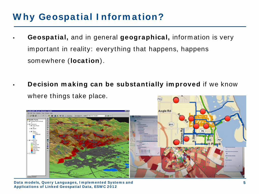
Why Geospatial Information?
• Geospatial, and in general geographical, information is very
important in reality: everything that happens, happens
somewhere (location).
• Decision making can be substantially improved if we know
where things take place.

Data models, Query Languages, Implemented Systems and Applications of Linked Geospatial Data, ESWC 2012
6
Geography
• From http://en.wikipedia.org/wiki/Geography
• Geography is the science that studies the lands,
the features, the inhabitants and the phenomena of
the Earth.
• From the Greek word γεωγραφία (geographia)
which means “describing the Earth”.
Data models, Query Languages, Implemented Systems and Applications of Linked Geospatial Data, ESWC 2012
7
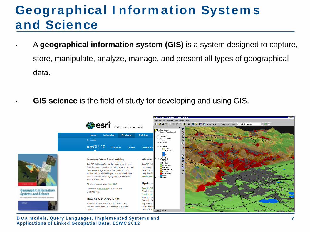
Geographical Information Systems and Science • A geographical information system (GIS) is a system designed to capture,
store, manipulate, analyze, manage, and present all types of geographical
data.
• GIS science is the field of study for developing and using GIS.

Data models, Query Languages, Implemented Systems and Applications of Linked Geospatial Data, ESWC 2012
8
Combining GIS Data for Decision Making

Data models, Query Languages, Implemented Systems and Applications of Linked Geospatial Data, ESWC 2012
9
Why this tutorial?
• Lots of geospatial data is available on the Web
today.
• Lots of public data coming out of open government
initiatives is geospatial.
• Lots of this public data is quickly being transformed
into linked data!
• People have started building applications utilizing
linked data.

Data models, Query Languages, Implemented Systems and Applications of Linked Geospatial Data, ESWC 2012
10
Geospatial data on the Web

Data models, Query Languages, Implemented Systems and Applications of Linked Geospatial Data, ESWC 2012
11
Open Government Data

Data models, Query Languages, Implemented Systems and Applications of Linked Geospatial Data, ESWC 2012
12
Linked geospatial data – Ordnance Survey

Data models, Query Languages, Implemented Systems and Applications of Linked Geospatial Data, ESWC 2012
13
Linked geospatial data – Research Funding Explorer

Data models, Query Languages, Implemented Systems and Applications of Linked Geospatial Data, ESWC 2012
14
Linked geospatial data – Spain

Data models, Query Languages, Implemented Systems and Applications of Linked Geospatial Data, ESWC 2012
15
Linked geospatial data – Open Street Map
Data models, Query Languages, Implemented Systems and Applications of Linked Geospatial Data, ESWC 2012
16
Conclusions
• Introduction • Why geospatial information?
• Geographical Information Science and
Systems
• Why this tutorial?
• Next topic: Background in geospatial
data modeling

Background in geospatial data modeling
Presenter: Manolis Koubarakis
Extended Semantic Web Conference 2012

Data models, Query Languages, Implemented Systems and Applications of Linked Geospatial Data, ESWC 2012
2
Outline
• Basic GIS concepts and terminology
• Abstract geographic space modeling
paradigms
• Concrete representations for the abstract
modeling paradigms
• Geospatial data standards

Data models, Query Languages, Implemented Systems and Applications of Linked Geospatial Data, ESWC 2012
3
Basic GIS Concepts and Terminology
• Theme: the information corresponding to a particular domain
that we want to model. A theme is a set of geographic
features.
• Example: the countries of Europe

Data models, Query Languages, Implemented Systems and Applications of Linked Geospatial Data, ESWC 2012
4
Basic GIS Concepts (cont’d)
• Geographic feature or geographic object: a domain entity
that can have various attributes that describe spatial and non-
spatial characteristics.
• Example: the country Greece with attributes
• Population
• Flag
• Capital
• Geographical area
• Coastline
• Bordering countries

Data models, Query Languages, Implemented Systems and Applications of Linked Geospatial Data, ESWC 2012
5
Basic GIS Concepts (cont’d)
• Geographic features can be atomic or complex.
• Example: According to the Kallikratis administrative reform of
2010, Greece consists of:
• 13 regions (e.g., Crete)
• Each region consists of perfectures (e.g., Heraklion)
• Each perfecture consists of municipalities (e.g., Dimos
Chersonisou)

Data models, Query Languages, Implemented Systems and Applications of Linked Geospatial Data, ESWC 2012
6
Basic GIS Concepts (cont’d)
• The spatial characteristics of a feature can involve:
• Geometric information (location in the underlying
geographic space, shape etc.)
• Topological information (containment, adjacency etc.).
Municipalities of the perfecture of Heraklion: 1. Dimos Irakliou 2. Dimos Archanon-Asterousion 3. Dimos Viannou 4. Dimos Gortynas 5. Dimos Maleviziou 6. Dimos Minoa Pediadas 7. Dimos Festou 8. Dimos Chersonisou
Data models, Query Languages, Implemented Systems and Applications of Linked Geospatial Data, ESWC 2012
7
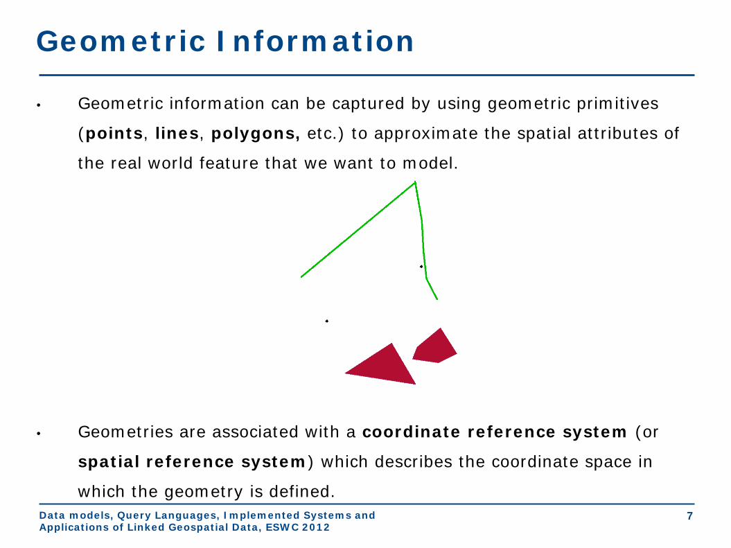
Geometric Information
• Geometric information can be captured by using geometric primitives
(points, lines, polygons, etc.) to approximate the spatial attributes of
the real world feature that we want to model.
• Geometries are associated with a coordinate reference system (or
spatial reference system) which describes the coordinate space in
which the geometry is defined.

Data models, Query Languages, Implemented Systems and Applications of Linked Geospatial Data, ESWC 2012
8
Topological Information
• Topological information is inherently qualitative and it is
expressed in terms of topological relations (e.g., containment,
adjacency, overlap etc.).
• Topological information can be derived from geometric
information or it might be captured by asserting explicitly the
topological relations between features.

Data models, Query Languages, Implemented Systems and Applications of Linked Geospatial Data, ESWC 2012
9
Topological Relations
• The study of topological relations has produced
a lot of interesting results by researchers in:
• GIS
• Spatial databases
• Artificial Intelligence (qualitative reasoning
and knowledge representation)
Data models, Query Languages, Implemented Systems and Applications of Linked Geospatial Data, ESWC 2012
10
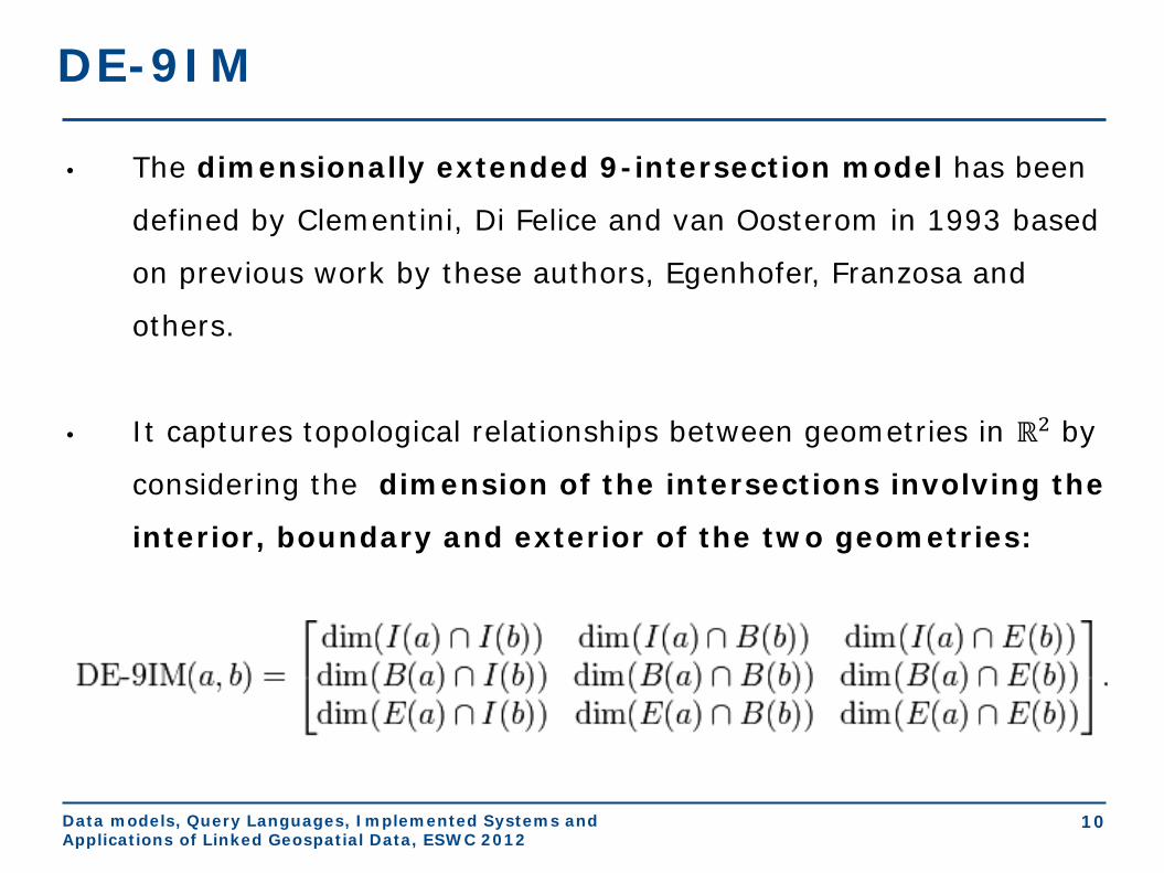
DE-9IM
• The dimensionally extended 9-intersection model has been
defined by Clementini, Di Felice and van Oosterom in 1993 based
on previous work by these authors, Egenhofer, Franzosa and
others.
• It captures topological relationships between geometries in ℝ2 by
considering the dimension of the intersections involving the
interior, boundary and exterior of the two geometries:
Data models, Query Languages, Implemented Systems and Applications of Linked Geospatial Data, ESWC 2012
11
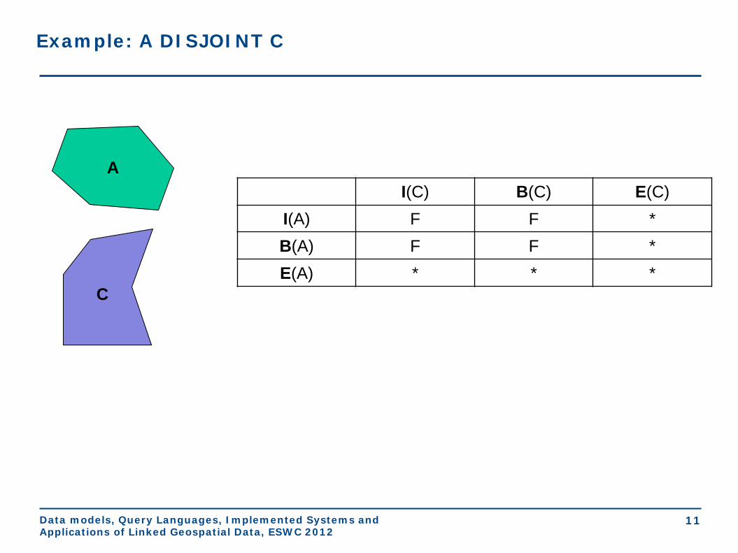
Example: A DISJOINT C
I(C) B(C) E(C) I(A) F F * B(A) F F * E(A) * * *
A
C

Data models, Query Languages, Implemented Systems and Applications of Linked Geospatial Data, ESWC 2012
12
Example: A WITHIN C
I(C) B(C) E(C) I(A) T * F B(A) * * F E(A) * * *
C
A

Data models, Query Languages, Implemented Systems and Applications of Linked Geospatial Data, ESWC 2012
13
The RCC-8 Calculus (Randell et al., 1991)
• Eight JEPD binary relations that can be all
defined in terms of a single primitive
(connection of two regions).
Data models, Query Languages, Implemented Systems and Applications of Linked Geospatial Data, ESWC 2012
14
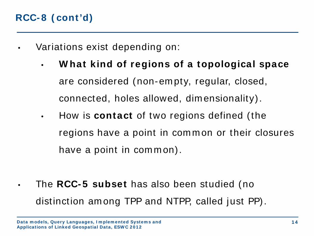
RCC-8 (cont’d)
• Variations exist depending on:
• What kind of regions of a topological space
are considered (non-empty, regular, closed,
connected, holes allowed, dimensionality).
• How is contact of two regions defined (the
regions have a point in common or their closures
have a point in common).
• The RCC-5 subset has also been studied (no
distinction among TPP and NTPP, called just PP).

Data models, Query Languages, Implemented Systems and Applications of Linked Geospatial Data, ESWC 2012
15
More Qualitative Spatial Relations
• Orientation/Cardinal directions (left of, right of,
north of, south of, northeast of etc.)
• Distance (close to, far from etc.). This information
can also be quantitative.

Data models, Query Languages, Implemented Systems and Applications of Linked Geospatial Data, ESWC 2012
16
Coordinate Systems
• Coordinate: one of n scalar values that determines the position
of a point in an n-dimensional space.
• Coordinate system: a set of mathematical rules for specifying
how coordinates are to be assigned to points.
• Example: the Cartesian coordinate system
Data models, Query Languages, Implemented Systems and Applications of Linked Geospatial Data, ESWC 2012
17
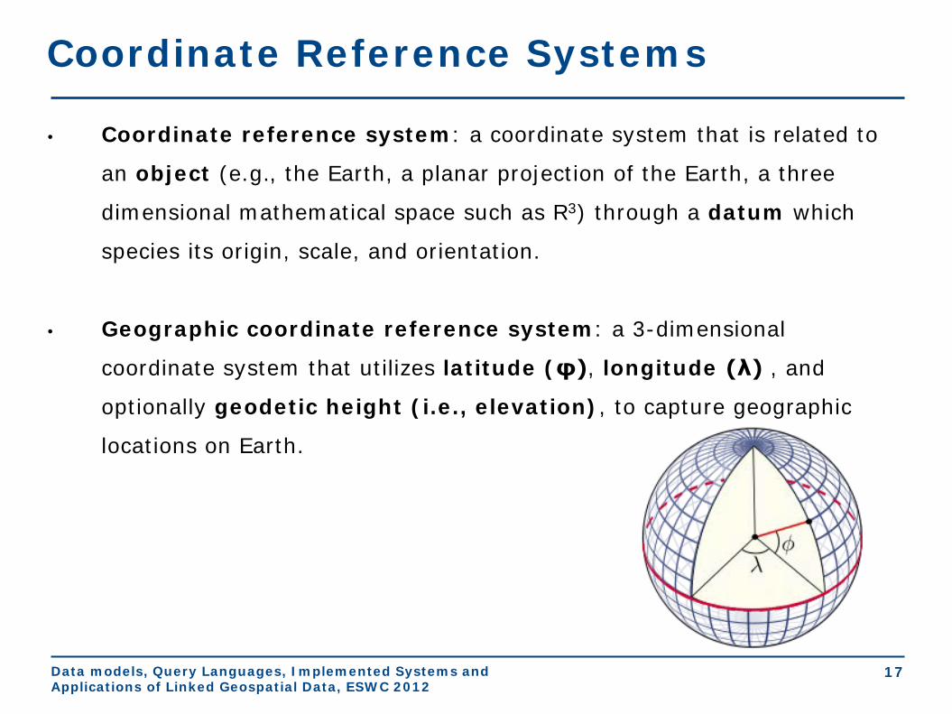
Coordinate Reference Systems
• Coordinate reference system: a coordinate system that is related to
an object (e.g., the Earth, a planar projection of the Earth, a three
dimensional mathematical space such as R3) through a datum which
species its origin, scale, and orientation.
• Geographic coordinate reference system: a 3-dimensional
coordinate system that utilizes latitude (φ), longitude (λ) , and
optionally geodetic height (i.e., elevation), to capture geographic
locations on Earth.

Data models, Query Languages, Implemented Systems and Applications of Linked Geospatial Data, ESWC 2012
18
The World Geodetic System
• The World Geodetic System (WGS) is the most well-known
geographic coordinate reference system and its latest revision is
WGS84.
• Applications: cartography, geodesy, navigation (GPS), etc.
Data models, Query Languages, Implemented Systems and Applications of Linked Geospatial Data, ESWC 2012
19
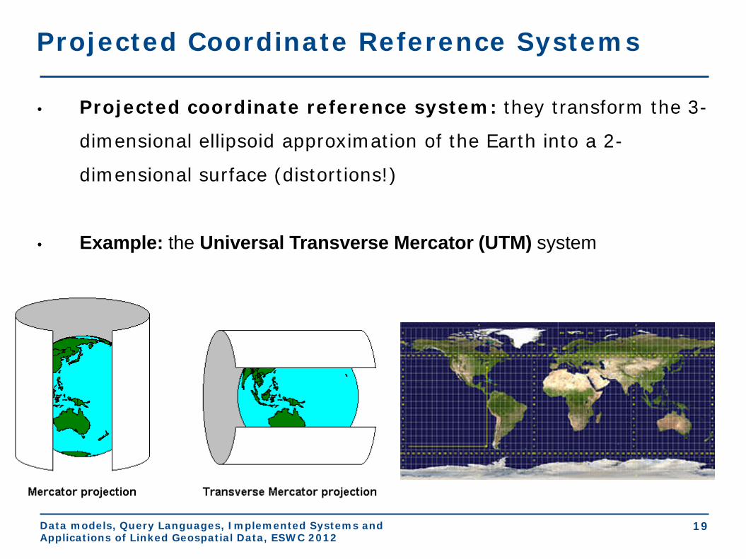
Projected Coordinate Reference Systems
• Projected coordinate reference system: they transform the 3-
dimensional ellipsoid approximation of the Earth into a 2-
dimensional surface (distortions!)
• Example: the Universal Transverse Mercator (UTM) system

Data models, Query Languages, Implemented Systems and Applications of Linked Geospatial Data, ESWC 2012
20
Coordinate Reference Systems (cont’d)
• There are well-known ways to translate between co-
ordinate reference systems.
• Various authorities maintain lists of coordinate
reference systems. See for example:
• OGC http://www.opengis.net/def/crs/
• European Petroleum Survey Group
http://www.epsg-registry.org/

Data models, Query Languages, Implemented Systems and Applications of Linked Geospatial Data, ESWC 2012
21
Abstract Modeling Paradigms: Feature-based
• Feature-based (or entity-based or object-based). This kind of
modeling is based on the concepts we presented already.
Data models, Query Languages, Implemented Systems and Applications of Linked Geospatial Data, ESWC 2012
22
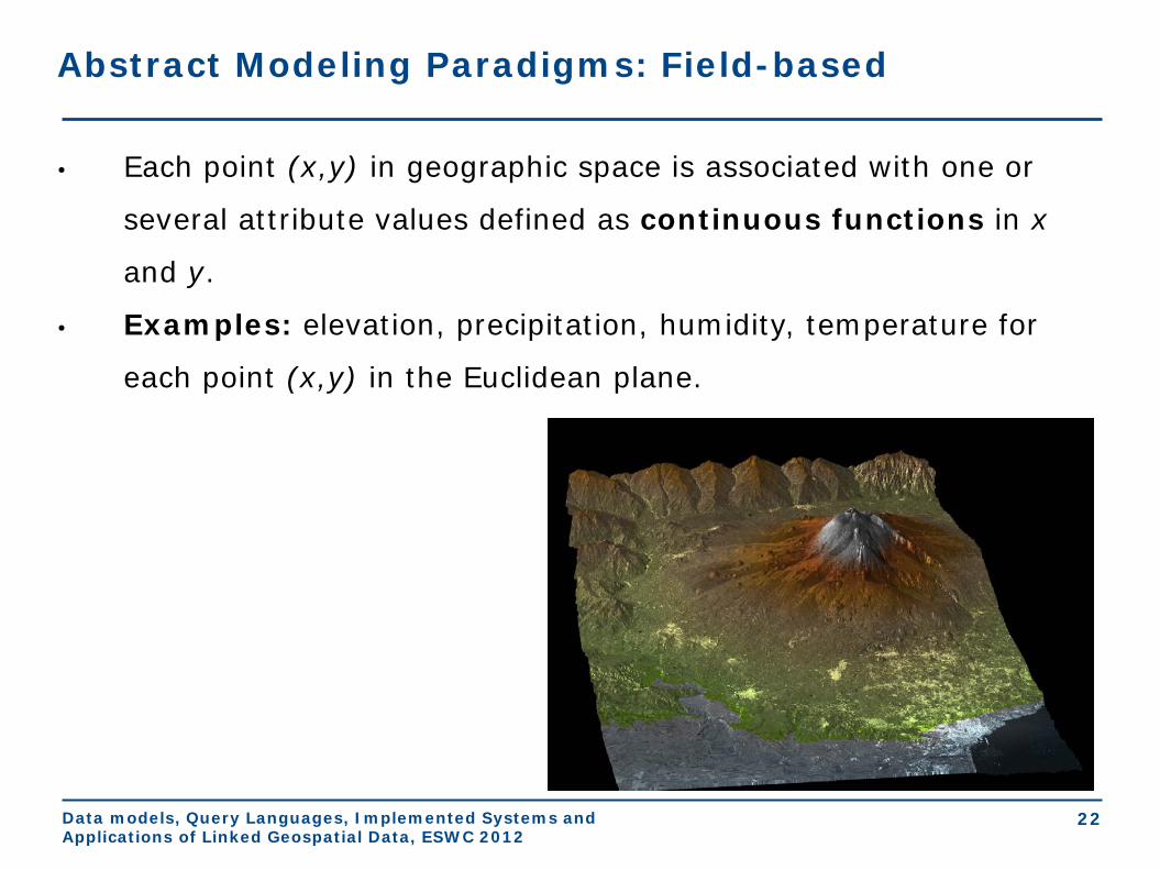
Abstract Modeling Paradigms: Field-based
• Each point (x,y) in geographic space is associated with one or
several attribute values defined as continuous functions in x
and y.
• Examples: elevation, precipitation, humidity, temperature for
each point (x,y) in the Euclidean plane.
Data models, Query Languages, Implemented Systems and Applications of Linked Geospatial Data, ESWC 2012
23
From Abstract Modeling to Concrete Representations
• Question: How do we represent the infinite objects of the
abstract representations (points, lines, fields etc.) by finite
means (in a computer)?
• Answers:
• Approximate the continuous space (e.g., ℝ2) by a discrete
one (ℤ2).
• Use special encodings

Data models, Query Languages, Implemented Systems and Applications of Linked Geospatial Data, ESWC 2012
24
Concrete Representations - Tessellation
• In this case a cellular decomposition of the plane (usually, a
grid) serves as a basis for representing the geometry.
• Example: raster representation
Data models, Query Languages, Implemented Systems and Applications of Linked Geospatial Data, ESWC 2012
25
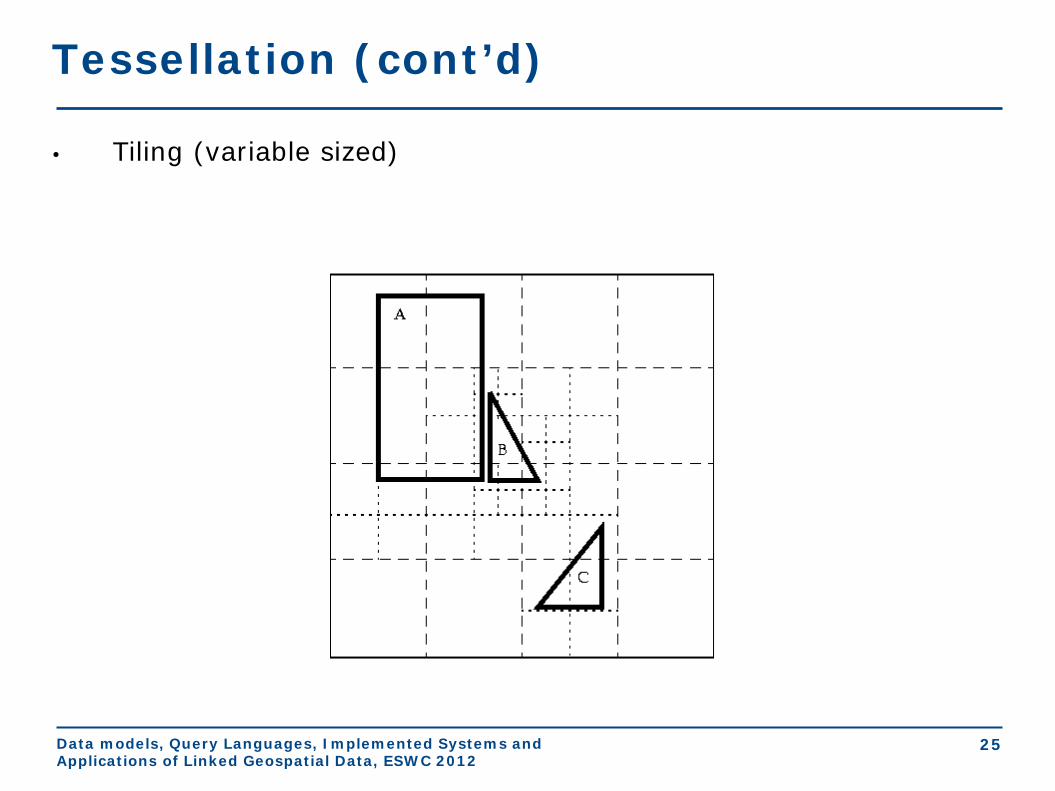
Tessellation (cont’d)
• Tiling (variable sized)
Data models, Query Languages, Implemented Systems and Applications of Linked Geospatial Data, ESWC 2012
26
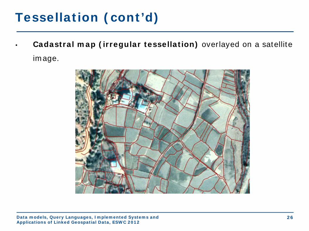
Tessellation (cont’d)
• Cadastral map (irregular tessellation) overlayed on a satellite
image.
Data models, Query Languages, Implemented Systems and Applications of Linked Geospatial Data, ESWC 2012
27
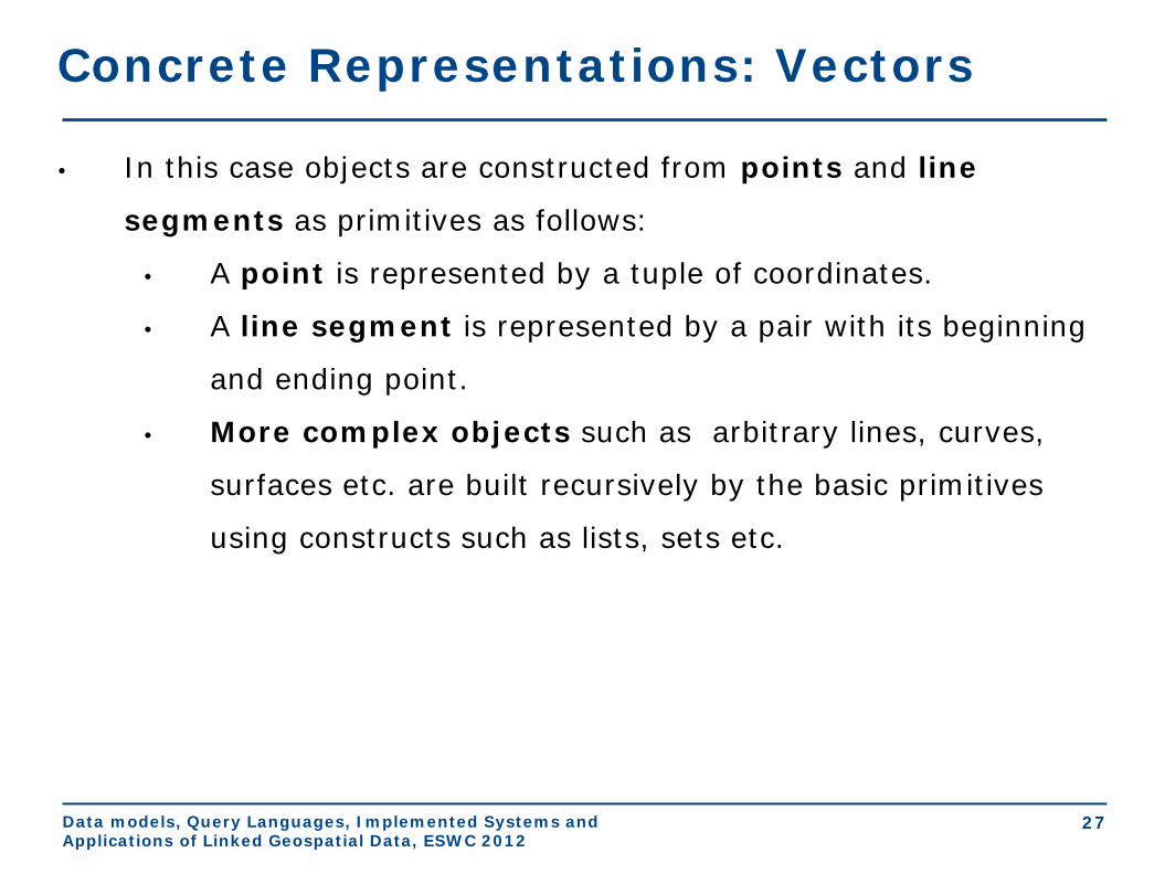
Concrete Representations: Vectors
• In this case objects are constructed from points and line
segments as primitives as follows:
• A point is represented by a tuple of coordinates.
• A line segment is represented by a pair with its beginning
and ending point.
• More complex objects such as arbitrary lines, curves,
surfaces etc. are built recursively by the basic primitives
using constructs such as lists, sets etc.
Data models, Query Languages, Implemented Systems and Applications of Linked Geospatial Data, ESWC 2012
28
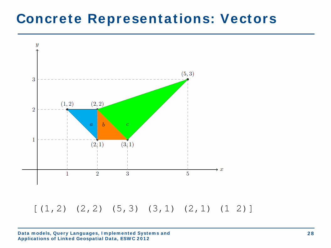
Concrete Representations: Vectors
[(1,2) (2,2) (5,3) (3,1) (2,1) (1 2)]

Data models, Query Languages, Implemented Systems and Applications of Linked Geospatial Data, ESWC 2012
29
Concrete Representations: Constraints
• In this case objects are represented by quantifier free formulas
in a constraint language (e.g., linear constraints).
)34
353()124()223( ≤−∧≤∧≥∨≥∧≥∧≤+∨≤∧≤∧≥+
xyxyyxxyyxxy

Data models, Query Languages, Implemented Systems and Applications of Linked Geospatial Data, ESWC 2012
30
Geospatial Data Standards
• The Open Geospatial Consortium (OGC) and the
International Organization for Standardization (ISO) have
developed many geospatial data standards that are in wide use
today. In this tutorial we will cover:
• Well-Known Text
• Geography Markup Language
• OpenGIS Simple Feature Access

Data models, Query Languages, Implemented Systems and Applications of Linked Geospatial Data, ESWC 2012
31
Well-Known Text (WKT)
• WKT is an OGC and ISO standard for representing geometries,
coordinate reference systems, and transformations between
coordinate reference systems.
• WKT is specified in OpenGIS Simple Feature Access - Part 1:
Common Architecture standard which is the same as the ISO 19125-1
standard. Download from
http://portal.opengeospatial.org/files/?artifact_id=25355 .
• This standard concentrates on simple features: features with all
spatial attributes described piecewise by a straight line or a
planar interpolation between sets of points.

Data models, Query Languages, Implemented Systems and Applications of Linked Geospatial Data, ESWC 2012
32
WKT Class Hierarchy

Data models, Query Languages, Implemented Systems and Applications of Linked Geospatial Data, ESWC 2012
33
Example
WKT representation: GeometryCollection( Point(5 35), LineString(3 10,5 25,15 35,20 37,30 40), Polygon((5 5,28 7,44 14,47 35,40 40,20 30,5 5), (28 29,14.5 11,26.5 12,37.5 20,28 29)) )

Data models, Query Languages, Implemented Systems and Applications of Linked Geospatial Data, ESWC 2012
34
Geography Markup Language (GML)
• GML is an XML-based encoding standard for the
representation of geospatial data.
• GML provides XML schemas for defining a variety of concepts:
geographic features, geometry, coordinate reference
systems, topology, time and units of measurement.
• GML profiles are subsets of GML that target particular
applications.
• Examples: Point Profile, GML Simple Features Profile etc.
Data models, Query Languages, Implemented Systems and Applications of Linked Geospatial Data, ESWC 2012
35
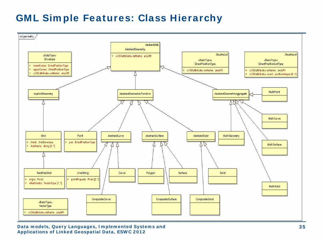
GML Simple Features: Class Hierarchy
Data models, Query Languages, Implemented Systems and Applications of Linked Geospatial Data, ESWC 2012
36
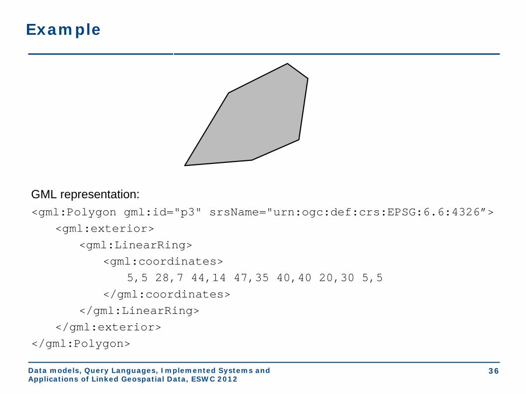
Example
GML representation: <gml:Polygon gml:id="p3" srsName="urn:ogc:def:crs:EPSG:6.6:4326”> <gml:exterior> <gml:LinearRing> <gml:coordinates> 5,5 28,7 44,14 47,35 40,40 20,30 5,5 </gml:coordinates> </gml:LinearRing> </gml:exterior> </gml:Polygon>

Data models, Query Languages, Implemented Systems and Applications of Linked Geospatial Data, ESWC 2012
37
OpenGIS Simple Features Access (cont’d)
• OGC has also specified a standard for the storage, retrieval,
query and update of sets of simple features using
relational DBMS and SQL.
• This standard is “OpenGIS Simple Feature Access - Part 2: SQL
Option” and it is the same as the ISO 19125-2 standard. Download from
http://portal.opengeospatial.org/files/?artifact_id=25354.
• Related standard: ISO 13249 SQL/MM - Part 3.

Data models, Query Languages, Implemented Systems and Applications of Linked Geospatial Data, ESWC 2012
38
OpenGIS Simple Features Access (cont’d)
• The standard covers two implementations options: (i) using only
the SQL predefined data types and (ii) using SQL with
geometry types.
• SQL with geometry types:
• We use the WKT geometry class hierarchy presented earlier
to define new geometric data types for SQL
• We define new SQL functions on those types.

Data models, Query Languages, Implemented Systems and Applications of Linked Geospatial Data, ESWC 2012
39
SQL with Geometry Types - Functions
• Functions that request or check properties of a geometry:
• ST Dimension(A:Geometry, B:Geometry):Integer
• ST_GeometryType(A:Geometry):Character Varying
• ST_AsText(A:Geometry): Character Large Object
• ST_AsBinary(A:Geometry): Binary Large Object
• ST_SRID(A:Geometry): Integer
• ST_IsEmpty(A:Geometry): Boolean
• ST_IsSimple(A:Geometry): Boolean

Data models, Query Languages, Implemented Systems and Applications of Linked Geospatial Data, ESWC 2012
40
SQL with Geometry Types – Functions (cont’d)
• Functions that test topological spatial relationships between two
geometries using the DE-9IM: • ST_Equals(A:Geometry, B:Geometry):Boolean
• ST_Disjoint(A:Geometry, B:Geometry):Boolean
• ST_Intersects(A:Geometry, B:Geometry):Boolean
• ST_Touches(A:Geometry, B:Geometry):Boolean
• ST_Crosses(A:Geometry, B:Geometry):Boolean
• ST_Within(A:Geometry, B:Geometry):Boolean
• ST_Contains(A:Geometry, B:Geometry):Boolean
• ST_Overlaps(A:Geometry, B:Geometry):Boolean
• ST_Relate(A:Geometry, B:Geometry, Matrix: Char(9)):Boolean

Data models, Query Languages, Implemented Systems and Applications of Linked Geospatial Data, ESWC 2012
41
DE-9IM Relation Definitions

Data models, Query Languages, Implemented Systems and Applications of Linked Geospatial Data, ESWC 2012
42
SQL with Geometry Types – Functions (cont’d)
• Functions for constructing new geometries out of existing
ones:
• ST Boundary(A:Geometry):Geometry
• ST_Envelope(A:Geometry):Geometry
• ST_Intersection(A:Geometry, B:Geometry):Geometry
• ST_Union(A:Geometry, B:Geometry):Geometry
• ST_Difference(A:Geometry, B:Geometry):Geometry
• ST_SymDifference(A:Geometry, B:Geometry):Geometry
• ST_Buffer(A:Geometry, distance:Double):Geometry

Data models, Query Languages, Implemented Systems and Applications of Linked Geospatial Data, ESWC 2012
43
Geospatial Relational DBMS
• The OpenGIS Simple Features Access Standard is today been
used in all relational DBMS with a geospatial extension.
• The abstract data type mechanism of the DBMS allows
the representation of all kinds of geospatial data types
supported by the standard.
• The query language (SQL) offers the functions of the
standard for querying data of these types.

Data models, Query Languages, Implemented Systems and Applications of Linked Geospatial Data, ESWC 2012
44
Conclusions
• Background in geospatial data modeling:
• Why geographical information?
• Geographical Information Science and Systems
• Geospatial data on the Web and linked geospatial data
• Abstract geographic space modeling paradigms: discrete
objects vs. continuous fields
• Concrete representations: tessellation vs. vectors vs.
constraints
• Geospatial data standards
• Next topic: Geospatial data in the Semantic Web

Geospatial data in the Semantic Web stSPARQL
Presenter: Kostis Kyzirakos
Extended Semantic Web Conference 2012
Data models, Query Languages, Implemented Systems and Applications of Linked Geospatial Data, ESWC 2012
2
Outline
• Main idea
• Early works
• The data model stRDF
• Examples of publicly available linked geospatial data
• The query language stSPARQL

How do we represent and query geospatial information in the Semantic Web?
Extend RDF to take into account the geospatial dimension. Extend SPARQL to query the new kinds of data.
Main idea
3 Data models, Query Languages, Implemented Systems and Applications of Linked Geospatial Data, ESWC 2012

Data models, Query Languages, Implemented Systems and Applications of Linked Geospatial Data, ESWC 2012
4
Early works
SPAUK (Kolas, 2007) • Geometric attributes of a resource are represented by:
• introducing a blank node for the geometry • specifying the geometry using GML vocabulary • associating the blank node with the resource
using GeoRSS vocabulary • Queries are expressed in the SPARQL query language
utilizing appropriate geometric vocabularies and ontologies (e.g., the topological relationships of RCC8).
• Introduces a new PREMISE clause in SPARQL to specify spatial geometries to be used in a query
• Use some form of the DESCRIBE query form of SPARQL for asking queries about geometries

Data models, Query Languages, Implemented Systems and Applications of Linked Geospatial Data, ESWC 2012
5
Early works
SPARQL-ST (Perry, 2008) • Assumes a particular upper ontology
expressed in RDFS for modeling theme, space and valid time.
• Spatial geometries in SPARQL-ST are specified by sets of RDF triples that give various details of the geometry.
• SPARQL-ST provides a set of built-in spatial conditions that can be used in SPATIAL FILTER clauses to constrain the geometries that are returned as answers to queries.

Data models, Query Languages, Implemented Systems and Applications of Linked Geospatial Data, ESWC 2012
6
stRDF and stSPARQL
• Similar approach to SPARQL-ST (theme, space and valid time can be represented)
• Linear constraints are used to represent geometries
• Constraints are represented using literals of an appropriate datatype
• Formal approach
• New version to be presented today uses OGC standards to represent and query geometries
(Koubarakis and Kyzirakos, 2010)

Data models, Query Languages, Implemented Systems and Applications of Linked Geospatial Data, ESWC 2012
7
Example

Data models, Query Languages, Implemented Systems and Applications of Linked Geospatial Data, ESWC 2012
8
Example with simplified geometries

Data models, Query Languages, Implemented Systems and Applications of Linked Geospatial Data, ESWC 2012
9
Example in stRDF
geonames:olympia geonames:name "Ancient Olympia";
owl:sameAs dbpedia:Olympia_Greece;
rdf:type dbpedia:Community .
Spatial literal
Spatial data type
geonames:olympia strdf:hasGeometry "POLYGON((21.5 18.5, 23.5 18.5, 23.5 21, 21.5 21, 21.5 18.5)); <http://www.opengis.net/def/crs/EPSG/0/4326>"^^ strdf:WKT .

Data models, Query Languages, Implemented Systems and Applications of Linked Geospatial Data, ESWC 2012
10
strdf:geometry rdf:type rdfs:Datatype;
rdfs:subClassOf rdfs:Literal.
strdf:WKT rdf:type rdfs:Datatype;
rdfs:subClassOf rdfs:Literal;
rdfs:subClassOf strdf:geometry.
strdf:GML rdf:type rdfs:Datatype;
rdfs:subClassOf rdfs:Literal;
rdfs:subClassOf strdf:geometry.
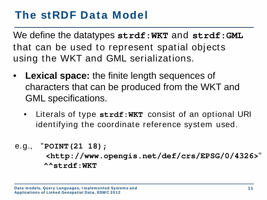
The stRDF Data Model
Data models, Query Languages, Implemented Systems and Applications of Linked Geospatial Data, ESWC 2012
11
We define the datatypes strdf:WKT and strdf:GML that can be used to represent spatial objects using the WKT and GML serializations.
• Lexical space: the finite length sequences of characters that can be produced from the WKT and GML specifications. • Literals of type strdf:WKT consist of an optional URI
identifying the coordinate reference system used.
The stRDF Data Model
e.g., "POINT(21 18); <http://www.opengis.net/def/crs/EPSG/0/4326>" ^^strdf:WKT

Data models, Query Languages, Implemented Systems and Applications of Linked Geospatial Data, ESWC 2012
12
• Value space: the set of geometry values defined in the WKT and GML standard that is a subset of the powerset of ℝ2 and ℝ3.
• Lexical-to-value mapping: takes into account that the vector-based model is used for representing geometries.
• The datatype strdf:geometry is the union of the datatypes strdf:WKT and strdf:GML.
The stRDF Data Model

Data models, Query Languages, Implemented Systems and Applications of Linked Geospatial Data, ESWC 2012
13
Examples of publicly available linked geospatial data
• Geonames
• Greek Administrative Geography
• Corine Land Use / Land Cover
• Burnt Area Products
Data models, Query Languages, Implemented Systems and Applications of Linked Geospatial Data, ESWC 2012
14
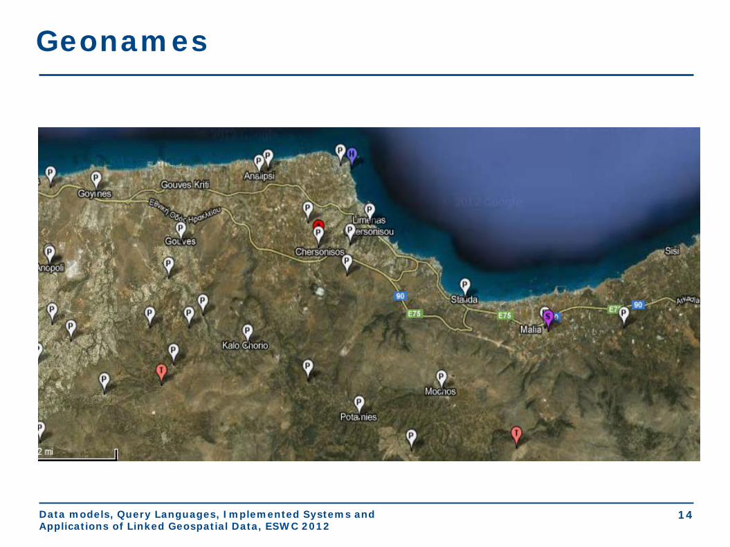
Geonames

Data models, Query Languages, Implemented Systems and Applications of Linked Geospatial Data, ESWC 2012
Geonames
geonames:260001 rdf:type gn:Feature; gn:name "Hersonissos"; gn:officialName "Χερσόνησος"@el; gn:countryCode "GR"; wgs84_pos:lat "35.30903"; wgs84_pos:long "25.37112"; gn:parentCountry geonames:390903. geonames:390903 gn:name "Greece".
Data models, Query Languages, Implemented Systems and Applications of Linked Geospatial Data, ESWC 2012
16
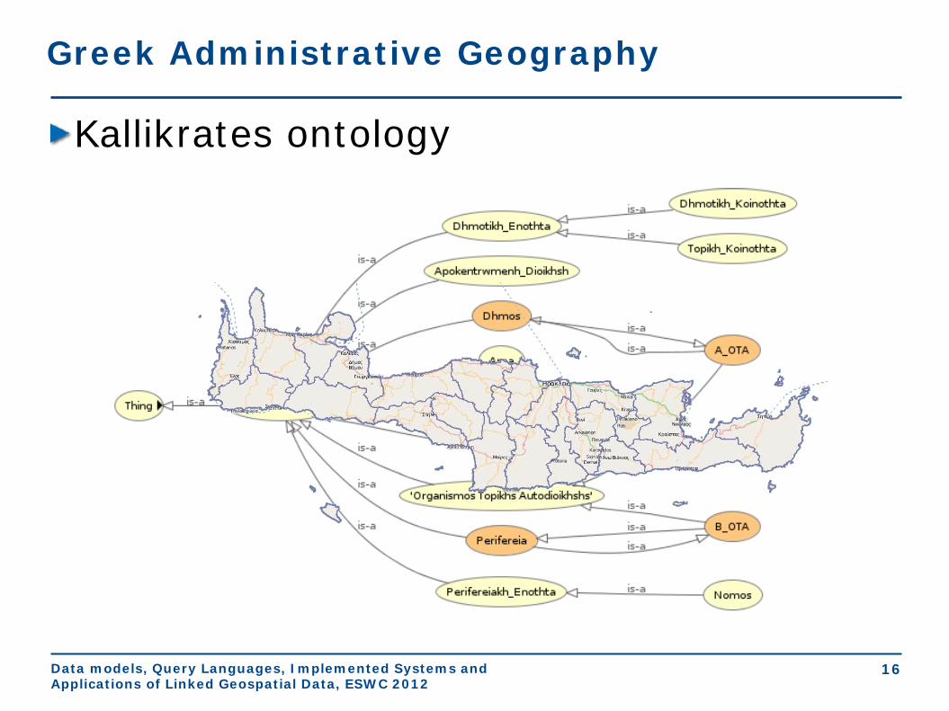
Greek Administrative Geography
Kallikrates ontology
Data models, Query Languages, Implemented Systems and Applications of Linked Geospatial Data, ESWC 2012
17
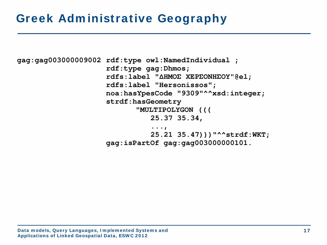
Greek Administrative Geography
gag:gag003000009002 rdf:type owl:NamedIndividual ; rdf:type gag:Dhmos; rdfs:label "ΔΗΜΟΣ ΧΕΡΣΟΝΗΣΟΥ"@el; rdfs:label "Hersonissos"; noa:hasYpesCode "9309"^^xsd:integer; strdf:hasGeometry "MULTIPOLYGON ((( 25.37 35.34, ..., 25.21 35.47)))"^^strdf:WKT; gag:isPartOf gag:gag003000000101.

Data models, Query Languages, Implemented Systems and Applications of Linked Geospatial Data, ESWC 2012
18
Corine Land Use / Land Cover

Data models, Query Languages, Implemented Systems and Applications of Linked Geospatial Data, ESWC 2012
19
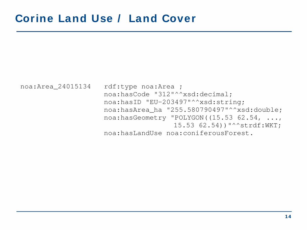
Corine Land Use / Land Cover
noa:Area_24015134 rdf:type noa:Area ; noa:hasCode "312"^^xsd:decimal; noa:hasID "EU-203497"^^xsd:string; noa:hasArea_ha "255.580790497"^^xsd:double; strdf:hasGeometry "POLYGON((15.53 62.54, ..., 15.53 62.54))"^^strdf:WKT; noa:hasLandUse noa:coniferousForest

Data models, Query Languages, Implemented Systems and Applications of Linked Geospatial Data, ESWC 2012
20
Burnt Area Products

Data models, Query Languages, Implemented Systems and Applications of Linked Geospatial Data, ESWC 2012
21
Burnt Area Products
noa:ba_15 rdf:type noa:BurntArea; noa:isDerivedFromSatellite "Landsat"^^xsd:string; noa:hasAcquisitionTime "2010-08-24T13:00:00"^^xsd:dateTime; strdf:hasGeometry "MULTIPOLYGON(((393801.42 4198827.92, ..., 393008 424131))); <http://www.opengis.net/def/crs/ EPSG/0/2100>"^^strdf:WKT.

Data models, Query Languages, Implemented Systems and Applications of Linked Geospatial Data, ESWC 2012
22
stSPARQL: Geospatial SPARQL 1.1
We define a SPARQL extension function for each function defined in the OpenGIS Simple Features Access standard Basic functions
• Get a property of a geometry xsd:int strdf:Dimension(strdf:geometry A) xsd:string strdf:GeometryType(strdf:geometry A) xsd:int strdf:SRID(strdf:geometry A)
• Get the desired representation of a geometry xsd:string strdf:AsText(strdf:geometry A) strdf:wkb strdf:AsBinary(strdf:geometry A) xsd:string strdf:AsGML(strdf:geometry A)
• Test whether a certain condition holds xsd:boolean strdf:IsEmpty(strdf:geometry A) xsd:boolean strdf:IsSimple(strdf:geometry A)

Data models, Query Languages, Implemented Systems and Applications of Linked Geospatial Data, ESWC 2012
23
stSPARQL: Geospatial SPARQL 1.1 Functions for testing topological spatial relationships • OGC Simple Features Access
xsd:boolean strdf:equals(strdf:geometry A, strdf:geometry B) xsd:boolean strdf:disjoint(strdf:geometry A, strdf:geometry B) xsd:boolean strdf:intersects(strdf:geometry A, strdf:geometry B) xsd:boolean strdf:touches(strdf:geometry A, strdf:geometry B) xsd:boolean strdf:crosses(strdf:geometry A, strdf:geometry B) xsd:boolean strdf:within(strdf:geometry A, strdf:geometry B) xsd:boolean strdf:contains(strdf:geometry A, strdf:geometry B) xsd:boolean strdf:overlaps(strdf:geometry A, strdf:geometry B) xsd:boolean strdf:relate(strdf:geometry A, strdf:geometry B, xsd:string intersectionPatternMatrix)
• Egenhofer
• RCC8
Data models, Query Languages, Implemented Systems and Applications of Linked Geospatial Data, ESWC 2012
24
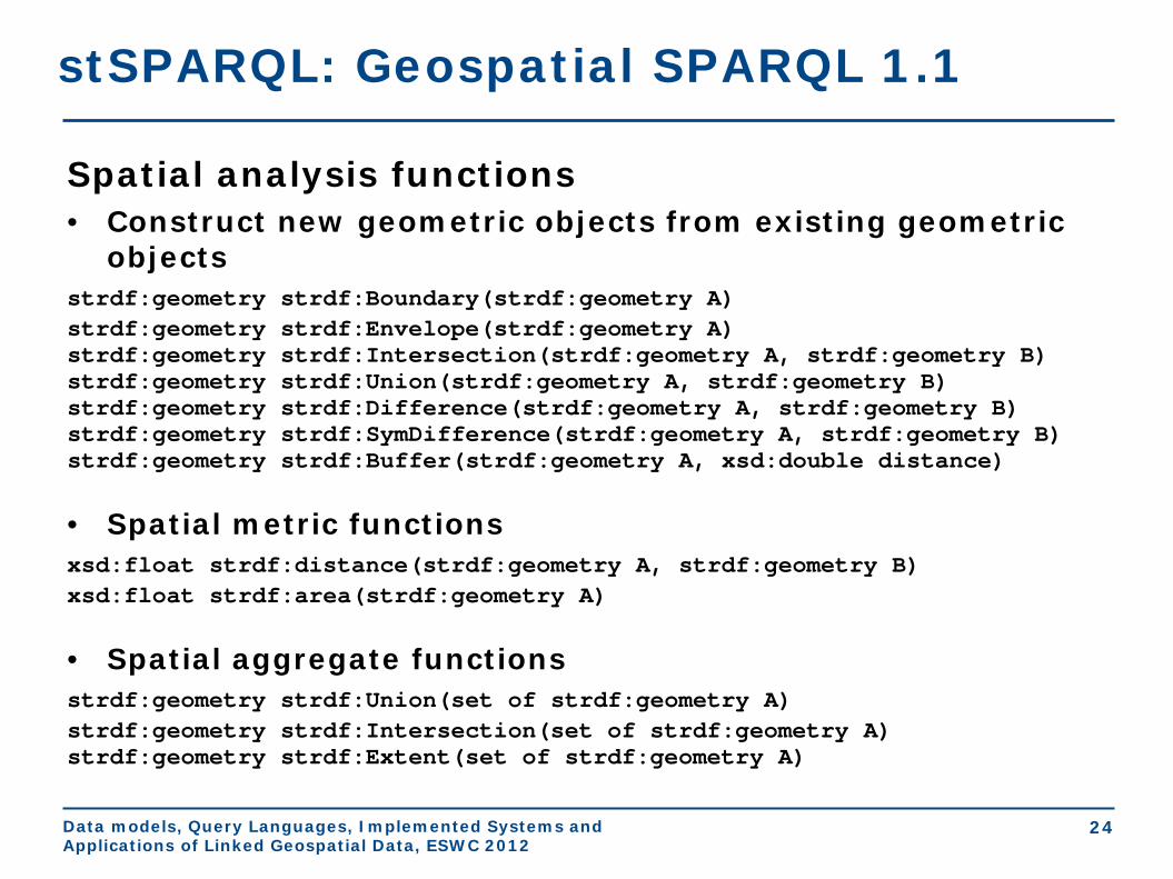
stSPARQL: Geospatial SPARQL 1.1
Spatial analysis functions • Construct new geometric objects from existing geometric
objects strdf:geometry strdf:Boundary(strdf:geometry A) strdf:geometry strdf:Envelope(strdf:geometry A) strdf:geometry strdf:Intersection(strdf:geometry A, strdf:geometry B) strdf:geometry strdf:Union(strdf:geometry A, strdf:geometry B) strdf:geometry strdf:Difference(strdf:geometry A, strdf:geometry B) strdf:geometry strdf:SymDifference(strdf:geometry A, strdf:geometry B) strdf:geometry strdf:Buffer(strdf:geometry A, xsd:double distance) • Spatial metric functions xsd:float strdf:distance(strdf:geometry A, strdf:geometry B) xsd:float strdf:area(strdf:geometry A) • Spatial aggregate functions strdf:geometry strdf:Union(set of strdf:geometry A) strdf:geometry strdf:Intersection(set of strdf:geometry A) strdf:geometry strdf:Extent(set of strdf:geometry A)

Data models, Query Languages, Implemented Systems and Applications of Linked Geospatial Data, ESWC 2012
25
stSPARQL: Geospatial SPARQL 1.1 Select clause
• Construction of new geometries (e.g., strdf:buffer(?geo, 0.1))
• Spatial aggregate functions (e.g., strdf:union(?geo))
• Metric functions (e.g., strdf:area(?geo))
Filter clause
• Functions for testing topological spatial relationships between spatial terms
(e.g., strdf:contains(?G1, strdf:union(?G2, ?G3)))
• Numeric expressions involving spatial metric functions
(e.g., strdf:area(?G1) ≤ 2*strdf:area(?G2)+1)
• Boolean combinations
Having clause
• Boolean expressions involving spatial aggregate functions and spatial
metric functions or functions testing for topological relationships between
spatial terms (e.g., strdf:area(strdf:union(?geo))>1)

Data models, Query Languages, Implemented Systems and Applications of Linked Geospatial Data, ESWC 2012
26
stSPARQL: An example (1/3)
SELECT ?name WHERE { ?community rdf:type dbpedia:Community; geonames:name ?name; strdf:hasGeometry ?comGeom. ?ba rdf:type noa:BurntArea; strdf:hasGeometry ?baGeom. FILTER(strdf:overlap(?comGeom,?baGeom)) }
Spatial Function
Return the names of communities that have been affected by fires
Data models, Query Languages, Implemented Systems and Applications of Linked Geospatial Data, ESWC 2012
27
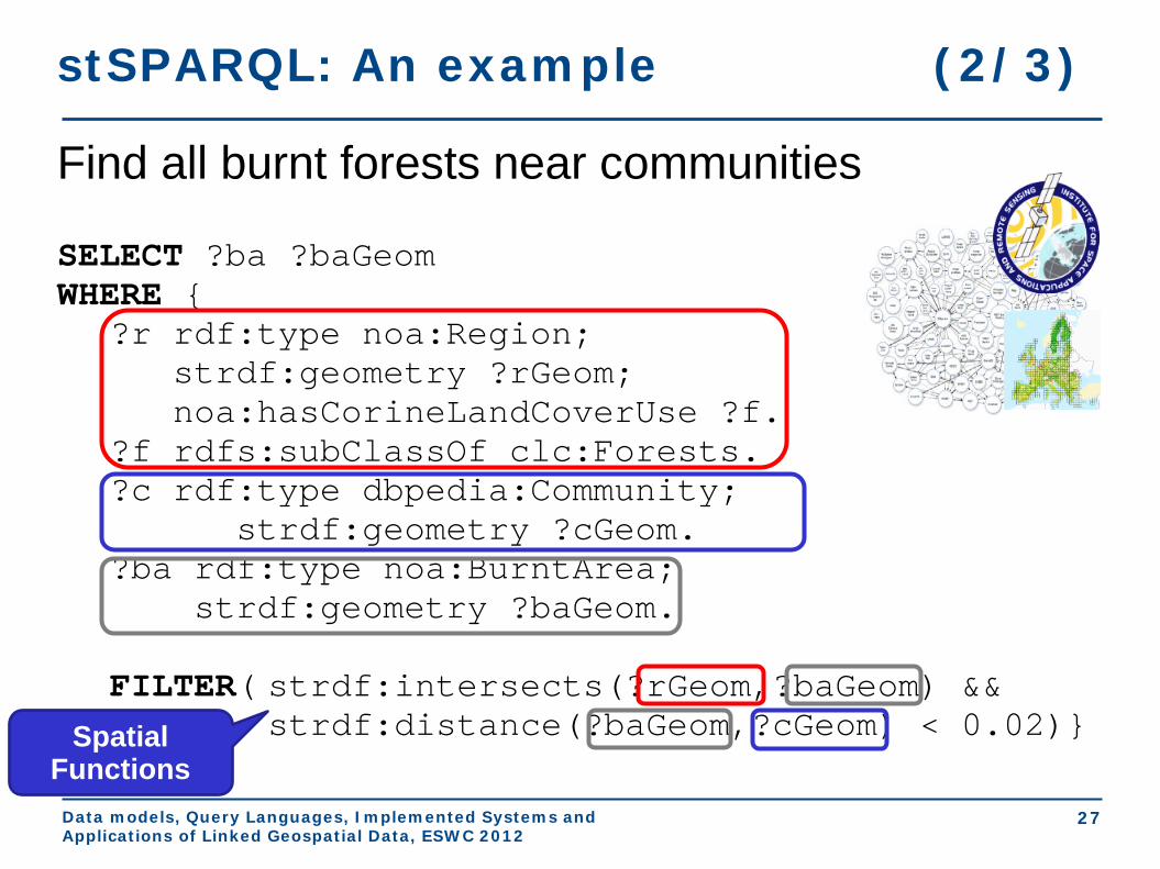
stSPARQL: An example (2/3)
SELECT ?ba ?baGeom WHERE { ?r rdf:type noa:Region; strdf:geometry ?rGeom; noa:hasCorineLandCoverUse ?f. ?f rdfs:subClassOf clc:Forests. ?c rdf:type dbpedia:Community; strdf:geometry ?cGeom. ?ba rdf:type noa:BurntArea; strdf:geometry ?baGeom. FILTER( strdf:intersects(?rGeom,?baGeom) && strdf:distance(?baGeom,?cGeom) < 0.02)} Spatial
Functions
Find all burnt forests near communities

Data models, Query Languages, Implemented Systems and Applications of Linked Geospatial Data, ESWC 2012
28
SELECT ?burntArea (strdf:intersection(?baGeom, strdf:union(?tGeom)) AS ?burntForest) WHERE { ?burntArea rdf:type noa:BurntArea; strdf:hasGeometry ?baGeom. ?forest rdf:type noa:Area; noa:hasLandCover noa:coniferousForest; strdf:hasGeometry ?fGeom.
FILTER(strdf:intersects(?baGeom,?fGeom)) } GROUP BY ?burntArea ?baGeom Spatial
Function
Isolate the parts of the burnt areas that lie in coniferous forests.
stSPARQL: An example (3/3)
Spatial Aggregate

Data models, Query Languages, Implemented Systems and Applications of Linked Geospatial Data, ESWC 2012
29
Conclusions
• Geospatial data in the Semantic Web - stSPARQL
• Early works
• The data model stRDF
• Examples of publicly available linked geospatial
data
• The query language stSPARQL
• Next topic: The query language GeoSPARQL

Geospatial data in the Semantic Web GeoSPARQL
Presenter: Kostis Kyzirakos
Extended Semantic Web Conference 2012

Data models, Query Languages, Implemented Systems and Applications of Linked Geospatial Data, ESWC 2012
2
GeoSPARQL
GeoSPARQL is a recently completed OGC standard (Perry and Herring, 2012).
Functionalities similar to stSPARQL:
• Geometries are represented using literals similarly to stSPARQL.
• The same families of functions are offered for querying geometries.
Functionalities beyond stSPARQL:
• Topological relations can now be asserted as well so that reasoning and querying on them is possible.
Data models, Query Languages, Implemented Systems and Applications of Linked Geospatial Data, ESWC 2012
3
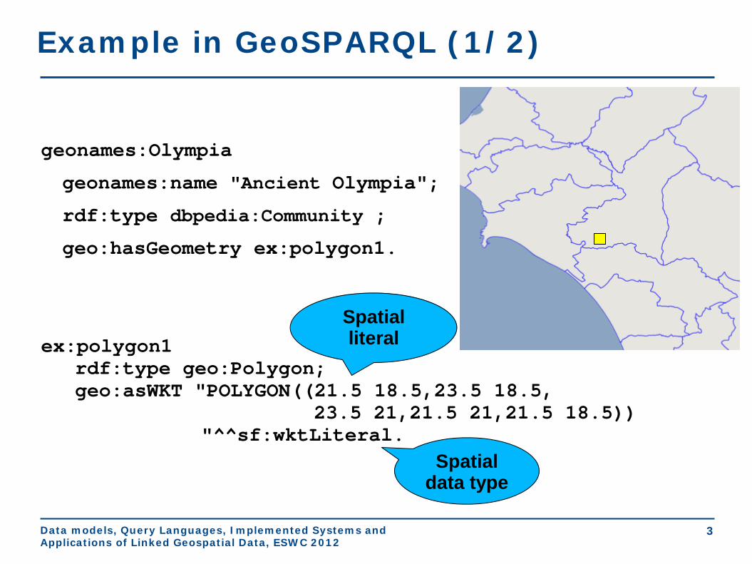
Example in GeoSPARQL (1/2)
geonames:Olympia
geonames:name "Ancient Olympia";
rdf:type dbpedia:Community ;
geo:hasGeometry ex:polygon1.
ex:polygon1 rdf:type geo:Polygon; geo:asWKT "POLYGON((21.5 18.5,23.5 18.5, 23.5 21,21.5 21,21.5 18.5)) "^^sf:wktLiteral.
Spatial data type
Spatial literal

Data models, Query Languages, Implemented Systems and Applications of Linked Geospatial Data, ESWC 2012
4
Example in GeoSPARQL (2/2)
gag:OlympiaMunicipality
rdf:type gag:Municipality;
rdfs:label "ΔΗΜΟΣ ΑΡΧΑΙΑΣ ΟΛΥΜΠΙΑΣ"@el;
rdfs:label "Municipality of Ancient Olympia".
Asserted topological
relation
gag:olympiaMunicipality geo:sfContains geonames:olympia .

Data models, Query Languages, Implemented Systems and Applications of Linked Geospatial Data, ESWC 2012
GeoSPARQL Components
Core
Topology Vocabulary Extension
- relation family
Geometry Extension - serialization - version
Geometry Topology Extension
- serialization - version - relation family
Query Rewrite Extension
- serialization - version - relation family
RDFS Entailment Extension
- serialization - version - relation family
Parameters • Serialization
• WKT • GML
• Relation Family • Simple
Features • RCC8 • Egenhofer

Data models, Query Languages, Implemented Systems and Applications of Linked Geospatial Data, ESWC 2012
6
GeoSPARQL Core
Defines top level classes that provides users with vocabulary for modeling geospatial information. • The class geo:SpatialObject is the
top class and has as instances everything that can have a spatial representation.
• The class geo:Feature is a subclass of geo:SpatialObject. Feature is a domain entity that can have various attributes that describe spatial and non-spatial characteristics.
Data models, Query Languages, Implemented Systems and Applications of Linked Geospatial Data, ESWC 2012
7
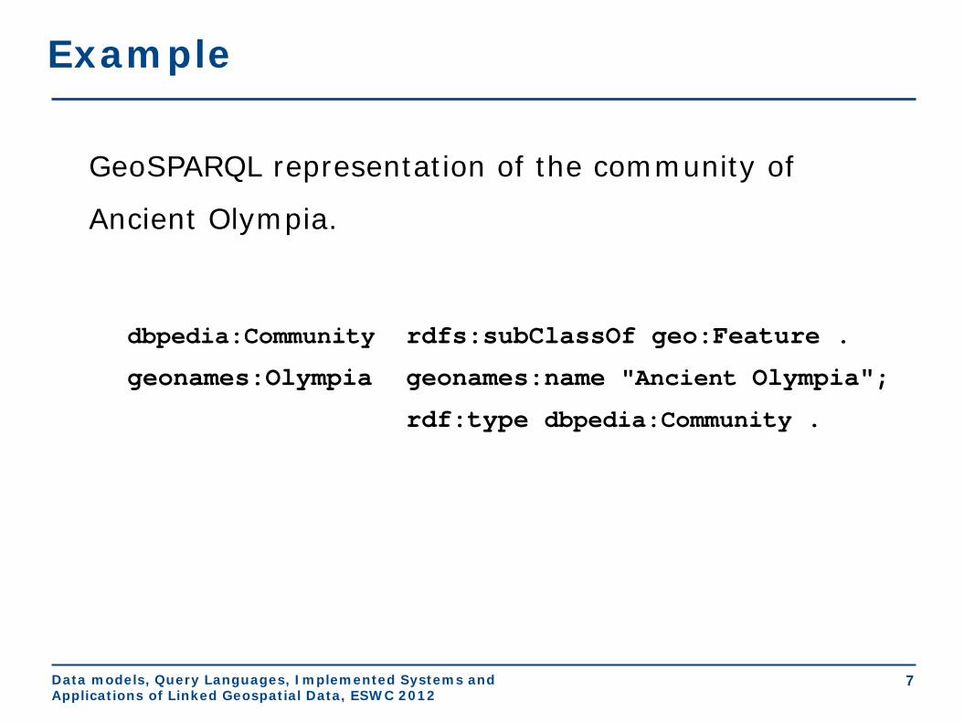
Example
GeoSPARQL representation of the community of
Ancient Olympia.
dbpedia:Community rdfs:subClassOf geo:Feature .
geonames:Olympia geonames:name "Ancient Olympia";
rdf:type dbpedia:Community .

Data models, Query Languages, Implemented Systems and Applications of Linked Geospatial Data, ESWC 2012
8
GeoSPARQL Geometry Extension
Provides vocabulary for asserting and querying information about geometries. • The class geo:Geometry is the top class and has as
instances everything that can have a spatial representation.

Data models, Query Languages, Implemented Systems and Applications of Linked Geospatial Data, ESWC 2012
9
Example
GeoSPARQL representation of the community of Ancient
Olympia.
dbpedia:Community rdfs:subClassOf geo:Feature .
geonames:Olympia geonames:name "Ancient Olympia";
rdf:type dbpedia:Community .
geonames:Olympia geo:hasGeometry ex:polygon1. ex:polygon1 rdf:type geo:Polygon; geo:isEmpty "false"^^xsd:boolean; geo:asWKT "POLYGON((21.5 18.5, 23.5 18.5, 23.5 21, 21.5 21, 21.5 18.5))"^^sf:wktLiteral.
Spatial data type

Data models, Query Languages, Implemented Systems and Applications of Linked Geospatial Data, ESWC 2012
10
GeoSPARQL Geometry Extension
Spatial analysis functions • Construct new geometric objects from existing geometric
objects geof:boundary (geom1: ogc:geomLiteral): ogc:geomLiteral geof:envelope (geom1: ogc:geomLiteral): ogc:geomLiteral geof:intersection( geom1: ogc:geomLiteral, geom2: ogc:geomLiteral): ogc:geomLiteral geof:union ( geom1: ogc:geomLiteral, geom2: ogc:geomLiteral): ogc:geomLiteral geof:difference ( geom1: ogc:geomLiteral, geom2: ogc:geomLiteral): ogc:geomLiteral geof:symDifference ( geom1: ogc:geomLiteral, geom2:ogc:geomLiteral): ogc:geomLiteral geof:buffer(geom: ogc:geomLiteral, radius: xsd:double, units: xsd:anyURI): ogc:geomLiteral geof:convexHull(geom1: ogc:geomLiteral): ogc:geomLiteral • Spatial metric functions geof:distance(geom1: ogc:geomLiteral, geom2: ogc:geomLiteral, units: xsd:anyURI): xsd:double

Data models, Query Languages, Implemented Systems and Applications of Linked Geospatial Data, ESWC 2012
11
GeoSPARQL: An example
SELECT ?name WHERE { ?c rdf:type geo:Feature; rdf:type dbpedia:Community; geonames:name ?name; geo:hasGeometry ?cPoly. ?cPoly geo:asWKT ?cGeom. ?ba rdf:type geo:Feature; rdf:type noa:BurntArea; geo:hasGeometry ?baPoly. ?baPoly geo:asWKT ?baGeom. FILTER(geof:distance(?cGeom,?baGeom, uom:metre) < 1500)}
Spatial Metric Function
Return the names of communities that are near burnt areas

Data models, Query Languages, Implemented Systems and Applications of Linked Geospatial Data, ESWC 2012
12
GeoSPARQL Topology Vocabulary Extension
• The extension is parameterized by the family of topological relations supported.
• Topological relations for simple features
• The Egenhofer relations e.g., geo:ehMeet
• The RCC8 relations e.g., geo:rcc8ec

Data models, Query Languages, Implemented Systems and Applications of Linked Geospatial Data, ESWC 2012
geonames:Olympia rdf:type dbpedia:Community; geonames:name "Ancient Olympia".
gag:OlympiaBorough rdf:type gag:Borough; rdfs:label "Borough of Ancient Olympia".
gag:OlympiaMunicipality rdf:type gag:Municipality; rdfs:label "Municipality of Ancient Olympia".
gag:OlympiaBorough geo:sfContains geonames:Olympia .
gag:OlympiaMunicipality geo:sfContains geonames:OlympiaBorough.
13
Example
Asserted topological
relation
Data models, Query Languages, Implemented Systems and Applications of Linked Geospatial Data, ESWC 2012
14
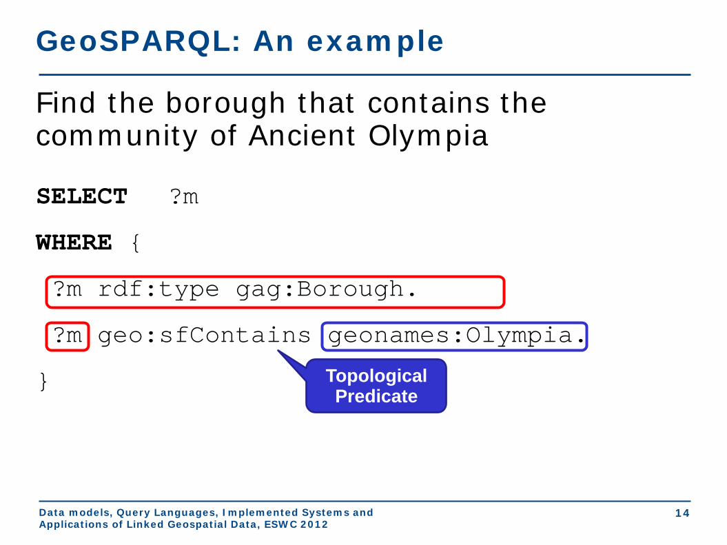
GeoSPARQL: An example
SELECT ?m
WHERE {
?m rdf:type gag:Borough.
?m geo:sfContains geonames:Olympia.
}
Find the borough that contains the community of Ancient Olympia
Topological Predicate
Data models, Query Languages, Implemented Systems and Applications of Linked Geospatial Data, ESWC 2012
15
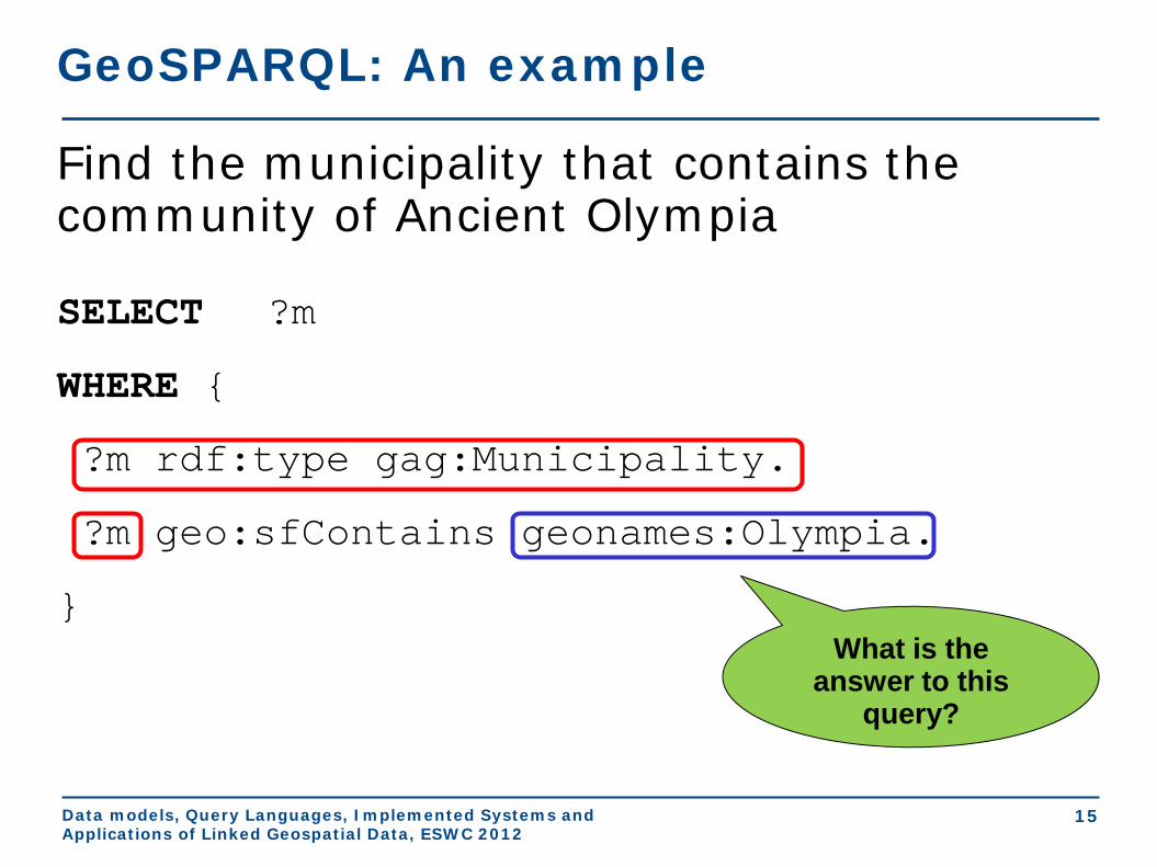
GeoSPARQL: An example
SELECT ?m
WHERE {
?m rdf:type gag:Municipality.
?m geo:sfContains geonames:Olympia.
}
Find the municipality that contains the community of Ancient Olympia
What is the answer to this
query?

Data models, Query Languages, Implemented Systems and Applications of Linked Geospatial Data, ESWC 2012
16
Example (cont’d)
The answer to the previous query is
?m = gag:OlympiaMunicipality
GeoSPARQL does not tell you how to compute this answer which needs reasoning about the transitivity of relation geo:sfContains. Options:
• Use rules • Use constraint-based techniques

Data models, Query Languages, Implemented Systems and Applications of Linked Geospatial Data, ESWC 2012
17
GeoSPARQL Geometry Topology Extension
• Defines Boolean functions that correspond to each of the topological relations of the topology vocabulary extension:
• OGC Simple Features Access geof:sfEquals(geom1: ogc:geomLiteral, geom2: ogc:geomLiteral): xsd:boolean
geof:sfDisjoint(geom1: ogc:geomLiteral, geom2: ogc:geomLiteral): xsd:boolean
geof:sfIntersects(geom1: ogc:geomLiteral,geom2: ogc:geomLiteral): xsd:boolean
geof:sfTouches(geom1: ogc:geomLiteral, geom2: ogc:geomLiteral): xsd:boolean
geof:sfCrosses(geom1: ogc:geomLiteral, geom2: ogc:geomLiteral): xsd:boolean
geof:sfWithin(geom1: ogc:geomLiteral, geom2: ogc:geomLiteral): xsd:boolean
geof:sfContains(geom1: ogc:geomLiteral, geom2: ogc:geomLiteral): xsd:boolean
geof:sfOverlaps(geom1: ogc:geomLiteral, geom2: ogc:geomLiteral): xsd:boolean
• Egenhofer • RCC8

Data models, Query Languages, Implemented Systems and Applications of Linked Geospatial Data, ESWC 2012
18
GeoSPARQL: An example
SELECT ?name WHERE { ?community rdf:type dbpedia:Community; geonames:name ?name; geo:hasGeometry ?cPoly. ?cPoly geo:asWKT ?cGeom. ?ba a noa:BurntArea; geo:hasGeometry ?baPoly. ?baPoly geo:asWKT ?baGeom. FILTER(geof:sfIntersects(?cGeom,?baGeom)) }
Spatial Function
Return the names of communities that have been affected by fires

Data models, Query Languages, Implemented Systems and Applications of Linked Geospatial Data, ESWC 2012
• Provides a mechanism for realizing the RDFS entailments that follow from the geometry class hierarchies defined by the WKT and GML standards.
• Systems should use an implementation of RDFS entailment to allow the derivation of new triples from those already in a graph.
19
GeoSPARQL RDFS Entailment Extension
Data models, Query Languages, Implemented Systems and Applications of Linked Geospatial Data, ESWC 2012
20
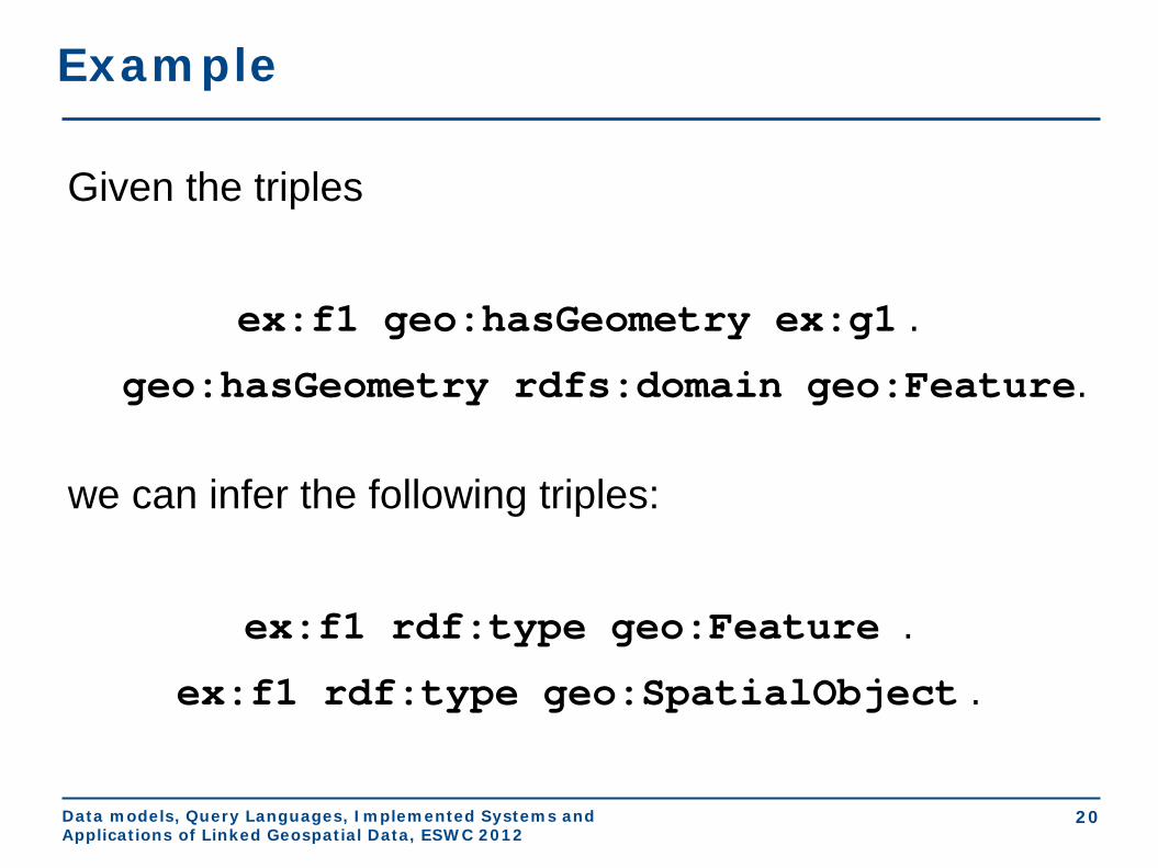
Example
Given the triples
ex:f1 geo:hasGeometry ex:g1 . geo:hasGeometry rdfs:domain geo:Feature.
we can infer the following triples:
ex:f1 rdf:type geo:Feature . ex:f1 rdf:type geo:SpatialObject .

Data models, Query Languages, Implemented Systems and Applications of Linked Geospatial Data, ESWC 2012
21
GeoSPARQL Query Rewrite Extension • Provides a collection of RIF rules that use topological extension
functions to establish the existence of topological predicates.
• Example: given the RIF rule named geor:sfWithin, the serializations of the geometries of dbpedia:Athens and dbpedia:Greece named AthensWKT and GreeceWKT and the fact that
geof:sfWithin(AthensWKT, GreeceWKT) returns true from the computation of the two geometries, we can derive the triple
dbpedia:Athens geo:sfWithin dbpedia:Greece • One possible implementation is to re-write a given SPARQL
query.

Data models, Query Languages, Implemented Systems and Applications of Linked Geospatial Data, ESWC 2012
22
RIF Rule Forall ?f1 ?f2 ?g1 ?g2 ?g1Serial ?g2Serial (?f1[geo:sfWithin->?f2] :- Or( And (?f1[geo:defaultGeometry->?g1] ?f2[geo:defaultGeometry->?g2] ?g1[ogc:asGeomLiteral->?g1Serial] ?g2[ogc:asGeomLiteral->?g2Serial] External(geo:sfWithin (?g1Serial,?g2Serial))) And (?f1[geo:defaultGeometry->?g1] ?g1[ogc:asGeomLiteral->?g1Serial] ?f2[ogc:asGeomLiteral->?g2Serial] External(geo:sfWithin (?g1Serial,?g2Serial))) And (?f2[geo:defaultGeometry->?g2] ?f1[ogc:asGeomLiteral->?g1Serial] ?g2[ogc:asGeomLiteral->?g2Serial] External(geo:sfWithin (?g1Serial,?g2Serial))) And (?f1[ogc:asGeomLiteral->?g1Serial] ?f2[ogc:asGeomLiteral->?g2Serial] External(geo:sfWithin (?g1Serial,?g2Serial))) ))
Feature -
Feature
Feature -
Geometry
Geometry -
Feature
Geometry -
Geometry

Data models, Query Languages, Implemented Systems and Applications of Linked Geospatial Data, ESWC 2012
23
GeoSPARQL: An example
SELECT ?feature WHERE { ?feature geo:sfWithin geonames:OlympiaMunicipality. }
Discover the features that are inside the municipality of Ancient Olympia

Data models, Query Languages, Implemented Systems and Applications of Linked Geospatial Data, ESWC 2012
24
GeoSPARQL: An example
SELECT ?feature WHERE { {?feature geo:sfWithin geonames:Olympia } UNION { ?feature geo:defaultGeometry ?featureGeom . ?featureGeom geo:asWKT ?featureSerial . geonames:Olympia geo:defaultGeometry ?olGeom . ?olGeom geo:asWKT ?olSerial . FILTER (geof:sfWithin (?featureSerial, ?olSerial)) } UNION { ?feature geo:defaultGeometry ?featureGeom . ?featureGeom geo:asWKT ?featureSerial . geonames:Olympia geo:asWKT ?olSerial . FILTER (geof:sfWithin (?featureSerial, ?olSerial)) } UNION { ?feature geo:asWKT ?featureSerial . geonames:Olympia geo:defaultGeometry ?olGeom . ?olGeom geo:asWKT ?olSerial . FILTER (geof:sfWithin (?featureSerial, ?olSerial)) } UNION { ?feature geo:asWKT ?featureSerial . geonames:Olympia geo:asWKT ?olSerial . FILTER (geof:sfWithin (?featureSerial, ?olSerial)) }
Data models, Query Languages, Implemented Systems and Applications of Linked Geospatial Data, ESWC 2012
25
Conclusions
• Geospatial data in the Semantic Web
• The query language GeoSPARQL
• Core
• Topology vocabulary extension
• Geometry extension
• Geometry topology extension
• Query rewrite extension
• RDFS entailment extension
• Next topic: Implemented Systems and Applications

Implemented Systems
Presenter: Manos Karpathiotakis
Extended Semantic Web Conference 2012

Outline
• Relational DBMS with a geospatial extension
• RDF stores with a geospatial component:
– Research prototypes
– Commercial systems
2
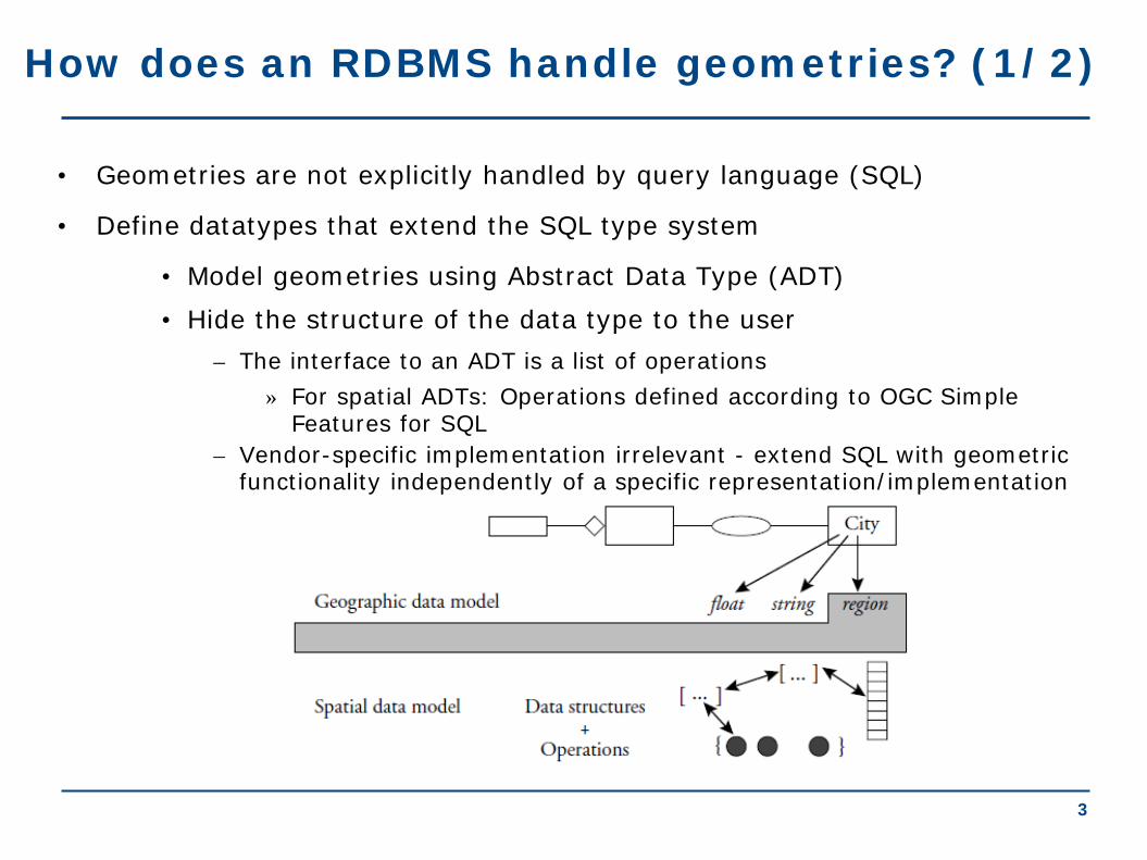
How does an RDBMS handle geometries? (1/2)
• Geometries are not explicitly handled by query language (SQL)
• Define datatypes that extend the SQL type system
• Model geometries using Abstract Data Type (ADT) • Hide the structure of the data type to the user
– The interface to an ADT is a list of operations » For spatial ADTs: Operations defined according to OGC Simple
Features for SQL – Vendor-specific implementation irrelevant - extend SQL with geometric
functionality independently of a specific representation/implementation
3
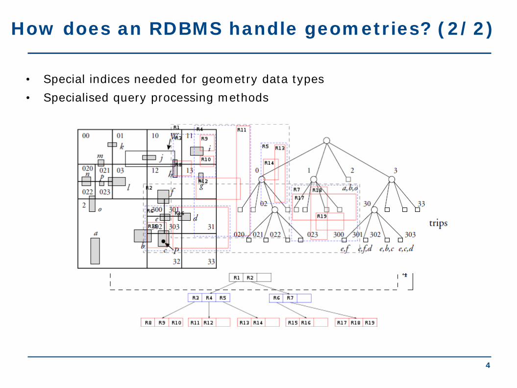
How does an RDBMS handle geometries? (2/2)
• Special indices needed for geometry data types
4
• Specialised query processing methods
Implemented Systems
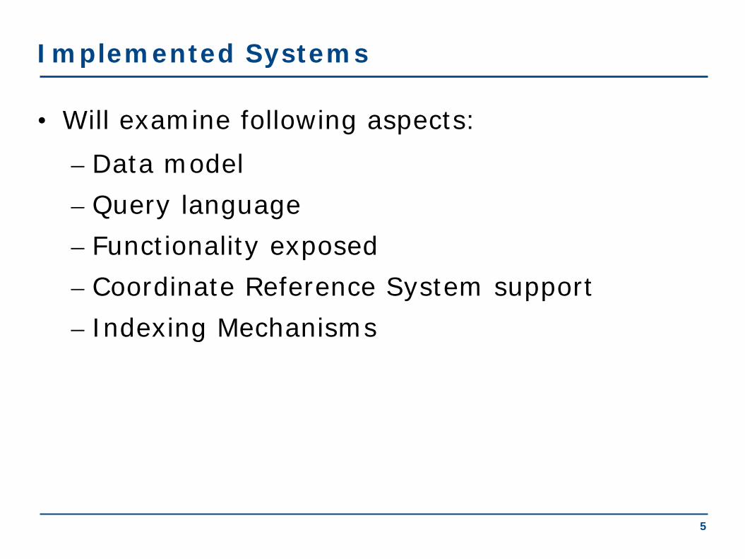
• Will examine following aspects: – Data model – Query language – Functionality exposed – Coordinate Reference System support – Indexing Mechanisms
5

Research Prototypes
• Strabon • Parliament • Brodt et al. • Perry
6

Strabon • Storage and query evaluation module for stSPARQL • Geometries represented using typed literals
– WKT & GML serializations supported • Spatial predicates represented as SPARQL functions
– OGC-SFA, Egenhofer, RCC8 families exposed – Spatial aggregate functions
• Support for multiple coordinate reference systems • GeoSPARQL support
– Core – Geometry Extension – Geometry Topology Extension
7

Strabon - Implementation
stRDF graphs
stSPARQL/ GeoSPARQL
queries
WKT GML
Open Source, available from http://www.strabon.di.uoa.gr/
8
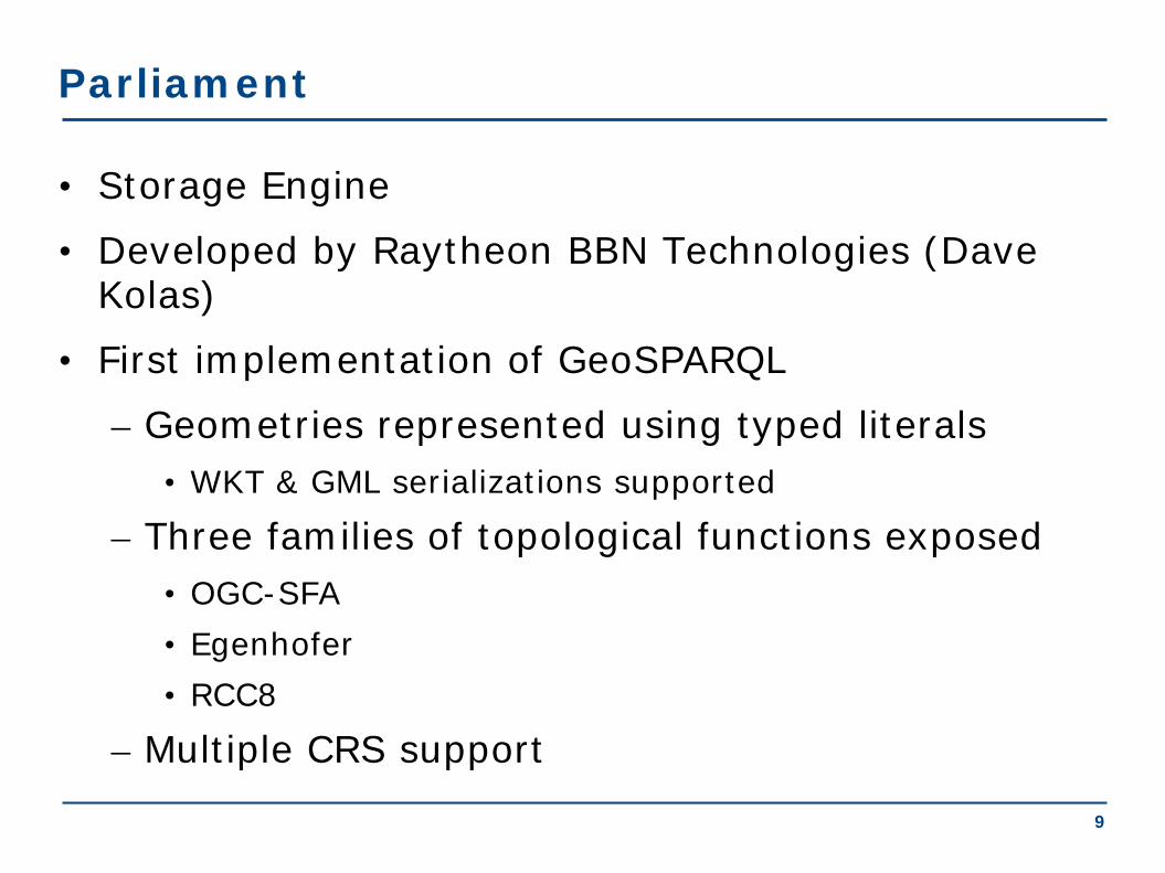
Parliament
• Storage Engine
• Developed by Raytheon BBN Technologies (Dave Kolas)
• First implementation of GeoSPARQL
– Geometries represented using typed literals • WKT & GML serializations supported
– Three families of topological functions exposed • OGC-SFA • Egenhofer • RCC8
– Multiple CRS support 9

Parliament - Implementation • Rule engine included
• Paired with query processor
• R-tree used
Open Source, available from http://www.parliament.semwebcentral.org
10
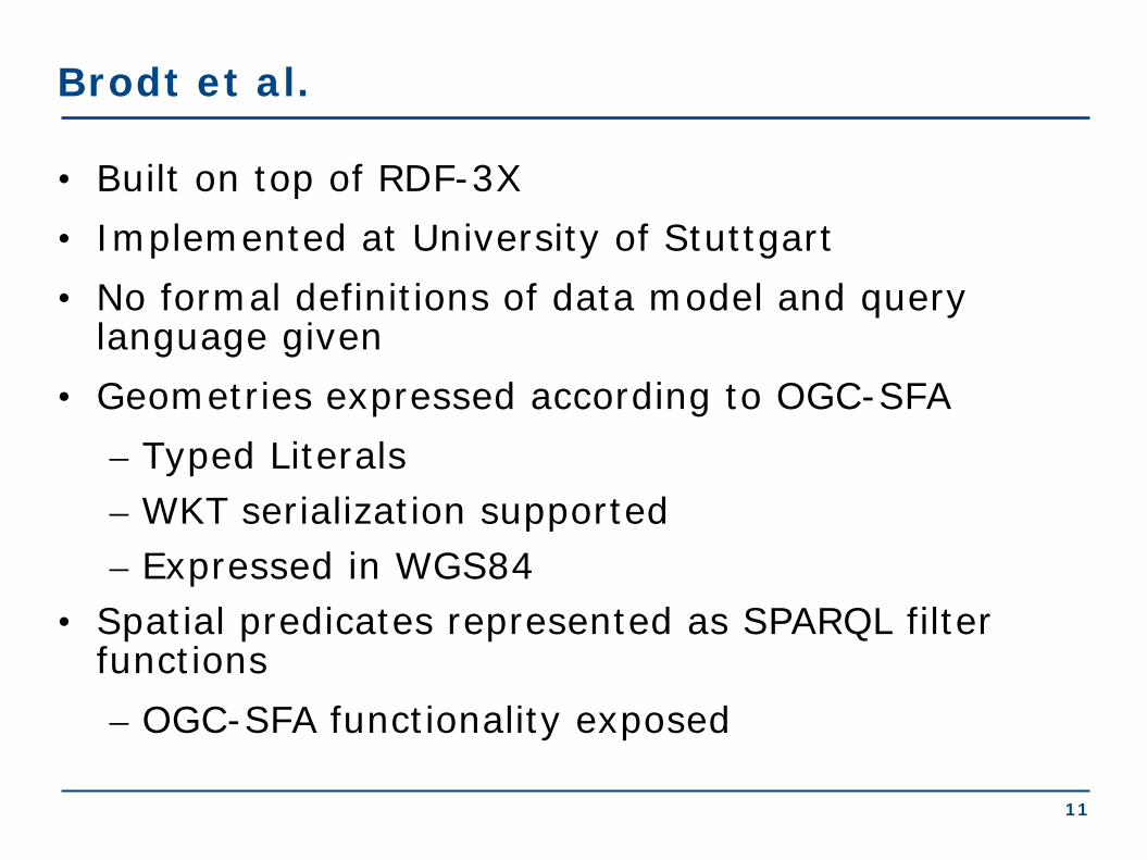
Brodt et al.
• Built on top of RDF-3X • Implemented at University of Stuttgart • No formal definitions of data model and query
language given • Geometries expressed according to OGC-SFA
– Typed Literals – WKT serialization supported – Expressed in WGS84
• Spatial predicates represented as SPARQL filter functions – OGC-SFA functionality exposed
11

Brodt et al. - Implementation
– Focus on spatial query processing and spatial indexing techniques for spatial selections • e.g. "Retrieve features
located inside a given polygon"
– Naive spatial selection operator • Placed in front of the
execution plan which the planner returns
– Spatial index (R-Tree) implemented • Only utilized in spatial
selections
Available upon request
12
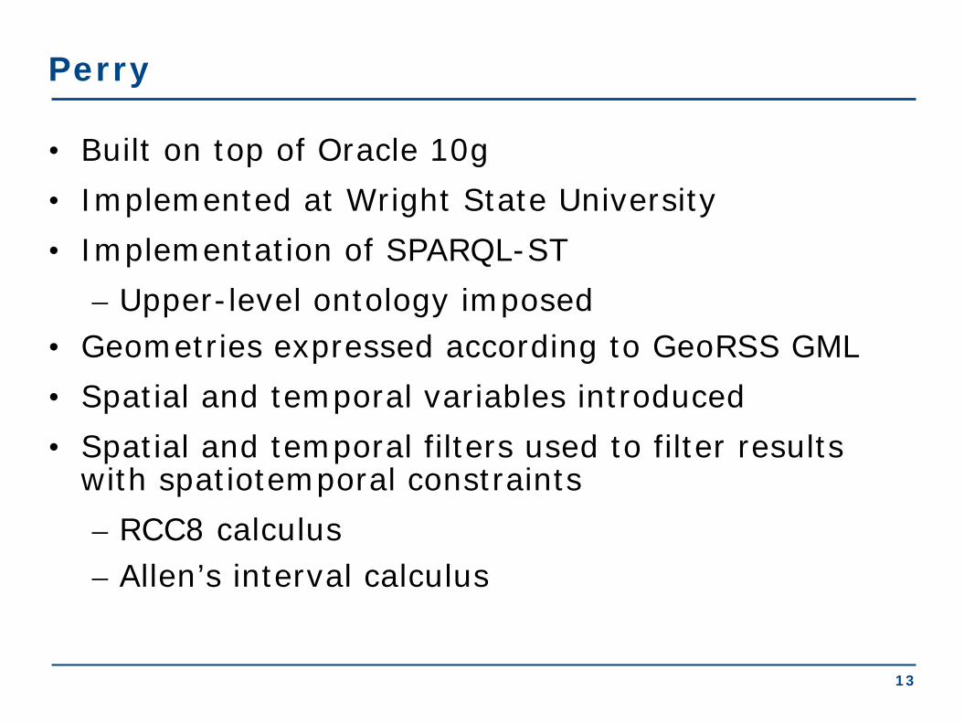
Perry
• Built on top of Oracle 10g • Implemented at Wright State University • Implementation of SPARQL-ST
– Upper-level ontology imposed • Geometries expressed according to GeoRSS GML • Spatial and temporal variables introduced • Spatial and temporal filters used to filter results
with spatiotemporal constraints – RCC8 calculus – Allen’s interval calculus
13

Perry • Spatiotemporal operators implemented using Oracle's extensibility
framework
– Three spatial operators defined
• Strictly RDF concepts implemented using Oracle’s RDF storage and inferencing capabilities
• R-Tree used for indexing spatial objects
Available upon request
14
Commercial RDF Stores
• AllegroGraph • OWLIM • Virtuoso • uSeekM
15
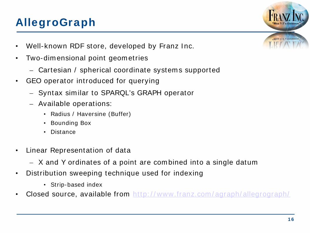
AllegroGraph
• Well-known RDF store, developed by Franz Inc.
• Two-dimensional point geometries
– Cartesian / spherical coordinate systems supported • GEO operator introduced for querying
– Syntax similar to SPARQL’s GRAPH operator – Available operations:
• Radius / Haversine (Buffer) • Bounding Box • Distance
• Linear Representation of data
– X and Y ordinates of a point are combined into a single datum • Distribution sweeping technique used for indexing
• Strip-based index • Closed source, available from http://www.franz.com/agraph/allegrograph/
16
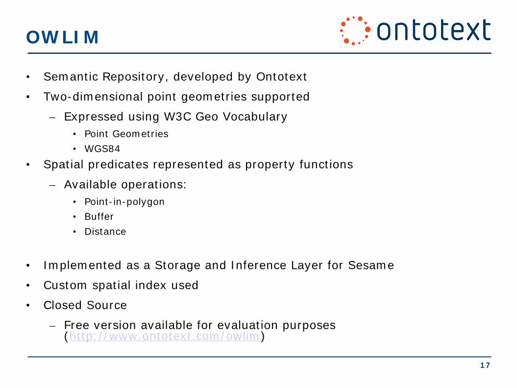
OWLIM
• Semantic Repository, developed by Ontotext
• Two-dimensional point geometries supported
– Expressed using W3C Geo Vocabulary • Point Geometries • WGS84
• Spatial predicates represented as property functions
– Available operations: • Point-in-polygon • Buffer • Distance
• Implemented as a Storage and Inference Layer for Sesame
• Custom spatial index used
• Closed Source
– Free version available for evaluation purposes (http://www.ontotext.com/owlim)
17
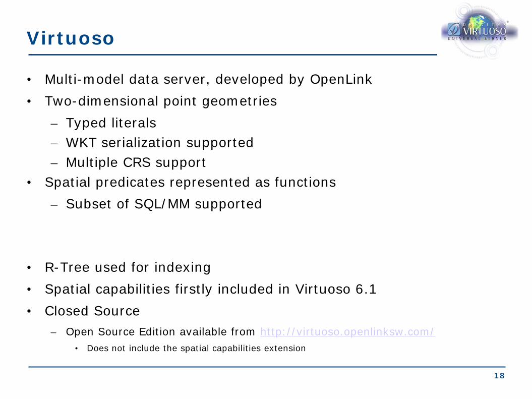
Virtuoso
• Multi-model data server, developed by OpenLink • Two-dimensional point geometries
– Typed literals – WKT serialization supported – Multiple CRS support
• Spatial predicates represented as functions – Subset of SQL/MM supported
• R-Tree used for indexing • Spatial capabilities firstly included in Virtuoso 6.1 • Closed Source
– Open Source Edition available from http://virtuoso.openlinksw.com/ • Does not include the spatial capabilities extension
18

uSeekM
• Add-on library for Sesame-enabled semantic repositories, developed by OpenSahara
• Geometries expressed according to OGC-SFA
– WKT serialization – Only WGS84 supported
• Spatial predicates represented as functions
– OGC-SFA functionality exposed – Additional functions
• e.g. shortestline(geometry,geometry)
• Implemented as a Storage and Inference Layer (SAIL) for Sesame
– May be used with RDF stores that have a Sesame Repository/SAIL layer • R-tree-over-GiST index used (provided by PostGIS)
• Open Source, Apache v2 License
• Available from https://dev.opensahara.com/projects/useekm
19

System Language Index Geometries CRS support Comments on Functionality
Strabon stSPARQL/ GeoSPARQL*
R-tree-over-GiST
WKT / GML support
Yes • OGC-SFA • Egenhofer • RCC-8
Parliament GeoSPARQL R-Tree WKT / GML support
Yes •OGC-SFA •Egenhofer •RCC-8
Brodt et al. (RDF-3X)
SPARQL R-Tree WKT support No OGC-SFA
Perry SPARQL-ST
R-Tree GeoRSS GML
Yes RCC8
AllegroGraph Extended SPARQL
Distribution sweeping technique
2D point geometries
Partial •Buffer •Bounding Box •Distance
OWLIM Extended SPARQL
Custom 2D point geometries (W3C Basic Geo Vocabulary)
No •Point-in-polygon •Buffer •Distance
Virtuoso SPARQL R-Tree 2D point geometries (in WKT)
Yes SQL/MM (subset)
uSeekM SPARQL R-tree-over GiST
WKT support No OGC-SFA

21
Conclusions
• Semantic Geospatial Systems:
• Research Prototypes
• Commercial Systems
• Next topic: Applications of Linked Geospatial Data
1
Conclusions
• Semantic Geospatial Systems:
• Research Prototypes
• Commercial Systems
• Next topic: Applications of Linked Geospatial Data
Applications of Linked Geospatial Data
Extended Semantic Web Conference 2012
Presenter: Manos Karpathiotakis

Existing applications of linked geospatial data (1/2)
• Linked Sensor Middleware – Utilizing Virtuoso as backend – Available at http://lsm.deri.ie
• Ordnance Survey – Utilizing an RDF store provided by Talis as backend – Available at http://bis.clients.talis.com/
• SemsorGrid4Env – Utilizing Strabon as backend – Demo available at http://webgis1.geodata.soton.ac.uk/flood.html
• TELEIOS – Fire monitoring service performed by the National Observatory of Athens – Utilizing Strabon as backend – Demo available at http://test.strabon.di.uoa.gr/NOA/
• …
3

• Design, implement, and validate a fully automatic fire monitoring processing chain, for real time fire monitoring and rapid mapping, that combines in real-time:
i) Volumes of Earth Observation image acquisitions.
ii) Volumes of fire monitoring products.
iii) Models/Algorithms for data exchange and processing.
iv) Auxiliary geo-information.
v) Human evidence, in order to draw reliable decisions and generate highly accurate fire products.
Fire Monitoring Service - Objective
4

Cataloguing Service & Metadata Creation
Processing Chain (SciQL based)
HotSpots
Back End: MonetDB / Strabon
Fire Monitoring Service
Data Vault
Eumetsat @ 9.5°East
Raw Data
• Corine Landcover • Admin Boundaries • POIs
External Sources
Front End: GUI Map Element
• Search for raw and processed data
• Refinement (Post-Processing) • Real-time fire monitoring using
Linked Data
Geospatial Ontology
Web access based on Semantics
Linked Geospatial Data
Semantic technologies
5

Requirements of the Fire Monitoring Service
• Need for modeling of • Geospatial information • Temporal information • Product metadata • Product content
• Need to link to other data sources • GIS data • Other information on the Web
6
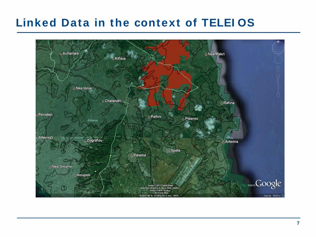
Linked Data in the context of TELEIOS
7

Linked Data used in the Fire Monitoring Service
• Hotspots detected by the National Observatory of Athens (NOA) and other authorities
• Administrative Regions of Greece • Corine Land Use / Land Cover Nomenclature • LinkedGeoData • GeoNames
8

Linked Open Data (1/4)
• Hotspots
9
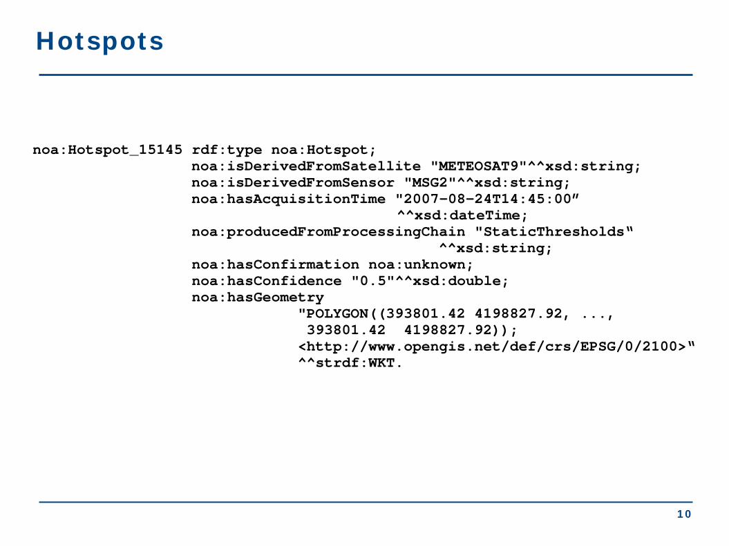
Hotspots
noa:Hotspot_15145 rdf:type noa:Hotspot; noa:isDerivedFromSatellite "METEOSAT9"^^xsd:string; noa:isDerivedFromSensor "MSG2"^^xsd:string; noa:hasAcquisitionTime "2007-08-24T14:45:00” ^^xsd:dateTime; noa:producedFromProcessingChain "StaticThresholds“ ^^xsd:string; noa:hasConfirmation noa:unknown; noa:hasConfidence "0.5"^^xsd:double; noa:hasGeometry "POLYGON((393801.42 4198827.92, ..., 393801.42 4198827.92)); <http://www.opengis.net/def/crs/EPSG/0/2100>“ ^^strdf:WKT.
10

Linked Open Data (2/4)
• Greek Administrative Geography
05/11/12 11

Greek Administrative Geography
gag:gag003000009002 rdf:type owl:NamedIndividual ; rdf:type gag:Dhmos; rdfs:label "ΔΗΜΟΣ ΧΕΡΣΟΝΗΣΟΥ"@el; rdfs:label "Hersonissos"; noa:hasYpesCode "9309"^^xsd:integer; strdf:hasGeometry "MULTIPOLYGON (((25.37 35.34,...,25.21 35.47)))"^^strdf:WKT; gag:isPartOf gag:gag003000000101.
12

Linked Open Data (3/4)
• Corine Land Use / Land Cover
05/11/12 13
14
Corine Land Use / Land Cover
noa:Area_24015134 rdf:type noa:Area ; noa:hasCode "312"^^xsd:decimal; noa:hasID "EU-203497"^^xsd:string; noa:hasArea_ha "255.580790497"^^xsd:double; noa:hasGeometry "POLYGON((15.53 62.54, ..., 15.53 62.54))"^^strdf:WKT; noa:hasLandUse noa:coniferousForest.
14

Linked Open Data (4/4)
• LinkedGeoData
15

lgd:node741703450 rdf:type lgdo:Node; rdf:type lgdo:Place; rdf:type lgdo:Town; rdfs:label "Зофори"@ru;
rdfs:label "Ζωφόροι"@el; rdfs:label "Zofori"@en; lgdo:directType lgdo:Town; wgs84:geometry "POINT(25.2704 35.2061)"^^virtrdf:Geometry;
wgs84:lat "35.2060912"^^xsd:double; wgs84:long "25.2703858"^^xsd:double; lgdo:contributor lgd:user153221 .
LinkedGeoData
16
Discovering raw data and products
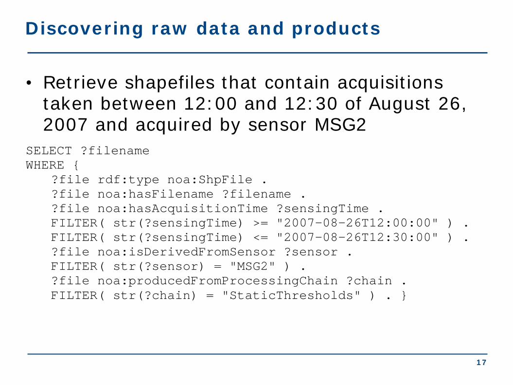
• Retrieve shapefiles that contain acquisitions taken between 12:00 and 12:30 of August 26, 2007 and acquired by sensor MSG2
SELECT ?filename WHERE { ?file rdf:type noa:ShpFile . ?file noa:hasFilename ?filename . ?file noa:hasAcquisitionTime ?sensingTime . FILTER( str(?sensingTime) >= "2007-08-26T12:00:00" ) . FILTER( str(?sensingTime) <= "2007-08-26T12:30:00" ) . ?file noa:isDerivedFromSensor ?sensor . FILTER( str(?sensor) = "MSG2" ) . ?file noa:producedFromProcessingChain ?chain . FILTER( str(?chain) = "StaticThresholds" ) . }
17

Discovering raw data and products
• Retrieve shapefiles that contain acquisitions taken between 12:00 and 12:30 of August 26, 2007 and acquired by sensor MSG2
?filename
MSG2_07-08-26_12:00_StaticThresholds.shp
MSG2_07-08-26_12:15_StaticThresholds.shp
MSG2_07-08-26_12:30_StaticThresholds.shp
18

Creating a map (1/4)
• Get all hotspots detected in Peloponnese at 24/08/2007.
SELECT ?h ?hConfidence ?hConfirmation ?hProvider ?hSensor ?hSatellite (strdf:transform(?hGeo, <http://www.opengis.net/def/crs/EPSG/0/4326>) as ?geo) WHERE { ?h rdf:type noa:Hotspot; noa:hasGeometry ?hGeo; noa:hasAcquisitionTime ?hAcqTime; noa:hasConfidence ?hConfidence; noa:isProducedBy ?hProvider; noa:hasConfirmation ?hConfirmation; noa:isDerivedFromSensor ?hSensor; noa:isDerivedFromSatellite ?hSatellite ; noa:producedFromProcessingChain ?hChain . FILTER(str(?hChain) = "StaticThresholds"). FILTER(?hAcqTime = "2007-08-24T14:45:00"^^xsd:dateTime) . FILTER(strdf:contains("POLYGON((21.027 38.36, 23.77 38.36, 23.77 36.05, 21.027 36.05, 21.027 38.36))"^^strdf:WKT, ?hGeo)) .
19
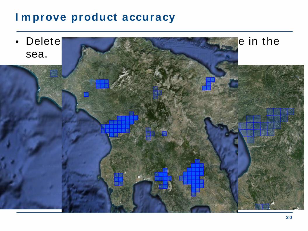
Improve product accuracy
• Delete the parts of each hotspot that lie in the sea.
DELETE {?h noa:hasGeometry ?hGeo} INSERT {?h noa:hasGeometry ?dif} WHERE { SELECT DISTINCT ?h ?hGeo (strdf:intersection(?hGeo, strdf:union(?cGeo)) AS ?dif) WHERE { ?h rdf:type noa:Hotspot. ?h strdf:hasGeometry ?hGeo. ?c rdf:type coast:Coastline. ?c strdf:hasGeometry ?cGeo. FILTER( strdf:intersects(?hGeo, ?cGeo)} GROUP BY ?h ?hGeo HAVING strdf:overlap(?hGeo, strdf:union(?cGeo))}
20

• Get all coniferous forests in Peloponnese SELECT ?a ?aGeo WHERE{ ?a rdf:type clc:Area;
clc:hasLandUse ?aLandUse; noa:hasGeometry ?aGeo. ?aLandUse rdf:type ?aLandUseType. FILTER(?aLandUseType = clc:ConiferousForest). FILTER(strdf:contains("POLYGON((21.027 38.36, 23.77 38.36, 23.77 36.05, 21.027 36.05, 21.027 38.36))" ^^strdf:WKT,?aGeo)). }
Creating a map (2/4)
21

Creating a map (3/4)
• Get all municipalities of Peloponnese SELECT ?d ?dGeo WHERE { ?d rdf:type gag:Dhmos; strdf:hasGeometry ?dGeo; rdfs:label ?dLabel. FILTER(strdf:contains("POLYGON((21.027 38.36, 23.77 38.36, 23.77 36.05, 21.027 36.05, 21.027 38.36))"^^ strdf:WKT, ?dGeo)). }
22

• Get all primary roads in Pelloponnese SELECT ?r ?rGeo WHERE{ ?r a ?rType ; noa:hasGeometry ?rGeo . FILTER(?rType = lgdo:Primary) . FILTER(strdf:contains("POLYGON(( 21.027 38.36, 23.77 38.36, 23.77 36.05, 21.027 36.05, 21.027 38.36))"^^strdf:WKT, ?rGeo) ). }
Creating a map (4/4)
23

Final map
05/11/12 24

25
Conclusions
• Applications using Linked Geospatial Data
• Examples of applications
• NOA Hotspot Detection and Fire Monitoring Service
• Datasets used
• Queries leading to final map creation

Conclusions
Presenter: Manolis Koubarakis
Extended Semantic Web Conference 2012

Data models, Query Languages, Implemented Systems and Applications of Linked Geospatial Data, ESWC 2012
2
What we talked about
• Introduction
• Background in geospatial data modeling
• Geospatial data in the Semantic Web:
stSPARQL and GeoSPARQL
• Implemented systems
• Applications

Data models, Query Languages, Implemented Systems and Applications of Linked Geospatial Data, ESWC 2012
3
What we did not talk about: Tools
• Tools for translating GIS data (e.g.,
shape files or tables from a geospatial
DBMS) into the geospatial extensions of
RDF that we presented
Data models, Query Languages, Implemented Systems and Applications of Linked Geospatial Data, ESWC 2012
4
What we did not talk about: Reasoning
• Description logics and ontology
languages for spatial information
• Theory
• Reasoners (e.g., RacerPro, PelletSpatial)
• OWL 2
• Approaches using rules (e.g., to do qualitative
spatial reasoning).

Data models, Query Languages, Implemented Systems and Applications of Linked Geospatial Data, ESWC 2012
5
Invitation

Data models, Query Languages, Implemented Systems and Applications of Linked Geospatial Data, ESWC 2012
6
What we did not talk about: Theory
• Semantics: How do we extend the semantics
of SPARQL, to give semantics to stSPARQL and
GeoSPARQL?
• Computational complexity of query
processing: What is the complexity of
stSPARQL or GeoSPARQL querying?
• Other theoretical issues

Data models, Query Languages, Implemented Systems and Applications of Linked Geospatial Data, ESWC 2012
7
Thank you for Attending!
• Questions?
• Feedback?