Download - 2014 Brandywine Gold Silver geochem Whistler British Columbia Turnagain Resources MLS Mining

Geochemical and Physical Prospecting Report On The: BRANDYWINE PROPERTY EVENT #5532374 April 18-Nov 08 2014 Vancouver Mining Division British Columbia, Canada BCGS Map 092J005 NTS 092J03E UTM (NAD 83) 10U 489873, 5546076 Lat: 50.066877 Lon: -123.141503 Lat: 50.4.013 Lon 123.8.490 Lat 50.04.00.76 Lon 128.08.29.41 Owner: Turnagain Resources Bill McKinney 11751 Shell Road Richmond, B.C. V7A-3W7 FMC: 277090 Operator: Turnagain Resources Bill McKinney 11751 Shell Road Richmond, B.C. V7A-3W7 FMC: 277090 Research and Report Prepared By: John Bakus #3 – 1572 Lorne Street East Kamloops, B.C. V2C-1X6 FMC:223385 1
Brandywine 2014 Event 5532374 Introduction 1 Brandywine 2014 Table of Contents 2
Brandywine Provincial Location Maps Scale 600 KM 100 KM Regional 10 KM 1 KM 3-4
Brandywine Location, Access Physiography, Topography and Ownership 5 Brandywine Geology Map Scale 1:200,000 DEM Image Hillside Map Scale 1:200,000 6
Brandywine Landsat Image Scale 1:200,000 ARIS Reports Scale Map 1:100,000 7
Brandywine Raster Base ARIS Map Scale 10 KM Hillside Relief Map Scale 10 KM 8
Brandywine Metallic Mineral Potential Scale 10 KM Industrial Mineral Potential Scale 10 KM 9-10
Brandywine Aerial Photography Map Scale 10 KM Terranes Map Scale 10 KM 11
Brandywine Mineralization Geology History 12-14
Brandywine Tenure List 15
Brandywine Mineral Claim Map Scale 1 KM 1024230, 1024231, 1025068, 1032325 and 1032326 16
Brandywine 2014 Work Program Claim Map Scale 1 KM 1024230, 1024231, 1025068 and 1032325 16
Brandywine 2014 Work Locations Map 1024230, 1024231, 1025068 Scale 500 M 17
Brandywine 2014 Work Locations Map 1032325 Scale 500 M 17
Brandywine Work Program Methodology Assessment and MinFile Review 18-19
Brandywine 2014 Work Program Spreadsheet 20-21
Brandywine General Work Site Tenure Map 1024230, 1024231, 1025068, 1032325 and 1032326 22
Brandywine Geochemical ACME Laboratory Results Certificate 23-24
ACME Geochemical Lab Results Maps Tenures (1024230, 1025068) and (1024231) 25-26
Event 5532364 Brandywine Geochemical Physical Work Report Form 27-28
Event 5532374 Explorations and Development Work / Expiry Date Change 29
Schedule A Brandywine Minfile Detail 30-37
Schedule B Brandywine 2014 Work Program Sample Photographs 37-39
2
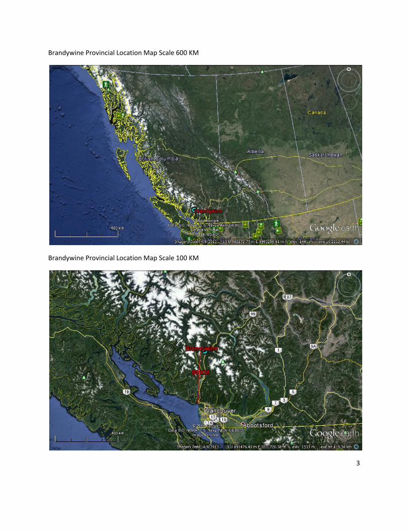
Brandywine Provincial Location Map Scale 600 KM
Brandywine Provincial Location Map Scale 100 KM
3
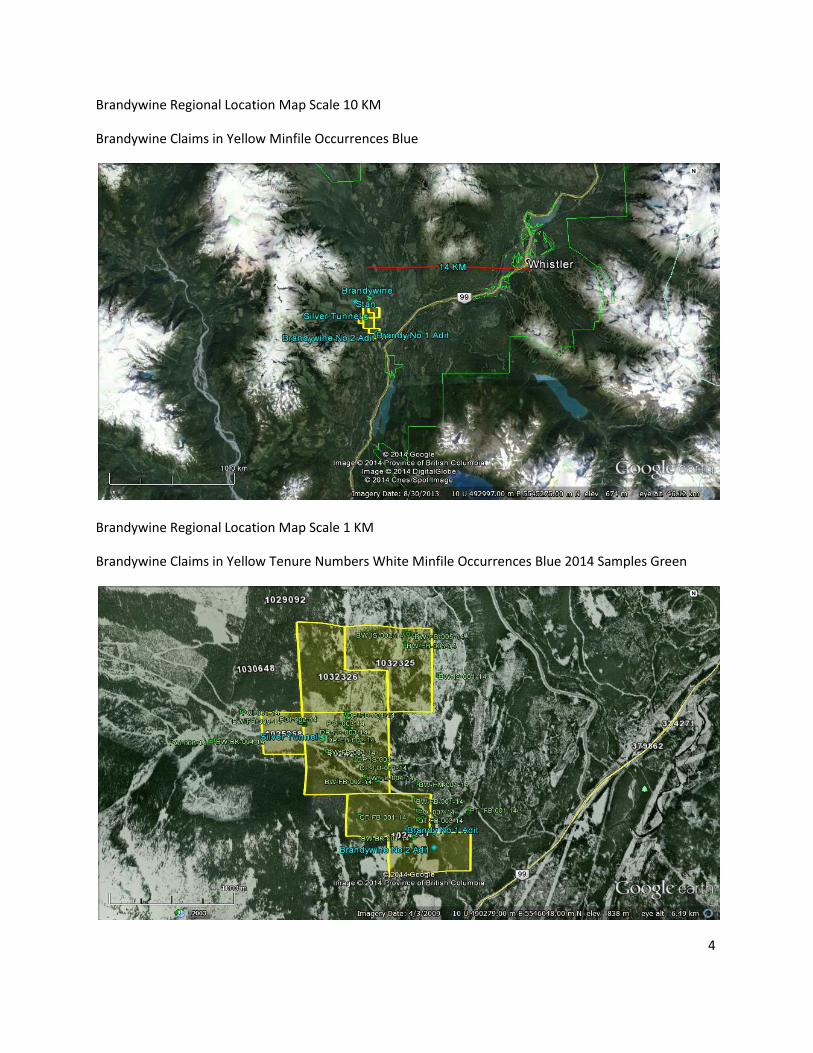
Brandywine Regional Location Map Scale 10 KM
Brandywine Claims in Yellow Minfile Occurrences Blue
Brandywine Regional Location Map Scale 1 KM
Brandywine Claims in Yellow Tenure Numbers White Minfile Occurrences Blue 2014 Samples Green
4

Brandywine Location, Access Physiography, Topography and Ownership:
The Brandywine property is located within the Vancouver Mining Division in South West British Columbia. The Brandywine project lays with BCGS Map number 092J005, NTS Map number 092J03E. The five adjoining Brandywine tenures total over 310 hectares in area and are situated 13 kilometers West South West of Whistler B.C. via Highway 99. Squamish B.C. is 42 kilometers South via Highway 99 and Vancouver B.C. is 110 KM South via Highway 33 South. According to Minfile records the Brandywine 1 and 2 adits lay within tenure 1024231 The Brandywine 2 Adit lies 400 meters South East of the Brandywine Adit 1. The Silver Tunnel is located on tenure 1024230 and on tenure 1025068 to the West of tenure 1024230. The Silver Tunnel lies 1.35 kilometers North West of the Brandywine 1 adit. The Silver Tunnel deposit is situated along Brandywine Creek in the Pacific Ranges of the Coast Crystalline tectonic belt. The Brandywine number 1 and 2 adits is located along the south side of Brandywine Creek approximately three kilometers northwest of Brandywine Falls.
Access:
From Vancouver B.C. access to the Brandywine property via Highway 99 North (Sea to Sky Highway) past Squamish B.C. to McGuire road (110KM) turnoff West at UTM 10U 491958 East 5545016 North, Latitude 50.057372 Longitude -123.112342 and then approximately 2 km West on McGuire road to the Brandywine property on a well maintained 2 way gravel road at UTM 10U 490497 East 5545340 North, Latitude 50.060264 longitude -123.132762.
Ownership:
The Brandywine tenures are owned by Bill McKinney of Turnagain Resources FMC 277090 located in Burnaby, B.C. The property consists of 5 adjoining tenures with an area of over 310 Hectares.
Physiography and Topography:
Topography on the property is moderate, with some rugged areas. The junction of Callaghan Creek and the Chekamus River valleys is located in a large, gently east sloping area, two kilometres east-west by five kilometres north-south, located in the eastern third of the property. The western two thirds of the property are dominated by the steep east-facing slopes of Mount Brew and Metal Dome Mountain and the Brandywine Creek valley. Elevations range from 400 metres ASL near Daisy Lake in the south-east corner of the property to 1400 meters ASL on the flank of Metal Dome Mountain on the western edge of the property.
The climate is West Coast Marine with generally mild temperatures, heavy spring and fall rains and heavy winter snowfall. Much of the property (~50%) has been clear cut. Mature cedar, hemlock, spruce and Douglas fir cover the reminder of the property. (ARIS 32240)
5
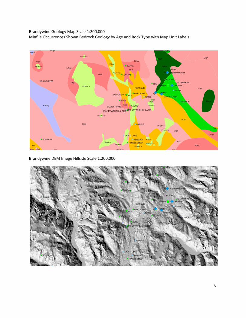
Brandywine Geology Map Scale 1:200,000 Minfile Occurrences Shown Bedrock Geology by Age and Rock Type with Map Unit Labels
Brandywine DEM Image Hillside Scale 1:200,000
6
Alpine Meadow s
Tamarisk
Whistler Whistler
Whistler Creek
VENETIAN
C
SOUTHAIR
CI
KAY
BRANDYWINE NO. 1 ADITBRANDYWINE NO. 2 ADIT
ZONE 4
SANTA
DISCOVERY II
AZURE
IRON KING
RM
LONDON
RUBBLE CREEK
DAISY LAKE
ELAHO RIVER
WMM
STAN
KMA
DISCON
MARBLE
NORTHAIR
FITZSIMMONSELK
SILVER TUNNEL
DISCOVERY I
ICE
ELEPHANT
LJKqd
LJKP
lKGsv
PzMzogMKqm
LJqd
PzMzog
LJKgd
lKGv a
MKqm
PiHoGv b
PiHoGv b
LJKqd
LJqd
EKdr
PiHoGv b
MKgd
MKgd
PiHoGv b
LJKqd
MKgd
lKGv a
lKGsv
EKdr PiHoGv b
PiHoGv b
lKGsv
PiHoGv b LJqd
PiHoGv b
lKGsv
lKGsv
MKqd
LJqdPiHoGv b
MKgdPiHoGv bPiHoGv b
PiHoGv b
LJqd PiHoGv b lKGsv
Alpine Meadow s
Tamarisk
Whistler Whistler
Whistler Creek
VENETIAN
C
SOUTHAIR
CI
KAY
BRANDYWINE NO. 1 ADITBRANDYWINE NO. 2 ADIT
ZONE 4
SANTA
DISCOVERY II
AZURE
IRON KING
RM
LONDON
RUBBLE CREEK
DAISY LAKE
ELAHO RIVER
WMM
STAN
KMA
DISCON
MARBLE
NORTHAIR
FITZSIMMONSELK
SILVER TUNNEL
DISCOVERY I
ICE
ELEPHANT
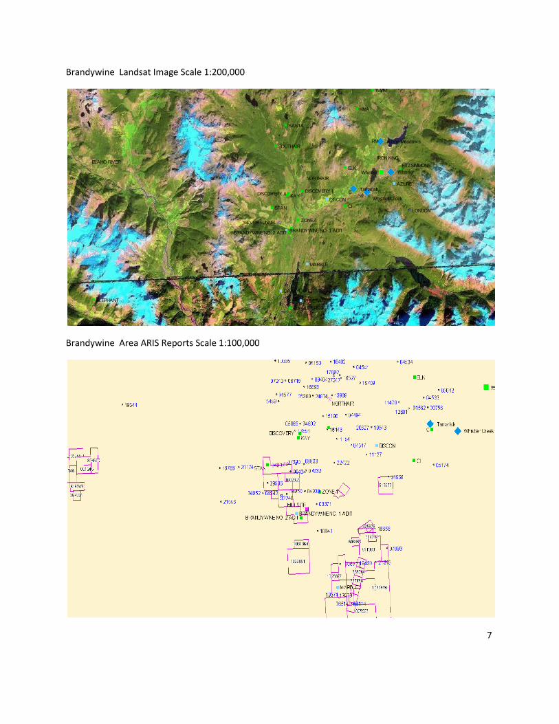
Brandywine Landsat Image Scale 1:200,000
Brandywine Area ARIS Reports Scale 1:100,000
7
Alpine Meadow s
Tamarisk
Whistler Whistler
Whistler Creek
VENETIAN
C
SOUTHAIR
CI
KAY
BRANDYWINE NO. 1 ADITBRANDYWINE NO. 2 ADIT
ZONE 4
SANTA
DISCOVERY II
AZURE
IRON KING
RM
LONDON
RUBBLE CREEK
DAISY LAKE
ELAHO RIVER
WMM
STAN
KMA
DISCON
MARBLE
NORTHAIR
FITZSIMMONSELK
SILVER TUNNEL
DISCOVERY I
ICE
ELEPHANT
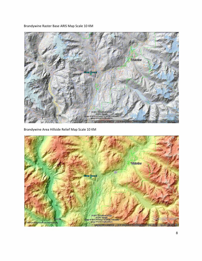
Brandywine Raster Base ARIS Map Scale 10 KM
Brandywine Area Hillside Relief Map Scale 10 KM
8
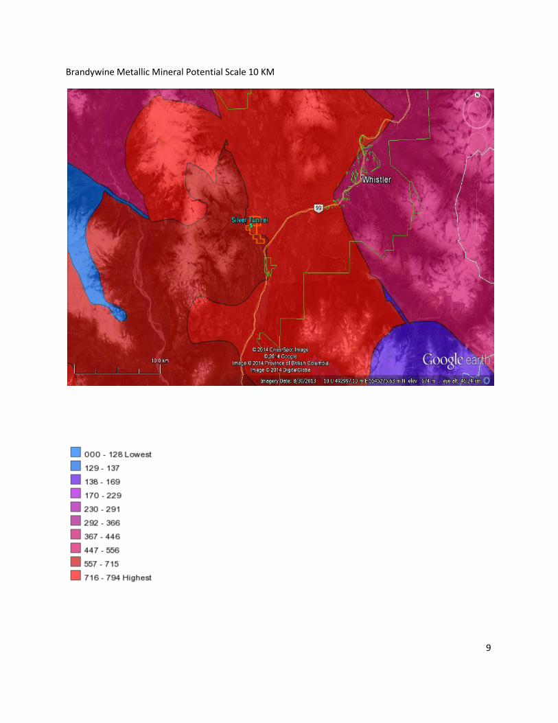
Brandywine Metallic Mineral Potential Scale 10 KM
9
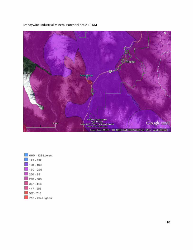
Brandywine Industrial Mineral Potential Scale 10 KM
10
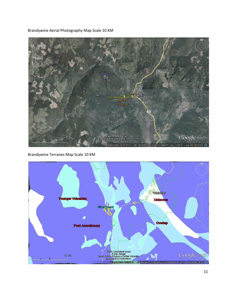
Brandywine Aerial Photography Map Scale 10 KM
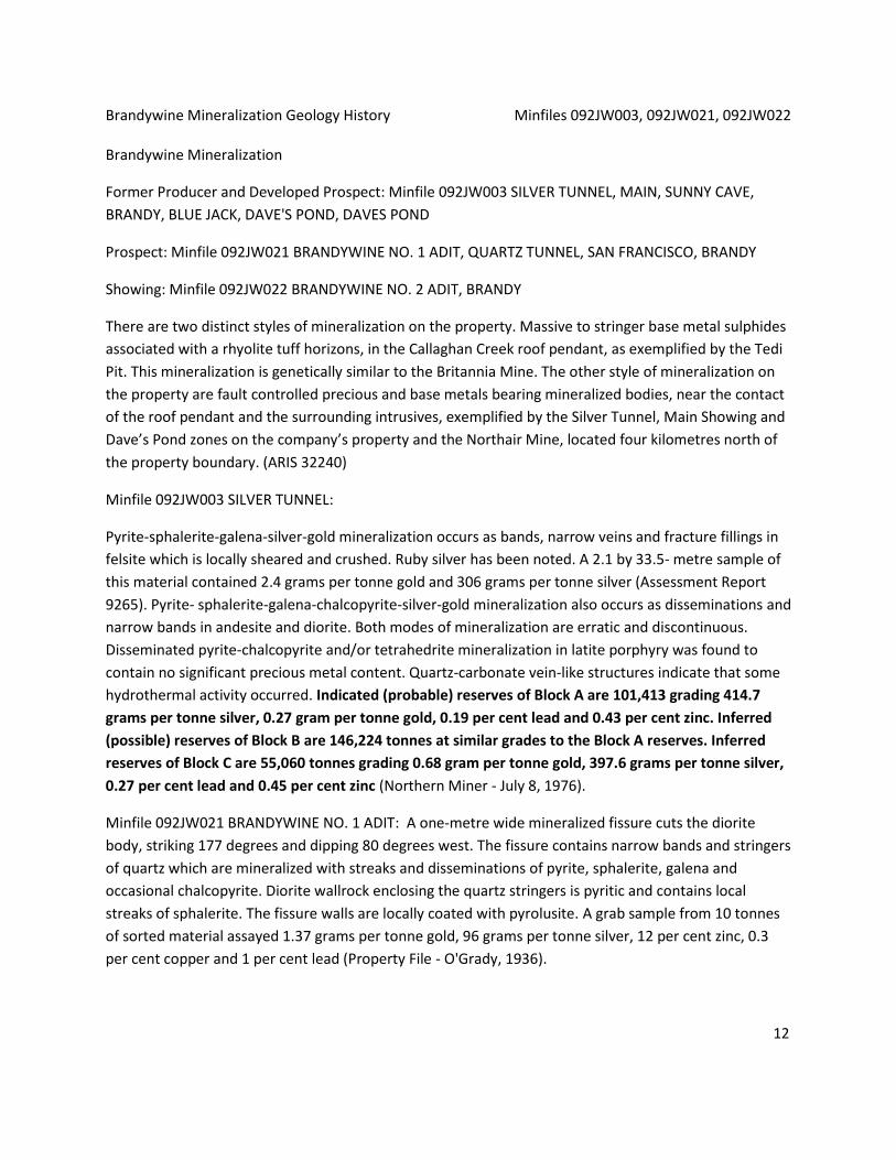
Brandywine Terranes Map Scale 10 KM
11
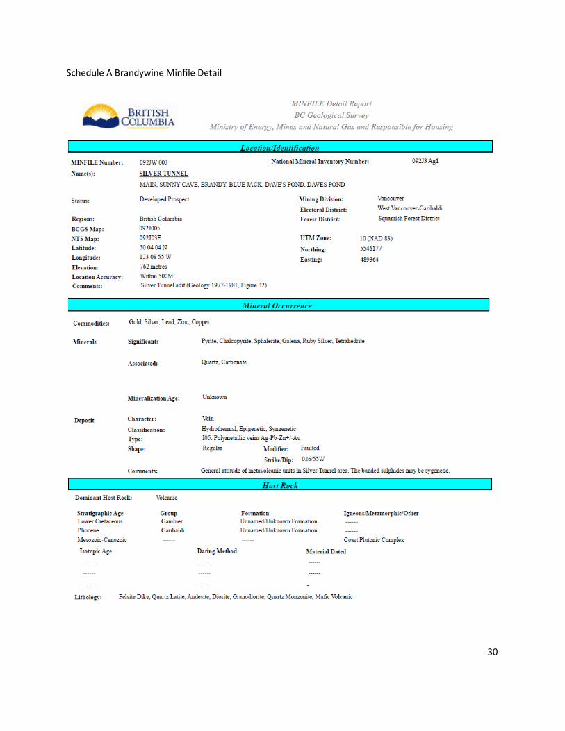
Brandywine Mineralization Geology History Minfiles 092JW003, 092JW021, 092JW022 Brandywine Mineralization
Former Producer and Developed Prospect: Minfile 092JW003 SILVER TUNNEL, MAIN, SUNNY CAVE,
BRANDY, BLUE JACK, DAVE'S POND, DAVES POND
Prospect: Minfile 092JW021 BRANDYWINE NO. 1 ADIT, QUARTZ TUNNEL, SAN FRANCISCO, BRANDY
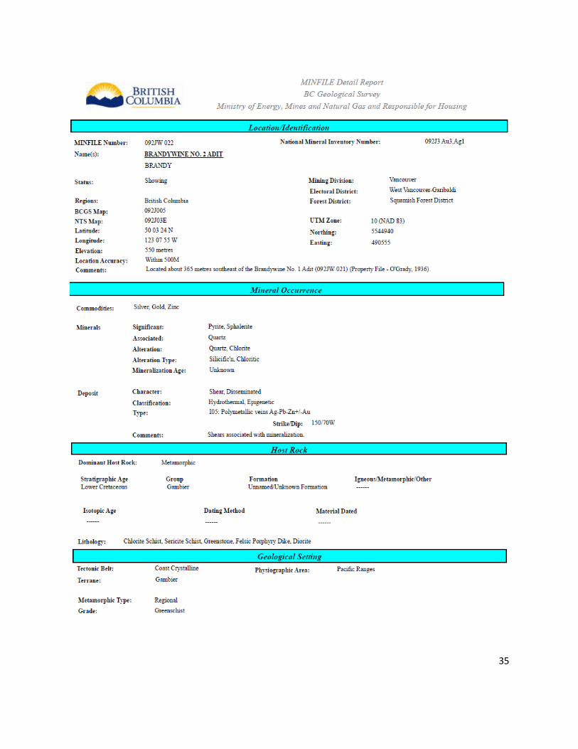
Showing: Minfile 092JW022 BRANDYWINE NO. 2 ADIT, BRANDY
There are two distinct styles of mineralization on the property. Massive to stringer base metal sulphides
associated with a rhyolite tuff horizons, in the Callaghan Creek roof pendant, as exemplified by the Tedi
Pit. This mineralization is genetically similar to the Britannia Mine. The other style of mineralization on
the property are fault controlled precious and base metals bearing mineralized bodies, near the contact
of the roof pendant and the surrounding intrusives, exemplified by the Silver Tunnel, Main Showing and
Dave’s Pond zones on the company’s property and the Northair Mine, located four kilometres north of
the property boundary. (ARIS 32240)
Minfile 092JW003 SILVER TUNNEL:
Pyrite-sphalerite-galena-silver-gold mineralization occurs as bands, narrow veins and fracture fillings in
felsite which is locally sheared and crushed. Ruby silver has been noted. A 2.1 by 33.5- metre sample of
this material contained 2.4 grams per tonne gold and 306 grams per tonne silver (Assessment Report
9265). Pyrite- sphalerite-galena-chalcopyrite-silver-gold mineralization also occurs as disseminations and
narrow bands in andesite and diorite. Both modes of mineralization are erratic and discontinuous.
Disseminated pyrite-chalcopyrite and/or tetrahedrite mineralization in latite porphyry was found to
contain no significant precious metal content. Quartz-carbonate vein-like structures indicate that some
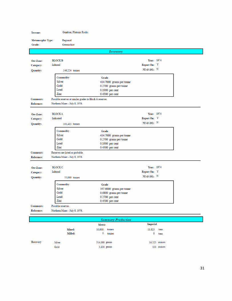
hydrothermal activity occurred. Indicated (probable) reserves of Block A are 101,413 grading 414.7
grams per tonne silver, 0.27 gram per tonne gold, 0.19 per cent lead and 0.43 per cent zinc. Inferred
(possible) reserves of Block B are 146,224 tonnes at similar grades to the Block A reserves. Inferred
reserves of Block C are 55,060 tonnes grading 0.68 gram per tonne gold, 397.6 grams per tonne silver,
0.27 per cent lead and 0.45 per cent zinc (Northern Miner - July 8, 1976).
Minfile 092JW021 BRANDYWINE NO. 1 ADIT: A one-metre wide mineralized fissure cuts the diorite
body, striking 177 degrees and dipping 80 degrees west. The fissure contains narrow bands and stringers
of quartz which are mineralized with streaks and disseminations of pyrite, sphalerite, galena and
occasional chalcopyrite. Diorite wallrock enclosing the quartz stringers is pyritic and contains local
streaks of sphalerite. The fissure walls are locally coated with pyrolusite. A grab sample from 10 tonnes
of sorted material assayed 1.37 grams per tonne gold, 96 grams per tonne silver, 12 per cent zinc, 0.3
per cent copper and 1 per cent lead (Property File - O'Grady, 1936).
12

The best drill hole intersection (DDH QTX1, 1974) assayed 0.69 grams per tonne gold, 27.4 grams per
tonne silver, 2.08 per cent zinc, 0.33 per cent lead and 0.11 per cent copper over 0.62 metres of
(Assessment Report 5404).
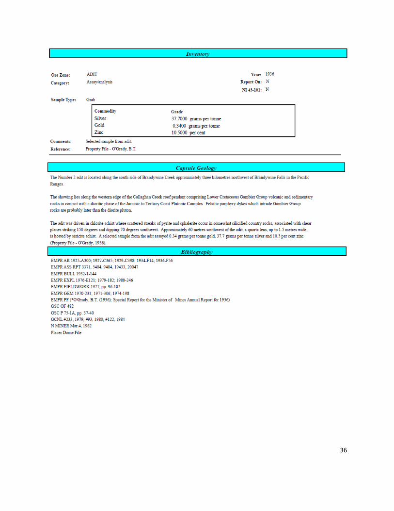
Minfile 092JW022 BRANDYWINE NO. 2 ADIT : The adit was driven in chlorite schist where scattered
streaks of pyrite and sphalerite occur in somewhat silicified country rocks, associated with shear planes
striking 150 degrees and dipping 70 degrees southwest. Approximately 60 metres southwest of the adit,
a quartz lens, up to 1.5 metres wide, is hosted by sericite schist. A selected sample from the adit assayed
0.34 grams per tonne gold, 37.7 grams per tonne silver and 10.5 per cent zinc (Property File - O'Grady,
1936).
Brandywine Geology SILVER TUNNEL 092JW003 Andesitic volcanic rocks of the Lower Cretaceous Gambier Group, preserved within the Callaghan roof pendant, are in contact with diorite, granodiorite and quartz monzonite of the Jurassic to Tertiary Coast Plutonic Complex. A series of felsite (quartz latite, latite) dykes intrude the volcanic and plutonic rocks. Mafic volcanic rocks of the Pliocene Garibaldi Group covers part of the property. Pyrite-sphalerite-galena-silver-gold mineralization occurs as bands, narrow veins and fracture fillings in felsite which is locally sheared and crushed. Ruby silver has been noted. A 2.1 by 33.5- metre sample of this material contained 2.4 grams per tonne gold and 306 grams per tonne silver (Assessment Report 9265). Pyrite- sphalerite-galena-chalcopyrite-silver-gold mineralization also occurs as disseminations and narrow bands in andesite and diorite. Both modes of mineralization are erratic and discontinuous. Disseminated pyrite-chalcopyrite and/or tetrahedrite mineralization in latite porphyry was found to contain no significant precious metal content. Quartz-carbonate vein-like structures indicate that some hydrothermal activity occurred BRANDYWINE NO. 1 ADIT 092JW021
The prospect is underlain by diorite of the Jurassic to Tertiary Coast Plutonic Complex, outcropping along the western contact with the Callaghan Creek roof pendant of Lower Cretaceous Gambier Group volcanic and sedimentary rocks. A one-metre wide mineralized fissure cuts the diorite body, striking 177 degrees and dipping 80 degrees west. The fissure contains narrow bands and stringers of quartz which are mineralized with streaks and disseminations of pyrite, sphalerite, galena and occasional chalcopyrite. Diorite wallrock enclosing the quartz stringers is pyritic and contains local streaks of sphalerite. The fissure walls are locally coated with pyrolusite.
BRANDYWINE NO. 2 ADIT 092JW022 The showing lies along the western edge of the Callaghan Creek roof pendant comprising Lower Cretaceous Gambier Group volcanic and sedimentary rocks in contact with a dioritic phase of the Jurassic to Tertiary Coast Plutonic Complex. Felsitic porphyry dykes which intrude Gambier Group rocks are probably later than the diorite pluton. 13
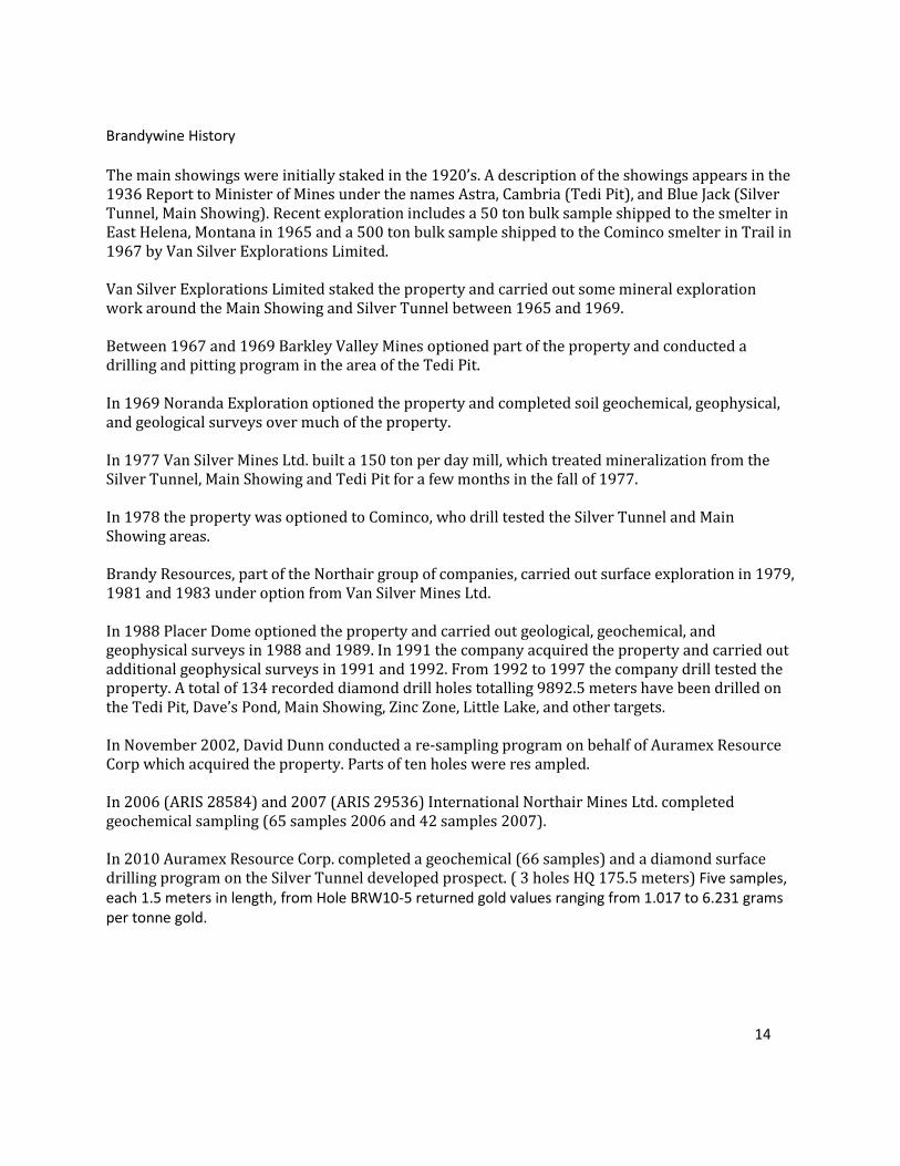
Brandywine History The main showings were initially staked in the 1920’s. A description of the showings appears in the 1936 Report to Minister of Mines under the names Astra, Cambria (Tedi Pit), and Blue Jack (Silver Tunnel, Main Showing). Recent exploration includes a 50 ton bulk sample shipped to the smelter in East Helena, Montana in 1965 and a 500 ton bulk sample shipped to the Cominco smelter in Trail in 1967 by Van Silver Explorations Limited. Van Silver Explorations Limited staked the property and carried out some mineral exploration work around the Main Showing and Silver Tunnel between 1965 and 1969. Between 1967 and 1969 Barkley Valley Mines optioned part of the property and conducted a drilling and pitting program in the area of the Tedi Pit. In 1969 Noranda Exploration optioned the property and completed soil geochemical, geophysical, and geological surveys over much of the property. In 1977 Van Silver Mines Ltd. built a 150 ton per day mill, which treated mineralization from the Silver Tunnel, Main Showing and Tedi Pit for a few months in the fall of 1977. In 1978 the property was optioned to Cominco, who drill tested the Silver Tunnel and Main Showing areas. Brandy Resources, part of the Northair group of companies, carried out surface exploration in 1979, 1981 and 1983 under option from Van Silver Mines Ltd. In 1988 Placer Dome optioned the property and carried out geological, geochemical, and geophysical surveys in 1988 and 1989. In 1991 the company acquired the property and carried out additional geophysical surveys in 1991 and 1992. From 1992 to 1997 the company drill tested the property. A total of 134 recorded diamond drill holes totalling 9892.5 meters have been drilled on the Tedi Pit, Dave’s Pond, Main Showing, Zinc Zone, Little Lake, and other targets. In November 2002, David Dunn conducted a re-sampling program on behalf of Auramex Resource Corp which acquired the property. Parts of ten holes were res ampled. In 2006 (ARIS 28584) and 2007 (ARIS 29536) International Northair Mines Ltd. completed geochemical sampling (65 samples 2006 and 42 samples 2007). In 2010 Auramex Resource Corp. completed a geochemical (66 samples) and a diamond surface drilling program on the Silver Tunnel developed prospect. ( 3 holes HQ 175.5 meters) Five samples, each 1.5 meters in length, from Hole BRW10-5 returned gold values ranging from 1.017 to 6.231 grams per tonne gold.
14
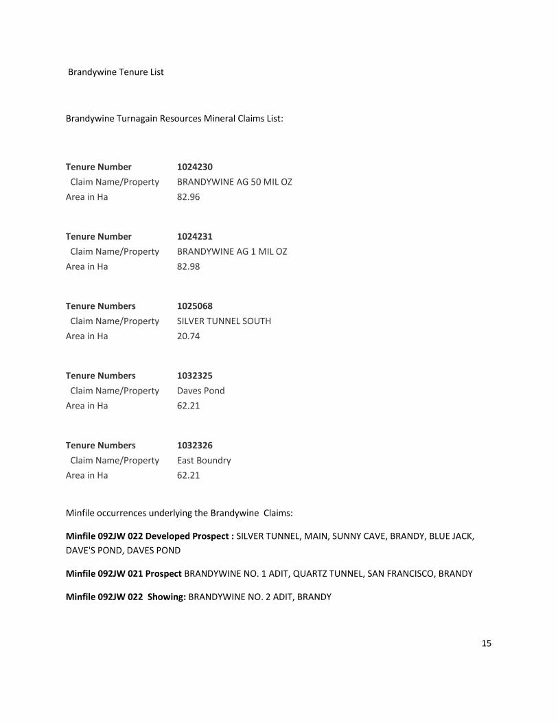
Brandywine Tenure List
Brandywine Turnagain Resources Mineral Claims List:
Tenure Number
1024230
Claim Name/Property
BRANDYWINE AG 50 MIL OZ
Area in Ha
82.96
Tenure Number
1024231
Claim Name/Property
BRANDYWINE AG 1 MIL OZ
Area in Ha
82.98
Tenure Numbers
1025068
Claim Name/Property
SILVER TUNNEL SOUTH
Area in Ha
20.74
Tenure Numbers
1032325
Claim Name/Property
Daves Pond
Area in Ha
62.21
Tenure Numbers
1032326
Claim Name/Property
East Boundry
Area in Ha
62.21
Minfile occurrences underlying the Brandywine Claims:
Minfile 092JW 022 Developed Prospect : SILVER TUNNEL, MAIN, SUNNY CAVE, BRANDY, BLUE JACK,
DAVE'S POND, DAVES POND
Minfile 092JW 021 Prospect BRANDYWINE NO. 1 ADIT, QUARTZ TUNNEL, SAN FRANCISCO, BRANDY
Minfile 092JW 022 Showing: BRANDYWINE NO. 2 ADIT, BRANDY
15

Brandywine Mineral Claim Map Scale 1 KM
1024230, 1024231, 1025068, 1032325 and 1032326
Brandywine 2014 Work Program Claim Map Scale 1 KM
1024230, 1024231, 1025068 and 1032325
16
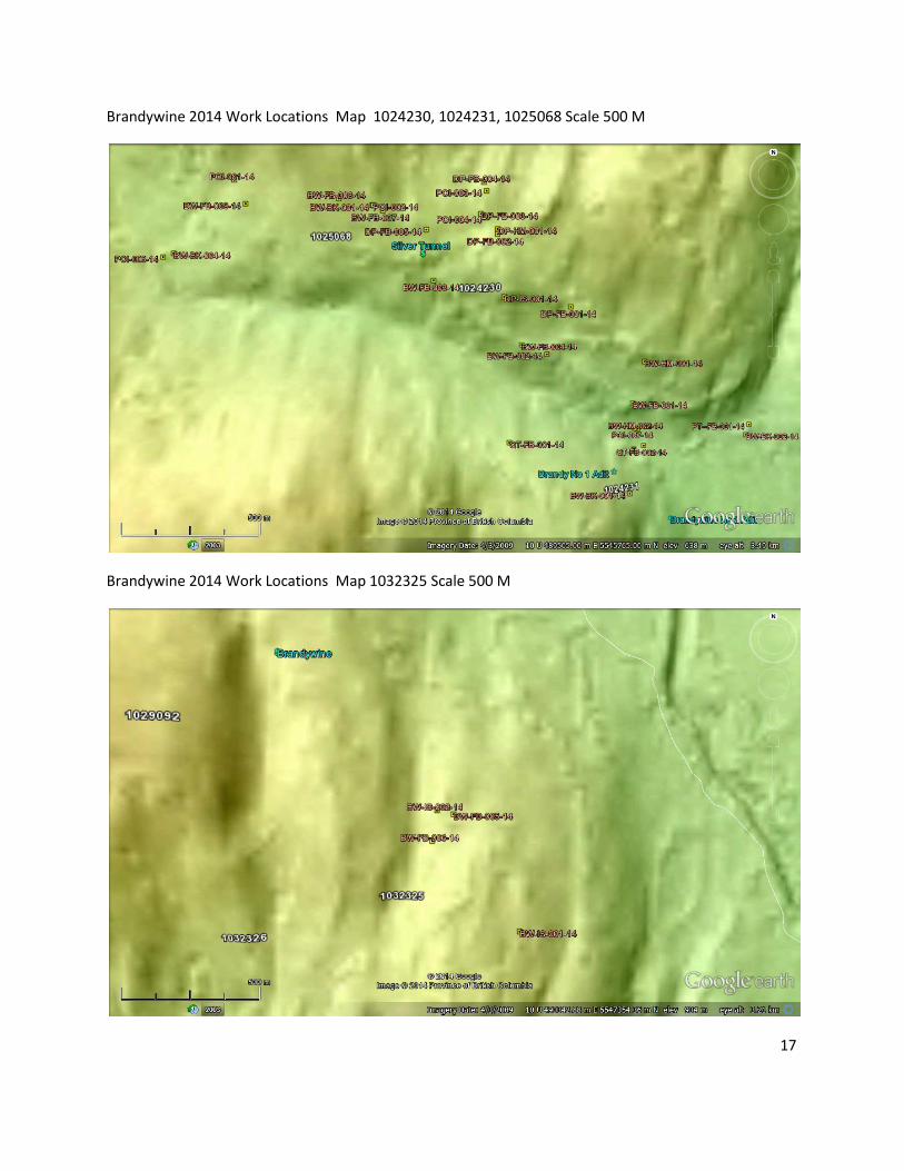
Brandywine 2014 Work Locations Map 1024230, 1024231, 1025068 Scale 500 M
Brandywine 2014 Work Locations Map 1032325 Scale 500 M
17
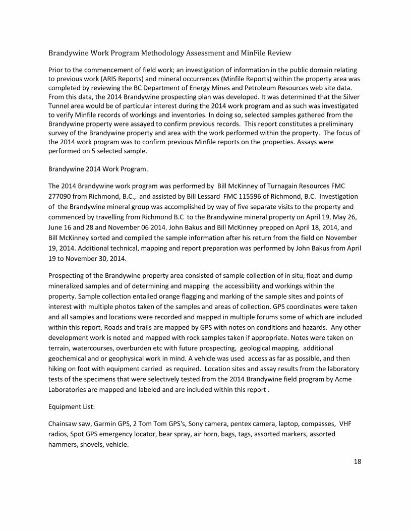
Brandywine Work Program Methodology Assessment and MinFile Review
Prior to the commencement of field work; an investigation of information in the public domain relating to previous work (ARIS Reports) and mineral occurrences (Minfile Reports) within the property area was completed by reviewing the BC Department of Energy Mines and Petroleum Resources web site data. From this data, the 2014 Brandywine prospecting plan was developed. It was determined that the Silver Tunnel area would be of particular interest during the 2014 work program and as such was investigated to verify Minfile records of workings and inventories. In doing so, selected samples gathered from the Brandywine property were assayed to confirm previous records. This report constitutes a preliminary survey of the Brandywine property and area with the work performed within the property. The focus of the 2014 work program was to confirm previous Minfile reports on the properties. Assays were performed on 5 selected sample. Brandywine 2014 Work Program.
The 2014 Brandywine work program was performed by Bill McKinney of Turnagain Resources FMC
277090 from Richmond, B.C., and assisted by Bill Lessard FMC 115596 of Richmond, B.C. Investigation
of the Brandywine mineral group was accomplished by way of five separate visits to the property and
commenced by travelling from Richmond B.C to the Brandywine mineral property on April 19, May 26,
June 16 and 28 and November 06 2014. John Bakus and Bill McKinney prepped on April 18, 2014, and
Bill McKinney sorted and compiled the sample information after his return from the field on November
19, 2014. Additional technical, mapping and report preparation was performed by John Bakus from April
19 to November 30, 2014.
Prospecting of the Brandywine property area consisted of sample collection of in situ, float and dump
mineralized samples and of determining and mapping the accessibility and workings within the
property. Sample collection entailed orange flagging and marking of the sample sites and points of
interest with multiple photos taken of the samples and areas of collection. GPS coordinates were taken
and all samples and locations were recorded and mapped in multiple forums some of which are included
within this report. Roads and trails are mapped by GPS with notes on conditions and hazards. Any other
development work is noted and mapped with rock samples taken if appropriate. Notes were taken on
terrain, watercourses, overburden etc with future prospecting, geological mapping, additional
geochemical and or geophysical work in mind. A vehicle was used access as far as possible, and then
hiking on foot with equipment carried as required. Location sites and assay results from the laboratory
tests of the specimens that were selectively tested from the 2014 Brandywine field program by Acme
Laboratories are mapped and labeled and are included within this report .
Equipment List:
Chainsaw saw, Garmin GPS, 2 Tom Tom GPS's, Sony camera, pentex camera, laptop, compasses, VHF
radios, Spot GPS emergency locator, bear spray, air horn, bags, tags, assorted markers, assorted
hammers, shovels, vehicle.
18
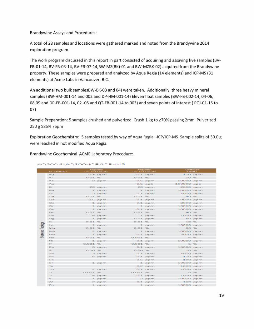
Brandywine Assays and Procedures:
A total of 28 samples and locations were gathered marked and noted from the Brandywine 2014
exploration program.
The work program discussed in this report in part consisted of acquiring and assaying five samples (BV-
FB-01-14, BV-FB-03-14, BV-FB-07-14,BW-MZ(BK)-01 and BW-MZBK-02) acquired from the Brandywine
property. These samples were prepared and analyzed by Aqua Regia (14 elements) and ICP-MS (31
elements) at Acme Labs in Vancouver, B.C.
An additional two bulk samplesBW-BK-03 and 04) were taken. Additionally, three heavy mineral
samples (BW-HM-001-14 and 002 and DP-HM-001-14) Eleven float samples (BW-FB-002-14, 04-06,
08,09 and DP-FB-001-14, 02 -05 and QT-FB-001-14 to 003) and seven points of interest ( POI-01-15 to
07)
Sample Preparation: 5 samples crushed and pulverized Crush 1 kg to ≥70% passing 2mm Pulverized
250 g ≥85% 75μm
Exploration Geochemistry: 5 samples tested by way of Aqua Regia -ICP/ICP-MS Sample splits of 30.0 g
were leached in hot modified Aqua Regia.
Brandywine Geochemical ACME Laboratory Procedure:
19
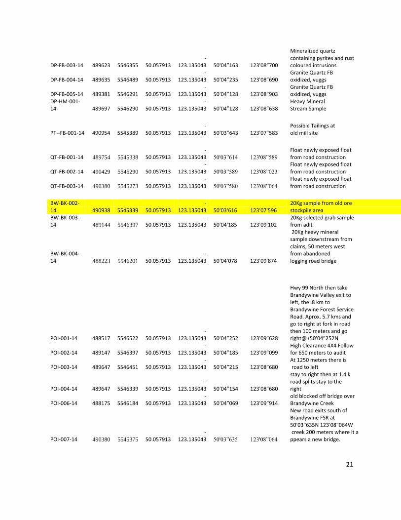
Brandywine 2014 Work Program Spreadsheet
Brandywine 2014
Assayed in Event 5532374
Samples Yellow
Sample X 11U Y 11U Lat Lon Lat Lon Notes
BW-FB-001-14 490355 5545502 50.057913 -
123.135043 50 03'42.2” 123 08'5.1”
Quartz, containing minor pyrites and highly oxidized on surface. Sample had fallen off vein about 3 meters above which is exposed horizontally for about 10 meters.
BW-FB-002-14 489936 5545737 50.057913 -
123.135043 50 03'49.8 123 08'26.2
Blue grey granite, lightly oxidize with minor pyrites.
BW-FB-003-14 489410 5545076 50.057913 -
123.135043 50 04'00.7 123 08'52.7
Lightly mineralized quartz containing pyrites and rust coloured intrusions.
BW-FB-004-14 489819 5545781 50.057913 -
123.135043 50 03'51.2 123 08'32.1 Blue grey granite, lightly oxidized.
BW-HM-001-14 490385 5545703 50.057913
-123.135043 50 03'48.7 123 08'03.6 Some pyrite flakes.
BW-HM-002-14 490396 5545373 50.057913
-123.135043 50 03'38.04 123 08'3.06
Small quartz pieces and small amount of black sand.
BW-BK-001-14 489150 5546395 50.057913
-123.135043
50' 04” 11.04 123' 09” 05.8
(Main Zone) Random 50 kg Sample
BW-IS-001-14 490588 5546907 50.057913 -
123.135043 50' 04” 27.7 123' 07” 53.5 In Situ Outcrop
BW-FB-005-14 490339 5547349 50.057913 -
123.135043 50' 04” 42.0 123' 08” 6.06 Float lightly oxidized
BW-IS-002-14 490277 5547364 50.057913 -
123.135043 50' 04” 42.48 123' 08” 9.18
(possible old caved audit) In Situ
BW-FB-006-14 490258 5547247 50.057913 -
123.135043 50' 04” 38.7 123' 08” 10.14 Float
BW-FB-007-14 489189 5546375 50.057913 -
123.135043 50' 04” 10.38 123' 09” 3.84 Float
BW-FB-008-14 488994 5546427 50.057913 -
123.135043 50' 04” 12.06
123' 09” 13.62 Float
BW-FB-009-14 488561 5546417 50.057913 -
123.135043 50' 04” 11.7 123' 09” 35.22
Float (possible old processing site)
DP-IS-001-14 489729 5545995 50.057913 -
123.135043 50'03”969 123'08”611 In Situ outcrop quartz
DP-FB-001-14 490034 5545952 50.057913 -
123.135043 50'03”946 123'08”355 Granite Quartz FB, vuggs
DP-FB-002-14 489697 5546268 50.057913 -
123.135043 50'04”116 123'08”638 Granite Quartz FB oxidized, vuggs
20
DP-FB-003-14 489623 5546355 50.057913 -
123.135043 50'04”163 123'08”700
Mineralized quartz containing pyrites and rust coloured intrusions
DP-FB-004-14 489635 5546489 50.057913 -
123.135043 50'04”235 123'08”690 Granite Quartz FB oxidized, vuggs
DP-FB-005-14 489381 5546291 50.057913 -
123.135043 50'04”128 123'08”903 Granite Quartz FB oxidized, vuggs
DP-HM-001-14 489697 5546290 50.057913
-123.135043 50'04”128 123'08”638
Heavy Mineral Stream Sample
PT--FB-001-14 490954 5545389 50.057913
-123.135043 50'03”643 123'07”583
Possible Tailings at old mill site
QT-FB-001-14 489754 5545338 50.057913
-123.135043 50'03”614 123'08”589
Float newly exposed float from road construction
QT-FB-002-14 490429 5545290 50.057913 -
123.135043 50'03”589 123'08”023
Float newly exposed float from road construction
QT-FB-003-14 490380 5545273 50.057913 -
123.135043 50'03”580 123'08”064
Float newly exposed float from road construction
BW-BK-002-14 490938 5545339 50.057913
-123.135043 50'03'616 123'07'596
20Kg sample from old ore stockpile area
BW-BK-003-14 489144 5546397 50.057913
-123.135043 50'04'185 123'09'102
20Kg selected grab sample from adit
BW-BK-004-14 488223 5546201 50.057913
-123.135043 50'04'078 123'09'874
20Kg heavy mineral sample downstream from claims, 50 meters west from abandoned logging road bridge
POI-001-14 488517 5546522 50.057913 -
123.135043 50'04”252 123'09”628
Hwy 99 North then take Brandywine Valley exit to left, the .8 km to Brandywine Forest Service Road. Aprox. 5.7 kms and go to right at fork in road then 100 meters and go right@ (50'04”252N
POI-002-14 489147 5546397 50.057913 -
123.135043 50'04”185 123'09”099 High Clearance 4X4 Follow for 650 meters to audit
POI-003-14 489647 5546451 50.057913 -
123.135043 50'04”215 123'08”680 At 1250 meters there is road to left
POI-004-14 489647 5546339 50.057913 -
123.135043 50'04”154 123'08”680
stay to right then at 1.4 k road splits stay to the right
POI-006-14 488175 5546184 50.057913 -
123.135043 50'04”069 123'09”914 old blocked off bridge over Brandywine Creek
POI-007-14 490380 5545375 50.057913 -
123.135043 50'03”635 123'08”064
New road exits south of Brandywine FSR at 50'03”635N 123'08”064W creek 200 meters where it a ppears a new bridge.
21

Brandywine General Work Site Tenure Map KM 1024230, 1024231, 1025068, 1032325 and 1032326
Scale 1:25,000
22

Brandywine Geochemical ACME Laboratory Results Certificate
23

24
Brandywine Geochemical ACME Laboratory Results Location Map Tenures 1024230, 1025068
25

Brandywine Geochemical ACME Laboratory Results Location Map Tenure 1024231
26

Event 5532364 Brandywine Geochemical Physical Work Report Form
27
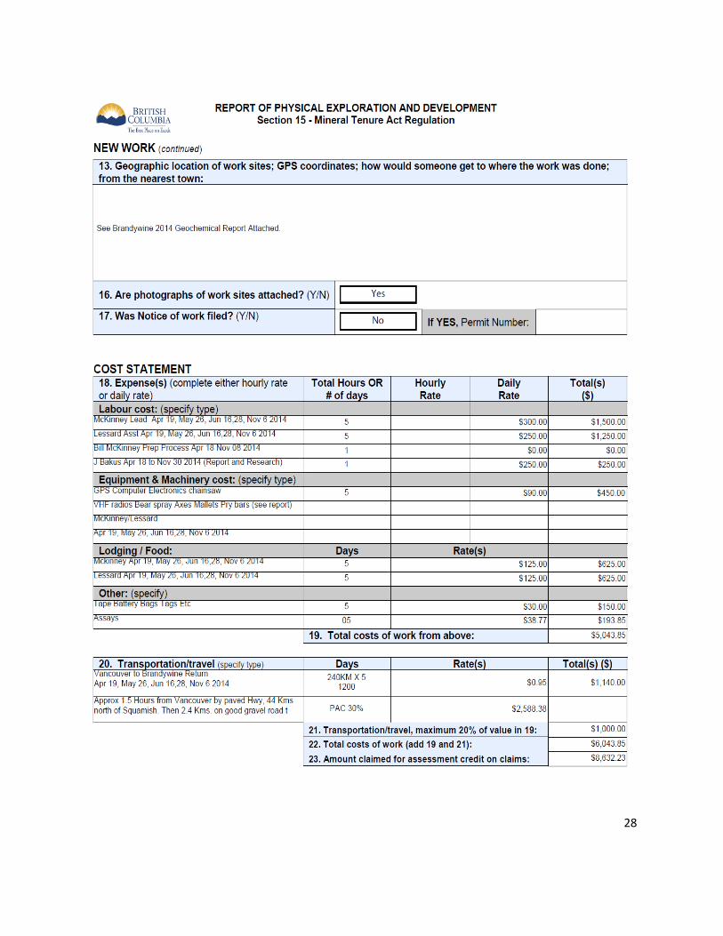
28
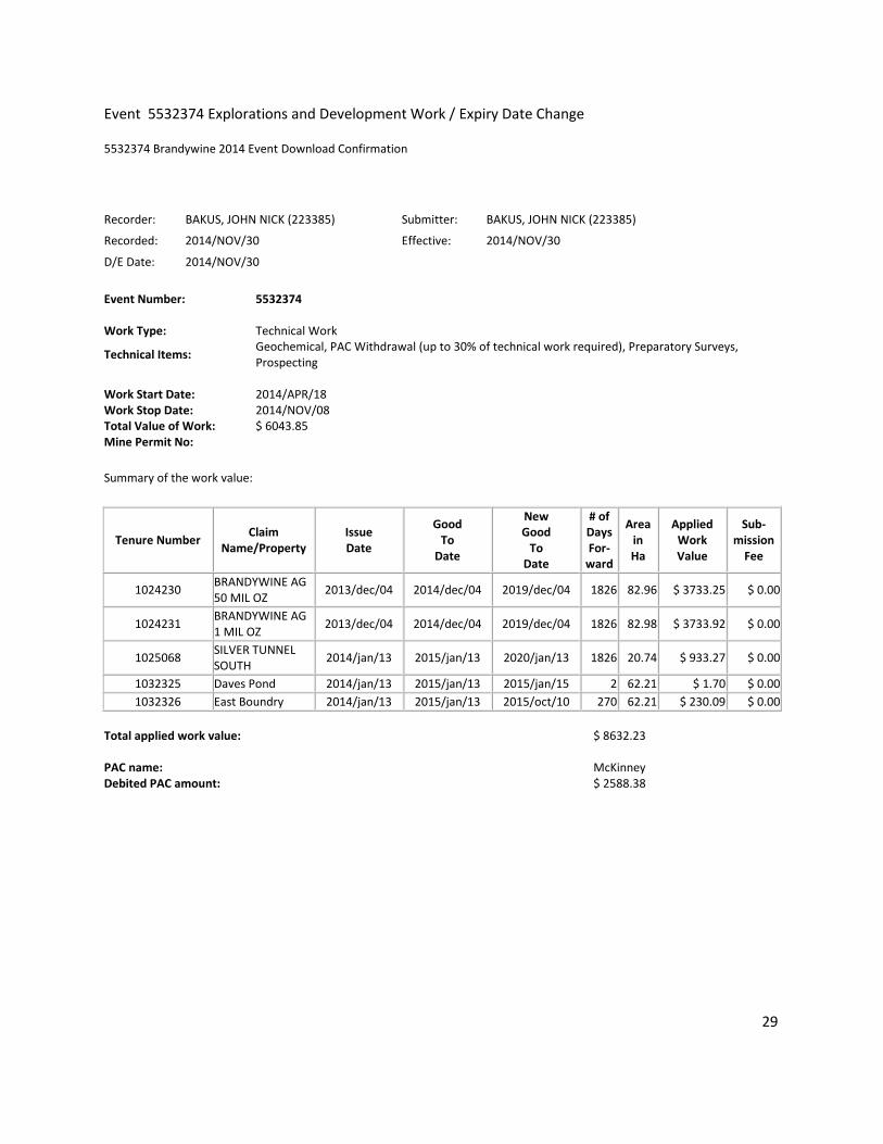
Event 5532374 Explorations and Development Work / Expiry Date Change
5532374 Brandywine 2014 Event Download Confirmation
Recorder: BAKUS, JOHN NICK (223385) Submitter: BAKUS, JOHN NICK (223385)
Recorded: 2014/NOV/30 Effective: 2014/NOV/30
D/E Date: 2014/NOV/30
Event Number: 5532374 Work Type: Technical Work
Technical Items: Geochemical, PAC Withdrawal (up to 30% of technical work required), Preparatory Surveys, Prospecting
Work Start Date: 2014/APR/18 Work Stop Date: 2014/NOV/08 Total Value of Work: $ 6043.85 Mine Permit No:
Summary of the work value:
Tenure Number Claim
Name/Property Issue Date
Good To
Date
New Good
To Date
# of Days For-
ward
Area in Ha
Applied Work Value
Sub- mission
Fee
1024230 BRANDYWINE AG 50 MIL OZ
2013/dec/04 2014/dec/04 2019/dec/04 1826 82.96 $ 3733.25 $ 0.00
1024231 BRANDYWINE AG 1 MIL OZ
2013/dec/04 2014/dec/04 2019/dec/04 1826 82.98 $ 3733.92 $ 0.00
1025068 SILVER TUNNEL SOUTH
2014/jan/13 2015/jan/13 2020/jan/13 1826 20.74 $ 933.27 $ 0.00
1032325 Daves Pond 2014/jan/13 2015/jan/13 2015/jan/15 2 62.21 $ 1.70 $ 0.00
1032326 East Boundry 2014/jan/13 2015/jan/13 2015/oct/10 270 62.21 $ 230.09 $ 0.00
Total applied work value:
$ 8632.23
PAC name:
McKinney
Debited PAC amount: $ 2588.38
29
Schedule A Brandywine Minfile Detail
30
31

32

33

34
35
36
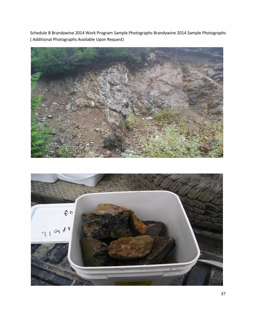
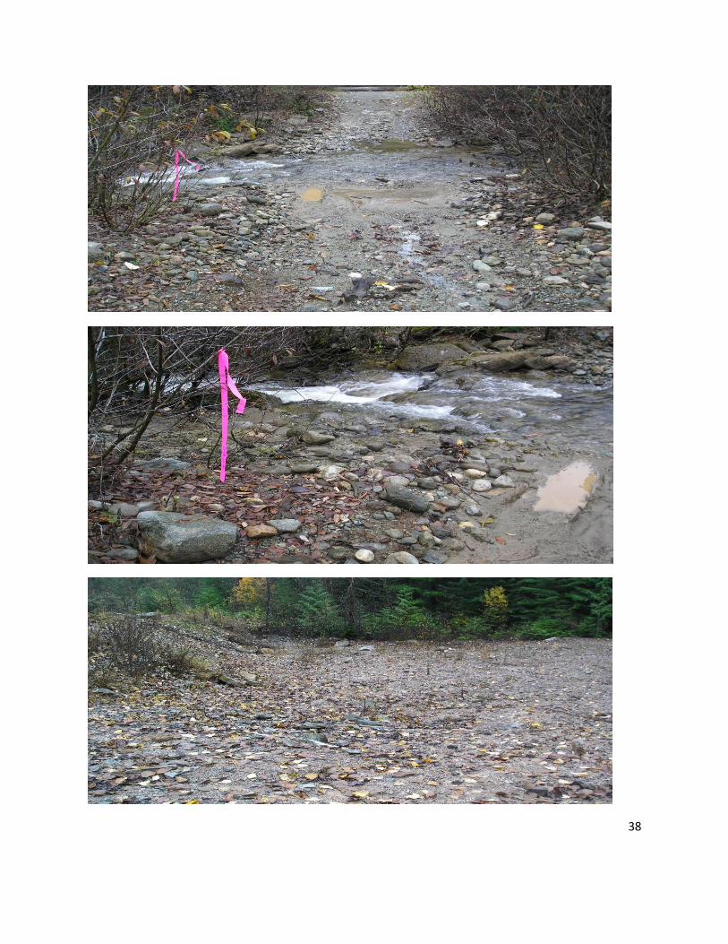
Schedule B Brandywine 2014 Work Program Sample Photographs Brandywine 2014 Sample Photographs
( Additional Photographs Available Upon Request)
37
38

39


