Download - 3.3 NOISE AND VIBRATION - Transportation

Coast Corridor Draft Program EIS/EIR 3.3 Noise and Vibration
3.3-1
3.3 NOISE AND VIBRATION
This section identifies noise and vibration sensitive land uses along the existing
Coast Corridor rail alignment and identifies potential noise and vibration impacts of
both the No Build Alternative and the Build Alternative.
3.3.1 REGULATORY REQUIREMENTS
Federal
Noise Pollution and Abatement Act of 1972
This act addresses excessive noise as a potential threat to human health and
welfare, including noise related to transportation, machinery, appliances, and other
products in commerce. Following adoption of this act, the U.S. Environmental
Protection Agency (EPA) published Information on Levels of Environmental Noise
Requisite to Protect Public Health and Welfare with an Adequate Margin of Safety
(EPA 1974). In this document, EPA provided recommendations for maximum noise
exposure levels below which there would be little to no risk from any of the
identified health or welfare effects of noise.
Federal Noise Emission Compliance Regulation Code
FRA’s Railroad Noise Emission Compliance regulations1 prescribe compliance
requirements for enforcing railroad noise emission standards adopted by the EPA.2
The provisions apply to the total sound emitted by moving rail cars and locomotives
(including the sound produced by refrigeration and air conditioning of units that are
an integral element of such equipment), and associated equipment.
Train Horn Rule and Quiet Zones
Under the Train Horn Rule3, locomotive engineers must begin to sound train horns
at least 15 seconds, and no more than 20 seconds, in advance of all public grade
crossings. The maximum volume level for the train horn is 110 decibels, and the
minimum sound level is 96 decibels.
1 49 CFR 210
2 40 CFR 201
3 49 CFR Part 222

Coast Corridor 3.3 Noise and Vibration Draft Program EIS/EIR
3.3-2
In a quiet zone, railroads have been directed to cease the routine sounding of their
horns when approaching public highway-rail grade crossings. Localities desiring to
establish a quiet zone are first required to mitigate the increased risk caused by the
absence of a train-mounted horn. Measures to reduce risk include gated crossings
with flashing signals, other signage, fencing, and related measures.
State
California Noise Control Act of 1973
The California Noise Control Act4 establishes the Office of Noise Control in the
Department of Health Services to assist local communities developing noise control
programs and provide guidance for cities and counties developing noise elements of
the General Plan in compliance with Government Code Section 65302.
California Occupational Safety and Health Administration (OSHA)
The California OSHA requires employers to provide employees with proper
protection against the effects of noise exposure when sound exceeds certain level
(an 8-hour time weighted average of 90 dBA).5 The protective measures may be
provided either through engineering or administrative controls. If these control
measures fail to reduce the noise within the acceptable limits, personal protective
equipment shall be provided and used. Additionally, whenever employee noise
exposures equal or exceed an 8-hour sound level of 85 dBA, the employer shall
develop and administer a Hearing Conservation Program.
California Noise Insulation Standards
California Noise Insulation Standards6 detail requirements for new multi-family
structures located within the 60 Community Noise Equivalent Level (CNEL)7 contour
adjacent to roads, railroads, rapid transit lines, airports or industrial areas.
Residential buildings or structures located within exterior community noise
equivalent level contours of 60 dB of an existing or adopted freeway, expressway,
major street, thoroughfare, railroad or rapid-transit line shall require an acoustical
analysis showing that the proposed building has been designed to limit intruding
noise to the allowable interior noise levels prescribed in Section 1092 (e)(2).
4 Health and Safety Code Section 46010
5 A decibel (dB) is a unit that describes the amplitude of sound. A dBA describes A-weighting in noise
measurements, which accounts for the relative frequencies at which humans perceive sound. 6 Title 25, Section 1092
7 Community Noise Equivalent Level (CNEL) is a 24-hour average sound level that includes both an
evening and nighttime weighting, as further discussed in Subsection 3.3.2.
Coast Corridor Draft Program EIS/EIR 3.3 Noise and Vibration
3.3-3
California Building Standards Code
The California Buildings Standards Code8 contains the regulations that govern the
construction of buildings in California. The Code requires that for any habitable
room within a multi-family residential development, interior noise levels shall not
exceed a CNEL of 45 dBA for noises attributable to exterior sources. Multi-family
residential uses must comply with pertinent requirements in addition to and
separate from CEQA. However, the State does not regulate noise levels within
single-family detached homes.
Local
Government Code Section 65302 requires cities and counties to include a noise
element as part of their general plans. The Noise Element identifies the major
sources of noise in the area and establishes ways to minimize exposure to sensitive
receptors. A city or county must quantify the current and projected noise levels
from highways and freeways, passenger and freight railroad operations, ground
rapid transit systems, air travels, and other sources.
Monterey County General Plan
The main sources of noise in Monterey County include transportation facilities
(highways, roads, railroads, and aircraft), several industrial and food-packing plants,
mining operations, and power-generation. The Safety Element includes policies that
establish acceptable limits of noise exposure. New noise-sensitive land uses may
only be allowed in areas where existing and projected noise levels are deemed
acceptable. Furthermore, the County requires the inclusion of standard noise
protection measures into all construction contracts. These measures limit
construction hours, require noise muffling equipment, and set forth other
regulations to reduce potential noise effects.
City of Salinas General Plan
The Noise Element identifies existing and projected noise sources in the community
and identifies ways to reduce potential impacts. The Noise Element contains
policies and programs to achieve and maintain noise levels compatible with various
types of land uses. Like most urbanized areas, Salinas experiences increasing noise
levels associated with transportation and other sources. In addition to standard
8 Title 24, California Code of Regulations

Coast Corridor 3.3 Noise and Vibration Draft Program EIS/EIR
3.3-4
policies to shield sensitive receptors from noise exposure, Salinas has developed a
Noise Plan that defines the City’s specific programs along with an implementation
plan. Programs include specific land use compatibility guidelines with maximum
noise level amounts, based on the land use designation.
City of Soledad General Plan
The major source of noise in Soledad is car and truck traffic on US 101. However,
other noise generators that contribute to local ambient noise levels include
railroads, aircraft, farming activities, quarry activities, and industrial facilities.
Policies and implementation programs outlined in the Noise Element focus on
establishing noise projections for proper planning and reducing the noise impacts at
sensitive receptor locations. The Soledad Downtown Specific Plan (2012)
contemplated a variety of new land uses in central portion of the City, including
conceptual plans for a proposed new passenger rail station (identical to the station
included here as part of the Build Alternative). In its environmental review of the
specific plan as a whole, the City concluded that buildout would result in temporary
construction noises, but with mitigation, such noises would not result in any
significant impacts.9
City of King City (King City) General Plan
According to the King City Noise Element, primary noise sources are US 101, the
railroad, and industrial activities. King City has adopted goals and policies to
encourage land use patterns that reduce the level of human noise exposure.10 King
City adopted the First Street Corridor Master Plan, in which the city contemplated a
number of land use changes, including conceptual plans for a passenger rail station
(identical to the station included here as part of the Build Alternative).11
San Luis Obispo County General Plan
The main sources of noise in San Luis Obispo County are from roadways, railroads,
airports, and agricultural and commercial activities. The County General Plan
includes policies and mitigation to reduce noise impacts from railroads and these
other sources. The noise exposure ranges depicted on noise contour maps are used
to determine the land use designation of the area and where new development may
occur. Noise created by new transportation noise sources must be consistent and
not exceed the levels specified within each land use designation.
9 City of Soledad,2012, p. 1-3 and appendix
10City of King, 1998, pp. 25-29
11 City of King, 2013, p. 29, p. 82

Coast Corridor Draft Program EIS/EIR 3.3 Noise and Vibration
3.3-5
3.3.2 METHODS OF EVALUATION
Information for the noise and vibration analysis was obtained/developed from
several sources. A qualified acoustical professional, with specific subject-matter
expertise as an author of FTA’s Transit Noise and Vibration Impact Assessment
Manual (2006), reviewed aerial mapping of proposed improvements as well as
considerable background information (including but not limited to Appendices B, C,
and D) and recommended appropriate screening distances to assess noise and
vibration impacts based on relevant criteria. The acoustical professional based the
screening distances on potential future train speed estimates and the type of
construction work for each improvement type. Recommended noise screening
distances along the corridor are shown in Table 3.3-1 for train operations in both
2020 and 2040. Vibration screening distances are shown in Table 3.3-2.
Federal Transit Administration Noise and Vibration Impact Assessment
The Federal Transit Administration (FTA) guidance manual, Transit Noise and
Vibration Impact Assessment (2006) contains methods for combining transit/rail
noise sources with traffic and bus noise sources at stations using both FTA criteria
(which are identical to the FRA criteria) and FHWA criteria.
The purpose of the document is to provide understanding of noise and vibration
effects of mass-transit projects located in population centers and populated land
use types. Furthermore, the document provides noise and vibration fundamentals
for subject-matter understanding and context.
Noise Compatibility
Based on the recommended screening distances, the second component of the
analysis was to inventory the surrounding land uses within the screening areas.
Generally, land use categories characterize the density of people and intensity of
nearby development. As a result, land use typology is a helpful gauge of the
potential presence of sensitive receptors. A review of aerial maps was conducted to
determine the presence of potentially sensitive land uses near the existing rail
alignment and proposed improvement areas. Sensitive land uses for this analysis
include residences, schools, hospitals, parks, and historic structures. Land use
assumptions are as follows:
Agricultural: Fields of crops, fences, farm equipment, rural dirt roads, electrical
distribution lines, barns, and crop processing buildings are dominant features in
an agricultural area. Agricultural areas may also include residential uses -
typically farmhouses or other farmworker housing.

Coast Corridor 3.3 Noise and Vibration Draft Program EIS/EIR
3.3-6
Urban/Suburban: Urban/suburban areas include residential and commercial
buildings, parking lots, and landscaping along streets and sidewalks. Generally,
urban/suburban areas have many residential sensitive receptors.
Industrial/Institutional: Industrial areas typically include utility lines,
equipment, machinery, freight tracks, and factories. Sensitive receptors in these
areas would be employees working in factories or operating machinery.
Open Space/Undeveloped: Open space and undeveloped areas include rolling
hills, mountain ranges, valleys, and trees and shrubs are visible on the horizon.
Residential and commercial developments are not prevalent in these areas.
The analysis then compares future noise and vibration created by each alternative
with the existing land use to determine the level of compatibility with each existing
land use type.
High compatibility indicates areas where the alternative would affect none or
very few sensitive receptors, either because sensitive land uses are not present
within the provided screening distances or that the nature of the proposed work
would not produce noticeable noise and vibration effects.
Medium compatibility indicates areas where there may be a moderate number
of sensitive land uses nearby within the screening distances and would be
moderately affected.
Low compatibility indicates areas where there are many sensitive land uses
nearby within the screening distances and would be highly affected.
Trains and train horns sounding at at-grade crossings are main contributor to
ambient noise levels in the immediate vicinity of the existing railroad, particularly
where the railroad is separated from US 101 by more than 0.25 miles.
As neither alternative would remove any existing at-grade crossings, screening
distances are sized to assume the ongoing use of horns (i.e., the distances are larger
than if no horns were sounding). Table 3.3-1 below reflects the screening distances
used in this analysis which reflect existing or new mainline operations as well as
siding increases.

Coast Corridor Draft Program EIS/EIR 3.3 Noise and Vibration
3.3-7
Table 3.3-1 Noise Screening Distances
Segment 2020 2040
Start Point
(Mile Post)
End Point
(Mile Post)
Mainline Operations
(Feet)
Siding Increase
(Feet)
Mainline Operations
(Feet)
Siding Increase
(Feet)
MP 114.9 Salinas
MP 116.9 Salinas
100 200 200 0
MP 116.9 Firestone
MP 144.9 Soledad
500 100 600 0
MP 144.9 Harlem
MP 155.5 Harlem
500 0 700 0
MP 155.5 Detector
MP 160.3 Detector
50 100 100 100
MP 160.7 King City
MP 163.7 King City
50 200 100 100
MP 163.7 Welby
MP 185.7 San Ardo
500 100 600 0
MP 185.7 Wunpost
MP 207.6 McKay
500 100 600 0
MP 207.6 Wellsona
MP 210.7 Wellsona
600 0 700 0
MP 210.7 Detector
MP 218.4 Paso Robles
500 100 600 0
MP 218.4 Templeton
MP 226.9 Atascadero
600 0 700 0
MP 226.9 Detector
MP 229.6 Detector
50 100 50 100
MP 229.6 Santa Margarita
MP 233.1 Santa Margarita
100 200 300 0
MP 233.1 South Santa Margarita
MP 234 South Santa Margarita
300 100 500 0
MP 234 Cuesta
MP 238.8 Cuesta
500 100 700 0
Coast Corridor 3.3 Noise and Vibration Draft Program EIS/EIR
3.3-8
Segment 2020 2040
Start Point
(Mile Post)
End Point
(Mile Post)
Mainline Operations
(Feet)
Siding Increase
(Feet)
Mainline Operations
(Feet)
Siding Increase
(Feet)
MP 238.8 Serrano
MP 244.8 Chorro
600 0 900 0
MP 244.8 Detector
MP 248.4 Detector
500 100 700 0
MP 248.4 N. San Luis Obispo
MP 248.5 N. San Luis Obispo
500 0 800 0
Source: Cross-Spectrum Acoustics, 2013
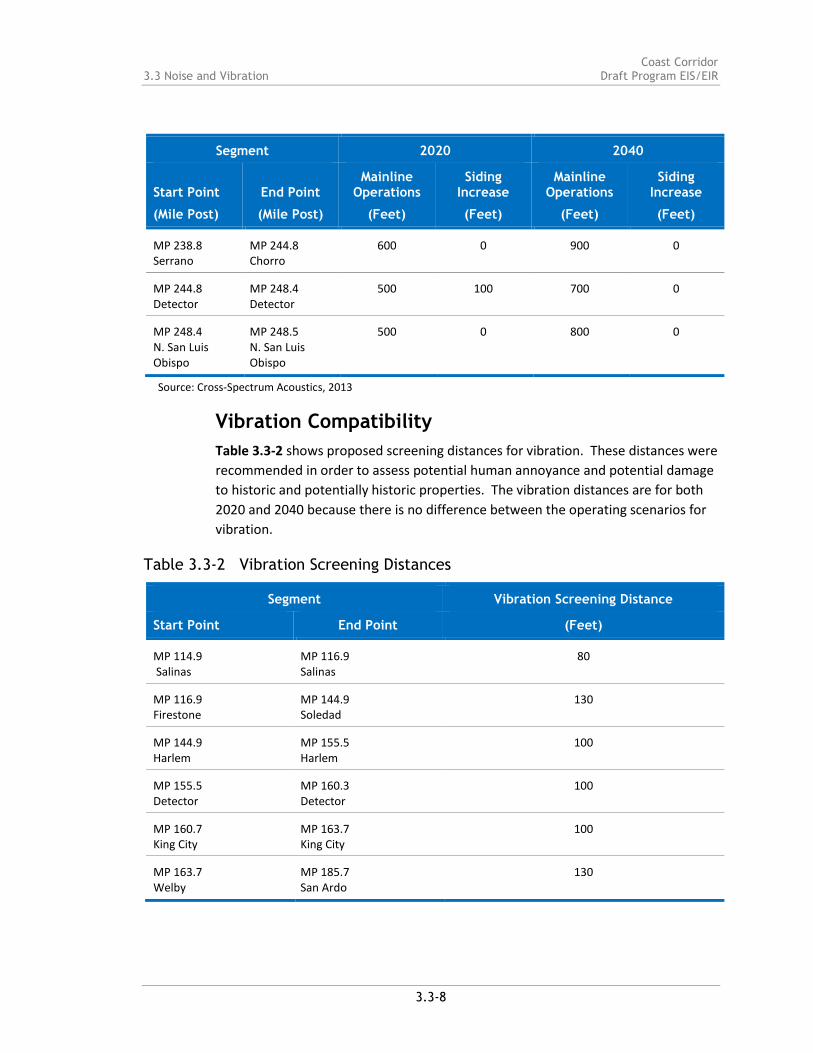
Vibration Compatibility
Table 3.3-2 shows proposed screening distances for vibration. These distances were
recommended in order to assess potential human annoyance and potential damage
to historic and potentially historic properties. The vibration distances are for both
2020 and 2040 because there is no difference between the operating scenarios for
vibration.
Table 3.3-2 Vibration Screening Distances
Segment Vibration Screening Distance
Start Point End Point (Feet)
MP 114.9 Salinas
MP 116.9 Salinas
80
MP 116.9 Firestone
MP 144.9 Soledad
130
MP 144.9 Harlem
MP 155.5 Harlem
100
MP 155.5 Detector
MP 160.3 Detector
100
MP 160.7 King City
MP 163.7 King City
100
MP 163.7 Welby
MP 185.7 San Ardo
130
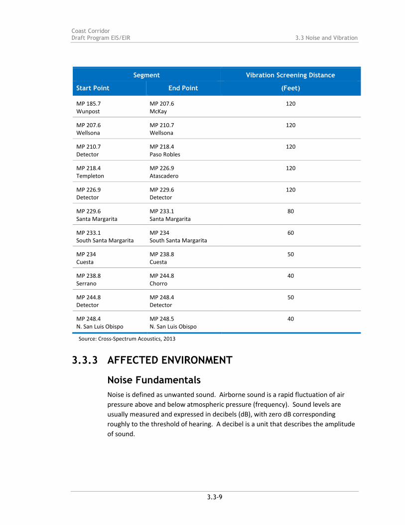
Coast Corridor Draft Program EIS/EIR 3.3 Noise and Vibration
3.3-9
Segment Vibration Screening Distance
Start Point End Point (Feet)
MP 185.7 Wunpost
MP 207.6 McKay
120
MP 207.6 Wellsona
MP 210.7 Wellsona
120
MP 210.7 Detector
MP 218.4 Paso Robles
120
MP 218.4 Templeton
MP 226.9 Atascadero
120
MP 226.9 Detector
MP 229.6 Detector
120
MP 229.6 Santa Margarita
MP 233.1 Santa Margarita
80
MP 233.1 South Santa Margarita
MP 234 South Santa Margarita
60
MP 234 Cuesta
MP 238.8 Cuesta
50
MP 238.8 Serrano
MP 244.8 Chorro
40
MP 244.8 Detector
MP 248.4 Detector
50
MP 248.4 N. San Luis Obispo
MP 248.5 N. San Luis Obispo
40
Source: Cross-Spectrum Acoustics, 2013
3.3.3 AFFECTED ENVIRONMENT
Noise Fundamentals
Noise is defined as unwanted sound. Airborne sound is a rapid fluctuation of air
pressure above and below atmospheric pressure (frequency). Sound levels are
usually measured and expressed in decibels (dB), with zero dB corresponding
roughly to the threshold of hearing. A decibel is a unit that describes the amplitude
of sound.

Coast Corridor 3.3 Noise and Vibration Draft Program EIS/EIR
3.3-10
Most of the sounds heard in the environment do not consist of a single frequency,
but rather a broad band of frequencies, with each frequency differing in sound level.
The intensities of each frequency add together to generate a sound and form the
overall ambient noise level. The method commonly used to quantify environmental
sounds consists of evaluating all of the frequencies; human hearing is less sensitive
at low frequencies and extreme high frequencies than in the frequency mid-range,
which is called "A" weighting and is how humans perceive noise. A-weighting de-
emphasizes low-frequency and very high-frequency sound in a manner similar to
human hearing. The use of A-weighting is required by most local agencies as well as
other federal and state noise regulations (e.g., the California Department of
Transportation, U.S. Environmental Protection Agency, U.S. Department of Labor,
Occupational Safety & Health Administration and U.S. Department of Housing and
Urban Development).
In practice, the level of a sound source is measured using a sound level meter that
includes an electrical filter corresponding to the A-weighting curve. Typical A-
weighted levels measured in the environment are shown in Figure 3.3-1 for
different types of noise.
In determining the daily level of environmental noise, it is important to account for
the difference in response of people to daytime and nighttime noises. During the
nighttime, exterior background noises are generally lower than the daytime levels.
However, most household noise also decreases at night and exterior noise becomes
very noticeable. Further, most people sleep at night and are very sensitive to noise
intrusion. To account for human sensitivity to nighttime noise levels, a descriptor,
Ldn (day/night average sound level), was developed. The Ldn divides the 24-hour day
into the daytime of 7:00 AM to 10:00 PM and the nighttime of 10:00 PM to 7:00
AM. The nighttime noise level is weighted 10 dB higher than the daytime noise
level. The CNEL is another 24-hour average that includes both an evening and
nighttime weighting.
Vibration Fundamentals
Ground vibration consists of rapidly fluctuating motions or waves with an average
motion of zero. Peak Particle Velocity (PPV) is typically used to quantify vibration
amplitude. The PPV is defined as the maximum instantaneous positive or negative
peak of the vibration wave and are used to evaluate human response to vibration.
To sensitive individuals, vibrations approaching the threshold of perception can be
annoying. Figure 3.3-2 displays the reactions of people and the effects on buildings
that continuous typical ground-borne vibration levels can produce.

Coast Corridor Draft Program EIS/EIR 3.3 Noise and Vibration
3.3-11
Low-level vibrations frequently cause irritating secondary vibration, such as a slight
rattling of windows, doors, or stacked dishes. The rattling sound can give rise to
exaggerated vibration complaints, even though there is very little risk of actual
structural damage. In high noise environments, which are more prevalent where
groundborne vibration approaches perceptible levels, this rattling phenomenon may
also be produced by loud airborne environmental noise causing induced vibration in
exterior doors and windows.
Construction activities can cause vibration that can vary in intensity. The use of pile
driving and vibratory compaction equipment typically generates the highest
construction related ground-borne vibration levels. Because of the impulsive nature
of such activities, the use of the peak particle velocity descriptor (PPV) has been
routinely used to measure and assess ground-borne vibration and almost exclusively
to assess the potential of vibration to induce structural damage and the degree of
annoyance for humans.
Railroad Noise and Vibration
Transit noise is generated by transit vehicles in motion, as well as from locomotive
engine exhaust. Speed also plays a direct factor in noise levels; however, according
to the FTA’s Transit Noise and Vibration Impact Assessment, locomotive exhaust
noise dominates at low speeds for diesel-powered trains. As speed increases,
wheel-rail noise becomes dominant. Trains are also equipped with horns and bells
for use in emergency situations as well as to signal to pedestrians and vehicles
before traveling through an intersection or at-grade crossings. Horns and bells
combined with moving vehicle noise can generate noise levels that are considered
annoying to nearby residents and other sensitive receptors.12
Ambient vibration is usually characterized with a continuous 10- to 30-minute
measurement of vibration. Passenger and freight trains usually create high levels of
vibration, but intermittently and for short periods of time. Train vibration results
from the type of wheel, texture of the railway tracks, and train speed. Effects upon
sensitive receptors will vary based on structural components of the nearby building
as well as geology of the underlying bedrock and soil.13
The study area encompasses a spectrum of land uses, all of which differ in ambient
noise level. Rural, undeveloped areas have lower noise levels in comparison to
noise levels near roadways and urban developments. Much of the study area
12 Federal Transit Administration (FTA), 2006, pp. 2-6 – 2-7
13FTA, 2006,.pp. 7-11
Coast Corridor 3.3 Noise and Vibration Draft Program EIS/EIR
3.3-12
encompasses agricultural, open space areas as well as industrial/institutional and
urban/suburban areas. US 101 and the existing Coast Corridor alignment are the
largest contributors to the ambient noise levels in the study area.
According to information from the applicable county general plans, existing noise
levels along the US 101 corridor - near which much of the existing railroad is located
-are between 60 and 70 CNEL.14
3.3.4 ENVIRONMENTAL CONSEQUENCES
No Build Alternative
The No Build Alternative would involve maintaining existing physical conditions
along the Coast Corridor study area. The No Build Alternative contemplates rail
service improvements in Salinas and points north along the railroad tracks in
Monterey County that are intended to facilitate expanded passenger rail service.
According to the SDP, freight rail operations are likely to increase by the year 2040,
doubling from 2 daily freight trains today to 4 daily trains in 2040. Implementation
of these projects would occur regardless of whether or not any of the proposed
physical improvements comprising the Build Alternative are ultimately constructed.
The No Build Alternative may thus result in result in noise and vibration impacts to
sensitive land uses, but primarily north of Salinas, as these areas would see both
increased passenger and freight service. The Salinas to San Luis Obispo study area
would see only increased freight service. If additional freight service is proposed for
late night hours, the additional service could result in somewhat more pronounced
noise effects along the corridor, because people are somewhat more sensitive to
nighttime noises. The Phillips 66 Company Rail Spur Extension Project is currently
undergoing CEQA-only review for the proposed construction and operation of a rail
spur into an existing oil refinery in southern San Luis Obispo County, CA.
Build Alternative
Construction-Period Noise and Vibration Effects
The Build Alternative contemplates a number of physical improvements throughout
the Coast Corridor study area. To the extent any of these improvements are
ultimately carried forward for further design leading to construction, heavy
14 County of Monterey, 2006, figure 4.8-3; County of San Luis Obispo , 1992, Noise Element and
Appendix A

Coast Corridor Draft Program EIS/EIR 3.3 Noise and Vibration
3.3-13
equipment and vehicles could result in temporary increases in noise and vibration
levels. These temporary construction impacts would be more pronounced at
nighttime when overall ambient noise levels are lower. Table 3.3-3 outlines typical
construction equipment and their relative noise levels.
Proposed improvements that require extensive grading or excavation, such as curve
realignments, siding extensions, and new stations would have a more noticeable
noise and vibration effect owing to anticipated construction time. Additionally,
some of the proposed improvements would likely require site clearing and
earthmoving activities, such as excavation, grading, and vibratory rolling, toward the
construction of new rail tracks.
Powered switches and other track/signal upgrades would generally not require such
extensive use of heavy construction equipment and thus would not have less
potential to result in significant noise or vibration effects upon sensitive receptors.
However, the anticipated equipment required for construction is unclear at this
time, since the Build Alternative improvements are conceptual at the programmatic
level.
Table 3.3-3 Typical Construction Equipment Noise Levels
Construction Equipment Maximum Noise Level (Lmax) dBA
at 50 feet Maximum Noise Level (Lmax)
dBA at 300 feet
Backhoe 78 63
Compactor (ground) 83 68
Compressor (air) 78 63
Concrete Mixer Truck 79 64
Concrete Pump Truck 81 66
Crane 81 66
Dozer 82 67
Dump Truck 76 61
Excavator 81 66
Front End Loader 79 64
Generator 81 66
Paver 77 62
Pneumatic Tools 85 70
Pumps 81 66
Roller 80 65
Scraper 85 70
Source: FHWA Roadway Construction Noise Model User’s Guide, 2006

Coast Corridor 3.3 Noise and Vibration Draft Program EIS/EIR
3.3-14
Operational Noise and Vibration Effects
The Build Alternative proposes an increase of two passenger trains per day through
the corridor by 2020 and two additional passenger trains per day by the year 2040.
The improvements included in the Build Alternative would also provide improved
efficiency in the movement of existing freight rail through the corridor. As a result,
the Build Alternative has the potential to increase operational noise and vibration
within the Coast Corridor study area.
For diesel-powered commuter rail trains at low speeds, locomotive exhaust is
typically the greatest source of noise. This would occur primarily as trains approach
and pass through urban areas. As speed increases, wheel-rail noise becomes the
dominant noise source. Additionally, the railway itself can radiate noise as it
vibrates in response to the dynamic loading of the moving train. Trains are also
equipped with horns and bells for use in emergency situations and as a general
audible warning to track workers and trespassers within the right-of-way as well as
to pedestrians and motor vehicles at highway grade crossing.15
Noise Compatibility
Table 3.3-4 summarizes the potential for the proposed physical improvements and
service expansion comprising the Build Alternative to result in operational period
noise impacts. The table identifies each proposed improvement’s noise
compatibility within the screening distances identified in Table 3.3-1. Table 3.3-4
also notes existing and proposed maximum speeds for each rail segment.
Table 3.3-4 Noise Compatibility
Build Alternative Components/Current and Future Maximum Train Speeds in the Area
Predominant Land Use Types within Screening
Distance
Noise Compatibility
Salinas Powered Switch
Current Max Speed: 40-60 mph
Future Max Speed: No Change
N/A N/A
15 FTA, 2006

Coast Corridor Draft Program EIS/EIR 3.3 Noise and Vibration
3.3-15
Build Alternative Components/Current and Future Maximum Train Speeds in the Area
Predominant Land Use Types within Screening
Distance
Noise Compatibility
Upgrades to Existing Alignment Section #1
Current Max Speed: 60-70 mph
Future Max Speed: 90 mph
Industrial/Institutional; Urban/Suburban; Some
Agricultural
High in Agricultural areas; Low in Residential areas
Spence Siding Extension
Current Max Speed: 60-70 mph
Future Max Speed: 90 mph
Agricultural N/A
Upgrades to Existing Alignment Section #2
Current Max Speed Zones 60-70 mph; 35-40
Future Max Speed Zones: 90 mph; 60 mph
Mostly Agricultural; Urban/Suburban near Chualar,
Gonzales, and Soledad
High in Agricultural areas; Low in Residential areas
Gonzales Powered Switch
Current Max Speed: 60-70 mph
Future Max Speed: 90 mph
N/A N/A
Soledad Powered Switch
Current Max Speed: 60-70 mph
Future Max Speed: 90 mph
N/A N/A
Soledad New Passenger Station
Current Max Speed: 60-70 mph
Future Max Speed: 90 mph
Industrial/Institutional; Urban/Suburban; Vosti Park
Medium
Harlem/Metz Curve Realignments
Current Max Speed: 35-40 mph
Future Max Speed: 60 mph
Agricultural; Open Space/Undeveloped; Some
Residential
High in Agricultural areas; Low in Residential areas
Chalone Creek New Siding
Current Max Speed: 35-40 mph
Future Max Speed: 60 mph
Agricultural; Open Space/Undeveloped; Some
Residential
N/A

Coast Corridor 3.3 Noise and Vibration Draft Program EIS/EIR
3.3-16
Build Alternative Components/Current and Future Maximum Train Speeds in the Area
Predominant Land Use Types within Screening
Distance
Noise Compatibility
Upgrades to Existing Alignment Section #3
Current Max Speed Zones: 35-40 mph; 60-70 mph
Future Max Speed Zones: 60 mph; 60-70 mph (no change)
Agricultural; Open Space/Undeveloped; Some
Industrial
High
Coburn Curve Realignments
Current Max Speed: 35-40 mph
Future Max Speed: 60 mph
Agricultural; Open Space/Undeveloped; Some
Industrial
High in Agricultural areas; Low in Residential areas
King City Siding Extension
Current Max Speed: 60 mph
Future Max Speed: No Change
Some Agricultural; Urban/Suburban
N/A
King City New Passenger Station
Current Max Speed: 60 mph
Future Max Speed: No Change
Industrial/Institutional; Urban/Suburban
Medium
King City Powered Switch
Current Max Speed: 60 mph
Future Max Speed: No Change
N/A N/A
Upgrades to Existing Alignment Section #4
Current Max Speed: 60-70 mph
Future Max Speed: 90 mph
Agricultural; Some Industrial/Institutional; Some
Residential
High in Agricultural areas; Low in Residential areas
MP 165 Curve Realignment
Current Max Speed: 60-70 mph
Future Max Speed: 90 mph
Agricultural; Some Industrial/Institutional; Some
Residential
High in Agricultural areas; Low in Residential areas
San Lucas New Siding
Current Max Speed: 60-70 mph
Future Max Speed: 90 mph
Agricultural; Urban/Suburban N/A

Coast Corridor Draft Program EIS/EIR 3.3 Noise and Vibration
3.3-17
Build Alternative Components/Current and Future Maximum Train Speeds in the Area
Predominant Land Use Types within Screening
Distance
Noise Compatibility
Upgrades to Existing Alignment Section #5
Current Max Speed Zones: 60-70 mph; 40-55 mph
Future Max Speed Zones: 90 mph; 70 mph
Agricultural; Open Space/Undeveloped; some Industrial; some Residential
High in Agricultural areas; Low in Residential areas
MP 172 Track Realignment
Current Max Speed: 60-70 mph
Future Max Speed: 90 mph
Agricultural; Open Space/Undeveloped; some Industrial; some Residential
High in Agricultural areas; Low in Residential areas
San Ardo Powered Switch
Current Max Speed: 60-70 mph
Future Max Speed: 90 mph
N/A N/A
Getty/Bradley Curve Realignments
Current Max Speed Zones: 60-70 mph; 40-55 mph
Future Max Speed Zones: 90 mph; 70 mph
Open Space/Undeveloped High
Bradley Siding Extension
Current Max Speed: 40-55 mph
Future Max Speed: 70 mph
Open Space/Undeveloped; some Residential
N/A
Bradley Powered Switch
Current Max Speed: 40-55 mph
Future Max Speed: 70 mph
N/A N/A
Upgrades to Existing Alignment Section #6
Current Max Speed: 40-55 mph
Future Max Speed: 70 mph
Open Space/Undeveloped; some Industrial and Residential near
Camp Roberts
High in Open Space/Undeveloped areas; Low in Residential areas

Coast Corridor 3.3 Noise and Vibration Draft Program EIS/EIR
3.3-18
Build Alternative Components/Current and Future Maximum Train Speeds in the Area
Predominant Land Use Types within Screening
Distance
Noise Compatibility
Upgrades to Existing Alignment Section #7
Current Max Speed: 40-55 mph
Future Max Speed: 70 mph
Urban/Suburban; some Agricultural
High in Agricultural areas; Low in Residential areas
McKay/ Wellsona Curve Realignments
Current Max Speed: 40-55 mph
Future Max Speed: 70 mph
Open Space/Undeveloped; some Residential
High in Open Space/Undeveloped areas; Low in Residential areas
McKay East Powered Switches
Current Max Speed: 40-55 mph
Future Max Speed: 70 mph
N/A N/A
Wellsona New Siding
Current Max Speed: 40-55 mph
Future Max Speed: 70 mph
Open Space/Undeveloped; some Residential
High in Open Space/Undeveloped areas; Medium in Residential
areas
Upgrades to Existing Alignment Section #8
Current Max Speed: 40-55 mph
Future Max Speed: 70 mph
Urban/Suburban; some Industrial; some Open Space/Undeveloped
High in Open Space/Undeveloped areas; Low in Residential areas
Wellsona/ Paso Robles Curve Realignments
Current Max Speed: 40-55 mph
Future Max Speed: 70 mph
Agricultural; Industrial; some Residential
High in Agricultural areas; Low in Residential areas
Templeton Siding
Current Max Speed: 40-55 mph
Future Max Speed: 70 mph
Urban/Suburban N/A
Templeton/ Henry Curve Realignments
Current Max Speed: 40-50 mph
Future Max Speed: 70 mph
Urban/Suburban; Agricultural High in Agricultural areas; Low in Residential areas

Coast Corridor Draft Program EIS/EIR 3.3 Noise and Vibration
3.3-19
Build Alternative Components/Current and Future Maximum Train Speeds in the Area
Predominant Land Use Types within Screening
Distance
Noise Compatibility
Upgrades to Existing Alignment Section #9
Current Max Speed Zones: 40-55 mph; 35 mph
Future Max Speed Zones: 70 mph (between mp 218.4-223.0)
Urban/Suburban; Santa Margarita Community Park; Pine Mountain
Cemetery
High in Open Space/Undeveloped areas; Low in Residential areas
Henry/Santa Margarita Curve Realignment
Current Max Speed Zones: 40-55 mph; 35 mph
Future Max Speed: No Change
Urban/Suburban; Open Space/ Undeveloped; some Industrial
Low
Santa Margarita Powered Switch
Current Max Speed 40-55 mph
Future Max Speed: No Change
N/A N/A
Cuesta Second Main Track
Current Max Speed: 20-30 mph
Future Max Speed: No Change
Utilities/Open Space High
Upgrades to Existing Alignment Section #10
Current Max Speed: 20-30 mph
Future Max Speed: No Change
Urban/Suburban; Parks Medium
Source: Circlepoint, 2013; Caltrans Division of Rail, 2013
Generally speaking, physical improvements proposed for urban/suburban areas
(where residential uses are common) generally have lower noise compatibility
because there are more sensitive land uses located within the noise screening
distances. Less populated areas like open space/undeveloped lands have few
sensitive land uses, but are considered more sensitive because increased noise
levels could degrade the quality of recreational activities.
Conversely, areas that have agricultural land use types are less likely to be affected
by proposed improvements because there are few people present in these areas to
experience increased noise.

Coast Corridor 3.3 Noise and Vibration Draft Program EIS/EIR
3.3-20
The noise compatibility level also depends on the type of improvement because
changes to the existing rail alignment may potentially expose new sensitive land
uses to operational impacts of the train.
The existing railway alignment passes through all areas potentially affected by curve
realignments, thus the noise generated by passing trains is currently experienced at
these locations. Additionally, curve realignments would serve to straighten the
alignment to some degree, as such, noise associated with reduced train speeds
would likely decrease.
Curve realignments are mostly proposed for agricultural and open space/
undeveloped areas, but some (particularly Wellsona/Paso Robles,
Templeton/Henry, and Henry/Santa Margarita) may affect residential properties
within the operative noise screening distances. The McKay/Wellsona curve
realignment is proposed for lands adjacent to and within the Big Sandy Wildlife
Area. These curve realignments would alter noise levels in these areas by relocating
portions of the railway. However, given the land uses in this area, noise
compatibility would be considered low.
The proposed King City and Soledad passenger rail stations are located in relatively
densely populated areas through which existing passenger and freight rail trains
pass without stopping. There are many noise sensitive uses located near the
footprint of the proposed stations. Train service associated with the Build
Alternative would result in trains that would potentially stop at the proposed new
passenger stations. Trains coming to a stop at a passenger station would travel at
lower speeds and thus result in a different noise profile than trains passing through
without stopping. Locomotive exhaust noise may be more apparent at such low
speeds, but wheel noise would be lower. Additionally, a train traveling through a
populated area would likely sound the train’s horn for standard safety purposes. As
a result, existing noise levels would not drastically change. Therefore, noise
compatibility in these locations would be moderate.
Proposed new sidings or siding extensions are generally less likely to affect sensitive
land uses because the new tracks would be placed within existing right-of-way of
the rail alignment. However, some proposed siding additions or new sidings
(Templeton, Wellsona, Bradley, and King City) could expose populated areas to
potential new noise from train idling. Noise compatibility in these populated
locations would be moderate; trains currently travel along these areas, but the
incremental addition of idling noise could affect sensitive receptors.
Coast Corridor Draft Program EIS/EIR 3.3 Noise and Vibration
3.3-21
Upgrades to tracks along the existing alignment would allow for trains to safely
travel at faster speeds, which may have additional noise impacts. Moreover,
increases in noise due to increased rail service would be gradual over time and
would be intermittent, rather than sudden and sustained.
Along several segments of the existing railroad (#1, #2, #4, and #6), proposed train
speeds would increase from a maximum of 60 miles per hour (mph) to as high as 90
mph. Because there are some sensitive land uses in proximity to this segment, the
incremental noise increase leads to a conclusion of medium compatibility.
Along existing alignment segment #3, train speeds would not substantially increase
and few sensitive land uses are present. Accordingly, noise compatibility would be
high.
Along existing alignment segments #7, #8, and #9, trains could increase from a
maximum speed of 55 mph to 70 mph. Resultant noise compatibility would be high
along portions that are in agricultural use; low in areas with residential uses. Speeds
along existing alignment #10 would not substantially increase, but since this is a
residential area, the resultant noise compatibility would be medium.
Vibration Compatibility
Generally, vibration effects are more localized near the proposed improvement,
thus the screening distance is shorter than noise compatibility. Similarly to the
noise compatibility assessment, proposed improvements within urban/suburban
areas have low vibration compatibility because there are more sensitive land uses
located within the vibration screening distances. Vibration impacts are not as
prevalent for agricultural and open space/undeveloped areas, owing to sparse
population and limited developed infrastructure in these areas.
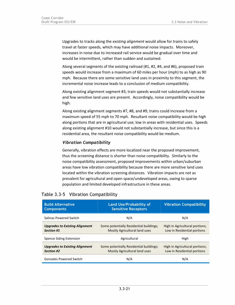
Table 3.3-5 Vibration Compatibility
Build Alternative Components
Land Use/Probability of Sensitive Receptors
Vibration Compatibility
Salinas Powered Switch N/A N/A
Upgrades to Existing Alignment Section #1
Some potentially Residential buildings; Mostly Agricultural land uses
High in Agricultural portions; Low in Residential portions
Spence Siding Extension Agricultural High
Upgrades to Existing Alignment Section #2
Some potentially Residential buildings; Mostly Agricultural land uses
High in Agricultural portions; Low in Residential portions
Gonzales Powered Switch N/A N/A

Coast Corridor 3.3 Noise and Vibration Draft Program EIS/EIR
3.3-22
Build Alternative Components
Land Use/Probability of Sensitive Receptors
Vibration Compatibility
Soledad Powered Switch N/A N/A
Soledad New Passenger Station Some potentially Residential buildings; 8 potentially Historic buildings and 1
potentially Historic park resource
Medium
Harlem/Metz Curve Realignments Mostly Agricultural and Open Space/Undeveloped; Some potentially
Residential properties; 4 potentially Historic properties
High in Agricultural portions; Low in Residential portions
Chalone Creek New Siding Mostly agricultural and open space/undeveloped; Some potentially
residential properties; 1 potentially historic property
High in Agricultural portions; Low in Residential portions
Upgrades to Existing Alignment Section #3
Mostly Agricultural and Open Space/Undeveloped; Some potentially
Residential properties; 2 potentially Historic properties
High in agricultural portions; Low in Residential portions
Coburn Curve Realignments Mostly Agricultural; Some potentially Residential properties
High in agricultural portions; Low in Residential portions
King City Siding Extension Mostly potentially Residential properties; some Agricultural; 6 potentially Historic properties
High in agricultural portions; Medium in Residential
portions
King City New Passenger Station Mostly potentially Residential properties; 3 potentially Historic
properties
Medium
King City Powered Switch N/A N/A
Upgrades to Existing Alignment Section #4
Mostly agricultural and open space/undeveloped; Some potentially
residential properties; 3 potentially historic properties
High in Agricultural portions; Low in Residential portions
MP 165 Curve Realignment Mostly agricultural; Some potentially residential properties; 2 potentially
historic properties
High in Agricultural portions; Low in Residential portions
San Lucas New Siding Mostly agricultural; Some potentially residential properties
High in Agricultural portions; Medium in Residential
portions
Upgrades to Existing Alignment Section #5
Agricultural; open space/undeveloped; some industrial; some residential
High in Agricultural portions; Low in Residential portions

Coast Corridor Draft Program EIS/EIR 3.3 Noise and Vibration
3.3-23
Build Alternative Components
Land Use/Probability of Sensitive Receptors
Vibration Compatibility
MP 172 Track Realignment Mostly Agricultural; some potentially Residential properties; 1 potentially
Historic property
High in Agricultural portions; Low in Residential portions
San Ardo Powered Switch N/A N/A
Getty/Bradley Curve Realignments Open Space/Undeveloped; 1 potentially Historic property
Medium
Bradley Siding Extension Open Space/Undeveloped High
Bradley Powered Switch N/A N/A
Upgrades to Existing Alignment Section #6
Open Space/Undeveloped; some Industrial and Residential near Camp
Roberts; 3 potentially Historic properties
High in Open Space/Undeveloped portions;
Low in Residential portions
Upgrades to Existing Alignment Section #7
Many potentially Residential properties; some Open
Space/Undeveloped; 3 potentially Historic properties
High in Agricultural portions; Low in Residential portions
McKay/Wellsona Curve Realignments
Mostly Open Space/Undeveloped; some potentially Residential
properties; 1 potentially Historic property
High in Open Space/ Undeveloped portions; Low
in Residential portions
McKay East Powered Switches N/A N/A
Wellsona New Siding Mostly open space/undeveloped; some potentially residential properties; 2
potentially historic properties
High in Open Space/Undeveloped portions;
Medium in Residential portions
Upgrades to Existing Alignment Section #8
Many potentially residential properties; some open space/
undeveloped; 3 potentially historic properties
High in Open Space/Undeveloped portions;
Low in Residential portions
Wellsona/Paso Robles Curve Realignments
Mostly Open Space/Undeveloped; some potentially Residential
properties; 3 potentially Historic properties
High in Agricultural portions; Low in Residential portions
Templeton Siding Many potentially Residential properties Low
Templeton/Henry Curve Realignments
Many potentially Residential properties Low
Coast Corridor 3.3 Noise and Vibration Draft Program EIS/EIR
3.3-24
Build Alternative Components
Land Use/Probability of Sensitive Receptors
Vibration Compatibility
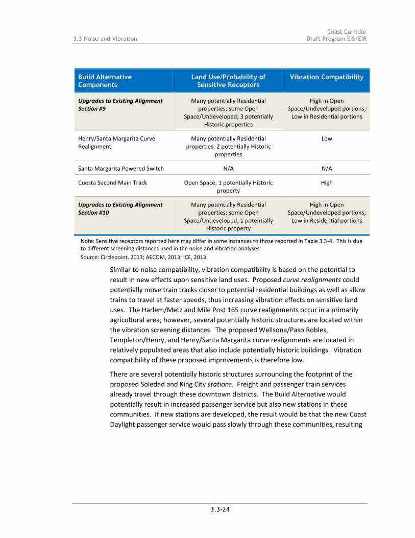
Upgrades to Existing Alignment Section #9
Many potentially Residential properties; some Open
Space/Undeveloped; 3 potentially Historic properties
High in Open Space/Undeveloped portions;
Low in Residential portions
Henry/Santa Margarita Curve Realignment
Many potentially Residential properties; 2 potentially Historic
properties
Low
Santa Margarita Powered Switch N/A N/A
Cuesta Second Main Track Open Space; 1 potentially Historic property
High
Upgrades to Existing Alignment Section #10
Many potentially Residential properties; some Open
Space/Undeveloped; 1 potentially Historic property
High in Open Space/Undeveloped portions;
Low in Residential portions
Note: Sensitive receptors reported here may differ in some instances to those reported in Table 3.3-4. This is due to different screening distances used in the noise and vibration analyses.
Source: Circlepoint, 2013; AECOM, 2013; ICF, 2013
Similar to noise compatibility, vibration compatibility is based on the potential to
result in new effects upon sensitive land uses. Proposed curve realignments could
potentially move train tracks closer to potential residential buildings as well as allow
trains to travel at faster speeds, thus increasing vibration effects on sensitive land
uses. The Harlem/Metz and Mile Post 165 curve realignments occur in a primarily
agricultural area; however, several potentially historic structures are located within
the vibration screening distances. The proposed Wellsona/Paso Robles,
Templeton/Henry, and Henry/Santa Margarita curve realignments are located in
relatively populated areas that also include potentially historic buildings. Vibration
compatibility of these proposed improvements is therefore low.
There are several potentially historic structures surrounding the footprint of the
proposed Soledad and King City stations. Freight and passenger train services
already travel through these downtown districts. The Build Alternative would
potentially result in increased passenger service but also new stations in these
communities. If new stations are developed, the result would be that the new Coast
Daylight passenger service would pass slowly through these communities, resulting

Coast Corridor Draft Program EIS/EIR 3.3 Noise and Vibration
3.3-25
in a lower level of vibration than if trains passed through at high speed.16 Freight
and Coast Starlight trains would continue to pass through Soledad and King City
without stopping at the new stations.
Similarly to proposed curve realignments, new sidings or siding extensions in mostly
developed areas, such as the proposed King City, San Lucas, and Wellsona sidings,
could expose populated areas to potential new noise from train idling. Although
trains currently travel along these areas, new sidings could result in incremental
addition of idling vibration impacts. Vibration compatibility in these areas is
moderate.
As with the noise compatibility assessment, track improvements to existing
alignment areas would allow trains to safely travel at higher speeds and would
accommodate a higher capacity of trains on the corridor. Both of these factors
would contribute to increased vibration to sensitive receptors. Several notable
historic structures and bridges occur within existing alignment areas. The Mission
San Miguel and the Rios Caledonia Adobes area both within the vibration screening
distance of segment #7 of the existing alignment. In this area, which includes
nearby residential lands, track improvements would allow for maximum speeds to
increase from 55 mph to 70 mph. The Bradley Bridge is eligible for the National
Record of Historic Places (NRHP) (and discussed in Section 3.10, Cultural Resources)
is located within existing alignment #6 where speeds would increase from a
maximum of 60 mph to 90 mph. Therefore, vibration compatibility both these areas
(segments #6 and #7) would be low.
3.3.5 AVOIDANCE, MINIMIZATION, AND MITIGATION STRATEGIES
Individual improvements comprising the Build Alternative should be designed to
minimize noise and vibration impacts along the Corridor. Strategies have been
identified at this preliminary stage to avoid, minimize, and/or mitigate any
potentially significant impacts. Mitigation strategies for construction noise and
vibration impacts can generally include noise control measures that can be applied
as needed. Such strategies include the following:
A-NO-1. Avoid nighttime construction in residential neighborhoods.
MIN-NO-2. Use specially quieted equipment with enclosed engines and/or high-
performance mufflers.
16 FTA, 2006, p. 7-10

Coast Corridor 3.3 Noise and Vibration Draft Program EIS/EIR
3.3-26
MIN-NO-3. Locate stationary construction equipment as far as possible from noise-
sensitive sites.
MIN-NO-4. Construct noise barriers, such as temporary walls or piles of excavated
material, between noisy activities and noise-sensitive receivers.
MIN-NO-5. Re-route construction-related truck traffic along roadways that will
cause the least disturbance to residents.
MIN-NO-6. Where construction of improvements requires deep foundations, avoid
impact pile driving near noise-sensitive areas, where possible. Drilled piles or the
use of a sonic or vibratory pile driver are quieter alternatives where the geological
conditions permit their use. If impact pile drivers must be used, their use will be
limited to the periods between 8:00 AM and 5:00 PM on weekdays.
Avoidance, minimization, and mitigation strategies for operational noise and
vibration impacts can generally be applied to the trains and the path between the
train and the receiver or property. Noise barriers are a common approach to
reducing noise impacts from surface transportation sources. Noise walls
constructed near the railroad right-of-way can shield sensitive receptors from train
noise as well. Building sound insulation can also be an effective mitigation strategy.
Sound insulation to improve the outdoor-to-indoor noise reduction has been widely
applied around airports and has seen limited application for rail projects. Although
this approach has no effect on noise in exterior areas, it may be the best choice for
sites where noise barriers are not feasible or desirable, and for buildings where
indoor sensitivity is of most concern. Substantial improvements in building sound
insulation (on the order of 5 to 10 dBA) can often be achieved by adding an extra
layer of glazing to the windows, by sealing any holes in exterior surfaces that act as
sound leaks, and by providing forced ventilation and air-conditioning so that
windows do not need to be opened.
Localities wishing to reduce train horn noise may take the steps needed to establish
a new quiet zone. This would cease the use of train horns at public highway-rail
grade crossings. The locality would be required to mitigate the increased risk
associated with the absence of a horn before receiving approval of the quiet zone.
Vibration impacts can generally be reduced by vehicle wheel and track maintenance
efforts. Additional track work and materials such as rail fasteners with soft and
resilient elements can provide greater vibration isolation than standard fasteners.
Ballast mats made of rubber-like material can be placed on asphalt or concrete base

Coast Corridor Draft Program EIS/EIR 3.3 Noise and Vibration
3.3-27
with the normal ballast, ties, and rail on top. The reduction in ground-borne
vibration provided by a ballast mat is strongly dependent on the frequency content
of the vibration and design and support of the mat.
The appropriateness of these strategies would be determined upon subsequent
analysis of proposed improvements and ground conditions.
3.3.6 SUBSEQUENT ANALYSIS
Prior to implementing specific elements of the Build Alternative, additional noise
and vibration analysis could be conducted to determine existing noise and vibration
levels within the areas to be specifically affected and to calculate any increases in
noise levels and vibration that may result from implementing the specific
improvement. If noise and vibration levels would increase substantially as a result
of the proposed improvement and would affect sensitive land uses, the evaluation
should identify specific mitigation measures to be applied based on those discussed
above in Subsection 3.3.5.

3.3-1Figure
Examples of Typical Outdoor Noise ExposureSource: FTA, 2006
Coast Corridor Improvements EIR/EIS

3.3-2Figure
Typical Ground-Borne Vibration Levels and CriteriaSource: FTA, 2006
Coast Corridor Improvements EIR/EIS

Coast Corridor 3.3 Noise and Vibration Draft Program EIS/EIR
3.3-30
Page intentionally left blank


