
The Pennsylvania State University
The Graduate School
College of Information Sciences and Technology
A COLLABORATIVE DIALOGUE APPROACH
FOR HUMAN-GIS COMMUNICATION OF VAGUE SPATIAL CONCEPTS
A Thesis in
Information Sciences and Technology
by
Hongmei Wang
© 2007 Hongmei Wang
Submitted in Partial Fulfillment of the Requirements
for the Degree of Doctor of Philosophy
May 2007

The thesis of Hongmei Wang was reviewed and approved* by the following:
Guoray Cai Associate Professor of Information Sciences and Technology Thesis Advisor Chair of Committee
Alan M. MacEachren Professor of Geography
Michael McNeese Associate Professor of Information Sciences and Technology
John Yen University Professor of Information Sciences and Technology
Joseph Lambert Senior Associate Dean Head of College of Information Sciences and Technology
*Signatures are on file in the Graduate School
iii
ABSTRACT
Natural multimodal interfaces have been proposed as an alternative interface for
geospatial information systems. A fundamental challenge in developing a usable
conversational interface for GIS is effective communication of spatial concepts in natural
language, which are commonly vague in meaning. This study recognizes and makes
distinctions between two sources of vagueness in human-GIS communication: (1) there
are multiple contexts within which a spatial concept can be interpreted (i.e. context-
dependency); and (2) there are multiple interpretations of the same spatial concept in the
same context (i.e. fuzziness). Existing studies have addressed the fuzziness aspect of the
vagueness problem to a great extent, but little work has been done to handle the context-
dependency sub-problem. This study focuses on the context-dependency nature of vague
spatial concepts. The goal is to enable effective communication of vague spatial concepts
in spoken language human-GIS interaction through better managing, sharing, and
utilizing contextual knowledge.
Toward this goal, this study has made two major contributions. Firstly, this study
provides a Human Communication Framework (HCF) to facilitate our understanding and
handling the vagueness problem in human-GIS communication. The HCF explains the
vagueness problem in human-human communication, and human communication
principles for handling this problem. It helps our understanding about major origins of
vagueness, major types of contextual factors, distributed nature of context knowledge and
need for building a shared context involved in human-GIS communication. Secondly, this
study also provides a collaborative dialogue approach for the GIS to handle the context-
iv
dependency problem through collaborative human-GIS dialogues. This approach is
driven by the success of collaborative human-human dialogues and distributed nature of
context knowledge in human-GIS communication. An agent-based computational model,
the PlanGraph model, has been developed to support this approach. This model enables
the GIS: (1) to build and keep track of the shared context involved in human-GIS
communication, (2) to understand the meaning of a vague spatial concept under
constraints of the shared context, (3) to repair the shared context and further reduce
vagueness through collaborative human-GIS dialogues, and (4) to effectively
communicate vague spatial concepts with the user in various contexts.

v
TABLE OF CONTENTS
LIST OF FIGURES .....................................................................................................viii
LIST OF TABLES.......................................................................................................xii
ACKNOWLEDGEMENTS.........................................................................................xiii
Chapter 1 Introduction ................................................................................................1
1.1 Motivation.......................................................................................................1 1.2 Problem Definition and Scope........................................................................3 1.3 Research Objectives........................................................................................5 1.4 Organization of the Thesis..............................................................................7
Chapter 2 Existing Studies..........................................................................................9
2.1 Overview.........................................................................................................9 2.2 Handling the Inherent Fuzziness Problem......................................................14
2.2.1 Modeling Fuzziness of Spatial Objects/Relations in Spatial Database .................................................................................................15
2.2.2 Experiments on Modeling Fuzziness of Vague Spatial Concepts........17 2.2.3 Fuzziness of Vague Spatial Concepts in Human-GIS
Communication ......................................................................................19 2.3 Handling the Context-Dependency Problem..................................................21 2.4 Summary and Discussion ...............................................................................26
Chapter 3 Human Communication Framework..........................................................29
3.1 Human Conceptual System.............................................................................30 3.2 Geospatial Knowledge Acquisition ................................................................34 3.3 Human-Human Communication Process .......................................................36
3.3.1 Major Steps in Human-Human Communication Process.....................37 3.3.2 Strategies of Uncertainty Reduction in Communication......................43
3.4 Vagueness in Human-Human Communication ..............................................44 3.5 Human Communication Principles.................................................................48 3.6 Summary and Discussion ...............................................................................50
Chapter 4 Methodology ..............................................................................................53
4.1 Overview.........................................................................................................54 4.2 Vagueness in Human-GIS Communication....................................................55 4.3 Design Principle of the Collaborative Dialogue Approach ............................60 4.4 PlanGraph Model...........................................................................................62
4.4.1 Computational Theoretical Framework................................................63
vi
4.4.2 Basic Concepts .....................................................................................66 4.4.3 Structure of the PlanGraph model .......................................................69 4.4.4 Modeling Various Contextual Factors..................................................72 4.4.5 Design and Representation of Actions and Recipes.............................75 4.4.6 Design and Representation of Mental States........................................83 4.4.7 Design and Representation of Reasoning Algorithms..........................87 4.4.8 Comparison with the Rgraph model.....................................................96
4.5 Example Human-GIS Collaborative Dialogue ...............................................98 4.5.1 Building Initial Shared Context through U (1) and G (1) ....................99 4.5.2 Repairing Shared Context through G (2) and U (3) .............................106 4.5.3 Reaching Shared Meaning of Near under Constraints of Shared
Context ...................................................................................................108 4.6 Summary and Discussion ...............................................................................109
Chapter 5 Prototype Software Agent, GeoDialogue...................................................115
5.1 Overview.........................................................................................................115 5.2 Modules in GeoDialogue................................................................................117 5.3 Implementation of the PlanGraph model.......................................................125
5.3.1 Implementation of the PlanGraph........................................................125 5.3.2 Implementation of Reasoning Algorithms ...........................................130
5.4 Summary and Discussion ...............................................................................133
Chapter 6 Handling the Context Dependency Problem in Various Situations ...........137
6.1 Various Situations Involving Vagueness in Human-GIS Communication ....137 6.1.1 Situation A: Understanding Context with Different Concepts.............138 6.1.2 Situation B: Understanding Context with Different Sub-Component
Values.....................................................................................................140 6.1.3 Situation C: Understanding Context with Different Depths.................141 6.1.4 Situation D: Understanding Context with Different Widths ................143 6.1.5 Situation E: Mix of Context-Dependency Problems ............................144 6.1.6 Summary and Discussion .....................................................................145
6.2 Scenario 1: Handling Context-Dependency in Situation A............................146 6.2.1 Extension of the PlanGraph Model .....................................................148 6.2.2 Process of Handling the Context-Dependency Problem in Situation
A .............................................................................................................150 6.3 Scenario 2: Handling the Context-Dependency Problem in Situation B........159
6.3.1 Extension of the PlanGraph Model .....................................................160 6.3.2 Process of Handling the Context-Dependency Problem in Situation
B .............................................................................................................162 6.4 Scenario 3: Handling the Context-Dependency Problem in Situation C........169
6.4.1 Extension of the PlanGraph Model .....................................................170 6.4.2 Process of Handling the Context-Dependency Problem in Situation
C .............................................................................................................171

vii
6.5 Scenario 4: Handling the Context-Dependency Problem in Situation D .......179 6.5.1 Extension of the PlanGraph Model .....................................................180 6.5.2 Process of Handling the Context-Dependency Problem in Situation
D .............................................................................................................182 6.6 Summary and Discussion ...............................................................................189
Chapter 7 Conclusion and Future Work .....................................................................192
7.1 Contributions ..................................................................................................193 7.2 Comparison with Previous Studies.................................................................196 7.3 Future Directions ............................................................................................200
Bibliography ................................................................................................................204
Appendix A Actions and Recipes in GeoDialogue ....................................................215
A.1 Domain Knowledge .......................................................................................215 A.1.1 General Contexts Involving User’s Spatial Intentions ........................215 A.1.2 Planning for Vacation..........................................................................216 A.1.3 Planning for Food Shopping................................................................216 A.1.4 Planning for Jobs Looking...................................................................217
A.2 GIS Function Knowledge ..............................................................................218 A.2.1 Modeling User Intention......................................................................218 A.2.2 For Helping User’s Spatial Information Request ................................218 A.2.3 Modeling GIS Agent’s Actions ...........................................................219
A.3 Collaborative Human-GIS Dialogues............................................................223 A.3.1 For Context-Sharing ............................................................................223 A.3.2 For Negotiation....................................................................................223 A.3.3 For Direct Communication..................................................................224
Appendix B Mental State Numbers in PlanGraph Implemented in GeoDialogue ....226
B.1 MSNs on Action Nodes in PlanGraph ..........................................................226 B.2 MSNs on Parameter Nodes in PlanGraph .....................................................227
Appendix C Reasoning Algorithms in PlanGraph in GeoDialogue ..........................228
C.1 Interpretation Algorithms...............................................................................228 C.2 Output Algorithms .........................................................................................231 C.3 Elaboration Algorithms..................................................................................232
C.3.1 Elaboration Algorithms for Actions ....................................................232 C.3.2 Elaboration Algorithms for Parameters ...............................................239

viii
LIST OF FIGURES
Figure 2-1: Example Spatial Contexts .........................................................................13
Figure 2-2: Fuzzy Membership Functions for Overlay (Zhan, 2002) .........................19
Figure 2-3: Conceptual Framework for Qualitative Reasoning (Yao & Thill, 2006) .....................................................................................................................26
Figure 3-1: Human Communication Framework.........................................................30
Figure 3-2: Structure of the Human Conceptual System.............................................32
Figure 3-3: Simulation of the Concept near ................................................................33
Figure 3-4: Geospatial Knowledge Acquisition Process .............................................34
Figure 3-5: Human Communication Process between a GIS Operator (O) and a user (U) .................................................................................................................37
Figure 3-6: Encoding Process in Human Conceptual System .....................................39
Figure 3-7: Decoding Process in the Human Conceptual System ...............................41
Figure 3-8: Information Flow in Communication of a Vague Spatial Concept ..........45
Figure 4-1: Human-GIS Communication of Vague Spatial Concepts.........................56
Figure 4-2: Distributed Context Knowledge between GIS and User ..........................58
Figure 4-3: Structure of a Recipe.................................................................................67
Figure 4-4: Structure of the PlanGraph model............................................................70
Figure 4-5: Contextual Factors Modeled in PlanGraph ..............................................72
Figure 4-6: Spatial Intention Underlying User’s Spatial Information Request ...........77
Figure 4-7: Recipes for GIS to Reach User’s Spatial Intention...................................78
Figure 4-8: Recipes for G’s Action ..............................................................................79
Figure 4-9: Recipe of Infer VSC ..................................................................................80
Figure 4-10: General Recipes Related to Context .......................................................81
Figure 4-11: Actions and Recipes for Retrieving/Inferring Context Information .......82

ix
Figure 4-12: Communicative Actions to Handle the Context-Dependency Problem..83
Figure 4-13: Major Steps in Plan Evolution (Grosz & Kraus, 1999) ..........................84
Figure 4-14: Three Major Steps for the GIS to React to User’s Utterances ................88
Figure 4-15: Structure of EAAs...................................................................................91
Figure 4-16: Structure of EAPs ..................................................................................93
Figure 4-17: Hypothetical Collaborative Human-GIS Dialogue .................................98
Figure 4-18: Shared Context before Communication..................................................99
Figure 4-19: PlanGraph Initiated after U (1) ..............................................................100
Figure 4-20: PlanGraph before Executing Infer Near ................................................101
Figure 4-21: PlanGraph after Inferring the Context....................................................102
Figure 4-22: PlanGraph after G (1) in the Hypothetical Dialogue Example ..............104
Figure 4-23: Map Response in G (1) in Hypothetical Human-GIS Dialogue .............105
Figure 4-24: Shared Context after Communication between U (1) and G (1)............106
Figure 4-25: System’s Updated Context Knowledge after U (3) ................................107
Figure 4-26: Shared Context after Communication between U (1) and U (3).............108
Figure 4-27: Map Response in G (3) in Hypothetical Human-GIS Dialogue .............109
Figure 5-1: Architecture of GeoDialogue....................................................................116
Figure 5-2: Example User Input to GeoDialogue........................................................117
Figure 5-3: Example Recipe Implemented in Knowledge Base..................................126
Figure 5-4: Class of PlanGraph in Visual Basic Language ........................................128
Figure 5-5: Class of a Plan in Visual Basic Language.................................................129
Figure 5-6: Class of a Parameter in Visual Basic Language .......................................130
Figure 5-7: Pseudo Code of the Recursive Elaboration Process..................................133
Figure 6-1: Context-Dependency Problem in Situation A..........................................139
x
Figure 6-2: Context-Dependency Problem in Situation B..........................................140
Figure 6-3: Context-Dependency Problem in Situation C..........................................142
Figure 6-4: Context-Dependency Problem in Situation D..........................................143
Figure 6-5: Scenario 1.................................................................................................147
Figure 6-6: Initial Map in Scenario 1..........................................................................148
Figure 6-7: PlanGraph after G (1) in Scenario 1........................................................153
Figure 6-8: Map Response in G (1) in Scenario 1 ......................................................154
Figure 6-9: User’s context knowledge after G (1) in Scenario 1 ................................155
Figure 6-10: PlanGraph after G (3) in Scenario 1......................................................157
Figure 6-11: Map response in G (3) in Scenario 1......................................................158
Figure 6-12: Scenario 2...............................................................................................159
Figure 6-13: Initial Map in Scenario 2........................................................................160
Figure 6-14: PlanGraph after G (1) in Scenario 2......................................................164
Figure 6-15: Map Response in G (1) in Scenario 2 ....................................................165
Figure 6-16: User’s Context Knowledge after G (1) in Scenario 2 ............................166
Figure 6-17: PlanGraph after G (2) in Scenario 2......................................................167
Figure 6-18: Map Response in G (2) in Scenario 2 ....................................................168
Figure 6-19: Scenario 3...............................................................................................169
Figure 6-20: Initial Map in Scenario 3........................................................................170
Figure 6-21: PlanGraph after G (1) in Scenario 3......................................................173
Figure 6-22: Map Response in G (1) in Scenario 3 ....................................................174
Figure 6-23: User’s Context Knowledge after G (1) in Scenario 3 ............................175
Figure 6-24: PlanGraph after G (3).............................................................................176
Figure 6-25: Map Response in G (4) in Scenario 3 ....................................................178

xi
Figure 6-26: Scenario 4...............................................................................................179
Figure 6-27: Initial Map in Scenario 4........................................................................180
Figure 6-28: PlanGraph after G (1) in Scenario 4......................................................183
Figure 6-29: Map Response in G (1) in Scenario 4 ....................................................183
Figure 6-30: User’s Context Knowledge after G (1) in Scenario 4 ............................184
Figure 6-31: PlanGraph after G (3) in Scenario 4......................................................186
Figure 6-32: Map Response in G (3) in Scenario 4 ....................................................186
Figure 6-33: Map Response in G (4) in Scenario 4 ....................................................188
Figure A-1: General Actions and Recipes Representing the Context..........................215
Figure A-2: Actions and Recipes Involved in Planning for Vacations........................216
Figure A-3: Actions and Recipes Involved in Planning for Food Shopping ...............217
Figure A-4: Actions and Recipes Involved in Planning for Looking for Jobs ............217
Figure A-5: Spatial Intention Underlying User’s Spatial Information Request ..........218
Figure A-6: Recipes for GIS to Reach User’s Spatial Intention..................................218
Figure A-7: Recipes for G’s Action .............................................................................219
Figure A-8: Action and Recipes for the GIS to Instantiate the Parameter p................220
Figure A-9: Recipe of Infer VSC .................................................................................221
Figure A-10: Actions and Recipes for Inferring Context Information ........................222
Figure A-11: Actions and Recipes for Context-Sharing..............................................223
Figure A-12: Actions and Recipes for Negotiation .....................................................224
Figure A-13: Actions and Recipes for Direct Communication ...................................225
xii
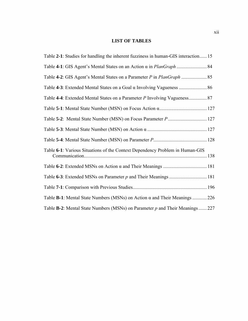
LIST OF TABLES
Table 2-1: Studies for handling the inherent fuzziness in human-GIS interaction......15
Table 4-1: GIS Agent’s Mental States on an Action α in PlanGraph .........................84
Table 4-2: GIS Agent’s Mental States on a Parameter P in PlanGraph .....................85
Table 4-3: Extended Mental States on a Goal α Involving Vagueness .......................86
Table 4-4: Extended Mental States on a Parameter P Involving Vagueness...............87
Table 5-1: Mental State Number (MSN) on Focus Action α.......................................127
Table 5-2: Mental State Number (MSN) on Focus Parameter P ................................127
Table 5-3: Mental State Number (MSN) on Action α .................................................127
Table 5-4: Mental State Number (MSN) on Parameter P............................................128
Table 6-1: Various Situations of the Context Dependency Problem in Human-GIS Communication.....................................................................................................138
Table 6-2: Extended MSNs on Action α and Their Meanings ....................................181
Table 6-3: Extended MSNs on Parameter p and Their Meanings ...............................181
Table 7-1: Comparison with Previous Studies.............................................................196
Table B-1: Mental State Numbers (MSNs) on Action α and Their Meanings ............226
Table B-2: Mental State Numbers (MSNs) on Parameter p and Their Meanings .......227

xiii
ACKNOWLEDGEMENTS
First and most, I would like to thank my advisor, Dr. Guoray Cai, for his
immeasurable guidance and support during the course of my graduate study at Penn
State. He has taught me how to do research, write papers, give presentations, and
everything else about how to become a successful Ph. D. He is an excellent researcher
and keeps high standards for himself and his students. I am very grateful to his insights
and suggestions that helped me to shape my research skills. Without his guidance and
support, I would not be able to accomplish and present the work here.
I am also very grateful to the other Ph. D committee members, Dr. Alan M.
MacEachren, Dr. Michael McNeese, and Dr. John Yen. I would like to thank them for
serving on my dissertation committees and providing valuable suggestions and other
efforts throughout my dissertation study. I feel extremely fortunate to have them on my
committee. Their comments and questions on my dissertation study helped me to re-
shape presentation of the dissertation work.
I would like to sincerely thank Dr. Alan M. MacEachren. He and my advisor
together gave me the opportunity to jump into the amazing research area of natural
multimodal GIS. I also learned the Geographical Information Science from him, in
particular, about challenges and qualitative research methods in this field, which helped
me a lot later to decide the research topic in my study. By working with him together on
writing papers/giving talks, I also received lots of help and guidance about how to polish
writings and give smooth talks. I would also like to thank him for his generous time and

xiv
help on directing me to more literature helpful to my study and polishing my dissertation
writing sentence by sentence.
I would also like to give special thanks to Dr. Michael McNeese and Dr. John
Yen. Dr. Michael McNeese taught me cognitive science and human-computer interaction,
which helped me a lot to understand part of key cognitive concepts and human-GIS
interaction involved in my dissertation study. In addition, he also gave me lots of
valuable comments on my dissertation research during project group meetings and
dissertation related group/individual meetings. His comments always turned out to be
very helpful in my study. Dr. John Yen taught me agent-based approaches, including lots
of agent-based theories and models that are basis of the agent-based computational
model, the PlanGraph model, developed to support the collaborative dialogue approach
in my dissertation study. I would also like to thank him for allowing me to join his
research group discussion about several agent-based theories and models, which helped
me to understand these theories better and apply them in the computational work in my
dissertation study.
My research benefits a lot from group members in two NSF projects, DAVE_G
and GCCM. I learned computational theories and techniques related to GIS from the sub-
group led by Dr. Guoray Cai; I learned computational research involved in natural
multimodal interfaces from the sub-group led by Dr. Rajeev Sharma; I learned a lot about
qualitative research methods involved in the GIScience from the sub-group led by Dr.
Alan M. MacEachren; I learned theories and methods used for knowledge elicitation
from the sub-group led by Dr. Michael McNeese.

xv
I am deeply indebted to my advisor and Dr. Alan M. MacEachren, who provided
me financial support over years. I would also like to express my thanks to the College of
Information Sciences and Technology for her support during my graduate study at Penn
State. I also thank lots of people, who have helped me in different ways during my time
here, e. g. faculties, staff and students in College of Information Sciences and
Technology.
As always, the greatest debt owes to my family, in particular, my parents and
husband. They always support and encourage me in my endeavors and never doubt my
capabilities in my career.

Chapter 1
Introduction
1.1 Motivation
Geographical Information Systems (GIS) are computer based systems for management
and analysis of geo-referenced data (Foote & Lynch, 1995; Malczewski, 1999). With
over forty years of development and improvement, GIS have been applied to various
areas, such as different streams of planning, transportation management, natural resource
assessment and management, risk analysis and crisis management, and facilities
management.
Most existing commercial GIS adopt the popular direct manipulation interface
paradigm, commonly known as windows, icons, menus, and pointing (WIMP) featured
interfaces (Egenhofer & Kuhn, 1999). WIMP-based interfaces do not support the
interaction between the system and the user efficiently (Frank & Mark, 1991). Such
systems are designed for expert users, but not for novice or non-technical users. Users
need to be trained how to express their spatial information needs in formal language
through WIMP-based interfaces so that the GIS can understand their requests. Users’
spatial information needs usually involve spatial concepts. A spatial concept is an
abstract mental representation of a category, which refers to a class of geospatial entities,
including geospatial objects, relations or processes (Fisher, 2000). A spatial concept in
the user’s mental representation can be imprecise and is typically qualitative, but the

2
formal language must be precise and usually is quantitative. Therefore, it takes a
substantial mental effort for the user to translate his/her imprecise mental representation
of the spatial concept into the formal language representation required in GIS commands.
In order to address the problems of WIMP–based GIS and enable wider adoption
of the GIS technology by non-technical users (e. g. crisis managers), the GIScience
community has paid increasing attention to development of transparent interfaces for GIS
(Nyerges et al., 1995), which decrease the difference between the human user’s mental
models of a problem in an application domain (e. g. crisis management) and those in the
GIS tool domain. One stream of such attempts is to introduce natural human
communication modalities into human-GIS interaction (Florence et al., 1996; Frank &
Mark, 1991; Mark & Frank, 1992a, 1992b; Mark et al., 1987). The assumption in this
attempt is that natural modalities, e. g. spoken natural language, gesture/sketch, gaze,
facial expression, and body movement, are natural and familiar modalities for human
users to express their information needs. Given that human users are more familiar with
using natural modalities than using formal language, it will cost users relatively less
cognitive effort to convert mental models of spatial concepts into natural modal
expressions than formal language-based expressions. As a result, GIS users can focus on
doing their domain tasks, instead of spending much time and effort on learning how to
use GIS tools.
Natural multimodal interfaces have been developed for geographic information
use along with advances in speech processing and capturing human gestures. Early
systems with natural modal capabilities can recognize the user’s voice command and
mouse-simulated pointing gesture (graphics). Examples are “Put-that-There” (Bolt, 1980)

3
and CUBISON (Neal et al., 1989). More recent systems adopted pen-based
gesture/sketch for interaction of geographical information, such as QuickSet (Cohen et
al., 1989; Oviatt, 1992, 1996) and Sketch and Talk (Egenhofer, 1996). The latest
advances in computer vision enable use of natural free-hand gestures in multimodal
systems for geographic information access, e. g. Dave_G, which uses both spoken
language and free-hand gestures (Cai et al., 2003; MacEachren et al., 2005; Sharma et al.,
2003).
1.2 Problem Definition and Scope
Among various natural modalities used in transparent interfaces, spoken natural language
was proposed as a major alternative interaction modality for GIS by scholars (Frank &
Mark, 1991; Mark & Frank, 1992a; Mark et al., 1987), as it is “the most natural, efficient,
flexible and inexpensive” modality for everyday human communication (Zue & Glass,
2000) and it naturally fits to human mental models of spatial concepts (Frank & Mark,
1991). To develop a usable spoken language enabled GIS, one of the challenges that must
be addressed is how to semantically interpret a spoken language request involving spatial
concepts. Natural language messages do not commonly have one-to-one mapping into
formal semantics. In particular, the user’s natural language requests can be incomplete,
ambiguous, vague, and inconsistent (Bosc & Prade, 1993; Owei, 2002; Robinson et al.,
1985; Wang, 2003). Existing studies have made much progress on handling the problems
of incompleteness, ambiguity, and inconsistence (Bosc & Prade, 1993; Owei, 2002;
Robinson et al., 1985; Wang, 2003), but it is still an open problem how to handle the

4
vagueness problem in human-GIS communication, although some initial progress
(Duckham et al., 2001; Kollias & Voliotis, 1991; Wang, 1994, 2000, 2003; Yao & Thill,
2005, 2006) has been achieved.
The meaning of a spatial concept involved in human-GIS communication through
natural modalities, particularly, through natural language, can be fuzzy and context-
dependent. The naturally formed categories that spatial concepts refer to usually do not
have clear boundaries (Barsalou, 1987, 2000; MacEachren, 1995). Such unclear
boundaries are called “fuzzy boundaries” in the geography field (MacEachren, 1995), or
“graded structures” in the cognitive science field (Barsalou, 1987). The unclear boundary
of a naturally formed category leads to the unclear meaning of the concept referring to
that category, that is, the inherent fuzziness property of the concept. According to
Barsalou’s study results (Barsalou, 1987), given different contexts, humans may use
different criteria to determine the grade of membership of each member in a category;
given the same context, different individuals have different mental constructions of the
same concept. As a result, the context-dependency property of a naturally formed
category leads to the context-dependent meaning of the concept referring to that category,
that is, the context-dependency property of the concept. Therefore, the meaning of a
naturally formed spatial concept usually holds these two properties, inherent fuzziness
and context-dependency. In this study, such a spatial concept is defined as a “vague
spatial concept.” These two properties of vague spatial concepts lead to the vagueness
problem in human-GIS communication.
The goal of this study is to facilitate spoken natural language enabled GIS to
handle the vagueness problem. Existing GIS can understand precise and quantitative

5
requests only, while the user’s spoken natural language requests involving vague spatial
concepts are vague and qualitative. To enable successful human-GIS communication
involving vague spatial concepts, we must meet two fundamental challenges here due to
the two unique characteristics of vague spatial concepts. The first challenge is to enable
the GIS to handle the inherent fuzziness problem, that is, to enable the GIS to convert the
fuzzy meaning of a vague spatial concept into a deterministic one or represent it fuzzily
(Yao & Thill, 2006). Numerous studies (Cross & Firat, 2000; Guesgen & Albrecht, 2000;
Kollias & Voliotis, 1991; Wang, 1994, 2000, 2003) have been performed to facilitate
handling the fuzziness problem. Approaches developed in these studies provide only a
best guess of fuzzy meanings of vague spatial concepts communicated by the user, which
may not be what the user intended. The second challenge is to enable the GIS to handle
the context-dependency problem, that is, to enable the GIS to determine a meaning of the
vague spatial concept which matches the current context involved in communication. In
the GIScience community, only a few studies, e. g. Wang’s studies (Wang, 1994, 2000,
2003) and Yao’s studies (Yao & Thill, 2005, 2006), have started to address the context-
dependency problem in human-GIS communication. However, the approaches of these
studies do not support the GIS to handle the context-dependency problem effectively.
1.3 Research Objectives
This study focuses on handling the vagueness problem, particularly, the context-
dependency problem, involved in spoken natural language human-GIS communication of
spatial concepts. The research objective of this study is to enable effective
6
communication of vague spatial concepts in spoken language human-GIS interaction
through better managing, sharing, and utilizing contextual knowledge.
This study has made two major contributions toward the research goal. Firstly, a
Human Communication Framework (HCF) is established to facilitate our understanding
and handling the vagueness problem in human-GIS communication. This framework
explains the vagueness problem in human-human communication and human
communication principles involved in handling the vagueness problem, in particular the
context-dependency problem. This framework facilitates our understanding about major
origins of vagueness, major types of contextual factors, distributed nature of context
knowledge and the need for building a shared context involved in human-GIS
communication.
Secondly, a collaborative dialogue approach is proposed and developed in this
study. This approach is driven by the success of collaborative dialogues in human-human
communication and the distributed nature of context knowledge in human-GIS
communication. An agent-based computational model, the PlanGraph model, is built to
support this approach. This model includes two components, the PlanGraph and
associated reasoning algorithms. The PlanGraph represents the dynamic knowledge kept
by the GIS on the shared context between the user and the system. Associated reasoning
algorithms support the GIS to build and keep track of the shared context with use of the
PlanGraph as the dialogue proceeds. They also support the system to repair the shared
context and further reduce vagueness through collaborative human-GIS dialogues. Thus,
the GIS can understand the meaning of a vague spatial concept under constraints of the
shared context. Finally, this model also enables the GIS to reach a shared understanding
7
about the vague spatial concept with the user in various situations where the system and
the user have different understandings about the current context involved in human-GIS
communication.
1.4 Organization of the Thesis
The remainder of this thesis is organized as follows. Chapter 2 reviews existing studies
related to handling the two sub problems, the fuzziness problem and the context-
dependency problem, of the vagueness problem in human-GIS communication. Details of
the HCF are provided in Chapter 3. This framework includes three components, the
human conceptual system, the human geospatial knowledge acquisition process, and the
human communication process. It facilitates our understanding of the vagueness problem
in human-human communication, in particular the context-dependency problem. It also
shows effective human solutions for handling the vagueness problem, that is,
collaborative dialogues. Chapter 4 describes details of the collaborative dialogue
approach developed in this study in detail. This approach is designed under the human
emulation principle. It helps the GIS to handle the context-dependency problem through
collaborative human-GIS dialogues by emulating a human agent’s reasoning and
behavior. It is supported by the agent-based computational model, the PlanGraph model.
Chapter 5 describes a prototype software agent, GeoDialogue, which incorporates the
collaborative dialogue approach and the PlanGraph model. Implementation details of the
PlanGraph model in this agent are also explained in this chapter. In Chapter 6, various
situations involving the context-dependency problem in human-GIS communication are

8
categorized and discussed. Several sample human-GeoDialogue dialogues are explained
to illustrate how the collaborative dialogue approach and the PlanGraph model can help
the GIS to handle the context-dependency problem in various situations. Finally, Chapter
7 concludes this thesis with a discussion of the major contributions, comparisons with
previous studies, and future work.
Chapter 2
Existing Studies
This study is concerned with supporting the GIS to handle the vagueness problem
involved in human-GIS communication of spatial concepts. As introduced in Chapter 1,
two challenges are met for development of spoken natural language enabled GIS,
including handling the inherent fuzziness problem and handling the context-dependency
problem. This chapter reviews existing studies related to handling these two challenges,
respectively.
2.1 Overview
The GIScience community has recognized the importance of handling the vagueness
problem for many years (Duckham et al., 2001; Erwig & Schneider, 1997; Frank &
Mark, 1991; Mark et al., 1987; Montello et al., 2003; Robinson, 1990, 2000). However,
there is no common understanding about vagueness of spatial concepts in the GIScience
field. One view (Couclelis, 1996; Duckham et al., 2001; Erwig & Schneider, 1997;
Montello et al., 2003; Worboys, 1998) states that vagueness of spatial concepts is subject
to the sorites paradox (Hyde, 2005) as well as dependent on the context involving these
concepts. For example, Worboys (2001a) defined vagueness as “imprecision in concepts
used to describe the information (e.g. near and far are vague metric properties of a spatial
object describing distance from the observer)”, and pointed out that vagueness is “often

10
have associations with context-dependency and subjectivity”. The other view focuses on
only the inherent fuzziness aspect of spatial concepts. For example, Fisher (2000)
conceives of vagueness from the philosophical view by applying the sorties paradox rule
to test whether a spatial concept is vague or not. His work does not mention the context-
dependency property of vague spatial concepts.
In this study, we take the view on vagueness of spatial concepts, which addresses
both the fuzziness aspect and the context-dependency aspect of spatial concepts. Thus,
two challenges are involved in handling the vagueness problem. The first challenge is
how to handle the inherent fuzziness problem, and the second challenge is how to handle
the context-dependency problem.
The Inherent Fuzziness Problem
The GIS needs to convert the meaning of a vague spatial concept into a metric
measure needed in certain GIS commands or represent it fuzzily in order to satisfy the
user’s request involving that concept. In the conversion process, the system needs to
determine a crisp boundary for that concept, which has a fuzzy boundary. However, the
process to determine the boundary of a vague spatial concept subjects to the sorties
paradox (Erwig & Schneider, 1997; Fisher, 2000; Montello et al., 2003; Varzi, 2001). For
example, in a given context where the user is looking for grocery stores near his/her
residence location for the purpose of shopping for food by driving a car in the small
town, State College, the system can determine that groceries stores within two or three
miles are near to this user, and that those beyond seven or eight miles are far to this user.

11
However, it is hard for the system to determine whether the grocery stores between three
miles and seven miles are near or not.
The Context-Dependency Problem
The meaning of a vague spatial concept is context-dependent, and varies in
different contexts, e. g. to different users (Worboys, 2001a), for different tasks (Erwig &
Schneider, 1997), and in different spatial contexts (Robinson, 2000; Worboys, 2001b).
The task context defined in this study includes the user’s goals, associated
activities towards these goals, and other properties associated with these activities
involved in or to be involved in the event involving the vague spatial concept. The task
contextual factor can be the final goal of the event, actions performed or to be performed
in the activities in the event, or other properties associated with these actions (Erwig &
Schneider, 1997; Yao & Thill, 2005). When a user requests a map to be displayed by a
GIS, it is often because the user is participating in or is going to participate in an event.
The user’s final/sub goals in this event and facilities to be involved in actions in this
event influence the user’s understanding about the vague spatial concept (Egenhofer &
Shariff, 1998; Erwig & Schneider, 1997). For example, a person A has just moved to a
new city and needs help to find restaurants for his daily lunch as well as grocery stores
for his weekly food shopping purpose near his current apartment. The same concept near
used by the same person A most likely means different distance relations for these two
different purposes. A may consider five miles of driving distances as near for the food
shopping purpose, but too far for the lunch purpose. For a same purpose, different
transportation modes (Yao & Thill, 2005) will also lead to different distance relations for
12
the same person in the same spatial context. For instance, A considers grocery stores
about five miles away from his residence location as near when planning to buy food by
driving, while takes them as far when planning to walk.
The spatial context is defined in this study as spatial locations where the event
involving the vague spatial concept takes place or will take place. There is evidence that
the meaning of a vague spatial concept, such as “near”, is dependent on the spatial
context involving the spatial concepts (Fisher & Orf, 1991; Lloyd & Heivly, 1987;
Robinson, 2000; Worboys, 2001a). For example, concerning the vague spatial concept
near, the spatial context involves the spatial scale/size of area covering all spatial
distances considered, topological closeness or reachability of routes, intervening
opportunities of routes (Yao & Thill, 2005), relative spatial distances, and absolution
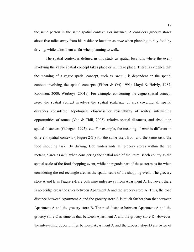
spatial distances (Gahegan, 1995), etc. For example, the meaning of near is different in
different spatial contexts ( Figure 2-1 ) for the same user, Bob, and the same task, the
food shopping task. By driving, Bob understands all grocery stores within the red
rectangle area as near when considering the spatial area of the Palm Beach county as the
spatial scale of the food shopping event, while he regards part of these stores as far when
considering the red rectangle area as the spatial scale of the shopping event. The grocery
store A and B in Figure 2-1 are both nine miles away from Apartment A. However, there
is no bridge cross the river between Apartment A and the grocery store A. Thus, the road
distance between Apartment A and the grocery store A is much farther than that between
Apartment A and the grocery store B. The road distance between Apartment A and the
grocery store C is same as that between Apartment A and the grocery store D. However,
the intervening opportunities between Apartment A and the grocery store D are twice of
13
that between Apartment A and the grocery store C. Thus, Bob considers the grocery store
C as near, but regards the grocery store D as far. When considering all grocery stores in
Palm Beach, Bob takes all grocery stores in the red rectangle area as near because the
spatial distances between these stores and Apartment A are relatively shorter than the
others. When Bob is going to buy food by walking, he needs to consider the absolute
spatial distance between each grocery store and his apartment. In this situation, he
considers the stores within one mile of walking distances of his apartment as near, and
these in the red rectangle area beyond two miles as far.
d
d
d
d
d
d
d
d d
d d
dd
d
d d
d
dd
ddd
d
d
dd
d$T
Palm Beach
Apartment A
A
B
D
C
State boundariesWatersCounty boundariesInterstatesMjor roads
d Grocery stores$T Apartments
0 20 MilesS
N
EW
d
d
d
d
d
dd
d
dd
d
d
d
d dddddddd
d dddddd
ddd d$T
Palm Beach
Apar tment A
A
B
C
D
Figure 2-1: Example Spatial Contexts

14
Different individual users can understand the same vague spatial concept
differently and the same user may understand the same concept differently at different
time (Barsalou, 1987). For example, Worboys’ work (2001a, 2001b) and Robinson’s
experiments (2000) on the near spatial relation indicate that different people have
different understandings of the same spatial distance relation. This is because individual
users may differ in cultural and education background, personal experiences, or other
aspects (Yao & Thill, 2005). In this study, this type of contextual factors is simply
referred to as the human context, similar to the term “subjectivity” in Worboys’ work
(2001a).
The remainder of this chapter reviews existing studies related to handling these
two challenges, respectively.
2.2 Handling the Inherent Fuzziness Problem
In the GIScience field, existing studies related to handling the inherent fuzziness
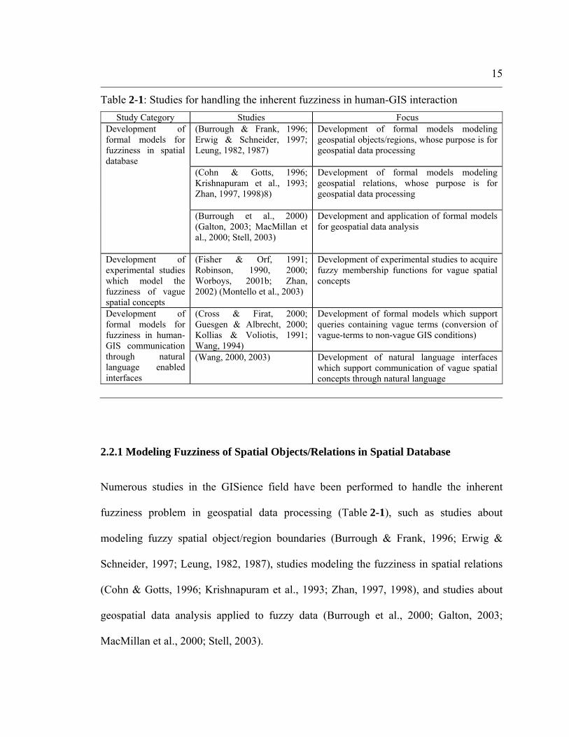
problem can be divided into three categories (Table 2-1). The first category of studies
concentrates on development of formal models to model the inherent fuzziness of spatial
objects/relations in spatial databases. The second category focuses on the development of
experimental studies which model the fuzziness of vague spatial concepts. The third
category works on development of formal models to support human-GIS communication
involving vague spatial concepts. This section reviews these three categories of studies
respectively.
15
2.2.1 Modeling Fuzziness of Spatial Objects/Relations in Spatial Database
Numerous studies in the GISience field have been performed to handle the inherent
fuzziness problem in geospatial data processing (Table 2-1), such as studies about
modeling fuzzy spatial object/region boundaries (Burrough & Frank, 1996; Erwig &
Schneider, 1997; Leung, 1982, 1987), studies modeling the fuzziness in spatial relations
(Cohn & Gotts, 1996; Krishnapuram et al., 1993; Zhan, 1997, 1998), and studies about
geospatial data analysis applied to fuzzy data (Burrough et al., 2000; Galton, 2003;
MacMillan et al., 2000; Stell, 2003).
Table 2-1: Studies for handling the inherent fuzziness in human-GIS interaction Study Category Studies Focus
(Burrough & Frank, 1996; Erwig & Schneider, 1997; Leung, 1982, 1987)
Development of formal models modeling geospatial objects/regions, whose purpose is for geospatial data processing
(Cohn & Gotts, 1996; Krishnapuram et al., 1993; Zhan, 1997, 1998)8)
Development of formal models modeling geospatial relations, whose purpose is for geospatial data processing
Development of formal models for fuzziness in spatial database
(Burrough et al., 2000) (Galton, 2003; MacMillan et al., 2000; Stell, 2003)
Development and application of formal models for geospatial data analysis
Development of experimental studies which model the fuzziness of vague spatial concepts
(Fisher & Orf, 1991; Robinson, 1990, 2000; Worboys, 2001b; Zhan, 2002) (Montello et al., 2003)
Development of experimental studies to acquire fuzzy membership functions for vague spatial concepts
(Cross & Firat, 2000; Guesgen & Albrecht, 2000; Kollias & Voliotis, 1991; Wang, 1994)
Development of formal models which support queries containing vague terms (conversion of vague-terms to non-vague GIS conditions)
Development of formal models for fuzziness in human-GIS communication through natural language enabled interfaces
(Wang, 2000, 2003) Development of natural language interfaces which support communication of vague spatial concepts through natural language

16
The studies modeling fuzzy regions (Burrough & Frank, 1996; Cohn & Gotts,
1996; Erwig & Schneider, 1997; Leung, 1982, 1987; Wang & Hall, 1996) developed
mathematical models to represent geospatial objects with fuzzy boundaries. For example,
Cohn and Gotts (1996) presented an “Egg-Yolk” model to represent fuzzy regions. In this
model, the whole region with a fuzzy boundary is represented as egg, the exact and
determined portion of the region as yolk and indeterminate parts as white. Such
mathematical models can be used to process spatial data representing spatial
objects/regions with fuzzy boundaries, and further to serve for the purpose of human-GIS
communication.
Similarly, the studies modeling fuzzy spatial relations also developed
mathematical models to represent spatial relations with fuzzy boundaries based on the
fuzzy set theory. For example, Zhan (1997,1998) developed a fuzzy representation of
spatial regions with fuzzy boundaries and methods for computing spatial relations
between spatial objects with fuzzy boundaries based on the fuzzy set theory.
Krishnapuram and his colleagues (1993) developed methods based on the fuzzy logic to
compute the directional relations between spatial regions with fuzzy boundaries. These
models can be used to process spatial data representing spatial relations with fuzzy
boundaries, and further show the fuzzy boundaries of spatial relations to the user.
Classification studies are typical examples in the studies about development and
application of formal models for geospatial data analysis. For example, Burrough, and his
colleagues (2000) developed a fuzzy k-means approach to classify landforms based on
statistical sampling results of DEM data. MacMillan and his colleagues (2000) developed
a model to segment landforms into landform facets. This model used derivatives

17
computed from DEM data and a fuzzy rule to identify up to 15 morphologically defined
landform facets. Galton (2003) investigated granularity-sensitivity, and proposed a
framework, which guides investigation of granularity-sensitivity in a “more rigorous,
systematic, and general way”.
2.2.2 Experiments on Modeling Fuzziness of Vague Spatial Concepts
To understand what a vague spatial concept is, GIS must have specific knowledge about
the degree to which the user believes each member in that category belongs to that
category. The fuzzy set theory (Zadeh, 1965, 1978, 1983a, 1983b) has been applied to
model such kind of knowledge about the inherent fuzziness property of the vague spatial
concept (Fisher & Orf, 1991; Montello et al., 2003; Robinson, 1990, 2000; Worboys,
2001b; Zhan, 2002).
Fisher and Ort (1991), Worboys (2001b), and Montello et al. (2003) all work on
modeling the inherent fuzziness aspect of vague spatial concepts in real environments. In
Fisher and Ort’s study (1991), the human subjects were asked if they agreed with a
computer program’s initial guess about whether particular buildings on the campus were
near/close to a central building on the campus, and then they were asked to modify the
initial guess if they disagreed. A fuzzy membership function for each subject’s
understanding of near/close relations was established based on their answers. In
Worboy’s study (2001b), two groups of subjects on the campus were asked to pick up
places which are near or not near from a list of places on the campus. The results from
the experiment were analyzed by four different approaches, including the three-valued
18
logic, fuzzy membership functions and higher valued logic. Montello and his colleagues
(2003) investigated the fuzziness property exhibited on the boundary of a downtown area.
Pedestrians around Downtown Santa Barbara were asked to delineate the area on a map
which they think is the downtown area, the area which they are 100% and 50% confident
is downtown, and the representative location in downtown. The participants’ answers
were used to analyze the inherent fuzziness nature of the downtown area.
Robinson (1990, 2000) and Zhan (2002) both investigated the fuzziness aspect of
spatial concepts in a geographical context/on a map. Robinson (1990) describes how a
computer program could be used to acquire the fuzzy membership function of the vague
spatial concept near. The human subject was first asked by the computer program if
he/she agrees with the system’s initial guess on the fuzzy membership value of a city, and
if not, he/she needs to modify the initial guess. Each individual’s answers were used to
construct the individual’s conception about near. In a subsequent study, Robinson (2000)
uses this program to acquire the user’s fuzzy membership functions on nearness and
farness in two different geographical contexts, respectively. Multi-person’s fuzzy
membership functions were explored in the study. Zhan (2002) investigated fuzziness in
several vague spatial concepts related to the topological relation, overlay. In his study,
human subjects were interviewed about their judgments on the overlay relation between
two overlaid diagrams. Their answers were used to establish fuzzy membership functions
for the topological relation concept overlay described by “a little bit, somewhat, and
nearly completely”. The spatial concept overlay described by each of these terms is
vague. The fuzzy membership functions (Figure 2-2) for fuzzy sets representing different

19
degrees of “cover a little”, “cover somewhat” and “nearly completely cover” were
obtained from 32 subjects.
2.2.3 Fuzziness of Vague Spatial Concepts in Human-GIS Communication
Most existing studies modeling fuzziness of spatial concepts involved in human-GIS
communication (Cross & Firat, 2000; Guesgen et al., 2003; Kollias & Voliotis, 1991;
Wang, 1994, 2000, 2003) have developed formal models based on the fuzzy set theory
and fuzzy logic. The purpose of these studies is to support the GIS to convert fuzzy
meanings of vague spatial concepts in user queries into non-fuzzy measures.
Guesgen & Albrecht (2000), Cross and Firat (2000), Kollias and Voliotis (1991),
and Wang (1994) have investigated formal models for fuzziness of spatial concepts in
human-GIS communication through Structured Query Language (SQL) based queries.
Figure 2-2: Fuzzy Membership Functions for Overlay (Zhan, 2002)

20
Guesgen & Albrecht (2000) proposed a conceptual scheme to integrate the fuzzy set with
the GIS. This scheme was used to model qualitative spatial relations among spatial
objects in the GIS. Their study did not show how such a scheme could be implemented
and applied for human-GIS communication of vague spatial concepts. Cross and Firat
(2000) and Kollias and Voliotis (Kollias & Voliotis, 1991) focused on development of a
fuzzy object data model or fuzzy relational database model that would enable the GIS to
execute SQL queries involving vague spatial concepts. In their studies, the GIS database
structure needs to be modified. To establish such a model for a vague spatial concept, the
user needs to define the fuzzy membership for that concept first either through the
computer screen or directly in the database. However, the user may not be able to clearly
define such a function. In addition, the user still needs to learn how to write the SQL
query before using the system. Wang (1994) studied an approach which enables the GIS
to convert vague spatial concepts in the user’s query into non-fuzzy conditions in GIS
commands. The GIS database does not need to be modified with his approach as it does
in the two studies by Cross and Firat (2000) and Kollias and Voliotis (Kollias & Voliotis,
1991). However, the fuzzy membership function in his study is pre-built before a user’s
interaction with the system by his approach. Consequently, the estimated meaning of a
vague spatial concept based on the pre-built fuzzy membership function may not be same
as the meaning of that concept that a specific user intends to communicate, and the user
may not agree with the system’s estimation of the boundary limit of the vague spatial
concept.
Wang (2000, 2003) further extended his 1994 study to support human-GIS
communication of vague spatial concepts through natural language. Wang (2000)
21
explored his approach in 1994 for the GIS to handle the ambiguity problem and the
inherent fuzziness problem in natural language queries based on the possibility theory
and the fuzzy set theory. Systems with this approach handle the ambiguity problem by
estimating the most possible parsing tree of the user’s natural language query and
defuzzy a vague concept by estimating the most possible meaning of the vague spatial
concept involved. Wang (2003) further extended his 2000 study. The three-step technique
developed in this study enables the GIS to handle three types of uncertainties involved in
human-GIS communication, incompleteness, ambiguity, and fuzziness. The first step is to
estimate the most possible missing component in the user’s natural language query. The
second step is to estimate the most possible parsing tree in the case that there are multiple
parsing results corresponding to the user’s natural language query. In the third step,
during the translation process, the system defuzzies the fuzzy expression (if possible) into
the most possible deterministic condition.
2.3 Handling the Context-Dependency Problem
The GIScience community has recognized the importance of the context to the meaning
of a vague spatial concept for many years (Ahlqvist, 2000; Briggs, 1973; Day, 1976;
Erwig & Schneider, 1997; Fischer et al., 1991; Kaplan, 1973; Kunnapas, 1960; Lloyd &
Heivly, 1987; Worboys, 2001a). Sharma et al. (1994) pointed out that human processing
and reasoning of qualitative properties of the spatial data is context-dependent, and so,
we need a model to explicitly map the relationship between the context and the metric
properties of data. Gahegan (1995) proposed to contextualize the proximity relation with

22
various contextual factors, including the scale and size of the area being considered, the
attractiveness of objects, spatial distribution of objects, reachability (topological
closeness or network distance). Hernandez et al. (1995) also pointed out that the
proximity concept is context-dependent. They proposed a framework built on three
elements to establish a proximity spatial relation. These elements include two spatial
objects between which the proximity spatial relation is studied – named the primary
object (PO) and the reference object (RO), and the frame of reference (FofR). The FofR
is instrumental in setting an upper bound on all distances within the area under
consideration. It is also used to formalize different types of contextual factors as to the
proximity relation.
Although numerous studies have recognized the role of the context on affecting
the meaning of a vague spatial concept, only a few studies (Wang, 1994, 2000, 2003; Yao
& Thill, 2005, 2006) have started to address the context-dependency problem involved in
human-GIS communication of spatial concepts.
Wang (1994, 2000, 2003) studied the role of the context on the meaning of a
vague concept involved in the user’s SQL query or natural language-based request. He
(1994) gave several examples about how the GIS using his approach can adjust its
inference on the meaning of a vague spatial concept depending on contextual information
provided by the user. In these examples, the GIS with his approach can consider only one
major contextual factor’s influence on each of the vague concepts. For example, the GIS
considers only the user’s transportation mode’s influence on the meaning of the vague
spatial concept, near, and only the influence from the spatial area on the meaning of
high/low describing the temperature. In case the major contextual information considered

23
by the GIS is not available in the user’s SQL query or natural language request, the GIS
will use the default value (a guessed value) of that contextual factor to estimate the
meaning of the vague concept. However, the guessed contextual information may not be
true. As a result, the estimated meaning of the vague spatial concept may not be agreed
upon by the user. In addition, it is not clear how the major contextual factor is modeled in
the GIS and kept track of by the GIS.
Yao and Thill (2005) explored a statistical approach, Ordered Logit Regression,
to computationally model the context-dependency property of proximity relations and
reported an empirical study for constructing a context-contingent model for proximity
spatial relations, e. g. near, and far. A computational context-dependent model of
meanings of proximity relations was built by implementing this approach so that the GIS
could translate metric distance measures (e. g. 5 miles of road distance) into linguistic
distance measures (e. g. near or far). The contextual factors included in the
computational model of proximity relations include the scale effect, type of activities
planned at the destination, topological closeness or reachability, intervening
opportunities, transportation mode, the familiarity level with areas and routes, financial
and time budget, and personal/demographical characteristics. This model was also used
to determine whether and how each contextual factor influenced the human subject’s
perception of proximity relations. Their empirical study was conducted on the campus of
the University of Buffalo. Undergraduate students were asked for their judgments on
several proximity relations, including very near, near, normal, far, and very far, in 19
hypothetical scenarios in Buffalo. The computational model built based on the empirical
study revealed that several contextual factors, including the metric network distance, the

24
level of familiarity with the area in the vicinity of the destinations, the transportation
mode, and the type of activities, significantly influenced the students’ perception of the
proximity relations. This study also indicated that the result of the computational model
predicts the linguistic distance well given the metric distance, but the reverse prediction
does not work well. This means that it is not suitable to use the result of this model to
translate linguistic distance (near or far) into metric distance given contextual
information.
Recently, Yao and Thill (2006) proposed a conceptual framework (Figure 2-3) for
geospatial information systems to handle qualitative terms or queries based on their
earlier work. They considered the linguistic terms representing vague spatial concepts as
typical examples of the qualitative terms, whose meanings are context-dependent.
Qualitative spatial reasoning about such terms usually involves handling the context-
dependency problem. Their conceptual framework was described by three modules, the
Spatial Database module, Language Interpreter and Qualitative Spatial Reasoner. The
Language Interpreter decomposes a user query into several types of elements needed in
formal queries to GIS and translates fuzzy linguistic terms. If qualitative terms are found,
then this module sends the interpreted data to the Qualitative Spatial Reasoner module;
otherwise, this module directly passes the data to the Spatial Database module. The
Qualitative Spatial Reasoner consists of the module of Central Control Unit (CCU) and
multiple qualitative reasoning models for each particular type of qualitative spatial
relations. CCU controls the information flow in the reasoner module, communicates with
the spatial database, and synthesizes results from the reasoning models and/or from the
spatial database. In this framework, the system can communicate with the user to clarify

25
uncertainties involved in the user query or the information (e. g. context information)
needed in various qualitative reasoning models in the reasoner module. Their study also
provides a prototype of the Qualitative Spatial Reasoner to illustrate this conceptual
framework. This study is valuable for proposing a framework for handling the context
dependency problem involved in qualitative reasoning about spatial relations. However, it
has some limitations. In this framework, the context information is directly stored in
context-contingent models of qualitative spatial relations. The framework does not
include a model or module to enable the system to keep track of the dynamic context
involved in human-computer interaction.

26
2.4 Summary and Discussion
This chapter reviews existing studies in the GIScience field related to handling the two
challenges involved in human-GIS communication of vague spatial concepts. Most
existing studies focus on handling the inherent fuzziness problem. Many studies have
Figure 2-3: Conceptual Framework for Qualitative Reasoning (Yao & Thill, 2006)

27
discussed the role of the context in human-GIS communication of vague spatial concepts
or human’s qualitative reasoning. However, only a few studies have started to consider
how to handle the context-dependency problem in human-GIS communication.
Formal models based on the fuzzy set theory and the fuzzy logic have been
developed in existing studies to model fuzziness of vague spatial concepts. The results of
these models can provide only a best guess to the meaning of a vague spatial concept
involved in human-GIS communication, and leave no room for the user to clarify and
confirm the estimated result generated by the system. Therefore, they do not ensure that
the GIS and the user reach a shared understanding about the fuzzy boundary of the vague
spatial concept communicated. In addition, the contexts where these models were
constructed are fixed or it is assumed that “geographic reality is certain, crisp,
unambiguous, independent of context and capable of quantitative representation”
(Duckham et al., 2001). This assumption may not be true. In particular, during human-
GIS communication of vague spatial concepts, these models can help to develop
strategies that allow the system to have a guess about the meaning of a vague spatial
concept communicated with the user, but they do not ensure that the communication is
successful.
As reviewed above, a significant body of literature has recognized contextual
influences on the meaning of the vague spatial concept. However, only a few studies have
started to address how to handle the context-dependency problem. These studies do not
have comprehensive understanding about how the context plays a role in human-GIS
communication of vague spatial concepts, neither offer a way to computationally model
the context involved in human-GIS communication. There are no workable proposals on

28
how to keep track of the context. Therefore, they do not effectively support the GIS to
infer the meaning of that concept with matching the current context involved in
communication. In addition, these studies also just provide a best guess to the meaning of
the vague spatial concept involved based on contextual information available or inferred,
and their results do not ensure that the GIS can reach a shared understanding with the
user about the meaning of that concept in various contexts.
In summary, there has been lack of effective handling of the vagueness problem,
in particular, the context-dependency problem. Thus, this presents an obstacle for
developing spoken natural language enabled GIS.

Chapter 3
Human Communication Framework
By following Frank (1993) and Mark (1993), we believe that a better matching with
human cognition would lead to a better interface, and better matching with human
cognition is always one of the goals toward development of transparent interfaces. Under
this assumption, we believe that a deeper understanding about how the vagueness
problem is generated and handled in human communication may motivate solutions for
spoken natural language human-GIS communication of vague spatial concepts. Toward
this goal, we have developed a Human Communication Framework (HCF) in this study.
Human communication is a process of making sense of the world and sharing that
sense with others (Leeds-Hurwitz, 1989; Tubbs & Moss, 2000). In interpersonal
communication, that is, human-human communication, most communication messages
are transmitted by spoken language, along with other nonverbal messages, such as visual
contact, gestures, facial expression, and posture (Heath & Bryant, 2000; Tubbs & Moss,
2000). What is communicated in human-human communication are messages, not
meanings of the messages (Cherry, 1978; Heath & Bryant, 2000; Tubbs & Moss, 2000;
Verderber, 1987). The meaning of a message is generated by the human conceptual
system (Barsalou, 1982, 1987, 1999, 2000, 2003; Jackendoff, 1991; Landau &
Jackendoff, 1993). The geospatial knowledge used in the human conceptual system to
generate the meaning of a spatial concept is formed through human’s knowledge
acquisition process (Egenhofer & Mark, 1995; Golledge, 1991, 2002; Kuipers, 1978;

30
Tversky, 1993). Based on these previous studies, we describe the cognitive process in the
HCF, which involves three components: the geospatial knowledge acquisition process,
the human conceptual system, and the human-human communication process (Figure 3-
1).
Details of the three components of the HCF are provided in Sections 3.1, 3.2, and
3.3, respectively. Then, origins of vagueness and human solutions in human-human
communication are summarized in Section 3.4 and Section 3.5, respectively.
3.1 Human Conceptual System
A human conceptual system provides knowledge about the world for the human. It plays
central roles in the reasoning involved in human communication, in particular, about
meanings of concepts. We need to understand how the context-dependent meaning of a
vague spatial concept is generated by the human conceptual system. Four major types of
theories (Barsalou, 2003) have been proposed for the human’s conceptual system,
including semantic memory, exemplar models, feed-forward connectionist nets, and the
Figure 3-1: Human Communication Framework
Communicator A Communicator B
Geospatial Knowledge Acquisition
Geospatial Knowledge Acquisition
Human Conceptual System
Human Conceptual System
Human-Human Communication Process

31
situated simulation theory. The situated simulation theory (Barsalou, 2003) emphasizes
the contextualized characteristic of the conceptual system; that is, the meaning of the
concept is not static, but constructed in terms of the current need/context/situation.
Therefore, the human conceptual system described in the HFC mainly follows the
situated simulation theory developed by Barsarlou (Barsalou, 1982, 1987, 1999, 2000,
2003). According to the perceptual symbol theory (Barsalou, 1999), which is part of the
situated simulation theory, human knowledge on a concept is stored as perceptual
symbols in Long Term Memory (LTM). The perceptual symbol corresponding to a
concept is used to generate conceptual simulations in Short Term Memory (STM) on the
fly constrained by simulation of the current context (Figure 3-2). A concept is a simulator
which can generate infinite specific simulations of the concept to fit to different contexts.
A perceptual symbol is generalized from the extraction of a subset of the
perceptual state that a person perceives from an information source (Figure 3-2). The
“subset” of the perceptual state is what the person has paid attention to. Perceptual
symbols referring to the same concept are all associated with that concept. However, due
to the graded structure of a category (Barsalou, 1987), the boundary between perceptual
symbols belonging to a concept and those not belonging to that concept also exhibits the
graded structure, that is, the inherent fuzziness property. The perceptual symbols are
multimodal from the five human senses, including vision, audition, haptic, olfaction and
gestation. Therefore, there may be multiple perceptual symbols from multimodalities
corresponding to the same concept, e. g. words and images (Paivio, 1971; Potter &
Faulconer, 1975).

32
Perceptual symbols referring to different components of the same concept are
integrated into a frame in terms of relationships among these related perceptual symbols.
The frame has four basic properties (Barsalou, 1999; Barsalou & Hale, 1993; Barsalou &
Hutchinson, 1987): 1) predicates – corresponding to unspecified sub-regions in the frame;
2) attribute-value bindings – corresponding to specific instantiations of perceptual
symbols under sub-regions in the frame; 3) constraints – corresponding to the inherent
relationships among different perceptual symbols; and 4) recursion structures.
The simulation of a concept, that is, a specific meaning of that concept, is
generated through instantiation of its corresponding perceptual symbol/frame. The
simulation of the concept is highly context-dependent. A perceptual symbol/frame
corresponding to a concept is always instantiated under partial instantiation of another
frame representing the context which involves that concept (see Figure 3-2) (Barsalou,
1999; Carey, 1985; Fillmore, 1985; Keil, 1989; Lehrer, 1974). The result of the
Figure 3-2: Structure of the Human Conceptual System
LTM Frame about the context
Perceptual Symbol
Sensory Systems
STM
Mental simulation of the current context
Mental Simulation R1
Reality in context: R
Auditory System Visual System etc.
Perceptual Symbol Development Process
Concept Simulation Process
Perception under attention
Extraction under attention

33
instantiation of the perceptual symbol/frame is the specific meaning of that concept under
the constraints of that context. For example (Figure 3-3), to generate a specific simulation
of the concept near in the shopping context, the human needs to instantiate the perceptual
symbol representing the proximity relation near under partial instantiation of the frame
representing the concept of the shopping context. So, the simulation of near is influenced
by instantiation of partial components in the frame representing the context, the shopping
event, including the goal of shopping (e. g. for food or clothes), the transportation mode
involved in traveling, the traffic situation (e. g. clear or jammed), actual distribution of
grocery stores, actual spatial distances between the house location and grocery stores.
Therefore, the simulation of a concept is not separable from the context where the
concept is used. According to Barsalou (Barsalou, 2000), the context becomes part of the
concept structure because of the importance of the meaning of that concept.
Figure 3-3: Simulation of the Concept near
From house drive a car on the road
to a grocery store
Spatial distance: nearFor food shopping

34
3.2 Geospatial Knowledge Acquisition
A spatial concept is mentally related to a collection of accumulated knowledge about a
category of spatial entities. Therefore, before the human communicator can communicate
any spatial concept, the communicator must have formed the meaning of that concept
based on knowledge of that concept in memory (Brodeur et al., 2003; Mark et al., 1999).
The human’s spatial knowledge is usually learned by gradually acquiring elements of the
world, e. g. landmarks and routes (Golledge, 1991; Tversky, 1993), and finally
integrating them into survey knowledge. According to some researchers (Egenhofer &
Mark, 1995; Golledge, 1991, 2002; Kuipers, 1978; Tversky, 1993), there are three major
steps involved in the geospatial knowledge acquisition process (Figure 3-4): 1)
interaction with the information resources, 2) perception with attention, and 3) concept
formation.
Figure 3-4: Geospatial Knowledge Acquisition Process
Communicator B
Interaction with various sources about the reality R (from A’s experiences in various contexts)
Perception of R with A’s attention
Formation of SC (with A’s reasoning)
Interaction with various sources about the reality R (from B’s experiences in various contexts)
Perception of R with B’s attention
Formation of SC (with B’s reasoning)
Communicator A
SC denotes a “spatial concept” R denotes realities that the spatial concept SC refers to
35
As shown in Figure 3-4, formation of a spatial concept starts with human
interaction with various information sources about the reality (realities) R that the spatial
concept refers to. The interaction can be a direct observation of R (Golledge, 1991;
Kuipers, 1978; Tversky, 1993) and/or indirect acquisition of preprocessed spatial
information, e. g. natural language texts (Taylor & Tversky, 1992), maps (Head, 1991)
and other visualization techniques (MacEachren, 1995). The spatial knowledge can be
acquired in various contexts (Hirtle & Hudson, 1991; Moar & Carleton, 1982; Presson &
Montello, 1988; Thorndyke & Hayes-Roth, 1982). In the example given in Figure 3-4,
two communicators A and B independently form a vague spatial concept from
experiencing different realities in different contexts, e. g. for different purposes, in
different places, and at different times. Different experiences held by A and B may lead
them to form different knowledge as to the same spatial concept.
During the process of perception of the reality R, different people can pay
different attention to different aspects of the same reality R, which lead to the
“perceptually based biases” during the human perception process (Golledge, 2002).
Therefore, even if different people experience the same reality R, they may perceive that
reality differently, and form different knowledge about that reality.
In the last step of geospatial knowledge acquisition, the human forms a SPATIAL
CONCEPT after reasoning about the perceived information about the reality R. As
discussed by Golledge (Golledge, 2002), much of human geospatial knowledge is
informal knowledge, and is “acquired using general guidelines that produce vague or
error-prone knowledge.” People have different reasoning rules for informal geospatial
knowledge, which can also lead to different knowledge in different people about the same

36
concept. The “conceptual biases” from “improper thinking and reasoning” (Golledge,
2002) can lead to a knowledge difference on the same spatial concept between different
people. It is believed that the geospatial knowledge can also be distorted in the human
memory (Lloyd & Heivly, 1987; Tversky, 1981).
3.3 Human-Human Communication Process
With the knowledge of a concept retrieved from the human conceptual system, the human
communicators can communicate with each other about that concept. In GIS application
domains, there are many examples of interpersonal communication involving spatial
concepts, e. g. communication between the GIS operator and the crisis manager (a non-
expert user). In such communication, the GIS operator needs to collaborate with the user
to reach the user’s spatial information requests involving spatial concepts. Such
communication “becomes centered, co-operative, and directed toward some goal”
(Cherry, 1978), that is, the communication is around a collaborative discourse.
To facilitate our understanding about human-GIS communication, this section
illustrates the human-human communication process with an example of communication
between two human communicators, a GIS operator O and a GIS user U, see Figure 3-5
(Schramm, 1954; Tubbs & Moss, 2000). For the convenience of the remaining
description about the communication, let O be a male, and U be a female.
In ideal communication, the sender and the receiver should reach the same
understanding about the communicated message (Schramm, 1954; Tubbs & Moss, 2000;
Weaver & Strausbaugh, 1964). However, real communication never reaches such a

37
success (Heath & Bryant, 2000; Lyotard, 1984; Weaver & Strausbaugh, 1964) and
various uncertainties can occur in the communication, e. g. misunderstanding/error
(Cherry, 1978; Heath & Bryant, 2000; Weaver & Strausbaugh, 1964), conflict (Heath &
Bryant, 2000; Tubbs & Moss, 2000), and vagueness (Dimitrov & Russell, 1994). The
human communicators need to handle various uncertainties involved in communication
and reach agreement on the meaning of communicated messages.
The remainder of this section describes the human-human communication process
in more detail, and then provides an introduction to uncertainty reduction in human-
human communication.
3.3.1 Major Steps in Human-Human Communication Process
The communication process between U and O (Figure 3-5) consists of the
following steps:
● 1) The information source R1 to be communicated is generated in the sender’s
mind from the sender’s conceptual system;
Figure 3-5: Human Communication Process between a GIS Operator (O) and a user (U)
Source: R1 in U’s mind
Destination: R4 in O’s mind
noiseChannel ChannelMessage R2 Message R3
U O
Feedback

38
● 2) R1 is encoded into the message R2 by the sender;
● 3) The signal representing R2 is sent out by the sender’s communication
channels (e. g. the user’s sensory organs);
● 4) The signal from the sender with a certain amount of noise is sensed by the
receiver’s communication channels;
● 5) The signal sensed in the receiver’s channels is encoded into message R3 by
the receiver;
● 6) The destination R4, which represents the receiver’s understanding about R3
corresponding to R1, is evoked in the receiver’s mind from the receiver’s
conceptual system;
● 7) The receiver starts the feedback process, which is same as the
communication process from the sender to the receiver, but in a reverse
order.
Steps 1) to 3) represent the encoding process at the sender’s side, and steps 4) to
6) represent the decoding process at the receiver’s side.
Mental Construction of the Information Source
The information source R1 (Figure 3-5) is defined in this study as the mental
representation of what the sender tries to communicate to the receiver. R1 is generated in
the sender’s conceptual system (Barsalou, 1999). R1 is a specific simulation of a concept,
e. g. a vague spatial concept near, that the sender tries to communicate (Barsalou, 1999).
So, the information source R1 is encoded from the sender’s conceptual system (Figure 3-
6). The human retrieves the frame/perceptual symbol F1 of the concept to be

39
communicated and the frame SF1 of the current context from LTM, and then instantiates
F1 to generate R1 under the constraints of instantiation of SF1 (Barsalou, 1999, 2000,
2003).
Encoding Message
To be able to communicate the information source R1 with the receiver, the sender
needs to transform R1 into a communicable representation of that mental simulation, a
message R2 (Figure 3-6). The content of R2 depends on the sender’s current attention to
R1 (Figure 3-6), what representation formats are used and what the sender thinks is
enough to represent R1. Context-dependent properties of the vague spatial concept also
contribute to the semantic variability of the message R2. According to Barsalou
(Barsalou, 1982), the contextual-dependent properties of the concept exist in the nature of
the concept, but are hard to be encoded in the message R2. For example, in relation to the
Figure 3-6: Encoding Process in Human Conceptual System
Attention
LTM
Frame/Perceptual Symbol F1
Sensory Systems
STM
R1: Instantiation of F1
Auditory System Visual System
Signals
etc.
Message R2
Concept Encoding Process Instantiation of SF1 Frame about the
context SF1

40
vague spatial concept “downtown”, the spatial boundary of “downtown” is context-
dependent, and it is hard to be encoded in a verbal message talking about “downtown”.
Sending Signals
The message R2 (Figure 3-6) is converted to a signal by the sender’s motor system
and sent out. The signal contains what the sender consciously intends to send, and may
also contain what the sender unconsciously sends.
Sensing Signal
The first stage in the decoding process at the receiver O’s side is sensing the
signal from the sender U by using O’s sensory system (Figure 3-7). The signal sensed by
O may have contained noises from the environment (Figure 3-7), such as other people’s
talking around O and U, which directly affects the receiver’s following perception of the
signal.

41
Perception of Signal into Message
The second stage in the decoding process is for the receiver to make sense of the
signal as a meaningful message R3 (Figure 3-7). According to human cognition theories
(Lindsay & Norman, 1977; Reisberg, 2001; Wickens, 1984), the receiver’s attention at
this stage plays an important role in the perception process (Figure 3-7), and the
perception may be selective in terms of what the focus of attention is in the receiver’s
mind, and what is expected by the receiver. For example, in the case that the receiver O is
expecting map-related requests from the sender U, O’s perception of the signal would
focus on the map-related requests and may ignore U’s description about unrelated
information, such as what U has eaten.
Meaning Evoked
Figure 3-7: Decoding Process in the Human Conceptual System
Concept Decoding Process
Attention
STM
LTM
Frame/Perceptual Symbol F2
Sensory Systems
R4: instantiation of F2
Signal + Noise
Auditory System Visual System etc.
Message R3
Instantiation of SF2
Frame of Current Context SF2

42
The last stage of the decoding process is for the receiver O to decode the message
R3 into the information destination R4 corresponding to R1 (Figure 3-7). The message R3
evokes O to instantiate a perceptual symbol or a frame F2 as a specific meaning, R4, of
the concept in R3. Similarly, a super-frame SF2 representing the current context involving
F2 is instantiated in order to constrain the instantiation of F2.
Feedback
The communication process does not end until the feedback from the receiver O
is received by the original sender U (Tubbs & Moss, 2000; Weaver & Strausbaugh,
1964). In the feedback process, the operator O and the user U reverse their roles in the
process from R1 to R4, that is, O becomes the communication sender and U is the
information receiver. O can return the feedback by showing his understanding about the
spatial concept involved in a map representation to satisfy U’s request.
After receiving O’s feedback, U may continue the communication by returning
feedback to O until both U and O believe the communication is successful. So, the
human-human communication can be a spiral process interleaving conveying messages
and feedback between two communicators.
In the communication between the GIS user and the GIS operator, the map
representation as the visual feedback helps the user and the operator to understand each
other better. This is because the map provides a visual shared spatial context involved in
the communication, which can constrain their understandings about the meaning of a
spatial concept involved in communication to be closer (MacEachren, 1995; MacEachren
et al., 2005).
43
3.3.2 Strategies of Uncertainty Reduction in Communication
Successful collaborative human communication is to seek consensus between the
communicators (Dimitrov & Russell, 1994) through reducing uncertainties involved in
communication. The consensus seeking is motivated by the communicators’ common
concerns, and they agree to explore it together and reach a shared understanding of the
common concerns. Three traditional steps are summarized by Dimitrov and Russell
(Dimitrov & Russell, 1994) for communicators to build the consensus in communication:
1) the communicators need to set up a “common ground”, e. g. find their common
interests, goals, and values; 2) they need to exchange their views and opinions and reduce
uncertainties by using “an accepted collaborative scheme”; 3) they need to act towards
reaching their common concerns.
So, to reach a successful communication, that is, the consensus in communication,
human communicators usually start by building their “common ground” (Berger, 1975,
1987; Berger & Calabrese, 1975; Chuah & Roth, 2003; Clark, 1996; Dimitrov & Russell,
1994; Klein et al., 2005), or the shared context (Kang, 1997; Pickering & Garrod, 2004)
between the communicators. The shared context constrains the human communicators’
understandings about the concept involved in communication. It involves not only the
general knowledge of the world and conventions, but also their mutual beliefs on the
communication (not only communicative activities, but also other joint activities) history,
and the current state of the communication. For the purpose of language comprehension,
besides the general knowledge of the world and conventions, the shared context involves
at least five dimensions, including time, space, causation, intentionality and protagonists

44
(Zwaan et al., 1995; Zwaan & Radvansky, 1998). The shared context consists of events
involved. Each event is structured with at least these five dimensions.
In case uncertainties exist in communication, the human communicators need to
repair the shared context and reduce uncertainties (Dimitrov & Russell, 1994). There are
three basic types of strategies for human communicators to reduce uncertainties in
communication (Berger, 1987). The first type is passive strategies, that is, communicator
A learns about the other communicator B by passively observing B. The second type is
active strategies, that is, A asks others about the communicator B whom A is interested in
or tries to set up a situation where A can observe B (e.g., taking the same class, sitting
close by a table at dinner). Once the situation is set up, A can use either passive or
interactive strategies to learn about B. The third type is interactive strategies, that is, A
directly communicates with B for further information. In a high information-seeking
mode of communication, e. g. interviews, the communicator A can directly ask the other
communicator B for questions about B’s behavior, goals, and plans.
3.4 Vagueness in Human-Human Communication
This section summarizes origins of vagueness in human-human communication based on
the HCF described in Section 3.1, 3.2, and 3.3. For illustration purposes, a simplified
chart about information flow involved in communication between a GIS operator O and a
user U is provided in Figure 3-8 based on the HCF described above. This figure shows
the information flow involved in the communication about the initial request “Show me

45
grocery stores near my house”. This section uses this example to explain and summarize
the origins of vagueness in human-human communication.
Practically, the communication of a spatial concept between the GIS operator and
the user is considered to be successful when the user is satisfied with the map response
showing the meaning of that spatial concept from the GIS operator. Based on the HCF,
we can see that the key for a successful communication lies in the two communicators’
current mental simulations (that is, current understandings) about the spatial concept
involved. In terms of the HFC, the frame/perceptual symbol corresponding to the concept
involved is always instantiated under instantiation of its super frame SF representing the
current context. Differences between the destination R4 and the source R1 in Figure 3-8
Figure 3-8: Information Flow in Communication of a Vague Spatial Concept
Attended perceptual states Ru’
R1, current mental simulation of near using Ru’’
Attended Message R2: Show me grocery stores near my house
Attended Message R3: Show me grocery stores near my house
Past experiences: Ro in the event of weekly shopping by driving in a small town A
Attended perceptual states Ro’
R4, current mental simulation of near using Ro’’
Perceptual Symbol/Frame Ru’’—Concept near
Perceptual Symbol/Frame Ro’’ – Concept near
Frame SF1 – Current context
Frame SF2 –Current context
Past experiences: Ru in the event of weekly shopping by driving a car in a metropolitan area B
Ru’’’: mental simulation of current context
Ro’’’: mental simulation of Current context
User U GIS Operator O
46
directly come from differences between Ru’’ and Ro’’ (individual spatial knowledge),
differences between Ru’’’ and Ro’’’ (understanding about the current context), and the
inherent fuzziness property of the spatial concept.
The remainder of this section discusses the three major sources contributing to the
vagueness problem in human-human communication: 1) individual differences on spatial
knowledge acquisition, 2) different understandings about the current context, and 3) the
inherent fuzziness of the vague spatial concept.
Individual Differences on Spatial Knowledge Acquisition
The individual abstract concept knowledge difference between Ru’’ and Ro’’
corresponding to the spatial concept communicated (Figure 3-8) comes from individual
knowledge acquisition process differences. Firstly, different past experiences between Ru
and Ro can lead to the development of different perceptual symbols on the same concept.
In the example of communication of near shown in Figure 3-8, U develops perceptual
symbols of near corresponding to less than half an hour of driving distance from her past
experience of weekly food shopping in a metropolitan area. O forms perceptual symbols
of near corresponding to less than 10 minutes of driving distance from his past
experience of weekly food shopping in a small town. Secondly, even if U and O develop
perceptual symbols of near from same the shopping experiences, their different levels of
attention paid can lead to different perceptual states Ru’ and Ro’ perceived by them.
Thirdly, different reasoning involved in transforming perceptual states into perceptual
symbols can lead to different results of perceptual symbols formed.

47
Different Understandings about the Current Context
In the example of communication of near (Figure 3-8), mental simulations of the
current context, Ro’’’ and Ru’’’ come from instantiations of the frames representing the
current context SF1 and SF2, respectively. Differences between Ro’’’ and Ru’’’ can come
from different instantiations of SF1 and SF2. SF1 and SF2 may represent different
concepts/contexts. In case SF1 and SF2 refer to the same context, U and O may instantiate
them with different values of sub-regions, and/or in different depth (due to recursive
structures of the frames) and/or with different width (due to different attentions paid to
the same context).
Inherent Fuzziness
Perceptual symbols corresponding to the same concept are associated together
with that concept. The inherent fuzziness is encountered during the categorization process
for the human to classify a perceptual symbol into the association. For example, in the
context of Bob’s weekly food shopping in a metropolitan area, Bob can easily categorize
perceptual symbols referring to less than 10 minutes of driving distance into the concept
near, and perceptual symbols referring to greater than one hour of driving distance into
the concept far. However, it is hard for him to categorize perceptual symbols referring to
spatial distances in between. The inherent fuzziness during the categorization process can
lead to the inherent fuzziness of the mental simulation of the concept, R1 and R4.

48
3.5 Human Communication Principles
Based on the HCF described at the beginning of this chapter, this section summarizes
human communication principles (HCPs), that is, human solutions, used to handle the
vagueness problem. Here, we focus on those related to understanding the meaning of a
vague spatial concept (HCP1), and those related to how to reduce vagueness involved in
communication (HCP2).
HCPs for Understanding about the Meaning of a Vague Spatial Concept
Here, we summarize HCP1 as follows:
• a) The human understands the meaning of a vague spatial concept under
constraints of mental simulation of the current context.
• b) The human usually attempts to collect contextual knowledge before
interpreting the meaning of the vague spatial concept.
• c) The human usually has only partial contextual knowledge. This means
that the human communicator usually interprets the meaning of a vague
spatial concept with major context information only, not all information
about the current context. The communicator’s model of the meaning of
the vague spatial concept under constraints of a series of major context
factors can be considered as a function Af of a list of variables (see
Eq. 3.1):
,...)...,,,...,,...,,,...,...,,( ,2121,21 iiiAA HHHSSSTTTfM = 3.1
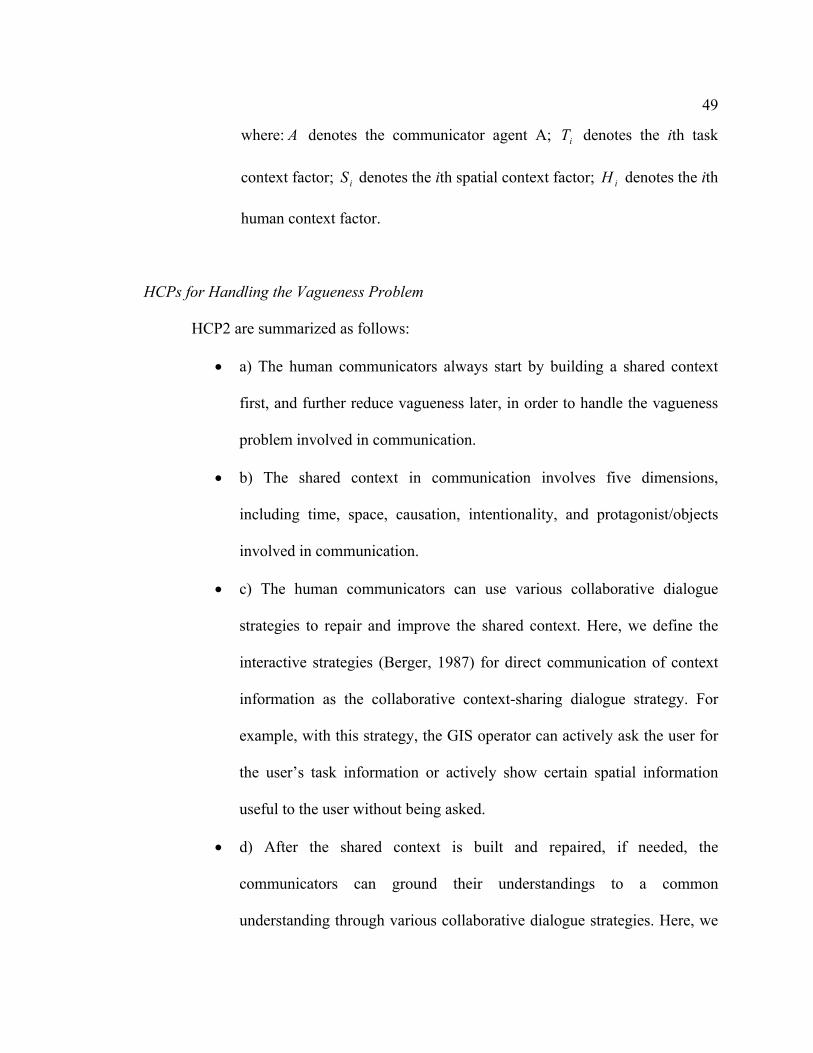
49
where: A denotes the communicator agent A; iT denotes the ith task
context factor; iS denotes the ith spatial context factor; iH denotes the ith
human context factor.
HCPs for Handling the Vagueness Problem
HCP2 are summarized as follows:
• a) The human communicators always start by building a shared context
first, and further reduce vagueness later, in order to handle the vagueness
problem involved in communication.
• b) The shared context in communication involves five dimensions,
including time, space, causation, intentionality, and protagonist/objects
involved in communication.
• c) The human communicators can use various collaborative dialogue
strategies to repair and improve the shared context. Here, we define the
interactive strategies (Berger, 1987) for direct communication of context
information as the collaborative context-sharing dialogue strategy. For
example, with this strategy, the GIS operator can actively ask the user for
the user’s task information or actively show certain spatial information
useful to the user without being asked.
• d) After the shared context is built and repaired, if needed, the
communicators can ground their understandings to a common
understanding through various collaborative dialogue strategies. Here, we

50
define the interactive strategies for refining the meaning of the vague
spatial concept based on its previous meaning as the negotiation strategy
(Dimitrov & Russell, 1994; Kang, 1997). For instance, in communication
about near in the food shopping context, with this strategy, the GIS
operator can ask the user’s opinion about increasing or decreasing the near
distance shown on the map, and the user can also directly give such
opinions without being asked. We also define the interactive strategies for
direct communication of the meaning of the vague spatial concept as the
direct communication strategy. For example, in communication about near
in the food shopping context, the user can directly tell the GIS operator or
point out which grocery stores he/she believes are near, and the GIS
operator can also ask for the user’s understanding about near.
3.6 Summary and Discussion
This chapter describes the major components of the HCF in detail. The primary origins of
the vagueness problem and human communication principles involved in human-human
communication are analyzed based on the HCF.
The HCF involves three major components, including the spatial knowledge
acquisition process, the human conceptual system, and the human-human communication
process. The spatial concept as human spatial knowledge is acquired through a human’s
experiences, perception, and reasoning about spatial information sources. Human’s
spatial knowledge is stored and accumulated as perceptual symbols/frames in LTM of the

51
human conceptual system. In the STM of the human conceptual system, the meaning of a
vague spatial concept is generated as a specific instantiation of the perceptual
symbol/frame corresponding to that concept under constraints of mental simulation of the
current context. With the spatial knowledge acquired, the human conceptual system
generates the information source from the speaker’s side and the information destination
invoked by the receiver in human-human communication. In collaborative human-human
communication, the human communicators seek consensus, that is, the success of the
communication, through reducing vagueness in various collaborative ways.
The HCF shows that vagueness in human-human communication involves three
origins, including individual spatial knowledge differences, different understandings
about the current context, and the inherent fuzziness. We can see that the context-
dependency problem, as the focus problem in this study, is caused by individual
differences in spatial knowledge and by different understandings about the current
context. The HCF also shows HCPs that human communicators use to understand the
meaning of a vague spatial concept and handle the vagueness problem in communication.
In high-information seeking communication, e. g. face-face communication, the human
communicators usually start by building the shared context, and further reduce vagueness
with various interactive collaborative strategies.
The HCF provides a comprehensive explanation about the vagueness involved in
human communication of spatial concepts, which facilitates our understanding about the
vagueness involved in human-GIS communication. It also shows success and
effectiveness of human collaborative dialogues for human communicators to handle the
vagueness problem. Based on the assumption that a better match with the human

52
cognition will lead to a better GIS interface, we believe that these human collaborative
dialogues and associated HCPs would direct a better approach to handle the vagueness
problem involved in human-GIS communication.

Chapter 4
Methodology
The success and effectiveness of human collaborative dialogues indicate the need for
collaborative human-GIS dialogues. This need drives us to propose and develop a new
approach, a collaborative dialogue approach, for the GIS to handle the context-
dependency problem. An agent-based computational model, the PlanGraph model, is
developed to support this approach. This chapter describes the collaborative dialogue
approach and the PlanGraph model in detail.
The remaining chapter is organized as follows. Firstly, an overview about this
chapter is provided in Section 4.1. Section 4.2 explains our understanding of the context-
dependency problem, in human-GIS communication based on the HCF. Section 4.3
describes the human emulation principle of the collaborative dialogue approach. Details
about the PlanGraph model are given in Section 4.4. An example of human-GIS
collaborative dialogue is explained in Section 4.5. This example illustrates how the
collaborative dialogue approach and the PlanGraph model can help the GIS and the user
to handle the context-dependency problem. Summary and discussion conclude this
chapter.

54
4.1 Overview
As discussed in Chapter 3, the HCF is developed to facilitate our deeper understanding
and better handling of the vagueness problem in human-GIS communication. Based on
the HCF, we have a better and more comprehensive understanding about the vagueness
problem in human-GIS communication, e. g. how the vagueness problem in particular,
the context-dependency problem, is generated in human-GIS communication, what
contributes to vagueness in human-GIS communication, why the shared context is needed
between the GIS and the user, why a collaborative human-GIS dialogue is needed for
handling vagueness in human-GIS communication, and various types of the contextual
factors involved in the shared context.
The success and effectiveness of human-human collaborative dialogues and the
distributed nature of context-knowledge in human-GIS communication lead us to
consider developing a collaborative dialogue approach for the GIS to handle the context-
dependency problem, that is, enabling human-GIS collaborative dialogues for the GIS
and the user to build a shared context and further reduce vagueness involved in
communication. The major design principle of the collaborative dialogue approach is to
enable the GIS to handle the context-dependency problem by emulating the human
communicator’s collaborative solutions.
The agent-based computational model, the PlanGraph model, is developed for
implementation of the collaborative dialogue approach. This model is designed based on
agent-based theories and models, and further extended by following the HCF, in
particular, HCPs involved in handling the vagueness problem. This model includes two

55
major components, the PlanGraph and associated reasoning algorithms. The PlanGraph
is a complex data structure which represents the GIS agent’s knowledge on the dynamic
human-GIS collaboration process underlying the human-GIS collaborative
communication. The reasoning algorithms associated with the PlanGraph are designed to
support the GIS agent to reason about how to collaborate with the user, in particular, how
to handle the context-dependency problem through collaborative human-GIS dialogues.
The GIS agent with the collaborative dialogue approach and the PlanGraph
model can collaborate with the user toward the success of the user’s request. The system
can keep track of the shared context between the GIS and the user by utilizing of the
PlanGraph. In case the shared context needs to be improved, the system can repair it
through various context-sharing human-GIS dialogues. The system can further have a
shared or closer understanding about a vague spatial concept involved in communication
with the user under constraints of the shared context represented in the PlanGraph. In
case vagueness still exists, the system can further reduce it through various collaborative
human-GIS dialogues by following human solutions in this case. Finally, the system and
the user can reach agreement on the meaning of the vague spatial concept.
4.2 Vagueness in Human-GIS Communication
By referring to the HCF, we can understand how the GIS and the human user
communicate a vague spatial concept (Figure 4-1), and how the vagueness problem is
generated in human-GIS communication.
56
Origins of Vagueness in Human-GIS Communication
In human-GIS communication of a vague spatial concept (Figure 4-1), both the
GIS and the human user understand the meaning of a vague spatial concept based on their
different abstract spatial conceptual knowledge under constraints of their different
understandings about the current context. Usually, the abstract spatial concept knowledge
built in GIS comes from certain human subjects’ spatial knowledge. Therefore, like
vagueness in human-human communication, vagueness in human-GIS communication
also originates from three aspects, including individual differences in spatial knowledge
acquisition, differences in understandings of the current context involved in
communication, and the inherent fuzziness in vague spatial concepts. Similarly, the
context-dependency problem in human-GIS communication also comes from different
Figure 4-1: Human-GIS Communication of Vague Spatial Concepts
Current mental simulation Message involving a vague spatial concept
Spatial concepts
Spatial knowledge acquisition
Different understanding
Mental simulation of the current context
Context concepts
Current mental simulation
Spatial concepts
Spatial knowledge acquisition
Mental simulation of the current context
Context concepts
Human User GIS
Inherent fuzziness
Individual difference
57
individual abstract spatial concept knowledge and different understandings about the
current context between the GIS and the user.
Various Types of Contextual Factors in Human-GIS Communication
The current context behind the user request to the GIS influences the meaning of a
vague spatial concept involved in the request. Based on the five dimensions of the shared
context in human-human communication (see HCP2(b)), we can also classify the
contextual factors in human-GIS communication into five different types, including the
temporal context (temporal contextual factors), the spatial context (spatial contextual
factors), the causal context (causal contextual factors), the task context (intentionality
related contextual factors), and the human context (human subject related contextual
factors). These various types of contextual factors are integrated around an event behind
the user request. In this study, the task context, the spatial context and the human context
are considered as three major types of contextual factors that influence the meaning of a
vague spatial concept (Cai et al., 2003), based on previous studies reviewed in Chapter 2
that discuss the context dependency aspect of the vague spatial concept or handle the
context-dependency problem in human-GIS communication.
Distributed Context Knowledge in Human-GIS Communication
Human-GIS communication usually starts with the human user’s spatial
information request to the GIS. At the beginning of human-GIS communication,
information about the context behind the user’s request is distributed between two ends
of the communication. When the spatial information request is communicated,

58
concerning the current context behind the user’s request, the user usually holds more
knowledge about the task context and the human context than the GIS, and the GIS
usually holds more knowledge about the spatial context through the GIS spatial database
(Figure 4-2). For example, as the shopping context behind the user’s spatial information
request, “I would like to see the map of grocery stores near my house”, the user is more
knowledgeable about the task for which the map is used (e. g. the user’s shopping goal,
the transportation mode involved in traveling between the house and grocery stores, etc.)
and the user’s own subjectivity related to his/her abstract spatial concept knowledge (e. g.
the user’s shopping experiences, preferences on understandings about the vague spatial
concept, near, in different contexts, etc.); while the GIS may be more knowledgeable
about details of the spatial area (e. g. the spatial scale/size of the area considered, details
of the traveling routes, absolute and relative spatial distances between the user’s house
and grocery stores). Therefore, at the beginning of the communication, knowledge about
the current context behind the user’s spatial information request is distributed between
the user and the GIS.
Figure 4-2: Distributed Context Knowledge between GIS and User
User’s knowledge
GIS’s knowledge
Context behind the user’s spatial information request
Task Context
Spatial Context
Human Context

59
Need for Building a Shared Context
Due to the distributed nature of the context knowledge at the beginning of human-
GIS communication, the GIS and the user also need to build a shared context (that is, a
shared understanding about the current context behind the user’s spatial information
request) to reduce vagueness involved in communication. This is because, similar to
human-human communication, the shared context in human-GIS communication can
constrain the GIS and the user’s understandings about the same vague spatial concept.
Need for Collaborative Human-GIS Dialogues
In order to build a shared context in human-GIS communication of a vague spatial
concept, the spoken language enabled GIS can follow the way that human
communicators take to build a shared context. As described in Chapter 3, one effective
way for human communicators to build the shared context is through varieties of context-
sharing dialogues (see HCP2(c)). Thus, collaborative context-sharing dialogues between
humans and GIS would help the two agents to build a shared context.
Similar to the human-human communication, vagueness in human-GIS
communication may still exist after the shared context is built. To further reduce
vagueness, various collaborative human-GIS dialogues are also needed so that the system
and the user finally reach a shared understanding about the vague spatial concept.
60
4.3 Design Principle of the Collaborative Dialogue Approach
We propose and develop a collaborative dialogue approach for the GIS to handle the
context-dependency problem through collaborative human-GIS dialogues, by considering
the need for the GIS to build a shared context and further reduce vagueness through
collaborative human-GIS dialogues. The major design principle of this approach is the
human emulation principle, that is, to enable the GIS to emulate a human agent’s role to
handle the context-dependency problem through collaborative human-GIS dialogues.
Considering that the system needs to help the user for his/her spatial information needs,
we use the human GIS operator as the human agent that the GIS emulates in human-GIS
communication.
Under the human emulation principle, human-GIS communication is modeled as
a human-GIS collaborative planning process toward the common goal between the GIS
and the user, which is the success of the user’s spatial information request. Here, the
assumption is that both the system and the user are rational agents (Bratman, 1992). The
system and the user both should contribute to the human-GIS collaboration toward the
success of the user’s request. The user can contribute more to proposing his/her request,
that is, the common goal of the collaboration, and evaluating the map result from the GIS.
He/she also needs to help the system if needed, such as answering the system’s question.
The system can contribute more to coming up with an executable plan toward the success
of the goal, executing GIS command related actions and returning the map and/or
text/speech responses to the user. The system can also ask the user for help when needed.
During the human-GIS communication process, both the system and the user can

61
contribute to building the shared context. With collaborative dialogues, the system and
the user can exchange relevant context information so that part of individual context
knowledge can become shared and integrated into a consistent set of knowledge held by
both participants. As a consequence, the system and the user can finally reach a shared
understanding about the context involved in communication. Under the constraints of the
shared context built in communication, the GIS and the user can reach a shared/closer
understanding about the meaning of the vague spatial concept initially involved at first.
The meaning of the vague spatial concept can be further grounded into a common
understanding through various human-GIS collaborative dialogues, e. g. the negotiation
strategy or the direct communication strategy, if needed.
One of the keys for the GIS with the collaborative dialogue approach is to keep
track of the current state of the human-GIS collaboration underlying the human-GIS
communication, that is, the shared context between the system and the user for the two
agents to understand each other in communication. By following the shared context built
in human-human communication, the shared context in human-GIS communication
consists of general knowledge involved in human-GIS collaboration and its current state
in communication, and the communicators’ mental states kept on the communication.
The general knowledge involved in human-GIS collaboration is similar to the human’s
abstract concept knowledge in long term memory. The current state of such general
knowledge in collaboration is similar to the human’s mental simulation of these concepts
in short term memory.
The GIS should keep track of various contextual factors involved in
communication. The collaborative dialogue approach focuses on modeling the three
62
major types of contextual factors to the vague spatial concept, including the task context,
the spatial context, and the human context. The three types of contextual factors are
organized in terms of the knowledge structure of the event involving the user’s spatial
information request. The task contextual factors include the user’s final goal, and actions
and associated facilities involved in the event. The spatial contextual factors include
spatial locations and their associated spatial attributes where the user’s actions take place.
The human context includes the human user involved in human-GIS communication and
the underlying human-GIS collaboration.
The GIS with the collaborative dialogue approach needs to have reasoning
capabilities similar to the human’s reasoning capabilities, in order to emulate the human
GIS operator’s role to reduce vagueness. The reasoning algorithms in the collaborative
dialogue approach are designed for the GIS to reason about how to collaborate with the
user toward the success of the user’s spatial information request, in particular, how to
handle the context-dependency problem involved in communication.
4.4 PlanGraph Model
The PlanGraph model is designed and developed for the GIS to handle the context-
dependency problem through the collaborative dialogue approach. It helps to keep track
of the shared context in the human-GIS communication. It also provides automatic
reasoning algorithms for the GIS to reason about how to collaborate with the user, in
particular, about how to build a shared context with the user and further reduce vagueness
in communication through various collaborative dialogues.

63
4.4.1 Computational Theoretical Framework
We apply the agent-based computational technology to support the collaborative dialogue
approach, considering the need to enable the system to have comparable capabilities with
respect to a human GIS operator. This is because the agent-based computational
technology fits with the human emulation principle of this approach and supports more
flexible and complex communication between the system and the user (McTear, 2002).
For comparison between the agent-based technology and other technologies used for
human-computer dialogue management, see the review paper by McTear (McTear,
2002).
The PlanGraph model is mainly designed based on two important computational
theories, the computational collaborative discourse theory (Grosz & Sidner, 1986) and
the SharedPlan theory (Grosz & Kraus, 1996, 1999), and the agent-based computational
model, the RecipeGraph (Rgraph) model (Lochbaum, 1994, 1998). This model extends
the Rgraph model by following the computational discourse theory and the SharedPlan
theory. It is further extended to facilitate the GIS agent to handle the context-dependency
problem by following the HCF, in particular, by following the HCPs for human
communicators to handle the context-dependency problem.
The assumption under our design of the PlanGraph model is that collaborative
behavior between the GIS and the user underlying the collaborative human-GIS discourse
is centered on a collaborative plan contributed to by both the system and the user. The
system agent needs to retain knowledge on the collaborative plan so that it can reason
about how to help the user in communication. There are several plan-based

64
computational theories, e. g. SharedPlan (Grosz & Kraus, 1993, 1996), Joint Intention
(Cohen & Levesque, 1991), and Belief-Desire-Intention (BDI) model (Bratman, 1987).
The SharedPlan theory was developed mainly based on the computational collaborative
discourse theory (Grosz & Sidner, 1986) to model the collaborative plan of a group of
agents in collaboration. Therefore, we believe that it can fit our need to model the
collaborative plan between the GIS and the user underlying collaborative human-GIS
communication. According to the SharedPlan theory, a SharedPlan involves a set of
mental states (individual/group intentions, individual and mutual beliefs and
commitment) that participating agents in collaboration hold on actions involved in the
collaboration. It is these mental states that lead the agents to take collaborative actions to
help each other during the collaboration.
The PlanGraph model needs to enable the GIS to understand and manage the
collaborative human-GIS communication, in particular, the intentions involved in human-
GIS collaboration underlying the communication. There are two major approaches for
understanding the collaborative discourse structure, including the informational approach
and the intentional approach (Lochbaum et al., 2000). We believe that the intention
underlying the user’s utterances is the major factor that influences the collaborative
behavior, e.g. actions, questions, and answers, that the user and the system will take in
communication. Therefore, we adopt the intentional approach in this study. The
computational collaborative discourse theory developed by (Grosz & Sidner, 1986) plays
an influential impact on studies with the intentional approach, and it is the base of the
SharedPlan theory. Thus, we design the PlanGraph model based on this computational
collaborative discourse theory to facilitate the system’s understanding about human-GIS
65
communication. According to the computational discourse theory, the structure of a
collaborative discourse consists of three interrelated structures, a linguistic structure, an
intentional structure and an attentional state. The linguistic structure consists of discourse
segments (DSs), a sequence of utterances, and relations embedded among the DSs. There
is always a purpose underlying each DS (DSP). The DSP functionally contributes to the
achievement of higher level intentions underlying the higher level DSs. The intentional
structure consists of the DSPs and relations among the DSPs. An attentional state
represents the participants’ focus of attention at a moment during the collaborative
discourse. The attentional state always shifts, depending on whether the current focus
intention/DSP has been fulfilled or partially fulfilled.
The PlanGraph model is designed to keep track of the current state of the human-
GIS collaboration and provide reasoning algorithms for the GIS, by extending the Rgraph
model. The Rgraph model is designed based on the computational discourse theory and
the SharedPlan theory. The Rgraph represents mental states that the agent being modeled
(e. g. the GIS agent in this study) holds about how all actions for intentions underlying
the discourse are related at a given point in the discourse. It is used mainly for modeling
the intentional structure of the collaborative discourse. The Rgraph model provides
reasoning algorithms to interpret the contribution of each utterance in the discourse to the
current SharedPlan underlying the discourse. Thus, we extend the Rgraph model for the
PlanGraph model in order for the GIS to keep track of the SharedPlan between the
system and the user and reason about how to handle the vagueness problem in
collaborative human-GIS communication.
66
4.4.2 Basic Concepts
We define several basic concepts involved in the PlanGraph model before describing this
model in detail. These concepts include action, recipe, and plan.
Action
An action refers to an act to be performed to fulfill a certain goal. An action can
be either a basic action or a complex one. A basic action defined in this study is an action
that can be executed directly. “Display a named layer” and “Refresh a map” are two
examples of basic actions. A complex action is defined in this study as an action that can
not be directly executed, such as an action which contains several subactions, an action
that requires a set of knowledge-preconditions to be satisfied before it can be executed,
and an action which the agent has multiple possible ways to do.
Recipe
The agent has one or multiple possible ways to execute a complex action α. One
possible way is one recipe of α. A recipe for a system action α encodes the system’s
knowledge about the abstract structure of that action, that is, how to do that action. It is a
one-level schematic description of the system’s knowledge, usually, in terms of
parameters, subactions, and constraints necessary for executing that action α (Figure 4-
3).

67
The constraints defined in a recipe can be any pre-conditions and/or time orders
of instantiating parameters and executing the subactions. For example, in Figure 4-3,
parameters P1 and P2 need to be instantiated before execution of the subactions (β1 and
β2), and β1 needs to be executed before execution of β2. Currently, the parallel execution
of actions or instantiation of parameters are not considered in this study because in most
cases the GIS needs to instantiate parameters and do actions one by one. Parameters are
modeled as knowledge pre-conditions for the recipes. A parameter in a recipe of an
action can either be required or optional in this study. If it is required, the predicating
agent of that action must instantiate it before executing the sub-actions in that action. If
the parameter is optional, the participating agent can instantiate it by estimation if it can
not be instantiated from the user’s request or the system’s spatial database. Subactions in
the recipe have access to all the parameters in the recipe, and cannot be executed before
required parameters of the recipe are instantiated and constraints associated with the
recipe are satisfied.
Figure 4-3: Structure of a Recipe
Action α (G/GR)
Subact β1 Subact β2
Action Parameter
P1 P2
G is a single agent involved in αGR is a group of agents involved in execution of this action Recipe name and associated constraints
P1
Recipe
Recipe 1
…… ……

68
Plan
A Plan for an action α specifies who is going to do α and the agent’s mental
states on α. α can be done by a single agent or multiple agents. The plan to be done by a
single agent is an individual plan, and the plan to be done by a group of agents is a
SharedPlan.
An individual agent G must have the following mental states on α (Grosz &
Kraus, 1996) to have a full plan to do an action α: (1) G has a recipe R for α; (2) for each
constituent act βi of R, G intends to perform βi; G believes that it can perform βi; G has an
individual plan for βi (Lochbaum, 1998).
A SharedPlan is constructed by the agents in the collaboration. It encodes mental
state specifications that a group of agents hold on the plan for an action α (Grosz &
Kraus, 1996, 1999; Grosz & Sidner, 1990; Lochbaum, 1994). It consists of subplans,
which can be individual plans and/or SharedPlans. A group of agents (GR) must hold the
following mental states on α to have a full SharedPlan for α:
• GR is committed to performing α and has a recipe to do α.
• For each single-agent constituent act βi of the recipe, there is an agent Gβi
(belonging to GR), who has an individual plan for βi, and GR mutually
believe in Gβi’s capabilities for doing βi, and are committed to Gβi’s
success in βi.
• For each multi-agent constituent act βi of the recipe, there is a subgroup of
agents GRβi (belonging to GR), which has a SharedPlan for βi, mutually

69
believe they can do βi, GR mutually believe GRβi’s capabilities for doing
βi, and are committed to Gβi’s success in βi.
A SharedPlan is full when all the required mental states have been established,
otherwise it is partial. The collaboration process for α is a plan evolution process of a
SharedPlan toward the success of α from partial to complete (Grosz & Kraus, 1999).
4.4.3 Structure of the PlanGraph model
The PlanGraph model is designed to support application of the collaborative dialogue
approach in human-GIS communication of vague spatial concepts. This model enables
the agent being modeled (that is, the GIS agent, in this study) to keep track of the current
state of human-computer collaboration through use of PlanGraph (Figure 4-4). It also
provides a set of reasoning algorithms associated with the PlanGraph. With these
reasoning algorithms, the GIS agent can reason about how to process and manage human-
GIS communication/collaboration with the use of the PlanGraph.

70
The PlanGraph represents the dynamic knowledge that, at a given time point
during the human-computer collaboration, the agent being modeled (that is, the GIS
agent, in this study) adheres to the SharedPlan developed by the agents in collaboration
during the collaborative planning process. It consists of the root plan representing the
common goal of the agents in collaboration, and all its sub-plans (Figure 4-4). At that
given time point, part of the subplans in the SharedPlan may have been executed, e. g.
the plan for action γ1 and the plan for action β1 in Figure 4-4. Part of them may be on the
attention focus for elaborating and executing, e. g. the plan for action β2 in Figure 4-4.
Part of them may be waiting for execution toward the success of the common goal, e. g.
the plan for action β3 in Figure 4-4.
Figure 4-4: Structure of the PlanGraph model
Various mental states that the agent being modeled holds on the action/parameter node
MS
Recipe
…… MS
MS MS MS
……
……
……
MS MSMS
……
Attention
Action α (G/GR)
Action β1 Action β2P1 P2
Recipe
MS
MS
Action β3 ……
Action γ1 (G/GR)
……
Recipe
……
……
Associated reasoning algorithms
…… MS MS
…… MS
MS

71
Each node in the PlanGraph is centered around a plan/subplan, a complex data
structure which records an action (and associated parameters if possible) together with a
set of mental states (MS in Figure 4-4) that the agent being modeled holds on that action.
A plan/subplan about how to reach an action involved in the SharedPlan comes from the
knowledge of the agent(s) responsible for that action. During the collaborative planning
process, this agent(s) needs to decide an appropriate recipe for that action from its best
knowledge and have it executed. The GIS agent must have general knowledge of such
actions and recipes involved in human-GIS collaboration in order to construct the
PlanGraph during the human-GIS collaborative planning process.
The PlanGraph records the agent(s)’s mental states on not only actions, but also
parameters. The set of mental states on an action/parameter consists of the intention,
commitment, and mental beliefs that the agent(s) responsible for that action/instantiation
of that parameter holds on that action/parameter.
The PlanGraph also records the attention focus that the agent being modeled
holds on the SharedPlan built in the collaboration at a given point of the collaborative
planning process. During the collaboration process, the agent being modeled can reason
about when to shift the attention focus on the SharedPlan from one node to another,
depending on whether the current focus intention on an action/parameter node has been
fulfilled or not.
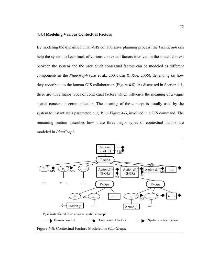
72
4.4.4 Modeling Various Contextual Factors
By modeling the dynamic human-GIS collaborative planning process, the PlanGraph can
help the system to keep track of various contextual factors involved in the shared context
between the system and the user. Such contextual factors can be modeled as different
components of the PlanGraph (Cai et al., 2003; Cai & Xue, 2006), depending on how
they contribute to the human-GIS collaboration (Figure 4-5). As discussed in Section 4.1,
there are three major types of contextual factors which influence the meaning of a vague
spatial concept in communication. The meaning of the concept is usually used by the
system to instantiate a parameter, e. g. P3 in Figure 4-5, involved in a GIS command. The
remaining section describes how these three major types of contextual factors are
modeled in PlanGraph.
Figure 4-5: Contextual Factors Modeled in PlanGraph
P1
……
MS
…… ……
MS MSMS
MS MS
MS
……
Human context
Action α (G/GR)
Action β1 (G/GR)
Action β2 (G/GR)
P2
Recipe
Action β3 ……
……
……
Recipe
P3
……
Action γ2
…… ……
Recipe
P4
Action γ3
……
Task context factors Spatial context factors
P3 is instantiated from a vague spatial concept
MS

73
Human Context as Agent(s) of Plans
The agent(s) (e. g. G/GR in Figure 4-5) responsible for a plan/subplan in the
SharedPlan built by the agents in collaboration is considered as the human context
influencing the meaning of a vague spatial concept. With the human agent modeled in the
PlanGraph, during the collaborative human-GIS communication, the GIS agent can
determine the human context from the PlanGraph to constrain its understanding about a
vague spatial concept. For example, from the PlanGraph representing the SharedPlan
between the GIS and the user, the system knows who proposes the spatial information
request involving a vague spatial concept. As a result, it can retrieve more human context
information (e. g. gender, age, familiarity with the spatial context involved, ethnicity,
etc.) about this particular user from its knowledge base and use the retrieved human
context information to constrain its understanding about the vague spatial concept.
Task Context as Actions and Parameters of Plans
The task context in the human-GIS communication usually involves the user’s
goals/activities and facilities associated with these goals/actions. In the PlanGraph, the
user’s goals/activities are modeled as action nodes, and facilities used in activities for
these goals are modeled as parameters associated with these action nodes. For example,
P3 in Figure 4-5 is instantiated from the meaning of a vague spatial concept, e. g. near.
The goals/activities, e. g. the food shopping purpose and the traveling activity, involved
in the task context are modeled as ascendant action nodes (e. g. action α, and β1 in
Figure 4-5) of P3 and their descendant action nodes (e. g. action β2 and β3, and their
descendant nodes in Figure 4-5). Facilities used in these activities, e. g. the transportation

74
vehicle, are modeled as part of parameter nodes associated with these action nodes, e. g.
the parameter node P1 in Figure 4-5.
With task context factors modeled in the PlanGraph, during the collaborative
human-GIS communication, the GIS agent can try to build a shared understanding with
the user about the task context factors that influence the meaning of a vague spatial
concept. The shared task context information will further help the GIS and the user to
reach closer understandings about the meaning of a vague spatial concept.
Spatial Context as Parameters of Plans
The spatial context in the human-GIS communication usually involves the spatial
properties of the spaces where the user’s activities towards the user’s goal behind the
user’s spatial information request take place. These spatial properties, e. g. spatial area
and routes involved in the user’s traveling activity, usually are modeled as part of
parameters associated with the action nodes representing these user activities. For
example, actions α, β1, β2, and β3 in Figure 4-5 represent the user activities toward the
user’s goal in the current context, and the spatial context factors can be modeled as part
of parameter nodes associated with these action nodes. P2 and P4 are two example
parameter nodes representing the spatial context factors.
With the spatial contextual factors modeled as parameter nodes in the PlanGraph,
the GIS agent can determine which spatial context information has been shared/not
shared with the user, and then decide if it needs to communicate with the user for
reaching a shared understanding about the spatial context involving the vague spatial
concept. Because the GIS map is usually used in human-GIS communication, all of the

75
spatial properties of the spaces can be shown on the map. So the spatial context
information shown on the GIS map can directly facilitate the GIS and the user in reaching
a shared understanding about the spatial context involved in communication
(MacEachren & Cai, 2006)
In summary, the GIS can keep track of the current context involving the vague
spatial concept, with using the PlanGraph to model various contextual factors related to
the SharedPlan in communication. The GIS can reason about how to handle the context-
dependency problem under constraints of the currently shared context represented in the
PlanGraph during the human-GIS communication.
4.4.5 Design and Representation of Actions and Recipes
The system needs to have general knowledge of actions and their recipes involved in
construction of PlanGraph before reasoning about how to handle the context-dependency
problem with use of PlanGraph. We designed the GIS agent’s general knowledge by
following the human GIS operator’s knowledge involved in human-human
communication of vague spatial concepts, based on the human emulation principle.
Part of the human GIS operator’s general knowledge is used in communication
without involving the vagueness problem, and some of it is used in communication
involving the vagueness problem. In the former case, the operator needs to have
knowledge about: (1) how to understand the user’s intention underlying the user
information request; (2) how to collaborate with the user toward the user’s spatial

76
information request; (3) how to execute GIS commands to satisfy the user’s request. In
the later case, the GIS operator needs to know: (1) how to understand the meaning of a
vague spatial concept with context information; (2) how to understand the context behind
the user’s spatial information request; (3) how to retrieve /infer context information from
the current context; (4) how to repair the shared context and reduce vagueness through
collaborative dialogues.
We also need to equip the GIS agent with general knowledge involved in these
two cases by following the human GIS operator’s knowledge described above. In human-
GIS communication, we consider only two types of agents, the GIS agent and the user
agent. In this domain, some actions can be performed by the GIS agent only, some of
them can be carried out by the user agent only, and some of them can be done by either
the GIS or the user. In design of actions and recipes for the GIS, we define the agent type
responsible for the three classes of actions as G, U and Gi, representing the GIS agent, the
user agent, and either of them, respectively.
Actions and Recipes in Communication without Vagueness
Upon receiving the user’s spatial information request to the GIS, the GIS agent
needs to recognize the user’s intention, Spatial Intention, underlying the request (see
Figure 4-6 (a)). A typical example of Spatial Intention underlying the user’s spatial
information request is to see a map, See Map (see Figure 4-6 (b)).
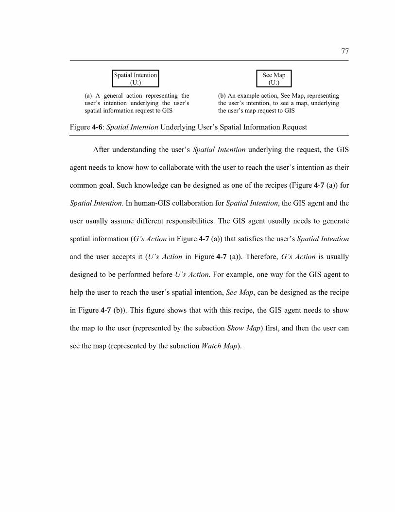
77
After understanding the user’s Spatial Intention underlying the request, the GIS
agent needs to know how to collaborate with the user to reach the user’s intention as their
common goal. Such knowledge can be designed as one of the recipes (Figure 4-7 (a)) for
Spatial Intention. In human-GIS collaboration for Spatial Intention, the GIS agent and the
user usually assume different responsibilities. The GIS agent usually needs to generate
spatial information (G’s Action in Figure 4-7 (a)) that satisfies the user’s Spatial Intention
and the user accepts it (U’s Action in Figure 4-7 (a)). Therefore, G’s Action is usually
designed to be performed before U’s Action. For example, one way for the GIS agent to
help the user to reach the user’s spatial intention, See Map, can be designed as the recipe
in Figure 4-7 (b)). This figure shows that with this recipe, the GIS agent needs to show
the map to the user (represented by the subaction Show Map) first, and then the user can
see the map (represented by the subaction Watch Map).
Figure 4-6: Spatial Intention Underlying User’s Spatial Information Request
Spatial Intention (U:)
(a) A general action representing the user’s intention underlying the user’s spatial information request to GIS
See Map (U:)
(b) An example action, See Map, representing the user’s intention, to see a map, underlying the user’s map request to GIS

78
To satisfy the user’s Spatial Intention, the GIS agent needs to know how to
perform its own responsibilities, that is, G’s Action. A recipe for such an action usually
involves various parameters, and certain subactions involving the execution of a GIS
command (Figure 4-8 (a)). An example for G’s Action is shown in Figure 4-8 (b). This
recipe for Show Map involves two parameters (Layer and Extent), and a GIS command
related sub action Generate Map. In addition, the GIS agent also needs to have
knowledge about how to instantiate the parameters involved in G’s Action, e. g. the two
parameters in the recipe in Figure 4-8 (b). For more examples of G’s Action, see the
actions and recipes in Appendix A.
Figure 4-7: Recipes for GIS to Reach User’s Spatial Intention
G’s Action (G)
U’s Action (U:)
See Map (U: , G)
Show Map (G)
Watch Map (U:)
(a) General recipe for GIS to help the user for the user’s intention as their common goal
(b) An example recipe for GIS to help the user for the user’s intention to see a map
Spatial Intention (U: , G)
Recipe Recipe 1

79
Actions and Recipes in Communication Involving Vagueness
In this study, a vague spatial concept is usually used by the GIS to instantiate a
parameter involved in a GIS command related action. For example, near in the user
request of “I’d like to see the map of grocery stores near Apartment A” is used by the GIS
to instantiate the parameter Dist, representing the spatial distance involved in certain GIS
commands, e. g. a spatial query with use of the spatial distance. By following HCP1(c)
and the human’s context-dependent model about the meaning of a vague spatial concept
VSC (Eq. 3.1), we can design a general recipe, Infer VSC, for the GIS to instantiate a
parameter from a vague spatial concept (Figure 4-9 (a)). In the recipe in Figure 4-9 (a),
the parameters represent major contextual factors that influence the meaning of the vague
spatial concept, and are designed as optional parameters. The subaction Calculate VSC in
Figure 4-9 (a) gives the parameter value based on the system’s model of the meaning of
the vague spatial concept. The parameter values representing contextual information can
be retrieved from or inferred based on the shared context represented in PlanGraph. With
this recipe, the GIS can infer the meaning of a vague spatial concept by using context
Figure 4-8: Recipes for G’s Action
G’s Action (G)
P1 …… SubAct1 (G)
Show Map (G)
Layer Extent Generate Map (G)
……
(a) General recipe for GIS to execute its action, G’s Action. One of SubActs is to execute a GIS command.
(b) An example recipe for the GIS agent’s duty, Show Map Layer: the map content Extent: the map extent
Recipe 1 Recipe 1

80
information based on the GIS agent’s model about the vague spatial concept. An example
recipe of Infer VSC, Infer Near for the GIS to understand the vague spatial concept near
is shown in Figure 4-9 (b). The system can use this recipe to understand near based on its
context-dependent model of the meaning of near.
The GIS agent also needs to have knowledge about how to understand the context
behind the user’s spatial information request to the GIS by following HCP1(a). The
general recipes in Figure 4-10 (a) and (b) show that the user’s final goal (Final Goal) in
the context behind the user’s spatial information request can involve the user’s activities
Figure 4-9: Recipe of Infer VSC
(a) A general recipe for the GIS to instantiate a parameter P with a vague spatial concept VSC with major context information. Calculate VSC gives the parameter value based on the system’s model of the meaning of the vague spatial concept. T_Pi: parameter representing a task context factor; S_Pi: parameter representing a spatial context factor; H Pi: parameter representing a human context factor
U Calculate Near(G) Goal Scale Vehicle
H_P1: Calculate VSC(G)
T_P1: S_P1: … … …
(b) A recipe for the GIS to calculate a distance value from the vague spatial concept near with major context information Goal: user’s goal behind the spatial information request; Vehicle: user’s transportation mode; Scale: spatial size of the interested area; U: user name Refer.: Reference location; Target: Target location Routes: Spatial distribution of routes
Instantiate P (G)
Infer VSC
Instantiate Dist (G)
Infer Near
Target Refer.routes

81
(Acti) toward the goal and each user activity may involve sub activities (SubActi). The
user’s Final Goal and each activity (Acti) or sub action (SubActi) in the activity may
involve parameters (S_Pi, S_Pj) representing spatial knowledge pre-conditions, which are
spatial context factors for the GIS agent to understand the meaning of a vague spatial
concept. Thus, the user’s Spatial Intention underlying the spatial information request to
the GIS is usually designed for the user to identify the spatial information (modeled in
parameters S_P) involved in the user’s goal and the activities (Figure 4-10 (c)). For
examples of actions and recipes related to different contexts, refer to Appendix A.
The human communicator needs to retrieve such context information from or
infer it based on the current shared context in human-human communication to
understand the vague spatial concept with major context information. Similarly, the GIS
agent also needs to have knowledge about how to retrieve or infer parameter values of the
Figure 4-10: General Recipes Related to Context
…… (U:)
Act1 (U:)
(a) A general recipe for the user’s Final Goal. S_Pi Parameter representing a spatial context factor
Final Goal (U:)
Recipe 1
Act2 (U:) … S_Pi … ……
(U:) SubAct1
(U:)
Acti (U:)
Recipe 1
SubAct2(U:) … …
(b) A general recipe for Acti toward Final Goal. S_Pj: Parameter representing a spatial context factor
S_P
Spatial Intention (U:)
(c) Relation between Spatial Intention and S_P in actions and recipes toward the user’s Final Goal. S_Pi Parameter representing a spatial context factor.
S_Pi

82
parameters in Figure 4-9 from PlanGraph. Therefore, the GIS agent needs to have
knowledge specifically about how to instantiate these parameters. In this study, an action
used to instantiate a parameter representing a context factor (Ct) is designed as
Instantiate Ct (see Figure 4-11 (a)). Its recipe Look and Infer are designed by following
the way by which the human user retrieves and estimates context information,
respectively (Figure 4-11 (b, c)).
We can design a set of actions and their recipes for the GIS agent to handle the
vagueness problem through various collaborative human-GIS dialogues, by following
HCP2(c) and HCP2(d). For example, in Figure 4-12, by following HCP2(c), Share
Context is designed as a general action for the GIS agent to reach a shared context
through context-sharing human-GIS dialogues; by following HCP2(d), Negotiate is
designed as a general action for the GIS agent to refine the existing meaning of a vague
spatial concept through negotiation human-GIS dialogues, and Direct Communicate as a
general action for the GIS agent to further reduce vagueness through direct
communication dialogues.
Figure 4-11: Actions and Recipes for Retrieving/Inferring Context Information
(b) Recipe for the GIS to look for the parameter value for Ctfrom the existing PlanGraph
Look Ct (G)
Instantiate Ct (G)
Look Instantiate Ct
(G)
(a) Action for the GIS to instantiate a parameter Ct representing a context factor
Infer Ct (G)
Instantiate Ct (G)
Infer
(c) Recipe for the GIS to infer the parameter value for Ct

83
4.4.6 Design and Representation of Mental States
The GIS agent’s mental states on action/parameter nodes in the PlanGraph are designed
by following the plan evolution process described in the SharedPlan theory (Grosz &
Kraus, 1996, 1999), and further extended by following the HCPs, in particular, the GIS
operator’s mental states involved in handling the vagueness problem.
According to the plan evolution process described in the SharedPlan theory
(Grosz & Kraus, 1996, 1999), a plan towards the goal/action α in collaboration usually
evolves from partial to complete through several major steps (Figure 4-13). We can
summarize the agent’s mental states (intention, commitment, and mental belief) required
at each step of a plan to execute an action α in Table 4-1. In this table, the “individual
intention” means that the agent being modeled, that is, the GIS agent in this study,
intends to achieve the success of α, and the “group intention” means that both the agent
being modeled and the other agents in collaboration (e. g. the user agent in this study) all
intend the success of α.
Figure 4-12: Communicative Actions to Handle the Context-Dependency Problem
Share Context (G1, G2)
(a) Communicative action for the GIS and the user to share context information with each other
Negotiate (G1, G2)
(b) Communicative action for the GIS and the user to negotiate the meaning of a vague spatial concept
Directly Communicate (G1, G2)
(c) Communicative action for the GIS and the user to communicate the meaning of the vague spatial concept directly

84
Figure 4-13: Major Steps in Plan Evolution (Grosz & Kraus, 1999)
Table 4-1: GIS Agent’s Mental States on an Action α in PlanGraph Step No.
Intention on α
Commitment on success of α
Belief (the agent being modeled believes that)
1 individual individual α is part of collaboration. 2 Individual
& group Individual and mutual
α is part of collaboration. All agents in collaboration also believe that α is part of collaboration.
3.1 Individual & group
Individual & mutual
α is basic, and needs to be executed directly; All agents in collaboration believe capabilities of the agent assigned for α to execute α.
3.2 Individual & group
Individual & mutual
α is complex, and needs to be elaborated and executed;
3.2.1 Individual & group
Individual & mutual
A recipe R for α is selected. All agents in collaboration agree with R selected for α.
3.2.2 Individual & group
Individual & mutual
Instantiation of each parameter Pi involved in R starts. All agents in collaboration believe capabilities of the agent assigned for instantiation of Pi
3.2.3 Individual & group
Individual & mutual
Further planning (& execution) for each sub-action/sub-goal βi involved in R starts. All agents in collaboration believe capabilities of the agent assigned for further planning (& execution) of βi
4 Individual & group
Individual & mutual
α is completed with the result of failure or success. All agents in collaboration need to know the result.
Note: For Step No. in this table, refer to Figure 4-13
• Step 1: α is initially proposed as part of the collaboration; • Step 2: α is agreed, intended and committed by all agents in collaboration; • Step 3: The agent(s) responsible for α needs to start the plan completion process, which includes:
o Step 3.1: If α can be directly executed, then the agent(s) assigned for α directly executes α, o Step 3.2: If α is complex and can not be directly executed,
Step 3.2.1: An appropriate recipe R for α is selected/constructed and an appropriate agent(s) is assigned for each parameter Pi and each sub action/goal βi involved in this recipe if any;
Step 3.2.2: The agent(s) assigned for instantiation of each parameter Pi involved in Rstarts to instantiate Pi.
Step 3.2.3: The agent(s) assigned for each sub action/goal βi involved in R if any begins to advance and evolve βi toward the success of βi.
• Step 4: The agent(s) responsible for α needs to monitor the result of execution of α, success or failure and updates its own belief and mutual beliefs about the result.
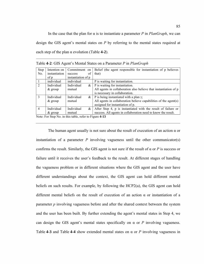
85
In the case that the plan for α is to instantiate a parameter P in PlanGraph, we can
design the GIS agent’s mental states on P by referring to the mental states required at
each step of the plan α evolution (Table 4-2).
The human agent usually is not sure about the result of execution of an action α or
instantiation of a parameter P involving vagueness until the other communicator(s)
confirms the result. Similarly, the GIS agent is not sure if the result of α or P is success or
failure until it receives the user’s feedback to the result. At different stages of handling
the vagueness problem or in different situations where the GIS agent and the user have
different understandings about the context, the GIS agent can hold different mental
beliefs on such results. For example, by following the HCP2(a), the GIS agent can hold
different mental beliefs on the result of execution of an action α or instantiation of a
parameter p involving vagueness before and after the shared context between the system
and the user has been built. By further extending the agent’s mental states in Step 4, we
can design the GIS agent’s mental states specifically on α or P involving vagueness.
Table 4-3 and Table 4-4 show extended mental states on α or P involving vagueness in
Table 4-2: GIS Agent’s Mental States on a Parameter P in PlanGraph Step No.
Intention on instantiation of p
Commitment on success of instantiation of p
Belief (the agent responsible for instantiation of p believes that)
1 individual individual P is waiting for instantiation. 2 Individual
& group Individual & mutual
P is waiting for instantiation. All agents in collaboration also believe that instantiation of p is necessary in collaboration.
3 Individual & group
Individual & mutual
P is being instantiated with a plan γ; All agents in collaboration believe capabilities of the agent(s) assigned for instantiation of p.
4 Individual & group
Individual & mutual
After Step 4, p is instantiated with the result of failure or success. All agents in collaboration need to know the result.
Note: For Step No. in this table, refer to Figure 4-13
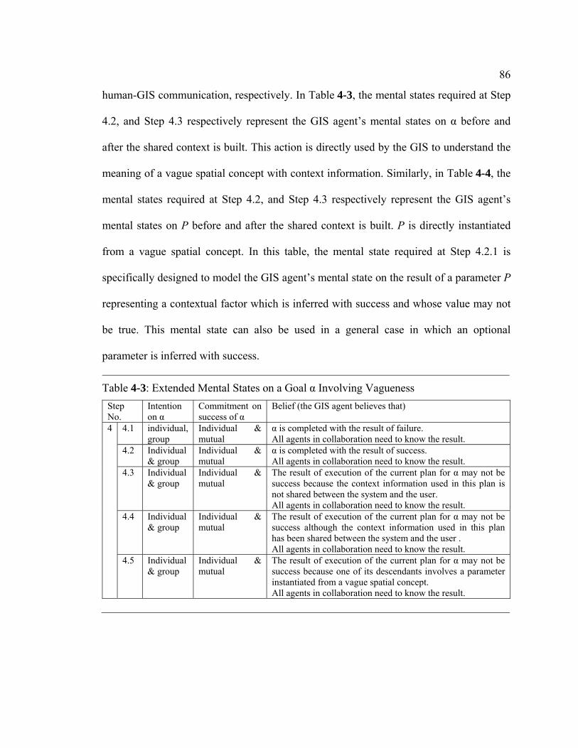
86
human-GIS communication, respectively. In Table 4-3, the mental states required at Step
4.2, and Step 4.3 respectively represent the GIS agent’s mental states on α before and
after the shared context is built. This action is directly used by the GIS to understand the
meaning of a vague spatial concept with context information. Similarly, in Table 4-4, the
mental states required at Step 4.2, and Step 4.3 respectively represent the GIS agent’s
mental states on P before and after the shared context is built. P is directly instantiated
from a vague spatial concept. In this table, the mental state required at Step 4.2.1 is
specifically designed to model the GIS agent’s mental state on the result of a parameter P
representing a contextual factor which is inferred with success and whose value may not
be true. This mental state can also be used in a general case in which an optional
parameter is inferred with success.
Table 4-3: Extended Mental States on a Goal α Involving Vagueness Step No.
Intention on α
Commitment on success of α
Belief (the GIS agent believes that)
4.1 individual, group
Individual & mutual
α is completed with the result of failure. All agents in collaboration need to know the result.
4.2 Individual & group
Individual & mutual
α is completed with the result of success. All agents in collaboration need to know the result.
4.3
Individual & group
Individual & mutual
The result of execution of the current plan for α may not be success because the context information used in this plan is not shared between the system and the user. All agents in collaboration need to know the result.
4.4 Individual & group
Individual & mutual
The result of execution of the current plan for α may not be success although the context information used in this plan has been shared between the system and the user . All agents in collaboration need to know the result.
4
4.5 Individual & group
Individual & mutual
The result of execution of the current plan for α may not be success because one of its descendants involves a parameter instantiated from a vague spatial concept. All agents in collaboration need to know the result.

87
4.4.7 Design and Representation of Reasoning Algorithms
Upon receiving each user input, the GIS agent needs to react to the input during the
collaborative human-GIS planning process with three steps, including interpretation,
elaboration and response control (Balkanski & Hurault-Plantet, 2000; Lochbaum, 1998)
(Figure 4-14). At the step of interpretation, the system needs to interpret the meaning of
the new input. At the step of elaboration, the system needs to advance the existing
human-GIS collaborative plan toward its success, and execute whatever can be executed
toward its success. At the step of response control, the system needs to control when and
Table 4-4: Extended Mental States on a Parameter P Involving Vagueness Step No. Intention
on instantiation of p
Commitment on success of instantiation of p
Belief (the agent responsible for instantiation of p believes that)
4.1 Individual & group
Individual & mutual
P is instantiated with the result of failure. All agents in collaboration know the result.
4.2.1 Individual & group
Individual & mutual
P’s value is inferred with the result of success. All agents in collaboration know the result.
4.2.2 Individual & group
Individual & mutual
P is instantiated with the result of success. All agents in collaboration know the result.
4.3
Individual & group
Individual & mutual
The result of instantiation of p may not be success because the context information used in the current plan for instantiation of p is not shared between the system and the user. All agents in collaboration know the result.
4.4 Individual & group
Individual & mutual
The result of instantiation of p may not be success although the context information used in the current plan for instantiation of p has been shared between the system and the user. All agents in collaboration know the result.
4
4.5 Individual & group
Individual & mutual
The result of instantiation of p may not be success because one of its descendants involves a parameter instantiated from a vague spatial concept.
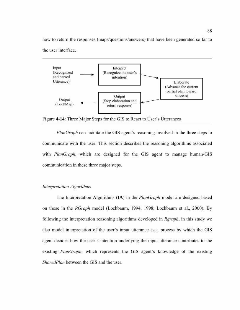
88
how to return the responses (maps/questions/answers) that have been generated so far to
the user interface.
PlanGraph can facilitate the GIS agent’s reasoning involved in the three steps to
communicate with the user. This section describes the reasoning algorithms associated
with PlanGraph, which are designed for the GIS agent to manage human-GIS
communication in these three major steps.
Interpretation Algorithms
The Interpretation Algorithms (IA) in the PlanGraph model are designed based
on those in the RGraph model (Lochbaum, 1994, 1998; Lochbaum et al., 2000). By
following the interpretation reasoning algorithms developed in Rgraph, in this study we
also model interpretation of the user’s input utterance as a process by which the GIS
agent decides how the user’s intention underlying the input utterance contributes to the
existing PlanGraph, which represents the GIS agent’s knowledge of the existing
SharedPlan between the GIS and the user.
Figure 4-14: Three Major Steps for the GIS to React to User’s Utterances
Interpret (Recognize the user’s
intention) Elaborate
(Advance the current partial plan toward
success) Output (Stop elaboration and
return response)
Input (Recognized and parsed Utterance)
Output (Text/Map)
89
In human-GIS communication, we assume that the user’s input utterance usually
is short and expresses only one major intention α. Under this assumption, IAs in the
PlanGraph model are designed for the following two cases (Balkanski & Hurault-Plantet,
2000): 1) the input utterance is an initial request from the user and PlanGraph is empty,
and 2) PlanGraph is not empty and the user input contributes to the current SharedPlan
between the GIS and the user:
• In the first case, if the GIS agent believes that it can participate in α, the GIS
agent needs to initiate the PlanGraph with α, update its mental state on α, and
focuses its attention on α.
• In the second case, the GIS agent needs to find a way to integrate α with the
existing PlanGraph and updates its mental states and attention focus in
PlanGraph. α can be directly contributing to the attention focus β in
PlanGraph, e. g. α is β or part of β; β is part of α; α represents the user’s
mental attitude on β. α can also be related to other components in PlanGraph.
For examples of IAs, see Appendix C. These algorithms can be further extended
for the GIS agent to handle vagueness by following how the human communicator
interprets the other communicator’s input in human-human communication involving
vagueness.
Elaboration Algorithms
The Elaboration Algorithms (EAs) in the PlanGraph model are designed by
following the plan evolution process (Figure 4-13) and referring to the task-advancement
reasoning algorithms in Balkanski and Hurault-Plantet’s work (Balkanski & Hurault-
90
Plantet, 2000). At each step of the plan evolution process (Figure 4-13), if the agent(s)
responsible for that plan holds mental states required at that step, the agent can evolve the
plan (e. g. change the mental state on that plan and/or execute action(s) involved in that
plan) to the next step towards the success of the plan. The PlanGraph records the GIS
agent’s mental states on each action/parameter in the SharedPlan built by the GIS and the
user and the attention focus on the SharedPlan. Therefore, by following the plan
evolution process described above, we can design EAs for the GIS agent to reason about
how to evolve the plan for executing the focus action or instantiating the focus parameter
with use of the PlanGraph. The plan evolution is a recursive process which interleaves
planning (e. g. finding a suitable recipe for a complex action involved in the
collaboration) and execution (e. g. execution of basic actions and instantiation of
parameters). Thus, the EAs are designed also as such a recursive process.
The elaboration process is designed as always starting with elaboration of the
focus action/parameter in the PlanGraph, e. g. an action to be done or a parameter to be
instantiated. In case the GIS agent’s current attention focus in PlanGraph is on an action
α, the Elaboration Algorithms on an Action α (EAAs) are designed for the GIS agent (G)
to evolve α from partial to complete, step by step, as follows (Figure 4-15):

91
• EAA at Step 1: if G holds mental states required at Step 1, G can start to
evolve α toward Step 2 by evolving its mental state on α to the mental state
required at Step 2
• EAA at Step 2: if G holds mental states required at Step 2, then the agent(s)
can start to evolve α toward Step 3 by evolving its mental state on α to the
mental state required at Step 3.1 or Step 3.2.1 after determining that α is basic
or complex (and if α is complex, an appropriate recipe needs to be selected for
α);
• EAA at Step 3:
o EAA at Step 3.1: If G holds the mental state required at Step 3.1 (α is
basic), G directly executes α, monitors the result of the execution of α and
then updates its mental state required at Step 4;
Figure 4-15: Structure of EAAs
M 3.1
M3.2
M4.1 failure
M4.2 success
Elaboration on α starts Elaboration on α evolves Elaboration on α stops
EAA1, EAA2, …. EAA at each step
Move attention
Re-pan for α or announce
its failure
M1, M2 … The GIS agent’s mental state at each step during the α evolution process
EAA3.2
EAA2
EAA3.1
M2 EAA1 M1 initial
4.3-4.5 vagueness EAP4.3, 4.4, 4.5

92
o EAA at Step 3.2
• EAA at Step 3.2.1: If G holds mental states required at Step 3.2.1
(α is complex and a recipe R is selected for α), the agent Gi
responsible for each parameter Pi in R starts to elaborate Pi if any
and updates its mental state on α as required at Step 3.2.2,
• EAA at Step 3.2.2: If G holds mental states required at Step 3.2.2,
G has all parameters in the current plan R for α instantiated, the
agent Gi responsible for each sub action βi in R starts to elaborate
βi and G updates its mental state required at Step 3.3.3.
• EAA at Step 3.2.3: If G holds mental states required at Step 3.2.2,
G has all sub actions in the current plan R for α finished, monitors
the result of execution of R and updates its mental state on α
required at Step 4.;
• EAA at Step 4: If G holds a mental state required at Step 4, G needs to give
up the current plan for α if α fails, or needs to move attention to the next
action in the collaboration that G can participate in if α succeeds.
Similar to design of the EAAs, the Elaboration Algorithms on Parameters (EAPs)
are designed by referring to the evolution process of the plan α for the agent(s) G to
instantiate the focus parameter p as follows (Figure 4-16):

93
• EAP at Step 1: if G holds mental states required at Step 1, then G can start to
evolve p toward Step 2 by evolving its mental state on p to the mental state
required at Step 2.
• EAP at Step 2: if G holds mental states required at Step 2, G can start to
evolve p toward Step 3 by proposing a plan α to instantiate p;
• EAP at Step 3: if G holds mental states required at Step 3, G waits for α’s
execution result, updates the parameter value for p and the mental state
required at Step 4 depending on the result from α.
• EAP at Step 4: If G holds a mental state required at Step 4, G needs to give up
p’s instantiation if α fails, or needs to move its attention to the next
action/parameter in the collaboration that G can contribute to if α succeeds.
From the EAAs and EAPs described above, we can see that by applying the
EAAs or EAPs, the GIS agent can evolve its mental states on an action or a parameter
Figure 4-16: Structure of EAPs
EAP3: monitor p’s result and update
mental state
EAP4.3, 4.4, 4.5
EAA2 2 3
4.1 fail
4.2 success
Elaboration on p starts: Elaboration on p advances: Elaboration on p ends
Elaborate α to instantiate
p
EAP1, EAP2, …. EAP at each step
Move attention in PlanGraph
Re-plan for instantiation of p or announce
its failure
1, 2, 3……Mental States required at each step
1 EAP1EAP4.2
EAP4.1
4.3-4.5 vagueness EAP4.3, 4.4, 4.5
94
from partial to complete. Each EAA/EAP for the focus action α/parameter p also
describes conditions (mainly the GIS agent’s mental states on α/p) under which it
applies, and the effects (mainly the GIS agent’s mental state change on α/p, attention
change in PlanGraph, and execution of α or instantiation of p) that it will bring to α/p.
By following the HCPs involved in handling the vagueness problem, we can
extend EAAs/EAPs for the GIS to elaborate the focus action α involving vagueness or
the focus parameter p instantiated from a vague spatial concept as the GIS agent’s mental
states are extended for handling the vagueness problem. Following are examples of
EAAs and EAPs at Step 4.3, Step 4.4, and Step 4.5 by referring to the mental states
designed in Table 4-3 and Table 4-4, respectively:
• EAA/EAP at Step 4.2, Step 4.3, and Step 4.5 in case α/instantiation of p is
just finished: If G holds a mental state required at Step 4.2, Step 4.3, or Step
4.5, G needs to move its attention to the next action/parameter in the
collaboration that G can contribute to. In human-human communication, the
human communicator usually continues the collaboration with an inferred
meaning of a vague spatial concept. By utilizing following the human’s
solution in this case, we design extended EAAs and EAPs here.
• EAA/EAP at Step 4.2, Step 4.3, or Step 4.5 in case the result of α/
instantiation of p is disputed by the user: G holds a mental state required at
Step 4.2, Step 4.3, or Step 4.5, G needs to re-visit α or the plan to instantiate
p. In human-human communication, the human communicator usually tries to
improve the previous plan involving vagueness when the user disagrees with
95
the result of the previous plan. By adopting this human solution, we have
designed EAAs and EAPs presented here. These algorithms can be further
detailed by employing the human solutions in this case. For example, by using
HCP2(c) and HCP2(d), we can design EAAs/EAPs in this case for the GIS
agent to repair the shared context and further reduce vagueness through use of
various collaborative dialogue strategies.
Here is another example for extension of EAAs/EAPs for the GIS to handle the
context-dependency problem by utilizing HCP1(b):
• EAA at Step 3.2.1 in case the current plan for α is used to understand a vague
spatial concept with contextual information: If G holds mental states required
at Step 3.2.1 (α is complex and a recipe R is selected for α), the agent Gi
responsible for each parameter Pi representing a contextual factor in R needs
to infer the context behind the user’s request involving the vague spatial
concept before starting to elaborate Pi if any and updates its mental state on α
as required at Step 3.2.2.
Response Control Algorithms
The output reasoning algorithms in the PlanGraph model are designed by
following the plan evolution process and referring to the stopping conditions in the task-
advancement reasoning algorithms in Balkanski and Hurault-Plantet’s work (Balkanski &
Hurault-Plantet, 2000). During the plan evolution process, the agent(s) responsible for
that plan may need to communicate with other collaborators in different situations, e. g.
exchanging mental beliefs/commitments on that plan or executing a communicative

96
action (e. g. asking questions or answering questions) in that plan. So, with the
PlanGraph modeling the SharedPlan between the GIS and the user, the GIS agent can
know whether the plan/subplan involved in the SharedPlan is communicative or not, or
whether there is a need to communicate with the user or not. Therefore, we can design
output reasoning algorithms for the GIS to reason about when to stop elaboration and
return responses to the user by using the PlanGraph.
In human-GIS communication, we currently consider two cases for the GIS agent
to stop elaboration and output responses: 1) in case execution of an action in the
PlanGraph involves communication, e. g. in case the GIS needs to execute a basic action
α representing the GIS agent’s question to the user; 2) in case the GIS agent needs to
communicate with the user about certain mental states, e. g. mutual beliefs, mutual
commitments. Two Output Response (OR) algorithms can be designed respectively for
these two cases. In these two cases, the GIS agent needs to send out responses, updates its
mental states and attention focus in PlanGraph. For examples of ORs, refer to Appendix
C.
4.4.8 Comparison with the Rgraph model
The PlanGraph model extends the Rgraph model based on the computational
collaborative discourse theory and the SharedPlan theory, and is further extended by
following the HCF, in particular, HCPs involved in handling the vagueness problem.
Here extensions of the PlanGraph model with respect to the Rgraph model are
summarized as follows.

97
Firstly, PlanGraph models not only action nodes, but also parameter nodes. In
Rgraph, parameters are modeled as knowledge pre-conditions that must be satisfied
before execution of plans involving the parameters. However, parameters are not
explicitly represented in the Rgraph. The vague spatial concept is the major focus in this
study. The GIS agent’s understanding about it usually involves use of complex plans.
Thus, the PlanGraph is designed to record parameter nodes explicitly for convenience of
reasoning about how to instantiate such parameters with complex plans.
Secondly, PlanGraph models not only mental statuses on actions, but also those
on parameters. In addition, PlanGraph also extends Rgraph by incorporating a set of
mental states involved in handling the vagueness problem. Rgraph does not explicitly
model the agent’s mental states on parameter values. In this study, the GIS agent may
hold more mental states on the result of an action or the instantiation result of a parameter
involving vagueness than just simple success or failure. Therefore, for convenience of
reasoning about how to handle the vagueness problem, PlanGraph is designed to record
the GIS agent’s mental states on both action and parameter nodes, and incorporate these
mental states involved in handling the vagueness problem.
Thirdly, by following the plan evolution process (Grosz & Kraus, 1996, 1999),
the PlanGraph model also extends the Rgraph model by providing reasoning algorithms
for not only interpreting each utterance in discourse, but also elaborating the SharedPlan
underlying the collaborative discourse and controlling responses in the discourse. In
particular, the EAAs and EAPs in the PlanGraph model enable both the planning process
and the actual execution process. These reasoning algorithms in the PlanGraph model are
further extended for the GIS agent to handle the vagueness problem by using the HCF.

98
4.5 Example Human-GIS Collaborative Dialogue
This section explains a hypothetical collaborative dialogue between a spoken natural
language GIS incorporating the collaborative dialogue approach and the PlanGraph
model and a human user (Figure 4-17). This dialogue example is used to illustrate how
the collaborative dialogue approach and the PlanGraph model can help the GIS agent to
handle the context-dependency problem. For convenience of description, let the user be a
male. For all actions and recipes involved in this example, refer to Appendix A. In all
PlanGraphs shown in this section, the plan evolution step number at the right side of an
action/parameter node represents the GIS agent’s mental states required at that step. For
each plan evolution step number and mental states required at that step, refer to Table 4-
1, Table 4-2, Table 4-3 and Table 4-4.
Figure 4-17: Hypothetical Collaborative Human-GIS Dialogue
G: GIS U: User-A
Before the following conversation, the map on the GIS is empty. U (1): Hi, I am User-A. I would like to see cities near City A. G (1): (show a map of City A, including interstates, and highlight certain cities near City A) For the plan of vacation purpose by driving, here are cities within 300 miles of City A. Is this OK? U (2): No. G (2): What is your goal in asking for this map? U (3): I am planning to look for jobs in cities near City A. I plan to work there by driving from City A. G (3): (Highlight fewer cities near City A) Here are cities within 150 miles of City A, is this OK? U (4): Yes. Thanks.

99
4.5.1 Building Initial Shared Context through U (1) and G (1)
Before the dialogue shown in Figure 4-17 starts, the GIS map is empty. As to the shared
context involved in communication (Figure 4-18), the GIS and the user share only
common sense knowledge about understanding the language and conventions involved in
human-GIS communication/collaboration. The user holds full knowledge about the task
context and the human context, but has no knowledge about the spatial context to be
involved in the task domain. The system does not have knowledge about who will be the
user and which spatial area and associated spatial information will be the user’s interest.
However, the system holds geospatial information needed for the conversation in its
database, and also holds part of the user’s previous experiences about understanding near
in various contexts.
Interpretation of U (1)
Figure 4-18: Shared Context before Communication
Task (full knowledge): the goal is to look for jobs; the transportation mode is driving
Task: empty
Spatial: Name of the spatial area, but no other spatial information
Spatial: the GIS has spatial information about all areas, but does not know the user’s interested area name.
Human: full knowledge Human: The GIS has knowledge about multiple users’ previous experiences involving near, but does not know who will be the communicator.
User-A’s context knowledge
System’s context knowledge
Shared context knowledge
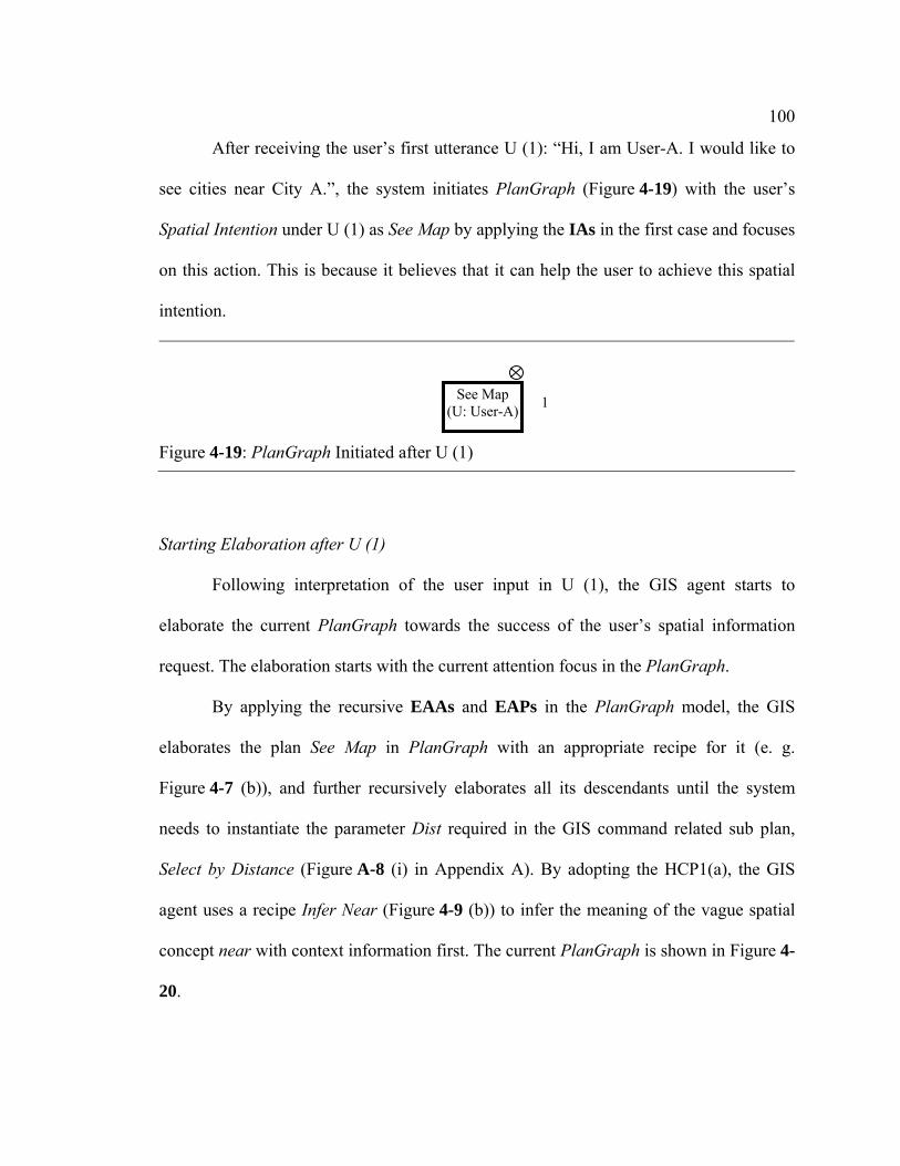
100
After receiving the user’s first utterance U (1): “Hi, I am User-A. I would like to
see cities near City A.”, the system initiates PlanGraph (Figure 4-19) with the user’s
Spatial Intention under U (1) as See Map by applying the IAs in the first case and focuses
on this action. This is because it believes that it can help the user to achieve this spatial
intention.
Starting Elaboration after U (1)
Following interpretation of the user input in U (1), the GIS agent starts to
elaborate the current PlanGraph towards the success of the user’s spatial information
request. The elaboration starts with the current attention focus in the PlanGraph.
By applying the recursive EAAs and EAPs in the PlanGraph model, the GIS
elaborates the plan See Map in PlanGraph with an appropriate recipe for it (e. g.
Figure 4-7 (b)), and further recursively elaborates all its descendants until the system
needs to instantiate the parameter Dist required in the GIS command related sub plan,
Select by Distance (Figure A-8 (i) in Appendix A). By adopting the HCP1(a), the GIS
agent uses a recipe Infer Near (Figure 4-9 (b)) to infer the meaning of the vague spatial
concept near with context information first. The current PlanGraph is shown in Figure 4-
20.
Figure 4-19: PlanGraph Initiated after U (1)
1 See Map (U: User-A)

101
Inferring Context before Understanding Near with Contextual Information
By applying EAAs/EAPs designed by following the HCP1(b), the GIS agent
infers the context behind the user’s intention in U (1) before executing the plan Infer
Near. Based on its best knowledge, the system infers that the context behind U (1) is
related to the goal Plan for Vacation (Figure A-2 (a)). The system believes that the user’s
intention See Map is to identify spatial information about the traveling destinations for
the goal Plan for Vacation. Then, the actions and recipes related to Plan for Vacation are
Figure 4-20: PlanGraph before Executing Infer Near
Identify
Target 4.2
4.2
3.2.1
In. lyr (G)
13 4.2
I_lyr (G)
4.2
4.2
I_Rf (G)
In. Rf (G)
Identify
4.2
13 1
3.2.1
See Map (U: User-A, G)
Show Map (G)
Watch Map (U: User-A)
Recipe 1
Layer Extent Generate Map (G)
Recipe 1
Dist. Spatial Query
(G) Refer.
Select by Distance
Instantiate lyr(G)
1
3.2.1
11 1 1
3.2.1
1 1 1 1
Instantiate Dist (G)
U Cal. Near
(G) Goal ScaleVeh.
Infer Near
Ref. TargetRoutes

102
integrated with the existing PlanGraph by linking See Map with Destination, a
descendant parameter of Plan for Vacation.
Actively Sharing Spatial Contextual Information with the User
To facilitate building a shared context, the GIS agent prepares spatial contextual
information needed in Plan for Vacation, e. g. routes needed in the traveling activity,
with the plan Actively Give of Share Context (Figure A-11 (c)) for the user and plans to
actively share such spatial information with the user through the GIS map later. The
current PlanGraph is shown in Figure 4-21.
Understanding Near with Contextual Information
Figure 4-21: PlanGraph after Inferring the Context
4.2
4.2
4.2
3.2.1
See Map (U: User-A, G)
Show Map (G)
Watch Map (U: User-A)
Recipe 1
1
3.2.14.2
……
4.2 4.2 4.2
4.2 4.2 4.2 3
1
Plan for Vacation (U:User-A)
Vehicle: Routes: Start: Destinat.
Visit Targets (U: User-A)
Recipe 1
Recipe 1
Scale
1
I_Veh. (G)
In. Veh. (G)
I_Start(G)
In. Start(G)
Identify
4.2
Move (U:User-A)
4.2
Search Rts. (G)
In. Rts. (G)
Search
Travel (U: User-A)
Share Context (User-A, G)
4.2
Actively Give
Answer (User-A, G)
Para: Rts.
3.2.1
3.2.1
Infer
…… For missed components under Show Map, please refer to Figure 4-20
103
After inferring Plan for Vacation, the GIS agent comes back to continue to
elaborate the plan Infer Near. By using the action and recipes shown in Figure 4-11, the
GIS agent infers/retrieves contextual information from the existing PlanGraph in
Figure 4-21 that is needed in Infer Near, and executes this plan by assigning 300 miles to
the parameter Dist. The system further generates a map response to the user in G (1) by
finishing the plan Show Map. This map shows not only “cities within 300 miles of City
A”, but also the interstate distribution in the spatial area that the user is interested in. The
interstate distribution information has been generated from the system’s active context-
sharing plan, Actively Give.
By applying the EAAs/EAPs designed for elaboration at Step 3 and 4, the GIS
agent shifts its attention to Watch Map responsible by the user and updates its mental
states on all action/parameter nodes in PlanGraph correspondingly. Because part of the
context-information used in Infer Near is inferred, the GIS agent updates its mental states
on Instantiate Dist and Dist as those required at the plan evolution Step 4.3. It also
updates its mental states on the ascendants of Dist as those required at the plan evolution
Step 4.5.
Controlling Responses to U (1)
The current attention focus Watch Map is to be done by the user. The GIS
assumes that the user can successfully accomplish this action. Under this assumption, by
applying the ORs designed, the system can shift its attention to the parent action of Show
Map, See Map, which is the last action in which the system can participate in human-GIS

104
collaboration after sending out responses in G (1). The current PlanGraph is shown in
Figure 4-22. The map response in G (1) is shown in Figure 4-23.
Figure 4-22: PlanGraph after G (1) in the Hypothetical Dialogue Example
4.2
4.2
4.2 4.2
4.2
4.2
4.2
4.2
4.2
4.2
4.2
4.2
4.2
4.2
4.2
4.2
4.5
4.24.3 4.2
4.2 4.5 4 2
4.5
See Map (U: User-A, G)
Show Map (G)
Watch Map (U: User-A)
Recipe 1
Layer Extent: Estimated Ext.
Generate Map (G)
Recipe 1
Dist. Spatial Query (G)
Refer: City A
Select by Distance
Instantiate lyr(G)
Target: Cities
4.2
4.5
4.24.2 4.2
4.3
4.2 4.2
Instantiate Dist (G)
U Cal. Near(G) Goal ScaleVeh.
Infer Near
Ref. TargetRoutes
Inf. Goal (G)
In. Goal (G)
Infer
LK. Veh. (G)
In. Veh. (G)
Look
LK. Scale(G)
In. Scale (G)
Look
LK. User (G)
In. User (G)
Look
LK. Ref. (G)
In.Ref. (G)
Look
LK. Tar. (G)
In. Target (G)
Look
LK. Rt (G)
In. Routes(G)
Look
Plan for Vacation (U:User-A) 3.2.1
……
To save space, I have removed actions for instantiation of parameters which are not involved in handling the vagueness problem. For the sub plan under Plan for Vacation, refer to Figure 4-21.
4.2
4.2
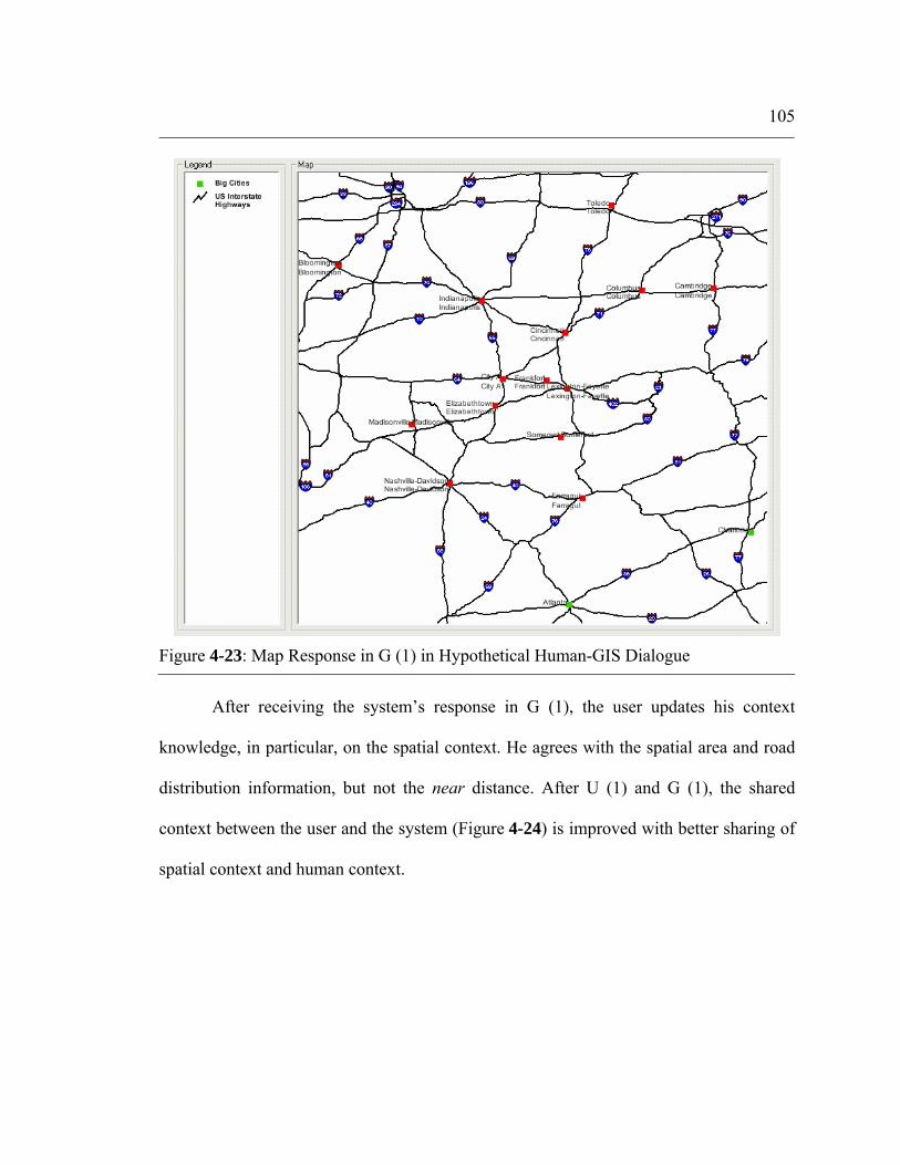
105
After receiving the system’s response in G (1), the user updates his context
knowledge, in particular, on the spatial context. He agrees with the spatial area and road
distribution information, but not the near distance. After U (1) and G (1), the shared
context between the user and the system (Figure 4-24) is improved with better sharing of
spatial context and human context.
Figure 4-23: Map Response in G (1) in Hypothetical Human-GIS Dialogue

106
4.5.2 Repairing Shared Context through G (2) and U (3)
After receiving the user’s negative response in U (2), the GIS agent revisits the previous
plan for See Map and all its descendants involving vagueness, in particular, the sub plan
Infer Near, by applying EAAs and EAPs at Step 4.2, 4.3, and 4.5 (specifically designed
for handling the vagueness problem). Because the user’s final goal in the event behind U
(1) is inferred in the previous plan Infer Near, the system uses the plan Ask of Share
Context (Figure A-11 (b)) to obtain such contextual information from the user in order to
repair the shared context. So, the system asks the user in G (2): “What is your goal in
asking for this map?”. The user collaboratively answers this question in U (3): “I am
planning to look for jobs in cities near City A.”. In addition, the user also actively shares
his transportation mode information with the system in U (3) without being asked: “I plan
to work there by driving from City A”. The system understands the later part of U (3) as
Actively Give of Share Context (Figure A-11 (c)).
Figure 4-24: Shared Context after Communication between U (1) and G (1)
Task (full knowledge): the goal is to look for jobs; the transportation mode is driving
Task (inferred): the goal is to plan for vacation; the transportation mode is driving.
Spatial: Spatial: Interested spatial area, Routes, All cities in the map area
User-A’s context knowledge
System’s context knowledge
Shared context knowledge
Human: full knowledge
Human: User name

107
With new updated contextual information from the user, the system re-elaborates
the context behind U (1), and integrates the plan Look for Jobs (Figure A-4) with the
existing PlanGraph. The system’s updated context knowledge in the PlanGraph is shown
in Figure 4-25.
After receiving U (3), the system and the user have reached a shared
understanding about the current context (Figure 4-26), which influences the meaning of
near in both agents’ model of near.
Figure 4-25: System’s Updated Context Knowledge after U (3)
4.2 3.2.1
See Map (U: User-A, G)
Show Map (G)
Watch Map (U: User-A)
Recipe 1
1
3.2.1
4.2 4.2 4.2 3
1
Look for Jobs (U:User-A)
Vehicle: Routes:On map
Start: City A
Destinat.
Work on Jobs (U: User-A)
Recipe 1
Recipe 1
Scale: Map area
4.2
1Move (U:User-A)
Travel (U: User-A)
3.2.1
3.2.1
……
Share Context (User-A, G)
Actively Give
Answer (User-A, G)
Para: Route
4.2
4.2
To save space, I have removed actions for instantiation of parameters that have the same values as those in Figure 4-22

108
4.5.3 Reaching Shared Meaning of Near under Constraints of Shared Context
By successfully building a shared context with the user through collaborative dialogues,
the system re-infers the meaning of near with the plan Infer Near. This plan is improved
with new contextual information retrieved from the plan Look for Jobs in the existing
PlanGraph in Figure 4-25. The system’s new understanding about near is 150 miles of
driving distance.
After re-inferring the meaning of near, the GIS agent re-generates a map response
showing cities within 150 miles of driving distance to City A in G (3) (Figure 4-27).
Similarly, the GIS agent updates its mental states on Dist and Instantiate Dist as those
required at the plan evolution Step 4.4 because it believes that all context information
used for its understanding about the vague spatial concept near has been shared with the
user.
Figure 4-26: Shared Context after Communication between U (1) and U (3)
Task: full knowledge
Task:
Spatial: Spatial: Interested spatial area, Routes, All cities in the map area
User-A’s context knowledge
System’s context knowledge
Shared context knowledge
Human: full knowledge
Human: User name User’s previous understandings about near in contexts similar to the current context
Event: goal, the transportation mode, and other conventions involved
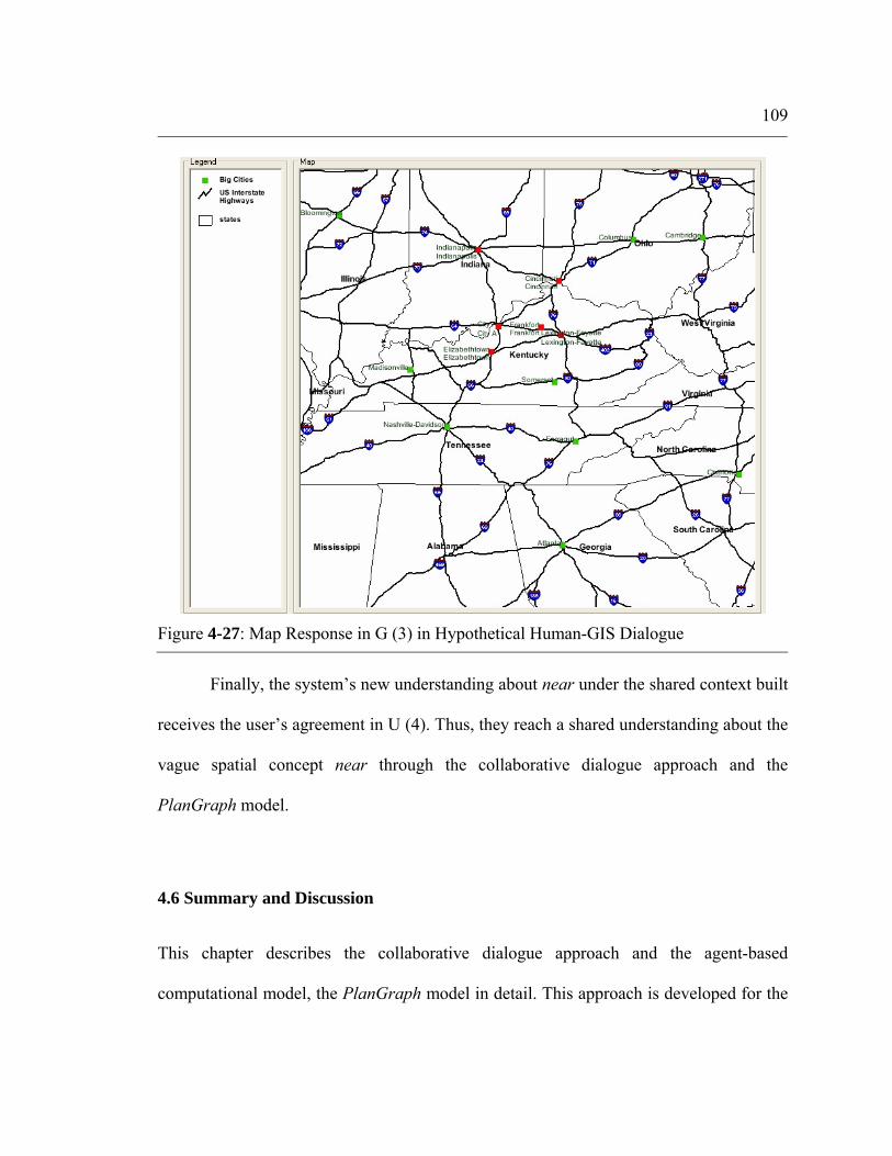
109
Finally, the system’s new understanding about near under the shared context built
receives the user’s agreement in U (4). Thus, they reach a shared understanding about the
vague spatial concept near through the collaborative dialogue approach and the
PlanGraph model.
4.6 Summary and Discussion
This chapter describes the collaborative dialogue approach and the agent-based
computational model, the PlanGraph model in detail. This approach is developed for the
Figure 4-27: Map Response in G (3) in Hypothetical Human-GIS Dialogue

110
GIS to handle the context-dependency problem with collaborative human-GIS dialogues.
This model is developed to support this approach.
The HCF enables us to understand the vagueness problem in human-GIS
communication more comprehensively. It helps us to understand three major sources of
vagueness in human-GIS communication. It also helps for understanding of three major
dimensions of the shared context in human-GIS communication, that is, the three major
types of contextual factors that influence the meaning of a vague spatial concept.
Contextual knowledge related to the three types of contextual factors is usually
distributed between the user and the system at the beginning of human-GIS
communication. The distributed nature of the context knowledge in human-GIS
communication leads to the need for building a shared context in human-GIS
communication, which can further help the two agents to for reach closer understandings
about the vague spatial concept. The need for a shared context leads to the need for
collaborative human-GIS dialogues.
The need for collaborative human-GIS dialogues leads to our development of the
collaborative dialogue approach. The major design principle of this approach is the
human emulation principle, i. e. enabling collaborative human-GIS dialogues by
emulating collaborative human-human dialogues. There are two keys for the GIS agent to
handle the context-dependency problem with the collaborative dialogue approach. One is
to enable the GIS to keep track of the shared context between the two agents; the other is
to provide the GIS with reasoning capabilities involved in handling the context-
dependency problem through collaborative human-GIS dialogues under the constraints of
the shared context. The PlanGraph model is designed for implementation of the

111
collaborative dialogue approach. This model includes two major components, the
PlanGraph and associated reasoning algorithms, which support the two keys of the
collaborative dialogue approach. The PlanGraph models the GIS agent’s dynamic
knowledge kept on the dynamic shared context. By modeling various contextual factors
as its different components, PlanGraph can enable the GIS to keep track of the current
state of the shared context, including the task context, the spatial context and the human
context involved in the shared context. The associated reasoning algorithms are designed
by following HCPs from the HCF and provide the GIS agent with reasoning capabilities
needed.
The hypothetical human-GIS dialogue explained at the end of this chapter shows
how the PlanGraph model can help the GIS agent to handle the context-dependency
problem with the collaborative dialogue approach. With the context knowledge
represented in the PlanGraph and reasoning algorithms designed for repairing the
context, the GIS agent can reach a shared understanding about the current context with
the user through various collaborative human-GIS dialogues. The shared context built
between the system and the user helps the two agents to reach a shared or closer
understanding about the meaning of a vague spatial concept. If vagueness still exists, they
can further reduce it through other collaborative dialogues, e. g. negotiation of the
meaning of that concept or direction communication of the meaning of that concept.
The human emulation design principle for the collaborative dialogue approach
corresponds to the Human Emulation (HE) approach for design of human-computer
collaboration defined in Terveen (1995). This approach views the human user as “rational
agents who form and execute plans for achieving their goals and infer other people’s

112
plans” and has comparable abilities with the human. The Human Complementary (HC)
approach is another approach for design of human-computer collaboration (Terveen,
1995). This approach assumes that the computer and the human user have different
abilities and that the computer collaborates with the user by taking on unique
responsibilities to complement the user(s) and being a “more intelligent partner”. The
system designed with the HE approach has comparable abilities with the human and can
have more natural communication with the user than that with the HC approach.
However, the system with the HE approach needs more domain knowledge and more
complicated reasoning than that of the HC approach in order to have comparable abilities
with the human.
The plan-based computational representation of the system’s knowledge in the
PlanGraph model related to inferring meanings of vague spatial concepts constrains
types of vague spatial concepts that can be communicated between the user and the
system with this model. In the current design of the PlanGraph model, such system
knowledge is encoded as actions and their recipes (Figure 4-9). Contextual factors
considered by the system are modeled as action nodes or parameter nodes in these
recipes. The meaning of a vague spatial concept under constraints of these contextual
factors is assigned as a parameter value needed in a GIS command related action.
Therefore, the PlanGraph model works for only vague spatial concepts whose contextual
influences can be modeled as action/parameter nodes needed in this model and whose
meanings can be converted into a parameter value needed in GIS commands. For
example, contextual factors that influence the meaning of the vague spatial concept, near
(Figure 4-9 (b)), can all be modeled as action/parameter nodes, and, the meaning of near
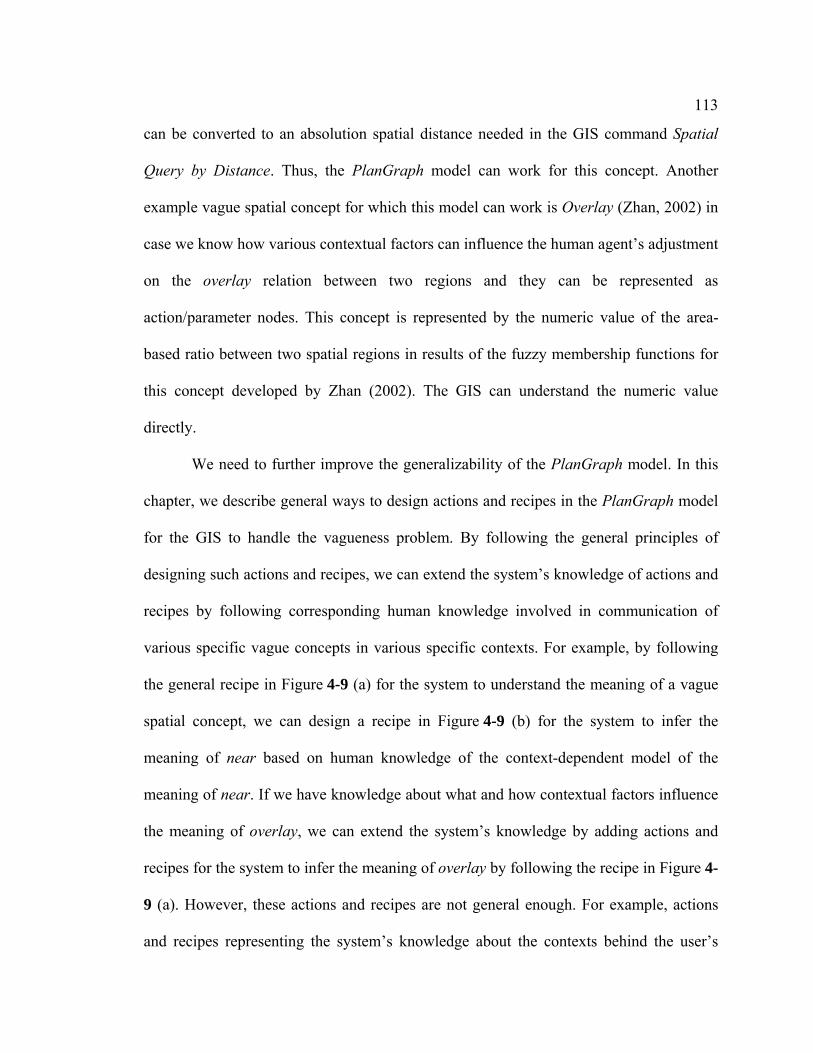
113
can be converted to an absolution spatial distance needed in the GIS command Spatial
Query by Distance. Thus, the PlanGraph model can work for this concept. Another
example vague spatial concept for which this model can work is Overlay (Zhan, 2002) in
case we know how various contextual factors can influence the human agent’s adjustment
on the overlay relation between two regions and they can be represented as
action/parameter nodes. This concept is represented by the numeric value of the area-
based ratio between two spatial regions in results of the fuzzy membership functions for
this concept developed by Zhan (2002). The GIS can understand the numeric value
directly.
We need to further improve the generalizability of the PlanGraph model. In this
chapter, we describe general ways to design actions and recipes in the PlanGraph model
for the GIS to handle the vagueness problem. By following the general principles of
designing such actions and recipes, we can extend the system’s knowledge of actions and
recipes by following corresponding human knowledge involved in communication of
various specific vague concepts in various specific contexts. For example, by following
the general recipe in Figure 4-9 (a) for the system to understand the meaning of a vague
spatial concept, we can design a recipe in Figure 4-9 (b) for the system to infer the
meaning of near based on human knowledge of the context-dependent model of the
meaning of near. If we have knowledge about what and how contextual factors influence
the meaning of overlay, we can extend the system’s knowledge by adding actions and
recipes for the system to infer the meaning of overlay by following the recipe in Figure 4-
9 (a). However, these actions and recipes are not general enough. For example, actions
and recipes representing the system’s knowledge about the contexts behind the user’s

114
spatial information requests are designed differently in different specific contexts, e. g.
food shopping, planning for vacation, and looking for jobs (see example actions and
recipes in Figure A-2, Figure A-3, and Figure A-4). Each context involves different
actions and different parameters. These actions and recipes do not have a general
representation that can be applicable in all different contexts. Another example is that
parameters representing contextual factors in the general recipe in Figure 4-9 (a) for the
system to understand the meaning of a vague spatial concept are also different for
different specific vague spatial concepts. These actions and recipes may be further
improved so that they do not need to be changed for communication of different concepts
in different contexts. For example, the recipe in Figure 4-9 (a) involves fixed parameters
representing the same lists of contextual factors which influence meanings of various
vague spatial concepts. Further generalization of the PlanGraph model can improve the
flexibility of this model by easing the application and implementation of this model for
various information systems to communicate various vague spatial concepts in a variety
of contexts.

Chapter 5
Prototype Software Agent, GeoDialogue
A prototype software agent, GeoDialogue, is implemented in this study as a dialogue
manager for a spoken natural language enabled GIS. It is used to illustrate how the
collaborative dialogue approach and the PlanGraph model can be implemented for the
GIS to manage collaborative human-GIS communication. This chapter describes
functions and implementation of this agent in detail.
5.1 Overview
The prototype software agent, GeoDialogue, is implemented with a modular architecture
as shown in Figure 5-1 (Cai et al., 2003; Cai et al., 2005). It includes five major modules,
including Semantic Analysis, Interpretation, Dialogue Control, Elaboration, and
Response Control. In addition, another two modules, Knowledge Base, and GIS
Component, are also included. Knowledge Base provides the dialogue agent with general
knowledge used in the five major modules. GIS Component provides GIS functions and
results of GIS commands to the Elaboration module when the dialogue agent needs to
execute certain GIS commands during the elaboration process.

116
The dialogue agent can take the input in the form of recognized and parsed
sentences and/or gestures, and send out the output as mix of sentences, maps, and/or
simulated gestures. The input form allows GeoDialogue to work with any natural
multimodal input devices that combine natural language (spoken or typed) with gestures
(pen-based or free-hand). Communications between GeoDialogue and input/out devices
are through a simple message protocol, DAVE_GXML, which is implemented with
common internet message protocols, e. g. XML. An example user input in the format of
DAVE_GXML is shown in Figure 5-2. In this figure, the root element <DAVE_GXML>
defines major input components, the utterance and the gesture, which are defined by the
child element <UTTERANCE> and <GESTURE>, respectively. The user utterance
information is further encoded in child elements, <WORD>, of <UTTERANCE>. Each
Figure 5-1: Architecture of GeoDialogue
Dialogue Control
…PlanGraph Reasoning Engine
Knowledge Base
Interpretation
Elaboration GIS Component
Response Control
Process flow Dynamic knowledge flow
Static Knowledge flow Connection with the GIS component
Recognized & passed
Input (sentences,
gesture)
Output (sentences, gestures, maps)
Semantic Analysis

117
point in the user gesture is encoded in child elements, <POINTS> and <POINT>, of
<GESTURE>.
The remainder of this section is organized as follows. Section 5.2 describes major
functions and partial implementation aspects of each module in this agent.
Implementation details of the PlanGraph model are provided in Section 5.3, which is
followed by a summary of this chapter.
5.2 Modules in GeoDialogue
Knowledge Base
Figure 5-2: Example User Input to GeoDialogue
<?xml version="1.0"?> <DAVE_GXML version="0.0.2"> <UTTERANCE Speaker="Bob" StartTime="4/15/2006 14:30:15"> <PHRASE> <WORD start_time="82243.12" end_time="82244.2" >zoom</WORD> <WORD start_time="82245.22" end_time="82246.4" >to</WORD> </PHRASE> <PHRASE> <WORD start_time="82247.12" end_time="82295.1" >this </WORD> <WORD start_time="82293.12" end_time="82294.2" >area</WORD> </PHRASE> </UTTERANCE> <GESTURE StartTime="4/15/2006 14:30:15"> <POINTS> <POINT start_time="82246.4" end_time="82244.2" >
<X>123</X> <Y>245</Y>
</POINT> …… <POINT start_time="82345.4" end_time="82346.2" >
<X>125</X> <Y>248</Y>
</POINT> </POINTS> </GESTURE> </DAVE GXML>

118
The Knowledge Base module provides general knowledge that the dialogue agent
needs to perform the tasks of the other individual modules. This module consists of
knowledge about the natural language (and gestures), actions and their recipes, meta data
of the GIS spatial datasets, and relations among them. In the current implementation of
GeoDialogue, the relations among the natural language, actions and GIS datasets are
implemented as a relational database, e. g. a SQL database or an ACCESS database. The
actual GIS datasets are stored and managed by the GIS component.
Different types of knowledge in the Knowledge Base play different roles in the
dialogue agent’s reasoning and performance in different modules (Figure 5-1):
• The knowledge about the natural language (the recognized and parsed user
input) and its semantic meanings is used to support GeoDialogue’s
performance in the module of Semantic Analysis. It helps the dialogue
agent to understand possible semantic meanings of each phrase/gesture in
the user input and the overall user input. For example, “I would like to
see” in the user request “I would like to see cities near City A” means the
user’s intention to see a map.
• The knowledge about the relation between semantic meanings of the
natural language (phrases and/gestures) and certain actions representing
the user’s intentions/goals supports the dialogue agent’s performance in
the module of Interpretation. For example, based on knowledge about the
relation between the semantic meaning of the user request “I would like to
see cities near City A” and the action See Map, the dialogue agent can

119
interpret the user input by initiating the PlanGraph with the action See
Map.
• The knowledge about the relation between semantic meanings of the
natural language (phrases and/gestures) and actions (and their recipes)
representing concepts other than the user’s intentions is designed to
support the agent’s performance in the module of Elaboration. For
example, “cities near City A” in the user request “I would like to see cities
near City A” means the map content required by the user in the user’s
intention See Map. The knowledge about the relation between the map
content and the action Instantiate Lyr and its recipe Select by Distance is
used by the GIS agent to elaborate the parameter Layer involved in the
plan for the user’s intention, See Map.
• The knowledge about semantic meanings of natural language (phrases and
gestures) and the GIS spatial datasets is used to support the dialogue
agent’s elaboration process, in particular, in the execution of certain basic
actions for determining appropriate geospatial data needed in GIS
commands. For example, the semantic meaning of “cities” in the user’s
request “show me cities” relates to the map layer of cities, as one of the
spatial datasets in the GIS spatial database. This knowledge is used by the
dialogue agent to instantiate the parameter Layer involved in the GIS
command, Show Map.
• The knowledge about actions and their recipes supports the dialogue
agent’s elaboration process and response control process. For example, to

120
instantiate the parameter Dist with the action Instantiate Dist, the dialogue
agent can select the recipe Infer Near under constraints of the user input
“show me cities near City A”. Here is another example. In case the recipe
Ask of Share Context is used by the dialogue agent to ask the user for
certain context information, with the knowledge from Knowledge Base,
the dialogue agent knows that the first sub-action Ask in this recipe is a
communicate action to be executed by itself. So it can send out the
response generated by executing Ask by applying ORs.
GIS Component
The GIS Component module provides results to the GIS commands executed in
certain actions during the elaboration process in the Elaboration module. In the
implementation of GeoDialogue, the ArcIMS is used as a GIS server. It manages spatial
datasets and provides basic GIS functions. It accepts GIS command requests, e. g. Select
by Distance, from the Elaboration module and returns responses, e. g. query results
and/or map responses, to the Elaboration module. The communication between the
ArcIMS server and the Elaboration module is through the ArcXML language (ESRI,
2002).
Semantic Analysis
The Semantic Analysis module starts to understand the meaning of the user input
after receiving it (usually, as recognized and parsed sentences with gestures if any). This

121
module first assigns a meaning(s) to each phrase in the user input after retrieving the
knowledge about natural language from Knowledge Base.
The meaning(s) of each phrase can be a concept referring to an action (e. g. the
spatial intention about seeing a map), or a concept referring to spatial information (e. g.
distribution of cities), or other entities corresponding to a parameter value (e. g. the
spatial distance unit, miles), or the user’s beliefs about certain facts (e. g. positive
comments on the system’s map response). In this study, under the assumption that the
user input usually is a simple sentence containing one major user intention, the semantic
analysis result of this module usually includes a concept referring to an action
representing the user’s intention underlying the user input and/or other concepts referring
to parameter values.
Interpretation
After the semantic analysis with the user input, the Interpretation module starts to
interpret the user’s intention underlying the user input depending on the relation between
the user intention and the existing SharedPlan between the GIS and the user (represented
as the PlanGraph in the Dialogue Control module). For example, in case the existing
PlanGraph is empty, the user intention See Map underlying the request “show me cities
near City A” is used to initiate the PlanGraph.
The interpretation process leads to updating of PlanGraph, in particular, the part
of PlanGraph corresponding to the user’s intention underlying the user input and other
concepts from the semantic analysis result. Such updates can be either the GIS agent’s
mental states on action/parameter nodes corresponding to these concepts, or parameter

122
values corresponding to these concepts, or change of the attention focus in PlanGraph.
For example, after interpreting the user’s positive feedback “Yes, thanks” to the system’s
map response to the user request “show me cities near City A”, the GIS updates all its
mental states on action/parameter nodes involving vagueness from near in the PlanGraph
as success. After interpreting the user’s reply “I am going to walk” to the system’s
question “what’s your transportation mode?”, the system updates the parameter value of
Vehicle as “walking”, and shifts attention to the next node in the PlanGraph that it can
participate in.
The dialogue agent’s reasoning process in the Interpretation module is controlled
by the Reasoning Engine in the Dialogue Control module.
Elaboration
Upon receiving the interpretation result of the user’s input, the Elaboration
module starts to evolve the existing collaborative human-GIS plan toward the success of
the user’s spatial information request. The collaborative plan is recorded by PlanGraph
in the Dialogue Control module. In this study, the dialogue agent usually tries to achieve
success of the plan for the user’s spatial information request, not for the whole plan in the
PlanGraph (including the plan representing the context behind the user’s request, later, as
the context plan). This is designed under the assumption that the GIS agent believes that
the user is responsible for sub plans in the context plan. For example, the existing
PlanGraph includes the user’s context plan about Plan for Vacation and the user’s spatial
intention See Map underlying the user request “show me cities near City A”. The system
123
usually focuses on advancing See Map towards its success and does not try to help the
user’s sub plans, e. g. Travel and Visit Targets, involved in Plan for Vacation.
The output of the Elaboration module usually involves results from execution of
certain sub plans during the elaboration process or communicative responses generated
by the dialogue agent to communicate mutual beliefs. For example, by executing the sub
plan, Generate Map, for displaying an existing GIS dataset (as a map layer), the dialogue
agent generates not only a map response from the GIS component, but also a natural
language response: “Here it is”; by executing a collaborative dialogue plan, Ask of Share
Context, for requesting certain context information X, the dialogue agent may generate a
natural language response: “What is X?”.
The dialogue agent’s reasoning in the Elaboration module is also controlled by
the Reasoning Engine in the Dialogue Control module.
Response Control
The Response Control module is to control when to stop the elaboration process
and output all responses from the Elaboration module. As described at the beginning of
this chapter, the output of this module is in the format of DAVE_GXML. Similarly, the
dialogue agent’s reasoning in the response control process is also controlled through the
Reasoning Engine in the Dialogue Control module.
Dialogue Control
The Dialogue Control module is the central intelligence module in the dialogue
agent. It includes two sub components, PlanGraph and Reasoning Engine. This module

124
plays three major roles through these two components. The first role is to maintain the
dynamic knowledge on the shared context involved in human-GIS communication
through the PlanGraph. The PlanGraph helps the dialogue agent to keep track of the
current state of human-GIS collaboration underlying the human-GIS communication. The
task context, spatial context and human context are kept in the dynamic knowledge of the
human-GIS collaboration process. The dynamic knowledge of the shared context
provides help for the dialogue agent to make appropriate reasoning during the human-
GIS collaboration process through the Reasoning Engine component.
The second role is to perform automated reasoning for the three modules,
Interpretation, Elaboration and Response Control, through the Reasoning Engine
component. This component incorporates the reasoning algorithms, IAs, EAAs & EAPs,
and ORs, described in Chapter 4. These reasoning algorithms are used to control the
dialogue agent’s reasoning in Interpretation, Elaboration, and Response Control,
respectively.
The third role is to control the dialogue process flow in the dialogue agent through
the Reasoning Engine in the order shown in Figure 5-1. Firstly, the user input from the
input device directly goes into Semantic Analysis. Then, the result of the semantic
analysis comes to the Interpretation module, followed by the recursive elaboration
process. Finally, the responses generated from Elaboration are sent out by the Response
Control module to the output device. The dialogue agent waits for the next user input
after outputting responses. In the current version of GeoDialogue, the five major modules
are implemented as separate functions. The Reasoning Engine is implemented as the
major function that organizes the information flow among all the other four functions. As
125
in the dialogue process described above, the five functions are organized in Reasoning
Engine in this order: Semantic Analysis, Interpretation, Elaboration, and Response
Control.
For implementation details of PlanGraph, and reasoning algorithms, see the next
section in this chapter.
5.3 Implementation of the PlanGraph model
This section describes implementation details of the PlanGraph model, including
PlanGraph and the associated reasoning algorithms.
5.3.1 Implementation of the PlanGraph
Knowledge of Actions and Recipes
The basic actions are implemented as public functions in GeoDialogue. Complex
actions are elaborated and executed after decomposing their recipes and executing basic
actions involved in these complex actions. The functions of basic actions can be called
when needed during the plan execution process.
The knowledge about recipes of complex actions is stored in Knowledge Base.
The recipes are implemented with DAVE_GXML. An example recipe in DAVE_GXML
is shown in Figure 5-3. This recipe is the one shown in Figure 4-8 (b) for the GIS agent’s
action Show Map. In Figure 5-3, attributes of the element <RECIPE> define the recipe’s
name as “ShowMap”, its action name as “ShowMap”, and the description of this recipe.
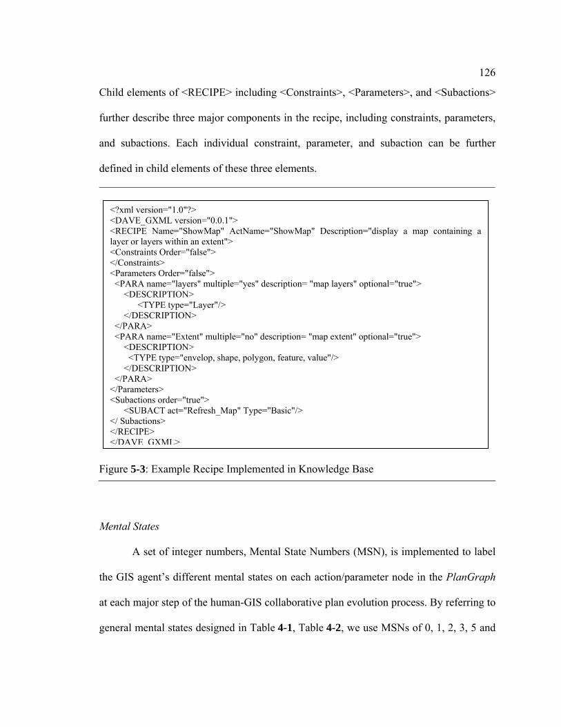
126
Child elements of <RECIPE> including <Constraints>, <Parameters>, and <Subactions>
further describe three major components in the recipe, including constraints, parameters,
and subactions. Each individual constraint, parameter, and subaction can be further
defined in child elements of these three elements.
Mental States
A set of integer numbers, Mental State Numbers (MSN), is implemented to label
the GIS agent’s different mental states on each action/parameter node in the PlanGraph
at each major step of the human-GIS collaborative plan evolution process. By referring to
general mental states designed in Table 4-1, Table 4-2, we use MSNs of 0, 1, 2, 3, 5 and
Figure 5-3: Example Recipe Implemented in Knowledge Base
<?xml version="1.0"?> <DAVE_GXML version="0.0.1"> <RECIPE Name="ShowMap" ActName="ShowMap" Description="display a map containing a layer or layers within an extent"> <Constraints Order="false"> </Constraints> <Parameters Order="false"> <PARA name="layers" multiple="yes" description= "map layers" optional="true"> <DESCRIPTION> <TYPE type="Layer"/> </DESCRIPTION> </PARA> <PARA name="Extent" multiple="no" description= "map extent" optional="true"> <DESCRIPTION> <TYPE type="envelop, shape, polygon, feature, value"/> </DESCRIPTION> </PARA> </Parameters> <Subactions order="true"> <SUBACT act="Refresh_Map" Type="Basic"/> </ Subactions> </RECIPE> </DAVE GXML>

127
6 to represent the GIS agent’s mental states involved in communication not involving
vagueness (Table 5-1 and Table 5-2).
With extensions of mental states involved in handling the vagueness problem, we
can further extend the set of MSNs. For example, by referring to the mental states
extended in Table 4-3 and Table 4-4, we can further extend MSNs in Table 5-3 and
Table 5-4.
Table 5-1: Mental State Number (MSN) on Focus Action α MSN Step No of Mental States in Table 4-1
0 1 1 2 2 3.1 3 3.2.1 5 4 (in case that execution of α fails) 6 4 (in case that execution of α succeeds)
Table 5-2: Mental State Number (MSN) on Focus Parameter P MSN Step No of Mental States in Table 4-2
0 1 1 2 2 3 (in case that p is optional) 3 3 (in case that p is required) 5 4 (in case that instantiation of P fails)
6_1 4 (in case that instantiation of P succeeds for sure) 6 6_2 4 (in case that instantiation of P succeeds with estimation)
Table 5-3: Mental State Number (MSN) on Action α MSN Step No of Mental States in Table 4-3
4_2a 4.3 (in case that the GIS agent believes that it needs to revisit α) 4_2b 4.3 (when the GIS agent right completes α) 4_3a 4.4 (in case that the GIS agent believes that it needs to revisit α) 4_3b 4.4 (when the GIS agent right completes α) 4_4a 4.5 (in case that the GIS agent believes that it needs to revisit α)
4
4_4b 4.5 (when the GIS agent right completes α) 5 4.1 (in case that execution of α fails) 6 4.2 (in case that execution of α succeeds)

128
For all MSNs and their meanings implemented in GeoDialogue, refer to
Appendix B.
PlanGraph
PlanGraph is implemented as a recursive dynamic data structure in GeoDialogue
(Figure 5-4). The recursive structure supports the dialogue agent’s recursive reasoning
involved in construction of the SharedPlan built by the GIS and the user. This data
structure defines the root plan and current attention focus. The current focus in the
PlanGraph can be an action node or a parameter node) in PlanGraph.
Table 5-4: Mental State Number (MSN) on Parameter P MSN Step No of Mental States in Table 4-4
4_2a 4.3 (in case that the GIS agent believes that it needs to revisit P) 4_2b 4.3 (when the GIS agent right completes P) 4_3a 4.4 (in case that the GIS agent believes that it needs to revisit P) 4_3b 4.4 (when the GIS agent right completes P) 4_4a 4.5 (in case that the GIS agent believes that it needs to revisit P)
4
4_4b 4.5 (when the GIS agent right completes P) 5 4.1 (in case that execution of α fails) 6 4.2 (in case that execution of α succeeds)
Figure 5-4: Class of PlanGraph in Visual Basic Language
Public root As clsPlan ' Root plan of PlanGraph Public Focus As Object ' Attention focus in PlanGraph, which can be a plan class
' (clsPlan) or a parameter class (clsPara) Private Sub Class_Initialize() Initialize End Sub Public Sub Initialize() Set root = Nothing Set Focus = Nothing End Sub
Note: The meaning of each variable is explained in the comment after definition of the variable.

129
The recursive tree structure of PlanGraph is achieved through the recursive tree
structure of the plan for an action and that of the parameter node. The recursive data
structure of the plan for an action (Figure 5-5) defines all properties of the plan, including
the parent object (which can be a plan or a parameter), subplans of the plan, the GIS
agent’s mental state on this plan, and other properties. Similarly, the data structure of the
parameter node (Figure 5-6) also defines the properties of the parameter, including its
parent object (which can be a plan only in the current implementation), its subplans
(which represents all plans used to instantiate this parameter), its parameter values that
have been instantiated so far, the GIS agent’s mental state on this parameter and other
properties.
Figure 5-5: Class of a Plan in Visual Basic Language
Public Action As String ' Action name Public ActionType As String ' Complexity of the action: Complex or basic Public parent As Object ' Parent object can be either clsPara or clsPlan Public MSN As enumPlanMentalState ' GIS’s Mental State Number on the plan Public Recipes As Collection ' All recipes for the same action Public CurrentRecipe as XML ' The current recipe used Public Parameters As Collection ' All parameters (type is clsPara) Public Agents As Collection ' All participating agents Public Subplans As Collection ' plan collection Private Sub Class_Initialize() Set Subplans = New Collection Set Parameters = New Collection MSN = enumMentalStateNumber.0 End Sub Private Sub Class_Terminate() Set Subplans = Nothing Set Parameters = Nothing End Sub
Note: The meaning of each variable is explained in the comment after definition of the variable.

130
5.3.2 Implementation of Reasoning Algorithms
All the reasoning algorithms associated with the PlanGraph are implemented as separate
functions in GeoDialogue. For convenience of describing different reasoning algorithms,
we label these algorithms with letters and numbers. For all reasoning algorithms with
such labels implemented in GeoDialogue, see Appendix C. Concerning to reasoning
algorithms which are designed for the GIS agent to process human-GIS communication
without vagueness, we have implemented them by referring to MSNs in Table 5-1 and
Table 5-2. In case the GIS agent does not need to handle the vagueness problem, the
dialogue agent can use reasoning algorithms in this category, e. g. IAs including IA1,
Figure 5-6: Class of a Parameter in Visual Basic Language
Public name As String ' Parameter name Public parent As clsPlan ' Parent, a plan object, of this parameter Public Multiple As Boolean ' if this parameter can have multiple values or not Public paraType As String ' parameter type: Layer, shape, point, line, polygon,
' extent, integer, real Public ParaDescription As String 'Description of this parameter Public Optionalness As Boolean 'If this parameter is optional or not Public MSN As enumParaMentalState ' GIS’s Mental State Number on this parameter Public paraList As Collection 'All values instantiated so far for this parameter Public Subplans As Collection 'Collection of plans to instantiate this parameter Private Sub Class_Initialize() Set Subplans = New Collection MSN = enumParaMentalState.0 Set paraList = New Collection End Sub Private Sub Class_Terminate() Set paraList = Nothing Set Subplans = Nothing End Sub
Note: The meaning of each variable is explained in the comment after definition of the variable.

131
IA3, and IA4, ORs including OR1 and OR2, EAAs including EAA0, EAA1, EAA2,
EAA3(a, b1), EAA5, EAA6, EAAU and EAAC, and EAPs including EAP0, EAP1,
EAP2/3 (c,d), EAP4_1, EAP5, and EAP6. Regarding EAAs and EAPs which are
specifically designed for the GIS agent to handle the vagueness problem in human-GIS
communication, we have implemented them with referring to MSNs in Table 5-3 and
Table 5-4, including EAA4_2, EAA4_3, EAA4_4, EAP4_2, EAP4_3, and EAP4_4,
EAP1(a) and part of EAP1(b).
The Reasoning Engine component organizes these reasoning algorithm functions
into different module functions to support the dialogue agent’s automatic reasoning in the
modules of Interpretation, Elaboration and Response Control. The three module
functions responsible for these three modules can access all IA functions, all OR
functions, and all EAA and EAP functions, respectively. The two module functions for
Interpretation and Response Control are relatively simpler compared with the function
responsible for the module of Elaboration. The module function for Elaboration
(Figure 5-7) integrates functions of EAAs and EAPs in the recursive way because the
dialogue agent’s elaboration process is a recursive process. The dialogue agent’s
elaboration reasoning always starts by calling the function, the procedure Elaborate
(PlanGraph) in Figure 5-7, to elaborate the current focus of the PlanGraph. This is
implemented by following the elaboration principle that the GIS agent’s elaboration
process always starts with elaboration of the current focus on the PlanGraph. If the
current focus is a plan for an action, the process of Elaborate (PlanGraph) will call the
procedure, Elaborate_Plan (Plan for an action) in Figure 5-7, to elaborate the focus plan.
If the current focus is a parameter node, the procedure, Elaborate_Parameter

132
(Parameter) in Figure 5-7, will be called. The result of elaborating a plan or a parameter
will lead to updating of the current attention focus and mental states on the
plan/parameter node on the PlanGraph. After applying each EAA or EAP function, the
elaboration process will continue to elaborate the PlanGraph by calling the function
Elaborate (PlanGraph). Thus this function will continue to elaborate the updated
attention focus in the PlanGraph until there is a need to stop the elaboration process.

133
5.4 Summary and Discussion
Figure 5-7: Pseudo Code of the Recursive Elaboration Process
Sub Elaborate (PlanGraph) ' Start elaboration with the current attention focus in PlanGraph If Focus in PlanGraph is an action, then Elaborate_Plan (Focus); Else Elaborate_Parameter (Focus); End if End Sub Sub Elaborate_Plan (Plan for α) ' All elaboration algorithms are implemented here. Select Case MSN on α … …
Case i 'Reasoning algorithm for elaborating α is implemented in the function
'below EAAi (Plan for α)
… … End Select 'After applying the reasoning algorithm, MSN on α and attention focus in
'PlanGraph can be changed. So, the GIS continues to elaborate 'PlanGraph recursively
Elaborate (PlanGraph) End Sub Sub Elaborate_Parameter (Parameter P) 'All elaboration algorithms are implemented here. Select Case MSN on P … …
Case i 'Reasoning algorithm for elaborating P is implemented in the function
'below EAPi (Parameter P); … … End Select 'After applying the reasoning algorithm above, MSN on P and attention
' focus in PlanGraph can be changed. So, the GIS continues to elaborate 'PlanGraph recursively
Elaborate (PlanGraph) End Sub
Note: The meaning of each variable is explained in the comment after definition of the variable.

134
Details of the prototype software agent, GeoDialogue, are described in this chapter. This
agent incorporates the collaborative dialogue approach and the PlanGraph model to keep
knowledge on the dynamic human-GIS communication process and reason about how to
react to each of the user’s utterances collaboratively. GeoDialogue has a modular
architecture. Its core module, Dialogue Control, incorporates the PlanGraph model to
maintain dynamic knowledge and perform automatic reasoning during human-GIS
communication. One of the two key components of the PlanGraph model, PlanGraph, is
implemented in Dialogue Control as a recursive dynamic data structure, which supports
the dialogue agent’s recursive reasoning involved in the construction of the SharedPlan
built by the GIS and the user. The other key component of the PlanGraph model,
associated reasoning algorithms, is implemented as separate functions in the Reasoning
Engine component of Dialogue Control. Reasoning Engine further organizes these
reasoning algorithm functions into different module functions to support the dialogue
agent’s automatic reasoning in the other major modules in this agent.
The knowledge built in the PlanGraph model and GeoDialogue can be further
improved to be dynamically updated through incorporation of machine learning methods
(Jebara, 2004) in this model and the dialogue agent. In the current implementation of the
PlanGraph model in GeoDialogue, the system’s spatial knowledge about meanings of
specific vague spatial concepts in various specific contexts is pre-built in the system’s
knowledge base. The pre-built knowledge does not change like human knowledge
acquisition as human-GIS communication experiences increase. In the future, we can
incorporate machine learning approaches in design and implementation of the PlanGraph
model and the dialogue agent so that the dialogue agent can dynamically accumulate and

135
update the spatial knowledge related to context-dependent meanings of vague spatial
concepts based on its experiences of human-GIS communication of vague spatial
concepts in various contexts. The dynamic learning capability provided by machine
learning approaches would ease implementation of this model and the dialogue agent.
The system with dynamically accumulated and updated spatial knowledge would be able
to communicate with the user more intelligently like a human agent by adjusting its
inference on the meaning of a vague spatial concept based on its previous communication
experience in a context similar to the current context.
Implementation of the dialogue agent, GeoDialogue, demonstrates that the
collaborative dialogue approach and the PlanGraph model can be used for the spoken
natural language enabled GIS to manage human-GIS communication and handle the
context-dependency problem. They can help the system to react to each of the user
utterances appropriately. For example, they support the system to interpret the user’s
input under constraints of the current communication, help the user by selecting and
executing appropriate GIS commands, and return appropriate responses to the user. They
support the system to handle the context-dependency problem like a human. For example,
they support the system to keep track of the dynamic human-GIS communication, build a
shared context with the user through collaborative dialogues, and reach a shared
understanding about the vague spatial concept with use of shared context information.
Implementation of GeoDialogue also demonstrates that the collaborative dialogue
approach and the PlanGraph model can help to bridge the gap between the advanced
natural multimodal interfaces for GIS and the insufficient human-GIS interaction style.
Much progress has been made on the development of natural modalities for the

136
geographic information use, e. g. CUBISON (Neal et al., 1989), QuickSet (Cohen et al.,
1989; Oviatt, 1992, 1996) and Sketch and Talk (Egenhofer, 1996). However, the human-
GIS interaction style in these systems is still the standard interaction style in WIMP-
based GISs (question-and-answer style), which is a user-initiative interaction style. This
interaction style is not sufficient for the natural multimodal GIS, in particular, the
conversational GIS to communicate with the user naturally (Egenhofer & Kuhn, 1999).
Implementation of GeoDialogue demonstrates that the collaborative dialogue approach
and the PlanGraph model support the system to interact with the user like a human agent.
GeoDialogue-user interaction is mix-initiative like human-human communication. The
user can ask GeoDialogue for spatial information or other questions and the system can
also initiate dialogues to ask the user for contextual information or other questions if
needed. Therefore, the collaborative dialogue approach and the PlanGraph model can
help to improve the human-GIS interaction for conversational GIS.
Success of the PlanGraph model in GeoDialogue also shows the possibility that
the collaborative dialogue approach and the PlanGraph model could be extended to
support human-GIS dialogue management for other natural multimodal GIS, e. g. eye-
track enabled, and/or facial gesture enabled GIS, as well as speech/written natural
language and free-hand gesture/pen-based gesture enabled GIS. They could be extended
to help the system to understand such new natural modal user input based on its relevance
to the current communication, and then decide how to help the user to reach the user’s
goal. Therefore, they could help to advance development of natural multimodal GIS.

Chapter 6
Handling the Context Dependency Problem in Various Situations
The GIS and the user can have different understandings of the current context in various
situations during the human-GIS communication process. Therefore, the system needs to
have flexibility to handle the context-dependency problem in various situations. This
chapter provides classification and analysis of these various situations first, and then
describes several sample human-GeoDialogue dialogues. These sample dialogues
illustrate how the collaborative dialogue approach and the PlanGraph model can enable
the GIS agent to have such flexibility.
6.1 Various Situations Involving Vagueness in Human-GIS Communication
As described in Chapter 3, human communicators may have different understandings
about the current context in different situations. In addition, the human communicators
may have different models about the meaning of a vague spatial concept (see Eq. 3.1).
Similarly, human-GIS communication can also involve vagueness in various situations of
different understandings about the context and different models of the meaning of the
vague spatial concept.
Similar to human communicators, the GIS agent and the user can also have
different understandings about the context involved in communication in various
situations. Concepts referring to contexts (simply as “context concepts” later) in the

138
human user’s conceptual system are represented as frames and associated perceptual
symbols with recursive tree structures (see Chapter 3). In this study, the GIS agent
incorporating the PlanGraph model also holds knowledge about the context concepts
with recursive tree structures represented in PlanGraph (see Chapter 4). The
instantiations of the context between the GIS agent and the human user can be different
in various situations (Table 6-1). In each of the situations described in Table 6-1, the GIS
agent and the user can have different models of the meaning of the vague spatial concept,
even if they reach a shared understanding about the context. This section describes these
various situations of the context-dependency problem in human-GIS communication.
6.1.1 Situation A: Understanding Context with Different Concepts
In Situation A, the GIS agent and the human user have different understandings about
the current context involved in communication from the top level of the context concept
structure (Figure 6-1). In this situation, the GIS agent understands the current context
Table 6-1: Various Situations of the Context Dependency Problem in Human-GIS Communication
Situation Category
Description
A The GIS agent and the human user have different understandings about the context at the top level of the context concept.
B The GIS agent and the human user understand the context with the same recursive structure, but with different instantiation values of part of its components.
C The GIS agent and the human user understand the context with different depths of the recursive structure.
D The GIS agent and the human user understand the context with different widths of the recursive structure.
E The GIS agent and the human user understand the context with different widths, depths, and instantiation values of part of components of the recursive structure.

139
behind the user’s spatial information request with a concept totally different from what
the human user intends. For example, the user’s final goal in the context behind the user’s
request “show me cities near City A” is for the user to look for jobs in the cities near City
A, while the GIS agent infers the context behind the user’s request as planning for
vacation. In this example, the GIS agent’s inference about the context differs from the
user’s understanding about the context from the root of the recursive structure of the
context concept.
In this situation, even if the GIS agent holds complete knowledge about the
human context including the user’s model about the meaning of the vague spatial concept
in various contexts, meanings of the vague spatial concept instantiated in the GIS agent
and the user are usually different.
Figure 6-1: Context-Dependency Problem in Situation A
(a) The user’s understanding about the context
P1 …… (U)
…… ……
Act1 (U)
Final Goal 1 (U)
Recipe 1
…… (U) P2 … Act11
(U)
Final Goal 2 (U)
Recipe 1
P11 P22 …
…… …… …… …… …… ……
Different from the top level of the context concept
(b) The GIS agent’s understanding about the context

140
6.1.2 Situation B: Understanding Context with Different Sub-Component Values
In Situation B, the GIS agent and the human user understand the context as the same
context concept with the same recursive structure, but with different instantiations of part
of the components in the structure (Figure 6-2). Thus, in this situation, in the two agents’s
understandings of the current context, the recursive structures of the context concept are
instantiated with same width and same depth, and the top level component of the
recursive structures are instantiated with the same value. However, certain sub
components of the context structure are instantiated with different values. In this
situation, the context factors about which the GIS agent and the user have different
understandings can be any task, spatial or human contextual factors, or any combination
of them. If these context factors play influential roles on the meaning of the vague spatial
concept, meanings of the vague spatial concept instantiated by the GIS agent and the user
usually will be different.
Here is an example of the concept dependency problem in this situation. As to the
context behind the human user’s request “show me grocery stores near Apartment A”,
Figure 6-2: Context-Dependency Problem in Situation B
Acti (U)
The GIS and the user mentally simulate the context with the same structure of the context concept, but their instantiations of the context concept differ at certain component values, e. g. Pi and Acti.
Final Goal 1 (U)
…… (U)
.…… Pi
…...…
…
…
Different instantiation
…

141
both the user and the GIS agent understand the context as planning for food shopping in
grocery stores in the urban area around Apartment A. This context involves a traveling
activity and a shopping activity. The GIS agent infers the transportation mode involved in
the traveling activity as driving a car, while the user actually plans to walk. The GIS
agent knows that the spatial area around Apartment A is a metropolitan area from its
spatial database, while the user considers it as a small city because he/she is not familiar
with it. So, in this example, the context meant by the user is the same as that inferred by
the GIS agent at the top level of the context structure, but different regarding the
instantiation of the transportation mode and the spatial area in the context. In this
example, both the GIS agent and the user consider the transportation mode and the spatial
size of the area as important context factors that influence the meaning of near. Thus,
before they reach a shared understanding about the context, their understandings about
near will be different.
6.1.3 Situation C: Understanding Context with Different Depths
In Situation C, the GIS agent and the human user understand the context with the same
context concept, but with different depths of the recursive structure (Figure 6-3). In the
example in Figure 6-3, the two agents’ understandings about the context are the same at
the top level of the recursive structure, but different at depths of the component Pi and
Acti. These components can correspond to various context factors. In this situation,
usually, the GIS and the user consider the influence of different context factors and have
different models of the meaning of the same vague spatial concept.
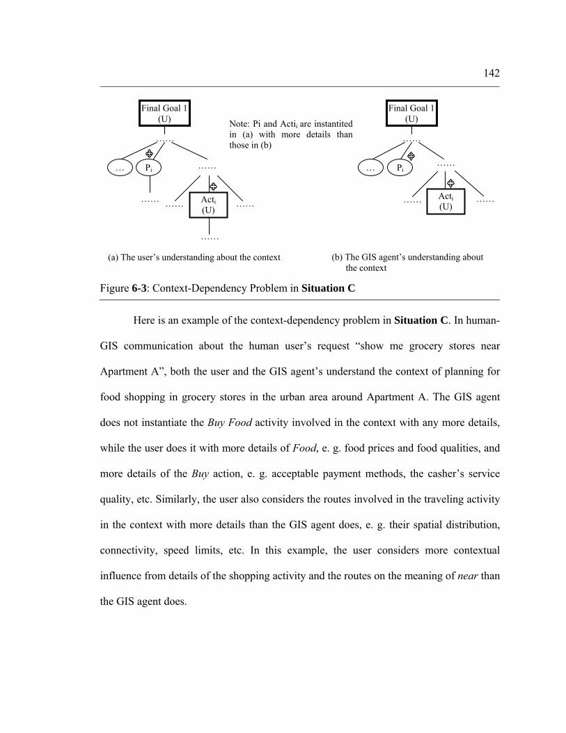
142
Here is an example of the context-dependency problem in Situation C. In human-
GIS communication about the human user’s request “show me grocery stores near
Apartment A”, both the user and the GIS agent’s understand the context of planning for
food shopping in grocery stores in the urban area around Apartment A. The GIS agent
does not instantiate the Buy Food activity involved in the context with any more details,
while the user does it with more details of Food, e. g. food prices and food qualities, and
more details of the Buy action, e. g. acceptable payment methods, the casher’s service
quality, etc. Similarly, the user also considers the routes involved in the traveling activity
in the context with more details than the GIS agent does, e. g. their spatial distribution,
connectivity, speed limits, etc. In this example, the user considers more contextual
influence from details of the shopping activity and the routes on the meaning of near than
the GIS agent does.
Figure 6-3: Context-Dependency Problem in Situation C
(a) The user’s understanding about the context (b) The GIS agent’s understanding about the context
…
Acti (U)
Final Goal 1 (U)
…… Pi
……
…… …… ……
……
Note: Pi and Actii are instantited in (a) with more details than those in (b)
Acti (U)
Final Goal 1 (U)
……
……
…
…… ……
Pi

143
6.1.4 Situation D: Understanding Context with Different Widths
In Situation D, the GIS agent and the human user understand the context with the same
context concept, but with different widths of the recursive structure (Figure 6-4). So, in
this situation, the two agents’ understandings about the current context are the same at the
top level of the context concept, but different regarding widths of part of components (e.
g. Pi and Acti shown in Figure 6-4) of the context structure. Similar to Situation C, in
this situation, these components can correspond to various context factors. The GIS and
the user usually consider influences of different contextual factors and have different
models of the meaning of the same vague spatial concept.
Here is an example of the context-dependency problem in Situation D. In
communication about the human user’s request “show me grocery stores near Apartment
A”, both the user and the GIS agent understand the context as planning for food shopping
Figure 6-4: Context-Dependency Problem in Situation D
(a) The user’s understanding about the context (b) The GIS agent’s understanding about the context
…
Note: N ≠ M n ≠ m
M child nodes
Acti (U)
Final Goal 1 (U)
…… Pi
……
…… …… ……
……
Recipe 1
N child nodes
n child nodes Acti
(U)
Final Goal 1 (U)
…… Pi
……
…
…… ……
……
Recipe 1
…… m child nodes

144
in grocery stores in the urban area around Apartment A. The user instantiates the food
shopping context as an event involving not only the shopping activity and the traveling
activity, which are agreed on by the GIS agent, but also the frequency of the traveling and
shopping activities. The user understands the Buy Food activity involved in the context
with more details than the GIS agent, including not only the food and the shopping
action, but also other services associated with this activity, e. g. parking spaces, return
services, etc. The user instantiates the routes involved the traveling activity involved in
the context with its traffic status, as well as its spatial distribution. In this example, the
user considers contextual influence from the shopping frequency, the traffic status of the
route, and associated services in the Buy Food activity for the meaning of near, in
addition to the contextual influence considered by the GIS agent.
6.1.5 Situation E: Mix of Context-Dependency Problems
In Situation E, the GIS agent and the human user understand the context as the same
context concept, but with different details of the recursive structure (Figure 6-4). Thus, in
this situation, the two agents’ understandings about the current context are same at the
top level of the context concept. However, they understand part of components (e. g. Pi
and Acti shown in Figure 6-4) of the context structure with different instantiation values
and/or different widths and/or different depths. These components can correspond to
various context factors. The context-dependency problem in this situation may involve a
mix of the context-dependency problems in Situation B, C, and D.

145
6.1.6 Summary and Discussion
This sub-section describes five categories of various situations involving the context-
dependency problem in human-GIS communication. The GIS agent and the user can
understand the current context behind the user’s spatial information request in different
ways in different categories of situations. In each category of such situations, the two
agents’ different understandings about various contextual factors lead to various
situations of the context-dependency problems.
The remainder of this chapter describes several sample human-GIS dialogues
involving the context-dependency problem in various situations. The GIS agent is
GeoDialogue. The user agent may vary in different dialogues. For convenience of
description, we suppose the user agent to be a male. In the GIScience community, the
concept near referring to the spatial distance relation, as a typical example of a vague
spatial concept, has been investigated for many years, in particular, for its context-
dependency problem. In these dialogues, we also use this concept to illustrate how the
GIS agent can handle the context-dependency problem with the collaborative dialogue
approach and the PlanGraph model.
In the remainder of this chapter, we provide a sample human-GIS dialogue in one
situation in each of the first four categories of situations described in this section and
explain how the collaborative dialogue approach and the PlanGraph model can help the
GIS agent to handle the vagueness problem in that situation. The context-dependency
problem in Situation E may involve various combinations of context-dependency
problems in Situation B, C and D. The GIS can handle the context-dependency problem

146
in Situation E by integrating reasoning and collaborative dialogues used in these three
situations. Thus, we do not present an example of how the GIS can handle the context-
dependency problem in Situation E in the remainder of this chapter.
The PlanGraph model needs to be extended to help the GIS agent to handle the
context-dependency problem in different situations in these dialogues. Firstly, the four
sample dialogues involve different events that the user will participate in, and different
spatial information requests. Thus, the GIS agent needs to have different knowledge to
understand such events and such information requests. Secondly, the context-dependency
problems in these dialogues are in different situations. The GIS agent needs to use
different collaborative dialogue strategies and associated reasoning to handle them in
different situations. As a result, we need to further extend the PlanGraph model
described in Chapter 4 with knowledge of actions and recipes and reasoning algorithms
involved in handling the context-dependency problem in each dialogue. For each
dialogue, we first explain the extension of the PlanGraph model, and then describe the
process for the GIS agent to handle the context-dependency problem in each dialogue by
using the extended PlanGraph model. For details about the actions and recipes, MSNs,
and reasoning algorithms addressed in these examples, refer to Appendix A, B and C.
6.2 Scenario 1: Handling Context-Dependency in Situation A
A sample human-GeoDialogue dialogue involving the context-dependency problem in
Situation A is shown in Figure 6-5. In this scenario, the GIS agent’s model of the

147
meaning of the vague spatial concept includes the same list of contextual factors as those
in the user’s model.
Figure 6-5: Scenario 1
G: GIS (GeoDialogue) U: User (User-A) Before the following conversation, the map on the GIS shows a basic map of the destination area, including only state boundaries and interstates (Figure 6-6). U (1): Hi, I am User-A. I want to see cities near City A. G (1): (highlight certain cities near City A) For the plan of vacation purpose by driving, here are
cities within 300 miles of City A. Is this OK? U (2): No. G (2): What is your goal in asking for this map? U (3): I am planning to look for jobs in cities near City A. I plan to work there by driving from City
A. G (3): (Highlight certain cities near City A) Here are cities within 150 miles of City A, is this OK? U (4): Yes. Thanks.

148
6.2.1 Extension of the PlanGraph Model
To enable the GIS agent to handle the vagueness problem in Scenario 1, we have
implemented a series of actions and recipes by following the general actions and recipes
involved in handling the vagueness problem.
To enable the GIS agent to understand the meaning of near (involved in the user’s
spatial information request in U (1)) with context information, we have implemented the
recipe Infer Near (Figure A-9 (b)) by following the general recipe Infer VSC (Figure 4-9
Figure 6-6: Initial Map in Scenario 1

149
(a)). The recipe Infer Near involves seven optional parameters representing seven
contextual factors in the GIS agent’s model of the meaning of near and a basic action to
calculate a spatial distance value corresponding to near with context information
modeled in these parameters. In this study, the calculation is based on the GIS agent’s
model of the meaning of near in Eq. 6.1:
Where: FgT _ , TmT _ , ScS _ , RtS _ , RfS _ , TgS _ , and AH _ respectively denote
the user’s final goal, the transportation mode, the spatial scale/size of area considered, the
route distribution, the reference location and the targets involved in the near spatial
distance relation, and the user name. In the current implementation of GeoDialogue, for
simplicity, the human agent’s name is the only human context factor considered in the
GIS model. The GIS agent holds knowledge about some users’ understandings about
near in various contexts with use of the model in Eq. 6.1.
To enable the GIS agent to infer the context of planning for vacation after
receiving U(1) and understand the context of looking for jobs in U (2) behind the user’s
spatial information request, we have implemented recipes for Plan for Vacation, Visit and
Travel in Figure A-2, and recipes for Look for Jobs and Work on Jobs in Figure A-4, by
following the general actions and recipes in Figure 4-10. In this scenario, the user’s
spatial intention See Map in U (1) will be attached with the parameter Destination in the
action Travel because the cities as the map content are the destination locations in the
user’s traveling activity.
)_,_,_,_,_,_,_( AHTgSRfSRtSScSTmTFgTfM GG = 6.1

150
To enable the GIS agent to instantiate parameters in the recipe Infer Near by
inferring/retrieving context information, we have implemented actions and recipes for
Instantiate Goal, Instantiate Tm, Instantiate Sc, Instantiate Rf, Instantiate Tg, and
Instantiate U by following the general action and recipes in Figure 4-11. Some of these
are shown in Figure A-10.
To enable the GIS agent to initiate context-sharing collaborative dialogues
between G (2) and the first half of U (3), we have designed and implemented the recipe,
Ask, in Figure A-11 (b) for the action Share Context (Figure 4-12). In addition, to enable
the GIS agent to understand the user’s active context-sharing dialogue in the second half
of U (3) “I plan to work there by driving from City A.”, we have designed and
implemented the recipe, Actively Give, in Figure A-11 (c) for the action Share Context.
6.2.2 Process of Handling the Context-Dependency Problem in Situation A
Initial Shared Context before Communication
In this scenario, before U (1), concerning the context to be involved in
communication about the vague spatial concept Near, GeoDialogue and the user agent
have shared nothing but partial spatial context through the existing GIS map in Figure 6-
6. The user holds details about the task context and the human context, and the GIS agent
has detailed knowledge about the spatial context.
Building Shared Context through U(1) and G (1)

151
After receiving the user’s request in U (1), by applying general reasoning
algorithms for interpretation and elaboration, GeoDialogue initiates the PlanGraph with
the user’s intention See Map and recursively elaborates it until it reaches to instantiate the
parameter Dist in the plan Select by Distance with the action Instantiate Dist.
In this study, the GIS agent always starts by using the recipe Infer VSC to
instantiate a parameter from a vague spatial concept by following the HCP1(a). In this
scenario, GeoDialogue uses the recipe Infer Near to assign a spatial distance value to
Dist. By applying EAP1(a), which is specifically designed for retrieving/inferring
contextual information, the GIS agent starts to infer the context behind See Map before
instantiating the optional parameters in Infer Near representing contextual factors. Based
on the GIS agent’s best knowledge, the GIS agent believes the user’s final goal of See
Map is to Plan for Vacation. Therefore, it integrates this action with the existing
PlanGraph after elaborating it with actions and recipes designed in Figure A-2 (a) and
(c). Here, See Map is attached to the parameter Destination in the sub action Travel of
Plan for Vacation. In the context of Plan for Vacation, the GIS agent infers the spatial
size of the area as the existing map extent area and the transportation mode as driving.
After elaborating Plan for Vacation, the GIS agent returns attention back to
instantiation of the parameters in Infer Near. It successfully instantiates them with the
recipe Look (Figure A-10 (b)), which is specifically designed for retrieving contextual
information from the existing PlanGraph. The near distance is inferred as 300 miles
based on the GIS agent’s knowledge of User-A’s understanding about near in the
inferred context.

152
With the inferred near distance, the GIS agent completes the remaining steps in
the existing PlanGraph for the success of See Map and sends out the responses in G (1).
During this process, due to the vague spatial concept involved in collaboration, the GIS
agent updates its MSNs on Instantiate Dist and Dist as 4_2b, and MSNs on all their
ascendant nodes as 4_4b. By applying EAA4_2(b), EAA4_4(b), EAP4_2(b), and
EAP4_4(b) specifically designed for handling vagueness, the GIS agent continues the
elaboration process with parameters and actions involving vagueness. The current
PlanGraph after G (1) and the map response in G (1) are shown in Figure 6-7 and
Figure 6-8, respectively.

153
Figure 6-7: PlanGraph after G (1) in Scenario 1
Plan for Vacation (U:User-A)
Inf. Scale (G)
In. Scale (G)
6-1
6
6
6
6
6_1 6_1 6_2
666
66
6
6
4_2b
6
4_4b
6_2 6_1 6_1 1
4_4b 6
6
4_2b
6_1 6_16_2
6_1
6-1
I_lyr (G)
In. lyr (G)
6
6
I_Rf (G)
In. Rf (G)
Identify
6
64_4b 6_2
4_4b 6
See Map (U: User-A, G)
Show Map (G)
Watch Map (U: User-A)
Recipe 1
Layer Extent Generate Map (G)
Recipe 1
Dist. Spatial Query
(G) Refer.
Select by Distance
Instantiate lyr(G)
Target
Instantiate Dist (G)
U Cal. Near
(G) Goal ScaleVeh.
Infer Near
Inf. Goal (G)
In. Goal (G)
Infer
6
6
LK. Veh. (G)
In. Veh. (G)
Look
6
LK. Scale(G)
In. Scale (G)
Look
LK. User (G)
In. User (G)
Look
6
E_Ext (G)
In. Ext (G)
Esti.
6
6
Ref. Target
LK. Ref. (G)
In.Ref. (G)
Look
6 LK. Tar. (G)
In. Target (G)
Look
03
3
Vehicle: Routes: Start: Destinat.
Visit Targets (U: User-A)
Recipe 1
Recipe 1
Scale 6_1
0Infer
Inf. Veh. (G)
In. Veh. (G)
Infer
6
I_Start (G)
In. Start(G)
Identify
66
Move (U: User-A)
Routes
LK. Rt (G)
In. Routes(G)
Look
6
Search Rts.(G)
In. Rts. (G)
Search
6
Travel (U: User-A)
6
Identify

154
The user updates his context knowledge, in particular the spatial context
knowledge, from G (1). His current context knowledge is shown in Figure 6-9 referring
to the PlanGraph representation. Comparing the GIS agent’s current context knowledge
in Figure 6-7 and the user’s in Figure 6-9, we can see that the GIS agent and the user’s
understandings about the context behind the user’s spatial information request in U(1) are
different from the top level of the context structure, that is, the context-dependency
problem in this scenario is in Situation A. Although the GIS agent’s model of the
Figure 6-8: Map Response in G (1) in Scenario 1
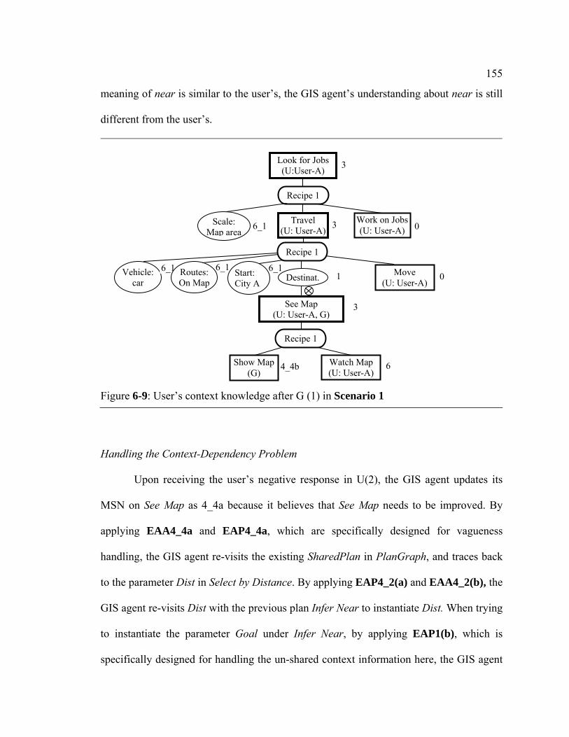
155
meaning of near is similar to the user’s, the GIS agent’s understanding about near is still
different from the user’s.
Handling the Context-Dependency Problem
Upon receiving the user’s negative response in U(2), the GIS agent updates its
MSN on See Map as 4_4a because it believes that See Map needs to be improved. By
applying EAA4_4a and EAP4_4a, which are specifically designed for vagueness
handling, the GIS agent re-visits the existing SharedPlan in PlanGraph, and traces back
to the parameter Dist in Select by Distance. By applying EAP4_2(a) and EAA4_2(b), the
GIS agent re-visits Dist with the previous plan Infer Near to instantiate Dist. When trying
to instantiate the parameter Goal under Infer Near, by applying EAP1(b), which is
specifically designed for handling the un-shared context information here, the GIS agent
Figure 6-9: User’s context knowledge after G (1) in Scenario 1
Vehicle: car
6_16_16_1 1
3See Map (U: User-A, G)
0 3
Look for Jobs (U:User-A) 3
Routes: On Map
Start: City A Destinat.
Work on Jobs (U: User-A)
Travel (U: User-A)
Recipe 1
Recipe 1
Scale: Map area
6_1
0 Move (U: User-A)
4_4b 6Show Map (G)
Watch Map (U: User-A)
Recipe 1

156
realizes that the user’s goal behind the user’s spatial information request in U (1) is not
shared. Thus, the GIS agent initiates a context-sharing dialogue in G (2) with the recipe
Ask of Share Context in Figure A-11 (b) to ask the user for such information: “What is
your goal in asking for this map?” and waits for the user’s answer.
After receiving the user’s answer in U (3) about the user’s goal, Look for Jobs, the
GIS agent re-instantiates the parameter Goal and elaborates and integrates the action
Look for Jobs with the existing PlanGraph by attaching See Map with the parameter
Destination in the sub action Travel under Look for Jobs. As to the second half of U (3)
about the user’s transportation mode, the GIS agent interprets it as the user’s active
context-sharing dialogues with the recipe Actively Give of Share Context in Figure A-11
(c). The GIS agent attaches Actively Give with the parameter Vehicle under Travel.
Consequently, the GIS agent re-estimates near as “150 miles” with Infer Near with new
contextual information retrieved from PlanGraph. Up to now, all context information
used in Infer Near cannot be improved better (to the GIS agent, the GIS agent usually
does not directly communicate the spatial size information to the user). Thus, the GIS
agent updates its MSN on Infer Near and Dist as 4_3b. The GIS agent re-generates a map
response with the new spatial distance value and send it out in G (3): “Here are the cities
within 150 miles of City A, is this OK?”. The current PlanGraph and the map response in
G (3) is shown in Figure 6-10 and Figure 6-11.

157
Figure 6-10: PlanGraph after G (3) in Scenario 1
6_1
6-1
Para: Vehicle
6_1 66_1 6_1 6_1
4_3b
6
4_4b
6_1 6_1 6_1 6_1
6
4_3b
6_1 6_16_1
6-1
66_1 6_1
6
See Map (U: User-A, G)
Show Map (G)
Watch Map (U: User-A)
Recipe 1
Layer Extent Generate Map (G)
Recipe 1
Dist. Spatial Query
(G) Refer.
Select by Distance
Instantiate lyr(G)
Target
Instantiate Dist (G)
U Cal. Near(G)
Goal ScaleVeh.
Infer Near
Ask (G, User-A)
Share Context (G, User-A)
Ask
6
6
Ref. Target
03
Look for Jobs (U:User-A) 3
Vehicle: Routes:On Map
Start: City A
Destinat.
Work on Jobs (U: User-A)
Recipe 1
Recipe 1
Scale: Map area
6_1
0
Answer (User-A, G)
Share Context(User-A, G)
Actively Give
6
Move (U: User-A)
Routes
6
Travel (U: User-A)
6Para: Vehicle
6_1
Answe (User-A, G)
6
Note: To save space, in this PlanGraph,we have removed all actions for instantiation of parameters that hold the same values as those in the PlanGraph in Figure 6-7.

158
By comparing the system’s context knowledge after G (3) (by referring to the root
plan, Look for Jobs, in Figure 6-10) and the user’s context knowledge after G (1)
(Figure 6-9), we can see that the system has achieved a shared understanding about the
current context with the user through two different context-sharing collaborative
dialogues between G (2) and U (3). One is initiated by the system to ask the user for
missed contextual information, and the other is initiated by the user to tell the system
certain contextual information without being asked. In this scenario, under constraints of
the shared context, the system and the user reach a shared understanding about the vague
Figure 6-11: Map response in G (3) in Scenario 1

159
spatial concept near. This is because in this scenario, the system and the user have similar
models of the meaning of near.
Finally, after receiving the user’s positive response in U (4), the GIS agent
believes that the human-GIS collaboration on the user’s See Map spatial intention is
successfully done. So, it updates all its MSNs on See Map and its descendants in the
PlanGraph in Figure 6-10 as successful.
6.3 Scenario 2: Handling the Context-Dependency Problem in Situation B
Scenario 2, which involves the context-dependency problem in Situation B, is shown in
Figure 6-12. Same as Scenario 1, in this scenario, the GIS agent’s model of the meaning
of the vague spatial concept includes the same list of contextual factors as those in the
user’s model.
Figure 6-12: Scenario 2
G: GeoDialogue U: User (User-A) Before the following conversation, the map on the GIS shows a basic map of City C (Figure 6-13). U (1): Hi, I am User-A. I need to buy some foods. Show me grocery stores near Apartment A. G (1): (highlight certain food stores near Apartment A) By driving, here are grocery stores within 3
miles of Apartment A. Is this OK to you? U (2): No. I plan to walk. G (2): Here are grocery stores within 1 mile to Apartment A. Is this OK? U (3): Yes, thank you.

160
6.3.1 Extension of the PlanGraph Model
To enable the GIS agent to handle the context-dependency problem in Scenario 2, we
have further extended actions and their recipes and reasoning algorithms of the
PlanGraph model described in Chapter 4.
Extension of Actions and Recipes
Figure 6-13: Initial Map in Scenario 2
161
To enable the GIS agent to understand the food shopping context involved in this
scenario, we have designed and implemented the actions and recipes in Figure A-3 by
following the general actions and recipes in Figure 4-10. Similarly, in this scenario, the
user’s See Map intention is attached to the parameter Destination in the subaction Travel
because the grocery stores that the user is trying to identify in See Map are the destination
locations in the user’s traveling activity.
Extension of Reasoning Algorithms
By following the general rule of designing the GIS agent’s reasoning algorithms
described in Chapter 4, we have extended the reasoning algorithms described and
implemented in Chapter 5 to facilitate the GIS agent to handle the vagueness problem in
Scenario 2.
In this scenario, after receiving the first half of U (1) about the user’s food
shopping intention, the GIS agent recognizes the user’s intention as Food Shopping.
Although Food Shopping does not directly involve the GIS agent’s participation, it does
involve parameters representing spatial context information, which the user may ask the
system to identify. So, this action is taken as the context involving the user’s spatial
information request to the GIS. To enable the GIS agent to interpret such actions as
contexts of human-GIS collaboration, we have designed and implemented IA2 (see
Appendix C) for the GIS to interpret such actions and initiate the PlanGraph with such
actions.
The user’s spatial intention See Map underlying the second half of U (1) about the
user’s spatial information request may not directly relate to the current attention focus in

162
PlanGraph, Food Shopping, but can relate to it after certain steps of elaboration about
Food Shopping. To enable the GIS agent to interpret such actions, we have designed and
implemented IA6 (see Appendix C).
In this scenario, the user’s active context-sharing dialogue in U (2) about the
transportation mode can be interpreted as the action Share Context. This action does not
directly relate to the current focus in PlanGraph, See Map, but relates instead to an
ascendant of the current focus. We have also designed and implemented IA7 (see
Appendix C) for the GIS agent to reason about how to interpret such actions and integrate
them with the existing PlanGraph.
6.3.2 Process of Handling the Context-Dependency Problem in Situation B
Initial Shared Context before Communication
In this scenario, before U (1), the shared context between the GIS agent and the
user agent is same as that in Scenario 1.
Building Shared Context through U(1) and G (1)
After receiving the first half in U (1) about the user’s intention about food
shopping, by applying IA2, which is specifically designed for interpreting the user’s
intention about the context, the GIS agent initiates PlanGraph with Food Shopping after
elaborating it with the recipe in Figure A-3 (a) and then focuses attention on it. After
receiving the second half in U (1) about the user’s spatial information request, the GIS
agent interprets it as the user’s spatial intention See Map. By applying IA6, which is

163
specifically designed for integrating the user’s spatial intention with the plan referring to
the context represented in PlanGraph, the GIS agent elaborates Food Shopping with
available information (without inferring any contextual information) and attaches it to the
parameter Destination in Travel under Food Shopping.
With a reasoning process similar to that in Scenario 1 for the GIS to elaborate See
Map, GeoDialogue recursively elaborates it until the GIS agent tries to instantiate the
optional parameters in the plan Infer Near representing contextual factors. Similarly, the
GIS agent tries to elaborate the parameters or actions in the action Food Shopping
corresponding to these parameters in Infer Near first. In the context of Food Shopping,
the GIS agent infers the spatial size of the area as the existing map extent area and the
transportation mode is driving. After elaborating Food Shopping, the GIS agent estimates
near as three miles based on the GIS agent’s knowledge of User-A’s understanding about
near in the food shopping context, generates a map response in G (1), and sends it out to
the user in G (1). The current PlanGraph after G (1) and the map response in G (1) are
shown in Figure 6-14 and Figure 6-15, respectively.
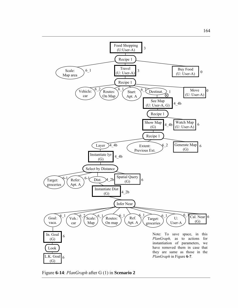
164
Figure 6-14: PlanGraph after G (1) in Scenario 2
6-1
4_4b
0
4_2b
6
4_4b
6_2 6_1 6_1 1
4_4b
4_2b 6-1
66_2
4_4b
See Map (U: User-A, G)
Show Map (G)
Watch Map (U: User-A)
Recipe 1
Layer Extent: Previous Ext.
Generate Map (G)
Recipe 1
Dist. Spatial Query
(G) Refer: Apt. A
Select by Distance
Instantiate lyr(G)
Target: groceries
Instantiate Dist (G)
L.K. Goal (G)
In. Goal (G)
Look
6
6
03
Food Shopping (U:User-A) 3
Vehicle: car
Routes:On Map
Start: Apt. A
Destinat.
Buy Food (U: User-A)
Recipe 1
Recipe 1
Scale: Map area
6_1
Move (U: User-A)
Travel (U: User-A)
6
Note: To save space, in this PlanGraph, as to actions for instantiation of parameters, we have removed them in case that they are same as those in the PlanGraph in Figure 6-7.
6_2 66_1 6_1 6_1 6_1 6_16_1 U:
User-A Cal. Near
(G) Goal: vaca.
Scale:Map
Veh.: car
Ref. Apt. A
Target: groceries
Routes:On map
Infer Near

165
The user’s current context knowledge after receiving G (1) is shown in Figure 6-
16. Comparing the GIS agent’s current context knowledge in Figure 6-14 and the user’s
in Figure 6-16, we can see that the GIS agent and the user’s understandings about the
context behind the user’s spatial information request in U(1) are different at only
instantiation of the transportation mode involved in the context structure, that is, the
context-dependency problem in this scenario is in Situation B. Similar to Scenario 1, in
this scenario, although the GIS agent’s model of the meaning of near is similar to the
user’s, the GIS agent’s understanding about near is still different from the user’s.
Figure 6-15: Map Response in G (1) in Scenario 2
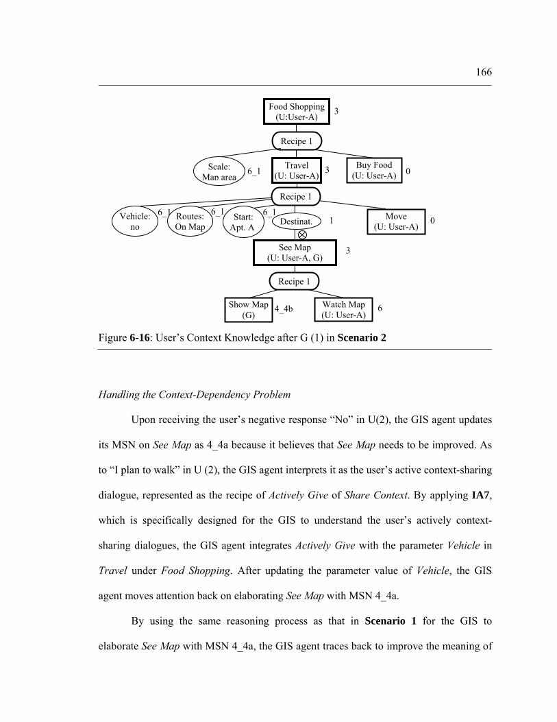
166
Handling the Context-Dependency Problem
Upon receiving the user’s negative response “No” in U(2), the GIS agent updates
its MSN on See Map as 4_4a because it believes that See Map needs to be improved. As
to “I plan to walk” in U (2), the GIS agent interprets it as the user’s active context-sharing
dialogue, represented as the recipe of Actively Give of Share Context. By applying IA7,
which is specifically designed for the GIS to understand the user’s actively context-
sharing dialogues, the GIS agent integrates Actively Give with the parameter Vehicle in
Travel under Food Shopping. After updating the parameter value of Vehicle, the GIS
agent moves attention back on elaborating See Map with MSN 4_4a.
By using the same reasoning process as that in Scenario 1 for the GIS to
elaborate See Map with MSN 4_4a, the GIS agent traces back to improve the meaning of
Figure 6-16: User’s Context Knowledge after G (1) in Scenario 2
6_16_16_1 1
3See Map (U: User-A, G)
0 3
Food Shopping (U:User-A) 3
Vehicle: no
Routes: On Map
Start: Apt. A Destinat.
Buy Food (U: User-A)
Travel (U: User-A)
Recipe 1
Recipe 1
Scale: Map area
6_1
0 Move (U: User-A)
4_4b 6Show Map (G)
Watch Map (U: User-A)
Recipe 1

167
near with the previous plan Infer Near. After successfully retrieving the updated
transportation mode information from the current PlanGraph, the GIS agent re-infers
near as one mile, re-generates a new map response and sends it out in G (2): “Here are
the grocery stores within 1 mile of Apartment A. Is this OK?”. The current PlanGraph
and the map response in G (2) are shown in Figure 6-17 and Figure 6-18 .
Figure 6-17: PlanGraph after G (2) in Scenario 2
6_1
4_4b
6_1 1
See Map (U: User-A, G)
……
Food Shopping (U:User-A) 3
Vehicle: Destinat.
…… 0
Answer (User-A, G)
Share Context (User-A, G)
Actively Give
6
Move (U:User-A)
6
Para: Vehicle
Note: For missed components, please refer to theose in the PlanGraph in Figure 6-14.
6_1 6_1 Goal Veh.
Infer Near
……
6 LK. Veh. (G)
In. Veh. (G)
Look
6
……
L.K. Goal(G)
In. Goal (G)
Look
6
6
4_3b
4_3b Dist.
Instantiate Dist (G)

168
By comparing the system’s context knowledge after G (2) (with referring to the
root plan, Food Shopping, in Figure 6-17) and the user’s context knowledge after G (1)
(Figure 6-16), we can see that the system has achieved a shared understanding about the
current context with the user through the context-sharing collaborative dialogue in U (3).
U (3) is initiated by the user to actively share the task contextual information with the
system without being asked. Similar to Scenario 1, under constraints of the shared
understanding about the current context, the system finally reaches a shared
Figure 6-18: Map Response in G (2) in Scenario 2

169
understanding about the vague spatial concept near with the user because the two agents
have similar models of the meaning of near.
Finally, after receiving the user’s positive response in U (3), the GIS agent
updates all its MSNs on See Map and its descendants in the PlanGraph in Figure 6-17 as
successful.
6.4 Scenario 3: Handling the Context-Dependency Problem in Situation C
Scenario 3, which involves the vagueness problem in Situation C, is shown in Figure 6-
19. In this scenario, the GIS agent’s model of the meaning of the vague spatial concept
near includes contextual factors different from those in the user’s model.
Figure 6-19: Scenario 3
G: GIS U: User (User-A) Before the following conversation, the map on GIS shows a basic map of City A (including state boundaries, see Figure 6-20). U (1): Hi, I am User-A. I am planning to visit cities near City A by driving on weekends. Show me
cities near City A. G (1): (show interstates, City A and all cities in the current area, and highlight certain cities near City
A) Here are cities within 300 miles of City A. Is this OK? U (2): (Pointing to an area on the map) No, please zoom to this area first. G (2): (Show a new map) Here is the map after zooming. Is this OK? U (3): No. Please show me history museums and outlets in these cities. G (3): Here you are. Is this OK? U (4): (Point to the map with gesture) No. Please highlight these cities only. G (4): Here are the cities highlighted. U (5): Thank you.

170
6.4.1 Extension of the PlanGraph Model
By following the general rule about design of reasoning algorithms in the PlanGraph
model, we have further extended this model for the GIS agent to handle the vagueness
problem in Scenario 3.
In this scenario, the user sends a new spatial information request in U (3), which
is different from the current spatial information request on focus. It does not directly
relate to the current elaboration of the context behind the current focus represented in
PlanGraph. To enable the GIS agent to interpret such intentions, we have designed and
Figure 6-20: Initial Map in Scenario 3
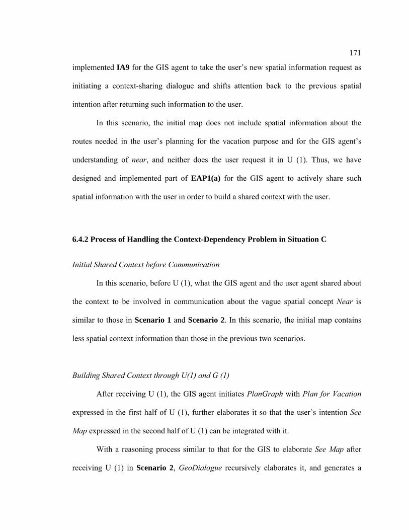
171
implemented IA9 for the GIS agent to take the user’s new spatial information request as
initiating a context-sharing dialogue and shifts attention back to the previous spatial
intention after returning such information to the user.
In this scenario, the initial map does not include spatial information about the
routes needed in the user’s planning for the vacation purpose and for the GIS agent’s
understanding of near, and neither does the user request it in U (1). Thus, we have
designed and implemented part of EAP1(a) for the GIS agent to actively share such
spatial information with the user in order to build a shared context with the user.
6.4.2 Process of Handling the Context-Dependency Problem in Situation C
Initial Shared Context before Communication
In this scenario, before U (1), what the GIS agent and the user agent shared about
the context to be involved in communication about the vague spatial concept Near is
similar to those in Scenario 1 and Scenario 2. In this scenario, the initial map contains
less spatial context information than those in the previous two scenarios.
Building Shared Context through U(1) and G (1)
After receiving U (1), the GIS agent initiates PlanGraph with Plan for Vacation
expressed in the first half of U (1), further elaborates it so that the user’s intention See
Map expressed in the second half of U (1) can be integrated with it.
With a reasoning process similar to that for the GIS to elaborate See Map after
receiving U (1) in Scenario 2, GeoDialogue recursively elaborates it, and generates a

172
map response and speech response in G (1). One difference between this scenario and the
Scenario 2 lies in the process of elaboration of the action representing the context before
elaboration of the parameter Routes in Infer Near. During the process of elaboration Plan
for Vacation in this scenario, by applying EAP1(a) specifically for the GIS agent to
actively share context information that the user may not know with the user, the GIS
agent attaches the recipe Actively Give of Share Context with the parameter Routes in the
action Travel involved in Plan for Vacation and executes it after successfully
instantiating this parameter. Another difference is on MSNs on Dist and Instantiate Dist.
In this scenario, MSNs on these two nodes are 4_3b because all context information used
in Infer Near can not be further improved, while they are 4_2b in Scenario 2. With the
context information retrieved from Plan for Vacation, the GIS agent generates a map
showing cities within 300 miles of City A. The current PlanGraph after G (1) and the
map response in G (1) are shown in Figure 6-21 and Figure 6-22, respectively.
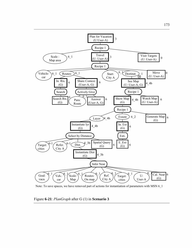
173
Figure 6-21: PlanGraph after G (1) in Scenario 3
6_1
6-1
4_4b
6_16
66_1 6_1 6_1
4_3b
6
6_1 6_1 6_1 1
4_4b
4_3b
6_1 6_16_1
6-1
64_4b
4_4b
See Map (U: User-A, G)
Show Map (G)
Watch Map (U: User-A)
Recipe 1
Layer Generate Map (G)
Recipe 1
Dist. Spatial Query
(G) Refer. City A
Select by Distance
Instantiate lyr(G)
Target: cities
Instantiate Dist (G)
U: User-A
Cal. Near(G)
Goal: vaca.
Scale: Map
Veh.: car
Infer Near
Ref. City A
Target: cities
03
Plan for Vacation (U:User-A) 3
Vehicle: car
Routes: Start: City A
Destinat.
Visit Targets (U: User-A)
Recipe 1
Recipe 1
Scale : Map area
6_1
0
6
Move (U: User-A)
Routes:On map
6
Search Rts. (G)
In. Rts. (G)
Search
Travel (U: User-A)
6
Share Context (User-A, G)
6
Actively Give
Answer (User-A, G)
Para: Route
6_2 Extent
E_Ext (G)
In. Ext (G)
Esti.
6
6
Note: To save spaces, we have removed part of actions for instantiation of parameters with MSN 6_1

174
In this scenario, the user’s model of the meaning of near involves more context
factors, in addition to those in the GIS agent’s model (Eq. 6.1). The user considers
influence on near from more details about the visiting activity, including the visiting
targets, as well as the action “Visit”. The user’s current context knowledge after receiving
G (1) is shown in Figure 6-23 by referring to the PlanGraph representation. Comparing
the GIS agent’s current context knowledge in Figure 6-21 with the user’s in Figure 6-23,
we can see that the GIS agent and the user’s understandings about the context are
Figure 6-22: Map Response in G (1) in Scenario 3
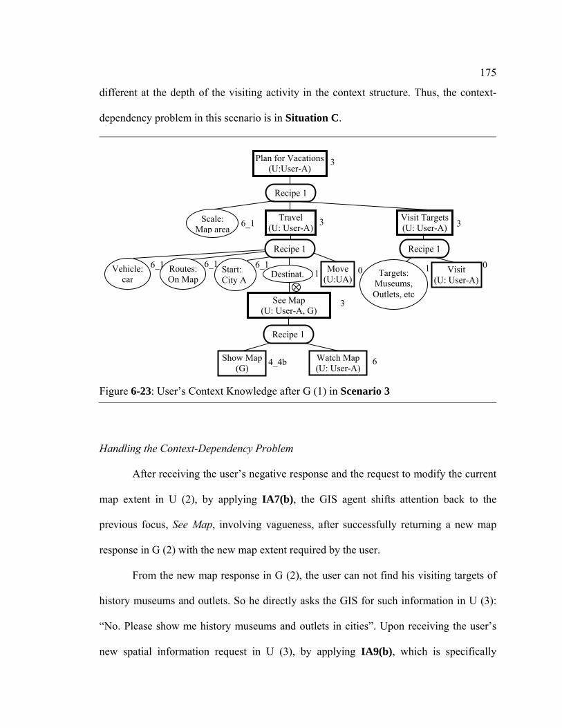
175
different at the depth of the visiting activity in the context structure. Thus, the context-
dependency problem in this scenario is in Situation C.
Handling the Context-Dependency Problem
After receiving the user’s negative response and the request to modify the current
map extent in U (2), by applying IA7(b), the GIS agent shifts attention back to the
previous focus, See Map, involving vagueness, after successfully returning a new map
response in G (2) with the new map extent required by the user.
From the new map response in G (2), the user can not find his visiting targets of
history museums and outlets. So he directly asks the GIS for such information in U (3):
“No. Please show me history museums and outlets in cities”. Upon receiving the user’s
new spatial information request in U (3), by applying IA9(b), which is specifically
Figure 6-23: User’s Context Knowledge after G (1) in Scenario 3
1 06_16_1 6_1 1
3See Map (U: User-A, G)
33
Plan for Vacations(U:User-A)
3
Vehicle: car
Routes: On Map
Start: City A Destinat.
Visit Targets (U: User-A)
Travel (U: User-A)
Recipe 1
Recipe 1
Scale: Map area
6_1
0Move (U:UA)
4_4b 6Show Map (G)
Watch Map (U: User-A)
Recipe 1
Recipe 1
Visit (U: User-A)
Targets: Museums, Outlets, etc

176
designed for the GIS to interpret the user’s new spatial information request under the
context of the current communication, the GIS agent re-elaborates the current plan for
Plan for Vacation, in particular, its sub action, Visit Targets. From the GIS agent’s
knowledge base, the GIS agent knows that history museums and outlets are part of
visiting targets in the plan for Visit Targets. So the GIS agent further elaborates Visit
Targets. By applying IA9(b), the GIS agent takes the user’s spatial information request in
U (3) as initating a context-sharing dialogue with the recipe, Ask, of Share Context. After
successfully showing such spatial context-information to the user in G (3) to the user, the
GIS agent comes back to the previous attention focus, See Map, for “cities near City A”,
involving vagueness. The current PlanGraph showing the GIS agent’s current context
knowledge is shown in Figure 6-24.
Figure 6-24: PlanGraph after G (3)
6
……
6_16 6
6_1 0….. 1
4_4bSee Map (U: User-A, G)
3 3
Plan for Vacations(U:User-A)
3
Destination
Visit Targets (U: User-A)
Travel (U: User-A)
Recipe 1
Recipe 1
Scale: Map area
6_1
0Move (U:User-A)
Recipe 1
Visit (U: User-A)
Targets: Museums, Outlets, etc
Share Context (User-A, G)
Ask
Para: Targets
Answer (G: User-A)
Ask (User-A, G)
In this figure, for missed components, please refer to these in Figure 6-21

177
After receiving the map response in G (3), the user updates his spatial context
knowledge on the visiting targets, that is, the parameter node Targets in Figure 6-23.
Comparing the system’s current context knowledge in Figure 6-24 and the user’s current
context knowledge, we can see that they have reached a shared understanding about the
context behind the user’s spatial information request in U (1).
Further Reducing Vagueness after Building the Shared Context
Although, after G (3), the user and the system have a shared understanding about
the current context, the user does not agree with the system’s understanding about the
concept near. The user points out the destination cities with a gesture in U (4) based on
his current understanding about near with updated spatial contextual information
represented in the map in G (3). In the current implementation of GeoDialogue, the GIS
agent does not have knowledge about how to understand near based on all context
information considered by the user in this scenario. Thus, the system can not generate a
new map to the user.
The user’s spatial intention in U (4) is interpreted by the system as another way to
improve the current focus, See Map with MSN 4_4b. Thus, the system updates its MSN
on See Map as 4_4a and re-visits See Map with another plan to instantiate the parameter
Layer under Show Map. The new plan is Select by Gesture of Instantiate Lyr (Figure A-8
(j)). The new plan does not involve vagueness, so, the GIS agent updates all its MSN on
Layer and ascendants of Layer as successful after re-generating a new map response in G
(4). The final map response in G (4) is shown in Figure 6-25.

178
The user’s positive response in U (5) confirms the GIS agent’s work in G (4). In
this scenario, what is different from the first two scenarios is that the two agents do not
reach a shared understanding about the vague spatial concept near when they have
reached a shared understanding about the current context. In this scenario, to further
reduce vagueness, the user directly tells the system what he thinks are near through a
gesture in U (4). Finally, the two agents successfully reach a shared understanding about
the vague spatial concept after further reducing vagueness through the direct
communication strategy.
Figure 6-25: Map Response in G (4) in Scenario 3

179
6.5 Scenario 4: Handling the Context-Dependency Problem in Situation D
Scenario 4, which involves the vagueness problem in Situation D, is shown in Figure 6-
26. In this scenario, the user’s model of the meaning of the vague spatial concept near
involves more contextual factors than those in the GIS agent’s model.
Figure 6-26: Scenario 4
G: GIS U: User (User-B) Before the following conversation, the map on the GIS shows a basic map of City C, including state boundaries, county boundaries, interstates and major roads (see Figure 6-27). U (1): Hi, I am User-B. I am planning to buy food by driving. Show me grocery stores near
Apartment A. G (1): (map) Here are the grocery stores within 5 miles of Apartment A. Is this OK for you? U (2): No. G (2): Do you want to increase or decrease the spatial distance of near? U (3): Decrease, please. G (3): (map) Here are the grocery stores within 2.5 miles of Apartment A. Is this OK? U (4): No. Please highlight all these grocery stores. G (4): (map) Here are the grocery stores highlighted as you requested. U (5): Thanks.

180
6.5.1 Extension of the PlanGraph Model
Similarly, we have also further extended the PlanGraph model represented in Chapter 4
for the GIS agent to handle the context-dependency problem in Scenario 4.
Extension of Actions and Recipes
To enable the GIS agent to have negotiation collaborative dialogues like the one
in G (2) and U (3), we have designed and implemented the recipe Ask of the action
Figure 6-27: Initial Map in Scenario 4

181
Negotiate (Figure A-12 (b)). In order to enable the GIS agent to understand the user’s
active refining comments upon being asked, we have also implemented the recipe Active
Give of Negotiate (Figure A-12 (c)).
Extension of Mental States
In this scenario, after receiving the user’s negative response on its understanding
about near in G (1), the GIS agent believes that the previous plan Infer Near used to
understand near and instantiate the parameter Dist can not be further improved. Thus, it
needs to change another plan to understand near. To model the GIS agent’s mental
beliefs involved in this process, we have further exteneded and implemented MSNs in
Table 5-3 and Table 5-4. Table 6-2 and Table 6-3 show the new MSNs and their
meanings.
Extension of Reasoning Algorithms
Table 6-2: Extended MSNs on Action α and Their Meanings Label Intention on
doing α Commitment on success of α
Belief (the agent being modeled believes that)
4 4_1 individual, group
Individual and mutual
The current plan for α does not succeed, and α can be re-executed with another plan.
Table 6-3: Extended MSNs on Parameter p and Their Meanings Label Intention on
instantiating p Commitment on success of instantiating p
Belief (the agent being modeled believes that)
4 4_1 individual, group
Individual and mutual
The current plan for instantiation of p does not succeed, and p can be re-instantiated with another plan.

182
With the new MSNs implemented above, we have also designed and extended
EAA4_1 and EAP4_1 (see Appendix C) for the GIS agent to change another appropriate
plan to re-execute an action or re-instantiate a parameter with the new MSN.
6.5.2 Process of Handling the Context-Dependency Problem in Situation D
Initial Shared Context before Communication
In this scenario, before U (1), what the GIS agent and the user agent shared about
the context to be involved in communication about the vague spatial concept Near is
similar to those in Scenario 1 and 2.
Building Shared Context through U(1) and G (1)
With a same reasoning process as that in Scenario 3 for the GIS to interpret U
(1), the GIS agent initiates PlanGraph with the plan Food Shopping and further
elaborates it so that the user’s intention See Map expressed in the second half of U (1)
can be integrated with it. Furthermore, with a reasoning process similar to that in
Scenario 2 for the GIS to elaborate See Map toward its success, the GIS agent generates
a map response in G (1) indicating its understanding about near as 5 miles. Because the
user actively shares his transporation mode information in this scenario, the GIS agent
updates its MSNs on Dist and Instantiate Dist as 4_3b because all context information
used in Infer Near can not be further improved. The current PlanGraph is shown in
Figure 6-28. The map response in G (1) is shown in Figure 6-29.

183
Figure 6-28: PlanGraph after G (1) in Scenario 4
Figure 6-29: Map Response in G (1) in Scenario 4
…… 6_1 1
3
6 4_4b See Map (U: User-B, G)
Food Shopping (U:User-B)
Vehicle: Destination
……
I_Veh. (G)
In. Veh. (G)
Identify
6
......For missed components, please refers to those in Figure 6-17 (except that the user is User-B in this figure, while the user is User-A in Figure 6-17)
……
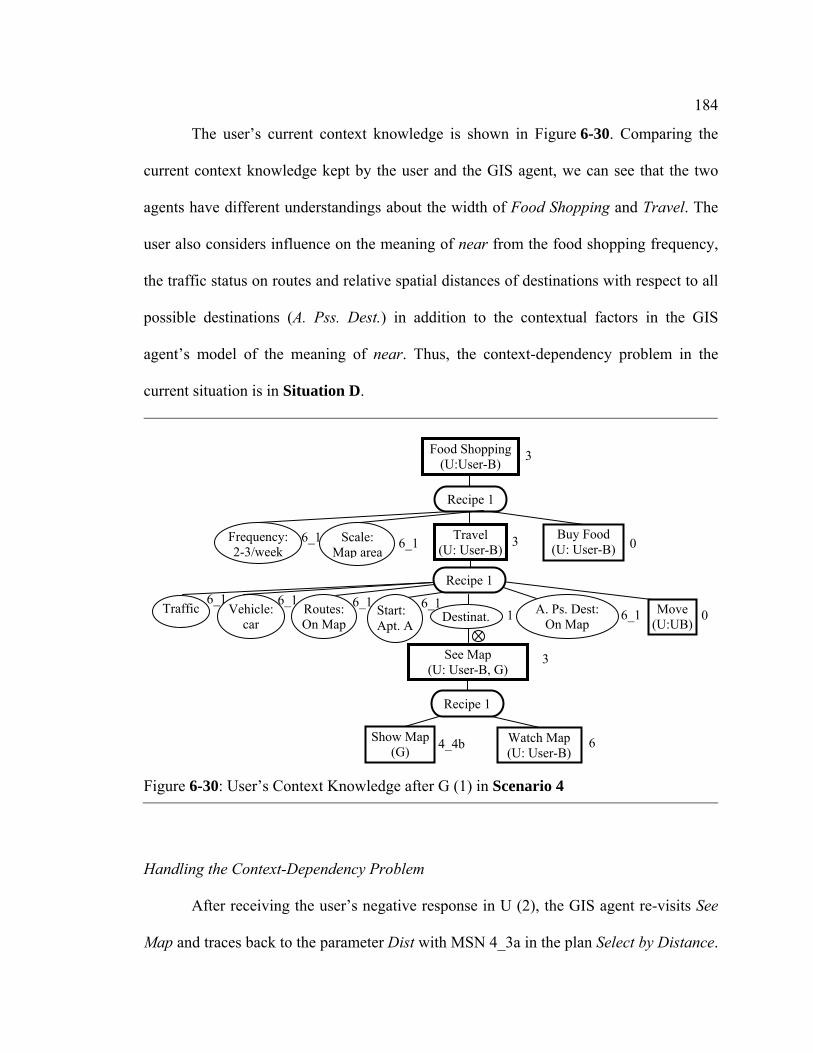
184
The user’s current context knowledge is shown in Figure 6-30. Comparing the
current context knowledge kept by the user and the GIS agent, we can see that the two
agents have different understandings about the width of Food Shopping and Travel. The
user also considers influence on the meaning of near from the food shopping frequency,
the traffic status on routes and relative spatial distances of destinations with respect to all
possible destinations (A. Pss. Dest.) in addition to the contextual factors in the GIS
agent’s model of the meaning of near. Thus, the context-dependency problem in the
current situation is in Situation D.
Handling the Context-Dependency Problem
After receiving the user’s negative response in U (2), the GIS agent re-visits See
Map and traces back to the parameter Dist with MSN 4_3a in the plan Select by Distance.
Figure 6-30: User’s Context Knowledge after G (1) in Scenario 4
6_1 6_11
6_1
6_16_1 6_1
3See Map (U: User-B, G)
0 3
Food Shopping (U:User-B) 3
Vehicle: car
Routes:On Map
Start: Apt. A
Destinat.
Buy Food (U: User-B)
Travel (U: User-B)
Recipe 1
Recipe 1
Scale: Map area
6_1
0Move (U:UB)
4_4b 6 Show Map (G)
Watch Map (U: User-B)
Recipe 1
Frequency: 2-3/week
A. Ps. Dest: On Map
Traffic
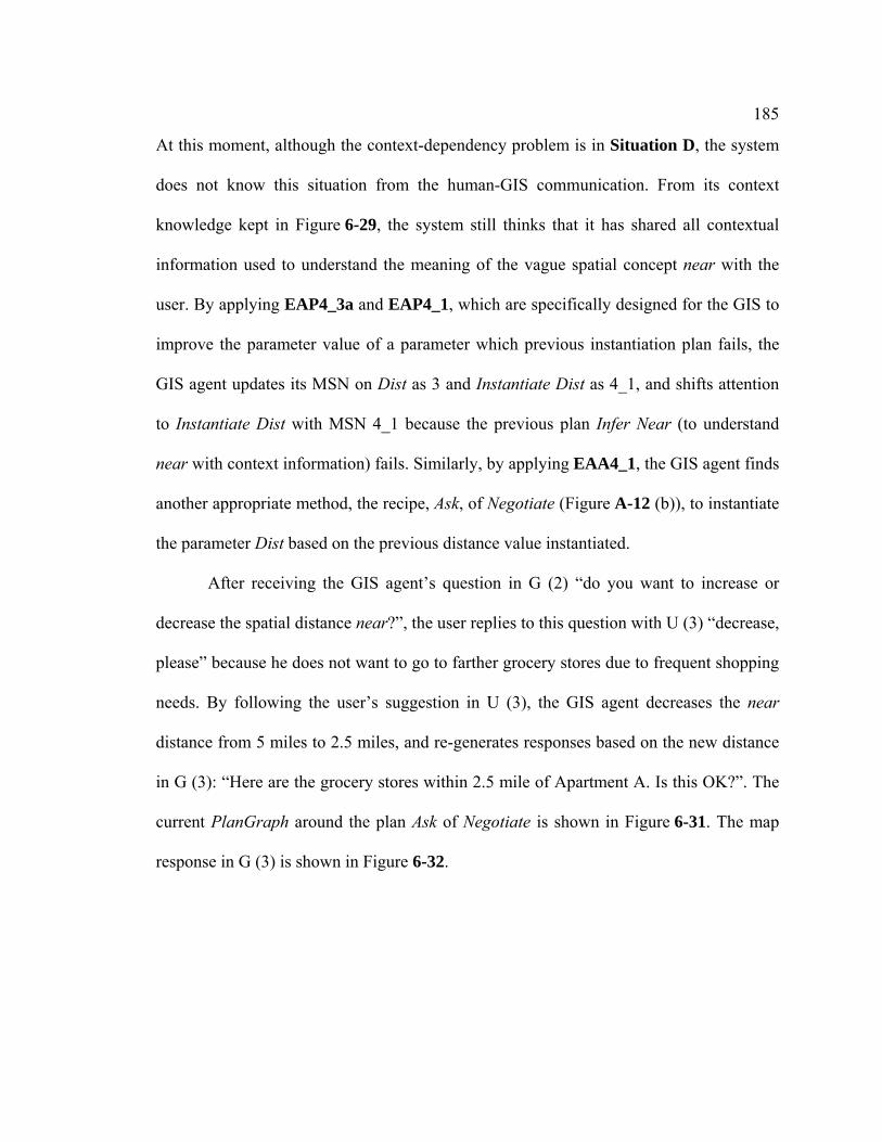
185
At this moment, although the context-dependency problem is in Situation D, the system
does not know this situation from the human-GIS communication. From its context
knowledge kept in Figure 6-29, the system still thinks that it has shared all contextual
information used to understand the meaning of the vague spatial concept near with the
user. By applying EAP4_3a and EAP4_1, which are specifically designed for the GIS to
improve the parameter value of a parameter which previous instantiation plan fails, the
GIS agent updates its MSN on Dist as 3 and Instantiate Dist as 4_1, and shifts attention
to Instantiate Dist with MSN 4_1 because the previous plan Infer Near (to understand
near with context information) fails. Similarly, by applying EAA4_1, the GIS agent finds
another appropriate method, the recipe, Ask, of Negotiate (Figure A-12 (b)), to instantiate
the parameter Dist based on the previous distance value instantiated.
After receiving the GIS agent’s question in G (2) “do you want to increase or
decrease the spatial distance near?”, the user replies to this question with U (3) “decrease,
please” because he does not want to go to farther grocery stores due to frequent shopping
needs. By following the user’s suggestion in U (3), the GIS agent decreases the near
distance from 5 miles to 2.5 miles, and re-generates responses based on the new distance
in G (3): “Here are the grocery stores within 2.5 mile of Apartment A. Is this OK?”. The
current PlanGraph around the plan Ask of Negotiate is shown in Figure 6-31. The map
response in G (3) is shown in Figure 6-32.
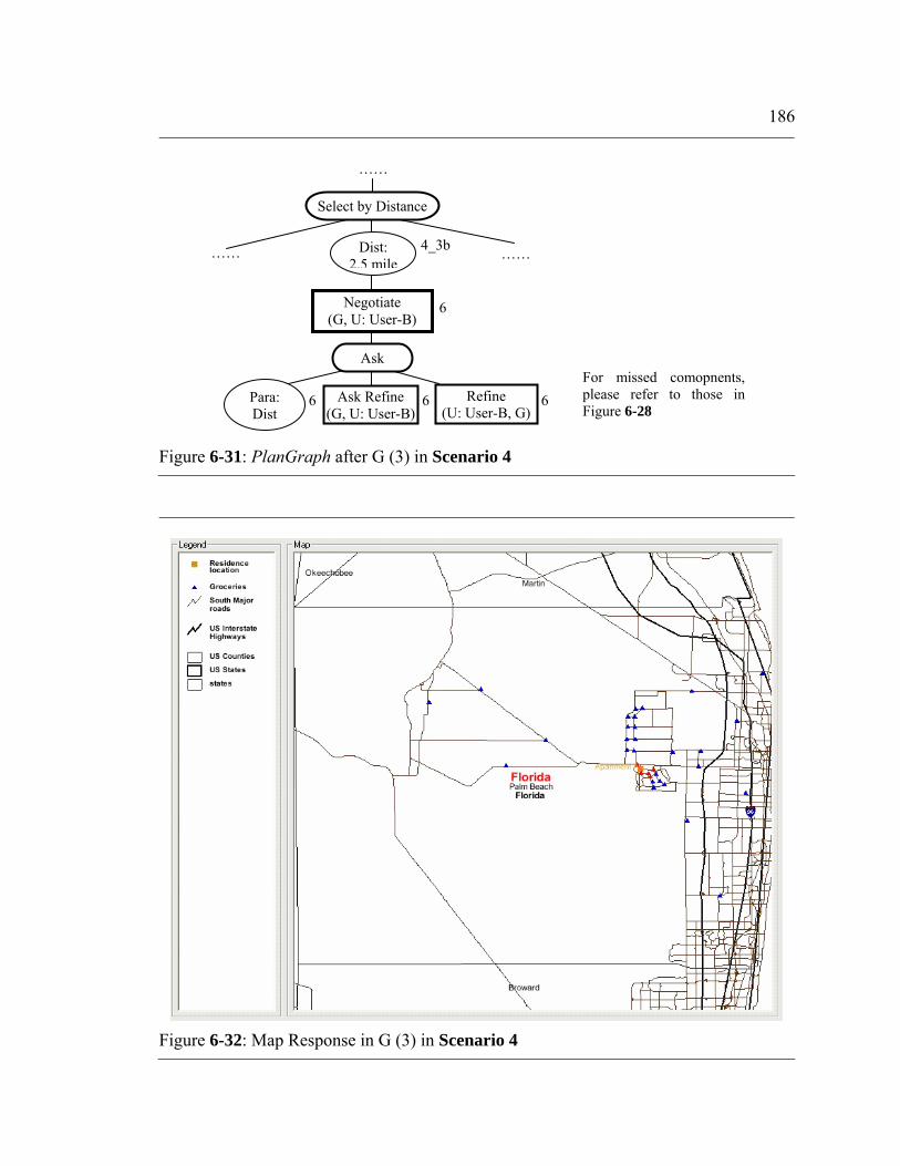
186
Figure 6-31: PlanGraph after G (3) in Scenario 4
Figure 6-32: Map Response in G (3) in Scenario 4
……
……
666
6
4_3b Dist: 2.5 mile
Ask Refine (G, U: User-B)
Negotiate (G, U: User-B)
Para: Dist
Ask
Refine (U: User-B, G)
Select by Distance
……
For missed comopnents, please refer to those in Figure 6-28

187
The user is not satisfied with the grocery stores shown in G (3). From his several
traveling experiences to the two grocery stores within 3 miles of Apartment A, he knows
that the traffic status around these two stores is acceptable. In addition, from the existing
GIS map, he finds that relative spatial distances of these two stores with respect to all
grocery stores in this area are not too far. Therefore, he believes that these two stores
should also be considered as near. Similar to Scenario 3, the user also gives his
understanding about near with a gesture directly in U (4): “No. Please highlight all these
groceries.” With the same reasoning process as that in Scenario 4 for processing U (4),
the GIS agent re-generates the map response based on the user’s gesture direction in G
(5). Finally, the user’s positive response in U (5) confirms that the user and the GIS agent
have reached a successful communication about near. The final map response in G (4) is
shown in Figure 6-33.
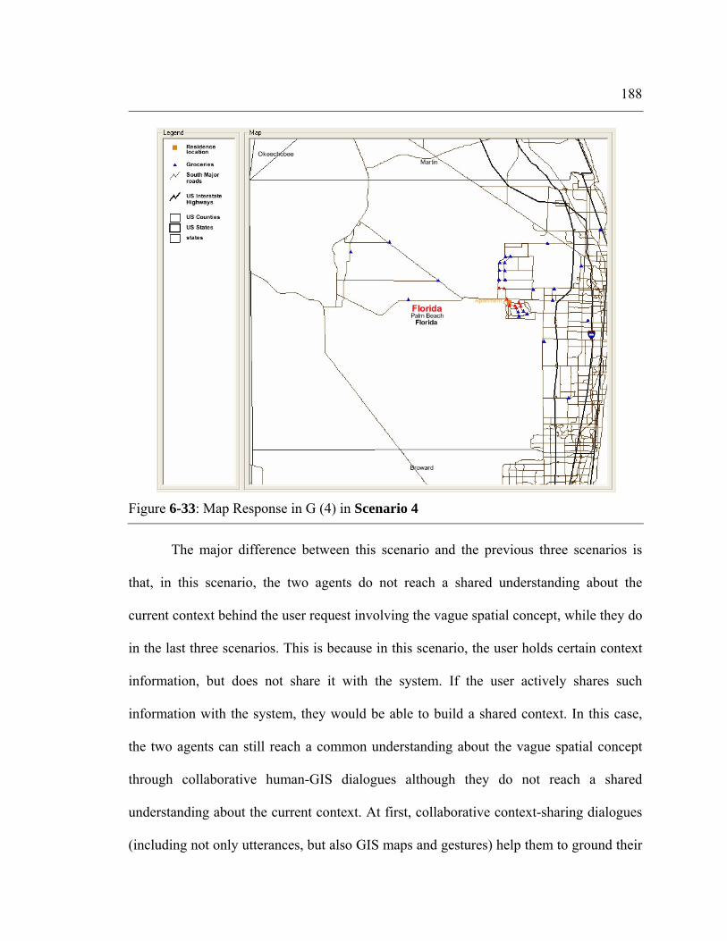
188
The major difference between this scenario and the previous three scenarios is
that, in this scenario, the two agents do not reach a shared understanding about the
current context behind the user request involving the vague spatial concept, while they do
in the last three scenarios. This is because in this scenario, the user holds certain context
information, but does not share it with the system. If the user actively shares such
information with the system, they would be able to build a shared context. In this case,
the two agents can still reach a common understanding about the vague spatial concept
through collaborative human-GIS dialogues although they do not reach a shared
understanding about the current context. At first, collaborative context-sharing dialogues
(including not only utterances, but also GIS maps and gestures) help them to ground their
Figure 6-33: Map Response in G (4) in Scenario 4

189
understandings about the current context to be close, although not common. Then, other
types of collaborative dialogues, e. g. negotiation and direction communication dialogues,
can help to further reduce vagueness until the two agents reach a common understanding
about the vague spatial concept involved.
6.6 Summary and Discussion
This section summarizes various situations of the context-dependency problem in human-
GIS communication and describes how the PlanGraph model can be extended to handle
the context-dependency problem in four sample human-GIS dialogues. These sample
dialogues demonstrate that the collaborative dialogue approach and the PlanGraph model
can enable the GIS agent to have the flexibility of handling the context-dependency
problem in various situations.
These sample human-GIS dialogues demonstrate how the collaborative dialogue
and the PlanGraph model can help the GIS agent to handle the context-dependency
problem in various ways. Firstly, they can help the GIS agent to maintain knowledge on
the dynamic context in human-GIS communication. At the beginning of these scenarios,
the PlanGraph is empty. As the dialogue proceeds, it records and updates contextual
information exchanged between two agents and contextual information inferred by the
GIS agent. As a result, it enables the GIS agent to keep track of the dynamic context
involved in human-GIS dialogues. Secondly, they enable the GIS agent and the user to
build a shared context in various situations through various collaborative context-sharing
dialogue strategies. With PlanGraph keeping track of the context involved, the GIS agent

190
knows what contextual information has not been shared between the two agents.
Therefore, it can initiate context-sharing dialogues to ask the user for such information
(see Scenario 1 and 2) or actively share such information with the user (see Scenario 3).
This model also enables the GIS agent to understand the user’s context-sharing dialogues
to ask for (Scenario 3) or actively share certain contextual information with the system
(see Scenario 1, 2, 3, and 4). Thirdly, they enable the GIS agent to understand the
meaning of the vague spatial concept with dynamic context information. These sample
dialogues demonstrate that the GIS agent can retrieve contextual information from the
shared context initially represented by the PlanGraph, and then understand the meaning
of the vague spatial concept with the retrieved contextual information based on its model
of the meaning of the concept. Fourthly, they can help the GIS agent and the user to reach
a shared understanding about the meaning of a vague spatial concept. The shared context
built in human-GIS communication constrains the GIS agent and the user’s
understandings about the vague spatial concept to be common or closer. These sample
dialogues show that, if needed, the GIS and the user can further ground their
understandings about that concept into a common understanding through various
collaborative human-GIS dialogue strategies, e. g. negotiation (see Scenario 4) or direct
communication (see Scenario 3, and 4). Finally, they enable the GIS to handle the
context-dependency problem in various situations where the system and the user have
different understandings about the current context. The context-dependency problems in
the four sample dialogues are in four different representative situations defined in this
study. The GIS agent successfully reaches a successful communication of a vague spatial
concept with the user in these four dialogues.
191
The performance of GeoDialogue is limited by the limited knowledge built into
the PlanGraph model. In the sample dialogues described in this chapter, the GIS agent’s
model about the meaning of the vague spatial concept near involves only seven fixed
major contextual factors, and does not include certain contextual factors commonly
considered in the human’s model, e. g. the relative distance contextual factor, time and
financial budget. In addition, GeoDialogue can not adjust its model when it knows that
the user considers more contextual influences (see Scenario 3 and 4). If we could build a
better model of the meaning of near (e. g. including more contextual factors that the
human user considers), and better reasoning algorithms (e. g. to enable the GIS agent to
adjust its model of the meaning of the vague spatial concept along with the change of the
context structure in the PlanGraph) for the PlanGraph model, GeoDialogue would be
able to give a better inference on the meaning of a vague spatial concept. Such
improvement of the PlanGraph model would ease human-GIS communication.

Chapter 7
Conclusion and Future Work
In this study, a collaborative dialogue approach is proposed and developed for spoken
natural language-enabled GIS to handle the context-dependency problem involved in
human-GIS communication. The Human Communication Framework (HCF) is
developed in this study for us to better understand and handle the vagueness problem
involved in human-GIS communication by referring to the vagueness problem in human-
human communication. This framework directs us to propose the collaborative dialogue
approach in this study. The agent-based computational model, the PlanGraph model, is
developed for us to implement the collaborative dialogue approach. We have also
implemented the collaborative dialogue approach and the PlanGraph model in the
prototype software agent, GeoDialogue. The sample dialogues between GeoDialogue and
the user demonstrate that the PlanGraph model and the collaborative dialogue approach
can help the GIS to effectively handle the context-dependency problem in various
situations.
The remainder of this section discusses contributions made by this study,
comparisons between this study and previous studies, and future research, respectively.

193
7.1 Contributions
The goal of this study is to facilitate the development of natural multimodal GIS, in
particular facilitate the handling of the vagueness problem in human-GIS communication.
This study has made the following two major contributions toward this goal.
Human Communication Framework
The first major contribution is Human Communication Framework (HCF). This
framework plays four major roles in this study as follows.
Firstly, it facilitates our comprehensive understanding about the vagueness
problem in human-GIS communication. The sources of vagueness in human-human
communication facilitate our understanding about major origins of vagueness in human-
GIS communication of spatial concepts. The five major dimensions of the shared context
in human-human communication help us to understand the three major types of
contextual factors, and the distributed nature of context knowledge in human-GIS
communication. The distributed nature of context knowledge in human-GIS
communication leads to the need for building a shared context in human-GIS
communication and the need for human-GIS collaborative dialogues.
Secondly, this framework helps us to understand various situations of the context-
dependency problem in human-GIS communication. The HCF indicates that
communicators may have different understandings about the current context in various
situations. We have classified these various situations in human-GIS communication into
five different categories of situations, where the GIS agent and the user understands the
194
context 1) with different concepts referring to the context, 2) with different values of
partial components in the context structure, 3) different widths or 4) different depths of
partial components of the context structure, and 5) with a combination of the problems in
the first four categories of situations.
Thirdly, this framework indicates success and effectiveness of human solutions
involved in handling the vagueness problem. The success of human solutions, that is,
collaborative human-human dialogues, motivated us to propose and develop the
collaborative dialogue approach for handling the context-dependency problem in human-
GIS communication.
Finally, this framework also guides our design and development of the
collaborative dialogue approach and the PlanGraph model. The major design principle of
the collaborative dialogue approach is to enable the GIS to handle the vagueness problem
by emulating a human agent’s role derived from the HCF. The PlanGraph model is and
can be further extended by following the HCPs in the HCF.
Collaborative Dialogue Approach
The second major contribution of this study is the collaborative dialogue
approach. This study provides a conceptual framework of the collaborative dialogue
approach. Section 4.2 gives conceptual description about design of this approach. The
major design principle of this approach is to enable human-GIS collaborative dialogues
for the system for the GIS to handle the context-dependency problem by emulating
human-human collaborative dialogues. During the collaborative human-GIS planning
process, the system needs to keep track of the shared context in human-GIS

195
communication, and repair the shared context and further reduce vagueness through
collaborative human-GIS dialogues.
This study also offers the PlanGraph model to support the collaborative dialogue
approach. This model plays several major roles in the GIS agent’s handling the context-
dependency problem as follows. Firstly, this model enables the GIS agent to maintain
dynamic knowledge on the shared context in human-GIS communication, including the
task context, the spatial context, and the human context, which influence the meaning of
the vague spatial concept. Secondly, this model enables the GIS agent and the user to
reach a shared understanding about the context, or a closer understanding about the
context if not fully shared. Thirdly, this model enables the GIS agent to understand the
meaning of a vague spatial concept under constraints of the shared context built in
human-GIS communication. Fourthly, this model enables the GIS agent to reach a shared
understanding about the meaning of the vague spatial concept with the user. Finally, this
model enables effective human-GIS communication of vague spatial concepts in various
situations.
This study also demonstrates how the collaborative dialogue approach and the
PlanGraph model can be implemented through the prototype software agent,
GeoDialogue. The sample dialogues between GeoDialogue and human users demonstrate
the success and effectiveness of this approach and this model.

196
7.2 Comparison with Previous Studies
As reviewed in Chapter 2, numerous previous studies have been performed to handle the
vagueness problem in human-GIS communication. Most of them focus on handling the
fuzziness sub problem, and their results support the system to work in only fixed
contexts. Among these previous studies, only a few studies, e. g. studies by Wang (1994,
2000, 2003), and Yao and Thill (2006), have addressed how to handle the context-
dependency problem in human-GIS communication. Wang (1994) gave several examples
about how the system can vary its inference on the meaning of a vague spatial concept
depending on contextual information in a user request. Yao and Thill (2006) provide a
conceptual framework about how the system can perform qualitative reasoning with
context-contingent models of qualitative spatial concepts. The remainder of this section
focuses on comparison between our study and these two attempts (Table 7-1).
Capability to Keep Track of the Dynamic Context
This study enables the GIS to keep track of the dynamic context involved in
human-GIS communication, while Wang’s studies and Yao and Thill’s study do not
address how the dynamic context is modeled in the system. The collaborative dialogue
Table 7-1: Comparison with Previous Studies Capability of the GIS enabled This study Wang’s study Yao and Thill’s
study Maintaining dynamic context knowledge Yes No No Building a shared context with the user Yes May not May not Reaching a shared meaning with the user Yes May not May not Having flexibility of handling the problem
Yes, in various situations
Yes, but in only limited situations
Yes, but in limited situations

197
approach and the PlanGraph model developed in this study enable the GIS agent to
maintain dynamic knowledge on the dynamic context as human-GIS communication
evolves. The dynamic context-knowledge facilitates the GIS’s understanding about not
only the vague spatial concept under communication, but also other concepts in the same
context. In Wang’s studies, it is not clear how and where the context knowledge is
modeled. In the conceptual framework developed by Yao and Thill, context knowledge is
directly encoded in context-dependent models of specific vague spatial concepts. With
the use of this framework, it is hard for the system to retrieve the context knowledge for
later use if needed.
This study enables the GIS agent to keep comprehensive context knowledge
similar to human context knowledge, but the studies by Wang and Yao and Thill do not.
This study enables the system to keep track of the three major types of contextual factors
that influence the meaning of a vague spatial concept. The recursive structure of the
context knowledge kept in the PlanGraph emulates that of human context knowledge.
Wang’s studies can enable the GIS to keep knowledge on only part of these three
contextual factors. In his studies, it is not clear how to organize the contextual factor in
the system’s knowledge. With the conceptual framework provided by Yao and Thill’s
study, the system may keep knowledge on varieties of contextual factors considered in
the system’s context-dependent model of the meaning of a vague spatial concept.
However, it is not clear how these factors are organized in the system’s knowledge.
Capability to Build a Shared Context

198
This study enables the GIS and the user to reach a shared understanding about the
dynamic context involved in human-GIS communication, while the system with
approached developed by Wang and Yao and Thill may not be able to reach a shared
context with the user. The collaborative dialogue capabilities provided by the
collaborative dialogue approach and the PlanGraph model enable the GIS to build a
shared context with the user through collaborative human-GIS dialogues. With the
approach in Wang’s studies, the system acquires context information directly from the
user’s spatial information request. As a result, the context information not specified in the
user’s request may not be shared between the GIS and the user. With the conceptual
framework in Yao and Thill’s study, the GIS can actively request context information
from the user needed in the system’s context-dependent model of the meaning of a vague
spatial concept. However, the system and the user do not communicate for other
contextual information, e. g. that in the user’s context-dependent model of the meaning of
that concept. If the user considers different contextual factors from those considered by
the system, the context may not be shared between the GIS and the user.
Capability to Reach a Shared Meaning
This study enables the GIS agent and the user to reach a shared understanding
about the meaning of a vague spatial concept, but the previous studies do not. The shared
context enabled by the collaborative dialogue approach and the PlanGraph model can
constrain the two agents’ understandings about the vague spatial concept to be close or
common. Collaborative dialogue capabilities enabled by this approach and this model can
help the two agents to further ground their understandings into a common one. The

199
approach in Wang’s studies supports the GIS to keep only limited dynamic context
information, which limits the capability of the GIS to understand the meaning of a vague
spatial concept. With the conceptual framework in Yao and Thill’s study, the system can
give only an estimated meaning of a vague spatial concept based on contextual
information considered by itself, however, the user may understand that concept with
different contextual information. Therefore, both Wang’s studies and Yao and Thill’s
studies can enable the system to provide only a best guess to the meaning of a vague
spatial concept involved in communication, which may not be agreed on by the user in
communication.
Flexibility to Handle the Context-Dependency Problem in Various Situations
This study enables the GIS to have the flexibility to handle the context-
dependency problem in various situations. However, the results of previous studies can
support the GIS to handle the context-dependency problem in only limited situations.
This study enables the system to reach a successful communication about a vague spatial
concept with different users for different tasks in different spatial contexts in various
situations where the system and the user have different understandings about the current
context. With Wang’s approach, the system can handle the context-dependency problem
only in a specific situation in Situation B, where the system and the user have different
understandings on only the major contextual factor considered by the system. With Yao
and Thill’s conceptual framework, the system may be able to handle the vagueness
problem in Situation A and Situation B, if the system and the user reach a shared
context. If the context-dependency problem is in Situation C, D, and E, that is, where the

200
user and the system consider different contextual influences, the system with this
framework may not reach a shared context with the user, which may lead to their
different understandings about a vague spatial concept in communication.
7.3 Future Directions
This study has taken a step toward the challenge of handling the context-dependency
problem that must be met in development of natural multimodal GIS. It can be further
extended in five directions, including a knowledge elicitation study, an evaluation study,
extension for handling other communication problems, extension for management of
human-GIS communication in various computing environments, and extension for
multimodal information fusion in natural multimodal GIS interfaces. We discuss these
directions in the remaining section.
Knowledge Elicitation Study
A knowledge elicitation study (Cooke, 1994) that collects human intelligence
involved in handling the context-dependency problem would help to design and
implement a more practical PlanGraph model for the spoken natural language enabled
GIS. The performance of the GIS agent with the PlanGraph model depends on the
human intelligence built into the system, in particular that built into the PlanGraph
model. In the current implementation of GeoDialogue, the general knowledge of actions
and recipes, mental states, and reasoning algorithms in the PlanGraph model are
designed and implemented based on general HCPs from the HCF, not from the human
201
knowledge elicited from human GIS operators/users in various application domains.
Therefore, in the future, a more practical PlanGraph model based on results of a
knowledge elicitation study would further improve the dialogue agent’s performance to
handle the context-dependency problem in human-GIS communication.
Evaluation Study
The sample dialogues described in Chapter 6 demonstrate the effectiveness of the
PlanGraph model and the collaborative dialogue approach for the GIS to handle the
context-dependency problem. However, if we need to know how well they work, an
evaluation study is necessary. An evaluation study can be designed based on comparison
between users’ performance with using a GIS with the PlanGraph model and that with
using a GIS with other approaches.
Extension for Handling Other Communication Problems
The collaborative dialogue approach and the PlanGraph model can be extended
to help the natural multimodal GIS to handle other communication problems, e. g. the
incompletion problem, and the ambiguity problem. With the PlanGraph keeping track of
the dynamic context involved in human-GIS communication, the GIS would be able to
make a better inference on the missing information or the meaning of an ambiguous input
in the user’s request under constraints of the current context. With the collaborative
dialogue abilities provided by the PlanGraph model, the GIS could further reduce
uncertainties involved in communication through collaborative dialogues with the user.

202
Extension for Management of Human-GIS Communication in Various Computing Environments
The collaborative dialogue approach and the PlanGraph model can be extended
to facilitate human-GIS communication in various computing environments, e. g. GIS in
PDA, and CSCW. In this study, we consider only one human user involved in human-
communication, while the natural multimodal GIS may need to communicate with
multiple people, e. g. in CSCW. This approach and this model can be extended to keep
track of the dynamic context involved in human-GIS-human communication, and
facilitate handling communication problems involved in such communication. Currently,
we consider design of the PlanGraph model only for its application in GIS used in a
general computer platform, e. g. a desktop PC or a PC with a large screen display. When
human-GIS communication involves the use of a different computer platform, e. g. PDA,
the context involved in communication between the user and such a computer system
may have different characteristics, e. g. the human context may be fixed, and the spatial
context may not be shared as much as that in communication between the user and a
system with a large screen display. The PlanGraph model needs to be further extended to
model the shared context involved in such human-GIS communication.
Extension for Multimodal Information Fusion in Natural Multimodal GIS Interfaces
The PlanGraph model can be extended to facilitate multimodal information
fusion in natural multimodal GIS. In the natural multimodal GIS, the multimodal input
from the user may include multiple segments pointing to the same object, or different
targets (Sharma et al., 1998). With the PlanGraph model keeping track of the context

203
involved in human-GIS communication, the system would be able to constrain its
interpretation of each segment in the multimodal input. For example, the system could
infer the meaning of each segment based on its contributions and relevance to the user’s
intention and the human-GIS collaboration represented in the PlanGraph. Furthermore,
the system could determine which segments represent the same meaning, and which
segments complement each other.

Bibliography
Ahlqvist, O. (2000). Context sensitive transformation of geographic information. Unpublished Ph. D Thesis, Stockholm University.
Ahlqvist, O., Keukelaar, J., & Oukbir, K. (2000). Rough classification and accuracy assessment. Journal of Geographical Information Science, 14, 475-496.
Balkanski, C., & Hurault-Plantet, M. (2000). Cooperative requests and replies in a collaborative dialogue model. International Journal of Human-Computer Studies, 53(6), 915-968.
Barsalou, L. W. (1982). Context-independent and context-dependent information in concepts. Memory & Cognition, 10(1), 82-93.
Barsalou, L. W. (1987). The instability of graded structure: Implications for the nature of concepts. In U. Neisser (Ed.), Concepts and conceptual development: Ecological and intellectual factors in categorization (pp. 101-140). Cambridge: Cambridge University Press.
Barsalou, L. W. (1999). Perceptual symbol systems. Behavioral and Brain Sciences, 22, 577-609.
Barsalou, L. W. (2000). Concepts: Structure. In A. E. Kazdin (Ed.), Encyclopedia of Psychology (Vol. 2, pp. 245-248). New York: Oxford University Press.
Barsalou, L. W. (2003). Situated simulation in the human conceptual system. Language and Cognitive Processes, 18, 513-562.
Barsalou, L. W., & Hale, C. R. (1993). Components of conceptual representation: From feature lists to recursive frames. Paper presented at the Categories and concepts: Theoretical views and inductive data analysis, San Diego, CA.
Barsalou, L. W., & Hutchinson, J. W. (1987). Schema-based planning of events in consumer contexts. Paper presented at the Advances in Consumer Research, Provo, UT.
Berger, C. R. (1975). Proactive and retroactive attribution processes in interpresonal communications. Human communication research, 2(1), 33-50.
Berger, C. R. (1987). Communicating under uncertainty. In M. E. Roloff & G. R. Miller (Eds.), Interpersonal processes: New directions in communication research (pp. 39-62). Newbury Park, CA: Sage.
205
Berger, C. R., & Calabrese, R. J. (1975). Some explorations in initial interaction and beyond: Toward a developmental theory of interpersonal communication. Human communication research(1), 99-112.
Bolt, R. A. (1980). Put-that-there: voice and gesture at the graphics interface. Paper presented at the Proceedings of the 7th annual conference on computer graphics and interactive techniques, Seattle, Washington, United States.
Bosc, P., & Prade, H. (1993). An introduction to fuzzy set and possibility theory based approaches to the treatment of uncertainty and imprecision in database management systems. Paper presented at the Proceedings of the 2nd Workshop on Uncertainty Management in Information Systems: From Needs to Solutions, Catalina, CA.
Bratman, M. E. (1987). Intentions, Plans, and Practical Reason. Cambridge, MA: Harvard University Press.
Bratman, M. E. (1992). Shared cooperative activity. Philosophical Review, 101, 327-341.
Briggs, R. (1973). Urban Cognitive Distance. In R. M. Downs & D. Stea (Eds.), Image and Environment: Cognitive mapping and spatial behavior (pp. 361-388). Chicago: Aldline Publishing Company.
Brodeur, J., Bédard, Y., Edwards, G., & Moulin, B. (2003). Revisiting the Concept of Geospatial Data Interoperability within the Scope of Human Communication Processes. Transactions in GIS, 7(2), 243-265.
Burrough, P. A., & Frank, A. U. (1996). Geographic Objects with Indeterminate Boundaries. London: Taylor & Francis.
Burrough, P. A., Gaans, P. F. M. v., & MacMillan, R. A. (2000). High-resolution landform classification using fuzzy k-means. Fuzzy Sets and Systems, 113(1), 37-52.
Cai, G., Wang, H., & MacEachren, A. M. (2003, September 24-28). Communicating Vague Spatial Concepts in Human-GIS Interactions: A Collaborative Dialogue Approach. Paper presented at the Conference on Spatial Information Theory 2003, Kartause Ittingen, Switzerland.
Cai, G., Wang, H., MacEachren, A. M., & Sven, F. (2005). Natural Conversational Interfaces to Geospatial Databases. Transactions in GIS, 9(2), 199-221.
Cai, G., & Xue, Y. (2006, January 29 – February 1, 2006). Activity-oriented Context-aware Adaptation Assisting Mobile Geo-spatial Activities. Paper presented at the ACM IUI’2006 – International Conference on Intelligent User Interface, Sydney, Australia.

206
Carey, S. (1985). Conceptual change in childhood: MIT Press.
Cherry, C. (1978). On human communication: a review, a survey, and a criticism (Third ed.). Cambridge, Massachusetts: The MIT Press.
Chuah, M. C., & Roth, S. F. ( 2003, 16-18 July 2003). Visualizing common ground. Paper presented at the Seventh International Conference on Information Visualization.
Clark, H. (1996). Using language. Cambridge: Cambridge University Press.
Cohen, P., Dalrymple, M., Moran, D., & Pereira, F. (1989). Synergistic use of direct manipulation and natural language. Paper presented at the CHI ’89.
Cohen, P. R., & Levesque, H. J. (1991). Teamwork. Nous, 25(4), 487-512.
Cohn, A. G., & Gotts, N. M. (1996). The ‘Egg-Yolk’ Representation of Regions with Indeterminate Boundaries. In Geographic Objects with Indeterminate Boundaries, GISDATA Series (Vol. 3, pp. 171-187): Taylor & Francis.
Cooke, N. J. (1994). Varieties of knowledge elicitation techniques. International Journal of Human-Computer Studies, 41, 801-849.
Couclelis, H. (1996). Towards an Operational Typology of Geographic Entities with Ill-defined Boundaries. In P. A. Burrough & A. V. Frank (Eds.), Geographic Objects with Indeterminate Boundaries (GISDATA Series) (Vol. 3, pp. 45-55). Bristol, PA: Taylor & Francis.
Cross, V., & Firat, A. (2000). Fuzzy objects for geographical information systems. Fuzzy Sets and Systems, 113(1), 19-36.
Day, R. A. (1976). Urban distance cognition: review and contribution. Australian Geographer, 13, 193-200.
Dimitrov, V., & Russell, D. (1994). The Fuzziness of Communication. In L. Fell, D. Russell & A. Stewart (Eds.), Seized by Agreement, Swamped by Understanding: Acollection of papers to celebrate the visit to Australia, in August 1994 (pp. 183-192). Sydney, Australia: Hawkesbury Printing, University of Western Sydney.
Duckham, M., Mason, K., Stell, J., & Worboys, M. F. (2001). A formal approach to imperfection in geographic information. Computers, Environments and Urban Systems, 25, 89-103.
Egenhofer, M. J. (1996). Multi-modal spatial querying. In J. M. Kraak & M. Molenaar (Eds.), Advances in GIS Research II (Proceedings of The Seventh International Symposium on Spatial Data Handling) (pp. 785-799). London: Taylor & Francis.

207
Egenhofer, M. J., & Kuhn, W. (1999). Interact with GIS. In P. A. Longley, M. F. Goodchild, D. J. Maguire & D. W. Rhind (Eds.), Geographical Information Systems (Vol. 1, pp. 401-402). New York: John wiley & Sonsm Inc.
Egenhofer, M. J., & Mark, D. M. (1995, September 1995). Naive Geography. Paper presented at the COSIT `95, Semmering, Austria.
Egenhofer, M. J., & Shariff, A. R. (1998). Metric details for natural-language spatial relations. ACM Transactions on Information Systems, 16(4), 295 - 321.
Erwig, M., & Schneider, M. (1997). Vague regions. Paper presented at the Advances in spatial databases(SSD '97), Berlin.
ESRI. (2002). ArcXML Programmer's Reference Guide - ArcIMS 4.0. Redlands, CA: ESRI.
Fillmore, C. J. (1985). Frames and the semantics of understanding. Quaderni di Semantica, 6, 222-255.
Fischer, G., Lemke, A. C., Mastaglio, T., & Morch, A. I. (1991). The role of critiquing in cooperative problem solving. ACM Transactions on Information Systems, 9(3), 123-151.
Fisher, P. (2000). Sorites paradox and vague geographies. Fuzzy Sets and Systems, 113, 7–18.
Fisher, P., & Orf, T. (1991). An investigation of the meaning of near and close on a university campus. Computers, Environment and Urban Systems, 15, 23–25.
Florence, J., Hornsby, K., & Egenhofer, M. J. (1996). The GIS Wallboard: interactions with spatial infor-mation on large-scale display. Paper presented at the Seventh International Symposium on Spatial Data Handling (SDH '96), Delft, The Netherlands.
Foote, K. E., & Lynch, M. (1995, Oct. 12, 1997). Geographic Information Systems as an Integrating Technology: Context, Concepts, and Definitions. Retrieved Apr. 27, 2004, 2004, from http://www.colorado.edu/geography/gcraft/notes/intro/intro.html
Frank, A. U. (1993). The Use of Geographical Information Systems: The User Interface is the System. In D. Medyckyj-Scott & H. M. Hearnshaw (Eds.), Human Factors in Geographical Information Systems (pp. 3-14). London: Belhaven Press.
Frank, A. U., & Mark, D. M. (1991). Language issues for GIS. In D. Macguire, M. F. Goodchild & D. Rhind (Eds.), Geographical Information Systems: Principles and Applications (pp. 147-163). New York: Wiley.

208
Gahegan, M. (1995). Proximity operators for qualitative spatial reasoning. Paper presented at the Spatial Information Theory: A Theoretical Basis for GIS, Berlin.
Galton, A. (2003). Granularity-sensitive Spatial Attributes. Spatial Cognition and Computation, 3(2/3), 97 - 118.
Golledge, R. G. (1991). Environmental cognition. In D. Stokols & I. Altman (Eds.), Handbook of Envrionmental Psychology. Malabar, FL: Krieger Publichsing Company.
Golledge, R. G. (2002). The nature of geographical knowledge. Annals of the Association of American Geographers, 92(1), 1-14.
Grosz, B. J., & Kraus, S. (1996). Collaborative plans for complex group action. Artificial Intelligence, 86(2), 269-357.
Grosz, B. J., & Kraus, S. (1999). The Evolution of SharedPlans. In A. Rao and M. Wooldridge (Ed.), Foundations and Theories of Rational Agency (pp. 227-262).
Grosz, B. J., & Sidner, C. L. (1986). Attention, intentions, and the structure of discourse. Computational Linguistics, 12(3), 175--204.
Grosz, B. J., & Sidner, C. L. (1990). Plans for discourse. In P. R. COHEN, MORGAN, J. L. and POLLACK, M. E. (Ed.), Intentions in Communication (pp. 417-444). Cambridge, MA: MIT Press.
Guesgen, H. W., & Albrecht, J. (2000). Imprecise reasoning in geographic information systems. Fuzzy Sets and Systems, 113(1), 121-131.
Head, C. G. (1991). Mapping as language or semiotic system: review and comment. In D. M. Mark & A. U. Frank (Eds.), Cognitive and L inguistic Aspects of Geographic Space (pp. 237-262). Dordrecht: Kluwer.
Heath, R. L., & Bryant, J. (2000). Human communication theory and research: concepts, contexts, and challenges (2 ed.). Mahwah, New Jersey: Lawrenece Erlbaum Associates, Publisher.
Hernández, D., E, C., & D., F. P. (1995). Qualitative distances. Paper presented at the Spatial Information Theory: A Theoretical Basis for GIS.
Hirtle, S. C., & Hudson, J. (1991). Acquisition of spatial knowledge for routes. Journal of Environmental Psychology, 11, 335- 345.
Hyde, D. (2005). Definition of Sorites Paradox. Retrieved Aug. 21, 2006, 2006, from http://plato.stanford.edu/entries/sorites-paradox/
Jackendoff, R. S. (1991). Parts and boundaries. Cognition, 41, 9-44.
209
Jebara, T. (2004). Machine Learning: Discriminative and Generative. Boston: Kluwer Academic Publishers.
Kang, S. (1997). Factors to Consider: Developing Adult EFL Students' Speaking Abilities. Forum, 35(3), 8.
Kaplan, S. (1973). Cognitive maps in perception and thought. In R. M. Downs & D. Stea (Eds.), Image and Environment: Cognitive mapping and spatial behavior (pp. 63-78). Chicago: Aldline Publishing Company.
Keil, F. C. (1989). Concepts, kinds, and cognitive development: MIT Press.
Klein, G., Feltovich, P. J., Bradshaw, J. M., & Woods, D. D. (2005). Common Ground and Coordination in Joint Activity. In W. R. Rouse & K. B. Boff (Eds.), Organizational Simulation. New York: John Wiley & Sons.
Kollias, V. J., & Voliotis, A. (1991). Fuzzy reasoning in the development of geographical information systems FRSIS: a prototype soil information system with fuzzy retrieval capabilities. International Journal of Geographical Information Science, 1(2), 209-223.
Krishnapuram, R., Keller, J. M., & Ma, Y. (1993). Quantitative analysis of properties and spatial relations of fuzzy image regions. IEEE Transactions on Fuzzy Systems, 1(3), 222-233.
Kuipers, B. (1978). Modelling Spatial Knowledge. Cognitive Science, 2, 129-153.
Kunnapas, T. (1960). Scales for subjective distance. Scandinavian Journal of Psychology, 1, 187-192.
Landau, B., & Jackendoff, R. (1993). "What" and "where" in spatial language and spatial congnition. Behavioral and brain sciences, 16, 217-265.
Leeds-Hurwitz, W. (1989). Communication in Everyday Life - a Social Interpretation. Norwood, New Jersey: Ablex Publishing Corporation.
Lehrer, A. (1974). Semantic fields and lexical structure. North-Hottand & New York: American Elsevier.
Leung, Y. (1982). Approximate characterization of some fundamental concepts of spatial analysis. Geographical Analysis, 14(1), 29-40.
Leung, Y. (1987). On the imprecision of boundaries. Geographical Analysis, 19, 125-151.
Lindsay, P. H., & Norman, D. A. (1977). Human Information Processing: An Introduction to Psychology. New York: Academic Press.
210
Lloyd, R., & Heivly, C. (1987). Systematic distortions in urban cognitive maps. Annals of the Association of American Geographers, 77(2), 191-207.
Lochbaum, K. E. (1994). Using Collaborative Plans to Model the Intentional Structure of Discourse. Harvard University, Cambridge.
Lochbaum, K. E. (1998). A collaborative planning model of intentional structure. Computational Linguistics, 24(4), 525-572.
Lochbaum, K. E., Grosz, B., & Sidner, C. (2000). Discourse structure and intention recognition. In R. Dale, H. Moisl & H. Somer (Eds.), Handbook of natural language processing (pp. 123-146). New York: Marcel Dekker, Inc.
Lyotard, J. F. (1984). The Postmodern Condition: A Report of Knowledge. Minneapolis: University of Minnesota Press.
MacEachren, A. M. (1995). How maps work: representation, visualization and design. New York: Guilford Press.
MacEachren, A. M., & Cai, G. (2006). Supporting Group Work in Crisis Management: Visually mediated human-GIS-human dialogue. Environment and Planning B: Planning and Design, 33(3), 435-456.
MacEachren, A. M., Cai, G., Sharma, R., Rauschert, I., Brewer, I., Bolelli, L., et al. (2005). Enabling Collaborative GeoInformation Access and Decision-Making Through a Natural, Multimodal Interface. International Journal of Geographical Information Science, 19(3), 293-317.
MacMillan, R. A., Pettapiece, W. W., Nolan, S. C., & Goddard, T. W. (2000). A generic procedure for automatically segmenting landforms into landform elements using DEMs, heuristic rules and fuzzy logic. Fuzzy Sets and Systems, 113(1), 81-109.
Malczewski, J. (1999). GIS and Multicriteria Decision Analysis. New York: John Wiley & Sons, Inc,.
Mark, D. M. (1993). Human spatial cognition. In D. Medyckyj-Scott & H. M. Hearnshaw (Eds.), Human Factors in Geographical Information Systems (pp. 51-60). London: Belhaven Press.
Mark, D. M., & Frank, A. U. (1992a). NCGIA Initiative 2, "Languages of Spatial Relations," Closing Report. Santa Barbara, CA: National Center for Geographic Information and Analysis.
Mark, D. M., & Frank, A. U. (1992b). User interfaces for Geographic Information Systems: report on the specialist meeting (No. 92-3): National Center for Geographic Information and Analysis.

211
Mark, D. M., Freksa, C., Hirtle, S. C., Lloyd, R., & Tversky, B. (1999). Coginitive models of geographical space. International Journal of Geographical Information Systems, 13(8), 747-774.
Mark, D. M., Svorou, S., & Zubin, D. (1987). Spatial terms and spatial concepts: Geographic, cognitive, and linguistic perspectives. Paper presented at the Proceedingsof International Geographic Information Systems (IGIS) Symposium: The Research Adgenda:, Arlington, VA.
McTear, M. F. (2002). Spoken dialogue technology: enabling the conversational user interface. ACM Computing Surveys, 34, 90 - 169.
Moar, I., & Carleton, L. R. (1982). Memory for routes. Quarterly Journal of Experimental Psychology, 34A, 381± 394.
Montello, D. R., Goodchild, M. F., Gottsegen, J., & Fohl, P. (2003). Where's Downtown?: Behavioral Methods for Determining Referents of Vague Spatial Queries. Spatial Cognition and Computation, 3(2/3), 185 - 206.
Neal, J. G., Thielman, C. Y., Funke, D. J., & Byoun, J. S. (1989, Mar. 27 - 31, 1989). Multi-modal output composition for human-computer dialogues. Paper presented at the Proceedings of the 1989 AI systems in Government Conference, Washington, D. C.
Nyerges, T. L., Mark, D. M., Laurini, R., & Egenhofer, M. J. (Eds.). (1995). Cognitive aspects of human-computer interaction for geographic information systems. Dordrecht, The Netherlands: Kluwer Academic Publishers.
Oviatt, S. L. (1992). Pen/voice: Complementary multimodal communication. Paper presented at the Proceeding of Speech Technology'1992.
Oviatt, S. L. (1996). Multimodal interfaces for dynamic interactive maps. Paper presented at the Proceedings of the Conference on Human Factors in Computing Systems (CHI'96).
Owei, V. (2002). An intelligent approach to handling imperfect information in concept-based natural language queries. ACM Transactions on Information Systems, 20(3), 291-328.
Paivio, A. (1971). Imagery and Verbal Processes. New York: Holt, Rinehart & Winston.
Pickering, M. J., & Garrod, S. (2004). Toward a mechanistic psychology of dialogue. BEHAVIORAL AND BRAIN SCIENCES, 27, 169–226.
Potter, M. C., & Faulconer, B. A. (1975). Time to Understand Pictures and Words. Nature, 253, 437-438.

212
Presson, C. C., & Montello, D. R. (1988). Points of reference in spatial cognition: Stalking the elusive landmark. British Journal of Developmental Psychology, 6, 65-79.
Reisberg, D. (2001). Cognition: Exploring the Science of the Mind (second ed.). New York: W. W. Norton & Company.
Robinson, V. B. (1990). Interactive Machine Acquisition of a Fuzzy Spatial Relation. Computers and Geosciences, 16(6), 857-872.
Robinson, V. B. (2000). Individual and multipersonal fuzzy spatial relations acquired using human-machine interaction. Fuzzy Sets and Systems, 113(1), 133 - 145.
Robinson, V. B., Thongs, D., & Blaze, M. (1985). Machine acquisition and representation of natural langauge concepts for geographic information retrieval. Paper presented at the Proceedings of 16th annual Pittsburgh conference.
Schramm, W. (1954). How communication works. In W. Schramm (Ed.), The process and effects of mass communication (pp. 3-26). Urbana, IL: University of Illinois Press.
Sharma, J., Flewelling, D. M., & Egenhofer, M. J. (1994). A qualitative spatial reasoner. Paper presented at the Proceedings of the Sixth International Symposium on Spatial Data Handling, Edinburgh, Scotland.
Sharma, R., Pavlovic, V. I., & Huang, T. S. (1998). Toward a multimodal human computer interface. Proceedings of the IEEE, 86(5), 853-869.
Sharma, R., Yeasin, M., Krahnstoever, N., Rauchert, I., Cai, G., Brewer, I., et al. (2003). Speech-gesture driven multimodal interfaces for crisis management. Proceedings of the IEEE, 91(9), 1327 - 1354.
Stell, J. G. (2003). Qualitative Extents for Spatio-Temporal Granularity. Spatial Cognition and Computation, 3(2/3), 119 - 136.
Taylor, H. A., & Tversky, B. (1992). Spatial mental models derived from survey and route descriptions. Journal of Memory and Language, 31, 261-282.
Terveen, L. G. (1995). Overview of human-computer collaboration. Knowledge-based Systems, 8(2-3), 67-81.
Thorndyke, P. W., & Hayes-Roth, B. (1982). Differences in spatial knowledge acquired from maps and navigation. Cognitive Psychology, 14, 560-589.
Tubbs, S., & Moss, S. (2000). Human communication (Eighth ed.). Boston: McGraw-Hill Higher Education.

213
Tversky, B. (1981). Distortions in Memory for Maps. Cognitive Psychology, 13, 407-433.
Tversky, B. (1993). Cognitive maps, cognitive collages, and spatial mental models. Paper presented at the Spatial Information Theory: A Theoretical Basis for GIS, Proceedings Cosit'93.
Varzi, A. C. (2001). Vagueness in Geography. Philosophy & Geography, 4(1), 49–65.
Verderber, R. F. (1987). Communicate! (5th ed.). Belmont, CA: Wadsworth Publishing Company.
Wang, F. (1994). Towards a natural language user interface: An approach of fuzzy query. International Journal of Geographical Information Systems, 8(2), 143-162.
Wang, F. (2000). A fuzzy grammar and possibility theory-based natural language user interface for spatial queries. Fuzzy Sets and Systems, 113(1), 147-159.
Wang, F. (2003). Handling Grammatical Errors, Ambiguity and Impreciseness in GIS Natural Language Queries. Transactions in GIS, 7(1), 103-121.
Wang, F., & Hall, G. B. (1996). Fuzzy representation of geographical boundaries in GIS. International Journal of Geographical Information Systems, 10, 573-590.
Weaver, C. H., & Strausbaugh, W. L. (1964). Fundamentals of speech communication. New York: American Book Company.
Wickens, C. D. (1984). Engineering psychology and human performance. Columbus, OH: Merrill Publishing Company.
Worboys, M. F. (1998). Imprecision in finite resolution spatial data. GeoInformatica, 2(3), 257-280.
Worboys, M. F. (2001a). Communicating geographic information in context. Paper presented at the Meeting on Fundamental Questions in GIScience, Manchester.
Worboys, M. F. (2001b). Nearness relations in environmental space. International Journal of Geographical Information Science, 15(7), 633–651.
Yao, X., & Thill, J.-C. (2005). How Far Is Too Far? A Statistical Approach to Context-contingent Proximity Modeling. Transactions in GIS, 9(2), 157-178.
Yao, X., & Thill, J.-C. (2006). Spatial queries with qualitative locations in spatial information systems. Computers, Environment and Urban Systems, 30(4), 485-502.
Zadeh, L. A. (1965). Fuzzy sets. Information and Control, 8, 338-353.

214
Zadeh, L. A. (1978). Fuzzy sets as the basis for a theory of possibility. Fuzzy Sets and Systems, 1, 1-27.
Zadeh, L. A. (1983a). Commonsense knowledge representation based on fuzzy logic. IEEE Computer(October, 1983), 61-65.
Zadeh, L. A. (1983b). The role of fuzzy logic in the management of uncertainty in expert systems. Fuzzy Sets and Systems, 11, 199-227.
Zhan, F. B. (1997). Topological Relations Between Fuzzy Regions. Paper presented at the Proceedings of the 1997 ACM Symposium on Applied Computing, San Jose, CA.
Zhan, F. B. (1998). Approximate Analysis of Topological Relations Between Geographic Regions with Indeterminate Boundaries. Soft Computing, 2(2), 28-34.
Zhan, F. B. (2002). A Fuzzy Set Model of Approximate Linguistic Terms in Descriptions of Binary Topological Relations between Simple Regions. In P. Matsakis & L. M. Sztandera (Eds.), Applying Soft Computing in Defining Spatial Relations (pp. 179-202). Heidelberg, Germany: Physica-Verlag.
Zue, V. W., & Glass, J. R. (2000). Conversational interfaces: Advances and challenges. Proceedings of the IEEE, 88, 1166-1180.
Zwaan, R. A., Langston, M. C., & Graesser, A. C. (1995). The construction of situation models in narrative comprehension: An event-indexing model. Psychological Science, 6, 292-297.
Zwaan, R. A., & Radvansky, G. A. (1998). Situation models in language comprehension and memory. Psychological Bulletin, 123, 162-185.

Appendix A
Actions and Recipes in GeoDialogue
A.1 Domain Knowledge
A.1.1 General Contexts Involving User’s Spatial Intentions
Here are general actions and recipes involving the user’s spatial intentions (Figure A-1).
Figure A-1: General Actions and Recipes Representing the Context
…… (U:)
Act1 (U:)
(a) A general recipe for the user’s Final Goal. S_Pi Parameter representing a spatial context factor
Final Goal (U:)
Recipe 1
Act2 (U:) … S_Pi … ……
(U:) SubAct1
(U:)
Acti (U:)
Recipe 1
SubAct2(U:) … …
(b) A general recipe for Acti toward Final Goal. S_Pj: Parameter representing a spatial context factor
S_P
Spatial Intention (U:)
(c) Relation between Spatial Intention and S_P in actions and recipes toward the user’s Final Goal. S_Pi Parameter representing a spatial context factor.
S_Pi

216
A.1.2 Planning for Vacation
Here are actions and recipes involved in the domain of planning for vacation
(Figure A-2).
A.1.3 Planning for Food Shopping
Here are actions and recipes involved in the domain of planning for food shopping
(Figure A-3).
Figure A-2: Actions and Recipes Involved in Planning for Vacations
Visit Targets(U:)
Travel (U:)
Plan for Vacation (U:)
Recipe 1
(a) A recipe about how a user achieves the goal Plan for Vacation
Scale Visit (U:) Targets
Visit Targets (U: )
Recipe 1
(b) A recipe about how a user does the subaction Visit Targets, where Targets: visiting targets
Move (U:)
Vehicle: Routes: Start: Destination:
Travel (U: )
Recipe 1
(c) A recipe about how a user achieves his/her goal Shopping behind the user’s map request to the GIS

217
A.1.4 Planning for Jobs Looking
Here are actions and recipes involved in the domain of planning for looking for jobs
(Figure A-4).
Figure A-3: Actions and Recipes Involved in Planning for Food Shopping
Figure A-4: Actions and Recipes Involved in Planning for Looking for Jobs
(a) A recipe about how a user achieves his/her goal Look for Jobs
Work on Job (U:)
Travel (U:)
Look for Jobs (U:)
Recipe 1
Scale: Work (U:)
Work on Jobs (U: )
Recipe 1
(b) A recipe about how a user does the sub action Work in a location
Job:
(a) A recipe about how a user achieves his/her goal Food Shopping
(b) A recipe about how a user does the sub action Travel and Shop involved in Shopping
Buy: (U:) Fds A/N
Buy Food (U: )
Recipe 1
Fds Pri. Buy Food (U:)
Travel (U:)
Food Shopping (U:)
Recipe 1
Scale:

218
A.2 GIS Function Knowledge
A.2.1 Modeling User Intention
Here are all actions and their recipes representing the user intentions (Figure A-5).
A.2.2 For Helping User’s Spatial Information Request
Here are actions and recipes for helping the user’s spatial information requests (
Figure A-6 ).
Figure A-5: Spatial Intention Underlying User’s Spatial Information Request
Figure A-6: Recipes for GIS to Reach User’s Spatial Intention
(a) General recipe for GIS to help the user for the user’s intention as their common goal
G’s Action (G)
U’s Action (U: )
See Map (U:, G )
Show Map (G )
Watch Map (U: )
(b) An example recipe for GIS to help the user for the user’s intention to see a map
Spatial Intention (U:, G)
Recipe Recipe 1
Spatial Intention (U: )
(a) A general action representing the user’s intention underlying the user’s spatial information request to GIS
See Map (U: )
(b) An example action, See Map, representing the user’s intention, to see a map, underlying the user’s map request to GIS

219
A.2.3 Modeling GIS Agent’s Actions
Here are actions and recipes modeling the GIS agent’s own goals (Figure A-7),
and ones for the GIS agent to instantiate associated parameters (Figure A-8). Actions and
recipes for the GIS agent to understand the meaning of a vague spatial concept (Figure A-
9), and instantiate parameters representing context information (Figure A-10).
Figure A-7: Recipes for G’s Action
G’s Action (G)
P1 …… SubAct1 (G)
Show Map (G)
Layer Extent Generate Map (G)
……
(a) General recipe for GIS to execute its action, G’s Action. One of SubActs is to execute a GIS command.
(b) An example recipe for the GIS agent’s duty, Show Map Layer: the map content Extent: the map extent
Recipe 1 Recipe 1

220
Figure A-8: Action and Recipes for the GIS to Instantiate the Parameter p
I_p (G)
(b) One recipe for the GIS to identify the parameter value if it is directly available from the users’ request
Instantiate p(G)
Identify
E_p (G)
Instantiate p(G)
Estimate
(c) One recipe for the GIS to estimate the parameter value for p if p is optional and its value is not available from the user’s request
…… GIS Command (G)
P1
Instantiate p (G)
GIS command
(d) One recipe for the GIS to instantiate the parameter value for p by executing a GIS command if p’s value must be generated through the GIS command
Instantiate p (G)
(a) Action for the GIS to instantiate the parameter p
I_lyr (G)
(f) One recipe for the GIS to identify the layer content
Instantiate lyr(G)
Identify
E_ext (G)
Estimate
(h) One recipe for the GIS to estimate the map extent ext
Dist Spatial Query (G)
Refer
Select by Distance
(i) One recipe for the GIS to generate a layer content by executing the GIS command, Select by Location, where: Target: the target map layer; Refer: the reference location; Dist: the spatial distance between Target and Refer
Instantiate lyr (G)
(e) Action for the GIS to instantiate the parameter Layer
Instantiate Ext(G)
Instantiate lyr (G)
Target
Gest. Spatial Query (G)
Refer
Select by Gesture
Instantiate lyr (G)
Target
(j) One recipe for the GIS to generate a layer content by executing the GIS command, Select by Location, where: Target: the target map layer; Refer: the reference location; Gest.: Gesture by the user
I_Gest_ext (G)
From Gest.
(k) One recipe for the GIS to change the map extent ext to the user’s gesture area
Instantiate Ext(G)

221
Figure A-9: Recipe of Infer VSC
U Calculate Near (G)
Goal Scale Vehicle
H_P1: Calculate VSC (G)
T_P1: S_P1: … … …
(a) A general recipe for the GIS to instantiate a parameter P with a vague spatial concept VSC with major context information. Calculate VSC gives the parameter value based on the system’s model of the meaning of the vague spatial concept. T_Pi: parameter representing a task context factor; S_Pi: parameter representing a spatial context factor; H Pi: parameter representing a human context factor
(b) A recipe for the GIS to calculate a distance value from the vague spatial concept near with major context information Goal: user’s goal behind the spatial information request; Vehicle: user’s transportation mode; Scale: spatial scale of the interested area; U: user name Refer.: Reference location; Target: Target location Routes: Spatial distribution of routes
Instantiate P (G)
Infer VSC
Instantiate Dist (G)
Infer Near
Target Refer.routes

222
Figure A-10: Actions and Recipes for Inferring Context Information
(b) Recipe for the GIS to look for the parameter value for Ct(representing context information) from the existing PlanGraph
Look Ct (G)
Instantiate Ct (G)
Look Instantiate Ct
(G)
(a) Action for the GIS to instantiate a parameter Ctrepresenting context information
Infer Ct (G)
Instantiate Ct (G)
Infer
(c) Recipe for the GIS to infer the parameter value for Ctrepresenting context information
(e) Recipe for the GIS to look for the parameter value for Goal (representing context information) from the existing PlanGraph
Look Goal (G)
Instantiate Goal (G)
Look Instantiate Goal
(G)
(d) Action for the GIS to instantiate the parameter Goal representing context information
Infer Goal (G)
Instantiate Goal (G)
Infer
(f) Recipe for the GIS to infer the parameter value for Goalrepresenting context information
Search Routes (G)
Instantiate Routes (G)
Search
(g) Recipe for the GIS to search map layers representing routes
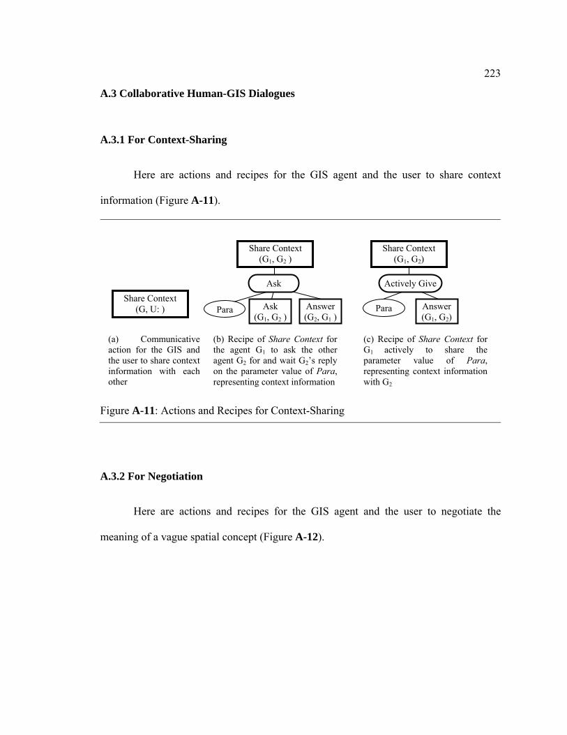
223
A.3 Collaborative Human-GIS Dialogues
A.3.1 For Context-Sharing
Here are actions and recipes for the GIS agent and the user to share context
information (Figure A-11).
A.3.2 For Negotiation
Here are actions and recipes for the GIS agent and the user to negotiate the
meaning of a vague spatial concept (Figure A-12).
Figure A-11: Actions and Recipes for Context-Sharing
Answer (G2, G1 )
Ask (G1, G2 )
Share Context (G1, G2 )
Para Answer (G1, G2)
Para
(b) Recipe of Share Context for the agent G1 to ask the other agent G2 for and wait G2’s reply on the parameter value of Para, representing context information
Ask
Share Context (G1, G2)
Actively Give Share Context
(G, U: )
(a) Communicative action for the GIS and the user to share context information with each other
(c) Recipe of Share Context for G1 actively to share the parameter value of Para, representing context information with G2

224
A.3.3 For Direct Communication
Here are actions and recipes for the GIS agent and the user to directly communicate the
meaning of a vague spatial concept (Figure A-13).
Figure A-12: Actions and Recipes for Negotiation
Refine (G2, G1 )
Ask_Refine(G1, G2 )
Negotiate (G1, G2 )
Para Refine (G1, G2 )
Para
(b) Recipe of Negotiate for G1 to ask for G2’s comment about how to refine the parameter value of Para, representing the meaning of a vague spatial concept
Ask
Negotiate (G1, G2 )
Active Give Negotiate (G, U: )
(a) Communicative action for the GIS and the user to negotiate the meaning of a vague spatial concept
(c) Recipe of Negotiate for G1 to actively share with G2 with his/her commonts on how to refine the parameter value of Para, representing the meaning of a vague spatial concept

225
Figure A-13: Actions and Recipes for Direct Communication
Answer (U: , G)
Ask (G, U: )
Directly Communicate(G, U: )
Para Answer (U: , G)
Para
(b) Recipe of Directly Communicate for the GIS to ask the user for and wait for the user’s reply on the parameter value of Para, representing the meaning of a vague spatial concept
Ask
Directly Communicate (U:, G)
Active Give Directly Communicate
(G, U: )
(a) Communicative action for the GIS and the user to communicate the meaning of the vague spatial concept directly
(c) Recipe of Share Context for the GIS to understand the user’s active providing the parameter value of Para, the meaning of a vague spatial concept

Appendix B
Mental State Numbers in PlanGraph Implemented in GeoDialogue
B.1 MSNs on Action Nodes in PlanGraph
Table B-1: Mental State Numbers (MSNs) on Action α and Their Meanings Label Intention
on doing α Commitment on success of α
Belief (the agent being modeled believes that)
0 individual individual α will be part of collaboration. 1 Individual
& group Individual & mutual
α is part of collaboration. The other agent in collaboration also believes that α is part of collaboration.
2 Individual & group
Individual & mutual
α is basic; The other agent in collaboration would agree to execute it directly.
3 Individual & group
Individual & mutual
α is complex; The other agent in collaboration would agree the particular recipe selected for α.
4_1
individual & group
Individual & mutual
The current plan for α does not succeed, and α can be re-executed with another plan.
4_2a
individual & group
Individual & mutual
The current plan for α to infer the meaning of a vague spatial concept may not succeed because the context information used in this plan is not shared between the agent being modeled and the other agent(s) in collaboration.
4_2b individual & group
Individual & mutual
The current plan for α to infer the meaning of a vague spatial concept does not succeed because the context information used in this plan is not shared between the agent being modeled and the other agent(s) in collaboration.
4_3b individual & group
Individual & mutual
The current plan for α may not succeed although the context information used in this plan has been shared between the agent being modeled and the other agent(s) in collaboration.
4_4a
individual & group
Individual & mutual
The current plan for α does not succeed because its descendants involves a parameter instantiated from a vague spatial concept.
4
4_4b individual & group
Individual & mutual
The current plan for α may not succeed because its descendants involves a parameter instantiated from a vague spatial concept.
5 no no α fails and there are no other plans available to re-perform it or there is no way to improve α.
6 individual & group
Individual & mutual
α was successfully finished.
Note: In this table, “the agent being modeled” means the agent whose dynamic knowledge is representedwith the PlanGraph model. In this study, the agent being modeled is the GIS agent.
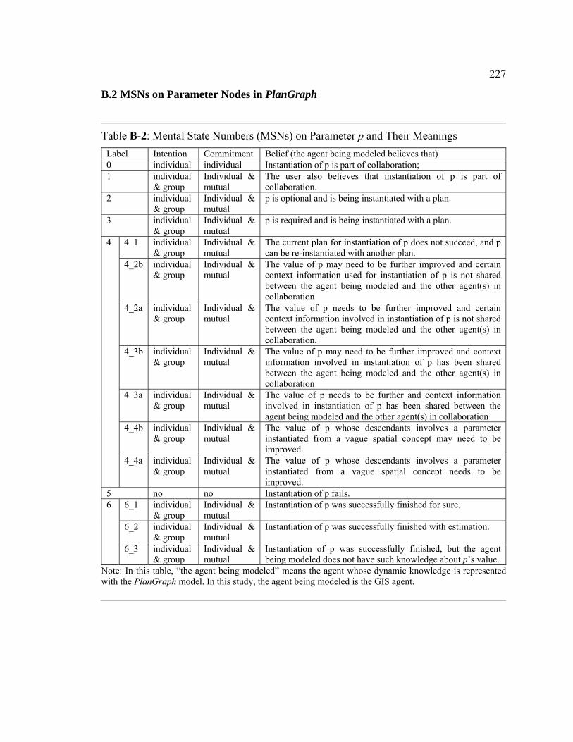
227
B.2 MSNs on Parameter Nodes in PlanGraph
Table B-2: Mental State Numbers (MSNs) on Parameter p and Their Meanings Label Intention Commitment Belief (the agent being modeled believes that) 0 individual individual Instantiation of p is part of collaboration; 1 individual
& group Individual & mutual
The user also believes that instantiation of p is part of collaboration.
2
individual & group
Individual & mutual
p is optional and is being instantiated with a plan.
3 individual & group
Individual & mutual
p is required and is being instantiated with a plan.
4_1 individual & group
Individual & mutual
The current plan for instantiation of p does not succeed, and p can be re-instantiated with another plan.
4_2b individual & group
Individual & mutual
The value of p may need to be further improved and certain context information used for instantiation of p is not shared between the agent being modeled and the other agent(s) in collaboration
4_2a individual & group
Individual & mutual
The value of p needs to be further improved and certain context information involved in instantiation of p is not shared between the agent being modeled and the other agent(s) in collaboration.
4_3b individual & group
Individual & mutual
The value of p may need to be further improved and context information involved in instantiation of p has been shared between the agent being modeled and the other agent(s) in collaboration
4_3a individual & group
Individual & mutual
The value of p needs to be further and context information involved in instantiation of p has been shared between the agent being modeled and the other agent(s) in collaboration
4_4b individual & group
Individual & mutual
The value of p whose descendants involves a parameter instantiated from a vague spatial concept may need to be improved.
4
4_4a individual & group
Individual & mutual
The value of p whose descendants involves a parameter instantiated from a vague spatial concept needs to be improved.
5 no no Instantiation of p fails. 6_1 individual
& group Individual & mutual
Instantiation of p was successfully finished for sure.
6_2 individual & group
Individual & mutual
Instantiation of p was successfully finished with estimation.
6
6_3 individual & group
Individual & mutual
Instantiation of p was successfully finished, but the agent being modeled does not have such knowledge about p’s value.
Note: In this table, “the agent being modeled” means the agent whose dynamic knowledge is representedwith the PlanGraph model. In this study, the agent being modeled is the GIS agent.
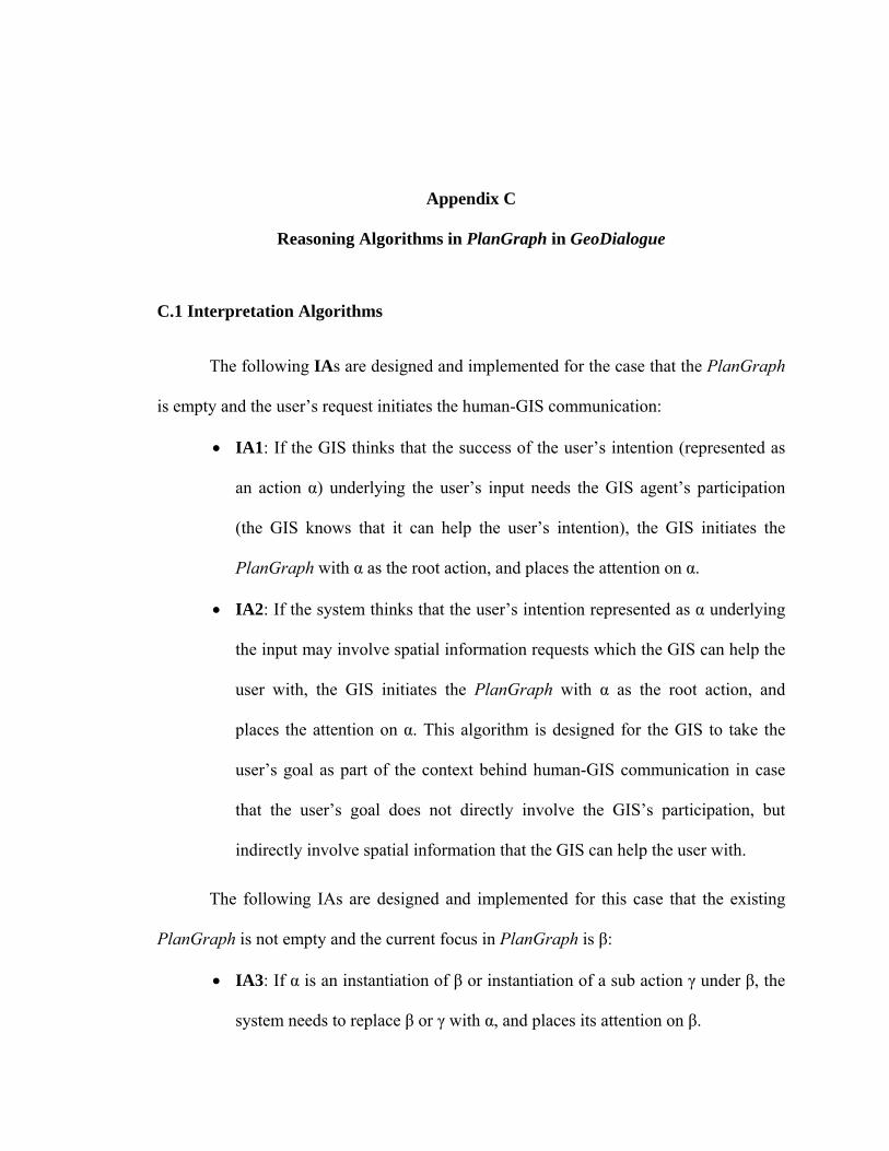
Appendix C
Reasoning Algorithms in PlanGraph in GeoDialogue
C.1 Interpretation Algorithms
The following IAs are designed and implemented for the case that the PlanGraph
is empty and the user’s request initiates the human-GIS communication:
• IA1: If the GIS thinks that the success of the user’s intention (represented as
an action α) underlying the user’s input needs the GIS agent’s participation
(the GIS knows that it can help the user’s intention), the GIS initiates the
PlanGraph with α as the root action, and places the attention on α.
• IA2: If the system thinks that the user’s intention represented as α underlying
the input may involve spatial information requests which the GIS can help the
user with, the GIS initiates the PlanGraph with α as the root action, and
places the attention on α. This algorithm is designed for the GIS to take the
user’s goal as part of the context behind human-GIS communication in case
that the user’s goal does not directly involve the GIS’s participation, but
indirectly involve spatial information that the GIS can help the user with.
The following IAs are designed and implemented for this case that the existing
PlanGraph is not empty and the current focus in PlanGraph is β:
• IA3: If α is an instantiation of β or instantiation of a sub action γ under β, the
system needs to replace β or γ with α, and places its attention on β.

229
• IA4: If α is part of a recipe R for β and constraints associated with R are met,
the system needs to replace β with the recipe R in the PlanGraph, updates
MSN on β as 3, and place its attention on β or β’s first descendant or β’s first
ascedent which the GIS agent can may participate in.
• IA5: If the focus action β is part of α after elaboration of α with certain recipes
Rs, and constraints required for Rs are met, the system needs to integrate Rs
for α with the PlanGraph, updates MSN on α as 3, and place attention on β
after elaborating α with information available. This algorithm is designed for
the GIS to understand the user’s goal under the current utterance as the
context involving the current focus on the PlanGraph.
• IA6: If α is part of the focus action β after elaboration of β with certain recipes
Rs and constraints required for Rs are met, the system needs to integrate α
with the PlanGraph through Rs, updates MSN on α as 3, and place attention
on α after elaborating β with information available. This algorithm is designed
for the GIS to integrate the user’s spatial information request with the context
as the current focus on the PlanGraph.
• IA7: This algorithm works in the case that the user’s intention represented as
the action α is to improve the current parameter value of a parameter p around
the focus action β in the PlanGraph:
o (a): α is to instantiate a parameter p in β in PlanGraph, the GIS moves
attention to p after updating its MSN on β as 3 and MSNs on subactions in
β as 1.

230
o (b): α is to instantiate a parameter p in one of descendants of β in
PlanGraph, the GIS updates its MSN on β as 3 and MSNs all descendant
actions which need to be executed after instantiation of p as 1.
o (c): to instantiate a parameter p in the focus action β’s ascendant action,
and the system’s MSN on the parameter p is not 6_1 (that is, p’s existing
value is not instantiated for sure), then, the system moves attention back to
β after completing instantiating the parameter p ( updates its MSN on p
and attaches α to the parameter p later).
• IA8: If the user’s intention represented as the action α is to express the user’s
mental attitude (agreement or disagreement) on the focus action β, and the
focus action β in PlanGraph has MSN as 4_4b, the GIS updates MSN on β in
terms of the user’s attitude.This algorithm is designed for the GIS to recognize
the user’s mental attitude on the result of human-GIS collaboration.
• IA9: If the user’s intention represented as the action α is to express the user’s
new information request (different from the original one involving the vague
spatial concept), and the focus action β in PlanGraph representing the last
spatial information request has MSN as 4_4a, the GIS agent changes MSN on
β as 4_4b and integrate the new information request with the existing
PlanGraph after checking the parent action γ of β. This algorithm is
specifically designed for the GIS to recognize the user’s new spatial
information request when the last spatial information still needs to be
improved.

231
o (a): if the required information corresponds to one of parameters involved
in the existing plan of γ, the GIS agent interprets α as initiating Share
Context with the recipe Ask and moves attention back to β after finishing
Ask.
o (b): if the existing plan for γ does not include a parameter corresponding
to the new required information, the GIS agent can re-elaborate γ so that
the parameter corresponding to the new information requested is included
in the new plan for γ, the GIS agent interprets α as initiating Share Context
with the recipe Ask and moves attention back to β after finishing Ask;
o (c): if the existing plan for γ does not include a parameter corresponding
to the new required information, the GIS agent fails to include the
parameter corresponding to the new information requested in a new plan
for γ, the GIS agent directly interprets the new information request and
moves attention back to β after finishing elaborating the new request.
C.2 Output Algorithms
Two ORs are described as follows.
OR1: If the focus action α is a communicative action to be initiated by the GIS,
the system outputs the responses that have been generated so far (including map
responses and the system’s explanation/questions), updates MSN on α as 6 and moves
attention to next sibling node if any or the parent of α.

232
OR2: If the focus action is the last action that the GIS can participate in
PlanGraph, the system outputs the responses. This algorithm is designed by following
the theorem in the Joint Intention theory (Cohen & Levesque, 1991) that, as to a jointed
commitment, the individual agent should keep other agents in collaboration mutually
known the status of the joint commitment.
C.3 Elaboration Algorithms
C.3.1 Elaboration Algorithms for Actions
In case that the focus action α is non-communicative, a set of EAAs are designed
and implemented for the GIS agent to reason what, when and how to do next with α in
terms of the GIS agent’s MSN on α:
• EAA0: In case that the MSN on α is 0, the GIS directly changes MSN as 1. In
this study, the GIS keeps default MSNs as 0 on all actions that are just added
in PlanGraph. With this algorithm, the GIS agent changes the initial intention,
commitment and belief on α from individual to joint/mutual. This algorithm is
designed under the assumption that the user always believes the GIS agent’s
capability to help the user for the user’s spatial information request and the
GIS always knows that the user believes its capabilities unless that the GIS
explicitly informs that it can not fulfill the user’s request.
• EAA1: In case that the MSN on α is 1:
o If α is basic, the system updates its MSN on it as 2;

233
o If α is complex, the system finds a suitable recipe from its knowledge base
if possible, integrates this recipe to the PlanGraph and updates its MSN
on α as 3;
o If α is complex, and there is no suitable recipe (the system does not know
how to do α), currently, the system updates its MSN on it as 5 and
generate a response to the user which indicates the failure on this action;
• EAA2: In case that the MSN on α is 2, the system directly executes it and
updates its mental status depending on the execution result.
• EAA3: If the MSN on α is 3,
o a)if there are any parameters/subactions under α that have not been
finished, the system places the attention on the first parameter/subaction
under α to be handled.
o b) in case that α is not to instantiate a parameter value from a vague
spatial concept, and all its subactions have been finished, the GIS agent
update its MSN on α in terms of the results of instantiation of all
parameters and execution of all subactions involved in the plan for α. For
example,
1) if all its α’s parameters and sub actions have been finished
successfully, the system updates MSN on α as success (6);
2) if part of its subactions/parameters has MSN as 4, the system
updates MSN on α as 4_4b.

234
3) if one of child nodes has MSN as 5, the system changes its MSN on
α as 4_1 if there is another appropriate recipe for α, otherwise keeps
its MSN on α as 5 if no more appropriate recipe for α exists.
o c) in case that α is to instantiate a parameter value from a vague spatial
concept, and all its subactions have been finished, the GIS agent update its
MSN on α in terms of the results of instantiation of all parameters and
execution of all subactions involved in the plan for α:
if all the parameters and subactions under α have been finished
successfully for sure (all MSN on subactions are 6 and all MSN on
parameters are 6_1 or 6_3), the system updates MSN on α as 4_3b. In
this case, context information used in the plan to infer the meaning of
the vague spatial concept has been shared between the GIS and the
user.
if part of parameters (representing context information) under α are
estimated by the GIS (MSNs on them are 6_2), the system updates
MSN on α as 4_2b. In this case, certain context information used in
the plan to infer the meaning of the vague spatial concept has not been
shared between the GIS and the user.
• EAA4: Here gives details of a few example EAA4:
o _1) If MSN on α = 4_1, the system finds another recipe R for α (or
another way to do α), replace α with R in PlanGraph, updates the mental
status on α as 3, and places its attention on α . This algorithm is designed
for the GIS to reason how to elaborate a regular action α in case that the

235
plan for α fails and another appropriate recipe for α exists. This algorithm
follows the way by which the human communicator tries different plans to
do an action if the current plan for this action fails.
o _2)
(b) if MSN on α = 4_2b, the system moves attention to α’s parent
node, that is, the parameter instantiated from the vague spatial
concept. This algorithm is designed for the GIS to continue the current
plan for α toward returning the user a response with an inferred
meaning of the vague spatial concept.
(a) if MSN on α = 4_2a, the system changes MSN on α as 3, and
changes MSNs on α’s child nodes to improve the existing plan for α
(in case that MSN on α’s parameter is 6_2, the system changes its
MSN on the parameter as 1; in case that MSN on α’s sub action is 6,
the system changes its MSN on the sub action as 1). This algorithm is
designed for the GIS to improve the previous plan to infer the
meaning of the vague spatial concept by improving instantiation of
optional parameters representing major context information involved
in this previous plan. Improving instantiation of these optional
parameters with estimated values will lead to collaborative human-
GIS dialogues for Share Context.
o _3) if MSN on α = 4_3b, the system moves attention to α’s parent node,
that is, the parameter instantiated from the vague spatial concept and
updates its MSN on this parameter as 4_3b. This algorithm is designed for

236
the GIS to continue the current plan for α towards giving the user a
response with an inferred meaning of the vague spatial concept.
o _4)
if MSN on α = 4_4b, the system generates a response indicating the
result of execution of α with an inferred meaning of the vague spatial
concept if α directly involves a parameter instantiated from a vague
spatial concept, and moves attention to α’s next sibling node if any, or
moves attention to α’s parent node that the GIS can participate in if no
sibling action node exists, or if α is the last action in PlanGraph that
involves the GIS agent’s participation, the GIS keeps attention on α
after generating a response indicating the vagueness problem (e. g. “Is
this OK?”). This algorithm is designed for the GIS to continue the
current plan to execute a GIS command with an inferred meaning of
the vague spatial concept.
if MSN on α = 4_4a, the system changes MSN on α as 3, and changes
MSNs on α’s child nodes:
• If the user’s newest utterance contains information about revising
any parameter p of α, the GIS agent changes MSN on p as 1 and
MSN on all subactions under α as 1, moves attention to only p and
all subactions under α; otherwise
• The GIS agent changes MSNs on α’s child nodes (in case that
MSN on α’s parameter is 4_2b, 4_3b or 4_4b, the system changes
its MSN on the parameter as 4_2a, 4_3a ir 4_4a correspondingly;
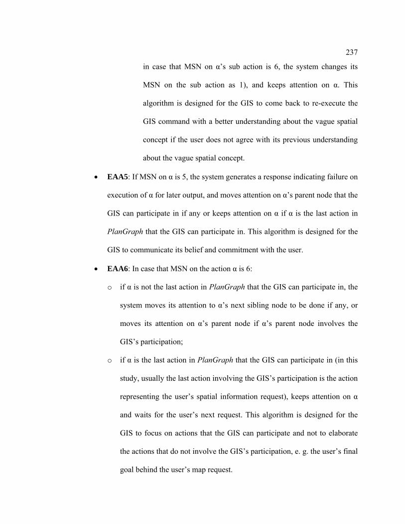
237
in case that MSN on α’s sub action is 6, the system changes its
MSN on the sub action as 1), and keeps attention on α. This
algorithm is designed for the GIS to come back to re-execute the
GIS command with a better understanding about the vague spatial
concept if the user does not agree with its previous understanding
about the vague spatial concept.
• EAA5: If MSN on α is 5, the system generates a response indicating failure on
execution of α for later output, and moves attention on α’s parent node that the
GIS can participate in if any or keeps attention on α if α is the last action in
PlanGraph that the GIS can participate in. This algorithm is designed for the
GIS to communicate its belief and commitment with the user.
• EAA6: In case that MSN on the action α is 6:
o if α is not the last action in PlanGraph that the GIS can participate in, the
system moves its attention to α’s next sibling node to be done if any, or
moves its attention on α’s parent node if α’s parent node involves the
GIS’s participation;
o if α is the last action in PlanGraph that the GIS can participate in (in this
study, usually the last action involving the GIS’s participation is the action
representing the user’s spatial information request), keeps attention on α
and waits for the user’s next request. This algorithm is designed for the
GIS to focus on actions that the GIS can participate and not to elaborate
the actions that do not involve the GIS’s participation, e. g. the user’s final
goal behind the user’s map request.

238
In case that the focus action α is communicative, the following are a set of EAAs
for the GIS agent to reason what, when and how to do next with α in terms of the GIS
agent’s MSN on α:
• EAAU: In case that the system’s current attention is on a non-communicative
action α to be done by the user,
o If α is not the parent of the action representing the user’s spatial
information request, then the GIS changes its MSN on the action α as 6.
This reasoning algorithm is designed under the assumption that the GIS
agent believes that the user can successfully finish the user’s duty in the
human-GIS collaboration.
o If α is the parent of the action β representing the user’s spatial information
request, the GIS moves attention to the next action on PlanGraph that the
GIS can participate in.
• EAAC: In case that the system’s current attention is on a communicative
action α, if α is to be initiated by the system, the GIS changes its MSN on α as
6 after generating the response to the user under the assumption that the GIS
usually can successfully send out the response to the user; if α is to be initiated
by the user, the GIS changes its MSN on α in terms of the result of
interpretation of the user’s input (if the user’s input satisfies the expected need
on α, then the GIS changes its MSN on α as 6, otherwise as 5).

239
C.3.2 Elaboration Algorithms for Parameters
A set of EAPs are designed as follows:
• EAP0: In case that the MSN on p is 0, the GIS directly changes MSN as 1. In
this study, the GIS keeps default MSNs as 0 on all parameters in actions/their
recipes that are integrated in PlanGraph. With this algorithm, the GIS agent
changes its intention and commitments on p’s instantiation from individual
one to joint one. This algorithm is designed under the assumption that the user
and the GIS in collaboration always commit to helping each other on
instantiating parameters involved in the collaboration.
• EAP1: In case that the MSN on p is 1, the GIS agent attaches an action α with
p to instantiate p, places attention on α and updates MSN on p as 2 or 3
depending on that if p is optional or required. In case that p is an optional
parameter representing a context factor involved in an action to instantiate a
parameter from a vague spatial concept:
o a) If p does not have an estimated parameter value already (which means
that this is the first time for p to be elaborated), the GIS agent needs to
check if the corresponding part p’ (corresponding to p) in the action β
representing the context directly behind the user’s spatial information
request to the GIS exists in the existing PlanGraph first before moving
attention on further elaboration of the action Instantiate Ct to instantiate p:
If p’ exists in β, the GIS agent moves attention on further elaboration
of Instantiate Ct;

240
If not, before moving attention back to Instantiate Ct, the GIS agent
needs to elaborate β until p’ can be found in the existing PlanGraph.
During the process of elaboration of β, the GIS agent needs to
elaborate parameter nodes and ignore the action nodes to be done by
the user. If a parameter q in β represents spatial information needed in
β, which is not the spatial information requested by the user, the GIS
agent can actively show the parameter value of q if it is not currently
on the map in order to build a shared context with the user. In case that
p represents the user’s goal in the context behind the user request and β
does not exist in the existing PlanGraph, the GIS agent needs to
instantiate p first to determine β, and then integrate β with the existing
PlanGraph before instantiating other optional parameters representing
other context factors. In this study, the GIS can either infer it or
directly use the communicative action Share Context to determine it.
o b) If p has an estimated parameter value pv already (which means that the
GIS agent re-elaborates p), the GIS agent needs to check if p’ in β first
before moving attention on further elaboration of the action Instantiate Ct
to instantiate p:
If p’ exists in β and p’ has a new value different from pv, the GIS agent
moves attention on further elaboration of Instantiate Ct; If p’ does
exist in β and p’ has a value same as pv, the GIS agent changes MSN
on p’ as 0, and attaches an communicative action Share Context with
p’. If p’ is the human agent in the plans representing the human-GIS

241
collaboration, the GIS agent directly attaches Share Context with p and
updates all p’ after instantiation of p. This algorithm is designed by
following the HCP2(c).
If p’ does not exists in β, before moving attention back to Instantiate
Ct, the GIS agent needs to elaborate β until p’ can be found in the
existing PlanGraph. During the process of elaboration of β, the GIS
agent needs to elaborate parameter nodes and ignore the action nodes
to be done by the user. If p represents the user’s goal in the context
behind the spatial information request, the GIS agent needs to
determine β first.
• EAP2/3: In case that the MSN on p is 2/3, the system updates its MSN on p
depending on the result of the action α under p to instantiate p. For example:
o a) if MSN on α is 4_2b, 4_3b, 4_4b (this means that p is instantiated from
a vague concept or instantiated from a GIS command involving a
parameter instantiated from a vague spatial concept, and may need
improvement later), the system updates MSN on p as 4_2b, 4_3b, or 4_4b
correspondingly; An exceptional case is that, if p is re-estimated with a
same value as before, the system directly updates MSN on p as 4_2a,
4_3a, or 4_4a correspondingly;
o b) if MSN on α is 6 and α is a communicative action for the GIS to
achieve the parameter value for p which was instantiated from a vague
spatial concept, the system updates MSN on p as 4_3b;

242
o c) if MSN on α is 6 and p is not a parameter which was instantiated from a
vague spatial concept, the system updates its MSN on p as 6_1 (if p is
instantiated with information from the human-GIS dialogue or the GIS’s
spatial database) or 6_2 (if p is instantiated from a recipe to infer the
parameter value).
o d) if MSN on α is 5, the system updates MSN on p as 4_1 if there is
another appropriate way (another recipe for α or use communicative
actions) to instantiate p; otherwise the system updates its MSN on p as 5.
• EAP4: In case that the MSN on p is 4, the GIS either continue to elaborate the
remaining parameters/subactions in PlanGraph with an inferred parameter
value for p from a vague spatial concept towards returning spatial information
requested by the user, or try to improve the parameter value of p after
receiving the user’s negative comments on the existing parameter value for p.
o _1) if MSN on p is 4_1, the system updates its MSN on p as 2 or 3
depending on whether p is optional or required, and moves attention to its
child action.
o _2)
if MSN on p = 4_2b, the system generates a response indicating
inferred context information used to infer the meaning of the vague
spatial concept, and moves attention to p’s sibling node. This algorithm
is designed for the GIS to continue to execute the GIS command with
an inferred understanding of the vague spatial concept with inferred
context information and inform the user the inferred context

243
information later by returning a speech response together with the map
response.
if MSN on p = 4_2a, the system changes MSN on p as 2 or 3
depending on whether p is optional or required, and places attention on
improving instantiation of p with the previous plan or the new plan
suggested by the user. In the former case, the system moves attention
to the previous plan R under p, and changes MSN on R as 4_2a.
o _3)
if MSN on p = 4_3b, the system moves attention to p’s sibling node.
if MSN on p = 4_3a, the system changes its MSNs on p and its child
action as 4_1.
o _4)
if MSN on p = 4_4b, the system moves attention to p’s next sibling
node. This algorithm is designed for the GIS to continue to execute
certain actions with an inferred understanding of the vague spatial
concept.
if MSN on p = 4_4a, the system changes MSN on p as 2 or 3
depending on whether p is optional or required, and places attention on
improving the action to instantiate p with the new plan proposed by the
user or the previous plan. In the later case, the system moves attention
to the previous plan R under p, and changes MSN on R as 4_4a. This
algorithm is designed for the GIS to re-visit the previous plan to

244
instantiate the parameter value in case that the GIS and the user have
not reached agreement on the existing parameter value of p.
• EAP5: If MSN on p = 5, the system generates a response indicating the failure
of p’s in instantiation for later output and moves attention on p’s parent node
in PlanGraph. This algorithm is designed for the GIS to communicate its
belief (failure) on instantiation of p to the user.
• EAP6: In case that MSN on p is 6 (6_1, 6_2, or 6_3), the GIS moves attention
to the next node in the PlanGraph that the GIS needs to elaborate.
o If p represents the user’s goal in the context behind the user request and
the GIS agent keeps MSN on p as 6_2, the GIS agent needs to integrate
the action (MSN 3) representing the user’s goal (with an appropriate
recipe) with the existing PlanGraph before moving attention to the next
node in the PlanGraph.

VITA
Hongmei Wang received the B. E. degree from Department of Geoscience,
Changchun College of Geology, P. R. China, in 1994, and the M. S. degree from Institute
of Remote Sensing Applications, Chinese Academy of Sciences, P. R. China, in 1997.
She had worked in Institute of Remote Sensing Applications, Chinese Academy of
Sciences, P. R. China, as a Research Associate from August 1997 to August 2000. From
September 2000 to July 2001, she had been a Master student in Department of
Geography, York University, Canada. Since August 2001, she has been a Ph. D student
in the College of Information Sciences and Technology, The Pennsylvania State
University, University Park, PA. Her current research interests lie on the boarder of
computer science and geography.


