A Review of the Whittenton Dam Crisis
Nicole M. BelkSenior Service Hydrologist
NWS Weather Forecast Office, Taunton, MA
David R. ValleeHydrologist-in-Charge
NWS Northeast River Forecast Center, Taunton, MA

Objectives
Review Hydro-meteorological evolution of events leading up to the potential dam failure
Examine the flood potential should the Whittenton Pond and/or Morey’s Bridge Dam had failed
Discuss the WFO/RFC capabilities to provide support during dam failure events

Hydro-met perspective
Back to back prolific rainfall events October 7-9 and October 13-16
First system dropped 3-5 inches Second system dropped 6-8 inches Both systems were linked to the deep
tropics – deep moisture plume

Round One:Tropical Storm Tammy
remnants and a slow moving frontal systemOctober 7-9, 2005


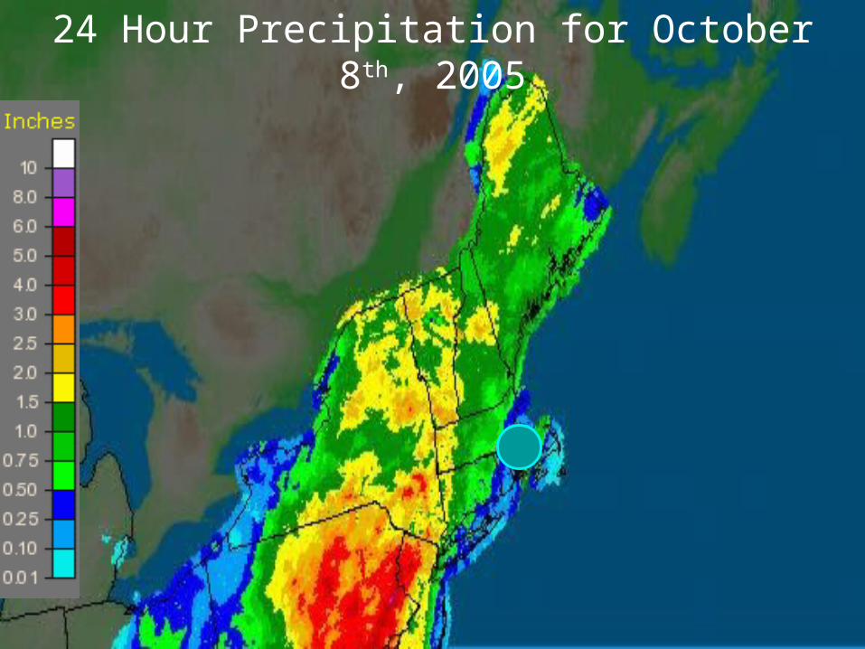
24 Hour Precipitation for October 8th, 2005

24 Hour Precipitation for October 9th, 2005
SE MassachusettsEvent Total: 3-5”
Round Two:Off-shore storm development and remnants of Subtropical
TD 22October 13-16, 2005

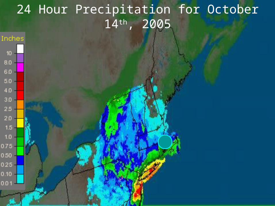
24 Hour Precipitation for October 14th, 2005

24 Hour Precipitation for October 15th, 2005

24 Hour Precipitation for October 16th, 2005
SE MassachusettsEvent Total: 6-8”(most of this fell in a 6 to 12 hour period)

Examining the Potential Dam Failure(s)
Crisis began 3 pm, Monday, Oct 17th
Taunton EMA called in the imminent failure of Whittenton Dam on the Mill River
Just upstream of the city center
Two structures at risk: Most immediate concern: Whittenton Dam
Built in the late 1800s, limited refurbishment in 1950s
Complicating matters: Morey’s Bridge Dam Holding back Lake Sabattia

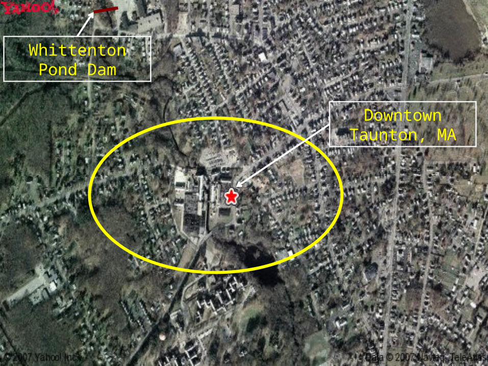
Whittenton Pond Dam
Downtown Taunton, MA

NWS CapabilitiesWhat we need from you
Have your local NWS office high on the local notification list for dams in your area High Hazard dams have Emergency Action Plans
(EAPs) – ensure the NWS is high on the notification tree
Most important information for the dam: The correct name of the dam! County & town the dam is located River, stream or lake the dam is on NID or State ID, Dam Type (earth, concrete) Condition of the dam
Width of breach Is the failure in progress or imminent Is the pool/lake full, ½ full, etc.

NWS CapabilitiesWhat we will provide you
Initial estimate of flood wave and the time to reach the nearest downstream location For Whittenton Dam – a Flash Flood Warning was issued almost
immediately after notification from EMA Time to fail = 5 minutes; a flood wave producing a peak depth
of 5 feet reaching downtown Taunton in ~ 20 minutes

Scenario One: Whittenton Fails
Additional CapabilitiesIf Time Allows!

City of interest: Taunton
Time elapsed from failure to Peak depth at Taunton: 8-14 minutes
Peak depth of flood: 5.4 feet – flood elevation exceeded for 1 hour
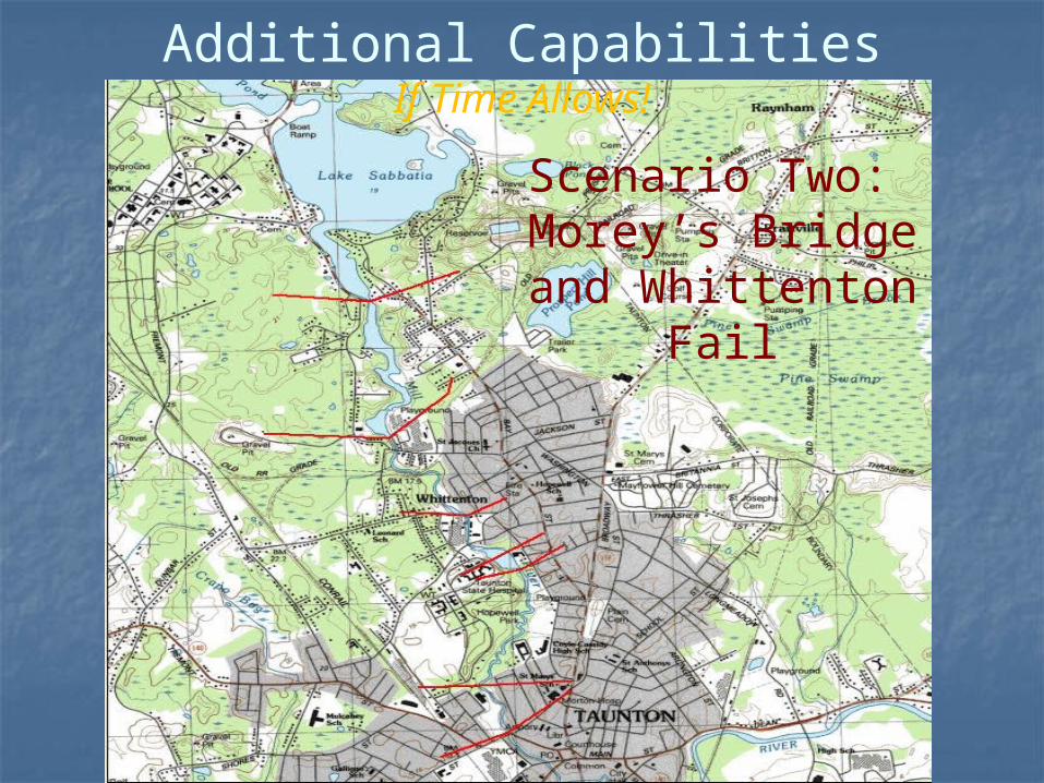
Additional CapabilitiesIf Time Allows!
Scenario Two: Morey’s Bridge and Whittenton
Fail
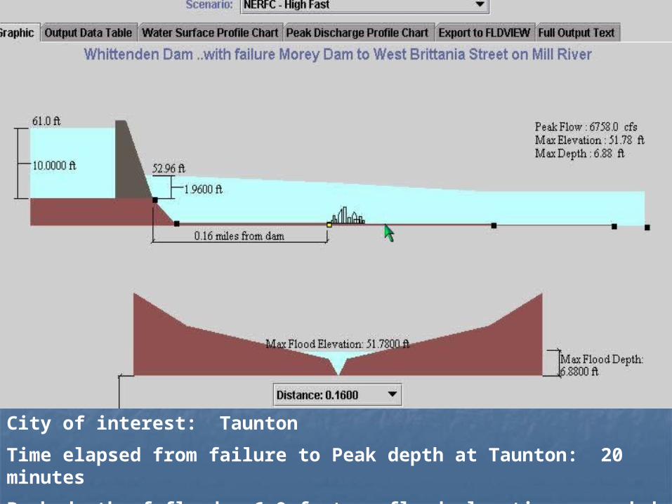
City of interest: Taunton
Time elapsed from failure to Peak depth at Taunton: 20 minutes
Peak depth of flood: 6.9 feet - flood elevation exceeded for ~ 12-18 hours

As for the eventual outcome…A near-failure as the USACE was successful in an emergency operation to draw down the pool and
gracefully take down the dam!
In just a matter of hours – note the bowing of the wooden structure!

USACE to the rescue – While NWS watched Hurricane Wilma like a Hawk
They need 84 hours to pull this off – Hurricane Wilma brought rains as forecast ~
hour 96!
During The Flooding
The New Dam

NWS Response WFO Taunton was notified 3 pm October
17th – Flash Flood Warning was issued for imminent failure Upon issuance, the city of Taunton ordered
evacuations of all downstream areas in the floodplain
Shut down businesses, schools, city offices RFC/WFO teamed to produce dam breach
simulations (DamCrest) program WFO/RFC provided both remote and on-site
Decision Support to the city of Taunton through the following weekend

A Review of the Whittenton Dam Crisis
Nicole M. BelkSenior Service Hydrologist
NWS Weather Forecast Office, Taunton, MA
David R. ValleeHydrologist-in-Charge
NWS Northeast River Forecast Center, Taunton, MA


