CAPAS A Service for Improving the Assignments of
Common Agriculture Policy Funds to Farmers and Land Owners
1Mariano Navarro, 1Ramón Baiget, 1Jesús Estrada, and 2Dumitru Roman1TRAGSA Group, Spain and 2SINTEF, Norway
@RuleML 2015

TRAGSA Grouphttp://www.tragsa.es
• A Spanish public sector administration company
• ~ 4000 people (Tragsatec)
• Provision of agricultural, forestry, livestock, and rural development services, to the conservation and protection of the environment
2

For the last 50 years the Common Agricultural Policy (CAP) has been the European Union's (EU) most important common policy. This explains why traditionally it has taken a large part of the EU's budget […]REGULATION (EU) No 1306/2013 OF THE EUROPEAN PARLIAMENT AND OF THE COUNCIL of 17 December 2013
3

• Stakeholders:• Public administration (e.g. FEGA in
Spain)• Farmers and land owners• Intermediaries (e.g. service providers)
• Problems:• Unfair grant assignment and
expenditure on audits• Incorrect grant assignments
• Farmers could loose close to 30% of funding
CAP funds assignments
4
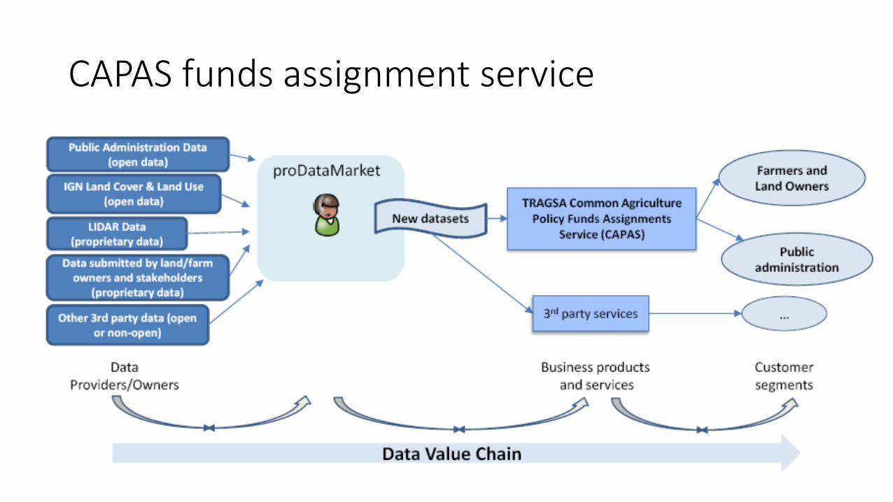
CAPAS funds assignment service
5

Technological Challenges
• Datasets:
• Volume
• Heterogeneity
• Different sectors and sources
• Technical process:
• Dynamic
• Integration
05.08.2015 proDataMarket 6
Free Maps Layers
WMS, WFS - Inspire
Lidar
Integration of
data from different
sources and scales
Dynamic process
Agricultural parcels
+
Cadastre / Land
registry
Land Cover – Land Use
INSPIRE – EU 2020

Example technical challenges: working with LIDAR data
7
• LIDAR Dataset• Points cloud• Relief• Elevation profile• Vegetation and crops type
LiDAR
CLASSES
Vegetation
Soil
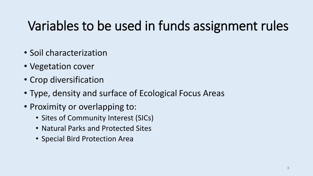
Variables to be used in funds assignment rules
• Soil characterization
• Vegetation cover
• Crop diversification
• Type, density and surface of Ecological Focus Areas
• Proximity or overlapping to:• Sites of Community Interest (SICs)
• Natural Parks and Protected Sites
• Special Bird Protection Area
8
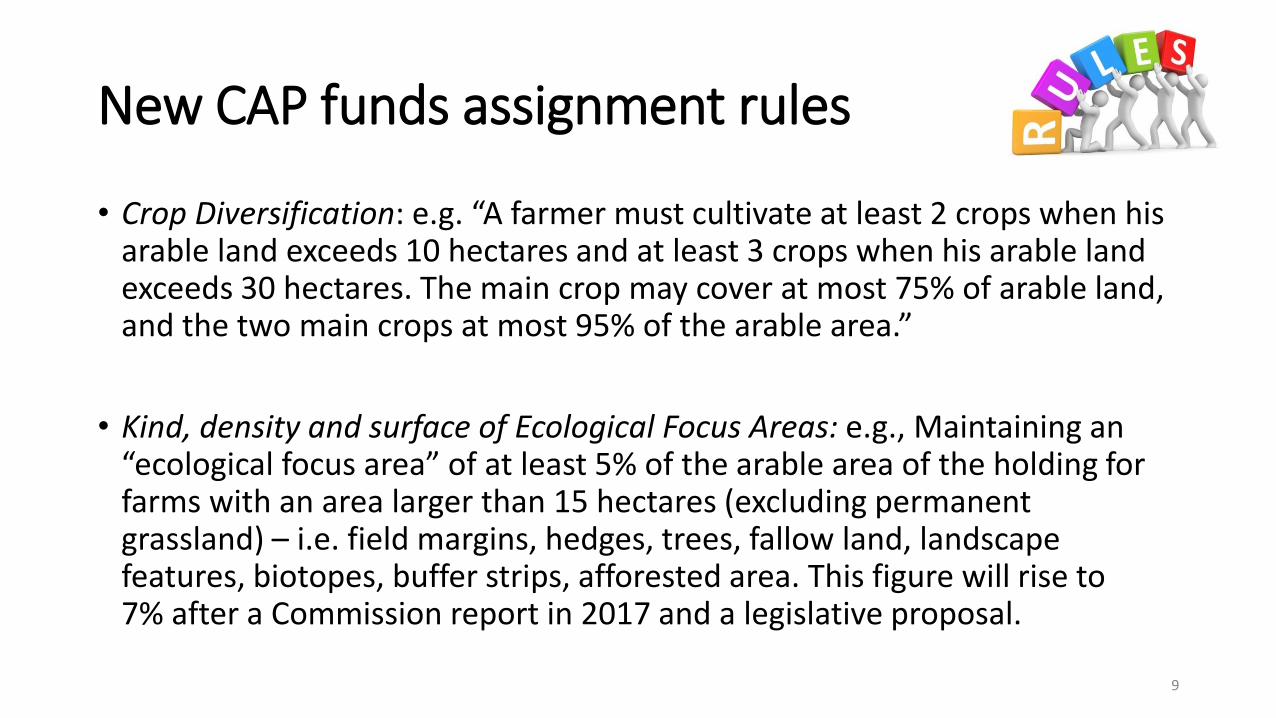
New CAP funds assignment rules
• Crop Diversification: e.g. “A farmer must cultivate at least 2 crops when his arable land exceeds 10 hectares and at least 3 crops when his arable land exceeds 30 hectares. The main crop may cover at most 75% of arable land, and the two main crops at most 95% of the arable area.”
• Kind, density and surface of Ecological Focus Areas: e.g., Maintaining an “ecological focus area” of at least 5% of the arable area of the holding for farms with an area larger than 15 hectares (excluding permanent grassland) – i.e. field margins, hedges, trees, fallow land, landscape features, biotopes, buffer strips, afforested area. This figure will rise to 7% after a Commission report in 2017 and a legislative proposal.
9

New CAP funds assignment rules (cont’)
• Ecological focus areas (EFA) on farms (determined by each member country within the categories established by the EU)• Are there EFAs in a specific parcel? How large are they? What is the surface ratio
between arable lands and EFAs surfaces?
• Conditionality - Obligations related to:• Public Health: Use of authorized pesticides, Avoiding pollution, Appropriate products
storing…• Environment: Avoiding groundwater pollution, Preservation of wild animals and
birds, Avoiding plastics pollution, Sewage sludge (they can be used only during a specific period before grazing)…
• Satisfactory Conditions-Good practices: Avoiding erosion, Avoiding water wasting, Avoiding spontaneous vegetation invasion…
10

Some characteristics of the rules
• Complexity• Direct translation from legal and administrative language
• Correct interpretation of the rules
• Potentially large number of rules
• Specification• Indirectly, by European Commission or National Administrations
(Transposition), and refined by other stakeholders
• Frequency of change• Not less than a year; typically 4-5 years
11

Preliminary result: CAPAS service
12
Currently integrated data: • Permanent pasture• Landscape elements• Crop protection products and
pollution produced by them
http://sigpac.mapa.es/fega/visor/

Importance
• Exploitation of cross-sectorial data sources
• Publication and use of currently collected but unused datasets in the distribution of funds algorithm
• New data processing algorithms over LIDAR Big Data
• Cadastre and ownership information enriched with biodiversity information
• Implementation of European 2020 CAP funds assignment rules
13

Impacts and outcomes
• Sharing of TRAGSA internal property datasets in novel ways
• Exploitation of cadastral data and other cross-sectorial data
• Sharing the GIS descriptive data obtained from LIDAR in novel ways
• Internationalization process
• Fairer funds assignment
• Public costs saving
14
Thank you!Contact: [email protected]; [email protected]
http://prodatamarket.eu
http://www.smartopendata.eu
http://www.tragsa.es
@prodatamarket
@smartopendata


