
ABSTRACT
Title of Thesis: Revealing Risk & Redefining Development:
Exploring Hurricane Impact on St. Croix, USVI
Name of degree candidate: Risa Dessel Abraham
Degree and year: Master of Landscape Architecture, 2013
Thesis directed by: Dr. Byoung-Suk Kweon Ph.D.
Professor, Department of Plant Science
And Landscape Architecture
This thesis explores the direct and indirect role of landscape architecture in
disaster risk reduction specifically focusing on designing and managing natural resources
such as sun, wind and water as well as allocating infrastructure to improve the power and
transportation system on the public, private and regulatory levels that can prove to endure
the impact of a hurricane and promote a “culture of prevention.” Every year natural
disasters cause a substantial amount of damage throughout the whole world bringing
forward the importance of disaster risk reduction to prevent or to mitigate the adverse
impacts of disasters. A two-step approach was formalized to develop an understanding
and to produce a design proposal based on the practice and theories of landscape
architecture. The findings from both steps will be applied to re-design the town of
Christiansted, St. Croix, in the United States Virgin Islands.

REVEALING RISK & REDEFINING DEVELOPMENT:
EXPLORING HURRICANE IMPACT ON ST. CROIX, USVI
By
Risa Abraham
Thesis submitted to the Faculty of the Graduate School of the
University of Maryland, College Park in partial fulfillment
of the requirements for the degree of
Master of Landscape Architecture
2013
Advisory Committee:
Assistant Professor Byoung-Suk Kweon, Ph.D. Committee Chair
Associate Professor Christopher Ellis, Ph.D., ASLA
Adjunct Instructor Caren Yglesias, Ph.D., AIA

© Copyright by
Risa Dessel Abraham
2013

ii
ACKNOWLEDGEMENTS
This thesis would not have been possible without the support of my family, friends and
coworkers. Their continual encouragement helps me get through every obstacle I face.
Byoung-Suk Kweon, my committee chair, whose wonderful support helped to keep me
focused and prepared. Her open heart and patience managed to calm me down and get
through even the toughest of chapters.
Chris Ellis and Caren Yglesias, my committee members, for their enthusiasm and
confidence in my understanding of this topic. Their wealth of knowledge and creativity
helped propel me to thinking beyond anything I could have imagined.
Lastly, for the island that has given me so much, I give this to you.

iii
TABLE OF CONTENTS
ACKNOWLEDGEMENTS ............................................................................................................. ii
TABLE OF CONTENTS ................................................................................................................ iii
LIST OF FIGURES ......................................................................................................................... v
Introduction ...................................................................................................................................... 1
St. Croix ....................................................................................................................................... 1
Methodology ................................................................................................................................ 1
Chapter 1: Literature Review .......................................................................................................... 4
1.1 Definition of Disaster and Disaster Management ................................................................. 4
1.2 Natural Disaster Framework ................................................................................................. 6
1.3 Disaster in the Cultural & Built Environment ...................................................................... 8
1.4 Disaster Risk Reduction in the Built Environment ............................................................. 10
1.4.1 Pre Disaster Protection Phase ...................................................................................... 10
1.4.2 Post Disaster Recovery ................................................................................................ 12
1.5 Conclusions ......................................................................................................................... 13
Chapter 2: A History of Recovery ........................................................................................... 14
2.1 History of St. Croix ........................................................................................................ 14
2.2 Hurricane Activity of St. Croix ...................................................................................... 15
2.3 Virgin Islands History of Disaster ................................................................................. 15
2.4 St. Croix Personal History of Recovery ......................................................................... 17
2.5 Preparation Plans ........................................................................................................... 18
2.6 Conclusions .................................................................................................................... 22
Chapter 3: Site Analysis .......................................................................................................... 23
3.1 Economic ....................................................................................................................... 23
3.2 Topography .................................................................................................................... 23
3.3 Climate .......................................................................................................................... 24
3.4 Water .............................................................................................................................. 25
3.5 Plant Life ........................................................................................................................ 26
3.6 City of Christiansted ...................................................................................................... 26
4.1 USVI Energy Background ............................................................................................. 29

iv
4.2 Developing a Strategic Energy Road Map ..................................................................... 29
4.3 Three Energy Scenarios ................................................................................................. 30
4.3.1 Base Case .......................................................................................................... 32
4.3.2 Solar Technology ................................................................................................... 32
4.4 Conclusions .................................................................................................................... 34
Chapter 5: Design Proposal ..................................................................................................... 36
5.1 Development of Form and Theme ................................................................................. 36
5.1.1 Emergency Preparedness Goals: ............................................................................ 36
5.1.2 Cultural Management Goals: ................................................................................. 37
5.2 Three Levels of Design .................................................................................................. 38
5.2.1 Island .......................................................................................................................... 38
5.2.2 City ............................................................................................................................. 46
5.2.3 Waterfront .................................................................................................................. 54
Bibliography .................................................................................................................................. 75

v
LIST OF FIGURES
Figure 1: Disaster Management Cycle [Kawata]………………..………………….……..8
Figure 2: Map of Christiansted grid layout [Abraham] .................................................... 28
Figure 3: Panoramic view of the Scale & Customs House [Abraham]……………….…29
Figure 4: USVI Solar Resource Map [Abraham] ............................................................. 34
Figure 5: Optimal solar locations map [Abraham] ........................................................... 34
Figure 6: Installed solar panels at Henry Rolsen Airport, St. Croix [Abraham]……..….35
Figure 7: Overlay map of buildings, roads and flood prone areas on St. Croix [Abraham]
........................................................................................................................................... 42
Figure 8: Areas of wind turbine generation [Abraham] .................................................... 43
Figure 9: Area of solar power generation [Abraham] ....................................................... 44
Figure 10: View of Hess Oil Refinery current conditions [Abraham] .............................. 45
Figure 11: View of Hess Oil Refinery current conditions after a hurricane [Abraham] . 46
Figure 12: View of Hess Oil Refinery proposed changes [Abraham] .............................. 46
Figure 13: View of Hess Oil Refinery proposed changes after a hurricane [Abraham] .. 47
Figure 14: Ariel view of Christiansted [Abraham] .......................................................... 48
Figure 15: Map of Christiansted grid pattern [Abraham] ................................................ 49
Figure 16: Map of building categories [Abraham]………………………………………50
Figure 17: Map of three levels of roads [Abraham]…………………….........................50
Figure 18: Map of key buildings and drop off areas [Abraham] .................... …………..51
Figure 19: Locations of bioswales within city limits [Abraham]………………………..53
Figure 20: Section of King St. with a bio-swale [Abraham] ............................................ 53
Figure 21: Perspective of bioswale looking north towards Christiansted harbor [Abraham]
........................................................................................................................................... 54
Figure 22: Diagram of emergency areas [Abraham]…………………………………….55
Figure 23: Boardwalk sections [Abraham] ..................................................................... ..56
Figure 24: Plan of Christiansted Wharf area [Abraham] .................................................. 61
Figure 25: Sketches of wave benches [Abraham]............................................................. 62
Figure 26: Section of emergency shelter area at wharf [Abraham] ................................. 64
Figure 27: Perspective of current boardwalk design [Abraham] ..................................... 65
Figure 28: Perspective of current boardwalk design after a hurricane [Abraham] ..... 65
Figure 29: Perspective of proposed boardwalk design [Abraham] ................................... 66
Figure 30: Perspective of proposed boardwalk design after a hurricane [Abraham] ... 66
Figure 31: Stormwater system outfall area current design [Abraham] ............................ 68
Figure 32: Stormwater system outfall area current design after a hurricane [Abraham] . 68
Figure 33: Stormwater system outfall area proposed design [Abraham] ......................... 69
Figure 34: Stormwater system outfall area proposed design after a hurricane [Abraham]
........................................................................................................................................... 69
Figure 35: Fort open lawn current design [Abraham] ...................................................... 70
Figure 36: Fort open lawn current design after a hurricane [Abraham] ........................... 71

vi
Figure 37: Fort open lawn current design [Abraham] ...................................................... 71
Figure 38: Fort open lawn current design [Abraham] ...................................................... 72
Figure 39: Diagram of Fort open lawn after a hurricane [Abraham]…………………….73

1
Introduction
St. Croix
Every year thousands of people come and visit the United States Virgin Islands
located in the heart of the Caribbean. Most marvel in the historic, architectural and
economic charm that the local towns and people embody while taking in the wide range
of sites the three islands have to offer. Those who have been to St. Croix have definitely
experienced the main town of Christiansted either by car or on foot. Amidst the historic
buildings and colorful flowers, people often forget about the natural disasters that
frequently, often annually, wreak havoc on this town and island. In 2010, earthquakes,
hurricanes and floods hit numerous countries across the globe, causing loss of life,
suffering and large economic loss. The number of people affected by increasingly
frequent hydrological events all over the world has doubled over the last 30 years.1
The contrasts between countries that have suffered a similar severity of hazard,
but whose losses have been in orders of magnitude greater for lesser-developed countries,
have shown that there is much work to be done in disaster risk reduction.
Conceptualizing the effects of a natural disaster by viewing these along the timeline that
begins with preparedness and ends with recovery is necessary. Envisioning this timeline
as a repeating line, where events reoccur, may encourage increased focus on pre-disaster
initiatives and longer-term thinking for response and recovery.
Methodology
The thesis includes a physical history of the site, documentation of existing
conditions, an analysis and evaluation of landscape characteristics and associated
1 (R.A Pielke 2005).

2
features, and a multi-level guide to mitigate future destruction caused by hurricanes in
Christiansted, St. Croix. It more fully documents the history of hurricanes that have
affected the island, builds upon existing disaster relief processes, and evaluates landscape
characteristics and features contributing to infrastructure failures within the site. In
addition to the existing historic district of Christiansted, this thesis also addresses the
surrounding landscape of the island that can be utilized for Caribbean wide disaster relief
efforts.
The thesis will first focus on the various impacts hurricanes have had and explain
the literature on disaster management. The next section is on disaster risk reduction
practices where relevant literature has been explored of disaster risk reduction and the
history of recovery typical throughout the world. This history is then compared to the
specific history and analysis of St. Croix’s personal recovery; focusing on St. Croix and
the evolution that this landscape has gone through in order to understand how current and
future development might impact disaster recovery. Following this, a detailed look at
alternative energy practices that can be woven through the landscape help to develop the
form and theme later used in the specific site designs. The final section synthesizes all
the findings to provide St. Croix with a comprehensive plan and new design proposal for
Christiansted that can be implemented to help protect the island from the threat of
hurricane destruction.
This thesis is based on a review of existing literature in order to explore disaster
reduction in the built environment. Academic literature, conference papers, journal and
have been used for the review of hurricane impacts on a wide range of locations. The
research portion of this thesis has been developed from the following three main papers:

3
“United Nations International strategy for Disaster Reduction Annual Report” (2010-
201), “FEMA Strategic Plan” (2008-2013), and the “St. Croix Emergency Management
Plan” (2011). Research has been undertaken at a thorough level of investigation,
involving studying primary holdings at the VITEMA Headquarters on St. Thomas
(USVI), at the National Archives in Washington, D.C. and at the University of Maryland
in College Park, Maryland. Primary and secondary sources such as photographs, aerial
images, textual descriptions and land use documents were examined to gain in‐depth
information regarding the physical development of Christiansted, as well as its
significance in the islands history.
Research included examining all available documentation dating from early
settle3rment of the local area through present‐day. Of the available documentation, the
majority of information found focused on the four most recent decades (1980 – Present)
and the Danish rule over the island. While research uncovered sources that provided
information for the pre-1980 era, a lack of specificity within the documents has made
many findings inconclusive specifically in relation to weather intensity.
For this reason, the in-between history section relies heavily on secondary sources
and predictions. In order to develop a complete understanding of the site, a combination
of methods was employed. Historic photographs and maps were examined and compared
to determine what changes occurred in the landscape throughout different periods of
history. Field inspections were conducted to determine the existing features in the
landscape and to identify what fragments might remain from earlier periods. Also,
consultations with knowledgeable individuals, including park staff and architectural
historians helped inform the understanding of the landscape’s evolution.

4
Chapter 1: Literature Review
There is an urgent need in the fields of disaster management for a comprehensive
understanding of how to build resilient communities. This literature review examines the
current practices and definitions of disaster management to present a basic knowledge of
how government and communities react to disasters and constructs a framework for
assessing community resilience and planning. An interdisciplinary body of speculative
and policy-oriented literature is studied to provide a focus that is expanded beyond the
physical to address all elements of society that are affected.
This literature review analyses key findings and studies issues that are not fully
addressed by the current disaster recovery literature. It will first define the terms
“disaster” and “disaster management” to gain the basic groundwork needed to understand
the overall process. Once the definition of these words has been clarified, the dialogue
surrounding them can be studied and directly applied to their relationship within the
cultural and built environments. Past assumptions and research about the process that
communities build both before and after a disaster are reviewed. A conceptual model for
understanding disaster recovery efforts is then presented. Finally, conclusions on the
practices of current disaster planning is summarized a series of guidelines are presented
to move forward with.
1.1 Definition of Disaster and Disaster Management
“Disaster” is derived from the Latin word of astrum, meaning star.2 In ancient
times, it was believed that earthquakes, volcanoes, etc.. were mandated by the heavens.
In today’s world, nature is still something that we, as humans, have no control over.
2 (Dictionary.com n.d.)

5
However, we are beginning to understand how to change our environment in order to
have a better control over their outcomes.
International Strategy for Disaster Reduction (IDSR 2002)3 has defined disaster as
a “serious disruption, of the functioning of a society, causing widespread human,
material, or environmental losses, which exceed the ability of the affected society to cope
using only its own resources”. Parker identified a disaster as “an unusual natural or man-
made event, including an event caused by failure of technological systems, which
temporarily overwhelms the response capacity of human communities, groups of
individuals or natural environments and which causes massive damage, economic loss,
disruption, injury, and/or loss of life”.4 The World Health Organization defines it as “a
sudden ecologic phenomenon of sufficient magnitude to require external assistance.”5
No matter how disasters are defined they always encompass this overwhelming link to
their effect on people.
Disasters are divided into two basic groups: natural and man-made. Among the
natural disasters are hurricanes, floods, earthquakes, volcanoes, and fires. The man-made
disasters can be anything from war, fires, transportation accidents, to hazardous materials
exposures, and explosions. After the fall of the Soviet Union, The World Health
Organization used the term “complex humanitarian disaster” to reference types of
3 (ISDR 2002)
4 (Parker 1992)
5 (Defining d isaster: the emergency department perspective n.d .)

6
specific man-mad disasters: “a combination of civil strife and conflict leading to a mass
exodus of people and the events that follow such as disease and destruction of property.”6
We tend to think of disasters as acute situations, but they can also be chronic. It
took over 30 years of the chronic pollution in Love Canal for it to be constituted a
disaster. Worldwide, a natural disasters needing international assistance occur weekly,
and a major disaster occurs daily.7 For the last 20 years around $50 billion in property
losses and 3 million lives have been taken from disasters. The risk will increase in years
to come with more people moving into disaster-prone areas. Disasters are not isolated
events, but happen again and again. Physical losses are an essential element of a disaster
with the ramifications spreading to cultural, economic, social, and institutional sectors.
1.2 Natural Disaster Framework
Tufekci and Wallace suggest that emergency response efforts can be portrayed in
two parts; pre-event and post-event.8 Viewing disaster recovery as pre-event planning and
post-event actions provides another way to frame the idea of resilience and sustainability.
Pre-event procedures include assessing the threats and developing a mitigation plan.
Post-event response starts while the disaster is still in progress. Tufekci and Wallace also
suggest that “an effective emergency response plan should integrate both of these stages
6 (Defining d isaster: the emergency department perspective n.d .)
7 (Heide 1996)
8 (T. a. Wallace 1998)

7
within its objective.”9
Without this collaboration the most favorable recovery outcome
cannot be achieved.
America’s comprehensive emergency management is typically broken down into
four programmatic phases: mitigation, preparedness, response, and recovery10
. The four-
phase approach covers all of the actions described in Tufekci and Wallace’s classification
while providing a more focused view of emergency management actions. These
classifications are based on the Comprehensive Emergency Management concept of 1978
which laid out the National Governors’ Association Emergency Preparedness Project.
Figure 1 shows the schematic diagram of disaster emergency management as designated
by Kawata.
9 (T. a. Wallace 1998)
10 (Kawata 2001)

8
Figure 1: Disaster Management Cycle[Kawata]
Response is the allocation of resources and emergency procedures as guided by
plans to preserve life, the environment, property and the social, political and economic
structure of the community. Recovery is the long term actions taken after the immediate
impact of the disaster has passed to stabilize the community and bring it back to
normalcy. Preparedness actions are implemented prior to the disaster so that the
community can better respond when a disaster does, in fact, occur. Mitigation is the use
of measures to reduce the impacts or prevent the onset of a disaster should one occur.
1.3 Disaster in the Cultural & Built Environment
“Much of the physical damage from disasters occurs to infrastructure and
therefore engineers and landscape architects have a vital role in the rectification of
Disaster Management
Disaster Occurrence
Emergency Response and
Relief
Recovery and Reconstruction
Crisis Management
Risk
Management
Mitigation
Preparedness

9
physical damages of disasters.”11
Landscape architects can contribute to mitigation
measures including enhancing building/ street/ land codes, standards, new material
recommendations, and construction technologies in hazard and risk areas by teaming with
suppliers, institutions and authorities.12
Landscape architecture professionals have a vital
role in all phases of the disaster management cycle portrayed in Figure 1 above. It is
important to be aware of the conditions of built environment in order to propose
improvements that reduce disaster risk.
The built environment is a term used to describe the products of human building
activity.13
Some have further expanded the definition to include any changes of the
natural environment through construction by humans. Below one author, Bartuska14
, has
identified four main characteristics of built environment.
1. Humans have formed their surrounding built environment to be acutely functional
to satisfy the everyday needs and want to maintain their desired lifestyle. Haigh and
Amaratunga state that the “built environment provides the context for all human
endeavors.”15
Therefore, once a disaster strikes, elements of their environment can be
damaged or destroyed which would hinder the function of society both economically and
socially.
2. Second, the built environment is erected according the wants, needs and values of
the people who function within their space on a daily bases. A disruption to this process
11
(Ofori 2004)
12 (Y. Chang 2010)
13 (Low 1990)
14 (Bartuska 2007)
15 (Amaratunga 2010)

10
of moving forward as a society with new or updated buildings, roads, etc.. can hinder the
overall psyche of a nation and set them back both emotionally and economically.
3. Built environments are constructed to help prevent the risk of disasters. By
having this proactive stance we are identifying the potential risks and mitigating them, to
the best of our ability, before they become a problem.
4. Lastly, each component of the built environment is shaped by the context that
surrounds it. The history, people, culture and future all have an impact on how specific
places are constructed and react to different variables. This point does not allow generic
solutions to problems and instead offers an opportunity for landscape architects and
engineers to develop place specific guidelines for mitigation and reconstruction.
According to Kibert16
“the academics and professionals in planning, civil
engineering, economics, ecology, architecture, landscape architecture, construction and
related fields are responsible for discovering ways of creating a more sustainable built
environment.” There is clearly a high relationship between the designing for disasters and
the built environment disciplines.
1.4 Disaster Risk Reduction in the Built Environment
Landscape architects play a major role in disaster risk reduction. Two categories
can be singled out to describe the role played by the construction industry in disaster risk
reduction: the role in pre-planning for a disaster and also in the wake of a disaster during
the recovery phase.
1.4.1 Pre Disaster Protection Phase
In the pre disaster protection phase, landscape architects are required to design for
the anticipation and mitigation of large and small scale destruction. These include sea
16
(Kibert 1999)

11
walls, drainage systems and infrastructure, and advising about building regulations and
codes, land use planning and zoning requirements.
Haigh and Amaratunga17
stressed the role that infrastructure can have after the
impact of a disaster particularly when the quality is not sufficient. Oh et al18
, too
supported the argument stating “with proper planning, the impact of natural disasters can
be reduced and that it is necessary to identify critical infrastructure that are vulnerable to
natural disasters and the necessity of taking appropriate rehabilitation measures”. These
authors support the argument that landscape architects have a vital role in pre disaster
protection and risk reduction of disaster management.
According to ISDR (2010) “the local governments can play a major role in urban
disaster risk reduction.” 19
The role of the government is such a huge component
because they have direct control over things such as public works, land use planning,
social services and directly being responsible for its constituents. Local governments
should consult with landscape architects in order to perform these activities effectively.
Additionally, ISDR (2010) has identified the specific risk reducing measures in which
professionals in the field can interact with local governments. This includes: “invest and
maintain risk reducing infrastructure such as flood drainage; apply risk compliant
building regulations and land use planning norms appropriate to the needs and
possibilities of low income citizens; ensure the safety of all schools and health facilities
and upgrade as necessary; provide ecosystems and natural buffers to mitigate floods,
17
(Amaratunga 2010)
18 (E. Oh 2010)
19 (Reduction 2010)

12
storm surges and other hazards; and adapt to climate change building on risk reduction
practices”.20
1.4.2 Post Disaster Recovery
The post disaster recovery involves two phases: Recovery and Reconstruction and
Emergency Response and Relief,.21
In both these phases, the design industry plays a
major role mainly in terms of reconstruction work.
The Emergency Response and Relief phase focuses on transport of clean water and
sanitation to victims, construct temporary shelters, and the reconstruction of damaged
infrastructure such as bridges, roads, electricity and telephone lines as well as material
supply. Being able to have a critical understanding of not only the engineered perspective
but also the cultural and social makes landscape architects invaluable when re-building a
destroyed location.
During the Recovery and Reconstruction phase all major changes are
implemented. Design changes to both public and private infrastructure such as housing,
education and health are all taken into consideration and appropriate modified to have a
more resilient future outcome. According to Keraminiyage et al., “the construction
industry has a much broader role to anticipate, assess, prevent, prepare, respond and
recover from disruptive challenges in the case of post disaster recovery.” 22
The process
for this reconstruction work does not begin after the disaster hits however, most
20
(Reduction 2010)
21 (Reduction 2010)
22 (KERAMINIYAGE 2007)

13
reconstruction work should be planned well in advance in order to avoid future
vulnerabilities.
1.5 Conclusions The built environment was created for the human and shaped around cultural
cues, everyday necessities as well necessary protective measures all to keep them safe
and happy. However, when a disaster strikes and collapses that system it can completely
topple a society. According to Ofori, “it is necessary to provide the construction
industries in developing countries with the requisite capacity and capability to enable
them to plan, design and build constructed items to reduce their vulnerability to disasters,
and to respond effectively to disasters that save and protect lives, rehabilitate vital
infrastructure, and reinstate economic activities.” 23
The success of recovery can be
enhanced by the establishment of a set of plans prior to a disaster for coordinated post-
disaster recovery planning and implementation. This literature review discusses the role
of the landscape architects throughout all of the planning process that goes into preparing
for a natural disaster. Both the pre and post-disaster phase hold importance when
planning because of the varying but instrumental role in the recovery of a place.
23
(Ofori 2004)

14
Chapter 2: A History of Recovery
2.1 History of St. Croix
St. Croix is an island found in the Caribbean Sea, and the largest of three
unincorporated Islands that are part of the United States. The Virgin Islands of the United
States consist of St. Thomas, St. John and St. Croix, and these three islands are about 135
square miles and have a population not exceeding a quarter of a million people. This
comprises about 75 percent African descent, 13 percent U.S. mainland expatriates, 5
percent Puerto Ricans, and the rest are a mix of Danish, French and people from the
Caribbean. St. Croix is seven by 28 square miles (45 by 11 km) and is the largest of the
U.S. Virgin Islands. Charlotte Amalie, which is the capital of the territory, is located on
Saint Thomas. 24
The people who originally settled in the Virgin Islands include the Ciboney, Carib
and Arawaks peoples. For the period towards 17th century, these islands were conquered
and controlled by many European powers, including the Netherlands, France, the United
Kingdom, Denmark and Spain. While the Danish West India Company was expanding
their influence into the Caribbean Sea in 1767, they built settlements on St. Thomas and
St. John. However in 1773, Denmark purchased St. Croix from France and proceeded to
transform the islands into royal Danish colonies by 1754. Soon thereafter, due to the
work and effort of slave labor, the sugarcane business began to prosper.25
The economy
continued to blossom across the island around those years. However, with the abolition of
slavery in the middle of the 19th century, "free labor" was hard to find. For this reason,
24 (National Register of Christiansted St.Croix n.d.)
25 (National Register of Christiansted St.Croix n.d .)

15
the Virgin Islands became unprofitable very quickly. The Danish government tried to sell
the islands to the United States, a move which was unsuccessful. But since it was during
World War I, the United States was concerned that the Germans would possibly use the
islands as a submarine base, and hence offered Denmark $25 million for the islands.
Denmark agreed to this deal and signed it on January 17, 1917. The United States took
official possession of these islands on March 31, 1917 and renamed them "The Virgin
Islands of the United States." The inhabitants of the island were granted U.S. citizenship
ten years after this takeover.
2.2 Hurricane Activity of St. Croix
The major concern with the weather in St. Croix is the hurricanes. The season for
these Hurricanes runs from July to November every year and most tourists plan their
getaways to these islands accordingly since temperatures are almost constant throughout
the year. Updates and information about the weather and other environmental concerns
can always be accessed from the National Hurricane Center.
2.3 Virgin Islands History of Disaster
Some of the most severe disasters the U.S. Virgin Islands has experiences are
listed below:
Hurricane Hugo (1989) -On September 18, 1989, Hurricane Hugo happened on the
island of St. Croix as a category four storm. Hurricane Hugo had winds of 140 mph (230
km/h) and created a 2-3 ft. storm surge. Two people were killed as a result of the storm
with an additional 80 people being injured. Ninety percent of the buildings on the island
were either destroyed or damaged. All infrastructure was destroyed including hospitals,
power lines, banks, and telephone lines. The island of St. Croix was unable to function.
In the days after Hurricane Hugo’s impact there was wide spread looting which required

16
the territorial governor to request federal assistance from the President of the United
States (George H.W. Bush was currently in office during this event). For a two month
period Army military police enforced a dusk to dawn curfew and patrolled the island. In
combination with other US owned Caribbean islands, damage estimates were around $1
billion dollars.
Hurricane Bertha (1996) – The final calculation of rainfall on the island of St. Croix
totaled at a maximum of 3.28 inches while the winds generated by the storm were as high
as 85 mph. There were 1,415 damaged homes where 43 of these lost their roofs. These
statistics about the damages were provided by FEMA. An individual, who chose to ride
out the storm on his sailboat was seriously injured. The damages caused by the storm
were estimated to range around $7.5 million dollars.
Hurricane Georges (1998) –The rainfall totals were around 7 inches on St. Croix while
St. Thomas only had around 5 inches. On St. Croix, the hurricane winds were ranging up
to 74 mph with the maximum wind gusts being 91 mph. 50 homes on the island
sustained damage and 20 were completely destroyed. The more serious losses caused by
the storm were in the livestock and agriculture sector. Total losses were estimated to be
$2 million dollars.
Hurricane Omar (2008) - Hurricane Omar produced rainfall totals of more than 7 inches
and sustained winds of the storm were recorded to be 53 mph on the island of St. Croix.
Ocean waves were as high as 15 feet and managed to sink 47 boats as a result. Majority
of the island was left without power. An estimate of the destruction caused by the
hurricane was around $700,000 dollars. An additional $1 million was incurred in clean-
up costs.

17
2.4 St. Croix Personal History of Recovery
The U.S. Virgin Islands have a history of being hit by hurricanes, earthquakes,
and flooding. The territory’s disaster mitigation plan as primarily been aligned with
addressing the damage caused by the destruction of hurricanes.26
Should there be a
natural disaster within the territory, formal procedures that outlines the protocols for a
disaster declaration are in place. Directly after a major disaster, a state of emergency
cane be declared by the territory’s governor. Then, an assessment of damage throughout
the islands and will be collected and submit to FEMA.27
FEMA then provides this
information to the president’s office for decision about relief activities and funds.
The president of the United States initiates the action of federal assistance by
declaring the territory a disaster area. Once the need for financial assistance is
recognized the territory has the opportunity to apply for federal aid28
. As noted by Bea et
Al, “The declaration activates the disaster plan and response and recovery activities, and
authorizes the deployment and use of any forces, supplies, equipment, and facilities.”29
FEMA will begin to provide funding resources and assistance.
There exists two tiers of disaster declaration depending on the extent of damage
encountered within the territory. Aid may only be given to individual homeowners and
small businesses or government agencies for community repair. Bea et al (2004, p. 4)
states, “When financial assistance is essential to meet the needs of individuals or families
after the President issues a major disaster declaration, the governor is authorized to accept
a grant by the federal government or to enter into an agreement with the federal 26
(Alperen 2006)
27Kossler, B. (2009). Disaster Agencies Outline Relief Programs. Saint John Source.
28 (Bea 2004)
29 (Bea 2004)

18
government to participate in funding. All federal grants and local matching funds are to
be deposited in the general disaster relief fund (Virgin Islands Code, Title 23, Chapter 12,
§1135). The “general disaster relief fund” within the treasury is used to meet necessary
expenses or serious needs of individuals or families that cannot otherwise be met from
other means. Grants of assistance cannot exceed $5,000 per family per incident. The
fund consists of appropriations by the legislature and the proceeds of federal grants
(Virgin Islands Code, Title 33, Chapter 111, §3041).”30
Only a federal executive order
can terminate the governor’s emergency declaration once this assistance is no longer
required,
2.5 Preparation Plans
The United States Virgin Islands has been cited as a community which is disaster
resistant by FEMA.31
FEMA’s effort to move from a culture of reaction to one of
avoidance can be seen through the implementation of the national Project Initiative.
Through this program FEMA donated $300,000 dollars to the territory to complete
preventative measures to ensure that the safety of their citizens was being addressed.
According to Samuel, the funding that was allotted to the island of St. Croix has been
used primarily to:
“Conduct assessments of the structural integrity of one of the islands primary
shelters and to correct deficiencies so as to allow it to better withstand earthquakes and
30 (Bea 2004)
31 (Staff 2011)

19
hurricanes, and to allow for the detection and identification of the most disaster-resilient
facilities which also serve multi-hazard purposes;
To sustain partnerships between the private sector and the public through the use
of a small grant program which provides incentives for groups and communities to
identify those areas of greatest risk and minimize damage by addressing mitigation
strategies of greater priority (short-term and long-term mitigation measures which
address preparedness needs have resulted due to partnerships between the government,
homeowner associations, local businesses, and community organizations);
To provide disaster mitigation education and awareness to the public with an
island-wide educational campaign that has been enacted to develop a family disaster
resource manual, a school-based curriculum to educate on family disaster planning, and
the development of a best practice resource guide for construction builders.”32
Due to unprecedented damage of Hurricane Hugo for instance, the Virgin Islands
government implemented the enforcement of new building codes that would require
buildings and structures to withstand the winds of a category two storm. The new code
required the use of hurricane clips, anchoring systems, and shutters on buildings.33
After the impact of hurricane Bertha, in 1996, the governor’s office began a home
protection roofing program to repair damaged roofs.34
Nearly 350 residential
homeowners were built to withstand a category 2-3 hurricane. Of course, “designing
buildings to withstand a Category 2 storm or 110 mph winds will not protect the island in
32 (C. Samuel 2009)
33 (FEMA 2007)
34 (Building Better n.d.)

20
the event of a higher-level storm, but it will prevent major damage in 87 percent of the
storms.”35
Much of the infrastructure has been retrofitted or rebuilt before subsequent
disasters, and since then, there had been damage to less than 2 percent of the private
homes. Currently, all building code regulations are overseen by the Division of Building
Permits, which is a division of the U. S. Virgin Islands, Department of Planning and
Natural Resources.
Electrical distribution systems were another undertaking implemented after past
hurricanes. Power is essential for the territory to begin the recovery and reconstruction
process after a large hurricane. After the impact of Hurricane Hugo (1989) and
Hurricane Berthas (1996), there was a complete failure of the power system on all three
Virgin Islands.
Funding from the hazard mitigation grant program and public assistance was able
to be used towards multiple projects such as “burying power poles foundations to proper
depths, instituting procedures to ensure that poles did not become overloaded with power
surges, running an underwater cable from St. Thomas to St. John to ensure that power
remained on the island, building new substations to decentralize the power grid, and
enclosing distribution facilities to ensure power production”.36
As a result of these
changes, in 1998 after Hurricane Georges, there was power interruption to only 15% of
St. Croix and full restoration was accomplished in three weeks.37
35 (Building Better n.d.)
36 (Building Better n.d.)
37 (Building Better n.d.)

21
In 2000, FEMA’s hazard mitigation program primarily funded one of the largest
projects WAPA has undertaken in the territory.38
The project focused on burring
electrical lines and feeders underground to critical locations such as hospitals and
airports. In 2009 WAPA took several steps to prepare for hurricane season including
borrowing $5 million dollars to purchase 90,000 barrels of extra fuel in order to fill their
reserve storage tanks to capacity. 39
This solution dealt with the issue of having
additional amounts of fuel on hand after a disaster.
According to Steve Parris,40
the former Deputy Director of VITEMA-St. Thomas,
VITEMA took steps to develop a new disaster mitigation plan that was in response to the
2002 2002 Disaster Mitigation Act that addressed hurricanes, earthquakes, tsunamis, and
floods. The disaster mitigation plan was developed with help from several consultant
firms. According to Mark Walters, “other mitigation projects that have recently been
undertaken by VITEMA include ensuring that hurricane window shutters have been
installed on buildings deemed as critical facilities (emergency shelters and hospitals) and
carrying out road projects to install flood alleviating drainage culverts”. 41
The former director of VITEMA advised the territory’s legislature that VITEMA will
require $12,714,948 dollars for fiscal year in efforts to better mitigate future disasters.42
The intended use of the funding is to carry mitigation efforts such as burying electrical
cables to important facilities to improve the recovery time following a disaster.
38
(Bate 2000)
39 (Pancham 2009)
40 (Shimel 2004)
41 (VITEMA 2010)
42 (VITEMA 2010)

22
2.6 Conclusions
A review of the pertinent literature discusses two distinct parts of disaster
mitigation and planning: pre disaster protection and post disaster recovery. After
reviewing at the history of response and recovery on St. Croix, it is clear that St. Croix is
requires significant work to achieve either of these vital components. Alperen asserts
“U.S. Virgin Islands is a collection of unassimilated and isolated groups that have their
own respective non-mingling social circles and differing family, household, occupational,
labor force, income, and educational characteristics, are often residentially segregated,
and engage in widely disparate and exclusive recreational and associational activities.” 43
The disparities among social groups are also reflected in the territory’s government.
Consequently VITEMA (Virgin Islands Territorial Emergency Management Agency)
does not regularly exchange ideas with the local rescue squads. The V.I. Department of
Homeland Security is not accessible to the population. The V.I. government needs to be
more networked, seamless and integrated.”44
The lack of cohesion throughout the
community and government is evident and a unifying plan to move forward with is
needed.
43
(Alperen 2006)
44 (Alperen 2006)

23
Chapter 3: Site Analysis
3.1 Economic
Economic and social change has been rapid in recent years and Virgin Islanders
have found it increasingly difficult to preserve their rich heritage. The variegated racial
and national groups in the society today reflect the waves of immigration. St. Croix was
once known for her agricultural productivity in the Caribbean ending the rapid
industrialization in the island in the 1960s. here tourism is one of the main sources of
revenue, like it is in many other Caribbean islands presently. However, the island has a
number of other industries to help support her economy.
St. Croix hosted HOVENSA, which is one of the largest oil refineries in the
world, was permanently closed in January of 2012. This sudden announcement is
currently having a major impact on St. Croix and the U.S. Virgin Islands community in
general, since the refinery employs around 3,000 workers and provided the government
with a large source of income.
The Cruzan Rum Distillery, which makes Cruzan Rum and other liquors such as
Southern Comfort, is also found in St. Croix. Having been founded in 1760, The Cruzan
Rum Distillery has for many years used local raw material, sugar-cane, to produce single
barrel dark rum. Currently, the distillery imports sugar cane molasses from other islands
around it, mostly from the Dominican Republic.
3.2 Topography
The US Virgin Islands consist of three islands with the majority of the total land
area being on St. Croix at 88 square miles in size. St. Croix is situated 40 miles south of
St. Thomas. It is the easternmost point of the United States (Point Udall). Christiansted
(population of 3,000 in 2004) and Frederisksted (population of 83 in 2004) are the two

24
major towns on St. Croix. The total island population is approximately 60,000 people
and is separated into nine sub districts.
The eastern side and north side of St. Croix has a hilly and moderately steep
geography. Mount Eagle and Blue Mountain are the two tallest peaks, both reaching
nearly 2,000 ft.,45
and are located on in the northern region of the island. The southern
side of the island is mostly flat and contains many lagoons near the coastline.
Christiansted and Fredricksted both lie on flat portions of the islands. Six percent
of the territory’s total land is forested and farmland constitutes roughly one-fifth of the
territory’s total land area. Mahogany trees have been planted by the government in the
efforts to reforest the island. The lack of water and irrigation to St.Croix’s rivulets has
been a large source of issues for both farmers and non-farmers. Numerous dams were
built in order to improve water supply and irrigation however, they have been poorly
maintained and have since fallen into disrepair.
3.3 Climate
The U.S. Virgin Islands have a temperature average of 78°F in the summer and
71°F in the winter with gentle trade winds, low humidity and little pollen.46
The direst
months fall between February and March while the wettest fall between September and
November. The average rainfall total is between 45 to 50 inches per year.47
45 (C. Samuel 2009)
46 (C. Samuel 2009)
47 (Zack 1994)

25
3.4 Water
The frequent occurrence of droughts in the U.S. Virgin Islands is typically severe
due to a limited amount of ground water supplier. Depletion in rainfall impacts the
territory’s agriculture and requires residents to ration the water supplies. Because of this
many residential homes have their own cisterns or wells. Thirteen percent of the fresh
water is obtained from rainfall corralled by rooftop catchments and 22% of the freshwater
supply is obtained from ground water. With periods of droughts being to frequent,
alternative means for supplying fresh water is needed. Sixty five percent of freshwater
supplies in the U.S. Virgin Islands are supplied by desalinated sea water. Because the
water needs to be desalinated the cost of getting fuel for the desalination process to the
island is factored into the total price per liter. This need for external resources has
propelled the Virgin Islands to the top of the list in the United States for having the most
expensive water per liter. Established in 1965, the Virgin Islands Water and Power
Authority (WAPA) operates several desalination plants.
The source of much of the flooding on the island of St. Croix is caused by
insufficient drainage systems throughout the island. According to Island Resources
Foundation, “floods in the Virgin Islands derive from three potential sources: 1) rain,
which creates what we will call “inland flooding” in this plan, even though much inland
flooding occurs on the coast; 2) sea surge from hurricanes or wind driven waves; and
3) tsunamis.” 48
Former Senator Bent Lawaetz states, “In the 1960s to the 1980s, the Department
of Agriculture built 130 ponds on St. Croix and several dozen on St. Thomas as part of a
48
(VITEMA Flood Hazard Mitigation Plan. 2010)

26
special USDA program”49
. As aforementioned, these water catchment areas require
frequent maintenance in order to be effective, however maintenance has ceased. The
2004 edition of the Territorial Hazard Mitigation Plan goes into detail on these flooding
hazards however, does not lay out a plan to avoid future flooding issues. Important
facilities such as a desalination plant, the main power plant and one police station are
located in areas that are prone to flooding.50
3.5 Plant Life
Both urban and rural trees in the USVI are subject to the extremes of nature,
especially tropical storms and hurricanes. Urban trees are especially susceptible to these
storms. During and after a storm event, many urban trees become hazards as branches
break and fall on vehicles, or across wires or roads. The antiquated sewer system in
Christiansted is susceptible to clogging because of tree debris, thus providing an even
greater need to monitor the health of trees preventing them from becoming hazards
during and after a storm.
3.6 City of Christiansted
Christiansted has a population of around 3, 000 and is a former capital of the
Danish West Indies.51
To this day the 18th-century Danish-style buildings, built by
African slaves, can be seen in pastel colors with brightly colored tile roofs throughout the
city. Christiansted reflects the 18th century European architectural style that was so
prevalent during its rise to becoming a large port city. The construction of Christiansted
we primarily done by African slaves and the subtle influences define it as one of the few
49
(VITEMA Flood Hazard Mitigation Plan. 2010)
50 (Alperen 2006)
51 (C. Samuel 2009)

27
"African-Danish" towns in the world. The town's grid system makes it popular for
walking tours with streets running at ninety degree angles to the waterfront. The
commercial areas can be found centrally located along King and Company Street. The
residential area extends inland from the commercial area. Because of the tourism
industry the town has several small hotels, scuba shops and restaurants to cater to the
commercial industry. The wharf provides easy access to many diving locations on the
island.
Covering nearly 30 acres, this site contains five classic Danish Colonial buildings open to
visitors:
1. Fort Christiansvaern: Erected in 1749 and enlarged around 1835 it was originally
built to protect the town from
attack and to enforce collection
of customs duties. It also
housed troops to prevent slave
revolts and to defend the port.
Figure 2: Map of Christiansted grid layout [Abraham]
2. The Steeple Building: In 1751, this was originally the first Lutheran church on St
Croix. The building was later used as a school, a storehouse, a hospital, and at one point
a bakery.

28
3. The Old Danish Scale House: This is place where giant barrels were filled with
sugar and weighed before exportation. As you enter the building the huge scales seen
were also used to weigh imports. The building is now used as the Visitors' Bureau and
National Park Service Information Center.
Figure 3: Panoramic view of the Scale & Customs House [Abraham]
4. The Customs House: Adjacent to the Scale House the customs house is where
taxes were paid on imports and exports passing
5. The Danish West India and Guinea Company Warehouse: Previous the
headquarters for the Danish West India Company, originally three times larger than the
current structure. The cultural history is complex because its courtyard was the site for
some of the biggest slave auctions in the Caribbean.

29
Chapter 4: “The Green Island”
4.1 USVI Energy Background
Island communities everywhere are looking towards alternative to fossil fuels
because of abundant renewable energy resources. The U.S. Virgin Islands has set
ambitious targets to reduce oil consumption and has lead the effort to reduce oil imports
and to aid in the energy crisis currently plaguing the island through renewable energy
technology. This chapter provides a framework within which decisions and a guide can
be made to determine what questions should follow.
“Developing and advanced economy relies on secure, affordable energy for
economic growth and prosperity.”52
Island communities face challenges with access and
development of energy systems because of their secluded nature. Access to affordable,
secure sources of energy for economic, environmental, and social development is
necessary for the future of their nation. “They typically have few conventional energy
resources (i.e., oil, natural gas, and coal), and their remoteness and relatively small size
lead to diseconomies of scale.”53
4.2 Developing a Strategic Energy Road Map
A basic feasibility assessment was conducted to determine what energy
technologies were advanced enough to be installed and possibility both financially and
maintenance wise that they would endure the test of time. The feasibility assessment
attempted to cover the following issues:
1. Economic viability..
52 (UN 2011)
53 (Weisser 2004)

30
2. Availability of resources
3. Land constraints.
4. Technology maturity
Preliminary assessments from an industry consultant indicated that there were
many energy efficiency opportunities in the residential sector as well as among large
commercial and industrial consumers. “Reductions in end-use consumption on the order
of 20 to 40 percent have been estimated across end-user types.”54
On the supply-side, a
22% increase in power system efficiency could be obtained if the USVI Water and Power
Authority’s current operation was overhauled with different, sustainable, practices. 55
Wind power solar photovoltaics, and solar water heating (SWH) are resource abundant in
the USVI. However, it is also the highest-cost renewable energy technology, “solar PV
capacity ranges from only 6 MW to 13 MW, with the majority of this being utility-scale
PV installations”.56
.
4.3 Three Energy Scenarios
This section outlines three energy scenarios (base case, high energy efficiency,
and renewable energy) as possible roads to achieve the 60x25 goal. They combine a
mixture of private and public partnerships at different degrees of participation all aimed
at reducing the fuel consumption of St. Croix.
The “base case” scenario is the most likely outcome to achieve the 60x25 goal.
The scenario is a balanced, but aggressive, mix of renewable end-user efficiency and
54
(Beck 2010)
55 (Beck 2010)
56 (Weisser 2004)

31
supply-side efficiency. Some energy installations are currently being built in the Virgin
Islands to become incorporated into the current energy grid.
The high efficiency scenario looks that the impact that an extremely aggressive, both
financially and technology wise, energy system could have on the efficiency of the current
energy grid. Basically, it takes the base case and applies a much higher dose of the
infrastructure associated with the base case. A balance between energy efficiency and
renewable energy is envisioned in the high efficiency case. Due to its relative cost
effectiveness, deployment of energy efficiency measures could have a lower cost than the
base case.
Potential for an aggressive energy scenario does exist to achieve the 60x25 goal.
However, the difficulty associated with such a dramatic change in 25 to 50 percent of
end-user electricity consumption would be difficult to impose on the residents. The
alternative would be building a renewable generation system.
The three scenarios portrayed vary principally in cost and the mix of equipment
needed to reach their desired outcomes. However, in any of the cases, the outcome of
reaching the 60x25 goal would mean so much for this small island nation. More than
$100 million annually would be conserved if these scenarios can be implemented.57
While St. Croix has taken a step in the right direction by implementing this 60x25 ruling,
taking the steps to fully implement this level of efficiency will be monumental and
require a lot of input from residents, private investors, and the government sector.
57 (K., et al. 2011)

32
4.3.1 Base Case
The case states that 43% of the energy efficiency needs on St. Croix will be met
by upgrades to the supply-side sector. As stated many efforts are currently underway,
however the full implementation of advanced technology and appropriate materials is
necessary to be able to see any of these efforts come to fruition. Solar water heating
systems are aimed at holding about 40% of the new energy input and account for the
largest renewable technology contributing. End-user energy efficiency constitutes about
13 % of the total.
Regarding the monetary aspect, the Virgin Islands has a very limited budget so
the implementation of all components needs to be handled with a high degree of thought.
“To implement the full portfolio of capital and infrastructure improvements associated
with this scenario, it is estimated to cost about $565 million.”58
Naturally the more
advanced the technology is the more costly it becomes so larger contributors to the 2025
energy mix tend to be the higher priced options. Solar Hot Water systems totals about
$70 million and solar PV (utility- scale and distributed) is estimated to be about $62
million.59
4.3.2 Solar Technology
Because of its proximity to the equator the sun in most parts of the Caribbean can
be extremely strong. The abundance of solar resources can prove to be very useful in
reaching the 60x25 goal by utilizing solar power as a key source of energy. The solar
maps below shows the amount of daily sun in particular points on the map and provides
an guidebook as to where to utilize solar PV to gain the best outcome.
58 (VIBER 2011)
59 (VIBER 2011)

33
Figure 4: USVI Solar Resource Map [Abraham]
Using the Solar resources map as a guideline for ideal solar locations the figure
below depicts the location of different scales of solar PV sites. These locations are
primarily on government buildings however, are also utilized by residential houses and
each person can contribute to the overall energy grid.
Figure 5: Optimal solar locations map [Abraham]
34
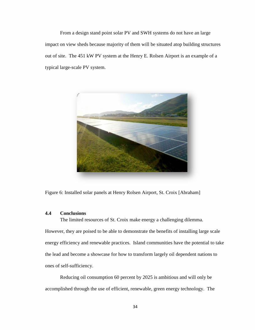
From a design stand point solar PV and SWH systems do not have an large
impact on view sheds because majority of them will be situated atop building structures
out of site. The 451 kW PV system at the Henry E. Rolsen Airport is an example of a
typical large-scale PV system.
Figure 6: Installed solar panels at Henry Rolsen Airport, St. Croix [Abraham]
4.4 Conclusions
The limited resources of St. Croix make energy a challenging dilemma.
However, they are poised to be able to demonstrate the benefits of installing large scale
energy efficiency and renewable practices. Island communities have the potential to take
the lead and become a showcase for how to transform largely oil dependent nations to
ones of self-sufficiency.
Reducing oil consumption 60 percent by 2025 is ambitious and will only be
accomplished through the use of efficient, renewable, green energy technology. The

35
outcomes that work well within this process can be used for other island communities
that face similar challenges in the energy crisis. Obtaining a sustainable energy future
will only be achieved if existing initiatives and resources are identify and used to
maximize their potential within the system.

36
Chapter 5: Design Proposal
5.1 Development of Form and Theme
The question of how to shift the perceived view of disaster recovery as a linear,
static phenomenon to a dynamic decision making process of recovery will be further
explored through design. The literature review pointed out that disaster management can
be defined as a “collective term encompassing all aspects of planning for and responding
to disasters, including both pre- and post-disaster activities”60
. The precedent studies add
an additional “real life” layer to this idea of creating a culture of prevention instead of
reaction. The design phase of this paper aims to design in a way that is sustainable both
from a structural and a cultural point of view.
The following guiding principles were created to capture the key emergency
management goals and objectives that were used to shape specific public spaces on the
island of St. Croix.
5.1.1 Emergency Preparedness Goals:
1. Re-Invent the Emergency Management Plan
Create a structurally sound emergency management plan that incorporates cultural
ideologies with sustainable practices to better prepare St. Croix for threats related to
hurricane damage.
2. Put Sustainable Design at the Forefront of Redevelopment
Reinvent the energy system to more efficiently use natural energy to power the island
primarily through wind and solar technology.
3. Reconnect the Island to its Waterfront
60 (DISASTER MANAGEMENT An Introductory n.d .)

37
The waterfront should act as a front porch to the downtown neighborhoods and the
multiple cities on St. Croix that border it. Building a network of protected spaces along
the coastline, both in the water and on land, creates a more inviting space while serving
as a barrier to the effects of hurricane destruction.
5. Improve Access and Mobility
The isolated nature of the island commands a need to have rations and shelters, and a
systematic plan for dispersing these items in place immediately after a natural disaster
strikes. A plan that identifies primary and secondary roads, buildings and energy sources
will allow for a more focused recovery effort.
5.1.2 Cultural Management Goals:
1. Embrace and Celebrate St. Croix’s Past, Present and Future
The island as a whole is a lens through which to understand the culture from its natural
history and early Indian settlements, to the rich variety of maritime, industrial,
commercial and recreational activities today.
2. Create an island for all
The island should engage the entire community. It should be a place for locals and
visitors alike. A place where everything comes together and co-mingles effortlessly while
serving a larger goal of protecting its inhabitants.
3. Create a vision that is flexible over time
The vision for the Island should clearly define how the process will take shape and how
the essential character of key elements can easily be displayed. At the same time, the
vision must be flexible to adapt to the changing cultural shifts.

38
5.2 Three Levels of Design
Due to the varying size of the design interventions, three scales were chose to
focus on in the following sections: the island scale, the city scale and the waterfront scale.
These three components each focused on current difficulties regarding water, power, road
and building infrastructure, and then proposed design changes that improve the function
to better serve the community after a hurricane.
5.2.1 Island
At the island scale, the focus is on long term sustainable design that is able to
weave into the existing fabric and culture of the island. This design proposal follows the
principles laid out in the “base case” energy efficiency plan, mentioned in Chapter 4, and
utilizes emergency principles to identify shelters, roadways and buildings of highest
importance. Four interventions were addressed on the island scale..
Issues:
1. Lack of Disaster Management Plan
- Individuals are not aware of overall mitigation plans and procedures.
- No clear identification of shelters or cleared roads.
2. Flooding
- There is a mixture of above and below ground runoff that floods particular areas and
can become dangerous during periods of heavy rainfall.
- Piers and boardwalks were not built to withstand heavy amounts of storm surge and if
destroyed, would cripple the island.
3. Outdated Energy Systems
- All power lines are above ground and are easily destroyed during hurricanes.
- Government buildings account for 36 percent of energy needs on the island.

39
- Current Water and Power Authority is opposed to new forms of sustainable energy and
wants to just continually update the current system
- Install solar water power heaters in each house.
- Utilize the south shore of the island for solar and wind harvesting because of the
expansive flat and protected land.
- Mandate that commercial/ government buildings be powered by solar energy.
4. Deconstruction of Hess Oil Refinery
- Unused land that is now a brownfield.
-No access to this land because of current ownership.
Proposals:
1. Lack of Disaster Management Plan
- Have marketing and ad campaigns that spread awareness.
- Create signage that guides people during such disasters.
2. Flooding
- Find key points of water runoff that overlap with key road systems and mitigate at the
source.
- Increase the amount of permeable pavers to help with runoff.
- Construct jetties or manmade reefs aimed at mitigating storm surge.
3. Outdated Energy Systems
- Offer incentives to use and install new power options.
- Install energy harvesting techniques in public spaces for people to understand and learn
about the methods.
- Identify ideal spaces where solar and wind can be harvested throughout the island.

40
4. Deconstruction of Hess Oil Refinery Site
- Clean and repurpose site.
- Utilize site to store supplies for disaster relief.
- Maintain port entry in case of disaster.
Design Ideas:
1. Lack of Disaster Management Plan
- Based on disaster management handbook, erect signage and early warning sound
systems that can guide people to safety.
- Utilize TV, radio and newspapers to spread the word about evacuation routes, shelters
and hospitals.
- Establish a hierarchy of roadways, buildings and energy sources that are of key
importance prior to, during and after a hurricane.
2. Flooding
- Specify points of mitigation to address overland water flow.
- Address long term sewer issues with creative ideas to hold, re-use and re-distribute
overland flow.
3. Outdated Energy Systems
- Install solar water power heaters in each house.
- Utilize the south shore of the island for solar and wind harvesting because of the
expansive flat and protected land.
- Mandate that commercial/ government buildings be powered by solar energy.
4. Deconstruction of Hess Oil Refinery Site

41
- Repurpose oil containers to hold supplies such as building material, water and other
necessities.
- Open port up to public to use in case of natural disaster.
Figure 7: Overlay map of buildings, roads and flood prone areas on St. Croix [Abraham]
Flooding
The mountainous terrain and poor sewer systems on St. Croix give rise to areas of
extreme flooding within the interior of the island. Hurricanes often produce widespread,
torrential rains in excess of 6 inches, which may result in deadly and destructive floods.
Flooding is one of the major threats for people living inland and severe flooding to
critical facilities or roadways typically result in unfavorable consequences. Mitigation
strategies include installing a basin under the roadways to hold some of the water while
increasing the height of the road to minimize pooling water. The images below show a

42
specific place on the island that frequently becomes inundated with water after even
small rain showers. This spot was chosen because it is located on a major roadway and
will need to be utilized immediately after a natural disaster. The two images on top show
how the current design responds to a simple rainstorm with the before and after effect
shown. While the two images on the bottom depict the same rainfall amount, they are
utilizing the design techniques laid out in this thesis to help mitigate flooding.
Outdated Energy Systems
The current electrical distribution configuration is susceptible to damage by both
wind and water damage. Their proximity to coastal areas that are susceptible to flooding
coupled with their outdated infrastructure reinforces the urgency for new techniques and
process to be introduced to the Virgin Islands. The image below depicts locations where
a wind farm would be most suitable as well as a perspective of land area the wind
turbines would cover.
The "footprint" of the turbine can typically be averaged around 0.25 acres per
machine, however, that number does not include the diameters of space needed between
turbines to avoid collisions. To account
for necessary room between the turbines
the boundary perimeter is typically around
1-2 acres from base to base of all
machines. It is important to understand
that all space between the turbines can still
be obtained for its Figure 8: Areas of wind turbine generation [Abraham]

43
original purpose of wildlife habitat, farming, or in the aftermath of a disaster, for
moveable shelters.
61 The other option for energy collection
is by solar pannels. The private and
commercial buildings can both install solar
panels of different sizes and to accomplish
different purposes. One of the main
drawbacks of solar energy is that they require
large areas of land for solar farms. As noted
in previous chapters, there are not many
locations where solar would be a suitable option at that scale, however new technology
has created alternatives to consider. The image to the left depicts a floating solar farm
that can be anchored to maintain its general position, but moves with the tides to prevent
heavy storm surge damage. In the event of a hurricane, the “solar islands” can be brought
to a more protected location and then put back in place once the storm subsides to
provide additional energy needs.
Deconstruction of Hess Oil Refinery Site
Hess oil refinery was often called “the city” by locals because of the sheer size
and the presence it commanded on the island. After its close in 2012, all that is left is
abandoned buildings. The site is now a brown field and is unusable unless it is
61 (Maps 2013)61
Figure 9: Area of solar power generation
[Abraham]

44
completely cleaned up. However, this is the site of the second deepest port on the island
of St. Croix, and can be utilized in the event of an emergency to get aid into the island.
Because the island is so secluded, a port of any type is of high demand after a natural
disaster for the import of food, clean water, supplies, and in some cases, evacuation. The
four images below show the current use before and after a disaster as well as the
proposed design implementation before and after, that show this port in service.
Figure 10: View of Hess Oil Refinery current conditions [Abraham]

45
Figure 11: View of Hess Oil Refinery current conditions after a hurricane [Abraham]
Figure 12: View of Hess Oil Refinery proposed changes [Abraham]

46
Figure 13: View of Hess Oil Refinery proposed changes after a hurricane [Abraham]
5.2.2 City
Initial identification of key building and road infrastructure helped guide the
emergency management plan to be able to point out the best location for shelters,
hospitals, emergency rations and entry points for rescue teams. Majority of Christiansted
will undergo changes outlined in the 60x25 plan such as storm water drainage
improvements, solar roofs and improved function and flow of the town as a whole.
These elements come together to create a dynamic city that is completely self-sufficient
with plans in place to be prepared for almost any disaster that strikes.

47
Figure 4: Ariel view of Christiansted [Abraham]
Christiansted is located on the northern portion of the island and is fairly closed
off from the rest of the island both visually and through access ways. There is one major
road that runs through the town and very few areas of open gathering space as most
infrastructure was built in the 1700’s without major updates since that time period.

48
Figure 15: Map of Christiansted grid pattern [Abraham]
This grid pattern of streets is how people moved within the city limits. Starting
with the most extreme case of complete isolation, several key components were identified
and assigned hierarchies on a scale of one to three (one being the most imperative for
survival, and three being the least imperative). Moving from the city limits inward, the
key roadways, buildings of importance and tracts of usable open space were identified
and labeled with the hierarchy ranking.

49
Figure 16: Map of building categories [Abraham]
Figure 17: Map of three levels of roads [Abraham]

50
The roadways hierarchy map was assigned values based on the quality of the
road. This quality assessment was reached by measuring width, cars per day, connections
to other major roadways and surrounding infrastructure. The building hierarchy map
was assigned based on historic relevance, the vital importance to maintaining order
within the city, and size. While 58 percent of the buildings within the town are not
priority one or two, they will still undergo protection efforts and re-location opportunities
if there is a complete failure of the structure.
Based on the roadway and building ranking maps, a system of emergency centers
were located in key places throughout the city. Utilizing both civic and private land
opportunities, several locations for shelters, hospitals and vital resource entry points were
identified and the design proposes changes for more efficiently.
Figure 5: Map of key buildings and drop off areas [Abraham]

51
Energy
The secluded nature of this city makes small power outages seem like catastrophic
events. Measures are currently underway to bury all overhead electrical lines that will
improve views as well as reduce the risk of storm damage by wind or flying debris.
However, the reliance on all gas powered energy is not sustainable and becomes a huge
issue in the event of a natural disaster. This design proposes weaves alternative forms of
energy into the residential and commercial landscape through things such as solar roofs
and solar water heaters on both residential and commercial buildings. With nearly 3,000
people living in this city, having access clean water and electricity is crucial to mitigate
the spread of disease and famine after a disaster.
Sewer
Similar to the buildings in this city, the sewer and drainage systems were installed
in the late 1800’s and have not been updated since. The majority of the sewage and water
systems are concrete, which can be subject to deterioration from hydrogen sulfide gas if
large amounts of raw sewage travel slowly through the pipes. Because the task of
replacing the sewage pipes was so monumental, this design focused on the overland flow
of water into storm drains and water catchment areas.
As mentioned, the majority of the storm water pipes are made of concrete and are
a mix of above and below ground piping. The lack of plant material along the roadside
has increased the water runoff rate and caused the streets to become inundated with small
streams. The Christiansted harbor has higher than average sediment and chemical
infiltration levels. To counteract this effect, bio swales and planting beds will be added
to several streets and alleyways at major water runoff points.

52
Figure 19: Locations of bioswales within city limits [Abraham]
Figure 20: Section of King St. with a bio-swale [Abraham]

53
Figure 21: Perspective of bioswale looking north towards Christiansted harbor [Abraham]
Limited open space for shelter/supply drop off
The current grid layout of Christiansted as well as the shallow port entry does not allow
for many potential locations for mass shelters or aid/supply drop off points. However,
several key points have been established in the event of total isolation from the rest of the
island. Several alternative modes of supply pick up and drop off were explored to see
which ones fit within the grid in the most appropriate locations. The diagram below
depicts these various modes and their location within the context of the city.

54
Figure 22: Diagram of emergency areas [Abraham]
The above disaster relief areas have been chosen because of their vicinity to the specific
issues they are tasked with mitigating.
5.2.3 Waterfront
The waterfront improvements implemented in the city of Christiansted intends to
set a new standard for innovative and functional spaces that mitigate the damaging effects
of a hurricane on a coastal community. Six character zones distinguish themselves along
the waterfront and were influential in helping to narrow specific design implementation.
One primary design proposal is a continuous public boardwalk that is built defensively to
provide protection from storm surge, debris and wind.

55
Figure 23: Boardwalk sections [Abraham]

56
These zones are defined by physical characteristics of the site, such as topography
and urban form, as well as the structurally protective qualities they embody. A project of
this magnitude required the understanding of many aspects to fully understand the
interrelated goals needed to improve this space.
Goals:
1. Address the importance of planning for sea level rise and the increased risks from
storm surges.
2. Recognizes the importance of innovative disaster design and highlight
Christiansted, St. Croix as an example of design innovation that should become more
standard over time.
3. Create waterfront infrastructure improvements such as Community Eco-Docks
that will better withstand hurricane force wind and water.
4. Realizes the importance of building open space and waterfront access with a the
outcome of not just allowing access for people, but also providing emergency shelters
and aid.
The central boardwalk area extends nearly a mile along the shore of the Christiansted
harbor from the sea plane landing area to the historic Christiansvaern Fort. The stretch of
public waterfront is a unique and quintessential part of the city representing its culture
and economic, and can serve as protection from natural disasters.
The design proposal:
Issues:
1. Storm Surge
- Increased overland flow of water

57
- No shield for the buildings from wind or water damage
- Failing bulkhead installed along the waterfront of the fort
- Loss of reef has caused lower fish diversification in the Christiansted harbor.
- Lack of barriers has allowed debris to wash ashore during storms
2. Outdated sewer system
- Sewers were built in the 1800’s and are beginning to fail.
- There is a mixture of above and below ground runoff that needs to be addressed.
- Streets are being built higher than the building base levels so water sometimes doesn’t
make it to the sewer and goes directly into the building.
3. Limited open space for shelter/supply drop off
- No formal gathering space designated
- No areas large enough to accommodate big crowds
- Town is segmented between commercial and residential sectors
- Most open space is along the waterfront is where tides are likely to be high after storm
4. Lack of renewable energy
- Commercial buildings account for 56 percent of power usage in Christiansted
- During natural disasters power is the first thing to be interrupted and it often takes
weeks to be restored because of overhead power line damage
Solutions:
1. Storm Surge
- Incorporate plants into landscape more effectively
- Replace bulkhead/boardwalk with soft shoreline
- Create fish and bird habitat

58
- Build a manmade reef
- Incorporate barriers into the area that are functional and provide protection
2. Outdated sewer system
- Find key points of water runoff and mitigate at the source
- Increase the amount of permeable pavers to help with runoff
- Lower street levels
3. Limited open space for shelter/supply drop off
- Enhance one central location to make it a space for all
- Pre-plan for specific community events and have design layout options for review and
comment to determine what type of space is needed and can accommodate a specific
number of patrons
- Increase the connectivity between residential and commercial areas through street trees,
view sheds and similar patterns throughout
- Designate space for supplies received by boat, helicopter and automobile
4. Lack of renewable energy
- Install energy harvesting techniques in public spaces for people to understand and learn
about the methods
- Utilize the solar and wind that can be collected throughout the site
- Enforce a net zero balance on all buildings
Design Ideas:
1. Storm Surge
- Create spaces that are shaded by trees to provide a more enjoyable experience as well as
protect buildings from wind, such as bus stops or recycling drop-off points

59
- Construct floating wetlands to provide a protected area for animals to live
- Create manmade reefs to act as a wave barrier and provide habitat for marine life
- Install low seat walls at key points along boardwalk to minimize storm surge impact
2. Outdated sewer system
- Shave down street levels and replace main streets with permeable pavers or heavily
plant the exterior
- Specify two points of mitigation to address overland water flow
- Address long term sewer issues with a master plan
- Deal with water run-off along the streets by creating planting beds in current gutters that
run along streets
3. Limited open space for shelter/supply drop off
- Reconstruct 3 spaces totaling in 30,000 square feet to become points for supply and to
aid distribution
- Create a hierarchy of roads to know what to clear first in order to create movement
through the city
- Designate the Fort lawn, NW parking lot and SW church lawn as aid and relief stations
4. Lack of renewable energy
- Install solar voltaics to power water heaters in each house
- Create a public installation that teaches people about the uses and process of energy
harvesting
- Mandate that commercial/ government buildings be powered by solar energy

60
Figure 24: Plan of Christiansted Wharf area [Abraham]

61
Storm Surge
The Christiansted harbor design was influenced by the idea of a landscape at the
front lines of defense that could absorb the impact of a hurricane. This stretch of
waterfront was conceived as a land of absorption that takes water, wind and debris from
every direction. This concept led to a rethinking of the material textures from the bottom
of the ocean to the city streets. Transformed through new wetlands and coral reefs, the
coastal area is a natural instrument for filtering both tidal changes and runoff after storms.
Some of the streets have been “greened” through re-surfacing in absorptive, open-mesh
concrete tiles and a layered filtering system.
A man made coral reef that stretches 1.3 miles is the start of the protection
measures against storm surge in the harbor. This reef is created in shallow coastal
waters to attenuate waves, particularly during storm surges. The reefs create a new
recreational opportunity, without diminishing the vista of the Caribbean ocean that can be
seen from the Christiansted boardwalk.
Figure 25: Sketches of wave benches [Abraham]

62
The second line of defense is the several wetland areas located at key points along
the boardwalk that mitigate additional storm surge energy and help reduce debris
overflow into the city. A boardwalk and wetland partnership is the gate to the city. On
the boardwalk, the wave-attenuating piers freely move with the tides and the boats
docked to them are less likely to suffer extreme damage because of this flexibility.
Boardwalk structures are fabricated from engineered lumber composite decking boards
that are easily replaced if they come loose. The composite material allows the boardwalk
to last longer without maintenance in the extreme Caribbean climate with intense sun, salt
water and hurricane storm surge sized waves. A principle of this research is that a softer
shoreline will create a more resilient edge, which is better able to connect both increased
storm surge flooding and sea level rise. The projected rate of sea level rise is 1.98 mm
per year,62
so while the larger implications of this are being examined, the larger issue
focuses on periodic storm surges.
The last line of defense from the threat of storm surges is the implementation of
wave seats that act as a physical barrier for large debris and swollen waves that may
reach shore. Their whimsical look and feel allows them to blend into the Christiansted
waterfront area without diminishing the connection between the land and the sea from the
human point of view.
62

63
Figure 26: Section of emergency shelter area at wharf [Abraham]
With three lines of defense, the infrastructure closest to the waterfront is projected
to have a more favorable survival rate from a natural disaster of similar magnitude.
Perspectives one and two below depict the before and after effects of a storm on an area
directly abutting the waterfront that is currently a gravel parking lot with a small strip of
boardwalk as its boundary to the ocean. The following two perspectives have utilized
several new design ideas that have increased the resiliency of the area after a storm. The
jumping pier/play area along the boardwalk acts as a wave break, and the addition of a
reinforced berm and depression help mitigate water flow onto the site. Farther into the
area, there are a series of telephone post that seem to be sculptural art on most days, and
then transform into tent post to house residents in shelters that are strung from post to
post creating private rooms within this civic area.

64
Figure 27: Perspective of current boardwalk design [Abraham]
Figure 28: Perspective of current boardwalk design after a hurricane [Abraham]

65
Figure 29: Perspective of proposed boardwalk design [Abraham]
Figure 30: Perspective of proposed boardwalk design after a hurricane [Abraham]

66
Outdated sewer system
As previously mentioned, the city’s outdated sewer system is one of the main
issues in Christiansted. The system must successfully transport water to the desalination
plant. After a storm, many of the gutters become clogged with sediment or debris, and
the drainage failure contributes to much of the overland water flow in the city. One
portion in particular towards the west end of the boardwalk has water gather from both
the ocean and the runoff of the streets creating a stagnant water situation. This particular
spot becomes inundated with water that then produces a very pungent smell. The
following images show this portion of the boardwalk in its current design before and after
a storm as well as with the alternative design proposed implementation before and after a
natural disaster. By creating a soft shoreline this area is able to utilize the tidal flush to
expel still water and to absorb additional water through the use of a vegetative planting.
In other areas of the city the old system of above-ground concrete sewer systems is
replaced with bioswales that are able to filter the water before it reaches the ocean.

67
Figure 6: Stormwater system outfall area current design [Abraham]
Figure 7: Stormwater system outfall area current design after a hurricane [Abraham]

68
Figure 33: Stormwater system outfall area proposed design [Abraham]
Figure 34: Stormwater system outfall area proposed design after a hurricane [Abraham]

69
Limited open space for shelter/supply drop off
The lack of contiguous open space provides little gathering space for areas of
shelter and aid. The largest piece of land is owned by the National Parks Service,
formerly the Christansavern Fort. The open lawn to the southwest of the fort can be
utilized as a helicopter landing area next to one of the main aid stations. This location is
central to both the city of Christiansted as well as the adjacent communities. The
perspective below shows the lawn with its current design before and after a natural
disaster as well as with the newly designed programing before and after a disaster.
Figure 34: Fort open lawn current design [Abraham]

70
Figure 36: Fort open lawn current design after a hurricane [Abraham]
Figure 37: Fort open lawn proposed design [Abraham]

71
Figure 38: Fort open lawn proposed design after a hurricane [Abraham]
Aside from a 20x20 square foot area of compacted earth utilized as a helicopter
pad, there are no significant changes proposed for the site. The largest impact will be
temporary re-purposing of the area in response to the need for aid. The site is broken into
zones that accommodate sections for food distribution, housing units, and medical
emergencies facilities.

72
Figure 39: Diagram of Fort open lawn after a hurricane [Abraham]
Lack of renewable energy
While the boardwalk requires little energy consumption because it is designed to
be completely self-sufficient. Solar powered lighting at its edge and a demonstration
“solar tree” that is compiled of small solar panels as leaves stands at the center of the taxi
pick up and drop off round-a-bout. The design creates an atmosphere based on the idea
of renewable energy. On the regulatory level, each house and commercial building will
be given incentives to update their current energy usage including some form of solar or
wind energy.

73
Chapter 6: Summary and Conclusions
The island of St. Croix is familiar with the trials and tribulations of a hurricane.
Hundreds of years have passed with the same outcome of a strong community that can
withstand disasters, and rebuild. However, the shift from a culture of reaction to a culture
of prevention is necessary in order to survive new and increasing destructive weather
patterns.
Responding to this lack of preparedness, this design-research thesis suggests
implementing specific emergency management practices and design guidelines that will
simplify the chaotic times after a natural disaster. This thesis identifies key hazards,
major vulnerabilities, and historical disaster events by providing a detailed look at the
emergency management history in the USVI. Combined with vulnerabilities such as
having limited natural resources, being an isolated island it becomes evident that there
must be an ongoing look at the changing future of this island the their emergency
management protocols.
Through the exploration of three levels of design, this thesis displays techniques for the
Virgin Islands to become the standard for other Caribbean islands. The territory can
become a showcase to other small-island nations demonstrating what can be
accomplished when a thorough emergency management initiative is implemented.
The response of a community, both from man-made and natural events, is fundamentally
based on the responses of its citizens. An interdisciplinary approach to the field of
disaster management that views landscape architecture as a central element—rather than

74
second—will lead to stronger, more resilient communities, and result in better decisions
on the part of government, hopefully reduce the need for extreme measures of damage
control in future catastrophes.

75
Bibliography
Alperen, M. Towards a Homeland Security Strategy for the United States Virgin Islands.
Masters Thesis, Naval Post Graduate School, 2006.
Amaratunga, R. Haigh and D. "AN integrative review of the built enviorment discipline's
role in the development of society's resilience to disasters." International Journal of
Disaster Resilience in the Built Enviroement, 2010: 11-24.
Bartuska, T. Introduction definition, design and development of the built enviornment-
part 1. Tokyo, 2007.
Bate, J. St. Croix Source. . 2000. http://stcroixsource.com/content/news/local-
news/2000/05/18/underground-power-projects-be-done-fall (accessed October 16, 2012).
BBC News- Timeline: How the hurricane crisis unfolded. September 2005.
http://news.bbc.co.uk/2/hi/americas/4211404.stm (accessed February 19, 2013).
Bea, K., Runyon, C.L., Warnock, K.M. U.S. Virgin Islands Emergency Management and
Homeland Security Statutory Authorities. . 2004.
http://www.policyarchive.org/handle/10207/bitstreams/3943.pdf (accessed November 18,
2010).
Beaubien, J., Baker, D. P., & Holtzman, A. "How military research can improve team
training effectiveness in other high-risk industries." 45th Annual Conference of the
International Military Testing Association. Pensacola, FL. , 2003.
Beck, RW. "Consulting Engineer’s Report on the Electric System of the Virgin Islands."
Engineers report, Christiansted, St. Croix, 2010.
Building Better. n.d.
http://www.riverwatchonline.org/flood_recovery/femamitigation/Proceed/00090.pdf
(accessed October 3, 2012).
C. Samuel, D. McEntire. Emergency Management in the U.S. Virgin Islands:. Program
Report, Charlotte Amalie: Virgin Islands Government, 2009.
Dictionary.com. n.d. www.dictionary.com (accessed September 2, 2012).
E. Oh, A. Deshmukh, M. Hastak. "Disaster imparct analysis base on interrelationship of
critical infrastruture and associated industries: a winter flood disaster event."
International Journal of Disaster Resilience in the Built Enviornment, 2010: 25-49.
Elliot, D. "Virgin Islands Wind Resources." 2008 U.S. Virgin Islands Wind Workshop. St.
Thomas, USVI., 2008 .

76
Engineers, American Society of Civil. Letter from Ray Seed, Professor of Civil and
Environmental Engineering to the President, American Society of Civil Engineers. 2006.
http://www.lasce.org/documents/RaySeedsLetter.pdf. (accessed February 19, 2013).
FEMA. New Building Code & Power Upgrade, U.S. Virgin Islands. 2007.
http://www.fema.gov/mitigationbp/bestPracticeDetail.do?mitssId=950 (accessed August
23, 2012).
GTM. U.S. Solar Energy Trade Assessment 2010: Trade flows and Domestic Content for
Solar Energy-Related Goods and Services in the United States. Trade Assessment,
Washington, DC: Solar Energy Industries Association, 2010.
Heide, Auf der. "Disaster Planning part II. Disaster problems, issues, and challenges
identified in the researc literature." Emerg. Med Clin North Am. (Emergency Med), 1996:
453-480.
ISDR. World Disaster Reduction Campaign Disaster Reduction for Sustainable
Mountain Development. Disaster Campaign, International Strategy for Disaster
Reduction, 2002.
K., Burman, et al. Integrating Renewable Energy into the Transmission and Distribution
System of the U.S. Virgin Islands. Renewable energy study, Golden, CO: NREL, 2011.
Kawata, Y. Disaster mitigation due to next Nankai earthquake tsunamis occuring in
around 2035. Kyoto, March 5, 2001.
KERAMINIYAGE, K., HAIGH, R., AMARATUNGA, D. AND BALDRY, D.
"EURASIA: Role of construction education in capacity building for facilities and
infrastructure development within a developing country setting." CIB World Building
Congress. Cape Town: World Building Congress, 2007.
Kibert, C. Reshaping the built ENvornement: ecology. ethics and economics. New York:
Island Press, 1999.
Lawrence, D.l. and Low, S.M. "The built environment and spatial form." Annual
Reviews, 1990: 453-505.
Low, D.L. Lawrence and S.M. "The built environment and spatial form." Annual Review,
1990: 453-505.
MSNBC. FEMA in chaos from start of crisis, memos say. 2005.
http://www.msnbc.msn.com/id/9732514/ (accessed February 19, 2013).
National Register of Christiansted St. Croix. n.d. www.nationalparkservice.org (accessed
August 16, 2012).

77
Ofori, G. Construction Industry Development for Disaster Prevention and Response.
London, September 23, 2004.
Pancham, A. St. Croix Source, Government Agencies Assess Emergency Preparedness .
2009. http://stcroixsource.com/content/news/local-news/2009/06/02/government-
agencies-assess-hurricane-preparedness (accessed October 16, 2013).
Parker, D. The Missmanagement of Hazards- Hazard Management and Emergency
Planning: Perspective of Britain. Paper, London: James & James, 1992.
Permits, Division of Building. USVI Department of Planning and Natural Resources.
2005. http://www.dpnr.gov.vi/permits.htm (accessed September 16, 2012).
R.A Pielke, Jr., C. Landsea M. Mayfield, J Laver and R. Pasch. "HUrricanes and Global
Warming." Bulletin of the American Meterological Socitey, 2005: 7.
Reduction, International Strategy for Disaster. Early Warning Practices can Save Lives:
Selected Examples. Strategic Report, Bonn: United Nations Secretariat of the
International Strategy for Disaster Reduction, 2010.
Service, National Park. National Register of Christiansted St. Croix. n.d.
www.nationalparkservice.org (accessed August 16, 2012).
Shimel, J. St. Croix Source, VITEMA to Develop New Disaster Mitigation Plan. 2004.
http://stthomassource.com/content/news/local-news/2004/06/24/vitema-develop-new-
disaster-mitigation-plan (accessed October 16, 2012).
Shirley, R., Kammen, D. "EDIN Working Group Meeting." Christianstead, VI,
November 15, 2010.
Staff, V.I. Business. St. Croix, USVI Signs Agreement to Become Disaster Resistant
Community Under New FEMA Initiative. 2011.
http://www.onepaper.com/vibusiness/?v=d&i=&s=News:In+The+News&p=5716
(accessed November 18, 2012).
Swenson D., Marshall B. "Flash Flood: Hurricane Katrina's Inundation of New Orleans,
August 29, 2005. New Orleans, 2005.
UN. United Nations Development Program. Program Development, New York: United
Nations, 2011.
VIBER. Civilian Employment. U.S.Virgin Islands Bureau of Economic Research
Historical Archive. Historical Archive, USVI Government, 2011.

78
VITEMA Flood Hazard Mitigation Plan. Mitigation plan, Island Resources Foundation,
2010.
VITEMA. United States Virgin Islands: VITEMA. 2010.
http://www.governordejongh.com/news/releases/2010 (accessed October 20, 2012).
Wallace, Tufecki and. The Emerging Area of Emergency Management and Engineering.
New York: World Press, 1998.
Wallace, Tufekci and. "The Emerging Area of Emergency Management and
Engineering." Transactions on Engineering Management. New York: World Press, 1998.
103-105.
Weisser, D. On the Economics of Electricity Consumption in Small Island Developing
States: A role for Renewable Energy Technologies? Energy Policy, 2004.
Y. Chang, S. Wilkinson, E. Seville and R. Potangoroa. "Resourcing for a resilient post
disaster reconstruction environment." International Journal of Disaster Resilience in the
Built Enviornment, 2010: 65-83.
Zack, A. and Larsen, M.C. Island Hydrology: Puerto Rico and the U.S. Virgin Islands.
National Geographic Research & Exploration: Water Issue, 126-134. 1994.
http://pr.water.usgs.gov/public/webb/bibliography/abstract010. (accessed January 10,
2013).

79


