Download - Aerial Planning for Flying Taxi of Dubai
Rochester Institute of Technology Rochester Institute of Technology
RIT Scholar Works RIT Scholar Works
Theses
11-17-2021
Aerial Planning for Flying Taxi of Dubai Aerial Planning for Flying Taxi of Dubai
Maitha Ali Salem Alnuaimi [email protected]
Follow this and additional works at: https://scholarworks.rit.edu/theses
Recommended Citation Recommended Citation Alnuaimi, Maitha Ali Salem, "Aerial Planning for Flying Taxi of Dubai" (2021). Thesis. Rochester Institute of Technology. Accessed from
This Master's Project is brought to you for free and open access by RIT Scholar Works. It has been accepted for inclusion in Theses by an authorized administrator of RIT Scholar Works. For more information, please contact [email protected].
i
RIT
Aerial Planning for Flying Taxi
of Dubai
By
Maitha Ali Salem Alnuaimi
A Graduate Paper/Capstone Submitted in Partial Fulfilment of the Requirements for the
Degree of Master of Science in Professional Studies in City Sciences
Department of Graduate Programs & Research
Rochester Institute of Technology
RIT Dubai
November 17, 2021

ii
RIT
Master of Science in Professional Studies:
City Sciences
Graduate Paper/Capstone Approval
Student Name: Maitha Ali Salem AL Nuaimi
Paper/ Capstone Title: Aerial Planning for flying taxi of Dubai
Graduate Paper/Capstone Committee:
Name: Dr. Sanjay Modak Designation: Chair of Committee Date
Name: Dr. Giovanna Potesta Designation: Member of committee Date
iii
Acknowledgments
Would like to express my deepest gratitude to the Chair of the Graduate Program and Research
Department, Dr. Sanjay Modak, for his guidance and continuous support throughout this journey. And I
would like to thank my mentor, Dr. Giovanna Potesta, whose sincerity and encouragement I will never
forget. She was an inspiration as I embarked on the path to this Master's degree. She is the true definition
of a leader and the ultimate role model. This thesis would not have been possible without Dr. Sanjay and
Dr. Giovanna Potesta, who guided me from the first step of research to develop an understanding of the
subject. I am grateful for the extraordinary experiences they arranged for me and for giving me the
opportunity to grow professionally.
I would like to thank Dr. Michael McQuaid for his insights into data analytics that led to the writing of this
article. My sincere thanks also go to Dr. Eric Hittinger for providing detailed analysis techniques that aided
the analysis in this paper.
iv
Abstract
Urban air mobility is the future of transportation in cities, and Dubai is one of the first cities to announce
the use of air mobility models in the city. The air taxi is expected to be operational in 2023. It is announced
to be electric and autonomous and will be the first in the region. The overall goal of the study was to
prepare the infrastructure to operate the taxi. The problem was that the Dubai authorities have not yet
started this phase, while the target date for operation has already been announced. The basic design of
the study involved a mixed analysis approach of qualitative and quantitative data to get the best results
for the zones and locations of the stations in Dubai, focusing on the city center and connecting both urban
and rural areas in Dubai. The project lays the foundation for one of the most important pillars for the
operation of the air taxi, which is the infrastructure. The taxi needs a base map of the area with the flight
zones of Dubai to guide its movement and suggest the best route for the taxi. The type and location of
stations is also important in the initial phase of operation. The next phase will be to prepare the possible
routes for the air taxi and the emergency landing site.
Keywords: Air taxi, Air mobility, Aerial planning, autonomous flying taxi, Flying taxi, Smart planning,
Flying zones, Dubai air taxi.
v
Table of Contents
ACKNOWLEDGMENTS ........................................................................................................................................... III
ABSTRACT ............................................................................................................................................................. IV
LIST OF FIGURES .................................................................................................................................................... VI
LIST OF TABLES ..................................................................................................................................................... VI
CHAPTER 1 – PROJECT DETAILS .............................................................................................................................. 1
1.1 BACKGROUND .................................................................................................................................................. 1 1.2 STATEMENT OF PROBLEM.................................................................................................................................... 3 1.3 PROJECT GOALS ................................................................................................................................................ 4 1.4 METHODOLOGY ................................................................................................................................................ 4 1.5 LIMITATIONS OF THE STUDY ................................................................................................................................ 7
CHAPTER 2 – LITERATURE REVIEW ......................................................................................................................... 8
2.1 FLYING TAXI ............................................................................................................................................................. 8 2.2 STATIONS ................................................................................................................................................................ 9 2.3 REGULATIONS AND POLICIES FOR FLYING TAXIS ............................................................................................................. 10
CHAPTER 3- PROJECT DESCRIPTION ..................................................................................................................... 12
3.1 PROJECT DETAILS ............................................................................................................................................. 12 3.2 PROJECT IMPLEMENTATION PLAN....................................................................................................................... 12 3.2 SOURCES OF DATA .......................................................................................................................................... 13
CHAPTER 4- PROJECT ANALYSIS ........................................................................................................................... 15
4.1 SELECTING THE FLYING TAXI TYPE ........................................................................................................................ 15 4.2 SELECTING THE STATIONS TYPE ........................................................................................................................... 20 4.3 AERIAL PLANNING OF DUBAI .............................................................................................................................. 22 4.4 SELECTING THE STATION’S LOCATION ................................................................................................................... 34 4.5 RESULTS ........................................................................................................................................................ 35
CHAPTER 5 CONCLUSION ..................................................................................................................................... 39
5.1 CONCLUSION .................................................................................................................................................. 39 5.2 RECOMMENDATIONS ....................................................................................................................................... 40
BIBLIOGRAPHY ..................................................................................................................................................... 42
APPENDIX ............................................................................................................................................................ 45
ROADS AND TRANSPORT AUTHORITY INTERVIEW ................................................................................................................ 45 DUBAI CIVIL AVIATION AUTHORITY INTERVIEW................................................................................................................... 47
vi
List of figures Figure 1 Urban Airport conceptual model ................................................................................................... 21
Figure 2 Air Taxi port design ....................................................................................................................... 22
Figure 3 Airport location and no fly buffer for each airport ........................................................................ 23
Figure 4 Flying zones for the Drone in Dubai and surroundings from GCAA .............................................. 24
Figure 5 Traffic Data in the morning and afternoon in one of the weekdays in October ........................... 25
Figure 6 No flight zones map with traffic information ................................................................................ 26
Figure 7 Population estimation per Community in Dubai in 2019 .............................................................. 27
Figure 8 Dubai Map of Traffic and population with No-fly zones of Dubai ................................................ 28
Figure 9 Communities with population higher than 1992 in Dubai ............................................................ 29
Figure 10 Potential communities ................................................................................................................ 31
Figure 11 Hatta boundaries ........................................................................................................................ 32
Figure 12 Flying zones of Dubai .................................................................................................................. 33
Figure 13 Public transportation distribution in the three zones ................................................................. 34
Figure 14 Proposed stations in the three zones .......................................................................................... 35
Figure 15 Aerial planning of Dubai ............................................................................................................. 36
Figure 16 Air Taxi platform mock-up .......................................................................................................... 37
List of Tables
Table 1: Comparison between different flying vehicle technologies …………………………………………………….15
Table 2: Attributes of the four Vehicle models for the multi attribute decision making analysis…………...16
Table 3: different station options…………………………………………………………………………………………………………..19
Table 4: Potential Communities Name…………………………………………………………………………………………………..29
1
Chapter 1 – Project Details
1.1 Background
Transportation is the most important element for the development of any city. People need reliable, safe
and fast means of transportation. Air mobility is one of the most promising areas in the near future. A
study conducted for 50 cities around the world to assess air mobility predicts that the market will grow at
an average annual rate of 45.9 percent between 2022 and 2040. And the sector will be dominated by
many types of flying vehicles, such as hybrid, piloted, electric, and autonomous (Wray, 2020).
The market for new transportation technologies is growing due to the increasing need for a faster mode
of transportation. In 2018, the air taxi market was valued at USD 1.3 billion and is projected to grow at a
CAGR of 28.59 percent by 2026 (Nasdaq, 2019). The other problem in transportation is traffic and its
impact on a city's environment and economy. Flying taxis are becoming an option that can solve the
problem by flying over traffic instead of adding to it. The testing phase for flying taxis is already underway
in many countries and many companies have started working on them. For example, in January 2019,
Boeing began testing the first prototype of an aerial vehicle that can take off and land vertically and has
an autonomous range of up to 50 miles (Automotive News, 2019).
In the world, the demand for faster transportation is increasing. This demand is driving the growth of
technologies in the transportation sector. The problem that is hampering this growth is the lack of
research and development in this field and the lack of regulatory framework in this field that can slow
down the growth of the market. Another problem is that companies are investing heavily in developing
technologies that support fast and smooth transportation without considering the necessary regulations

2
and policies required to operate such technologies. This is the case with flying cars and flying taxis.
Companies promise that they will be available as early as 2023, but there are no clear regulations and
guidelines in the world. The need for flying zones and blocks is only part of the requirements, the other
part is the need for a sustainable station for landing and take-off that does not require much space and
reduces the carbon footprint
In 2017, Dubai announced the first test of the autonomous flying taxi, which can accommodate two
people and will be used in Dubai (Ong, 2017). The use of electric autonomous flying taxis aims to achieve
the goal of transforming Dubai into a green city by reducing its carbon footprint through the high use of
cars. To achieve the goal of converting 25% of Dubai's traffic to autonomous transport by 2030
(Achkhanian, 2016). The flying planes or helicopters that have been used in Dubai or other cities were
controlled by a pilot who was responsible for the movements and steering. However, the current
development is moving towards the autonomous mode, which requires more studies and high-resolution
maps that support the decisions in the autonomous vehicles and are used for accurate positioning during
the flights, and ensure passenger safety and operational management from the ground. In the case of air
taxis, such maps and regulations are not yet available and ready, posing a challenge that may affect the
operation of the technology.
The Roads and Transport Authority, the owner of the air taxis, started communicating with Dubai Air
Navigation in late 2020 to start preparing taxi lanes in a specific area of Dubai and to define Dubai's
geographical boundaries by using advanced technologies (Buchan, 2020). And in 2020, Dubai Civil aviation
authority announced the first unmanned aerial vehicle law to regulate the operation of aerial vehicles in
Dubai, but the law only covered the small vehicles and not the large aerial vehicles such as the flying taxi
(Godinho, 2020).
3
1.2 Statement of problem
Dubai is a fast-growing city that is looking for the best unique solutions to the existing urban problems
and challenges. In 2019, the transportation sector in Dubai accounted for 12 percent of the urban
economy as the government is trying to improve the sector by using various technologies and become a
pioneer in this field (Oxford Business group, 2019). The biggest challenge and problem in Dubai are the
increasing traffic congestion due to the increasing use of private vehicles. These problems have prompted
the government to look for a new means of transportation, which is aerial transit. The technology is
currently being studied and the government has started working with companies to make it available. The
supporting infrastructure includes flight zones, flight paths, regulation and policy are still not yet available.
The flying taxi will create a new mode of transportation that will impact the airspace system in the
emirate. This highlights the need to prepare the right infrastructure in the airspace and establish a link
between the air and ground stations to pick up customers. These planning systems are not yet ready in
Dubai and are needed as Dubai is one of the major hubs for international flights. The aerial planning will
facilitate the movement of the proposed air taxi in a smooth, well-structured manner to maintain air
traffic in Dubai.
4
1.3 Project goals
The project will provide an aerial planning proposal for the Emirate of Dubai, the proposal will provide the
first phase of operations and the phase will include details of the flight zones allowed for air taxis and the
proposed location of taxi stations suitable for landing and take-off. The project will produce a map of
Dubai showing the flight zones for air taxi based on the geographical study and the current airspace system
of Dubai, indicating the locations for the landing and take-off stations.
The aim of the project is to work on the infrastructure part for the flying taxi ecosystem, that ensure the
safe operation of the taxi and smooth flight for the customers and. One of the project objectives is to
provide the best take-off and landing sites that do not require new space and can easily accommodate
customers within the first phase of flight. It also aims to provide solutions that can support flight
preparation requirements and ensure safety. It also provides dynamic flight planning for air taxis. Another
objective is to provide scalable urban air mobility in Dubai and the base maps for the alarm system, which
will be useful for the ground operations center of the air taxi.
1.4 Methodology
The methodology of this research is a mixed methodology of quantitative and qualitative methods to
ensure proper selection of areas and zones for air taxi. The mixture of different methods allows the
problem to be solved in a more comprehensive way. The first qualitative method is an interview with an
expert, a project manager from the Roads and Transport Authority to understand the current project and
to identify the technical aspects of the air taxi in Dubai. The interview questions were formulated to get
the technical information and maximum knowledge of the expert. The questions have been formulated
5
to address all the infrastructural requirements of the taxi and the technical details of the technology that
will be used in Dubai which includes the hardware requirements. This will help to provide further analysis
on the selected type of air taxi for Dubai and facilitate the flight plan as this is the most important
information needed to start the research. The second interview is conducted with other agencies that are
responsible for policies and regulations. An interview with an expert from the Dubai Civil Aviation
Authority will provide the necessary information about the restricted areas in the air of Dubai and how to
create a flight path based on the available guidelines and laws. The questions have been formulated to
provide maximum information about the regulations and guidelines as these details are very sensitive and
not available online.
Interviews are a very good way to gather information, but they are very time consuming. If you do not ask
the right questions, you may miss out on information or parts of it. Also, interviews sometimes reveal
sensitive and confidential information for which there are no other sources. This makes interviewing a
very valuable way of collecting information, but at the same time, it can become very difficult to verify
the information given because it is not available in any other source. Some bias may be found in the
interview responses as we are interviewing a person from a company who may not have all the
information, especially because the project idea is very broad and the expert's view may influence the
actual information, especially the case when the information from the company is not finalized yet.
Scientific research will be the way to find the currently available technologies for the air taxi and select a
model that is suitable for Dubai. Also, the scientific research method will help understanding the
regulations and studies for air taxis from around the world and it will help in making the right air taxi plan
for Dubai. Information on other studies being conducted around the world on air taxi and how cities are
evolving in this area will help bring Dubai in line with other cities and the global market. The research can
be used to understand how far companies have come and how we can implement this in Dubai, with a
6
little tweak that will make Dubai better and unique. Scientific research and understanding the regulation
of air planning worldwide will be used to see if it can be implemented in Dubai or it can be used as a
guideline for the process of planning. In addition, scientific research will help identify the right types of
stations for the air taxi in Dubai and the facilities that can be added to the stations by looking at other
proposals from other countries and previous studies.
Scientific research as a method is very powerful and provides a lot of detail on a topic, but it can also
provide information or ideas that are not applicable to the area of study, which means that they need to
be investigated further and should be linked to local government information to ensure that they can be
implemented. In the case of air planning, it is difficult to find a basis for air planning policies and
regulations that is suitable for all cities in the world. For example, not all cities have a busy aerospace like
Dubai, which means that what is implemented in another city that is not very busy may not be applicable
in Dubai.
The qualitative methods used in this report to identify the best type of vehicle for Dubai based on the
multi-attribute decision-making approach, as each technology or vehicle has multiple attributes based on
different factors like: speed, range and safety. The final analysis in this project is the geospatial data
analysis to determine aerial map of Dubai and the selection of the station locations. The geospatial data
analysis is performed in ArcMap and ArcPro, which is a specialized software for viewing and analyzing
geospatial data. Building and parcel data and base map data of Dubai form the basis of the analysis. The
rest of the information collected by DCAA and RTA helps in determining the locations of stations and flight
zones. The geographic analysis depends on traffic data, building heights, flight specifications,
demographics, landmarks, landmark and other entertainment activities, and parcel information. This
initial geographic data will not only support route selection based on regulations, but also ensure that it

7
meets the needs of customers in Dubai. It will solve the transportation problems and improve
transportation and mobility in Dubai.
1.5 Limitations of the Study
There are many limitations affected the study, The first limitation that affected the whole plan of the
study is that Dubai Roads and Transport Authority has not yet selected the type of taxi, so the study is not
valid without the type of technology. This limitation added to the scope of the study to include an analysis
of the best type that can suit Dubai and the expectation of Dubai Roads and Transport Authority. The
second limitation is data privacy. Most of the regulations and policies that are available for the airspace
system are classified as confidential or sensitive data. This means that they are not published and are not
available for further analysis or to support the study. Obtaining hard copy geospatial data was also a
barrier as most of the data required is not openly available and requires a lengthy approval process to
obtain, such as municipal boundaries and parcel information. This affected the quality of the results and
the time required for the analysis. The Roads and Transport Authority also did not provide information
on the project, the information provided was minimal and limited and lacked detail. The flight zone and
exclusion area data are from a PDF file that was only published with no details or coordinates and very
low resolution, which is considered a limitation as it affects the accuracy of the selected flight zones and
the overall study.
8
Chapter 2 – Literature Review
2.1 Flying taxi
The airline industry has doubled in size since the introduction of jet engines and has continued to grow
over the past 20 years. It has reached the highest rate in the transportation sector and is expected to
continue growing even after the pandemic COVID19. The environmental impact of existing vehicles
prompted companies to look for better solutions that are more environmentally friendly and energy
efficient. The most viable solution so far is the hybrid electric drive, which is cleaner, more energy efficient
and quieter than other options. Research shows that there are many techniques that combine different
methods, including electric motors, systems to store the energy in the aircraft, and power electronic
converters that have made the industry much better, allowing aircraft systems to be fully electronic.
Electric propulsion systems are not yet being used for large aircraft, only for small aircraft. It will start with
2-4 passenger planes and then increase to 20 passengers by 2030, and it could go up to 50 seats. There
are many companies trying to develop different designs and concepts of aircraft. The VTOL design, which
stands for vertical take-off and landing, is attracting the attention of various commercial users, which can
fly up to 27 km at 70 km/h. The market is expected to grow for flying taxis, ambulances, airport shuttles,
and police. And by 2023, it will be used for urban air mobility in cities. The biggest challenge will be
regulations and energy density. That's why research is focused on these two areas when it comes to
electric aircraft for commercial use. (Manuel, Carlos, Josselyn, & Alexandre , 2020).
Many companies are working on flying vehicles that can quickly transition from vertical to horizontal flight.
A German company has started testing its autonomous electric flying vehicle that can accommodate up
to 6 people and uses the same technology and has managed to cover a distance of 300 km in 1 hour on a
9
single battery charge. Another company that has started testing the vertical launcher has also given the
dates for the operation of this technology which will be by 2022. It can accommodate only 2 people and
has nine batteries that can power 18 rotors in the vehicle. It can reach a speed of 110 kilometers per hour
and has a payload of 200 kilograms. The vehicle was tested in Singapore for a 2-minute mission and
covered a distance of 1.5 kilometers with an average height of 130 feet (Alfred, 2019). Another study
shows that the cruising range that volocopter which it is one of the VTOL vehicles is planning for is 17
miles (Hawkins, 2018) This idea is the same technology that was announced by the Dubai Road and
Transport Authority. Based on the specifications and technical details, it can determine the exact
dimensions and specifications of the taxi.
2.2 Stations
An initial study shows that a landing pad of about 15 meters in diameter is required for a two-seat air taxi,
and that a landing pad can only accommodate one taxi at a time (Middleton, 2019). The approximate size
will be sufficient for one taxi at a time. If the city plans the right infrastructure, the stations should also
provide other services such as landing pads, charging stations, passenger areas for loading and unloading.
Volocopter plans to prepare a solid infrastructure for the air taxi that can accommodate around 1000
passengers within an hour at a station. The stations will have batteries and charging ports and will be
designed to accommodate passengers during the day. The size can be accommodated on an existing
building. The plan is to set up a fully automated process for changing batteries and preparing the aircraft
for the next session, so that there is about 30 seconds between each flight (Hawkins, 2018).
For the take-off and landing stations, many cities have started planning, one of them is United Kingdom,
they have started building an airport specifically for the flying cars, it is an urban airport, the airport
consists of a hub for the electric vertical take-off and landing vehicles (Flemming, 2021). The initial stages
10
of the development of the urban airport began in early 2021, and many investors and companies
supported the idea (Sandhu, 2021). The airport's footprint is 60 percent smaller than that of a traditional
helipad, the site takes only a few days to set up, and carbon emissions are almost zero. The urban airport
is flexible and designed to be easily relocated to another site and to accommodate different types of flying
vehicles (Hyundai, 2021). In some researches, it is found that the helipad is located on the roof of certain
buildings, considering different aspects of the buildings and the helipad. The first option is the size and
weight of the helipad, consideration of the load on the building, structural consideration and turbulence
and placement of the helipad to avoid challenges in landing or taking off the helicopter (Aluminium
offshore, 2020).
2.3 Regulations and policies for flying taxis
Companies are racing to provide the technologies, and governments should race to provide the right
infrastructure to accommodate and support the technologies. Researchers have done many studies in this
area to provide suitable routes or areas for the aircraft. The biggest challenge in network or flight planning
for the flying vehicle is that the network is very dynamic. This technology will create a non-linear
transportation network that requires long strategic planning and gamesmanship of cities (Lacina, 2020).
Some studies have recommended establishing hubs or airports in areas of interest to other modes to
facilitate mobility between points and bridge the gaps between current and future modes.
The altitude restriction for drones is 120 km according to the Dubai Civil Aviation Authority regulation,
and as drones continue to be used, and are growing in the logistics sector, flying taxis should not operate
in the same area to avoid collisions or traffic (Bilslah, 2021). In one of the studies, the flight plan was
created by dividing the areas into a regular grid. The grid is represented with an optimal dispersion
achieved by dividing the area into cubes and blocks, and for each cube there is a center that represents
11
the waypoint for the flying vehicle (Barrientos , et al., 2010). Another study and research for the
unmanned aerial vehicle shows the path planning approach by dividing it into two methods. The first
method is global path planning, which uses the previous environmental information for planning, and the
second method is local path planning, which responds to the real-time sensors. Both are input to the
drone in flight for operation. The global path planning works with the information and cannot respond to
real-time issues during operation, i.e., it is static and only changes when it manually receives the update
from the source (Huang, et al., 2018). This is one of the approaches for air taxi that can provide the first
type of input for air taxi and land operations and regulations.
The U.S. government has made a proposal for planning the flight path of each flying vehicle through a
platform. The platform will receive the origin and destination and create routes based on the geospatial
data that will be sent back to the vehicle. Geospatial data includes speed, altitude, height of buildings
within the block between the origin and destination, terrain data, power lines, cell towers, other tall
infrastructure, no-fly zones, population density data, and locations with high concentrations of people.
The route can be calculated based on all these features and the type of vehicle, i.e., whether it needs a
landing station or can land in an open space. Also, the route depends on the on-board device receiving
the information. It should be able to receive live data about any in-flight changes and make decisions
based on the available data and readings from the sensors. The on-board device should send information
about longitude, latitude and various information about the battery and sensors back to the main
operations room. This information should be shared and they can be considered as time series geodata
stored in a database (Christopher , Andreas , Kendall , & Ido , 2016)
12
Chapter 3- Project Description
3.1 Project details
The study will be the initial phase of the air taxi operation. The outcome of the project will be a map that
can be used as a base map for the operation and will be considered as part of the infrastructure of the air
taxi operation. The key stakeholders in the project are the Roads and Transport Authority, Dubai Civil
Aviation Authority, General Civil Aviation Authority, Ministry of Defense, Dubai Municipality, Dubai Air
Navigation System and the private sector, including taxi technology providers and platforms. The Roads
and Transport Authority will be the owner of the project and the sponsor, while both the Dubai Civil
Aviation Authority and the General Civil Aviation Authority will be responsible for approving the flights
and will obtain permits before each flight, an agreement can be between the three entities to finalize a
preapproved areas for the zones approved. The Ministry of Defense is involved in the project to ensure
that the flights do not interfere with any military operations within the flight or within the zones. Dubai
Municipality's role will be to grant permission for the parcels of land selected for the stations and provide
up-to-date geospatial data. The private sector will provide the technology and maintenance with the
support required for operations. The map will need to be tested before it can go live, and testing will take
place after the first taxi is completed.
3.2 Project implementation plan
The project can be divided into 4 main phases. Phase one is to select the right taxi, which will be the
responsibility of the Roads and Transport Authority, and this phase will be completed by 2023. The second
phase, which runs in parallel with the first phase, is the preparation of the routes and the operation
platform with data integration. This phase will take about a year and a half to complete and may begin in
13
early 2022, with the first six months dedicated to the development of the platform and a year to study
the route proposals based on the proposed flight zones and implement the integration that can support
route selection. The integration will be divided into two parts. The first part is the integration with the
sensors present in the city such as temperature sensors, weather sensors and air quality sensors while the
second part will be the integration with the air taxi sensors. The third phase will be testing the flight zones
and the platform after integration. This testing phase can take anywhere from six months to a year,
depending on the approvals and cooperation between the Roads and Traffic Authority and the other
stakeholders in the project. In the fourth phase, the flight zones will be adjusted based on the test results
and the final proposal for Dubai's flight zones will be created. After one year of operation, Dubai can start
planning for the next phases of the flight zones to cover more areas and expand the project to the entire
emirate.
3.2 Sources of Data
This project relies on both secondary and primary data sources. For primary data, both quantitative and
qualitative data are used in this analysis. The primary data is a list of information about the air taxi
collected by interviewing the Dubai Road and Transport Authority, the information collected is about the
type of air taxi and its technical specifications. The problem with this data is that it is not complete as the
project has not yet been finalized. According to Engineer Ruba from the Roads and Transport Authority,
the air taxi in Dubai has been postponed to 2023 as there are not enough air taxis available to meet all
the requirements of the authority. The authority has an initial idea of how it needs the taxi, but some
technical information has not been finalized because the taxi is not yet available and it has not yet decided
on a company. Which lead to the scientific research. This means that the technical details of the taxi are
not available, including information on the weight, size, operating system, speed and maximum altitude,
which led to the data being collected through scientific research and data published online, which is
14
considered secondary data. Another source of primary data was the interview with the Dubai Civil Aviation
Authority to obtain information on regulations.
Other sources of primary data come from Dubai Municipality, the Center for Geographic Information
Systems, through a request to the Map and Data Service. The data obtained from the center are the
communities of Dubai. The data on public transport and the location of metro and bus stations and
network was obtained from the Dubai Pulse platform, which belongs to the Dubai Data establishment,
which is under the Dubai Digital Authority. The data was open and available to the public. In addition,
open base map data, traffic data and images of Dubai were obtained from the base map available online
in ArcMap software.
Secondary data sources are from the data published by the General Civil Aviation Authority on restricted
and no-fly zones in Dubai. The data is published on the My drone hub platform

15
Chapter 4- Project Analysis
4.1 Selecting the flying taxi type
The interview with the Roads and Transport Authority's project manager for the air taxi detailed the
current status of the project, which has been delayed and is not expected to be operational until 2023.
The reason, according to the expert, is that they could not find the right vehicle for their needs. They are
looking for an electric vehicle to reduce the emissions and environmental impact of the currently available
means of transportation. Also, one of the specifications is that the vehicle should be fully autonomous for
4 passengers. The other specifications are not yet clear as the project is still in the research and
development phase (Abdelal, 2021). This implies a limitation for the current study as the planning depends
on the technical specifications of the vehicle to determine the zones, stations and possible routes. This
leads to further analysis of the available flying vehicles that can be compared to choose the right one for
Dubai.
There are many studies and companies working on this technology and a detailed comparison is made to
select the right type for Dubai to meet the original requirements of the road and transport authority.
Table 1 shows the different options that are compared in terms of architecture, safety level, noise level,
power requirement, speed, range and concept design. There are five available and tested technologies
for the air taxi, namely the multirotor vehicle, the lift and cruise vehicle, the tilt rotor vehicle, the
helicopter and the multirotor vehicle with wings. Each of them is designed differently, but all of them are
used for commercial purposes. Some of them have been available and in use for a long time, like the
helicopter, while others are still being tested, like the multirotor with wings, which is being tested by
Boeing (Snelgrove, 2020). The helicopter is very good with high range, medium safety and high speed, but
it is not suitable for roads and transport authorities because it runs on fuel, is very noisy and is not yet
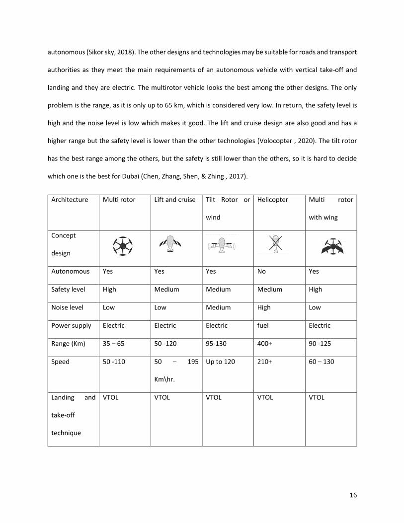
16
autonomous (Sikor sky, 2018). The other designs and technologies may be suitable for roads and transport
authorities as they meet the main requirements of an autonomous vehicle with vertical take-off and
landing and they are electric. The multirotor vehicle looks the best among the other designs. The only
problem is the range, as it is only up to 65 km, which is considered very low. In return, the safety level is
high and the noise level is low which makes it good. The lift and cruise design are also good and has a
higher range but the safety level is lower than the other technologies (Volocopter , 2020). The tilt rotor
has the best range among the others, but the safety is still lower than the others, so it is hard to decide
which one is the best for Dubai (Chen, Zhang, Shen, & Zhing , 2017).
Architecture Multi rotor
Lift and cruise Tilt Rotor or
wind
Helicopter
Multi rotor
with wing
Concept
design
Autonomous Yes Yes Yes No Yes
Safety level High Medium Medium Medium High
Noise level Low Low Medium High Low
Power supply Electric Electric Electric fuel Electric
Range (Km) 35 – 65 50 -120 95-130 400+ 90 -125
Speed 50 -110 50 – 195
Km\hr.
Up to 120 210+ 60 – 130
Landing and
take-off
technique
VTOL VTOL VTOL VTOL VTOL

17
Approximate
cost
Medium
operational
cost
Medium
operational
cost
Medium
operational
cost
High
operational
cost
Medium
operational
cost
Capacity 2-4 2 – 6 2 – 6 4-6 2-4
Table 1: Comparison between different flying vehicle technologies
Based on the comparison made in Table 1 and the specifications given by the Road and Traffic Authority,
there are some technologies that meet the requirements. The first technology that is immediately
excluded is the helicopter because it uses fuel as a source of energy, which is not accepted. The four listed
technologies are analyzed using multi-attribute decision making. The attributes that are used to make the
decision are the ones that are different and the ones that are important. Table 2 shows which attributes
are included in the analysis.
Architecture Multi rotor Lift and cruise Tilt Rotor or wind Multi rotor with
wings
Vehicle number vehicle 1 Vehicle 2 Vehicle 3 Vehicle 4
Safety level High
2
Medium
1
Medium
1
High
2
Noise level Low Low Medium Low
Range (Km) 65 120 130 125
Table 2: Attributes of the four Vehicle models for the multi attribute decision making analysis
18
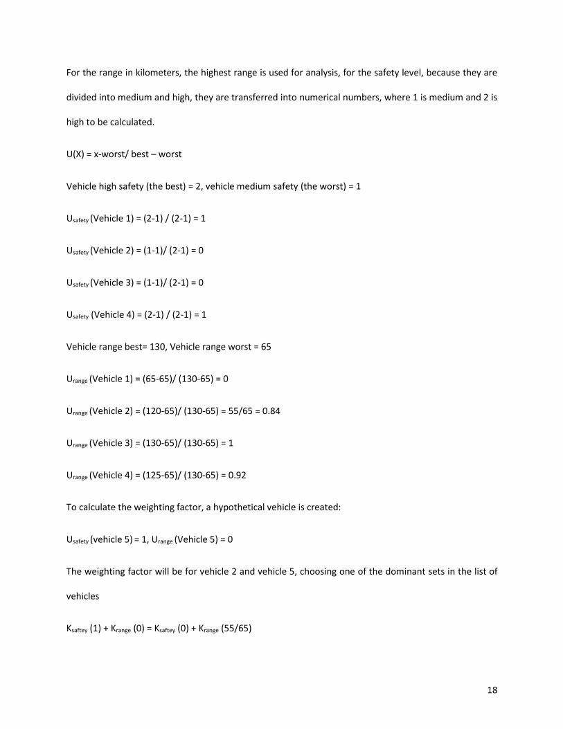
For the range in kilometers, the highest range is used for analysis, for the safety level, because they are
divided into medium and high, they are transferred into numerical numbers, where 1 is medium and 2 is
high to be calculated.
U(X) = x-worst/ best – worst
Vehicle high safety (the best) = 2, vehicle medium safety (the worst) = 1
Usafety (Vehicle 1) = (2-1) / (2-1) = 1
Usafety (Vehicle 2) = (1-1)/ (2-1) = 0
Usafety (Vehicle 3) = (1-1)/ (2-1) = 0
Usafety (Vehicle 4) = (2-1) / (2-1) = 1
Vehicle range best= 130, Vehicle range worst = 65
Urange (Vehicle 1) = (65-65)/ (130-65) = 0
Urange (Vehicle 2) = (120-65)/ (130-65) = 55/65 = 0.84
Urange (Vehicle 3) = (130-65)/ (130-65) = 1
Urange (Vehicle 4) = (125-65)/ (130-65) = 0.92
To calculate the weighting factor, a hypothetical vehicle is created:
Usafety (vehicle 5) = 1, Urange (Vehicle 5) = 0
The weighting factor will be for vehicle 2 and vehicle 5, choosing one of the dominant sets in the list of
vehicles
Ksaftey (1) + Krange (0) = Ksaftey (0) + Krange (55/65)
19
Ksaftey (1) = Ksaftey (0) + Krange (55/65)
Ksaftey (1) = Krange (55/65)
Ksaftey + Krange = 1
0.846 Krange + Krange = 1
1.846Krange = 1
Krange = 0.54
Ksafety = 0.458
To select the best vehicle, the equation below is used to calculate the vehicle with higher utility based on
the calculated utility for each attribute and weight.
U (Vehicle x) = Ksafety Usafety (Vehicle x) + Krange Urange (Vehicle x)
U (Vehicle 1) = 0.458*1 + 0.54 * 0 = 0.458
U (vehicle 2) = 0.458 * 0 + 0.54 * 0.85 = 0.459
U (vehicle 3) = 0.458* 0 + 0.54 * 1 = 0.54
U (vehicle 4) = 0.458 * 1 + 0.540 * 0.92 = 0.9548
The best vehicle is vehicle 4, the multirotor with wings. The dimension of the multirotor vehicle with wings
is 30-feet long and 28-feet wide based on the vehicle build by Boeing (Snelgrove, 2020).

20
4.2 Selecting the stations type
The dimension of the selected flying taxi will be around 10 meters long and 9 meters wide, the dimension
will decide the size of the stations area. The area must be big enough to accommodate more than one
taxi and to accommodate different facilities. There are several stations type available in the market and
they are listed in table 3
Station type Urban Airport Helipad Air taxi port
Size 10-meter diameter 15-meter diameter 20 – 30-meter
diameter
Cost of construction Low Low High
Facilities availability Yes No Yes
Power supply availability Yes No Yes
Readiness Will be ready by 2028 Available Available
Table 3: different station options
Table 3 shows different designs proposed by different companies and cities from around the world. The
first option which it is urban airport is an airport proposed by Hyundai motor group and the UK
government to produce the first of it is kind the Urban airport that can accommodate flying taxis and
unmanned aerial vehicles in on place, it is an innovative hub that includes power supply and can be built
very fast and relocated at any time Figure 1 shows the conceptual model of the urban airport. The urban
airport is smaller than the helipad for around 60 percent smaller (Hyundai, 2021)

21
Figure 1 Urban Airport conceptual model
The helipad is cheaper but doesn’t provide sources of power or any facilities to the passengers which
make it the least favorable option especially that Roads and transport authority emphasized that they are
looking for an option with different option and facilities (Abdelal, 2021). Helipad can be used for
emergency landing and it can be utilized for those emergencies landing to reduce the cost of the
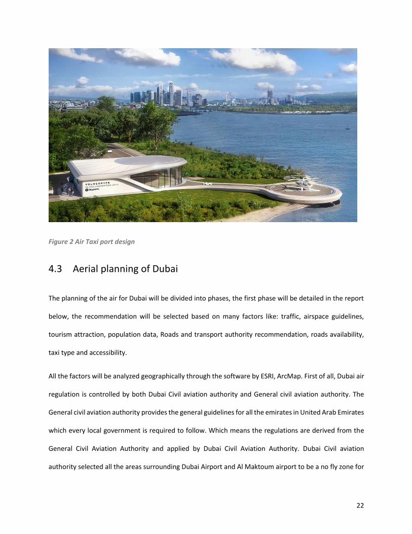
constructions. The third option is the air taxi port as showing in figure 2 which they are similar to the
urban airport but they are a permanent location they are bigger in size and higher in construction costs
but they are the best option because they are available and ready to be constructed a utilized (GRAFT,
2018). The differences in between the options are not much which make it harder to select the best. The
suggestion is to go for the three options, the air taxi port can be utilized for the first phase then the second
phase the Urban airport will be utilized across the emirate of Dubai and last option will be only utilized
for emergencies.
22
Figure 2 Air Taxi port design
4.3 Aerial planning of Dubai
The planning of the air for Dubai will be divided into phases, the first phase will be detailed in the report
below, the recommendation will be selected based on many factors like: traffic, airspace guidelines,
tourism attraction, population data, Roads and transport authority recommendation, roads availability,
taxi type and accessibility.
All the factors will be analyzed geographically through the software by ESRI, ArcMap. First of all, Dubai air
regulation is controlled by both Dubai Civil aviation authority and General civil aviation authority. The
General civil aviation authority provides the general guidelines for all the emirates in United Arab Emirates
which every local government is required to follow. Which means the regulations are derived from the
General Civil Aviation Authority and applied by Dubai Civil Aviation Authority. Dubai Civil aviation
authority selected all the areas surrounding Dubai Airport and Al Maktoum airport to be a no fly zone for

23
any other than airplanes, the no fly zone around Dubai Airport reaches to Sheikh Zayed road, the map in
figure 3 below shows indications of how the no fly zone in Dubai is there, the data is only to visualize the
area it was gathered by the interview with one of the experts in Dubai Civil aviation and not provided by
them, because it is secret data (Bilslah, 2021).
Figure 3 Airport location and no fly buffer for each airport
This means that those area and their surrounding cannot be selected for the operation of the flying taxi,
also it was mentioned that the area in the beginning of Sheikh Zayed road
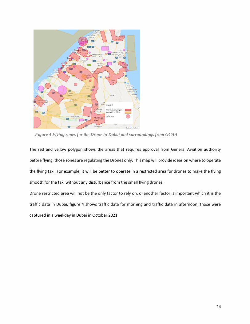
The General Civil Aviation Authority announced 3 categories for flying drones, those categories are
explained and detailed in the map that is shown in figure 4
24
The red and yellow polygon shows the areas that requires approval from General Aviation authority
before flying, those zones are regulating the Drones only. This map will provide ideas on where to operate
the flying taxi. For example, it will be better to operate in a restricted area for drones to make the flying
smooth for the taxi without any disturbance from the small flying drones.
Drone restricted area will not be the only factor to rely on, o=another factor is important which it is the
traffic data in Dubai, figure 4 shows traffic data for morning and traffic data in afternoon, those were
captured in a weekday in Dubai in October 2021
Figure 4 Flying zones for the Drone in Dubai and surroundings from GCAA
25
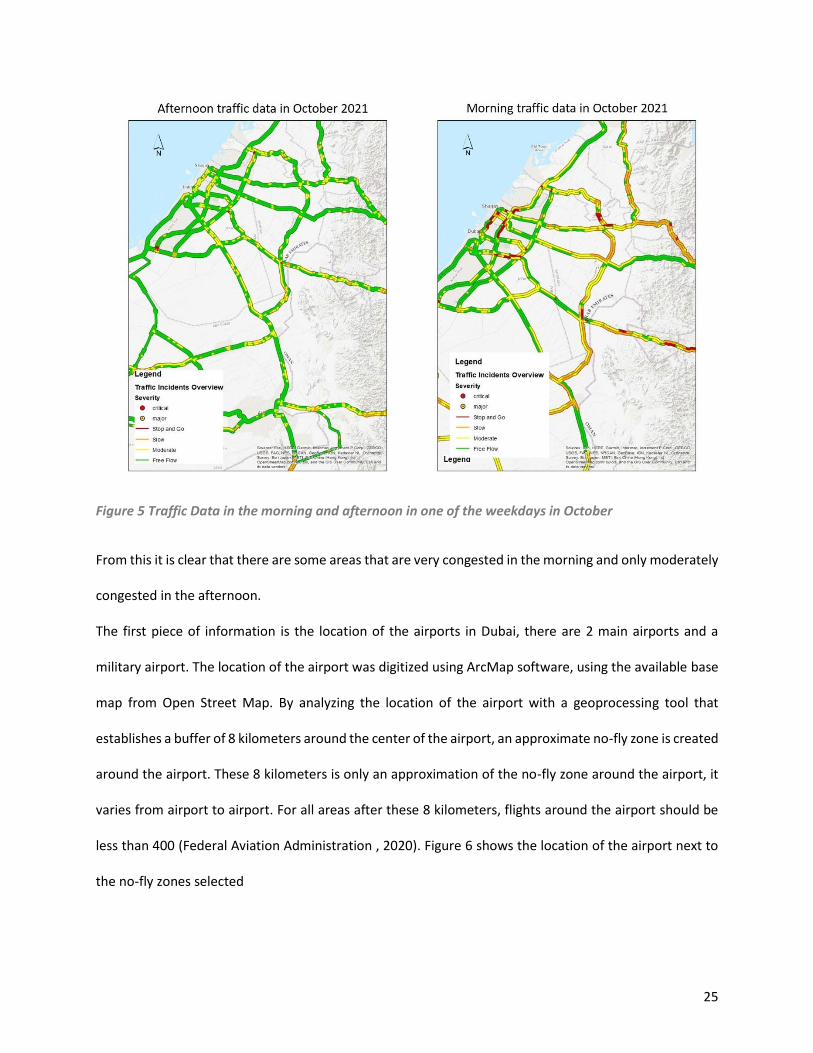
Figure 5 Traffic Data in the morning and afternoon in one of the weekdays in October
From this it is clear that there are some areas that are very congested in the morning and only moderately
congested in the afternoon.
The first piece of information is the location of the airports in Dubai, there are 2 main airports and a
military airport. The location of the airport was digitized using ArcMap software, using the available base
map from Open Street Map. By analyzing the location of the airport with a geoprocessing tool that
establishes a buffer of 8 kilometers around the center of the airport, an approximate no-fly zone is created
around the airport. These 8 kilometers is only an approximation of the no-fly zone around the airport, it
varies from airport to airport. For all areas after these 8 kilometers, flights around the airport should be
less than 400 (Federal Aviation Administration , 2020). Figure 6 shows the location of the airport next to
the no-fly zones selected

26
Figure 6 No flight zones map with traffic information
by the Dubai General Aviation Authority. Also, a large area has been selected as a no-fly zone because it
is under Oman, which means that it will be difficult to get permission for domestic flights for the taxi. The
map clearly shows that there are some roads that are heavily trafficked and need to be fixed up and can
be a potential location for the air taxi.
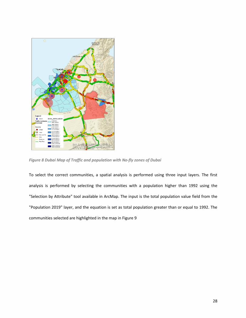
The next factor added to the map is the estimate of the population for Dubai in 2019. Figure 7 shows the
estimate for each municipality in Dubai, the darker the color, the higher the population. The population
is an estimate for each municipality. The total number was then displayed using ArcMap by plotting the
number using the symbology option in the software, which can assign different colors to each list of
values. Adding the population count to the traffic data and no-fly zones gives a better indication of where
the potential areas for air taxis are located. Figure 8 shows that there is congestion on the roads and in
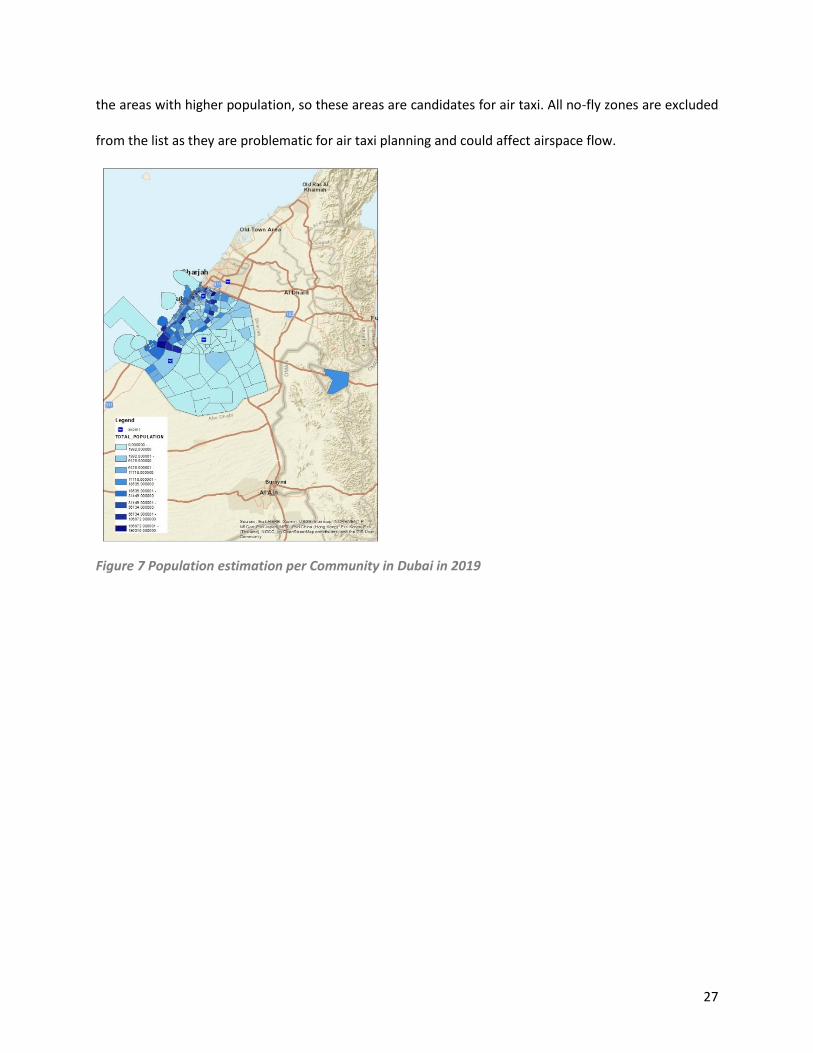
27
the areas with higher population, so these areas are candidates for air taxi. All no-fly zones are excluded
from the list as they are problematic for air taxi planning and could affect airspace flow.
Figure 7 Population estimation per Community in Dubai in 2019
28
Figure 8 Dubai Map of Traffic and population with No-fly zones of Dubai
To select the correct communities, a spatial analysis is performed using three input layers. The first
analysis is performed by selecting the communities with a population higher than 1992 using the
"Selection by Attribute" tool available in ArcMap. The input is the total population value field from the
"Population 2019" layer, and the equation is set as total population greater than or equal to 1992. The
communities selected are highlighted in the map in Figure 9
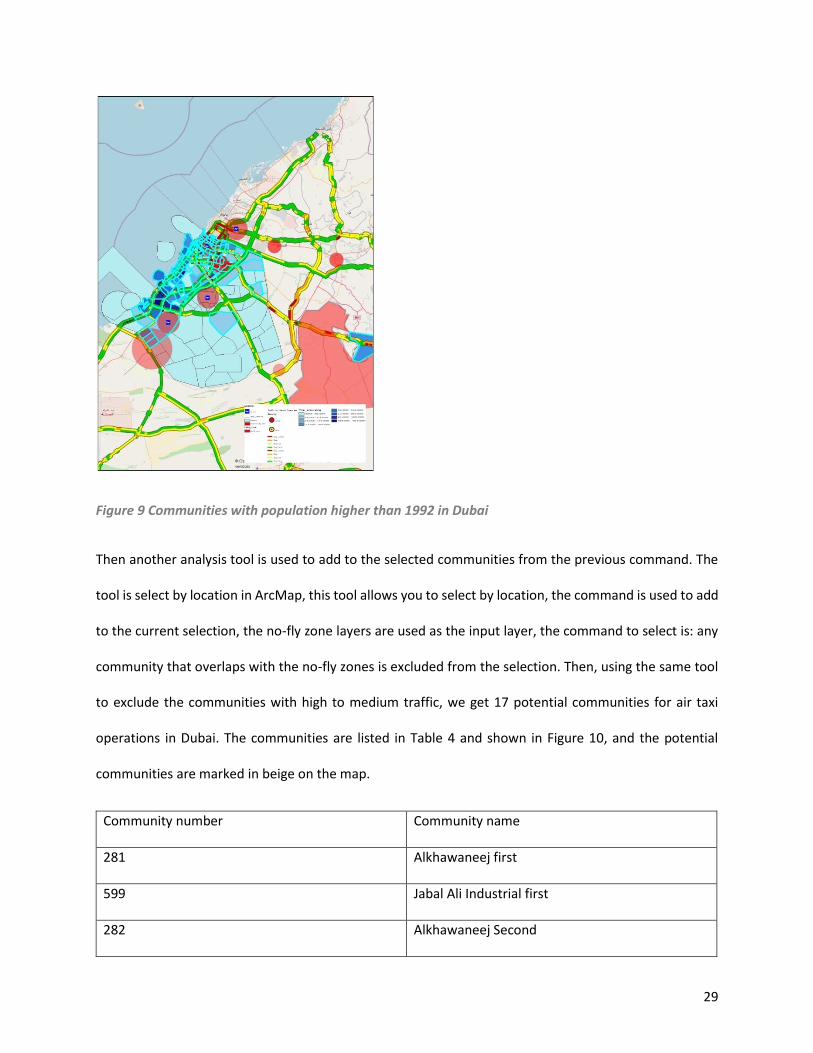
29
Figure 9 Communities with population higher than 1992 in Dubai
Then another analysis tool is used to add to the selected communities from the previous command. The
tool is select by location in ArcMap, this tool allows you to select by location, the command is used to add
to the current selection, the no-fly zone layers are used as the input layer, the command to select is: any
community that overlaps with the no-fly zones is excluded from the selection. Then, using the same tool
to exclude the communities with high to medium traffic, we get 17 potential communities for air taxi
operations in Dubai. The communities are listed in Table 4 and shown in Figure 10, and the potential
communities are marked in beige on the map.
Community number Community name
281 Alkhawaneej first
599 Jabal Ali Industrial first
282 Alkhawaneej Second
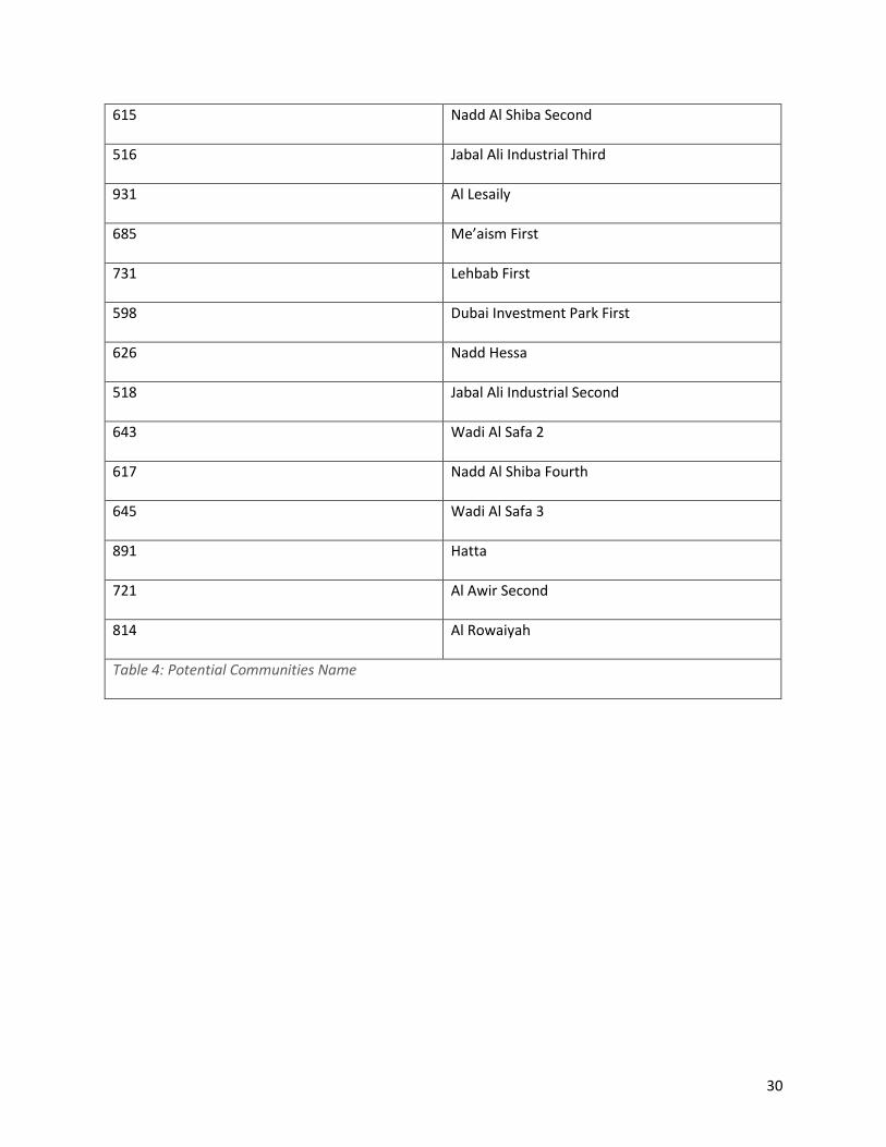
30
615 Nadd Al Shiba Second
516 Jabal Ali Industrial Third
931 Al Lesaily
685 Me’aism First
731 Lehbab First
598 Dubai Investment Park First
626 Nadd Hessa
518 Jabal Ali Industrial Second
643 Wadi Al Safa 2
617 Nadd Al Shiba Fourth
645 Wadi Al Safa 3
891 Hatta
721 Al Awir Second
814 Al Rowaiyah
Table 4: Potential Communities Name
31
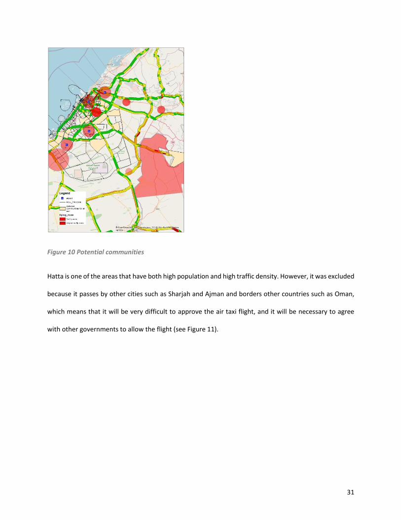
Figure 10 Potential communities
Hatta is one of the areas that have both high population and high traffic density. However, it was excluded
because it passes by other cities such as Sharjah and Ajman and borders other countries such as Oman,
which means that it will be very difficult to approve the air taxi flight, and it will be necessary to agree
with other governments to allow the flight (see Figure 11).
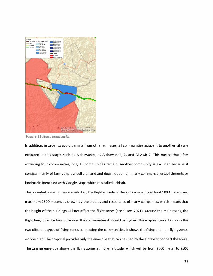
32
In addition, in order to avoid permits from other emirates, all communities adjacent to another city are
excluded at this stage, such as Alkhawaneej 1, Alkhawaneej 2, and Al Awir 2. This means that after
excluding four communities, only 13 communities remain. Another community is excluded because it
consists mainly of farms and agricultural land and does not contain many commercial establishments or
landmarks identified with Google Maps which it is called Lehbab.
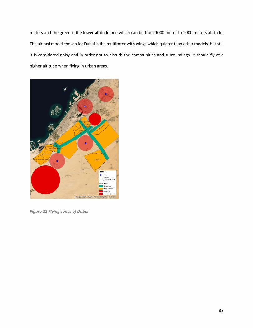
The potential communities are selected, the flight altitude of the air taxi must be at least 1000 meters and
maximum 2500 meters as shown by the studies and researches of many companies, which means that
the height of the buildings will not affect the flight zones (Kochi Tec, 2021). Around the main roads, the
flight height can be low while over the communities it should be higher. The map in Figure 12 shows the
two different types of flying zones connecting the communities. It shows the flying and non-flying zones
on one map. The proposal provides only the envelope that can be used by the air taxi to connect the areas.
The orange envelope shows the flying zones at higher altitude, which will be from 2000 meter to 2500
Figure 11 Hatta boundaries
33
meters and the green is the lower altitude one which can be from 1000 meter to 2000 meters altitude.
The air taxi model chosen for Dubai is the multirotor with wings which quieter than other models, but still
it is considered noisy and in order not to disturb the communities and surroundings, it should fly at a
higher altitude when flying in urban areas.
Figure 12 Flying zones of Dubai
34
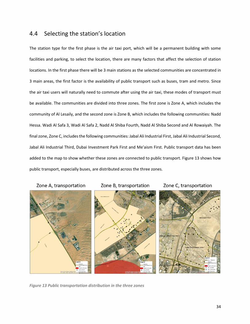
4.4 Selecting the station’s location
The station type for the first phase is the air taxi port, which will be a permanent building with some
facilities and parking, to select the location, there are many factors that affect the selection of station
locations. In the first phase there will be 3 main stations as the selected communities are concentrated in
3 main areas, the first factor is the availability of public transport such as buses, tram and metro. Since
the air taxi users will naturally need to commute after using the air taxi, these modes of transport must
be available. The communities are divided into three zones. The first zone is Zone A, which includes the
community of Al Lesaily, and the second zone is Zone B, which includes the following communities: Nadd
Hessa. Wadi Al Safa 3, Wadi Al Safa 2, Nadd Al Shiba Fourth, Nadd Al Shiba Second and Al Rowaiyah. The
final zone, Zone C, includes the following communities: Jabal Ali Industrial First, Jabal Ali Industrial Second,
Jabal Ali Industrial Third, Dubai Investment Park First and Me'aism First. Public transport data has been
added to the map to show whether these zones are connected to public transport. Figure 13 shows how
public transport, especially buses, are distributed across the three zones.
Figure 13 Public transportation distribution in the three zones
35
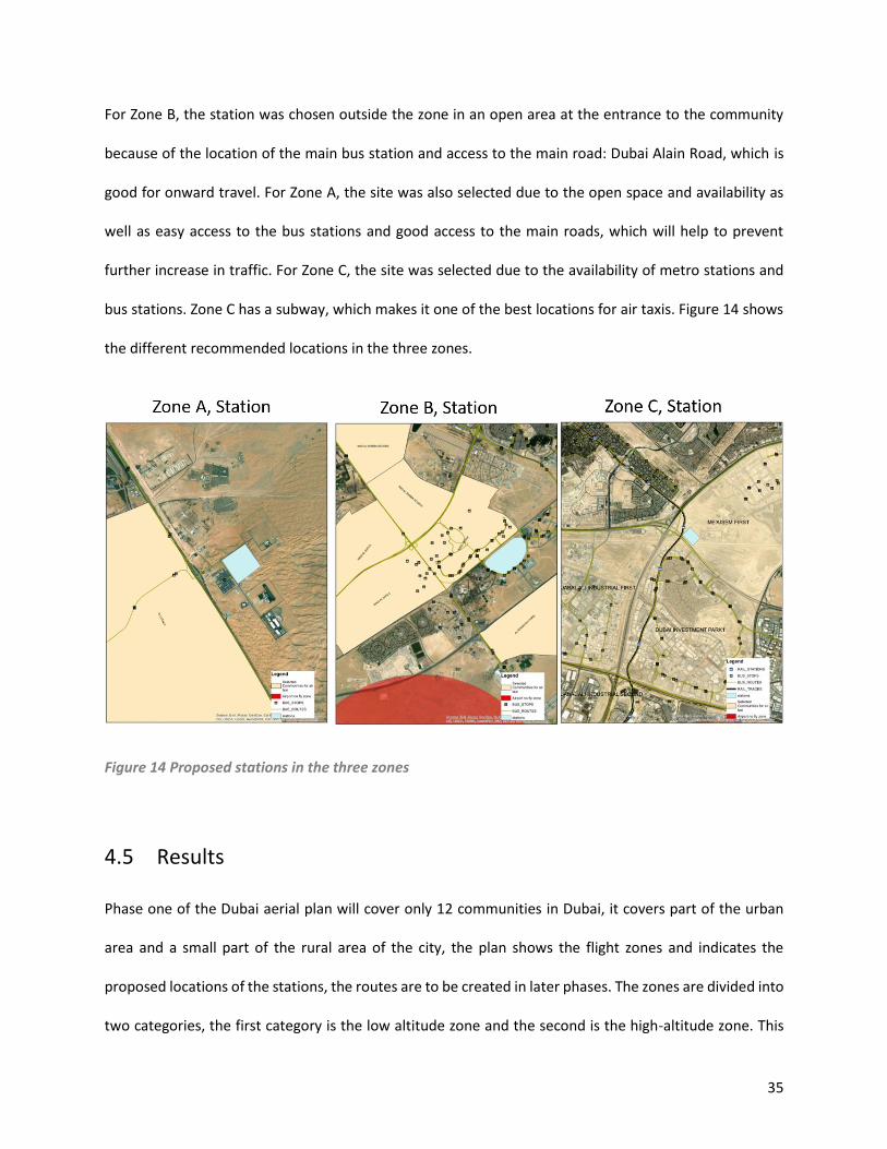
For Zone B, the station was chosen outside the zone in an open area at the entrance to the community
because of the location of the main bus station and access to the main road: Dubai Alain Road, which is
good for onward travel. For Zone A, the site was also selected due to the open space and availability as
well as easy access to the bus stations and good access to the main roads, which will help to prevent
further increase in traffic. For Zone C, the site was selected due to the availability of metro stations and
bus stations. Zone C has a subway, which makes it one of the best locations for air taxis. Figure 14 shows
the different recommended locations in the three zones.
Figure 14 Proposed stations in the three zones
4.5 Results
Phase one of the Dubai aerial plan will cover only 12 communities in Dubai, it covers part of the urban
area and a small part of the rural area of the city, the plan shows the flight zones and indicates the
proposed locations of the stations, the routes are to be created in later phases. The zones are divided into
two categories, the first category is the low altitude zone and the second is the high-altitude zone. This
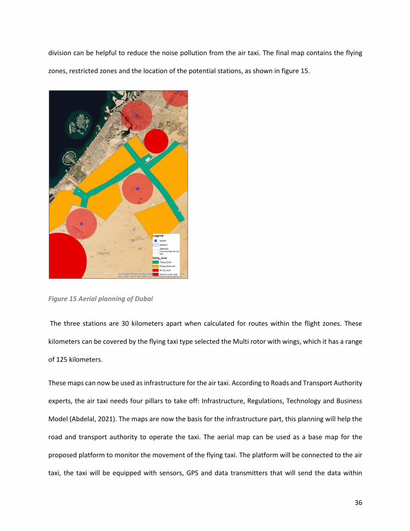
36
division can be helpful to reduce the noise pollution from the air taxi. The final map contains the flying
zones, restricted zones and the location of the potential stations, as shown in figure 15.
Figure 15 Aerial planning of Dubai
The three stations are 30 kilometers apart when calculated for routes within the flight zones. These
kilometers can be covered by the flying taxi type selected the Multi rotor with wings, which it has a range
of 125 kilometers.
These maps can now be used as infrastructure for the air taxi. According to Roads and Transport Authority
experts, the air taxi needs four pillars to take off: Infrastructure, Regulations, Technology and Business
Model (Abdelal, 2021). The maps are now the basis for the infrastructure part, this planning will help the
road and transport authority to operate the taxi. The aerial map can be used as a base map for the
proposed platform to monitor the movement of the flying taxi. The platform will be connected to the air
taxi, the taxi will be equipped with sensors, GPS and data transmitters that will send the data within
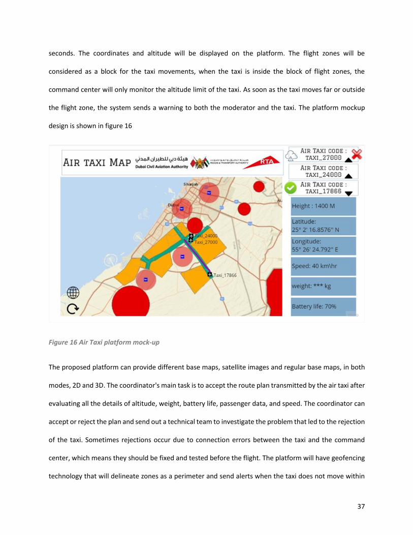
37
seconds. The coordinates and altitude will be displayed on the platform. The flight zones will be
considered as a block for the taxi movements, when the taxi is inside the block of flight zones, the
command center will only monitor the altitude limit of the taxi. As soon as the taxi moves far or outside
the flight zone, the system sends a warning to both the moderator and the taxi. The platform mockup
design is shown in figure 16
Figure 16 Air Taxi platform mock-up
The proposed platform can provide different base maps, satellite images and regular base maps, in both
modes, 2D and 3D. The coordinator's main task is to accept the route plan transmitted by the air taxi after
evaluating all the details of altitude, weight, battery life, passenger data, and speed. The coordinator can
accept or reject the plan and send out a technical team to investigate the problem that led to the rejection
of the taxi. Sometimes rejections occur due to connection errors between the taxi and the command
center, which means they should be fixed and tested before the flight. The platform will have geofencing
technology that will delineate zones as a perimeter and send alerts when the taxi does not move within
38
the perimeter. The command center can manage more than one air taxi at a time, the platform can
provide details about each taxi. The platform also has an alert system for each and every attribute and
reading of the taxi.
Also, the alert will be for any obstacles that comes in the routes like for example: birds, drones, rains, fogs
or any other not expected obstacles, those are sensed from the taxi and sent to the command center to
verify the possible route change. These measures will ensure the safety of the flight and the safety of the
passengers, as the air taxi carries passengers and their safety is important.
39
Chapter 5 Conclusion
5.1 Conclusion Transportation is important, it has always been the focus of governments and is the most dynamic pillar
of cities in the world. Smart cities are always looking for new means of transportation to reduce
congestion and improve the environment. Air mobility has been studied by many smart cities in the world
and has the potential to improve cities in terms of mobility and environment. Dubai started working on
Flying taxi and the study focused on finding a solution to speed up the operation of air taxi and ensure
that the operation is safe. In Summary, the results have shown that the air taxi can be used in Dubai. It
can solve the existing problems of traffic congestion in Dubai and also provide better connectivity
between areas in Dubai.
There are four pillars required for the operation of air taxi, these pillars are: Technology, Infrastructure,
Business and Legislation. The Roads and Transport Authority is working on the technical side, which
includes finding the right vehicle, while work on the second key pillar, infrastructure, has yet to begin. The
project covered the most important parts of the infrastructure and formed the basis for operations from
an infrastructure perspective.
The road and transport authority and other agencies in Dubai were yet to come up with the infrastructure
to operate the air taxi. The study and results have shown that preparations can be made and the taxi can
start operating if all organizations work together to move the study forward. has been divided into two
distinct zones to reduce noise pollution to citizens from flying taxis. There are many constraints to
implementation, for example, the air taxi must be selected this year so that planning can begin
accordingly. The aerial planning proposed in the study can be used for any type of taxi, but some
adjustments are needed if the design is completely different from the options proposed in the study. The
40
flexibility of aerial planning is important because there can be many obstacles and changes in the air and
flexibility and quick reactions are important. Aerial mobility will change the transportation system and
improve the quality of life in Dubai.
5.2 Recommendations
It is recommended to start preparing the platform on which to display the base map created as part of
the project. The ground operation must have a very good platform to ensure that the taxi is safe and
works well. It is also recommended to test the first proposed aerial plan once the taxi is approved and
ready, along with the platform and integration. Testing can be done along with the testing of the taxi. This
will help mitigate risks and find problems or missing parts that were not included in the study. Then start
planning for the other phases that include other areas, once the operation is successful with the first
phase.
It is also recommended to start working together for the pre-approved areas in the flight zones. These
pre-approved areas will make the movement easier and smooth as the permitting and approval time can
be long. Another recommendation is to prepare an approval process for on-demand routes that will allow
areas not covered in the flight zones to be approved. This approval process will also involve other agencies
such as the General Civil Aviation Authority, the Dubai Civil Aviation Authority and the Dubai Air
Navigation System, as they should all be aware of this on-demand flight.
For the future, the Roads and Transport Authority and other stakeholders should work to create the
possible routes within the zones. Routes could be divided into emergency routes and normal routes. This
planning will provide predefined routes for each flight. This will make operations much safer and easy to
manage and monitor from the ground. It will ensure the safety of the passengers. The second future task
41
is to prepare the air planning for the second area of Dubai, which will connect the currently proposed
zones with other areas. The second area could include tourist areas such as the connection between Dubai
and Hatta or the connection of Sheikh Zayed Road with other areas such as Dubai Investment Park.
Moreover, the platform can be upgraded with an artificial intelligence model and a set of rules that
support the automatic creation of routes based on standards and criteria that can be defined by the
stakeholders working in the field. This will allow the automatic creation of the best routes based on these
criteria and facilitate operations. The artificial intelligence mode can be trained with a few flights during
the test phase and the first year of operation and can then automatically propose the best route based
on the environment and the roles.

42
Bibliography
Abdelal, R. (2021, August 26). Project Manager. (M. Alnuaimi, Interviewer)
Achkhanian, M. (2016, April 25). 25% of all transportation in Dubai will be smart and driverless by 2030:
Mohammad Bin Rashid. Retrieved from Gulf News : https://gulfnews.com/uae/transport/25-of-
all-transportation-in-dubai-will-be-smart-and-driverless-by-2030-mohammad-bin-rashid-
1.1810896
Alfred, C. (2019, October 29). Volocopter takes step towards commercial flights. Flight international , p.
22.
Aluminium offshore. (2020). Elevated and Rooftop Helipads and Heliports. Retrieved from Aluminium
offshore: https://www.aluminium-offshore.com/elevated-and-rooftop-helipads-and-heliports/
Automotive News. (2019). Boeing joins the flying taxi crowd. Detroit : Automotive News.
Barrientos , A., Colorado, J., Cerro, J., Martinez , A., Rossi, C., Sanz, D., & Valente, J. (2010). Aerial
Remote Sensing in Agriculture: A PracticalApproach to Area Coverage and Path Planning for
Fleetsof Mini Aerial Robots. Field Robotics .
Bilslah, B. (2021, Sep 01). Drone operation Manager . (M. Alnuaimi, Interviewer)
Buchan, A. (2020, August 26). DUBAI TO GET ITS OWN SKY LANES FOR FLYING TAXIS AND DRONES.
Retrieved from Dubai lad : https://www.dubailad.com/dubai-to-get-its-own-sky-lanes-for-flying-
taxis-and-
drones/#:~:text=A%20new%20agreement%20signed%20in,Dubai%20%E2%80%9Cthrough%20a
dvanced%20technologies%E2%80%9D.&text=At%20last%2C%20flying%20taxis!
Chen, C., Zhang, J., Shen, L., & Zhing , D. (2017). Control and flight test of a tilt rotor unmanned aerial
vehicle . International Journal of Advanced Robotic Systems .
Christopher , H., Andreas , R., Kendall , L., & Ido , B. (2016). Route Planning for Unmanned Vehicle. San
Francisco: HNKLE .
Federal Aviation Administration . (2020, July 22). Flying Near Airports . Retrieved from Federal Aviation
Administration :
https://www.faa.gov/uas/recreational_fliers/where_can_i_fly/airspace_restrictions/flying_near
_airports/
Flemming, S. (2021, Feb 08). The UK is building the world’s first airport... for flying cars. Retrieved from
World economic forum : https://www.weforum.org/agenda/2021/02/uk-first-airport-electric-
flying-cars/
Godinho, V. (2020, July 05). Sheikh Mohammed’s new law to regulate all drone operations in Dubai.
Retrieved from Gulf Business : https://gulfbusiness.com/sheikh-mohammeds-new-law-to-
regulate-all-drone-operations-in-dubai/
43
GRAFT. (2018). Air Taxi Volo-Ports. Retrieved from World Architects : https://www.world-
architects.com/en/graft-berlin/project/air-taxi-volo-ports
Hawkins, A. J. (2018, 4 17). Volocopter envisions air taxi stations that can handle 10,00 passengers a day
. Retrieved from The verge .
Huang, C., Lan, Y., Zhou, W., Pei, H., Yang, L., & Cheng, Y. (2018, Nov 05). A New Dynamic Path Planning
Approach for Unmanned Aerial Vehicles. Control Design for Systems Operating in Complex
Environments, p. page 17.
Hyundai. (2021, January 28). World-first electric Urban Air Port® secures UK government backing.
Retrieved from Hyundai: https://www.hyundai.news/eu/articles/press-releases/world-first-
electric-urban-air-portr-secures-uk-government-backing.html
Kochi Tec. (2021, July 2). Back to the future? Flying car completes inter-city test flight. Retrieved from
Indian Experess : https://indianexpress.com/article/technology/science/back-to-the-future-
flying-car-completes-inter-city-test-flight-7385646/
Lacina, L. (2020, Sep 15). The next big disruption is coming. How cities can prepare for 'flying cars' .
Retrieved from World Economic Forum : https://www.weforum.org/agenda/2020/09/flying-
cars-are-the-next-big-disruption-how-cities-can-prepare/
Manuel, R., Carlos, S., Josselyn, G., & Alexandre , A. (2020). Aircraft Hybrid-Electric Propulsion:
Development Trends, Challenges. Journal of Control, Automation and Electrical Systems, 1244–
1268.
Middleton, J. (2019, January 29). flying taxis within five years . Retrieved from The conversation :
https://theconversation.com/flying-taxis-within-five-years-not-likely-110025
Nasdaq. (2019, Nov 18). Flying Taxi Market To Reach USD 9.4 Billion By 2026 | Reports And Data: Flying
Taxi Market Size – USD 1.3 Billion in 2018, Market Growth - CAGR of 28.59%, Flying Taxi Industry
Trends – Rising number of investments in Research & Development are being carri. New York :
Nasdaq OMX's news release distribution channel . Retrieved from N.
Ong, T. (2017, Sep 27 ). Dubai Starts testing crewless two-person flying taxis . Retrieved from The verge :
https://www.theverge.com/2017/9/26/16365614/dubai-testing-uncrewed-two-person-flying-
taxis-volocopter
Oxford Business group. (2019). Dubai 2019 . Oxford Business group.
Sandhu, R. (2021). Urban-Air Port Ltd and Hyundai Air Mobility Partner to Develop Urban Air Mobility
Infrastructure. Retrieved from Small talk : https://www.sixmilesacrosslondon.com/pr-urban-air-
port-hyundai-partnership
Sikor sky. (2018). Multi mission helicopter .
Snelgrove, G. (2020, December 15). Boeing’s Flying Taxi – What’s The Latest? Retrieved from Simple
flying : https://simpleflying.com/boeing-flying-taxi/
Tolley, G. (2021, August 21). Sheikh Mohammed bin Rashid unveils six new tourism projects planned for
Hatta. Retrieved from The National News :

44
https://www.thenationalnews.com/uae/2021/08/21/sheikh-mohammed-bin-rashid-unveils-six-
new-tourism-projects-planned-for-hatta/
UAE government . (2021). UAE government . Retrieved from About Dubai : https://u.ae/en/about-the-
uae/the-seven-emirates/dubai
Volocopter . (2020). The Roadmap to scalable urban mobility .
Wray, S. (2020, August). Flying taxi trials in cities set to expand. Retrieved from Cities Today :
https://cities-today.com/cities-progress-flying-taxi-plans/
45
Appendix
Roads and Transport Authority interview
Name: Ruba abdelal
Title: Project Manager, managing the flying taxi
Date: 26\08\2021
Time: 10:00
Interview questions:
Q: What type of flying taxi Dubai is utilizing?
A: RTA is still looking for the best air taxi that meets the requirements. There is no company that
provides the vehicle according to the requirements. RTA is looking for the right company that can meet
all the requirements, the first requirements are an all-electric vehicle with zero emissions that can take
off and land vertically.
Q: What is the time plan of the project, when will it fly?
A: First operation 2023
Q: What are the requirements for the operation of the taxi?
A: There are 4 main pillars for the operation of the taxi:
- Legislation: which RTA is working on right now with DANS and DCAA
- Infrastructure: which includes the paths, stations
- Technology: the selection of the right vehicle
- Business: the business model
Q: What is the power requirement of the taxi?
A: Electric, no voltage specified yet because the taxi type is not yet selected
Q: What is the technical specification of the flying taxi?
A: We don’t have it, it is still a plan

46
Q: How many flying taxi Dubai is planning to get and when will it happen?
A: Start small and then grow, based on the demand it will be few vehicles only
Q: Is there is a plan to change the type of the taxi?
A: For now, it is will be for 4 passengers and it depends on the growth trend and need
Q: Will it cover all Dubai?
A: Gradually it will
Q: What is the coverage of the taxi, current and expected?
A: There are several locations in mind but the information is confidential cannot be shared
Q: What is the maximum duration?
A: It depends on the battery life (1 hours max), it depends on the regulation and DTA
Q: What is the maximum height?
A: Depends on the regulation of Dubai Civil Aviation Authority
Q: What is the maximum speed?
A: It depends on the type of the taxi
Q: What is the maximum weight?
A: It depends on the type of the taxi
Q: How is the taxi managed from ground operations?
A: Control center managed by the operator of the vehicle it may not be in RTA
Q: Will the location of the taxi be tracked? How?
47
A: For sure by a tracker that can send the data to the operation center, it will be manager similar to any
plane or flying vehicle
Q: What are the selected stations for the landing and take-off?
A: No specific type ports, helicopter with some facilities, for passenger security and to enter, waiting
rooms, bathroom, lobby, restaurants and coffee shop, ground base
Q: What are the locations for the suggested stations?
A: Not selected yet
Q: What are other services that will be provided within the stations?
A: Coffee shops, restaurants, waiting area, lobby, restrooms, etc.
Q: Can a person bring luggage?
A: Yes, but still not yet defined the size and weight
Q: What are the expected routs for the taxi?
A: Not defined yet,
Dubai Civil Aviation Authority interview
Name: Badel Belslah
Title: Drone operation Manager
Date: 01\09\2021
Time: 01:00 pm
Interview questions:
Q: What are the available policies in Dubai for flying vehicles?
A: There are no available policies but Dubai Dome project is now facilitating the usage of flying vehicles.
48
Q: How can we prepare the flying zones and routes for the flying taxi?
A: The zones can be defined by the weight, size, speed and the technical specifications
Q: How much is the buffer of no-fly zones from the airport?
A: this information is classified as secret, but you can put a buffer from the center of the airport.
Q: what is the allowed maximum altitude for the drones?
A: 120 km
Q: Where is the no fly zones in Dubai?
A: This information classified as secret and cannot be shared. You can check my Drone Hub to get an
indication of the Area.


