Rough Draft
ALPINE WETLANDS IN COLORADO
BY
THm1AS OWENS
Colorado State Forest Service
February 26, 1980
INTRODUCTION
Alpine wetlands are important. They produce a great i.dea1 of
water for lower elevations. Twenty percent of Colorado's stream
flow comes from the alpine region (Zwinger, 1972). Most of this
moisture is produced by alpine wetlands. Alpine wetlands slow
runoff from snowmelt. This spreads runoff from snowmelt over more
of the growing season, and provides more moisture during the dry
summer. It also reduces flood risk downstream and reduces erosion.
The relatively luxuriant vegetation of alpine wetlands provide food
and cover for elk, mountain sheep, snowshoe hares, ptarmigan, and
other wildlife.
Alpine wetlands is a subject that is not addressed directly by
those who study alpine environments or by those who study wetlands.
In alpine ecological studies, wetlands are often classed with non
wetland situations. In wetland studies, alpine wetlands are ignored
entirely. This situation was noticed during an aerial photographic
survey of Colorado wetlands. Many different moist and wet situations
above treeline were observed on aerial photographs and during field
reconnaisance. Some wet situations appeared to be anomalous with what
was considered "normal" for wetlands (e.g., wetlands on steep slopes).
Information in a concise form was needed to analyze this subject
for the wetland survey. The purpose of this paper is to briefly
describe types of wetlands found in the alpine environment.
Wetland is defined as "land where the water table is at, near,
or above the land surface long enough to promote the formation of
hydric soils or to support the growth of hydrophytes" (Cowardin
et al., 1977). This definition includes lakes and rivers. Hydrophytes
2
are plants that grow in water or soils which contain enough water to
inhibit the "average" plant (Daubenmire, 1974). Hydric soil are soils
formed under saturated condition (Foth and Turk, 1972).
The alpine zone is the treeless area at high altitudes on
mountain tops generally above 3,400 meters in Colorado. This zone or
has no obvious economic significance such as agricultural ef forested
lands have, but is important for many reasons. The alpine zone covers
only three percent of Colorado but supplies 20 percent of the state's
streamflow. It is home for many rare plants which are found nowhere Voo~.r
else and rare animals such as mountain~. It is the focus of
research which leads to insights into interrelationships of plants,
animals, and environment. It is an area of great scenic beauty, which
is important for tourism in Colorado.
ALPINE ENVIRONMENT
GEOLOGY
Most mountains in Colorado consist of Precambrian (the most
ancient geologic era: it spans from the earth's formation to 600
million years ago) rocks which were uplifted. Younger layers were
stripped from above by erosion and Precambrian layers were exposed.
These rocks are mainly metamorphic; schists and gneisses. There is
much granite as well. Igneous rocks are most important in the San
Juan Mountains in southwest Colorado and the Spanish Peaks in south-
central Colorado (Chronic and Chronic, 1972). These rocks are hard
and strongly resistant to weathering and erosion. This causes rugged
terrain and soils of low fertility and coarse texture (Retzer, 1956).
Glaciation has been a major force in shaping high mountains.
The latest period of glaciation was from three million years ago to

3
ten thousand years ago. Downward pressure caused by the glaciers'
great weight and freezing water in hairline cracks quarried out huge
boulders. Glaciers moved downslope scouring out valleys. When
glaciers retreated, they left moraines at their farthest points of
advance, this at about 2,800 meters of elevation. Glacier left
steep-walled cirques above U-shaped valleys. These glacial valleys
are stair-stepped; each step being a terminal moraine with a lake
in each step (Zwinger). Glacial 'valleys are filled with rock glaciers,
coarse till, and outwash materials. As a result, large areas are under
lain by a regolith or unconsolidated debris over bedrock (Retzer).
Parts of the alpine region are nearly flat or gently rolling.
These areas are unglaciated remnants of the "600-million-year-old
erosion surface that once existed at the top of the Precambrian
rocks, and ..• has been raised (3,600-4,300 meters) from its original
level" (Chronic).
TOPOGRAPHY
Colorado's mountain ranges run north-south, swinging to the south
west in the San Juans (Chronic). Glaciation produced two different
landscapes above timberline. On north-south ranging mountains, the
east side was heavily glaciated, producing many cirques with steep
rock walls, lakes, and glacier-scoured valleys containing little vege
tation. Soils on gentle slopes have been affected by frost action
which smooths them. On east-west ranging mountains, there is sloping
land on both sides with a few cirques on north slopes (Retzer).
CLIMATE
Alpine climate is characterized by short, cool summers and long,
cold winters. The growing season is usually less than 50 days with

4
freezes possible at any time. Afternoon thunderstorms are common
during summer and sometimes accompanies by hail or sleet. Autumns
are short, dry, and clear. Warm spells alternate with cold. Winters
are cloudy with frequent severe blizzards. Springs are short, cool,
and wet at the beginning but usually end with droughts (Marr, 1961).
Mean annual temperature at 3,500 meters on James Peak in central
Colorado is -30 Centegrade. The _30 isotherm on a temperature map of
the world runs through Alaska, Labrador, and Greenland. This indicates
an artic climate (Cox, 1933). Tundra air temperatures were found to
obe 1-3 cooler than subalpine air temperatures and soil temperatures
o were 2-6 cooler (Marr).
Alpine environment is one of the most extreme in the world.
A study done in the White mountains of California found that the
climate was extremely hot due to intense light. Thin atmosphere
does not hold heat well and loses it rapidly after sunset. Heat
is radiated rapidly from rocks and soil at night. These factors
contribute to one of the greatest energy fluctuations observed on
this planet during summer (Terjung et al., 1969).
Most precipitation comes as snow in winter. Snowfalls of
several meters are common for a season. A weather station on James
Peak in the front range measured about 110 centimeters of precipitation,
with 100 centimeters of this coming as snow (Cox, 1933). From mid-
May to mid-July, light rains are common during afternoons.
There is a pronounced difference in snowfall received between
the east and west side of the continental divide. The west side
receives more precipitation because as air moves over high peaks,
it cools and cannot hold as much moisture. This moisture is left
5
west of the divide. Vegetation observed on our field trips west
of the continental divide appears much lusher than vegetation on the
east side.
An important weather factor of alpine environments is wind.
?1arr found the tundra to be twice as windy as the subalpine forest
below. This has a large effect on evapotranspiration rates of the
tundra as well as on snow distribution. Wind chills air temperature
(Zwinger) and affects vegetation mechanically. Prevailing winds
in Colorado are from the west.
There are great differences in climate due to severe topography
within a small area. These differences are due to aspect, eleva
tion, and air drainage (Cox, 1977). Vegetation is very much affected
by these differences because of different exposure to wind. light,
moisture, and temperature. This leads to diversity in vegetation
within small areas.
HYDROLOGY
Important factors in alpine hydrology are: amount of snowfall,
distribution of snow by wind. coarse nature of many alpine soils,
and underlying regolith. Wind sweeps exposed areas such as wind
ward slopes and ridgetops bare of snow, leaving them with little
moisture. Snow is carried to more protected sites such as lee slopes
and cirques. These areas accumulate snowfields that are many meters
deep. Large, well protected snowfields may remain year round.
During snowmelt. which is from mid-May to mid-July, most meltwater
is dispersed through the regolith, thus there are few streams above
ground. As a result, there are many springs and seeps in the alpine
region; these often emerge at the base of steep slopes. Snowfields
in cirques feed the string of lakes in glacial valleys.
6
SOILS
Alpine soils are poorly developed. This is due to low soil
temperature, short growing season, and low soil moisture ,during
the warmest months (Retzer). Other factors are high acidity in the
soils, and steep terrain. Parent material consists of silicate rocks
which, when weathered, develop only acid reactions. These factors
cause an absence of soil organisms which decay vegetation. In very
wet soils, this acidity creates a peat-like humus which is low in
nutrients (Cox, 1933).
Because of low temperatures, chemical weathering is slow.
However chemical weathering is important in bogs. There it produces
appreciable amounts of silt and clay. Another source of fine-grained
material is from lower elevations. Silts and clays are blown in from
deserts to the west. Accumulation of fine materials can be seen on
snow in winter (Retzer). Fine materials are washed down from higher
slopes and deposited on more level areas, where springs are located.
Alpine soils have several features which are not associated
with soils in more temperate climates. One feature already mentioned
is that of frost action. One type of frost action, expansion by
freezing of saturated soils, forces rocks to the surface. Benedict
(1970) states, "the combination of low temperatures, locally high
effective precipitation, and the large snow-free expanses of upland
tundra produced an environment in which frost processes are highly
effective. Active sorted rock polygons, rock nets, and rock stripes
occur on floors of ephemeral ponds and in areas that receive melt- i
water from persistent snowbanks." Inactive rock patterns occur in
soils that were once moist but have dried because of climatic change.

7
Another alpine soil feature is permafrost. Permafrost is found
under wet soils in bogs and snowfields. Peat and snow £orms good
insulation which allows soil to remain fDozen over summer. Perma
frost forms an impermeable layer.
On slopes below snowfields, wet soils over impermeable layers
slowly flow downslope. This process is called solifluction. It is
most effective where melting ice layers weaken soils. Average
annual rate of movement for wet soils is 1-2 cm (Benedict). These
flowing masses of soil and vegetation often form terraces at their
bottoms. There, moving soils slow down and thickens because soils are
moving faster above and piles on faster than it can flow away. These
terraces hold water and form very wet areas (Zwinger).
Soil Conservation Surveys classify soils into major groups
according to parent materials. The next classification is according
to properties produced by climate. The next finer group is classed
according to properties produced by vegetation and moisture. Finer
classifications are made according to chemical differences s engineering
differences, and horizon features (Cox, 1979).
Classification of soils for this paper is done according to
two Soil Conservation Surveys of Colorado alpine regions (Cox, 1977
and Retzer, 1956).
Alpine soils are divided into two major categories: upland soils
and wetland soils. Upland soils include alpine turf and rock soils.
Wetland soils are divided into three major types: Lunch peats,
Nystrom peats, and Vasquez-Haverly soils.
Lunch peat is associated with springs and seeps on steep slopes
high in the alpine zone. This soils consists of 25 to 50 centimeters
of highly organic materials over mixed saturated mineral materials.
Peat is developed from woody materials and forbs. Water moves down
8
slopes from seeps producing long, narrow areas of Lunch peat. The
soils is acidic with a pH of 5.35. Vegetation is composed of willow
sedges. rushes, grasses, and succulent forbs. Peat acts as a sponge
reducing water velocity down slopes and also reduces erosion (Retzer).
Nystrom peat occurs where water is ponded, often behind soli
fluction terraces. The soil is found with Vasquez-Haverly soil
and near alpine lakes. Peat is usually about 25 cm thick and formed
from sedges. pH is about 4.5. Vegetation is composed mainly of
sedges, but willows can occur locally (Retzer).
Vasquez-Haverly soils are fine-textured, poorly-drained soils of
granitic origin on slopes of 5i.to 70 percent. These soils are found
in cirque basins and below ridgetops. They receive seepage water most
of the growing season, but can dry out in late summer. Vegetation
is mainly willow plus sedges and forbs. pH is about 5.0 (Cox, 1979).
VEGETATION
As was mentioned earlier, alpine climate is severe. This elimi
nates many plant species which cannot survive long, harsh winters
and short summers. To survive, plants must make special adaptations.
The most ovbious feature of alpine vegetation is lack of trees.
Wind is the most important factor in limiting tree growth. Wind
dessicates needles and growth shoots in winter when there is no
replacement water (Komarkova). Treeline rises to higher elevations in
wind-protected sites. Snow drifts higher and protects trees from
dessication. Shoots that rise above the snow are killed. This creates
a shrubby form of tree known as Krumholtz or windblown timber.

9
Plants that survive the harsh alpine environment have many
special adaptations. Alpine plants are shorter, more slender, less
branched, have fewer and smaller leaves, and fewer flowers than
plants of the same species at lower elevations (Zwinger). Small
plants require less energy for tissue production and short plants
are more protected from wind which causes dessication and mechanical
damage. Alpine plants are rich in anthocyanin pigment which converts
sunlight into heat to warm plant tissues. This makes plants more
cold-hardy. Alpine plants are able to grow when temperatures are
o 0just above 0 C (as opposed to 7-10 C for lowland plants). Alpine
plants flower and set fruit early so summer warmth can ripen fruits.
Flower buds often set one or more seasons before they flower. Large
amounts of carbohydrates are stQred underground and are used in spring
for rapid sprouting. Many alpine plants are grasses, sedges, or
rushes which have narrow leaves not likely to be damaged by winds.
Grasses and sedges have flowers that are reduced to essential parts
and do not require much energy for their production. Most alpine
plants (300 out of 301 species in alpine Colorado) are perennials.
This means they do not have to produce a whole new plant every year
but can add to what is established. A common form of vegetative
reproduction in grasses, sedges, rushes, and irises is by rhizomes
(Zwinger).
Plant communities in alpine environments are fragile and easily
disrupted or destroyed. This is due to a short growing season and
soils low in available nutrients. Any disturbance which opens soil
to wind and ice action will require years or decades to become
revegetated.

10
Ecologists think there is little overall plant succession
taking place in alpine environments. Komarkova states, "Each connnunity
occupies a specific niche in the alpine environment (and is in) •..
a dynamic steady state•.• Succession that can be observed today is
limited to places of relatively rapid environmental change, affected
by plants or outside factors."
The most important environmental factors controlling vegetation
distribution in Colorado's alpine regions are moisture, snow, stability
of soil, and rodents (Komarkova).
The alpine zone can be divided into three vegetative belts.
The low-alpine belt extends from timberline at 3,350 meters to 3,800
meters. Vascular plant dominate and most alpine wetlands are found
here. The middle-alpine belt extends from 3,800 meters to 4,200
meters. It consists of exposed rocks and boulder fields with patches
of fungus, algae, lichens, and mosses dominant. The high-alpine
belt is above 4,200 meters. It consists of exposed rocks and boulder
vields with patches of algae, fungus, mosses, and lichens (Komarkova).
ALPINE WETLANDS
CHARACTERISTICS
Alpine wetlands have several unusual characteristics. One is
slope. Usually, wetlands are associated with flat areas where water
remains. Water runs off slopes, but due to the high amount of water
flowing through the coarse regolith and constant water supply from
snowmelt, sloped wetlands are common in alpine zones. There is little
standing water except in small flat areas; sloped alpine wetlands
are characterized by saturated soils.

11
Another characteristic is low temperature. Water received from
snowmelt is very cold. Water has a high specific heat and warms up
slowly. This causes a short growing season. As a result, most
reproduction in alpine wetlands is by vegetative means because
sexual reproduction is too unreliable.
A third characteristic is that alpine wetlands can build them
selves. Downslope m~ement of wet soils over permafrost builds
terraces and dikes which pond water.
TYPES
The classification of alpine wetlands in this paper is done
according to Komarkova. Komarkova's publication is the most recent,
extensive, and complete ecological study done on Colorado's alpine
region. The method used in Komarkova was Braun-Blanquet association
approach. This approach considers dominant species as well as asso
ciated species to classify vegetation units. Classes are formed
by combining key groups of species which are common to different
sample sites (Mueller-Dombois and Ellenberg). The emphasis is on
presence/absence of species rather than cover dominance.
Lakes
Alpine lakes are found in glacial valleys and often in stairsteps,
with higher lakes formed by terminal moraines draining into lower
lakes. Lakes are fed by snowfields at the heads of valleys below
cirques and have permanent standing water. Alpine Lakes are very
deep, high in oxygen,arid are cold. Due to low fertility of alpine
soils that drain into them, lakes have low algae population and few
fish. Lakes are fringed with wetland vegetation, including species
of Salix, Juncus, and Carex (Zwinger).

12
Snowflush Communities
Snowflush communities are communities of snowpatches. Vegetation
is covered by snow part of the growing season. Snow distribution
is controlled by prevailing westerly winds so extensive snowfields
and snowflush communities are found on lee east slopes of ranges.
Moisture and surface disturbance create sharp changes in vegetation.
The warmest and driest snowflush communities are farthest from the
snowpatch t S center. Soil is saturated most of the year and is acidic.
Soil is subject to downstream soils movement over permafrost. These
communities are cold because of snow cover most of the year above and
permafrost below. There are two major wetland subdivisions within
this type. One is dominated by mosses. An important species is Poly
trichum piliforum. Snow cover is off for only two months which makes
the growing season too short for vascular plants. The other wetland
type is warmer and drier. It is dominanted by Juncus drummondii
and Carex nigicans which form dense sods (Komarkova). Species
such as Polygon bistortoides carryon photosynthesis under snow and
can push their way through a thin layer of snow (Cox, 1933).
Moist Sloping Communities
These communities differ from snowflush communities in having
a longer growing season, lower humus, and higher mineral content in
the soil as well as lower acidity. They differ from bog communities
in having higher mineral content, ldwerhumus, .plus lb.wer acidity in
the soil (Cox). In addition, these communities do not have ponded
water.
Cox (1933) divides Salix communities from herbaceous communities,
but Komarkova classes them together; they will be classed together
in this paper. Nearly pure stands of Salix as well as Juncaceae will

13
be found in this type. These two types of pure stands are included
in the type.
Moist sloping communities are found on slopes below snowfields,
as are most common on protected slopes. These communities can be
extensive, especially on humid slopes west of the continental divide.
The soil is Vasquez-Haverly. Soils are saturated most of the growing
season but can dry out late in the season. These soils are subject
to down-slope motion. Shrub stands are extensive at treeline (Komarkova).
Important species include Salix glauca, S. planifolia, S. nivalis, Carex
nigircans, Carex drummondiana, and Juncus arapahoensis.
Spring Communities
Spring communities are associated with moist sloping communities.
They are characterized by high slopes and high moss cover. Rock
and water can cover significant surface area. These communities
can also have high herb cover. They are more common on west-facing
slopes because of higher precipitation giving rise to more springs.
Soil is Lunch peat. Important vascular species are Cardamine cordi
folia, Caltha leptosepala, Epilobium anagallidifolium, Saxifraga
odontoloma. Important mosses include Philonotis tomentella and
Drepanocladtis exannulatus.
Bog Communities
Alpine bog communities are found behind solifluction terraces
below snowfields, on lake edges, below seeps or snowfields where
there is little or no slope, and around small alpine ponds. These
communities contain permanent water if there is a sufficient water
supply or then can dry out if below a transient snowfield.

14
Soil is Nystrom peat which is high in organic matter. This
acts as a good insulator which allows permafrost to exist under it
and makes downslope processes more active.
Main species are Carex aqutilis, Carex scopularum. Juncus
triglumis, Juncus castaneus, Salix arctica, Salix reticulata (Komarkova).
These communities also contain rare plants such as Ranunculus pygemus
(pygmy buttercup) and Saxifraga foliosa (leafy saxifrage) (Zwinger).
Species of Carex and Juncus have constructed restraining barriers
five to 60 centimeters at the lower end of gentle slopes which forms
pond water. Water spreads out in a thin sheet before falling to the
next level.

15
APPENDIX A
Classification of alpine wetlands according to U.S. Fish and Wildlife Service classification (Cowardin et al.)
TYPE
Lake
Snowflush Communities
Moist Sloping Communities
Spring Communities
Bog Communities
CLASSIFICATION
powz (Under 8 hectares) L10WZ (Over 8 hectares)
PMLB PEMB PS$OO
PErm PS~MB
PElm
PEMC PEMF PSS;£MC PS~
16
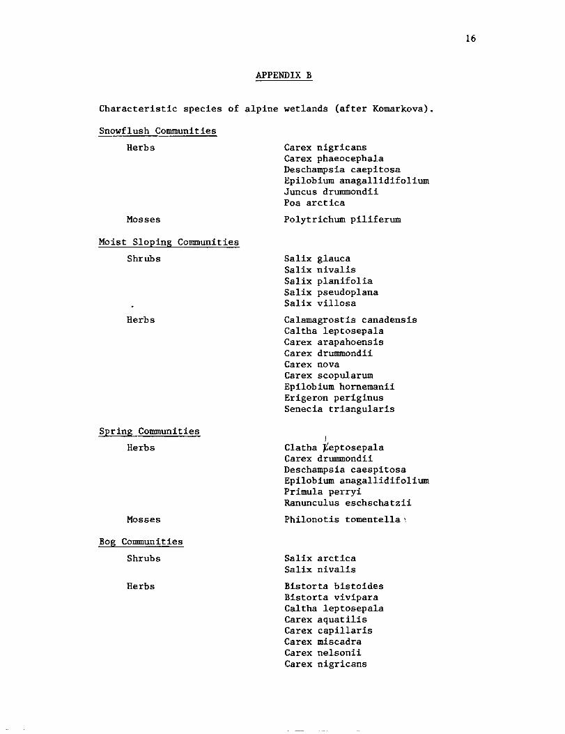
APPENDIX B
Characteristic species of alpine wetlands (after Komarkova).
Snowflush Communities
Herbs
Mosses
Moist Sloping Communities
Shrubs
Herbs
Spring Communities
Herbs
Mosses
Bog Communities
Shrubs
Herbs
Carex nigricans Carex phaeocephala Deschampsia caepitosa Epilobium anagallidifolium Juncus drummondii Poa arctica
Polytrichum piliferum
Salix glauca Salix nivalis Salix planifolia Salix pseudoplana Salix villosa
Calamagrostis canadensis Caltha leptosepala Carex arapahoensis Carex drummondii Carex nova Carex scopularum Epilobium hornemanii Erigeron periginus Senecia triangularis
I Clatha ~eptosepala Carex drummondii Deschampsia caespitosa Epilobium anagallidifolium Primula perryi Ranunculus eschschatzii
Philonotis tomentella 1
Salix arctica Salix nivalis
Bistorta bistoides Bistorta vivipara Caltha leptosepala Carex aquatilis Carex capillaris Carex miscadra Carex nelsonii Carex nigricans
17
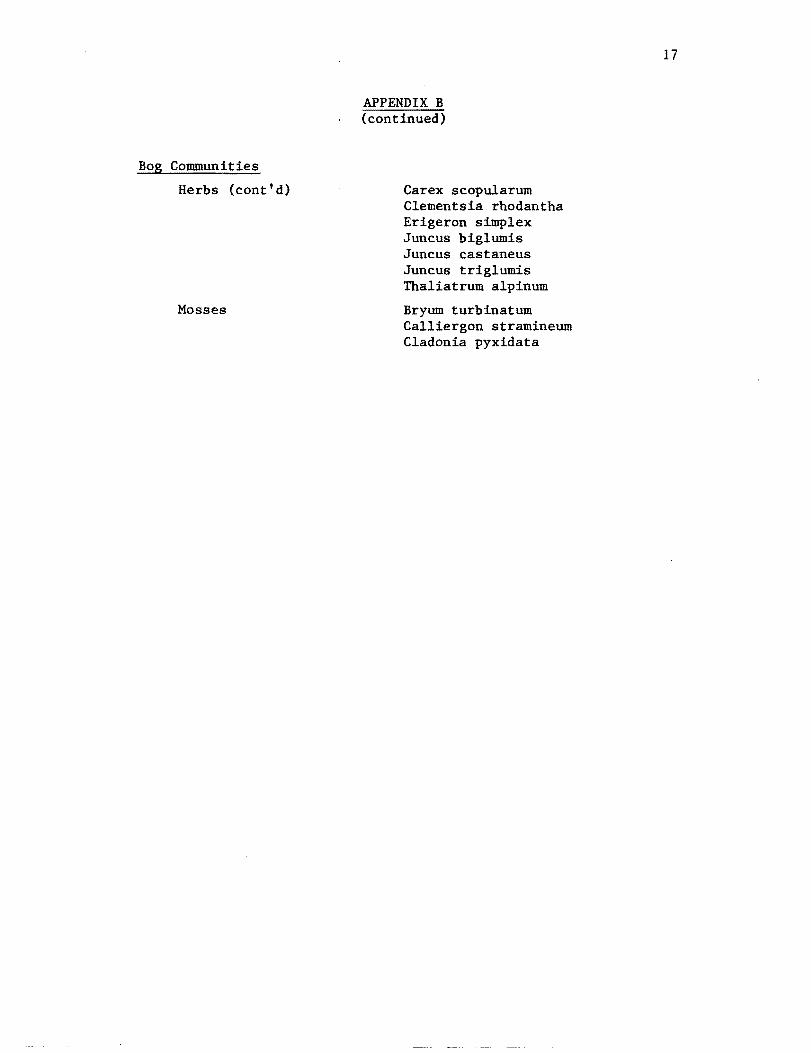
Bog Communities
Herbs (cont'd)
Mosses
APPENDIX B (continued)
Carex scopularum Clementsia rhodantha Erigeron simplex Juncus biglumis Juncus castaneus JuncuB triglumis Thaliatrum alpinum
Bryum turbinatum Calliergon stramineum Cladonia pyxidata
18
BIBLIOGRAPHY
Benedict, James. 1970. Downslope Soil Movement in a Colorado Alpine Region: Rates, Processes, and Climatic Significance. Arctic and Alpine Research. 2: 165-226.
Chronic & Chronic. 1972. Prairie. Peak and Plateau, Colorado Geological Survey Bulletin 32. Denver, Colo. 126 pp.
Cowardin, Golet. Larue. 1977. Classification of Wetlands and DeepWater Habitats of U.S. (Operational Wildlife Service. 100 pp.
Draft) U.S.D.I. Fish and
Cox, C.F. 1933. Alpine Plant Succession Ecological 11onographs. 3: 299-372.
on James Peak, Colorado -
Cox, C.J. 1977. Soil Survey of Taylor RSoil Conservation Service. 82 pp.
iver Area, Colorado. U.S.D.A.
Daubermire, R.F. 1974. Plants and Environment, A Textbook of Autecology, 3rd ed. John Wiley and Sons. New York. 422 pp.
Foth & Turk. 1972. Fundamentals of Soil Science. S&L ed. John Wiley and Sons, New York. 454 pp.
Komarkova, Vera. 1979. Alpine Vegetation of the Indian Peaks Area, Front Range, Colorado. J. Cramer, Germany. 891 pp.
Marr, John. 1961. Ecosystems of the East Slope of the Front Range in Colorado. University of Colorado Studies, Series in Biology. no. 8. 134 pp.
Mueller, Dombois, & Ellenberg. 1974. Aims and Methods of Vegetation Ecology. John Wiley and Sons, New York. 547 pp.
Retzer, J. L. 1956. Soil Survey of Fraser Alpine Area, Colorado. U.S.D.A. Soil Conservation Service. 47 pp.
Terjung, Kiekert, Potter, Swarts. 1969. Energy and Moisture Balance of an Alpine Tundra in Mid-July. Arctic and Alpine Research. 1: 247-266.
Zwinger and Willard. 1972. Land Above the Trees, a Guide to American Alpine Tundra. Harper and Row. 460 pp.


