October 2021 5-1 Stagecoach Solar Project Draft EIR
5.0 ALTERNATIVES SCREENING, IDENTIFICATION, AND IMPACT ANALYSIS
5.1 INTRODUCTION 1
As noted in Section 1.0, Introduction, the CSLC, as lead agency under the California 2
Environmental Quality Act (CEQA), is preparing this Environmental Impact Report (EIR) for 3
the proposed Stagecoach Solar Project (Proposed Project). Section 2.0, Project Description, 4
provides detailed information on the Project proposed by the Applicant, Aurora Solar, LLC, 5
for lease of State-owned school lands managed by the CSLC. 6
The State CEQA Guidelines (§ 15126.6, subd. (a))33 require the CSLC to “describe a range 7
of reasonable alternatives to the project, or to the location of the project, which would 8
feasibly attain most of the basic objectives of the project but would avoid or substantially 9
lessen any of the significant effects of the project, and evaluate the comparative merits of 10
the alternatives.” This EIR section describes the screening methodology to identify 11
reasonable alternatives, identifies alternatives eliminated from further consideration, and 12
provides a description and impact analysis of each alternative considered.Section 6.6 13
identifies the environmentally superior alternative. 14
5.2 SELECTION OF ALTERNATIVES 15
5.2.1 Guidance on Alternatives Development and Evaluation 16
The State CEQA Guidelines provide the following guidance for evaluating alternatives: 17
• An EIR need not consider every conceivable alternative to a project. Rather, it must 18
consider a reasonable range of potentially feasible alternatives that will foster 19
informed decision-making and public participation. An EIR is not required to consider 20
alternatives which are infeasible. (§ 15126.6, subd. (a).) 21
• The discussion of alternatives shall focus on alternatives to the project or its location 22
which are capable of avoiding or substantially lessening any significant effects of the 23
project, even if these alternatives would impede to some degree the attainment of the 24
project objectives, or would be more costly. (§ 15126.6, subd. (b).) 25
• In selecting a range of potential reasonable alternatives to the project, the lead agency 26
shall include those that could feasibly accomplish most of the basic objectives of the 27
project and could avoid or substantially lessen one or more of the significant effects. 28
Among the factors that a lead agency may use to eliminate alternatives from detailed 29
consideration in an EIR are: (i) failure to meet most of the basic project objectives, (ii) 30
infeasibility, or (iii) inability to avoid significant environmental impacts. (§ 15126.6, 31
subd. (c).) 32
33 The “State CEQA Guidelines” refers to California Code of Regulations, Title 14, Chapter 3.

5.0 Alternatives Screening, Identification, and Impact Analysis
October 2021 5-2 Stagecoach Solar Project Draft EIR
• The EIR shall include sufficient information about each alternative to allow meaningful 1
evaluation, analysis, and comparison with the proposed project. If an alternative 2
would cause one or more significant effects in addition to those that would be caused 3
by the project as proposed, the significant effects of the alternative shall be discussed, 4
but in less detail than the significant effects of the project as proposed. (§ 15126.6, 5
subd. (d).) 6
• The specific alternative of “no project” shall also be evaluated along with its impact. 7
The purpose of describing and analyzing a no project alternative is to allow 8
decisionmakers to compare the impacts of approving the proposed project with the 9
impacts of not approving the proposed project…. The “no project” analysis shall 10
discuss the existing conditions, as well as what would be reasonably expected to 11
occur in the foreseeable future if the project were not approved. (§ 15126.6, subd. 12
(e)(1) and (2).) 13
5.2.2 Alternatives Screening Methodology 14
Alternatives to the Proposed Project were identified by the CSLC and proposed by other 15
agencies and the public in comments in response to the Notice of Preparation. These were 16
screened and either retained for further analysis or eliminated as described below. The 17
alternatives screening process consisted of the following steps: 18
Step 1: Define the alternatives to allow comparative evaluation. 19
Step 2: Evaluate each alternative using the following criteria: 20
• The extent to which the alternative would accomplish most of the basic objectives of 21
the Proposed Project (see Section 1.2, Proposed Project Objectives) 22
• The feasibility of the alternative, considering factors such as site suitability, economic 23
viability, availability of infrastructure, General Plan consistency, and consistency with 24
other applicable plans and regulatory limitations (CEQA; Pub. Resources Code, 25
§ 21061.1 defines “feasible” as “capable of being accomplished in a successful manner 26
within a reasonable period of time, taking into account economic, environmental, 27
social, and technological factors”) 28
• The extent to which the alternative would avoid or lessen one or more of the significant 29
environmental impacts of the Proposed Project 30
Step 3: Determine the suitability of the proposed alternative for full analysis in the EIR based 31
on Steps 1 and 2 above. Alternatives considered unsuitable are eliminated, with appropriate 32
justification, from further consideration. CEQA does not require elimination of a potential 33
alternative based on cost of construction and operation/maintenance. 34
For the screening analysis, the technical and regulatory feasibility of potential alternatives 35
was assessed at a general level. At the screening stage, potential impacts of the 36

5.0 Alternatives Screening, Identification, and Impact Analysis
October 2021 5-3 Stagecoach Solar Project Draft EIR
alternatives or the Proposed Project cannot be evaluated with any measure of certainty; 1
however, elements of the Proposed Project that are likely to be sources of impacts can be 2
identified. The assessment of feasibility was conducted by identifying whether the alternative 3
would be infeasible based on technical or regulatory grounds. 4
In general, characteristics used to eliminate alternatives from further consideration included: 5
• Inconsistency with the Proposed Project’s purpose and need 6
• Limited effectiveness in reducing environmental impacts 7
• Engineering feasibility and safety 8
• Permitting feasibility 9
• Potential for adverse effects on biological resources, aesthetics, cultural or tribal 10
resources, or water supply 11
• Potential for inconsistency with adopted agency plans and policies 12
• Feasibility when compared to other alternatives under consideration 13
Feasible alternatives that did not clearly offer the potential to reduce significant environmental 14
impacts of the Proposed Project and infeasible alternatives were not analyzed further. In 15
the final screening step, environmental advantages and disadvantages of the remaining 16
alternatives were carefully weighed with respect to their potential for overall environmental 17
advantage, technical feasibility, and consistency with the Proposed Project objectives. 18
The State CEQA Guidelines require the consideration of a “no project” alternative and to 19
identify, under specific criteria, an “environmentally superior” alternative. If the environmentally 20
superior alternative is determined to be the no project alternative, the EIR must identify an 21
environmentally superior alternative among the other alternatives (State CEQA Guidelines, 22
§ 15126.6, subd. (e)(2)). 23
5.2.3 Summary of Screening Results 24
Following are the potential alternatives that were eliminated from further consideration (see 25
rationale in Section 5.3, Alternatives Eliminated from Further Consideration): 26
• San Bernardino County Suggested Alternative Project Areas: Trona, Amboy, El 27
Mirage, Hinkley, Kramer Junction 28
• Bureau of Land Management (BLM) Land Swap Alternative 29
• Overhead Gen-tie34 on BLM Land Alternative 30
• State Route (SR) 247 Underground Gen-tie Alternative 31
34 A gen-tie line is an electrical generation intertie line that connects the solar generation plant with a
substation.
5.0 Alternatives Screening, Identification, and Impact Analysis
October 2021 5-4 Stagecoach Solar Project Draft EIR
The following alternatives are described and evaluated in detail in Sections 5.5 through 1
5.8): 2
• Solar Generation Plant Alternative at Proposed Location (see Section 5.5): 3
o Joshua Tree Avoidance Alternative 4
• Gen-tie Alternatives (see Section 5.6): 5
o Underground Gen-tie Alternative in County Roads 6
o Underground Gen-tie Alternative Along Proposed Route 7
• SCE Calcite Facilities Alternative (see Section 5.7) 8
o SCE Calcite Facilities Alternative 9
• No Project Alternative (as required by CEQA) (see Section 5.8) 10
5.3 ALTERNATIVES ELIMINATED FROM CONSIDERATION 11
Siting assessments for utility-scale solar projects typically include the following major 12
factors, listed in order of importance: 13
1. Access to a transmission line (ideally with voltage of 230 kV and within 10 miles of 14
the solar site), with adequate capacity to allow full deliverability of electricity generated 15
into the California Independent System Operator (CAISO) electric grid 16
2. Appropriate zoning on private land, acceptable BLM land designation, and lack of 17
other development constraints that may exist on State-owned land 18
3. Large parcel size (generally greater than 80 acres per parcel), generally flat land, 19
and landowner willingness to sell. Private land parcels must be acquired at least via 20
an “option to purchase” agreement. 21
4. Minimal environmental impacts and constraints, including listed or sensitive species, 22
proximity of residences, visual impacts from sensitive public viewpoints, availability of 23
water for construction dust control, and the potential presence of high value cultural 24
or tribal resources. 25
The alternatives eliminated, as described in the following parts of Section 5.3, have been 26
found not to meet some or all of these criteria. Sections 5.4 through 5.8 describe the 27
alternatives retained for EIR analysis. 28
5.3.1 San Bernardino County Areas: Trona, Amboy, El Mirage, Hinkley, Kramer 29
Junction 30
The San Bernardino County Land Use Services Department and other commenters 31
suggested, in comments on the Notice of Preparation (NOP), that consideration be given 32

5.0 Alternatives Screening, Identification, and Impact Analysis
October 2021 5-5 Stagecoach Solar Project Draft EIR
to the renewable energy development focus areas supported by the County Board of 1
Supervisors in Resolution No. 2016-20. This Resolution stated: 2
COUNTY indicates its general and tentative support for five (5) of the Development 3
Focus Areas (DFAs) identified in the BLM DRECP LUPA (North of Kramer Junction, 4
Trona, Hinkley, El Mirage, and Amboy) (San Bernardino County 2016) 5
Background on DRECP. The County Resolution was prepared in response to the 6
analysis and conclusions presented in the Desert Renewable Energy Conservation Program 7
(DRECP) Draft EIR/EIS (published in 2014) and the DRECP Land Use Plan Amendment 8
(LUPA) and Final Environmental Impact Statement (EIS) (published in 2016). Figure 5-1 9
illustrates the locations of these five areas within San Bernardino County. 10
The 2016 DRECP LUPA, adopted by the BLM in its Record of Decision (ROD), identifies 11
nearly 400,000 acres of DFAs on BLM-administered lands within the California Desert 12
Conservation Area (CDCA). DFAs are defined in the DRECP as follows: 13
• Development Focus Areas. Locations where renewable energy generation is an 14
allowable use, incentivized, and could be streamlined for approval under the DRECP 15
LUPA. The LUPA will only streamline and provide incentives for renewable energy 16
activities sited in a DFA. 17
The 2016 LUPA adopted by the BLM defined DFAs only on BLM-administered public 18
lands, because BLM does not have jurisdiction over private land. Within San Bernardino 19
County, the DRECP LUPA defined the largest areas of DFAs in and around Trona (east 20
of Ridgecrest) and north of Kramer Junction. Scattered parcels of DFAs were identified 21
east of Barstow, around Adelanto (including the Hinkley and Victorville areas), and in the 22
Lucerne Valley and Johnson Valley. 23
Most of the BLM-administered lands in the Amboy area were identified as Variance Process 24
Lands (VPL), defined as follows: 25
• Variance Process Lands. These lands are potentially available for renewable 26
energy development, but projects on Variance Process Lands have minimal 27
streamlining and are not incentivized. Variance Process Lands have a specific set of 28
CMAs [Conservation and Management Actions]. Project Applicants must demonstrate 29
that a proposed activity on Variance Process Lands will avoid, minimize, and/or 30
mitigate sensitive resources as per the CMAs, will be compatible with any underlying 31
BLM land allocation, and per the CMAs be compatible with and not have an adverse 32
effect on the LUPA design and DRECP strategies. Renewable energy applications in 33
Variance Process Lands will follow the process described in the Western Solar Plan 34
Record of Decision, section B.5. 35

§̈¦40
ÄÆ127
ÄÆ58
£¤395
§̈¦15
§̈¦18
ÄÆ18ÄÆ247
ÄÆ58
§̈¦15
£¤66
Figure 5-1
San Bernardino CountySolar Alternative Areas
F0 2010 Miles
Victorville
Barstow
Ridgecrest
NEVADA
InyoCounty
KernCounty
San BernardinoCounty
Los AngelesCounty
Trona
KramerJunction
Hinkley
El Mirage
Amboy
Proposed Stagecoach Solar Projectand Gen-tie Line
County Alternative AreasLand Ownership
MilitaryBureau of Indian AffairsBureau of Land ManagementLocal GovernmentNational Park ServicePrivate (No Color)StateUS Forest Service
Mojave National Preserve
Marine Corps Air Ground
Combat Cente r
Edwards Air Force
Base
Fort Irwin National
Training Center
Death Val ley National
Park China Lake Naval Weapons
Station
5.0 Alternatives Screening, Identification, and Impact Analysis
Stagecoach Solar Project Draft EIR 5-6October 2021

5.0 Alternatives Screening, Identification, and Impact Analysis
October 2021 5-7 Stagecoach Solar Project Draft EIR
The five areas defined as being supported by the San Bernardino County Board of 1
Supervisors have been evaluated for their potential to meet the siting criteria defined 2
above, including relevant BLM siting requirements and the BLM’s likely support of a large 3
solar project. The Board of Supervisors suggestions for consideration of Trona, El Mirage, 4
Hinkley, Amboy, and Kramer Junction are eliminated from consideration in this EIR. Each 5
area is described below; all are considered to be infeasible for the reasons presented at 6
the end of each discussion. 7
5.3.1.1 Trona 8
Figure 5-2 (San Bernardino County Alternative Areas: Potential Trona Alternative) shows 9
the Trona area, the BLM land designations, and the existing transmission line. 10
Description. The largest area of BLM DFA in San Bernardino County is in the Trona area, 11
primarily overlying Searles Dry Lake. The DFA and the lake are immediately east of the 12
unincorporated towns of Trona, Pioneer Point, and Argus. The lakebed is over 70,000 13
acres and is heavily disturbed from previous mining activities. The active mines in the area 14
produce minerals from brine solutions from Searles Lake, which fills the entire DFA, to 15
produce boric acid, sodium carbonate, sodium sulfate, several specialty forms of borax, 16
and salt (SVM 2020). 17
A hypothetical solar project alternative is shown at the north end of the DFA. This area was 18
selected because of its apparently lesser amount of active lakebed mining activity, as 19
compared with the southern area. Also, a solar project at the north end of the DFA would 20
maximize separation distance from BLM’s Trona Pinnacles, a National Natural Landmark 21
located just south of the DFA. 22
Transmission. The Trona area is connected to the state’s electric grid via an approximately 23
30-mile-long 115 kV line from the Inyokern Substation. This line serves the mining and 24
residential uses in the Trona area. The 115 kV line is unlikely to be able to export the 25
power generated from a 200 MW solar generation plant, typically connected to the electric 26
grid via a 220 or 230 kV transmission line. The cost of constructing a new 30-mile 220 kV 27
gen-tie line would be high, estimated at over $22 million (Mott MacDonald 2020). 28
In addition, the right-of-way for a 220 kV line is generally 150 feet wide, and the line would 29
have to pass through the center of the City of Ridgecrest, where there is no existing right-30
of-way available. Also, if following the existing Southern California Edison (SCE) 115 kV 31
line, up to 13 miles of the line would pass through China Lake Naval Air Weapons Station 32
(NAWS), which may not be permitted. China Lake NAWS is very sensitive to the height of 33
towers in the vicinity due to its low-altitude training flights in the region. 34

ÄÆ178
Tare Access Rd
E Bowman Rd
N K
nox R
d
Tro
na R
dC T Access Rd
Pinnacle
Rd
Randsburg W
ash Rd
Figure 5-2
San Bernardino County Alternative Areas:Potential Trona Alternative
F0 42 Miles
Trona
Kern County
San Bernardino County
Ridgecrest
China Lake Naval Weapons
Station
InyoCounty
Fort Irwin National
Training Center
SCE 115 kV Transmission LinePotential Trona Alternative
Land OwnershipMilitaryLocal GovernmentPrivate (No Color)StateBureau of Land ManagementBLM Area of Critical Environmental Concern (ACEC)BLM Development Focus Area (DFA)
5.0 Alternatives Screening, Identification, and Impact Analysis
Stagecoach Solar Project Draft EIR 5-8October 2021
5.0 Alternatives Screening, Identification, and Impact Analysis
October 2021 5-9 Stagecoach Solar Project Draft EIR
Finally, the line would pass through approximately 6.5 miles of the BLM Mohave Ground 1
Squirrel Area of Critical Environmental Concern (ACEC) between Trona and Ridgecrest. 2
Development within this ACEC is constrained in two ways. First, the BLM would have to 3
determine whether a new transmission line right-of way within the ACEC is permissible. 4
The ACEC Management Plan states, “Land use authorization proposals (new, renewal, 5
and amendment) will be analyzed on a case‐by‐case basis to assess whether they are 6
compatible with the ACEC and its management goals.” The goals are focused on protection 7
of Mohave ground squirrel (Xerospermophilus mohavensis)35 habitat and preventing its 8
fragmentation, so a new transmission line appears to be incompatible with these goals. 9
Second, this ACEC’s Management Plan limits disturbance to 1 percent of its land area 10
under a “disturbance cap.” Whether additional ground disturbance would be allowed 11
depends on BLM’s assessment of existing disturbance within each sub-area of the ACEC, 12
and the disturbance that would result from the construction, operation, and maintenance 13
of a new transmission line. 14
Environmental Concerns. Given the existing mines around the lakebed, the aesthetic 15
impacts of a large-scale solar project may not be significant. The major environmental 16
concerns are likely to be the following: 17
• Mineral Resources: Searles Dry Lake is a high priority mineral area for the BLM. In 18
evaluating any development proposal within the California Desert Conservation Area, 19
the BLM is required to implement the CMAs adopted as part of the DRECP. CMA 20
LUPA-MIN-3 defines the Searles Dry Lake area (72,000 surface acres) as a high 21
priority operation area. Because of this designation, CMA LUPA-MIN-2 requires that 22
the mineral resource value must be analyzed in the National Environmental Policy 23
Act (NEPA) document for any potential renewable energy development. 24
• Cultural and Tribal Resources: Traditional Native American use of the Searles 25
Valley area is likely to have resulted in the presence of numerous important tribal and 26
cultural resources. Also, historic mining resources are widespread (CPUC 2012) 27
• Paleontology: The Searles Lake sediments are considered likely to have high 28
sensitivity for fossil resources, including potential large mammals (mammoth, saber-29
toothed cat, horses, camel) and freshwater invertebrates (CPUC 2012) 30
• Air Quality/Dust: The dry lake is covered with evaporated salts across most of its 31
surface, which create a concern for blowing dust during construction. In addition, this 32
dust may settle on solar panels, potentially reducing electricity production 33
• Water Supply and Water Quality: Water quality is uncertain due to the highly 34
mineralized sediments and the ongoing evaporite mining from these waters and 35
availability of groundwater for dust control has not been investigated 36
35 The Mohave ground squirrel is a small day-active rodent endemic to the western Mojave Desert of California.
It has one of the smallest geographic ranges of any North American ground squirrel and spends much of the year in underground burrows to avoid the harsh conditions of its desert environment (CDFW 2020a).

5.0 Alternatives Screening, Identification, and Impact Analysis
October 2021 5-10 Stagecoach Solar Project Draft EIR
• Transportation and Traffic and Public Services and Utilities: Given the single 1
route of access to the site via SR-178, a solar project in the Trona area would likely 2
experience similar significant impacts regarding construction traffic safety and 3
inhibition of emergency response as defined for the Proposed Project 4
Rationale for Elimination. The Trona site is eliminated because of the high cost and 5
substantial siting challenges associated with constructing a new 30-mile 220 kV 6
transmission line to the Inyokern Substation. As a result, the development of a large solar 7
project in the Trona area is considered infeasible. 8
5.3.1.2 El Mirage 9
Figure 5-3 (Potential El Mirage Alternative) shows the El Mirage area and the location of 10
BLM lands and designations. 11
Description. The area surrounding the unincorporated community of El Mirage has some 12
scattered BLM-administered public lands to the north, and entirely private lands to the south. 13
The area is best known for the El Mirage Off-Highway Vehicle (OHV) Recreation Area, 14
which covers nearly all the land north of the community (see Figure 5-3, Potential El Mirage 15
Alternative). The area includes a visitor center and is jointly managed by the County, BLM, 16
and State of California. The County zoning for the entire area north of the community is RC 17
(Resource Conservation); renewable energy facilities could be allowed with a Conditional 18
Use Permit (San Bernardino County Code Title 8, Development Code, Table 82-4). 19
According to the BLM webpage for the El Mirage OHV Recreation Area (BLM 2020a): 20
The El Mirage Off-Highway Vehicle (OHV) Recreation Area is located in the Mojave 21
Desert on the western edge of San Bernardino County near the Los Angeles County 22
Line. This off-highway vehicle riding area attracts a variety of activities including 23
motorcycles, ATVs, trucks, cars, buggies, land yachts, model airplanes, model 24
rockets, ultra-light aircraft, gyrocopters, parasails, and full-sized aircrafts. The areas 25
of interest include the El Mirage Dry Lake Bed, the Shadow Mountains, the El Mirage 26
Basin, and the Twin Hills area that make up the 24,400-acre project area of public 27
and private land. 28
Further protection of the El Mirage OHV Recreation Area was defined in 2019, when the 29
President signed into law Public Law 116-9, the John D. Dingell, Jr. Conservation, 30
Management, and Recreation Act. This law amended the California Desert Protection Act 31
to add Title XIII (OHV Recreation Areas [OHVRAs]), formalizing the Congressional 32
designation of several formal OHVRAs, including the El Mirage OHV Recreation Area. The 33
newly designated OHVRAs were designated as Special Recreation Management Areas 34
(SRMAs) in the BLM CDCA Plan. The Congressional designation and expansion of the El 35
Mirage OHV Recreation Area also removed approximately 1,475 acres in the south-central 36
portion of the Fremont-Kramer ACEC and incorporated them into the El Mirage OHV 37
Recreation Area. 38

Rancho Rd
El Mirage Rd
La Mesa Rd
Shadow Mountain Rd
£¤395
ÄÆ138
ÄÆ18
§̈¦15
Figure 5-3
Potential El Mirage Alternative
F0 42 Miles
Community ofEl Mirage
El Mirage OHVRecreation Area
Adelanto
Phelan
Los AngelesCounty
San BernardinoCounty
Potential Private Land Solar Project
Victorville
Transmission LinesPotential Private Land Solar Project
Land OwnershipPrivate (No Color)StateBureau of Land ManagementBLM Special Recreation Management Area (SRMA)
5.0 Alternatives Screening, Identification, and Impact Analysis
October 2021 5-11 Stagecoach Solar Project Draft EIR
5.0 Alternatives Screening, Identification, and Impact Analysis
October 2021 5-12 Stagecoach Solar Project Draft EIR
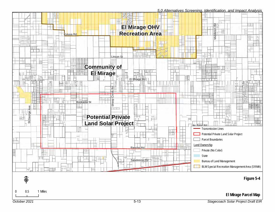
The area south of the community of El Mirage is entirely private land, with scattered 1
residences at a density similar to that of the Lucerne Valley. An area of approximately 2
10,000 acres is identified in Figure 5-4 (El Mirage Parcel Map). Parcel size varies from 2 to 3
80 acres; no larger parcels exist and the 80-acre parcels are not contiguous. Many parcels 4
are vacant, but some have residences or other structures. In order to acquire the 5
approximately 2,500 acres required for a utility-scale solar project, a developer would have 6
to assemble more than 60 parcels. Zoning in this area is RL-5 (Rural Living – 5-acre 7
minimum parcel size). 8
Transmission. There is an SCE 220 kV transmission line running north-south, about 10 9
miles east of central El Mirage. There are several 500 kV transmission lines running east-10
west, about 4 miles south of El Mirage. The Adelanto Substation is about 11 miles east-11
southeast of El Mirage. The access to existing transmission lines appears to be acceptable, 12
but it is not known whether there is available capacity on these lines. 13
Environmental Concerns. The major environmental concerns in the area south of El 14
Mirage are associated with the proximity of existing residences to the potential solar 15
project. These residences would be exposed to dust, construction noise, construction 16
traffic, and a substantial change to their viewshed. Also, the entire area is crossed by 17
natural channels, so there appears to be the potential for surface erosion due to the site’s 18
location on an alluvial plain at the base of the north face of the San Gabriel Mountains. 19
No site-specific information was collected about cultural or tribal resources or the 20
availability of groundwater. 21
Rationale for Elimination. Solar development north of El Mirage appears to be infeasible 22
due to the OHV use and recent formal designations under the Dingell Act. South of El 23
Mirage, the land use is rural residential with widely scattered residences. For a commercial 24
solar generation plant to be approved on private land, the County Development Code 25
requires that the Board of Supervisors “… determine that the location of the proposed 26
commercial solar energy facility is appropriate in relation to the desirability and future 27
development of communities, neighborhoods, and rural residential uses, and will not lead 28
to loss of the scenic desert qualities that are key to maintaining a vibrant desert tourist 29
economy.” In terms of residential development, this area is similar to the Lucerne Valley, 30
so scoping commenters presumably would have the same concerns for El Mirage residents 31
as they expressed for residents in the Lucerne Valley. As a result, this area would not 32
offer an environmental advantage over the Proposed Project and is eliminated from 33
consideration. 34
Mid
dle
ton R
d
Air Base Rd
Sandstone Rd
Linson St
Rancho Rd
She
ep
Cre
ek R
d
El Mirage Rd
Colusa Rd
Bookasta St
St G
eorg
e A
ve
Figure 5-4
El Mirage Parcel Map
F0 10.5 Miles
Community ofEl Mirage
El Mirage OHVRecreation Area
Potential Private Land Solar Project
Transmission LinesPotential Private Land Solar ProjectParcel Boundaries
Land OwnershipPrivate (No Color)StateBureau of Land ManagementBLM Special Recreation Management Area (SRMA)
5.0 Alternatives Screening, Identification, and Impact Analysis
October 2021 5-13 Stagecoach Solar Project Draft EIR

5.0 Alternatives Screening, Identification, and Impact Analysis
October 2021 5-14 Stagecoach Solar Project Draft EIR
5.3.1.3 Amboy 1
Figure 5-5, Amboy Area Land Ownership and Designations, shows the Amboy area, the 2
BLM land designations, and the surrounding National Monument lands. 3
Description. The town of Amboy is reached via National Trails Highway (Historic Route 66), 4
about 30 miles from the 1-40 Ludlow exit, which is about 50 miles east of Barstow. The 5
small town has a motel and cafe on private land along Route 66 adjacent to the railroad. 6
This area was popular from the 1920s through the 1940s when U.S. Route 66 was heavily 7
used, but after the opening of I-40 in 1973, visitation to Amboy via Route 66 dropped 8
dramatically (Wikipedia 2020). 9
Most of the Amboy area is BLM-administered land, including the Mojave Trails National 10
Monument. There is a large operating salt mine on Bristol Dry Lake, with operations 11
spread between 3 and 6 miles southeast of town. See Figure 5-5 for land ownership in the 12
Amboy area; this map shows that the Amboy area is now surrounded by the 1.6-million-13
acre Mojave Trails National Monument, created in February 2016 by Presidential 14
Proclamation. The map also shows the BLM land designations for the Amboy area; most 15
of the BLM lands are defined as VPLs. While these lands are potentially available for 16
renewable energy development, the BLM process for their consideration is considerably 17
more complicated than the process for DFAs, and no VPLs have not yet been developed 18
in the California desert. 19
Transmission. The Amboy area’s electricity needs appear to be served only by a 20
distribution level system with a small substation. The transmission lines that would need to 21
be accessed to export power generated from Amboy would connect with one of the 22
following lines, both shown on Figure 5-6 (Amboy Area Existing Transmission Lines): 23
• SCE 220 kV Iron Mountain-Camino – 35 miles east/southeast, requiring a crossing 24
of about 8 miles of the Mojave Trails National Monument, then 13 miles across the 25
Old Woman Mountains Wilderness (where new transmission rights-of-way would 26
generally be prohibited) 27
• SCE 500 kV Mojave-Lugo – 27 miles north/northwest, through 16 miles of the 28
Monument and 12 miles through the National Park Service (NPS) Mojave National 29
Preserve (where new transmission rights-of-way would likely be prohibited) 30
As a result, a 220 kV gen-tie line serving Amboy is not feasible for several reasons: 31
• This 27- to 35-mile length for a gen-tie is infeasible due to its cost. Construction of a 32
new 30-mile 220 kV gen-tie line is estimated at over $22 million (Mott MacDonald 33
2020). 34
• Amboy is surrounded by National Monument lands, so a solar project in the Amboy 35
area would require a new transmission line through the Monument, which is unlikely 36
to be approved 37

§̈¦40
£¤66
Cad
iz Rd
Am
boy R
d
Amboy Crater
Figure 5-5
Amboy AreaLand Ownership and Designations
F0 42 Miles
Amboy
Marine Corps Air Ground
Combat Cente r
Mojave National Preserve
National MonumentLand Ownership
MilitaryNational Park ServicePrivate (No Color)StateBureau of Land ManagementBLM General Public LandsBLM Variance Process Lands
5.0 Alternatives Screening, Identification, and Impact Analysis
October2021 5-15 Stagecoach Solar Project Draft EIR

4Wd R
oad
Kel
bake
r R
d
Sun
flower S
prings R
d
Cadiz Rd
Hidden Hills Rd
Bag
da
dW
ay
£¤66
§̈¦40
Figure 5-6
Amboy AreaExisting Transmission Lines
F0 105 Miles
Amboy
Old Woman Mountains Wilderness
Marine Corps Air Ground
Combat Cente r
Essex
Transmission LinesNational Monument
Land OwnershipMilitaryNational Park ServiceStateBureau of Land ManagementBLM General Public LandsBLM Variance Process LandsBLM Wilderness Area
Mojave Nationa l Preserve
5.0 Alternatives Screening, Identification, and Impact Analysis
Stagecoach Solar Project Draft EIR 5-16October 2021
5.0 Alternatives Screening, Identification, and Impact Analysis
October 2021 5-17 Stagecoach Solar Project Draft EIR
• Beyond the National Monument lands that surround Amboy, an Amboy solar project 1
gen-tie would have to pass through either Congressionally designated Wilderness or 2
the NPS Mojave National Preserve. Neither option is viable. 3
Environmental Concerns. The most important environmental constraints in the Amboy 4
area are driven by the need to protect the Mojave Trails National Monument from direct 5
and indirect impacts. As described above, the monument surrounds the Amboy area. In 6
addition, the following environmental issues are of concern: 7
• Aesthetics/Light and Glare: Two unique and valuable resources are near Amboy. 8
First is the Amboy Crater (a symmetrical volcanic cinder cone located southwest of 9
the town of Amboy), which was designated as a National Natural Landmark in 1973. 10
The trail to the crater was designated by the Secretary of the Interior as a National 11
Recreational Trail in October 2020 (NPS 2020). Views from this nationally designated 12
trail would be degraded by a large solar project, but there is already a large highly 13
visible salt mine in the Amboy area. Second, the Amboy area is surrounded by the 14
2016-designated Mojave Trails National Monument, spanning 1.6 million acres of 15
federal lands, including more than 350,000 acres of already Congressionally 16
designated wilderness. It is a stunning mosaic of rugged mountain ranges, ancient 17
lava flows, and spectacular sand dunes. The monument contains the longest 18
remaining undeveloped stretch of Route 66 and some of the best-preserved sites 19
from the World War II-era Desert Training Center. It connects the Mojave National 20
Preserve with Joshua Tree National Park (BLM 2020b). 21
• Mineral Resources: Bristol Dry Lake is a high priority mineral area for the BLM. In 22
evaluating any development proposal within the California Desert Conservation Area, 23
the BLM is required to implement the CMAs adopted as part of the DRECP. CMA 24
LUPA-MIN-3 defines the Bristol Lake area (3,500 acres) as a high priority operation 25
area. Because of this designation, CMA LUPA-MIN-2 requires that the mineral 26
resource value must be analyzed in a BLM-prepared NEPA document for any 27
potential renewable energy development in this area. 28
• Air Quality/Dust: The dry lake is covered with evaporated salts across most of its 29
surface, which create a concern for blowing dust during construction. In addition, this 30
dust may settle on solar panels, potentially reducing electricity production. 31
• Water Supply and Water Quality is uncertain due to the highly mineralized 32
sediments and the ongoing salt mining from these waters 33
No site-specific information was gathered on cultural, tribal, or paleontological resources in 34
the Amboy area. 35
Rationale for Elimination. While the VPL designation means that solar development 36
would be considered by the BLM, the transmission interconnection options (if they have 37
available capacity) are too far away to be considered feasible. In addition, new transmission 38
would have to pass through National Monument, Wilderness, and National Park lands, 39
which would create other permitting obstacles. 40
5.0 Alternatives Screening, Identification, and Impact Analysis
October 2021 5-18 Stagecoach Solar Project Draft EIR
5.3.1.4 Hinkley 1
Figure 5-7 shows the Hinkley area, the BLM land and its designations, and transmission 2
lines. 3
Description. A hypothetical 1,920-acre solar project site has been identified that includes 4
1,170 acres of BLM land designated as DFA and 750 acres of private land, as shown on 5
Figure 5-7. This site is between 1 and 4 miles northwest of central Hinkley, and between 1 6
and 3 miles north of SR-58. The northern boundary of this alternative site would be about 4 7
miles southeast of the existing Abengoa Solar Project, located on private land just north of 8
an SCE transmission corridor. 9
The DFA is crossed by a dirt road (with a BLM ROW grant) and also by a rail line (Burlington 10
Northern Santa Fe [BNSF]), both of which would require avoidance and development 11
setbacks, reducing the amount of land available for solar arrays. Crossing of the rail line 12
for construction and operation would have to be arranged with BNSF. 13
There are 750 acres of private land adjacent to the northern DFA parcel. The private land 14
appears to be vacant and consists of two large parcels, but it is unknown if the owners of 15
this land would be willing to sell or lease to a solar developer. These parcels are shown on 16
Figure 5-8, but given the uncertainty about their availability, they are not included in the 17
acreage for this potential alternative. 18
Figure 5-8 shows that there are other private parcels south of those identified for solar 19
development in this potential alternative, but this land is not considered viable for solar 20
development because it is subdivided into parcels ranging from 2 to 40 acres. The 21
numerous small parcels are illustrated on Figure 5-8. As many as 100 parcels may need to 22
be acquired. There are also a few isolated residential properties in this southern area. 23
Zoning is RL-5 or RL-40 (Rural Living, 5-acre or 40-acre minimum). 24
There is a high likelihood of development approval only for the BLM DFA parcels (1,170 25
acres). Using an estimate of 10 acres per MW (which allows for inclusion of an on-site 26
substation, battery storage facilities, access roads, and potential setbacks from biological 27
or cultural resources), these two DFA parcels would accommodate less than 120 MW of 28
solar arrays (not the 200 MW included in the Proposed Project). The additional 750 acres 29
of private land would be needed to have adequate land for a 200 MW project, but that land 30
may not be available for sale or lease. 31
Transmission. The Hinkley Alternative area is located about 3 miles south of existing SCE 32
115 kV and 220 kV transmission lines that run east-west from the Coolwater Substation to 33
the Kramer Substation. The existing Abengoa Solar Project interconnects to this line. The 34
hypothetical gen-tie line shown on Figure 5-7 would be located on BLM-administered 35
public lands for about 1.5 miles and on private lands (assuming rights could be obtained) 36
for about 1.5 miles. 37

Community Blvd
Bla
ck C
an
yo
n R
d
Thompson Rd
Santa Fe Ave
Fossil Bed R
d
ÄÆ58
Potential Hinkley Alternative
Figure 5-7F0 10.5 Miles
Hinkley
Potential Gen-Tie Line Route Transmission LinesPotential Hinkley Alternative
Land OwnershipMilitaryPrivate (No Color)StateBureau of Land ManagementBLM Area of Critical Environmental Concern (ACEC)BLM Development Focus Areas (DFA)
5.0 Alternatives Screening, Identification, and Impact Analysis
October 2021 5-19 Stagecoach Solar Project Draft EIR

ÄÆ58
Community Blvd
Bla
ck C
anyo
n R
d
Santa Fe Ave
Figure 5-8
Hinkley Area Parcel MapF
Hinkley
0 10.5 Miles
Potential Gen-Tie Line RouteTransmission LinesPotential Hinkley Alternative
Land OwnershipMilitaryPrivateBureau of Land ManagementBLM Area of Critical Environmental Concern (ACEC)BLM Development Focus Area (DFA)
5.0 Alternatives Screening, Identification, and Impact Analysis
Stagecoach Solar Project Draft EIR 5-20October 2021
5.0 Alternatives Screening, Identification, and Impact Analysis
October 2021 5-21 Stagecoach Solar Project Draft EIR
In order to reach the existing SCE line from the potential Hinkley Alternative, a new gen-tie 1
line would have to cross about 1.5 miles of the very large BLM Superior-Cronese ACEC, 2
which covers over 330,000 acres and has a very low (0.5 percent) disturbance cap (the 3
ACEC is shown with green hatching on Figure 5-7). This ACEC was created primarily to 4
protect lands defined for protection of desert tortoise (Gopherus agassizii) in the U.S. Fish 5
and Wildlife Service (USFWS) Desert Tortoise Recovery Plan and includes high density 6
desert tortoise population and habitat linkages. The ACEC Management Plan states that 7
“Land use authorization proposals (new, renewal, and amendment) will be analyzed on a 8
case‐by‐case basis to assess whether they are compatible with the ACEC and its 9
management goals.” 10
The feasibility of a gen-tie line crossing the ACEC is questionable because it is not clear 11
whether the BLM would allow the gen-tie line to cross the ACEC. In addition, rights for the 12
primary gen-tie line would have to be obtained from two private landowners. If avoidance 13
of the ACEC were required, the gen-tie line would have to be built around the east side of 14
the ACEC, requiring rights across 20-30 individual private parcels of from 10 to 180 acres. 15
Feasibility. As described above, the feasibility of this alternative is uncertain, due to (a) 16
the amount of private land that would have to be acquired from small parcel landowners, 17
and (b) the need for the gen-tie line to cross the BLM Superior-Cronese ACEC, which may 18
not be permitted by the BLM, or acquisition of rights to use private parcels, which may not 19
be forthcoming. 20
Environmental Impacts. The Hinkley Alternative area is at the eastern edge of the Mohave 21
Ground Squirrel Population Area, as defined in the California Department of Fish and 22
Wildlife (CDFW) Conservation Strategy (CDFW 2019b). MGS is defined as a Threatened 23
Species by the CDFW. Mohave ground squirrel surveys would be required; they are 24
expensive and season-specific. Mitigation would likely be required with potential avoidance 25
of occupied habitat within the DFA. BLM’s Conservation and Management Action (CMA) 26
DFA-VPL-BIO-IFS-2 (below) would be implemented. 27
• DFA-VPL-BIO-IFS-2: Within the Mohave ground squirrel range configure solar panel 28
and wind turbine arrays to allow areas of native vegetation that will facilitate Mohave 29
ground squirrel movement through the project site. This may include raised and/or 30
rotating solar panels or open space between rows of panels or turbines. Fences 31
surrounding sites should be permeable for Mohave ground squirrels. 32
The DFA is also adjacent to protected areas for desert tortoise (the Superior-Cronese 33
ACEC), and the following BLM CMA for desert tortoise protection would be required: 34
• DFA-VPL-BIO-IFS-1: To the maximum extent practicable (see Glossary of Terms 35
[in the BLM DRECP LUPA]), activities will be sited in previously disturbed areas, 36
areas of low-quality habitat, and areas with low habitat intactness in desert tortoise 37
linkages and the Ord-Rodman TCA, identified in Appendix D [to the BLM DRECP 38
LUPA] 39
5.0 Alternatives Screening, Identification, and Impact Analysis
October 2021 5-22 Stagecoach Solar Project Draft EIR
No site-specific data was gathered on cultural or paleontological resources in the Hinkley 1
area, nor on the availability of water for dust control. 2
Groundwater quality is a significant concern in the area, based on its contamination by 3
hexavalent chromium between 1952 and 1966 (Lahontan 2021). Hinkley (also known as 4
the “Erin Brockovich town”) is the town from which a group of residents won a direct-action 5
arbitration against Pacific Gas and Electric (PG&E) in 1996 (Grist 2019). PG&E used 6
hexavalent chromium, also known as chromium 6, to fight corrosion in cooling tower water. 7
The wastewater from the cooling towers was discharged to unlined ponds at the site, 8
where some of the wastewater percolated to the groundwater, resulting in hexavalent 9
chromium contamination. The chromium affects an area of groundwater at least 8 miles 10
long and 2 miles wide; the area is south of SR-58 and over 2 miles southeast of the DFA 11
parcels. 12
Rationale for Elimination. The Hinkley Alternative is eliminated because the size of the 13
BLM DFAs is inadequate for a 200 MW solar project with battery storage, and the private 14
land is not known to be available for project use. There are additional feasibility concerns 15
about the construction of a gen-tie line through an ACEC or multiple private parcels. 16
5.3.1.5 Kramer Junction 17
The Kramer Junction area was evaluated as an alternative in the San Bernardino County 18
EIR for the Daggett Solar Power Project (San Bernardino County 2019b). This 2019 study 19
found the alternative site to be feasible, but not environmentally superior to other sites, and 20
the proposed Daggett Solar Power Project was approved. However, the County EIR did 21
not fully consider the feasibility challenges presented by the BLM CMAs adopted as part of 22
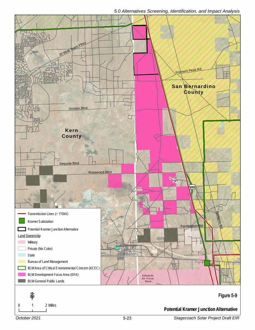
the DRECP, as discussed below. 23
Description. The BLM defines its land north and west of Kramer Junction (at the 24
intersection of SR-58 and U.S. 395) as DFA (see Figure 5-9). The DFA extends along the 25
west side of U.S. 395 for about 14 miles. Much of this DFA is characterized by low rolling 26
hills, not ideal for solar development due to the extensive grading that would likely be 27
required. The northernmost part of the DFA is flatter and the hypothetical Kramer Junction 28
Alternative would be located at this northern end of the DFA as shown in Figure 5-9. The 29
area outlined on the map includes about 2,600 acres. 30
This potential solar project site location adjacent to U.S. 395 would be easily accessed for 31
construction. Also, a major transmission corridor runs along the eastern edge of the site 32
(just west of U.S. 395). The solar field would be entirely on BLM-managed public lands, 33
and there are no apparent residences within several miles of the site. 34
""
ÄÆ58
£¤395
Sequoia Blvd
20 Mule Team Pkwy
Bals
am
o R
dFarmington Rd
Fremont Peak Rd
Gordon Blvd
Rosewood Blvd
Potential Kramer Junction Alternative
Figure 5-9F0 21 Miles
KernCounty
San BernardinoCounty
Boron
Edwards Air Force
Base
Transmission Lines (> 115kV)"" Kramer Substation
Potential Kramer Junction AlternativeLand Ownership
MilitaryPrivate (No Color)StateBureau of Land ManagementBLM Area of Critical Environmental Concern (ACEC)BLM Development Focus Area (DFA)BLM General Public Lands
5.0 Alternatives Screening, Identification, and Impact Analysis
Stagecoach Solar Project Draft EIR 5-23October 2021

5.0 Alternatives Screening, Identification, and Impact Analysis
October 2021 5-24 Stagecoach Solar Project Draft EIR
A solar project in the Kramer Junction DFA might be able to be constructed with an on-site 1
substation and no off-site gen-tie line. An on-site substation could be constructed to allow 2
interconnection to one of the existing SCE lines that parallels the east side of the site. If 3
this is not feasible due to the available capacity of those lines, a new 14-mile-long gen-tie 4
line would have to be constructed to the Kramer Substation, crossing both BLM-managed 5
and private lands. 6
Transmission. The individual BLM DFA parcels shown in Figure 5-9 are located from 4 to 7
15 miles north of the SCE Kramer Substation (which is at the southwest corner of the 8
SR-58/U.S. 395 intersection). There are two SCE transmission lines running along the 9
west side of U.S. 395 (the east side of the hypothetical solar site): 10
• SCE Coso-Kramer 220 kV11
• SCE Inyokern-Kramer 115 kV12
The available capacity of these lines is not known and would require a planning study to be 13
prepared in response to an interconnection application filed with SCE and the CAISO. The 14
California Public Utilities Commission (CPUC) and the BLM are currently evaluating a 15
proposed upgrade to the 115 kV line, as described on the CPUC’s Ivanpah-Control Project 16
website (CPUC 2021), so additional capacity may be available after this upgrade is 17
completed in several years. 18
It is also not known whether the Kramer Substation has available space for interconnection 19
of a new 220 kV transmission line or the additional 200 MW that would be generated in this 20
location. 21
As described above, while transmission lines are present on the site, transmission line 22
capacity is not known, and the capacity of the Kramer Substation to accept additional 23
generation is not known. 24
Feasibility of gen-tie line construction, if a new line to the Kramer Substation is required, is 25
uncertain. As shown in Figure 5-9, the land ownership pattern between the potential solar 26
field and the Kramer Substation is a checkerboard pattern. A gen-tie line following either 27
the west side of U.S. 395 or the route shown on Figure 5-9 (with the line crossing to the 28
east side of the highway to avoid the existing solar field) would require acquisition of rights 29
across about 8 miles of private land and 6 miles of BLM-administered land. The BLM-30
managed lands along U.S. 395 are within a designated section 368 energy corridor and in 31
BLM Utility Corridor P (defined in the CDCA Plan). Acquisition of rights on private land may 32
be challenging if landowners are not willing to sell. 33
Environmental Impacts 34
The Kramer Junction Alternative was also evaluated as an alternative in the San Bernardino 35
County EIR for the Daggett Solar Power Project. The Daggett Solar Project was approved 36
by the San Bernardino County Board of Supervisors in December of 2019. Portions of the 37
5.0 Alternatives Screening, Identification, and Impact Analysis
October 2021 5-25 Stagecoach Solar Project Draft EIR
environmental analysis presented here rely on information in that EIR (San Bernardino 1
County 2019b). 2
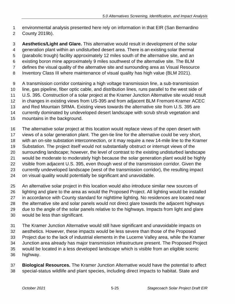
Aesthetics/Light and Glare. This alternative would result in development of the solar 3
generation plant within an undisturbed desert area. There is an existing solar thermal 4
(parabolic trough) facility approximately 12 miles south of the alternative site, and an 5
existing boron mine approximately 9 miles southwest of the alternative site. The BLM 6
defines the visual quality of the alternative site and surrounding area as Visual Resource 7
Inventory Class III where maintenance of visual quality has high value (BLM 2021). 8
A transmission corridor containing a high voltage transmission line, a sub-transmission 9
line, gas pipeline, fiber optic cable, and distribution lines, runs parallel to the west side of 10
U.S. 395. Construction of a solar project at the Kramer Junction Alternative site would result 11
in changes in existing views from US-395 and from adjacent BLM Fremont-Kramer ACEC 12
and Red Mountain SRMA. Existing views towards the alternative site from U.S. 395 are 13
currently dominated by undeveloped desert landscape with scrub shrub vegetation and 14
mountains in the background. 15
The alternative solar project at this location would replace views of the open desert with 16
views of a solar generation plant. The gen-tie line for the alternative could be very short, 17
with an on-site substation interconnection, or it may require a new 14-mile line to the Kramer 18
Substation. The project itself would not substantially obstruct or interrupt views of the 19
surrounding landscape; however, the level of contrast to the existing undisturbed landscape 20
would be moderate to moderately high because the solar generation plant would be highly 21
visible from adjacent U.S. 395, even though west of the transmission corridor. Given the 22
currently undeveloped landscape (west of the transmission corridor), the resulting impact 23
on visual quality would potentially be significant and unavoidable. 24
An alternative solar project in this location would also introduce similar new sources of 25
lighting and glare to the area as would the Proposed Project. All lighting would be installed 26
in accordance with County standard for nighttime lighting. No residences are located near 27
the alternative site and solar panels would not direct glare towards the adjacent highways 28
due to the angle of the solar panels relative to the highways. Impacts from light and glare 29
would be less than significant. 30
The Kramer Junction Alternative would still have significant and unavoidable impacts on 31
aesthetics. However, these impacts would be less severe than those of the Proposed 32
Project due to the lack of industrial elements in the Lucerne Valley area, while the Kramer 33
Junction area already has major transmission infrastructure present. The Proposed Project 34
would be located in a less developed landscape which is visible from an eligible scenic 35
highway. 36
Biological Resources. The Kramer Junction Alternative would have the potential to affect 37
special-status wildlife and plant species, including direct impacts to habitat. State and 38
5.0 Alternatives Screening, Identification, and Impact Analysis
October 2021 5-26 Stagecoach Solar Project Draft EIR
federally listed species occur in and around the site including desert tortoise and Mohave 1
ground squirrel. State species of special concern that are documented in the vicinity include 2
burrowing owl (Athene cunicularia), Townsend’s big-eared bat (Corynorhinus townsendii), 3
and American badger (Taxidea taxus). 4
BLM sensitive plant species documented in the vicinity include, desert cymopterus 5
(Cymopterus deserticola), Barstow woolly sunflower (Eriophyllum mohavense), Beaver 6
Dam breadroot (Pediomelum castoreum), recurved larkspur (Delphinium recurvatum), Red 7
Rock Canyon monkeyflower (Erythranthe rhodopetra), Red Rock poppy (Eschscholzia 8
minutiflora ssp. twisselmannii), and sagebrush loeflingia (Loeflingia squarrosa var. 9
artemisiarum) (CNDDB 2021). 10
This alternative would have similar impacts to the Proposed Project with respect to effects 11
on habitat and special-status plants and wildlife, including desert tortoise. However, this 12
site is located in proximity to known populations of Mohave ground squirrel, and would 13
result in substantial loss of habitat. It would likely require Mohave ground squirrel surveys 14
to define potential avoidance areas; the areas that may be required for avoidance are 15
unknown but may be substantial, requiring solar development to be spread across a larger 16
area to develop the 200 MW of the Proposed Project. 17
BLM’s DRECP LUPA included Appendix D (Conservation and Management Action 18
Implementation Support and Maps), Figure D-18 (Mohave Ground Squirrel Important Areas) 19
and defines most of the Kramer Junction DFA area as a “Key Population Center” for Mohave 20
ground squirrel, and the area just north of it is “Linkage.” BLM would require specific 21
mitigation for impacts to this species, including compliance with the CMAs presented in 22
Table 5-1 (references to the Glossary and Appendix D refer to the DRECP LUPA) (BLM 23
2016b). 24
Table 5-1. BLM CMAs for Mohave Ground Squirrel
(From BLM DRECP LUPA)
CMAs Compliance Concerns
LUPA-BIO-IFS-35: Protocol surveys (see Glossary of Terms) are required for activities in Mohave ground squirrel key population centers and linkages as indicated in Appendix D [of the BLM DRECP LUPA]. Results of protocol surveys will be provided to BLM and CDFW to consult on, as appropriate, for third party activities.
DRECP LUPA Figure D-19 shows that protocol surveys would be required in the Kramer Junction DFA. These surveys are very expensive and time-consuming.

5.0 Alternatives Screening, Identification, and Impact Analysis
October 2021 5-27 Stagecoach Solar Project Draft EIR
Table 5-1. BLM CMAs for Mohave Ground Squirrel
(From BLM DRECP LUPA)
CMAs Compliance Concerns
LUPA-BIO-IFS-36: Activities in Mohave ground squirrel key population centers, as identified in Appendix D [of the BLM DRECP LUPA], requiring an Environmental Impact Statement are required to assess the effect of the activity on the long-term function of the affected key population center.
Activities within a key population center, as identified in Appendix D [of the BLM DRECP LUPA], must be designed to avoid adversely impacting the long-term function of the affected key population center.
Required avoidance of adverse impacts to the long-term function of the key population center may constrain availability of developable land.
LUPA-BIO-IFS-37: Activities in key population centers will be sited in previously disturbed areas, areas of low habitat quality and in areas with low habitat intactness, to the maximum extent practicable (see Glossary of Terms [for BLM DRECP LUPA]).
There are few disturbed areas within the DFAs in the Kramer Junction area. If solar development must occur within disturbed areas, there is not adequate land for a 200 MW project.
LUPA-BIO-IFS-38: Disturbance of suitable habitat from activities, requiring an EA or EIS, within the Mohave ground squirrel key population centers and linkages (as identified in Appendix D [of the BLM DRECP LUPA]) will not occur during the typical dormant season (August 1 through February 28) unless absence is inferred and supported by protocol surveys or other available data during the previous active season.
Disturbance may occur only from March 1 through July 31. This is not a feasible timeframe for construction of a 200 MW solar project, given the typical 18-month required construction timeframe without seasonal constraints.
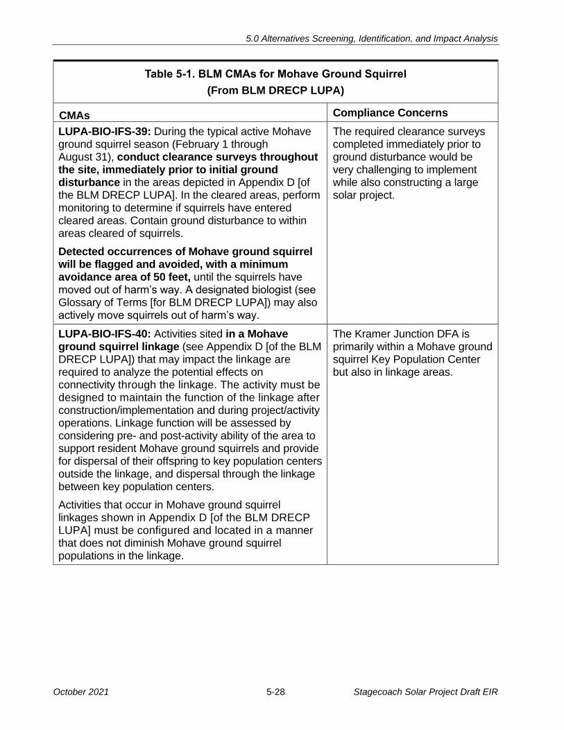
5.0 Alternatives Screening, Identification, and Impact Analysis
October 2021 5-28 Stagecoach Solar Project Draft EIR
Table 5-1. BLM CMAs for Mohave Ground Squirrel
(From BLM DRECP LUPA)
CMAs Compliance Concerns
LUPA-BIO-IFS-39: During the typical active Mohave ground squirrel season (February 1 through August 31), conduct clearance surveys throughout the site, immediately prior to initial ground disturbance in the areas depicted in Appendix D [of the BLM DRECP LUPA]. In the cleared areas, perform monitoring to determine if squirrels have entered cleared areas. Contain ground disturbance to within areas cleared of squirrels.
Detected occurrences of Mohave ground squirrel will be flagged and avoided, with a minimum avoidance area of 50 feet, until the squirrels have moved out of harm’s way. A designated biologist (see Glossary of Terms [for BLM DRECP LUPA]) may also actively move squirrels out of harm’s way.
The required clearance surveys completed immediately prior to ground disturbance would be very challenging to implement while also constructing a large solar project.
LUPA-BIO-IFS-40: Activities sited in a Mohave ground squirrel linkage (see Appendix D [of the BLM DRECP LUPA]) that may impact the linkage are required to analyze the potential effects on connectivity through the linkage. The activity must be designed to maintain the function of the linkage after construction/implementation and during project/activity operations. Linkage function will be assessed by considering pre- and post-activity ability of the area to support resident Mohave ground squirrels and provide for dispersal of their offspring to key population centers outside the linkage, and dispersal through the linkage between key population centers.
Activities that occur in Mohave ground squirrel linkages shown in Appendix D [of the BLM DRECP LUPA] must be configured and located in a manner that does not diminish Mohave ground squirrel populations in the linkage.
The Kramer Junction DFA is primarily within a Mohave ground squirrel Key Population Center but also in linkage areas.

5.0 Alternatives Screening, Identification, and Impact Analysis
October 2021 5-29 Stagecoach Solar Project Draft EIR
Table 5-1. BLM CMAs for Mohave Ground Squirrel
(From BLM DRECP LUPA)
CMAs Compliance Concerns
LUPA-BIO-IFS-41: For any ground-disturbing (e.g., vegetation removal, earthwork, trenching) activities, occurrences of Mohave ground squirrel will be flagged and avoided, with a minimum avoidance area of 50 feet, until the squirrels have moved out of harm’s way. A designated biologist (see Glossary of Terms [for BLM DRECP LUPA]) may also actively move squirrels out of harm’s way.
The required avoidance areas would be very challenging to comply with while also constructing a large solar project.
In addition to the CMAs defined in Table 5-1, more significant constraint to development of 1
this DFA is its location in the center of the CDFW’s designated habitat for the Mohave 2
ground squirrel. The first development challenges are described in the following two CMAs: 3
• DFA-BIO-IFS4: This CMA prohibits renewable energy applications within this DFA 4
until after the CDFW publication of a final Mojave Ground Squirrel Conservation 5
Strategy. In August of 2019, this strategy document was published (CDFW 2019b). 6
However, the CMA also prohibits development until Kern and San Bernardino Counties 7
“… complete county General Plan amendments/updates that include renewable 8
energy development and Mohave ground squirrel conservation on nonfederal land in 9
the West Mojave ecoregion.” (BLM 2016a and 2016b) These have not been prepared; 10
they were required within 5 years, and the timeframe ends in the fall of 2021. 11
• DFA-BIO-IFS-5: This CMA states that after the planning criteria in DFA-BIO-IFS-4 12
are met, the BLM would reevaluate the Mohave ground squirrel key population 13
center. Depending on County actions, the BLM may eliminate the “North of Edwards” 14
DFA and change the area’s designation to “General Public Lands,” which require a 15
more complex development process. 16
If compliance with the two CMAs described above could be achieved, there is a second set 17
of CMAs that apply to a solar project in this area, as described under Biological Resources 18
(below). Compliance would be onerous, time-consuming and would likely further constrain 19
the amount of land on which the BLM could allow development. 20
A project developed within the Kramer Junction DFA would require compliance with NEPA 21
and all applicable CMAs. Full biological and cultural resources surveys would be required 22
before the start of the NEPA process; this process would likely take one to 2 years to 23
complete. CEQA compliance would be required also in order for the developer to obtain 24
permits from CDFW. Both CEQA and NEPA compliance are feasible, but the NEPA 25
component and the BLM and Department of the Interior review processes can add an 26
additional year or two to the typical CEQA-only process. 27
5.0 Alternatives Screening, Identification, and Impact Analysis
October 2021 5-30 Stagecoach Solar Project Draft EIR
Noise and Proximity of Residences. There are no residences near this alternative or 1
along the gen-tie line route to the Kramer Substation, if a new gen-tie line were required. 2
Traffic and Transportation. A solar project of 2,600 acres would require a similar 3
construction workforce as needed for the Proposed Project, but U.S. 395 provides 4
substantially better access and on paved roads. Construction vehicles would have to pass 5
through the Kramer Junction intersection, and left turns off of U.S. 395 into the site would 6
require temporary traffic controls. Traffic impacts would be substantially reduced in 7
comparison to the Proposed Project due to the elimination of the 30-mile drive through 8
Apple Valley and Lucerne Valley and the 2.5-mile drive on unpaved Lucerne Valley Cutoff. 9
BLM Grazing Rights. According to Figure D-21 of DRECP LUPA Appendix D, the Kramer 10
Junction area is within a BLM grazing allotment. The allotment name is Monolith-Cantil 11
(CA05007; BLM 2021); it is 15,544 acres and it overlies nearly all of the BLM DFA parcels 12
in the Kramer Junction area. Full-time grazing is not compatible with large-scale solar since 13
the vegetation otherwise available for grazing animals would be removed or cut, and the 14
solar field would be fenced to exclude cattle. As a result, BLM authorization of a solar 15
project within this grazing allotment would eliminate about 2,600 acres of grazing land from 16
an existing allotment. 17
BLM CMA LUPA-LIVE-4 would apply to solar development within an active grazing allotment: 18
• LUPA-LIVE-4: If the BLM determines that the grazing allotment is to be put to a 19
different public purpose than grazing, follow the notification requirements outlined in 20
the Grazing Regulations at 43 CFR 4110.4-2(b) and BLM Instruction Memorandum 21
(IM) 2011-181 (BLM 2011), or future policy replacing IM 2011-181 22
The notification defined above requires that the grazing permittee/lessee be given 2 years’ 23
prior notification before the grazing permit/lease may be cancelled. In addition, the BLM IM 24
2011-181 states that “The right-of-way (ROW) applicant and the permittee/lessee should 25
be strongly encouraged to enter into an agreement that addresses mitigation and 26
compensation strategies to be submitted concurrent with the POD [BLM-required Plan of 27
Development], but the BLM will not directly participate in these discussions.” This would 28
result in additional cost to develop a solar project on a site with active grazing, as well as 29
potentially an additional development delay due to the notification timeframe. 30
Rationale for Elimination. The BLM-administered land in the Kramer Junction area does 31
not have nearby residences, and there is a nearby transmission corridor. Both of these 32
factors would be advantageous in comparison with the Proposed Project’s location. 33
However, the capacity of the nearby transmission line and the Kramer Substation to 34
accommodate 200 MW of new generation is unknown. In addition, development of a solar 35
generation facility within this BLM “North of Edwards” DFA is not currently feasible. At this 36
time, developers cannot comply with the relevant BLM CMAs, so BLM would not be able to 37
accept development applications. Even if applications could be accepted by the BLM, a 38
5.0 Alternatives Screening, Identification, and Impact Analysis
October 2021 5-31 Stagecoach Solar Project Draft EIR
developer would have to comply with a series of specific requirements related to protection 1
of the Mohave ground squirrel that may limit the amount of land that could be developed. 2
In addition. Therefore, this alternative is eliminated from detailed consideration. 3
5.3.2 BLM Land Exchange Alternative 4
Background. Several scoping comments suggested that the CSLC should exchange the 5
lands that it currently owns in the Lucerne Valley area with BLM lands that have a 6
comparatively lower habitat value and are further from areas of residential development. 7
These commenters suggest that a land exchange would allow these Lucerne Valley lands 8
to be preserved, while still allowing the State to achieve development of renewable energy 9
by encouraging solar development in other areas. The scoping comments included the 10
following suggestions: 11
• Town of Apple Valley: The proposed project is located in an ecologically sensitive 12
site that is inappropriate for large-scale development. Alternatives that must be 13
evaluated are the development of an alternative location with lower resource values 14
and the feasibility of completing land swap with the BLM for lands within an 15
established Development Focus Area. 16
• Desert Tortoise Council: Another alternative should be to exchange/sell the land at 17
the location of the proposed project and acquire land with fewer sensitive biological 18
resources, and closer to where the demand for electricity is 19
• Neil Nadler: The Trona Alternative could be analyzed as a land exchange between 20
the CSLC and the BLM 21
5.3.2.1 Description 22
In October 1994, the California Desert Protection Act (CDPA) was approved by Congress 23
and signed into law, designating 3.6 million acres in Southern California as federal 24
wilderness and 4 million acres in Southern California for inclusion in the national park 25
system. A total of 442 parcels (approximately 251,000 acres) of fee-owned school lands 26
and more than 100 parcels encumbered by the State’s reservation of mineral interests 27
were initially identified as within the CDPA boundaries. Section 707 of the CDPA authorizes 28
exchanging school lands within CDPA-designated areas for federal lands located elsewhere. 29
The CSLC is compensated for the exchange of its fee and mineral interests on a value-for-30
value basis, as determined by fair market appraisals. 31
The CDPA authorized the BLM to implement land exchanges with the CSLC. Five 32
exchanges were completed during the 1990s, resulting in the transfer of more than 66,000 33
acres of school lands to the BLM and deposits totaling more than $14.7 million into the 34
School Land Bank Fund (CSLC 2020). 35
Potential land exchanges between the BLM and the CSLC have been addressed in two 36
processes in the past 30 years. 37

5.0 Alternatives Screening, Identification, and Impact Analysis
October 2021 5-32 Stagecoach Solar Project Draft EIR
California Desert Protection Act. As summarized above, the CDPA authorized exchanges 1
of school lands with federal lands. 2
DRECP. The DRECP process designated BLM lands for conservation and renewable 3
energy development. The DRECP also defined a potential State-federal land exchange. 4
Appendix F to the BLM DRECP LUPA is “Proposed Land Exchange with the State of 5
California.” In Section F.2 (Background), Appendix F states: 6
• The lands the BLM acquires will consolidate Federal ownership to allow for better 7
management of the NCL units and other BLM managed lands. The BLM will convey 8
Federal lands to the California State Lands Commission (CSLC), acting as Trustee, 9
to consolidate State lands to be used for renewable energy development. The CSLC 10
intends to acquire renewable energy projects to help generate revenue for the State 11
of California in accordance with the School Land Bank Act and Assembly Bill 982. 12
The CSLC issued a press release in October 2015 announcing “a historic agreement to 13
pursue an exchange of State school lands with federal lands. The exchange, slated to be 14
executed in phases, will protect conservation lands, facilitate renewable energy 15
development, and provide revenue benefiting California’s retired teachers” (CSLC 2015). 16
Attachment 1 to DRECP LUPA Appendix F (BLM 2016f) also includes a signed 17
Memorandum of Agreement between the BLM and the CSLC, a copy of the School Land 18
Bank Act (Assembly Bill [AB] 982, Skinner, Chapter 485, Statutes of 2011), and a feasibility 19
study of the proposed land exchange. The proposal was that the State would acquire 20
operating solar generation projects, providing revenue to the State. The projects defined in 21
Appendix F were: 22
• Desert Sunlight Project (550 MW, now operating in Riverside County) 23
• Lucerne Valley Solar Project, proposed by Chevron Energy Solutions (San 24
Bernardino County), which was approved by the BLM in 2010. The project was 25
not issued permits by the CDFW and was never constructed. 26
Most of the parcels proposed for exchange were State school land sections that are 27
currently isolated within BLM-administered public lands. However, in the Lucerne Valley 28
area, a large area of State lands was under consideration for a land exchange from the 29
State to the BLM. This included approximately 2,600 acres located approximately 1.6 miles 30
east of the Proposed Project site. 31
Figure 5-10 shows the location of a potential exchange area in the Lucerne Valley, as 32
shown in the Databasin DRECP Gateway36 (Databasin 2021). This map shows the State 33
lands proposed for Stagecoach Solar Generation Plant to the west (purple boundaries) 34
and illustrates the boundary of the potential exchange in red. 35
36 The DRECP Gateway (located at https://drecp.databasin.org/) is a collaborative data storage and
mapping site that allows viewing and creation of maps and use of shared datasets.

Parcel boundaries around State lands.
Parcels identified in the DRECP LUPA for potential exchange with the BLM.
Figure 5-10
Area of Proposed DRECP Land Exchange Source: Source: DRECP Databasin 2021.
5.0 Alternatives Screening, Identification, and Impact Analysis
October 2021 5-33 Stagecoach Solar Project Draft EIR
5.0 Alternatives Screening, Identification, and Impact Analysis
October 2021 5-34 Stagecoach Solar Project Draft EIR
The DRECP LUPA Appendix F also presents lists of parcels to be considered for future 1
phases of land exchanges. 2
Status of the DRECP Land Exchange 3
At the end of 2016, then-Interior Secretary Sally Jewell and Governor Jerry Brown 4
executed a Memorandum of Understanding regarding renewable energy in California 5
which, among other provisions, directed the State and the Department of the Interior to 6
continue to maintain the Renewable Energy Action Team, place priority on processing 7
applications for renewable energy development in areas that are consistent with the 8
DRECP, and complete the Phase 1 land exchange proposal by December 31, 2018. 9
However, the Phase I land exchange was not completed by this date due to shifting 10
priorities of the federal administration (CSLC 2020). 11
In 2021, CSLC staff initiated discussion with the BLM again under the new federal 12
administration and hopes to revisit the lists of parcels and potentially move the exchange. 13
However, these discussions are very preliminary. 14
BLM Process for Land Exchanges 15
The BLM defines its land exchange process in its Land Exchange Handbook (BLM 2005). 16
It is a complicated and time-consuming process, requiring assessment of feasibility, 17
consideration of mineral values, sharing of costs, considering environmental impacts, 18
valuation analysis and appraisal, and a process for decision, protests, and appeals. Chapter 19
13 deals specifically with “Exchanges Involving State Governments.” 20
The process generally takes several years to implement and is not feasible within the 21
timeline required for consideration of alternatives to the Stagecoach Facilities. 22
5.3.2.2 Rationale for Elimination 23
This alternative is eliminated from consideration in this EIR for the following reasons: 24
• The timeframe required for implementing a land exchange is long, as illustrated by 25
the DRECP exchange, which was approved in concept in 2015 but has not been 26
implemented 6 years later. Therefore, it could not be completed in a timeframe that 27
would be reasonable for consideration of siting the proposed Stagecoach Solar 28
Generation Plant at a different location. 29
• The DRECP process did not conceive of an exchange that would transfer BLM land 30
to the State to develop for solar generation, but instead, would give the State income 31
from currently operating solar projects on BLM land 32
CEQA requires that alternatives to a proposed project be feasible for implementation. 33
While there is a defined process for land exchanges between the BLM and the State, it is 34
cumbersome and time-consuming. Because the land exchange process would require 35
5.0 Alternatives Screening, Identification, and Impact Analysis
October 2021 5-35 Stagecoach Solar Project Draft EIR
many years of agency processes and interaction with an uncertain result, a land exchange 1
could not be implemented within a reasonable timeframe or with any certainty. As a result, 2
this Applicant could not pursue development in accordance with its objectives and contract 3
obligations. 4
5.3.3 Overhead Gen-tie on BLM Land Alternative 5
5.3.3.1 Description 6
When the Proposed Project was initially designed by the Applicant, its gen-tie line route 7
was primarily located on BLM land west of State Route 247 (SR-247, or Barstow Road). 8
That route was defined because it would avoid existing residences and would be less 9
visible than a route on private land. However, this route was abandoned by the Applicant in 10
favor of the currently proposed gen-tie line after the BLM adopted the DRECP LUPA, 11
which prohibits new rights-of-way in these lands. 12
5.3.3.2 Rationale for Elimination 13
In 2016, the BLM adopted the DRECP as a Land Use Plan Amendment to the California 14
Desert Conservation Area Plan, resulting in re-definition of permitted uses of the lands 15
west of SR-247. The BLM lands west of SR-247 are now defined as ACECs and their 16
Management Plans (presented in Appendix A to the DRECP LUPA) do not allow new 17
rights-of-way. 18
Therefore, the installation of an overhead gen-tie on BLM-administered land west of SR-247 19
for an overhead gen-tie line is infeasible. 20
5.3.4 SR-247 Underground Gen-tie Alternative 21
5.3.4.1 Description 22
An underground line buried below Lucerne Valley Cutoff and SR-247 would not create a 23
hazard to motorists and is technically feasible to construct. This would be an approximately 24
5.5-mile route, as compared to the proposed 9.1-mile route. Figure 5-11 shows a proposed 25
route for the SR-247 Underground Gen-tie Alternative between the proposed Stagecoach 26
Solar Generation Plant and SCE Calcite Facilities. 27

!(!(!( !( !(
!(
!(
!(
!(
!(
!(
!(
!(
!( !( !( !( !( !(!( !( !(!( !( !( !(
!(
!(
!(
!(
!(
!(
!( !(!( !( !(
!(
!(
!(
!(
!(
!(
!( !(
!(
!(!(!(!(
!(
!(
!(!(!(
!(
!(!(
!(
!(
!(
!(
!(
!(
!(!( !( !(
!(
!(
!(
ST247
Johnson Rd
Lucerne Valley Cutoff
Haynes Rd
Althouse Rd
Me
an
der
Rd
Jay
Jay
Blvd
Stagecoach FacilitiesLease BoundarySolar Facilities FencelineSolar Support FacilitiesConstruction Water Storage and Laydown YardSolar ArraysInvertersAccess Roads
!( 220 kV Structures220 kV Gen-Tie Route
SCE Calcite FacilitiesSCE Calcite SubstationSCE Calcite Facilities Property BoundarySCE Calcite Facilities
Land OwnershipBureau of Land ManagementPrivate (No Color)State
Figure 5-11
SR-247 Underground Gen-Tie Alternative
Underground Gen-Tie Alternative Route Right-of-Way Types
PrescriptiveDedicated
0 10.5 Miles
F
5.0 Alternatives Screening, Identification, and Impact Analysis
October 2021 5-36 Stagecoach Solar Project Draft EIR

5.0 Alternatives Screening, Identification, and Impact Analysis
October 2021 5-37 Stagecoach Solar Project Draft EIR
The underground route along these two roadways was considered because an overhead 1
route following these roads would not be feasible. The most direct overhead gen-tie line 2
route between the Stagecoach Solar Generation Plant and the SCE Calcite Facilities would 3
be to follow two roads: Lucerne Valley Cutoff and SR-247. An overhead route following 4
SR-247 would be infeasible because it would require that poles be installed within areas 5
under County or Caltrans jurisdiction, respectively. Poles at the edge of these roads would 6
pose a driving hazard and would not be allowed by Caltrans on SR-247. The use of the 7
Caltrans ROW along SR-247 for an overhead gen-tie line is infeasible because Caltrans 8
does not have easement rights along the entire route, and existing Caltrans rights extend 9
only to the edge of the graded shoulder, where poles would be too close to the roadway. 10
As a result, an underground route within these roadways was considered. 11
5.3.4.2 Rights and Access 12
Many roads in the project vicinity are within either dedicated ROWs or prescriptive 13
easements, defined as follows: 14
• Dedicated ROWs are public lands managed by an agency that can issue permits for 15
additional uses, such as a utility line 16
• Prescriptive easements occur where the continuous use of the land over a prescribed 17
period of time establishes an ongoing continuing right for that use. The land itself is 18
not acquired by the user. For example, a prescriptive easement can be created by 19
using a particular route across one property to reach another property over time 20
(generally 5 years); this use establishes the right to continue the use of that access 21
route via the prescriptive easement. Under a prescriptive easement the land 22
traversed remains the property of the original owner. 23
The northernmost 1.5 miles of this alternative would be buried in the unpaved Lucerne 24
Valley Cutoff. The road is 25 to 30 feet wide, and connects SR-247 with Interstate 15, via 25
Stoddard Wells Road, Stoddard Valley Road, and Hodge Road. The Lucerne Valley Cutoff 26
is entirely a County Maintained Road under the jurisdiction of the County Department of 27
Public Works. For private utilities, the County requires a franchise agreement37 to install 28
utilities in its roads, and it can issue permits for installation. 29
Both Lucerne Valley Cutoff and SR-247 are installed within prescriptive easements along 30
portions of their lengths. There are approximately 7 parcels along Lucerne Valley Cutoff 31
and approximately 25 parcels along SR-247. Within County-maintained roads that are 32
within a prescriptive easement (not a dedicated ROW), it would also be required to obtain 33
agreements with the underlying property owner to install a gen-tie line in the road segment. 34
37 A franchise agreement is a negotiated contract between a city or county and an electric service provider
that grants the utility the right to use the land in exchange for a fee or other services.
5.0 Alternatives Screening, Identification, and Impact Analysis
October 2021 5-38 Stagecoach Solar Project Draft EIR
As shown in Figure 5-11, approximately 4.0 miles of the route would be within the ROW for 1
SR-247, which is a State highway under Caltrans jurisdiction. Approximately 1.5 miles of 2
this highway segment are within dedicated Caltrans ROW and approximately 2.5 miles of 3
this segment are in prescriptive easements (where the underlying land is not owned by 4
Caltrans). Caltrans has limited ability to issue encroachment permits38 in prescriptive areas 5
because it operates and maintains the road while not owning the land. Generally, the 6
underlying property owner of the prescriptive area must agree to any encroachment in the 7
land used by Caltrans. 8
The southernmost 0.5 miles of the gen-tie line into the SCE Calcite Facilities could be 9
overhead, from a transition structure west of SR-247, or could remain underground within 10
the SR-247 ROW to a transition structure just outside of the substation itself. 11
In summary, permission to install an underground gen-tie line in public ROW along 12
Lucerne Valley Cutoff and SR-247 would be needed from the agency having jurisdiction 13
over each road. For locations where the road is in a prescriptive easement, permission for 14
a gen-tie line to be installed would require both a Caltrans encroachment permit and a 15
grant by the property owner. 16
5.3.4.3 Rationale for Elimination 17
Construction of an underground 220 kV line is technically feasible and has been done in 18
other locations. This alternative is eliminated because of the anticipated challenges to 19
obtaining rights to use the entire underground route. While it is theoretically possible to 20
obtain the rights required to install an underground line along Lucerne Valley Cutoff and 21
SR-247, there is no guarantee that Caltrans (approximately 1.5 miles) and the other 32 22
landowners with prescriptive easements (approximately 2.5 miles in five separate segments) 23
would allow such an installation. Any one of the approximately 32 landowners refusing an 24
easement would make the entire alternative infeasible. 25
5.4 ALTERNATIVES EVALUATED IN THIS EIR 26
Four alternatives, including the No Project Alternative, are identified for full evaluation and 27
comparison to the Proposed Project. The alternatives are as follows: 28
• Section 5.5: Joshua Tree Avoidance Alternative 29
• Section 5.6: Gen-tie Alternatives (two alternatives) 30
• Section 5.7: SCE Calcite Facilities Alternative 31
• Section 5.8: No Project Alternative 32
38 An encroachment permit is required for the placement of a facility or completion of an activity within,
under, or over the State highway ROWs. For example, these permits are required for utility installation, excavations, vegetation planting or trimming, surveys, mail boxes, driveways, and commercial filming activities.
5.0 Alternatives Screening, Identification, and Impact Analysis
October 2021 5-39 Stagecoach Solar Project Draft EIR
Potential impacts for each alternative are evaluated for the following resource areas where 1
impacts of the Proposed Project are most severe: 2
• Aesthetics/Light and Glare: Conflict with existing setting and visibility from 3
protected areas (addressed for the Proposed Project in Section 4.1) 4
• Biological Resources: Potential effects on protected species, habitat linkages, and 5
habitats (addressed in Section 4.2) 6
• Noise: Proximity of residences or other sensitive noise receptors (addressed in 7
Section 4.12) 8
• Traffic and Transportation: Site access routes and constraints (addressed in 9
Section 4.17) 10
Analysis of the following additional resource areas was added for certain alternatives: 11
• Cultural Resources surveys were completed for the Underground Gen-tie 12
Alternative in County Roads, and the results are summarized in Section 5.6.1 13
• Electric and Magnetic Fields are described for the Underground Gen-tie Alternative 14
in County Roads and the Underground Gen-tie Alternative Along Proposed Route 15
The following resource areas are also important in analysis of large solar projects, but are 16
not considered in the comparison of most alternatives (except as described above) for the 17
following reasons: 18
• Air Quality: Section 4.2 identifies certain air emissions to be significant and 19
unavoidable impacts. These impacts are assumed to be very similar for all solar 20
projects of similar size, so they are not addressed in the comparison of alternatives. 21
• Cultural and Tribal Resources: While cultural resources and Native American 22
concerns can result in significant impacts in desert projects requiring extensive 23
ground disturbance, the extent of these impacts cannot be defined without surveys 24
and consultation with Native American tribes 25
• Hydrology and Water Quality: The availability of water for construction dust control 26
(addressed in Section 4.10) is of similar concern in most areas of the desert due to 27
constrained groundwater supplies 28
5.5 JOSHUA TREE AVOIDANCE ALTERNATIVE 29
In September 2020, the California Fish and Game Commission (Commission) approved a 30
one-year listing of the western Joshua tree (Yucca brevifolia) as a candidate for Threatened 31
species status, protected under the California Endangered Species Act (CDFW 2020c). 32
The action started a status review for the Joshua tree; the Commission now expects to 33
issue a report in April of 2022 (CDFW 2021). 34

5.0 Alternatives Screening, Identification, and Impact Analysis
October 2021 5-40 Stagecoach Solar Project Draft EIR
Surveys of the Proposed Project site documented approximately 578 Joshua trees within the 1
boundaries of the proposed solar generation plant and 10 additional trees were documented 2
within a 50-foot buffer outside the project fence line; approximately 398 Joshua trees 3
would be removed for construction of the proposed solar generation plant. Because of the 4
recent listing of this species, an alternative has been developed to relocate some of the 5
solar arrays within the Proposed Project boundaries to avoid the areas with the densest 6
populations of the western Joshua Tree. This alternative is shown on Figure 5-12a, and 7
the habitat and land cover are illustrated in Figure 5-12b. 8
5.5.1.1 Description 9
This alternative would eliminate solar panels in the two Project areas with the densest 10
populations of Joshua trees. This design would reduce the loss of Joshua trees by about 11
80 percent compared with the Proposed Project (resulting in a loss of approximately 160 12
Joshua trees, 238 fewer than the Proposed Project). Under this alternative, the Project 13
area within the fence line would be approximately 1,859 acres (compared to 1,880 acres 14
for the Proposed Project shown in Figure 2-2b). The on-site substation, O&M facility, and 15
battery storage facilities would also be rearranged to minimize the loss of Joshua trees. 16
5.5.1.2 Feasibility 17
This alternative is feasible. 18
5.5.1.3 Environmental Impacts 19
Aesthetics/Light and Glare 20
The layout of project facilities in the Joshua Tree Avoidance Alternative would not change 21
the severity of the aesthetic impacts described in Section 4.1.4.1. For drivers on Lucerne 22
Valley Cutoff, there would be a reduction in visual impact because panels would be set 23
back from road on the north side of the road and the dense area of Joshua trees retained. 24
However, in this alternative, the panels would extend further south on alluvial fans that rise 25
in elevation to the south. These panels would be visible to drivers on southbound SR-247 26
and to recreationists near the Sawtooth Canyon Campground. Overall, the visual impact of 27
the solar field would remain significant and unavoidable. 28
All mitigation measures (MMs) recommended for the Proposed Project would also apply to 29
this alternative. 30
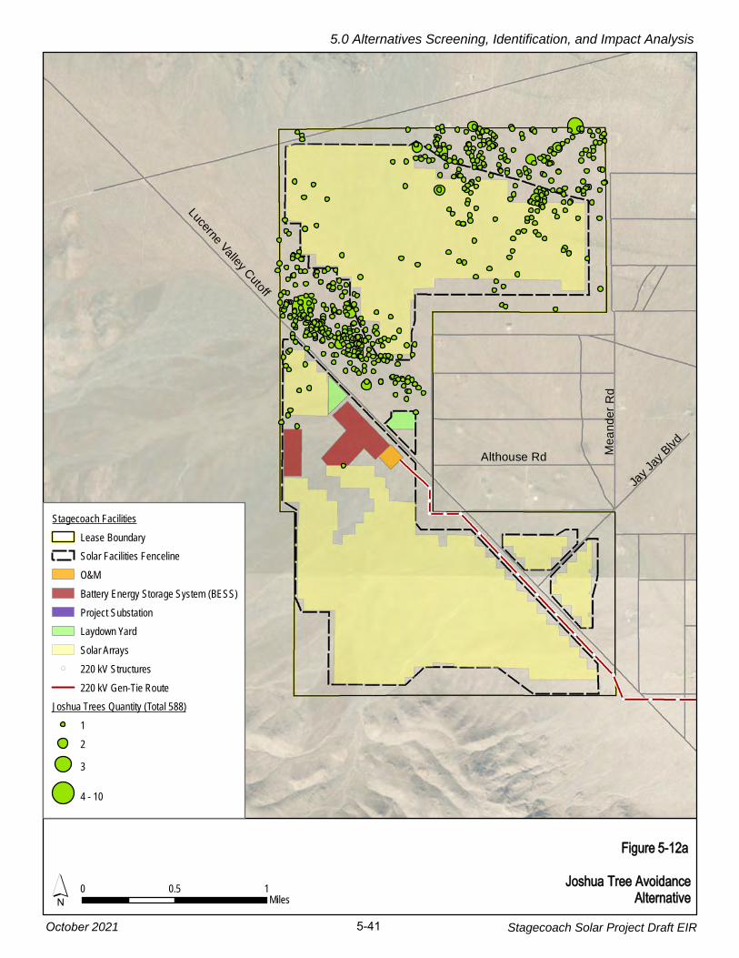
!(
!(
!( !( !(
!(
!(
!(
!(
!(
!(
!(
!(
!( !( !(
LucerneValley
Cutoff
Jay
Jay
Blvd
Althouse Rd Me
an
de
rR
d
Figure 5-12a
Joshua Tree Avoidance Alternative´ 0 0.5 1
Miles
Stagecoach FacilitiesLease BoundarySolar Facilities FencelineO&MBattery Energy Storage System (BESS)Project SubstationLaydown YardSolar Arrays
!( 220 kV Structures220 kV Gen-Tie Route
Joshua Trees Quantity (Total 588)123
4 - 10
5.0 Alternatives Screening, Identification, and Impact Analysis
Stagecoach Solar Project Draft EIR 5-41October 2021

Lucerne Valley Cutoff
Althouse RdM
ean
der
Rd
Me
an
der
Rd
Jay
Jay
Blvd
ÄÆ247
Stagecoach FacilitiesLease BoundarySolar Facilities FencelineSolar Support FacilitiesLaydown YardGen-tie ROW
Vegetation and Cover TypesActon's and Virgin River brittle brush scrubCreosote bush scrubCreosote bush - white bursage scrubDisturbedJoshua tree woodlandMojave yucca scrubNevada joint fir scrubSparsely vegetated wash
Figure 5-12bVegetation and Land Cover:
Joshua Tree Avoidance Alternative2,000 2,0000Feet´
5.0 Alternatives Screening, Identification, and Impact Analysis
October 2021 5-42 Stagecoach Solar Project Draft EIR

5.0 Alternatives Screening, Identification, and Impact Analysis
October 2021 5-43 Stagecoach Solar Project Draft EIR
Biological Resources 1
As illustrated in Figure 5-12a, the Joshua Tree Avoidance Alternative would reduce impacts 2
on the recently listed western Joshua tree. While avoiding the majority of the trees within 3
the State lease area, approximately 160 trees would still be removed for project 4
construction. This impact is described in Section 4.3.4.1 under Impact BIO-2. The analysis 5
concludes that while the solar generation plant would result in loss of Joshua trees, the 6
impact would be less than significant because of mitigation measures that would require 7
the Applicant to purchase and conserve compensation lands. 8
While this alternative would reduce the loss of Joshua trees in comparison with the 9
Proposed Project, the reconfiguration of the solar generation plant results in extending the 10
solar arrays approximately 1,500 further south within the State land parcels. This extension 11
of Project disturbance reduces foraging habitat for raptors in the southern area but would 12
open an equivalent space in the dense Joshua tree woodland north of Lucerne Valley 13
Cutoff. Figure 4.3-4a (Special Status Wildlife Avian Observations [Solar Field]) shows that 14
potential golden eagle nests are located in the mountains both north and south of the 15
Stagecoach Solar Generation Plant. The impacts of this alternative on special status avian 16
species, including golden eagles, would be similar to those of the Proposed Project (less 17
than significant with implementation of mitigation measures). 18
The Joshua Tree Avoidance Alternative would eliminate construction in an area where 19
biological surveys found evidence that burrowing owls were present, and where surveys 20
identified potential burrows. This alternative’s extension of the solar arrays to the south 21
would not affect areas where there was evidence showing that burrowing owls are 22
expected to be present. As a result, this alternative would also reduce impacts to 23
burrowing owls in comparison with the Proposed Project. 24
All of the mitigation measures presented in Section 4.3, Biological Resources, would also 25
be required for this Joshua Tree Avoidance Alternative. In particular, the following mitigation 26
measures from Impacts BIO-1 and BIO-3 would ensure that impacts to special status plants 27
and avian species would be less than significant: 28
• MM BIO-1a: Implement Biological Monitoring 29
• MM BIO-1b: Implement Worker Environmental Awareness Training 30
• MM BIO-1c: Minimize Impact and Protect Identified Vegetation and Habitat 31
• MM BIO-1d: Weed Management 32
• MM BIO-1e: Revegetation 33
• MM BIO-1f: Protect Important Plants 34
• MM BIO-1g: Compensate for Loss of Natural Habitat 35
• MM BIO-3e: Avoid Effects on Burrowing Owl 36
• MM BIO-3f: Bird and Bat Protection 37
5.0 Alternatives Screening, Identification, and Impact Analysis
October 2021 5-44 Stagecoach Solar Project Draft EIR
In addition to the mitigation measures listed above that would protect vegetation and 1
habitat, all other mitigation measures recommended for the Proposed Project would also 2
apply to this alternative. 3
As described in Section 4.3, Biological Resources, all impacts of the Proposed Project 4
would be less than significant with implementation of the mitigation measures listed in 5
Table 4.3-2 (Impact and Mitigation Measure Summary). The Joshua Tree Avoidance 6
Alternative would also result in impacts that are less than significant, with implementation 7
of the same mitigation measures. However, this alternative provides a substantial 8
reduction of impacts to Joshua trees and it also reduces potential effects in areas that 9
have been occupied by burrowing owls. 10
Noise and Proximity of Residences 11
Noise impacts would be the same as described for the Proposed Project (see Section 12
4.12.4.1). The impact is found to be less than significant with implementation of four 13
mitigation measures: MM NOI-1a (Construction Restrictions), MM NOI-1b (Public 14
Notification Process), MM NOI-1c (Noise Complaint Process), and MM NOI-1d 15
(Operational Noise Performance Standard). All mitigation measures recommended for the 16
Proposed Project would also apply to this alternative. 17
Traffic and Transportation 18
Transportation and traffic impacts would be the same as described for the Proposed Project 19
(see Section 4.17.4.1). Impact TRA-1 (project traffic volumes) would be significant and 20
unavoidable, even with implementation of MM TRA-1 (Construction Traffic Control Plan). 21
Impact TRA-3 (increased roadway hazards) would be less than significant with 22
implementation of MM TRA-3a (Repair roadways damaged by construction activities). 23
These mitigation measures recommended for the Proposed Project would also apply to 24
this alternative. 25
5.6 GEN-TIE ALTERNATIVES 26
The Proposed Project would require a 220 kV gen-tie line that would be on approximately 27
60 steel towers averaging 80 feet tall. Based on the Applicant’s ability to obtain permission 28
for the gen-tie line on private property, the route would follow a somewhat indirect 9.1-mile 29
route between the solar field and the SCE Calcite Facilities (see Figure 2-3). There is no 30
other large industrial development in the Lucerne Valley, and there are no high voltage 31
transmission lines north of the existing SCE Pisgah-Lugo transmission line corridor (which 32
crosses SR-247 just south of Haynes Road and the proposed SCE Calcite Substation 33
site). 34
The proposed overhead line would be highly visible and out of character with the sparsely 35
developed, low-density residential character of the valley. The aesthetics analysis 36

5.0 Alternatives Screening, Identification, and Impact Analysis
October 2021 5-45 Stagecoach Solar Project Draft EIR
(Section 4.1) concludes that the gen-tie line would create a significant visual impact in the 1
currently undeveloped desert setting. The impact would be especially severe in the 2
northern half of the line because the line would be more visually prominent than it would be 3
in the southern segment (where it crosses to the west side of SR-247). 4
An alternative to the proposed highly visible overhead gen-tie line would be to install the 5
transmission line underground for all or part of its length. Installation of underground 220 6
kV or 230 kV lines has been done elsewhere where the visual impact would be severe or 7
in areas where there is inadequate access to or space for an overhead right-of-way. 8
Underground construction is much more expensive than overhead lines, and the 9
construction process requires more ground disturbance, so it is not feasible in all cases. 10
An underground gen-tie line alternative would eliminate the need for overhead conductor 11
and towers, and tower foundations. However, underground installation would require more 12
material (e.g., concrete for the duct bank, soil and crushed rock for fill and cover) and more 13
ground disturbance than an overhead gen-tie line. During construction, an underground 14
alternative would require greater use of water for dust control and for concrete production 15
than an overhead line. 16
Design of an Underground Transmission Line 17
The design of an underground transmission line would require installation of the conductors 18
in a buried concrete-encased duct bank. A typical duct bank would be installed via a trench 19
that would be 3 to 4 feet wide, and the duct bank would be buried about 3 feet below the 20
ground surface. To splice segments of conductor together, splice vaults would be required 21
approximately every 1,000 feet. Figures 5-13a and 5-13b illustrate typical duct banks and 22
splice vaults. 23
Two riser poles would be required, one at each end of the underground segment, allowing 24
the conductors to transition between overhead and underground. Riser poles are wider 25
than typical gen-tie line structures because the conductors are attached to the sides of the 26
poles themselves as the conductors travel from the ground to the overhead support arms; 27
see Figure 5-13c. For a single-circuit 220 kV line, the riser poles would be approximately 28
100 to 120 feet tall. One riser pole would be required at each end of the underground route 29
segment to allow the conductors to transition from underground to overhead. 30
A paved or unpaved road would be required along the line to allow access for maintenance 31
and repair. Construction would require ground disturbance for the length of the trench and 32
access would be required from either existing roads or new roads. 33

Figure 5-13a Typical Duct Bank
Source: PG&E, 2012.
5.0 Alternatives Screening, Identification, and Impact Analysis
Stagecoach Solar Project Draft EIR 5-46October 2021
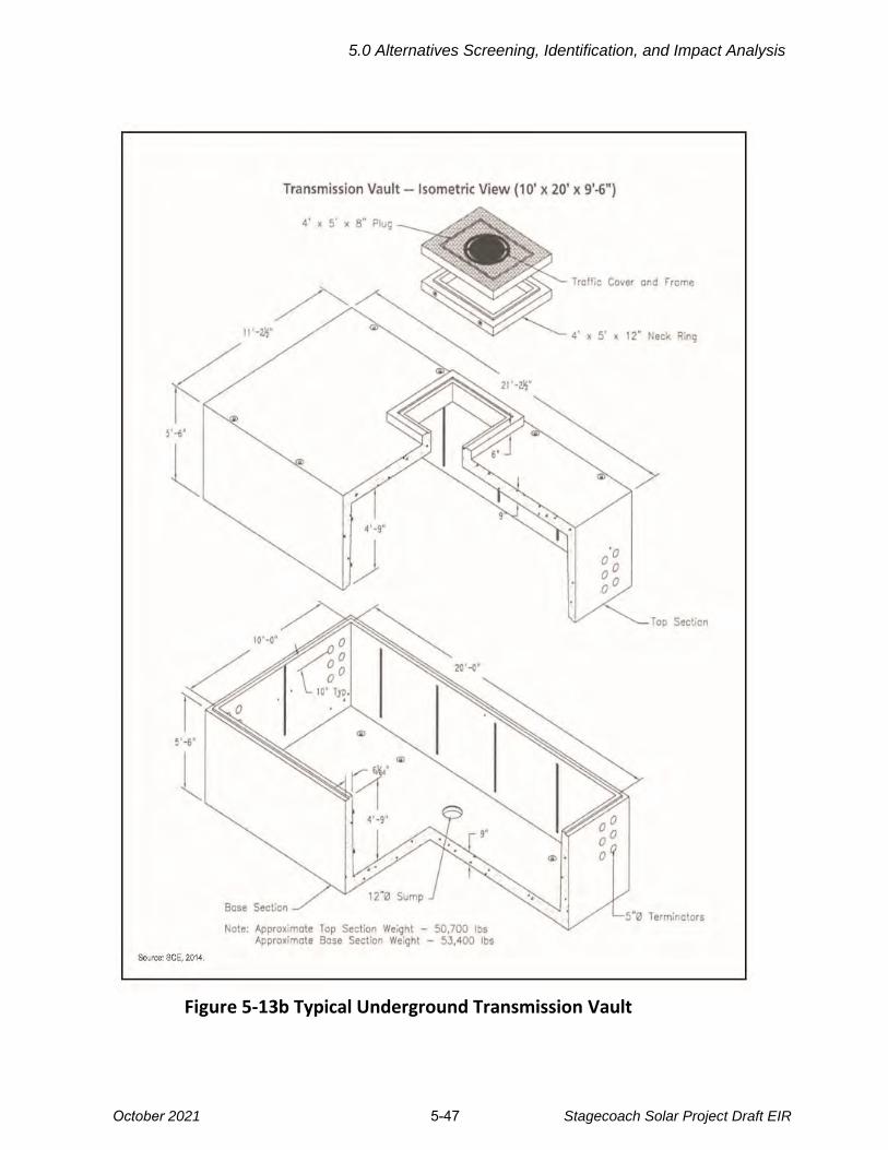
Figure 5-13b Typical Underground Transmission Vault
5.0 Alternatives Screening, Identification, and Impact Analysis
October 2021 5-47 Stagecoach Solar Project Draft EIR

Figure 5-13c
Riser Pole Photographs
These poles allow the transition of conductors from underground to overhead.
Source: Google Earth Street View 2021.
5.0 Alternatives Screening, Identification, and Impact Analysis
Stagecoach Solar Project Draft EIR 5-48October 2021
5.0 Alternatives Screening, Identification, and Impact Analysis
October 2021 5-49 Stagecoach Solar Project Draft EIR
Construction Process 1
Riser Poles. One riser pole would be installed at each end of the 6-mile underground 2
segment. As described above, these poles would be wider than the typical gen-tie line 3
structures. They would also require deeper foundations due to the additional stress on the 4
structure resulting from the fact that the overhead conductors extend in only one direction, 5
because the conductors would be underground in the other direction. 6
Trenching and Duct Bank Installation. To match the required capacity of the Proposed 7
Project’s overhead single-circuit 220 kV transmission line, the underground system would 8
require the installation of a single cable for each of the three phases of the 220 kV line. 9
Cables would be installed in a buried concrete-encased duct bank system (approximately 3 10
feet wide and 3 feet high; see Figure 5-13a). The concrete duct banks would be installed in 11
a trench of up to 4 feet wide and 6 feet deep, allowing 3 feet of cover over the duct bank. 12
During construction, roads in which the underground line is installed would have to be closed, 13
and detours would be required where trenching crosses existing roadways. During non-work 14
hours, any open trench would be covered by either heavy-duty plywood (in non-traffic areas) 15
or steel plates (in roadways). 16
A permanent access road along the underground segment would likely be required because 17
access to the underground structures and the duct bank route must be readily available for 18
maintenance or repair. 19
Vault Installation. Buried vaults for cable splicing would be installed at regular intervals 20
along the entire underground alignment for this alternative. These vaults would house 21
equipment and splices for the underground circuits. Because there is a practical limit to the 22
length of cable that can be pulled in one section, vaults generally would be located about 23
every 800 feet along the alignment. In addition, due to the requirements for cable pulling to 24
the steel riser poles (allowing the underground segment to transition to overhead at each 25
end of the underground segment), the first set of splicing vaults must be placed within 200 26
feet of the riser poles (CPUC 2016). 27
Given the length of the underground alternatives being evaluated (6 to 8 miles) A total of 28
40 or 50 vaults are anticipated to be required. Vaults would be prefabricated and would be 29
constructed of steel-reinforced concrete, with dimensions of approximately 20 feet long by 30
10 feet wide by 10 feet deep. The vaults would be designed to withstand the maximum 31
credible earthquake in the Proposed Project area. During operations, manholes located at 32
finished grade level would provide for access to the vaults so that operations personnel 33
could access the underground cables for maintenance, inspections, and repairs. 34
The total excavation footprint for a vault would be approximately 26 feet long by 12 feet 35
wide and 12 feet deep. Installation of each vault would include the following activities: 36
5.0 Alternatives Screening, Identification, and Impact Analysis
October 2021 5-50 Stagecoach Solar Project Draft EIR
• Excavation and shoring of the vault pit 1
• Delivery and installation of the vault 2
• Backfill and compaction followed by restoration of the excavated area 3
Conductor (Cable) Pulling. After the conduit system and the riser poles have been 4
constructed, the cable would be installed. Starting at one end, cable is pulled from the first 5
vault up through the riser pole. Cable is then pulled through to the next vault, and so on, 6
until the last length of cable has been pulled through the last riser pole. Once installed, the 7
cable is ready to be spliced, terminated, tested, and energized. This would require the 8
installation of one cable per phase, resulting in the use of three of the available conduits in 9
the duct bank leaving one or more spare conduits in the duct bank. 10
Cable Splicing and Termination. After cable installation is completed, the cables would 11
be spliced at each vault. A splice trailer would be located directly above the vaults’ manhole 12
openings for easy access by workers. A mobile power generator would be located directly 13
behind the trailer. 14
Once cable is installed the vault must be kept dry to ensure that unfinished splices are not 15
contaminated with water or impurities. Normal splicing would be 8 to 10 hours per day with 16
some workers remaining after hours to maintain splicing conditions and guard against 17
vandalism and theft. These conditions are essential to maintaining quality control through 18
completion of splicing. As splicing is completed at a vault, the splicing apparatus setup is 19
moved to the next vault location and the splicing is resumed. 20
Operations and Maintenance 21
Regular maintenance would be required for the underground system, generally on an 22
annual basis. This would be accomplished through visual inspections of the cable and 23
splices installed in each vault. Inspections would require approximately several days of 24
work with a two-person crew in a pick-up truck. 25
In the event of an underground cable failure (e.g., from a cable defect or damage to the 26
protective covering), it is likely that the failure would cause collateral damage to other 27
cables and/or splices nearby. Such failures typically result in extensive repair efforts, which 28
could include replacing sections of conduit banks. Typically, these repairs require multiple 29
days of construction, as well as the complete replacement of cable sections. During 30
restoration work, impacts similar those during original construction may occur. 31
Cost. The cost of an underground line is substantially greater than the cost of an overhead 32
line due to the more extensive construction effort and different materials. The Applicant 33
provided an analysis of a potential underground line that would follow the entire proposed 34
overhead route (Mott MacDonald 2020); this underground line was estimated as costing 6 35
to 10 times more than an overhead line (ranging from $40 to $68 million). Cost varies 36

5.0 Alternatives Screening, Identification, and Impact Analysis
October 2021 5-51 Stagecoach Solar Project Draft EIR
based on terrain, ease of access, and construction methods. The underground alternatives 1
considered in this EIR would be installed in essentially flat terrain with easy access. 2
Under CEQA, an alternative is not eliminated only because it may have greater cost. 3
Rights-of-Way. Installation of an underground line would require easements or other 4
ROW agreements with all landowners for a route across private land, and rights would 5
need to be acquired from Caltrans and/or the County for rights along or across roads. 6
The County defines two types of rights-of-way on its “County Maintained Road System 7
(CMRS)” online viewer (San Bernardino County 2021): 8
1. County Maintained Roads: These roads are shown in yellow on the County’s 9
CMRS viewer. Rights to install an underground transmission line in these roads 10
requires a Franchise Agreement with the County’s Department of Public Works and, 11
depending on the type of easements, may also require that the Applicant obtain 12
permission directly from private landowners. 13
2. Non-County Maintained Roads: These roads are identified in the County’s CMRS 14
viewer by areas between defined private land parcels. In the CMRS these have no 15
Assessor’s Parcel Number. Rights to install an underground transmission line in 16
these roads requires a Franchise Agreement with the County’s Department of 17
Public Works, and/or permission from adjacent landowners. The County has no 18
defined process for obtaining permission from private landowners (San Bernardino 19
County 2017b). 20
Underground Alternatives Evaluated. Three potential underground alternative routes 21
have been defined. One was eliminated from consideration (see Section 5.3.4). The two 22
remaining routes can be assembled by segment into different combinations that mix 23
underground and overhead route segments, and a range of ownership and easement 24
types, as shown in Table 5-2. 25
Table 5-2. Gen-tie Line Alternatives
Land Ownership or Road Jurisdiction
Alternative Length State Land
Private Parcel
Easement
County Maintained
Roads
Non-County Maintained
Roads
Proposed Gen-tie Line Route (all overhead, or combination of overhead and underground)
9.1 mi. 1.5 mi. 7.6 mi. 0 0
Underground Gen-tie Alternative in County Roads
Underground Segment
6.0 mi. 0.4 mi. 0 2.5 mi. 3.1 mi.
Overhead Segments
2.6 mi. 1.5 mi. 1.5 mi. 0 0
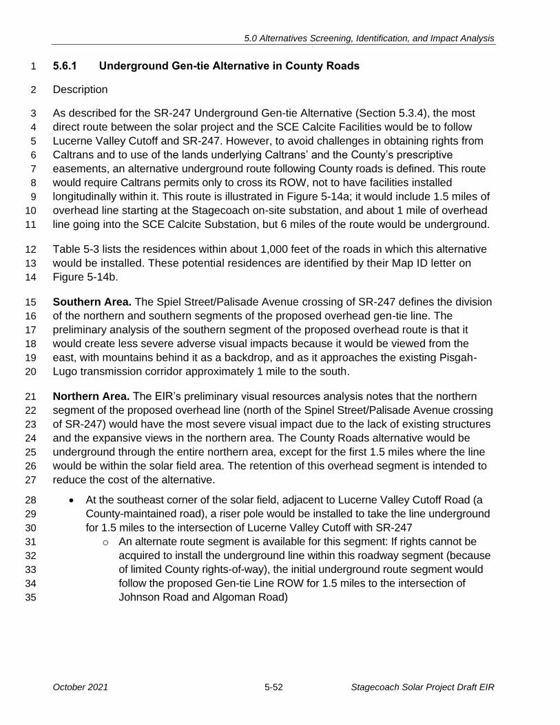
5.0 Alternatives Screening, Identification, and Impact Analysis
October 2021 5-52 Stagecoach Solar Project Draft EIR
5.6.1 Underground Gen-tie Alternative in County Roads 1
Description 2
As described for the SR-247 Underground Gen-tie Alternative (Section 5.3.4), the most 3
direct route between the solar project and the SCE Calcite Facilities would be to follow 4
Lucerne Valley Cutoff and SR-247. However, to avoid challenges in obtaining rights from 5
Caltrans and to use of the lands underlying Caltrans’ and the County’s prescriptive 6
easements, an alternative underground route following County roads is defined. This route 7
would require Caltrans permits only to cross its ROW, not to have facilities installed 8
longitudinally within it. This route is illustrated in Figure 5-14a; it would include 1.5 miles of 9
overhead line starting at the Stagecoach on-site substation, and about 1 mile of overhead 10
line going into the SCE Calcite Substation, but 6 miles of the route would be underground. 11
Table 5-3 lists the residences within about 1,000 feet of the roads in which this alternative 12
would be installed. These potential residences are identified by their Map ID letter on 13
Figure 5-14b. 14
Southern Area. The Spiel Street/Palisade Avenue crossing of SR-247 defines the division 15
of the northern and southern segments of the proposed overhead gen-tie line. The 16
preliminary analysis of the southern segment of the proposed overhead route is that it 17
would create less severe adverse visual impacts because it would be viewed from the 18
east, with mountains behind it as a backdrop, and as it approaches the existing Pisgah-19
Lugo transmission corridor approximately 1 mile to the south. 20
Northern Area. The EIR’s preliminary visual resources analysis notes that the northern 21
segment of the proposed overhead line (north of the Spinel Street/Palisade Avenue crossing 22
of SR-247) would have the most severe visual impact due to the lack of existing structures 23
and the expansive views in the northern area. The County Roads alternative would be 24
underground through the entire northern area, except for the first 1.5 miles where the line 25
would be within the solar field area. The retention of this overhead segment is intended to 26
reduce the cost of the alternative. 27
• At the southeast corner of the solar field, adjacent to Lucerne Valley Cutoff Road (a 28
County-maintained road), a riser pole would be installed to take the line underground 29
for 1.5 miles to the intersection of Lucerne Valley Cutoff with SR-247 30
o An alternate route segment is available for this segment: If rights cannot be 31
acquired to install the underground line within this roadway segment (because 32
of limited County rights-of-way), the initial underground route segment would 33
follow the proposed Gen-tie Line ROW for 1.5 miles to the intersection of 34
Johnson Road and Algoman Road) 35
ST247
Johnson Rd
Lucerne Valley Cutoff
Haynes Rd
Althouse Rd
Me
an
der
Rd
Jay
Jay
Blvd
Circle C Rd
Stagecoach FacilitiesLease BoundarySolar Facilities FencelineSolar Support FacilitiesConstruction Water Storage and Laydown YardSolar ArraysInvertersAccess Roads220 kV Gen-Tie Route
SCE Calcite FacilitiesSCE Calcite SubstationSCE Calcite Facilities Property BoundarySCE Calcite Facilities
Land OwnershipBureau of Land ManagementPrivate (No Color)State
Figure 5-14aUnderground Gen-Tie
Alternative in County Roads
Underground Gen-Tie SegmentsCounty Roads, Not DedicatedCounty Maintained RoadsState Land
Underground line transitionsto overhead 220 kV at thispoint and follows proposed
gen-tie route to Calcite Substation.
0 10.5 Miles
F
Northern/Southern Divider
Alternative gen-tie linetransitions to underground
from this point south.
5.0 Alternatives Screening, Identification, and Impact Analysis
October 2021 5-53 Stagecoach Solar Project Draft EIR

!(
!(
!(
!(!(
!(!(
!(!(
!(
!(!(!(
!(
!(!(!(
!(!(
!(
!(!(
!(
!(
!(
Fe
rn D
r
No End Rd
Pa
lisad
e A
ve
Desert Ln
Haynes Rd
Catt
lem
an
Rd
Blake St
Laurjoe St
Circle C Rd
Rickman Rd
Northside Rd
Mon
olith
St
4W
d R
oad
Ja
sp
er
Ave
Corwin Rd
4Wd Road
ÄÆ247
Potential Residences Along Underground Gen-tie Alternative in County Roads
Figure 5-14b
0 10.5 Miles
F
Underground line transitionsto overhead 220 kV at thispoint and follows proposed
gen-tie route to Calcite Substation.
Northern/Southern Divider
A
B
C
D
E
FG
H
I
J
K
LM N
O
PQ R
S
TU V
WX
Y
Stagecoach Facilities220 kV Gen-Tie Route
SCE Calcite FacilitiesSCE Calcite SubstationSCE Calcite Facilities Property BoundarySCE Calcite Facilities
Underground Gen-Tie SegmentsCounty Roads, Not DedicatedCounty Maintained RoadsState Land
Potential Residences!( Potential Residences in Project Vicinity
5.0 Alternatives Screening, Identification, and Impact Analysis
Stagecoach Solar Project Draft EIR 5-54October 2021

5.0 Alternatives Screening, Identification, and Impact Analysis
October 2021 5-55 Stagecoach Solar Project Draft EIR
Table 5-3. Underground Gen-tie Alternative in County Roads: Residences
Map ID# Street or Intersection Distance to Potential
Residence (feet)
A Lucerne Valley Cutoff 270
B Selmadolph Street and Algoman Ave. 530
C Algoman Ave. (Access from Barstow Rd.) 180
D Algoman Ave. (Access from Barstow Rd.) 190
E Algoman Ave. (Access from Barstow Rd.) 70
F Brucite Street 440
G Algoman Ave. and Brucite Street 80
H Brucite Street and Algoman Ave. 70
I Algoman Ave. and Brucite Street 70
J Spinel Street 650
K Brucite Street and Algoman Ave. 300
L Spinel Street 160
M Spinel Street 160
M Spinel Street 300
O Spinel Street 100
P Spinel Street 180
Q Spinel Street 250
R Spinel Street 260
S Spinel Street 70
T Spinel Street 170
U No End Road and Cummings Road 90
V No End Road and Cattleman Road 710
W Corwin Road 770
X Cummings Road and Corwin Road 150
Y Cummings Road 100
Source: Google Earth
The northern 4.4-mile segment of the Underground Gen-tie Alternative in County Roads 1
would be installed in both County maintained roads and non-County maintained roads, as 2
shown on Figure 5-14a. The route would be as follows: 3
• The line would be overhead, as proposed, for approximately 1.5 miles where it would 4
be within the solar field 5

5.0 Alternatives Screening, Identification, and Impact Analysis
October 2021 5-56 Stagecoach Solar Project Draft EIR
• At this intersection the route would cross under SR-247and continue east on State-1
owned land for approximately 0.4 miles. It would follow existing dirt roads southeast 2
for about 700 feet before turning east (paralleling Johnson Street) for 0.4 miles into 3
Laurjoe Street or Johnson Street. 4
• The route would turn south in Algoman Avenue (a non-County maintained road) and 5
follow this road for 1.3 miles to cross to the west side of SR-247. The route would 6
remain in this road for another 0.6 miles to Spinel Street. 7
• The route would turn east in County-maintained Spinel Street for 0.4 miles, crossing 8
to the east side of SR-247 where the road name changes to Palisade Avenue 9
The southern segment (2.5 miles) would be entirely in non-County-maintained roads, as 10
follows: 11
• It would turn southeast from Palisade Avenue into Barstow Outer Highway East, 12
paralleling SR-247 for about 800 feet 13
• Then turn east on Corwin Road (also called No End Road) for about 1,500 feet 14
• Then turn south on Cummings Road for 0.5 miles to Papago Road 15
• It would turn west in Papago Road for about 700 feet 16
• Then south in an unnamed County road ROW for 0.5 miles to reach Waalew Road 17
• It would turn west in Waalew Road for approximately 660 feet to its intersection with 18
an unnamed road. The route would transition to an overhead riser pole and follow 19
approximately 1.1 miles of the southernmost part of the proposed overhead ROW 20
into the SCE Calcite Facilities. 21
Rights and Access 22
As described in the introduction, the County roads considered in this alternative would be 23
either County-Maintained Roads or Non-County-Maintained Roads. Because this alternative 24
would be installed primarily within County roads, it appears that rights for installation of this 25
route would be obtained from the County. The CSLC would grant rights for use of the 26
1.9-mile segment across State-owned land (including 1.5 miles within the Stagecoach Solar 27
Generation Plant boundaries). 28
Feasibility 29
Assuming the County’s ability to grant rights is confirmed, this alternative is feasible. The 30
cost would be five to ten times higher than the cost of an overhead line, but based on State 31
CEQA Guidelines, higher cost is not a reason to eliminate consideration of an alternative in 32
an EIR. 33
5.0 Alternatives Screening, Identification, and Impact Analysis
October 2021 5-57 Stagecoach Solar Project Draft EIR
Environmental Impacts 1
Aesthetics/Light and Glare 2
The Underground Gen-tie Alternative in County Roads would retain about 1.5 miles of 3
overhead line at the north end of the route and about 1 mile overhead at the south end. 4
The most visible 6.6 miles of the proposed overhead gen-tie line, including the northern 5
and southern crossings of SR-247 and its ROW past several residences, would be 6
eliminated and replaced with underground segments. This alternative would substantially 7
reduce the significant visual impacts of the gen-tie line and is strongly preferred for 8
aesthetics. However, the underground gen-tie route would not eliminate the significant and 9
unavoidable visual impacts associated with the Stagecoach Solar Generation Plant or the 10
SCE Calcite Facilities. 11
Construction of the underground line would be more intense than construction of the 12
overhead line, resulting in more equipment being present along the ROW and potentially 13
additional dust. 14
Biological Resources 15
Because the underground alternative would follow County road rights-of-way, most of the 16
area that would be temporarily disturbed for construction is already disturbed (unpaved 17
roads). Some of the County rights-of-way are not maintained or graded, so these areas 18
would require grading and establishment of a new unpaved road after installation of the 19
underground line. 20
Typically, an underground transmission line disturbs more habitat than an overhead line 21
due to the need to install the underground conductors in a continuous trench. In this case, 22
the Applicant’s assumptions for the proposed overhead line (see Table 2-1, Section 2) 23
include grading and installation of an unpaved access road within a 150-foot-wide ROW for 24
9.1 miles. In comparison, the underground ROW maintained for operational access would 25
not exceed 40 feet wide. 26
The impacts of this alternative would be similar to the Proposed Project with respect to 27
desert tortoise, special-status plants, and jurisdictional waters. One Class 4 desert tortoise 28
burrow was observed along the underground gen-tie alignment at the northern end near 29
the solar generation plant. No special-status plants were observed. The alternative would 30
impact generally the same area of jurisdictional waters. 31
Impact BIO-5 (Create a substantial collision and electrocution risk for birds or bats) would 32
be substantially reduced for the underground alternative. 33
All mitigation measures recommended for the Proposed Project would also apply to this 34
alternative. The Proposed Project and this alternative would result in similar impact 35
severity under CEQA (less than significant with mitigation). 36

5.0 Alternatives Screening, Identification, and Impact Analysis
October 2021 5-58 Stagecoach Solar Project Draft EIR
Cultural Resources 1
A cultural resources survey of the underground ROW was completed in March 2021, and a 2
Supplemental Report to the Cultural Resources report for the Proposed Project was 3
prepared (Aspen 2021). The survey and associated research defined five cultural resources 4
within the area of the underground alternative. One resource was previously recorded and 5
four were newly identified. None of the resources are recommended as being eligible for 6
the California Register of Historic Resources. 7
All mitigation measures recommended in Section 4.4.4.1, Cultural Resources, would be 8
implemented also for this alternative. Implementation of MM CUL-1d (Archaeological 9
Monitoring) and MM CUL-1e (Unanticipated Discoveries) would be especially important 10
because trenching required for installation of the underground line has the potential to 11
uncover buried resources. The likelihood of discovering unanticipated resources is 12
considered to be similar to that of the proposed gen-tie line (with its 150-foot-wide and 13
9.1-mile-long access road). Overall, the impact severity and mitigation measures described 14
in Section 4.4, Cultural Resources, would be the same for this alternative as for the 15
Proposed Project. 16
Noise and Proximity of Residences 17
The underground route would require construction in County roads, passing approximately 18
25 potential residences within 800 feet, as defined in Table 5-3. While more residences 19
would be located along the underground route than the overhead route, the line itself would 20
not be visible to these residents since it would be located in underground duct banks. 21
According to the San Bernardino County Development Code, construction noise and 22
vibration would be exempt from standards in the Code, if conducted between 7:00 a.m. 23
and 7:00 p.m. Monday through Saturday, except federal holidays (Chapter 83.01.080 and 24
83.01.090). Accordingly, gen-tie line construction activities would not be subject to 25
community noise standards in the County Development Code. However, County policies 26
require implementation of acceptable practices to minimize the effects of adverse 27
construction noise. 28
MM NOI-1a (Construction Restrictions), recommended for the solar generation plant 29
(Section 4.12.4.1) would require the Applicant to control noise in a manner consistent with 30
the County Development Code, and MM NOI-1b (Public Notification Process) and MM 31
NOI-1c (Noise Complaint Process) would require the Project implement best practices for 32
engaging the surrounding community to avoid potential noise complaints. With these 33
measures, the impact of gen-tie line construction noise relative to applicable community 34
noise standards would be less than significant. 35
While short-term construction noise would occur during installation of the underground line, 36
the underground alternative would eliminate the corona noise that can be associated with 37
5.0 Alternatives Screening, Identification, and Impact Analysis
October 2021 5-59 Stagecoach Solar Project Draft EIR
overhead transmission lines in some conditions during their operational life. Overall, the 1
impact severity and mitigation measures described in Section 4.12, Noise and Vibration, 2
would be the same for this alternative as for the Proposed Project. 3
Traffic and Transportation 4
Construction of an underground line would require different types and locations of 5
construction equipment and workforce than for an overhead line. In addition, the location of 6
the construction activity would be shifted from the proposed gen-tie ROW, with rights 7
already acquired by the Applicant, to County-road ROWs. 8
Overall, the traffic on non-project roads is expected to be similar for both the overhead and 9
underground gen-tie line options. The impact severity and mitigation measures described 10
in Section 4.17, Traffic and Transportation, would be the same for this alternative as for the 11
Proposed Project. 12
Electric and Magnetic Fields 13
Section 4.9.4.2, Hazards and Hazardous Materials, Gen-tie Line, describes the electric 14
and magnetic fields generated by high voltage transmission lines. Underground lines also 15
generate these fields, and due to the reduced distance between the conductors and the 16
potential receptor (e.g., a person walking on the road), the magnetic fields can be 17
substantially higher for an underground line (potentially 60 to 80 milligauss directly over the 18
line). However, the field strength of an underground line declines steeply with distance 19
from the line, so at about 50 feet from the line the field strength would be very low (likely 20
below 5 milligauss). For comparison, the magnetic field strength 20 feet away from an 21
electric distribution line on wood poles, as exist in the central area of Lucerne Valley, 22
ranges from 2 to 10 milligauss, and could be up to 70 milligauss directly below a distribution 23
line (PPL Electric 2021). 24
Residences along the roads in which the Underground Gen-tie Alternative in County 25
Roads would be installed are set back from 60 to over 100 feet from the edge of the road 26
right-of-way. As described above, at these distances, the electric and magnetic fields 27
would be substantially reduced due to the distance from the underground line. 28
5.6.2 Underground Gen-tie Alternative Along Proposed Route 29
Description 30
This underground alternative route would follow all or part of the route of the proposed 31
overhead 220 kV gen-tie route, as shown on Figure 5-15. Due to the greater visual 32
sensitivity of the northern portion of the route, this alternative is also divided into the 33
northern and southern segments. Either the entire 9.1-mile-long route could be installed 34
underground in the ROW already acquired by the Applicant, or only the northern segment 35
could be installed underground, leaving the southern segment overhead, as proposed. 36
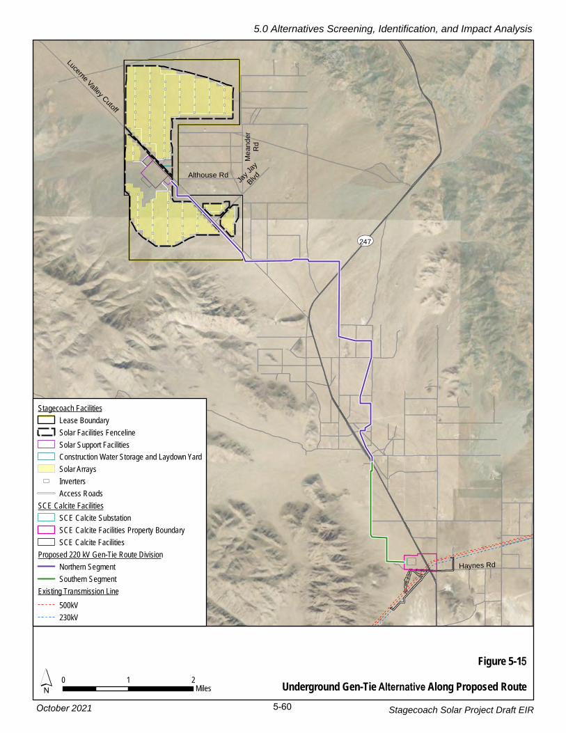
ST247
Haynes Rd
Lucerne Valley Cutoff
Althouse Rd
Me
an
der
Rd
Jay
Jay
Blvd
Figure 5-15Underground Gen-Tie Alternative Along Proposed Route´ 0 1 2
Miles
Stagecoach FacilitiesLease BoundarySolar Facilities FencelineSolar Support FacilitiesConstruction Water Storage and Laydown YardSolar ArraysInvertersAccess Roads
SCE Calcite FacilitiesSCE Calcite SubstationSCE Calcite Facilities Property BoundarySCE Calcite Facilities
Proposed 220 kV Gen-Tie Route DivisionNorthern SegmentSouthern Segment
Existing Transmission Line500kV230kV
5.0 Alternatives Screening, Identification, and Impact Analysis
October 2021 5-60 Stagecoach Solar Project Draft EIR
5.0 Alternatives Screening, Identification, and Impact Analysis
October 2021 5-61 Stagecoach Solar Project Draft EIR
Northern Segment. This approximately 6.9-mile-long northern segment would involve 1
installing an underground line from the solar field to line’s crossing of SR-247, just south 2
of Palisade Avenue. The line would be installed underground within the overhead ROW 3
easement for which the Applicant has already obtained easement rights. 4
Southern Segment. This 2.2-mile segment is less visually sensitive than the northern area 5
and could remain overhead. It would follow the proposed overhead ROW from its 6
intersection with Palisade Road, south to the SCE Calcite Facilities. 7
Feasibility 8
The use of the Applicant’s overhead ROW for an underground line would likely be feasible. 9
The Applicant has already obtained options for an overhead easement and a permanent 10
access road across the private lands, so those easements would have to be evaluated for 11
underground installation rights. 12
Environmental Impacts 13
Aesthetics/Light and Glare 14
As described for the Underground Gen-tie Alternative in County Roads, installation of any 15
part of the proposed overhead gen-tie line in underground ducts would reduce the significant 16
visual effects of the proposed overhead line. Overall, the Stagecoach Facilities would still 17
have significant and unavoidable impacts due to the presence of the solar generation plant, 18
the overhead portions of the gen-tie line, and the SCE Calcite Facilities. 19
Biological Resources 20
The biological resources impacts of installing the gen-tie line underground would be very 21
similar to those described in Section 4.3.4.2, analysis of proposed gen-tie line for biological 22
resources. That analysis assumed the loss of all habitat within the 150-foot ROW of the 23
9.1-mile-long route. 24
Impact BIO-5 (Create a substantial collision and electrocution risk for birds or bats) would 25
be substantially reduced for the underground alternative, depending on how much of the 26
line was installed underground. 27
All mitigation measures recommended for the Proposed Project would also apply to this 28
alternative. The Proposed Project and this alternative would result in similar impact severity 29
under CEQA (less than significant with mitigation). 30
Noise and Proximity of Residences 31
The noise impacts of this alternative would be similar to those described for the Proposed 32
Project gen-tie line, and the same receptors would be affected, as defined in Section 4.12.4.2, 33
5.0 Alternatives Screening, Identification, and Impact Analysis
October 2021 5-62 Stagecoach Solar Project Draft EIR
Noise and Vibration. However, the more intense construction activities required for a 1
continuous trench along the entire gen-tie line route would result in greater construction 2
noise impacts when the trenching activity was near each residence. 3
The underground alternative would eliminate the corona noise that is sometimes associated 4
with overhead transmission lines during certain conditions during their operational life. 5
Overall, the impact severity and mitigation measures described in Section 4.12, Noise and 6
Vibration, would be the same for this alternative as for the Proposed Project. 7
Traffic and Transportation 8
Construction of an underground line would require different types and locations of 9
construction equipment and workforce than needed for an overhead line. Overall, the traffic 10
on non-project roads is expected to be similar for both the Proposed Project (overhead 11
gen-tie line) and the underground gen-tie options. The mitigation measures described in 12
Section 4.17, Traffic and Transportation, would still apply to this alternative as they would 13
for the Proposed Project. 14
Electric and Magnetic Fields 15
Section 4.9.4.2, Hazards and Hazardous Materials, Gen-tie Line describes the electric and 16
magnetic fields generated by high voltage transmission lines. Underground lines also 17
generate these fields, and due to the reduced distance between the conductors and the 18
potential receptor (e.g., a person walking on the road), the magnetic fields can be 19
substantially higher for an underground line (potentially 60 to 80 milligauss directly over the 20
line). However, the field strength declines steeply with distance from the line so at about 50 21
feet from the line the field strength would be very low (likely below 5 milligauss). 22
Residences along the proposed gen-tie route are set back over 200 feet from the edge of 23
the gen-tie line ROW. As described above, at these distances, the electric and magnetic 24
fields would be substantially reduced (likely to below 5 milligauss) due to the distance from 25
the underground line. 26
5.7 SCE CALCITE FACILITIES ALTERNATIVE 27
5.7.1.1 Environmental Impact Analysis 28
The SCE Calcite Facilities Alternative would not modify the solar project facilities or the gen-29
tie line, except that the Stagecoach Gen-tie Line would be about one-half mile shorter than 30
the proposed route, and the SCE 220 kV loop-in to the Pisgah-Lugo transmission corridor 31
would be about one-half mile longer. 32

5.0 Alternatives Screening, Identification, and Impact Analysis
October 2021 5-63 Stagecoach Solar Project Draft EIR
5.7.1.2 Description 1
An alternative location for the SCE Calcite Facilities would be on an approximately 40-acre 2
property immediately northwest of the proposed substation site property. The alternative 3
substation would be similar to the proposed substation but would be approximately 1,000 4
feet northwest of the proposed site. See Figure 5-16, and Section 8 of Appendix E. Compared 5
to the proposed substation site, the alternate site would be slightly closer to the solar field 6
and slightly farther from the interconnection with SCE’s Lugo-Pisgah No. 1 230 kV 7
transmission line. This alternative would result in an approximately 0.5-mile shorter gen-tie 8
line and a somewhat longer interconnection to SCE’s Lugo-Pisgah line. Both sites would 9
be accessed by an extension of Haynes Road from SR-247 and would have similar 10
equipment within the substation. 11
The differences between the proposed substation site and the alternative site are that the 12
SCE Calcite Facilities Alternative would: 13
• Be approximately 1,500 feet west of SR-247 as compared to approximately 500 feet 14
west of SR-247 for the proposed site 15
• Require an additional 2,600 feet of access road from SR-247 to the alternate site as 16
compared to the proposed site (4,500 vs 1,900 feet) 17
• Require two to four fewer Stagecoach Gen-tie Line poles 18
• Require two additional SCE 230 kV transmission interconnect poles to support 19
approximately 1,500 feet of additional transmission line to loop the Lugo-Pisgah line 20
into and out of the alternative substation 21
• Require approximately 1,000 feet more of new overhead distribution line but 22
approximately 700 feet less of underground distribution line than the Proposed 23
Project 24
Environmental Impacts 25
Aesthetics/Light and Glare 26
Like the proposed SCE Calcite Facilities site, the SCE Calcite Facilities Alternative would 27
include development of the substation in an undeveloped desert landscape. The substation 28
would be located northwest of the proposed substation and 1,000 feet further west of 29
SR-247. 30
Figure 5-17 presents a visual simulation of the substation, as viewed from SR-247 (KOP 6). 31
For comparison, the existing view from this site is shown in Figure 4.1-7a (SCE Calcite 32
Facilities Existing View), and the simulation of the proposed substation site is presented in 33
Figure 4.1-7b (SCE Calcite Facilities Simulation) in Section 4.1, Aesthetics/Light and 34
Glare. The viewpoint in Figure 4.1-7a is representative of the views of the SCE Calcite 35
Facilities Alternative site, providing a panoramic field of view that encompasses the 36
alternative substation site. 37
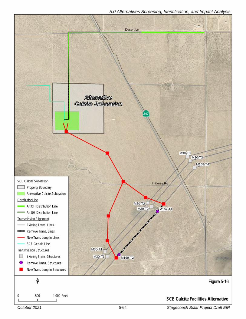
XY XY XY
XY
XY
XY
XY
XY
XY
XY
XY
XY
XY
XY
XY
XY
XY
XY
XY
XY
XY
XY
XY
XY
XY
XY
XY
XY
XY
XY
XY
XY
XY
XY
XY
XY
XY
XY
XY
XY
XY
XY
XY
XY
XY
XY
XY
XY
XY
XY
XY
XY
XY
XY
XY
XY
XY XY XY XY XY XY XY XY XY XY XY XY XY XY XY XY XY XY XY XY XY XY XY XY XY XY XY XY XY XY XY XY XY XY XY XY XY XY XY XY XY XY XY XY XY XY
")
")
")
")
")
")
")
")
M30-T2
M30-T1
M30-T3
M30-T2
M30-T1
M30-T3
M169-T2
M169-T1
M168-T4
Desert Ln
Haynes Rd
ÄÆ247
AlternativeCalcite Substation
SCE Calcite Facilities Alternative
Figure 5-16
0 1,000500 Feet
F
SCE Calcite SubstationProperty BoundaryAlternative Calcite Substation
DistributionLineAlt OH Distribution Line
XY XY XY XY Alt UG Distribution LineTransmission Alignment
Existing Trans. LinesRemove Trans. LinesNew Trans Loop-in LinesSCE Gen-tie Line
Transmission Structures") Existing Trans. Structures!? Remove Trans. Structures") New Trans Loop-in Structures
5.0 Alternatives Screening, Identification, and Impact Analysis
Stagecoach Solar Project Draft EIR 5-64October 2021

This panoramic image presents a Visual Simulation of the Alternative SCE Calcite Substation from KOP 6 on southbound State Route 247, approximately 0.84 mile north of the intersection with Haynes Road. The alternative substation site is located approximately 0.2 mile northwest of the proposed substation site and closer to KOP 6. Although the discussion of the proposed substation simulation presented in Figure 4.1-7B is also applicable to this alternative site simulation, there are two notable differences. While the alternative site is situated in a slightly less exposed location with a more immediate terrain backdrop compared to the proposed site, it is closer to KOP 6 and so, appears more visually prominent. Also, the alternative substation would still require the seven transmission poles in the immediate vicinity of the proposed substation site to connect to the Lugo-Pisgah No. 1 line. So the alternative substation facilities would appear slightly more spread out across the landscape when viewed from KOP 6.
KOP 6 SCE Calcite Facilities Alternative
Visual Simulation
Stagecoach Solar Project EIR Visual Resources
Figure 5-17
5.0 Alternatives Screening, Identification, and Impact Analysis
Stagecoach Solar Project Draft EIR 5-65October 2021

5.0 Alternatives Screening, Identification, and Impact Analysis
October 2021 5-66 Stagecoach Solar Project Draft EIR
As shown in the simulation (Figure 5-17), and similar to the Proposed SCE Calcite Facilities, 1
the SCE Calcite Facilities Alternative would result in the introduction of a visually prominent 2
and structurally complex electric transmission facility with its associated industrial character 3
and structural contrast into the predominantly natural desert landscape of the central 4
portion of Lucerne Valley. The notable exception to the natural landscape is the existing 5
high-voltage electric transmission line system south of both SCE Calcite Facilities sites. As 6
with the Proposed SCE Calcite Facilities, the Alternative SCE Calcite Facilities would also 7
connect to the Lugo-Pisgah No. 1 line, which is the southernmost transmission facility in 8
the existing transmission line corridor. However, the alternative substation would be 9
slightly farther away from SR-247 and closer to, and more backdropped by, the ridge that 10
descends to the valley floor shown along the right side of the image. As a result, the 11
alternative substation appears less exposed and more integrated to the background 12
landform, reducing its overall visual prominence. However, because the alternative 13
substation would still need to connect to the Lugo-Pisgah No. 1 line, the seven interconnect 14
poles in the vicinity of the proposed substation would still be required, as would the 15
connection between the alternative substation and those interconnect poles. The visual 16
result would be that the alternative substation facilities would appear more spread out 17
across the landscape and introduce slightly more structural contrast compared to the 18
proposed substation. 19
In the context of the existing landscape, the alternative substation would exhibit Moderate 20
to High visual contrast. The substation in the foreground would appear visually co-dominant 21
with the valley floor, background landforms, and existing transmission line facilities and 22
would noticeably impair views of the background valley floor, adjacent ridges, and more 23
distant San Bernardino Mountains. The structurally complex facility would attract the 24
attention of the casual observer on SR-247, and view blockage of higher value landscape 25
features (e.g., adjacent ridge, background valley floor, and mountains) would be Moderate 26
to High. Combining the Moderate to High visual contrast, co-dominant structural 27
prominence, and Moderate to High view blockage results in an overall Moderate to High 28
degree of visual change, which in the context of the existing landscape’s High visual 29
sensitivity, results in a visual effect that would be significant and unavoidable under CEQA 30
Significance Criterion (c), degradation of existing visual character or quality. Implementation 31
of MM ALG-6 (Surface Treatment and Design of Project Structures and Buildings) is 32
recommended as it would reduce the visual contrast associated with visually discordant 33
structural features and industrial character, though the impact would remain significant. 34
Overall, because the proposed SCE Calcite Facilities location is closer to SR-247, the 35
alternative site is slightly preferred for its reduced impacts to aesthetics. However, the 36
aesthetic impact of the long-term presence of the substation facilities (Impact ALG-6) 37
would remain significant and unavoidable, as it would be for the proposed substation site. 38
All other impacts and mitigation measures presented in Section 4.1.4.3, Aesthetics/Light 39
and Glare, SCE Calcite Facilities, would be the same as the proposed SCE Calcite 40
Facilities site. 41

5.0 Alternatives Screening, Identification, and Impact Analysis
October 2021 5-67 Stagecoach Solar Project Draft EIR
Biological Resources 1
Biological resource surveys completed for the Proposed Project also covered the SCE 2
Calcite Facilities Alternative. The resources at the alternative site are essentially the same 3
as those at the proposed SCE Calcite Facilities site. There were no sensitive plant or 4
wildlife resources defined within the boundaries of either site; both sites would result in the 5
loss of undisturbed creosote bush scrub within desert tortoise habitat. All mitigation 6
measures recommended for the Proposed Project (summarized in Section 4.3.6) would 7
also be implemented for the alternative site, and with implementation of these measures, 8
impacts to biological resources would be less than significant. 9
Noise and Proximity of Residences 10
The alternative substation location would be closer to one potential residence, located 11
about 1,000 feet west of the substation alternative. The distribution line connection for the 12
alternative substation would terminate at the intersection of Waalew Road and Fern Road, 13
where additional potential residences are located. Overall, the impact severity and mitigation 14
measures described in Section 4.12, Noise and Vibration, would be the same for this 15
alternative as for the Proposed Project. 16
Traffic and Transportation 17
There would be no difference in traffic because both potential substation sites would use 18
the same access off of SR-247. The mitigation measures described in Section 4.17, 19
Traffic and Transportation, would still apply to this alternative as they would for the 20
Proposed Project, and the impact severity would be the same. 21
5.8 NO PROJECT ALTERNATIVE 22
5.8.1.1 Description 23
Pursuant to State CEQA Guidelines section 15126.6, subdivision (e), the purpose of 24
describing and analyzing a No Project Alternative is to provide decision makers with 25
comparative information regarding the impacts of approving a project versus not approving 26
a project. The No Project Alternative considers existing environmental conditions as well 27
as what would reasonably be expected to occur in the foreseeable future if the Proposed 28
Project is not approved, based on current plans and other available information about 29
expected future conditions. 30
Under the No Project Alternative, the CSLC lease requested by the Applicant would not be 31
approved. The state-owned school lands managed by CSLC would not be graded and 32
fenced, and the solar field and battery storage facilities, O&M building, substation, and 33
associated equipment would not be constructed or installed. The gen-tie line between the 34
solar generation plant site and the proposed SCE Calcite Facilities would not be built. The 35
SCE Calcite Facilities would not be developed to serve the project and the interconnection 36
between the SCE substation and SCE’s existing Lugo-Pisgah 220 kV transmission line 37
would not be made. 38

5.0 Alternatives Screening, Identification, and Impact Analysis
October 2021 5-68 Stagecoach Solar Project Draft EIR
5.8.1.2 Environmental Impact Analysis 1
The No Project Alternative would avoid all impacts from the construction, operation, 2
maintenance, and decommissioning of the Stagecoach Facilities. As a result, there would 3
be no direct or cumulative impacts to the resources evaluated in Section 4 of this EIR. 4
However, if the Project is not constructed, the State would not realize the beneficial 5
impacts of the Project related to long-term reduction of greenhouse gas emissions from 6
non-renewable (fossil fuel) energy generation. 7
The No Project Alternative would also prevent the CSLC from using this land to assist 8
California utilities in meeting their obligations under California’s Renewable Portfolio 9
Standard (RPS).39 The CSLC supports the State’s initiatives such as Senate Bill (SB) 100 10
(Nunez, Chapter 312, Statutes of 2018) and AB 32 (Nunez, Chapter 448, Statutes of 2006, 11
the California Global Warming Solutions Act), to increase renewable energy and reducing 12
greenhouse gas (GHG) emissions, respectively. The No Project Alternative would not 13
allow the installation of the renewable solar generation project on these State lands, 14
preventing consistency with the CSLC 2021-2025 Strategic Plan. 15
In addition, the No Project Alternative would prevent the CSLC from using this land to 16
provide revenue from the Proposed Project for State Teacher’s Retirement Fund. As 17
stated in Section 1.3, the CSLC is responsible for proactively managing and enhancing 18
State properties in order to provide revenue for the fund. The CSLC is also required to 19
identify new, sustainable, equitable, and responsible revenue streams, including 20
consideration of CSLC-driven project requests for proposals with desired revenue-21
generating activities like solar generation. However, if the Proposed Project or an 22
alternative is not approved, the CSLC would retain the option to evaluate a future lease 23
proposal for the State school lands for a different solar project, or for other purposes. 24
The No Project Alternative would not allow the Applicant to meet any of its Project 25
objectives, which include assisting California utilities in meeting their obligations under 26
California’s RPS. Similarly, the Applicant would not be supporting California in meeting 27
GHG emissions reduction goal as required by AB 32 or assisting California in transitioning 28
the transportation sector to zero-emission vehicles by 2035 under Executive Order N-79-20, 29
signed by Governor Newsom on September 23, 2020. 30
If the SCE Calcite Facilities are not constructed, SCE would not have the ability to 31
interconnect the Stagecoach Facilities or other solar projects in the Lucerne Valley area. 32
However, because San Bernardino County has adopted the Renewable Energy Conservation 33
Element, including Policy 4.10 (as discussed in Section 4.11, Land Use and Planning, 34
Impact LU-2), the development of utility-scale renewable energy projects on private land in 35
the Lucerne Valley is not permissible.36
39 The RPS is a State program intended to advance the use of renewable energy but setting continuously
escalating renewable energy procure targets for the State’s electric utility providers.

October 2021 6-1 Stagecoach Solar Project Draft EIR
6.0 OTHER REQUIRED CEQA ISSUES AND ENVIRONMENTALLY SUPERIOR ALTERNATIVE
As noted in this Environmental Impact Report (EIR), Aurora Solar, LLC (Aurora Solar or 1
Applicant), a wholly owned subsidiary of Avangrid Renewables, has applied to the California 2
State Lands Commission (CSLC) for lease of State-owned school lands on which to 3
construct and operate the Stagecoach Facilities, a solar generation project and a 220 kV 4
transmission generation intertie line (gen-tie line). The Stagecoach Solar Generation Plant 5
would be located within a lease area that would cover 3,570 acres. The Stagecoach Gen-6
tie Line would run approximately 9.1 miles, connecting the Stagecoach Solar Generation 7
Plant to the proposed Southern California Edison (SCE) Calcite Facilities, which would be 8
owned and operated by SCE. 9
The SCE Calcite Facilities are evaluated as part of the Proposed Project because electricity 10
generated by the Stagecoach Facilities would be interconnected to the substation. The 11
impacts of construction and operation of this substation are fully evaluated in this EIR in 12
order to support SCE’s application to the California Public Utilities Commission (CPUC) for 13
permission to construct the substation. The CPUC will use this EIR to support its decision 14
on whether to approve the substation. 15
As lead agency under the California Environmental Quality Act (CEQA), the CSLC prepared 16
this EIR to evaluate the potential significant environmental effects associated with the 17
Proposed Project. The description of the Project components is provided in Section 2.0, 18
Project Description. 19
The State CEQA Guidelines40 state in part that an EIR shall: 20
• Identify and focus on the significant environmental effects of a proposed project 21
(State CEQA Guidelines, § 15126.2, subd. (a)) 22
• Describe any significant impacts, including those that can be mitigated but not reduced 23
to a level of insignificance (State CEQA Guidelines, § 15126.2, subd. (b)) 24
• Identify significant irreversible environmental changes that would be caused by a 25
proposed project should it be implemented (State CEQA Guidelines, § 15126.2, 26
subd. (c)) 27
• Identify effects found not to be significant (State CEQA Guidelines, § 15128) 28
• Identify any growth-inducing impacts of a proposed project such as the ways in which 29
the proposed project could foster economic or population growth, or the construction 30
of additional housing, either directly or indirectly, in the surrounding environment 31
(State CEQA Guidelines, § 15126.2, subd. (d)) 32
40 The “State CEQA Guidelines” refers to California Code of Regulations, Title 14, Chapter 3.

6.0 Other Required CEQA Issues and Environmentally Superior Alternative
October 2021 6-2 Stagecoach Solar Project Draft EIR
These elements are discussed in Sections 6.1 through 6.5 below. Section 6.6 presents a 1
comparison of the Proposed Project with the alternatives evaluated in Chapter 5. 2
6.1 SIGNIFICANT ENVIRONMENTAL EFFECTS THAT CANNOT BE AVOIDED 3
The significant environmental impacts anticipated as a result of the Proposed Project, along 4
with mitigation measures (MMs) to reduce or avoid significant impacts are discussed in 5
Section 4.0, Environmental Impact Analysis. State CEQA Guidelines, section 15126.2, 6
subdivision (b), requires that an EIR describe any significant impacts that cannot be 7
avoided, even with the implementation of feasible MMs. The significant unavoidable 8
impacts (i.e., impacts that cannot be reduced to a less than significant level with mitigation) 9
are listed below for the Stagecoach Facilities (Section 6.1.1) and the SCE Calcite Facilities 10
(Section 6.1.2). These significant and unavoidable impacts include effects on aesthetics, 11
air quality, cultural resources, land use and planning, and transportation and traffic. Some 12
would exist only during construction (short-term impacts), and some would occur during 13
the life of project operation (long-term impacts). 14
6.1.1 Significant and Unavoidable Impacts: Stagecoach Facilities 15
• Aesthetics/Light and Glare Impact ALG-2: Creation of visual contrast due to 16
vegetation removal (long-term impact) 17
• Aesthetics/Light and Glare Impact ALG-6: Long-term presence of the Proposed 18
Project would result in landscape changes that degrade existing visual character or 19
quality (long-term impact) 20
• Air Quality Impact AQ-1: Air pollutant emissions from construction and O&M (short-21
term construction impact from PM10) 22
• Air Quality Impact AQ-3: Exposure of sensitive receptors to substantial pollutants 23
concentrations (short-term construction impact from criteria air pollutants and toxic air 24
contaminants) 25
• Cultural Resources Impact CUL-1: The Proposed Project (gen-tie line only) could 26
cause a substantial adverse change in the significance of a historical resource 27
pursuant to State California Environmental Quality Act (CEQA) Guidelines section 28
15064.5 (long-term indirect effect) 29
• Energy Impact EN-2: The Stagecoach Solar Generation Plant and Gen-tie Line 30
would conflict with or obstruct a State or local plan for renewable energy or energy 31
efficiency (County’s adopted Renewable Energy and Conservation Element (RECE)) 32
• Land Use and Planning Impact LU-2: The Stagecoach Solar Generation Plant and 33
Gen-tie Line would conflict with the County’s adopted Renewable Energy and 34
Conservation Element (RECE) 35
• Public Services, Utilities, and Service System Impact PSU-1: The County’s 36
population would not increase due to construction and operation of the Stagecoach 37

6.0 Other Required CEQA Issues and Environmentally Superior Alternative
October 2021 6-3 Stagecoach Solar Project Draft EIR
Facilities, and they would not create the need for new public service facilities. However, 1
emergency response times may be severely inhibited by construction traffic (short-term 2
impact during construction). 3
• Traffic and Transportation Impact TRA-1: Proposed Project traffic volumes, or 4
temporary road or travel lane closures, would substantially affect the circulation system 5
(short-term impact during construction) 6
• Traffic and Transportation Impact TRA-4: Proposed Project activities would affect 7
emergency vehicle response (short-term impact during construction) 8
6.1.2 Significant and Unavoidable Impacts: SCE Calcite Facilities 9
• Aesthetics/Light and Glare Impact ALG-6: Long-term presence of the Proposed 10
Project would result in landscape changes that degrade existing visual character or 11
quality (long-term impact) 12
• Air Quality Impact AQ-1: Air pollutant emissions from construction and O&M (short-13
term construction impact from PM10) 14
• Energy Impact EN-2: The SCE Calcite Facilities would conflict with or obstruct a 15
State or local plan for renewable energy or energy efficiency 16
• Land Use and Planning Impact LU-2: The SCE Calcite Facilities would conflict with 17
the County’s adopted RECE 18
• Public Services, Utilities, and Service System Impact PSU-1: (If constructed 19
concurrently with the Stagecoach Facilities) The County’s population would not 20
increase due to construction and operation of the SCE Calcite Facilities, and they 21
would not create the need for new public service facilities. However, emergency 22
response times may be severely inhibited by construction traffic (short-term impact 23
during construction). 24
• Traffic and Transportation Impact TRA-1: (If constructed concurrently with the 25
Stagecoach Facilities) Traffic volumes associated with construction of the SCE 26
Calcite Facilities would substantially affect the circulation system (short-term impact 27
during construction) 28
• Traffic and Transportation Impact TRA-4: (If constructed concurrently with the 29
Stagecoach Facilities) SCE Calcite Facilities construction activities would affect 30
emergency vehicle response (short-term impact during construction) 31
Due to these significant and unavoidable impacts, approval of the Proposed Project would 32
require the CSLC to adopt a Statement of Overriding Considerations stating the specific 33
reasons to support its action, in compliance with State CEQA Guidelines, section 15093. 34
The CPUC will also weigh these impacts in its consideration of the SCE Calcite Facilities. 35

6.0 Other Required CEQA Issues and Environmentally Superior Alternative
October 2021 6-4 Stagecoach Solar Project Draft EIR
6.2 SIGNIFICANT IRREVERSIBLE ENVIRONMENTAL CHANGES 1
Significant irreversible environmental changes that would be involved with a proposed project 2
may include the following (State CEQA Guidelines, § 15126.2, subd. (c)): 3
• Uses of non-renewable resources during the initial and continued phases of the 4
project, which would be irreversible because a large commitment of such resources 5
makes removal or non-use thereafter unlikely 6
• Primary impacts and, particularly, secondary impacts which commit future generations 7
to similar uses 8
• Irreversible damage, which may result from environmental accidents associated with 9
the project 10
The purpose of the Proposed Project is to generate renewable energy for approximately 11
40 years, displacing generation from non-renewable sources (e.g., natural gas, oil, or 12
coal). Construction activities would require short-term use of fossil fuels; however, in the 13
context of local, regional, and global energy consumption, the proposed use of non-14
renewable fossil fuels associated with Proposed Project implementation would not be 15
considered a large commitment for the use of such resources and would not contribute to 16
the continued use of and reliance upon such non-renewable resources. 17
Implementation of the Proposed Project would result in various forms of environmental 18
damage to the land from construction activities. This damage would occur during 19
construction of the Proposed Project and would likely persist throughout the 40-year 20
operational period and until the site is fully restored and revegetated. In the desert 21
environment, this type of damage can take many years to recover. 22
As described in Section 4.9, Hazards and Hazardous Materials, hazardous materials typical 23
of construction projects would be used and stored in construction staging areas (e.g., 24
gasoline, diesel fuel, oil, lubricants, paints, solvents, detergents, degreasers, pesticides, 25
herbicides). Hazardous materials could be released during construction as a result of 26
improper handling, accidental spills or leaks, and/or due to leaking equipment or vehicles 27
and could result in soil or water contamination. MM HAZ-1 (Hazardous Materials Training 28
and Management Plan) requires specific processes and response procedures to minimize 29
these effects, but the potential for hazardous leaks to affect soil and water quality occur 30
remains. 31
6.3 GROWTH-INDUCING IMPACTS 32
State CEQA Guidelines section 15126.2, subdivision (d), states that growth-inducing impacts 33
of the project must be discussed in the EIR. In general terms, a project may induce spatial, 34
economic, or population growth in a geographic area if it meets any one of the four criteria 35
identified below: 36

6.0 Other Required CEQA Issues and Environmentally Superior Alternative
October 2021 6-5 Stagecoach Solar Project Draft EIR
• Removal of an impediment to growth (e.g., establishment of an essential public 1
service or the provision of new access to an area) 2
• Economic expansion or growth (e.g., changes in revenue base or employment 3
expansion) 4
• Establishment of a precedent-setting action (e.g., an innovation, a change in zoning, 5
or general plan amendment approval) 6
• Development or encroachment in an isolated area or one adjacent to open space 7
Significant growth-inducing impacts could also occur if a project provides infrastructure or 8
service capacity to accommodate growth levels beyond those permitted by local or regional 9
plans and policies. 10
Scoping comments requested that the EIR address the relationship of the SCE Calcite 11
Facilities to the Stagecoach Facilities and define additional development that may occur 12
due to the construction of the SCE Calcite Facilities. 13
The Proposed Project would involve the construction and operation of the solar field and 14
gen-tie line. This EIR also evaluates the proposed SCE Calcite Facilities, which are under 15
the jurisdiction of the CPUC. The potential growth-inducing effects of these two components 16
are considered separately in Sections 6.3.1 and 6.3.2. 17
6.3.1 Stagecoach Facilities and Gen-tie Line 18
Population Growth. The construction and operation of the Stagecoach Facilities are not 19
likely to induce growth, either in population levels or in infrastructure development in the 20
Proposed Project area. As described in Section 4.11, Population and Housing, there would 21
be few operational staff supporting the Proposed Project, and this level of staffing would 22
not affect populations levels. 23
The 2020 Census showed that San Bernardino County grew by 7.1 percent between 2010 24
and 2019 (U.S. Census 2021a). For comparison, population grew by 6.1 percent statewide 25
and by 7.4 percent nationally. While population is affected by births and deaths, population 26
changes in California are driven primarily by economic conditions that vary from year to 27
year. These conditions most significantly affect the rates of migration in and out of the 28
state (US News 2021). 29
Growth in Renewable Energy Development. The Stagecoach Gen-tie Line, proposed as 30
a 220 kV single-circuit line, may have capacity to carry additional generation (beyond the 31
200 megawatt (MW) for the Proposed Project) to the SCE Calcite Facilities. Since the gen-32
tie line is being constructed and paid for by the Applicant, Aurora Solar LLC, the presence 33
of the line may allow for construction of additional generation facilities that could also use 34
the existing gen-tie line. The available capacity would depend on the conductor used and 35
the structure design (i.e., it could be designed to allow addition of a second circuit later). 36
6.0 Other Required CEQA Issues and Environmentally Superior Alternative
October 2021 6-6 Stagecoach Solar Project Draft EIR
Due to County planning restrictions contained in the Renewable Energy and Conservation 1
Element (RECE) of the County’s General Plan (see discussion in Section 4.11, Land Use 2
and Planning), solar development in the northern Lucerne Valley could occur only on 3
State-owned land or on Bureau of Land Management (BLM) land that is designated for 4
renewable energy development, but not on private land. There is one BLM Development 5
Focus Area (DFA) in the northern Lucerne Valley; it is located just east of the proposed 6
solar generation plant and is less than 600 acres total, but as shown in Figure 2-3 (Land 7
Management and Ownership), the DFA is noncontiguous, as it includes numerous private 8
land inholdings. This pattern of BLM land would be nearly impossible to develop for solar 9
energy. 10
There are also approximately 4,000 acres of other State-owned land within 2 miles of the 11
Proposed Project that are not included in the current development plan. If the Proposed 12
Project is approved by the CSLC and a land exchange for the remaining undeveloped 13
State-owned land is not implemented, solar project developers may be interested in the 14
potential for installing additional solar projects on the remaining State-owned lands in this 15
area. As described in Section 5.3.2, BLM Land Exchange Alternative, and illustrated in 16
Figure 5-10, over 2,500 acres of this State-owned land (east of the Proposed Project) were 17
proposed for exchange with BLM. However, this exchange has not been implemented, and 18
the path to implementing an exchange is not yet clear. If the land remains in State 19
ownership, additional solar development proposals could be made to the State, either 20
using the existing gen-tie line or following the proposed gen-tie line path to the proposed 21
SCE Calcite Facilities. This could result in the addition of an approximately 250 MW solar 22
generation plant. 23
Conclusion. The construction of the Proposed Project may facilitate other solar projects 24
on approximately 4,600 acres of State-owned or BLM-administered public lands. However, 25
population growth in California is not constrained by availability of electric power. As 26
described above, population growth is driven more by economic factors, and solar projects 27
have very small operational staffing requirements. Therefore, the development of the 28
Proposed Project itself would be unlikely to induce population growth. 29
6.3.2 SCE Calcite Facilities 30
The proposed SCE Calcite Facilities would allow the electricity generated at the Stagecoach 31
Solar Generation Plant to flow into the State’s electric grid. The existing Lugo-Pisgah 32
transmission corridor is located just south of the proposed SCE Calcite Substation. 33
The proposed SCE Calcite Facilities were first evaluated in a 2018 Draft EIR prepared by 34
San Bernardino County, which considered the proposed Ord Mountain Solar Project (San 35
Bernardino County 2018a). As described in Section 3, Cumulative Scenario, there are a 36
total of three solar projects that have identified the SCE Calcite Substation as their points 37
of interconnection: Ord Mountain Solar LLC, Sienna Solar (North, South, East and West), 38
and Calcite Solar I – Lendlease Energy Development LLC (see Table 3-1 in Section 3). All 39

6.0 Other Required CEQA Issues and Environmentally Superior Alternative
October 2021 6-7 Stagecoach Solar Project Draft EIR
three were proposed to be located on private land and would require County approval of 1
Conditional Use Permits. None of the three are being actively evaluated by the County at 2
this time, and it appears unlikely that they could be approved and constructed given the 3
RECE policy that was implemented after these projects were proposed. As a result, the 4
SCE Calcite Facilities are not expected to induce growth in solar projects on private lands. 5
As discussed in Section 6.3.1, it is possible that about 250 MW of additional solar 6
development on State-owned or BLM-administered lands near the Proposed Project would 7
be facilitated by the availability of an interconnection at the SCE Calcite Substation. 8
Scoping commenters suggested that the construction of the SCE Calcite Facilities would 9
facilitate another future application from SCE for a new transmission system like the 10
Coolwater-Lugo Transmission Project (CLTP; SCE 2021b). The CLTP did not originally 11
include a substation in the Calcite Substation area, but it did include one south of Apple 12
Valley (Desert View Substation). There is no current data as to whether the presence of 13
the SCE Calcite Facilities would affect the likelihood of other future transmission 14
expansion through the Lucerne Valley area. 15
The only other renewable energy resource in the Lucerne Valley vicinity is wind. A proposed 16
84 MW wind project was proposed on BLM-administered public lands about 4 miles west 17
of the proposed SCE Calcite Substation in 2010, but it was withdrawn in 2013 due to the 18
presence of golden eagle nests in the vicinity (Basin and Range Watch 2021). Because 19
the Desert Renewable Energy Conservation Plan (DRECP) has designated nearly all of 20
the land surrounding the Lucerne Valley as either Area of Critical Environmental Concern 21
(ACEC) or for dedicated recreation use, additional renewable energy development on 22
BLM-administered land is unlikely. 23
The SCE Calcite Facilities would be unstaffed and would not require that SCE hire additional 24
personnel. The facilities would be maintained and operated by existing employees. 25
Therefore, no new employees would be required, and no new population growth would 26
result from the presence of the new substation. 27
Residences in the Lucerne Valley are currently adequately served by the existing SCE 28
electric distribution system from the SCE Thorn Substation (on SR-247 just north of Old 29
Woman Springs Road), and this substation is connected to the SCE Cottonwood Substation 30
(approximately 7 miles southeast of the center of the Lucerne Valley community). Neither 31
the Stagecoach Facilities nor the SCE Calcite Facilities would interconnect with the 32
distribution lines that serve local load. 33
In conclusion, as described for the Stagecoach Facilities (Section 6.3.1), the presence of 34
the SCE Calcite Facilities would be unlikely to lead to construction of additional infrastructure 35
or housing that would encourage population growth. 36

6.0 Other Required CEQA Issues and Environmentally Superior Alternative
October 2021 6-8 Stagecoach Solar Project Draft EIR
6.4 ENERGY CONSERVATION 1
Section 4.6 addresses energy use and energy conservation. 2
6.5 KNOWN AREAS OF CONTROVERSY OR UNRESOLVED ISSUES 3
State CEQA Guidelines, section 15123, subdivision (b)(2) requires EIRs to contain a brief 4
summary of areas of known controversy including issues raised by agencies and the 5
public. The public has expressed a wide range of concerns about the proposed 6
Stagecoach Facilities and the SCE Calcite Facilities. During public scoping for the 7
Proposed Project, agencies and the public defined the following major concerns: 8
• San Bernardino County policy conflict. Commenters stated that the County’s 9
Renewable Energy and Conservation Element would not allow a solar project on this 10
land, if it were private land, and the CSLC should consider this in its decision-making 11
• Potential impacts to desert tortoise and other sensitive species. The 12
undeveloped site is in a natural condition and is occupied with desert tortoise and 13
other sensitive species. The Proposed Project would result in loss of habitat and 14
potentially death or injury to sensitive wildlife due to construction and operation 15
vehicles. 16
• Potential blockage of wildlife movement corridors. The Stagecoach Facilities 17
would block a portion of defined movement corridors for desert tortoise and other 18
wildlife 19
• SCE Calcite Facilities could induce other growth in the area. The construction of 20
the SCE Calcite Facilities could facilitate other future solar energy projects because 21
the cost of the substation itself would have been paid by the Stagecoach developers 22
• SR-247 is a State-Eligible Scenic Highway, but it has not yet been formally 23
designated by Caltrans. The highway is currently a County-Designated Scenic 24
Highway. 25
• The community has lower income so environmental justice concerns should be 26
analyzed 27
• The Apple Valley Multi-Species Habitat Conservation Plan is in development, and 28
this Proposed Project would conflict with its goals 29
• Ground disturbance will result in windblown dust and soil erosion. Uncontrolled dust 30
could expose people to Valley Fever spores. 31
• Availability of groundwater is constrained, and the Proposed Project would require 32
a large amount of water for dust control 33
• Greenhouse gas emissions from the Proposed Project could result from conversion 34
of land from open space and vehicle emissions 35

6.0 Other Required CEQA Issues and Environmentally Superior Alternative
October 2021 6-9 Stagecoach Solar Project Draft EIR
Appendix C, Index to Public Scoping Comments, identifies concerns raised during the EIR 1
scoping period, which include additional concerns about the Proposed Project’s potential 2
effects to the desert environment, effects on biological resources, impacts related to 3
environmental justice, noise and dust impacts, and others. 4
6.6 COMPARISON OF PROPOSED PROJECT AND ALTERNATIVES AND 5
ENVIRONMENTALLY SUPERIOR ALTERNATIVE 6
State CEQA Guidelines, section 15126.6, subdivision (e)(2), states, in part, that an EIR 7
shall identify an environmentally superior alternative among the other alternatives “if the 8
environmentally superior alternative is the ‘No Project’ alternative.” Tables 6-1a, 6-1b, and 9
6-1c (at the end of this section) compare the Proposed Project impacts with those of the 10
alternatives. 11
Chapter 4 of this EIR defines a wide range of impacts, including several significant and 12
unavoidable impacts that cannot be avoided by the Proposed Project or the other 13
alternatives. The No Project Alternative would avoid all impacts from the construction, 14
operation, maintenance, and decommissioning of the Proposed Project. In the analysis of 15
an industrial facility, typically the No Project Alternative would be environmentally superior 16
as it would avoid the direct impacts associated with construction and operation. However, 17
the No Project Alternative would not realize the long-term, beneficial impacts of the Project 18
to air quality and greenhouse gas emissions through the use of renewable energy 19
generation replacing fossil fuel generation. The No Project Alternative does not have the 20
potential to meet any of the Proposed Project objectives. However, as described in Section 21
6.6.2 below, the No Project Alternative is environmentally superior to the other alternatives 22
evaluated in this EIR. 23
Among the other alternatives for each project component, the Environmentally Superior 24
Alternatives are as follows: 25
• For the solar generation plant, the Joshua Tree Avoidance Alternative would have 26
less severe impacts in comparison with the Proposed Project 27
• For the gen-tie line, the Underground Gen-Tie Alternative in County Roads would 28
have the fewest impacts overall, primarily by eliminating the most severe aesthetics 29
impacts of the gen-tie line and by using existing disturbed rights-of-way 30
• The SCE Calcite Facilities Alternative is preferred over the proposed location due to 31
its somewhat less visible location 32
6.6.1 Proposed Project 33
The following are brief descriptions of the proposed Stagecoach Facilities and the SCE 34
Calcite Facilities (see detailed descriptions in Section 2, Project Description). 35
6.0 Other Required CEQA Issues and Environmentally Superior Alternative
October 2021 6-10 Stagecoach Solar Project Draft EIR
Stagecoach Facilities 1
The Proposed Project would include the following primary components: 2
• Solar PV modules (also referred to as solar panels) and inverters, with generating 3
capacity of up to 200 MW at the point of interconnect 4
• An underground and overhead 34.5 kV collection system linking the PV modules to 5
the onsite collector substation 6
• A 5-acre 34.5 kV/220 kV substation within the Stagecoach Solar Generation Plant 7
boundaries 8
• A 5,000-square-foot operations and maintenance (O&M) facility 9
• A battery energy storage system covering up to 56 acres and with approximately 10
200-800 MW hours of capacity 11
• New access roads within the fence line of the Proposed Project area 12
• New access roads to enter the Proposed Project area 13
• Fencing and site security systems 14
• Permanent groundwater wells or an on-site water tank using water transported from 15
off-site for the O&M building and to facilitate washing of the PV modules 16
• An approximately 9.1-mile-long 220 kV generation intertie transmission line 17
(Stagecoach Gen-tie Line) to interconnect the Stagecoach Solar Generation Plant 18
with the SCE Calcite Substation 19
• A fiber optic line from the Stagecoach Solar Generation Plant substation to the SCE 20
Calcite Substation within the Stagecoach Gen-tie Line right-of way (ROW; installed 21
mostly underground, with a few overhead segments on wood poles) 22
Construction of the Stagecoach Facilities would take approximately 18 months. The 23
operating life of the project is anticipated to be 40 years. Following operation, all facilities 24
would be removed in accordance with a Decommissioning Plan filed with the CSLC. 25
SCE Calcite Facilities 26
The SCE Calcite Facilities are proposed by SCE to interconnect electrical generation 27
facilities in the region to the SCE electrical system. These facilities would be designed, 28
constructed, owned, operated, and maintained by SCE and fall under the permitting 29
jurisdiction of the CPUC. Among other authorizations and approvals, the SCE Calcite 30
Facilities would require a discretionary Permit to construct from the CPUC. Because the 31
SCE Calcite Substation is needed to deliver electricity from the Stagecoach Solar 32
Generation Plant, construction and operation of the proposed SCE Calcite Substation and 33
the associated interconnection facilities are considered part of the Proposed Project for 34
purposes of environmental review in this EIR. 35

6.0 Other Required CEQA Issues and Environmentally Superior Alternative
October 2021 6-11 Stagecoach Solar Project Draft EIR
The proposed SCE Calcite Facilities would be located on and adjacent to an approximately 1
75-acre parcel that extends on the west and east sides of SR-247, directly north of Haynes 2
Road, in San Bernardino County. The main components of the proposed SCE Calcite 3
Facilities are: 4
• The SCE Calcite Substation with a 220 kV switchyard on approximately 7 acres along 5
with approximately 4 additional acres for drainage, grading, and an access road 6
• Transmission structures to loop-in the Lugo-Pisgah No. 1 220 kV transmission line 7
into SCE Calcite Substation adding a total of approximately 5,000 feet of new 8
transmission line (two lines of approximately 2,500 feet located adjacent to one 9
another, creating the Calcite-Lugo and Calcite-Pisgah 220 kV transmission lines) 10
• Structures to connect the Stagecoach Gen-tie Line into the SCE Calcite Substation 11
• Approximately 700 feet of 12 kV overhead distribution line and approximately 3,100 12
feet of underground distribution line (connecting the existing distribution system along 13
Haynes Road to the SCE Calcite Substation) to provide temporary power for 14
construction and permanent substation light and power 15
• Fiber optic communication cables, equipment, and associated structures for required 16
duplication of communications systems. The telecommunication facilities would 17
include a Remedial Action Scheme, which is a protective system providing rapid 18
automated response to outages and unplanned system events. 19
See Tables 6-1a, 6-1b, and 6-1c (at the end of Section 6), and Section 5.0, Project 20
Alternatives Analysis, for details on impacts and mitigation relevant to each alternative. 21
6.6.2 No Project Alternative 22
Under the No Project Alternative the following activities would not occur if the CSLC does 23
not approve the Proposed Project or any other alternative under consideration: 24
• Approval of a State Lease to allow for the construction and operation of the 25
Stagecoach Solar Generation Plant, including the components defined in Section 26
6.6.1 27
• Construction and operation of the Stagecoach Gen-tie Line 28
• Because the CPUC will consider approval of the SCE Calcite Facilities in a separate 29
proceeding, the CPUC may approve that substation even in the CSLC does not 30
approve the Stagecoach Facilities. However, if the State lease for the Stagecoach 31
Facilities is not approved by the CSLC, the CPUC may be less likely to approve the 32
SCE Calcite Facilities. 33
The following is a comparison of the No Project Alternative to potential impacts of the 34
Proposed Project. 35
6.0 Other Required CEQA Issues and Environmentally Superior Alternative
October 2021 6-12 Stagecoach Solar Project Draft EIR
• Significant and unavoidable aesthetic impacts of the Proposed Project would not occur 1
under the No Project Alternative, and there would be no effect on the State Eligible 2
Scenic Highway (SR-247) 3
• The Proposed Project would result in significant air quality impacts as a result of 4
construction vehicle emissions, even with implementation of MMs for dust control and 5
emissions controls on construction vehicles; these emissions would not occur with the 6
No Project Alternative 7
• The loss of habitat for sensitive biological resources would result from construction of 8
the Stagecoach Facilities and the SCE Calcite Facilities. There would be some 9
obstruction of wildlife movement corridors, and the potential for overhead wires and 10
facilities to result in avian collision or electrocution. All impacts would be less than 11
significant with implementation of 14 MMs for the Proposed Project. Impact reduction 12
relies on acquisition of compensation lands (MM BIO-1g) to be managed permanently 13
for habitat conservation. None of these impacts would occur with the No Project 14
Alternative. 15
• Construction of the Proposed Project would not directly affect known cultural or 16
paleontological resources, but an indirect effect would result from the presence of the 17
gen-tie line along a segment of Barstow Road, a resource listed in the California 18
Register of Historic Resources. Construction of the Stagecoach Facilities and the 19
SCE Calcite Facilities may affect currently unknown resources or human remains. 20
None of these impacts would occur with the No Project Alternative. Seven MMs 21
identified for the Proposed Project would reduce other impacts from the Proposed 22
Project to less than significant. 23
• No specific impacts of the Proposed Project to tribal cultural resources have been 24
identified, and MMs developed through coordination with the San Manuel Band of 25
Mission Indians define appropriate treatment of currently unknown resources that 26
may be found during construction. No impacts to tribal cultural resources would occur 27
with the No Project Alternative. 28
• The conflict with the County General Plan’s RECE would not occur if the Proposed 29
Project is not constructed; this conflict results in significant and unavoidable impacts 30
related to energy policy and land use policy. 31
• The beneficial reduction of greenhouse gas emissions from fossil fueled power 32
generation facilities that would result from operation of the Proposed Project would 33
not occur with the No Project Alternative 34
• Construction and operation of the Proposed Project would require use or exposure of 35
hazardous materials and the potential discovery of unexploded ordnance. These 36
impacts would be less than significant with implementation of seven MMs. In addition, 37
the presence of the gen-tie line could create interference and would increase electric 38
and magnetic fields. These impacts that would not occur with the No Project 39
Alternative. 40

6.0 Other Required CEQA Issues and Environmentally Superior Alternative
October 2021 6-13 Stagecoach Solar Project Draft EIR
• The construction and operation of the Proposed Project would disturb nearly 2,000 1
acres of currently natural desert land that would be unaffected with the No Project 2
Alternative. The project would result in soil erosion and modified surface water flow. 3
These effects would be less than significant with implementation of two MMs for 4
geology and soils and one for hydrology. 5
• The Proposed Project would also require use of groundwater for construction dust 6
control; this would be avoided under the No Project Alternative. Mitigation would be 7
required for assessment of the Project’s contribution to cumulative groundwater level 8
decline. 9
• Construction and operation of the Proposed Project would result in noise experienced 10
by nearby residents. Implementation of four MMs would ensure that these impacts 11
would be less than significant, but the No Project Alternative would not add new noise 12
to the environment. 13
• Emergency response times may be severely inhibited by Proposed Project 14
construction traffic. One MM for traffic and transportation would reduce the effect but 15
the impact would remain significant and unavoidable. The No Project Alternative 16
would not create traffic impacts. 17
• Construction traffic impacts of the Proposed Project would be significant even with 18
implementation of mitigation, due to the large number of vehicles needing access to 19
the site during the 18-month construction period and the potentially hazardous site 20
access from SR-247. Three MMs would be required. The No Project Alternative 21
would not create any traffic impacts. 22
• Construction and operation of the Proposed Project would increase the risk of wildfire 23
due to the vehicles and activities that would be present on the site. One MM would be 24
required to ensure adequate risk reduction and fire response; the impact would be 25
less than significant. Under the No Project Alternative, no additional wildfire risk 26
would occur. 27
The No Project Alternative is environmentally superior to the Proposed Project. 28
6.6.3 Joshua Tree Avoidance Alternative 29
This alternative would be constructed within the same State lease boundary as the 30
Proposed Project. As a result, most impacts defined in Chapter 4 of this EIR would be the 31
same for the Joshua Tree Avoidance Alternative as for the Proposed Project. This 32
alternative layout shifts many solar arrays to the south, as shown in Figure 2-2b (Proposed 33
Solar Field) and Figure 5-12a (Joshua Tree Alternative). Overall, a similar acreage of 34
currently undisturbed desert would be graded for panel and facility installation. 35
The following environmental disciplines would have different impacts for the Joshua Tree 36
Avoidance Alternative as compared with the Proposed Project: 37

6.0 Other Required CEQA Issues and Environmentally Superior Alternative
October 2021 6-14 Stagecoach Solar Project Draft EIR
• The aesthetics impact of the two site designs would not be substantially different from 1
the somewhat distant viewpoints evaluated in Section 4.1. Impacts ALG-2 (Creation 2
of visual contrast due to vegetation removal) and ALG-6 (Long-term presence of the 3
Project would result in landscape changes that degrade existing visual character or 4
quality) would remain significant and unavoidable. However, there would be an 5
aesthetic benefit to the much greater setback of the solar panels in the alternative 6
design from the north side of Lucerne Valley Cutoff Road, where development would 7
be eliminated to protect a large area of Joshua tree woodland. 8
• The impacts of both the Proposed Project and the Joshua Tree Avoidance Alternative 9
would be less than significant with mitigation for Impact BIO-2 (affecting state or 10
federally listed threatened or endangered plants). The major difference between this 11
alternative and the Proposed Project is that most of the Joshua trees that would be 12
removed for the Proposed Project would be retained in this alternative (see Figure 13
5-12a). The high value of the western Joshua tree is acknowledged by the 14
September 22, 2020, listing of the species by the California Fish and Game 15
Commission as a candidate threatened species under the California Endangered 16
Species Act. The Joshua Tree Avoidance Alternative would reduce the removal of 17
Joshua trees from approximately 398 trees with the Proposed Project to approximately 18
160 trees for this alternative. 19
The Joshua Tree Avoidance Alternative is preferred over the Proposed Project. 20
6.6.4 Underground Gen-tie Alternative in County Roads 21
This alternative would be made up of three segments, as illustrated in Figure 5-14a: 22
• Approximately 1.5 miles of the proposed overhead gen-tie line at the north end (within 23
the Stagecoach Solar Generation Plant area) 24
• Approximately 6 miles of underground gen-tie line 25
• Approximately 1.1 miles of the proposed overhead gen-tie line at its southernmost 26
terminus (into the SCE Calcite Substation) 27
The underground segment would result in the elimination of the most highly visible portion 28
of the proposed gen-tie line, including its two overhead crossings of SR-247. This alternative 29
would require installation of 6 miles of the route underground in State-owned land (0.4 miles) 30
and County road rights-of-way (5.6 miles), which would be expensive. Construction would 31
be disruptive to nearby residents. 32
The construction impacts of the proposed Stagecoach Gen-tie Line would not be 33
insignificant. This line would also require construction of a 9-mile access road parallel to 34
the overhead high-voltage transmission line, as well as a separate and parallel 35
telecommunications line. 36
6.0 Other Required CEQA Issues and Environmentally Superior Alternative
October 2021 6-15 Stagecoach Solar Project Draft EIR
Impacts associated with a number of resources would be somewhat more severe for the 1
Underground Gen-tie Alternative in County Roads than the proposed Stagecoach Gen-tie 2
Line, due to the more intense construction process associated with trenching. These 3
resource areas include cultural resources, cultural tribal resources, energy, geology and 4
soils, greenhouse gas emissions, noise, paleontology, population and housing, public 5
services, and traffic and transportation. However, the significance of the impacts for each 6
of these resource areas would be the same as for the Proposed Project, and the same 7
MMs would apply as recommended for the Proposed Project. 8
The following impacts of the Underground Gen-tie Alternative in County Roads would differ 9
from those of the Proposed Project: 10
• Aesthetics/Light and Glare impacts would be substantially reduced by elimination of 11
6 miles of the proposed overhead line. The overall aesthetic impact would remain 12
significant and unavoidable for the Stagecoach Solar Generation Plant and the SCE 13
Calcite Facilities due to the changes to the existing visual setting, but there would be 14
major improvement in the visual quality between these two facilities. 15
• Air quality impacts would remain significant and unavoidable during construction, 16
and would be somewhat more severe, given the trenching required for installation of 17
the underground gen-tie line. However, these emissions would remain only a small 18
component of overall emissions when compared to those resulting from the 19
construction of the solar generation plant itself. 20
• The same types of biological resources would be affected, but because this 21
alternative would primarily use existing, already disturbed ROWs along unpaved 22
County roads, new ground disturbance would be reduced. In addition, the elimination 23
of 6 miles of overhead lines would reduce some of the risk of avian electrocution and 24
collision with the gen-tie line. Overall, impacts would be less severe than with the 25
Proposed Project, but they would still require the same MMs to ensure that impacts 26
are less than significant. 27
• Hazards and hazardous materials concerns would be the same as the proposed 28
gen-tie line (less than significant with implementation of seven MMs), except that the 29
levels of electric and magnetic fields (EMFs) would be higher during operation on the 30
roads in which the line would be installed underground. Best management practices 31
are recommended to reduce EMF levels. 32
Overall, the Underground Gen-tie Alternative in County Roads is preferred to the Proposed 33
Stagecoach Gen-tie Line. 34
6.6.5 Underground Gen-tie Alternative Along Proposed Route 35
This underground alternative route would follow all or part of the route of the proposed 36
overhead 220 kV gen-tie route, as shown on Figure 5-15. Either the entire 9.1-mile-long 37
route could be installed underground in the ROW already acquired by the Applicant, or 38

6.0 Other Required CEQA Issues and Environmentally Superior Alternative
October 2021 6-16 Stagecoach Solar Project Draft EIR
only the northern segment could be installed underground, leaving the southern segment 1
overhead, as proposed. 2
Impacts associated with the following resources would be more severe due to the trenching 3
required for installation of the underground gen-tie line, but all would remain less than 4
significant with implementation of the same MMs as recommended for the Proposed 5
Project: cultural resources, cultural tribal resources, energy, geology and soils, greenhouse 6
gas emissions, land use and planning, noise, paleontology, population and housing, public 7
services, recreation, traffic and transportation, and wildfire. 8
The following impacts of this alternative would differ from those of the Proposed Project: 9
• Aesthetics/Light and Glare impacts would be substantially reduced by elimination of 10
any portion of the proposed overhead line. The overall aesthetic impact would remain 11
significant and unavoidable for the Stagecoach Solar Generation Plant and the SCE 12
Calcite Facilities due to the changes to the existing visual setting, but there would be 13
major improvement in the visual quality between these two facilities. 14
• Air quality impacts would remain significant and unavoidable during construction, 15
and would be somewhat more severe, given the intensity of gen-tie line construction. 16
However, these emissions would remain only a small component of overall emissions 17
when compared to those resulting from the construction of the solar generation plant 18
itself. 19
• The same types of biological resources would be affected, but because this 20
alternative would primarily follow the route of the proposed Stagecoach Gen-tie Line, 21
new ground disturbance would be required along the length of the route (unlike the 22
Underground Gen-tie Alternative in County Roads), as this alternative would not 23
follow existing disturbed roadways. In addition, the elimination of any portion of the 24
overhead lines would reduce the risk of avian electrocution and collision with the gen-25
tie line. Overall, impacts would be less severe than with the Proposed Project, but the 26
same MMs would be required to ensure that impacts are less than significant. 27
• Hazards and hazardous materials concerns would be the same as the proposed 28
gen-tie line (less than significant with 7 MMs), except that the levels of EMFs would 29
be higher during operation on the roads in which the line would be installed 30
underground. Best management practices are recommended to reduce EMF levels. 31
Overall, the Underground Gen-tie Alternative Along Proposed Route is preferred to the 32
proposed Stagecoach Gen-tie Line. However, given its longer length and the lack of 33
existing continuous roads along this route, this alternative is less preferred than the 34
Underground Gen-tie Alternative in County Roads. 35

6.0 Other Required CEQA Issues and Environmentally Superior Alternative
October 2021 6-17 Stagecoach Solar Project Draft EIR
6.6.6 SCE Calcite Facilities Alternative 1
An alternative location for the SCE Calcite Substation would be on an approximately 2
40-acre property immediately northwest of the proposed substation site property. The 3
alternative substation would be similar to the proposed substation but would be 4
approximately 1,000 feet northwest of the proposed site. The locations of the other SCE 5
components (i.e., distribution line for substation power, telecommunications facilities, and 6
access roads) would be located between the existing Lugo-Pisgah transmission corridor and 7
the alternative substation site. 8
The alternative site would result in no difference in impact for nearly all disciplines evaluated 9
for the proposed site. However, for aesthetics, the alternative substation site appears less 10
exposed and more integrated to the background landform, reducing its overall visual 11
prominence. Even with the reduced severity of the aesthetic impact, the impact would 12
remain significant and unavoidable. 13
Overall, because the proposed SCE Calcite Facilities location is closer to SR-247, the 14
alternative site is slightly preferred over the Proposed Project site for its reduced impacts 15
to aesthetics. 16
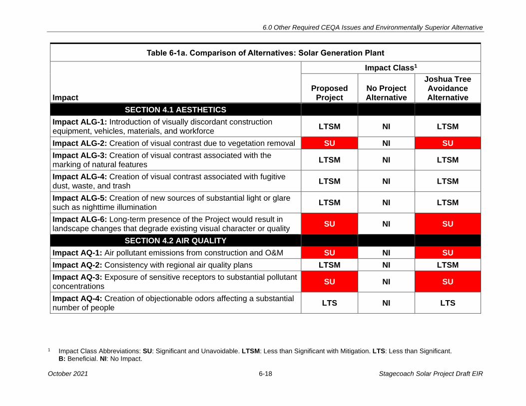
6.0 Other Required CEQA Issues and Environmentally Superior Alternative
1 Impact Class Abbreviations: SU: Significant and Unavoidable. LTSM: Less than Significant with Mitigation. LTS: Less than Significant. B: Beneficial. NI: No Impact.
October 2021 6-18 Stagecoach Solar Project Draft EIR
Table 6-1a. Comparison of Alternatives: Solar Generation Plant
Impact Class1
Impact Proposed
Project No Project Alternative
Joshua Tree Avoidance Alternative
SECTION 4.1 AESTHETICS
Impact ALG-1: Introduction of visually discordant construction equipment, vehicles, materials, and workforce
LTSM NI LTSM
Impact ALG-2: Creation of visual contrast due to vegetation removal SU NI SU
Impact ALG-3: Creation of visual contrast associated with the marking of natural features
LTSM NI LTSM
Impact ALG-4: Creation of visual contrast associated with fugitive dust, waste, and trash
LTSM NI LTSM
Impact ALG-5: Creation of new sources of substantial light or glare such as nighttime illumination
LTSM NI LTSM
Impact ALG-6: Long-term presence of the Project would result in landscape changes that degrade existing visual character or quality
SU NI SU
SECTION 4.2 AIR QUALITY
Impact AQ-1: Air pollutant emissions from construction and O&M SU NI SU
Impact AQ-2: Consistency with regional air quality plans LTSM NI LTSM
Impact AQ-3: Exposure of sensitive receptors to substantial pollutant concentrations
SU NI SU
Impact AQ-4: Creation of objectionable odors affecting a substantial number of people
LTS NI LTS
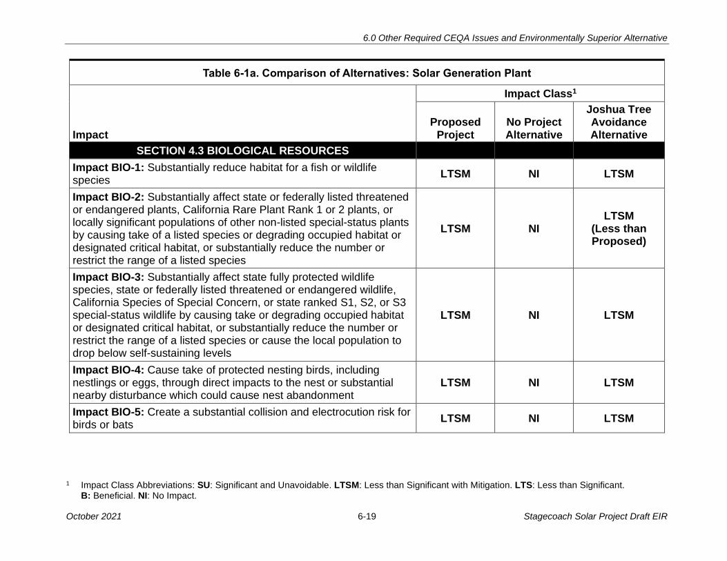
6.0 Other Required CEQA Issues and Environmentally Superior Alternative
1 Impact Class Abbreviations: SU: Significant and Unavoidable. LTSM: Less than Significant with Mitigation. LTS: Less than Significant. B: Beneficial. NI: No Impact.
October 2021 6-19 Stagecoach Solar Project Draft EIR
Table 6-1a. Comparison of Alternatives: Solar Generation Plant
Impact Class1
Impact Proposed
Project No Project Alternative
Joshua Tree Avoidance Alternative
SECTION 4.3 BIOLOGICAL RESOURCES
Impact BIO-1: Substantially reduce habitat for a fish or wildlife species
LTSM NI LTSM
Impact BIO-2: Substantially affect state or federally listed threatened or endangered plants, California Rare Plant Rank 1 or 2 plants, or locally significant populations of other non-listed special-status plants by causing take of a listed species or degrading occupied habitat or designated critical habitat, or substantially reduce the number or restrict the range of a listed species
LTSM NI LTSM
(Less than Proposed)
Impact BIO-3: Substantially affect state fully protected wildlife species, state or federally listed threatened or endangered wildlife, California Species of Special Concern, or state ranked S1, S2, or S3 special-status wildlife by causing take or degrading occupied habitat or designated critical habitat, or substantially reduce the number or restrict the range of a listed species or cause the local population to drop below self-sustaining levels
LTSM NI LTSM
Impact BIO-4: Cause take of protected nesting birds, including nestlings or eggs, through direct impacts to the nest or substantial nearby disturbance which could cause nest abandonment
LTSM NI LTSM
Impact BIO-5: Create a substantial collision and electrocution risk for birds or bats
LTSM NI LTSM

6.0 Other Required CEQA Issues and Environmentally Superior Alternative
1 Impact Class Abbreviations: SU: Significant and Unavoidable. LTSM: Less than Significant with Mitigation. LTS: Less than Significant. B: Beneficial. NI: No Impact.
October 2021 6-20 Stagecoach Solar Project Draft EIR
Table 6-1a. Comparison of Alternatives: Solar Generation Plant
Impact Class1
Impact Proposed
Project No Project Alternative
Joshua Tree Avoidance Alternative
Impact BIO-6: Remove or degrade substantial acreage of riparian vegetation or sensitive vegetation communities identified as S1, S2, or S3, such that the community could be eliminated or its structure or function in the vicinity of the project would be substantially affected
LTSM NI LTSM
Impact BIO-7: Substantially impact jurisdictional wetlands or waters of the U.S. or waters of the state such that ecological structure or function of jurisdictional features in the vicinity of the project would be substantially affected
LTSM NI LTSM
Impact BIO-8: Interfere substantially with the movement of any native resident or migratory fish or wildlife species or with established native resident or migratory wildlife corridors or impede the use of native wildlife nursery sites
LTSM NI LTSM
Impact BIO-9: Conflict with local policies or ordinances protecting biological resources
LTSM NI LTSM
Impact BIO-10: Conflict with provisions of an adopted Habitat Conservation Plan, Natural Community Conservation Plan, or other approved local, regional, or State habitat conservation plan
NI NI NI
SECTION 4.4 CULTURAL RESOURCES
Impact CUL-1: The Project could cause a substantial adverse change in the significance of a historical resource pursuant to State CEQA Guidelines, § 15064.5
LTSM NI LTSM

6.0 Other Required CEQA Issues and Environmentally Superior Alternative
1 Impact Class Abbreviations: SU: Significant and Unavoidable. LTSM: Less than Significant with Mitigation. LTS: Less than Significant. B: Beneficial. NI: No Impact.
October 2021 6-21 Stagecoach Solar Project Draft EIR
Table 6-1a. Comparison of Alternatives: Solar Generation Plant
Impact Class1
Impact Proposed
Project No Project Alternative
Joshua Tree Avoidance Alternative
Impact CUL-2: The Project could cause a substantial adverse change in the significance of a unique archaeological resource pursuant to State CEQA Guidelines, § 15064.5
LTSM NI LTSM
Impact CUL-3: The Project could disturb human remains, including those interred outside of formal cemeteries
LTSM NI LTSM
SECTION 4.5 CULTURAL RESOURCES – TRIBAL
Impact TCR-1: Change the Significance of a Tribal Cultural Resource as defined in Public Resources Code section 21074, that is either eligible for or listed in the California Register of Historical Resources or in a local register or is determined by the lead agency to be significant
LTSM NI LTSM
SECTION 4.6 ENERGY
Impact EN-1: Wasteful, inefficient, or unnecessary consumption of energy resources during construction or operation and maintenance
LTS NI LTS
Impact EN-2: Conflict with or obstruct a State or local plan for renewable energy or energy efficiency
SU NI SU
SECTION 4.7 GEOLOGY AND SOILS
Impact GEO-1: Damage or injury from fault rupture NI NI NI
Impact GEO-2: Strong earthquake-induced ground shaking could result in damage to project structures and/or injury to people
LTS NI
LTS
Impact GEO-3: Project structures could be damaged by seismically induced liquefaction phenomena
LTS NI
LTS

6.0 Other Required CEQA Issues and Environmentally Superior Alternative
1 Impact Class Abbreviations: SU: Significant and Unavoidable. LTSM: Less than Significant with Mitigation. LTS: Less than Significant. B: Beneficial. NI: No Impact.
October 2021 6-22 Stagecoach Solar Project Draft EIR
Table 6-1a. Comparison of Alternatives: Solar Generation Plant
Impact Class1
Impact Proposed
Project No Project Alternative
Joshua Tree Avoidance Alternative
Impact GEO-4: Seismically induced landslides or slope failures could damage project structures or expose workers to injury
LTS NI
LTS
Impact GEO-5: Construction and operation of the Project could trigger or accelerate soil erosion
LTSM NI
LTSM
Impact GEO-6: Slope failures, such as landslides, could be triggered by project construction
LTS NI
LTS
Impact GEO-7: Unsuitable soils result in damage to project structures
LTSM NI LTSM
Impact GEO-8: Soils could be incapable of supporting a Septic System
LTS NI LTS
SECTION 4.8 GREENHOUSE GAS EMISSIONS
Impact GHG-1: GHG emissions from project activities LTS NI LTS
Impact GHG-2: Consistency with applicable GHG plan, policy, or regulation
NI NI NI
SECTION 4.9 HAZARDS AND HAZARDOUS MATERIALS
Impact HAZ-1: Spill or release of hazardous materials occurs during construction, operation, or maintenance of the project
LTSM NI LTSM
Impact HAZ-2: Encountering unexploded ordnance or military munitions and explosives of concern (UXO or MEC)
LTSM NI LTSM
Impact HAZ-3: Unknown environmental contamination could be encountered during construction
LTSM NI LTSM
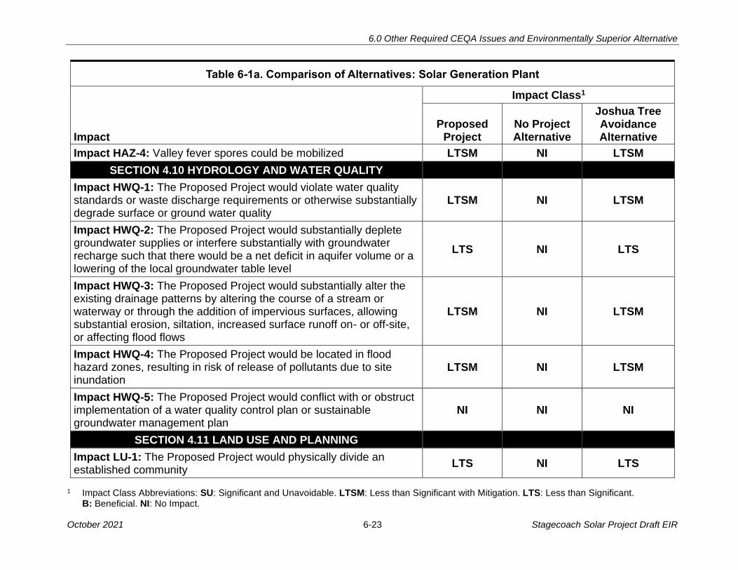
6.0 Other Required CEQA Issues and Environmentally Superior Alternative
1 Impact Class Abbreviations: SU: Significant and Unavoidable. LTSM: Less than Significant with Mitigation. LTS: Less than Significant. B: Beneficial. NI: No Impact.
October 2021 6-23 Stagecoach Solar Project Draft EIR
Table 6-1a. Comparison of Alternatives: Solar Generation Plant
Impact Class1
Impact Proposed
Project No Project Alternative
Joshua Tree Avoidance Alternative
Impact HAZ-4: Valley fever spores could be mobilized LTSM NI LTSM
SECTION 4.10 HYDROLOGY AND WATER QUALITY
Impact HWQ-1: The Proposed Project would violate water quality standards or waste discharge requirements or otherwise substantially degrade surface or ground water quality
LTSM NI LTSM
Impact HWQ-2: The Proposed Project would substantially deplete groundwater supplies or interfere substantially with groundwater recharge such that there would be a net deficit in aquifer volume or a lowering of the local groundwater table level
LTS NI LTS
Impact HWQ-3: The Proposed Project would substantially alter the existing drainage patterns by altering the course of a stream or waterway or through the addition of impervious surfaces, allowing substantial erosion, siltation, increased surface runoff on- or off-site, or affecting flood flows
LTSM NI LTSM
Impact HWQ-4: The Proposed Project would be located in flood hazard zones, resulting in risk of release of pollutants due to site inundation
LTSM NI LTSM
Impact HWQ-5: The Proposed Project would conflict with or obstruct implementation of a water quality control plan or sustainable groundwater management plan
NI NI NI
SECTION 4.11 LAND USE AND PLANNING
Impact LU-1: The Proposed Project would physically divide an established community
LTS NI LTS
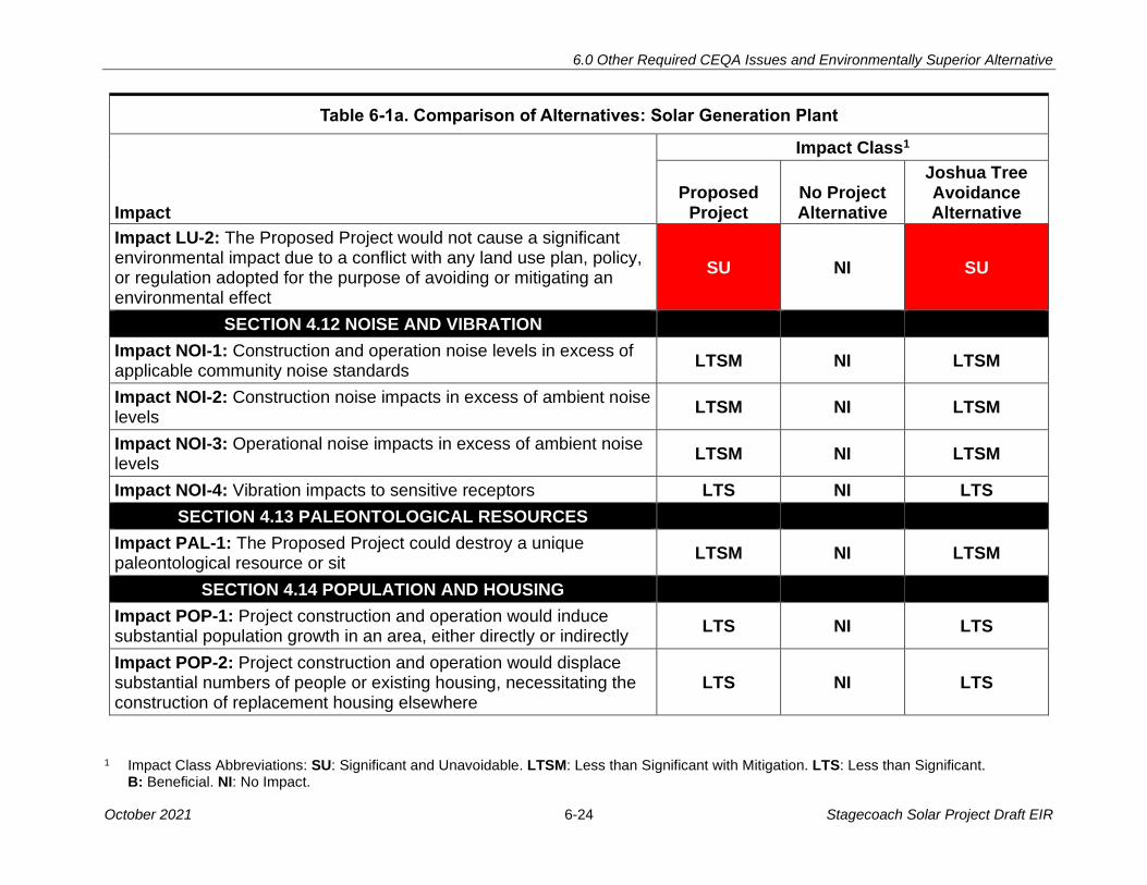
6.0 Other Required CEQA Issues and Environmentally Superior Alternative
1 Impact Class Abbreviations: SU: Significant and Unavoidable. LTSM: Less than Significant with Mitigation. LTS: Less than Significant. B: Beneficial. NI: No Impact.
October 2021 6-24 Stagecoach Solar Project Draft EIR
Table 6-1a. Comparison of Alternatives: Solar Generation Plant
Impact Class1
Impact Proposed
Project No Project Alternative
Joshua Tree Avoidance Alternative
Impact LU-2: The Proposed Project would not cause a significant environmental impact due to a conflict with any land use plan, policy, or regulation adopted for the purpose of avoiding or mitigating an environmental effect
SU NI SU
SECTION 4.12 NOISE AND VIBRATION
Impact NOI-1: Construction and operation noise levels in excess of applicable community noise standards
LTSM NI LTSM
Impact NOI-2: Construction noise impacts in excess of ambient noise levels
LTSM NI LTSM
Impact NOI-3: Operational noise impacts in excess of ambient noise levels
LTSM NI LTSM
Impact NOI-4: Vibration impacts to sensitive receptors LTS NI LTS
SECTION 4.13 PALEONTOLOGICAL RESOURCES
Impact PAL-1: The Proposed Project could destroy a unique paleontological resource or sit
LTSM NI LTSM
SECTION 4.14 POPULATION AND HOUSING
Impact POP-1: Project construction and operation would induce substantial population growth in an area, either directly or indirectly
LTS NI LTS
Impact POP-2: Project construction and operation would displace substantial numbers of people or existing housing, necessitating the construction of replacement housing elsewhere
LTS NI LTS
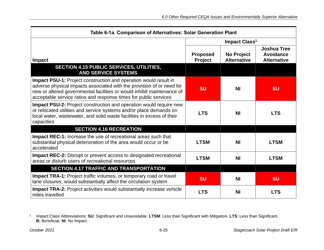
6.0 Other Required CEQA Issues and Environmentally Superior Alternative
1 Impact Class Abbreviations: SU: Significant and Unavoidable. LTSM: Less than Significant with Mitigation. LTS: Less than Significant. B: Beneficial. NI: No Impact.
October 2021 6-25 Stagecoach Solar Project Draft EIR
Table 6-1a. Comparison of Alternatives: Solar Generation Plant
Impact Class1
Impact Proposed
Project No Project Alternative
Joshua Tree Avoidance Alternative
SECTION 4.15 PUBLIC SERVICES, UTILITIES, AND SERVICE SYSTEMS
Impact PSU-1: Project construction and operation would result in adverse physical impacts associated with the provision of or need for new or altered governmental facilities or would inhibit maintenance of acceptable service ratios and response times for public services
SU NI SU
Impact PSU-2: Project construction and operation would require new or relocated utilities and service systems and/or place demands on local water, wastewater, and solid waste facilities in excess of their capacities
LTS NI LTS
SECTION 4.16 RECREATION
Impact REC-1: Increase the use of recreational areas such that substantial physical deterioration of the area would occur or be accelerated
LTSM NI LTSM
Impact REC-2: Disrupt or prevent access to designated recreational areas or disturb users of recreational resources
LTSM NI LTSM
SECTION 4.17 TRAFFIC AND TRANSPORTATION
Impact TRA-1: Project traffic volumes, or temporary road or travel lane closures, would substantially affect the circulation system
SU NI SU
Impact TRA-2: Project activities would substantially increase vehicle miles travelled
LTS NI LTS

6.0 Other Required CEQA Issues and Environmentally Superior Alternative
1 Impact Class Abbreviations: SU: Significant and Unavoidable. LTSM: Less than Significant with Mitigation. LTS: Less than Significant. B: Beneficial. NI: No Impact.
October 2021 6-26 Stagecoach Solar Project Draft EIR
Table 6-1a. Comparison of Alternatives: Solar Generation Plant
Impact Class1
Impact Proposed
Project No Project Alternative
Joshua Tree Avoidance Alternative
Impact TRA-3: Project activities or features would substantially increase roadway hazards from roadway damage or incompatible uses
LTSM NI LTSM
Impact TRA-4: Project activities would affect emergency vehicle response
SU NI SU
SECTION 4.18 WILDFIRE
Impact WIL-1: Require the installation or maintenance of infrastructure (such as roads, fuel breaks, emergency water sources, power lines or other utilities) that may exacerbate fire risk or that may result in temporary or ongoing increased wildfire risk
LTSM NI LTSM
Impact WIL-2: Expose people or structures, either directly or indirectly, to a significant risk of loss, injury or death involving wildland fires
LTSM NI LTSM

6.0 Other Required CEQA Issues and Environmentally Superior Alternative
1 Impact Class Abbreviations: SU: Significant and Unavoidable. LTSM: Less than Significant with Mitigation. LTS: Less than Significant. B: Beneficial. NI: No Impact.
October 2021 6-27 Stagecoach Solar Project Draft EIR
Table 6-1b. Comparison of Alternatives: Gen-tie Line
Impact Class1
Impact
Proposed Gen-tie
Line No Project Alternative
Under-ground
Alternative in County
Roads
Under-ground
Alternative Along
Proposed ROW
SECTION 4.1 AESTHETICS
Impact ALG-1: Introduction of visually discordant construction equipment, vehicles, materials, and workforce
LTSM NI LTSM LTSM
Impact ALG-2: Creation of visual contrast due to vegetation removal
SU NI SU SU
Impact ALG-3: Creation of visual contrast associated with the marking of natural features
LTSM NI LTSM LTSM
Impact ALG-4: Creation of visual contrast associated with fugitive dust, waste, and trash
LTSM NI LTSM LTSM
Impact ALG-5: Creation of new sources of substantial light or glare such as nighttime illumination
LTSM NI LTSM LTSM
Impact ALG-6: Long-term presence of the Project would result in landscape changes that degrade existing visual character or quality SU NI
SU (Less than Proposed)
SU (Less than Proposed)
SECTION 4.2 AIR QUALITY
Impact AQ-1: Air pollutant emissions from construction and O&M
SU NI SU
(More than Proposed)
SU
(More than Proposed)
Impact AQ-2: Consistency with regional air quality plans LTSM NI LTSM LTSM

6.0 Other Required CEQA Issues and Environmentally Superior Alternative
1 Impact Class Abbreviations: SU: Significant and Unavoidable. LTSM: Less than Significant with Mitigation. LTS: Less than Significant. B: Beneficial. NI: No Impact.
October 2021 6-28 Stagecoach Solar Project Draft EIR
Table 6-1b. Comparison of Alternatives: Gen-tie Line
Impact Class1
Impact
Proposed Gen-tie
Line No Project Alternative
Under-ground
Alternative in County
Roads
Under-ground
Alternative Along
Proposed ROW
Impact AQ-3: Exposure of sensitive receptors to substantial pollutant concentrations
LTSM NI LTSM LTSM
Impact AQ-4: Creation of objectionable odors affecting a substantial number of people
LTS NI LTS LTS
SECTION 4.3 BIOLOGICAL RESOURCES
Impact BIO-1: Substantially reduce habitat for a fish or wildlife species
LTSM NI LTSM LTSM
Impact BIO-2: Substantially affect state or federally listed threatened or endangered plants, California Rare Plant Rank 1 or 2 plants, or locally significant populations of other non-listed special-status plants by causing take of a listed species or degrading occupied habitat or designated critical habitat, or substantially reduce the number or restrict the range of a listed species
LTSM NI LTSM LTSM
Impact BIO-3: Substantially affect state fully protected wildlife species, state or federally listed threatened or endangered wildlife, California Species of Special Concern, or state ranked S1, S2, or S3 special-status wildlife by causing take or degrading occupied habitat or designated critical habitat, or substantially reduce the number or restrict the range of a listed species or cause the local population to drop below self-sustaining levels
LTSM NI LTSM LTSM
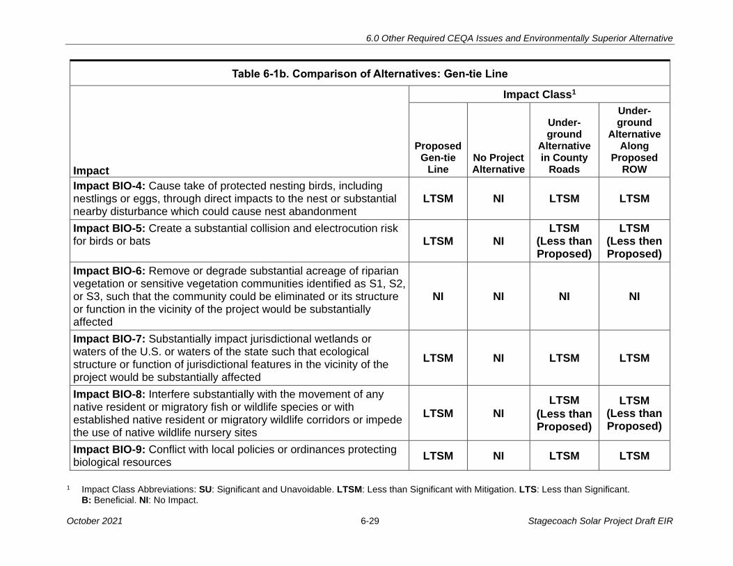
6.0 Other Required CEQA Issues and Environmentally Superior Alternative
1 Impact Class Abbreviations: SU: Significant and Unavoidable. LTSM: Less than Significant with Mitigation. LTS: Less than Significant. B: Beneficial. NI: No Impact.
October 2021 6-29 Stagecoach Solar Project Draft EIR
Table 6-1b. Comparison of Alternatives: Gen-tie Line
Impact Class1
Impact
Proposed Gen-tie
Line No Project Alternative
Under-ground
Alternative in County
Roads
Under-ground
Alternative Along
Proposed ROW
Impact BIO-4: Cause take of protected nesting birds, including nestlings or eggs, through direct impacts to the nest or substantial nearby disturbance which could cause nest abandonment
LTSM NI LTSM LTSM
Impact BIO-5: Create a substantial collision and electrocution risk for birds or bats LTSM NI
LTSM (Less than Proposed)
LTSM (Less then Proposed)
Impact BIO-6: Remove or degrade substantial acreage of riparian vegetation or sensitive vegetation communities identified as S1, S2, or S3, such that the community could be eliminated or its structure or function in the vicinity of the project would be substantially affected
NI NI NI NI
Impact BIO-7: Substantially impact jurisdictional wetlands or waters of the U.S. or waters of the state such that ecological structure or function of jurisdictional features in the vicinity of the project would be substantially affected
LTSM NI LTSM LTSM
Impact BIO-8: Interfere substantially with the movement of any native resident or migratory fish or wildlife species or with established native resident or migratory wildlife corridors or impede the use of native wildlife nursery sites
LTSM NI
LTSM
(Less than Proposed)
LTSM (Less than Proposed)
Impact BIO-9: Conflict with local policies or ordinances protecting biological resources
LTSM NI LTSM LTSM
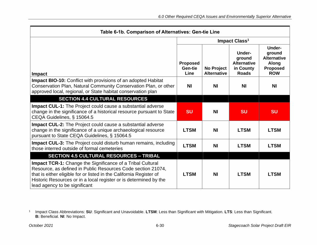
6.0 Other Required CEQA Issues and Environmentally Superior Alternative
1 Impact Class Abbreviations: SU: Significant and Unavoidable. LTSM: Less than Significant with Mitigation. LTS: Less than Significant. B: Beneficial. NI: No Impact.
October 2021 6-30 Stagecoach Solar Project Draft EIR
Table 6-1b. Comparison of Alternatives: Gen-tie Line
Impact Class1
Impact
Proposed Gen-tie
Line No Project Alternative
Under-ground
Alternative in County
Roads
Under-ground
Alternative Along
Proposed ROW
Impact BIO-10: Conflict with provisions of an adopted Habitat Conservation Plan, Natural Community Conservation Plan, or other approved local, regional, or State habitat conservation plan
NI NI NI NI
SECTION 4.4 CULTURAL RESOURCES
Impact CUL-1: The Project could cause a substantial adverse change in the significance of a historical resource pursuant to State CEQA Guidelines, § 15064.5
SU NI SU SU
Impact CUL-2: The Project could cause a substantial adverse change in the significance of a unique archaeological resource pursuant to State CEQA Guidelines, § 15064.5
LTSM NI LTSM LTSM
Impact CUL-3: The Project could disturb human remains, including those interred outside of formal cemeteries
LTSM NI LTSM LTSM
SECTION 4.5 CULTURAL RESOURCES – TRIBAL
Impact TCR-1: Change the Significance of a Tribal Cultural Resource, as defined in Public Resources Code section 21074, that is either eligible for or listed in the California Register of Historic Resources or in a local register or is determined by the lead agency to be significant
LTSM NI LTSM LTSM
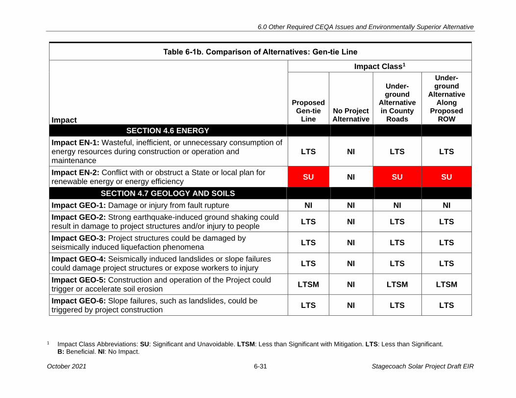
6.0 Other Required CEQA Issues and Environmentally Superior Alternative
1 Impact Class Abbreviations: SU: Significant and Unavoidable. LTSM: Less than Significant with Mitigation. LTS: Less than Significant. B: Beneficial. NI: No Impact.
October 2021 6-31 Stagecoach Solar Project Draft EIR
Table 6-1b. Comparison of Alternatives: Gen-tie Line
Impact Class1
Impact
Proposed Gen-tie
Line No Project Alternative
Under-ground
Alternative in County
Roads
Under-ground
Alternative Along
Proposed ROW
SECTION 4.6 ENERGY
Impact EN-1: Wasteful, inefficient, or unnecessary consumption of energy resources during construction or operation and maintenance
LTS NI LTS LTS
Impact EN-2: Conflict with or obstruct a State or local plan for renewable energy or energy efficiency
SU NI SU SU
SECTION 4.7 GEOLOGY AND SOILS
Impact GEO-1: Damage or injury from fault rupture NI NI NI NI
Impact GEO-2: Strong earthquake-induced ground shaking could result in damage to project structures and/or injury to people
LTS NI LTS LTS
Impact GEO-3: Project structures could be damaged by seismically induced liquefaction phenomena
LTS NI LTS LTS
Impact GEO-4: Seismically induced landslides or slope failures could damage project structures or expose workers to injury
LTS NI LTS LTS
Impact GEO-5: Construction and operation of the Project could trigger or accelerate soil erosion
LTSM NI LTSM LTSM
Impact GEO-6: Slope failures, such as landslides, could be triggered by project construction
LTS NI LTS LTS
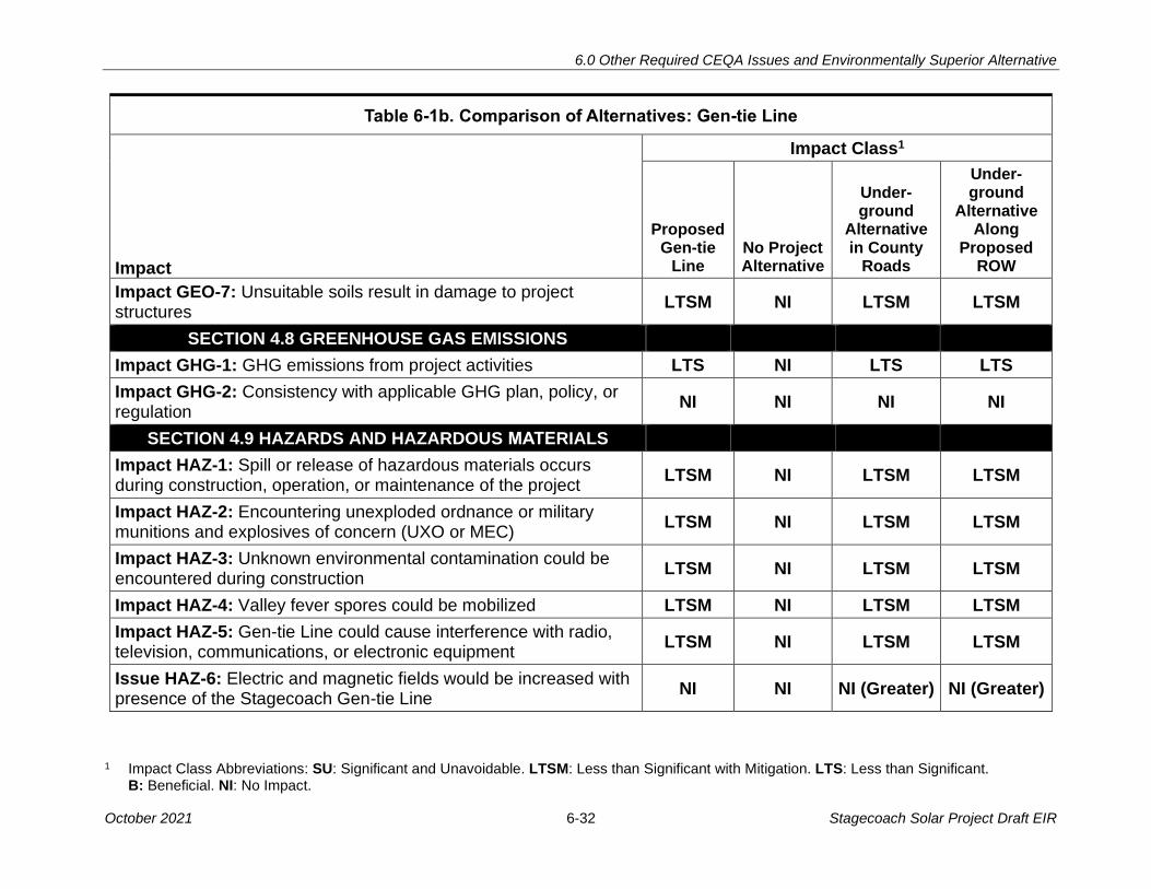
6.0 Other Required CEQA Issues and Environmentally Superior Alternative
1 Impact Class Abbreviations: SU: Significant and Unavoidable. LTSM: Less than Significant with Mitigation. LTS: Less than Significant. B: Beneficial. NI: No Impact.
October 2021 6-32 Stagecoach Solar Project Draft EIR
Table 6-1b. Comparison of Alternatives: Gen-tie Line
Impact Class1
Impact
Proposed Gen-tie
Line No Project Alternative
Under-ground
Alternative in County
Roads
Under-ground
Alternative Along
Proposed ROW
Impact GEO-7: Unsuitable soils result in damage to project structures
LTSM NI LTSM LTSM
SECTION 4.8 GREENHOUSE GAS EMISSIONS
Impact GHG-1: GHG emissions from project activities LTS NI LTS LTS
Impact GHG-2: Consistency with applicable GHG plan, policy, or regulation
NI NI NI NI
SECTION 4.9 HAZARDS AND HAZARDOUS MATERIALS
Impact HAZ-1: Spill or release of hazardous materials occurs during construction, operation, or maintenance of the project
LTSM NI LTSM LTSM
Impact HAZ-2: Encountering unexploded ordnance or military munitions and explosives of concern (UXO or MEC)
LTSM NI LTSM LTSM
Impact HAZ-3: Unknown environmental contamination could be encountered during construction
LTSM NI LTSM LTSM
Impact HAZ-4: Valley fever spores could be mobilized LTSM NI LTSM LTSM
Impact HAZ-5: Gen-tie Line could cause interference with radio, television, communications, or electronic equipment
LTSM NI LTSM LTSM
Issue HAZ-6: Electric and magnetic fields would be increased with presence of the Stagecoach Gen-tie Line
NI NI NI (Greater) NI (Greater)

6.0 Other Required CEQA Issues and Environmentally Superior Alternative
1 Impact Class Abbreviations: SU: Significant and Unavoidable. LTSM: Less than Significant with Mitigation. LTS: Less than Significant. B: Beneficial. NI: No Impact.
October 2021 6-33 Stagecoach Solar Project Draft EIR
Table 6-1b. Comparison of Alternatives: Gen-tie Line
Impact Class1
Impact
Proposed Gen-tie
Line No Project Alternative
Under-ground
Alternative in County
Roads
Under-ground
Alternative Along
Proposed ROW
SECTION 4.10 HYDROLOGY AND WATER QUALITY
Impact HWQ-1: The Proposed Project would violate water quality standards or waste discharge requirements or otherwise substantially degrade surface or ground water quality
LTSM NI LTSM LTSM
Impact HWQ-2: The Proposed Project would substantially deplete groundwater supplies or interfere substantially with groundwater recharge such that there would be a net deficit in aquifer volume or a lowering of the local groundwater table level
LTS NI LTS LTS
Impact HWQ-3: The Proposed Project would substantially alter the existing drainage patterns by altering the course of a stream or waterway or through the addition of impervious surfaces, allowing substantial erosion, siltation, increased surface runoff on- or off-site, or affecting flood flows
LTS NI LTS LTS
Impact HWQ-4: The Proposed Project would be located in flood hazard zones, resulting in risk of release of pollutants due to site inundation
LTSM NI LTSM LTSM
Impact HWQ-5: The Proposed Project would conflict with or obstruct implementation of a water quality control plan or sustainable groundwater management plan
NI NI NI NI
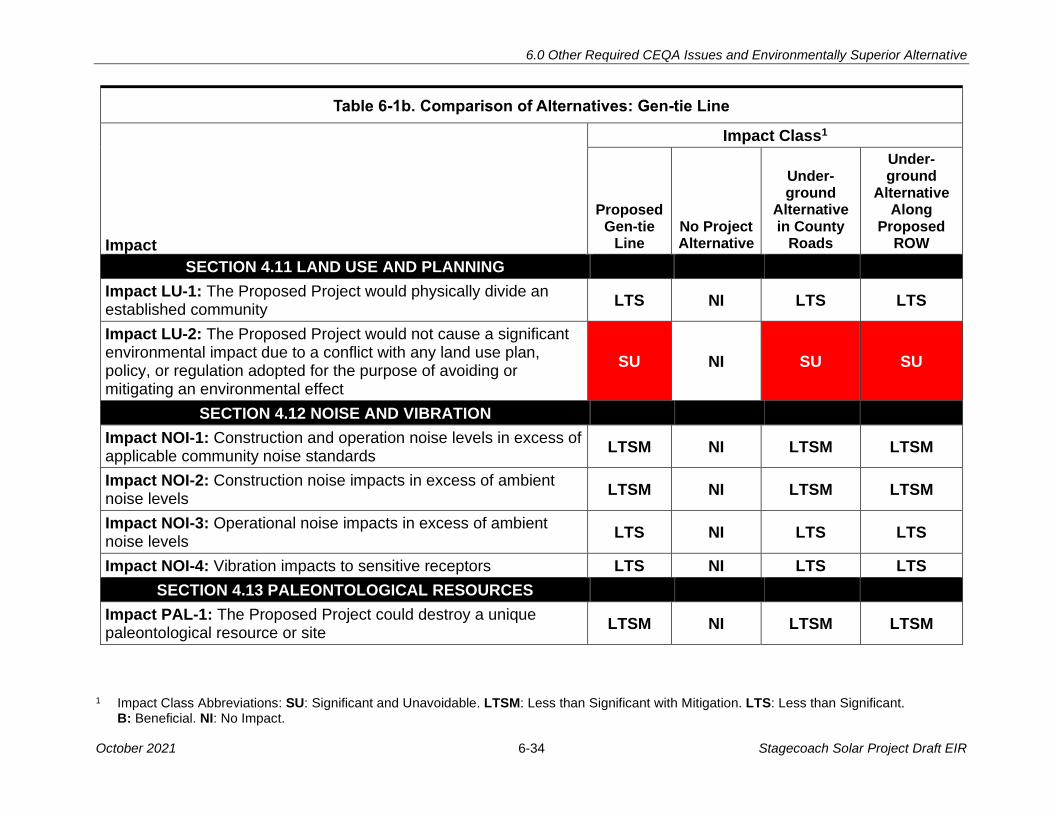
6.0 Other Required CEQA Issues and Environmentally Superior Alternative
1 Impact Class Abbreviations: SU: Significant and Unavoidable. LTSM: Less than Significant with Mitigation. LTS: Less than Significant. B: Beneficial. NI: No Impact.
October 2021 6-34 Stagecoach Solar Project Draft EIR
Table 6-1b. Comparison of Alternatives: Gen-tie Line
Impact Class1
Impact
Proposed Gen-tie
Line No Project Alternative
Under-ground
Alternative in County
Roads
Under-ground
Alternative Along
Proposed ROW
SECTION 4.11 LAND USE AND PLANNING
Impact LU-1: The Proposed Project would physically divide an established community
LTS NI LTS LTS
Impact LU-2: The Proposed Project would not cause a significant environmental impact due to a conflict with any land use plan, policy, or regulation adopted for the purpose of avoiding or mitigating an environmental effect
SU NI SU SU
SECTION 4.12 NOISE AND VIBRATION
Impact NOI-1: Construction and operation noise levels in excess of applicable community noise standards
LTSM NI LTSM LTSM
Impact NOI-2: Construction noise impacts in excess of ambient noise levels
LTSM NI LTSM LTSM
Impact NOI-3: Operational noise impacts in excess of ambient noise levels
LTS NI LTS LTS
Impact NOI-4: Vibration impacts to sensitive receptors LTS NI LTS LTS
SECTION 4.13 PALEONTOLOGICAL RESOURCES
Impact PAL-1: The Proposed Project could destroy a unique paleontological resource or site
LTSM NI LTSM LTSM

6.0 Other Required CEQA Issues and Environmentally Superior Alternative
1 Impact Class Abbreviations: SU: Significant and Unavoidable. LTSM: Less than Significant with Mitigation. LTS: Less than Significant. B: Beneficial. NI: No Impact.
October 2021 6-35 Stagecoach Solar Project Draft EIR
Table 6-1b. Comparison of Alternatives: Gen-tie Line
Impact Class1
Impact
Proposed Gen-tie
Line No Project Alternative
Under-ground
Alternative in County
Roads
Under-ground
Alternative Along
Proposed ROW
SECTION 4.14 POPULATION AND HOUSING
Impact POP-1: Project construction and operation would induce substantial population growth in an area, either directly or indirectly
LTS NI LTS LTS
Impact POP-2: Project construction and operation would displace substantial numbers of people or existing housing, necessitating the construction of replacement housing elsewhere
LTS NI LTS LTS
SECTION 4.15 PUBLIC SERVICES, UTILITIES, AND SERVICE SYSTEMS
Impact PSU-1: Project construction and operation would result in adverse physical impacts associated with the provision of or need for new or altered governmental facilities or would inhibit maintenance of acceptable service ratios and response times for public services
SU NI SU SU
Impact PSU-2: Project construction and operation would require new or relocated utilities and service systems and/or place demands on local water, wastewater, and solid waste facilities in excess of their capacities
LTS NI LTS LTS

6.0 Other Required CEQA Issues and Environmentally Superior Alternative
1 Impact Class Abbreviations: SU: Significant and Unavoidable. LTSM: Less than Significant with Mitigation. LTS: Less than Significant. B: Beneficial. NI: No Impact.
October 2021 6-36 Stagecoach Solar Project Draft EIR
Table 6-1b. Comparison of Alternatives: Gen-tie Line
Impact Class1
Impact
Proposed Gen-tie
Line No Project Alternative
Under-ground
Alternative in County
Roads
Under-ground
Alternative Along
Proposed ROW
SECTION 4.16 RECREATION
Impact REC-1: Increase the use of recreational areas such that substantial physical deterioration of the area would occur or be accelerated
LTS NI LTS LTS
Impact REC-2: Disrupt or prevent access to designated recreational areas or disturb users of recreational resources
LTS NI LTS LTS
SECTION 4.17 TRAFFIC AND TRANSPORTATION
Impact TRA-1: Project traffic volumes, or temporary road or travel lane closures, would substantially affect the circulation system
SU NI SU SU
Impact TRA-2: Project activities would substantially increase vehicle miles travelled
LTS NI LTS LTS
Impact TRA-3: Project activities or features would substantially increase roadway hazards from roadway damage or incompatible uses
LTSM NI LTSM LTSM
Impact TRA-4: Project activities would affect emergency vehicle response
LTSM NI LTSM LTSM
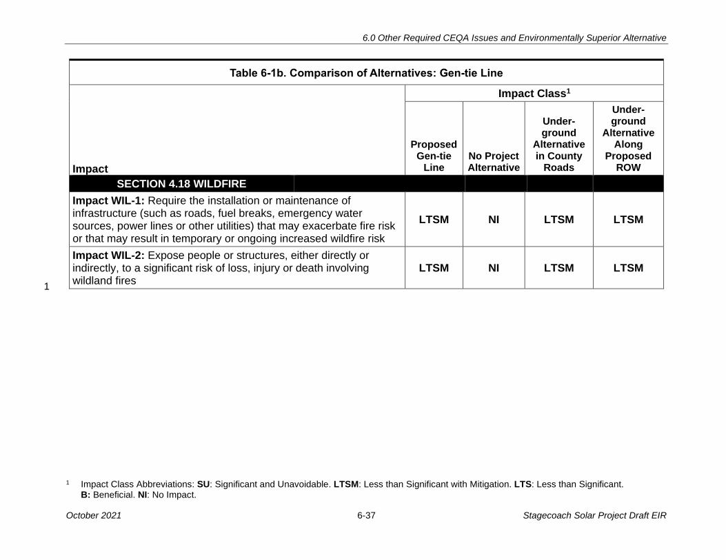
6.0 Other Required CEQA Issues and Environmentally Superior Alternative
1 Impact Class Abbreviations: SU: Significant and Unavoidable. LTSM: Less than Significant with Mitigation. LTS: Less than Significant. B: Beneficial. NI: No Impact.
October 2021 6-37 Stagecoach Solar Project Draft EIR
Table 6-1b. Comparison of Alternatives: Gen-tie Line
Impact Class1
Impact
Proposed Gen-tie
Line No Project Alternative
Under-ground
Alternative in County
Roads
Under-ground
Alternative Along
Proposed ROW
SECTION 4.18 WILDFIRE
Impact WIL-1: Require the installation or maintenance of infrastructure (such as roads, fuel breaks, emergency water sources, power lines or other utilities) that may exacerbate fire risk or that may result in temporary or ongoing increased wildfire risk
LTSM NI LTSM LTSM
Impact WIL-2: Expose people or structures, either directly or indirectly, to a significant risk of loss, injury or death involving wildland fires
LTSM NI LTSM LTSM
s 1
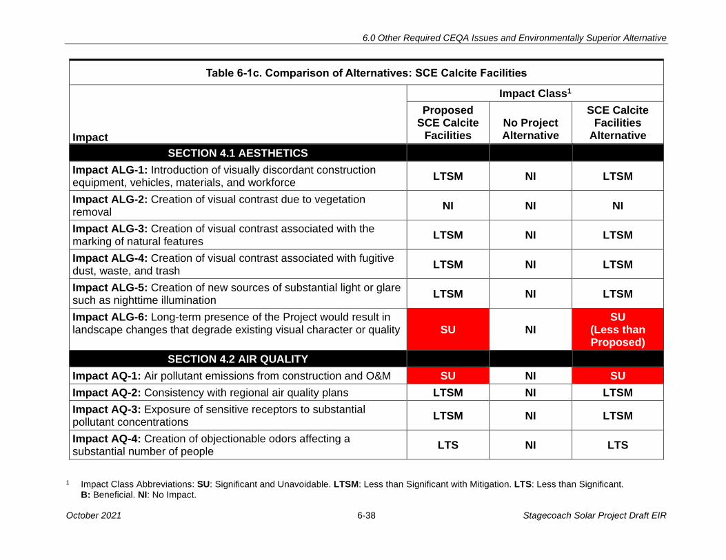
6.0 Other Required CEQA Issues and Environmentally Superior Alternative
1 Impact Class Abbreviations: SU: Significant and Unavoidable. LTSM: Less than Significant with Mitigation. LTS: Less than Significant. B: Beneficial. NI: No Impact.
October 2021 6-38 Stagecoach Solar Project Draft EIR
Table 6-1c. Comparison of Alternatives: SCE Calcite Facilities
Impact Class1
Impact
Proposed SCE Calcite
Facilities No Project Alternative
SCE Calcite Facilities
Alternative
SECTION 4.1 AESTHETICS
Impact ALG-1: Introduction of visually discordant construction equipment, vehicles, materials, and workforce
LTSM NI LTSM
Impact ALG-2: Creation of visual contrast due to vegetation removal
NI NI NI
Impact ALG-3: Creation of visual contrast associated with the marking of natural features
LTSM NI LTSM
Impact ALG-4: Creation of visual contrast associated with fugitive dust, waste, and trash
LTSM NI LTSM
Impact ALG-5: Creation of new sources of substantial light or glare such as nighttime illumination
LTSM NI LTSM
Impact ALG-6: Long-term presence of the Project would result in landscape changes that degrade existing visual character or quality SU NI
SU (Less than Proposed)
SECTION 4.2 AIR QUALITY
Impact AQ-1: Air pollutant emissions from construction and O&M SU NI SU
Impact AQ-2: Consistency with regional air quality plans LTSM NI LTSM
Impact AQ-3: Exposure of sensitive receptors to substantial pollutant concentrations
LTSM NI LTSM
Impact AQ-4: Creation of objectionable odors affecting a substantial number of people
LTS NI LTS
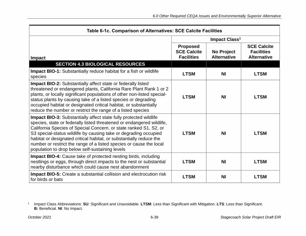
6.0 Other Required CEQA Issues and Environmentally Superior Alternative
1 Impact Class Abbreviations: SU: Significant and Unavoidable. LTSM: Less than Significant with Mitigation. LTS: Less than Significant. B: Beneficial. NI: No Impact.
October 2021 6-39 Stagecoach Solar Project Draft EIR
Table 6-1c. Comparison of Alternatives: SCE Calcite Facilities
Impact Class1
Impact
Proposed SCE Calcite
Facilities No Project Alternative
SCE Calcite Facilities
Alternative
SECTION 4.3 BIOLOGICAL RESOURCES
Impact BIO-1: Substantially reduce habitat for a fish or wildlife species
LTSM NI LTSM
Impact BIO-2: Substantially affect state or federally listed threatened or endangered plants, California Rare Plant Rank 1 or 2 plants, or locally significant populations of other non-listed special-status plants by causing take of a listed species or degrading occupied habitat or designated critical habitat, or substantially reduce the number or restrict the range of a listed species
LTSM NI LTSM
Impact BIO-3: Substantially affect state fully protected wildlife species, state or federally listed threatened or endangered wildlife, California Species of Special Concern, or state ranked S1, S2, or S3 special-status wildlife by causing take or degrading occupied habitat or designated critical habitat, or substantially reduce the number or restrict the range of a listed species or cause the local population to drop below self-sustaining levels
LTSM NI LTSM
Impact BIO-4: Cause take of protected nesting birds, including nestlings or eggs, through direct impacts to the nest or substantial nearby disturbance which could cause nest abandonment
LTSM NI LTSM
Impact BIO-5: Create a substantial collision and electrocution risk for birds or bats
LTSM NI LTSM
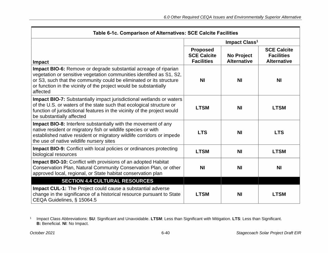
6.0 Other Required CEQA Issues and Environmentally Superior Alternative
1 Impact Class Abbreviations: SU: Significant and Unavoidable. LTSM: Less than Significant with Mitigation. LTS: Less than Significant. B: Beneficial. NI: No Impact.
October 2021 6-40 Stagecoach Solar Project Draft EIR
Table 6-1c. Comparison of Alternatives: SCE Calcite Facilities
Impact Class1
Impact
Proposed SCE Calcite
Facilities No Project Alternative
SCE Calcite Facilities
Alternative
Impact BIO-6: Remove or degrade substantial acreage of riparian vegetation or sensitive vegetation communities identified as S1, S2, or S3, such that the community could be eliminated or its structure or function in the vicinity of the project would be substantially affected
NI NI NI
Impact BIO-7: Substantially impact jurisdictional wetlands or waters of the U.S. or waters of the state such that ecological structure or function of jurisdictional features in the vicinity of the project would be substantially affected
LTSM NI LTSM
Impact BIO-8: Interfere substantially with the movement of any native resident or migratory fish or wildlife species or with established native resident or migratory wildlife corridors or impede the use of native wildlife nursery sites
LTS NI LTS
Impact BIO-9: Conflict with local policies or ordinances protecting biological resources
LTSM NI LTSM
Impact BIO-10: Conflict with provisions of an adopted Habitat Conservation Plan, Natural Community Conservation Plan, or other approved local, regional, or State habitat conservation plan
NI NI NI
SECTION 4.4 CULTURAL RESOURCES
Impact CUL-1: The Project could cause a substantial adverse change in the significance of a historical resource pursuant to State CEQA Guidelines, § 15064.5
LTSM NI LTSM

6.0 Other Required CEQA Issues and Environmentally Superior Alternative
1 Impact Class Abbreviations: SU: Significant and Unavoidable. LTSM: Less than Significant with Mitigation. LTS: Less than Significant. B: Beneficial. NI: No Impact.
October 2021 6-41 Stagecoach Solar Project Draft EIR
Table 6-1c. Comparison of Alternatives: SCE Calcite Facilities
Impact Class1
Impact
Proposed SCE Calcite
Facilities No Project Alternative
SCE Calcite Facilities
Alternative
Impact CUL-2: The Project could cause a substantial adverse change in the significance of a unique archaeological resource pursuant to State CEQA Guidelines, § 15064.5
LTSM NI LTSM
Impact CUL-3: The Project could disturb human remains, including those interred outside of formal cemeteries
LTSM NI LTSM
SECTION 4.5 CULTURAL RESOURCES – TRIBAL
Impact TCR-1: Change the Significance of a Tribal Cultural Resource, as defined in Public Resources Code section 21074, that is either eligible for or listed in the California Register of Historic Resources or in a local register or is determined by the lead agency to be significant
LTSM NI LTSM
SECTION 4.6 ENERGY
Impact EN-1: Wasteful, inefficient, or unnecessary consumption of energy resources during construction or operation and maintenance
LTS NI LTS
Impact EN-2: Conflict with or obstruct a State or local plan for renewable energy or energy efficiency
SU NI SU
SECTION 4.7 GEOLOGY AND SOILS
Impact GEO-1: Damage or injury from fault rupture NI NI NI
Impact GEO-2: Strong earthquake-induced ground shaking could result in damage to project structures and/or injury to people
LTS NI LTS
Impact GEO-3: Project structures could be damaged by seismically induced liquefaction phenomena
LTS NI LTS

6.0 Other Required CEQA Issues and Environmentally Superior Alternative
1 Impact Class Abbreviations: SU: Significant and Unavoidable. LTSM: Less than Significant with Mitigation. LTS: Less than Significant. B: Beneficial. NI: No Impact.
October 2021 6-42 Stagecoach Solar Project Draft EIR
Table 6-1c. Comparison of Alternatives: SCE Calcite Facilities
Impact Class1
Impact
Proposed SCE Calcite
Facilities No Project Alternative
SCE Calcite Facilities
Alternative
Impact GEO-4: Seismically induced landslides or slope failures could damage project structures or expose workers to injury
NI NI NI
Impact GEO-5: Construction and operation of the Project could trigger or accelerate soil erosion
LTSM NI LTSM
Impact GEO-6: Slope failures, such as landslides, could be triggered by project construction
NI NI NI
Impact GEO-7: Unsuitable soils result in damage to project structures
LTSM NI LTSM
SECTION 4.8 GREENHOUSE GAS EMISSIONS
Impact GHG-1: GHG emissions from project activities LTS NI LTS
Impact GHG-2: Consistency with applicable GHG plan, policy, or regulation
LTS NI LTS
SECTION 4.9 HAZARDS AND HAZARDOUS MATERIALS
Impact HAZ-1: Spill or release of hazardous materials occurs during construction, operation, or maintenance of the project
LTSM NI LTSM
Impact HAZ-3: Unknown environmental contamination could be encountered during construction
LTSM NI LTSM
Impact HAZ-4: Valley fever spores could be mobilized LTSM NI LTSM

6.0 Other Required CEQA Issues and Environmentally Superior Alternative
1 Impact Class Abbreviations: SU: Significant and Unavoidable. LTSM: Less than Significant with Mitigation. LTS: Less than Significant. B: Beneficial. NI: No Impact.
October 2021 6-43 Stagecoach Solar Project Draft EIR
Table 6-1c. Comparison of Alternatives: SCE Calcite Facilities
Impact Class1
Impact
Proposed SCE Calcite
Facilities No Project Alternative
SCE Calcite Facilities
Alternative
SECTION 4.10 HYDROLOGY AND WATER QUALITY
Impact HWQ-1: The Proposed Project would violate water quality standards or waste discharge requirements or otherwise substantially degrade surface or ground water quality
LTSM NI LTSM
Impact HWQ-2: The Proposed Project would substantially deplete groundwater supplies or interfere substantially with groundwater recharge such that there would be a net deficit in aquifer volume or a lowering of the local groundwater table level
LTS NI LTS
Impact HWQ-3: The Proposed Project would substantially alter the existing drainage patterns by altering the course of a stream or waterway or through the addition of impervious surfaces, allowing substantial erosion, siltation, increased surface runoff on- or off-site, or affecting flood flows
LTSM NI LTSM
Impact HWQ-4: The Proposed Project would be located in flood hazard zones, resulting in risk of release of pollutants due to site inundation
LTSM NI LTSM
Impact HWQ-5: The Proposed Project would conflict with or obstruct implementation of a water quality control plan or sustainable groundwater management plan
NI NI NI
SECTION 4.11 LAND USE AND PLANNING
Impact LU-1: The Proposed Project would physically divide an established community
LTS NI LTS
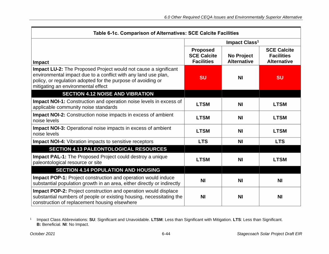
6.0 Other Required CEQA Issues and Environmentally Superior Alternative
1 Impact Class Abbreviations: SU: Significant and Unavoidable. LTSM: Less than Significant with Mitigation. LTS: Less than Significant. B: Beneficial. NI: No Impact.
October 2021 6-44 Stagecoach Solar Project Draft EIR
Table 6-1c. Comparison of Alternatives: SCE Calcite Facilities
Impact Class1
Impact
Proposed SCE Calcite
Facilities No Project Alternative
SCE Calcite Facilities
Alternative
Impact LU-2: The Proposed Project would not cause a significant environmental impact due to a conflict with any land use plan, policy, or regulation adopted for the purpose of avoiding or mitigating an environmental effect
SU NI SU
SECTION 4.12 NOISE AND VIBRATION
Impact NOI-1: Construction and operation noise levels in excess of applicable community noise standards
LTSM NI LTSM
Impact NOI-2: Construction noise impacts in excess of ambient noise levels
LTSM NI LTSM
Impact NOI-3: Operational noise impacts in excess of ambient noise levels
LTSM NI LTSM
Impact NOI-4: Vibration impacts to sensitive receptors LTS NI LTS
SECTION 4.13 PALEONTOLOGICAL RESOURCES
Impact PAL-1: The Proposed Project could destroy a unique paleontological resource or site
LTSM NI LTSM
SECTION 4.14 POPULATION AND HOUSING
Impact POP-1: Project construction and operation would induce substantial population growth in an area, either directly or indirectly
NI NI NI
Impact POP-2: Project construction and operation would displace substantial numbers of people or existing housing, necessitating the construction of replacement housing elsewhere
NI NI NI
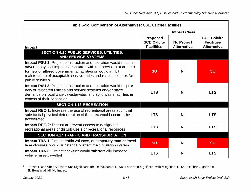
6.0 Other Required CEQA Issues and Environmentally Superior Alternative
1 Impact Class Abbreviations: SU: Significant and Unavoidable. LTSM: Less than Significant with Mitigation. LTS: Less than Significant. B: Beneficial. NI: No Impact.
October 2021 6-45 Stagecoach Solar Project Draft EIR
Table 6-1c. Comparison of Alternatives: SCE Calcite Facilities
Impact Class1
Impact
Proposed SCE Calcite
Facilities No Project Alternative
SCE Calcite Facilities
Alternative
SECTION 4.15 PUBLIC SERVICES, UTILITIES, AND SERVICE SYSTEMS
Impact PSU-1: Project construction and operation would result in adverse physical impacts associated with the provision of or need for new or altered governmental facilities or would inhibit maintenance of acceptable service ratios and response times for public services
SU NI SU
Impact PSU-2: Project construction and operation would require new or relocated utilities and service systems and/or place demands on local water, wastewater, and solid waste facilities in excess of their capacities
LTS NI LTS
SECTION 4.16 RECREATION
Impact REC-1: Increase the use of recreational areas such that substantial physical deterioration of the area would occur or be accelerated
LTS NI LTS
Impact REC-2: Disrupt or prevent access to designated recreational areas or disturb users of recreational resources
LTS NI LTS
SECTION 4.17 TRAFFIC AND TRANSPORTATION
Impact TRA-1: Project traffic volumes, or temporary road or travel lane closures, would substantially affect the circulation system
SU NI SU
Impact TRA-2: Project activities would substantially increase vehicle miles travelled
LTS NI LTS

6.0 Other Required CEQA Issues and Environmentally Superior Alternative
1 Impact Class Abbreviations: SU: Significant and Unavoidable. LTSM: Less than Significant with Mitigation. LTS: Less than Significant. B: Beneficial. NI: No Impact.
October 2021 6-46 Stagecoach Solar Project Draft EIR
Table 6-1c. Comparison of Alternatives: SCE Calcite Facilities
Impact Class1
Impact
Proposed SCE Calcite
Facilities No Project Alternative
SCE Calcite Facilities
Alternative
Impact TRA-3: Project activities or features would substantially increase roadway hazards from roadway damage or incompatible uses
LTSM NI LTSM
Impact TRA-4: Project activities would affect emergency vehicle response
SU NI SU
SECTION 4.18 WILDFIRE
Impact WIL-1: Require the installation or maintenance of infrastructure (such as roads, fuel breaks, emergency water sources, power lines or other utilities) that may exacerbate fire risk or that may result in temporary or ongoing increased wildfire risk
LTSM NI LTSM
Impact WIL-2: Expose people or structures, either directly or indirectly, to a significant risk of loss, injury or death involving wildland fires
LTSM NI LTSM
October 2021 7-1 Stagecoach Solar Project Draft EIR
7.0 MITIGATION MONITORING PROGRAM
As the lead agency under the California Environmental Quality Act (CEQA), the California 1
State Lands Commission (CSLC) is required to adopt a program for reporting or monitoring 2
the implementation of mitigation measures. As lead agency for the Stagecoach Facilities 3
(Proposed Project), the CSLC will also ensure the implementation of the adopted mitigation 4
measures defined in this Environmental Impact Report (EIR). This lead agency responsibility 5
originates in Public Resources Code section 21081.6, subdivision (a) (Findings), and the 6
State CEQA Guidelines41 sections 15091, subdivision (d) (Findings) and 15097 (Mitigation 7
Monitoring or Reporting). 8
7.1 MONITORING AUTHORITY 9
The purpose of a Mitigation Monitoring Program (MMP) is to ensure that measures adopted 10
to mitigate or avoid significant impacts are implemented. A MMP can be a working guide to 11
facilitate the implementation of the mitigation measures and associated monitoring, 12
compliance, and reporting activities. CSLC staff may delegate duties and responsibilities 13
for monitoring to environmental monitors or consultants as deemed necessary, and some 14
monitoring responsibilities may be assumed by responsible agencies, such as affected 15
jurisdictions and cities. The number of construction monitors assigned to the Proposed 16
Project will depend on the number of concurrent construction activities and their locations. 17
CSLC staff will ensure that appropriate agency reviews and approvals are obtained, that 18
each person delegated any duties or responsibilities is qualified to monitor compliance, 19
and that it is aware of and has approved any deviation from the MMP. 20
7.2 ENFORCEMENT RESPONSIBILITY 21
The CSLC, as lead agency, is responsible for enforcing the procedures adopted for 22
monitoring through the environmental monitor. Any assigned environmental monitor shall 23
note problems with monitoring, notify appropriate agencies or individuals about any 24
problems, and report the problems to CSLC staff or its designee. 25
7.3 MITIGATION COMPLIANCE RESPONSIBILITY 26
The CSLC is responsible for successfully implementing all the mitigation measures in the 27
MMP and shall ensure that these requirements are met by all construction contractors and 28
field personnel. Standards for successful mitigation also are implicit in many mitigation 29
measures that include such requirements as obtaining permits or avoiding a specific impact 30
entirely. Other mitigation measures include detailed success criteria. Additional mitigation 31
success thresholds may be established by applicable agencies with jurisdiction through the 32
permit process and through the review and approval of specific plans for the implementation 33
of mitigation measures. 34
41 The “State CEQA Guidelines” refers to California Code of Regulations, Title 14, Chapter 3.

7.0 Mitigation Monitoring Program
October 2021 7-2 Stagecoach Solar Project Draft EIR
7.4 GENERAL MONITORING PROCEDURES 1
7.4.1 Environmental Monitors 2
Many of the monitoring procedures will be conducted prior to or during the construction 3
phase of the Proposed Project. CSLC staff and its environmental monitor(s) are responsible 4
for integrating the mitigation monitoring procedures into the construction process in 5
coordination with the contractor. To oversee the monitoring procedures and to ensure 6
success, the environmental monitor must be on site during that portion of construction that 7
has the potential to create a significant environmental impact or other impact for which 8
mitigation is required. The environmental monitor is responsible for ensuring that all 9
procedures specified in the monitoring program are followed. 10
7.4.2 General Reporting Procedures 11
Site visits and specified monitoring procedures performed by other individuals will be 12
reported to the environmental monitor. A monitoring record form will be submitted to the 13
environmental monitor by the individual conducting the visit or procedure so that details of 14
the visit can be recorded and progress tracked by the environmental monitor. A checklist 15
will be developed and maintained by the environmental monitor to track all procedures 16
required for each mitigation measure and to ensure that the timing specified for the 17
procedures is adhered to. The environmental monitor will note any problems that may 18
occur and take appropriate action to rectify the problems. 19
7.4.3 Public Access to Records 20
The public is allowed access to records and reports used to track the monitoring program. 21
Monitoring records and reports will be made available for public inspection by the CSLC or 22
its designee on request. 23
7.5 MITIGATION MONITORING PLAN 24
This section presents the mitigation measures for each environmental discipline that 25
requires mitigation measures. Impacts that do not require mitigation are not included (see 26
Executive Summary Tables ES-2a, ES-2b, and ES-2c for a summary description of all 27
Proposed Project impacts). The following information is presented for each mitigation 28
measure: 29
• Impact (impact number and title) 30
• Mitigation Measure (full text of the measure) 31
• Location (where the impact occurs and the mitigation measure should be applied). 32
The following location abbreviations are used in the Mitigation Monitoring Plan: 33
o SSGP: Stagecoach Solar Generation Plant 34
o SGTL: Stagecoach Gen-tie Line 35
o SCF: SCE Calcite Facilities 36

7.0 Mitigation Monitoring Program
October 2021 7-3 Stagecoach Solar Project Draft EIR
• Monitoring/reporting action (the action to be taken by the monitor or lead agency) 1
• Effectiveness criteria (how the agency can know if the measure is effective) 2
• Responsible Party 3
• Timing (before, during, or after construction; during operation, etc.) 4
AESTHETICS/LIGHT AND GLARE 5
Impact ALG-5: Creation of new sources of substantial light or glare such as 6
nighttime illumination 7
MM ALG-5: Minimize Night Lighting at Project Facilities. The Applicant shall avoid 8
night lighting where possible and minimize its use under all circumstances. To ensure this, 9
the Applicant shall implement the following requirements for both construction and 10
operation: 11
• Illumination of the Project and its immediate vicinity shall be minimized 12
• Lamps and reflectors are to be fully shielded with sufficient cutoff angles such that 13
they are not visible from beyond the construction site or facility including any off-site 14
security buffer areas 15
• Lighting shall emphasize the use of low-pressure sodium (LPS) or amber light-16
emitting diode (LED) lighting 17
• Lighting shall not cause excessive reflected glare and shall not illuminate the 18
nighttime sky, except for required Federal Aviation Administration (FAA) aircraft 19
safety lighting (which, if required, shall be an on-demand, audio-visual warning 20
system that is triggered by radar technology) 21
• Creation of sky glow caused by project lighting shall be avoided 22
• All permanent light sources shall be below 3,500 Kelvin color temperature (warm 23
white) and shall be full cutoff fixtures 24
• All security lighting is to be motion activated only through the use of passive infrared 25
sensors and controlled as specific zones such that only targeted areas are illuminated 26
Location: SSGP, SGTL, and SCF 27
Monitoring/Reporting Action: Implement night lighting requirements 28
Effectiveness Criteria: Reduce impacts of night lighting visual effects 29
Responsible Party: Applicant and/or contractor 30
Timing: During construction and operation 31

7.0 Mitigation Monitoring Program
October 2021 7-4 Stagecoach Solar Project Draft EIR
Impact ALG-6: Long-term presence of the Project would result in landscape 1
changes that degrade existing visual character or quality 2
MM ALG-6: Surface Treatment and Design of Project Structures and Buildings. To 3
the extent commercially feasible, the Applicant shall treat the surfaces of all non-temporary 4
large Project structures and buildings visible to the public and all gen-tie structures such 5
that: (a) their colors minimize visual intrusion and contrast by blending with (matching) the 6
existing characteristic landscape colors; (b) their colors and finishes do not create 7
excessive glare; and (c) their colors and finishes are consistent with local policies and 8
ordinances. Gen-tie Line conductors shall be non-specular and non-reflective, and the 9
insulators shall be non-reflective and non-refractive. The Applicant shall implement the 10
following requirements: 11
• Carefully consider the selection of color(s) and finishes based on the characteristic 12
landscape. Colors will be field tested using the actual distances from the KOPs to the 13
proposed structures, using the proposed colors painted on representative surfaces. 14
• Color treatment shall be applied to all major Project structures and buildings; the gen-15
tie line towers and/or poles; and walls or fencing 16
• Develop a procedure to ensure proper color treatment maintenance for the life of the 17
Project 18
• Minimize the number of structures and combine different activities in one structure, 19
where possible. Use natural, self-weathering materials and chemical treatments on 20
surfaces to reduce color contrast. Bury all or part of structures to the extent practical. 21
Use natural appearing forms to complement the characteristic landscape. Screen the 22
structure from view by using natural landforms and vegetation. Reduce the line 23
contrast created by straight edges. 24
Location: SSGP, SGTL, and SCF 25
Monitoring/Reporting Action: Implement surface treatment requirements 26
Effectiveness Criteria: Reduce impacts of visual intrusion and glare, and increase 27
consistency with local policies 28
Responsible Party: Applicant and/or contractor 29
Timing: During construction 30
AIR QUALITY 31
Impact AQ-1: Air pollutant emissions from construction and O&M 32
MM AQ-1a: Fugitive Dust Control. Prior to the issuance of grading permits, the Applicant 33
shall submit a Dust Control Plan to the Mojave Desert Air Quality Management District 34
(MDAQMD), the County, and the CSLC for review and approval. The plan shall describe 35
the fugitive dust control measures which would be implemented and monitored at all 36
7.0 Mitigation Monitoring Program
October 2021 7-5 Stagecoach Solar Project Draft EIR
locations of proposed project construction. The plan shall comply with the mitigation 1
measures described in the Fugitive Dust Control Rules enforced by the MDAQMD (Rule 2
403), San Bernardino County Development Code sections 83.01.040 and 84.29.035, as 3
well as the existing State Implementation Plan available for PM10 and PM2.5. The plan 4
shall be incorporated into all contracts and contract specifications for construction work 5
and operation of onsite activities. The plan shall outline the steps to be taken to minimize 6
fugitive dust generated by construction and operation of onsite activities by: 7
• Describing each active operation that may result in the generation of fugitive dust. 8
• Identifying all sources of fugitive dust, e.g., earthmoving, storage piles, vehicular 9
traffic. 10
• Describing the control measures to be applied to each of the sources identified. The 11
descriptions shall be sufficiently detailed to demonstrate that the best available 12
control measures required by air districts for solar projects are used. 13
• Providing the following control measures, in addition to or as listed in the applicable 14
rules, but not limited to: 15
o Manage and limit disturbance of ground surfaces from vehicle traffic, excavation, 16
grading, vegetation removal, or other activities to lower the potential for soil 17
detachment and reduce dust transport. Maximize the use of compaction methods 18
rather than the removal of topsoil other than in areas where excavation or grading 19
are required. This process referred to as mow-and-roll (agricultural land) or 20
plate-and-roll (native vegetation) lessens the level of ground disturbance and 21
leaves the root system in place for quicker regeneration of vegetative cover. 22
o Watering will occur at a minimum of three times daily on disturbed soil areas 23
with active operations, including maintenance and access vehicular roads and 24
parking areas, unless dust is otherwise controlled by rainfall or use of a chemical 25
dust palliative, gravel, asphaltic pavement, or other approved dust control 26
measure sufficient to minimize visible fugitive dust from vehicular travel and wind 27
erosion and comply with MDAQMD Rule 403. Actions, including sweeping 28
sealed roads, use of stabilized construction/facility entrances, and, if needed, 29
using one or more entrance/exit vehicle tire wash apparatuses, shall be taken to 30
prevent project-related track-out. Any project-related track-out must be cleaned 31
within 24 hours. 32
o Water conservation may be achieved by using a non-toxic chemical dust 33
palliative or soil weighting agent. Non-water-based soil stabilizers shall be as 34
efficient as or more efficient for fugitive dust control than Air Resources Board 35
(ARB)-approved soil stabilizers and shall not increase any other environmental 36
impacts, including loss of vegetation, adverse odors, or emissions of ozone 37
precursor reactive organic gases (ROG) or volatile organic compounds (VOC). 38
7.0 Mitigation Monitoring Program
October 2021 7-6 Stagecoach Solar Project Draft EIR
o Use natural vegetation to stabilize disturbed or otherwise unstable surfaces to 1
the extent feasible. 2
o All clearing, grading, earth moving, and excavation activities will cease during 3
period of winds greater than 20 miles per hour (averaged over one hour), or 4
when dust plumes of 20 percent or greater opacity impact public roads, occupied 5
structures, or neighboring property, and in conformance with MDAQMD 6
regulations. 7
o An adequate wind barrier shall be provided where the boundary of a new 8
commercial solar energy generation facility will be located within one-quarter 9
mile of a primary residential structure, to reduce potentially blowing dust in the 10
direction of the residence during construction and ongoing operation of the 11
commercial solar energy generation facility. 12
o A water truck shall be used to maintain most disturbed surfaces and to actively 13
spread water during visible dust episodes to minimize visible fugitive dust and 14
limit emissions to 20 percent opacity in areas where grading occurs, within the 15
staging areas, and on any unpaved roads. For projects with exposed sand or 16
fines deposits (and for projects that expose such soils through earthmoving), 17
chemical stabilization or covering with a stabilizing layer of gravel may be 18
required to eliminate visible dust/sand from sand/fines deposit, if water 19
application does not achieve stabilization. Other controls could include 20
application of hydromulch (with seed for re-establishment of vegetation), 21
application of soil binders, or the use of soil cement for particularly unstable 22
areas. 23
o Minimize the idling time of diesel-powered construction equipment to 5 minutes, 24
except in extreme heat events where workers require conditioned air to avoid 25
health and safety issues. 26
o All trucks and equipment, including their tires, shall be washed off prior to 27
leaving the site. 28
o On-site vehicle speed shall be limited to 15 miles per hour. 29
o The following signage shall be erected not later than the commencement of 30
construction: 31
o A minimum 48-inch-high by 96-inch-wide sign containing the following 32
information shall be located within 50 feet of each project site entrance, meeting 33
the specified minimum text height, black text on white background, on 1-inch 34
A/C laminated plywood board, with the lower edge between 6 and 7 feet above 35
grade, with the contact name of a responsible official for the site and a local or 36
toll-free number that is accessible 24 hours per day. 37
7.0 Mitigation Monitoring Program
October 2021 7-7 Stagecoach Solar Project Draft EIR
“Site Name” (4-inch text) 1
“Project Name/Project Number” (4-inch text) 2
IF YOU SEE DUST COMING FROM THIS PROJECT, CALL: (4-inch text) 3
[Contact Name]. PHONE NUMBER: XXX-XXX-XXXX (6-inch text) 4
IF YOU DO NOT RECEIVE A RESPONSE, PLEASE CALL the MDAQMD at 5
1-800-635-4617. (3-inch text) 6
• The Applicant or its designated representative shall obtain prior approval from the 7
MDAQMD prior to any deviations from fugitive dust control measures specified in the 8
approved Air Quality Construction Management Plan. A justification statement used 9
to explain the technical and safety reason(s) for the substitute dust control measures 10
required shall be submitted to the appropriate agency for review. 11
• The provisions of the Fugitive Dust Control Plan shall also apply to project 12
decommissioning activities. 13
Location: SSGP, SGTL, and SCF 14
Monitoring/Reporting Action: Prepare Dust Control Plan for the Mojave Desert Air 15
Quality Management District, the County, and the CSLC for review and approval 16
Effectiveness Criteria: Minimize fugitive dust and reduce impacts associated with air 17
quality 18
Responsible Party: Applicant and/or contractor 19
Timing: Prior to and during construction, O&M, and decommissioning 20
MM AQ-1b: Control On-Site Off-Road Equipment Emissions. The Applicant, when 21
entering into construction contracts or when procuring off-road equipment or vehicles for 22
on-site construction or O&M activities, shall ensure that only new model year equipment or 23
vehicles are obtained. The following measures would be included with contract or 24
procurement specifications: 25
• All construction diesel engines not registered under California Air Resources Board’s 26
Statewide Portable Equipment Registration Program, with a rating of 50 hp or higher 27
shall meet the Tier 4 California Emission Standards for Off-Road Compression-28
Ignition Engines, as specified in California Code of Regulations, title 13, section 2423, 29
subdivision (b)(1), unless a good faith effort demonstrates that such engine is not 30
available for a particular item of equipment. In the event that a Tier 4 engine is not 31
available for any off-road equipment larger than 50 hp, a Tier 3 engine shall be used 32
or that equipment shall be equipped with retrofit controls to reduce exhaust emissions 33
of nitrogen oxides (NOx) and diesel particulate matter (DPM) to no more than Tier 3 34
levels unless certified by the engine manufacturers that the use of such devices is not 35
practical for specific engine types. 36
• All diesel-fueled engines used in the construction of the facility shall have clearly 37
visible tags showing that the engine meets the standards of this measure. 38

7.0 Mitigation Monitoring Program
October 2021 7-8 Stagecoach Solar Project Draft EIR
• All equipment and trucks used in the construction or O&M of the facility shall be 1
properly maintained and the engines tuned to the engine manufacturer’s 2
specifications. 3
• All diesel heavy construction equipment shall not idle for more than 5 minutes. 4
Vehicles that need to idle as part of their normal operation (such as concrete trucks) 5
are exempted from this requirement. 6
Location: SSGP, SGTL, and SCF 7
Monitoring/Reporting Action: Compliance 8
Effectiveness Criteria: Minimize impacts associated with air quality 9
Responsible Party: Applicant and/or contractor 10
Timing: During construction, O&M, and decommissioning 11
BIOLOGICAL RESOURCES 12
Impact BIO-1: Substantially reduce habitat for a fish or wildlife species 13
MM BIO-1a: Implement Biological Monitoring. Monitoring to ensure conformance with 14
conditions of approval, including effective protection and avoidance of biological resources, 15
shall be implemented by the Applicant (Aurora Solar LLC for the Solar Generation Plant 16
and Stagecoach Gen-tie Line and Southern California Edison (SCE) for the Calcite 17
Facilities) as follows: 18
Biological Monitoring Team. During construction and decommissioning the Applicant shall 19
employ or contract with a biological monitoring team to oversee project activities. Any 20
activity that may impact vegetation, wildlife, and sensitive resources will be monitored to 21
ensure compliance with all mitigation measures for biological resources. The biological 22
monitoring team will consist of: 23
• Lead Biologist: The Applicant shall assign a Lead Biologist, approved by the 24
California State Lands Commission (CSLC), as the primary point of contact for the 25
CSLC and resource agencies regarding biological resources mitigation and 26
compliance. The Lead Biologist will be under contract to the Applicant and will serve 27
as principal point of contact to the CSLC regarding implementation and compliance 28
with biological resources measures throughout construction, O&M, and 29
decommissioning. 30
• Biological Monitor: Biological monitors will be overseen by the Lead Biologist and 31
will perform any required surveys, ground disturbance and construction monitoring, 32
wildlife monitoring, inspections, marking sensitive resource buffers, and revegetation 33
monitoring during project activities. Biological monitors will include trained desert 34
tortoise monitors (MM BIO-3c), nest monitors (MM BIO-3f) and other specialists as 35
appropriate to any given measure. 36
7.0 Mitigation Monitoring Program
October 2021 7-9 Stagecoach Solar Project Draft EIR
• Authorized Desert Tortoise Biologist: For desert tortoise protection measures (MM 1
BIO-3c), Avangrid will nominate one or more qualified individuals to serve as 2
Authorized Desert Tortoise Biologist for the solar plant and gen-tie line, for approval 3
by the U.S. Fish and Wildlife Service (USFWS) 4
The Applicant shall provide the resumes of each member of the proposed Biological 5
Monitoring Team to the CSLC for approval prior to onset of ground-disturbing activities. 6
Each member of The Biological Monitoring Team will have demonstrated expertise with 7
the biological resources within the project region. Each member of the Biological 8
Monitoring Team will have authority to halt any activities in any area if it is determined that 9
the activity, if continued, would cause an unauthorized adverse impact to biological 10
resources. 11
The duties of the Biological Monitoring Team will vary during the construction, O&M, and 12
decommissioning phases, based on the biological monitoring tasks needed for compliance 13
during each phase. The Biological Monitoring Team will be used mostly during 14
construction; however, some intermittent inspections or monitoring may be needed during 15
O&M and decommissioning. Biological monitoring during O&M will not necessitate a full 16
team, but the Applicant will ensure all required biological monitoring and reporting (e.g., 17
revegetation and avian mortality monitoring) are completed as specified in MMs below. 18
During O&M, an Applicant staff member serving as compliance manager may perform the 19
administrative duties of the Lead Biologist, by overseeing qualified Biological Monitors, to 20
ensure compliance with biological mitigation measures, such as overseeing inspections for 21
entrapped wildlife and fence condition, reporting dead or injured wildlife, and avoiding 22
nesting birds. Qualifications for monitors during O&M and lead agency review of resumes 23
will be as described above. 24
In general, the duties of the Lead Biologist will include, but will not be limited to: 25
• Regular, direct communication with representatives of the CSLC, and other agencies, 26
as appropriate. The Lead Biologist (or, the Applicant’s compliance manager during 27
O&M) shall immediately notify the CSLC and applicable resource agencies in writing 28
of dead or injured special-status species, or of any non-compliance with biological 29
mitigation measures or permit conditions. 30
• Train and supervise Biological Monitors, including desert tortoise monitors, nest 31
monitors, and construction monitors 32
• Conduct or oversee Worker Environmental Awareness Program (WEAP) training 33
(MM BIO-1b) 34
• During construction and decommissioning, clearly mark and inspect sensitive 35
biological resource areas in compliance with regulatory terms and conditions 36

7.0 Mitigation Monitoring Program
October 2021 7-10 Stagecoach Solar Project Draft EIR
• Oversee wildlife clearance surveys, monitoring of ground disturbance and grading, 1
and other biological monitoring requirements. Ensure that all biological monitoring is 2
completed properly and on schedule. 3
• Conduct or oversee bi-weekly compliance inspections during ground disturbing 4
activities and communicate any remedial actions needed (i.e., trash, fence, weed 5
maintenance; wildlife mortality) to maintain compliance with mitigation measures 6
Reporting. The Lead Biologist (or the Applicant’s compliance manager during O&M) shall 7
report regularly to the CSLC to document the status of compliance with biological 8
mitigation measures. 9
During construction and decommissioning: 10
• Provide weekly verbal or written updates to the CSLC with any information pertinent 11
to the CSLC, to resource agencies, or to state or federal permits for biological 12
resources 13
• Prepare and submit monthly and annual compliance reports to include a summary of 14
project activities that occurred, biological resources surveys and monitoring that were 15
performed, any sensitive or noteworthy species observed, weed infestations 16
removed, and non-compliance issues and remedial actions that were implemented 17
During O&M: 18
• Conduct quarterly compliance inspections and reporting, to be submitted to the 19
CSLC, to document the condition of exclusion fencing, wildlife mortality, and any 20
biological resource issues of note 21
Location: SSGP, SGTL, and SCF 22
Monitoring/Reporting Action: Monitoring to ensure effective protection and 23
avoidance of biological resources. 24
Effectiveness Criteria: Reduce impacts to wildlife and special-status species 25
Responsible Party: Applicant and/or contractor 26
Timing: During construction, O&M, and decommissioning phases. 27
MM BIO-1b: Implement Worker Environmental Awareness Training. To ensure worker 28
understanding and conformance with conditions of approval, including effective protection 29
and avoidance of biological resources, the Lead Biologist shall prepare and implement a 30
Worker Environmental Awareness Program (WEAP) during construction, O&M, and 31
decommissioning. The Applicant shall be responsible for ensuring that all workers at the 32
site receive WEAP training prior to beginning work on the project and throughout 33
construction and operations. The WEAP shall be available in English and Spanish. The 34
Applicant shall submit the WEAP to the CSLC for approval prior to implementation. The 35
WEAP shall: 36

7.0 Mitigation Monitoring Program
October 2021 7-11 Stagecoach Solar Project Draft EIR
• Be developed by or in consultation with the Lead Biologist and consist of an on-site or 1
training center presentation with supporting written material and electronic media, 2
including photographs of protected species, available to all participants 3
• Provide an explanation of the function of flagging that designates authorized work 4
areas; specify the prohibition of soil disturbance or vehicle travel outside designated 5
areas 6
• Discuss general safety protocols such as vehicle speed limits, hazardous substance 7
spill prevention and containment measures, and fire prevention and protection 8
measures 9
• Review mitigation and biological permit requirements 10
• Explain the sensitivity of the vegetation and habitat within and adjacent to work areas, 11
and proper identification of these resources 12
• Discuss the federal and state Endangered Species Acts, Bald and Golden Eagle 13
Protection Act, and the Migratory Bird Treaty Act and the consequences of non-14
compliance with these acts 15
• Discuss the locations and types of sensitive biological resources on the project site 16
and adjacent areas and explain the reasons for protecting these resources 17
• Inform participants that no snakes, other reptiles, birds, bats, or any other wildlife will 18
be harmed or harassed 19
• Place special emphasis on species that may occur on the project site and/or gen-tie 20
lines, including special-status plants, desert tortoise, burrowing owl, golden eagle, 21
nesting birds, desert kit fox, American badger, and burro deer 22
• Specify guidelines for avoiding rattlesnakes and reporting rattlesnake observations to 23
ensure worker safety and avoid killing or injuring rattlesnakes. Wherever feasible, 24
rattlesnakes must be safely removed from the work area using appropriate snake 25
handling equipment, including a secure storage container for transport. 26
• Describe workers’ responsibilities for avoiding the introduction of invasive weeds onto 27
the project site and surrounding areas, describe the Integrated Weed Management 28
Plan 29
• Provide contact information for the Lead Biologist and instructions for notification of 30
any vehicle-wildlife collisions or dead or injured wildlife species encountered during 31
project-related activities. 32
• Include a training acknowledgment form to be signed by each worker indicating that 33
they received training and will abide by the guidelines. 34
• Desert Tortoise Education Requirements: Prior to the start of construction activities, a 35
desert tortoise education program shall be presented by the Lead Biologist to all 36
personnel who will be present on Project work areas. Following the start of 37

7.0 Mitigation Monitoring Program
October 2021 7-12 Stagecoach Solar Project Draft EIR
construction, any new employee shall be required to complete the tortoise education 1
program prior to working on-site. At a minimum, the tortoise education program shall 2
cover the following topics: 3
o A detailed description of the desert tortoise, including color photographs 4
o The distribution and general behavior of the desert tortoise 5
o Sensitivity of the species to human activities 6
o The protection the desert tortoise receives under the state and federal 7
Endangered Species Acts, including prohibitions and penalties incurred for 8
violation 9
o The protective measures being implemented to conserve the desert tortoise 10
during construction activities 11
o Procedures and a point of contact if a desert tortoise is observed on-site 12
Location: SSGP, SGTL, and SCF 13
Monitoring/Reporting Action: Provide WEAP to CSLC staff for review and approval 14
and evidence of training attendance 15
Effectiveness Criteria: Reduce impacts to wildlife and special-status species 16
Responsible Party: Applicant and/or contractor 17
Timing: During construction, O&M, and decommissioning phases. 18
MM BIO-1c: Minimize Impact and Protect Identified Vegetation and Habitat. Prior to 19
ground-disturbing activities during construction, O&M, or decommissioning, authorized 20
work areas shall be clearly delineated. These areas shall include, but are not limited to, 21
staging areas, access roads, and sites for temporary placement of construction materials 22
and spoils. Delineation may be implemented with common orange vinyl “fencing” or 23
staking to clearly identify the limits of work and shall be verified by the Lead Biologist. No 24
paint or permanent discoloring agents shall be applied to rocks or vegetation (to indicate 25
surveyor construction activity limits or for any other purpose). Fencing/staking shall remain 26
in place for the duration of the ground-disturbing activity and while construction vehicles 27
are driving on-site. Spoils shall be stockpiled in disturbed areas. All disturbances, vehicles, 28
and equipment shall be confined to the fenced/flagged areas. 29
Low-Impact Site Preparation. Native vegetation will be allowed to recover from rootstocks 30
and seed bank wherever facilities do not require permanent vegetation removal (e.g., 31
access roads, foundations, paved areas, or fire clearance requirements) within the 32
perimeter fenceline of the solar plant and under solar arrays. Vegetation height and density 33
will be managed as needed for O&M and fire safety, but vegetation management will 34
otherwise focus on maintaining habitat and soil conditions. 35
Upon completion of construction, O&M, or decommissioning activities in any given area, all 36
unused materials, equipment, staking and flagging, and refuse shall be removed and 37

7.0 Mitigation Monitoring Program
October 2021 7-13 Stagecoach Solar Project Draft EIR
properly disposed of, including wrapping material, cables, cords, wire, boxes, rope, broken 1
equipment parts, twine, strapping, buckets, and metal or plastic containers. Any unused or 2
leftover hazardous products shall be properly disposed of off-site. 3
Location: SSGP, SGTL, and SCF 4
Monitoring/Reporting Action: Delineation of work areas to prevent disturbance of 5
wildlife habitat 6
Effectiveness Criteria: Reduce impacts to soils, vegetation, and root systems to 7
protect wildlife habitat 8
Responsible Party: Applicant and/or contractor 9
Timing: Prior to and during construction, O&M, and decommissioning 10
MM BIO-1d: Weed Management. The Applicant shall prepare and implement an 11
Integrated Weed Management Plan (IWMP) to minimize or prevent invasive weeds from 12
infesting the site or spreading into surrounding habitat during construction, O&M, and 13
decommissioning. The plan must be submitted to the CSLC staff for review and approval a 14
minimum of 60 days prior to the start of construction activities. The IWMP shall identify 15
weed species occurring or potentially occurring in the project area, means to prevent their 16
introduction or spread (e.g., vehicle cleaning and inspections), monitoring methods to 17
identify infestations, and herbicides or manual methods that may be used for control or 18
eradication. Herbicide use shall be avoided in Environmentally Sensitive Areas (ESAs). 19
The IWMP shall also require monthly and annual reporting during construction and 20
decommissioning, which shall identify weeds found, the control mechanisms used, and the 21
success of the effort. For additional details on reporting, see MM BIO-1a. The Lead 22
Biologist shall oversee timely implementation of the IWMP and manual or chemical 23
removal measures to control or eradicate invasive weeds. 24
Location: SSGP, SGTL, and SCF 25
Monitoring/Reporting Action: Prepare Integrated Weed Management Plan, and 26
submit to the CSLC staff for review and approval. 27
Effectiveness Criteria: Minimize non-native infestations in wildlife habitat. 28
Responsible Party: Applicant and/or contractor 29
Timing: Prior to construction, O&M, and decommissioning phases. 30
MM BIO-1e: Revegetation. The Applicant shall prepare and implement a Revegetation 31
Plan, to be submitted to the CSLC staff for review and approval a minimum of 60 days 32
prior to the start of construction activities. The Plan shall be implemented in areas 33
temporarily impacted during construction and operation. Any additional acreage disturbed 34
during O&M or decommissioning will also be subject to revegetation according to the terms 35
of the Revegetation Plan. The Lead Biologist shall oversee implementation of the 36
Revegetation Plan to meet success criteria and prevent further degradation of areas 37
temporarily disturbed by project activities. Pre-disturbance habitat values would not be 38
restored, but off-site compensation would offset the loss in habitat value. 39

7.0 Mitigation Monitoring Program
October 2021 7-14 Stagecoach Solar Project Draft EIR
The Revegetation Plan shall detail the methods to implement the following 1
restoration/revegetation requirements. 2
• Revegetation of temporarily impacted sites. Upon completion of construction, 3
areas that are temporarily impacted during construction will be revegetated with 4
native desert species. The Revegetation Plan shall specify methods to prevent or 5
minimize further site degradation; stabilize soils; maximize the likelihood of vegetation 6
recovery over time (for areas supporting native vegetation); and minimize soil 7
erosion, dust generation, and weed invasions. The nature of revegetation shall differ 8
according to each disturbed area, its pre-disturbance condition, and the nature of the 9
construction disturbance. The Revegetation Plan shall include: (a) soil preparation 10
measures, including locations and methods of recontouring, decompacting, 11
imprinting, or other treatments; (b) details for topsoil storage, as applicable; (c) plant 12
material collection and acquisition guidelines, including guidelines for salvaging, 13
storing, and handling plants from the project site, as well as obtaining replacement 14
plants from outside the project area (plant materials shall be limited to locally 15
occurring native species from local sources); (d) a plan drawing or schematic 16
depicting the temporary disturbance areas (drawing of “typical” gen-tie structure sites 17
will be appropriate); (e) time of year that the planting or seeding will occur and the 18
methodology of the planting; (f) a description of the irrigation, if used; (g) success 19
criteria; and (h) a monitoring program to measure the success criteria, commensurate 20
with the Plan’s goals, (i) contingency measures for failed revegetation efforts not 21
meeting success criteria. 22
Location: SSGP, SGTL, and SCF 23
Monitoring/Reporting Action: Provide Revegetation Plan to CSLC staff for review 24
and approval 25
Effectiveness Criteria: Reduce impacts to wildlife and special-status species 26
Responsible Party: Applicant and/or contractor 27
Timing: Prior to, and during construction, O&M, and decommissioning activities 28
MM BIO-1f: Protect Important Plants. Due to the Joshua tree’s California Endangered 29
Species Act (CESA) status as a candidate for listing, and the Beaver Indian breadroot 30
(CRPR 1B) occurrence within the proposed Calcite Facilities area, the Applicant will 31
reduce Project effects on Joshua tree and Beaver Indian breadroot impacts through one or 32
a combination of the following strategies. If the California Fish and Game Commission 33
determines that Joshua tree listing is not warranted and the western Joshua tree is neither 34
a candidate for listing nor elevated to California Rare Plant Rank (CRPR) 1B status prior to 35
the start of solar field construction, then Joshua tree impacts would be mitigated through 36
habitat compensation (MM BIO-1g: Compensate for Loss of Natural Habitat) and the 37
following measures would not be required. 38
• Avoidance. Where Joshua trees or Beaver Indian breadroot exist within the project 39
fenceline but are not within the disturbance footprint of the solar arrays or support 40

7.0 Mitigation Monitoring Program
October 2021 7-15 Stagecoach Solar Project Draft EIR
facilities, project site preparation and construction shall minimize impacts by 1
minimizing or avoiding soil compaction within a radius of 10 feet (3 meters) 2
surrounding each plant. 3
• Salvage of Joshua Tree and Beaver Indian breadroot. The Applicant shall consult 4
with a qualified horticulture specialist regarding the success of salvage efforts for 5
these species. If the strategy has been shown to be feasible and certain Joshua trees 6
and/or breadroot have been judged suitable for relocation, the Applicant shall prepare 7
and implement a Salvage and Relocation Plan (SRP) for Joshua Tree or Beaver 8
Indian breadroot (as applicable based on presence of these plants), to be submitted 9
to CSLC staff for review and approval at least 60 days prior to disturbance of any 10
occupied habitat. The Applicant shall contract with a qualified entity with experience 11
and qualifications, to salvage the Joshua trees or Beaver Indian breadroot judged 12
suitable for relocation, and transfer them to a suitable location outside the project 13
footprint. The Lead Biologist shall oversee implementation of the SRP. The SRP shall 14
include methods to salvage and replant Joshua tree and breadroot specimens found 15
on the site; define the season for salvaging the plants; specify methods for salvage, 16
storage, and re-planting them; define locations for re-planting; and state appropriate 17
monitoring and success criteria for the salvage work. Planting sites shall be selected 18
in coordination with the CSLC and California Department of Fish and Wildlife (CDFW) 19
to ensure avoidance of excessive disturbance to existing habitat. For Joshua trees, 20
planting sites will be prioritized as follows: 21
1. Temporary disturbance areas within the project site scheduled for revegetation 22
or restoration 23
2. Previously disturbed areas within suitable habitat on off-site public lands 24
3. Previously disturbed areas within suitable habitat on off-site private lands 25
4. Landscaping sites on public lands (e.g., public parks) 26
5. Landscaping areas on private lands 27
• Horticultural Propagation and Off-site Introduction. If the CSLC, in coordination 28
with CDFW and the Applicant, agree that salvage and relocation is not feasible for 29
Joshua trees or Beaver Indian breadroot, then the Applicant shall consult with a 30
qualified entity, to develop and implement an appropriate experimental propagation 31
and relocation strategy. 32
Location: SSGP, SGTL, and SCF 33
Monitoring/Reporting Action: Avoidance, Salvage of Joshua Tree and Beaver Indian 34
breadroot, and Horticultural Propagation and Off-site Introduction. 35
Effectiveness Criteria: Reduce impacts to important plants 36
Responsible Party: Applicant and/or contractor 37
Timing: Prior to and during construction 38

7.0 Mitigation Monitoring Program
October 2021 7-16 Stagecoach Solar Project Draft EIR
MM BIO-1g: Compensate for Loss of Natural Habitat. The Applicant shall acquire and 1
protect, in perpetuity, compensation habitat to offset loss of natural habitat. Habitat 2
acquisition and protection may be conducted through a CDFW approved mitigation bank or 3
another approved third party, or may be carried out by the Applicant itself. The preliminary 4
acreages are presented in Table 4.3-1, but final acreages shall be based upon final 5
calculation of impacted acreage for the approved project design. Acreages will be adjusted 6
as appropriate for the approved alternative and for design modifications made after 7
approval. 8
Compensation shall be provided for impacts to the following resources, at the specified 9
ratios (acres acquired and preserved to acres impacted): 10
• Desert tortoise habitat. Suitable desert tortoise habitat is found throughout the 11
proposed solar facility site, gen-tie route, and SCE Calcite Facilities area. 12
Compensation for loss of this habitat shall be at a 1:1 ratio (i.e., one acre of 13
compensation habitat of comparable quality for each acre of permanent or temporary 14
disturbance). 15
• Joshua tree woodland and Indian breadroot habitat. Compensation shall be at a 16
1.5:1 ratio (i.e., 1.5 acres of occupied compensation habitat for each acre of impacted 17
occupied habitat), and based on the acreage of occupied Joshua trees or Indian 18
breadroot habitat lost in Project construction. Occupied habitat will be defined either 19
according to the definition used by the CDFW Incidental Take Permit (ITP) or, if there 20
is no ITP, as a 200-foot radius surrounding all Joshua trees or Indian breadroot 21
plants. Compensation habitat must support the target species in densities 22
comparable to the habitat lost during construction. If compensation habitat with 23
comparable densities of the target plants is not available, greater acreage will be 24
required so that sufficient habitat shall be acquired to protect 1.5 Joshua trees or 25
Indian breadroots for each individual removed for construction. Any compensation 26
habitat for these plants that is also suitable habitat for desert tortoise will be credited 27
toward the overall desert tortoise habitat compensation requirement. 28
If any additional acreage of desert tortoise habitat or Joshua tree woodland is disturbed 29
during O&M or decommissioning, that disturbance will also be compensated at the same 30
ratios unless those resources are no longer considered sensitive at that time. 31
Criteria for the acquisition, initial protection and habitat improvement, and long-term 32
maintenance and management of compensation lands shall include all the following: 33
Provide habitat value that is comparable to the habitat impacted, taking into consideration 34
soils, vegetation, topography, human-related disturbance, invasive species, wildlife 35
movement opportunity, proximity to other protected lands, management feasibility, and 36
other habitat values. Mitigation may be “nested” or “layered,” to the extent that it meets 37
habitat requirements for multiple species that will or may be impacted by the Project. 38
7.0 Mitigation Monitoring Program
October 2021 7-17 Stagecoach Solar Project Draft EIR
The Applicant shall provide funding or bonding for the acquisition in fee title or in easement, 1
initial habitat improvements and long-term maintenance and management of the 2
compensation lands prior to construction activities on native habitat. Within 18 months of 3
completing construction, the Applicant or an approved third party shall prepare a 4
compensation plan, identifying the proposed mitigation bank or compensation lands, and 5
specifying the land ownership, conservation easement terms, long-term management, and 6
responsibility for funding or endowment. The compensation plan shall be submitted for 7
review and approval to the CSLC. The CSLC shall consult with CDFW and USFWS to 8
ensure that the mitigation will support any permits and authorizations to be issued by either 9
agency. 10
Location: SSGP, SGTL, and SCF 11
Monitoring/Reporting Action: Acquire compensation habitat, and compensation plan 12
submitted for review and approval to the CSLC. 13
Effectiveness Criteria: Offset permanent and long-term impacts to desert tortoise and 14
Joshua tree habitat 15
Responsible Party: CDFW approved mitigation bank, or Applicant 16
Timing: Prior to and during construction 17
Impact BIO-3: Substantially affect state fully protected wildlife species, state or 18
federally listed threatened or endangered wildlife, California 19
Species of Special Concern, or state ranked S1, S2, or S3 special-20
status wildlife by causing take or degrading occupied habitat or 21
designated critical habitat, or substantially reduce the number or 22
restrict the range of a listed species or cause the local population to 23
drop below self-sustaining levels 24
MM BIO-3a: Protect Wildlife Resources. The Applicant shall undertake the following 25
measures to avoid or minimize impacts to wildlife during construction, O&M, and 26
decommissioning. The Lead Biologist shall oversee implementation of all measures, which 27
are subject to review and approval by the CSLC. 28
• Wildlife avoidance. Project activities shall minimize interference with wildlife (include 29
ground-dwelling species, birds, bats) by allowing animals to escape from a work site 30
prior to disturbance; conducting pre-construction surveys and exclusion measures for 31
certain species as specified in other measures. 32
• Avoid use of toxic substances. Soil bonding and weighting agents used for dust 33
suppression on unpaved surfaces shall be non-toxic to wildlife and plants. 34
• Water. Potable and non-potable water sources such as tanks, ponds, and pipes shall 35
be covered or otherwise secured to prevent animals (including birds) from entering. 36
Prevention methods may include storing water within closed tanks or covering open 37
tanks with 2 centimeter netting, unless local fire policy states otherwise. Dust 38
abatement shall use the minimum amount of water on dirt roads and construction 39

7.0 Mitigation Monitoring Program
October 2021 7-18 Stagecoach Solar Project Draft EIR
areas to meet safety and air quality standards. Water sources (e.g., hydrants, tanks, 1
etc.) shall be managed to prevent puddles or ponding and periodic inspection should 2
occur by biological monitors. 3
• Trash. All trash and food-related waste shall be contained in vehicles or covered 4
trash containers inaccessible to ravens, coyotes, or other wildlife and removed from 5
the site regularly. 6
• Workers. Workers shall not feed wildlife or bring pets, except for Americans With 7
Disabilities Act (ADA) compliance animals, to the Project site. Except for law 8
enforcement personnel, no workers or visitors to the site shall bring firearms or 9
weapons. 10
• Wildlife netting or exclusion fencing. The Applicant may install temporary or 11
permanent netting or fencing around equipment, work areas, or Project facilities to 12
prevent wildlife exposure to hazards such as toxic materials, vehicle strikes, or to 13
prevent birds from nesting on equipment or facilities. Bird deterrent netting shall be 14
maintained free of holes and shall be deployed and secured on the equipment in a 15
manner that, insofar as possible, prevents wildlife from becoming trapped inside the 16
netted area or within the excess netting. If bird deterrents are installed, the biological 17
monitor shall inspect netting twice daily, at the beginning and close of each workday. 18
The biological monitor shall inspect exclusion fence (if installed) weekly. 19
• Wildlife entrapment. Project-related excavations shall be secured to prevent wildlife 20
entry and entrapment. Holes and trenches shall be backfilled, securely covered, or 21
fenced. Excavations that cannot be fully secured shall incorporate wildlife ramp or 22
other means to allow trapped animals to escape. At the end of each workday, a 23
biological monitor shall ensure that excavations have been secured or provided with 24
appropriate means for wildlife escape. Biological monitors shall periodically inspect 25
areas with high vehicle activity (e.g., roads, parking lots) for animals in harm’s way 26
and relocate them if necessary. 27
• All pipes or other construction materials or supplies shall be covered or capped in 28
storage or laydown areas to prevent bird or other wildlife entry into pipes. No pipes or 29
tubing will be left open either temporarily or permanently, except during use or 30
installation. Any construction pipe, culvert, or other hollow materials shall be 31
inspected for wildlife before it is moved, buried, or capped. 32
• Dead or injured wildlife shall be reported to USFWS (for federally listed species and 33
migratory birds) and CDFW (for State listed species or other special-status wildlife) 34
and/or the local animal control agency (for other wildlife species), as appropriate, by 35
the Lead Biologist (or the Applicant’s compliance manager during O&M). For special-36
status species or injured animals, reporting will be as soon as possible and no longer 37
than 24 hours of discovery. For common species, reporting may be delayed until the 38
next regular workday. For migratory birds, reporting will be as above or in accordance 39
with an applicable USFWS Special Purpose Utility Permit. The carcass shall be 40
7.0 Mitigation Monitoring Program
October 2021 7-19 Stagecoach Solar Project Draft EIR
safely moved out of the road or work area and removed for disposal or preserved as 1
directed by the agency. If an animal is entrapped, a biological monitor or compliance 2
manager shall free the animal if feasible, or work with construction crews to free it, in 3
compliance with safety requirements, or work with animal control or CDFW to resolve 4
the situation. 5
• Pest control. No anticoagulant rodenticides, such as Warfarin and related compounds 6
(indandiones and hydroxycoumarins), may be used within the project site, on off-site 7
project facilities and activities, or in support of any other project activities. 8
Location: SSGP, SGTL, and SCF 9
Monitoring/Reporting Action: Implement measures to avoid or minimize impacts to 10
wildlife during construction, O&M, and decommissioning. Measures are subject to 11
review and approval by the CSLC 12
Effectiveness Criteria: Reduce impacts to wildlife and special-status species 13
Responsible Party: Applicant and/or contractor 14
Timing: During construction, O&M, and decommissioning activities 15
MM BIO-3b: Relocate Special-status Wildlife Species. The Applicant shall prepare and 16
implement a wildlife relocation plan to ensure that special-status wildlife species, including 17
desert tortoise, burrowing owl, American badger, and desert kit fox, are safely avoided or 18
relocated off the Project site prior to and during construction. 19
The Lead Biologist shall oversee implementation of the plan. The wildlife relocation plan 20
shall conform to USFWS guidelines (USFWS 2020) for desert tortoise surveys, avoidance, 21
and relocation, and CDFW staff guidance for burrowing owl, American badger, and desert 22
kit fox passive relocation, including scheduling to avoid disturbance to natal dens or 23
burrows. 24
The wildlife relocation plan will specify methodologies for pre-construction wildlife 25
clearance surveys on the proposed solar fields and gen-tie routes; monitoring or tracking 26
special-status species, burrows, or dens that may be located during the surveys; 27
construction of off-site artificial burrows if needed; avoidance to allow for wildlife to safely 28
move out of harm’s way, or methods for localized “out of harm’s way”; desert tortoise 29
relocation; passive relocation methods for burrowing owl or desert kit fox; qualifications of 30
field personnel who may handle desert tortoises; and follow-up monitoring of translocated 31
animals. 32
The wildlife relocation plan shall specify detailed methods for passive relocation of 33
burrowing owls, including construction of replacement burrows on land controlled by the 34
Applicant if needed, and monitoring and management of the passive relocation including a 35
three-year monitoring program. 36
The plan shall include protocols for communication with CDFW and USFWS for any 37
relocations that may be needed during O&M. 38

7.0 Mitigation Monitoring Program
October 2021 7-20 Stagecoach Solar Project Draft EIR
The Plan must be reviewed and approved by the CSLC, USFWS, and CDFW at least 90 1
days prior to the start of ground-disturbing activities. 2
Location: SSGP, SGTL, and SCF 3
Monitoring/Reporting Action: Prepare and implement Wildlife Relocation Plan in 4
accordance with USFWS and CDFW guidelines 5
Effectiveness Criteria: Avoid direct mortality and reduce impacts to special-status 6
wildlife species 7
Responsible Party: Applicant 8
Timing: Prior to and during construction 9
MM BIO-3c: Protect Desert Tortoise. No desert tortoise may be handled or relocated 10
without authorization from USFWS and CDFW. The Applicant shall obtain incidental take 11
authorization from both agencies to address any potential take of desert tortoise, including 12
authorization to handle or translocate desert tortoise. Desert tortoises would be handled or 13
translocated according to a wildlife relocation plan, to be prepared as specified in MM 14
BIO-3b (Relocate Special-status Wildlife Species), pending approval by both agencies. 15
Authorized Personnel Roles and Titles. As defined in MM BIO-1a, Avangrid shall designate 16
a USFWS Authorized Biologist to implement the desert tortoise protection measures. The 17
Authorized Biologist may (or may not) also serve as the project’s Lead Biologist. 18
The Applicant shall employ one or more desert tortoise monitors who are qualified to 19
conduct desert tortoise clearance surveys and who will be on-site during all construction. 20
The desert tortoise monitors’ qualifications will be subject to review and approval by the 21
CSLC. Qualifications may include work as a compliance monitor on a project in desert 22
tortoise habitat, work on desert tortoise trend plot or transect surveys, conducting surveys 23
for desert tortoise, or other research or field work on desert tortoise. Attendance at a 24
training course endorsed by the agencies (e.g., Desert Tortoise Council tortoise training 25
workshop) is a supporting qualification. 26
The Authorized Biologist or Lead Biologist shall direct one or more desert tortoise monitors 27
to conduct pre-construction clearance surveys for each work area, watch for tortoises 28
wandering into the construction areas, check under vehicles, and examine excavations 29
and other potential pitfalls for entrapped animals. 30
The Authorized Biologist or Lead Biologist will be responsible for overseeing compliance 31
with desert tortoise protective measures and for coordination with resource agencies. The 32
Authorized Biologist and Lead Biologist will have the authority to halt any Project activities 33
that may risk take of a desert tortoise or that may be inconsistent with adopted mitigation 34
measures or permit conditions. Neither the Authorized Biologist nor any other project 35
employee or contractor may bar or limit any communications between CSLC, CDFW, or 36
USFWS staff and any project biologist, biological monitor, or contracted biologist. Upon 37
notification by the desert tortoise monitor or another biological monitor of any 38
7.0 Mitigation Monitoring Program
October 2021 7-21 Stagecoach Solar Project Draft EIR
noncompliance the Authorized Biologist or Lead Biologist shall ensure that appropriate 1
corrective action is taken. 2
Actions to Protect Desert Tortoise. The Applicant shall be responsible for implementing the 3
following requirements, under direction of the Lead Biologist. 4
• Preconstruction Clearance Survey. Transects will be spaced 15 feet apart. Clearance 5
will be considered complete after two successive 100 percent coverage surveys have 6
been conducted without finding any desert tortoises. Clearance surveys must be 7
conducted during the active season for desert tortoises (April through May or 8
September through October). If a tortoise or an occupied tortoise burrow is located 9
during clearance surveys, work activities will proceed only at the site and within a 10
suitable buffer area after the tortoise has either moved away of its own accord, or if it 11
has been translocated off the site under authorization by the USFWS and CDFW. 12
• Tortoise exclusion fencing. Prior to construction of solar and substation facilities, 13
desert tortoise exclusion fencing or an effective border with below ground footing 14
shall be installed around the solar facility and substation, and maintained throughout 15
the life of the project. The fence shall adhere to USFWS design guidelines, where 16
applicable. The Authorized Biologist or Lead Biologist shall oversee a clearance 17
survey within the tortoise fence to ensure no tortoises are in the fenced area 18
according to USFWS pre-construction survey protocol (USFWS 2009). Any 19
potentially occupied burrows shall be avoided until monitoring or field observations 20
(e.g., with a motion-activated camera or fiber-optic mounted video camera) 21
determines absence. If live tortoises or an occupied tortoise burrow are identified in 22
the work area, tortoises shall be relocated under authorization by USFWS and CDFW 23
or allowed to leave on their own accord before enclosing the fence. Once installed, 24
exclusion fencing shall be inspected at least monthly and within 24 to 48 hours 25
following all substantial rain events (i.e., rainfall that causes surface flow in washes 26
that cross the fenceline), and corrective action taken if needed to maintain it. Fencing 27
around each work area shall include a “cattle guard” or desert tortoise exclusion gate 28
at each entry point. This gate shall remain closed, except when vehicles are entering 29
or leaving the project area. If deemed necessary to leave the gate open for extended 30
periods of time (e.g., during high traffic periods), the gate may be left open as long as 31
a desert tortoise monitor is present to observe tortoise activity in the vicinity. 32
• Work Within Unfenced Areas. Any work conducted in an area that is not fenced to 33
exclude desert tortoises (i.e., gen-tie work areas) must be monitored at all times by a 34
desert tortoise monitor who will stop work if a tortoise enters the work area. Work 35
activities will proceed only at the site and within a suitable buffer area after the 36
tortoise has either moved away of its own accord, or if it has been translocated off-37
site under authorization by the USFWS and CDFW. Work sites with potential hazards 38
to desert tortoise (e.g., auger holes, steep-sided depressions, trenches) that are 39
outside of the desert tortoise exclusion fencing shall be covered, fenced by installing 40
7.0 Mitigation Monitoring Program
October 2021 7-22 Stagecoach Solar Project Draft EIR
exclusionary fencing, or not left unfilled overnight. Makeshift ramps may be placed in 1
holes to allow wildlife to escape. 2
• Lucerne Valley Cutoff Monitoring and Avoidance. Beginning when exclusion fencing 3
is installed along Lucerne Valley Cutoff and continuing through the life of the project, 4
Biological Monitors shall inspect the area between the fencelines to identify and 5
relocate (if needed) any desert tortoise that may be within the narrow area and at risk 6
of road mortality. 7
• Inspect for Tortoises Under Vehicles. During construction, O&M, and 8
decommissioning the ground beneath vehicles parked outside of desert tortoise 9
exclusion fencing shall be inspected immediately prior to the vehicle being moved. If 10
a tortoise is found beneath a vehicle, the vehicle shall not be moved until the desert 11
tortoise leaves of its own accord. 12
• Protect Tortoises on Roads. During construction and O&M, speed limits of 15 mph 13
would be enforced. If a tortoise is observed on or near access roads or work and 14
maintenance areas, vehicles shall stop to allow the tortoise to move away from the 15
road on its own. 16
• Stop Work After Tortoise Observations. During construction, O&M, and 17
decommissioning, any time a tortoise is observed within or near a work or maintenance 18
site, Project work activities may proceed at the site and within a suitable buffer area 19
only after the tortoise has either moved away of its own accord, or if it has been 20
translocated off the site under authorization by the USFWS and CDFW. If a tortoise is 21
observed outside of exclusion fencing, construction shall stop, and the tortoise shall 22
be allowed to move out of the area on its own. If a tortoise or tortoise burrow is 23
observed within the exclusion fencing, construction in the vicinity shall stop, pending 24
translocation of the tortoise or other action as authorized by USFWS and CDFW. 25
• Dead or Injured Specimens. Upon locating a dead or injured tortoise, the Applicant or 26
its agent shall immediately notify the Palm Springs or Ventura Fish and Wildlife Office 27
by telephone within three days of the finding. Written notification to USFWS must be 28
made within five days of the finding. The information provided must include the date 29
and time of the finding or incident (if known), location of the carcass or injured animal, 30
a photograph, cause of death, if known, and other pertinent information. 31
• Conditions Requiring Cessation of Work. The Authorized Biologist and Lead Biologist 32
shall have the authority to halt all Project activities that are in violation of mitigation 33
measures or that may result in take of a desert tortoise. The following incidents will 34
require immediate cessation of any Project activities that could harm a desert tortoise: 35
(1) location of a desert tortoise within a work area; (2) imminent threat of injury or 36
death to a desert tortoise; (3) unauthorized handling of a desert tortoise, regardless of 37
intent; (4) operation of construction equipment or vehicles outside a Project area 38
cleared of desert tortoise, except on designated roads; and (5) conducting any 39
construction activity without a biological monitor where one is required. 40

7.0 Mitigation Monitoring Program
October 2021 7-23 Stagecoach Solar Project Draft EIR
Location: SSGP, SGTL, and SCF 1
Monitoring/Reporting Action: Desert tortoise pre-construction clearance surveys, 2
compliance monitoring, inspections, and relocation 3
Effectiveness Criteria: Avoid direct impacts to desert tortoise 4
Responsible Party: Applicant 5
Timing: Prior to and during construction 6
MM BIO-3d: Protect Desert Kit Fox and American Badger. This measure supplements 7
MM-BIO-3b (Wildlife Relocation) by specifying further protective measures regarding 8
desert kit fox and American badger. 9
Relocation. Under direction of the Lead Biologist, biological monitors shall conduct pre-10
construction surveys for desert kit fox and American badger no more than 30 days prior to 11
initiation of construction activities. Surveys shall also consider the potential presence of 12
dens within 100 feet of the project boundary (including utility corridors and access roads) 13
and shall be performed for each phase of construction if the Project is constructed in 14
phases. If dens are detected each den shall then be further classified as inactive, 15
potentially active, or definitely active. Inactive dens directly impacted by construction 16
activities shall be excavated by hand and backfilled to prevent reuse. Potentially active 17
dens directly impacted by construction activities shall be monitored by the Biological 18
Monitor for three consecutive nights using a tracking medium such as diatomaceous 19
medium or fire clay and/or infrared camera stations at the entrance. If no tracks are 20
observed in the tracking medium or no photos of the target species are captured after 21
three nights, the den shall be excavated and backfilled by hand. If tracks are observed, 22
dens shall be fitted with the one-way trap doors to encourage animals to move off-site. 23
After 48 hours post installation, the den shall be excavated by hand and collapsed. Dens 24
shall be collapsed prior to construction of the perimeter fence, to allow animals the 25
opportunity to move off-site without impediment. If an active natal den is detected on the 26
site, the CDFW shall be contacted within 24 hours. The course of action would depend on 27
the age of the pups, location of the den site, status of the perimeter fence, and the pending 28
construction activities proposed near the den. A 50 foot no disturbance buffer shall be 29
maintained within the project boundary around all potential dens. A 100-foot no 30
disturbance buffer is required around known dens. Buffers around natal dens would be 31
identified in coordination with CDFW. Alternatively, a designated biologist authorized by 32
CDFW shall trap and remove animals from occupied dens and move them off-site into 33
appropriate habitat. 34
Minimize Likelihood of Transmitting Distemper. Additionally, the following measures are 35
required to minimize the likelihood of distemper transmission: 36
• Any kit fox hazing activities that include the use of animal repellents such as coyote 37
urine must be cleared through the CDFW prior to use 38
7.0 Mitigation Monitoring Program
October 2021 7-24 Stagecoach Solar Project Draft EIR
• Any documented kit fox mortality shall be reported to the CDFW by the Lead Biologist 1
within 24 hours of identification. If a dead kit fox is observed, it shall be retained and 2
protected from scavengers to the maximum extent practicable until the CDFW 3
determines if the collection of necropsy samples is justified. 4
Location: SSGP, SGTL, and SCF 5
Monitoring/Reporting Action: Pre-construction clearance surveys, compliance 6
monitoring, inspections, and relocation 7
Effectiveness Criteria: Avoid direct impacts to desert kit fox and American Badger 8
Responsible Party: Applicant 9
Timing: Prior to and during construction 10
MM BIO-3e: Avoid Effects on Burrowing Owl. Burrowing owl protection and relocation 11
shall incorporate the following requirements: 12
• Pre-construction surveys for burrowing owls, possible burrows, and sign of owls (e.g., 13
pellets, feathers, white wash) shall be conducted throughout each work area no more 14
than 14 days prior to construction 15
• Should any of the pre-construction surveys identify burrowing owl or active burrows 16
within the solar facility, the Lead Biologist will coordinate with the Construction 17
Contractor to implement avoidance and set-back distances. Disturbance of owls or 18
occupied burrows during the breeding season (February 1 through August 31) will not 19
be permitted. 20
• Any unoccupied suitable burrows within the project disturbance footprint shall be 21
excavated and filled in under the supervision of the Lead Biologist prior to site 22
preparation 23
• See also MM BIO-3b regarding burrowing owls, as discussed in the wildlife relocation 24
plan 25
Location: SSGP, SGTL, and SCF 26
Monitoring/Reporting Action: Pre-construction clearance surveys, compliance 27
monitoring, inspections, and avoidance of nesting season 28
Effectiveness Criteria: Avoid direct impacts to burrowing owl 29
Responsible Party: Applicant 30
Timing: Prior to and during construction 31
MM BIO-3f: Bird and Bat Protection. The Applicant will prepare and implement the 32
following two documents to define and minimize potential impacts to protected birds and 33
bats. Both documents must be reviewed and approved by CSLC staff prior to any 34
vegetation clearing or ground disturbing activities. 35
1. Bird and Bat Conservation Strategy (BBCS). The Applicant shall prepare and 36
implement a BBCS to avoid or minimize take of protected birds or special-status bats that 37

7.0 Mitigation Monitoring Program
October 2021 7-25 Stagecoach Solar Project Draft EIR
may nest on the site or may be vulnerable to collision with project components. The Lead 1
Biologist shall oversee implementation of the BBCS. The BBCS shall identify potential 2
hazards to birds during construction, O&M, and decommissioning phases of the project 3
and specify measures to recognize, minimize, or avoid those hazards. The BBCS shall 4
articulate the Applicant’s commitments to reduce risk to birds and bats. Over the course of 5
construction and O&M, progress and challenges that are encountered may necessitate 6
review or revision of the BBCS, on mutual agreement among the Applicant and the CSLC. 7
The goals of the BBCS are to: 8
• Provide an organized and cost-effective framework for compliance with state and 9
federal laws and policies protecting birds and special-status bats 10
• Specify record keeping, reporting, and communication procedures to document 11
compliance 12
• Foster a sense of stewardship with the Applicant and on-site staff 13
Mortality Monitoring and Adaptive Management. The BBCS shall specify monitoring 14
and conservation measures to be implemented by the Applicant to document bird or 15
special-status bat mortality that may result from bird injury or mortality caused by 16
collision with project components, including gen-tie line collisions. The BBCS shall 17
include: 18
• A statement of the Applicant’s understanding of the importance of bird and bat safety 19
and management’s commitment to remain in compliance with relevant laws 20
• Documentation of conservation measures to be implemented through design and 21
operations to minimize bird and bat fatalities at the solar plant and gen-tie line 22
• Consistent, practical and up-to-date direction to O&M staff on how to avoid, reduce, 23
and monitor bird and bat fatalities 24
• A 2 year O&M monitoring and reporting program for potential bird and bat fatalities 25
• Identification of fatality thresholds that, if surpassed, would trigger adaptive 26
management measures such as changes to Project O&M 27
• An adaptive management framework to be applied if thresholds are surpassed 28
2. Nesting Bird Management Plan. The Applicant shall prepare and implement a Nesting 29
Bird Management Plan, to include nest surveys, avoidance and protection measures, and 30
a reporting schedule. The project will either avoid vegetation clearing during the nesting 31
season, or conduct pre-construction nest surveys of potential habitat and implement no-32
disturbance buffer areas around active nests. 33
Pre-activity surveys for active nests will be conducted by one or more biological monitors 34
at the direction of the Lead Biologist. The biologists’ qualifications will be subject to review 35
and approval by the CSLC. Nest surveys shall be conducted for all project activities 36
7.0 Mitigation Monitoring Program
October 2021 7-26 Stagecoach Solar Project Draft EIR
throughout the nesting season, identified here as beginning January 1 for raptors and 1
hummingbirds and February 1 for other species, and continuing through August 15. 2
Nest surveys shall be completed at each work site no more than 7 days prior to initiation of 3
site preparation or construction activities. Nest surveys shall cover all work sites, including 4
the solar facility, substation, and gen-tie, and adjacent off-site habitat areas equivalent to 5
the final NBMP buffer distances (or 1,200 feet for raptors and 250 feet for other species). 6
If adjacent properties are not accessible to the field biologists, the off-site nest surveys 7
may be conducted with binoculars. Any changes to survey areas will be determined in 8
coordination with CDFW and USFWS through the NBMP. 9
The NBMP may identify species-specific buffer distances or variable distances, depending 10
on activity levels (e.g., driving past the nest to access work sites may be less disruptive 11
than foundation construction). At each active nest, a biological monitor will establish and 12
mark a buffer area surrounding the nest, as outlined in the NBMP. Construction activities 13
that could disrupt nesting behavior will be excluded within the buffer area. If buffers are not 14
defined in the NBMP, buffer distances shall be 1,200 feet for most raptor (non-eagle) nests 15
and 250 feet for most other species (including American kestrel). For golden eagles, a 16
one-mile buffer around active nests shall be maintained per USFWS nest buffer guidelines 17
(USFWS 2021). The golden eagle buffer may be reduced in coordination with USFWS 18
when the nest is not in use or activities are not in line-of-sight of the nest. Any changes to 19
buffer distances from the NBMP will be determined in coordination with CDFW and 20
USFWS. 21
The extent of nest protection shall be based on proposed construction activities, species, 22
human activities already underway when the nest is initiated (e.g., a house finch nest built 23
in the eaves of an occupied structure would warrant less avoidance or protection than a 24
loggerhead shrike nest build in native shrubland), topography, vegetation cover, and other 25
factors. The avoidance and protection measures shall remain in effect until the nest is no 26
longer active. 27
If for any reason a bird nest must be removed during the nesting season, the Applicant or 28
its agent shall notify the CDFW and USFWS and retain written documentation of the 29
correspondence. Nests will be removed only if they are inactive, or if an active nest 30
presents a hazard to work activities, as defined in the NBMP. 31
Location: SSGP, SGTL, and SCF 32
Monitoring/Reporting Action: Prepare and implement a BBCS, and would identify 33
adaptive management measures 34
Effectiveness Criteria: Avoid direct impacts to birds and bat 35
Responsible Party: Applicant 36
Timing: Prior to and during construction 37

7.0 Mitigation Monitoring Program
October 2021 7-27 Stagecoach Solar Project Draft EIR
MM BIO-3g: Implement Protective Designs for Collector Line and Gen-tie Lines. Gen-1
tie line support structures and other facility structures shall be designed in compliance with 2
current APLIC (2006, 2012) standards and practices to discourage their use by raptors for 3
perching or nesting (e.g., by use of anti-perching devices) in high use areas. This design 4
would also reduce the potential for increased predation of special-status species, such as 5
the desert tortoise. 6
The following measures shall be implemented to minimize collision and electrocution: 7
• Mechanisms to visually warn birds (permanent markers or bird flight diverters) shall 8
be placed on gen-tie lines at regular intervals in high risk areas to prevent birds from 9
colliding with the lines 10
• To the extent practicable, the use of guy wires shall be avoided because they pose a 11
collision hazard for birds and bats. Necessary guy wires shall be clearly marked with 12
bird flight diverters to reduce the probability of collision. 13
• Shield wires shall be marked with devices that have been scientifically tested and 14
found to significantly reduce the potential for bird collisions 15
• Gen-tie lines shall maintain sufficient distance between all conductors and grounded 16
components to prevent potential for electrocution of the largest birds that may occur 17
in the area (e.g., golden eagle and turkey vulture) 18
Location: SSGP, SGTL, and SCF 19
Monitoring/Reporting Action: Implement designs in compliance with current APLIC 20
standards to minimize collision and electrocution hazard 21
Effectiveness Criteria: Avoid direct impacts to large birds 22
Responsible Party: Applicant 23
Timing: Prior to construction 24
Impact BIO-7: Substantially impact jurisdictional wetlands or waters of the U.S. or 25
waters of the State such that ecological structure or function of 26
jurisdictional features in the vicinity of the project would be 27
substantially affected 28
MM BIO-7a: Protect Streambeds and Watersheds. At least 60 days prior to the start of 29
ground-disturbing activities or O&M activities in jurisdictional waters of the State, the 30
Applicant shall obtain a Lake and Streambed Alteration Agreement from the CDFW and 31
applicable authorization from the Colorado River Regional Water Quality Control Board. 32
The Applicant shall implement the following Best Management Practices (BMPs) to 33
minimize adverse impacts to streambeds and watersheds. 34
• During construction and O&M, vehicles and equipment shall not be operated in 35
ponded or flowing water except as specified by resource agencies 36
7.0 Mitigation Monitoring Program
October 2021 7-28 Stagecoach Solar Project Draft EIR
• The Applicant shall minimize road building, construction activities, and vegetation 1
clearing within ephemeral drainages to the extent feasible 2
• The Applicant shall prevent water containing mud, silt, or other pollutants from 3
grading or other activities from entering ephemeral drainages or being placed in 4
locations that may be subjected to high storm flows 5
• Spoil sites shall not be located within 30 feet from the boundaries of drainages or in 6
locations that may be subjected to high storm flows, where spoils might be washed 7
back into drainages 8
• Raw cement/concrete or washings thereof, asphalt, paint or other coating material, oil 9
or other petroleum products, or any other substances that could be hazardous to 10
vegetation or wildlife resources, resulting from Project-related activities, shall be 11
prevented from contaminating the soil and/or entering ephemeral drainages. The 12
Applicant shall ensure that safety precautions specified by this measure, as well as all 13
other safety requirements of other measures and permit conditions are followed 14
during all phases of the Project. 15
• When operations are completed, any excess materials or debris shall be removed 16
from the work area. No rubbish shall be deposited within 150 feet of the high-water 17
mark of any drainage during construction, operation, and decommissioning the 18
Project. 19
• No equipment maintenance shall occur within 150 feet of any category 3, 4, or 5 20
streambed or any streambed greater than 10 feet wide and no petroleum products or 21
other pollutants from the equipment shall be allowed to enter these areas or enter any 22
off-site State-jurisdictional waters under any flow. 23
• With the exception of the drainage control system installed for the Project, the 24
installation of bridges, culverts, or other structures will be such that water flow 25
(velocity and low flow channel width) is not impaired. Bottoms of temporary culverts 26
will be placed at or below stream channel grade. 27
• No broken concrete, debris, soil, silt, sand, bark, slash, sawdust, rubbish, or other 28
organic or earthen material from any construction, maintenance, or associated activity 29
of whatever nature will be allowed to enter into, or be placed where it may be washed 30
by rainfall or runoff into, off-site State-jurisdictional waters 31
• During construction and O&M, stationary equipment such as motors, pumps, 32
generators, and welders located within or adjacent to a drainage will be positioned 33
over drip pans. Stationary heavy equipment will have suitable containment to handle 34
a catastrophic spill/leak. Clean up equipment such as brooms, absorbent pads, and 35
skimmers will be on-site prior to the start of construction. 36
7.0 Mitigation Monitoring Program
October 2021 7-29 Stagecoach Solar Project Draft EIR
Location: SSGP, SGTL, and SCF 1
Monitoring/Reporting Action: Obtain a Lake and Streambed Alteration Agreement 2
from the CDFW and authorization from the Colorado River Regional Water Quality 3
Control Board, and implement Best Management Practices 4
Effectiveness Criteria: Minimize adverse impacts to streambeds and watersheds 5
Responsible Party: Applicant 6
Timing: Prior to and during construction 7
CULTURAL RESOURCES 8
Impact CUL-1: The Project could cause a substantial adverse change in the 9
significance of a historical resource pursuant to State CEQA 10
Guidelines, § 15064.5 11
MM CUL-1a: Retain a Cultural Resources Specialist. Prior to the start of construction, 12
the Applicant shall propose a Cultural Resources Specialist (CRS) to manage and direct 13
implementation of all cultural resources requirements during construction. The CRS shall 14
have training and background that conforms to the U.S. Secretary of Interior’s Professional 15
Qualifications Standards, as published in Title 36, Code of Federal Regulations, part 61 16
(36 C.F.R., part 61). The CRS shall be retained by the Applicant to supervise monitoring of 17
construction excavations and to prepare the project’s Cultural Resources Management 18
Plan (see MM CUL-1b) for the approved project. The CRS shall be an archaeologist with 19
demonstrated prior experience in the southern California desert and previous experience 20
working with southern California Tribal Nations. A copy of the CRS’ qualifications shall be 21
provided to the CSLC for review and approval at least 60 days before the start of 22
construction. 23
Location: SSGP, SGTL, and SCF 24
Monitoring/Reporting Action: Retain a CSLC-approved CRS to supervise monitoring 25
and prepare a Cultural Resources Management Plan 26
Effectiveness Criteria: Reduce adverse impacts to Cultural Resources 27
Responsible Party: Applicant 28
Timing: Prior to and during construction 29
MM CUL-1b: Prepare and Implement a Cultural Resources Monitoring Plan. Prior to 30
start of construction, the Applicant shall develop a Cultural Resource Monitoring Plan 31
(CRMP) that addresses the details of all activities and provides procedures that must be 32
followed in order to reduce the impacts to cultural and historic resources to a level that is 33
less than significant as well as address potential impacts to undiscovered buried 34
archaeological resources and Tribal cultural resources associated with the approved 35
Project. Specifics requirements of the CRMP are: 36
• The CRMP shall be provided to the CSLC and the SMBMI representative for review 37
and approval at least 60 days before the start of construction 38

7.0 Mitigation Monitoring Program
October 2021 7-30 Stagecoach Solar Project Draft EIR
• The CRMP shall incorporate the results of preconstruction geoarchaeological testing 1
including any project-related design or route changes that would successfully result in 2
resource avoidance. Based on the geoarchaeological test results, the CRMP shall 3
define the level of archaeological monitoring that is recommended. 4
• The CRMP shall specify the level of tribal participation in monitoring, the qualifications 5
for archaeological monitors, the handling of discoveries, and the process for 6
evaluating unanticipated resources (as defined in MM CUL-1e) 7
The CRMP shall include provisions for treatment of cultural resources that are Native 8
American in nature consistent with MM TCR-1b (Treatment of Cultural Resources; see 9
Section 4.5, Cultural Resources – Tribal) 10
Location: SSGP, SGTL, and SCF 11
Monitoring/Reporting Action: Prepare a Cultural Resource Monitoring Plan to be 12
approved by the CSLC and the San Manuel Band of Mission Indians 13
Effectiveness Criteria: Reduce adverse impacts to Cultural Resources 14
Responsible Party: Applicant 15
Timing: Prior to construction 16
MM CUL-1c: Develop and Implement Cultural Resources Environmental Awareness 17
Training. Prior to ground disturbance, the CSLC-approved CRS will provide Cultural 18
Sensitivity Training for all construction personnel. Training shall include a brief review of 19
the cultural sensitivity of the Project and the surrounding area; what resources could 20
potentially be identified during earthmoving activities; the protocols that apply in the event 21
unanticipated cultural resources are identified, including who to contact and appropriate 22
avoidance measures until the find(s) can be properly evaluated; and any other appropriate 23
protocols. This is a mandatory training, and all construction personnel must attend prior to 24
beginning work on the project site. A copy of the agreement and a copy of the sign in sheet 25
shall be kept ensuring compliance with this mitigation measure. 26
Location: SSGP, SGTL, and SCF 27
Monitoring/Reporting Action: CSLC-approved CRS will provide Cultural Sensitivity 28
Training 29
Effectiveness Criteria: Reduce adverse impacts to Cultural Resources 30
Responsible Party: Applicant 31
Timing: Prior to construction 32
MM CUL-1d: Archaeological Monitoring. Due to the heightened cultural sensitivity of the 33
proposed project area, one or more California State Lands Commission staff-approved 34
archaeological monitors with at least 3 years of regional experience in archaeology, shall 35
be present for all ground-disturbing activities that occur within the proposed Project area 36
(which includes, but is not limited to, tree/shrub removal and planting, clearing/grubbing, 37
grading, excavation, trenching, compaction, fence/gate removal and installation, drainage 38

7.0 Mitigation Monitoring Program
October 2021 7-31 Stagecoach Solar Project Draft EIR
and irrigation removal and installation, hardscape installation [benches, signage, boulders, 1
walls, seat walls, fountains, etc.], and archaeological work). A sufficient number of 2
archaeological monitors, under the direction of the CRS, shall be present each workday to 3
ensure that simultaneously occurring ground disturbing activities receive appropriate levels 4
of monitoring coverage, as defined in the CRMP (MM CUL-1b) and in MM TCR-1a (Tribal 5
Monitoring) in Section 4.5, Cultural – Tribal Resources. The archaeological monitor(s) shall 6
complete daily monitoring forms. The archaeological monitor(s), in coordination with the 7
CRS, will have the authority to increase or decrease the monitoring effort should the 8
monitoring results indicate that a change is warranted. 9
Location: SSGP, SGTL, and SCF 10
Monitoring/Reporting Action: One or more CSLC-approved archaeological 11
monitor(s) present during ground-disturbing activities, and prepare daily monitoring 12
forms 13
Effectiveness Criteria: Reduce adverse impacts to Cultural Resources 14
Responsible Party: Applicant 15
Timing: Prior to and during construction 16
MM CUL-1e: Unanticipated Discoveries. If construction personnel unearth Tribal cultural 17
resources, or precontact or historic-period archaeological resources during Project 18
implementation, all Project activities within 100 feet will halt until the CRS or an approved 19
archaeological monitor determines the significance of the discovery. Precontact 20
archaeological materials/Tribal cultural resources might include lithic scatters, ceramic 21
scatters, quarries, habitation sites, temporary camps/rock rings, ceremonial sites, and 22
trails. Historic period materials may include structural remnants (such as cement 23
foundations), historic era objects (such as bottles and cans), and sites (such as refuse 24
deposits or scatters). 25
After stopping Project activities, the approved archaeologist will determine impacts, 26
significance, and mitigation in consultation with local Native American representatives. If 27
the resource is a Tribal Cultural Resource, substantial adverse changes to this resource 28
shall be avoided or minimized following the measures identified in Public Resources Code 29
section 21084.3, subdivision (b), if feasible, unless other equally or more effective 30
measures are mutually agreed on by CSLC, the archaeologist, and the interested local 31
Native American representative(s). 32
A treatment plan, if needed to address a find, shall be developed cooperatively by the 33
archaeologist and, for Tribal cultural resources, the interested local Native American 34
representative(s). The plan will be submitted to the appropriate tribal representatives and 35
CSLC staff for review, input, and concurrence prior to its implementation. 36
Protection in place of Tribal cultural resources shall be prioritized, if feasible; if the 37
archaeologist or Tribal representative determines that damaging effects on the cultural 38
Tribal cultural resource can be avoided in place, then work in the area may resume 39
7.0 Mitigation Monitoring Program
October 2021 7-32 Stagecoach Solar Project Draft EIR
provided the area of the find is clearly marked for no disturbance. If avoidance in place of 1
tribal cultural resources is infeasible, the treatment plan shall include measures that place 2
priority on Tribal self-determination over collection and curation, including the option to 3
repatriate (rebury) materials nearby at a location of their choosing, and to transfer 4
possession/ownership to the culturally affiliated Tribe. 5
Title to all archaeological sites, historical or cultural resources, and Tribal cultural resources 6
on State-owned school lands is vested in the state and under CSLC jurisdiction. The final 7
disposition of archaeological, historical, and Tribal cultural resources recovered on state 8
lands under CSLC jurisdiction must be approved by the CSLC. 9
Location: SSGP, SGTL, and SCF 10
Monitoring/Reporting Action: CRS and Tribal Monitor to evaluate any unknown 11
archaeological resource exposed during construction activities 12
Effectiveness Criteria: Reduce adverse impacts to Cultural Resources 13
Responsible Party: Applicant 14
Timing: Prior to and during construction 15
MM CUL-1f: Monitoring Report. Within 6 months of completing construction, a Cultural 16
Resources Monitoring Report shall be submitted to the CSLC. The report shall include 17
evidence of the required cultural sensitivity training for the construction staff held during 18
the required pre-grade meeting and evidence that any artifacts have been treated in 19
accordance with procedures stipulated in the Cultural Resources Management Plan. 20
Location: SSGP, SGTL, and SCF 21
Monitoring/Reporting Action: Prepare a Cultural Resources Monitoring Report for 22
CSLC after construction is completed 23
Effectiveness Criteria: Reduce adverse impacts to Cultural Resources 24
Responsible Party: Applicant 25
Timing: After construction 26
MM CUL-1g: Avoidance of Environmentally Sensitive Area. SCE shall protect site 27
3380 13, plus a 200-foot buffer, by installing exclusion fencing or other visible markings 28
and labeling the site as an Environmentally Sensitive Area. The Applicant shall ensure that 29
this site is not affected by any construction activity. 30
Location: SCF 31
Monitoring/Reporting Action: Install exclusion fencing for ESAs 32
Effectiveness Criteria: Reduce adverse impacts to Cultural Resources 33
Responsible Party: Applicant 34
Timing: During construction 35
7.0 Mitigation Monitoring Program
October 2021 7-33 Stagecoach Solar Project Draft EIR
Impact CUL-3: The Project could disturb human remains, including those interred 1
outside of formal cemeteries 2
MM CUL-3: Treatment of Human Remains. In accordance with state law (Health & Saf. 3
Code, § 7050.5; Pub. Resources Code, § 5097.98), if human remains are found, all ground 4
disturbing activities shall halt within 165 feet (50 meters) of the discovery and an 5
Environmentally Sensitive Area (ESA) physical demarcation/barrier constructed. The on-6
site lead/foreman/CRS shall then immediately (within 24 hours) notify the County Coroner 7
and the CSLC. No further excavation or disturbance within the ESA or any nearby area 8
reasonably suspected to overlie potential remains shall occur until the County Coroner has 9
determined whether the remains are subject to his or her authority. The County Coroner 10
must make this determination within 2 working days of notification of the discovery 11
(pursuant to Health & Saf. Code, § 7050.5, subd. (b)). If the County Coroner determines 12
that the remains do not require an assessment of cause of death and that the remains are, 13
or are believed to be Native American, the Coroner must notify the Native American 14
Heritage Commission (NAHC) by telephone within 24 hours, which must in turn immediately 15
notify those persons it believes to be the Most Likely Descendant (MLD) of the deceased 16
Native American. The MLD shall be allowed to (1) inspect the site of the discovery and (2) 17
make determinations as to how the human remains and funerary objects shall be treated 18
and disposed of with appropriate dignity. The MLD, CSLC, and other landowner if 19
applicable, agree to discuss in good faith what constitutes “appropriate dignity” as that 20
term is used in the applicable statutes. The MLD shall complete their inspection and make 21
recommendations within forty-eight (48) hours of the site visit, as required by California 22
Public Resources Code section 5097.98. 23
Reburial of human remains and/or funerary objects (those artifacts associated with any 24
human remains or funerary rites) shall be accomplished in compliance with California 25
Public Resources Code section 5097.98, subdivisions (a) and (b). The MLD, in consultation 26
with the landowner, shall make the final discretionary determination regarding the 27
appropriate disposition and treatment of human remains and funerary objects. All parties 28
are aware that the MLD may wish to rebury the human remains and associated funerary 29
objects on or near the site of their discovery, in an area that shall not be subject to future 30
subsurface disturbances. On-site reburial in a mutually agreed on location shall be 31
accommodated as much as feasible. 32
It is understood by all Parties that revealing the location of a site of any reburial of Native 33
American human remains or cultural artifacts would endanger the remains or artifacts to 34
vandalism and looting. Maintaining the confidentiality of such information helps respect 35
and preserve reburials and artifacts. Accordingly, public agencies should withhold from 36
public disclosure information related to such reburials or artifacts, pursuant to the specific 37
exemption set forth in California Government Code section 6254, subdivision (r). 38

7.0 Mitigation Monitoring Program
October 2021 7-34 Stagecoach Solar Project Draft EIR
Location: SSGP, SGTL, and SCF 1
Monitoring/Reporting Action: Compliance with state law if human remains are found 2
Effectiveness Criteria: Reduce adverse impacts to Cultural Resources 3
Responsible Party: Applicant 4
Timing: During construction 5
CULTURAL RESOURCES – TRIBAL 6
Impact TCR-1: Change the Significance of a Tribal Cultural Resource, as defined in 7
Public Resources Code section 21074, that is either eligible for or 8
listed in the California Register of Historical Resources (CRHR) or 9
in a local register or is determined by the lead agency to be 10
significant. 11
MM TCR-1a: Tribal Monitoring. Due to the heightened cultural sensitivity of the proposed 12
project area, Tribal monitors representing the San Manuel Band of Mission Indians shall be 13
present for all ground-disturbing activities that occur within the proposed project area 14
(which includes, but is not limited to, tree/shrub removal and planting, clearing/grubbing, 15
grading, excavation, trenching, compaction, fence/gate removal and installation, drainage 16
and irrigation removal and installation, hardscape installation [benches, signage, boulders, 17
walls, seat walls, fountains, etc.], and archaeological work). A sufficient number of Tribal 18
monitors shall be present each work day to ensure that simultaneously occurring ground 19
disturbing activities receive thorough levels of monitoring coverage. 20
Location: SSGP, SGTL, and SCF 21
Monitoring/Reporting Action: Presence of tribal monitors present on site for all 22
ground-disturbing activities. 23
Effectiveness Criteria: Reduce adverse impacts to Tribal Cultural Resources 24
Responsible Party: Applicant 25
Timing: During ground disturbing activities 26
MM TCR-1b: Treatment of Cultural Resources. If a pre-contact cultural resource is 27
discovered during archaeological testing or during construction, the discovery shall be 28
properly recorded and then reburied in situ. The Cultural Resources Management Plan 29
(defined in MM CUL-1b) shall include a research design developed by the Cultural 30
Resources Specialist (CRS) that shall include a plan to evaluate the resource for 31
significance under CEQA criteria. Representatives from the San Manuel Band of Mission 32
Indians Cultural Resources Department (SMBMI), the CRS, and the CSLC shall confer 33
regarding the research design, as well as any testing efforts needed to delineate the 34
resource boundary. 35
Following the completion of evaluation efforts, all parties shall confer regarding the 36
archaeological significance of the resource, its potential as a Tribal Cultural Resource 37
(TCR), avoidance (or other appropriate treatment) of the discovered resource 38

7.0 Mitigation Monitoring Program
October 2021 7-35 Stagecoach Solar Project Draft EIR
If avoidance of any significant resource and/or TCR is not feasible and the removal of the 1
resource is necessary to mitigate impacts, then a data recovery plan will be developed by 2
the CRS in coordination with the SMBMI and CSLC. The data recovery plan will include a 3
research design and a comprehensive discussion of sampling strategies, resource 4
processing, analysis, and reporting protocols/obligations. Removal of any cultural 5
resource(s) shall be conducted with the presence of a Tribal monitor representing the 6
Tribe, unless otherwise decided by SMBMI. The data recovery plan must be reviewed and 7
approved by the applicant, CSLC, and SMBMI prior to implementation, and all removed 8
materials will be temporarily curated on-site. 9
It is the preference of SMBMI that removed cultural material be reburied as close to the 10
original find location as possible. However, should reburial within/near the original find 11
location during project implementation not be feasible, then a reburial location for future 12
reburial shall be decided upon by SMBMI, the landowner, and the Lead Agency, and all 13
finds shall be reburied within this location. Additionally, in this case, reburial shall not occur 14
until all ground-disturbing activities associated with the project have been completed, all 15
monitoring has ceased, all cataloguing and basic recordation of cultural resources have 16
been completed, and a final monitoring report has been issued to Lead Agency, California 17
Historical Resources Information System (CHRIS), and SMBMI. All reburials are subject to 18
a reburial agreement that shall be developed between the landowner and SMBMI outlining 19
the determined reburial process/location, and shall include measures and provisions to 20
protect the reburial area from any future impacts (vis a vis project plans, 21
conservation/preservation easements, etc.). 22
Should it occur that avoidance, preservation in place, and on-site reburial are not an option 23
for treatment, the landowner shall relinquish all ownership and rights to this material and 24
confer with SMBMI to identify an American Association of Museums (AAM)-accredited 25
facility within the County that can accession the materials into their permanent collections 26
and provide for the proper care of these objects in accordance with the 1993 CA Curation 27
Guidelines. A curation agreement with an appropriate qualified repository shall be 28
developed between the landowner and museum that legally and physically transfers the 29
collections and associated records to the facility. This agreement shall stipulate the 30
payment of fees necessary for permanent curation of the collections and associated 31
records and the obligation of the Project developer/applicant to pay for those fees. 32
All draft records/reports containing the significance and treatment findings and data 33
recovery results shall be prepared by the archaeologist and submitted to the Lead Agency 34
and SMBMI for their review and comment. After approval from all parties, the final reports 35
and site/isolate records are to be submitted to the local CHRIS Information Center, the 36
Lead Agency, and SMBMI. 37

7.0 Mitigation Monitoring Program
October 2021 7-36 Stagecoach Solar Project Draft EIR
Location: SSGP, SGTL, and SCF 1
Monitoring/Reporting Action: Evaluate any resource found under CEQA guidelines, 2
and if reburial is not possible, then a data recovery plan will be developed by the CRS 3
in coordination with the SMBMI and CSLC. 4
Effectiveness Criteria: Reduce impacts to Tribal Cultural Resources 5
Responsible Party: Applicant 6
Timing: During and after construction 7
GEOLOGY AND SOILS 8
Impact GEO-5: Construction and operation of the Project could trigger or 9
accelerate soil erosion 10
MM GEO-5: Prepare Desert Pavement Assessment. The Applicant shall complete a 11
site-specific desert pavement assessment, prepared by a qualified geologist or other 12
qualified specialist. The assessment shall identify and map desert pavement within and 13
adjacent to project construction impact areas. Based on the mapping, the plan shall 14
include options for avoidance, minimized disturbance of, and/or protection of desert 15
pavement, to the extent feasible. These design changes shall be incorporated into the 16
Project design. The desert pavement assessment and any modifications to the Project 17
design based on the assessment shall be submitted to the CSLC for review and approval 18
at least 60 days prior to start of construction. 19
Location: SSGP and SGTL 20
Monitoring/Reporting Action: Prepare a desert pavement assessment by a qualified 21
geologist/specialist to be reviewed by CSLC 22
Effectiveness Criteria: Reduce impacts due to disturbance of desert pavement 23
Responsible Party: Applicant 24
Timing: Prior to construction 25
Impact GEO-7: Unsuitable soils result in damage to project structures 26
MM GEO-7: Assess Unsuitable Soils. The project-specific geotechnical investigation(s) 27
shall include evaluation of expansive and corrosive soils underlying Project components 28
and if necessary, develop recommendations to protect project structures from expansive or 29
corrosive soil conditions. If expansive soils are identified, geotechnical recommendations 30
to mitigate potential problems from expansive soils could include over-excavation and 31
replacement with non-expansive fill, ground treatment processes, or redirection of surface 32
water and drainage away from components underlain by expansive soils. If corrosive soils 33
are identified, geotechnical design recommendations for the protection of steel 34
reinforcement, concrete, and buried metal structural components could include use of 35
corrosion resistant materials and coatings, increased thickness of project components 36
exposed to corrosive soils, or use of passive or active cathodic protection systems. The 37

7.0 Mitigation Monitoring Program
October 2021 7-37 Stagecoach Solar Project Draft EIR
geotechnical recommendations shall be incorporated in the final project design to reduce 1
impacts related to expansive or corrosive soils. The geotechnical investigation report and 2
project plans with any modifications made based on geotechnical recommendations should 3
be submitted to CSLC for review 60 days prior to the start of construction. 4
Location: SSGP, SGTL, and SCF 5
Monitoring/Reporting Action: Prepare and submit to CSLC a geotechnical 6
investigation, and incorporate findings into project plans 7
Effectiveness Criteria: Avoid project components being damaged by unsuitable soils 8
Responsible Party: Applicant 9
Timing: Prior to construction 10
HAZARDS AND HAZARDOUS MATERIALS 11
Impact HAZ-1: Spill or release of hazardous materials occurs during construction, 12
operation, or maintenance of the project 13
MM HAZ-1: Hazardous Materials Training and Management Plan. Prior to approval of 14
final construction plans, a Project-specific Hazardous Materials Training and Management 15
Plan shall be prepared for the construction phase of the Project to ensure that accidental 16
spills, leaks or mishandling of hazardous materials does not result in contamination of soil 17
or water. The plan is subject to CSLC approval, and shall include the following information 18
related to hazardous materials, as applicable: 19
• Hazardous Material Storage and Disposal Procedures. A list of the hazardous 20
materials that will be present onsite during construction, including information 21
regarding their storage, use, and transportation requirements. A description of the 22
waste management and disposal procedures for any hazardous materials that will be 23
used or generated during construction. Hazardous materials shall not be stored near 24
drainages or waterways. 25
• Training. The plan shall also include procedures for training and communication to 26
minimize the potential exposure of the public and site workers to potential hazardous 27
materials during all phases of construction. This would include training on hazardous 28
material protocols and best management practices (BMPs). All project personnel 29
shall be provided with project-specific training to ensure that all hazardous materials 30
and wastes associated with the project are handled in a safe and environmentally 31
sound manner and disposed of according to applicable rules and regulations. 32
• Emergency Release Response Procedures. The Plan shall include emergency 33
response procedures in the event of a release of hazardous materials. The Plan must 34
prescribe hazardous materials handling procedures for reducing the potential for a 35
spill during construction and would include an emergency response program to 36
ensure quick and safe cleanup of accidental spills. A list of spill response materials 37
and the locations of such materials at the Project site during construction shall be 38

7.0 Mitigation Monitoring Program
October 2021 7-38 Stagecoach Solar Project Draft EIR
included. All construction personnel, including environmental monitors, would be 1
made aware of state and federal emergency response reporting guidelines for 2
accidental spills. 3
• Fueling and Maintenance of Construction Equipment. Written procedures for fueling 4
and maintenance of construction equipment shall be included in the Plan. Refueling 5
and maintenance procedures may require vehicles and equipment to be refueled on 6
site or by tanker trucks. Procedures will require the use of drop cloths made of plastic, 7
drip pans and trays to be placed under refilling areas to ensure that chemicals do not 8
come into contact with the ground. Equipment would be inspected daily for potential 9
leakage or failures. Fueling shall not take place within 200 feet of drainages or 10
waterways with flowing water or within 75 feet of drainages or waterways that are dry. 11
The Hazardous Material Training and Management Plan shall be submitted to the CSLC 12
60 days prior to the start of construction for review, comment, and approval. 13
Location: SSGP, SGTL, and SCF 14
Monitoring/Reporting Action: Prepare Hazardous Materials Training and 15
Management Plan, subject to CSLC approval 16
Effectiveness Criteria: Reduce impacts related to waste disposal 17
Responsible Party: Applicant 18
Timing: Prior to and during construction 19
Impact HAZ-2: Encountering unexploded ordnance or military munitions and 20
explosives of concern (UXO or MEC) 21
MM HAZ-2: Unexploded Ordnance (UXO) Identification, Training and Reporting Plan. 22
A project-specific UXO Identification, Training and Reporting Plan shall be prepared and 23
implemented to properly train all site workers in the recognition, avoidance and reporting of 24
military waste, munitions debris, and ordnance, and provide guidelines for identification 25
and removal of UXO or munition and explosives of concern (MEC) by trained experts. The 26
Plan shall contain, at a minimum, the following: 27
• Identification of areas of ground disturbance where UXO, MEC, or munitions debris 28
may be encountered that may require additional ordnance surveys prior to 29
construction. Identification of these areas and additional surveys shall be conducted 30
by an UXO or another approved expert. 31
• A description of the training program and materials, and the qualifications of the 32
training program preparer and training personnel 33
• Notification and avoidance requirements when potential UXO, MEC, or munitions 34
debris are noted by site workers 35
• Identification of available trained experts that will respond to notification of discovery 36
of any UXO, MEC, or munitions debris (unexploded or not) 37

7.0 Mitigation Monitoring Program
October 2021 7-39 Stagecoach Solar Project Draft EIR
• Work plan to recover and remove discovered ordnance or munitions debris, and 1
complete additional field screening, possibly including geophysical surveys to 2
investigate adjacent areas for surface, near surface or buried ordnance in all 3
proposed land disturbance areas 4
The UXO Identification, Training and Reporting Plan shall be submitted to the CSLC 60 5
days prior to the start of construction for review, comment, and approval. 6
Location: SSGP and SGTL 7
Monitoring/Reporting Action: Prepare and implement UXO Identification, Training 8
and Reporting Plan, submitted to the CSLC for review and approval 9
Effectiveness Criteria: Avoid and remove UXOs to reduce impacts 10
Responsible Party: Applicant 11
Timing: Prior to and during construction 12
Impact HAZ-3: Unknown environmental contamination could be encountered 13
during construction 14
MM HAZ-3a: Aerially Deposited Lead Testing Program. Prior to Project construction an 15
Aerially Deposited Lead (ADL) soil testing program will be prepared and conducted to 16
determine the presence and extent of ADL contaminated soils along and adjacent to 17
Lucerne Valley Cutoff and SR-247 in areas where Project related ground disturbance 18
would occur. If ADL contaminated soil is identified the Applicant shall coordinate with the 19
Department of Toxic Substance Control (DTSC) to determine appropriate handling, 20
treatment, and disposal of any ADL contaminated soil. 21
The ADL Testing Program shall be submitted to the CSLC and Hazardous Materials Division 22
of the San Bernardino County Fire Department 60 days prior to the start of construction for 23
review, comment, and approval. 24
Location: SSGP, SGTL, and SCF 25
Monitoring/Reporting Action: Prepare and conduct an ADL soil testing program, and 26
coordinate with the DTSC if contaminated soil is found, and submit to the CSLC and 27
Hazardous Materials Division of the San Bernardino County Fire Department for review 28
and approval 29
Effectiveness Criteria: Reduce impacts related to encountering ADL contaminated soil 30
Responsible Party: Applicant 31
Timing: Prior to construction 32
MM HAZ-3b: Soil and Groundwater Management Plan. The Contractor shall prepare a 33
Soil and Groundwater Management Plan that outlines how Proposed Project construction 34
crews would identify, handle, and dispose of previously unidentified potentially 35
contaminated soil and groundwater. Due to the potential for unknown contamination, the 36
plan shall include the following requirements: 37

7.0 Mitigation Monitoring Program
October 2021 7-40 Stagecoach Solar Project Draft EIR
• Identify the anticipated field screening methods and appropriate regulatory limits to be 1
applied to determine proper handling and disposal of excavated soil spoils 2
• Any suspect soil already excavated shall be segregated, and work will stop in the 3
subject area until sampling and testing is done to determine appropriate treatment 4
and disposal 5
• Although dewatering during construction is unlikely, any water produced by 6
dewatering shall be tested prior to disposal, which would be in accordance with all 7
applicable regulations 8
• Include requirements for documenting and reporting incidents of encountered 9
contaminants, such as documenting locations of occurrence, sampling results, and 10
reporting actions taken to dispose of contaminated materials. The Contractor shall 11
immediately notify the Hazardous Materials Division of the San Bernardino County 12
Fire Department and the CSLC in the event of encountering contaminated soil or 13
groundwater. A weekly report listing encounters with contaminated soils and 14
describing actions taken shall be submitted to the CSLC and the County Fire 15
Department. 16
The Soil and Groundwater Management Plan shall be submitted to the CSLC and 17
Hazardous Materials Diversion of the San Bernardino County Fire Department 60 days 18
prior to the start of construction for review, comment, and approval. 19
Location: SSGP, SGTL, and SCF 20
Monitoring/Reporting Action: Prepare a Soil and Groundwater Management Plan, 21
subject to review and approval by CSLC and Hazardous Materials Division of the San 22
Bernardino County Fire Department 23
Effectiveness Criteria: Reduce impacts related to potential unknown contamination 24
Responsible Party: Applicant 25
Timing: Prior to construction 26
Impact HAZ-5: Gen-tie line could cause interference with radio, television, 27
communications, or electronic equipment 28
MM HAZ-5a: Limit the Conductor Surface Gradient. As part of the design and 29
construction process for the Stagecoach Gen-tie Line, the Applicant shall limit the 30
conductor surface gradient in accordance with the Institute of Electrical and Electronic 31
Engineers Radio Noise Design Guide. 32
Location: SGTL 33
Monitoring/Reporting Action: Comply with design limits on construction surface 34
gradient 35
Effectiveness Criteria: Reduce impacts due to corona discharges and addressing 36
loose connections 37

7.0 Mitigation Monitoring Program
October 2021 7-41 Stagecoach Solar Project Draft EIR
Responsible Party: Applicant 1
Timing: Prior to construction 2
MM HAZ-5b: Document and Resolve Electronic Interference Complaints. After 3
energizing the Stagecoach Gen-tie Line, the Applicant shall respond to, document, and 4
resolve radio, television, and electronic equipment interference complaints received. These 5
records shall be made available to the CSLC for review upon request. All unresolved 6
disputes shall be referred by the Applicant to the CSLC for resolution. 7
Location: SGTL 8
Monitoring/Reporting Action: Document and resolve complaints related to electronic 9
interference, and provide records to the CSLC upon request 10
Effectiveness Criteria: Reduce impacts related to electronic interference 11
Responsible Party: Applicant 12
Timing: Prior to, and during construction and operation 13
MM HAZ-5c: Implement Grounding Measures. As part of the final siting and construction 14
process for the Stagecoach Gen-tie Line, the Applicant shall identify objects (such as 15
metal fences, metal buildings, and metal pipelines) within and near the right-of-way that 16
have the potential for induced voltages and shall implement electrical grounding of metallic 17
objects in accordance with the industry standards (e.g., IEEE 1048-2016 – IEEE Guide for 18
Protective Grounding of Power Lines) (IEEE 2016). The identification of objects shall 19
document the threshold electric field strength and metallic object size at which grounding 20
becomes necessary. 21
Location: SGTL 22
Monitoring/Reporting Action: Identify objects within and near the right-of-way (ROW) 23
that have the potential for induced voltages 24
Effectiveness Criteria: Reduce impacts related to induced voltage 25
Responsible Party: Applicant 26
Timing: Prior to construction 27
Issue HAZ-6: Electric and Magnetic Fields would be increased with presence of 28
the Stagecoach Gen-tie Line 29
Best Management Practice 30
Best Management Practice EMF-1, Low-Cost EMF Reduction: The Applicant shall 31
implement the provisions of California Public Utilities Commission (CPUC) Decision 32
06-01-042 (CPUC 2006), focusing on reduction of magnetic field where the gen-tie line is 33
closest to existing residences. In these areas, the tower height could be increased, or the 34
conductor phases modified, with the goal being a magnetic field reduction of at least 15 35
percent in areas where residences are located adjacent to the ROW. The cost of these 36

7.0 Mitigation Monitoring Program
October 2021 7-42 Stagecoach Solar Project Draft EIR
practices would be capped at 4 percent of total gen-tie cost, unless the CSLC determines 1
that a higher expenditure is appropriate. 2
HYDROLOGY AND WATER QUALITY 3
Impact HWQ-2: The Proposed Project would substantially deplete groundwater 4
supplies or interfere substantially with groundwater recharge such 5
that there would be a net deficit in aquifer volume or a lowering of 6
the local groundwater table level 7
Cumulative Impact Mitigation: 8
MM HWQ-2: Prepare & Implement Groundwater Monitoring and Reporting Plan. Prior 9
to issuance of an operational well construction permit, a Groundwater Monitoring and 10
Reporting Plan shall be prepared by an Agency-approved California professional geologist 11
or certified hydrogeologist and submitted to the CSLC and MWA for review and approval. 12
The purpose of the Plan is to detect a potential decline in groundwater levels in the Project 13
area because Project water use during operation may contribute to this decline. The Plan 14
shall define a methodology for monitoring groundwater levels. The purpose of monitoring is 15
to establish pre-operation groundwater level, and to monitor changes in groundwater level 16
and groundwater quality during the Project life. 17
The Plan shall define installation of a discharge meter on the Project well and recording of 18
production on at least a monthly basis. Monitoring of the Project well shall be performed 19
prior to its regular operation for a sufficient time to allow for collection of baseline 20
groundwater level and water quality. Water level monitoring shall be performed and 21
documented monthly for at least one year and quarterly thereafter. Monitoring shall be 22
conducted consistent with California Statewide Groundwater Elevation Monitoring 23
(CASGEM) Program procedures (CDWR 2010). Available information on groundwater 24
levels for all wells within one mile of the State lease boundary shall be obtained at least 25
annually from MWA and from California Department of Water Resources (CDWR) and 26
U.S. Geological Survey (USGS) websites. 27
The Plan shall include identification of all water supply wells within one mile of the State 28
lease boundary. It shall also include coordination with MWA for provision of monitoring 29
data including development of a schedule for submittal of annual monitoring data reports 30
by the Applicant to MWA. During the first 5 years of project operation, annual water level 31
monitoring data reports shall be submitted to MWA for review and approval. At a minimum, 32
these annual reports shall include: 33
• Quarterly usage, quarterly range, and quarterly average of water usage 34
• Total water used on a quarterly and annual basis in acre-feet 35
• Summary of all water level data 36

7.0 Mitigation Monitoring Program
October 2021 7-43 Stagecoach Solar Project Draft EIR
• Identification of trends that indicate potential for off-site wells within one mile of the 1
Project well to experience deterioration of water level 2
Based on the results of annual trend analyses during the first 5 years of Project operation, 3
the Applicant and MWA shall determine if a water level decline (drawdown) of 5 feet or 4
more below the baseline (pre-operation) level has occurred. If water level decline of 5 feet 5
or more is found, and the MWA determines that Project groundwater use is attributable for 6
all or part of this decline, the Applicant shall immediately reduce groundwater pumping to 7
levels approved by the MWA until water levels stabilize or recover. Alternatively, the 8
Applicant may reach out to other well owners within one mile of the Lease boundary to 9
provide compensation to well owners commensurate with the Project’s contribution to local 10
water level decline, as determined in conjunction with the MWA. Compensation may 11
include reimbursement of increased energy costs, deepening the well (if appropriate/12
feasible) or pump setting, or development of a new well. 13
After the first 5 years of project operation, the Applicant and MWA shall jointly evaluate the 14
effectiveness of the Groundwater Monitoring and Reporting Plan and recommend to the 15
Commission whether it is appropriate that monitoring frequencies or procedures be revised 16
or eliminated. 17
Location: SSGP, SGTL, and SCF 18
Monitoring/Reporting Action: Prepare a Groundwater Monitoring and Reporting Plan, 19
subject to CSLC and MWA for review and approval 20
Effectiveness Criteria: Reduce impacts related to groundwater availability and 21
prevent a decline in groundwater levels 22
Responsible Party: Applicant 23
Timing: Prior to construction 24
Impact HWQ-3: The Proposed Project would substantially alter existing drainage 25
patterns by altering the course of a waterway or through the addition 26
of impervious surfaces, allowing substantial erosion, siltation, 27
increased surface runoff on- or off-site, or affecting flood flows 28
MM HWQ-3: Drainage Plan Development. At least 60 days before site mobilization, the 29
Applicant shall submit a Drainage Plan for review and approval to the CSLC and the 30
County of San Bernardino. The Drainage Plan shall address management of stormwater 31
flow during Project construction and operation, and shall contain the following components: 32
• An assessment of runoff discharges, floodplains, and flood depths entering and 33
passing through the property under conditions both with and without the Project 34
• Measures to avoid erosion damage that may result from concentration of flows, 35
including consideration of providing dedicated entryways for incoming flood flows, 36
collection and conveyance channels, and/or fence design that does not obstruct flows 37
7.0 Mitigation Monitoring Program
October 2021 7-44 Stagecoach Solar Project Draft EIR
• Consideration of potential flood, erosion, and siltation that could occur on or adjacent 1
to the Project site, by identifying off-site flow concentration points, discharges, and 2
flood depths and widths, and ensuring that flow patterns entering and exiting the site 3
are not altered in a manner that would induce erosion and siltation 4
• Demonstration that during and after Project construction, existing drainage patterns 5
will not be disturbed, and runoff will not be increased to the extent that either adjacent 6
properties or Project components (substation, O&M building, or battery energy 7
storage system [BESS]) would be adversely affected by erosion or flooding 8
Location: SSGP and SCF 9
Monitoring/Reporting Action: Prepare a Drainage Plan, subject to CSLC and County 10
of San Bernardino for review and approval 11
Effectiveness Criteria: Reduce impacts due to drainage or runoff 12
Responsible Party: Applicant 13
Timing: Prior to construction 14
NOISE AND VIBRATION 15
Impact NOI-1: Construction and operation noise levels in excess of applicable 16
community noise standards 17
MM NOI-1a: Construction Restrictions. Construction Restrictions. Heavy equipment 18
operation relating to any Project features shall be restricted to the hours between 7:00 a.m. 19
and 7:00 p.m. on Monday through Saturday, and not allowed on Sundays or federal 20
holidays, unless a special approval has been granted by the County of San Bernardino. 21
Location: SSGP, SGTL, and SCF 22
Monitoring/Reporting Action: Comply with heavy equipment restrictions 23
Effectiveness Criteria: Reduce impacts due to construction noise 24
Responsible Party: Applicant 25
Timing: During construction, O&M, and operation 26
MM NOI-1b: Public Notification Process. At least 15 days prior to the start of ground 27
disturbance, the Project owner shall notify all residents within 1 mile of the Project site and 28
the linear facilities, by mail or by other effective means, of the commencement of Project 29
construction. Notification materials shall identify a mechanism for residents to register 30
complaints with the appropriate jurisdiction if construction noise levels are overly intrusive 31
or construction occurs outside the permitted hours. Recommendations to assist noise-32
sensitive land uses in reducing interior noise levels (e.g., closing windows and doors) shall 33
be included in the notification. At the same time, the Project owner shall establish a 34
telephone number for use by the public to report any undesirable noise conditions 35
associated with the construction and operation of the Project. If the telephone is not staffed 36
24 hours a day, the Project owner shall include an automatic answering feature, with date 37

7.0 Mitigation Monitoring Program
October 2021 7-45 Stagecoach Solar Project Draft EIR
and time stamp recording, to answer calls when the phone is unattended. This telephone 1
number shall be posted at the Project site during construction where it is visible to 2
passersby. This telephone number shall be maintained until the Project has been 3
commercially operational for at least one year. 4
Location: SSGP, SGTL, and SCF 5
Monitoring/Reporting Action: Notify residents near the project of commencement of 6
construction with directions about how to register a complaint 7
Effectiveness Criteria: Reduce impacts due to construction noise 8
Responsible Party: Applicant 9
Timing: Prior to construction 10
MM NOI-1c: Noise Complaint Process. Throughout construction and operation of the 11
Project, the Project owner shall document, investigate, evaluate, and attempt to resolve all 12
Project-related noise complaints. The Project owner or authorized agent shall be responsible 13
for responding to any complaints about construction activities. The disturbance coordinator 14
shall receive all public complaints about construction disturbances and be responsible for 15
determining the cause of the complaint and implementation of feasible measures to be 16
taken to alleviate the problem. 17
Location: SSGP, SGTL, and SCF 18
Monitoring/Reporting Action: Document, investigate, evaluate and attempt to resolve 19
noise-related complaints 20
Effectiveness Criteria: Reduce impacts due to construction noise 21
Responsible Party: Applicant 22
Timing: During construction and O&M 23
MM NOI-1d: Operational Noise Performance Standard. The Project design and 24
implementation shall include appropriate noise control features adequate to ensure that 25
the operation of the Project will not cause the noise levels due to plant operation alone to 26
exceed 45 dBA Leq measured at a property boundary of any inhabited dwelling [County 27
Development Code Chapter 83.01.080(c)]. All step‐up transformers and power inverters, 28
and air handling units associated with the energy storage system shall be located, enclosed, 29
or shielded, if necessary, to meet this standard. No new pure-tone components shall be 30
caused by the power inverters or transformers associated with the Project. No single piece 31
of equipment shall be allowed to stand out as a source of noise that draws legitimate 32
complaints. To achieve this standard, the final Project design in site plans shall avoid 33
placing stationary sources of noise within 1,000 feet of residential property boundaries. If 34
the final design of the Project includes any stationary source of noise, including the battery 35
energy storage system, heating, ventilation and air conditioners, inverters, or transformers 36
within 1,000 feet of a residential property boundary, then a final noise study shall be 37
submitted to the satisfaction of the appropriate jurisdiction demonstrating that noise will not 38
exceed 45 dBA Leq at nearby property boundaries of any inhabited dwelling. 39

7.0 Mitigation Monitoring Program
October 2021 7-46 Stagecoach Solar Project Draft EIR
Location: SSGP and SCF 1
Monitoring/Reporting Action: Design project to include appropriate noise control 2
Effectiveness Criteria: Reduce impacts due to construction noise 3
Responsible Party: Applicant 4
Timing: Prior to construction 5
PALEONTOLOGICAL RESOURCES 6
Impact PAL-1: The Proposed Project could destroy a unique paleontological 7
resource or site 8
MM PAL-1a: Paleontological Worker Environmental Awareness Program. A County of 9
San Bernardino qualified professional paleontologist shall be retained by the project prior 10
to beginning construction. They shall have an advanced degree (Masters or higher) in 11
geology, paleontology, biology or related disciplines (exclusive of archaeology). 12
Additionally, they shall have at least 5 years professional experience with paleontological 13
(not including cultural) resources, including the collection, identification and curation of the 14
resources (County of San Bernardino Development Code § 82.20.040). 15
The qualified professional paleontologist shall prepare a Paleontological Worker 16
Environmental Awareness Program (WEAP training shall be provided for all staff who will 17
be onsite during excavations. The WEAP shall show what local Pleistocene fossils look 18
like in general, where they may appear in the project, and how to proceed should material 19
suspected to be a fossil is encountered. If COVID-19 protocols are in place, a digital 20
presentation which workers may view on their phones is recommended. 21
Location: SSGP, SGTL, and SCF 22
Monitoring/Reporting Action: Choose a County of San Bernardino qualified 23
Paleontologist who will Prepare a WEAP and provide training for all staff who will be on 24
site during excavations 25
Effectiveness Criteria: Reduce impacts to paleontological resources 26
Responsible Party: Applicant and/or contractor 27
Timing: Prior to construction 28
MM PAL-1b: Unanticipated Fossil Discovery. Should fossils be encountered, construction 29
work within 25 feet of the find(s) shall be halted and directed away from the discovery until 30
the qualified professional paleontologist (defined in MM PAL-1a) can be contacted and 31
come to the site to assess the significance of the resource. Where warranted, fossils will 32
be excavated or otherwise recovered. Field data forms shall be used to record pertinent 33
geologic data, stratigraphic sections shall be measured, and appropriate sediment samples 34
will be collected and submitted for analysis from each fossil locality. Recovered fossils 35
shall be prepared to the point of curation, identified by qualified experts, listed in a database 36
to facilitate analysis, and deposited in a County of San Bernardino designated 37
7.0 Mitigation Monitoring Program
October 2021 7-47 Stagecoach Solar Project Draft EIR
paleontological curation facility. Reporting shall be to CEQA standards (County of San 1
Bernardino Development Code § 82.20.030). 2
Location: SSGP, SGTL, and SCF 3
Monitoring/Reporting Action: Comply with guidelines if an unanticipated fossil is 4
discovered 5
Effectiveness Criteria: Reduce impacts to paleontological resources 6
Responsible Party: Applicant and/or contractor 7
Timing: During construction 8
TRAFFIC AND TRANSPORTATION 9
Impact TRA-1: Project traffic volumes, or temporary road or travel lane closures, 10
would substantially affect the circulation system 11
MM TRA-1: Construction Traffic Control Plan. Prior to the start of construction, the 12
Applicant shall submit a Construction Traffic Control Plan (CTCP) for review and approval 13
by the CSLC, Caltrans, and San Bernardino County. The CTCP shall address all roads 14
that would be directly affected by the construction activities or would require permits and 15
approvals. The CTCP shall include consideration of the specific contents defined below, as 16
applicable to each component of the Proposed Project. The components defined herein 17
may be modified based on agency consultation and on the final construction schedule and 18
staffing levels. 19
Stagecoach Solar Generation Plant: 20
• Employ a licensed Traffic Engineer to study the need for temporary intersection 21
improvements at the intersections of SR 18/SR 247 and SR 247/Lucerne Valley 22
Cutoff Road during project construction to improve safety and traffic flow, especially 23
for vehicles turning left from northbound SR 247 onto Lucerne Valley Cutoff Road, 24
but also considering vehicles turning right from southbound SR 247. The study shall 25
be completed at least 90 days before the start of construction and shall be consistent 26
with all Caltrans methodologies for determining roadway safety. The study shall be 27
completed in coordination with Caltrans. Improvements studied shall include, but not 28
be limited to: 29
o Temporary four-way stop light at SR 18/SR 247 sequenced to facilitate efficient 30
turning movements consistent with project worker commute shifts 31
o Temporary three-way stop light at SR 247/Lucerne Valley Cutoff Road 32
sequenced to facilitate turning movements consistent with project worker 33
commute shifts 34
• Employ a licensed Traffic Engineer to study the need for and design of a paved 35
transition zone and paved apron on Lucerne Valley Cutoff Road where it connects 36
with SR 247. The purpose of this is to ensure safe vehicle ingress/egress at this 37
7.0 Mitigation Monitoring Program
October 2021 7-48 Stagecoach Solar Project Draft EIR
intersection, and to allow for adequate speed and acceleration when transitioning 1
to/from SR 247. The assessment shall be done consistent with all Caltrans and San 2
Bernardino County Department of Public Works (or other) methodologies for 3
determining roadway safety and include coordination with, and approval by, Caltrans 4
and San Bernardino County. This assessment shall be completed by the Applicant at 5
least 90 days before the start of construction and shall be reviewed and approved by 6
Caltrans and the County at least 30 days before construction. 7
• The Applicant shall implement all recommendations made by Caltrans and San 8
Bernardino County as a result of the two studies identified above 9
• The Applicant shall install signage along Lucerne Valley Cutoff Road at appropriate 10
intervals notifying drivers of the presence of construction traffic on those roadways 11
• If Lucerne Valley Cutoff Road is not paved, place steel shaker plates west of the 12
entrance to SR 247 to reduce the potential for gravel, dirt, and debris to be deposited 13
on SR 247 14
• The Applicant shall consult with the California Highway Patrol (CHP) to evaluate the 15
potential safety benefit resulting from increased CHP patrol of SR 18 between I 15 16
and SR 247 and on SR 247 between SR 18 and Lucerne Valley Cutoff Road during 17
at least the 12-month period of most intense construction activity. The consultation 18
shall consider the potential cost and value of the Applicant paying for additional 19
patrols and shall be documented in a letter to the CSLC, Caltrans, and the County. If 20
determined by the CHP, Caltrans, and County to be beneficial, the precise number 21
and timing of additional patrols shall be defined in consideration of the potential safety 22
impacts presented by construction traffic. 23
For the Stagecoach Gen-tie Line, the CTCP shall include: 24
• The locations of all road or traffic lane segments that would be temporarily closed or 25
disrupted due to construction activities 26
• The locations where guard poles, netting, or similar means to protect transportation 27
facilities for any construction, conductor, or communication line installation work, may 28
require an overhead crossing of a local street or highway 29
• Provisions for ensuring that detours enable safe movement of pedestrians and 30
bicycles through all public roadways and/or sidewalk facilities temporarily closed or 31
disrupted 32
• Applicable to All Components (Stagecoach Solar Generation Plant, Stagecoach Gen-33
tie Line, and SCE Calcite Facilities) – the Applicant shall: 34
• Provide written notification to all property owners and tenants at properties affected 35
by access restrictions to inform them about the timing and duration of obstructions 36
and to arrange for alternative access if necessary. Initial notification defining the start 37
of construction and the anticipated length of construction shall be included in the 38
7.0 Mitigation Monitoring Program
October 2021 7-49 Stagecoach Solar Project Draft EIR
public notices defined in MM NOI-1b (Public Notification Process). Additional notices 1
shall be provided if conditions or schedules change, at least one week prior to any 2
change or road closures. 3
• Stagger shifts for construction workers to spread associated traffic over longer times 4
in the morning and evening to improve traffic flow and safety challenges resulting 5
from all workers having the same starting and ending times 6
• Restrict non-worker construction trips, to the maximum extent feasible, to outside the 7
hours of 7:00 9:00 a.m. and 4:00 6:00 p.m. to increase safety and traffic flow through 8
Apple Valley and Lucerne Valley during peak construction commuter hours. 9
• Coordinate with the Cities of Victorville, Apple Valley, and Barstow to identify 10
locations for park-and-ride carpooling lots within their communities and establish 11
project-supported buses or vanpools from these locations. The purpose of this 12
measure is to increase safety and maintain traffic flow by decreasing the number of 13
trips on rural roadway segments that have low baseline traffic volumes. 14
• Use flaggers, warning signs, lights, barricades, delineators, cones, arrow boards, etc., 15
at key locations according to standard guidelines outlined in the Manual on Uniform 16
Traffic Control Devices (FHWA 2021), the Standard Specifications for Public Works 17
Construction (SFPUC 2021), and/or the California Manual on Uniform Traffic Control 18
(Caltrans 2021) to ensure safe site ingress/egress and use of public roadways 19
• Implement a public outreach campaign (signage, direct mail, website, recorded 20
telephone update line, newspaper notices, etc.) to notify the public of construction 21
traffic routes and construction duration 22
• Install signage placed along the east and west shoulders of SR 247 at Sunset Road, 23
Sunrise Road, and Rabbit Springs Road in the vicinity of Lucerne Valley Elementary 24
School and Lucerne Valley Middle/High School notifying drivers of the school 25
entrance and school traffic. Develop other provisions to ensure safe crossings of SR 26
247 by students at Lucerne Valley Elementary School and Lucerne Valley 27
Middle/High School during peak Project commute hours and months. 28
• Submit to the CSLC, Caltrans, the CHP, and San Bernardino County a description of 29
required oversize vehicles anticipated, permits from Caltrans, and means to follow all 30
safety requirements such as flaggers, flashing lights, and/or the use of continuous 31
traffic breaks operated by the CHP on state highways (if necessary) 32
• Develop plans to coordinate in advance with emergency service providers to avoid 33
restricting the movements of emergency vehicles. Notify police departments and fire 34
departments that serve the affected area in advance of the proposed locations, 35
nature, timing, and duration of any roadway disruptions, areas of likely congestion, 36
and access restrictions that could impact their effectiveness. At locations where roads 37
will be blocked or constrained, provisions shall be ready at all times to accommodate 38
emergency vehicles, such as immediately stopping work for emergency vehicle 39
7.0 Mitigation Monitoring Program
October 2021 7-50 Stagecoach Solar Project Draft EIR
passage, providing short detours, and developing alternate routes in conjunction with 1
the public agencies. 2
• Develop and implement a method for maintaining close coordination with San 3
Bernardino County and other federal and local agencies responsible for approving 4
major projects that may include significant traffic volumes on shared segments of 5
regional and local roadways where the majority of Project-related trips would occur. 6
This coordination would allow Lead Agencies to consider staggering project 7
construction timeframes to minimize the potential for multiple simultaneous 8
construction projects affecting shared portions of the circulation system. 9
Location: SSGP, SGTL, and SCF 10
Monitoring/Reporting Action: Prepare a Construction Traffic Control Plan for review 11
and approval by the CSLC, Caltrans, and San Bernardino County 12
Effectiveness Criteria: Reduce impacts to traffic and transportation and reduce 13
potential safety impacts 14
Responsible Party: Applicant and/or contractor 15
Timing: Prior to construction 16
Impact TRA-3: Project activities or features would substantially increase roadway 17
hazards from roadway damage or incompatible uses 18
MM TRA-3a: Repair Roadways Damaged by Construction Activities. If roadways, 19
sidewalks, medians, curbs, shoulders, or other such features are damaged by the Project’s 20
construction activities, as determined by the affected public agency, such damage shall be 21
repaired and streets restored to their pre-project condition by the Project applicant. Prior to 22
construction, the Project applicant shall confer with agencies having jurisdiction over the 23
roads anticipated to be directly affected by delivery vehicles and equipment. At least 30 24
days prior to construction, the Project applicant shall photograph or video record the 25
affected portions of Lucerne Valley Cutoff Road, SR 247 between SR 18 and Lucerne 26
Valley Cutoff Road, and a 2,000-foot segment of SR 18 west of SR 247 and shall provide 27
the CSLC, Caltrans, and San Bernardino County with a copy of these images and videos. 28
At least 15 days prior to construction, the Project applicant shall provide a letter or email to 29
the CSLC confirming that the mitigation measure has been executed. This communication 30
shall identify persons or agencies contacted, contact information, and the date of contact, 31
and shall summarize discussions and/or agreements reached. 32
At the end of major construction, the Project applicant shall coordinate with each affected 33
jurisdiction to confirm what repairs are required. Any damage is to be repaired to the pre-34
construction condition within 60 days from the end of construction, or on a schedule mutually 35
agreed to by the Project applicant and the affected jurisdiction. The Project applicant shall 36
provide the CSLC written and visual (photo or video) documentation when the coordination 37
has been completed and when the repairs have been completed. 38

7.0 Mitigation Monitoring Program
October 2021 7-51 Stagecoach Solar Project Draft EIR
Location: SSGP 1
Monitoring/Reporting Action: Repair roadways damaged by construction activities 2
Effectiveness Criteria: Reduce impacts to traffic and transportation and reduce 3
potential safety impacts 4
Responsible Party: Applicant and/or contractor 5
Timing: Prior to and after construction 6
MM TRA-3b: Gen-tie Access Road Design Approval. Prior to construction of the 7
Stagecoach Gen-tie Line, the Applicant shall provide designs and gain approval by the 8
San Bernardino County Department of Public Works for all new permanent access roads 9
that would be accessible to the public. 10
Location: SGTL 11
Monitoring/Reporting Action: Provide designs for approval by the San Bernardino 12
County Department of Public Works 13
Effectiveness Criteria: Reduce impacts to traffic and transportation and reduce 14
potential safety impacts 15
Responsible Party: Applicant and/or contractor 16
Timing: Prior to construction 17
WILDFIRE 18
Impact WIL-1: Require the installation or maintenance of associated infrastructure 19
(such as roads, fuel breaks, emergency water sources, power lines 20
or other utilities) that may exacerbate fire risk or that may result in 21
temporary or ongoing increased wildfire risk. 22
MM WIL-1: Expand Fire Management and Prevention Plan. The Applicant (for the 23
Stagecoach Facilities) and SCE (for SCE Calcite Facilities) shall expand their respective 24
FMPPs to include additional standards for review and approval by the SBCFD, CSLC, and 25
CPUC (for SCE Calcite Facilities) prior to initiation of construction. The draft Plan shall be 26
provided to each listed agency at least 60 days before the start of any construction 27
activities. The final Plan shall be approved by the CSLC, the CPUC, and SBCFD at least 28
30 days prior to the initiation of construction activities. The Applicant and SCE shall fully 29
implement the Plan during construction, operation, and decommissioning activities. 30
The expanded Fire Management and Prevention Plan (FMPP) shall include, but not be 31
limited to, the following elements: 32
• Safety and design elements and standards, including, but not limited to, signage near 33
the entrance of the BESS stating that the enclosure contains energized battery 34
systems, electrical circuits, and type of batteries; continuous monitoring of the 35
temperature and temperature control systems within the BESS enclosure; use of 36
certified battery cells; and regular inspections of fire suppression equipment. 37

7.0 Mitigation Monitoring Program
October 2021 7-52 Stagecoach Solar Project Draft EIR
Combustible materials shall not be stored inside or within 10 feet of the BESS 1
enclosures. 2
• Coordination with the local water supplier to ensure a sufficient on-site water supply 3
• Design shall ensure appropriate water pressure, equipment, and facilities for 4
firefighting 5
• A fire suppression system shall be required, and fire suppression equipment shall be 6
available to workers during construction, operation, and decommissioning 7
• An adequate number of Knox Boxes (or equivalent key boxes for emergency access) 8
shall be available at main secured access areas to allow for rapid access for first 9
responders 10
• Procedures for minimizing potential ignition, including, but not limited to, vegetation 11
clearing, parking requirements/restrictions, idling restrictions, smoking restrictions, 12
proper use of gas-powered equipment, and hot work restrictions 13
• Daily monitoring of weather conditions and implementing work restrictions during Red 14
Flag Warnings and High to Extreme Fire Danger days 15
• All internal combustion engines used at the Project site shall be equipped with spark 16
arrestors that are maintained in good working order 17
• Once initial two-track roads have been cut and initial fencing completed, light trucks 18
and cars shall be used only on roads where the roadway is cleared of vegetation. 19
Mufflers on all cars and light trucks shall be maintained in good working order. 20
• Fire rules shall be posted on the project bulletin board at the contractor’s field office 21
and areas visible to employees 22
• Equipment parking areas and small stationary engine sites shall be cleared of all 23
flammable materials 24
• Fire suppression equipment requirements when spark-generating work is being 25
implemented 26
• Smoking shall be prohibited in all vegetated areas and within 50 feet of combustible 27
materials storage and shall be limited to paved areas or areas cleared of all 28
vegetation 29
• Each Project construction site (including gen-tie construction locations) and the 30
proposed solar generation plant site shall be equipped with fire extinguishers and fire-31
fighting equipment sufficient to extinguish small fires 32
• The Applicant shall coordinate with the SBCFD to create a training component for 33
emergency first responders to prepare for specialized emergency incidents (such as 34
a fire at the BESS) that may occur at the Project site 35
7.0 Mitigation Monitoring Program
October 2021 7-53 Stagecoach Solar Project Draft EIR
• All construction workers, plant personnel, and maintenance workers visiting the 1
facilities and/or transmission lines to perform maintenance activities shall receive 2
training on fire prevention procedures; the proper use of fire-fighting equipment; the 3
proper handling, storage, and disposal of flammable materials; initial attack 4
firefighting; and fire reporting. Each worker shall carry at all times a laminated card 5
listing pertinent telephone numbers for reporting fires and defining immediate steps to 6
take if a fire starts. Information on contact cards shall be updated and redistributed to 7
all crewmembers as needed, and outdated cards destroyed, prior to the initiation of 8
construction activities on the day the information change goes into effect. Training 9
records shall be maintained and be available for review by the SBCFD. 10
• Vegetation near all solar panel arrays, ancillary equipment, and access roads shall be 11
controlled through periodic cutting or spraying of weeds, in accordance with the 12
requirements of MM BIO 1d (Integrated Weed Management Plan) 13
• The SBCFD shall be consulted during plan preparation and fire safety measures 14
recommended by these agencies included in the plan 15
• The plan shall list fire prevention procedures and specific emergency response and 16
evacuation measures that would be required to be followed during emergency 17
situations 18
• All on-site employees shall participate in annual fire prevention and response training 19
exercises with the SBCFD 20
• The plan shall list all applicable wildland fire management plans and policies 21
established by state and local agencies and demonstrate how the Project will comply 22
with these requirements 23
• The Applicant shall designate an emergency services coordinator from among the 24
full-time, on-site employees who shall perform routine patrols of the site during the 25
most active period of the fire season (defined as June 1 to October 31), equipped 26
with a portable fire extinguisher and communications equipment. The Applicant shall 27
notify the SBCFD of the name and contact information of the current emergency 28
services coordinator in the event of any change. 29
• Remote monitoring of all major electrical equipment (transformers and inverters) will 30
screen for unusual operating conditions. Higher than nominal temperatures, for 31
example, can be compared with other operational factors to indicate the potential for 32
overheating, which under certain conditions could precipitate a fire. Units could then 33
be shut down or generation curtailed remotely until corrective actions are taken. 34
• Fires igniting onsite shall be immediately reported to the SBCFD. 35
• The Applicant shall develop a project-specific O&M guide, incorporating the relevant 36
CAL FIRE principles from the 2021 California Power Line Fire Prevention Field Guide 37
(CAL FIRE 2021), specifically to govern the O&M procedures to be implemented for 38
the Stagecoach Gen-tie Line 39

7.0 Mitigation Monitoring Program
October 2021 7-54 Stagecoach Solar Project Draft EIR
• The engineering, procurement, and construction contract(s) for the Project shall 1
clearly state the requirements of this mitigation measure. The Plan shall include 2
methods for verification that all protocols and requirements are being followed. 3
Location: SSGP, SGTL, and SCF 4
Monitoring/Reporting Action: The Applicant and SCE both to Expand Fire 5
Management and Prevention Plan to include additional standards. This is subject to 6
review by SBCFD, CSLC, and CPUC 7
Effectiveness Criteria: Reduce fire hazards and improve safety 8
Responsible Party: Applicant and/or contractor 9
Timing: Prior to construction 10
SCE Applicant Proposed Measures 11
SCE has developed the following Applicant Proposed Measures (APMs) that it proposes to 12
apply to construction of the SCE Calcite Facilities. The first four measures include similar 13
protective requirements as those in the mitigation measures developed for the 14
Stagecoach Solar Generation Plant and that are recommended for the SCE Calcite 15
Facilities (see Section 4.3.4.3, Biological Resources, Impacts of the SCE Calcite 16
Facilities). Because certain components of the Stagecoach Facilities’ mitigation measures 17
are more protective than the APMs, the mitigation measures identified in Section 4.3, 18
Biological Resources, supersede the APMs presented by SCE. 19
With respect to APM BIO-MAM1 (Mohave Ground Squirrel), as discussed in Section 4.3, 20
Biological Resources, under Impact BIO-3 for the solar generation plant, this species is not 21
known to be present in the Proposed Project area or vicinity. None were observed during 22
2017 surveys of the SCE Calcite Facilities area, known occurrences from trapping are 20 23
miles away, the Proposed Project area is over 8 miles from the MGS geographic range, 24
and MGS occurrences are lacking in the vicinity since 1955. Therefore, this EIR does not 25
present mitigation for Mohave ground squirrel, but it does not prevent SCE from 26
implementing this measure independently. 27
BIO-GEN-1: Pre-construction Biological Clearance Surveys and Monitoring 28
Pre-construction clearance surveys will be performed by a qualified biologist (i.e., a biologist 29
with the requisite education and experience to address specific resources) to avoid or 30
minimize impacts on special status plants and wildlife species, habitat, nesting birds, and 31
other sensitive biological resources in areas with the potential for resources to be present. 32
Sensitive resources identified during the clearance survey will be either: 33
• Flagged for avoidance; 34
• Moved to outside impact areas; 35
• Avoided by implementing procedures to avoid impacts to individuals while impacting 36
habitat (e.g., burrows, dens, etc.); or 37
• Documented based on permit authorizations 38

7.0 Mitigation Monitoring Program
October 2021 7-55 Stagecoach Solar Project Draft EIR
Specific details on the pre-construction survey requirements may be found within measures 1
for each individual species below (i.e., in BIO-HERP-1 for desert tortoise and BIO-MAM-1 2
for Mohave ground squirrel). 3
Where special-status species (e.g., reptiles, birds, mammals, and bat roosts) or unique 4
resources (defined by regulations and local conservation plans) are known to occur, and 5
there is a potential for significant impacts, qualified biologists will monitor construction 6
activities to ensure that impacts to special-status species, sensitive vegetation types, 7
wildlife habitat, and unique resources are avoided and minimized. 8
Location: SCF 9
Monitoring/Reporting Action: SCE to ensure appropriate construction monitoring. 10
Effectiveness Criteria: Minimize impacts to special status plants and wildlife 11
Responsible Party: SCE and/or contractor 12
Timing: Prior to construction 13
ENV-GEN-1 WEAP: Worker’s Environmental Awareness Training Program 14
All workers on the project site shall be required to attend a Worker’s Environmental 15
Awareness Training Program (WEAP). Training shall inform all construction personnel of 16
the resource protection and avoidance measures as well as procedures to be followed 17
upon the discovery of environmental resources. The WEAP training will include, at a 18
minimum, the following topics so crews will understand their obligations: 19
• Environmentally sensitive area (ESA) boundaries 20
• Housekeeping (trash and equipment cleaning) 21
• Safety 22
• Work stoppage and environmental monitor authority 23
• Communication protocol 24
• Consequences of non-compliance 25
Location: SCF 26
Monitoring/Reporting Action: SCE to implement WEAP training 27
Effectiveness Criteria: Develop awareness of onsite resources 28
Responsible Party: SCE and/or contractor 29
Timing: Prior to and during construction 30
BIO-AVI-1: Avian-Safe Design 31
All transmission, substation, and distribution facilities for the project will be designed to be 32
avian-safe, following the intent of Suggested Practices for Avian Protection on Power 33
Lines: The State of the Art in 2006 (APLIC 2006). All transmission facilities will be 34
evaluated for potential collision risk and, where determined to be high risk, lines will be 35
marked with collision reduction devices in accordance with Reducing Avian Collisions with 36
Power Lines: The State of the Art in 2012 (APLIC 2012). 37

7.0 Mitigation Monitoring Program
October 2021 7-56 Stagecoach Solar Project Draft EIR
Location: SCF 1
Monitoring/Reporting Action: SCE to implement avian-safe design 2
Effectiveness Criteria: Minimize impacts to birds and bats 3
Responsible Party: SCE and/or contractor 4
Timing: Prior to final design 5
BIO-HERP-1: Desert Tortoise 6
Pre-construction surveys/Construction monitoring. Prior to initial ground-disturbing 7
activities, an approved biologist with experience monitoring and handling desert tortoise 8
(Gopherus agassizii) will conduct a pre-activity survey in all work areas within potential 9
desert tortoise habitat, plus an approximate 100-foot buffer. All desert tortoise burrows 10
within the pre-activity survey area (including desert tortoise pallets) will be prominently 11
flagged at that time so that they may be avoided during work activities. 12
An approved biologist will be onsite to monitor vegetation removal and grading until desert 13
tortoise fencing is installed around the perimeter of the site and as needed thereafter. For 14
work areas located outside of desert tortoise fencing, an approved biologist will be onsite 15
to monitor vegetation removal and grading and provide regular inspections of all other 16
construction activities within desert tortoise habitat. The approved biologist will have the 17
authority to halt all non-emergency actions (as soon as safely possible) that may result in 18
harm to desert tortoise, and will assist in the overall implementation of APMs for the tortoise. 19
In the event a desert tortoise is encountered in the work area, all work will cease and the 20
approved biologist will be contacted. Work will not commence until the animal has voluntarily 21
moved to a safe distance away from the work area. No tortoise will be handled except 22
under authorization from the USFWS and CDFW. Encounters with desert tortoise will be 23
documented and provided to the appropriate wildlife resource agencies. In the event a 24
dead or injured desert tortoise is observed, the approved biologist will be responsible for 25
notifying SCE’s Herpetologist and reporting the incident to the wildlife resource agencies. 26
Coordinate with agencies. If desert tortoise is observed in the project area, and avoidance 27
is not possible through project design, SCE would obtain the necessary permits or 28
authorizations in consultation with USFWS, CDFW, and/or land management agencies. 29
Avoid and minimize impacts. All project activities located within areas identified as desert 30
tortoise habitat shall implement the following avoidance and minimization measures: 31
• Under Vehicle Checks. Desert tortoises commonly seek shade during the hottest 32
times of the day. Employees working within the geographic range of this species will 33
be required to check under their equipment or vehicles before they are moved. If 34
desert tortoises are encountered, the vehicle will not be moved until the tortoise has 35
voluntarily moved away from the equipment or vehicle. 36
• Disposal of Trash. Trash and food items will be contained in closed containers and 37
removed daily to reduce attractiveness to opportunistic predators, such as common 38
ravens (Corvus corax), coyotes (Canis latrans), and feral dogs (Canis lupus familiaris). 39

7.0 Mitigation Monitoring Program
October 2021 7-57 Stagecoach Solar Project Draft EIR
• Pets Prohibited. Employees will not bring pets or other animals to the Proposed 1
Project area, unless the animal is ADA compliant. 2
• Vehicle Travel. During construction-related activities, motor vehicles will be limited to 3
maintained roads, designated routes, and areas identified as being permanently or 4
temporarily affected by construction within the Project footprint. Motor vehicle speeds 5
along Project routes and access roads within habitat for desert tortoise will not 6
exceed 20 miles per hour. 7
• Trapped Animal Prevention. All auger holes, trenches, pits, or other steep-sided 8
excavations that may pose a hazard to desert tortoise will be either constructed with 9
escape ramps (earthen or wooden) or securely covered when unattended to prevent 10
entrapping animals. At the start and end of each workday, and just before backfilling, 11
all excavations will be inspected for trapped animals. If found, trapped animals will be 12
removed by the qualified biologist and relocated to outside the Project footprint, as 13
required in all applicable permits or habitat conservation plans. 14
Location: SCF 15
Monitoring/Reporting Action: SCE to implement protective measures for desert 16
tortoise 17
Effectiveness Criteria: Tortoise are not injured or killed 18
Responsible Party: SCE and/or contractor 19
Timing: Prior to and during construction 20
BIO-MAM-1: Mohave Ground Squirrel 21
Pre-construction survey/Construction monitoring. Prior to initial ground-disturbing 22
activities, a qualified Mohave Ground Squirrel (MGS; Xerospermophilus mohavensis) 23
biologist would conduct pre-construction surveys within identified MGS habitat areas. The 24
preconstruction surveys would identify MGS individuals or burrows for avoidance. The 25
qualified biologist would demarcate (e.g., flagging, signage, fencing, construction maps, 26
etc.) avoidance areas as needed to prevent impacts. Qualified biological monitors would 27
monitor all construction activities in occupied habitat and areas adjacent to occupied 28
habitat. The qualified biologist would have the authority to stop all activities with the 29
potential to impact MGS. Work would not resume in that area until appropriate corrective 30
measures have been implemented. 31
Coordinate with agencies. If MGS habitat is determined or presumed to be occupied 32
within or adjacent to impact areas (including access routes), or if presence is assumed (no 33
trapping due to poor conditions or time constraints), SCE would consult with CDFW to 34
determine whether the protective measures identified below are sufficient or if additional 35
measures may be needed and obtain an incidental take permit (ITP), if needed. 36
Avoid and minimize impacts. All project activities located within areas identified as 37
suitable MGS habitat would implement the following avoidance and minimization measures: 38

7.0 Mitigation Monitoring Program
October 2021 7-58 Stagecoach Solar Project Draft EIR
• Burrow avoidance. A qualified biologist would demarcate (e.g., flagging, signage, 1
fencing, construction maps, etc.) a 50-foot buffer avoidance area around all potential 2
MGS burrows as needed to prevent impacts. 3
• Trash disposal. Trash and food items would be contained in closed containers and 4
removed daily to reduce attracting predators. 5
• Pets Prohibited. Employees would not bring pets or other animals to the Proposed 6
Project area, unless the animal is ADA compliant. 7
• Vehicle Travel. During construction-related activities, motor vehicles would be limited 8
to maintained roads, designated routes, and areas identified as being permanently or 9
temporarily affected by construction within the Project footprint. Motor vehicle speeds 10
along Project routes and access roads within habitat for MGS would not exceed 20 11
miles per hour. 12
• Trapped animal prevention. All auger holes, trenches, pits, or other steep-sided 13
excavations that may pose a hazard to MGS would be either constructed with escape 14
ramps (earthen or wooden) or securely covered when unattended to prevent 15
entrapping animals. At the start and end of each workday, and just before backfilling, 16
all excavations would be inspected for trapped animals. Any MGS found would be 17
allowed to escape unimpeded. If a MGS is trapped and does not leave on its own, 18
a qualified biologist would move the animal according to agency authorizations; if 19
there is no agency authorization, the MGS would not be moved (unless in imminent 20
danger) until the CDFW has been contacted and further guidance has been 21
received. 22
• Cover Materials. All pipes or other construction materials or supplies would be 23
covered or capped in storage or laydown areas at the end of each workday to prevent 24
entrapping animals. No pipes or tubing of sizes or inside diameters ranging from 3 to 25
10 inches would be left open either temporarily or permanently. All pipes or other 26
construction materials would be inspected for wildlife prior to moving or installing. 27
MGS would be allowed to leave on their own accord or would be removed by a 28
qualified biologist according to an ITP, if obtained, or other authorization 29
requirements. 30
Location: SCF 31
Monitoring/Reporting Action: SCE to implement protective measures for Mohave 32
ground squirrel 33
Effectiveness Criteria: Mojave ground squirrel are not injured or killed 34
Responsible Party: SCE and/or contractor 35
Timing: Prior to and during construction 36

October 2021 8-1 Stagecoach Solar Project Draft EIR
8.0 ENVIRONMENTAL JUSTICE
8.1 ENVIRONMENTAL JUSTICE CONSIDERATIONS 1
Environmental justice is defined by California law as “the fair treatment and meaningful 2
involvement of people of all races, cultures, incomes, and national origins, with respect to 3
the development, adoption, implementation, and enforcement of environmental laws, 4
regulations, and policies” (Gov. Code, § 65040.12, subd. (e)). The CSLC adopted an 5
Environmental Justice Policy in December 2018 (Item 75, December 2018) to ensure that 6
environmental justice is an essential consideration in the CSLC’s processes, decisions, 7
and programs (CSLC 2021a). Through its policy, the CSLC reaffirms its commitment to an 8
informed and open process in which all people are treated equitably and with dignity, and 9
in which its decisions are tempered by environmental justice considerations. Among other 10
goals, the policy commits the CSLC to, “Strive to minimize additional burdens on and 11
increase benefits to marginalized and disadvantaged communities resulting from a 12
proposed project or lease” (CSLC 2021a). 13
In keeping with its commitment to environmental sustainability and access to all, California 14
was one of the first states to codify the concept of environmental justice in its statutes. 15
Beyond the fair treatment principles described in statute, the CSLC believes that it is 16
critical to include individuals who are disproportionately affected by a Proposed Project’s 17
effects in the decision-making process. The goal is that, through equal access to the 18
decision-making process, everyone has equal protection from environmental and health 19
hazards and can live, learn, play, and work in a healthy environment. 20
In 2016, Senate Bill (SB) 1000 (Leyva, Chapter 587, Statutes of 2016) was enacted to 21
require local governments with disadvantaged communities, as defined in statute, to 22
incorporate environmental justice into their general plans when two or more general plan 23
elements (sections) are updated. The Governor’s Office of Planning and Research (the 24
lead state agency on planning issues) worked with state agencies, local governments, 25
and many partners to update the General Plan Guidelines in 2020 to include guidance for 26
communities on environmental justice (OPR 2020). 27
8.1.1 Scoping Comments Related to Environmental Justice 28
Several scoping comments noted that an analysis of environmental justice would be 29
important for this project. Specific comments are as follows: 30
• The Lucerne Valley area is a disadvantaged community that would experience 31
economic injuries due to the Proposed Project (Scenic 247 Committee) 32
• Lucerne Valley was not defined as an “EJ Community” by the County, but has a 33
“Severely Disadvantaged Community” status, with “very low income of rural residents 34
adjacent to the project site and transmission corridor” (Lucerne Valley Economic 35
Development Association) 36
8.0 Environmental Justice
October 2021 8-2 Stagecoach Solar Project Draft EIR
• Consideration of environmental justice concerns should take into account that the 1
Community would not reap any benefits from the Proposed Project while suffering all 2
of the impacts of the project (noise, dust, equipment). The CSLC should not fund the 3
State Teacher’s Retirement Fund on the backs of the State’s rural communities. In 4
addition, the County’s economy is heavily dependent on tourism, and the proliferation 5
of energy generation facilities would have both long-term and short-term effects on 6
that industry due to the visual blight of these projects. This would affect the economic 7
welfare of the County’s residents. (Coalition of Community Groups and Individuals) 8
• Environmental justice concerns should consider all social, economic, and physical 9
impacts that would be imposed on the surrounding community, including whether 10
pollution from the project would have a significant burden on nearby communities 11
already bearing other pollution burdens (Coalition of Community Groups and 12
Individuals) 13
• A letter to the CSLC dated April 30, 2020, states that the Lucerne Valley is a low-14
income (economically disadvantaged) community already affected by environmental 15
pollution. Residents include an older, health-compromised population. The Project 16
would cause Lucerne Valley residents to suffer disproportionate environmental and 17
social impacts, while providing it with no benefits. Health concerns include effects of 18
dust and potential exposure to Valley Fever. The Project would ruin the local 19
economy which is oriented towards tourism, and it would deplete groundwater 20
resources. (Coalition of Community Groups and Individuals) 21
8.1.2 Geographic Extent of Potential Environmental Justice Impacts 22
For environmental justice concerns, a 5-mile radius surrounding the entire Proposed 23
Project was used. This area encompasses the Stagecoach Solar Generation Plant, the 24
Stagecoach Gen-tie Line, and Southern California Edison (SCE) Calcite Facilities. This 25
5-mile radius was selected because most short- and long-term direct and indirect impacts 26
associated with the Proposed Project are reasonably expected to occur within this area. 27
An analysis of this radius includes only one U.S. Census Tract: 121.04 (refer to Figure 8-1). 28

I
5 mile
Source: 2010 Census, San Bernardino County
0 2.5 5
MilesFigure 8-1
U.S. Census Tracts in the Project Area
Census Tract 121.04

8.0 Environmental Justice
October 2021 8-4 Stagecoach Solar Project Draft EIR
8.1.3 U.S. Census Bureau Statistics 1
Table 8-1 presents income, employment, and race data of the regional and 5-mile radius 2
area of the Proposed Project, based on the most recently available information from the 3
U.S. Census. 4
As shown, Census Tract 121.04 does not contain a disproportionate minority population. 5
Greater than 50 percent of the tract population identified their race as white (not Hispanic or 6
Latino). 7
Table 8-1. U.S. Census 20191 Environmental Justice Statistics for California, San Bernardino County, and Census Tract 121.04
California
San Bernardino
County Census Tract
121.04
Income and Population
Total population 39,283,497 2,149,031 5,280
Median Household Income $75,235 $63,362 $62,609
Low-Income Population2 (Percent of Total)
13.4 16.0 27.0
Race (percentage of total population)
Hispanic or Latino 39.0 53.3 29.4
Not Hispanic or Latino White 37.2 28.5 62.3
Black 5.5 7.9 6.7
American Indian
0.4 0.4 0.4
Asian 14.3 7.0 0.0
Other/mix 6.7 5.4 0.2
Employment by Industry (percentage)
Agriculture, forestry, fishing and hunting, mining
2.2 0.7 1.5
Construction 6.3 7.5 8.2
Manufacturing 9.1 8.5 8.4
Wholesale trade 2.8 3.3 0.6
Retail trade 10.5 12.8 6.9
Transportation and warehousing, and utilities
5.3 10.1 12.1
Information 2.9 1.2 0.5
Finance and insurance, and real estate and rental and leasing
6.0 4.6 3.3

8.0 Environmental Justice
October 2021 8-5 Stagecoach Solar Project Draft EIR
Table 8-1. U.S. Census 20191 Environmental Justice Statistics for California, San Bernardino County, and Census Tract 121.04
California
San Bernardino
County Census Tract
121.04
Professional, scientific, and management, and administrative and waste management services
13.7 9.6 11.7
Educational services and health care and social assistance
21.0 21.9 22.2
Arts, entertainment, and recreation, and accommodation and food services
10.4 9.3 11.1
Other services, except public administration
5.2 5.1 4.5
Public administration 4.4 5.3 8.9
Source: U.S. Census 2021b. Notes: 1 As of September 1, 2021, the detailed data presented in this table remains unavailable from the 2020 U.S.
Census. Therefore, 2019 data remain the most currently available. Because U.S. Census 2014-2019 American Community Survey (ACS) estimates come from a sample population, a certain level of variability is associated with the estimates. ACS estimate data were utilized for providing current data and are considered to represent the best available data for representing the demographic makeup of the affected local communities affected by the Proposed Project. U.S. Census 5-year ACS data are regularly used by Lead Agencies for decisions under CEQA. Because they are based on a sample of population, a certain level of variability is associated with the estimates. Supporting documentation on ACS data accuracy and statistical testing can be found on the ACS website in the Data and Documentation section available here: https://www.census.gov/programs-surveys/acs.
2 Represents the population identified as “Income in the past 12 months below poverty level.”
8.1.4 Population and Economic Characteristics 1
From a regional standpoint, Census Tract 121.04 has an equivalent median household 2
income level ($62,609) to San Bernardino County ($63,362), which are both below the 3
State of California median household income ($75,235). San Bernardino County and Tract 4
121.04 residents are supported primarily by employment in educational and health care 5
services, as well as transportation/warehousing. With respect to populations living below the 6
established poverty level, Census Tract 121.04 (27 percent) is substantially greater than 7
San Bernardino County (16 percent) and the State of California (13.4 percent). 8
8.1.5 California Office of Environmental Health Hazard Assessment (OEHHA) 9
CalEnviroScreen Results 10
CalEnviroScreen is a screening tool that evaluates the burden of pollution from multiple 11
sources in communities while accounting for potential vulnerability to the adverse effects of 12
pollution. CalEnviroScreen ranks Census Tracts in California based on potential exposures 13
to pollutants, adverse environmental conditions, socioeconomic factors, and prevalence of 14
8.0 Environmental Justice
October 2021 8-6 Stagecoach Solar Project Draft EIR
certain health conditions. The CalEnviroScreen model uses the following formula to 1
calculate an overall score for a particular census tract: 2
[Pollution Burden] x [Population Characteristics] = CalEnviroScreen Score 3
Pollution Burden and Population Characteristics each has a maximum score of 10; therefore, 4
the maximum CalEnviroScreen Score is 100 (10 x 10 = 100). 5
According to California Office of Environmental Health Hazard Assessment (OEHHA 2019) 6
California Communities Environmental Health Screening Tool (CalEnviroScreen) data 7
(CalEnviroScreen 2020), the entire Proposed Project area has a score in the 65th to 70th 8
percentile, meaning that 35 to 30 percent of all census tracts in California have greater 9
population vulnerability and/or environmental burdens (see Figure 8-2). Typically, Census 10
Tracts (and population within) that score in the 75th to 100th percent on CalEnviroScreen 11
are considered disadvantaged communities42 within a statewide context. Therefore, the 12
Proposed Project area (Census Tract 121.04) is not considered disadvantaged compared 13
to Statewide CalEnviroScreen scores. 14
More detailed CalEnviroScreen data for the Proposed Project area indicate the existing 15
pollution burden for the Proposed Project area is in the 42nd percentile, with ozone levels, 16
cleanup sites, asthma, and drinking water as factors with the greatest environmental 17
concerns (CalEnviroScreen 2020). This area, with an assigned CalEnviroScreen 18
population of 5,110, has a population characteristics (vulnerability) score in the 77th 19
percentile, which represents health factors and socioeconomic community components 20
that could result in increased pollution vulnerability. This score is derived in part from 21
higher unemployment and poverty scores within the area, as well as scores for high public 22
health concerns such as asthma and cardiovascular emergencies (i.e., heart attacks). 23
42 The term “disadvantaged community” is commonly associated with minority and low-income populations
in several California laws (e.g., Safe Drinking Water Act, Affordable Housing and Sustainable Communities Program [Pub. Resources Code, div. 44, part 1, § 75200]). Additionally, the California Legislature passed SB 535 (De León, Chapter 830, Statutes of 2012), regarding the Greenhouse Gas Reduction Fund, which requires the California Environmental Protection Agency (CalEPA) to implement a more comprehensive approach to identifying disadvantaged communities within the State through th e use of public health and environmental hazard criteria in addition to socioeconomic data. Through this refined approach, the State definition of disadvantaged communities was expanded to include areas that are disproportionately impacted by environmental pollution and negative public health effects.
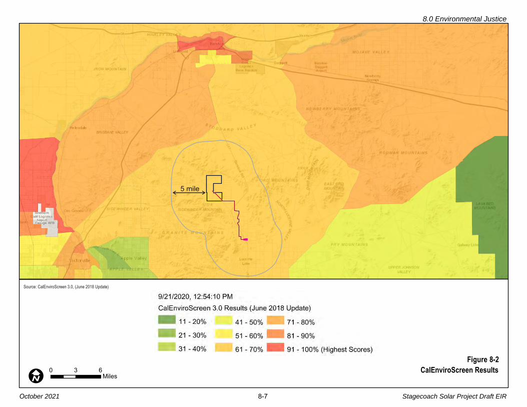
5 mile
Figure 8-2
CalEnviroScreen Results0 3 6MilesI
Source: CalEnviroScreen 3.0, (June 2018 Update)
8.0 Environmental Justice
October 2021 8-7 Stagecoach Solar Project Draft EIR
8.0 Environmental Justice
October 2021 8-8 Stagecoach Solar Project Draft EIR
8.1.6 Impacts and Mitigation Measures 1
8.1.6.1 Construction Impacts 2
The Proposed Project would have temporary environmental health effects during 3
construction from air emissions and traffic. Construction-related dust also increases the 4
risk of exposure to Valley Fever spores (see discussion in Section 4.9, Hazards and 5
Hazardous Materials). These impacts are defined as significant and unavoidable, but they 6
would occur only during the 18-month construction timeframe. As defined in Table 8-2, 7
impact severity would be reduced with implementation of a number of mitigation measures 8
(MMs). 9
Table 8-2. Construction Impacts and Mitigation Measures Related to Environmental Justice
Impact Mitigation Measure(s)
Section 4.2, Air Quality
Impact AQ-1: Air pollutant emissions from construction (Significant and Unavoidable)
MM AQ-1a: Fugitive Dust Control
MM AQ-1b: Control On-Site Off-Road Equipment Emissions
Impact AQ-3: Exposure of sensitive receptors to substantial pollutant concentrations (Significant and Unavoidable)
MM AQ-1a: Fugitive Dust Control
MM AQ-1b: Control On-Site Off-Road Equipment Emissions
Section 4.9, Hazards and Hazardous Materials
Impact HAZ-4: Valley Fever spores could be mobilized (Less than Significant with Mitigation)
MM AQ-1a: Fugitive Dust Control
Section 4.17, Traffic and Transportation
Impact TRA-1: Project traffic volumes, or temporary road or travel lane closures, would substantially affect the circulation system (Significant and Unavoidable)
MM TRA-1: Construction Traffic Control Plan
Impact TRA-4: Project activities requiring temporary road or travel lane closures would affect emergency vehicle response (Significant and Unavoidable)
MM TRA-1: Construction Traffic Control Plan
The Proposed Project would generate direct and indirect employment opportunities during 10
construction. Beneficial economic and tax base impacts would occur from local expenditures 11
of construction worker wages, as well as from procurement of goods and services required 12
for project construction. This is considered a local economic benefit of the Proposed Project 13
in an area that contains a high percentage of population living in poverty. 14
8.0 Environmental Justice
October 2021 8-9 Stagecoach Solar Project Draft EIR
8.1.6.2 Operational Impacts 1
Once operational, the Proposed Project would not create any long-term environmental or 2
health effects related to air emissions or traffic. There would be direct economic benefits to 3
the owners of the approximately 50 private land parcels crossed by the Stagecoach Gen-4
tie Line, all of whom have agreements with the Applicant including payment for use or 5
purchase of their land. 6
The potential for the Proposed Project to contribute to a decline in groundwater levels is 7
addressed in Section 4.10.5, Hydrology and Water Quality, Cumulative Impacts. MM 8
HWQ-2 (Prepare and Implement Groundwater Monitoring and Reporting Plan) would be 9
required to reduce the contribution of the Proposed Project to a potential cumulative 10
decline in basin groundwater levels. 11
The Proposed Project would generate direct employment opportunities during operation. 12
Additionally, beneficial economic and tax base impacts would occur from expenditures of 13
operation worker wages. This is considered a local economic benefit of the Proposed 14
Project in an area that contains a high percentage of population living in poverty. 15
8.1.7 Conclusion 16
The Proposed Project site is located in a census tract with a moderate CalEnviroScreen 17
environmental burden score, but the Proposed Project area (Census Tract 121.04) is not 18
considered disadvantaged compared to Statewide CalEnviroScreen scores. 19
Overall, the Proposed Project is considered to have a low long-term contribution to pollution. 20
Thus, the Proposed Project is not anticipated to create new burdens or add to existing 21
pollution burdens felt by a vulnerable community. There are no anticipated factors that 22
would put any of the nearby populations at risk from adverse health effects related to 23
increased levels of pollution resulting from the Proposed Project. 24
Furthermore, the Proposed Project would not introduce disproportionate impacts to 25
minority persons; the population is over 62 percent white according to Census data (Table 26
8-1). Within the Proposed Project area, approximately 27 percent of people have income in 27
the past 12 months that was below poverty level. However, the Proposed Project is 28
expected to introduce construction jobs and direct/indirect economic benefits to the area 29
through worker and developer purchases of goods and services. 30
October 2021 9-1 Stagecoach Solar Project Draft EIR
9.0 REPORT PREPARATION SOURCES AND REFERENCES
9.1 CALIFORNIA STATE LANDS COMMISSION STAFF 1
Sarah Mongano, Senior Environmental Scientist, Division of Environmental Planning and 2
Management (DEPM) 3
Nicole Dobroski, Chief, DEPM 4
Eric Gillies, Assistant Chief, DEPM 5
Jennifer Mattox, Science Policy Advisor and Tribal Liaison 6
Randy Collins, Public Land Management Specialist 7
Patrick Huber, Staff Attorney 8
Yessica Ramirez, Environmental Justice Liaison 9
9.2 PROFESSIONAL CONSULTANT TEAM 10
Aspen Environmental Group 11
Susan Lee, EIR Principal, Alternatives 12
Hedy Koczwara, EIR Project Manager 13
Brewster Birdsall, PE, Air Quality, Greenhouse Gas Emissions, Energy, Noise 14
Lauren DeOliveira, PhD, RPA, Cultural Resources, Cultural Resources – Tribal 15
Fritts Golden, Land Use and Planning and Public Access, Utilities and Service Systems 16
Philip Lowe, PE, Hydrology 17
Aurie Patterson, PG, Geology and Soils, Hazards, Hydrology 18
Stephanie Tang, Public Services, Wildfire 19
Grace Weeks, Recreation, Public Participation 20
Scott Debauche, CEP, Transportation and Traffic, Environmental Justice, Hydrology 21
Erin Woods, Biological Resources 22
Scott White, Biological Resources 23
Sandra Alarcón-Lopez, Public Participation 24
Michael Macko, Cultural Resources Surveys 25
Justin Wood, Biological Resources Surveys 26
Michael Clayton & Associates 27
Michael Clayton, Aesthetics/Light and Glare 28
Granite Financial Services (Geology and Hazards) 29
James Thurber, PG, CEG, CHG, Geology and Hazardous Materials 30
Jennifer Knipper, Geology and Hazardous Materials 31

9.0 Report Preparation Sources and References
October 2021 9-2 Stagecoach Solar Project Draft EIR
Cogstone (Paleontological Resources) 1
Eric Scott 2
Logan Freeberg 3
Kim Scott 4
ECORP (Biological Resources Surveys) 5
Don Mitchell, Manager 6
Adam Schroeder 7
Alexandra Dorough 8
Carley Lancaster 9
Caroline Garcia 10
Greg Hampton 11
Jonathan Renard 12
Josh Corona-Bennett 13
Kent Hughes 14
Kristen Wasz 15
Lauren Simpson 16
Marc Guidry 17
Max Murray 18
Michael Tuma 19
Taylor Dee 20
Wendy Turner 21
Granite Financial Services (Biological Resources Surveys) 22
Corey Mitchell 23
Dave Silverman 24
Kelly Herbison 25
Rachel Woodard 26
Todd Groundwater 27
Iris Priestaf (Water Supply Assessment) 28
Maureen Reilly (Water Supply Assessment) 29
Applied Earthworks (Cultural Resources Surveys) 30
Kurt McLean, Field Supervisor 31
Matthew Tennyson, Senior Archaeologist 32
Evan Mills, Archaeologist 33
William Borkan, Archaeologist 34
9.0 Report Preparation Sources and References
October 2021 9-3 Stagecoach Solar Project Draft EIR
9.3 REFERENCES CITED 1
American Cancer Society. 2017. Power Lines, Electrical Devices and Extremely Low 2
Frequency Radiation. Last Revised: April 18, 2017. [Online]: https://www.cancer.3
org/cancer/cancer-causes/radiation-exposure/extremely-low-frequency-4
radiation.html. Accessed August 17, 2021. 5
APLIC (Avian Power Line Interaction Committee). 2012. Reducing Avian Collisions with 6
Power Lines. [Online]: https://www.aplic.org/uploads/files/11218/Reducing_Avian_7
Collisions_2012watermarkLR.pdf. Published October 2012 8
_____. 2006. Suggested Practices for Avian Protection on Power Lines. [Online]: https://9
www.aplic.org/uploads/files/2613/SuggestedPractices2006(LR-2watermark).pdf. 10
Published 2006. 11
_____. 1996. Suggested Practices for Raptor Protection on Power Lines: The State of the 12
Art in 1996. Avian Power Line Interaction Committee (APLlC), the Edison Electric 13
Institute, and the Raptor Research Foundation. 14
_____. 1994. Mitigating Bird Collisions with Power Lines: The State of the Art in 1994. 15
Edison Electric Institute. Washington, D.C. 16
Aspen (Aspen Environmental Group). 2021. Supplemental Phase I Cultural Resources 17
Assessment for the Stagecoach Solar Project-Underground Gen-tie Alternative 18
Route. March 30, 2021. 19
_____. 2020a. Stagecoach Solar Biological Resources Technical Report (BRTR). 20
Prepared for California State Lands Commission. 21
_____. 2020b. Phase I Cultural Resource Assessment for the Stagecoach Solar Project, 22
Northern Lucerne Valley, San Bernardino County, California. Prepared for the 23
California State Lands Commission. Presented as Appendix G to this EIR. 24
Aurora (Aurora Solar LLC). 2016. Application for Lease of State Lands – Attachment D: 25
Project Description. August 2016. 26
Averill-Murray, R.C., T.C. Esque, L.J. Allison, S. Bassett, S.K. Carter, K.E. Dutcher, S.J. 27
Hromada, K.E. Nussear, and K. Shoemaker. 2021. Connectivity of Mojave Desert 28
tortoise populations—Management implications for maintaining a viable recovery 29
network: U.S. Geological Survey Open-File Report 2021–1033, 23 p., [Online]: 30
https://doi.org/10.3133/ofr20211033. 31
Averill-Murray, R.C., C.R. Darst, N. Strout, and M. Wong. 2013. Conserving population 32
linkages for the Mojave desert tortoise (Gopherus agassizii). Herpetological 33
Conservation and Biology 8(1):1-15. 34
Bakersfield Californian. 2017. State fines six employers for exposing workers to valley 35
fever in Monterey County, by Harold Pierce, dated November 21, 2017. [Online]: 36
https://www.bakersfield.com/news/health/state-fines-six-employers-for-exposing-37
workers-to-valley-fever-in-monterey-county/article_ee258742-cf14 11%e2%80%a6/ 38
Barr Engineering. 2017. Sorrel Solar Project Desktop [Geotechnical] Study. 39

9.0 Report Preparation Sources and References
October 2021 9-4 Stagecoach Solar Project Draft EIR
Barstow Community Hospital. 2020. Barstow Community Hospital About Us. [Online]: 1
www.barstowhospital.com/barstow-community-hospital/aboutus.aspx. Accessed 2
September 2020. 3
Basin and Range Watch. 2021. Granite Mountain Wind Energy Project. [Online]: https://4
www.basinandrangewatch.org/GraniteWind.html Accessed August 28, 2021. 5
Becker, Wendy L. 2013. DPR 523 Site Record Update for P-36-014876 SCE Lugo-Pisgah 6
No. 1/No. 2 Transmission Line. On file at the South Central Coastal Information 7
Center. [Confidential] 8
Bedrossian, T.L., P.D. Roffers, C.A. Hayhurst, J.T. Lancaster, and W.R. Short. 2012. 9
Geologic Compilation of Quaternary Surficial Deposits in Southern California, 10
Newberry Springs 30’ x 60’ Quadrangle. California Geological Survey Special 11
Report 217, 21 p. Plate 23, scale 1:100,000. 12
Bezore, S.P. and D.O. Shumway. 1994. Mineral land classification of a part of 13
southwestern San Bernardino County: the Barstow-Victorville area, California. 14
California Department Conservation, Division of Mines and Geology Open File 15
Report 94 04, 156 p. Scale 1:62,500. 16
Bleich, V.C., R.T. Bowyer, and J.D. Wehausen. 1997. Sexual segregation in mountain 17
sheep: resources or predation? Wildlife Monographs. No. 134. The Wildlife Society. 18
50pp. 19
BLM (Bureau of Land Management). 2021. BLM National Data Online Map Viewer [Online]: 20
https://www.arcgis.com/apps/webappviewer/index.html?id=6f0da4c7931440a8a8021
bfe20eddd7550. Accessed June 30, 2021. 22
_____. 2020a. El Mirage OHV Area. [Online]: https://www.blm.gov/visit/el-mirage-ohv-23
area. Viewed December 30, 2020. 24
_____. 2020b. Mojave Trails National Monument. [Online]: https://www.blm.gov/programs/25
national-conservation-lands/california/mojave-trails-national-monument. Viewed 26
December 31, 2020. 27
_____. 2020c. Sawtooth Canyon Campground. [Online]: https://www.blm.gov/visit/sawtooth-28
canyon-campground. Accessed November 2020. 29
_____. 2018a. Programs: Public Safety and Fire: Fire and Aviation: About Fire and Aviation. 30
[Online]: https://www.blm.goc/programs/public-safety-and-fire/about-fire-and-aviation. 31
Accessed January 2018. 32
_____. 2018b. Palen Solar Project Final Supplemental EIS. Sections III.21 and IV.21 33
Wildlife Resources. May. 34
_____. 2016a. DRECP (Desert Renewable Energy Conservation Plan) Proposed LUPA 35
(Land Use Plan Amendment) and Final Environmental Impact Statement. [Online]: 36
https://drecp.databasin.org/. 37
_____. 2016b. DRECP LUPA, Appendix B. Areas of Critical Environmental Concern 38
(ACECs). 39
_____. 2016c. DRECP LUPA, Appendix C. Special Recreation Management Areas 40
(SRMAs). November. 41

9.0 Report Preparation Sources and References
October 2021 9-5 Stagecoach Solar Project Draft EIR
_____. 2016d. DRECP LUPA, Appendix D, CMA Implementation Support Information and 1
Maps. Section D.2.8 (Mohave Ground Squirrel) and Figures D 18 and D 19. 2
Published September 2016. 3
_____. 2016e. DRECP LUPA, Appendix F, Proposed Land Exchange with the State of 4
California. Published September 2016. 5
_____. 2016f. BLM Instruction Memorandum 2016-124, Attachment 1: Potential Fossil 6
Yield Classification System. July 8. 7
_____. 2015a. DRECP Proposed LUPA. and Final Environmental Impact Statement. 8
Section III.14.2.4, Special Recreation Management Areas. 9
_____. 2015b. DRECP Proposed LUPA and Final Environmental Impact Statement. 10
Section III.14.1. 11
_____. 2011. Instruction Memorandum No. 2011 181, Involvement of Grazing Permittee/12
Lessee with Solar and Wind Energy Right-of-Way Application Process. [Online]: 13
https://www.blm.gov/policy/im-2011-181. Published September 21, 2011. 14
_____. 2005. Land Exchange Handbook. Published December 16, 2005. 15
_____. 2002. Proposed Northern and Eastern Colorado Desert Coordinated Management 16
Plan and Final Environmental Impact Statement. 17
BLM and CDFW (Bureau of Land Management and California Department of Fish and 18
Wildlife). 2014. DRECP Draft EIR/EIS and Land Use Plan Amendment (LUPA). 19
Published September 26, 2014. 20
BLM FA (Bureau of Land Management Fire and Aviation Program). 2020. Fire and 21
Aviation Program. [Online]: https://www.blm.gov/programs/fire-and-aviation. 22
Accessed June 4, 2020. 23
BRC-Equals 3, Inc. (BRC). 2016a. Habitat Assessment, Calcite Substation Project, San 24
Bernardino County, California. Prepared for Southern California Edison, 25
Irwindale, CA. June. 26
_____. 2016b. RE: Calcite Substation Project – Mohave Ground Squirrel Habitat 27
Assessment. Letter to Southern California Edison, Irwindale, CA. July. 28
_____. 2016c. Botanical Report, Calcite Substation Project, San Bernardino County, 29
California. Prepared for Southern California Edison, Irwindale, CA. August. 30
_____. 2016d. Burrowing Owl Focused Survey, Calcite Substation Project, San Bernardino 31
County, California. Prepared for Southern California Edison, Irwindale, CA. August. 32
_____. 2016e. Desert Tortoise Protocol Survey, Calcite Substation Project, San 33
Bernardino County, California. Prepared for Southern California Edison, 34
Irwindale, CA. August. 35
_____. 2016f. RE: Calcite Substation Project – Desert Tortoise Protocol Surveys. Letter to 36
Southern California Edison, Irwindale, CA. October. 37
_____. 2016g. Wetlands and Other Waters Jurisdictional Delineation Report, Calcite 38
Substation Project, San Bernardino County, California. Prepared for Southern 39
California Edison, Irwindale, CA. October. 40

9.0 Report Preparation Sources and References
October 2021 9-6 Stagecoach Solar Project Draft EIR
Brown-Buntin Associates. 2014. Ambient Noise Measurements, Coolwater-Lugo Brown-1
Buntin Transmission Project. August 13. 2
CA DOF (California Department of Finance). 2020a. Total Estimated and Projected 3
Population for California and Counties: July 1, 2010 to July 1, 2060 in 1-year 4
increments. [Online]: http://www.dof.ca.gov/Forecasting/Demographics/Projections/. 5
Accessed October 23, 2020. 6
_____. 2020b. Population and Housing Estimates for Cities, Counties, and the State, 7
January 2011-2020, with 2010 Benchmark. Last Updated May. [Online]: http://www.8
dof.ca.gov/Forecasting/Demographics/Estimates/E-5/Y. Accessed October 26, 9
2020. 10
CA EDD (California Employment Development Department). 2020a. San Bernardino 11
County Industry Employment & Labor Force – by Annual Average, March 2019 12
Benchmark. Last Updated March 27. [Online]: https://www.labormarketinfo.edd.ca.13
gov/data/employment-by-industry.html. Accessed October 26, 2020. 14
_____. 2020b. Monthly Labor Force Data for Cities and Census Designated Places (CDP), 15
Annual Average 2019 – Revised, Data Not Seasonally Adjusted. Last Updated 16
March 27. [Online]: https://www.labormarketinfo.edd.ca.gov/data/labor-force-and-17
unemployment-for-cities-and-census-areas.html#CCD. Accessed October 26, 2020. 18
CAISO (California Independent System Operator). 2021. Board-Approved 2020-2021 19
Transmission Plan. March 24. 20
CAL FIRE (California Department of Fire and Forestry Protection). 2020. Cooperative 21
Efforts. [Online]: https://www.fire.ca.gov/programs/fire-protection/cooperative-efforts/. 22
Accessed December 18, 2020. 23
_____. 2017a. Wildland Hazard& Building Codes, Fire Hazard Severity Zone Development 24
web site. [Online]: http://www.fire.ca.gov/fire_prevention/fire_prevention_wildland_25
zones_development. Accessed December 2017 26
_____. 2017b. Unit Strategic Fire Plan, San Bernardino Unit. [Online]: http://cdfdata.fire.ca.27
gov/fire_er/fpp_planning_plans_details?plan_id=286 28
_____. 2007a. Fact Sheet: California’s Fire Hazard Severity Zones. [Online]: https://www.29
sccgov.org/sites/dpd/DocsForms/Documents/Fire_Hazard_Zone_Fact_Sheet.pdf. 30
Accessed June 16, 2020. 31
_____. 2007b. Draft Fire Hazard Severity Zones in LRA. [Online]: https://osfm.fire.ca.gov/32
media/6776/fhszl06_1_map64.pdf. Accessed June 5, 2020. 33
CalEEMod (California Emissions Estimator Model). 2017. User’s Guide Appendix D: Default 34
Data Tables. Prepared for: California Air Pollution Control Officers Association 35
(CAPCOA). October. 36
CalEnviroScreen. 2020. CalEnviroScreen 3.0 Data. [Online]: https://oehha.ca.gov/37
calenviroscreen/report/calenviroscreen-30. Accessed September 21, 2020. 38
Calflora: Information on California plants for education, research and conservation. [web 39
application]. 2017. Berkeley, California: The Calflora Database [a non-profit 40
9.0 Report Preparation Sources and References
October 2021 9-7 Stagecoach Solar Project Draft EIR
organization]. [Online]: http://www.calflora.org/. Accessed in 2016, 2017, 2018, 1
2019, and 2020. 2
California Native Plant Society (CNPS). 2018. Inventory of Rare and Endangered Plants of 3
California (online edition, v8-03 0.39). [Online]: http://www.rareplants.cnps.org. 4
Accessed in 2016, 2017, 2018, 2019, and 2020. 5
CalRecycle. 2020a. Facility/Site Summary Details: Barstow Sanitary Landfill (36 AA 0046). 6
[Online]: https://www2.calrecycle.ca.gov/SolidWaste/SiteActivity/Details/1871?7
siteID=2653 Accessed September 2020. 8
_____. 2020b. Facility/Site Summary Details: Landers Sanitary Landfill (36 AA 0057). 9
[Online]: https://www2.calrecycle.ca.gov/SolidWaste/SiteActivity/Details/1882?10
siteID=2664 Accessed September 2020. 11
_____. 2020c. Facility/Site Summary Details: Mid-Valley Sanitary Landfill (36 AA 0055). 12
[Online]: https://www2.calrecycle.ca.gov/SolidWaste/SiteActivity/Details/1882?13
siteID=2662. Accessed September 2020. 14
_____. 2020d. Facility/Site Summary Details: San Timoteo Sanitary Landfill (36 AA 0087). 15
[Online]: https://www2.calrecycle.ca.gov/SolidWaste/SiteActivity/Details/1882?16
siteID=2688. Accessed September 2020. 17
_____. 2020e. Facility/Site Summary Details: Victorville Sanitary Landfill (36 AA 0045). 18
[Online]: https://www2.calrecycle.ca.gov/SolidWaste/SiteActivity/Details/19
1882?siteID=2652. Accessed September 2020. 20
Caltrans (California Department of Transportation). 2021. California Manual on Uniform 21
Utility Traffic Control (2014 Edition including Revision 1). 22
_____. 2020a. List of eligible and officially designated State Scenic Highways. [Online]: 23
https://dot.ca.gov/programs/design/lap-landscape-architecture-and-community-24
livability/lap-liv-i-scenic-highways. Accessed October 15, 2020 25
_____. 2020b. Transportation and Construction Vibration Guidance Manual. April. [Online]: 26
https://dot.ca.gov/-/media/dot-media/programs/environmental-analysis/documents/27
env/tcvgm-apr2020-a11y.pdf. April. 28
_____. 2020c. 2017 Traffic Volumes on California State Highways. [Online]: https://dot.ca.29
gov/programs/traffic-operations/census/traffic-volumes/2017. Accessed June 15. 30
_____. 2020d. 2017. Traffic Volumes and AADT. [Online]: https://dot.ca.gov/programs/31
traffic-operations/census/traffic-volumes/2017/route-221-275. Accessed 32
November 9, 2020. 33
_____. 2017. Transportation Concept Reports (SR 247 and SR 18). [Online]: http://www.34
dot.ca.gov/hq/tpp/corridor-mobility/d8page.html. Accessed November 20. 35
_____. 2013. Technical Noise Supplement to the Traffic Noise Analysis Protocol. 36
September 2013. 37
CARB (California Air Resources Board). 2020. California Greenhouse Gas Inventory for 38
2000-2018 — by Category as Defined in the 2008 Scoping Plan. 39

9.0 Report Preparation Sources and References
October 2021 9-8 Stagecoach Solar Project Draft EIR
_____. 2017. California’s 2017 Climate Change Scoping Plan. The strategy for achieving 1
California’s 2030 greenhouse gas target. November. 2
_____. 2008. Climate Change Scoping Plan: A Framework for Change. Pursuant to AB 32 3
the California Global Warming Solutions Act of 2006. December 2008. 4
_____. 2005. Air Quality and Land Use Handbook: A Community Health Perspective. April. 5
CDC (Centers for Disease Control and Prevention). 2018a. Valley Fever 6
(Coccidioidomycosis), Diagnosis and Testing for Valley Fever (Coccidioidomycosis) 7
website. [Online]: https://www.cdc.gov/fungal/diseases/coccidioidomycosis/8
diagnosis.html. 9
_____. 2018b. Coccidioidomycosis Outbreak Among Workers Constructing a Solar Power 10
Farm – Monterey County, California, 2016 2017. Morbidity and Mortality Weekly 11
Report – August 24, 2018. [Online]: https://www.cdc.gov/mmwr/volumes/67/wr/12
mm6733a4.htm. 13
CDFW (California Department of Fish and Wildlife). 2021. CDFW Petitions to List Species 14
Under the California Endangered Species Act: Western Joshua Tree. [Online]: 15
https://fgc.ca.gov/CESA#wjt. Viewed October 3, 2021. 16
_____. 2020a. Mohave Ground Squirrel website: Mohave Ground Squirrel. [Online]: 17
https://wildlife.ca.gov/Conservation/Mammals/Mohave-Ground-Squirrel. Viewed 18
January 1, 2021. 19
_____. 2020b. RareFind 5 California Natural Diversity Database (CNDDB). Sacramento, 20
CA: California Department of Fish and Wildlife, Biogeographic Data Branch. 21
Accessed in 2016, 2017, 2018, 2019, and 2020. 22
_____. 2020c California Fish and Game Commission, Notice of Findings, Western Joshua 23
Tree. September. [Online]: https://nrm.dfg.ca.gov/FileHandler.ashx?DocumentID=24
183565&inline. 25
_____. 2019a. California Sensitive Natural Communities List. [Online]: https://wildlife.ca.26
gov/Data/VegCAMP/Natural-Communities. Accessed November 8, 2019. 27
_____. 2019b. MGS Conservation Strategy. [Online]: https://nrm.dfg.ca.gov/FileHandler.28
ashx?DocumentID=171301&inline. Viewed January 1, 2021. Published August 4, 29
2019. 30
_____. 2018. Desert Bighorn Sheep Status Report, November 2013 to October 2016. 31
Region 6, Inland Deserts Region. September. 32
_____. 2017a. CNDDB QuickView Tool [web application]. Sacramento, CA, CDFW 33
Biogeographic Data Branch. [Online]: https://map.dfg.ca.gov/bios/?tool=cnddbQuick. 34
Accessed in 2016, 2017, 2018, 2019, and 2020. 35
_____. 2017b. Biogeographic Information Observation System (BIOS). Sacramento, CA: 36
California Department of Fish and Wildlife, Biogeographic Data Branch. Accessed in 37
2016, 2017, 2018, 2019, and 2020. 38
CDMR (California Division of Mine Reclamation). 2020. Mines Online interactive website. 39
[Online]: https://maps.conservation.ca.gov/mol/index.html. Accessed November 18. 40

9.0 Report Preparation Sources and References
October 2021 9-9 Stagecoach Solar Project Draft EIR
CDOC (California Department of Conservation). 2020. California Important Farmland 1
Finder. [Online]: https://maps.conservation.ca.gov/DLRP/CIFF/. Accessed 2
November 18. 3
CDPH (California Department of Public Health). 2020a. Valley Fever Basics, California 4
Department of Public Health website. [Online]: https://www.cdph.ca.gov/Programs/5
CID/DCDC/Pages/ValleyFeverBasics.aspx. Accessed November 2020. 6
_____. 2020b. Symptoms, California Department of Public Health website. [Online]: https://7
www.cdph.ca.gov/Programs/CID/DCDC/Pages/ValleyFeverSymptoms.aspx. 8
Accessed November 2020. 9
_____. 2020c Valley Fever (Coccidioidomycosis) In California, 2019, Surveillance and 10
Statistics Section, Infectious Diseases Branch, Division of Communicable Disease 11
Control, Center for Infectious Diseases, California Department of Public Health. 12
[Online]: https://www.cdph.ca.gov/Programs/CID/DCDC/CDPH%20Document%2013
Library/CocciEpiSummary2019.pdf. 14
_____. 2019. CDPH, Health and Human Services, Division of Communicable Disease 15
Control: Valley Fever Fact Sheet. August. 16
_____. 2017. Increase in Reported Valley Fever Cases in California in 2017 News 17
Release, Office of Public Affairs website. [Online]: https://www.cdph.ca.gov/18
Programs/OPA/Pages/NR17 080.aspx. Accessed January 2018. 19
_____. 2013. Preventing Work-Related Coccidioidomycosis (Valley Fever) Fact Sheet, 20
Hazard Evaluation System & Information Service, CDPH Occupational Health 21
Branch. 22
CDWR (California Department of Water Resources). 2021. Groundwater data from the 23
SGMA Data Viewer. [Online]: https://sgma.water.ca.gov/webgis/?appid=SGMA24
DataViewer#gwlevels. Accessed May 2021. 25
_____. 2020. Statewide Map of Current SGMA Basin Prioritization. [Online]: https://water.26
ca.gov/Programs/Groundwater-Management/Basin-Prioritization. Accessed 27
June 25, 2020. 28
_____. 2010, California Statewide Groundwater Elevation Monitoring (CASGEM) Program 29
Procedures for Monitoring Entity Reporting, December 2010. 30
_____. 2004. Lucerne Valley Groundwater Basin. California’s Groundwater Bulletin 118. 31
CEC (California Energy Commission). 2021. Monthly Petroleum Watch. May. [Online]: 32
https://www.energy.ca.gov/data-reports/reports/petroleum-watch. 33
_____. 2019. Staff’s 2018 Integrated Energy Policy Report (IEPR) Update, Volume II. 34
Publication Number: 100-2018-001-V2-CMF. Table 2: GHG Emission Intensity 35
Rates. Released March 2019. 36
_____. 2015. Staff Paper, “Proposed Near‐Term Method for Estimating Generation Fuel 37
Displacement by Avoided Use of Grid Electricity” CEC-200-2015-002. June 2015. 38
CGS (California Geological Survey). 2020a. Earthquake Zones of Required Investigation 39
interactive website. [Online]: https://maps.conservation.ca.gov/cgs/EQZApp/app/. 40
9.0 Report Preparation Sources and References
October 2021 9-10 Stagecoach Solar Project Draft EIR
_____. 2020b. Ground Motion Interpolator (2008). [Online]: https://www.conservation.ca.1
gov/cgs/ground-motion-interpolator. 2
_____. 2020c. California Earthquake History and Catalogs, Downloadable California 3
Earthquake Catalogs: Updated Magnitude 4 and greater Earthquakes, Compiled 4
from various sources (1769-2000). [Online]: https://www.conservation.ca.gov/cgs/5
Pages/Earthquakes/earthquake-catalog.aspx. 6
_____. 2012. Geologic Compilation of the Quaternary Surficial Deposits in Southern 7
California, Newberry Springs 30’ X 60’ Quadrangle, CGS Special Report 217, 8
Plate 23. Compiled by Trinda L. Bedrossian and Michelle A. Myers. 9
_____. 1999. Fault Rupture Hazard Zones in California, CGS Special Publication #42. 10
CHP (California Highway Patrol). 2020. [Online]: https://www.chp.ca.gov/find-an-office/11
inland-division/offices/(835)-barstow. Accessed September 16, 2020. 12
CNDDB (California Natural Diversity Database). 2021. Search of the California Natural 13
Diversity Database in the area of the Kramer Junction Alternative. Accessed June 29, 14
2021. 15
Cox, B.F. and J.C. Tinsley III. 1999. Origin of the late Pliocene and Pleistocene Mojave 16
River between Cajon Pass and Barstow, California. In R.E. and J. Reynolds (eds.), 17
Tracks along the Mojave: a field guide from Cajon Pass to the Calico Mountains and 18
Coyote Lake. SBCM Association Quarterly 46(3): 49 54. 19
Cox, B.F. and J.W. HiIIhouse, 2000. Pliocene and Pleistocene evolution of the Mojave 20
River, and associated tectonic development of the Traverse Ranges and Mojave 21
Desert, based on borehole stratigraphy studies near Victorville, California. U.S. 22
Geological Survey Open File Report No. OF 00 0147. 66 p. 23
Cox, B.F., J.W. Hillhouse and L.A. Owen, 2003. Pliocene and Pleistocene evolution of the 24
Mojave River, and associated tectonic development of the Traverse Ranges and 25
Mojave Desert, based on borehole stratigraphy studies and mapping of landforms 26
and sediments near Victorville, California. In Y. Enzel, S.G. Wells and N. Lancaster 27
(eds.), Paleoenvironments and paleohydrology of the Mojave and southern Great 28
Basin Deserts. Boulder, Colorado: Geological Society of America Special Paper 29
#368, p. 1 42. 30
CPUC (California Public Utilities Commission). 2021a. SCE Ivanpah-Control Project. 31
[Online]: https://www.cpuc.ca.gov/Environment/info/aspen/ivanpah-control/ivanpah-32
control.htm. Viewed June 11, 2021. 33
_____. 2021b. General Order 131-D. [Online]: https://docs.cpuc.ca.gov/PUBLISHED/34
Graphics/589.PDF. Accessed August 7, 2021. 35
_____. 2019. CPUC FireMap. [Online]: https://ia.cpuc.ca.gov/firemap/. Accessed June 5, 36
2020. 37
_____. 2016. Valley South Subtransmission Line Final EIR. Project Description. [Online]: 38
https://www.cpuc.ca.gov/environment/info/aspen/valleysouth/Index_6_9_16.htm. 39
Published June 2016. 40
9.0 Report Preparation Sources and References
October 2021 9-11 Stagecoach Solar Project Draft EIR
_____. 2015. Final Environmental Impact Report for SCE West of Devers Upgrade Project, 1
Section D.13 Noise. December. 2
_____. 2012. Downs Substation Expansion Project Initial Study/Mitigated Negative 3
Declaration. Section B.3.5, Cultural and Paleontological Resources. Published July 4
2012. 5
_____. 2008a. Sunrise Powerlink Environmental Impact Statement/Environmental Impact 6
Report, Section D.15, Fire and Fuels Management. October. 7
_____. 2008b. Energy Action Plan, 2008 Update. February. [Online]: http://www.cpuc.ca.8
gov/eaps/. 9
CSLC (California State Lands Commission). 2021a. Agency web page, Environmental 10
Justice Policy and Implementation Plan. [Online]: https://www.slc.ca.gov/11
envirojustice/. Accessed March 1, 2021. 12
_____. 2021b. State Lands Commission Strategic Plan. https://slcprdwordpressstorage.13
blob.core.windows.net/wordpressdata/2021/02/2021-2025-Strategic-Plan.pdf. 14
[Online]: Accessed March 13, 2021. 15
_____. 2020. CSLC State School Lands Annual Report 2019-2020. [Online]: https://16
slcprdwordpressstorage.blob.core.windows.net/wordpressdata/2020/12/SL_17
2019-20.pdf. Accessed March 13, 2021. 18
_____. 2015. Press Release: Commission and Bureau of Land Management announce 19
intent to pursue landmark land exchange. [Online]: https://www.slc.ca.gov/press-20
release/commission-and-bureau-of-land-management-announce-intent-to-pursue-21
landmark-land-exchange/. Published October 1, 2015. 22
_____. 2008. Resolution by the California State Lands Commission Supporting 23
Environmentally Responsible Development of School Lands Under the Commission’s 24
Jurisdiction for Renewable Energy Related Projects. [Online]: https://www.slc.ca.25
gov/wp-content/uploads/2018/10/Resolution.pdf. Accessed September 14, 2020. 26
Databasin. 2021. DRECP Proposed Land Exchange from CA State Lands Commission to 27
BLM Phase I. [Online]: https://drecp.databasin.org/datasets/afe17320f19f4778bd28
01ae9b23b21a72. Viewed June 13. Published September 24, 2015. 29
Desert Sun. 2020. Dome Fire torches 43,000 acres in Mojave National Preserve, many 30
Joshua trees burned. [Online]: https://www.desertsun.com/story/news/2020/08/17/31
dome-fire-burns-in-mojave-national-park-as-temps-soar/3383180001/. Accessed 32
August 18, 2020. 33
Desert Valley Hospital. 2017. Desert Valley Hospital Fact Sheet. [Online]: https://www.34
dvmc.com/About-Us/Fact-Sheet. Accessed September 16, 2020. 35
DHS. 2002. California EMF Program. An Evaluation of the Possible Risks From Electric 36
and Magnetic Fields (EMFs) From Power Lines, Internal Wiring, Electrical 37
Occupations, and Appliances. Accessed March 23, 2021. 38
Dibblee, T.W., and J.A. Minch. 2008. Geologic Map of the Apple Valley & Ord Mountains 39
15 Minute Quadrangles, San Bernardino County, California. Dibblee Geology 40
Center Map #DF377. 41

9.0 Report Preparation Sources and References
October 2021 9-12 Stagecoach Solar Project Draft EIR
Dick, M.C., and A.R. Kjos. 2017, Regional water table (2016) in the Mojave River and 1
Morongo groundwater basins, southwestern Mojave Desert, California: U.S. 2
Geological Survey Scientific Investigations Map 3391, scale 1:170,000. [Online]: 3
https://doi.org/10.3133/sim3391. 4
DMR (Division of Mine Reclamation). 2020. Data for Mine ID 91-36-0105, Alvic and 5
Alumina Quarry. Accessed November 18, 2020. 6
DTSC (Department of Toxic Substances Control). 2017a. EnviroStor Database Web 7
Search. [Online]: https://www.envirostor.dtsc.ca.gov/public/map/?myaddress=north+8
lucerne+valley. 9
_____. 2017b. EnviroStor database, VICTORVILLE PBR NO 5 (80000525). [Online]: 10
https://www.envirostor.dtsc.ca.gov/public/profile_report?global_id=80000525. 11
Dudek. 2018. DPR 523 Site Record Update for P-36-014876 SCE Lugo-Pisgah No. 1/No. 12
2 Transmission Line. On file at the South Central Coastal Information Center. 13
[Confidential] 14
Earle, David D. 2005. The Mojave River and the Central Mojave Desert: Native Settlement, 15
Travel, and Exchange in the Eighteenth and Nineteenth Centuries. Journal of 16
California and Great Basin Anthropology, 25(1). [Online]: 17
http://www.escholarship.org/uc/item/7zj17572 18
EC Mag (Electrical Contractor Magazine). 2018. The Link Between Power Lines and 19
Wildfires. [Online]: https://www.ceqanetag.com/section/systems/link-between-20
power-lines-and-wildfires#:~:text=In%20some%20instances%2C%20high%2021
winds,grass%2C%20setting%20it%20on%20fire. Accessed March 12, 2021. 22
ECM (ECM Consultants). 2018. Aurora Solar UXO Escort Site Summary letter report, 23
dated January 22, 2018. 24
ECORP (ECORP Consulting, Inc.). 2020a. Jurisdictional Delineation, Stagecoach Solar 25
Project. Prepared for California State Lands Commission, Avangrid Renewables, 26
and Aspen Environmental Group. 27
_____. 2020b. Results of a Joshua Tree Survey for the Stagecoach Solar Project. 28
Prepared for California State Lands Commission, Avangrid Renewables. 29
Energy Storage. 2020. Arizona Battery Fire’s Lessons Can Be Learned by Industry to 30
Prevent Further Incidents, DNV GL Says. July 29. [Online]: https://www.energy-31
storage.news/news/arizona-battery-fires-lessons-can-be-learned-by-industry-to-32
prevent-further. Accessed December 22, 2020. 33
EPRI (Electric Power Research Institute). 1997.Susceptibility of Implanted Pacemakers 34
and Defibrillators to Interference by Power-Frequency Electric and Magnetic Fields. 35
August. 36
_____.1982. Transmission Line Reference Book. 345 kV and Above/Second Edition. 37
Chapter 4 Corona Phenomenon on AC Transmission Lines. 38
FEMA (Federal Emergency Management Agency). 2020. Emerging Hazards of Battery 39
Energy Storage System Fires. October 27. [Online]: https://www.fema.gov/case-40

9.0 Report Preparation Sources and References
October 2021 9-13 Stagecoach Solar Project Draft EIR
study/emerging-hazards-battery-energy-storage-system-fires. Accessed 1
December 18, 2020. 2
FHWA (Federal Highway Administration). 2021. Manual on Uniform Traffic Control Devices 3
for Streets and Highways. [Online]: https://mutcd.fhwa.dot.gov/kno_2009r1r2.htm. 4
Accessed August 20. 5
_____. 2006. Roadway Construction Noise Model, User’s Guide. January. [Online]: http://6
www.fhwa.dot.gov/environment/noise/construction_noise/rcnm/rcnm.pdf. 7
FTA (Federal Transit Administration). 2018. Transit Noise and Vibration Impact 8
Assessment Manual (Report 0123). September. [Online]: https://www.transit.dot.9
gov/sites/fta.dot.gov/files/docs/research-innovation/118131/transit-noise-and-10
vibration-impact-assessment-manual-fta-report-no-0123_0.pdf. 11
Geiger, D.L. and L.T. Groves. 1999. Review of Fossil Abalone Gastropoda etigastropoda 12
Haliotidae with Comparison to Recent Species. 13
Google Earth. 2021. Stagecoach Solar Generation Plant Area Viewed on Google Earth. 14
Accessed September 2021. 15
Grist. 2019. “The 'Erin Brockovich' town is still toxic (and nearly abandoned).” [Online]: 16
https://grist.org/science/the-true-story-of-the-town-behind-erin-brockovich/. 17
Published January 29, 2019. 18
Harrison et al. 2017. Evidence review of the impact of solar farms on birds, bats and 19
general ecology. Natural England. 1st Edition. March 9. 20
ICF International. 2016. Cultural Resources Inventory Report for The Calcite Substation 21
Project, Lucerne Valley, California, Volume 1 Report. 22
IEEE. 2016. IEEE 1048-2016 – IEEE Guide for Protective Grounding of Power Lines. 23
January 29. 24
_____.1979. The Effect of 60 Hertz Electric Fields and Currents on Cardiac Pacemakers. 25
_____. 1971. Radio Noise Design Guide for High-Voltage Transmission Lines. IEEE Radio 26
Noise Subcommittee Report – Working Group No. 3. March/April 1971. 27
IPCC (Intergovernmental Panel on Climate Change). 2014: Climate Change 2014: 28
Synthesis Report. Contribution of Working Groups I, II and III to the Fifth 29
Assessment Report of the Intergovernmental Panel on Climate Change. IPCC, 30
Geneva, Switzerland, 151 pp. 31
Jefferson, G.T. 2003a. Catalog of Late Quaternary vertebrates from California, 32
unpublished data expanding on Jefferson 1991a, 1991b. 33
_____. 2003b. A catalog of Blancan and Irvingtonian vertebrates and floras from Arizona, 34
southern California, Nevada, Utah, and northwestern Mexico, unpublished data. 35
_____. 1991a. A Catalogue of late Quaternary Vertebrates from California: Part one, 36
nonmarine lower vertebrate and avian taxa. Natural History Museum of Los 37
Angeles, Technical Report #5. 38
_____. 1991b. A Catalogue of late Quaternary Vertebrates from California: Part two, 39
Mammals. Natural History Museum of Los Angeles, Technical Report #7. 40
9.0 Report Preparation Sources and References
October 2021 9-14 Stagecoach Solar Project Draft EIR
Katzner, T. et al. 2012. Golden Eagle Home Range, Habitat Use, Demography and 1
Renewable Energy Development in the California Desert. West Virginia University. 2
Interim Report to Bureau of Land Management, California State Office. Contract 3
No. L11PS01121. 18 pp. 4
Korpinen, Leena, Harri Kuisti, Jarmo Elovaara, Vesa Virtanen. 2021. Cardiac pacemakers 5
in electric and magnetic fields of 400-kV power lines. February. 6
Kosciuch, K., D. Riser-Espinoza, M. Gerringer, and W. Erickson. 2020. A Summary of Bird 7
Mortality at Photovoltaic Utility Scale Solar Facilities in the Southwestern U.S. PLoS 8
ONE 15(4): e0232034. doi: 10.1371/journal.pone.0232034. 9
Lahontan Water Board (Lahontan Regional Water Quality Control Board). 2021. PG&E 10
Hinkley Chromium Cleanup. [Online]: https://www.waterboards.ca.gov/lahontan/11
water_issues/projects/pge/. Published November 19, 2019. 12
Latta, B., and C. Thelander. 2013. Results of 2012 golden eagle nesting surveys of the 13
California Desert and Northern California Districts. BioResource Consultants, Inc. 14
Ojai, CA. Final Report to Bureau of Land Management, California State Office. 15
Contract No. L11PXO2234. 13 pp and appendices. 16
Leitner, P. 2015. Current Status of the Mohave Ground Squirrel (Xerospermophilus 17
mohavensis): A Five-Year Update (2008-2012). Western Wildlife 2:9-22. 18
_____. 2008. Current Status of the Mohave Ground Squirrel. Transactions of the Western 19
Section of the Wildlife Society 44:11-29. 20
McLeod S.A. 2012. Vertebrate paleontology records search for paleontological resources 21
for the proposed South of Kramer Project, from near Daggett to near Hesperia, San 22
Bernardino County, project area. See Paleo Solutions 2013 Appendix C. 23
MDAQMD (Mojave Desert Air Quality Management District). 2016. California 24
Environmental Quality Act (CEQA) and Federal Conformity Guidelines. August. 25
Mojave Watermaster (Mojave Basin Area Water Master). 2021. Twenty-Seventh Annual 26
Report of the Mojave Basin Area Water Master Water Year 2019-2020. [Online]: 27
https://www.mojavewater.org/files/27AR1920.pdf. Accessed May 2021. 28
Mott MacDonald. 2020. A Comparison Between Underground and Overhead Methods of 29
Construction for a Generation Tie Line. Prepared for Aurora Solar LLC. Published 30
June 30, 2020. 31
MWA (Mojave Water Agency). 2021. 2020 Urban Water Management Plan, Public Draft. 32
April. [Online]: https://www.mojavewater.org/files/33
MojaveWaterAgency2020-UWMP_Public-Draft_041421.pdf. Accessed May 2021. 34
_____. 2005A. Este Hydrologic Atlas. Hydrologic Assessment developed with the California 35
State University, Fullerton. 36
_____. 2005B. Mojave Water Agency 2005 Regional Water Management Plan. Volume 1: 37
Report. 38
NCEDC (Northern California Earthquake Data Center), 2017. ANSS Composite Catalog 39
Search, 1898 – present). [Online]: https://ncedc.org/anss/catalog-search.html. 40

9.0 Report Preparation Sources and References
October 2021 9-15 Stagecoach Solar Project Draft EIR
NIEHS (National Institute of Environmental Health Sciences). 2002. Electric and Magnetic 1
Fields Associated with the Use of Electric Power, Questions and Answers. June. 2
NOAA (National Oceanic & Atmospheric Administration). 2020. Global Monitoring 3
Laboratory, Earth System Research Laboratories: Trends in Atmospheric Carbon 4
Dioxide, Full Record. [Online]: https://www.esrl.noaa.gov/gmd/ccgg/trends/mlo.html. 5
Accessed October 2020. 6
NPS (National Park Service). 2020. Trump Administration Adds 1,275 Miles to the National 7
Trail System – Office of Communications. [Online]: 8
https://www.doi.gov/pressreleases/trump-administration-adds-1275-miles-national-9
trail-system. Published October 22, 2020. 10
NRCS (National Resource Conservation Service). 2021. Soil Data from the Web Soil 11
Survey interactive website. [Online]: https://websoilsurvey.nrcs.usda.gov/app/12
WebSoilSurvey.aspx. Accessed June 2021. 13
_____. 2013. Soil Survey Geographic (SSURGO) database for San Bernardino County, 14
California, Mojave River Area, CA671. [Online]: http://websoilsurvey.nrcs.usda.gov 15
_____. 1986. Soil Survey of San Bernardino County, California, Mojave River Area. 16
[Online]: https://www.nrcs.usda.gov/wps/portal/nrcs/surveylist/soils/survey/state/17
?stateId=CA 18
NREL (National Renewable Energy Laboratory). 2021. Solar Resource Glossary. [Online]: 19
https://www.nrel.gov/grid/solar-resource/solar-glossary.html. Accessed June 7, 20
2021. 21
Nussear, K.E., Esque, T.C., Inman, R.D., Gass, Leila, Thomas, K.A., Wallace, C.S.A., 22
Blainey, J.B., Miller, D.M., and Webb, R.H., 2009, Modeling habitat of the desert 23
tortoise (Gopherus agassizii) in the Mojave and parts of the Sonoran Deserts of 24
California, Nevada, Utah, and Arizona: U.S. Geological Survey Open-File Report 25
2009-1102, 18 p. 26
OEHHA (Office of Environmental Health Hazard Assessment, California Environmental 27
Protection Agency). 2018. Indicators of Climate Change in California. May. 28
OPR (California Office of Planning and Research). 2020. General Plan Guidelines, 29
Chapter 4 required Elements. Updated Environmental Justice Element. June. 30
[Online]: https://opr.ca.gov/docs/20200706-GPG_Chapter_4_EJ.pdf. 31
_____. 2018. Technical Advisory on Evaluating Transportation Impacts in CEQA. 32
December. [Online]: https://opr.ca.gov/ceqa/technical-advisories.html. Accessed 33
June 2020. 34
_____. 2017.Technical Advisory, AB 52 and Tribal Cultural Resources in CEQA. July 35
2017. [Online] http://nahc.ca.gov/wp-content/uploads/2017/06/Technical-Advisory-36
AB-52-and-Tribal-Cultural-Resources-in-CEQA.pdf. 37
Paleo Solutions. 2014a. Analysis of new impact areas, 1,000 foot corridor Paleontological 38
Resource Survey Addendum # 1: Southern California Edison Coolwater-Lugo 39
Transmission Line Project (formerly South of Kramer), San Bernardino County, 40
California. 92 p. On file with the Barstow BLM Field Office, Barstow, California. 41

9.0 Report Preparation Sources and References
October 2021 9-16 Stagecoach Solar Project Draft EIR
_____. 2014b. 1,305 acre supplemental Paleontological Resource Survey Addendum # 2: 1
Southern California Edison Coolwater-Lugo Transmission Line Project, San 2
Bernardino County, California (non-confidential version). 321 p. On file with the 3
Barstow BLM Field Office, Barstow, California. 4
_____. 2013. Confidential Paleontological Survey Report: Southern California Edison 5
Coolwater-Lugo Transmission Line Project. 133 p. On file with the Barstow BLM 6
Field Office, Barstow, California. 7
Parsons. 2008. Site Inspection Report, Former Victorville Precision Bombing Range No. 5, 8
San Bernardino County, California. U.S. Army Corps of Engineers, Southwest IMA 9
Region, FUDS Project No. J09CA069001. 10
Penrod, K., P. Beier, E. Garding, and C. Cabañero. 2012. A Linkage Network for the 11
California Deserts. Produced for the Bureau of Land Management and The 12
Wildlands Conservancy. Produced by Science and Collaboration for Connected 13
Wildlands, Fair Oaks, CA. [Online]: www.scwilcllancls.org and Northern Arizona 14
University, Flagstaff, Arizona. http://oak.ucc.nau.edu/pbl/. 15
Phelps, G.A., D.R. Bedford, D.J. Lidke, D.M. Miller, and K.M. Schmidt. (Phelps et al), 16
2012, Preliminary surficial geologic map of the Newberry Springs 30’ x 60’ 17
quadrangle, California: U.S. Geological Survey Open-File Report 2011–1044, 18
pamphlet 68 p., 1 sheet, scale 1:100,000. [Online]: http://pubs.usgs.gov/of/2011/19
1044/. 20
Plumbing & Mechanical Engineer. 2018. Fire-Suppression Systems for Battery Energy 21
Storage Systems. May 24. [Online]: https://www.pmengineer.com/articles/22
93694-fire-suppression-systems-for-battery-energy-storage-systems. Accessed 23
December 21, 2020. 24
PPL Electric. 2021. EMF and Health. [Online]: https://www.pplelectric.com/reliability/25
delivering-electricity/emf. Accessed September 7, 2021. 26
Research. 2020. Real Estate Market Overview, Lucerne Valley, CA 92356. [Online]: 27
https://www.rate.com/research-old/lucerne_valley-ca-92356. Accessed October 26, 28
2020. 29
RWQCB (California Regional Water Quality Control Board Colorado River Basin Region). 30
2019. Water Quality Control Plan for the Colorado River Basin Region. 31
S&P Global. 2019. Burning concern: Energy Storage Industry Battles Battery Fires. 32
May 24. [Online]: https://www.spglobal.com/marketintelligence/en/news-insights/33
latest-news-headlines/burning-concern-energy-storage-industry-battles-battery-34
fires-51900636. Accessed December 18, 2020. 35
San Bernardino County Fire. 2019. July 2018–June 2019 Annual Report. [Online]: https://36
www.sbcounty.gov/uploads/SBCFire/documents/About/2018-19AnnualReport.pdf. 37
Accessed September 16, 2020. 38
San Bernardino County Sheriff’s Department. 2020. [Online]: https://wp.sbcounty.gov/39
sheriff/about-us/. Accessed September 16, 2020. 40
San Bernardino County. 2021a. County Roads Map Viewer. [Online]: https://sbcountydpw.41
maps.arcgis.com/home/webmap/viewer.htm. Viewed April 2021. 42
9.0 Report Preparation Sources and References
October 2021 9-17 Stagecoach Solar Project Draft EIR
_____. 2021b. Renewable Energy Projects as of June 2020. [Online]: http://www.sbcounty.1
gov/uploads/LUS/Renewable/SolarProjectList2020_Maps.pdf Accessed October 2
2020. 3
_____. 2021c. Evacuation Route Map (San Bernardino County). [Online]: 4
http://webcache.googleusercontent.com/search?q=cache:RIrA-5
tAj8lMJ:www.sbcounty.gov/calmast/sbc/html/6
emergency_plan_routes.asp+&cd=1&hl=en&ct=clnk&gl=us. Accessed 7
September 7, 2021. 8
_____. 2020a. Countywide Plan, Lucerne Valley 2020 Community Action Guide. [Online]: 9
http://countywideplan.com/wp-content/uploads/2020/10/04_Lucerne-Valley-10
Community-Plan_FINAL_2019.pdf. Accessed November 10, 2020 11
_____. 2020b. Countywide Plan. County Policy Plan, Housing Element. [Online]: http://12
countywideplan.com/wp-content/uploads/2021/01/CWP_PolicyPlan_HardCopy_13
MainText_Tables_20201027_adopted.pdf. Accessed October 29, 2020. 14
_____. 2020c. Countywide Plan. Policy Plan, Hazards Element. [Online]: http://15
countywideplan.com/policy-plan/beta/hz/ 16
_____. 2020d. Countywide Plan. County Policy Plan. Natural Resources Element. [Online]: 17
http://countywideplan.com/wp-content/uploads/2021/01/NR-Merged-Maps-201027_18
adopted.pdf. Accessed October 2020. 19
_____. 2020e. Average Daily Traffic Volumes. [Online]: https://cms.sbcounty.gov/dpw/20
Transportation/Traffic.aspx. Accessed September. 21
_____. 2020f. Code of Ordinances, Division 2 (Traffic). [Online]: https://22
codelibrary.amlegal.com/codes/sanbernardino/latest/sanberncty_ca/0-0-0-48112. 23
Accessed November 10, 2017. 24
_____. 2020g. HZ-5 Fire Hazard Severity Zones. [Online]: https://www.arcgis.com/apps/25
webappviewer/index.html?id=355f9beb4a8f446e8869459e91d58431. Accessed 26
December 9, 2020. 27
_____. 2020h. NR-4 Mineral Resource Zones Policy Map – Public Review Draft. [Online]: 28
https://www.arcgis.com/apps/webappviewer/index.html?id=9948b9bc78f147fd9ea29
193c2ce758081. Accessed November 18, 2020. 30
_____. 2019a. County of San Bernardino 2007 Development Code (amended through May 31
2019). [Online]: http://www.sbcounty.gov/Uploads/lus/DevelopmentCode/DCWebsite.32
pdf#PAGE=87. Amended May 2, 2019. 33
_____. 2019b. Daggett Solar Power Facility Final EIR. [Online]: https://ceqanet.opr.ca.gov/34
2018041007/3. Viewed June 11, 2021. 35
_____. 2019c. General Plan Renewable Energy and Conservation Element. (Adopted 36
August 2017, amended February 2019). [Online]: http://www.sbcounty.gov/uploads/37
LUS/Renewable/2019_WEBSITE/REC%20Element.pdf. Accessed September 9, 38
2020 39
_____. 2018a. Draft EIR Ord Mountain Solar and Energy Storage Project and the Calcite 40
Substation Project. [Online]: http://www.sbcounty.gov/uploads/LUS/Environmental/41

9.0 Report Preparation Sources and References
October 2021 9-18 Stagecoach Solar Project Draft EIR
Ord_Mountain_Solar_Energy_Storage_Project_DEIRDOCS/Ord%20Mountain%201
Solar%20DRAFT%20EIR%202018 10.pdf 2
_____. 2018b. Emergency Operations Plan (EOP). [Online]: https://www.sbcfire.org/3
Portals/58/Documents/Emergency_Services/Final%202017-2018%20EOP%204
Update.pdf?ver=2018-02-06-125224-430. Accessed June 16, 2020. 5
_____. 2017a. Chapter 82.12: Fire Safety (FS) Overlay. [Online]: https://codelibrary.6
amlegal.com/codes/sanbernardino/latest/sanberncty_ca/0 0-0-70744. Accessed 7
December 9, 2020. 8
_____. 2017b. County Public Easements Brochure. [Online]: http://cms.sbcounty.gov/9
Portals/50/operations/permits/PublicEasementBrochure.pdf?ver=10
2017-05-19-135724-000. Viewed April 2021. 11
_____. 2016. Resolution 2016-20 of the Board of Supervisors of the County of San 12
Bernardino, State of California, Establishing the County’s Position on the Proposed 13
Land Use Plan Amendment in Phase I of the Desert Renewable Energy 14
Conservation Plan. San Bernardino, CA. Published February 17, 2016. 15
_____. 2014a. County of San Bernardino 2007 General Plan (amended 2014). [Online]: 16
http://www.sbcounty.gov/Uploads/lus/GeneralPlan/FINALGP.pdf. Accessed 17
September 11, 2020. 18
_____. 2014b. County of San Bernardino 2007 General Plan (amended 2014). Noise 19
Element. [Online]: http://www.sbcounty.gov/Uploads/lus/GeneralPlan/FINALGP.pdf. 20
Accessed June 4, 2021. 21
_____. 2014c. Department of Public Works, Traffic Division, Traffic Planning Research 22
Section; January 2012. [Online]: http://cms.sbcounty.gov/Portals/50/transportation/23
traffic/Traffic-Volume-Expansion-Factors.pdf. Accessed June 15, 2020. 24
_____. 2011. Greenhouse Gas Emissions Reduction Plan. September. 25
_____. 2007. Lucerne Valley Community Plan. [Online]: http://www.sbcounty.gov/Uploads/26
lus/CommunityPlans/LucerneValleyCP.pdf. Accessed September 9, 2020. 27
SANBAG (San Bernardino Associated Governments). 2018. San Bernardino County Non-28
Motorized Transportation Plan (Revised June 2018). [Online]: http://www.gosbcta.29
com/plans-projects/plans/NMTP-RevisedMay2015.pdf. Accessed June 15, 2020. 30
_____. 2016. San Bernardino County Congestion Management Program. [Online]: https://31
www.gosbcta.com/wp-content/uploads/2019/10/2016-Congestion-Management-32
Plan-.pdf. Accessed June 15, 2020. 33
SBCFD (San Bernardino County Fire Department). 2020a. About the San Bernardino 34
County Fire Protection District. [Online]: https://www.sbcfire.org/about/AboutSBCFire.35
aspx. Accessed June 4, 2020. 36
_____. 2020b. San Bernardino County Fire & Rescue Station Map. [Online]: https://www.37
sbcfire.org/FireStations.aspx. Accessed June 8, 2020. 38
SCE (Southern California Edison). 2021a. SCE’s Calcite Substation and the 39
Interconnection of Ord Mountain Solar Project – Project Description. May. 40

9.0 Report Preparation Sources and References
October 2021 9-19 Stagecoach Solar Project Draft EIR
_____. 2021b. Coolwater-Lugo Transmission Project website. [Online]: 1
https://www.sce.com/about-us/reliability/upgrading-transmission/kramer. Accessed 2
September 7, 2021. 3
_____. 2020. 2020-2022 Wildfire Mitigation Plan. February 7. [Online]: https://www.sce.com/4
sites/default/files/AEM/SCE%202020%202022%20Wildfire%20Mitigation%20Plan.5
pdf. Accessed June 4, 2020. 6
_____. 2013. Focused Avian Survey Report for the Coolwater-Lugo Transmission Project, 7
San Bernardino County, California. BioResource Consultants, Inc. Ojai, CA. Report 8
to Southern California Edison, Monrovia, CA. 9
SCEDC (Southern California Earthquake Data Center). 2017. Significant Earthquakes and 10
Faults, Chronological Earthquake Index. [Online]: http://www.data.scec.org/significant/11
chron-index.html 12
Scott, E. 2012. Paleontology literature and records review, linear alignment south of 13
Kramer, San Bernardino County, California. See Paleo Solutions 2013 Appendix C. 14
Scott, E., and K. Springer. 2003. CEQA and fossil preservation in southern California. The 15
Environmental Monitor, Winter: p. 4 10. 16
Scott, E., K. Springer, and J.C. Sagebiel. 2004. Vertebrate paleontology in the Mojave 17
Desert: The continuing importance of “Follow-Through” in preserving paleontological 18
resources in Allen, M.W. and J. Reed (eds), The Human Journey and ancient life in 19
California’s deserts: Proceedings from the 2001 Millennium Conference. Ridgecrest: 20
Maturango Museum Publication No. 15, p. 65 70. 21
SFPUC (San Francisco Public Utilities Commission). 2021. Standard Specifications for 22
Public Works Construction. [Online]: https://sfpublicworks.org/services/standards-23
specifications-and-plans. August 20. 24
Sibbett, B.S. 1999. Pleistocene channels of the Mojave River near Victorville, California. In 25
R.E. and J. Reynolds (eds.), Tracks along the Mojave: a field guide from Cajon Pass 26
to the Calico Mountains and Coyote Lake. SBCM Association Quarterly 46(3): 65-68. 27
SMA (SMA Solar Technology AG). 2015. White Paper BU-U-019: Sunny Central. Sound 28
Power Measurements on SC 2200 (-US) central inverters. November 2. 29
Society for California Archaeology. 2020. Guidelines for Determining the Significance of 30
and Impacts to Cultural Resources – Archaeological, Historic, and Tribal Cultural 31
Resources. [Online]: https://scahome.org/wp-content/uploads/2020/04/CEQA-32
Guidelines-for-Cultural-Resources_21APR2020.pdf. April. 33
Solt, M. and Sneed, M. 2009. Subsidence (2004-09) In and Near Lakebeds of the Mojave 34
River and Morongo Groundwater Basins, Southwest Mojave Desert, California. 35
[Online]: https://ca.water.usgs.gov/mojave/mojave-subsidence-2004-2009.html. 36
Spencer, W.D., P. Beier, K. Penrod, K. Winters, C. Paulman, H. Rustigian-Romsos, J. 37
Strittholt, M. Parisi, and A. Pettler. 2010. California Essential Habitat Connectivity 38
Project: A Strategy for Conserving a Connected California. Prepared for California 39
Department of Transportation, California Department of Fish and Game, and 40
Federal Highways Administration. 41

9.0 Report Preparation Sources and References
October 2021 9-20 Stagecoach Solar Project Draft EIR
St. Mary Medical Center. 2020. About St. Joseph Health, St. Mary. [Online]: https://www.1
providence.org/locations/st-mary-medical-center/about-us. Accessed 2
September 16, 2020. 3
SVM (Searles Valley Minerals). 2020. Home – Searles Valley Minerals. [Online]: http://4
www.svminerals.com/default.aspx. Viewed December 30, 2020. 5
SWRCB (State Water Resources Control Board). 2020. Final 2014/2016 California 6
Integrated Report (Clean Water Act Section 303(d) List / 305(b) Report). [Online]: 7
https://www.waterboards.ca.gov/water_issues/programs/tmdl/integrated2014_2016.8
shtml. Accessed June 25, 2020. 9
_____. 2017. GeoTracker website. [Online]: https://geotracker.waterboards.ca.gov/map/10
?CMD=runreport&myaddress=north+lucerne+valley. Accessed January 16, 2018. 11
T&D World (Transmission and Distribution World). 2020. Increase Reliability in the Power 12
Grid and Reduce Wildlife-Related Fire Risk. [Online]: https://www.tdworld.com/13
wildfire/article/21142039/te-connectivity-increase-reliability-in-the-power-grid-and-14
reduce-wildliferelated-fire-risk. Accessed March 12, 2021. 15
Technology.org. 2015. Cardiac device wearers should limit their exposure to high voltage 16
power lines. [Online]: https://www.technology.org/2015/06/25/cardiac-device-17
wearers-limit-exposure-high-voltage-power-lines/. June 25. 18
Tennyson, Matthew. 2017. Phase I Field Investigation for the Aurora Solar Project, San 19
Bernardino County, California. Prepared by Applied EarthWorks for Aspen 20
Environmental Group. [Confidential] 21
Thomas, Roberta. 2017. Class I Study for the Sorrel/Aurora Solar Project in San 22
Bernardino County, California. Prepared by Applied EarthWorks for Aspen 23
Environmental Group. [Confidential] 24
Todd (Todd Groundwater). 2021. Water Supply Assessment, Stagecoach Solar Project. 25
May. 26
Town of Apple Valley and San Bernardino County. 2016. Memorandum of Understanding 27
by and between the Town of Apple Valley and San Bernardino County for the 28
Planning and Implementation of the Apple Valley Multispecies habitat Conservation 29
Plan / Natural Community Conservation Plan. 30
Trow, J. 2014. Coolwater-Lugo Transmission Project Regional Golden Eagle Nesting 31
Summary. BioResource Consultants, Inc. Ojai, CA. Report to Southern California 32
Edison, Monrovia, CA. 33
U.S. Census. 2021a. San Bernardino County Quick Facts. [Online]: https:// 34
www.census.gov/quickfacts/fact/table/sanbernardinocountycalifornia/AFN120212 35
Accessed August 28. 2021. 36
_____. 2021b. 2019 American Community Survey 5 Year Detailed Tables. [Online]: https://37
data.census.gov/cedsci/. Accessed August 31. 2021. 38
US News. 2021. California Dreaming? Not These Days. [Online]: 39
https://www.usnews.com/news/best-states/articles/2021-04-27/census-shows-40
california-population-growth-at-a-record-low. Accessed August 28, 2021. 41

9.0 Report Preparation Sources and References
October 2021 9-21 Stagecoach Solar Project Draft EIR
USACE (United States Army Corps of Engineers). 2020. Formerly Used Defense Sites 1
Geographic System, FUDS Public GIS – 2019 Annual Report to Congress, Property 2
Name: J09CA0690 – VICTORVILLE PRECISION BR NO 5. [Online]: https://ags02.3
sec.usace.army.mil/portal/apps/webappviewer/index.html?id=afacf8394c8a43c5b4
960eb1cf9145738. 5
USEPA (U.S. Environmental Protection Agency). 2020. Inventory of U.S. Greenhouse Gas 6
Emissions and Sinks, Fast Facts. [Online]: https://www.epa.gov/ghgemissions/7
inventory-us-greenhouse-gas-emissions-and-sinks. Accessed October 2020. 8
_____. 1974. Information on Levels of Environmental Noise Requisite to Protect Public 9
Health and Welfare with an Adequate Margin of Safety. No. 550/9-74-004, 10
Washington, D.C. 11
USFWS (United States Fish and Wildlife Service). 2021. Recommended Buffer Zones for 12
Ground-based Human Activities around Nesting Sites of Golden Eagles in 13
California and Nevada. May. 14
_____. 2020. Information for Planning and Consultation (IPAC). Environmental 15
Conservation Online System (ECOS). [Online]: https://ecos.fws.gov/ipac/. Accessed 16
February 9, 2020. 17
_____. 2011. Revised Recovery Plan for the Mojave Population of the Desert Tortoise 18
(Gopherus agassizii). Region 8, Pacific Southwest Region. 19
_____. 1994. Endangered and Threatened Wildlife and Plants; Determination of critical 20
Habitat for the Mojave Population of the Desert Tortoise. Federal Register 59: 21
5820-5866. 22
USGS (United States Geological Survey). 2020. Mineral Resources Data System in the 23
Stagecoach Project Area. Accessed November 17 2020. 24
_____. 2017a. Regional Water Table (2016) in the Mojave River and Morongo 25
Groundwater Basins, Southwestern Mojave Desert, California. USGS Scientific 26
Investigations Map 3391, prepared in cooperation with the Mojave Water Agency. 27
_____. 2017b. California Water Science Center, Mojave Groundwater Resources. [Online]: 28
https://ca.water.usgs.gov/mojave/index.html. 29
_____. 2017c. Earthquake Hazards Program, 2008 National Seismic Hazard Maps – Fault 30
Parameters website. [Online]: https://earthquake.usgs.gov/cfusion/hazfaults_2008_31
search/query_main.cfm. 32
_____. 2016. USGS Mineral Resources Data System, GIS data for San Bernardino County. 33
[Online]: https://mrdata.usgs.gov/mrds/geo-inventory.php. Accessed November 18, 34
2020. 35
_____. 2008. Documentation for the 2008 Update of the United States National Seismic 36
Hazard Maps. OF 08-1128. 37
_____. 2003. Detection and Measurement of Land Subsidence Using Interferometric 38
Synthetic Aperture Radar and Global Positioning System, San Bernardino County, 39
Mojave Desert, California. 40
9.0 Report Preparation Sources and References
October 2021 9-22 Stagecoach Solar Project Draft EIR
USGS and CGS (United States Geological Survey and California Geological Survey). 1
2010. GIS data for the Quaternary fault and fold database for the United States. 2
[Online]: https://www.usgs.gov/natural-hazards/earthquake-hazards/faults?qt-3
science_support_page_related_con=4#qt-science_support_page_related_con 4
Victor Valley Daily Press. 2018. Fight over solar heating up. May 23. [Online]: https://www.5
vvdailypress.com/news/20180523/fight-over-solar-heating-up-residents-plan-to-6
take-stand-over-industrial-scale-projects. Accessed August 7, 2021. 7
Victor Valley Global Medical Center. 2020. About Us – Victor Valley Global Medical 8
Center. [Online]: https://victorvalleyglobalmedicalcenter.com/about/. Accessed 9
September 16, 2020. 10
VVTA (Victor Valley Transit Authority). 2020. Route 23: Lucerne Valley. [Online]: http://11
vvta.org/bus/route 23/. Accessed June 15. 12
WEST (Western Ecosystems Technology, Inc.). 2020a. 2020 Aerial Raptor Nest Survey 13
Results for the Stagecoach Solar Project, San Bernardino County, California. For 14
Avangrid Renewables. 15
_____. 2020b. Bird and Bat Impacts: Victory Pass and Arica Solar Projects. Technical 16
Memorandum. December. 17
WHO (World Health Organization). 2001. Electromagnetic Fields and Public Health. 18
Extremely low frequency fields and cancer. October. Accessed March 23, 2021. 19
_____. 1999. Guidelines for Community Noise. April. 20
Wikipedia. 2020: Amboy, California. [Online]: https://en.wikipedia.org/wiki/Amboy,_21
California. Viewed December 30, 2020. 22
Wilken, Jason A., Gail Sondermeyer, Dennis Shusterman, Jennifer McNary, Duc Vugia, 23
Ann McDowell, Penny Borenstein, Debra Gilliss, Benedict Ancock, Janice Prudhomme, 24
Deborah Gold, Gayle C. Windham, Lauren Lee, and Barbara L. Materna. 2015. 25
Coccidioidomycosis among Workers Constructing Solar Power Farms, California, 26
USA, 2011–2014, in CDC Emerging Infectious Diseases Journal, Volume 21, 27
Number 11, November 2015. [Online]: https://wwwnc.cdc.gov/eid/article/21/11/28
15-0129_article. 29
World Population Review. 2021. San Bernardino County, California, Population 2021. 30
[Online]: https://worldpopulationreview.com/us-counties/ca/san-bernardino-county-31
population Viewed August 8, 2021. 32
WRCC (Western Regional Climate Center). 2020. Barstow, California (040519) Period of 33
Record Monthly Climate Summary. [Online]: https://wrcc.dri.edu/cgi-bin/cliMAIN.34
pl?ca0519. Accessed June 25, 2020. 35
Youd, T.L. and Perkins, D.M. 1978. Mapping Liquefaction-Induced Ground Failure Potential. 36
Journal of the Geotechnical Engineering Division, ASCE. vol. 104, p 433-446. 37


