
WorldSpace , with the help of it s two existing geostationnary satellites AfriStar & AsiaStar broadcast a variety of digital contents :(Audio- Text, Imaging, Streaming Video) directly to transportable receivers in more than 130 countries
(Africa, Middle East, Europe and Asia).
Anny Network :Satellite based technologies for National and Regional dissemination of •Early Warnings•Related critical data•Preparedness Contents
WorldSpace Digital Technology
An efficient tool for administrations to reach citizens – Almost Anywhere - Independant from terrestrial infra- structures.

THE NEED is for an alerting system which can cover all hazards and can be delivered by authorized agencies directly and instantaneously to those who respond to the emergency.
Within Nation
Issuance of warnings Delivering emergency and preparedness data down to village level.
Authority to Authority:
From National to Local Authority.
Authority to citizen:
Local Authorities disseminate Warnings to communities.
Multi-hazard approach,
Redundancy
Robustness
Sustainability


AN operates as a single point of entry for Regional and National Authorities.
Authorities are able to record and deliver Audio/Warnings to designated receivers
Web based Alert Platform allowing generation and broadcasting of Alerts and geo-referenced alerts.
A Public Key Infrastructure (PKI) for Users authentication Encryption of messages.
XML-based Alerts, allowing interoperabilityAnd Multi-lingual communication.

Anny Network Web based platform to issue warnings and manage the Network
To generate Alerts.
To geo-reference the alerts- thanks to a built-in GIS (Geographic Information System).
To visualize on maps the terminals current status.
To give access to specific partners applications that would process incoming alerts/messages from the various sources, through hosting services.
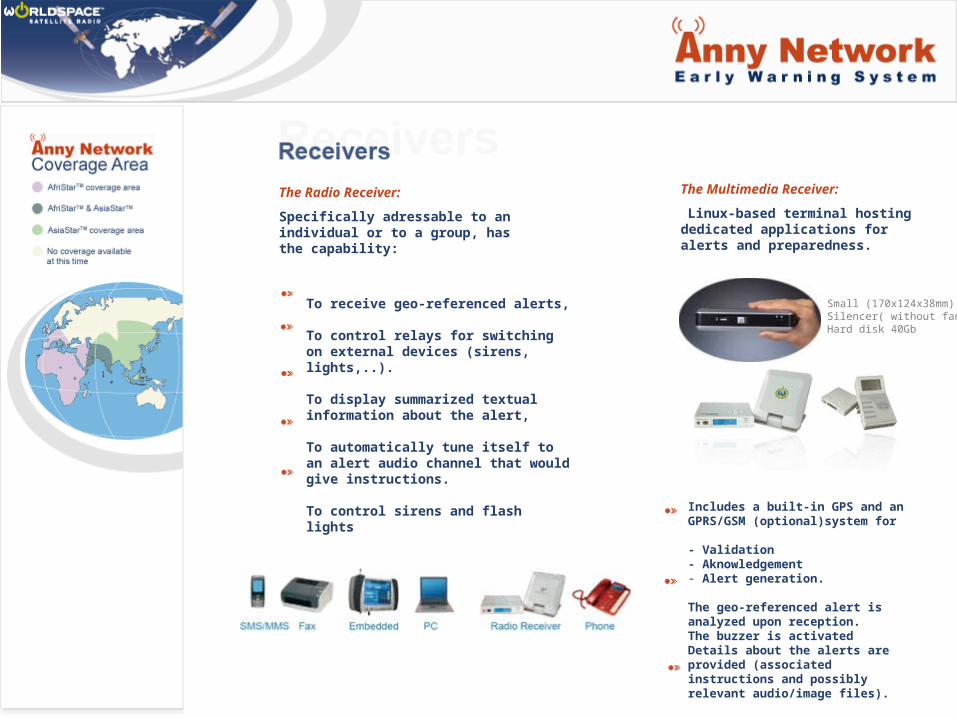
The Radio Receiver:
Specifically adressable to an individual or to a group, has the capability:
To receive geo-referenced alerts,
To control relays for switching on external devices (sirens, lights,..).
To display summarized textual information about the alert,
To automatically tune itself to an alert audio channel that would give instructions.
To control sirens and flash lights
The Multimedia Receiver:
Linux-based terminal hosting dedicated applications for alerts and preparedness.
Includes a built-in GPS and an GPRS/GSM (optional)system for
- Validation - Aknowledgement - Alert generation.
The geo-referenced alert is analyzed upon reception. The buzzer is activated Details about the alerts are provided (associated instructions and possibly relevant audio/image files).
The radio receiver with its mini-antenna
Small (170x124x38mm)Silencer( without fan)Hard disk 40Gb

Audio: How it can be usedAudio: How it can be used
Live/Recorded
Uplink Station
Audio uplink to satelliteSatellite
Transmission to audio receivers
IndividualVillage ClassroomEmergency
Preparedness
Content:
-Locally & regionally relevant-Culturally appropriate-Practical & solution oriented-Balance and accurate/ Non-political

Multimedia: How it can be usedMultimedia: How it can be used
Uplink Station
Internet
Multimedia adapter converts receiver to modem for download of data from satellite to computer
Receiver + MMS Adaptor + computer
Internet-type downloads without an Internet connection
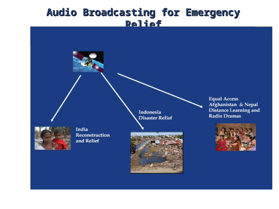
Audio Broadcasting for Emergency ReliefAudio Broadcasting for Emergency Relief

Cyclone Warning System for Fisherman out at SeaCyclone Warning System for Fisherman out at Sea
• Pilot Experiment in west coast of India• 80 boats fitted with WorldSpace reception
- Encased in water proof enclosure- Pretuned to the assigned channel
• Warning messages in MP3 format via Internet to the uplink site
• Boats into the sea up to 200 miles• Valuable experience gained in designing the full
system
WorldSpace Reception on a Fishing BoatWorldSpace Reception on a Fishing Boat

Anny Network is not a substitute to existing solutions.
It can be used as a unique Warning System or as a redundant Warning System linked to other solutions.

– Existing coverage of more than 130 countries.– Reach well beyond traditional communication and broadcast networks.– Least dependence on terrestrial infrastructure.– Rapid roll-out of the system over wide areas.– Geo-referencing and selective addressability.– Easy to use web-interface for alert generation, updates and cancellation.– Built-in authentication and security features.– Low power consumption and possibility of Lufo or solar powering. – Display of the alert’s attributes like : Category, Severity, Urgency and Certainty.– USB interface to an external box for operating a relay for a warning
signal.– Ease of deployment, operation and maintenance.– Expandability and Scalability.
• With CENTRAL GOVERNMENT AGENCIES (e.g., Indian Meteorological Department) who can provide alerts
• With NONGOVERNMENTAL ORGANIZATIONS (e.g., M.S. Swaminathan Foundation) who can provide information for communities’ preparedness
• With STATE AND REGIONAL GOVERNMENT AGENCIES (e.g., Relief Commissioner in Chennai) who can coordinate activities post-disaster
• With UN AGENCIES involved in Emergency communications, humanitarian affairs, preparedness and educational (e.g., ITU, WMO)

Pierre Casadebaig General Manager [email protected]
Pierre Genillon DataCasting Services Manager [email protected]
Jérome Soumagne Chief Technology Officer [email protected]
For more information, visit our web site at : www.annynetwork.comwww.worldspace.fr
WorldSpace France 13, rue Michel Labrousse31100 TOULOUSE FRANCE

Thank youThank you


