
Cavan Local Authority, Road Design Office.
Road Design & Road Safety Issues in Planning Control (Draft)
Guide to ROAD DESIGN & ROAD SAFETY ISSUES
In Planning Control

Cavan Local Authority, Road Design Office.
Road Design & Road Safety Issues in Planning Control (Draft)
PART I REQUIREMENTS WITH RESPECT TO PLANNING APPLICATIONS PART II DESIGN GUIDELINE
Traffic & Transport Assessments + Road Safety Audits
- Reasons for and purpose of Assessments - Thresholds for TTA Levels - Scoping of TTA - CTTS1 - CTTS2
Junction Details
- Junction Types & Issues - Sightlines - Junction Kerb Radii - Gradients - Pedestrian & Cycle Facilities - Dropped Crossings & Tactile Paving - Building Lines - Further Information on junctions
Estate Road Layout Design
- Road Categories - Design Details
- Speed Control within Developments - Lengths of straights - Service Road Gradients - Loops - Turning Areas - Footpaths & Lighting - Crèches - Further Information on Estate Road Layout Design
Access to Developments
Parking
Appendices
References
Cavan Local Authority, Road Design Office.
Road Design & Road Safety Issues in Planning Control (Draft)
FOREWORD
This document is intended for the guidance of private developers, architects and consultants, in the design of housing and other mixed use developments. The document sets out recommended standards and design guidelines in relation to Road Design, which should generally be acceptable to Cavan County Council. The document deals largely with issues of estate layout. It is the objective of the Road Design Department to encourage and promote layouts which seek to ensure low traffic speeds and greater priority for pedestrians and cyclists within housing areas.
Cavan Local Authority, Road Design Office.
Road Design & Road Safety Issues in Planning Control (Draft)
PART I
DESIGN DETAILS REQUIRED WITH RESPECT TO PLANNING
APPLICATIONS

Cavan Local Authority, Road Design Office.
Road Design & Road Safety Issues in Planning Control (Draft)
THE FOLLOWING DETAILS ARE REQUIRED AS PART OF ANY PLANNING APPLICATION TO ALLOW THAT APPLICATION BE ASSESSED FROM A ROAD DESIGN PERSPECTIVE:
Traffic and Transport Assessment, formally Traffic Impact Assessment (TTA /
TIA) at appropriate level scoped with Road Design
Scale of Site Layout Plan to be at 1:500
A Site Layout drawing indicating gradients of service roads
All levels shall be to Ordinance Datum
Longitudinal Sections of all roads within development
Typical cross section of road
Cross section of road and house access where differing from typical
Where the following details are requested by Cavan Local Authority, they
shall be undertaken by specialist Road Design Engineers:
Full Traffic & Transport Assessments
Road Safety Audits
Roundabout Design
Cavan County Council require the CVs of designers
Cavan Local Authority, Road Design Office.
Road Design & Road Safety Issues in Planning Control (Draft)
PART II
DESIGN GUIDELINE

Cavan Local Authority, Road Design Office.
Road Design & Road Safety Issues in Planning Control (Draft)
NOTE: THIS DOCUMENT DOES NOT CONTAIN STANDARDS OR TECHNICAL
SPECIFICATIONS FOR ROAD CONSTRUCTION. DESIGNERS ARE ADVISED TO
REFER TO “RECOMMENDATIONS FOR SITE DEVELOPMENT WORKS FOR
HOUSING AREAS” AND IRL, “DMRB” FOR GUIDANCE IN RELATION TO SAME.

Cavan Local Authority, Road Design Office.
Road Design & Road Safety Issues in Planning Control (Draft)
TRAFFIC AND TRANSPORT ASSESSMENTS & ROAD SAFETY
AUDITS
REASONS FOR ASSESSMENTS “1.1.1 All new developments will generate trips on the existing transport network, either by car, commercial vehicle, cycling, walking or public transport. Many of these proposed developments are of a size or type that would generate significant additional levels of trip-making on adjoining transport infrastructure. In certain circumstances this additional demand may necessitate changes to be made to the road layout. 1.1.2 It is essential that the developer or promoter should provide a full and detailed assessment of how the trips to and from the development might affect the road transport network. 1.1.3 A Traffic and Transport Assessment should be an impartial description of the impacts of the proposed development and should outline both its positive and negative aspects. The assessment should not be a promotional exercise undertaken on behalf of the scheme promoter.” (Traffic and Transport Assessment Guidelines, National Roads Authority) PURPOSE OF ASSESSMENTS FOR CAVAN COUNTY COUNCIL There are 3 Levels of TIA / TTA depending on extent of development (see thresholds) namely CTTS 1, CTTS 2 and full TTAs. These are used to determine:-
The capability of the roads network to accommodate the proposed development and to determine if the development is acceptable in travel / traffic terms.
The need for lighting, footpaths, widening, Right Turning Lanes,
Junction Improvement, Road Strengthening.
Apportionment of contribution warranted for infrastructure to service the proposed development.
FURTHER INFORMATION ON ASSESSMENTS For detailed descriptions of use, scope, purpose, process and implemtation of traffic impact assessments and transport assessments see: Traffic and Transport Assessment Guidelines, National Roads Authority Guide to Transport Assessment in Scotland, The Scottish Executive. Transport Assessment Guidelines for Development Proposals in Northern Ireland Traffic Impact Assessment Guidelines, Institution of Highways and Transportation (IHT)
Cavan Local Authority, Road Design Office.
Road Design & Road Safety Issues in Planning Control (Draft)
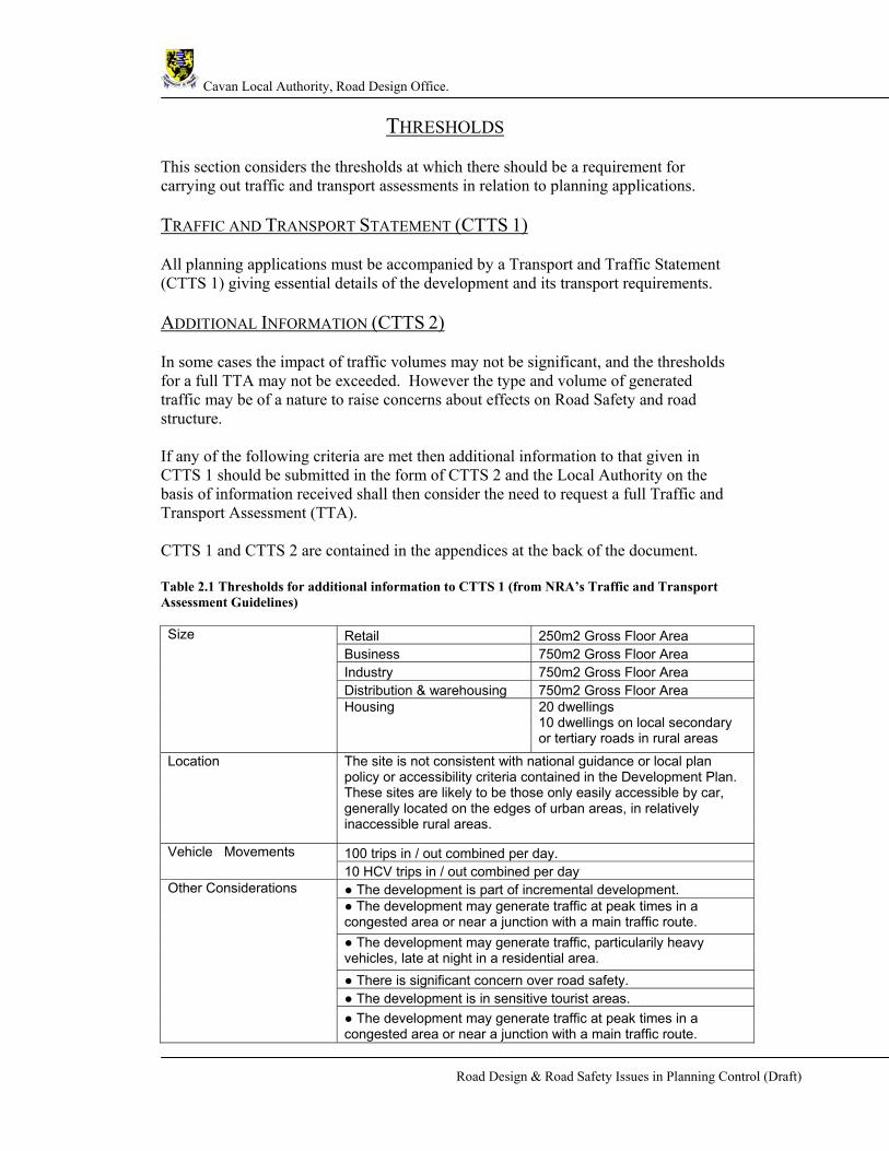
THRESHOLDS
This section considers the thresholds at which there should be a requirement for carrying out traffic and transport assessments in relation to planning applications. TRAFFIC AND TRANSPORT STATEMENT (CTTS 1) All planning applications must be accompanied by a Transport and Traffic Statement (CTTS 1) giving essential details of the development and its transport requirements. ADDITIONAL INFORMATION (CTTS 2) In some cases the impact of traffic volumes may not be significant, and the thresholds for a full TTA may not be exceeded. However the type and volume of generated traffic may be of a nature to raise concerns about effects on Road Safety and road structure. If any of the following criteria are met then additional information to that given in CTTS 1 should be submitted in the form of CTTS 2 and the Local Authority on the basis of information received shall then consider the need to request a full Traffic and Transport Assessment (TTA). CTTS 1 and CTTS 2 are contained in the appendices at the back of the document. Table 2.1 Thresholds for additional information to CTTS 1 (from NRA’s Traffic and Transport Assessment Guidelines)
Retail 250m2 Gross Floor Area Business 750m2 Gross Floor Area Industry 750m2 Gross Floor Area Distribution & warehousing 750m2 Gross Floor Area
Size
Housing 20 dwellings 10 dwellings on local secondary or tertiary roads in rural areas
Location The site is not consistent with national guidance or local plan policy or accessibility criteria contained in the Development Plan. These sites are likely to be those only easily accessible by car, generally located on the edges of urban areas, in relatively inaccessible rural areas.
100 trips in / out combined per day. Vehicle Movements 10 HCV trips in / out combined per day ● The development is part of incremental development. ● The development may generate traffic at peak times in a congested area or near a junction with a main traffic route. ● The development may generate traffic, particularily heavy vehicles, late at night in a residential area. ● There is significant concern over road safety. ● The development is in sensitive tourist areas.
Other Considerations
● The development may generate traffic at peak times in a congested area or near a junction with a main traffic route.

Cavan Local Authority, Road Design Office.
Road Design & Road Safety Issues in Planning Control (Draft)
COMPLETE TRAFFIC AND TRANSPORT ASSESSMENT Applications that exceed any of the following thresholds will be required to produce full TTAs, in addition to completing the CTTS 2 form. The CTTS 2 should summarise the findings of the TTA and describe the mitigating measures proposed by the developer or agent. Table 2.2 Thresholds for full Traffic and Transport Assessments (from NRA’s Traffic and Transport Assessment Guidelines)
SCOPING OF TRAFFIC AND TRANSPORT ASSESSMENT A scoping study should be carried out prior to the preparation of a TTA. The agent or developer should liaise with Cavan County Council, Road Design Department so as to:
Agree the approach to and extent of the TTA. Gather background information. Agree the main problems / issues to be addressed in the TTA.
CONTENTS OF THE SCOPING STUDY INCLUDE:
Size and description of development Description of existing land use Details of extra data to be collected – particularly traffic surveys Sources of information for travel / traffic generation (including modal split) Geographic area of analysis (extent) Proposed years of assessment Key junctions and links accesses to be investigated – requires traffic modelling Sustainable transport / development plan issues Summary of discussion between applicant and Road Design Office / Planning
Authority Main issues to tackle.

Cavan Local Authority, Road Design Office.
Road Design & Road Safety Issues in Planning Control (Draft)
ROAD SAFETY AUDITS
WHAT IS A ROAD SAFETY AUDIT A Road Safety Audit is a process for checking the safety of new schemes on
roads. Audits are carried out:-
Systematically
based on sound safety principles
from the road users’ point of view
AIMS OF ROAD SAFETY AUDIT To ensure all highway schemes operate as safely as practicable
To minimize accident numbers and severity
To consider the safety of all road users – particularly vulnerable road users
To improve the awareness of safe design practices by design, construction and
maintenance staff.
WHAT TO AUDIT Road Safety Audits are mandatory for all planning applications on National
Roads (HD19/00)
On Local Roads Safety Audits are recommended as good practice for all
planning applications and are mandatory for applications in excess of 50
dwellings or other developments of similar traffic types and/or volumes or as
deemed necessary by Cavan County Council in the interests of traffic safety.
WHEN TO AUDIT Feasibility stage – may include a comparative assessment of options
Stage 1 – completion of preliminary design
Stage 2 – completion of detailed design
Stage 1/2 combined for minor schemes
Stage 3 – completion of construction / prior to opening to traffic
Monitoring after 1 and 3 years

Cavan Local Authority, Road Design Office.
Road Design & Road Safety Issues in Planning Control (Draft)
WHO SHOULD CARRY OUT AUDITS? Members of the Road Safety Audit team shall be NRA approved and the Audit
Team shall be approved by Cavan County Council – training and experience
required
Safety engineering expertise needed
Independent of the design team
At least two people – three people on large schemes
WHAT IS LOOKED FOR? Mistakes – checklists
How all road users cope at all times and in all conditions – road user role play
Interaction between design elements
Departures from standards
Opportunities to include accident-reducing elements
FORMAT OF SAFETY AUDIT REPORT List audit team members and others involved
List safety issues – problem followed by recommendation stating the safety
problem as clearly as possible
List all plans and other information examined
Sign and date the report
Cavan Local Authority, Road Design Office.
Road Design & Road Safety Issues in Planning Control (Draft)
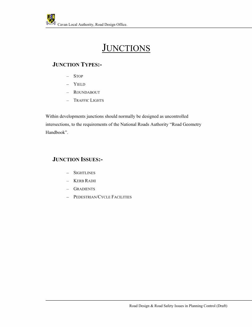
JUNCTIONS JUNCTION TYPES:-
– STOP
– YIELD
– ROUNDABOUT
– TRAFFIC LIGHTS
Within developments junctions should normally be designed as uncontrolled
intersections, to the requirements of the National Roads Authority “Road Geometry
Handbook”.
JUNCTION ISSUES:-
– SIGHTLINES
– KERB RADII
– GRADIENTS
– PEDESTRIAN/CYCLE FACILITIES

Cavan Local Authority, Road Design Office.
Road Design & Road Safety Issues in Planning Control (Draft)
JUNCTION SIGHTLINES
• SIGHTLINES TO STANDARDS SET OUT IN DMRB IN ACCORDANCE WITH NRA TD
42/95 FOR MAJOR/MINOR PRIORITY JUNCTIONS. (SEE FIGURES FOR MINIMUM
REQUIREMENTS TAKEN FROM ABOVE NAMED PUBLICATION.)
Required sight distances may differ for each individual road.
Sightlines shall be calculated on the basis of the speed limit of the road
except in circumstances where the 85th Percentile Speed of vehicles on
the stretch of road appears to be in excess of that speed limit.
Local Authority to require speed measurements in places where actual
speeds are considered high – at Further Information stage developer
will be requested to carry out study using an automated device for
speed measurement.
In these circumstances the sightline shall cover the equivalent distance
for the 85th Percentile Speed. If sightlines are not achieved the
applicant will be requested to acquire land to provide at F.I. stage or
alternatively will be required to submit a Road Safety Audit of the
junction to be carried out by an NRA approved Road Safety Auditor.
The recommendations of the audit shall be implemented in full by the
developer.
Note: Where the 85th percentile speed on lightly trafficked local roads
is significantly below the speed limit, reduced sight lines proportionate
to the 85th percentile speed may be considered.

Cavan Local Authority, Road Design Office.
Road Design & Road Safety Issues in Planning Control (Draft)
Cavan Local Authority, Road Design Office.
Road Design & Road Safety Issues in Planning Control (Draft)
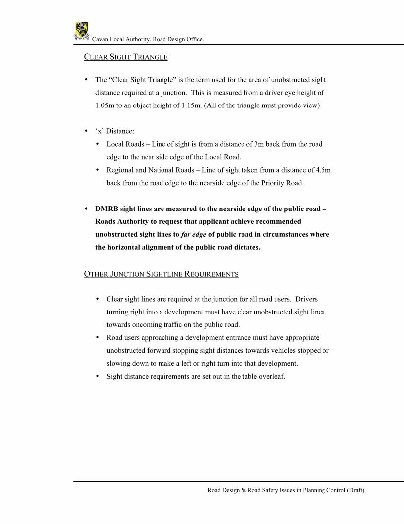
CLEAR SIGHT TRIANGLE
• The “Clear Sight Triangle” is the term used for the area of unobstructed sight
distance required at a junction. This is measured from a driver eye height of
1.05m to an object height of 1.15m. (All of the triangle must provide view)
• ‘x’ Distance:
• Local Roads – Line of sight is from a distance of 3m back from the road
edge to the near side edge of the Local Road.
• Regional and National Roads – Line of sight taken from a distance of 4.5m
back from the road edge to the nearside edge of the Priority Road.
• DMRB sight lines are measured to the nearside edge of the public road –
Roads Authority to request that applicant achieve recommended
unobstructed sight lines to far edge of public road in circumstances where
the horizontal alignment of the public road dictates.
OTHER JUNCTION SIGHTLINE REQUIREMENTS
• Clear sight lines are required at the junction for all road users. Drivers
turning right into a development must have clear unobstructed sight lines
towards oncoming traffic on the public road.
• Road users approaching a development entrance must have appropriate
unobstructed forward stopping sight distances towards vehicles stopped or
slowing down to make a left or right turn into that development.
• Sight distance requirements are set out in the table overleaf.
Cavan Local Authority, Road Design Office.
Road Design & Road Safety Issues in Planning Control (Draft)
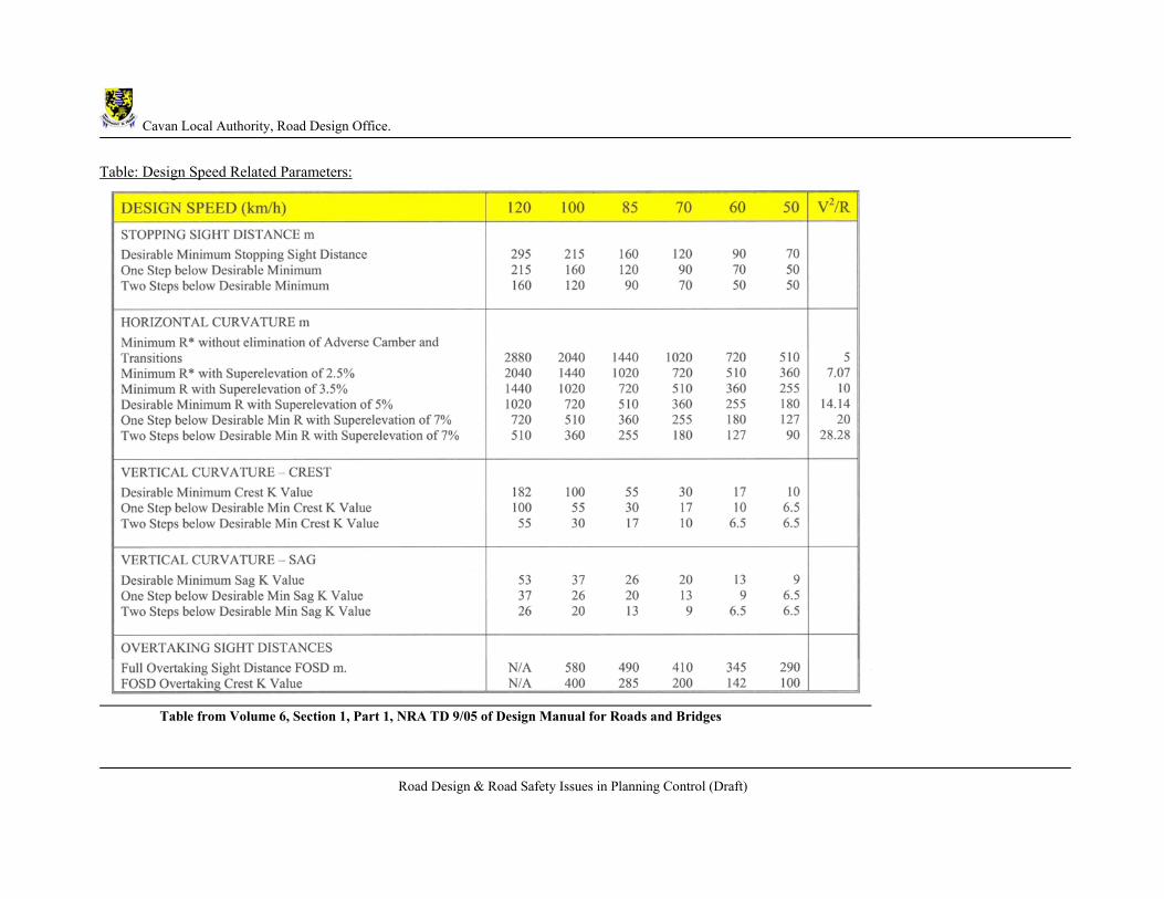
Table: Design Speed Related Parameters:
Table from Volume 6, Section 1, Part 1, NRA TD 9/05 of Design Manual for Roads and Bridges

Cavan Local Authority, Road Design Office.
Road Design & Road Safety Issues in Planning Control (Draft)
JUNCTION KERB RADII
• Kerb radii will be determined by the type of the development i.e. Residential
or Industrial.
• For residential developments kerb radii should be designed to accommodate
car traffic. Keeping entrance and exit kerb radii to a minimum will slow down
the traffic entering and leaving the estate. Typically residential kerb radii
should be 6m. (Furniture removal lorries and refuse trucks are occasional
traffic and should not drive the design).
• For other developments radii at junctions should typically be:-
10.5m exit onto Regional, National & other Major roads
10.5m entrance from Regional, National & other Major roads
JUNCTION GRADIENTS
• At junctions, the gradients of the proposed service road should not be greater
than 2% (1 in 50) for a distance of 7m and not greater than 5% (1 in 20) for the
remainder of the first 20m.

Cavan Local Authority, Road Design Office.
Road Design & Road Safety Issues in Planning Control (Draft)
PEDESTRIAN / CYCLE FACILITIES
• The layout and design of junctions should always take into consideration the
safety of pedestrians crossing the junction as well as the requirements for
cyclists negotiating the junction.
• Footpaths and Public Lighting are always essential.
Lighting shall be designed to standard and must be provided on all
footpaths.
In an urban environment footpaths should be on both sides of the
public road.
On Distributor, Major Access and Strategic Link Roads footpaths to be
2.5m – 3.0m wide.
Other Roads:
2.0m wide standard
1.5m may be acceptable for short sections as agreed with RDO.
1.2m minimum width (at pinch points)
Cavan Local Authority, Road Design Office.
Road Design & Road Safety Issues in Planning Control (Draft)
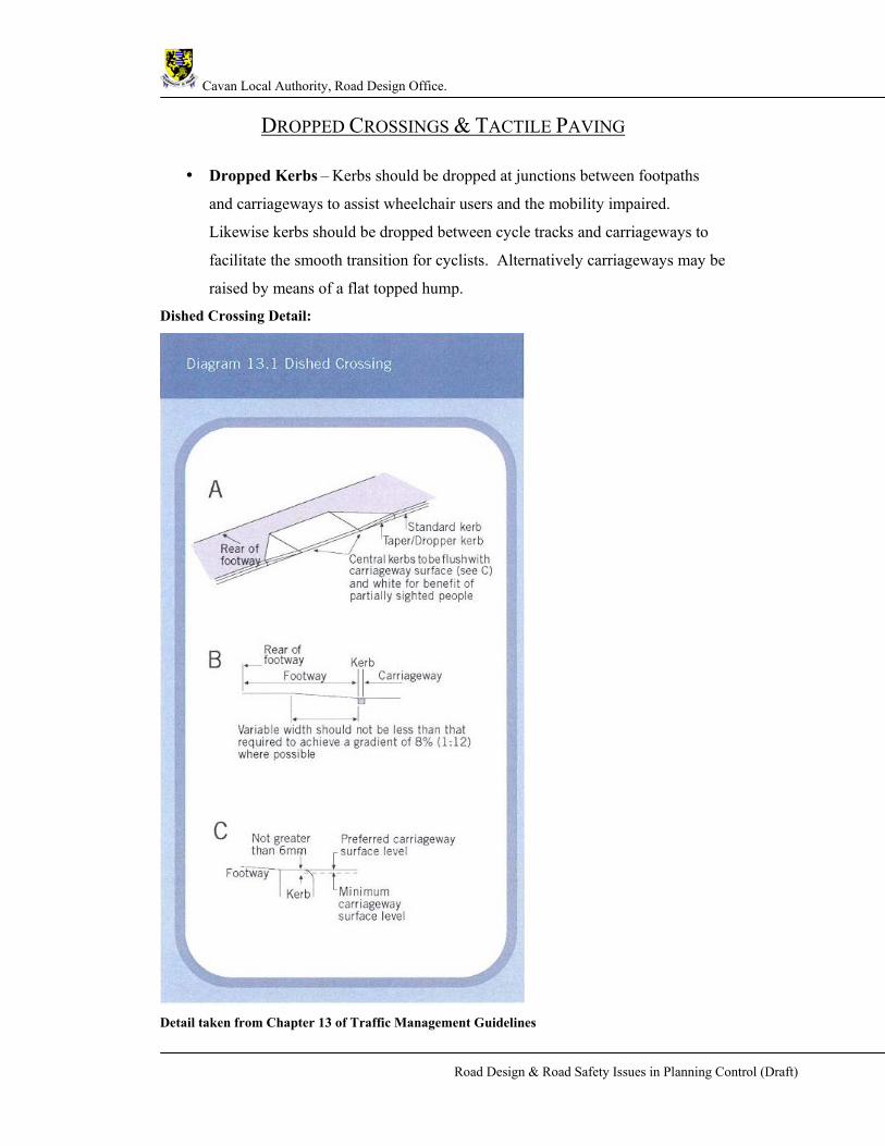
DROPPED CROSSINGS & TACTILE PAVING
• Dropped Kerbs – Kerbs should be dropped at junctions between footpaths
and carriageways to assist wheelchair users and the mobility impaired.
Likewise kerbs should be dropped between cycle tracks and carriageways to
facilitate the smooth transition for cyclists. Alternatively carriageways may be
raised by means of a flat topped hump.
Dished Crossing Detail:
Detail taken from Chapter 13 of Traffic Management Guidelines

Cavan Local Authority, Road Design Office.
Road Design & Road Safety Issues in Planning Control (Draft)
• Tactile Paving –
Where footways are being constructed, repaired or renewed,
consideration should be given to the provision of appropriate tactile
paving surfaces particularly at junctions and crossing locations along
pedestrian desire lines to provide information to visually impaired.
Tactile paving should be laid so as the blisters direct the pedestrians.
Controlled crossings – red tactile paving shall be used and shall be laid
in an “L” shape. For Inset Controlled Crossings the stem of the L shall
extend back to the building line. (For details see “Guidance on the use
of tactile paving surfaces”)
Uncontrolled crossings – buff / grey coloured tactile paving shall be
used and shall be laid with no “stems” Table 13.1 below is taken from the “Traffic Management Guidelines” DoT, DOELG, DTO
Examples of dropped kerbing and tactile paving are shown on the following pages.
For further information on tactile paving see:
“Guidance on the Use of Tactile Paving Surfaces.”, DFT
“Traffic Management Guidelines”, Department Of Transport
“Inclusive Mobility”, The Department for Transport

Cavan Local Authority, Road Design Office.
Road Design & Road Safety Issues in Planning Control (Draft)
Indented uncontrolled crossing point at a side road Layout at in-line uncontrolled crossing Uncontrolled crossing away from junction Figures take from “Guidance on the Use of Tactile Paving Surfaces.”, DFT
Cavan Local Authority, Road Design Office.
Road Design & Road Safety Issues in Planning Control (Draft)
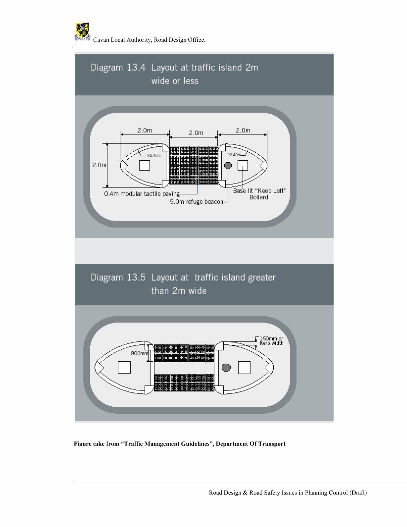
Figure take from “Traffic Management Guidelines”, Department Of Transport

Cavan Local Authority, Road Design Office.
Road Design & Road Safety Issues in Planning Control (Draft)
Tactile Paving Crossing Detail:

Cavan Local Authority, Road Design Office.
Road Design & Road Safety Issues in Planning Control (Draft)
Tactile Paving Crossing Detail:

Cavan Local Authority, Road Design Office.
Road Design & Road Safety Issues in Planning Control (Draft)
BUILDING LINES
• Ensure building lines are the correct distance from the public road.
Building lines from the centre line of public road:-
National Road 40m
Regional Roads 30m
Other Roads 20m
FURTHER INFORMATION ON JUNCTION REQUIREMENTS • Type of junction and level of Access Design required (i.e. Need for Right
Turning Lane, Roundabout, Road Widening etc.) will be driven in many cases
by the results of the TTA data.
• Stop junction to be taken as default unless otherwise indicated.
• Yield junctions will be acceptable at locations within developments where
traffic volumes and speeds are low.
• When analysing junctions all possible movements must be considered.
Where vehicles turning into a development come from both directions
there are at least 6 possible impacts at the junction.
• No internal access road junction shall be closer than 20m to the service road
junction with the public road. See diagram below. Note: This distance may
increase depending on the traffic volumes using the internal access road.
• Driveway accesses shall not be located at the bellmouth of a junction, nor shall
they be located within twice the kerb radius on minor arms of a junction.

Cavan Local Authority, Road Design Office.
Road Design & Road Safety Issues in Planning Control (Draft)
ESTATE ROAD LAYOUT DESIGN
APPROPRIATE ESTATE ROAD LAYOUT DESIGN SHOULD AIM TO:- Create a safe, secure and pleasant environment for people to live in.
Minimize conflict between road users.
Minimise the intrusion of vehicle traffic.
Keep vehicle speeds low.
Ensure ease of access for the emergency services.
Encourage walking, cycling and sustainability.
AREAS OF CONSIDERATION
ROAD CATEGORIES - 50KPH roads, 30kph roads, Cul de Sacs
(Access roads within developments should be designed so as to restrain vehicle
speeds to a 30kph target maximum speed or lower.)
DESIGN DETAILS – Speed Control & Calming Details, Gradients, Max/Min
Kerb Radii, Stopping Sight Distance, Lengths of Straights, Turning Heads, Loops,
Footpaths & Pedestrian facilities.
PARKING PROVISION – On-Site, Lay-bys, Pedestrian Areas.
Cavan Local Authority, Road Design Office.
Road Design & Road Safety Issues in Planning Control (Draft)
ROAD CATEGORIES
(50KPH ROADS, 30KPH ROADS, CUL DE SACS.) There are 2 main categories of Housing Estate Roads:-
30 Kph – will be the most predominant service road type. These roads
must be appropriately designed and traffic calmed. (Access roads within
developments should be designed so as to restrain vehicle speeds to a
30kph target maximum speed or lower.)
50 kph – may be appropriate for some spine roads which have minimal
dwelling accesses onto the stretch of road being considered.
CARRIAGEWAY WIDTHS
Shall be designed to take into account expected volumes and speeds of
vehicular traffic
Wide enough to ensure ease of access for all emergency service vehicles
with expected parking.
Narrow enough to encourage slow speeds.
Service roads shall generally be a minimum of 6m wide with 2 no. 2m
wide footpaths, assuming there is adequate provision for off-street parking.
Where Lay-bys, indented or off-street parking is provided kerb to kerb
road widths may be reduced to 5.0 metres where there a small number of
dwellings being served by the stretch of road being considered. (Designs
incorporating road widths narrower than 6m shall be agreed with Road
Design)
The minimum width for a shared surface is 6m. All details relating to the
design of shared surfaces shall be agreed with Road Design.
Cavan Local Authority, Road Design Office.
Road Design & Road Safety Issues in Planning Control (Draft)
DESIGN DETAILS The design of new residential layouts should avoid features that promote speed
and safety problems such as:
Wide Roads
Straights or long sweeping curves
Unnecessarily large junction corner radii
Large visibility splays
SPEED CONTROL WITHIN DEVELOPMENTS
Access roads within developments should be designed so as to restrain vehicle
speeds to a 30kph target maximum speed or lower.
The preferred method of speed restraint is through the appropriate horizontal
alignment design of the service road. The design of new residential roads
should be such that there is no necessity for the retrofitting of vertical traffic
calming at a later stage.
In certain circumstances it may be acceptable to use vertical measures to
restrain vehicle speeds but these will be the exception and details of any
vertical calming proposals shall be agreed with Road Design and will be in
accordance with the “Traffic Management Guidelines”.
LENGTHS OF STRAIGHTS
Lengths of straights should be only so long that the vehicle user has a
maximum sight distance of 70m
Buildings should be used to reinforce the impression of low speed i.e. sited in
the drivers line of sight at the change of direction
Twisting alignments and tighter kerb radii will reduce visibility and thus
reduce speeds.
Cavan Local Authority, Road Design Office.
Road Design & Road Safety Issues in Planning Control (Draft)
GRADIENTS
• Desirable gradients for footpaths and service roads within residential
developments should lie between 0.5% (1 in 200) and 5% (1 in 20). Extreme
gradients of 8.3% (1 in 12) may be acceptable, but should be used moderately
and for short lengths. They should be integrated into the design and there
should be no sharp changes in gradient.
• Exceptions may be considered only in situations where the design includes
adequate provision for pedestrians and cyclists (Road & Social?)
LOOPS
• Loops – Service road loops are not desirable within housing developments
where there is a danger of creating a “racing circuit” effect. The service road
should terminate with a turning area that complies with “Recommendations
for site development works for Housing Areas”
• A Dual Access is acceptable and is encouraged for larger developments and
where the layout is appropriate. It is also dependant on the volume of
generated traffic generated by the development. (N.B. It is essential that the
provision of a second access does not create a layout which may be conducive
to rat running - need for a dual access must be agreed with Road Design)
TURNING AREAS
• No turning area is required if the distance from a junction or alternative
turning facility is less than 30m i.e. Cul de Sacs off 30kph roads.
• ALTERNATIVELY:–
– 6m radius circle or equivalent from 30 kph road off an estate road.
– 9m radius circle or equivalent from other roads.
– Alternative turning areas to comply with “Recommendations for Site
Development Works for Housing Areas”

Cavan Local Authority, Road Design Office.
Road Design & Road Safety Issues in Planning Control (Draft)
Cavan Local Authority, Road Design Office.
Road Design & Road Safety Issues in Planning Control (Draft)
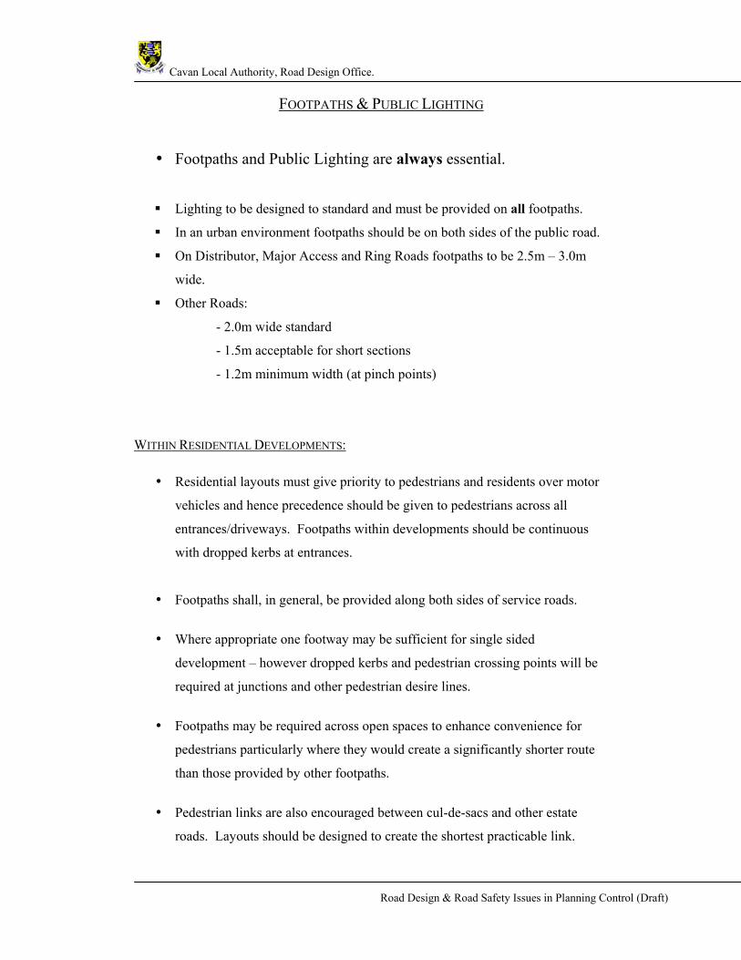
FOOTPATHS & PUBLIC LIGHTING
• Footpaths and Public Lighting are always essential.
Lighting to be designed to standard and must be provided on all footpaths.
In an urban environment footpaths should be on both sides of the public road.
On Distributor, Major Access and Ring Roads footpaths to be 2.5m – 3.0m
wide.
Other Roads:
- 2.0m wide standard
- 1.5m acceptable for short sections
- 1.2m minimum width (at pinch points)
WITHIN RESIDENTIAL DEVELOPMENTS:
• Residential layouts must give priority to pedestrians and residents over motor
vehicles and hence precedence should be given to pedestrians across all
entrances/driveways. Footpaths within developments should be continuous
with dropped kerbs at entrances.
• Footpaths shall, in general, be provided along both sides of service roads.
• Where appropriate one footway may be sufficient for single sided
development – however dropped kerbs and pedestrian crossing points will be
required at junctions and other pedestrian desire lines.
• Footpaths may be required across open spaces to enhance convenience for
pedestrians particularly where they would create a significantly shorter route
than those provided by other footpaths.
• Pedestrian links are also encouraged between cul-de-sacs and other estate
roads. Layouts should be designed to create the shortest practicable link.

Cavan Local Authority, Road Design Office.
Road Design & Road Safety Issues in Planning Control (Draft)
CRÈCHES • Shall be located as near to the development’s entrance as practicable to avoid
the additional traffic that it will generate travelling through the estate.
• A drop off area shall be provided on the crèche site.
• Appropriate staff parking shall be provided i.e. 1 parking space per staff
member
• Vehicular entrance shall be a maximum width of 6m with 6m radii curves.
Cavan Local Authority, Road Design Office.
Road Design & Road Safety Issues in Planning Control (Draft)
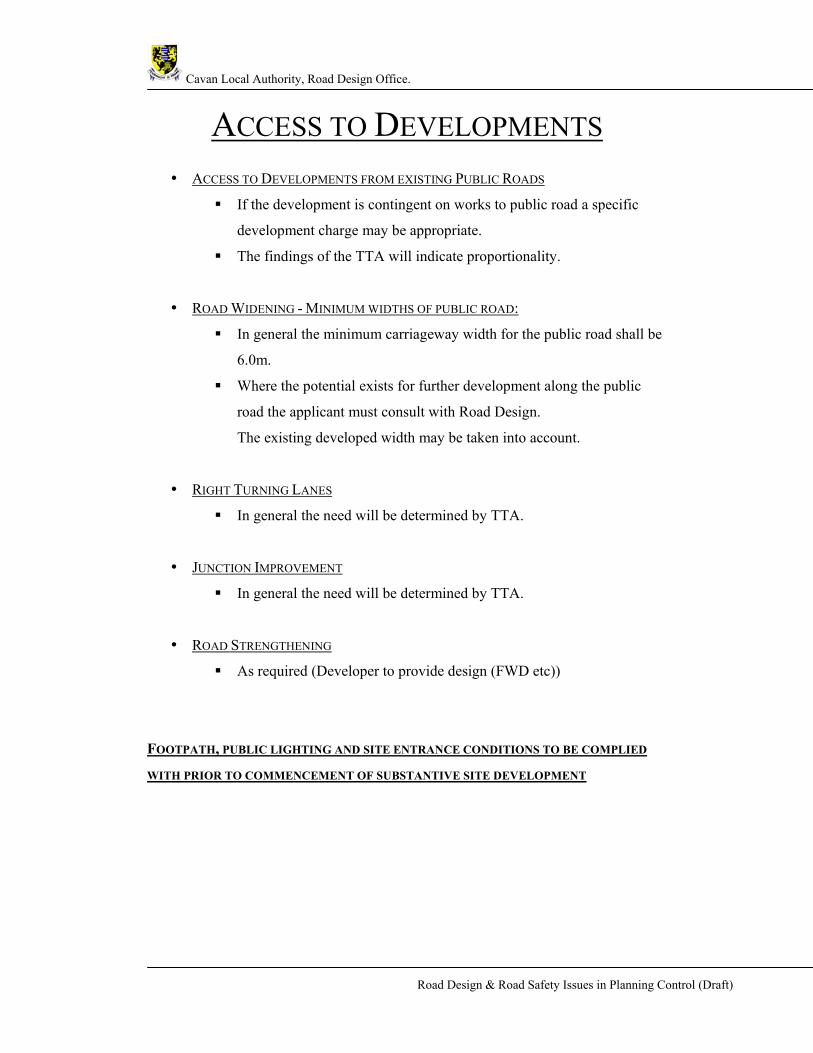
ACCESS TO DEVELOPMENTS
• ACCESS TO DEVELOPMENTS FROM EXISTING PUBLIC ROADS
If the development is contingent on works to public road a specific
development charge may be appropriate.
The findings of the TTA will indicate proportionality.
• ROAD WIDENING - MINIMUM WIDTHS OF PUBLIC ROAD:
In general the minimum carriageway width for the public road shall be
6.0m.
Where the potential exists for further development along the public
road the applicant must consult with Road Design.
The existing developed width may be taken into account.
• RIGHT TURNING LANES
In general the need will be determined by TTA.
• JUNCTION IMPROVEMENT
In general the need will be determined by TTA.
• ROAD STRENGTHENING
As required (Developer to provide design (FWD etc))
FOOTPATH, PUBLIC LIGHTING AND SITE ENTRANCE CONDITIONS TO BE COMPLIED
WITH PRIOR TO COMMENCEMENT OF SUBSTANTIVE SITE DEVELOPMENT
Cavan Local Authority, Road Design Office.
Road Design & Road Safety Issues in Planning Control (Draft)
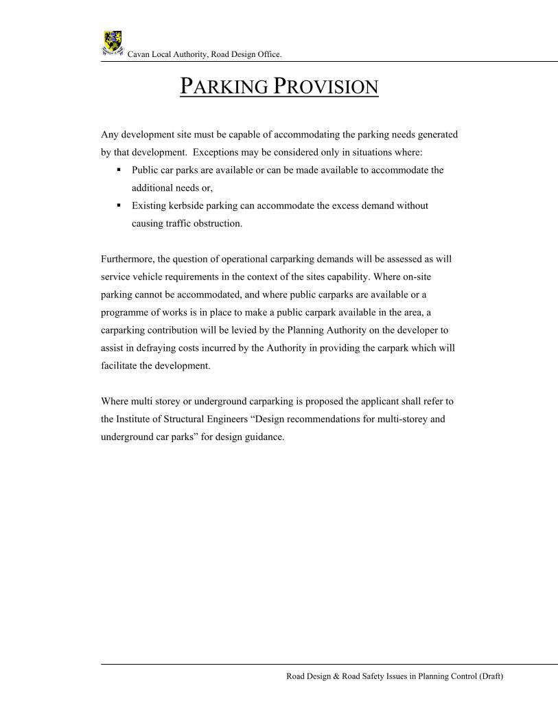
PARKING PROVISION
Any development site must be capable of accommodating the parking needs generated
by that development. Exceptions may be considered only in situations where:
Public car parks are available or can be made available to accommodate the
additional needs or,
Existing kerbside parking can accommodate the excess demand without
causing traffic obstruction.
Furthermore, the question of operational carparking demands will be assessed as will
service vehicle requirements in the context of the sites capability. Where on-site
parking cannot be accommodated, and where public carparks are available or a
programme of works is in place to make a public carpark available in the area, a
carparking contribution will be levied by the Planning Authority on the developer to
assist in defraying costs incurred by the Authority in providing the carpark which will
facilitate the development.
Where multi storey or underground carparking is proposed the applicant shall refer to
the Institute of Structural Engineers “Design recommendations for multi-storey and
underground car parks” for design guidance.

Cavan Local Authority, Road Design Office.
Road Design & Road Safety Issues in Planning Control (Draft)
PARKING RECOMMENDATIONS FOR RESIDENTIAL DEVELOPMENTS • A minimum of 2 parking spaces are required within each site boundary or
communal designed parking areas allowing for manoeuvrability and easy
access. Communal parking spaces shall be close to and within sight of the
dwellings they are intended to serve.
• A minimum of 1 parking space per 4 dwellings shall be provided within the
development for visitor parking. Parking areas shall allow for
manoeuvrability and easy access.
• Driveways shall be designed so not to encourage overspill parking onto the
footpath.
• Parking (both parallel & perpendicular for 30kph designed roads) is acceptable
at open spaces however the applicant must provide safe crossing locations for
pedestrians.
• For apartment developments a minimum of 1.5 parking spaces are required per
apartment.

Cavan Local Authority, Road Design Office.
Road Design & Road Safety Issues in Planning Control (Draft)
County Car Parking Requirements Type Development Car Parking
Standard Cycle Parking Standard
Residential 2 spaces within boundaries of dwelling
To be agreed
Apartments 1 per unit 1 per 10 units Mobile Home 1 per unit 1 per 10 units Student Accommodation 1 per 6 beds 1 per unit Shop/Retail Units 1 per 20sqm retail
floorspace 1 per 100sqm retail floor space
Shopping Centres >1,000sqm
Individually assessed Individually assessed
Supermarkets 1 per 20sqm retail floorspace
1 per 100sqm retail floorspace
Retail Warehousing/Cash and Carry
1 per 40sqm floorspace
1 per 150sqm floorspace
Garden Centres 1 per 30sqm floorspace
1 per 150sqm floorspace
Car Showrooms 1 per 150sqm gross floorspace
N/A
Factory Retail 1 per 40sqm floorspace
1 per 150sqm floorspace
Public Houses 1 per 5sqm public floorspace
1 per 150sqm floorspace
Restaurants 1 per 10sqm dining space
1 per 100sqm floorspace
Café 1 per 7sqm dining space
1 per 100sqm
Take Aways 3 per take away 1 per 100sqm floorspace Offices, Financial and Professional Services (including banks, other agencies, betting shops)
1 per 25sqm gross floorspace
1 per 100sqm gross floorspace
Manufacturing, Industrial/Light Industrial
1 per 40sqm working floorspace
1 per 500sqm gross floorspace
Garage (service) 1 per 300sqm working space
N/A
Warehouse 1 per 75sqm gross floorspace
1 per 500sqm gross floorspace
Conference Centres 1 per 50sqm public area
To be agreed
Surgeries, Clinics and Group Medical Practices
2 spaces per Public Consulting Room
1 per Consulting Room
Guesthouses/Hotels 1 per Bedroom 1 per 20 beds Hostels 1 per 2 bedrooms 1 per 10 beds
Cavan Local Authority, Road Design Office.
Road Design & Road Safety Issues in Planning Control (Draft)
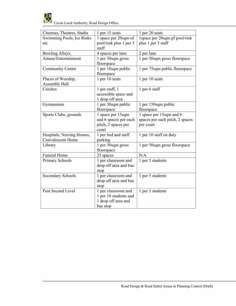
Cinemas, Theatres, Stadia 1 per 15 seats 1 per 20 seats Swimming Pools, Ice Rinks etc
1 space per 20sqm of pool/rink plus 1 per 3 staff
1space per 20sqm pf pool/rink plus 1 per 3 staff
Bowling Alleys, 4 spaces per lane 2 per lane Amuse/Entertainment 1 per 30sqm gross
floorspace 1 per 50sqm gross floorspace
Community Centre 1 per 10sqm public floorspace
1 per 75sqm public floorspace
Places of Worship, Assembly Hall
1 per 10 seats 1 per 10 seats
Crèches 1 per staff, 1 accessible space and 1 drop off area
1 per 6 staff
Gymnasium 1 per 30sqm public floorspace
1 per 150sqm public floorspace
Sports Clubs, grounds 1 space per 15sqm and 6 spaces per each pitch, 2 spaces per court
1 space per 15sqm and 6 spaces per each pitch, 2 spaces per court
Hospitals, Nursing Homes, Convalescent Home
1 per bed and staff parking
1 per 10 staff on duty
Library 1 per 30sqm gross floorspace
1 per 50sqm gross floorspace
Funeral Home 25 spaces N/A Primary Schools 1 per classroom and
drop off area and bus stop
1 per 5 students
Secondary Schools 1 per classroom and drop off area and bus stop
1 per 5 students
Post Second Level 1 per classroom and 1 per 10 students and 1 drop off area and bus stop
1 per 3 students

Cavan Local Authority, Road Design Office.
Road Design & Road Safety Issues in Planning Control (Draft)
APPENDICES
Appendix A – CTTS 1 Form
Appendix B – CTTS 2 Form

Cavan Local Authority, Road Design Office.
Road Design & Road Safety Issues in Planning Control (Draft)

Cavan Local Authority, Road Design Office.
Road Design & Road Safety Issues in Planning Control (Draft)
Planning Reference No.
1 Applicant Details: Name Phone Address Fax Email 2 Development Details: Description of proposed development
On which road(s) does site have frontage? (Provide road no.) N / R / L ……………… 3 Single Dwelling House Is the proposed development only a single dwelling house construction or extension? Yes / No Complete Section 4 if answer to section 3 is “No”. 4 Traffic and Transport Impacts What is the size of the proposed development? (m2 or no. of units) How many trips will be made per day to the site? Car driver Pedestrian Bus / Tram Car passenger Cyclist Rail HGV(indicate type / size) Taxi Total Will traffic to / from the development be more than 10% of existing traffic on the adjoining road (5% in the case of an already congested road)?
Yes / No
Is a new or modified access to the site needed to join the existing road network? Yes / No What changes to the existing roads layout are required as a result of this development?
Is there existing public transport access to the site? Describe.
What specific public transport provision is to be made as part of the development e.g. school minibus?
What specific provision is to be made for pedestrians / cyclists as part of the development?
CTTS 1 TRAFFIC AND TRANSPORT STATEMENT To be completed for all planning applications
Cavan Local Authority, Road Design Office.
Road Design & Road Safety Issues in Planning Control (Draft)
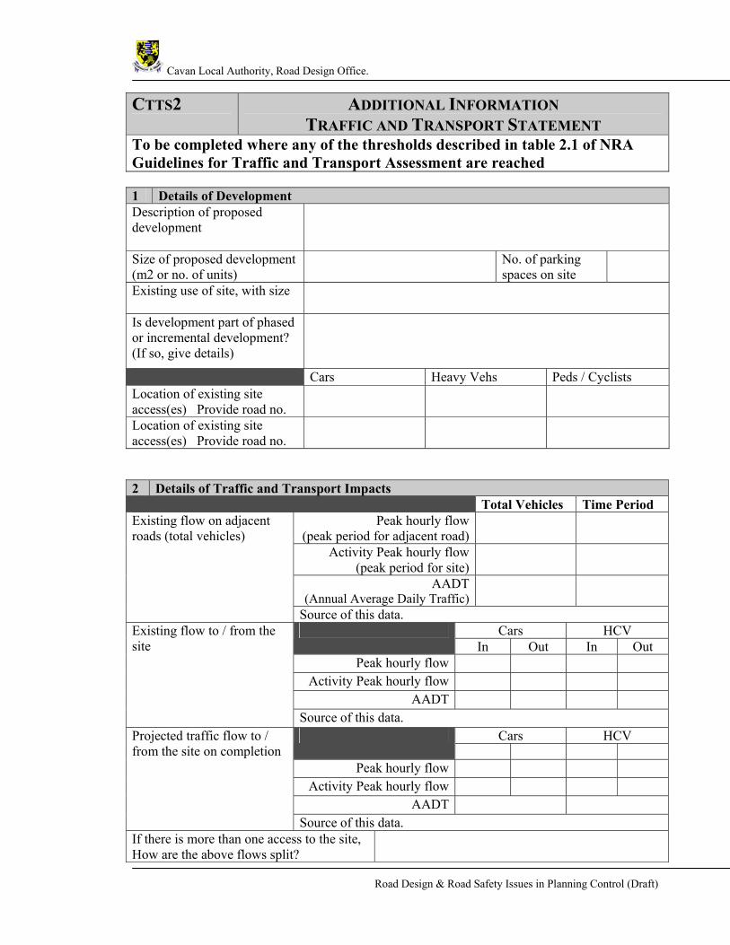
CTTS2 ADDITIONAL INFORMATION TRAFFIC AND TRANSPORT STATEMENT
To be completed where any of the thresholds described in table 2.1 of NRA Guidelines for Traffic and Transport Assessment are reached 1 Details of Development Description of proposed development
Size of proposed development (m2 or no. of units)
No. of parking spaces on site
Existing use of site, with size
Is development part of phased or incremental development? (If so, give details)
Cars Heavy Vehs Peds / Cyclists Location of existing site access(es) Provide road no.
Location of existing site access(es) Provide road no.
2 Details of Traffic and Transport Impacts Total Vehicles Time Period
Peak hourly flow (peak period for adjacent road)
Activity Peak hourly flow (peak period for site)
AADT(Annual Average Daily Traffic)
Existing flow on adjacent roads (total vehicles)
Source of this data. Cars HCV
In Out In Out Peak hourly flow
Activity Peak hourly flow AADT
Existing flow to / from the site
Source of this data. Cars HCV
Peak hourly flow
Activity Peak hourly flow AADT
Projected traffic flow to / from the site on completion
Source of this data. If there is more than one access to the site, How are the above flows split?

Cavan Local Authority, Road Design Office.
Road Design & Road Safety Issues in Planning Control (Draft)
Describe briefly any changes to existing roads layout required as a result of this development.
Explain briefly how the proposed measures will accommodate existing and proposed traffic.
Can the necessary consents and agreements to implement the above measures be obtained, including all the access requirements?
Yes / No Describe:
Have any public transport providers been consulted in relation to this development?
Yes / No Describe:
Note a):- Where any of the thresholds in Table 2.2 of the Transport and Traffic Assessment Guidelines are met, a full TTA shall be completed and this statement shall be a summary of the findings of the report. Note b):- Where any of the thresholds in Table 2.1 of the Transport and Traffic Assessment Guidelines are met, the developer or agent shall seek advice from the Local Authority planning representative as to the requirement for a full TTA.

Cavan Local Authority, Road Design Office.
Road Design & Road Safety Issues in Planning Control (Draft)
REFERENCES & FURTHER READING
IRL DMRB, Irish Design Manual for Roads and Bridges, NRA.
Traffic Calming Guidelines, Traffic Calming Guidelines for Towns and Villages on
National Roads
Traffic Management Guidelines, DoT, DOELG, DTO.
Inclusive Mobility, The Department for Transport.
Creating Places, achieving quality in residential developments, DOE, NI.
http://www.mobility-unit.dft.gov.uk/tactile/, Guidance on the Use of Tactile Paving
Surfaces.
Recommendations for Site Development Works for Housing Areas, DOELG.
County Cavan Development Plan 2003-2009, Cavan County Council.
Design recommendations for multi-storey and underground car parks, Institute of
Structural Engineers


