
APPLICATION
OF
MASONRY STONE MINING PROJECT (M.L. No- 325/97)
FOR
ENVIRONMENTAL CLEARANCE
Near Village Sri Balaji
Tehsil Nagaur
District Nagaur
State Rajasthan
Capacity 84116 TPA (Max)
Lease Area 1.00 Ha
Category of Project ‘B2’
Project Cost Rs. 50 Lakhs
Date of issue of Work Order 25.04.2015
Name of Project Proponent: Shri Ganpat Ram S/o Shri Jitu Ram
Address: R/o Didiya Kalan, Tehsil Jayal, District Nagaur, Rajasthan
E-mail address: [email protected]
Mobile No: 7792079201
CONSULTANT
SRUSHTI SEWA
(Accredited by QCI / NABET, S.No 146, Rev. 31 (A)/June 11, 2015)
Harihar Niwas, Agrasen Marg, Near Adivasi Bhavan,
Giri Peth, Nagpur, Maharashtra – 440010

1
FORM 1
OF
MASONRY STONE MINING PROJECT (ML No-325/97)
FOR
ENVIRONMENTAL CLEARANCE
Near Village Sri Balaji
Tehsil Nagaur
District Nagaur
State Rajasthan
Capacity 84116 TPA (Max)
Lease Area 1.00 Ha
Category of Project ‘B2’
Period of Study May-2015
Project Cost Rs. 50 Lakhs
Date of issue of Work Order 25.04.2015
Name of Project Proponent: Shri Ganpat Ram S/o Shri Jitu Ram
Address: R/o Didiya Kalan, Tehsil Jayal, District Nagaur, Rajasthan
E-mail address: [email protected]
Mobile No: 7792079201
CONSULTANT
SRUSHTI SEWA
(Accredited by QCI / NABET, S.No 146, Rev. 31 (A)/June 11, 2015)
Harihar Niwas, Agrasen Marg, Near Adivasi Bhavan,
Giri Peth, Nagpur, Maharashtra – 440010

2
FORM-1
[AS PER EIA NOTIFICATION 2006, MODIFICATION IN 2009 & MODIFICATION IN 2011]
(I) Basic Information
S.No. Item Details
1. Name of the project/s Masonry Stone Mining Project (M.L. No- 325/97)
2. S. No. in the schedule Sl. No. 1(a)
3. Proposed capacity /area /length /tonnage to
be handled/command area/lease
area/number of wells to be drilled.
The Mining Lease area of the proposed mine is
1.00Ha and the proposed capacity of the mine is
84116 TPA (Max) of Masonry Stone.
4 New/Expansion/Modernization Existing But Fresh Case for EC
5. Existing Capacity/Area etc. Not Applicable
6. Category of Project i.e. ‘A’ or ‘B’ ‘B2’
7. Does it attract the general condition? If yes,
please specify.
No
8. Does it attract the specific condition? If
yes, please specify.
No
9. Location Latitude : 27° 22’ 50.59”N
Longitude : 73° 31’ 42.21”E
Plot/Survey/Khasra No. --
Village Sri Balaji
Tehsil Nagaur
District Nagaur
State Rajasthan
10. Nearest railway station/airport along with
distance in kms.
Sri Balaji Railway Station (about 3.5 km in Northdirection)Jodhpur Airport (about 137 km in SW direction)
11. Nearest Town, city, District Headquarters
along with distance in kms.
Nagaur (about 28 km in SE direction)
12. Village Panchayats, Zilla Parishad,
Municipal Corporation, Local body
(complete postal addresses with telephone
nos. to be given)
Tehsil : Nagaur
District : Nagaur
State : Rajasthan
13. Name of applicant Shri Ganpat Ram
14. Registered Address R/o Didiya Kalan
Tehsil: Jayal
District: Nagaur

3
State: Rajasthan.
15. Address for correspondence
Name Shri Ganpat RamDesignation (Owner/Partner/CEO) Owner
Address R/o Didiya Kalan
Tehsil: Jayal
District: Nagaur
State: Rajasthan.
Pin Code --
E-mail [email protected]
Telephone No. 7792079201
Fax No. --
16. Details of Alternative Sites examined, if
any. Location of these sites should be
shown on a topo sheet
No alternative sites examined, because the mineralis site specific.
17. Interlinked Projects No
18. Whether separate application of interlinked
project has been submitted?
Not applicable
19. If yes, date of submission Not applicable
20. If no, reason Not applicable
21. Whether the proposal involves approval/
clearance under: if yes, details of the same
and their status to be given.
(a)The Forest (Conservation) Act, 1980?
(b) The Wildlife (Protection) Act, 1972?
(C) The C.R.Z Notification, 1991?
The proposal does not involve any approval/
clearance under the said Acts & Notification.
22. Whether there is any Government
Order/Policy relevant/relating to the site?
No
23. Forest land involved (hectares) No forest land involved
24. Whether there is any litigation pending
against the project and /or land in which the
project is propose to be set up?
(a) Name of the Court
(b) Case No.
No litigation pending against the project

4
(c) Orders/directions of the Court, if any
and its relevance with the proposed project.
(II) Activity
1. Construction, operation or decommissioning of the Project involving actions, which will cause
physical changes in the locality (topography, land use, changes in water bodies, etc.)
S.No. Information/Checklist confirmation Yes/No
Details thereof (with approximate quantities
/rates, wherever possible) with source of
information data
1.1 Permanent or temporary change in
land use, land cover or topography
including increase in intensity of land
use (with respect to local land use
plan).
Yes The mining will be done by Opencast semi
mechanized method. There will be permanent
changes in land use, land cover and
topography.
1.2 Clearance of existing land, vegetation
and buildings?
No Not applicable.
1.3 Creation of new land uses? Yes The mining activity will done by making
benches which involves cutting of surface,
stacking of mineral, transportation of mineral,
resulting in changes in land use of ML area
change. At the end of the life of the mine the
total area shall be used as water reservoir.
1.4 Pre-construction investigations e.g.
bore holes, soil testing?
Yes Exploration work is already carried out.
1.5 Construction works? No No major construction activities are proposed
during plan period. Only temporary offices/rest
shelter etc. will be provided during plan
period.
1.6 Demolition works? No No demolition works are involved.
1.7 Temporary sites used for construction
works or housing of construction
workers?
Yes Construction of temporary offices, rest shelter,
Store and water supply, First Aid center etc.
1.8 Above ground buildings, structures or
earthworks including linear structures,
cut and fill or excavations
Yes Only offices/rest shelter, store etc. required.
Excavation for mining of mineral will be
carried out.
1.9 Underground works including mining No Only open cast mining will be done,

5
or tunneling? Underground Mining is not involved.
1.10 Reclamation works? No In the next five years, there is no proposal for
reclamation of the land affected by mining
because the bottom of the Masonry stone will
not be reached in the next five years.
At the end of mining lease period the total area
will not be excavated hence no proposal for
reclamation has been proposed.
1.11 Dredging? No No dredging will be involved.
1.12 Offshore structures? No No offshore structure will be involved.
1.13 Production and manufacturing
processes?
Yes Excavation will cause change in land use due
to excavation of mineral.
1.14 Facilities for storage of goods or
materials?
No No storage is required as the Masonry Stone
excavated will be transported from mine site to
required destination.
1.15 Facilities for treatment or disposal of
solid waste or liquid effluents?
No The waste will be dumped outside the mining
lease area in his own land.
No liquid effluent shall be generated from the
mine.
1.16 Facilities for long term housing of
operational workers?
No Workers will be hired/ employed locally from
the nearby villages, for the mining activity.
Thus no housing facility will be developed
near mine site.
1.17 New road, rail or sea traffic during
construction or operation
No Existing facilities are sufficient. During the
operation phase traffic will be increased.
However the road already existing is sufficient
to cater the increase.
1.18 New road, rail, air waterborne or other
transport infrastructure including new
or altered routes and stations, ports,
airports etc?
No Existing facilities are sufficient. No new
road/rail will be required.
1.19 Closure or diversion of existing
transport routes or infrastructure
leading to changes in traffic
movements?
No There is no closure or diversion of existing
routes or infrastructure for the proposed
project.
6
1.20 New or diverted transmission lines or
pipelines?
No There are no new or diverted transmission
lines or pipelines in the project site.
1.21 Impoundment, damming, culverting,
realignment or other changes to the
hydrology of watercourses or aquifers?
No Not Applicable
1.22 Stream crossings? No There is no stream crossing in the mine lease
area.
1.23 Abstraction or transfers of water from
ground or surface waters?
Yes Total water requirement is about 2.0 KLD =
0.5 KLD (Drinking & Domestic Uses) + 0.4
KLD (Plantation) + 1.1 KLD (Dust
Suppression). Water for Drinking, dust
suppression and plantation will be collected
from nearby villages.
1.24 Changes in water bodies or the land
surface affecting drainage or run-off?
No There is no river, nalla or any surface water
course in the lease area. Since there is no water
course in the lease area, diversion will not be
required.
1.25 Transport of personnel or materials for
construction, operation or
decommissioning?
No Masonry stone from the mine site will be
transported by road in trucks.
1.26 Long-term dismantling or
decommissioning or restoration
works?
Yes During mining operations, the mined out area
will be converted into a small water reservoir,
which shall be a useful as to the society post
mining scenario.
1.27 Ongoing activity during
decommissioning which could have an
impact on the environment?
No Not applicable
1.28 Influx of people to an area in either
temporarily or permanently?
No Mostly local people will be deployed to carry
out material extraction. So no influx of people
has been envisaged.
1.29 Introduction of alien species? No There would be no introduction of any alien
species since local species would be preferred
for the plantation.
1.30 Loss of native species or genetic
diversity?
No There will be no loss of native species or
genetic diversity due to proposed project

7
activities.
1.31 Any other actions? No No other actions would be involved for the
excavation of the mineral.
2. Use of Natural resources for construction or operation of the Project (such as land, water,
materials or energy, especially any resources which are non-renewable or in short supply):
S.No Information/checklist confirmation Yes/No
Details thereof (with approximate quantities
/rates, wherever possible) with source of
information data
2.1 Land especially undeveloped or
agricultural land (ha)
No There is no agriculture land in the mine lease
area. The land is Govt. land of 1.00ha.
2.2 Water (expected source & competing
users) unit: KLD
Yes Total water requirement is about 2.0 KLD =
0.5 KLD (Drinking & Domestic Uses) + 0.4
KLD (Plantation) + 1.1 KLD (Dust
Suppression). Water for Drinking, dust
suppression and plantation will be collected
from nearby villages.
2.3 Minerals (MT) No No raw minerals are required for mining
operation.
2.4 Construction material – stone,
aggregates, sand / soil (expected source
– MT)
No There is no permanent construction needed in
lease area hence no construction material is
used.
2.5 Forests and timber (source – MT) No No forest and timber products involved in the
proposed project.
2.6 Energy including electricity and fuels
(source, competing users) Unit: fuel
(MT), energy (MW)
Yes Diesel will be used for transportation.
2.7 Any other natural resources (use
appropriate standard units)
No No other natural resources will be used.
3. Use, storage, transport, handling or production of substances or materials, which could be
harmful to human health or the environment or raise concerns about actual or perceived risks
to human health.
S.No Information/Checklist confirmation Yes/No
Details thereof (with approximate
quantities/rates, wherever possible) with
source of information data
3.1 Use of substances or materials, which
are hazardous (as per MSIHC rules) to
human health or the environment
No As the mining will involve Blasting, hence
explosives will be used. The applicant will do
necessary arrangements as per rules. The

8
(flora, fauna, and water supplies) explosives will be purchased from authorized
party and blasting will be carried out by
registered contractor.
3.2 Changes in occurrence of disease or
affect disease vectors (e.g. insect or
water borne diseases)
No Not envisaged
3.3 Affect the welfare of people e.g. by
changing living conditions?
Yes This project will provide livelihood to the
workforce during the operation which will help
in improving their living conditions.
3.4 Vulnerable groups of people who could
be affected by the project e.g. hospital
patients, children, the elderly etc.,
No No Vulnerable groups of people will be
affected by the project as entry of unauthorized
person in the mining lease area will be
prohibited.
3.5 Any other causes Yes On long term basis person working in the mine
can be affected by dust bronchitis, however all
precautions will be taken including provision
of dust mask. The mine worker will also be
medically examined as per statutory provision.
4. Production of solid wastes during construction or operation or decommissioning (MT/month)
S.No Information/Checklist confirmation Yes/No
Details thereof (with approximate
quantities/rates, wherever possible) with
source of information data
4.1 Spoil, overburden or mine wastes Yes It has been estimated that about 1036
MT/Month of waste will be generated which
mainly contains low grade weathered mineral
which is exposed with top soil/alumina.
4.2 Municipal waste (domestic and or
commercial wastes)
Yes Insignificant amount of domestic waste will be
generated by the labours at site which will be
treated in septic tank followed by soak pit.
4.3 Hazardous wastes (as per Hazardous
Waste Management Rules)
No No Hazardous waste (as per Hazardous Waste
Management Rules) will be generated.
4.4 Other industrial process wastes No There is no industrial process involved in the
project.
4.5 Surplus product No The entire mined out product will be sold to
the consumer.

9
4.6 Sewage sludge or other sludge from
effluent treatment
No There is no effluent treatment plant in the
proposed project.
4.7 Construction or demolition wastes No No construction or demolition work involved.
4.8 Redundant machinery or equipment No There is no redundancy of machineries
involved, as the machineries are movable and
will be removed from the mine lease area after
the lease is over and will be used elsewhere.
4.9 Contaminated soils or other materials No No contamination of soil or other material will
be involved.
4.10 Agricultural wastes No There is no agricultural waste involved.
4.11 Other solid wastes No No other solid waste is generated.
5. Release of pollutants or any hazardous, toxic or noxious substances to air (Kg/hr)
S.No Information/Checklist confirmation Yes/No
Details thereof (with approximate
quantities/rates, wherever possible) with
source of information data
5.1 Emissions from combustion of fossil
fuels from stationary or mobile sources.
Yes There will be emissions from trucks engaged
for transportation.
It will be managed by the following methods:-
Proper maintenance of vehicles and machines.
PUC certified vehicles will be allowed for
transportation purposes.
5.2 Emissions from production processes Yes There will be negligible dust emission from
production process. However, mitigative
measures such as water sprinkling and
plantation would be done to control dust
pollution.
5.3 Emissions from materials handling
including storage or transport
Yes The transport and handling of mineral likely to
emit fugitive dust which will be controlled by-
regular water sprinkling on the site, dispatch
trucks carrying ore will be covered with
tarpaulin, all service roads made boulder
packed and water sprayed regularly.
5.4 Emissions from construction activities
including plant and equipment
No No construction activity will be carried out at
site so there will be no emission from any such
activities.

10
5.5 Dust or odors from handling of
materials including construction
materials, sewage and waste
No There would be no dust or odors from handling
of construction materials since there is no
construction proposed at the site.
5.6 Emissions from incineration of waste No No such waste will be generated, which may
be incinerated.
5.7 Emissions from burning of waste in
open air (e.g. slash materials,
construction debris)
No No waste of any kind will be burnt in the open
air.
5.8 Emissions from any other sources No There is no other source of emission.
6. Generation of Noise and Vibration, and Emissions of Light and Heat:
S.No Information/Checklist confirmation Yes/No
Details thereof (with approximate
quantities/rates, wherever possible) with
source of information data
6.1 From operation of equipment e.g.
engines, ventilation plant, crushers
Yes Noise is created due to machineries deployed
in the area. Precaution and regular
maintenance of drills and excavator
replacement of damaged/ worn out parts when
ever required will be taken. Ear plugs will be
provided to the persons exposed to high noise
level.
6.2 From industrial or similar processes No There will not be any industrial process
involved.
6.3 From construction or demolition No No construction or demolition is involved.
6.4 From blasting or piling Yes Since the proposed mining involves blasting
hence noise is expected. However all the
precautionary measures will be adopted to
reduce the noise.
6.5 From construction or operational traffic Yes Due to vehicular traffic and material
transportation within applied area, noise will
be generated but measures will be taken up to
control the noise levels within the DGMS &
CPCB norms.
6.6 From lighting or cooling systems No No lighting or cooling systems are involved.
6.7 From any other sources No No other source generates noise & vibration,
heat etc.

11
7. Risks of contamination of land or water from release of pollutants into ground or into sewers,
surface waters, groundwater, coastal waters or the sea:
S.No Information/Checklist confirmation Yes/No
Details thereof (with approximate
quantities/rates, wherever possible) with
source of information data
7.1 From handling, storage, use or spillage
of hazardous materials
No Oiling and lubrication of hauling vehicles
will be done by using oil tray to prevent
spillage on soil.
Blasting will be carried out by the competent
persons as per the rules and provisions of
MMRD 1961.
7.2 From discharge of sewage or other
effluents to water or the land (expected
mode and place of discharge)
No No effluent and sewage will be generated from
the proposed project operations.
7.3 By deposition of pollutants emitted to
air into the land or into water
No Dust emission will be limited to the site itself
which will be suppressed by regular water
sprinkling. Hence there is no risk of
contamination of air, water and land.
7.4 From any other sources No There is no other source from which risk of
contamination is anticipated.
7.5 Is there a risk of long term build up of
pollutants in the environment from
these sources?
No There is no risk of long term buildup of
pollutants in the environment from the
proposed project operations as frequent dust
suppression would be done in mining area and
surrounding roads.
8. Risk of accidents during construction or operation of the Project, which could affect human
health or the environment
S.No Information/Checklist confirmation Yes/No
Details thereof (with approximate
quantities/rates, wherever possible) with
source of information data
8.1 From explosions, spillages, fires etc
from storage, handling, use or
production of hazardous substances.
Yes There is possibility of accident due to
handling/use of explosive material. The risk
will be mitigated by following the procedure
and precautions as per MMR 1961.
8.2 From any other causes Yes Accidents by transport vehicles due to
negligence and/or ignoring the safety
aspects.

12
Accidents during mining caused due to
negligence of workers or bad mining
practice.
No loose stone or debris will be allowed to
remain near the edges of excavation and
along the sides of haul road.
However, to deal the minor incidences and
accidents, First Aid measures at site will be
provided.
8.3 Could the project be affected by natural
disasters causing environmental
damage (e.g. floods, earthquakes,
landslides, cloudburst etc)?
No Since project site comes under Seismic zone II
as per IS 1893 (Part I): 2002, so there is
moderate risk of earthquakes.
9. Factors which should be considered (such as consequential development) which could lead to
environmental effects or the potential for cumulative impacts with other existing or planned
activities in the locality
S.No Information/Checklist confirmation Yes/No
Details thereof (with approximate
quantities/rates, wherever possible) with
source of information data
9.1 Lead to development of supporting
facilities ancillary development or
development stimulated by the project
which could have impact on the
environment e.g.:
• Supporting infrastructure (roads,
power supply, waste or waste water
treatment, etc.)
• Housing development
• Extractive industries
• Supply industries
• Other
Yes Proposed project will result in further growth
of the surrounding area by increasing direct
and indirect employment opportunities in the
region.
9.2 Lead to after-use of the site, which
could have an impact on the
environment
Yes There is likely to be positive impact on the
environment as mining pit will be converted
into a water reservoir.
9.3 Set a precedent for later developments Yes A better after use scenario, which is likely to
increase aesthetic beauty of the area by

13
converting the excavated region into water
reservoir.
9.4 Have cumulative effects due to
proximity to other existing or planned
projects with similar effects
Yes There can be cumulative positive impact due to
proximity to other existing or planned projects
with similar effects.
(III) Environmental Sensitivity
S. No. Areas Name/Identity
Aerial distance (within 15
km.) Proposed project
location boundary
1 Areas protected under international
conventions, national or local
legislation for their ecological,
landscape, cultural or other related
value.
Nil --
2 Areas which are important or
sensitive for ecological reasons -
Wetlands, watercourses or other
water bodies, coastal zone,
biospheres, mountains, forests.
Nil --
3 Areas used by protected, important
or sensitive species of flora or
fauna for breeding, nesting, foraging,
resting, over wintering, migration
resting, over wintering, migration
No important or
sensitive breeding
place of fauna exists
within the study area.
--
4 Inland, coastal, marine or
underground watersNot existing --
5 State, National boundaries Nil --
6 Routes or facilities used by the
public for access to recreation or
other tourist, pilgrim areas
NH-89 About 1 km in East Direction
7 Defense installations Nil --
8 Densely populated or built-up area Sri Balaji
Alai
Pabuthal
Nayagaon
About 2.5 km in North direction
About 7 km in SE in direction
About 2 km in SE in direction
About 4 km in SE in direction

14
Bhagu
Charkara
About 5 km in North direction
About 12 km in NW direction
9 Areas occupied by sensitive man-
made land uses (hospitals, schools,
places of worship, community
facilities)
Sri Balaji
Alai
Pabuthal
Nayagaon
Bhagu
Charkara
About 2.5 km in North direction
About 7 km in SE in direction
About 2 km in SE in direction
About 4 km in SE in direction
About 5 km in North direction
About 12 km in NW direction
10 Areas containing important, high
quality or scarce resources
(ground water resources, surface
resources, forestry, agriculture,
fisheries, tourism, minerals)
Nil --
11 Areas already subjected to pollution
or environmental damage. (those
where existing legal environmental
standards are exceeded)
Nil --
12 Areas susceptible to natural hazard
which could cause the project to
present environmental problems
(earthquakes, subsidence, landslides,
erosion, flooding or extreme or
adverse climatic conditions)
The area comes under
Seismic Zone –II as
per IS 1893 (Part I):
2002
--

15
UNDERTAKING
“I hereby give undertaking that the data and information given in the application and
enclosures are true to the best of my knowledge and belief and I am aware that if any part of the data
and information submitted is found to be false or misleading at any stage, the project will be rejected
and clearance given, if any to the project will be at our risk and cost.
Date:Place: Signature of the applicant
Shri Ganpat Ram
(Authorized Signatory)
NOTE:
1. The Projects involving clearance under Coastal Regulation Zone Notification, 1991 shall submit
with the application a C.R.Z map duly demarcated by one of the authorized agencies, showing the
project activities, w.r.t. C.R.Z. and the recommendations of the state Coastal Zone management
Authority. Simultaneous action shall also be taken to obtain the requisite clearance under the
provisions of the C.R.Z. Notification, 1991 for the activities to be located in the CRZ.
2. The projects to be located within 10 km of the National Parks, Sanctuaries, Biosphere Reserves,
Migratory Corridors of Wild Animals, the project proponent shall submit the map duly
authenticated by Chief Wildlife Warden showing these features vis-à-vis the project location and
the recommendations or comments of the Chief Wildlife Warden thereon.”
3. All correspondence with the Ministry of Environment & Forests including submission of
application for TOR/ Environmental Clearance, subsequent clarifications, as may be required
from time to time, participation in the EAC Meeting on behalf of the project proponent shall be
made by the authorized signatory only. The authorized signatory should also submit a document
in support of his claim of being an authorized signatory for the specific project”

16
PRE- FEASIBILITY REPORT
OF
MASONRY STONE MINING PROJECT (ML No- 325/97)
FOR
ENVIRONMENTAL CLEARANCE
Near Village Sri Balaji
Tehsil Nagaur
District Nagaur
State Rajasthan
Capacity 84116 TPA (Max)
Lease Area 1.00 Ha
Category of Project ‘B2’
Project Cost Rs. 50 Lakhs
Date of issue of Work Order 25.04.2015
Name of Project Proponent: Shri Ganpat Ram S/o Shri Jitu Ram
Address: R/o Didiya Kalan, Tehsil Jayal, District Nagaur, Rajasthan
E-mail address: [email protected]
Mobile No: 7792079201
CONSULTANT
SRUSHTI SEWA
(Accredited by QCI / NABET, S.No 146, Rev. 31 (A)/June 11, 2015)
Harihar Niwas, Agrasen Marg, Near Adivasi Bhavan,
Giri Peth, Nagpur, Maharashtra – 440010

17
1.0 EXECUTIVE SUMMARY
1.1 Executive Summary
Masonry Stone Mining Project (ML No-325/97), the lease area is situated near Village Sri Balaji,
about a distance of 3.5 Km (Cart Track). The lease lies in Tehsil Nagaur District Nagaur, Rajasthan
over an area of 1.00 Hect. The proposed mining is proposed by Shri Ganpat Ram S/o Shri Jitu Ram,
R/o Village Didiya Kalan, Tehsil Jayal, District Nagaur, Rajasthan. The mining lease was granted in
favour of Shri Ganpat Ram S/o Shri Jitu Ram, R/o Village Didiya Kalan, Tehsil Jayal, District
Nagaur, Rajasthan, for a period of 20 years from date of registration. (Lease Documents is attached
as Annexure-1).
The proposed average rate of production is 84116 TPA (Max) of Masonry Stone. The lease area
comprises of Govt. land. The estimated project cost is Rs. 50 Lakhs. The expected life of mine is 5
years based on present level of exploration. Approved mine plan is attached as Annexure-2.
This mining project falls under Category “B2” Project or activity 1(a) as per EIA Notifications
2006, 2009, 2011 and 2013.
1.2 Salient features of the project
Project Name Masonry Stone Mining Project (M.L. No- 325/97)
Location of mine near Village-Sri Balaji,
Tehsil-Nagaur
District-Nagaur,
State -Rajasthan
Location Latitude : 27° 22’ 50.59”N
Longitude : 73° 31’ 42.21”E
Topo sheet number 45E/11
Minerals of mine Masonry Stone
Total geological reserves 669263 Tonnes
Total Mineable reserves 416361Tonnes
Life of mine 5 years
Proposed production of mine 84116 TPA (Max) of Masonry Stone
Method of mining Opencast Semi Mechanized
No of working days 300 days
Water demand Total water requirement is about 2.0 KLD = 0.5 KLD
(Drinking & Domestic Uses) + 0.4 KLD (Plantation) + 1.1
KLD (Dust Suppression).
Sources of water Water for dust suppression and plantation will be collected
from nearby villages. Water tanker will provide the drinking

18
water. During monsoon period, rain water accumulated on
the pit which will be used for dust suppression and
plantation.
Man power 20
Nearest railway station Sri Balaji Railway Station (about 3.5 km in North direction)
Nearest State
highway/national highway
NH-89 about 1 km away in East direction from the site.
Nearest airport Jodhpur Airport (about 137 km in SW direction)
Seismic zone Zone II as per IS 1893 (Part I): 2002
1.3 Proposed Planning
Mining method - Opencast Semi Mechanized
Project cost - Rs. 50 Lakhs
Production - 84116 TPA (Max) of Masonry Stone
1.4 Conclusion
The production of mineral will benefit to the State in the form of Royalty. Apart from this, the
project will generate direct and indirect employment opportunities to the tune of about 20 persons
from the nearby villages. Also, the mine management will conduct medical camps at regular interval
in the nearby villages and will help the nearby villages in providing infrastructure like school
furniture, water tankers, etc.
2.0 INTRODUCTION OF THE PROJECT/BACKGROUND INFORMATION
2.1 Identification of Project and Project Proponent
Masonry Stone Mining Project (ML No-325/97), the lease area is situated near Village Sri Balaji,
about a distance of 3.5 Km (Cart Track). The lease lies in Tehsil Nagaur District Nagaur, Rajasthan
over an area of 1.00 Hect. The proposed mining is proposed by Shri Ganpat Ram S/o Shri Jitu Ram,
R/o Village Didiya Kalan, Tehsil Jayal, District Nagaur, Rajasthan. The mining lease was granted in
favour of Shri Ganpat Ram S/o Shri Jitu Ram, R/o Village Didiya Kalan, Tehsil Jayal, District
Nagaur, Rajasthan, for a period of 20 years from date of registration. (Lease Documents is attached
as Annexure-1).
The proposed average rate of production is 84116 TPA (Max) of Masonry Stone. The lease area
comprises of Govt. land. The estimated project cost is Rs. 50 Lakhs. The expected life of mine is 5
years based on present level of exploration. Approved mine plan is attached as Annexure-2.
2.2 Brief Information about the Project
The project has been proposed for mining of 84116 TPA (Max) of Masonry Stone by opencast semi
mechanized method. The mine lease area is 1.0 ha. The expected life of the mine is 5 years. Water

19
requirement for the proposed project for drinking use, dust suppression and other use will be 2.0 KLD,
which will be taken from nearby source.
2.3 Need for the Project and Its Importance to the Country or Region
The mining project falls in the Nagaur District of Rajasthan, the area is devoid of industrial growth.
The earning sources of the region are limited. Most of the people are dependent upon agriculture only.
Mineral wealth of the state Rajasthan provides the employment opportunity to the people of the state
as well as region also. Mining is one of the major core sector industries which play a crucial role in the
process of country economic development. The mineral Masonry Stone finds extensive use in the
construction and infrastructural works. The basic objective of the project is the effective utilization of
Material in the country or region. Masonry Stone is the world's most commonly used material in
construction of road, railway track construction etc. Masonry Stone will help in the economic growth
of the country or region.
2.4 Demands-Supply Gap
There is a large demand of masonry stone for roads, railway tracks, building construction etc.
2.5 Imports vs. Indigenous Production
Development needs will be met only through indigenous produced Masonry Stone against the high cost
of imported material.
2.6 Export Possibility
Project Proponent would like to sale out the mineral in domestic market only.
2.7 Domestic/Export Markets
Project Proponent would like to sale out in domestic market as per requirement. No export is
proposed.
2.8 Employment Generation
The proposed mining activity will provide employment to about 20 workers. The workers will be hired
mostly from the nearby villages.
3.0 PROJECT DESCRIPTION
3.1 Type of Project Including Interlinked and Interdependent Projects, If Any
The mine is over an area of 1.0 hectares. The proposed production is 84116 TPA (Max) of Masonry
Stone. This is an independent mining project and there are no interlinked projects involved.
The project falls under Category “B2” Project or activity 1(a) as per EIA Notifications 2006,
2009, 2011 and 2013
3.2 Location
The mining lease area is located at near Village Sri Balaji, Tehsil Nagaur, Dist: Nagaur. The mining
lease area falls in G.T sheet No. 45E/11

20
Fig 1: Location Map of proposed Project site
3.3 Details of Alternate Sites
Mining is site specific so no alternative site is proposed.
3.4 Size or magnitude of operation
The mining lease has been granted over an area of 1.0 ha. The average number of working days in the
year would be 300.
Regional Geology
The applied lease area is situated near Village Sri Balaji of Tehsil- Nagaur, District- Nagaur. The
applied area comprises the lithounits of Marwar super group of rocks. Stratigraphic Succession of area
may be given as under:
Age Super group Group Formation/lithology
Recent to sub recent -- -- AlluviumQuaternary -- -- Kankar formationCambrian
Marwar Supergroup
BilaraGroup
Pondio DolomiteGotan Lime StoneDhanapa Dolomite
Detail description of local geology:-
Around the area Sediments of the Marwar Super group occurs with dune sands of the great Thar
Desert. The sesilicielastic sediments of the Jodhpur Group that form the basal sequence of the Marwar
super group are observed to be intercalated with layers of felsic volcanic. The entire sequence
unconformable overlies the highly deformed basement rocks. The unconformity which is erosional and

21
angular in characterisiluis marked by lenticular bodies of polymathic "basal" conglomerate. General
trends of rock types are N 10° E to N 55° B with gentle dips (10°- 45°).
3.5 Project description with process details
3.5.1 Method of Mining
The proposed method of mining will be semi mechanized “Open Cast” mining. The mining will be
done by forming benches of 6.0 m average height. The Masonry Stone production will be started from
the first year, the systematic working of open cast mines, and the main development work will be the
formation of systematic benching. The height of bench will not be kept more than 6.0 m at a time and
the width of the benches will always be kept safe according to provision. The mining will be done with
the help of tools such as drills, jack-hammers, compressor, hand shovels, picks, excavators etc.
Loading of Masonry Stone will be done with the help of shovels and excavators at face and stock yard
as well. Masonry stone gitti will be loaded directly in truck manually. The truck will be used for
transportation of Masonry stone and Masonry stone gitti from mine site to destination. The cost of the
Masonry stone is directly related and dependent on the size of the material mined. First Masonry stone
bench will be opened by removal of Alluvium/ Soil than Masonry Stone will be mined out either by
labours with the help of JCB/Hitachi.
Extent Of Mechanization
Drilling Machines
Type Nos Make HP/Capacity
Jack Hammers 2 As Available 32 mm
Compressor 1 As Available 62.5 HP
DG Set 1 As Available 15 KVA
Poklean 1 As Available 148 HP
Dumper 3 As Available 75 HP
Water tanker 1 As Available 5000 Liter
Wagon Drill M/C 1 As Available 30m
Loading Equipment
Mechanical loading equipment such as shovel and excavators will be used for removal and loading of
the mineral at face and stock yard.
Haulage and Transport EquipmentLoading of Masonry Stone will be done with the help of Shovel and Excavators at face and stock yard.
Masonry stone gitti are loaded in truck by manually. The truck will be used for transportation of
Masonry Stone and Masonry Stone Ballast from mine site to destination.
Production details
The Proposed year wise Production:
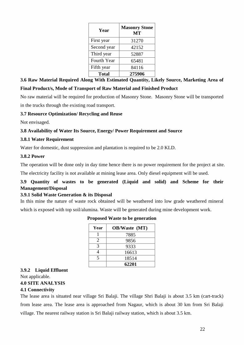
22
YearMasonry Stone
MT
First year 31270
Second year 42152
Third year 52887
Fourth Year 65481
Fifth year 84116
Total 2759063.6 Raw Material Required Along With Estimated Quantity, Likely Source, Marketing Area of
Final Product/s, Mode of Transport of Raw Material and Finished Product
No raw material will be required for production of Masonry Stone. Masonry Stone will be transported
in the trucks through the existing road transport.
3.7 Resource Optimization/ Recycling and Reuse
Not envisaged.
3.8 Availability of Water Its Source, Energy/ Power Requirement and Source
3.8.1 Water Requirement
Water for domestic, dust suppression and plantation is required to be 2.0 KLD.
3.8.2 Power
The operation will be done only in day time hence there is no power requirement for the project at site.
The electricity facility is not available at mining lease area. Only diesel equipment will be used.
3.9 Quantity of wastes to be generated (Liquid and solid) and Scheme for their
Management/Disposal
3.9.1 Solid Waste Generation & its Disposal
In this mine the nature of waste rock obtained will be weathered into low grade weathered mineral
which is exposed with top soil/alumina. Waste will be generated during mine development work.
Proposed Waste to be generation
Year OB/Waste (MT)
1 78852 98563 93334 166135 18514
622013.9.2 Liquid Effluent
Not applicable.
4.0 SITE ANALYSIS
4.1 Connectivity
The lease area is situated near village Sri Balaji. The village Shri Balaji is about 3.5 km (cart-track)
from lease area. The lease area is approached from Nagaur, which is about 30 km from Sri Balaji
village. The nearest railway station is Sri Balaji railway station, which is about 3.5 km.

23
4.2 Landform, Land use and Land ownership
4.2.1 Landform
Stratigraphic Succession of the area (Source Pareek 1981 & 1984) is given below:
AgeSUPERGROUP/
GROUPFORMATION ROCK TYPE
MA
RW
AR
SU
PE
RG
RO
UP
Nagour Group(75-500m)
Tunklian Sand Stone
Nagour Sand Stone
Sand stone, gritty sandstone and pebbleSandstoneBrick-red Sandstone with greenish clayeyblotches, siltstones, shale, evaporate, local basalconglomerate
Bilara Group
Pundlu Dolomite Dolomite, Dolomitic limestone Chertydolomite, Stromatolitic limestone and dolomite
Gotan Limestone Limestone with bands of chert and dolomite,Dhanapa dolomite Stromatolitic, limestone/dolomite, cherty
dolomite and dolomite limestone
Jodhpur Group
Girbhakar Sandstone Brick-red Siltstone, shale & SandstoneSonia Sandstone Maroon siltstone and shale, creamish sand
stone, salt pseudo morphs shales, banded chertjasper dolomite
Pokran Boulder Bed Pebbles, cobbles boulders in maroon/red clayand silt matrix
4.2.2 Land use
The applied lease area is as per revenue detail is a Govt. land. There is no River/ Canal/Port in the
existing area. There is no village or human settlement in the lease area. There is no public road passing
through the area.
4.2.3 Land Ownership
The proposed lease area is Govt. waste land.
4.3 Topography
The applied/Sanctioned/Granted area has a mild hilly land. The highest contour in the area is MRL
312.0mts and the lowest contour is MRL 302.0mts. The general slope of the area is towards SE. There
is no tube well is exists in the area. The rainwater flows down the slope of the area and flows into the
nearby areas. There is no public road passing through the area. Boundary pillar “B” is taken as
temporary bench mark for topographical survey. The assumed R.L. for temporary bench mark is taken
as 312MRL.
4.4 Existing land Use Pattern
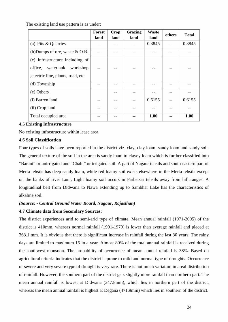
The applied lease area is Govt. Waste Land. In general the area is low hilly. There is no village or
human settlement in the lease area. Permanent vegetation in the area is also very less prominent.
24
The existing land use pattern is as under:
Forest
land
Crop
land
Grazing
land
Waste
landothers Total
(a) Pits & Quarries -- -- -- 0.3845 -- 0.3845
(b)Dumps of ore, waste & O.B. -- -- -- -- -- --
(c) Infrastructure including of
office, watertank workshop
,electric line, plants, road, etc.
-- -- -- -- -- --
(d) Township -- -- -- -- -- --
(e) Others
(i) Barren land
(ii) Crop land
--
--
--
--
--
--
--
--
--
0.6155
--
--
--
--
--
0.6155
--
Total occupied area -- -- -- 1.00 -- 1.00
4.5 Existing Infrastructure
No existing infrastructure within lease area.
4.6 Soil Classification
Four types of soils have been reported in the district viz, clay, clay loam, sandy loam and sandy soil.
The general texture of the soil in the area is sandy loam to clayey loam which is further classified into
“Barani” or unirrigated and “Chahi” or irrigated soil. A part of Nagaur tehsils and south-eastern part of
Merta tehsils has deep sandy loam, while red loamy soil exists elsewhere in the Merta tehsils except
on the banks of river Luni, Light loamy soil occurs in Parbatsar tehsils away from hill ranges. A
longitudinal belt from Didwana to Nawa extending up to Sambhar Lake has the characteristics of
alkaline soil.
(Source: - Central Ground Water Board, Nagaur, Rajasthan)
4.7 Climate data from Secondary Sources:
The district experiences arid to semi-arid type of climate. Mean annual rainfall (1971-2005) of the
district is 410mm. whereas normal rainfall (1901-1970) is lower than average rainfall and placed at
363.1 mm. It is obvious that there is significant increase in rainfall during the last 30 years. The rainy
days are limited to maximum 15 in a year. Almost 80% of the total annual rainfall is received during
the southwest monsoon. The probability of occurrence of mean annual rainfall is 38%. Based on
agricultural criteria indicates that the district is prone to mild and normal type of droughts. Occurrence
of severe and very severe type of drought is very rare. There is not much variation in areal distribution
of rainfall. However, the southern part of the district gets slightly more rainfall than northern part. The
mean annual rainfall is lowest at Didwana (347.8mm), which lies in northern part of the district,
whereas the mean annual rainfall is highest at Degana (471.9mm) which lies in southern of the district.
25
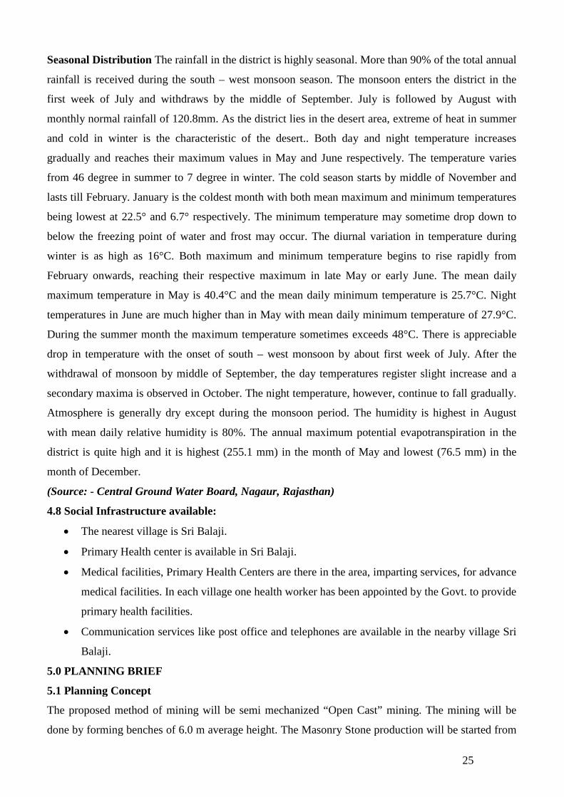
Seasonal Distribution The rainfall in the district is highly seasonal. More than 90% of the total annual
rainfall is received during the south – west monsoon season. The monsoon enters the district in the
first week of July and withdraws by the middle of September. July is followed by August with
monthly normal rainfall of 120.8mm. As the district lies in the desert area, extreme of heat in summer
and cold in winter is the characteristic of the desert.. Both day and night temperature increases
gradually and reaches their maximum values in May and June respectively. The temperature varies
from 46 degree in summer to 7 degree in winter. The cold season starts by middle of November and
lasts till February. January is the coldest month with both mean maximum and minimum temperatures
being lowest at 22.5° and 6.7° respectively. The minimum temperature may sometime drop down to
below the freezing point of water and frost may occur. The diurnal variation in temperature during
winter is as high as 16°C. Both maximum and minimum temperature begins to rise rapidly from
February onwards, reaching their respective maximum in late May or early June. The mean daily
maximum temperature in May is 40.4°C and the mean daily minimum temperature is 25.7°C. Night
temperatures in June are much higher than in May with mean daily minimum temperature of 27.9°C.
During the summer month the maximum temperature sometimes exceeds 48°C. There is appreciable
drop in temperature with the onset of south – west monsoon by about first week of July. After the
withdrawal of monsoon by middle of September, the day temperatures register slight increase and a
secondary maxima is observed in October. The night temperature, however, continue to fall gradually.
Atmosphere is generally dry except during the monsoon period. The humidity is highest in August
with mean daily relative humidity is 80%. The annual maximum potential evapotranspiration in the
district is quite high and it is highest (255.1 mm) in the month of May and lowest (76.5 mm) in the
month of December.
(Source: - Central Ground Water Board, Nagaur, Rajasthan)
4.8 Social Infrastructure available:
The nearest village is Sri Balaji.
Primary Health center is available in Sri Balaji.
Medical facilities, Primary Health Centers are there in the area, imparting services, for advance
medical facilities. In each village one health worker has been appointed by the Govt. to provide
primary health facilities.
Communication services like post office and telephones are available in the nearby village Sri
Balaji.
5.0 PLANNING BRIEF
5.1 Planning Concept
The proposed method of mining will be semi mechanized “Open Cast” mining. The mining will be
done by forming benches of 6.0 m average height. The Masonry Stone production will be started from
26
the first year, the systematic working of open cast mines, and the main development work will be the
formation of systematic benching. The height of bench will not be kept more than 6.0 m at a time and
the width of the benches will always be kept safe according to provision. The mining will be done with
the help of tools such as drills, jack-hammers, compressor, hand shovels, picks, excavators etc.
Loading of Masonry Stone will be done with the help of shovels and excavators at face and stock yard
as well. Masonry stone gitti will be loaded directly in truck manually. The truck will be used for
transportation of Masonry stone and Masonry stone gitti from mine site to destination. The cost of the
Masonry stone is directly related and dependent on the size of the material mined. First Masonry stone
bench will be opened by removal of Alluvium/ Soil than Masonry Stone will be mined out either by
labours with the help of JCB/Hitachi.
5.2 Land use Planning
At the end of the life of mine some area will be backfilled and remaining area will be used as water
reservoir.
5.3 Assessment of Infrastructure demand (Physical & Social)
On the basis of the preliminary site visit, the infrastructure demand in the village was assessed on the
basis of need and priority.
The health infrastructure of the study area requires improvement. The lack of medical facilities needs
improvement. Medical facilities will be provided by mine owner during mining.
5.4 Amenities/Facilities
In the next five years as per the approved mining plan it has been proposed to construct and provide
Site services like Office, First Aid, Rest Shelter, Urinals and Maintenance Workshops etc. as per the
statutory requirements.
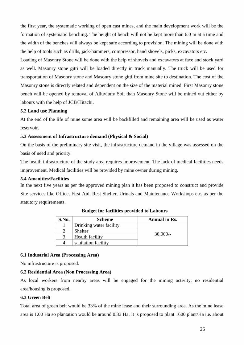
Budget for facilities provided to Labours
S.No. Scheme Annual in Rs.1 Drinking water facility
30,000/-2 Shelter3 Health facility4 sanitation facility
6.1 Industrial Area (Processing Area)
No infrastructure is proposed.
6.2 Residential Area (Non Processing Area)
As local workers from nearby areas will be engaged for the mining activity, no residential
area/housing is proposed.
6.3 Green Belt
Total area of green belt would be 33% of the mine lease and their surrounding area. As the mine lease
area is 1.00 Ha so plantation would be around 0.33 Ha. It is proposed to plant 1600 plant/Ha i.e. about

27
528 plants will be planted in the lease area. For the plantation work the project proponent is committed
to plantation and may consult to the Gram Panchayat.
Place of proposed plantation: -
The plantation shall be done at the following places:-
At the boundary of the Lease.
Both sides of the transportation route.
Species for Plantation
Babul, Neem, Shisham, Rohira, Kalsi Dhangood, Akara etc, more species will be introduced for
plantation after consultation with the local village authority.
6.4 Social Infrastructure
The Applicant shall spend some of profit for the development of the area i.e. treatment of poor,
schools, temples and other social work.
Budget allocated for ESR will be rupees 40,000/- annually.
6.5 Sewerage System
Domestic waste water will be treated into septic tank followed by soak pit
6.6 Industrial Waste Management
Not applicable
6.7 Solid Waste management
In this mine the nature of waste rock obtained will be weathered into low grade weathered mineral
which is exposed with top soil/alumina. Waste will be generated during mine development work.
Proposed Waste to be generation
Year OB/Waste (MT)
1 78852 98563 93334 166135 18514
622016.8 Power Requirement & Supply/Source
The operation will be done only in day time hence there is no power requirement for the project at site.
The electricity facility is not available at mining lease area. Only diesel equipment will be used
6.9 Environmental Management Plan
The environmental management plan consists of the set of mitigation, management, monitoring and
institutional measures to be taken during the implementation and operation of the project, to eliminate
adverse environmental impacts or reduce them to acceptable levels. The present environmental
management plan addresses the components of environment, which are likely to be affected by the
different operations in the mine area.

28
Budget Allotted for the EMP
S. No Measures Annual in Rs.
1Pollution Controli) Dust Suppressionii) Garland drain & ground dump
50,000/-2Pollution Monitoringi) Air pollutionii) Water pollution
3 Green Belt4 Reclamation of mined out area
7.0 REHABILITATION AND RESETTLEMENT (R&R) PLAN
As no personnel are expected to be migrated due to mining in the lease area and the adjoining region is
also having a good mineral potential, the rehabilitation of the employees is not going to be a problem.
The workers and other staff can get job in the neighboring areas after the end of life of mine. The
applicant shall also try for employment of the workers.
8.0 PROJECT SCHEDULE & COST ESTIMATES
8.1 Likely Date of Start of Construction and Likely Date of Completion
No construction activities are proposed. The mining activity will commence only after receiving
environmental clearance and other statutory clearance.
8.2 Estimated Project Cost along with analysis in Terms of Economic Viability of the Project
Estimated project cost is Rs. 50 Lakhs. The lessee has all the mining equipments used for the scientific
mining. The mine is Eco-Friendly. Economically the ore is mineable as compared to overburden
thickness.
9.0 ANALYSIS OF PROPOSAL (FINAL RECOMMENDATIONS)
The proposed mine will bring about economic benefits to the state in the form of Royalty of mineral
and to the local people by getting direct and secondary employment opportunities. The material is in
high demand at the local market for real estate industry. Masonry is commonly used for the
construction of walls of buildings, retaining walls and buildings. Brick and concrete block are the most
common types of masonry which is used in industrialized nations and may be either weight-bearing or
a veneer. Concrete blocks, especially those with hollow cores, offer various possibilities in masonry
construction. They generally provide great compressive strength, and are best suited structures with
light transverse loading when the cores remain unfilled. Filling some or all of the cores with concrete
or concrete with steel reinforcement (typically rebar) offers much greater tensile and lateral strength to
structures.
Advantages:
The use of material such as bricks and stones can increase the thermal mass of a building and
can protect the building from fire.
29
Most types of masonry will not require painting and so it can provide a structure with reduced
life-cycle costs.
Masonry is non-combustible product.
Masonry walls are more resistant to projectiles, such as debris from hurricanes or tornadoes.
Masonry structures built in compression preferably with lime mortar can have a useful life of
more than 500 years as compared to 30 to 100 for structures of steel or reinforced concrete.
This project operation will provide livelihood to the poorest section of the society/economically
backward population and tribal in the area. It provides employment to the people residing in vicinity
directly or indirectly. The mine management will also help nearby villages by providing aid to school,
conducting medical and social awareness camps, helping in formation of self-help groups, etc. Thus
the project will bring about socio-economic improvement of the area and will prove beneficial to the
area.
****************


