
CHAPTER III
PROFILE OF THE STUDY AREA –
KANYAKUMARI DISTRICT
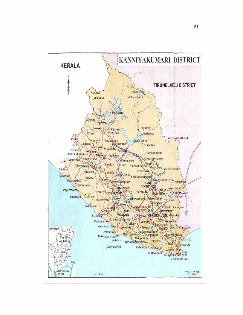
Location
The District is situated between 8o 8’ – 8
o 29’ northern
latitude and 76o 9’ – 77
o 41’ eastern longitude, occupying a tota1 area of
1672 Sq.Km. It is bordered with Thirunelveli District in the north and
northeast, Kerala in the north-west, the Arabian Sea in the west, the Indian
Ocean in the south, and the Gulf of Mannar as well as the Bay of Bengal in
the east. It has a coastline of 68 Km stretching on three sides.
History
Kanyakumari’s history is an ancient one and it dates back to
the sangam age. It is a cradle of civilization in the southern tip of the Indian
peninsula. The district has a large number of historic monuments and
temples. A series of kingdoms are known to have ruled, this territory and
the most important being the Cheras, the Cholas and the Pandyas. Up to the
93
early fifties of the last century, this region was part of the now defunct
Travancore Samasthanam, which is the southern part of the present Kerala
State. The Tamil-speaking majority population struggled to get this
territory merged with Tamil Nadu and thus Kanyakumari District became a
part of Tamil Nadu after the reorganization of the States of the Indian
Union in 1956.
94

95
On the recommendations of the States Reorganization
Commission, Agastheeswaram, Thovalai, Kalkulam, Vilavancode and
Senkottai taluks were given to Tamil Nadu and the first four of the taluks
were grouped to form the new Kanyakumari District. The present
Kanyakumari District came into existence with Nagercoil as its
headquarters on November, 1956.
Climate and Rainfall
The Kanyakumari District enjoys a favourable agro climatic
condition suited to the growth of different varieties of crops such as paddy,
banana, tapioca, coconut and rubber. Semi arid tropical monsoon type of
climate prevails in the plains. In the plains the maximum and the minimum
temperatures are 37.5oC and 25.7
oC respectively. Heat becomes intense in
April and shoots further up in May unless moderated by rains. The
proximity of the Western Ghats and the sea as well as the south-west and
north-east monsoons greatly influence the climate of the district.
The district has a unique advantage of the rainfall during the
south west and north east monsoon. The occurrence of southwest monsoon
is from June to September and northeast monsoon from October to
December is responsible for flourishing cultivation crops like rubber in the
district. Rainfall is generally high in the northern parts of the district. The
annual rainfall ranges between 90-160cm and the average is 140cm. The
annual average rainy days are normally 85-90 days. It is significant that

96
next to the Nilgiris district. The highest annual average rainfall has been
recorded only in the Kanyakumari District. Hence, this district is suited for
raising all sorts of crops like food crops, plantain crops, cash crops, fibre
crops and tuber crops.
There are considerable variations in the annual rainfall both
in time and space from more than 2000m.m at the dam sites in the north-
western part to 800mm to 900mm in the tail end of the irrigated areas in
the south-east portion of the district.1 A season-wise distribution of rainfall
in the Kanyakumari District is presented in Table 3.1.
TABLE 3.1
SEASON-WISE ACTUAL RAINFALL IN KANYAKUMARI
DISTRICT (1997-98 TO 2007-08)
Year
South
West
Monsoon
North
East
Monsoon
Winter
Season
Hot
weather
Season
Total
1997-1998 760.0 653.4 2.8 240.4 1656.9
1998-1999 667.8 1069.3 52.7 458.6 2248.4
1999-2000 590.4 602.0 204.1 138.8 1535.3
2000-2001 894.6 360.3 73.9 419.2 1748.5
2001-2002 650.9 484.8 28.2 341.6 1505.5
2002-2003 239.8 769.1 9.5 188.6 1207.6
2003-2004 230.9 486.2 10.5 380.6 1108.2
2004-2005 603.4 337.4 32.8 461.9 1435.5
2005-2006 389.3 549.9 38.6 272.1 1249.9
2006-2007 644.4 611.5 7.38 290.2 1553.9
2007-2008 803.9 506.6 71.7 413.1 1795.3
Source: Assistant Director of Statistics, Nagercoil, 2008.
1. Gazetteer of India, Tamil Nadu, Kanyakumari District, p.302.
97
Natural Division
Based on the agro-climatic and topographic conditions,
Kanyakumari District is divided into three natural divisions as follows.
1. The mountainous region of the north-east along the Western Ghats
in the Vilavancode and Kalkulam taluks and the hill bases are called high
lands, suitable for raising crops like rubber, cloves, coffee, coconut, pepper
and pineapple.
2. In the extreme south east, south and south west there is the 68
kilometer long sea coast called the lowlands, ideal for growing, coconut,
cashew etc.
3. Between the uplands and low lands is found a strip of undulating
valley known as mid lands with broad patches of coconut groves, smiling
paddy fields, tapioca and banana farms.
Soil
Agriculture in any region depends on its soil conditions
which constitute the physical basis for the same. Contrasts in agriculture
are caused by differences in soil textures, drainage and fertility.2 Seasonal
rains and the fertility of the soil in the Kanyakumari District enables the
farmers to raise different varieties of crops. While climatic variations all
2. Shirla, D.W., “Agricultural Geography of Great Britain”, Pergamom Press, Oxford, 1971,
p.20.

98
over the district are not very conspicuous, soil conditions in the different
parts of the district differ considerably within short distances.
There are three kinds of soil, viz., sandy soil, laterite soil and
red soil. Sandy soil is found along the high lands, laterite soil in areas with
high rainfall and red soil in the mid lands. Laterite soil with moisture
holding capacity with varying amounts of aluminium hydroxide is found in
the Thiruvattar, Munchirai, Kurunthancode, Rajakkamangalam, Killiyoor,
Thuckalay and Melpuram blocks. In these blocks the chief crops are
tapioca, rubber, coconut and spices. Red soil is classified into red loam soil
and red sandy soil. Red soil has low moisture holding capacity and so it is
not as fertile as the lateritc soil. Mixed type of red and alluvial soil occur in
Agasteeswaram and Thovalai blocks.3 Red soil and laterite soil are
suitable for rubber cultivation in the traditional rubber growing areas of
Kerala and Tamil Nadu.4
Irrigation
Irrigation is the artificial application of water to soil for the
purpose of crop production. As the timing and amount of rainfall are not
adequate to meet the moisture requirement of crops, irrigation is essential
to raise crops and meet the need for food and fiber.5 The irrigation system
3. Annual Credit Plan for Kanyakumari District, Lead Bank cell, IOB, 2008-09, p.6.
4. Natural Rubber, “Agro Management and Crop Processing”, Rubber Research Institute of
India, Kottayam. 2005, p.174.
5. Gazetteers of India, Tamil Nadu, Kanyakumari District, 1995, p.291.

99
in the Kanyakumari District consists of a few non-perennial rivers like the
Paralayar, Kothaiyar, Thamiraparani, Valliar, Chittar and Pazhayar.
Originating from the Western Ghats and running across the gentle slopes of
the midlands, these rivers confluence with the waters of the Arabian sea on
the west.
The Paralayar takes its course from the Mahendragiri hills in
the Thovalai taluk and flows in a south – westerly direction to a distance of
37 kilometres and joins with Kothaiyar at Thiruvattar to form the
Kuzhithurai river known as Thamiraparani. The Thamiraparani flows
through Kalkulam and Vilavancode taluks covering a distance of 59
Kilometers and merges into the Arabian sea.6 The Kothaiyar originates
from the southern extremity of Muthukuzhi vayal plateau and irrigates
Nanjinaud, comprising the Thovalai and Agasteeswaram taluks. Paralayar
and Kothaiyar are the two main tributaries of the Thamiraparani river. The
Vadasery river also known as Pazhayar runs through Thuvalai and
Agasteeswaram taluks and finally flows into the Manakudy estuary after a
course of 23 miles and providing irrigation to Boothapandi, Nagercoil,
Kottar, Thazhakudi and Suchindram.
Since the beginning of the 20th
century, the Government of
Travancore bestowed serious attention to irrigation and planned to form
6. Census of India, District census Handbook Kanyakumari, The Director of Census
Operation, Part XIII A and B, Tamil Nadu, p.9.

100
storage reservoirs for impounding water irrigation during periods of
drought or insufficient rainfall. The efforts of the government in this
direction resulted in the construction of the Petchipparai dam in 1906 and
the Perunchani dam in 1953 across Kothaiyar and Paralayar respectively.7
The Kothaiyar system consisting of the Petchipparai and Perunchani dams
as well as a network of channels irrigates 25900 hectares of double crop
land in the district. The main channels in the district are the Thovalai
channel, Anandanar channel, Padmanabhapuram Puthanar channel and the
Nanjinaud – Puthanar channel including Pazhayar.8 The Pandian dam and
the Puthan dam across Paralayar are only diversion weirs. Such diversion
weirs have been built at Thirparappu and Aruvikkarai also. Two reservoirs,
viz. Chittar I and Chittar II have been built to improve the storage capacity
of the Petchipparai and Perunchani reservoirs.9 Surface water stored up in
reservoirs is distributed through a network of irrigation canals.
Besides the reservoirs and a network of irrigation canals, tank
irrigation also plays a significant role in providing water for agriculture.10
There are in all 1205 tanks, including the non-system Chembagaraman-
puthoor Periakulam with an ayacut area of 19400.47 hectares. The
percentage of area irrigated by tanks to the net area irrigated is 56.6
7. Gazetteers of India, Tamil Nadu, Kanyakumari District, pp.297-298.
8. Ibid., p.295.
9. Ibid., p.301.
10. Agrostat, Joint director of Agriculture, Kanyakumari District, 2006, p.126.

101
percent.11
These tanks are fed mainly by canals Small rain-fed tanks are
found in large numbers all over the district. The total area directly and
indirectly irrigated by channels is 31758 hectares and the number of tanks
fed by them is 1205.
Table 3.2 gives the details of the lands irrigated by various
sources.
TABLE 3.2
IRRIGATION IN KANYAKUMARI DISTRICT DURING 2008
Type of Irrigation Area Irrigated
(in Hectares) Percentage
Canals 11114 38.86
Tanks 15794 55.23
Wells 1220 4.27
Other Sources 468 1.64
Total 28596 100.00
Source: Department of Agriculture, Nagercoil, 2008.
Administrative Set-up
The district is divided into two revenue divisions viz.
Padmanabhapuram and Nagercoil, having headquarters at Thuckalay and
Nagercoil respectively. There are four taluks namely, Vilavancode,
Kalkulam, Agastheeswaram and Thovalai and 82 revenue villages. The
district has four municipalities, Nagercoil, Padmanabhapuram, Colachel
and Kuzhithurai. The district has been divided into 9 Panchayat Unions
11. Gazetteers of India, Kanyakumari District, 1995, p.271.

102
namely Agastheeswaram, Thovalai, Rajakkamangalam, Kurunthencode,
Thuckalay, Thiruvattar, Killiyoor, Melpuram and Munchirai.
TABLE 3.3
ADMINISTRATIVE SET-UP IN KANYAKUMARI DISTRICT
DURING 2008
Sl.
No.
Name of the
Development
Division
Name of
Panchayat
Union
Office
Location
Area
(Sq.Km)
1. Nagercoil
Agastheeswaram
Rajakkamangalam
Thovalai
Kurnuthencode
Perumapuram
Pazhavilai
Boothpandy
Kurunthencode
143.26
135.49
360.91
100.54
2. Padmanabhapuram
Thuckalay
Thiruvattar
Killiyoor
Munchirai
Melpuram
Kozhiporvilai
Thiruvattar
Thoayavattam
Munchirai
Pacode
127.41
88.37
1 38.86
71.45
27.57
Source: District Collectorate, Nagercoil, 2008.
Population
According to 2001 census, the total population of
Kanyakumari District was 16,76,034. The male population is 8,32,269 and
the female population is 8,43,765. In this district, the rural population is
more than the urban population. The rural population is 5,82,107 and the
urban population is 10,93,927. The density of population is high with 995
per Sq.km. The total literates in this district are 13,08,322.

103
TABLE 3.4
AREA, POPULATION AND LITERACY IN KANYAKUMARI
DISTRICT DURING 2008
Name of the
Block
Municipalities
Area
(Sq.km.)
Population Literate
Persons Male Female Female Male Female
1 2 3 4 5 6 7 8
Agasteeswaram 133.12 148419 73260 75159 118778 60120 58658
Rajakkamangaam 120.16 137254 68119 69135 108539 55337 53209
Thovalai 369.07 110719 55057 55662 85132 44101 41031
Kurunthencode 106.85 165070 81823 83247 126882 64369 62513
Thuckalay 130.33 167262 82488 84774 131428 66461 64967
Thruvattar 344.80 161619 80220 81399 122710 62524 60186
Killiyoor 82.70 156387 78663 77724 119931 62173 57758
Munchirai 72.01 177225 89122 88103 131461 68366 63095
Melpuram 271.89 179535 88578 90957 137211 70560 66651
Nagercoil
Muncipaty 24.27 208179 102907 105272 175248 88590 86658
Padmanabhapuram 6.47 20075 9967 10108 16282 8372 7910
Colachel 5.18 23787 11996 11791 18008 9275 8733
Kuzhithurai 5.15 20503 10069 10434 16712 8419 8293
Total 1672.00 1676034 832269 843765 1308322 668667 639655
Source: Statistical Handbook, Department of Economics & Statistics,
2008.
Land Use Pattern
The Kanyakumari District extends over a geographical area
of 1,67,200 hectares with net sown area of 79,323 hectares which accounts
for 47.4 percent of the total area. The forest occupies 54155 hectares which
accounts for 32.4 percent. The land use pattern in the Kanyakumari District
is presented in Table 3.5.
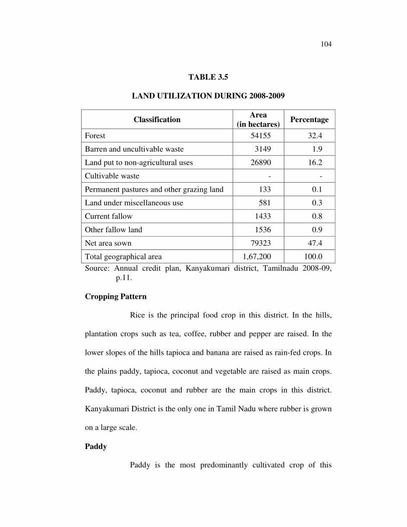
104
TABLE 3.5
LAND UTILIZATION DURING 2008-2009
Classification Area
(in hectares) Percentage
Forest 54155 32.4
Barren and uncultivable waste 3149 1.9
Land put to non-agricultural uses 26890 16.2
Cultivable waste - -
Permanent pastures and other grazing land 133 0.1
Land under miscellaneous use 581 0.3
Current fallow 1433 0.8
Other fallow land 1536 0.9
Net area sown 79323 47.4
Total geographical area 1,67,200 100.0
Source: Annual credit plan, Kanyakumari district, Tamilnadu 2008-09,
p.11.
Cropping Pattern
Rice is the principal food crop in this district. In the hills,
plantation crops such as tea, coffee, rubber and pepper are raised. In the
lower slopes of the hills tapioca and banana are raised as rain-fed crops. In
the plains paddy, tapioca, coconut and vegetable are raised as main crops.
Paddy, tapioca, coconut and rubber are the main crops in this district.
Kanyakumari District is the only one in Tamil Nadu where rubber is grown
on a large scale.
Paddy
Paddy is the most predominantly cultivated crop of this
105
district in an area of 31000 hectares. It is grown in two seasons. The first
crop is sown in April – June (Kannipoo) and the second crop is raised in
September – October (Kumpapoo).
Tapioca
Tapioca is raised as a subsidiary food crop in this district.
The climate and soil conditions are quite suitable for cultivation of this
crop. It is purely raised as rainfed crop in Kalkulam and Vilavancode taluks
and as irrigated crop in some area of Agastheeswaram taluk of this district.
The tapioca stems and leaves are used for fuel purposes in rural house hold.
Coconut
Coconut is a major plantation crop, cultivated extensively in
this district. The climatic condition of this district is quite conducive for
coconut cultivation. The stalk and spadix obtained from coconut trees are
very good non-commercial energy sources for households. Most of the
households have been using these sources of energy traditionally for
cooking and heating purposes.
Rubber
The northern part of the district, which is at the foot of the
Western Ghats, is highly suitable for cultivation of rubber. Hence the state
has been taking special efforts to expand the area under this crop. These
rubber plantations produce not only latex but also wood logs and twigs as
well. The rubber trees are cut down after 20 to 25 years of plantation.

106
Forest
The forests are highly enchanting with pleasant shoals,
beautiful grasslands, Panoramic valleys, hillocks, singing streams, vast
stretches of rubber plantations, valuable teak plantations and an immense
treasure of medical plants. The Government reserve forests occupy an area
of 50486 hectares. They cover 30.2 percent of the geographical area of
Kanyakumari District. The yield per hectare of forest is probably the
highest in TamilNadu with an yield of 200 to 275 cubic meters of timber.
Electricity
Kanyakumari District has one hydro-electric project, which is
located at Kodayar. The installed capacity of this power plant is 6 MW and
4 MW. This project has two plants.
Roads
The district has a good network of roads connecting the
important villages and towns in the district. Important commercial centers
like Vadassery, Kottar, Manavalakurichi, Kaliakkavilai, Marthandam,
Puthukadai and Karungal are connected by roads with other districts in
Tamil Nadu and the states of Karnataka and Kerala.
The total length of roads in the district is 1863 km. They
cover 62.4 km of national highways, 48 km of state highways, 975 km
maintained by municipalities, district administration, and public works
department. The remaining roads are maintained by panchayats and
107
panchayat unions. The length of the roads in the district per 100 sq.km of
area is 110 km as against the state average of 30 km.12
Railways
This district is linked with other places throughout the
country by means of railways. The distance of the railway line from
Nagercoil to Trivandrum is 66 km. From Nagercoil to Tirunelveli Junction
the distance is 77 km and from Nagercoil to Cape Comorin is 15.51 km.
The length of broad gauge railway line in the district is 70.41 km. The
important railway stations are Kuzhithurai, Eraniel, Palliyadi, Nagercoil,
Thovalai, Suchindrum, Agasteeswaram and Cape Comorin.13
The long and the short of what has been said so far about the
study area is that it has been endowed variously and copiously with
enormous reserve of environmental resources which can maintain a steady
supply of every type of non-commercial energy source for years on end.
Banking Sectors in Kanyakumari District
The banking structure in the district comprises 19 public
sector and 10 private sector Commercial Banks, with 144 branches, two
branches of Pandyan Grama Bank, Kanyakuamri District Central
Cooperative Bank Ltd., with 17 branches, including its head office branch,
and 114 Primary Agriculture Cooperative Societies, 5 Primary Cooperative
12. Credit Plan for Kanyakumari District, Tamil Nadu, Indian Overseas Bank, Madras, p.4.
13. Kanyakurnari District, The Hindecon, Vol.1992, p.30.

108
Agriculture and Rural Development Banks (PCARDBs) affiliated to Tamil
Nadu Cooperative State Agriculture and Rural Development Bank and a
branch each of Tamil Nadu Industrial Cooperative Bank
(TAICOB)/Peoples’ Cooperative Bank (PCB) / Tamil Nadu Industrial
Investment Coorporation (TIIC), in all having 285 units in the district. The
health of the credit institutions plays a major role in achieving the desired
flow of credit and its recycling for further development. The working
results of the credit institutions in the district are quite encouraging except
in respect of PCARDBs which suffer from high degree of overdues, low
volume of business etc. Pandyan Grama Bank recently opened two
branches making its entry to the district.
Performance Parameters: Table 3.6 shown the Performance Parameters
of various Banks in Kanyakumari District 2005-2006 to 2007-08.
TABLE 3.6
PERFORMANCE PARAMETERS OF VARIOUS BANKS IN
KANYAKUMARI DISTRICT 2005-2006 TO 2007-2008
Sl.
No
Ag
ency
No
.of
Bra
nch
es
Deposits % of
share as
on
31/03/08
2005-06 2006-07 2007-08
Amt. % * Amt. % * Amt. % *
1 CBs 144 2322.68 13.10 2645.04 13.88 2790.43 5.50 87.03
2 RRB 2 NA NA NA NA 3.72 NA 0.12
3 DCCB 17 164.73 (-
)2.92
163.93 (-)
0.48
190.67 16.31 5.94
4 PCARDBs 5 0.00 NA 0.00 NA 0.00 NA 0.00
5 PACS 114 147.88 1.74 152.50 3.12 167.71 9.97 5023
6 OFIs 3 9.43 1.72 53.25 464.69 53.89 1.20 1.68
Total 285 2644.72 11.22 3014.72 13.99 3206.42 6.36 100.00
* growth over previous year : NA – not applicable; OFI Other financial
institutions – PCB, TAICOB & Tic
Source : Potential Credit Plan, NABARD, 2008-09

109
While DCCB has recouped from the adverse trend witnessed
in the previous two years, growth rate of deposits of commercial banks,
PACSs and OFIs during 2007-08 was moderate.
TABLE 3.7
OUTSTANDING LOANS IN VARIOUS BANKS OF
KANYAKUMARI DISTRICT 2005-06 TO 2007-08
Loans outstanding
Sl.
No
Agen
cy
No
.of
Bra
nch
es
Loans outstanding % of
share as
on
31/03/08
2005-06 2006-07 2007-08
Amt. % * Amt. % * Amt. % *
1 CBs 144 1612.61 7.17 2009.10 24.58 2377.84 18.35 78.37
2 RRB 2 NA NA NA NA 25.81 NA 0.85
3 DCCB 17 257.65 7.56 233.12 (-)
9.52
283.65 21.68 9.34
4 PCARDBs 5 26.84 (-)
18.14
10.14 (-)
62.22
15.23 50.20 0.50
5 PACS 114 386.99 41.38 216.86 (-)
43.96
283.71 30.83 9.36
6 OFIs 3 29.72 10.85 47.57 60.06 47.90 0.69 1.58
Total 285 2313.81 11.37 2516.79 8.77 3034.14 20.56 100.00
* growth over previous year : NA – not applicable; OFI Other financial
Source : Potential Credit Plan, NABARD, 2008-09.
Role of Informal Credit Delivery System
NABARD has been playing a leading role in the micro
finance programme for the last one and half decades. It has been acting as a
catalyst for the banking system of the country to join hands with informal
delivery channels to give SHG-Bank linkage Programme the required
momentum. The Self Help Group – Bank Linkage Programme initiated by

110
NABARD in 1992 is perhaps the most successful community development
initiative ever tried in India. It has been acknowledged as the fastest
growing and the most cost effective micro Finance initiative in the World.
The pilot project which started in 1992 with a modest target of linking just
about 500 SHGs with a few banks across the country had reached over 40
million poor people by 31 March 2008. The banks have now recognized
SHG Bank linkage as a new dimension of quality lending and apart from
banks, other institutions like Post Offices are also associating themselves
with the movement.
SHG Bank Linkage Programme in Tamilnadu : Regular
savings, maintenance of books and accounts, internal lending are the major
factors in determining the credit absorption capacity of the groups. During
2007-08, 1,31,796 SHGs have been credit linked with a bank loan of Rs.
1302 crore in TamilNadu. As on 31 March 2008, in TamilNadu, the
cumulative number of SHGs credit linked stood at 473610 with an
aggregate bank loan of Rs.5118.73 crore.
The Overview of Micro finance Profile in the district is as
under:-
1.1 Total number of blocks in the district 9
1.2 No. of blocks where SHGs exist 9
1.3 No. of blocks where SHGs are credit linked 9
2.1 No. of NGOs in the district 130*
2.2 No. of NGOs participating in the linkage programme 92
2.3 No. of additional NGOs to be roped in during the
year
10 to 15

111
3.1 Total No. of bank branches in the district 163
3.2 Of which No. of branches participating in the linkage
programme
156+106
PACS
3.3 No, of additional branches proposed to be roped in
during the year
5
4.1 No. of Govt./Post Offices/other agencies
participating
7
4.2 No. of Govt./Post Offices / other agencies likely to
participate
1 (KVK)
5 No of poor households in districts NA
5.1 No. of SHGs in the district 34800+
5.2 Scope for formation of new SHGs 750
5.3 No of SHGs savings linked in the district 31524
5.4 No of SHGs credit linked 30066
5.5 No of SHGs taken up micro enterprise 8000
* There are more than 125 NGOs – approved by TNCDW – 29 NGOs;
Means for expansion of linkage programme
• Encouraging SHG formation in uncovered activities
• Encouraging new NGOs who are dedicated
• Concentrating attention on the tribal population in remote areas
• Promotion of SHGs through farmers clubs and formation of SHGs
of tenant farmers as absentee cultivation is quite common in the district.
SHG Bank Linkage Programme in the District
As per data collated from various source, the number of
SHGs as at the end of 31 March 2008 was about 34000 and about 49000
groups have been credit linked during 2007-08 with a credit disbursement
of Rs. 61 crore. Quite a good number of NGOs (about 130) are operating in
the district and facilitate formation of SHGs. These agencies are engaged in
awareness creation, health care training, adult education, skill training,

112
propagation of organic farming, vermin-culture etc. They organize people
into groups and work with them. These NGOs inculcate savings habit and
help the people to take loans from their own savings. Tamil Nadu
Corporation for Development of Women Ltd. (TNCDW) maintain data in
respect of NGOs reconginised by them. Of the 12838 groups, 12447 are
credit linked. TNCDW has enrolled 29 NGOs and for all purposes
including subsidy extension, only TNCDW are only considered.
Commercial banks and KDCCB are actively involved in supporting the
credit initiatives with programmes reviews of TNCDW at monthly
intervals. Most of the SHGs are activity based. Apart from NABARD,
District Rural Development Agency (DRDA), TNCDW and the extension
office of handicraft department provide various training and assist them in
marketing their products. Pillow lace embroidery, hand embroidery, zeri
embroidery, coconut shell products, seashell products, palm leaf products,
tailoring, ready made garments etc. are some of the major activities in
which the SHG members are involved. Vermi-compost, apiculture, masala
powder, agro processing and fish processing are some of the innovative
activities practiced in Kanayakumari by the SHG members. At present
NGOs like SEDA, CHARDEP, KODI, SSWC, KSSS, PWDS, MALAR,
RWDS,MIDS,YMCA,Nala Oli, CARD, Vivekananda Kendra, Resource
Centre, PASA, CSD, IED, Stella Maris Social Centre, Seva Bharati, Good
Vision, Mary Quiry, Gill Call and a few others have engaged themselves in

113
SHG formation. Multifold increase in number of NGOs and SHGs have
been observed after Tsunami. The field level feedback indicates that dual
membership is prevalent in certain areas.
SHG Linkage Programmes Strategy
• Orientation of newly posted/transferred officers of banks is
desirable for continuing the success of the programme.
• Quality training is desirable for staff of NGO especially in
facilitating micro enterprise initiatives to sustain the movement in
the long run.
• Rating of SHGs are done jointly by the TNCDW and Bank branches
for the groups affiliated to the TNCDW.
Projection for the year 2009-10
No. of SHGs to be
promoted
No. of SHGs to be
savings linked
No. of SHGs to be
credit linked
750 500 1400
D. mFI Bank linkage: There are no micro finance institution operating in
the district.
CREDIT FOR AGRICULTURE AND ALLIED SECTOR IN
KANYAKUMARI DISTRICT
Investment Credit for Agriculture
Minor irrigation
Kanyakumari District is endowed with plentiful surface
water. Apart from the surface water the ground water development forms

114
the major part of the minor irrigation programme and includes construction
of dug wells, dug-cum-bore wells, filter points etc. With a view to
increasing the ground level disbursement for minor irrigation, NABARD
has made certain relaxation in the refinance policy for long term
investment credit to minor irrigation sector. The quantum of refinance for
minor irrigation has been raised to a minimum of 95% of the bank loan
with effect from 10 October 2002.
Agency wise details of bank credit through NABARD,
disbursed under minor irrigation sector from 2003-04 to 2006-07 is given
in Table 3.8.
TABLE 3.8
BANK CREDIT DISBURSED UNDER MINOR IRRIGATION
SECTOR IN KANYAKUMARI DISTRICT
(Rs in lakhs)
Sl.
No. Agency 2003-04 2004-05 2005-06
2006-07
Target
1 Commercial Banks 94.89 301.14 641.45 2177.6
2 KDCCB 0.44 1924.53 2834.24 0.00
3 PCARDBs 0.88 0.00 0.00 2.92
4 Others 36.00 0.00 0.00 0.00
Total 132.21 2225.67 3475.00 2180.52
Source : Potential Linked credit plan, NABARD, Tamil Nadu 2007-2008.
It may be observed from Table 1 that loan disbursement
reported under minor irrigation during the year 2005-06 was very high and
115
the disbursement by DCCB during 2004-05 and 2005-06 is also very high
which may be due to incorrect coding of activities in the (LBR) returns.
The banks in the district have been informed to indicate correct code
numbers so as to avoid such lapses in future. Involvement by PCARDB
and other banks is nil. This was due to poor response by other financial
institutions and non availability of future for PCARDBs.
Land Development
Land development sectors encompasses all activities related
to improving productivity of land such as land leveling and off-farm
development works for preparing the land for higher irrigation efficiency.
Soil conservation, contour bunding, reclamation of saline and alkaline soil,
soil improvement, water management and improved rainfed farming
practices are other activities taken up under this sector. Out of the net sown
area of 78829 ha.as on 31.03.2006, 51978 ha., constituting 65.94% is under
rainfed cultivation. The district has plantation to an extent of 30,000 ha.in
hilly areas which are prone to soil erosion. Soil conservation is, therefore,
an essential and important investment activity in the district.
The agency wise details of bank credit through NABARD
disbursed under Land Development sector from 2003-04 to 2006-07 is
given in Table 3.9.

116
TABLE 3.9
BANK CREDIT DISBURSED UNDER LAND DEVELOPMENT
SECTOR (RS IN LAKHS)
Sl.
No. Agency 2003-04 2004-05 2005-06 2006-07
1 Commercial Banks 1294.25 703.81 411.06 4206.21
2 KDCCB 0.00 1774.11 1846.10 400.00
3 PCARDBs 10.63 2.18 0.00 0.00
4 Others 0.00 0.00 0.00 0.00
Total 1304.88 2480.10 2257.16 4606.21
Source : Potential Linked credit plan, NABARD, Tamil Nadu 2007-2008.
Table 3.9 reveals that the flow of credit to this sector is
fluctuating. The ground level credit during 2004-05 and 2005-06 by the
Co-operative Bank was very high. Agricultural credit plan (ACP) target for
2006-07 is much more than the potential linked plan projection. Under
potential linked plan, only available potential has been considered for
projection. Considering the importance of sector in agricultural
development, financing under the sector is expected to be more in coming
years.
Farm Mechanisation
Agricultural Mechanisation helps in increasing production,
productivity and profitability in agriculture by achieving timeliness in farm
operations, bringing precision in metering and placement of inputs,
reducing available input losses, increasing utilisation efficiency of costly

117
inputs )seed, chemical, fertilizer, irrigation, water etc), enhancing
profitability and competitiveness in the cost of operation. It also helps in
the conservation of the produce and by – product from qualitative and
quantitative damages; enables value addition and establishment of agro-
processing enterprises for additional income and employment generation
from farm produce. It is one of the important inputs to usher in all – round
development in rural area.
Agency wise detail of bank credit disbursed through
NABARD under farm mechanisation sector for the years from 2003-04 to
2006-07 is shown in Table 3.10.
TABLE 3.10
BANK CREDIT DISBURSED UNDER FARM MECHANISATION
SECTOR IN KANYAKUMARI DISTRICT (RS IN LAKHS)
Sl.
No. Agency 2003-04 2004-05 2005-06 2006-07
1 Commercial
Banks
27.94 145.56 299.62 5232.28
2 KDCCB 0.00 0.00 0.15 0.00
3 PCARDBs 6.00 0.00 0.00 113.9
4 Others 0.00 0.00 0.00 0.00
Total 33.94 145.56 299.77 5345.37
Source : Potential Linked credit plan, NABARD, Tamil Nadu 2007-2008.
Table 3.10 reveals that except commercial banks, no other
agency has extended credit to farm mechanisation during 2003-04 and
2004-05 and a meagre disbursement was done by District Central Co-
118
operative bank (DCCB) during 2005-06. Agricultural credit plan (ACP)
target for 2006-07 is much more than the potential linked plan (PLP)
projection. Under PLP only available potential has been considered for
projection.
Investment Credit for Allied activities
Dairy Development
Dairy development is one of the major allied activities in
Kanyakumai District. About 3.37 lakh (97%) of operational holdings are of
less than one hectare and without fully depending upon agriculture alone
the farmers have to take up allied activities like dairy farming to
supplement their income and sustain their livelihood. Moreover unlike
other districts in the state, the district of Kanyakumari has deficit in milk
production. Hence, dairy development is important.
In this district, as the 2004 live stock population, the number
of available cattle were 101712 (exotic / crores bred 96067 and indigenous
5645) and buffaloes numbering 6077 Milch animals were 44204.
The agency wise details of bank credit disbursed under dairy
development for the years 2003-04 to 2006-07 are given in Table 3.11.

119
TABLE 3.11
BANK CREDIT DISBURSED UNDER DAIRY DEVELOPMENT
SECTOR IN KANYAKUMARI DISTRICT (RS. LAKHS)
Sl.
No. Agency 2003-04 2004-05 2005-06 2006-07
1 Commercial Banks 83.66 269.67 2136.83 3312.50
2 KDCCB 3.82 4.20 0.00 1923.80
3 PCARDBs 68.91 0.22 0.00 123.13
4 Others 47.10 76.43 0.00 0.00
Total 206.49 350.52 2136.83 5359.43
Source : Potential Linked credit plan, NABARD, Tamil Nadu 2007-2008.
Table 3.11 reveals that the ground level disbursement by the
KDCCB and PCARDB for the year 2005-06 is nil. This may be because of
showing it under Swarnajayanthi Gram Swarozgar Yojana (SGSY).
Further, the interest evinced by banks is not adequate as large potential
under dairy development remains untapped. Target fixed for 2006-07 is
exorbitantly high.
Poultry Development
The climate in Kanyakumari District is not congenial for
poultry development because of high rainfall and high humidity. Though
there is good demand for poultry meat and eggs, there are constraints for
expanding this activity in the district. Poultry development may be taken
up in a small way. Commercial poultry farming is picking up in the district,
after the bird flu scare. However, as said before, the off take of this activity

120
is not to the expected level. Agricultural Credit Plan achievement under the
sector for 2005-06 was only 14%. Larger share of loan disbursed were for
contract farming.
The agency wise details of bank credit disbursed under
poultry farming for the years 2003-04 to 2006-07 (Target) are given in
Table 3.12.
TABLE 3.12
BANK CREDIT DISBURSED UNDER POULTRY FARMING
SECTOR (RS. LAKHS)
Sl.
No. Agency 2003-04 2004-05 2005-06 2006-07
1 Commercial
Banks
27.33 153.98 32.92 3494.71
2 KDCCB 0.00 0.00 8.01 1420.10
3 PCARDBs 4.92 0.00 0.00 28.71
4 Others 0.00 0.00 0.00 0.00
Total 32.25 153.98 40.93 4943.00
Source: Potential Linked credit plan, NABARD, Tamil Nadu 2007-2008.
Table 3.12 reveals that the disbursements under poultry by
commercial bank is fluctuating and KDCCB’s involvement is poor.
PCARDB has not disbursed during 2005-06.
Investment Credit for Non Farm Sector Activities
Investment Credit
Agriculture is the predominant activity in the district. The
district falls under high rainfall zone and the availability of lands for non-

121
agricultural purposes is limited, which hampers the industrial development
in the district. Investment credit in the district was given to the following
broad group of activities like rural artisans/ craftsman decentralised sector,
tiny industries, cottage and village industries, ancillary units, handlooms
and powerlooms, agro-industries and Small Scale Industries (SSIs).
However, handlooms, powerlooms and rural artisans have less scope
compared to others1.
NABARD supports certain activities which are income
generating and provide sustainable employment opportunities to people
living in rural areas. Important activities are initiatives of NABARD, Rural
tourism, Trainers Training programme, skill upgradation and design
Development for Handloom weavers (SUDHA), Rural Mart and Rural
Innovation Network.
The agency wise ground level credit for non-farm sector,
including working capital and Investment credit for the years 2003-04 to
2006-07 in the given Table 3.13.
14. Potential Linked Credit plan, NABARD, Tamil Nadu, 2007-08, p.78.

122
TABLE 3.13
BANK CREDIT DISBURSED UNDER NON FARM SECTOR
(Rs in Lakhs)
Sl.
No. Agency 2003-04 2004-05 2005-06 2006-07
1 Commercial Banks 3013.83 4419.01 2422.73 4109.28
2 KDCCB 46.78 1173.48 59.46 1352.40
3 PCARDBs 250.24 93.69 0.00 744.52
4 Others 485.05 618.03 812.51 869.85
Total 3795.90 6304.21 3294.70 7076.05
Source : Potential Linked credit plan, NABARD, Tamil Nadu 2007-2008.
Table 3.13 shows that the ground level credit has been
increasing over the reference period except in the year 2005-06. Keeping
this in view and the potential available under non farm sectors (NFSs), the
projection under the sector has also been increased.
F. Self Help Groups (SHGs) Linkage Programme
NABARD offers faculty support, organises exposure and
awareness programmes for the participating bank managers, field staff and
senior officers of the banks. During 2006-07 NABARD had sanctioned
SHG Basic Orientation Training to three NGOs viz., HOPE, Mary Quiry
and Snekham involving 60 SHGs. Further with the increased involvement
of co-operatives and intensified focus of commercial banks in SHG linkage
programme, NABARD and TamilNadu Corporation for Development of
Women (TNCDW) are addressing the issue of capacity building of the

123
bank officials and Primary Agriculture Co-operative Bank (PACB)
Secretaries. With the introduction of the branch level grading exercises for
all government sponsored programmes and for SHG direct linkage, branch
managers are fully involved in the exercise. Operational difficulties are
clarified on the spot. This has created a sea change in the outlook of branch
managers.
Details of training programmes conducted during 2003-04 to
2006-07 are given in Table 3.14.
TABLE 3.14
TRAINING PROGRAMMES CONDUCTED
FROM 2003-04 TO 2006-07
Year
Com
mer
cial
Ban
k O
ffic
ers
Co-o
per
ati
ve
Ban
k O
ffic
ers
Tra
inin
g t
o S
HG
Mem
ber
s
Ref
resh
er
train
ing t
o S
HG
Mem
ber
s
NG
Os
Ba
nk
ers
mee
t
Ex
po
sure
vis
its
to S
HG
s b
y
BL
BC
Part
ner
s
Gover
nm
ent
Off
icia
ls (
blo
ck
level
)
Sk
ill
Devel
op
men
t to
SH
G M
emb
ers
2003-2004 2 4 25 2 4
2004-2005 1 2 30 4 1 2
2005-2006 5 2 4 4 2
2006-2007 1 2 4 5
Source: Potential Linked Credit plan, NABARD, Tamil Nadu, 2007-2008.
This profile helps to understand the different geographical
and economic facts of Kanyakumari District.


