Download - Chilton Neighbourhood Development Plan
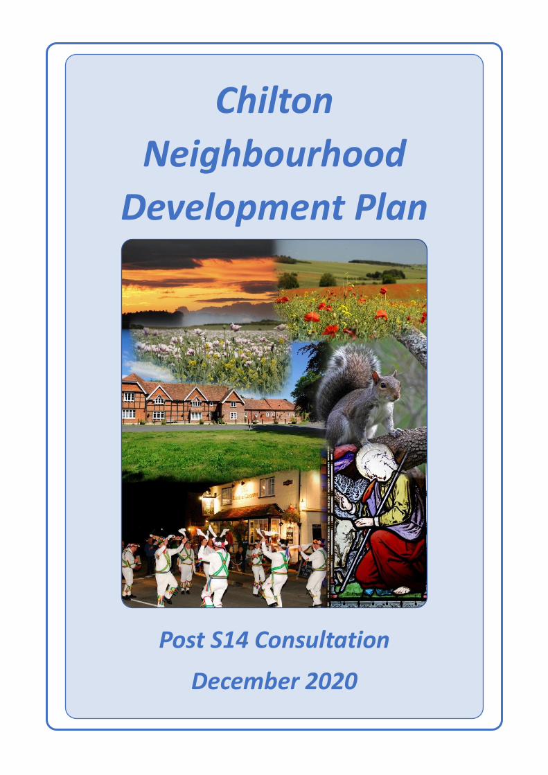
Chilton
Neighbourhood
Development Plan
Post S14 Consultation
December 2020

Chilton Neighbourhood Development Plan
2 Chilton Neighbourhood Development Plan V1.4, Post S14 Regulation Public Consultation; January 2021
Page deliberately left blank
Chilton Neighbourhood Development Plan
3 Chilton Neighbourhood Development Plan V1.4, Post S14 Regulation Public Consultation; January 2021
Contents Executive Summary .......................................................................................................................... 5
Vision Statement .......................................................................................................................... 6
Policy Summaries .......................................................................................................................... 7
Community Issues ......................................................................................................................... 9
1. Introduction ............................................................................................................................ 10
1a. Background to the Plan ................................................................................................... 10
1b. Summary of Process, including consultation ................................................................... 10
1c. Vision Statement and Objectives ..................................................................................... 11
1d. Neighbourhood Plan Area ............................................................................................... 13
2. Chilton and its Surroundings ................................................................................................... 14
2a. Introduction to Chilton .................................................................................................... 14
2b. History leading to Current Status .................................................................................... 16
2c. Location within Area of Outstanding Natural Beauty ...................................................... 17
3. Built Environment ................................................................................................................... 18
3a. Village Character Assessment .......................................................................................... 18
3b. Sewerage and Drainage ................................................................................................... 24
3c Housing Needs Survey ..................................................................................................... 24
3d. Settlement Boundary ...................................................................................................... 25
3e. Settlement Boundary Principles ...................................................................................... 25
4. Sustainable Development ....................................................................................................... 30
4a. Existing Enterprises ......................................................................................................... 30
4b. Sustainable Future Opportunities.................................................................................... 31
5. Local Ecology and Environment............................................................................................... 33
5a. Flora ................................................................................................................................ 33
5b. Fauna .............................................................................................................................. 33
5c. Ambient Sound – Traffic Noise ........................................................................................ 35
5d. Light Pollution: ................................................................................................................ 37
5e. Air Pollution .................................................................................................................... 38
6. Village Infrastructure .............................................................................................................. 39
6a. Chilton Primary School .................................................................................................... 39
6b. Village Hall and Community Room .................................................................................. 40
6c. Recreational Facilities ...................................................................................................... 41
6d. Communal and Recreational Facilities – Feedback from Village Survey .......................... 42
6e. Public House – The Rose and Crown ................................................................................ 43
6f. Religious Worship ............................................................................................................ 43
Chilton Neighbourhood Development Plan
4 Chilton Neighbourhood Development Plan V1.4, Post S14 Regulation Public Consultation; January 2021
6g. Community Infrastructure - Summary ............................................................................. 45
7. Open and Local Green Spaces ................................................................................................. 47
7a. Open and Green Infrastructure Audit .............................................................................. 47
7b. Designated ‘Local Green Space’ Areas ............................................................................. 48
8. Connectivity ............................................................................................................................ 52
8a. Road Networks ................................................................................................................ 52
8b. Footpaths, Bridleways, Cycleways ................................................................................... 52
8c. Public Transport – Bus Services ...................................................................................... 53
8d. Public Transport – Train Services ..................................................................................... 54
8e. Local Taxi Services ........................................................................................................... 54
8f. High Speed Broadband .................................................................................................... 54
9. Community Issues ....................................................................................................................... 55
9a. All Saints’ church churchyard ................................................................................................ 55
9b. Public Transport .................................................................................................................... 55
9c. Recreation Facilities .............................................................................................................. 55
9d. Accessibility to the surrounding AONB and access to A34 Service Station ............................ 56
10. Glossary/Defined Terms ...................................................................................................... 57
11. Credits and Acknowledgements .......................................................................................... 59
List of Appendices ........................................................................................................................... 60
Appendix 1: Village Character Assessment and Design Styles .................................................... 60
Appendix 2: Village Survey and Results ...................................................................................... 60
Appendix 3: Local Green Spaces Infrastructure Audit data ......................................................... 60
Appendix 4: Traffic Noise Levels in Chilton.................................................................................. 60
Chilton Neighbourhood Development Plan
5 Chilton Neighbourhood Development Plan V1.4, Post S14 Regulation Public Consultation; January 2021
Executive Summary
Chilton is a vibrant small village lying within the North Wessex Downs Area of Outstanding Natural
Beauty (AONB) and situated within the Vale of White Horse District of Oxfordshire, adjacent to the
Oxfordshire border with Berkshire.
With a heritage going back to ancient times and a close affiliation to the Ridgeway National Trail and
horse racing, the village is now primarily a residential setting for some 670 dwellings. The A34 trunk
road divides the village with the older part of the village lying predominantly to the east of the A34
and the newer part, substantially expanded in the period 2010-2014, lying to the west of the A34.
To the north-west of the village lies the Harwell Science and Innovation Campus, a major
employment centre and scientific site for Oxfordshire and the United Kingdom.
The designated area for this Neighbourhood Plan (‘the Plan’) largely coincides with Chilton Parish
boundary but excludes that part of the parish lying within the Harwell Campus.
This Plan has been prepared in accordance with national policy guidance to supplement the Vale of
White Horse District Council (VWHDC) Local Plan 2031 to represent the needs of the local
community to guide further sustainable development.
Community consultation and involvement has been key to the development of the Plan. Following
early public meetings, a vision statement and set of objectives for the Plan were agreed. These were
used by the steering group to develop the plan including the use of a village survey open to all
residents. The survey covered a wide range of subjects including housing needs, village amenities
and business activities.
The content of the Plan comprises (1) a document describing the village, its heritage, attributes,
amenities and opportunities for enhancement as valued by its residents, (2) a number of planning
policies to be adopted by the planning authority when assessing planning development proposals
and (3) a number of community issues to be pursued by the community.
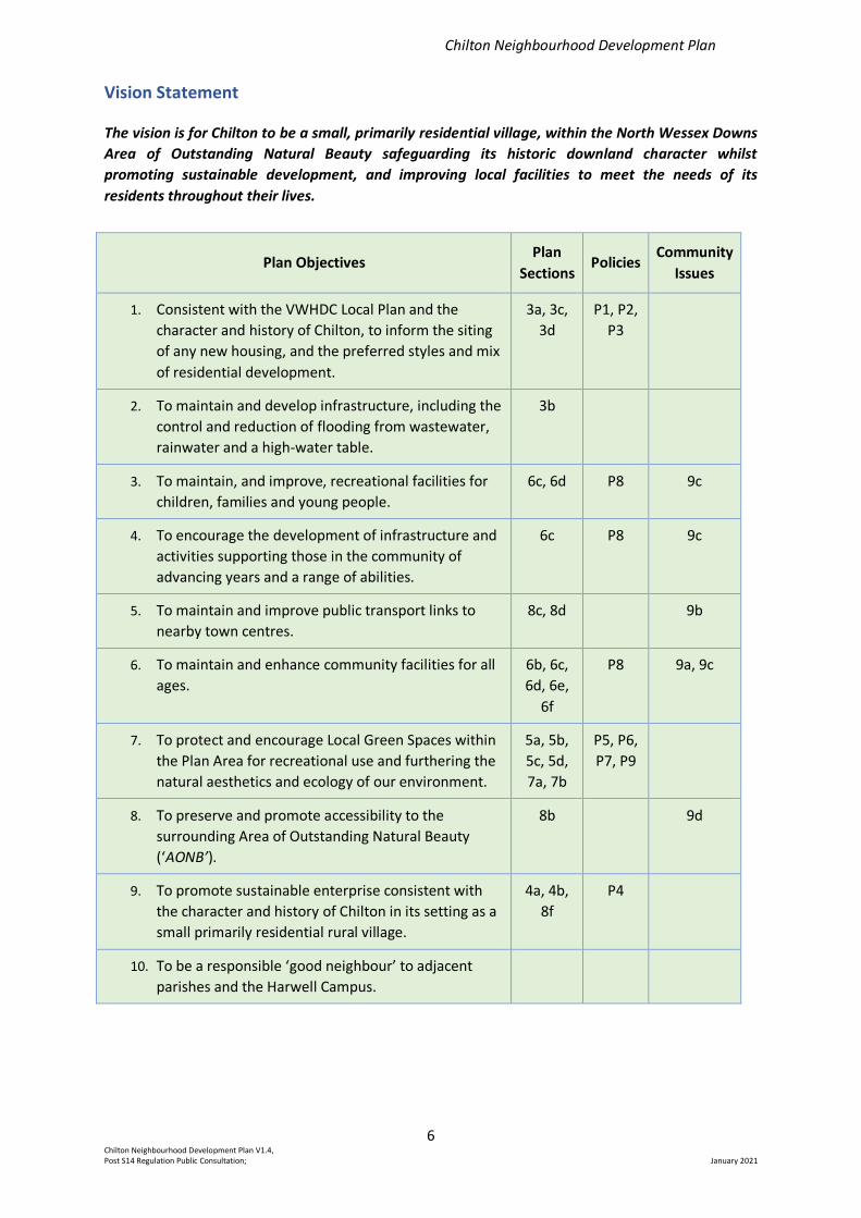
The Plan vision and objectives together with their related sections within the Plan and resulting
policies and community issues are summarised below:
Early consultation identified ten possible objectives for developing the Plan. Further consultation
identified that the location and styles of development, community facilities, Local Green Spaces and
the relationship of the village to the AONB all to be of particular interest. Attention has therefore
been focussed on these objectives (1, 3, 4, 6, 7 and 9) and policies developed to reflect the
community needs.
Other topics, such as access to public transport or interactions with neighbouring parishes
(objectives 5, 10), although of community interest, are not within the remit permitted for policies
within a Neighbourhood Plan and where appropriate these have been addressed by proposed
community issues to be pursued following adoption of the Plan.
Control of the potential for flooding (Objective 2) will continue to be addressed by building
regulations and planning requirements from policies within higher level documents such as the
VWHDC Local Plan.
Access to the AONB (Objective 8) is provided by existing rights of way which should be preserved by
policies within the Local Plan without the need for additional policies in this Plan.
Chilton Neighbourhood Development Plan
6 Chilton Neighbourhood Development Plan V1.4, Post S14 Regulation Public Consultation; January 2021
Vision Statement
The vision is for Chilton to be a small, primarily residential village, within the North Wessex Downs
Area of Outstanding Natural Beauty safeguarding its historic downland character whilst
promoting sustainable development, and improving local facilities to meet the needs of its
residents throughout their lives.
Plan Objectives Plan
Sections Policies
Community
Issues
1. Consistent with the VWHDC Local Plan and the
character and history of Chilton, to inform the siting
of any new housing, and the preferred styles and mix
of residential development.
3a, 3c,
3d
P1, P2,
P3
2. To maintain and develop infrastructure, including the
control and reduction of flooding from wastewater,
rainwater and a high-water table.
3b
3. To maintain, and improve, recreational facilities for
children, families and young people.
6c, 6d P8 9c
4. To encourage the development of infrastructure and
activities supporting those in the community of
advancing years and a range of abilities.
6c P8 9c
5. To maintain and improve public transport links to
nearby town centres.
8c, 8d 9b
6. To maintain and enhance community facilities for all
ages.
6b, 6c,
6d, 6e,
6f
P8 9a, 9c
7. To protect and encourage Local Green Spaces within
the Plan Area for recreational use and furthering the
natural aesthetics and ecology of our environment.
5a, 5b,
5c, 5d,
7a, 7b
P5, P6,
P7, P9
8. To preserve and promote accessibility to the
surrounding Area of Outstanding Natural Beauty
(‘AONB’).
8b 9d
9. To promote sustainable enterprise consistent with
the character and history of Chilton in its setting as a
small primarily residential rural village.
4a, 4b,
8f
P4
10. To be a responsible ‘good neighbour’ to adjacent
parishes and the Harwell Campus.
Chilton Neighbourhood Development Plan
7 Chilton Neighbourhood Development Plan V1.4, Post S14 Regulation Public Consultation; January 2021
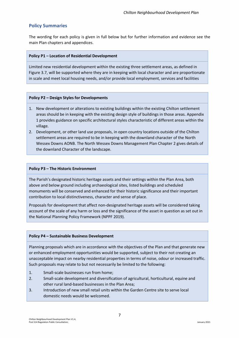
Policy Summaries
The wording for each policy is given in full below but for further information and evidence see the
main Plan chapters and appendices.
Policy P1 – Location of Residential Development
Limited new residential development within the existing three settlement areas, as defined in
Figure 3.7, will be supported where they are in keeping with local character and are proportionate
in scale and meet local housing needs, and/or provide local employment, services and facilities
Policy P2 – Design Styles for Developments
1. New development or alterations to existing buildings within the existing Chilton settlement
areas should be in keeping with the existing design style of buildings in those areas. Appendix
1 provides guidance on specific architectural styles characteristic of different areas within the
village.
2. Development, or other land use proposals, in open country locations outside of the Chilton
settlement areas are required to be in keeping with the downland character of the North
Wessex Downs AONB. The North Wessex Downs Management Plan Chapter 2 gives details of
the downland Character of the landscape.
Policy P3 – The Historic Environment
The Parish’s designated historic heritage assets and their settings within the Plan Area, both
above and below ground including archaeological sites, listed buildings and scheduled
monuments will be conserved and enhanced for their historic significance and their important
contribution to local distinctiveness, character and sense of place.
Proposals for development that affect non-designated heritage assets will be considered taking
account of the scale of any harm or loss and the significance of the asset in question as set out in
the National Planning Policy Framework (NPPF 2019).
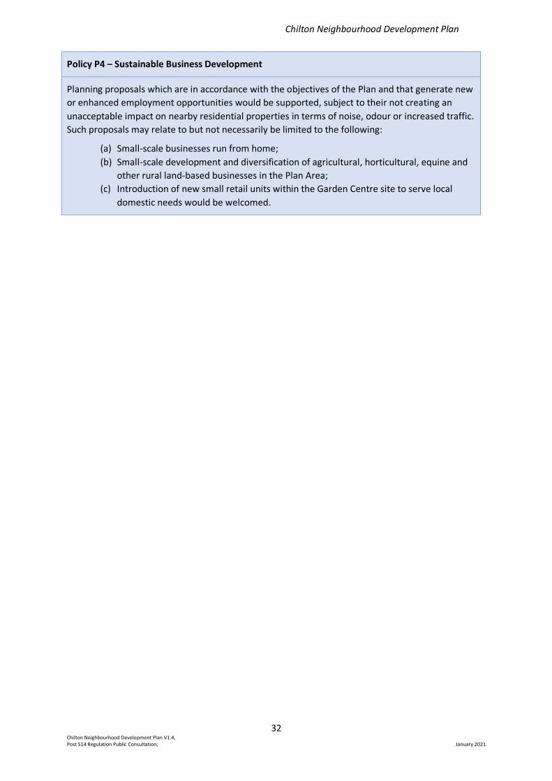
Policy P4 – Sustainable Business Development
Planning proposals which are in accordance with the objectives of the Plan and that generate new
or enhanced employment opportunities would be supported, subject to their not creating an
unacceptable impact on nearby residential properties in terms of noise, odour or increased traffic.
Such proposals may relate to but not necessarily be limited to the following:
1. Small-scale businesses run from home;
2. Small-scale development and diversification of agricultural, horticultural, equine and
other rural land-based businesses in the Plan Area;
3. Introduction of new small retail units within the Garden Centre site to serve local
domestic needs would be welcomed.
Chilton Neighbourhood Development Plan
8 Chilton Neighbourhood Development Plan V1.4, Post S14 Regulation Public Consultation; January 2021
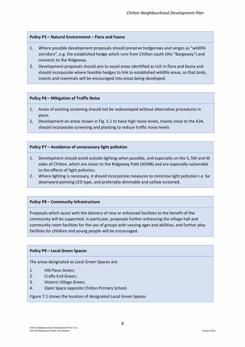
Policy P5 – Natural Environment – Flora and Fauna
1. Where possible development proposals should preserve hedgerows and verges as “wildlife
corridors”, e.g. the established hedge which runs from Chilton south (the “Bargeway”) and
connects to the Ridgeway.
2. Development proposals should aim to avoid areas identified as rich in flora and fauna and
should incorporate where feasible hedges to link to established wildlife areas, so that birds,
insects and mammals will be encouraged into areas being developed.
Policy P6 – Mitigation of Traffic Noise
1. Areas of existing screening should not be redeveloped without alternative procedures in
place.
2. Development on areas shown in Fig. 5.1 to have high noise levels, mainly close to the A34,
should incorporate screening and planting to reduce traffic noise levels
Policy P7 – Avoidance of unnecessary light pollution
1. Development should avoid outside lighting when possible, and especially on the S, SW and W
sides of Chilton, which are closer to the Ridgeway Path (AONB) and are especially vulnerable
to the effects of light pollution.
2. Where lighting is necessary, it should incorporate measures to minimise light pollution i.e. be
downward pointing LED type, and preferably dimmable and yellow screened.
Policy P8 – Community Infrastructure
Proposals which assist with the delivery of new or enhanced facilities to the benefit of the
community will be supported. In particular, proposals further enhancing the village hall and
community room facilities for the use of groups with varying ages and abilities, and further play
facilities for children and young people will be encouraged.
Policy P9 – Local Green Spaces
The areas designated as Local Green Spaces are:
1. Hill Piece Green;
2. Crafts End Green;
3. Historic Village Green;
4. Open Space opposite Chilton Primary School.
Figure 7.1 shows the location of designated Local Green Spaces
Chilton Neighbourhood Development Plan
9 Chilton Neighbourhood Development Plan V1.4, Post S14 Regulation Public Consultation; January 2021
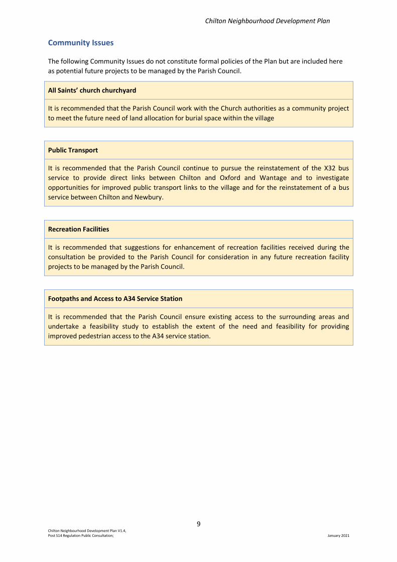
Community Issues
The following Community Issues do not constitute formal policies of the Plan but are included here
as potential future projects to be managed by the Parish Council.
All Saints’ church churchyard
It is recommended that the Parish Council work with the Church authorities as a community project
to meet the future need of land allocation for burial space within the village
Public Transport
It is recommended that the Parish Council continue to pursue the reinstatement of the X32 bus
service to provide direct links between Chilton and Oxford and Wantage and to investigate
opportunities for improved public transport links to the village and for the reinstatement of a bus
service between Chilton and Newbury.
Recreation Facilities
It is recommended that suggestions for enhancement of recreation facilities received during the
consultation be provided to the Parish Council for consideration in any future recreation facility
projects to be managed by the Parish Council.
Footpaths and Access to A34 Service Station
It is recommended that the Parish Council ensure existing access to the surrounding areas and
undertake a feasibility study to establish the extent of the need and feasibility for providing
improved pedestrian access to the A34 service station.
Chilton Neighbourhood Development Plan
10 Chilton Neighbourhood Development Plan V1.4, Post S14 Regulation Public Consultation; January 2021
1. Introduction
1a. Background to the Plan
On behalf of Chilton Parish Council, the Chilton Neighbourhood Plan Steering Group has prepared a
Neighbourhood Development Plan (the Plan) for the village.
The area covered by the Plan is described at Section 1d.
The Plan has been written for Chilton by a group of volunteers who formed a Steering Group (the
‘Steering Group’), the members of which are listed in the Credits and Acknowledgements section.
Input has been sought from across the community. Support and advice has been provided by officers
from the Vale of White Horse District Council (‘VWHDC’) and others, who are also listed in the same
section.
The principal purpose of the Plan is to derive policies that will be used in making planning decisions
about the future of the area up to 2031, the Plan Period (the ‘Plan Period’). Once approved by the
independent examiner and supported at a village referendum, the Plan becomes part of the
VWHDC’s Statutory Development Plan. The policies developed must all be relevant to planning, and
therefore can only relate to the development and use of land.
When preparing the Plan, the Steering Group has taken into account the following requirements of
any neighbourhood plan:
• it must have appropriate regard for national planning policy;
• it must contribute to the achievement of sustainable development;
• it must be in general conformity with the strategic policies in the Development Plan for the
local area; and
• it must be compatible with EU obligations, including human rights.
Neighbourhood plans provide local communities with the chance to shape the future development
of their area. Therefore, consultation with the residents of Chilton has been fundamental to the
process of preparing the Plan. The steps taken in preparing the Plan, and the consultations with the
village and advisers, are described in Section 1b below.
Consultation has also brought forward a number of issues in relation to the village which do not
relate directly to land use. In order to use this valuable feedback, the Plan includes a list of
Community Issues, essentially additional matters of concern to the community and which can be
considered by the Parish Council in the future.
1b. Summary of Process, including consultation
The proposal to prepare a Plan was first discussed at the Chilton Parish Council meeting in
September 2015. Representatives from the VWHDC then attended the Parish Council meeting on 6
April 2016 and gave an outline of the purpose of a neighbourhood plan and the process involved. At
this meeting the Parish Council agreed to proceed, and that a separate Steering Group be formed to
progress the production of the plan.
An introduction to neighbourhood planning was included in the June 2016 edition of the Chilton
Chronicle and circulated to all residents together with an invitation to attend a public meeting held
Chilton Neighbourhood Development Plan
11 Chilton Neighbourhood Development Plan V1.4, Post S14 Regulation Public Consultation; January 2021
in the village hall on 21 June 2016. An invitation to express an interest to join the Steering Group was
extended to all those present.
The Steering Group for this project was formed in the autumn of 2016. Steering Group members are
volunteers with a broad mix of skills and experience, including planning, public consultation, and
extensive knowledge of the history and environs of Chilton. The VWHDC designated the area (the
‘Plan Area’) to be covered by the Plan on 1 October 2017 following a statutory consultation. The Plan
Area is shown in section 1d.
A neighbourhood plan is a community project and must derive its authority and policies from the
community. Communication, feedback and consultation have played a major part in developing the
Plan. Full details of the overall consultation process are set out in a separate Consultation Report,
but in summary:
• The Steering Group met six-weekly in open meetings available to the community;
• Agendas were published on the Parish Council website http://www.parish-
council.com/Chilton/ in advance of each meeting, and Minutes were similarly published
after each meeting;
• Feedback was obtained through the village survey (See Appendix 2), village events, and
individually via members of the Parish Council and the Steering Group;
• Progress updates were provided:
- in the Chilton Chronicle, the news sheet published by the Parish Council and hand-
delivered to every household (10 editions/year);
- via the three Chilton Facebook pages, and
- on posters placed around the village.
• Progress of the Plan was discussed at each Parish Council meeting;
• A joint project was set up with Chilton Primary school to collect data on local fauna
• A draft plan was prepared and submitted for pre-submission consultation;
• Comments from the pre-submission consultation were addressed in an amended plan
submitted to the VWHDC for the formal ‘regulation 16’ consultation.
During the process, helpful advice was provided by members of the VWHDC’s neighbourhood
planning team.
1c. Vision Statement and Objectives
Following a public consultation, including further public meetings, a vision and set of objectives were
agreed by the Steering Group to reflect the views expressed by residents and other interested
parties:
Vision Statement
The vision is for Chilton to be a small, primarily residential village, within the North Wessex Downs
Area of Outstanding Natural Beauty safeguarding its historic downland character whilst
promoting sustainable development, and improving local facilities to meet the needs of its
residents throughout their lives.
Chilton Neighbourhood Development Plan
12 Chilton Neighbourhood Development Plan V1.4, Post S14 Regulation Public Consultation; January 2021
Objectives
1. Consistent with the VWHDC Local Plan and the character and history of Chilton, to inform the
siting of any new housing, and the preferred styles and mix of residential development.
2. To maintain and develop infrastructure, including the control and reduction of flooding from
wastewater, rainwater and a high water table.
3. To maintain, and improve, recreational facilities for children, families and young people.
4. To encourage the development of infrastructure and activities supporting those in the
community of advancing years and a range of abilities.
5. To maintain and improve public transport links to nearby town centres.
6. To maintain and enhance community facilities for all ages.
7. To protect and encourage Local Green Spaces within the Plan Area for recreational use and
furthering the natural aesthetics and ecology of our environment.
8. To preserve and promote accessibility to the surrounding Area of Outstanding Natural Beauty
(‘AONB’).
9. To promote sustainable enterprise consistent with the character and history of Chilton in its
setting as a small primarily residential rural village.
10. To be a responsible ‘good neighbour’ to adjacent parishes and the Harwell Campus.
A consistent theme coming from the public consultation was a wish to keep the village as a primarily
residential small rural village, building on its history and embracing the benefits and opportunities
offered by the AONB in which it lies, whilst promoting appropriate sustainable enterprise. Whilst
good progress has been made over the years in developing facilities and amenities to support a
thriving community, further advances are desirable to maximise opportunities for residents of all
ages and abilities.
This vision, and the classification of Chilton as a small village, is consistent with the policies set out in
the adopted VWHDC 2031 Local Plan Part 1
Chilton Neighbourhood Development Plan
13 Chilton Neighbourhood Development Plan V1.4, Post S14 Regulation Public Consultation; January 2021
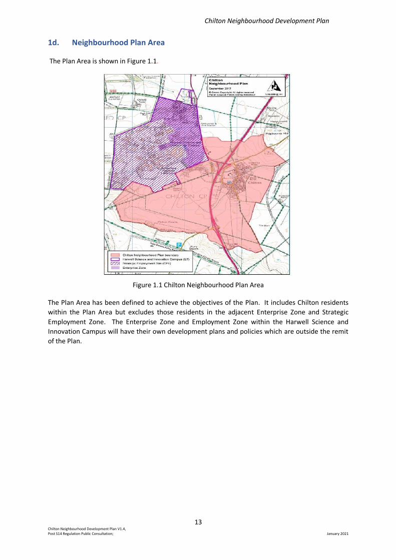
1d. Neighbourhood Plan Area
The Plan Area is shown in Figure 1.1.
Figure 1.1 Chilton Neighbourhood Plan Area
The Plan Area has been defined to achieve the objectives of the Plan. It includes Chilton residents
within the Plan Area but excludes those residents in the adjacent Enterprise Zone and Strategic
Employment Zone. The Enterprise Zone and Employment Zone within the Harwell Science and
Innovation Campus will have their own development plans and policies which are outside the remit
of the Plan.
Chilton Neighbourhood Development Plan
14 Chilton Neighbourhood Development Plan V1.4, Post S14 Regulation Public Consultation; January 2021
2. Chilton and its Surroundings
2a. Introduction to Chilton
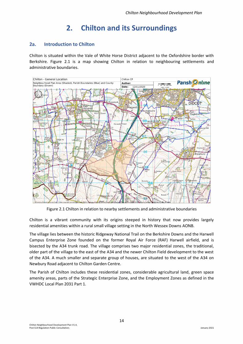
Chilton is situated within the Vale of White Horse District adjacent to the Oxfordshire border with
Berkshire. Figure 2.1 is a map showing Chilton in relation to neighbouring settlements and
administrative boundaries.
Figure 2.1 Chilton in relation to nearby settlements and administrative boundaries
Chilton is a vibrant community with its origins steeped in history that now provides largely
residential amenities within a rural small village setting in the North Wessex Downs AONB.
The village lies between the historic Ridgeway National Trail on the Berkshire Downs and the Harwell
Campus Enterprise Zone founded on the former Royal Air Force (RAF) Harwell airfield, and is
bisected by the A34 trunk road. The village comprises two major residential zones, the traditional,
older part of the village to the east of the A34 and the newer Chilton Field development to the west
of the A34. A much smaller and separate group of houses, are situated to the west of the A34 on
Newbury Road adjacent to Chilton Garden Centre.
The Parish of Chilton includes these residential zones, considerable agricultural land, green space
amenity areas, parts of the Strategic Enterprise Zone, and the Employment Zones as defined in the
VWHDC Local Plan 2031 Part 1.
Chilton Neighbourhood Development Plan
15 Chilton Neighbourhood Development Plan V1.4, Post S14 Regulation Public Consultation; January 2021
Size and Population
The Plan Area consists of approximately 670 residences – some 360 in the older part of the village to
the east of the A34 and 310 to the west of the A34. The most recent census in 2011 lists the
population as 894 but this does not fully embrace the recently arrived residents in Chilton Field. A
more recent estimate places the current population to be about 1400-1500.
Footpaths
The Parish is surrounded and/or crossed by a number of footpaths and rights of way, many of
historic interest, providing valued access to the surrounding AONB (see Figs 2.2 and 8.1).
Community Assets and Facilities
Chilton houses a number of buildings and amenities that serve the community. All Saints’ church
provides a commanding visual asset in the traditional part of Chilton as well as being a centre of
spiritual wellbeing. Chilton Primary School, situated adjacent to the Chilton Field development, has a
long-standing reputation for excellence and also accommodates a vibrant pre-school nursery class.
The Parish includes a recently extended village hall in the traditional part of the village and a
community room on the Chilton Field development. Recreational facilities are provided in both parts
of the village. Green space amenity areas are interspersed within the housing. Allotment plots are
provided east of the A34 and in a new area for allotments west of the A34.
The village has one public house, the Rose and Crown, a traditional building situated at a
commanding location on Main Street.
These buildings and amenities host a wide range of organisations and activities that underpin the
vibrant village community of Chilton and include: Beavers, Cubs and Scouts; toddler groups;
badminton; yoga; Pilates; Women’s Institute; All Saints’ Women’s Group; football; choir; bowls;
Caledonian dancing; fitness class, and radio-controlled model vehicles.
Housing
The residential zone to the east of the A34 includes a range of traditional style properties, including
several that are Grade II listed, together with some more recent developments. Eight developments,
with a total of 185 houses (i.e. an average of 23 per development) were constructed over a 30-year
period from 1961 to 1991.
The residential zone to the west of the A34 comprises a farmhouse, 12 houses in Severn Road
constructed in 19521, a row of newly built/renovated properties adjacent to the Garden Centre,
together with 275 houses on the Chilton Field development constructed in 2011/2012 following the
removal of the 100 prefabricated houses and reclamation of the adjacent ex RAF and United
Kingdom Atomic Energy Authority (UKAEA) brown field land.
Employment and Business
As well as including parts of the adjacent Harwell Campus, Chilton has a range of thriving
independent small businesses and enterprises and home workers. There is a petrol filling station
with an integral shop south of the village on the A34; a garden centre including a café and antiques
centre; an agricultural business and an office building housing the Horticultural Trades Association.
About 12% of the houses have one member of the household employed at Harwell Campus. Others
travel to work at locations from Oxford to Newbury (north to south) and from Reading to Swindon
(east to west) or commute by train to London.
1 Severn Road lies within the Employment Zone and at the request of VWHDC has been excluded from the Plan Area (See Section 1.d)
Chilton Neighbourhood Development Plan
16 Chilton Neighbourhood Development Plan V1.4, Post S14 Regulation Public Consultation; January 2021
Public Transport
Chilton is served partly by the X32 Thames Travel bus service between Oxford and the nearby towns
of Didcot and Wantage, and the more restricted 94 bus service between Chilton and Didcot. Bus
timetables are frequently changed for Chilton services. Additionally, the Thames Travel science
shuttle service (ST1) operates between the Harwell Campus, a distance of about a mile from Chilton
village east of the A34, and Oxford city centre.
2b. History leading to Current Status
Ancient and Medieval
The Parish of Chilton has a history of settlement since ancient times. Its strategic position in a
sheltered valley below the Ridgeway, a thoroughfare of great historic significance, has provided
opportunities for hunting and farming and good communications for trade and new ideas.
Chilton fell within the region occupied by the Celtic tribe of the Atrebates. Many Iron Age remains
have been found locally.
A possibly older scheduled monument is Grim’s Ditch which lies on the southern boundary of the
Plan Area. Much of this extensive earthwork has now been lost, but short distances can still be
found and appear on Ordnance Survey maps in the south of the Parish. This was a significant,
possibly tribal, boundary.
During the Roman occupation there is evidence that there was much development in the local area.
Excavations took place before the building of homes at Chilton Field, which revealed that an
extensive settlement existed here.
During the medieval period, King Edward II (1284-1327; reigned 1307-27) is believed to have passed
through Chilton on his way to Harwell, where he had installed his favourite Piers Gaveston with a
large landholding.
During the English Civil War (1642-1649) following the second battle of Newbury (1644), defeated
Royalist troops fled through Chilton towards their stronghold at Oxford. Parliamentarian troops
pursuing them paused long enough at Chilton to destroy the church tower. Chilton rebuilt its tower
in wood and its stone tower was reinstated in the nineteenth century.
Agricultural and Equine
In the eighteenth-century William Duke of Cumberland (the second son of King George II) was the
tenant of a mansion at Kate’s Gore on Gore Hill, which was used as an important establishment for
training his racehorses. The chalk downland with its well-drained springy turf offered the perfect
platform for equine exercise. In the nineteenth and twentieth centuries racehorse training became
a major industry in Chilton. It employed many people and enhanced the viability of the rural
economy. Although now diminished in size, equine activities continue to provide sustainable
economic and recreational value to the present day.
The open countryside surrounding the village is classified as Grade 2 (very good) agricultural land
and continues to be farmed largely with arable produce.
Chilton Neighbourhood Development Plan
17 Chilton Neighbourhood Development Plan V1.4, Post S14 Regulation Public Consultation; January 2021
Royal Air Force - Harwell
The former RAF Harwell airfield lies to the north-west and adjacent to the Plan Area. It is within the
Enterprise Zone.
There is a memorial marking the end of the runway to commemorate the 6 June 1944 ‘D-Day’
operation when gliders taking troops to Normandy took off. It lies within Chilton Parish.
UKAEA and Harwell Campus
After World War II, the airfield became the research centre for the United Kingdom Atomic Energy
Authority (UKAEA), bringing with it supporting residential housing of 100 prefabricated houses on
the Chilton site and 12 houses on Severn Road, both within the Parish Boundary. Scientific research
has continued to this day to be a major theme on the adjacent Harwell Campus which is a Strategic
Enterprise Zone and Employment Zone within Part 1 of the VWHDC Local Plan 2031. The
prefabricated houses were demolished in the 1990’s and the extended site formed the location for
the Chilton Field housing development on the west side of the A34.
2c. Location within Area of Outstanding Natural Beauty
Until 1974 Chilton was, for approximately 1,000 years, in the Royal County of Berkshire. After
Government changes throughout the country many ancient counties found themselves placed in
unfamiliar areas. Chilton had until 1974 been within Wantage Rural District Council. After that date
it was placed in the newly formed VWHDC.
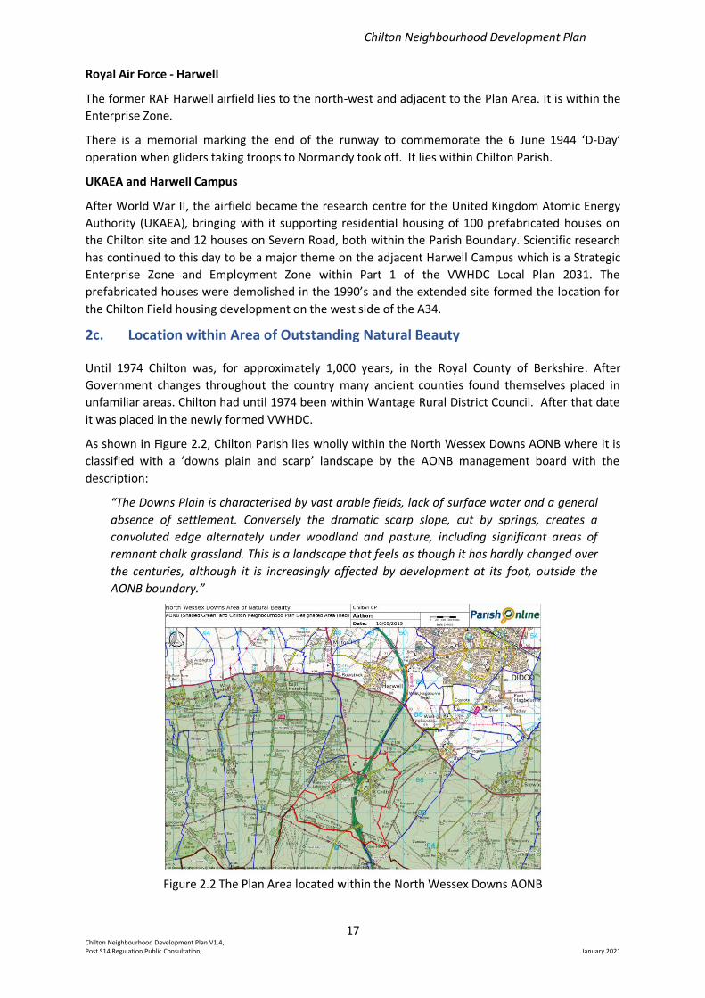
As shown in Figure 2.2, Chilton Parish lies wholly within the North Wessex Downs AONB where it is
classified with a ‘downs plain and scarp’ landscape by the AONB management board with the
description:
“The Downs Plain is characterised by vast arable fields, lack of surface water and a general
absence of settlement. Conversely the dramatic scarp slope, cut by springs, creates a
convoluted edge alternately under woodland and pasture, including significant areas of
remnant chalk grassland. This is a landscape that feels as though it has hardly changed over
the centuries, although it is increasingly affected by development at its foot, outside the
AONB boundary.”
Figure 2.2 The Plan Area located within the North Wessex Downs AONB
Chilton Neighbourhood Development Plan
18 Chilton Neighbourhood Development Plan V1.4, Post S14 Regulation Public Consultation; January 2021
3. Built Environment
In this section of the Plan we describe the character of Chilton village, its heritage assets and how
the village has developed over time, leading to a number of characteristic architectural styles that
are predominant in different locations within the village. We also describe the current housing needs
of the village as perceived by local residents, and propose how future needs, within the Plan
timeframe, can best be accommodated within existing defined settlement areas.
More detailed information and evidence is given in two supporting appendices.
Appendix 1 presents a village character assessment outlining the relationship between the built and
natural environments. Typical styles of development that positively contribute to the local character
are described together with their main locations within the Plan Area. This appendix provides a
design and style guide to capture those characteristic architectural features to ensure harmonisation
of any future development with the existing styles in the different areas of the village. Guidance is
given on design principles, siting, materials, environmental standards as well as the change of use,
conversion or replacement of existing buildings.
Appendix 2 presents the results of a survey, open to all village residents and visitors, undertaken by
the steering group in 2018 to assess the needs and perceptions of requirements for future
development of the village. Section 1 of the survey addresses housing needs, section 2 addresses
village amenity needs, section 3 addresses business activities and section 4 provides for open
comments not covered elsewhere. In section 3c below we focus on the results of the housing needs
section of the survey and the implications for future housing development sites.
3a. Village Character Assessment
Chilton is one of a series of springline villages at the northern edge of the North Wessex Downs, just
below the ancient Ridgeway. Historically its rural and somewhat isolated location has dictated that
its economy has been rooted in agriculture and racehorse training. With the advent of modern
transport Chilton has grown and diversified, although its rural setting and retention of green open
spaces are much enjoyed and valued by its community.
A major new development to the village, on the west side of the A34, has been built on the site
previously occupied by 100 prefabricated houses and other facilities owned by the UKAEA. This
development, known as Chilton Field, built over the period from 2010 to 2014, comprises 275
residential dwellings.
The older part of the village has evolved from its main thoroughfare, which was originally a loop
between two points on the old A34 Oxford to Newbury road (White Road and Townsend at the
northern end and Lower Road at the southern end). When the A34 trunk road was upgraded and
realigned in the 1970s, Chilton’s status as a small village with no through traffic was upheld. It
therefore retains a degree of tranquillity which is often lost to villages in less optimal locations, and
it remains a priority of parishioners that Chilton’s character is preserved for the benefit of its
residents.
Although Chilton has no conservation area, it retains many of its historic properties, together with
later infilling and new development in a pleasing mix of homes and gardens, suited to its rural
location.
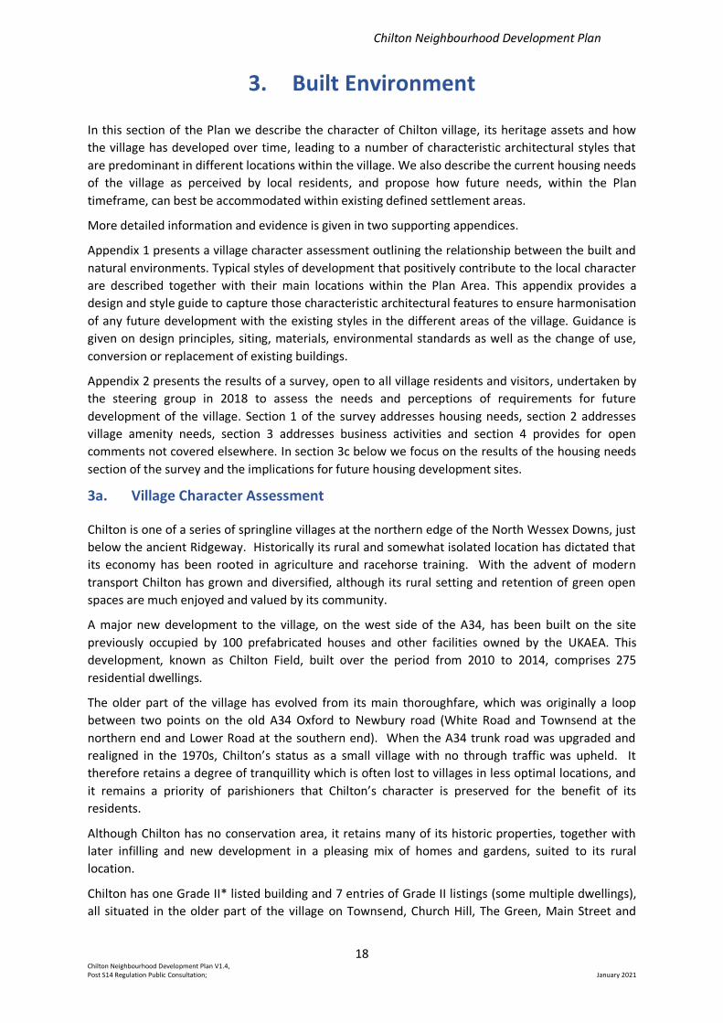
Chilton has one Grade II* listed building and 7 entries of Grade II listings (some multiple dwellings),
all situated in the older part of the village on Townsend, Church Hill, The Green, Main Street and
Chilton Neighbourhood Development Plan
19 Chilton Neighbourhood Development Plan V1.4, Post S14 Regulation Public Consultation; January 2021
Dene Hollow as shown in Table 3.1 and Figure 3.1. All the architectural details for these buildings can
be found on the Historic England website under “Chilton, Oxfordshire” and a summary of the most
notable features are given in Table 3.1 (Abridged) below, full table is in Appendix 1 Section 1.4.
Listed Buildings in Chilton
Property Location Grade Description
Place Farm House The Lane II* 15th/16th Century farmhouse
Chilton House Townsend II Mid-17th century origin, now 4 dwellings
The Goddards Church Hill II Early 17th century house
All Saints’ church Church Hill II 12th century origin with additions 13th, 14th and 19th
century
East, Middle and West
Houses
Church Hill II 17th century origin built as vicarage, now 3 dwellings
Dene Hollow and
Dene Lodge
Dene
Hollow
II 17th century origin
Malt House Main
Street
II Early 18th century
1 and 2 The Green The Green II 17th century origin, now 2 dwellings
Table 3.1 Listed Buildings in Chilton (Abridged)
Figure 3.1 Location of Listed Buildings in Chilton
Chilton Neighbourhood Development Plan
20 Chilton Neighbourhood Development Plan V1.4, Post S14 Regulation Public Consultation; January 2021
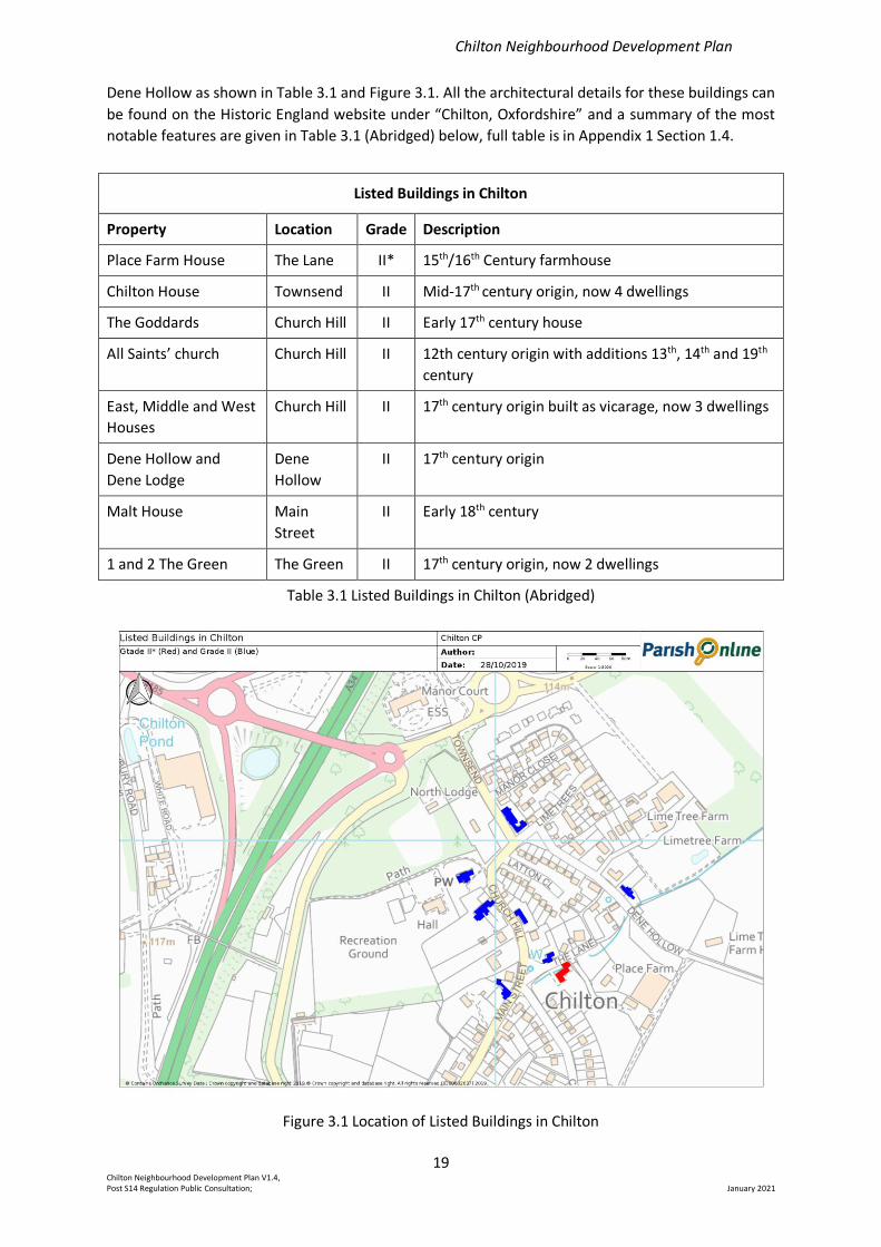
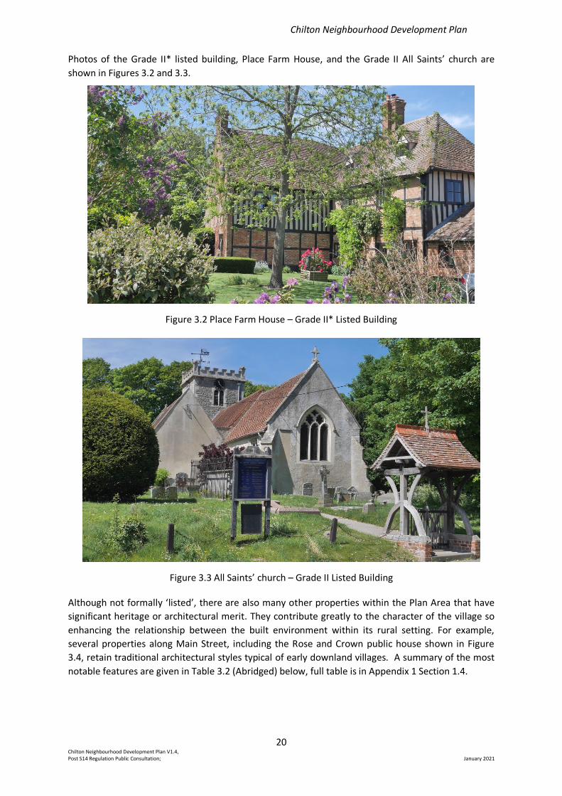
Photos of the Grade II* listed building, Place Farm House, and the Grade II All Saints’ church are
shown in Figures 3.2 and 3.3.
Figure 3.2 Place Farm House – Grade II* Listed Building
Figure 3.3 All Saints’ church – Grade II Listed Building
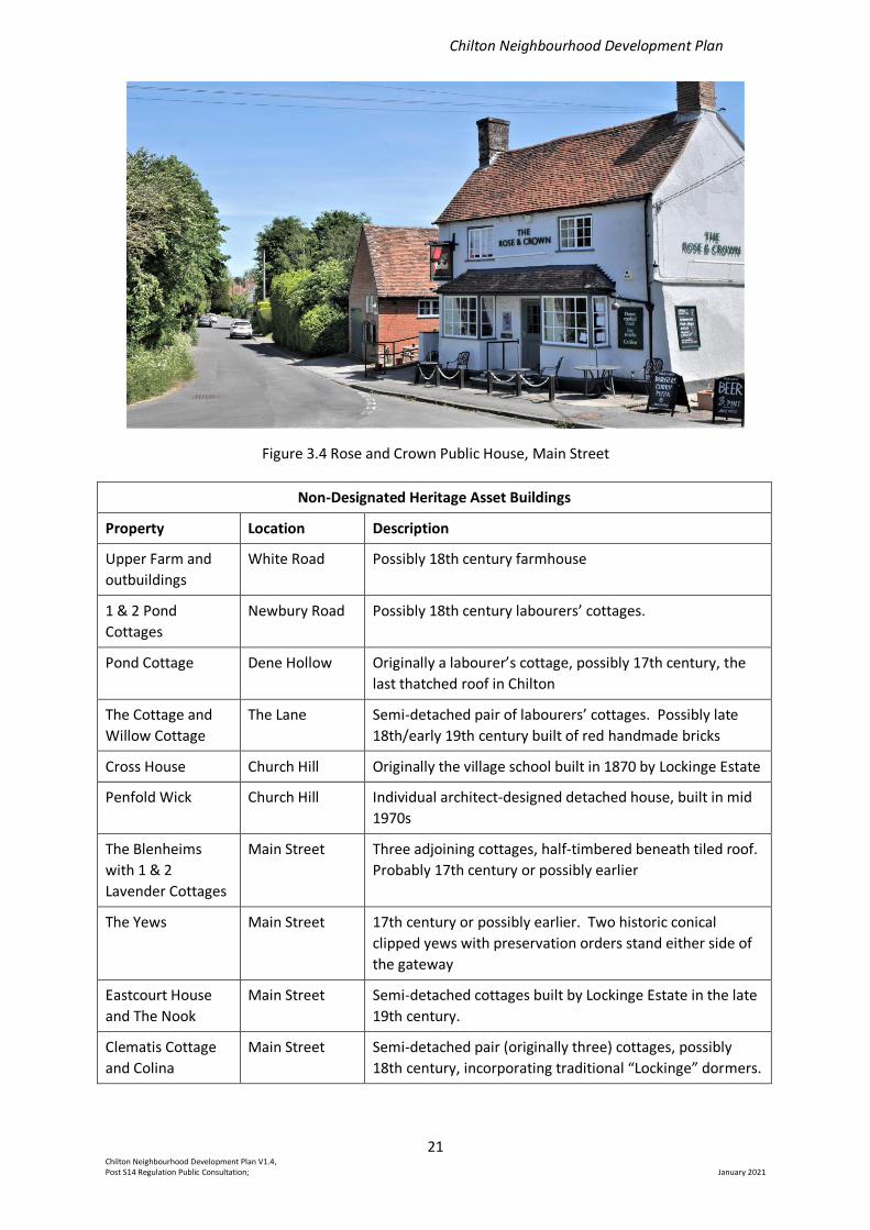
Although not formally ‘listed’, there are also many other properties within the Plan Area that have
significant heritage or architectural merit. They contribute greatly to the character of the village so
enhancing the relationship between the built environment within its rural setting. For example,
several properties along Main Street, including the Rose and Crown public house shown in Figure
3.4, retain traditional architectural styles typical of early downland villages. A summary of the most
notable features are given in Table 3.2 (Abridged) below, full table is in Appendix 1 Section 1.4.
Chilton Neighbourhood Development Plan
21 Chilton Neighbourhood Development Plan V1.4, Post S14 Regulation Public Consultation; January 2021
Figure 3.4 Rose and Crown Public House, Main Street
Non-Designated Heritage Asset Buildings
Property Location Description
Upper Farm and
outbuildings
White Road Possibly 18th century farmhouse
1 & 2 Pond
Cottages
Newbury Road Possibly 18th century labourers’ cottages.
Pond Cottage Dene Hollow Originally a labourer’s cottage, possibly 17th century, the
last thatched roof in Chilton
The Cottage and
Willow Cottage
The Lane Semi-detached pair of labourers’ cottages. Possibly late
18th/early 19th century built of red handmade bricks
Cross House Church Hill Originally the village school built in 1870 by Lockinge Estate
Penfold Wick Church Hill Individual architect-designed detached house, built in mid
1970s
The Blenheims
with 1 & 2
Lavender Cottages
Main Street Three adjoining cottages, half-timbered beneath tiled roof.
Probably 17th century or possibly earlier
The Yews Main Street 17th century or possibly earlier. Two historic conical
clipped yews with preservation orders stand either side of
the gateway
Eastcourt House
and The Nook
Main Street Semi-detached cottages built by Lockinge Estate in the late
19th century.
Clematis Cottage
and Colina
Main Street Semi-detached pair (originally three) cottages, possibly
18th century, incorporating traditional “Lockinge” dormers.
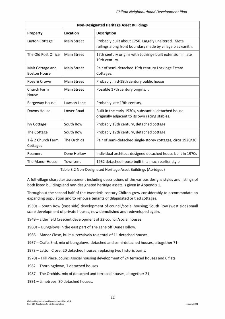
Chilton Neighbourhood Development Plan
22 Chilton Neighbourhood Development Plan V1.4, Post S14 Regulation Public Consultation; January 2021
Non-Designated Heritage Asset Buildings
Property Location Description
Layton Cottage Main Street Probably built about 1750. Largely unaltered. Metal
railings along front boundary made by village blacksmith.
The Old Post Office Main Street 17th century origins with Lockinge built extension in late
19th century.
Malt Cottage and
Boston House
Main Street Pair of semi-detached 19th century Lockinge Estate
Cottages.
Rose & Crown Main Street Probably mid-18th century public house
Church Farm
House
Main Street Possible 17th century origins. .
Bargeway House Lawson Lane Probably late 19th century.
Downs House Lower Road Built in the early 1930s, substantial detached house
originally adjacent to its own racing stables.
Ivy Cottage South Row Probably 18th century, detached cottage
The Cottage South Row Probably 19th century, detached cottage
1 & 2 Church Farm
Cottages
The Orchids Pair of semi-detached single-storey cottages, circa 1920/30
Roamers Dene Hollow Individual architect-designed detached house built in 1970s
The Manor House Townsend 1962 detached house built in a much earlier style
Table 3.2 Non-Designated Heritage Asset Buildings (Abridged)
A full village character assessment including descriptions of the various designs styles and listings of
both listed buildings and non-designated heritage assets is given in Appendix 1.
Throughout the second half of the twentieth century Chilton grew considerably to accommodate an
expanding population and to rehouse tenants of dilapidated or tied cottages.
1930s – South Row (east side) development of council/social housing; South Row (west side) small
scale development of private houses, now demolished and redeveloped again.
1949 – Elderfield Crescent development of 22 council/social houses.
1960s – Bungalows in the east part of The Lane off Dene Hollow.
1966 – Manor Close, built successively to a total of 11 detached houses.
1967 – Crafts End, mix of bungalows, detached and semi-detached houses, altogether 71.
1973 – Latton Close, 20 detached houses, replacing two historic barns.
1970s – Hill Piece, council/social housing development of 24 terraced houses and 6 flats
1982 – Thorningdown, 7 detached houses
1987 – The Orchids, mix of detached and terraced houses, altogether 21
1991 – Limetrees, 30 detached houses.
Chilton Neighbourhood Development Plan
23 Chilton Neighbourhood Development Plan V1.4, Post S14 Regulation Public Consultation; January 2021
1996 – The Paddock, 11 detached houses.
Since the year 2000 there have been further developments, situated predominantly to the west of
the A34 trunk road.
2007 – The Gallops, 11 linked dwellings
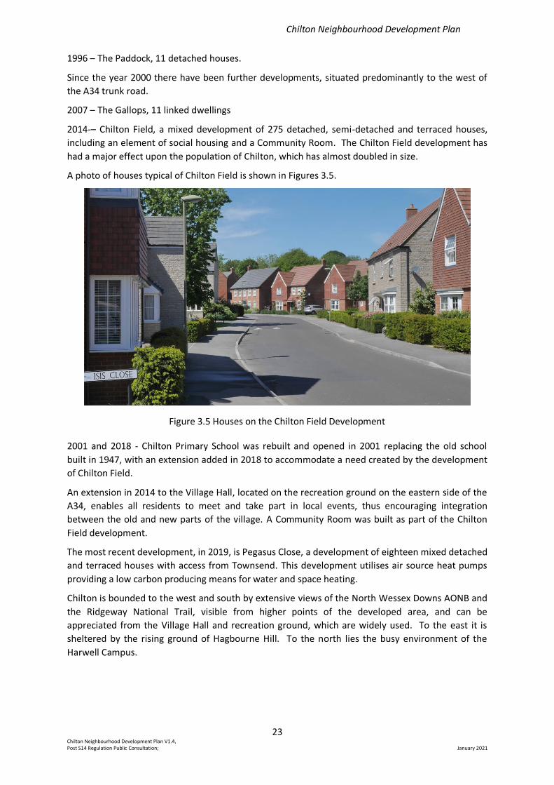
2014-– Chilton Field, a mixed development of 275 detached, semi-detached and terraced houses,
including an element of social housing and a Community Room. The Chilton Field development has
had a major effect upon the population of Chilton, which has almost doubled in size.
A photo of houses typical of Chilton Field is shown in Figures 3.5.
Figure 3.5 Houses on the Chilton Field Development
2001 and 2018 - Chilton Primary School was rebuilt and opened in 2001 replacing the old school
built in 1947, with an extension added in 2018 to accommodate a need created by the development
of Chilton Field.
An extension in 2014 to the Village Hall, located on the recreation ground on the eastern side of the
A34, enables all residents to meet and take part in local events, thus encouraging integration
between the old and new parts of the village. A Community Room was built as part of the Chilton
Field development.
The most recent development, in 2019, is Pegasus Close, a development of eighteen mixed detached
and terraced houses with access from Townsend. This development utilises air source heat pumps
providing a low carbon producing means for water and space heating.
Chilton is bounded to the west and south by extensive views of the North Wessex Downs AONB and
the Ridgeway National Trail, visible from higher points of the developed area, and can be
appreciated from the Village Hall and recreation ground, which are widely used. To the east it is
sheltered by the rising ground of Hagbourne Hill. To the north lies the busy environment of the
Harwell Campus.
Chilton Neighbourhood Development Plan
24 Chilton Neighbourhood Development Plan V1.4, Post S14 Regulation Public Consultation; January 2021
3b. Sewerage and Drainage
Owing to its topological positioning with respect to the surrounding area, the mains drainage system
for developments to the east of the A34 relies on a pumping station situated in Dene Hollow.
In recent years, there have been a few occasions during or following extended periods of wet
weather when low lying parts of Chilton to the east of the A34 have suffered sewer overflows and
groundwater flooding.
Following one of the wettest periods on record, when emergency measures were required to
augment the pumping station, Thames Water upgraded the sewage effluent link. Although
significantly improved, instances of blocked and/or overloaded mains sewers have continued to
occur and remain of some concern.
It is noted that for the recent housing development in Chilton in Pegasus Close, control of waste
water was addressed at the planning stage and that a sustainable solution was included in the
resulting approved plans. It is important that any future development should not exacerbate the
potential for groundwater flooding or sewer overflows and that appropriate safeguards are ensured
through existing planning and building regulations
3c Housing Needs Survey
Part of the survey of all residents in 2018, managed by the Steering Group, was designed to gather
views on the need for further housing, the preferred location of any housing and the preferred
design styles. Appendix 2 gives full details.
The results of the survey are summarised as follows:
1. The majority (67%) of respondents said either they were not very likely or not at all likely to
move in the next five years
2. Of those wanting to move, 34% cited affordability as the reason preventing their moving and
19% as lack of suitable housing being available.
3. The majority of respondents (55%) did not consider that there were any suitable locations for
new homes in or around the village. 27% of respondents supported infill between existing
properties and 15% supported backfill on existing properties. 10% of respondents supported
new housing on paddocks or open spaces.
4. For those people with established links to Chilton and who need housing, 38% of respondents
were supportive of new sheltered housing for older people, 37% supported new housing to buy,
30% supported new housing for people over 55 years old, 29% supported new affordable rented
housing provided by a housing association, 25% supported new shared ownership housing, 25%
supported self-build schemes and 21% supported new housing to rent at market rates. 35% of
respondents stated they did not support any of these.
5. In keeping with existing design styles, in the older part of the village to the east of the A34, 80%
of respondents supported brick designs, 75% supported timber framed or other traditional
designs and 31% supported contemporary designs. In the newer part of the village to the west of
the A34, 83% supported brick designs, 53% supported contemporary designs and 36% supported
timber framed or traditional designs.
The evidence from the survey indicates there is only a limited local need for further housing
development and that there is a strong preference that any housing development should not be
permitted on existing paddocks or open spaces. In addition, there was preference that the design of
Chilton Neighbourhood Development Plan
25 Chilton Neighbourhood Development Plan V1.4, Post S14 Regulation Public Consultation; January 2021
any houses reflect existing styles in accordance with location and reflected by the village character
assessment.
These findings underpin the vision and objectives for the Plan. They are consistent with the ‘smaller
village’ designation for Chilton in Part 1 of the VWHDC Local Plan 2031, and that no further
development sites within the Part 2 of the VWHDC Local Plan 2031 are identified within the Plan
Area.
In response to these findings, policies P1, P2 and P3 have been formulated to address the location
and design styles of future development proposals within the Plan Area.
3d. Settlement Boundary
A settlement boundary is recognised and generally accepted for defining appropriate locations for
development, and to prevent the unregulated encroachment of development into the open
countryside or otherwise inappropriate locations.
It is recognised that settlement boundaries, as defined in a Neighbourhood Plan, are required to be
consistent with development policies and development sites as defined in the VWHDC Local Plan.
The Local Plan is the primary means of demonstrating that adequate land supply has been allocated
to meet defined housing needs. The VWHDC Local Plan Parts 1 and 2 currently meet forward
projections of housing needs up to 2031 and the settlement boundaries in this Plan are consistent
with the designation of Chilton village as a smaller village. Should at some future point the VWHDC
no longer be able to demonstrate compliance with the 5-year land supply to meet housing needs
then the settlement boundary would be considered out of date.
It is therefore important that the principles on which settlement boundaries are based are clear,
consistently applied, and capable of being easily understood. It defines the boundary between the
predominately built-up area of the village and the predominately open countryside surrounding the
village. The principles by which the settlement boundary has been determined are as follows:
3e. Settlement Boundary Principles
Principle 1: Given the status of Chilton as a smaller village in the VWHDC Local Plan the
boundary should be drawn fairly tightly around the existing built-up area and no new allocations
for housing or other land uses incorporated until built out.
Principle 2: Where possible the boundary should follow clearly defined features e.g. field
boundaries, roads, ditches, walls, fences, etc.
Principle 3: The boundary should generally follow the curtilage of properties except where
there are large gardens or other open areas, which would be inappropriately drawn into the
built-up area.
Principle 4: Isolated dwellings and agricultural buildings which are clearly detached from or
peripheral to the main built-up area of the village should be excluded.
Principle 5: Existing areas of employment and business that are detached from or peripheral to
the village should not be included but instead they should be clearly identified for that purpose.
Principle 6: Important amenity areas and large public open spaces that contribute to the
character of the village and that are already subject to restrictions on future development should
not be included.
Principle 7: The settlement boundary does not need to be continuous. It may be appropriate
given the nature and form of the village to define two or more separate elements.
Chilton Neighbourhood Development Plan
26 Chilton Neighbourhood Development Plan V1.4, Post S14 Regulation Public Consultation; January 2021
Principle 8: The boundary should be drawn consistent with existing planning permissions that
are built out, recent refusals and appeal decisions.
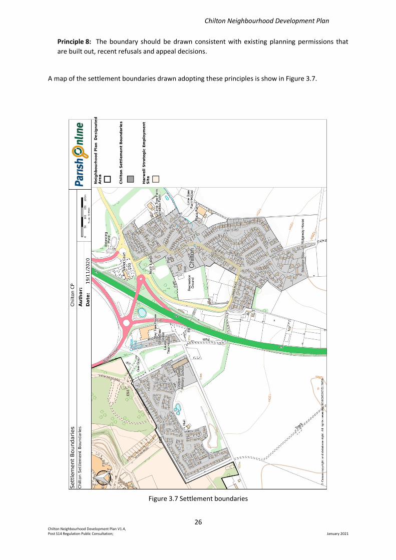
A map of the settlement boundaries drawn adopting these principles is show in Figure 3.7.
Figure 3.7 Settlement boundaries
Chilton Neighbourhood Development Plan
27 Chilton Neighbourhood Development Plan V1.4, Post S14 Regulation Public Consultation; January 2021
Three settlement areas are identified: a large area to the east of the A34; a large area to the west of
the A34; and a small area to the west of the A34 adjacent to the employment site close to the
northbound slip road off the A34.
Two employment sites are identified: an area to the west of the A34 adjacent to the northbound slip
road off the A34 and the site of Chilton Garden Centre, and an area to the east of the A34 enclosed
by the southbound slip road off the A34 and the site of Horticulture House, a large office building.
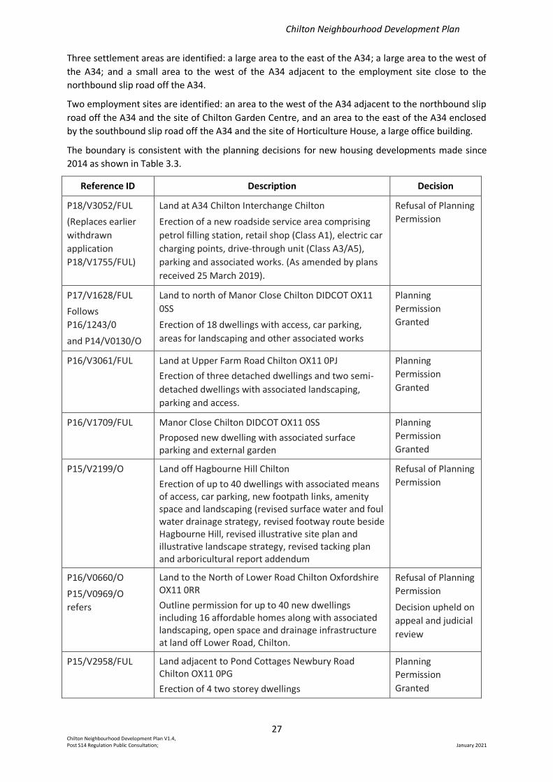
The boundary is consistent with the planning decisions for new housing developments made since
2014 as shown in Table 3.3.
Reference ID Description Decision
P18/V3052/FUL
(Replaces earlier
withdrawn
application
P18/V1755/FUL)
Land at A34 Chilton Interchange Chilton
Erection of a new roadside service area comprising
petrol filling station, retail shop (Class A1), electric car
charging points, drive-through unit (Class A3/A5),
parking and associated works. (As amended by plans
received 25 March 2019).
Refusal of Planning
Permission
P17/V1628/FUL
Follows
P16/1243/0
and P14/V0130/O
Land to north of Manor Close Chilton DIDCOT OX11
0SS
Erection of 18 dwellings with access, car parking,
areas for landscaping and other associated works
Planning
Permission
Granted
P16/V3061/FUL Land at Upper Farm Road Chilton OX11 0PJ
Erection of three detached dwellings and two semi-
detached dwellings with associated landscaping,
parking and access.
Planning
Permission
Granted
P16/V1709/FUL Manor Close Chilton DIDCOT OX11 0SS
Proposed new dwelling with associated surface parking and external garden
Planning
Permission
Granted
P15/V2199/O Land off Hagbourne Hill Chilton
Erection of up to 40 dwellings with associated means of access, car parking, new footpath links, amenity space and landscaping (revised surface water and foul water drainage strategy, revised footway route beside Hagbourne Hill, revised illustrative site plan and illustrative landscape strategy, revised tacking plan and arboricultural report addendum
Refusal of Planning
Permission
P16/V0660/O
P15/V0969/O
refers
Land to the North of Lower Road Chilton Oxfordshire OX11 0RR
Outline permission for up to 40 new dwellings including 16 affordable homes along with associated landscaping, open space and drainage infrastructure at land off Lower Road, Chilton.
Refusal of Planning
Permission
Decision upheld on
appeal and judicial
review
P15/V2958/FUL Land adjacent to Pond Cottages Newbury Road Chilton OX11 0PG
Erection of 4 two storey dwellings
Planning
Permission
Granted

Chilton Neighbourhood Development Plan
28 Chilton Neighbourhood Development Plan V1.4, Post S14 Regulation Public Consultation; January 2021
Reference ID Description Decision
P14/V2462/O McCloskey Equipment Ltd Upper Farm Road Chilton OX11 0PJ
Erection of 58 dwellings with associated means of access, car parking, new footpath links, amenity space and landscaping
Refusal of Outline
Planning
Permission
P15/V0325/O Land off Hagbourne Hill Chilton
Erection of 40 dwellings with associated means of access, car parking, new footpath links, amenity space and landscaping.
Refusal of Outline
Planning
Permission
P14/V0112/FUL The Yews Main Street Chilton Didcot OX11 0RZ
Demolition of existing ancillary building. Erection of a new four-bedroom dwelling (within the grounds of The Yews).
Planning
Permission granted
Table 3.3 VWHDC Planning Decisions on Housing Development Proposals 2014-2019
Figure 3.8 illustrates the locations of these planning proposals in relation to the settlement
boundaries and employment areas.
Figure 3.8 Location of Recent Planning Applications
Chilton Neighbourhood Development Plan
29 Chilton Neighbourhood Development Plan V1.4, Post S14 Regulation Public Consultation; January 2021
From the evidence and descriptions presented in Sections 2 and 3 and Appendix 1, there are three
associated policies to further the achievement of the vision for the Plan.
The policy relating to the location of residential development is as follows:
Policy P1 – Location of Residential Development
Limited new residential development within the existing three settlement areas, as defined in
Figure 3.7, will be supported where they are in keeping with local character and are proportionate
in scale and meet local housing needs, and/or provide local employment, services and facilities
The policy relating to the design styles of development is as follows:
Further details of design styles and explanation of downland character are given in Appendix 1
Policy P2 – Design Styles for Developments
1. New development or alterations to existing buildings within the existing Chilton settlement
areas should be in keeping with the existing design style of buildings in those areas. Appendix
1 provides guidance on specific architectural styles characteristic of different areas within the
village.
2. Development, or other land use proposals, in open country locations outside of the Chilton
settlement areas are required to be in keeping with the downland character of the North
Wessex Downs AONB. The North Wessex Downs Management Plan Chapter 2 gives details of
the downland Character of the landscape.
The policy relating to maintaining and enhancing heritage assets and the historic environment is as
follows:
Listed buildings are those defined in Section 3a. Scheduled monuments and archaeological finds are
described in Section 2b and further details of non-designated historic assets are given in Appendix 1.
Policy P3 – The Historic Environment
The Parish’s designated historic heritage assets and their settings within the Plan Area, both
above and below ground including archaeological sites, listed buildings and scheduled
monuments will be conserved and enhanced for their historic significance and their important
contribution to local distinctiveness, character and sense of place.
Proposals for development that affect non-designated heritage assets will be considered taking
account of the scale of any harm or loss and the significance of the asset in question as set out in
the National Planning Policy Framework (NPPF 2019).
Chilton Neighbourhood Development Plan
30 Chilton Neighbourhood Development Plan V1.4, Post S14 Regulation Public Consultation; January 2021
4. Sustainable Development
The Plan Area lies adjacent to the Harwell Strategic Enterprise Zone and Employment Zone (see
Figure 1.1) and close to the Milton Park enterprise zone. These locations provide for major
employment provision within the VWHDC Local Plan 2031.
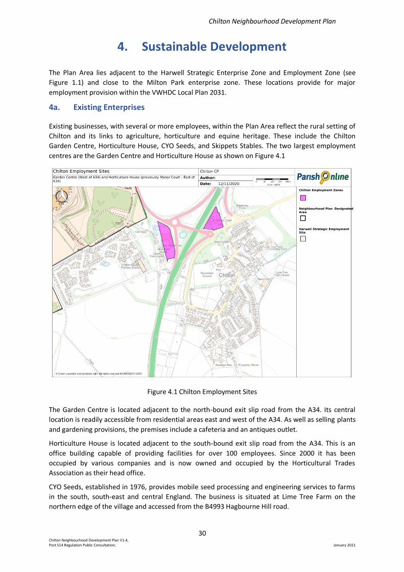
4a. Existing Enterprises
Existing businesses, with several or more employees, within the Plan Area reflect the rural setting of
Chilton and its links to agriculture, horticulture and equine heritage. These include the Chilton
Garden Centre, Horticulture House, CYO Seeds, and Skippets Stables. The two largest employment
centres are the Garden Centre and Horticulture House as shown on Figure 4.1
Figure 4.1 Chilton Employment Sites
The Garden Centre is located adjacent to the north-bound exit slip road from the A34. Its central
location is readily accessible from residential areas east and west of the A34. As well as selling plants
and gardening provisions, the premises include a cafeteria and an antiques outlet.
Horticulture House is located adjacent to the south-bound exit slip road from the A34. This is an
office building capable of providing facilities for over 100 employees. Since 2000 it has been
occupied by various companies and is now owned and occupied by the Horticultural Trades
Association as their head office.
CYO Seeds, established in 1976, provides mobile seed processing and engineering services to farms
in the south, south-east and central England. The business is situated at Lime Tree Farm on the
northern edge of the village and accessed from the B4993 Hagbourne Hill road.
Chilton Neighbourhood Development Plan
31 Chilton Neighbourhood Development Plan V1.4, Post S14 Regulation Public Consultation; January 2021
Skippets Stables is a relatively newly formed equine business providing specialist stabling and
convalescent facilities for racehorses. It is situated close to the old railway to the east of the village
and accessed from the village via Dene Hollow.
Other enterprises within the Plan Area which provide employment include farming, the Rose and
Crown public house, the petrol station on the south bound carriageway of the A34 south of the
village, and homeworking.
Although no longer a large employer of people, farming occupies a high proportion of the open
countryside within the Plan Area and contributes greatly to the aesthetic appeal of this region of the
North Wessex Downs AONB.
The Rose and Crown public house, situated in Main Street in the older part of the village, has been in
Chilton for over 100 years and now provides restaurant facilities, regular quiz nights and supports
other community-based groups.
There has been a petrol station at this location on the A34 for some decades, well before the current
dual carriageway was completed in 1977, and before the designation of the North Wessex Downs
AONB in 1972. The introduction of the dual carriageway left it accessible by road when going south
only. It is also accessible by a footpath from The Orchids at the southern edge of the village to the
east of the A34. As well as selling fuel, the petrol station includes a recently upgraded retail outlet
selling foodstuffs, newspapers etc.
Homeworking includes home office working and offering room rental. Such enterprises may be short
or long-term arrangements and have been recently assisted by the provision of high-speed broad
band.
In addition, the close proximity of Chilton to the Ridgeway National Trail and the Harwell Campus
renders the location convenient for short term bed and breakfast accommodation as is offered by a
few residences within the village.
4b. Sustainable Future Opportunities
Objective 9 of the Plan establishes the aim “To promote sustainable enterprise consistent with the
character and history of Chilton in its setting as a small primarily residential rural village”.
In the village survey, conducted in June 2018, respondents were asked how satisfied they were that
existing business enterprises met their needs. Whilst over 50% of respondents were either very
satisfied, satisfied or neither satisfied nor dissatisfied, a sizeable minority (44%) indicated some level
of dissatisfaction. The free text comments accompanying the question suggested that many were in
favour of improved local shopping facilities within walking distance. Some form of community or
local village shop selling basic groceries and fresh produce seemed to be preferred over retail
facilities attached to a service station primarily aimed at attracting custom from A34 road users.
A further question in the survey addressed what types of sustainable enterprises should be
supported or encouraged. There was strong support for businesses promoting local employment
(53% of respondents); businesses that were agricultural or horticultural (52%) or those that were
equine related (39%). There was also strong support given to promoting home-based working (46%).
To promote future sustainable development consistent with the character and history of Chilton
whilst recognising the opportunities from existing businesses and their locations the following policy
has been developed:
Chilton Neighbourhood Development Plan
32 Chilton Neighbourhood Development Plan V1.4, Post S14 Regulation Public Consultation; January 2021
Policy P4 – Sustainable Business Development
Planning proposals which are in accordance with the objectives of the Plan and that generate new
or enhanced employment opportunities would be supported, subject to their not creating an
unacceptable impact on nearby residential properties in terms of noise, odour or increased traffic.
Such proposals may relate to but not necessarily be limited to the following:
(a) Small-scale businesses run from home;
(b) Small-scale development and diversification of agricultural, horticultural, equine and
other rural land-based businesses in the Plan Area;
(c) Introduction of new small retail units within the Garden Centre site to serve local
domestic needs would be welcomed.
Chilton Neighbourhood Development Plan
33 Chilton Neighbourhood Development Plan V1.4, Post S14 Regulation Public Consultation; January 2021
5. Local Ecology and Environment
To minimise damage to the flora and fauna of the Plan Area, VWHDC Local Plan LPP1 CP46 must be
followed for all developments
5a. Flora
Chilton is situated on chalk downland very close to the Ridgeway, with significant numbers of native
orchids at various village locations. Species found locally include bee orchid, pyramidal orchid, broad
leaved helleborine, white helleborine, common spotted orchid and common twayblade. Some key
sites in or close to the village that are used for recreational purposes by residents where orchids are
common are shown in Table 5.1.
Many other wildflower species are found on these sites which are also rich in insects and birdlife.
5b. Fauna
Mammals
A number of protected mammal species are found in the Parish and nearby, including badgers and
several species of bat. Other common local mammals include roe and muntjac deer, hare, rabbit,
fox, weasel, stoat, hedgehog and many small mammals such as bank vole.
Site Grid
Reference*
Species of Interest
Former site of prefab
housing (North Site). A
large site with a few
areas rich in orchids
SU475873 Rich in several species of orchids including large
numbers of white helleborine and bee orchid.
Many butterflies and birds.
Old Railway Cutting
(Upton Parish)
SU496857 to
SU510868
Some orchids and other wildflowers including
kidney vetch. A haven for butterflies including
small blue, green hairstreak and many solitary
bee species (pollinators), and mammals.
Bargeway to
Ridgeway Path
SU490853 to
SU494840
Rich in butterflies (including chalkhill blue), bees,
birds and mammals.
Path to Ridgeway by
Chilton School and
Grim’s Ditch
SU483858 to
SU462848
Used for many leisure activities, rich in flora and
birds, and reptiles including common lizard and
slow worm.
Scrub land close to
the Ridgeway Path
and Grim’s Ditch used
by walkers and riders
SU 495840 Many butterfly species, bees, birds (including
nesting buzzards and red kites), hoverflies and
some orchids.
Verges close to A4185 SU482873 Many white helleborine orchids.
Verges close to A34 SU487860
and
SU488860.
Many orchids including bee orchids, broad-leaved
helleborines and common twayblade, butterflies
and solitary bees and hoverflies.
Table 5.1 Some Flora and Fauna Locations in, or bordering on, the Plan Area
* Grid references are approximate, reflecting the spread of both flora and fauna.
Chilton Neighbourhood Development Plan
34 Chilton Neighbourhood Development Plan V1.4, Post S14 Regulation Public Consultation; January 2021
Reptiles
There are few reptiles apart from slow worm, grass snake and common lizard. These occur mainly on
slopes where the chalk is fissured.
Amphibians
Common frog, toad and newts are found at a number of village locations.
Invertebrates
Butterflies are regarded as key markers of biodiversity and indicators of the effects of man and
development. The main sites around Chilton with significant numbers of butterflies are shown in
Table 5.1. Many other invertebrates are found at these sites, including key pollinators such as
hoverflies and bee species. Approximately 61 species of butterfly are found in the UK, of which 45
are found in the Berkshire, Buckinghamshire, and Oxfordshire region. Approximately 27 of these are
found in Chilton with another 13 or so found within a few miles of the village.
Given favourable conditions, some of these may spread to Chilton as the climate warms, including
the adonis blue. This has happened in 2018 with the chalkhill blue.
Key species for conservation concern are the small blue (Butterfly Conservation priority: Medium,
Section 41 species of principal importance under the NERC Act in England) and small heath (Butterfly
Conservation priority: High, Section 41 species of principal importance under the NERC Act in
England). Both of these are common close to the village.
There are also large numbers of wild bee species (for example on the Bargeway) and rare insects
such as the Hornet Robber Fly.
Birds
Some key species are barn owls (Schedule 1 of both the Wildlife and Countryside Act, 1981) common
in the village, yellowhammers (endangered species, but common in Chilton), lapwings (greatly
declined in the past 30 years locally, Amber List), fieldfare: (UK conservation status: Red; Protected
by The Wildlife and Countryside Act 1981) common in Chilton, common buzzard: (Green; Protected
by The Wildlife and Countryside Act 1981) – nesting in Chilton, redwing: UK Red List – common in
Chilton.
Reporting Local Fauna Sightings
To enhance the awareness of local wildlife, a system has been set up in collaboration with Chilton
Primary School to report local fauna sightings by pupils and teachers. These are added to sightings
made by other local observers and combined with data from e.g. Berkshire, Buckinghamshire,
Oxfordshire Wildlife Trust (BBOWT) and Butterfly Conservation; significant sightings will be added to
the Chilton website.
As well as providing valuable data about numbers of key fauna like badgers, hedgehogs and hare,
this contributes to involvement by primary school children and residents in the Plan Area, and makes
them more aware of the wildlife heritage of the region.
The requirements in Local Plan 2031 Core Policy 46 should be followed and additionally, to preserve
and enhance the natural environment for existing and future generations of residents, the following
policy has been devised.
Policy P5 – Natural Environment – Flora and Fauna
Chilton Neighbourhood Development Plan
35 Chilton Neighbourhood Development Plan V1.4, Post S14 Regulation Public Consultation; January 2021
1. Where possible development proposals should preserve hedgerows and verges as “wildlife
corridors”, e.g. the established hedge which runs from Chilton south (the “Bargeway”) and
connects to the Ridgeway.
2. Development proposals should aim to avoid areas identified as rich in flora and fauna and
should incorporate where feasible hedges to link to established wildlife areas, so that birds,
insects and mammals will be encouraged into areas being developed.
5c. Ambient Sound – Traffic Noise
The issue of road traffic noise has been covered in depth in various published reports, including
limits, compensation and mitigation strategies, and the health effects to humans of raised traffic
noise which include stress-related issues such as raised blood pressure.
Since the early 1990s the Royal Commission on Environmental Pollution has published three reports
which looked, wholly or in part, at the issue of traffic noise. The Commission’s most recent report,
on the urban environment, stated: “Roads, railways and airports are ... the main sources of ambient
noise, which can affect the quality of people’s lives”. Around half the UK’s population may be
exposed to levels above the World Health Organization (WHO) guideline of 50-55 decibels which
aims to protect the majority of people from serious annoyance during the daytime. However, the UK
does not have national limits on ambient noise, although there are limits on individual aircraft and
road vehicles. Local authorities can also impose local limits.
In the 2018 survey, residents were invited in an open question to register any concerns or other
suggestions that might be addressed within the Plan Area. There were several responses noting that
traffic noise from the A34 was of increasing concern, and instances were raised of for example,
mourners being unable to hear the words of a burial service taking place in the churchyard, and of
difficulties of selling houses because of the issue.
On behalf of the Steering Group, a survey was carried out to assess relative traffic noise levels at
various parts of the village to identify the worst hit areas, and the effects of screening.
Measurements were made at the locations shown on four occasions (not specifically chosen as days
on which sound levels were high) using a calibrated sound level meter. These were averaged, and
the averages shown in Fig. 5.1. further details of which are given in Appendix 4. This approach was
adopted because of the variability of the traffic noise levels depending on traffic flow, wind direction
etc, so that any more detailed measurements on just a few days at selected locations would be
unlikely to capture the full impact of the nuisance and stress caused. Summer nights are of particular
note since windows will likely be open, and traffic levels may be heavy. The prevailing wind from the
SW increases noise levels very considerably as there is no screening from this direction. Locations to
the E of the A34 are worst affected, in particular to some locations within 200m of the road and to
raised areas such as Crafts End and South Row.
Data ringed in red refer to average traffic noise levels in dB measured at these locations on up to six
occasions during 2018. These were chosen to reflect a range of conditions, and in each case, the
peak levels at each location may be considerably higher than the mean levels
Screening trees and shrubs are marked on the eastern A34 verge as a dotted area in green, and both
sides of Lower Road are also planted with screening trees and shrubs. The screening does not
continue southwards to reduce noise reaching the southern half of the village.
Developments must follow LPP2 DP25, and in response to this topic of public concern the following
policy has been devised.
Chilton Neighbourhood Development Plan
36 Chilton Neighbourhood Development Plan V1.4, Post S14 Regulation Public Consultation; January 2021
Policy P6 – Mitigation of Traffic Noise
1. Areas of existing screening should not be redeveloped without alternative procedures in
place.
2. Development on areas shown in Fig. 5.1 to have high noise levels, mainly close to the A34,
should incorporate screening and planting to reduce traffic noise levels
Fig 5.1 Traffic Noise - Mean dB measured during Summer 2018 at each location.
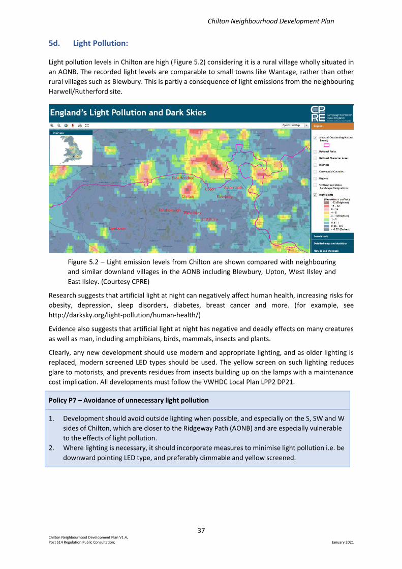
Chilton Neighbourhood Development Plan
37 Chilton Neighbourhood Development Plan V1.4, Post S14 Regulation Public Consultation; January 2021
5d. Light Pollution:
Light pollution levels in Chilton are high (Figure 5.2) considering it is a rural village wholly situated in
an AONB. The recorded light levels are comparable to small towns like Wantage, rather than other
rural villages such as Blewbury. This is partly a consequence of light emissions from the neighbouring
Harwell/Rutherford site.
Figure 5.2 – Light emission levels from Chilton are shown compared with neighbouring
and similar downland villages in the AONB including Blewbury, Upton, West Ilsley and
East Ilsley. (Courtesy CPRE)
Research suggests that artificial light at night can negatively affect human health, increasing risks for
obesity, depression, sleep disorders, diabetes, breast cancer and more. (for example, see
http://darksky.org/light-pollution/human-health/)
Evidence also suggests that artificial light at night has negative and deadly effects on many creatures
as well as man, including amphibians, birds, mammals, insects and plants.
Clearly, any new development should use modern and appropriate lighting, and as older lighting is
replaced, modern screened LED types should be used. The yellow screen on such lighting reduces
glare to motorists, and prevents residues from insects building up on the lamps with a maintenance
cost implication. All developments must follow the VWHDC Local Plan LPP2 DP21.
Policy P7 – Avoidance of unnecessary light pollution
1. Development should avoid outside lighting when possible, and especially on the S, SW and W
sides of Chilton, which are closer to the Ridgeway Path (AONB) and are especially vulnerable
to the effects of light pollution.
2. Where lighting is necessary, it should incorporate measures to minimise light pollution i.e. be
downward pointing LED type, and preferably dimmable and yellow screened.
Chilton Neighbourhood Development Plan
38 Chilton Neighbourhood Development Plan V1.4, Post S14 Regulation Public Consultation; January 2021
5e. Air Pollution
From the interactive DEFRA map which provides air pollution data in 1km squares across the UK, the
following are the levels recorded for Chilton for the principal pollutants, originating from road traffic
(mainly A34) for the year 2018: -
Nitrogen Oxides: Annual mean Concentrations
Min. 9.36 microgram/m3
Max. 11.99 microgram/m3
Mean. 10.70 microgram/m3
PM10: Annual Mean Concentrations
Min. 14.53 microgram/m3
Max. 17.37 microgram/m3
Mean. 15.43 microgram/m3
CO (Carbon monoxide): Annual Mean Concentrations
Min. 0.20 mg/m3
Max. 0.21 mg/m3
Mean. 0.21 mg/m3
UK National Air Pollution Objectives mean annual levels are: -
Nitrogen Oxides 40 microgram/m3
PM10 40 microgram/m3
CO 10 mg/m3
At present only two local areas, both outside of the Plan Area, exceed these target concentrations,
viz. Botley and Abingdon town centre. Clearly, bearing in mind that Chilton, like Botley, is bisected by
a busy trunk road, the levels in Chilton should be monitored at regular intervals to ensure that any
increase in traffic density does not result in air pollutant levels reaching unacceptable levels.
Chilton Neighbourhood Development Plan
39 Chilton Neighbourhood Development Plan V1.4, Post S14 Regulation Public Consultation; January 2021
6. Village Infrastructure
Chilton has had a primary school since the 18th century which has continued to develop as the
number of children and their needs have evolved. Other notable landmarks include All Saints’ church
and the village pub, The Rose and Crown.
Similarly, communal village infrastructure facilities, serving the wider needs of the community as a
whole, have evolved as the number of residents has grown.
In the village survey (see Appendix 2) views were sought on the amount of use and adequacy of the
existing communal village infrastructure facilities, together with what improvements or further
developments residents would like to see.
6a. Chilton Primary School
The first mention of a school in Chilton is a charity school opened in the 18th century in the Malt
House in Main Street. The school on Church Hill (now Cross House) was built in 1870 for 60 children.
Education for children up to the age of ten was made compulsory in this year and all villages were
required to provide for this.
The small village school functioned well until, with the anticipated extension of the newly-formed
Atomic Energy Research Establishment on the former RAF Harwell airfield, an adjacent newly-built
school was opened in 1950.
The new school, with four prefabricated classrooms, could accommodate about 90 children, both
from the village and the newly erected prefab housing (which was to meet the needs of the
employees of the scientific establishment). This school served the community of Chilton for 50 years
when, owing to an aging infrastructure and an expanding village population, funding was secured for
a new, larger school.
The new school was opened in 2002 and could accommodate 130 children. However, with the
completion of the Chilton Field residential development, from 2012 onwards the school was once
again failing to keep pace with rising school numbers. In order to absorb increased demand for
placements, an additional three classrooms were added and these were opened in 2018, creating
the school that currently exists. The annual intake has increased from 30 to 45 pupils, with a
maximum capacity of 315 pupils from reception to Year 6, with a further 25 pupils in the purpose-
built nursery class.
The school now offers the full National Curriculum 2014 as well as breakfast and after school clubs.
Regular events, such as the Christmas Fair, and the summer event are open to everyone, and
particularly well attended by those families living in the village.
The Harwell Stone Service, commemorating the historic role of RAF Harwell airfield in the D-Day
landings, is regularly attended by a group of pupils and staff.
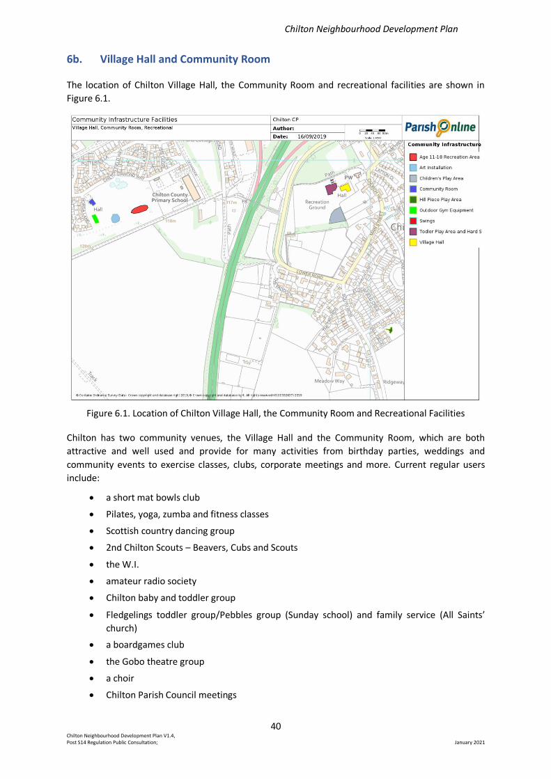
Chilton Neighbourhood Development Plan
40 Chilton Neighbourhood Development Plan V1.4, Post S14 Regulation Public Consultation; January 2021
6b. Village Hall and Community Room
The location of Chilton Village Hall, the Community Room and recreational facilities are shown in
Figure 6.1.
Figure 6.1. Location of Chilton Village Hall, the Community Room and Recreational Facilities
Chilton has two community venues, the Village Hall and the Community Room, which are both
attractive and well used and provide for many activities from birthday parties, weddings and
community events to exercise classes, clubs, corporate meetings and more. Current regular users
include:
• a short mat bowls club
• Pilates, yoga, zumba and fitness classes
• Scottish country dancing group
• 2nd Chilton Scouts – Beavers, Cubs and Scouts
• the W.I.
• amateur radio society
• Chilton baby and toddler group
• Fledgelings toddler group/Pebbles group (Sunday school) and family service (All Saints’
church)
• a boardgames club
• the Gobo theatre group
• a choir
• Chilton Parish Council meetings
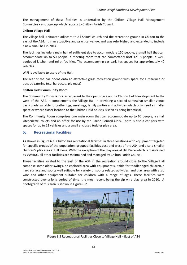
Chilton Neighbourhood Development Plan
41 Chilton Neighbourhood Development Plan V1.4, Post S14 Regulation Public Consultation; January 2021
The management of these facilities is undertaken by the Chilton Village Hall Management
Committee - a sub-group which reports to Chilton Parish Council.
Chilton Village Hall
The village hall is situated adjacent to All Saints’ church and the recreation ground in Chilton to the
east of the A34. It is an attractive and practical venue, and was refurbished and extended to include
a new small hall in 2014.
The facilities include a main hall of sufficient size to accommodate 150 people, a small hall that can
accommodate up to 50 people, a meeting room that can comfortably host 12-15 people, a well-
equipped kitchen and toilet facilities. The accompanying car park has spaces for approximately 40
vehicles.
WiFi is available to users of the Hall.
The rear of the hall opens onto an attractive grass recreation ground with space for a marquee or
outside catering (e.g. barbecue, pig roast)
Chilton Field Community Room
The Community Room is located adjacent to the open space on the Chilton Field development to the
west of the A34. It complements the Village Hall in providing a second somewhat smaller venue
particularly suitable for gatherings, meetings, family parties and activities which only need a smaller
space or where closer location to the Chilton Field houses is seen as being beneficial.
The Community Room comprises one main room that can accommodate up to 60 people, a small
kitchenette, toilets and an office for use by the Parish Council Clerk. There is also a car park with
spaces for up to 12 vehicles and a small enclosed toddler play area.
6c. Recreational Facilities
As shown in Figure 6.1, Chilton has recreational facilities in three locations with equipment targeted
for specific groups of the population: grouped facilities east and west of the A34 and also a smaller
children’s play area at Hill Piece. With the exception of the play area at Hill Piece which is maintained
by VWHDC, all other facilities are maintained and managed by Chilton Parish Council.
Those facilities located to the east of the A34 in the recreation ground close to the Village Hall
comprise some older swings, an enclosed area with equipment suitable for toddler aged children, a
hard surface and sports wall suitable for variety of sports related activities, and play area with a zip
wire and other equipment suitable for children with a range of ages. These facilities were
constructed over a long period of time, the most recent being the zip wire play area in 2010. A
photograph of this area is shown in Figure 6.2.
Figure 6.2 Recreational Facilities Close to Village Hall – East of A34
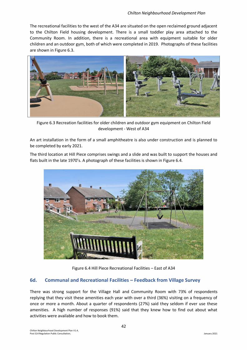
Chilton Neighbourhood Development Plan
42 Chilton Neighbourhood Development Plan V1.4, Post S14 Regulation Public Consultation; January 2021
The recreational facilities to the west of the A34 are situated on the open reclaimed ground adjacent
to the Chilton Field housing development. There is a small toddler play area attached to the
Community Room. In addition, there is a recreational area with equipment suitable for older
children and an outdoor gym, both of which were completed in 2019. Photographs of these facilities
are shown in Figure 6.3.
Figure 6.3 Recreation facilities for older children and outdoor gym equipment on Chilton Field
development - West of A34
An art installation in the form of a small amphitheatre is also under construction and is planned to
be completed by early 2021.
The third location at Hill Piece comprises swings and a slide and was built to support the houses and
flats built in the late 1970’s. A photograph of these facilities is shown in Figure 6.4.
Figure 6.4 Hill Piece Recreational Facilities – East of A34
6d. Communal and Recreational Facilities – Feedback from Village Survey
There was strong support for the Village Hall and Community Room with 73% of respondents
replying that they visit these amenities each year with over a third (36%) visiting on a frequency of
once or more a month. About a quarter of respondents (27%) said they seldom if ever use these
amenities. A high number of responses (91%) said that they knew how to find out about what
activities were available and how to book them.
Chilton Neighbourhood Development Plan
43 Chilton Neighbourhood Development Plan V1.4, Post S14 Regulation Public Consultation; January 2021
There was a high number of responses saying that the village hall (91%) and the community room
(84%) met their needs. Most respondents did not think that further building extensions were
required at the present time either at the Village Hall (85%) or the Community Room (75%). There
were several useful suggestions for how these facilities might be improved including improved
outdoor areas and redecoration.
There was also strong support for the children’s play areas with nearly a quarter of respondents
(22%) saying that they visited facilities once or more per week. A high proportion (83%) of
respondents said that children’s play facilities at the Village Hall met the needs of the village as did
those at Hill Piece (77%). However, there was a lower percentage (56%) satisfied with the play
facilities close to the Community Room. It should be noted that the survey pre-dates the installation
of the recreational facilities in that location. Several suggestions were made as to how these facilities
could be improved, some of which will be met by those newly installed. Others include the provision
of sports pitches and better facilities for pre-school children.
There was only limited support (15%) for additional facilities to be located outside of the existing
areas with no specific suggestions given for what locations might be appropriate.
There was some, but not overwhelming, support for extending recreational facilities for adults: 35%
in the location of the Village Hall and 28% near the Community Room. Suggestions included outdoor
gym equipment (now installed close to the Community Room) and tennis courts.
All of the comments and suggestions for further improvement of communal recreational facilities
are given in Appendix 2 and are available to the Parish Council, and the Village Hall Management
Committee.
6e. Public House – The Rose and Crown
As well as being a commercial enterprise providing limited employment opportunities (See Section
4a Existing enterprises) and a building of heritage significance (see Section 3a Village Character
Assessment) the only public house in the village also provides a centre for informal gatherings for
individuals and groups. Recent examples include entertainment such as quiz nights, lunches for local
walking groups, community group committee meetings and lunches for the local ageing community
group.
In recognition of its value to the community the Rose and Crown public house was registered as an
Asset of Community Value. It is planned to renew this registration.
6f. Religious Worship
All Saints’ church and churchyard (Church of England)
All Saints’ has served the people of Chilton for about 900 years and continues to minister to
parishioners of all ages. It is both a much-valued architectural heritage asset and a long-standing
contributor to village community life.
The church building dates from the 12th century but has grown over the years with the addition of a
south aisle and chancel in the 13th and 14th centuries, a Victorian tower and porch, and a two-storey
extension and toilet built in the 1970’s. Figure 6.5 shows the current view of the church taken from
the south.
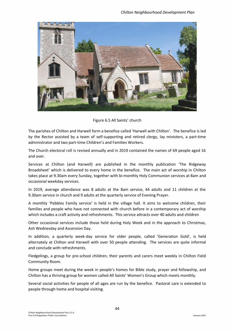
Chilton Neighbourhood Development Plan
44 Chilton Neighbourhood Development Plan V1.4, Post S14 Regulation Public Consultation; January 2021
Figure 6.5 All Saints’ church
The parishes of Chilton and Harwell form a benefice called ‘Harwell with Chilton’. The benefice is led
by the Rector assisted by a team of self-supporting and retired clergy, lay ministers, a part-time
administrator and two part-time Children’s and Families Workers.
The Church electoral roll is revised annually and in 2019 contained the names of 69 people aged 16
and over.
Services at Chilton (and Harwell) are published in the monthly publication ‘The Ridgeway
Broadsheet’ which is delivered to every home in the benefice. The main act of worship in Chilton
takes place at 9.30am every Sunday, together with bi-monthly Holy Communion services at 8am and
occasional weekday services.
In 2019, average attendance was 8 adults at the 8am service, 44 adults and 11 children at the
9.30am service in church and 9 adults at the quarterly service of Evening Prayer.
A monthly ‘Pebbles Family service’ is held in the village hall. It aims to welcome children, their
families and people who have not connected with church before in a contemporary act of worship
which includes a craft activity and refreshments. This service attracts over 40 adults and children
Other occasional services include those held during Holy Week and in the approach to Christmas,
Ash Wednesday and Ascension Day.
In addition, a quarterly week-day service for older people, called ‘Generation Gold’, is held
alternately at Chilton and Harwell with over 50 people attending. The services are quite informal
and conclude with refreshments.
Fledgelings, a group for pre-school children, their parents and carers meet weekly in Chilton Field
Community Room.
Home groups meet during the week in people’s homes for Bible study, prayer and fellowship, and
Chilton has a thriving group for women called All Saints’ Women’s Group which meets monthly.
Several social activities for people of all ages are run by the benefice. Pastoral care is extended to
people through home and hospital visiting.
Chilton Neighbourhood Development Plan
45 Chilton Neighbourhood Development Plan V1.4, Post S14 Regulation Public Consultation; January 2021
The number of weddings, funerals and baptisms vary widely from year to year. In 2019 there were 2
weddings, 9 funerals and 4 baptisms held at Chilton. All Saints’ has an adult choir and a team of
bellringers who are regularly supplemented by ringers from other parishes. There is a ring of 6 bells
which were restored in the year 2000 after over 40 years of silence due to deterioration of the tower
and bell frame.
The churchyard surrounds All Saints’ church. It is open for burials and is maintained by the Church. A
grant is received from the Parish Council each year which helps to pay towards the cost of
maintenance. Interments of cremated remains take place within the Garden of Remembrance in the
south west corner of the churchyard. It is estimated that there is room for burials for about another
20 years, and possibly a longer time for the interment of cremated remains. When the churchyard
can take no further burials, it will be closed and alternative provision will be required in the form of a
cemetery which will come under the responsibility of the Parish Council. It is proposed that finding
an alternative site is taken forward as a community project outside of the formal policy provisions
within this Plan.
The results from the 2018 survey of residents detailed in Appendix 2 indicated that 22% of
respondents visited the church or churchyard more often than once per month with 53% visiting
seldom if ever.
Other Religions
The Insight Report on Chilton which was published in 2017 quotes statistics from the 2011 census, so
figures quoted for adherents to religions will now be out of date with the large influx of residents on
Chilton Field. According to the 2011 census Chilton’s population included 5 Hindus, 5 Muslims, 5
‘other religion’, and no Jews or Buddhists. In addition, 245 described themselves as being of no
religion while 555 said they were Christians. Since 2011 the Chilton Field development has been
built and populated, leading to an approximate doubling of the population of the Parish. Chilton
Field, as a large new development, is likely to include people of diverse faiths and those of no
religion.
6g. Community Infrastructure - Summary
The Plan objectives 3,4 and 6 reflect the importance attached to village infrastructure and support
the need to maintain community meeting spaces in accordance with Local Plan Policy LPP2 DP8:
Plan Objective 3. To maintain, and improve, recreational facilities for children, families and
young people.
Plan Objective 4. To encourage the development of infrastructure and activities supporting those
in the community of advancing years and a range of abilities.
Plan Objective 6. To maintain and enhance community facilities for all ages.
The Plan identifies four sites of community importance which reflect value to the life and enjoyment
of the local community: the village hall; community room; the public house “The Rose and Crown “;
and All Saints’ church and churchyard.
Proposals that will enhance the viability of the Rose and Crown Public House will be supported.
Proposals that would result in the loss of the Rose and Crown public House will only be permitted
where it can be clearly demonstrated that:
Chilton Neighbourhood Development Plan
46 Chilton Neighbourhood Development Plan V1.4, Post S14 Regulation Public Consultation; January 2021
1. The retention of the Rose and Crown Public House is not economically viable and it can be
demonstrated that all reasonable efforts have been made to sell or let the property as a public
house on the open market at a realistic price, and
2. There is no reasonable likelihood of a suitable alternative facility or service of benefit to the local
community making use of the building.
This is in accordance with VWHDC Local Plan 2031 Development Policy 9.
Policy P8 – Community Infrastructure
Proposals which assist with the delivery of new or enhanced facilities to the benefit of the
community will be supported. In particular, proposals further enhancing the village hall and
community room facilities for the use of groups with varying ages and abilities, and further play
facilities for children and young people will be encouraged.
The Plan also supports the need for the Parish Council to work with the Church authorities as a
community project to meet the future need of land allocation for burial space within the village.
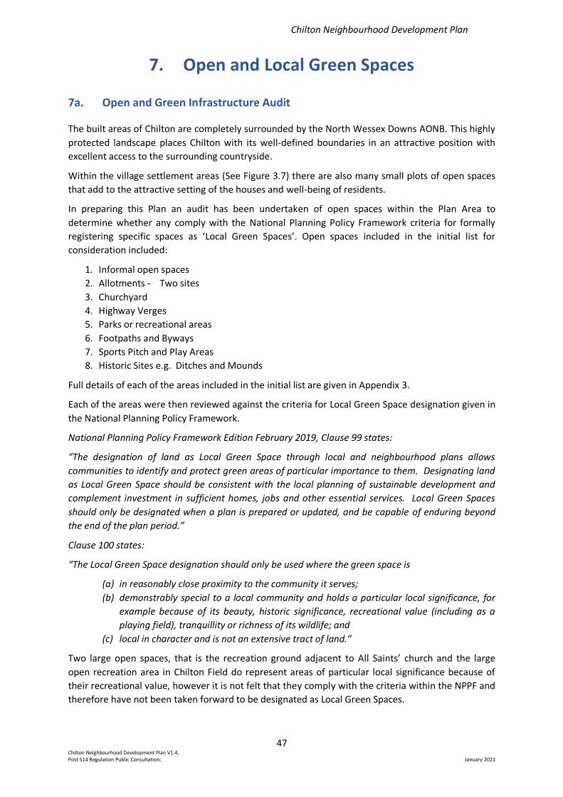
Chilton Neighbourhood Development Plan
47 Chilton Neighbourhood Development Plan V1.4, Post S14 Regulation Public Consultation; January 2021
7. Open and Local Green Spaces
7a. Open and Green Infrastructure Audit
The built areas of Chilton are completely surrounded by the North Wessex Downs AONB. This highly
protected landscape places Chilton with its well-defined boundaries in an attractive position with
excellent access to the surrounding countryside.
Within the village settlement areas (See Figure 3.7) there are also many small plots of open spaces
that add to the attractive setting of the houses and well-being of residents.
In preparing this Plan an audit has been undertaken of open spaces within the Plan Area to
determine whether any comply with the National Planning Policy Framework criteria for formally
registering specific spaces as ‘Local Green Spaces’. Open spaces included in the initial list for
consideration included:
1. Informal open spaces
2. Allotments - Two sites
3. Churchyard
4. Highway Verges
5. Parks or recreational areas
6. Footpaths and Byways
7. Sports Pitch and Play Areas
8. Historic Sites e.g. Ditches and Mounds
Full details of each of the areas included in the initial list are given in Appendix 3.
Each of the areas were then reviewed against the criteria for Local Green Space designation given in
the National Planning Policy Framework.
National Planning Policy Framework Edition February 2019, Clause 99 states:
“The designation of land as Local Green Space through local and neighbourhood plans allows
communities to identify and protect green areas of particular importance to them. Designating land
as Local Green Space should be consistent with the local planning of sustainable development and
complement investment in sufficient homes, jobs and other essential services. Local Green Spaces
should only be designated when a plan is prepared or updated, and be capable of enduring beyond
the end of the plan period.”
Clause 100 states:
“The Local Green Space designation should only be used where the green space is
(a) in reasonably close proximity to the community it serves;
(b) demonstrably special to a local community and holds a particular local significance, for
example because of its beauty, historic significance, recreational value (including as a
playing field), tranquillity or richness of its wildlife; and
(c) local in character and is not an extensive tract of land.”
Two large open spaces, that is the recreation ground adjacent to All Saints’ church and the large
open recreation area in Chilton Field do represent areas of particular local significance because of
their recreational value, however it is not felt that they comply with the criteria within the NPPF and
therefore have not been taken forward to be designated as Local Green Spaces.
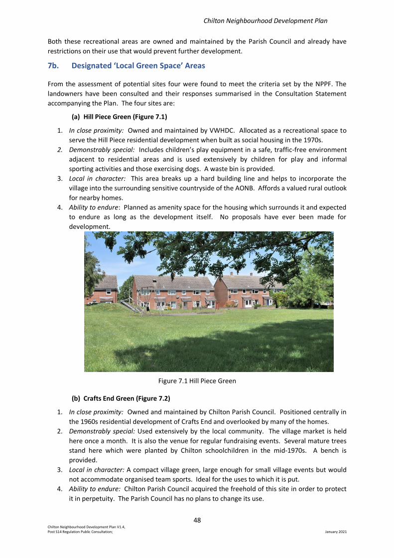
Chilton Neighbourhood Development Plan
48 Chilton Neighbourhood Development Plan V1.4, Post S14 Regulation Public Consultation; January 2021
Both these recreational areas are owned and maintained by the Parish Council and already have
restrictions on their use that would prevent further development.
7b. Designated ‘Local Green Space’ Areas
From the assessment of potential sites four were found to meet the criteria set by the NPPF. The
landowners have been consulted and their responses summarised in the Consultation Statement
accompanying the Plan. The four sites are:
(a) Hill Piece Green (Figure 7.1)
1. In close proximity: Owned and maintained by VWHDC. Allocated as a recreational space to
serve the Hill Piece residential development when built as social housing in the 1970s.
2. Demonstrably special: Includes children’s play equipment in a safe, traffic-free environment
adjacent to residential areas and is used extensively by children for play and informal
sporting activities and those exercising dogs. A waste bin is provided.
3. Local in character: This area breaks up a hard building line and helps to incorporate the
village into the surrounding sensitive countryside of the AONB. Affords a valued rural outlook
for nearby homes.
4. Ability to endure: Planned as amenity space for the housing which surrounds it and expected
to endure as long as the development itself. No proposals have ever been made for
development.
Figure 7.1 Hill Piece Green
(b) Crafts End Green (Figure 7.2)
1. In close proximity: Owned and maintained by Chilton Parish Council. Positioned centrally in
the 1960s residential development of Crafts End and overlooked by many of the homes.
2. Demonstrably special: Used extensively by the local community. The village market is held
here once a month. It is also the venue for regular fundraising events. Several mature trees
stand here which were planted by Chilton schoolchildren in the mid-1970s. A bench is
provided.
3. Local in character: A compact village green, large enough for small village events but would
not accommodate organised team sports. Ideal for the uses to which it is put.
4. Ability to endure: Chilton Parish Council acquired the freehold of this site in order to protect
it in perpetuity. The Parish Council has no plans to change its use.
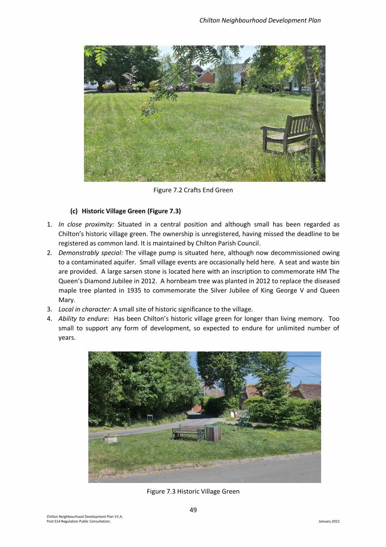
Chilton Neighbourhood Development Plan
49 Chilton Neighbourhood Development Plan V1.4, Post S14 Regulation Public Consultation; January 2021
Figure 7.2 Crafts End Green
(c) Historic Village Green (Figure 7.3)
1. In close proximity: Situated in a central position and although small has been regarded as
Chilton’s historic village green. The ownership is unregistered, having missed the deadline to be
registered as common land. It is maintained by Chilton Parish Council.
2. Demonstrably special: The village pump is situated here, although now decommissioned owing
to a contaminated aquifer. Small village events are occasionally held here. A seat and waste bin
are provided. A large sarsen stone is located here with an inscription to commemorate HM The
Queen’s Diamond Jubilee in 2012. A hornbeam tree was planted in 2012 to replace the diseased
maple tree planted in 1935 to commemorate the Silver Jubilee of King George V and Queen
Mary.
3. Local in character: A small site of historic significance to the village.
4. Ability to endure: Has been Chilton’s historic village green for longer than living memory. Too
small to support any form of development, so expected to endure for unlimited number of
years.
Figure 7.3 Historic Village Green
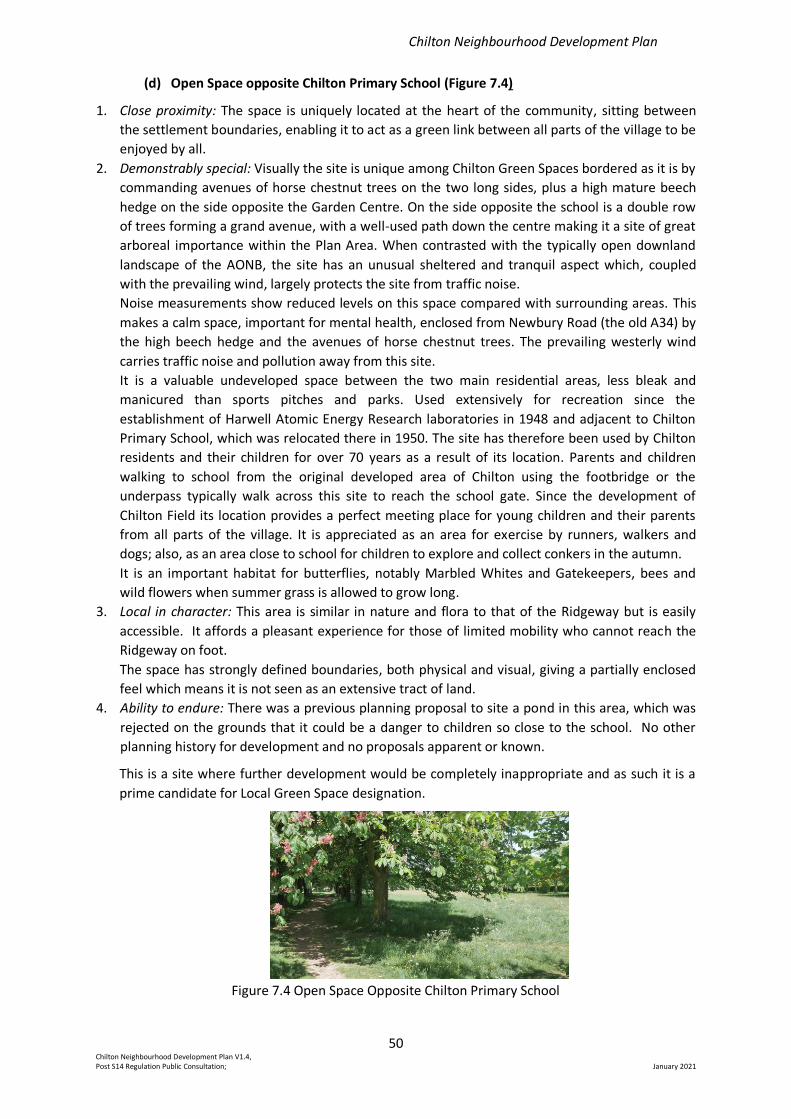
Chilton Neighbourhood Development Plan
50 Chilton Neighbourhood Development Plan V1.4, Post S14 Regulation Public Consultation; January 2021
(d) Open Space opposite Chilton Primary School (Figure 7.4)
1. Close proximity: The space is uniquely located at the heart of the community, sitting between
the settlement boundaries, enabling it to act as a green link between all parts of the village to be
enjoyed by all.
2. Demonstrably special: Visually the site is unique among Chilton Green Spaces bordered as it is by
commanding avenues of horse chestnut trees on the two long sides, plus a high mature beech
hedge on the side opposite the Garden Centre. On the side opposite the school is a double row
of trees forming a grand avenue, with a well-used path down the centre making it a site of great
arboreal importance within the Plan Area. When contrasted with the typically open downland
landscape of the AONB, the site has an unusual sheltered and tranquil aspect which, coupled
with the prevailing wind, largely protects the site from traffic noise.
Noise measurements show reduced levels on this space compared with surrounding areas. This
makes a calm space, important for mental health, enclosed from Newbury Road (the old A34) by
the high beech hedge and the avenues of horse chestnut trees. The prevailing westerly wind
carries traffic noise and pollution away from this site.
It is a valuable undeveloped space between the two main residential areas, less bleak and
manicured than sports pitches and parks. Used extensively for recreation since the
establishment of Harwell Atomic Energy Research laboratories in 1948 and adjacent to Chilton
Primary School, which was relocated there in 1950. The site has therefore been used by Chilton
residents and their children for over 70 years as a result of its location. Parents and children
walking to school from the original developed area of Chilton using the footbridge or the
underpass typically walk across this site to reach the school gate. Since the development of
Chilton Field its location provides a perfect meeting place for young children and their parents
from all parts of the village. It is appreciated as an area for exercise by runners, walkers and
dogs; also, as an area close to school for children to explore and collect conkers in the autumn.
It is an important habitat for butterflies, notably Marbled Whites and Gatekeepers, bees and
wild flowers when summer grass is allowed to grow long.
3. Local in character: This area is similar in nature and flora to that of the Ridgeway but is easily
accessible. It affords a pleasant experience for those of limited mobility who cannot reach the
Ridgeway on foot.
The space has strongly defined boundaries, both physical and visual, giving a partially enclosed
feel which means it is not seen as an extensive tract of land.
4. Ability to endure: There was a previous planning proposal to site a pond in this area, which was
rejected on the grounds that it could be a danger to children so close to the school. No other
planning history for development and no proposals apparent or known.
This is a site where further development would be completely inappropriate and as such it is a
prime candidate for Local Green Space designation.
Figure 7.4 Open Space Opposite Chilton Primary School
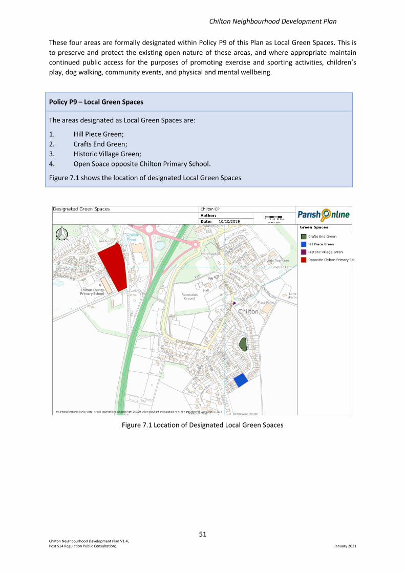
Chilton Neighbourhood Development Plan
51 Chilton Neighbourhood Development Plan V1.4, Post S14 Regulation Public Consultation; January 2021
These four areas are formally designated within Policy P9 of this Plan as Local Green Spaces. This is
to preserve and protect the existing open nature of these areas, and where appropriate maintain
continued public access for the purposes of promoting exercise and sporting activities, children’s
play, dog walking, community events, and physical and mental wellbeing.
Policy P9 – Local Green Spaces
The areas designated as Local Green Spaces are:
1. Hill Piece Green;
2. Crafts End Green;
3. Historic Village Green;
4. Open Space opposite Chilton Primary School.
Figure 7.1 shows the location of designated Local Green Spaces
Figure 7.1 Location of Designated Local Green Spaces
Chilton Neighbourhood Development Plan
52 Chilton Neighbourhood Development Plan V1.4, Post S14 Regulation Public Consultation; January 2021
8. Connectivity
As a small village, connectivity with surrounding settlements is essential for day-to-day living as well
as for recreational pursuits. This includes access to workplaces, doctors, dentists, hospitals and for
shopping. The nearest doctors’ surgeries are in Didcot. The nearest (non 24hr) minor injuries unit is
at Abingdon. The nearest 24hr Accident and Emergency Unit and other specialist hospitals are in
Oxford, some 18 miles away.
The nearest shop is located at the Berkshire Downs Service Station on the A34 to the south of
Chilton. The attached retail area was substantially increased in size during 2019 and now offers a
substantial range of food, household goods and alcoholic drinks. It is accessible on foot via an
unsurfaced footpath across a field. A local store, with a somewhat wider product range, is situated
on Curie Avenue within the Harwell Science and Engineering Campus. The nearest range of several
shops is at Didcot.
8a. Road Networks
Chilton is situated within the North Wessex Downs AONB, about 4 miles/6 kms south west of the
expanding town of Didcot and is bisected by the busy A34 trunk road.
The A34 was branded by the Oxford Mail (6 May 2013) as "one of the worst roads in the country".
Records dating back more than 30 years chronicle decades of congestion, accident blackspots and
numerous safety campaigns. Up to 79,000 vehicles use the Oxfordshire stretch of the A34 every day
and since 1994 a total of 2,040 collisions have been recorded claiming 56 lives, leaving 278 people
seriously injured and 2,600 with minor injuries.
The A4185 runs along a short stretch of the former A34 and now provides access to the Harwell
Campus from the A34 Chilton interchange. The A4185 is often used when there is an incident or
road works resulting in closure of the A34.
The B4493 (Hagbourne Hill) to A4185 (Newbury Road) runs from Hagbourne Hill on the north-east
side of the village towards the A34 interchange roundabouts. This road is now a main artery for
traffic from new developments both in and surrounding Didcot, to the A34.
The A34, A4185 and the B4493 all form key access routes for commuters travelling to the Harwell
Science and Engineering Campus.
The VWHDC Local Plan identifies the Campus as a Science Vale UK Enterprise Zone destined for
continued expansion up to 2031.
The results from the survey of Chilton residents conducted in 2018 indicate a level of concern arising
from noise and potential adverse effect of traffic on air quality – see Sections 5c and 5e.
Housing in the village is accessed by local roads east and west of the A34. Some roads do not have
pavements, and some are partially paved. In particular, both Church Hill and the stretch of Lower
Road from the Rose and Crown to the A34 underpass are main thoroughfare routes for the east side
of the village, including buses, but neither has pavements and are shared by both vehicles and
pedestrians.
8b. Footpaths, Bridleways, Cycleways
The Plan Area includes a network of public footpaths and bridleways and offers close access to the
Ridgeway National Trail and the national cycle route 544. From the village survey (see Appendix 2)
70% of respondents reported using rights of way, other than roads, with a frequency of once or
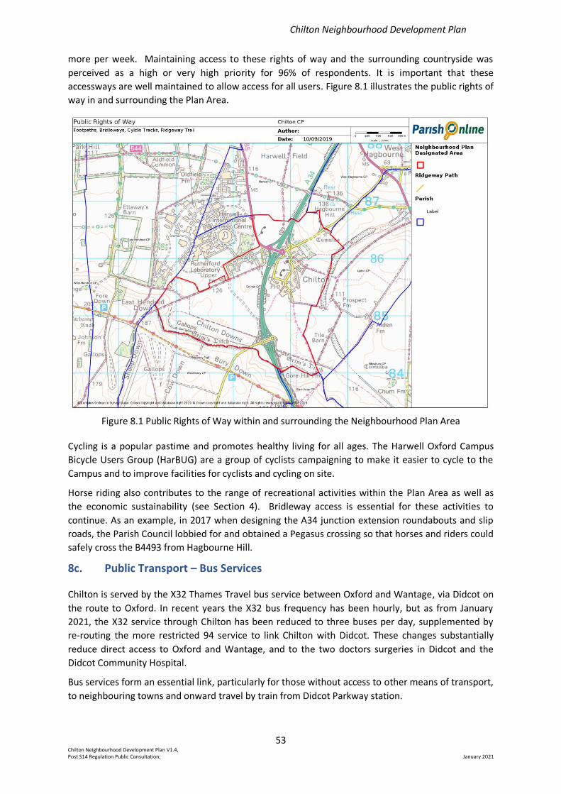
Chilton Neighbourhood Development Plan
53 Chilton Neighbourhood Development Plan V1.4, Post S14 Regulation Public Consultation; January 2021
more per week. Maintaining access to these rights of way and the surrounding countryside was
perceived as a high or very high priority for 96% of respondents. It is important that these
accessways are well maintained to allow access for all users. Figure 8.1 illustrates the public rights of
way in and surrounding the Plan Area.
Figure 8.1 Public Rights of Way within and surrounding the Neighbourhood Plan Area
Cycling is a popular pastime and promotes healthy living for all ages. The Harwell Oxford Campus
Bicycle Users Group (HarBUG) are a group of cyclists campaigning to make it easier to cycle to the
Campus and to improve facilities for cyclists and cycling on site.
Horse riding also contributes to the range of recreational activities within the Plan Area as well as
the economic sustainability (see Section 4). Bridleway access is essential for these activities to
continue. As an example, in 2017 when designing the A34 junction extension roundabouts and slip
roads, the Parish Council lobbied for and obtained a Pegasus crossing so that horses and riders could
safely cross the B4493 from Hagbourne Hill.
8c. Public Transport – Bus Services
Chilton is served by the X32 Thames Travel bus service between Oxford and Wantage, via Didcot on
the route to Oxford. In recent years the X32 bus frequency has been hourly, but as from January
2021, the X32 service through Chilton has been reduced to three buses per day, supplemented by
re-routing the more restricted 94 service to link Chilton with Didcot. These changes substantially
reduce direct access to Oxford and Wantage, and to the two doctors surgeries in Didcot and the
Didcot Community Hospital.
Bus services form an essential link, particularly for those without access to other means of transport,
to neighbouring towns and onward travel by train from Didcot Parkway station.
Chilton Neighbourhood Development Plan
54 Chilton Neighbourhood Development Plan V1.4, Post S14 Regulation Public Consultation; January 2021
In response to the questions on public transport in the 2018 survey (Appendix 2), 10% of
respondents said that they currently use public transport (X32 bus) once or more per week. Despite
only 48 responses indicating that the existing service did not meet their needs there were 50-60
responses wanting the service to be improved in various ways. The free text comments revealed
very high support for a bus service to Newbury. The previous daily service operating between
Newbury and the Harwell Campus was withdrawn in 2017.
It is recommended that as a community issue the Parish Council investigate opportunities for
improved public transport links to the village and for the reinstatement of a bus service between
Chilton and Newbury.
In addition to services passing through Chilton, the Thames Travel science travel shuttle service (ST1)
operates between the Harwell Campus and Oxford city centre.
8d. Public Transport – Train Services
The GWR Didcot Parkway mainline station is 4 miles/6kms away with direct trains to London
Paddington {40 mins), Oxford (20 mins), Reading (15-20 mins), Fast trains are also available to the
south west - Bath, Taunton, Exeter, Newton Abbot, Plymouth and Truro. Also, Swindon, Bristol,
Cardiff and Swansea, south Wales.
Access to the train station is a high priority particularly for those in the village regularly commuting
to London, Reading or Oxford for work purposes.
8e. Local Taxi Services
There are a number of local commercial taxi services operating from Didcot and Wantage. These
services may be readily accessed for journeys to and from Chilton.
8f. High Speed Broadband
High speed broadband is increasingly regarded as an essential requirement for economic
sustainability in rural areas, day-to-day living, promotion of community wellbeing and recreational
activities. With the introduction of fibre broadband to a BT cabinet close to the Rose and Crown,
internet access speeds of 30-50 Mb/s are accessible for most residents in the older part of the
village. Residents of Chilton Field enjoy higher speeds due to fibre connection to the houses.
Chilton Neighbourhood Development Plan
55 Chilton Neighbourhood Development Plan V1.4, Post S14 Regulation Public Consultation; January 2021
9. Community Issues
During the preparation of this Neighbourhood Plan the various stages of consultation with local
residents has highlighted several issues of interest and concern to the community that do not relate
directly to planning and therefore cannot be the subject of formal policies in a Neighbourhood Plan.
However, they are topics of relevance to the future wellbeing and the quality of life when living in
Chilton. These issues are summarised below to inform follow-up by the Parish Council and local
government.
9a. All Saints’ church churchyard
Although not of immediate concern All Saints’ church burial land as currently defined will at some
stage become fully utilised. Current projections indicate there will be space available to meet
ongoing needs to at least 2031. However, it is recognised that securing appropriate new burial land
is a long-term requirement for Chilton Village.
It is recommended that the Parish Council work with the Church authorities as a community project
to meet the future need of land allocation for burial space within the village
9b. Public Transport
Public transport provides an essential service for those without private or other transport for
accessing employment, shops, schools, doctors, hospitals, chemists, dentists, friends, relations, or
entertainment in local towns and settlements.
Over recent years the bus services available to Chilton have frequently changed being dependent
both on commercial viability and subsidies from local government. The need for maintaining or
enhancing existing bus services was covered in our survey in 2018 (see appendix 2). At that time,
the main concern was to re-establish a service between Chilton and Newbury. Since then Thames
Travel has changed the timetable for the X32 service such that it no longer provides an hourly direct
service between Chilton and Oxford or Wantage.
It is recommended that the Parish Council continue to pursue the reinstatement of the X32 bus
service to provide direct links between Chilton and Oxford and Wantage and to investigate
opportunities for improved public transport links to the village and for the reinstatement of a bus
service between Chilton and Newbury.
9c. Recreation Facilities
During the course of our consultation a number of suggestions have been received as to how the
existing recreation facilities for all ages and play facilities for younger people available at Chilton
Field and close to the village hall might be further enhanced.
It is recommended that suggestions for enhancement of recreation facilities received during the
consultation be provided to the Parish Council for consideration in any future recreation facility
projects to be managed by the Parish Council.
Chilton Neighbourhood Development Plan
56 Chilton Neighbourhood Development Plan V1.4, Post S14 Regulation Public Consultation; January 2021
9d. Accessibility to the surrounding AONB and access to A34 Service Station
Our survey in 2018 identified frequent usage and a high importance attached to local footpaths,
bridleways, cycleways, and byways. 70% of respondents said they use these public rights of way
once or more per week and 96% of respondents attached either a high or very high importance to
maintaining access by rights of way, other than roads, to the surrounding areas of Chilton Village.
Furthermore, two responses received during the pre-submission regulation 14 consultation
requested improvement of the existing public footpath access to the service station on the
southbound carriageway of the A34 so improving the non-vehicular access to nearby shopping
facilities. The current public footpath goes across a farmer’s field. Re-routing and/ or enhancing the
existing path are potential enhancements that would require a full examination of the possible
options before proceeding further.
It is recommended that the Parish Council ensure existing access to the surrounding areas and
undertake a feasibility study to establish the extent of the need and feasibility for providing
improved pedestrian access to the A34 service station.
Chilton Neighbourhood Development Plan
57 Chilton Neighbourhood Development Plan V1.4, Post S14 Regulation Public Consultation; January 2021
10. Glossary/Defined Terms
Affordable Housing: There are three categories: social rented, affordable rented and intermediate
housing. These are provided for eligible households whose needs are not met by market housing.
Eligibility is determined with regard to local incomes and local house prices and is also determined
by meeting relevant, district based, local connection criteria.
Affordable housing should remain at an affordable price for future eligible households, or for the
subsidy to be recycled for alternative affordable housing provision. Homes that do not meet this
definition of affordable housing, such as ‘low-cost market housing’, may not be considered as
affordable housing for planning purposes.
Affordable rented housing: Housing let by local authorities or private registered providers of social
housing to households who are eligible for social rented housing. Affordable rent is no more than
80% of the local market rent (including service charges, where applicable).
AONB: Area of Outstanding Natural Beauty; designated in recognition of national importance and
to ensure that its character and qualities are protected for all to enjoy.
‘the Plan’: Chilton Neighbourhood Development Plan.
Chilton Village Survey: Survey on housing, village infrastructure, transport, business and related
matters distributed to all households in Chilton in September 2018. The results have been used to
inform the policies in this Plan.
Curtilage: The land immediately surrounding a house or dwelling, including any closely associated
buildings and structures, but excluding any associated open fields.
Development Plan: A set of documents that set out a local authority’s policies and proposals for
the development and use of land. This plan guides and shapes day-to-day decisions as to whether or
not planning permission should be granted. By law, all decisions made should be in accordance with
the Development Plan unless material considerations indicate otherwise.
Employment Zone: A designation defined in the VWHDC Local Plan that has defined boundaries
and is used to safeguard areas in the district for employment uses (both existing and proposed).
Other uses may be permitted provided that they are ancillary to the main employment uses.
Enterprise Zone: Areas around the country that support both new and expanding businesses by
offering incentives through means such as business rates relief and simplified planning procedures.
Landscape character: The distinctive and recognisable pattern of features that makes a landscape
type different from others.
Listed building: A building which has been designated because of its special architectural or
historic interest. Unless the list entry indicates otherwise, includes not only the building itself but
also any object or structure fixed to the building and any object or structure within the curtilage of
the building which, although not fixed to the building, forms part of the land and has done so since
before 1 July 1948.
Local Plan (part 1 and part 2): Vale of White Horse District Council development plans, proposing
to build 20,000 new houses up to 2031. Part 1 (Strategic Sites and Policies) deals with large
developments of more than 200 dwellings and part 2 (Detailed Policies and Local Sites) with smaller
developments.
Market housing: Housing available to buy or rent privately at open market prices.
Chilton Neighbourhood Development Plan
58 Chilton Neighbourhood Development Plan V1.4, Post S14 Regulation Public Consultation; January 2021
NPPF: National Planning Policies Framework; sets out the Government’s planning policies for
England and how these are expected to be applied.
OCC: Oxfordshire County Council.
Parish Council: In our case Chilton Parish Council
Plan Area: The geographical area covered by the Plan as designated by VWHDC following a
statutory consultation.
Plan Period: From the commencement date of this Plan to 2031.
Rural Exception Site: Social rented and affordable housing on a site where housing would not
normally be permitted, provided the development meets a proven local need and is supported or
initiated by the Parish Council.
Science Vale UK Enterprise Zone: Harwell is one of two enterprise zones in the region housing a
significant proportion of its scientific, research and development, and high technology businesses.
New businesses can benefit from business rates discounts, superfast broadband and simplified
planning.
Significance (for heritage policy): The value of a heritage asset to this and future generations
because of its heritage interest. That interest may be archaeological, architectural, artistic or
historic. Significance derives not only from a heritage asset’s physical presence, but also from its
setting.
Social rented housing: Housing owned by local authorities and private registered providers, on
which guideline target rents are determined through the national rent regime. It may also be owned
by other persons and provided under equivalent rental arrangements, as agreed with the local
authority or with the Homes and Communities Agency.
Steering Group: A group of volunteers who progressed the development of the Plan on behalf of
the Parish Council, the members of which are listed in the Credits and Acknowledgements section.
VWHDC: Vale of White Horse District Council
Chilton Neighbourhood Development Plan
59 Chilton Neighbourhood Development Plan V1.4, Post S14 Regulation Public Consultation; January 2021
11. Credits and Acknowledgements
The Chilton Neighbourhood Plan Steering Group would like to thank everyone who has been
involved in helping to develop our Neighbourhood Plan. We are grateful for every contribution to
the development of the Plan, including from the following:
1. All Chilton residents who responded to the village survey and who attended public Plan-
related events.
2. All businesses and organisations that provided consultation feedback.
3. Parish Councillors who have provided advice and guidance as required.
4. The Vale of White Horse District Council, who have supported the development of the Plan.
Steering Group Members
Stephen Druce (Coordinator) Bob Girling Kevin Williams
Chris Broad (Chairman) Steve Hughes Jane Woods
Hazel Benton Chris Pickford Keith Woods
Richard Benton Pam Rolls Ros Page (Secretary)
Janet Cockburn Janet Williams
Chilton Neighbourhood Development Plan
60 Chilton Neighbourhood Development Plan V1.4, Post S14 Regulation Public Consultation; January 2021
List of Appendices
The following appendices are available separately:
Appendix 1: Village Character Assessment and Design Styles
Appendix 2: Village Survey and Results
Appendix 3: Local Green Spaces Infrastructure Audit data
Appendix 4: Traffic Noise Levels in Chilton


