
CLICKHERETOKNOWMORE

LANDS AND SURVEYS DEPARTMENT
SABAH, MALAYSIA
Sr Hj SAFAR B UNTONG, FISM, MRICS
Director, Lands & Surveys Department
Sabah, Malaysia1 October, 2015
GEO-CADASTRE IN LAND
ADMINISTRATION:
SABAH’S EXPERIENCE

contents
1
1. Introduction
2. Building Geospatial Data
3. Cadastre – Land Title Information
4. Mobile GIS
5. Way Forward: 3D Cadastre
6. Conclusion
INTRODUCTION
2
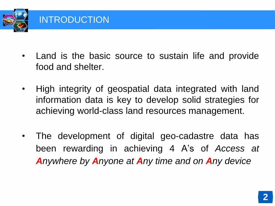
• Land is the basic source to sustain life and provide
food and shelter.
• High integrity of geospatial data integrated with land
information data is key to develop solid strategies for
achieving world-class land resources management.
• The development of digital geo-cadastre data has
been rewarding in achieving 4 A’s of Access at
Anywhere by Anyone at Any time and on Any device

Map Sheet Scale 1: 12,500 (1,285 sheets, A0 size )
3

Map Sheet Scale 1: 2,500 (13,285 sheets, A0 size)
4
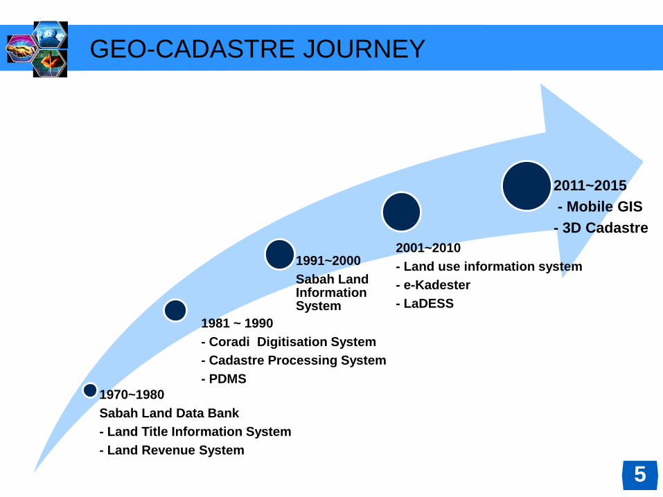
GEO-CADASTRE JOURNEY
1970~1980
Sabah Land Data Bank
- Land Title Information System
- Land Revenue System
1981 ~ 1990
- Coradi Digitisation System
- Cadastre Processing System
- PDMS
1991~2000
Sabah Land Information System
2001~2010
- Land use information system
- e-Kadester
- LaDESS
2011~2015
- Mobile GIS
- 3D Cadastre
5
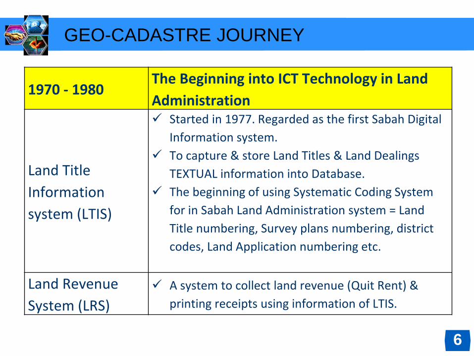
1970 - 1980The Beginning into ICT Technology in Land
Administration
Land Title
Information
system (LTIS)
Started in 1977. Regarded as the first Sabah Digital
Information system.
To capture & store Land Titles & Land Dealings
TEXTUAL information into Database.
The beginning of using Systematic Coding System
for in Sabah Land Administration system = Land
Title numbering, Survey plans numbering, district
codes, Land Application numbering etc.
Land Revenue
System (LRS)
A system to collect land revenue (Quit Rent) &
printing receipts using information of LTIS.
GEO-CADASTRE JOURNEY
6
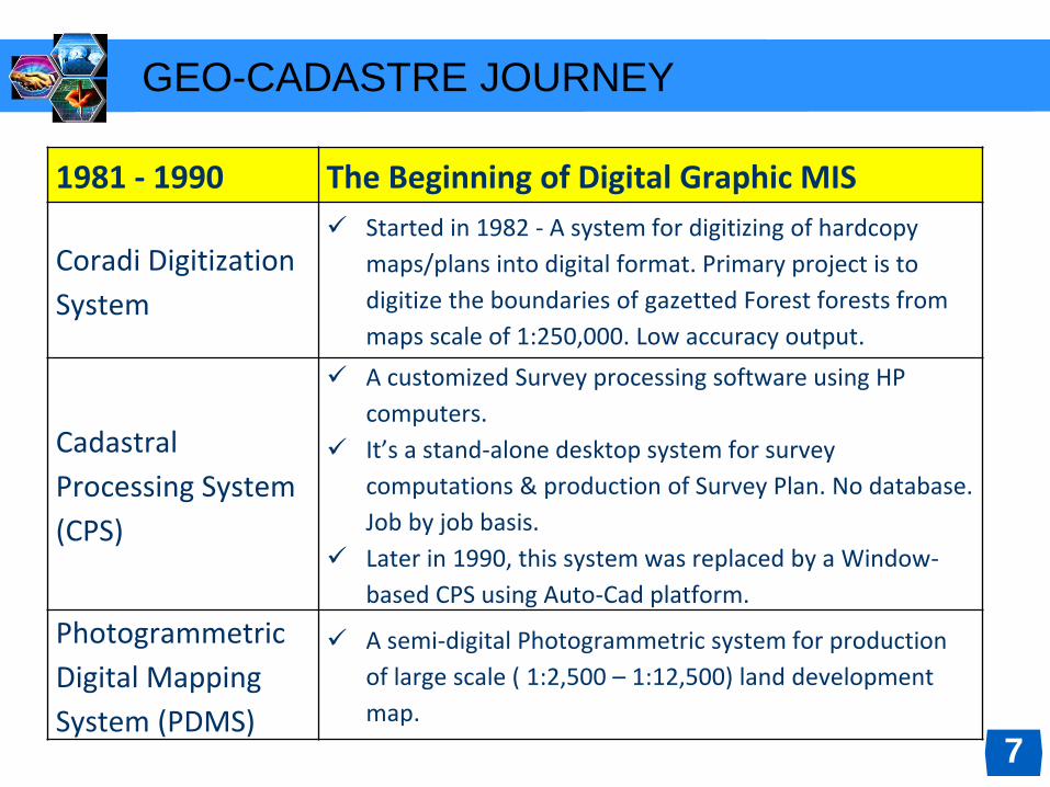
1981 - 1990 The Beginning of Digital Graphic MIS
Coradi Digitization
System
Started in 1982 - A system for digitizing of hardcopy
maps/plans into digital format. Primary project is to
digitize the boundaries of gazetted Forest forests from
maps scale of 1:250,000. Low accuracy output.
Cadastral
Processing System
(CPS)
A customized Survey processing software using HP
computers.
It’s a stand-alone desktop system for survey
computations & production of Survey Plan. No database.
Job by job basis.
Later in 1990, this system was replaced by a Window-
based CPS using Auto-Cad platform.
Photogrammetric
Digital Mapping
System (PDMS)
A semi-digital Photogrammetric system for production
of large scale ( 1:2,500 – 1:12,500) land development
map.
GEO-CADASTRE JOURNEY
7

1991- 2000 Entering the Era of GIS
Sabah land
Information System
(SALIS)
Started in 1997.
A web-based system to integrate all JTU digital
textual, graphical & images unto a common
platform.
Among the early digital data integrated are – Land
titles textual information, Land dealings info, land
revenue info, graphical cadatral parcel ,
orthophotos.
Later includes – High Resolution remotely sensed
images Land acquisition info, land value
information, cadastral boundaries info etc.
GEO-CADASTRE JOURNEY
8

2001- 2010 Towards Digital Sabah
Land use info
system(LUIS)
Production of Digital Land cover maps from
orthophoto, ortho- images.
Mapping of Sabah under IFSAR Project
e-Kadester Sabah
2009 - Beginning of Field to Finish Surveying
System
2011 - Creation of high accuracy Digital Cadestral
Database (DCDB) by entering of bearings &
distances from Survey Plans.
Land Dealing
Electronic Submission
System (LaDess)
Started 2010 - Can be consider as the first ever On-
Line Digital Submission Land Dealing system in
Malaysia.
GEO-CADASTRE JOURNEY
9

2011-2015 Going Mobile
Mobile GIS
Enable Android & IOS mobile users
accessing Land parcel textual & graphical
information using Esri’s ArcGis mobile
apps.
A cloud technology which allow access to
Sabah land information Anywhere, Any
One, Anytime & Any Device.
3D Cadestre Production of 3D cadastral maps and
DTM from IFSAR Digital Sabah Images.
GEO-CADASTRE JOURNEY
10
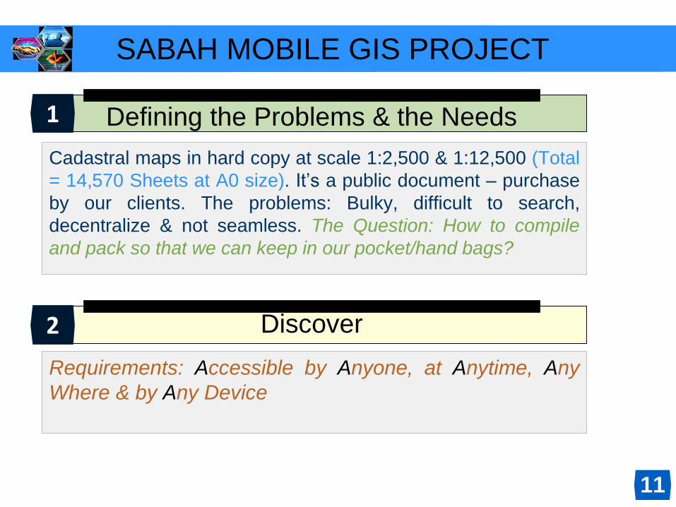
SABAH MOBILE GIS PROJECT
Defining the Problems & the Needs
Cadastral maps in hard copy at scale 1:2,500 & 1:12,500 (Total
= 14,570 Sheets at A0 size). It’s a public document – purchase
by our clients. The problems: Bulky, difficult to search,
decentralize & not seamless. The Question: How to compile
and pack so that we can keep in our pocket/hand bags?
Discover
Requirements: Accessible by Anyone, at Anytime, Any
Where & by Any Device
1
2
11

How do we start this project?
Develop
Sabah Digital Cadastral Data Base (DCDB) consist of
more than 560,000 land parcels was develop and
completed in 2011. These huge graphical cannot ride on
Sabah.Net. The Solution: We purchase Esri ArcGis
Server and upload/store our DCDB at Amazon Cloud.
Implement
We implement the solution and ArcGis mobile meet our
needs and requirements. Cadastral lots/land parcels now
in our pockets/hand bags and can be access by Anyone,
at Any Time, Any Where & by Any Mobile Device.
4
3
12

SABAH DIGITAL CADASTRAL DATA BASE (DCDB)
Access via Mobile
Device(Smartphone,
iPad, iPod, tab, note) -
Cloud Computing Esri
ArcGIS.
Access via Alfresco
and GoogleEarth
http://218.111.213.197:
8080/share/page)
1
2
13
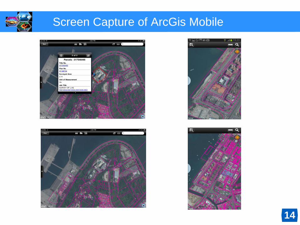
Screen Capture of ArcGis Mobile
14

Cadastre information (kmz Files) on mobile Phone
15

INTEGRATED SABAH GEO-CADASTRE DATA
16

INTEGRATED SABAH GEO-CADASTRE DATA
17

INTEGRATED SABAH GEO-CADASTRE DATA
18

INTEGRATED SABAH GEO-CADASTRE DATA
19
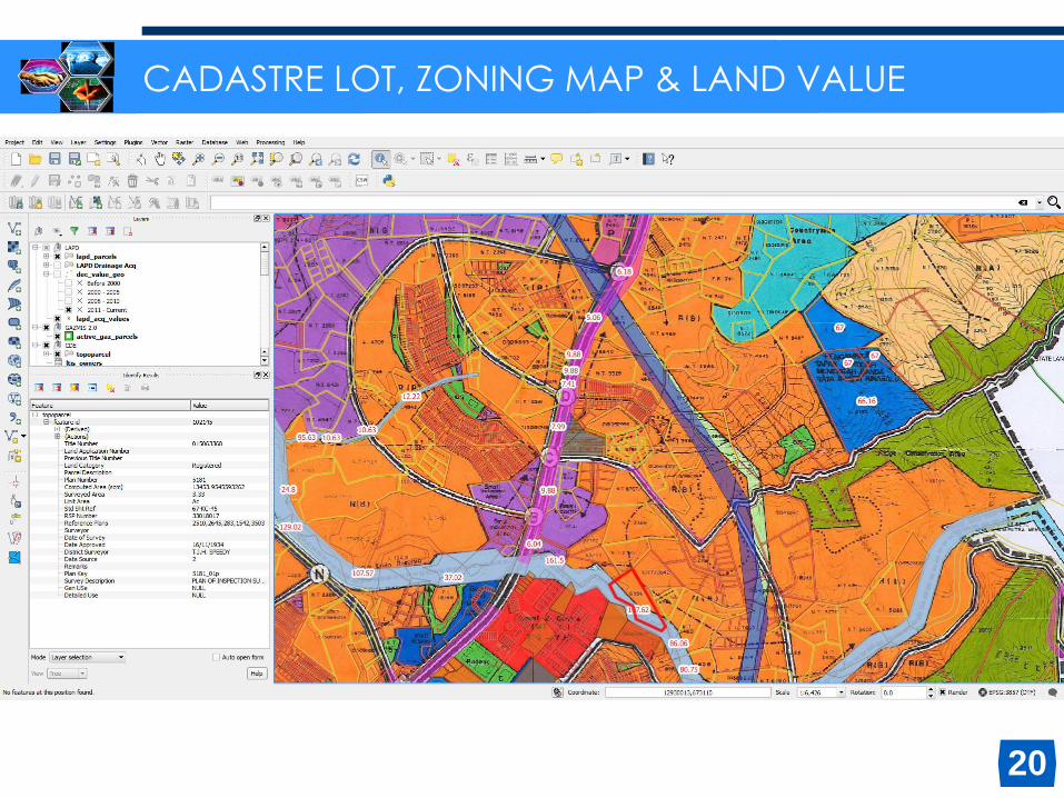
CADASTRE LOT, ZONING MAP & LAND VALUE
20

21
3D CADASTRE PROJECT – cadastre lots with google earth

22
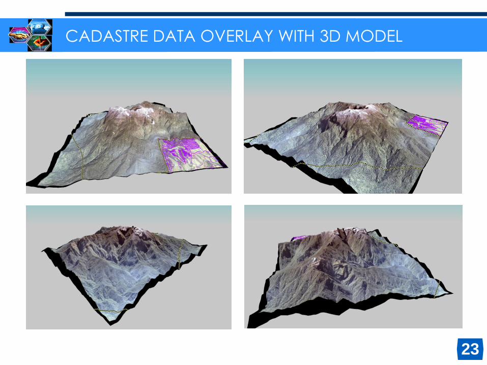
CADASTRE DATA OVERLAY WITH 3D MODEL
23
CADASTRE DATA OVERLAY WITH 3D MODEL

DTM +
Orthophoto
Contour
Analysis
Slope Analysis -
45 deg
24
CONTOUR ANALYSIS & SLOPE ANALYSIS

25
CADASTRE LOTS OVERLAY WITH 3D MODEL

26
CADASTRE LOTS, CONTOUR OVERLAY WITH 3D MODEL
27
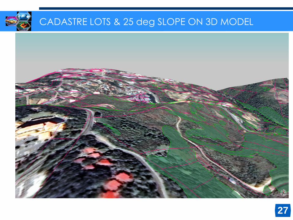
CADASTRE LOTS & 25 deg SLOPE ON 3D MODEL

28
CADASTRE LOTS & 25 deg SLOPE ON 3D MODEL

CONCLUSION
❖ Mobile GIS application is just one of many innovations
that are being implemented in the Department of Lands
and Surveys to provide fast and efficient service to
customers.
❖ Now public can access to know the status of their land
without having to go to Lands and Surveys Department.
It saves time and costs. Therefore the objective Mobile
GIS project is achieved, namely “Access by Any One, At
Any Time, At Any Where, By Any Device”.
❖ Integrated Sabah Geo-Cadastre Data is currently being
used as a management tool by our Land Administrators
29
THANK YOU
? & a
30


