Report No: AG1646-12-M77 Date: April 2012 Status: Validated Issue 1 Prepared on behalf of TWG (Specialist Vehicles) Ltd
DESK STUDY REPORT AT CHURCH LANE, CORLEY

AG1646-12-M77 APPLiED GEOLOGY
REPORT STATUS SHEET
Client: TWG (Specialist Vehicles) Ltd Report Title: Church Lane, Corley Report Type: Desk Study/Phase I Geoenvironmental Risk Assessment Report Number: AG1646-12-M77 Report Status: Validated Issue 1 Date: April 2012
One Copy Issued
Date Signed for and on behalf of Applied Geology Limited
Report Author M Lawson BSc (Hons) FGS Project Engineer
19/04/2012
Checked J L Allum BSc (Hons) MSc FGS Principal Engineer
19/04/2012
Authorised S Day BSc (Hons) MSc CGeol FGS SiLC Associate Director
19/04/2012

Church Lane, Corley
AG1646-12-M77 APPLiED GEOLOGY
CONTENTS
1.0 INTRODUCTION ........................................................................................................ 1 2.0 SITE LOCATION AND DESCRIPTION ...................................................................... 2
2.1 General ....................................................................................................................................2 2.2 Walkover Survey......................................................................................................................2 2.3 Proposed Development ...........................................................................................................2
3.0 DESK STUDY INFORMATION .................................................................................. 3 3.1 Site History ..............................................................................................................................3 3.2 Anticipated Geology ................................................................................................................4 3.3 Mining History/Geological Cavities ..........................................................................................4 3.4 Radon ......................................................................................................................................4 3.5 Hydrology .................................................................................................................................4 3.6 Hydrogeology ...........................................................................................................................5 3.7 Ecology ....................................................................................................................................5 3.8 Environmental Searches .........................................................................................................5 3.9 Contemporary Trade Directories .............................................................................................6
4.0 CONCEPTUAL MODEL ............................................................................................ 6 4.1 Summary of Site History ..........................................................................................................6 4.2 Summary of Anticipated Geology ............................................................................................6 4.3 Potential Source - Pathway – Receptor Pollutant Linkages ....................................................6
5.0 DISCUSSION ............................................................................................................. 9 6.0 ADDITIONAL WORK ................................................................................................. 9 7.0 LIMITATIONS AND EXCEPTIONS OF ASSESSMENT ........................................... 10 GENERAL NOTES
APPENDICES APPENDIX A DRAWINGS & FIGURES APPENDIX B DESK STUDY DATA

Church Lane, Corley Page 1
AG1646-12-M77 APPLiED GEOLOGY
1.0 INTRODUCTION
An area of land at Church Lane, Corley is being considered for redevelopment by TWG (Specialist Vehicles) Ltd, (the Client). The proposals for the site comprise four detached two-storey houses with associated access roads and gardens, as shown on Drawing No 600.03, dated 24/01/2012, prepared by Callingham Associates and presented in Appendix A. This report presents the results of a desk study/Phase I Geoenvironmental Risk Assessment undertaken on behalf of the Client. The desk study/Phase I assessment was undertaken to:
• Permit formulation of an opinion, as to the potential for hazardous substances or conditions to exist on, at or near the site at levels or in a situation likely to warrant mitigation or consideration appropriate to the intended end use proposed by the Client and as stated above.
• Establish anticipated geological conditions to inform preliminary
geotechnical design.
The terms of reference/brief for the works were mutually developed between Callingham Associates (the Clients Architects) and Applied Geology and are outlined in our proposal and estimate (ref.AG12-3373let001) of the 27th of February 2012. Limitations and Exceptions of the report are presented in Section 7. More specifically, the services provided are summarised below and detailed in the following Sections.
• A site inspection and walkover survey to identify indicators (as defined in later sections) of the existence of hazardous substances or conditions on and in the vicinity of the site.
• A review of the following sources to provide data on likely ground conditions, geohazards and features which may affect development and to obtain information about the potential for hazardous substances to exist at and in the vicinity of the site:
GroundSure – Environmental Database. GroundSure – Historical maps. BGS - Published Information & Borehole Database. Environment Agency Web Site. Animal Health and Veterinary Laboratories Agency. Natural England Web Site. MAGIC Web Site.
• Assessment and reporting of the results of the works, including the
development of an initial Conceptual Site Model.
A topographic survey ref.600.01 dated 10th of February 2012 by On Centre Surveys Ltd and updated by Callingham Associates was provided by the Client’s Architects prior to any work being undertaken.

Page 2 Church Lane, Corley
APPLiED GEOLOGY AG1646-12-M77
2.0 SITE LOCATION AND DESCRIPTION 2.1 General
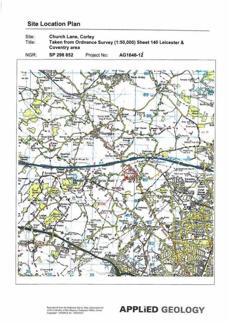
The site is located north of Church Lane, Corley, approximately 7km north-west of the centre of Coventry. The site is roughly rectangular in shape and covers an area of approximately 0.88ha. The Ordnance Survey grid reference for the centre of the site is SP 298 852 as shown on the Site Location Plan in Appendix A.
2.2 Walkover Survey
A brief walkover was carried out on the 28th of March 2012 and is described below. The site comprised a now defunct plant nursery and was accessed via a 2m high metal gate fronting onto Church Lane. The boundaries of the site comprised a mixture of 2m high metal palisade fencing and wire link fencing, all of which was vegetated with either semi-mature trees or holly. To the north and west of the site were ploughed fields, to the east was a residential dwelling and to the south, beyond Church Lane were a covered reservoir and an area of paddocks. The site itself was generally covered in hardcore and limited areas of asphalt or concrete slab. Near to the entrance of the site a timber shed and toilet block were noted and a metal cabin situated behind them. Corrugated metal buildings were located in the west and north-west of the site although access could not be gained to them. A bunded fuel store was noted next to the western building. General building and landscaping materials were stockpiled to the rear of the north-western building. A number of approximately 2m high polyurethane tunnels and a glass greenhouse stood near to the centre of the site. Water tubs, wood scraps and pots were occasionally noted across the site. Where access could not be gained a previously undertaken topographic survey notes the presence of a water storage tank and corrugated shed to the rear of the glass greenhouse, although their presence and state of repair could not be verified during the walkover survey. No potentially contaminative sources or uses were identified on or within the immediate vicinity of the site apart from those noted above.
It should be noted that Applied Geology Limited does not provide arboricultural surveys or specialist surveys for the detection of invasive plant species (such as Japanese Knotweed) or protected species of wildlife. Whilst no Japanese Knotweed or other controlled or invasive species was noted it is recommended that if required, separate investigation by specialists be undertaken to confirm this.
2.3 Proposed Development
The proposals for the site comprise four detached two-storey houses with associated access roads and gardens, as shown on Callingham Associates Drawing No 600.03 presented in Appendix A.
Church Lane, Corley Page 3
AG1646-12-M77 APPLiED GEOLOGY
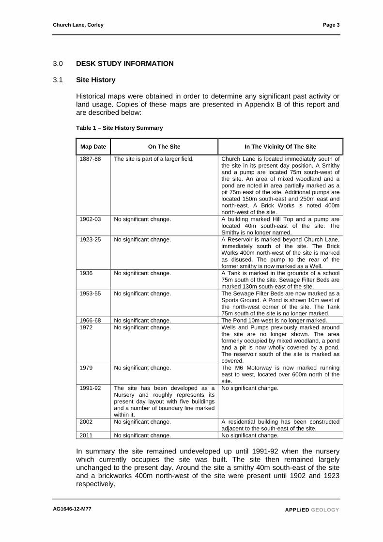
3.0 DESK STUDY INFORMATION 3.1 Site History
Historical maps were obtained in order to determine any significant past activity or land usage. Copies of these maps are presented in Appendix B of this report and are described below:
Table 1 – Site History Summary
Map Date On The Site In The Vicinity Of The Site
1887-88 The site is part of a larger field. Church Lane is located immediately south of the site in its present day position. A Smithy and a pump are located 75m south-west of the site. An area of mixed woodland and a pond are noted in area partially marked as a pit 75m east of the site. Additional pumps are located 150m south-east and 250m east and north-east. A Brick Works is noted 400m north-west of the site.
1902-03 No significant change. A building marked Hill Top and a pump are located 40m south-east of the site. The Smithy is no longer named.
1923-25 No significant change. A Reservoir is marked beyond Church Lane, immediately south of the site. The Brick Works 400m north-west of the site is marked as disused. The pump to the rear of the former smithy is now marked as a Well.
1936 No significant change. A Tank is marked in the grounds of a school 75m south of the site. Sewage Filter Beds are marked 130m south-east of the site.
1953-55 No significant change. The Sewage Filter Beds are now marked as a Sports Ground. A Pond is shown 10m west of the north-west corner of the site. The Tank 75m south of the site is no longer marked.
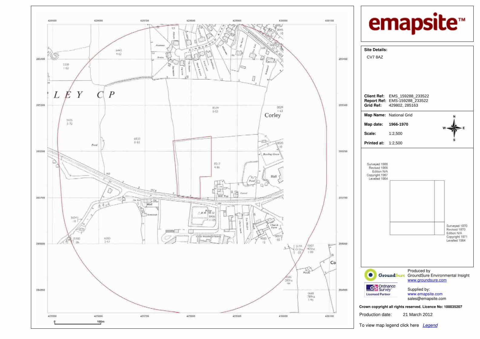
1966-68 No significant change. The Pond 10m west is no longer marked. 1972 No significant change. Wells and Pumps previously marked around
the site are no longer shown. The area formerly occupied by mixed woodland, a pond and a pit is now wholly covered by a pond. The reservoir south of the site is marked as covered.
1979 No significant change. The M6 Motorway is now marked running east to west, located over 600m north of the site.
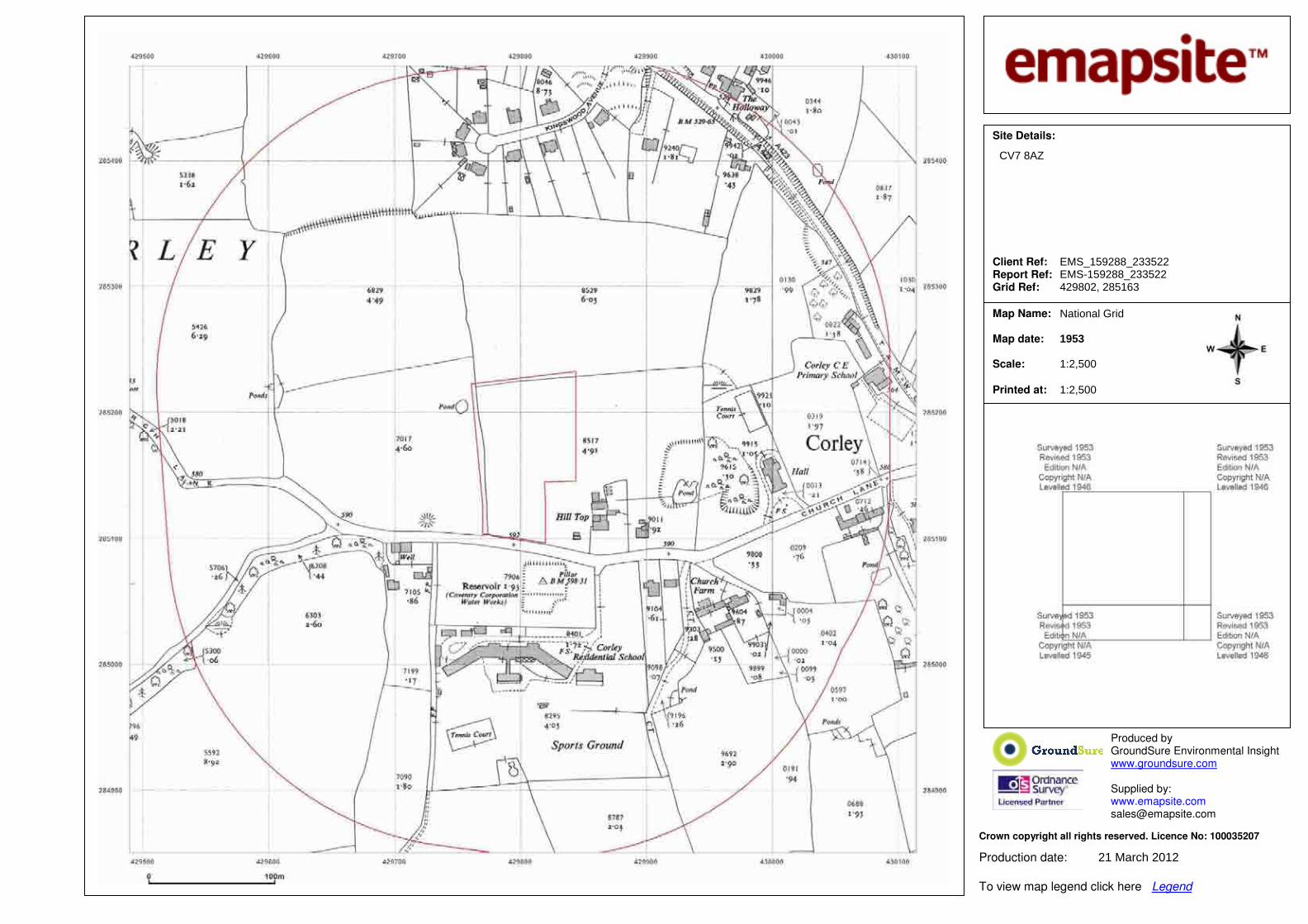
1991-92 The site has been developed as a Nursery and roughly represents its present day layout with five buildings and a number of boundary line marked within it.
No significant change.
2002 No significant change. A residential building has been constructed adjacent to the south-east of the site.
2011 No significant change. No significant change.
In summary the site remained undeveloped up until 1991-92 when the nursery which currently occupies the site was built. The site then remained largely unchanged to the present day. Around the site a smithy 40m south-east of the site and a brickworks 400m north-west of the site were present until 1902 and 1923 respectively.

Page 4 Church Lane, Corley
APPLiED GEOLOGY AG1646-12-M77
Ponds were located east and west of the site, and Pumps and Wells were located around the site up until 1972. A reservoir was constructed by 1923 immediately south of the site.
3.2 Anticipated Geology
Reference to the published 1:50,000 scale British Geological Survey (BGS) map, Sheet ‘169 Coventry’ (solid and drift edition), indicates the site to be directly underlain by the Keresley Member Sandstone. The maps also note an outcrop of Keresley Member Conglomerate 72m south-east of the site as well as an area of Glacial Till 185m west of the site. Additional reference to the BGS Technical Report WA/89/29 – Geology of the Coventry Area – confirms these findings and also indicates that an area of Mudstone is located just north of the site.
The BGS archived records were checked for relevant boreholes within the vicinity of the site, however none were identified.
3.3 Mining History/Geological Cavities
Reference to the Department of the Environment (now DEFRA) “Review of Mining Instability in Great Britain” indicates the site is not located in an area of recorded non-coal mining activities. Consultation of the Coal Authority's/Law Society’s Coal Mining Searches Directory indicates that the site lies in an area for which a standard mining report is not required for new development. A review of the DoE regional reports for Natural Underground Cavities in Great Britain (1993) indicates the site is not located in an area of recorded natural cavity formation. A pond located 75m east was previously marked as a pit and is likely to have been associated with the local extraction of either sandstone or mudstone from the Keresley Member.
3.4 Radon
Reference to the BRE document 211:2007, (Radon: guidance on protective measures for new buildings), indicates that the site does not lie in an area where the geological strata may be susceptible to radon emissions. Hence, no precautions against ingress of radon into buildings are necessary.
3.5 Hydrology
The nearest surface water feature is the pond noted 75m east of the site. There is no Environment Agency General Quality Assessment (GQA) classification for this water feature. There are no other surface water features within 250m of the site, the nearest being the Breach Brook over 1.5km north-east of the site, which flows east, away from the site. According to the GroundSure report there are no surface water abstractions within 500m of the centre of the site. The covered reservoir is located at an elevated location and is therefore considered to be associated with pumped storage and distribution rather than for the direct capture of water.

Church Lane, Corley Page 5
AG1646-12-M77 APPLiED GEOLOGY
There is a single discharge consent indicated 204m to the south east of the site for sewage discharge from Pikers Lane Farm. No receiving water was defined. The Environment Agency Web site indicates that the site lies outside of any zone likely to be affected by flooding / extreme flooding. However this report is not intended to be a full hydrological study and if a flood risk assessment is needed, additional analysis by others is recommended to confirm this aspect of the development.
3.6 Hydrogeology
According to the Groundwater Vulnerability Map produced by the Environment Agency the Keresley Member underlying the site is classified as a Principal Aquifer by the Environment Agency. While no groundwater abstractions are noted within 1km of the site the site is located within a Total Catchment of a more distant abstraction.
3.7 Ecology
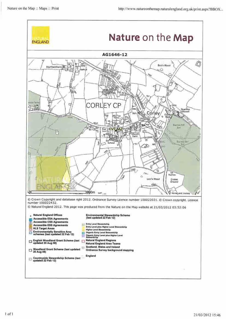
Information from environmental and ecological datasets was obtained from a review of the MAGIC (Multi-Agency Geographic Information for the Countryside) website and the Natural England website undertaken on the 21st of March 2012 and from the GroundSure report. These searches indicate the site to be located within a larger nitrate sensitive area. No other protected species or habitats, or non statutory designations were associated with the site. If a full assessment of Environmental or Ecological aspects is required, it is recommended that other specialists are consulted.
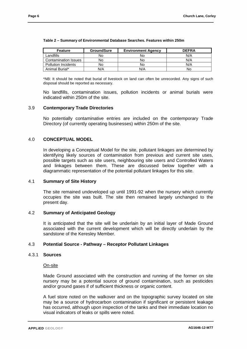
3.8 Environmental Searches
Information pertaining to environmental issues was obtained from a GroundSure report, commissioned by Applied Geology Limited, dated 21st March 2012. This database contains sets of data corresponding to the databases held by a number of sources including the Environment Agency (EA), British Geological Survey (BGS), Health Protection Agency (HPA), Coal Authority (CA), Department for the Environment, Farming and Rural Affairs (DEFRA) and the Local Authorities (LAs). A copy of the report is included in Appendix B. A letter of enquiry was also sent to DEFRA regarding animal burial or processing sites existing within a 250m radius of the property. A summary of the findings of these searches is presented below and copies of the responses from the various authorities are included in Appendix B.
Page 6 Church Lane, Corley
APPLiED GEOLOGY AG1646-12-M77
Table 2 – Summary of Environmental Database Searches. Features within 250m
Feature GroundSure Environment Agency DEFRA Landfills No No N/A Contamination Issues No No N/A Pollution Incidents No No N/A Animal Burial* N/A N/A No
*NB: It should be noted that burial of livestock on land can often be unrecorded. Any signs of such disposal should be reported as necessary.
No landfills, contamination issues, pollution incidents or animal burials were indicated within 250m of the site.
3.9 Contemporary Trade Directories
No potentially contaminative entries are included on the contemporary Trade Directory (of currently operating businesses) within 250m of the site.
4.0 CONCEPTUAL MODEL
In developing a Conceptual Model for the site, pollutant linkages are determined by identifying likely sources of contamination from previous and current site uses, possible targets such as site users, neighbouring site users and Controlled Waters and linkages between them. These are discussed below together with a diagrammatic representation of the potential pollutant linkages for this site.
4.1 Summary of Site History
The site remained undeveloped up until 1991-92 when the nursery which currently occupies the site was built. The site then remained largely unchanged to the present day.
4.2 Summary of Anticipated Geology
It is anticipated that the site will be underlain by an initial layer of Made Ground associated with the current development which will be directly underlain by the sandstone of the Keresley Member.
4.3 Potential Source - Pathway – Receptor Pollutant Linkages 4.3.1 Sources
On-site Made Ground associated with the construction and running of the former on site nursery may be a potential source of ground contamination, such as pesticides and/or ground gases if of sufficient thickness or organic content. A fuel store noted on the walkover and on the topographic survey located on site may be a source of hydrocarbon contamination if significant or persistent leakage has occurred, although upon inspection of the tanks and their immediate location no visual indicators of leaks or spills were noted.

Church Lane, Corley Page 7
AG1646-12-M77 APPLiED GEOLOGY
Off-site
The pond 75m east of the site which appears to have been formed from a pit of some description may be a potential source of ground contamination and/or ground gases if it had been backfilled, partially or otherwise, prior to filling with water. Made Ground associated with the construction of a covered reservoir on the southern side of Church Lane may be a source of potential ground gases, if of sufficient organic content. A Tank briefly marked on historical maps 75m south of the site may be a source of hydrocarbon contamination if it was a fuel tank. A former smithy 75m south-west of the site may be a source of ground contamination including metals and hydrocarbons.
4.3.2 Pathways
Dermal Contact, Ingestion and Inhalation
End users could be at risk from dermal contact, ingestion of fugitive dust and outdoor/indoor air inhalation pathways if contaminants were present in sufficient concentrations. During construction, groundworkers may be exposed to potentially contaminated soils via the inhalation, ingestion and dermal contact pathways although exposure times will be less and will be further reduced with standard personal protective equipment, good hygiene and welfare facilities. Both end users and construction workers may be exposed to harmful ground gases via the inhalation pathways. Migration via Leaching and Groundwater Flow
Mobile or leachable contaminants within any granular Made Ground may migrate laterally and vertically via service trenches and ducting as well as via pore spaces within the materials underlying the site. Sandstone of the Keresley Member is anticipated to underlie the site and is classified as a Principle Aquifer of moderate to high permeability. As such both lateral and vertical migration could occur. However, geological mapping indicates that areas of outcropping mudstone are located to the north-east and deposits of Glacial Till are located to the west of the site. If either of these are encountered on site both lateral and vertical migration of contaminants may be limited. Local topography also suggests that near surface groundwater flow and surface water flow would be away from the site in all directions. Direct Contact Buried concrete and service pipes may be affected by direct contact with sulphates and hydrocarbons if present within the soils on site.

Page 8 Church Lane, Corley
APPLiED GEOLOGY AG1646-12-M77
4.3.3 Receptors End Users End users will be at risk of inhalation of fugitive dust and ground gas should any be present. Controlled Waters The most sensitive controlled water is considered to be the Principal Aquifer of the Keresley Member Buildings Aqueous solutions of sulphate can attack hardened concrete. The attack causes expansive chemical reactions, which result in a reduction in strength and durability of the concrete. Buried concrete can also be affected by the presence of hydrocarbons. Plastics used in construction and service trenching will also be at risk from hydrocarbons, if present. Construction Workers Groundworkers are considered receptors, who could require protection if significant contamination was present although exposure times and the use of PPE and good hygiene are likely to limit any risk.
4.3.4 Diagrammatic Representation:
The diagrammatic representation of the Conceptual Site Model described above is presented in Appendix A and tabulated below.
Table 3 – Initial Conceptual Site Model
Source Pathway Receptor Risk*
Potential contaminants within Made or Disturbed Ground.
Inhalation, ingestion, dermal contact.
End users, groundworkers. Low
Migration via Made Ground / Keresley Member
Principal Aquifer. Low
Hydrocarbon contamination associated with the fuel store on site.
Ingestion, dermal contact. End users, groundworkers. Low
Soil gas from Made Ground – both on site and off site sources including pond & reservoir (methane & carbon dioxide).
Migration via Made Ground into buildings and any excavations during construction.
End users Low
Hydrocarbon and metal contamination associated with tank and smithy 75m south and south-east.
Inhalation, ingestion, dermal contact.
End users, groundworkers. Negligible
Sulphates and hydrocarbons (potentially aggressive to concrete).
Direct contact. Proposed structure. Low

Church Lane, Corley Page 9
AG1646-12-M77 APPLiED GEOLOGY
Potential contaminants within the groundwater Migration Principal
Aquifer. Low
* Definition of Risk Categories N/A - Not Applicable: Either source, pathway or receptor not present – no pollutant linkage Negligible - Contaminants that might have unacceptable impact on key receptors, are unlikely to be present, or, no pathway is envisaged. Low Risk: Contaminants may be present but are unlikely to be at levels to have unacceptable impact on key receptors, or pathways are likely to be minimal. Medium Risk: Contaminants are probably present and might have an unacceptable impact on key receptors. Pathways may also be present therefore remedial measures may be necessary to reduce the risks.
5.0 DISCUSSION
Geotechnical A thin superficial layer of Made Ground is anticipated beneath the whole site, associated with the construction of the current site. This is likely to include a varied range of materials initially comprising asphalt and hardcore overlying a principally reworked topsoil material. These materials are anticipated to be underlain by weathered Keresley Member comprising sand which will grade to a sandstone at depth. As such it is likely that conventional shallow strip or pad foundations would be appropriate for the proposed development. It is likely that soakaways will be appropriate for use on this site due to the anticipated granular ground conditions. Contamination The desk study has indicated some limited potential for contaminants to exist in the soils on site. This contamination will be associated with the use of the site as a nursery such as pesticides and heating oils and may present a risk to end users. It is recommended that this risk is further assessed by intrusive site investigation. Off site sources such as the tanks and Smithy identified on historical maps and the Made Ground associated with the pond and covered reservoir are considered to be of negligible risk to end users.
6.0 ADDITIONAL WORK
A combined geoenvironmental and geotechnical ground investigation together with laboratory testing is recommended in order to identify the potential pollutant linkages and to provide information concerning the geotechnical properties on the site. It is considered that this should include a programme of driven continuous sampling boreholes to view near surface soils, enable sampling of Made Ground for contamination testing, installation of monitoring wells should significant Made Ground be encountered and provide information to assist with foundation design. A routine programme of contamination testing is considered appropriate together with targeted analysis associated with the sites association with vehicles and horticulture (e.g. Petroleum Hydrocarbons, (TPH) and pesticides), particularly in the vicinity of the on-site fuel tank.

Page 10 Church Lane, Corley
APPLiED GEOLOGY AG1646-12-M77
7.0 LIMITATIONS AND EXCEPTIONS OF ASSESSMENT
TWG (Specialist Vehicles) Ltd (the Client) has requested that a Phase I Geoenvironmental Risk Assessment be performed in order to provide a preliminary assessment of site conditions. The report is not a comprehensive site characterisation and should not be construed as such. The investigation was conducted and this report has been prepared for the sole internal use and reliance of TWG (Specialist Vehicles) Ltd. This report shall not be relied upon or transferred to any other parties without the express written authorisation of Applied Geology limited. If any unauthorised third party comes into possession of this report they rely on it at their peril and the authors owe them no duty of care and skill. The findings and opinions conveyed via this report are based on information obtained from a variety of sources as detailed within this report, and which Applied Geology Limited believes are reliable. Nevertheless, Applied Geology Limited cannot and does not guarantee the authenticity or reliability of the information it has relied upon. The report represents the findings and opinions of experienced geoenvironmental consultants. Applied Geology Limited does not provide legal advice and the advice of lawyers may also be required. The opinions presented in this report are based on findings derived from a site inspection and walkover and offsite surveys, a review of records and historical sources, and comments made by interviewees. Applied Geology Limited has found indicators that suggest that hazardous substances exist at the site at levels likely to warrant mitigation or consideration appropriate to the end use stated by TWG (Specialist Vehicles) Ltd. Not finding such indicators does not mean that hazardous substances do not exist at the site. The most recent site inspection/walkover survey was performed on the 28th of March 2012. TWG (Specialist Vehicles) Ltd is advised that the conditions observed by Applied Geology Limited are subject to change. Certain indicators of the presence of hazardous substances may have been latent at the time of the most recent site reconnaissance and may subsequently have become observable. It is possible that Applied Geology Limited’s researches, while fully appropriate for a Phase I Geoenvironmental Risk Assessment, failed to indicate the existence of important information sources. Assuming such sources actually exist, their information could not have been considered in the formulation of Applied Geology Limited’s findings and opinions.
Applied Geology Limited Unit 23 Abbey Park Stareton Kenilworth Warwickshire CV8 2LY 19th April 2012

APPLIED GEOLOGY GENERAL NOTES (June 2011)
GENERAL NOTES
A) The assessment made in this report is based on the site terrain and ground conditions revealed by the various field investigations undertaken and also any other relevant data for the site including previous site investigation reports (if available) and desk study data. There may be special conditions appertaining to the site, however, which have not been revealed by the investigation and which have not, therefore, been taken into account in the report. The assessment may be subject to amendment in the light of additional information becoming available. It must be recognised that many of the Environmental Searches obtained during the course of the desk study are often lengthy. Applied Geology have, where appropriate and in the interests of simplicity, only reproduced the summary of the searches within the report. A full copy of all the search data is held at the Applied Geology office and is available for inspection if required.
B) Where any data supplied by the Client or other external source, including that from previous site
investigations, has been used it has been assumed that the information is correct. No responsibility can be accepted by Applied Geology for inaccuracies within this data.
C) Whilst the report may express an opinion on possible configurations of strata between or beyond
the exploratory locations, or on the possible presence of features based on either visual, verbal or published evidence this is for guidance only and no liability can be accepted for the accuracy.
D) Comments on groundwater (and landfill gas) conditions are based on observations made during
the course of the present and past investigations or with reference to published data unless otherwise stated. It should be noted, however, that groundwater (and landfill gas) levels vary due to seasonal (or atmospheric conditions) or other effects.
E) The copyright of this report and other plans and documents prepared by Applied Geology is
owned by Applied Geology and no such report, plan or document may be reproduced, published or adapted without the written consent of Applied Geology. Complete copies of the report may, however, be made and distributed by the Client as an expedient in dealing with matters related to its submission.
F) This report is prepared and written in the context of the proposals stated in the introduction to the
report and should not be used in a differing context. Furthermore, new information, improved practices and legislation may necessitate an alteration to the report in whole or in part after its submission. Therefore with any change in circumstances or after the expiry of one year from the date of the report, the report should be referred to Applied Geology for re-assessment and if necessary, re-appraisal.
G) The survey was conducted and this report was prepared for the sole internal use and reliance of
the Client. This report shall not be relied upon or transferred to any other parties without the express written authorisation of Applied Geology. If an unauthorised third party comes into possession of this report they rely on it at their peril and Applied Geology owes them no duty of care and skill.
H) Ground conditions should be monitored during the construction of the works and the
recommendations of the report re-evaluated in the light of this data by the supervising geotechnical engineers.
I) Unless specifically stated, the investigation has not taken into account the possible effects of
mineral extraction.
J) The economic viability of the proposals referred to in the report, or of the solutions put forward to any problems encountered, depends on very many factors in addition to geotechnical considerations and hence its evaluation is outside the scope of this report.
K) Applied Geology operates as a Consultancy and does not operate it's own laboratory for soil
testing, this work being sub contracted to known and respected, generally UKAS accredited, laboratories. Applied Geology can therefore not be held responsible for the testing carried out. In a similar manner Applied Geology does not operate it's own drilling crews and all drilling work is sub contracted under our control and direction.

APPENDIX A


APPENDIX B

Historical Map Pack Legend
County Series & National Grid
1:10,560 scale
& 1:10,000 scale
County Series 1:10,560 scale National Grid 1:10,000 scale
If you have a query regarding any of the maps provided please contact GroundSure’s technical helpline. We will endeavour to answer any queries you may have. Technical Helpline Tel:01273 819 700 maps&[email protected] www.groundsure.com
Information present on these legends is sourced from the same Ordnance Survey mapping as the
maps used in this product.

Historical Map Pack Legend
If you have a query regarding any of the maps provided within this map pack, please contact GroundSure’s technical helpline. We will endeavour to answer any queries you may have.
Technical Helpline: Tel:01273 819 700 maps&[email protected] www.groundsure.com
Information present on these legends is sourced from the same Ordnance Survey mapping as the
maps used in this product.
County Series
1:1,250 scale ~
County Series & National Grid
1:2,500 scale
County Series 1:2,500 scale
National Grid 1:2,500 / 1:1,250 scale

Site Details: Client Ref: Report Ref: Grid Ref:
Map Name: Map date: Scale:
Printed at:
Crown copyright all rights reserved. Licence No: 100035207
Produced by GroundSure Environmental Insight www.groundsure.com Supplied by: www.emapsite.com [email protected]
Production date:
To view map legend click here Legend
CV7 8AZ
EMS_159288_233522EMS-159288_233522429802, 285163
MasterMap
2011
1:2,500
1:2,500
21 March 2012

Site Details: Client Ref: Report Ref: Grid Ref:
Map Name: Map date: Scale:
Printed at:
Crown copyright all rights reserved. Licence No: 100035207
Produced by GroundSure Environmental Insight www.groundsure.com Supplied by: www.emapsite.com [email protected]
Production date:
To view map legend click here Legend
CV7 8AZ
EMS_159288_233522EMS-159288_233522429802, 285163
National Grid
1991-1992
1:2,500
1:2,500
21 March 2012

Site Details: Client Ref: Report Ref: Grid Ref:
Map Name: Map date: Scale:
Printed at:
Crown copyright all rights reserved. Licence No: 100035207
Produced by GroundSure Environmental Insight www.groundsure.com Supplied by: www.emapsite.com [email protected]
Production date:
To view map legend click here Legend
CV7 8AZ
EMS_159288_233522EMS-159288_233522429802, 285163
National Grid
1972
1:2,500
1:2,500
21 March 2012
Site Details: Client Ref: Report Ref: Grid Ref:
Map Name: Map date: Scale:
Printed at:
Crown copyright all rights reserved. Licence No: 100035207
Produced by GroundSure Environmental Insight www.groundsure.com Supplied by: www.emapsite.com [email protected]
Production date:
To view map legend click here Legend
CV7 8AZ
EMS_159288_233522EMS-159288_233522429802, 285163
National Grid
1966-1970
1:2,500
1:2,500
21 March 2012
Site Details: Client Ref: Report Ref: Grid Ref:
Map Name: Map date: Scale:
Printed at:
Crown copyright all rights reserved. Licence No: 100035207
Produced by GroundSure Environmental Insight www.groundsure.com Supplied by: www.emapsite.com [email protected]
Production date:
To view map legend click here Legend
CV7 8AZ
EMS_159288_233522EMS-159288_233522429802, 285163
National Grid
1953
1:2,500
1:2,500
21 March 2012

Site Details: Client Ref: Report Ref: Grid Ref:
Map Name: Map date: Scale:
Printed at:
Crown copyright all rights reserved. Licence No: 100035207
Produced by GroundSure Environmental Insight www.groundsure.com Supplied by: www.emapsite.com [email protected]
Production date:
To view map legend click here Legend
CV7 8AZ
EMS_159288_233522EMS-159288_233522429802, 285163
County Series
1936
1:2,500
1:2,500
21 March 2012

Site Details: Client Ref: Report Ref: Grid Ref:
Map Name: Map date: Scale:
Printed at:
Crown copyright all rights reserved. Licence No: 100035207
Produced by GroundSure Environmental Insight www.groundsure.com Supplied by: www.emapsite.com [email protected]
Production date:
To view map legend click here Legend
CV7 8AZ
EMS_159288_233522EMS-159288_233522429802, 285163
County Series
1925
1:2,500
1:2,500
21 March 2012

Site Details: Client Ref: Report Ref: Grid Ref:
Map Name: Map date: Scale:
Printed at:
Crown copyright all rights reserved. Licence No: 100035207
Produced by GroundSure Environmental Insight www.groundsure.com Supplied by: www.emapsite.com [email protected]
Production date:
To view map legend click here Legend
CV7 8AZ
EMS_159288_233522EMS-159288_233522429802, 285163
County Series
1903
1:2,500
1:2,500
21 March 2012

Site Details: Client Ref: Report Ref: Grid Ref:
Map Name: Map date: Scale:
Printed at:
Crown copyright all rights reserved. Licence No: 100035207
Produced by GroundSure Environmental Insight www.groundsure.com Supplied by: www.emapsite.com [email protected]
Production date:
To view map legend click here Legend
CV7 8AZ
EMS_159288_233522EMS-159288_233522429802, 285163
County Series
1888
1:2,500
1:2,500
21 March 2012

Site Details: Client Ref: Report Ref: Grid Ref:
Map Name: Map date: Scale:
Printed at:
Crown copyright all rights reserved. Licence No: 100035207
Produced by GroundSure Environmental Insight www.groundsure.com Supplied by: www.emapsite.com [email protected]
Production date:
To view map legend click here Legend
CV7 8AZ
EMS_159288_233522EMS-159288_233522429802, 285163
National Grid
2011
1:10,000
1:10,000
21 March 2012

Site Details: Client Ref: Report Ref: Grid Ref:
Map Name: Map date: Scale:
Printed at:
Crown copyright all rights reserved. Licence No: 100035207
Produced by GroundSure Environmental Insight www.groundsure.com Supplied by: www.emapsite.com [email protected]
Production date:
To view map legend click here Legend
CV7 8AZ
EMS_159288_233522EMS-159288_233522429802, 285163
1:10,000 Raster
2002
1:10,000
1:10,000
21 March 2012

Site Details: Client Ref: Report Ref: Grid Ref:
Map Name: Map date: Scale:
Printed at:
Crown copyright all rights reserved. Licence No: 100035207
Produced by GroundSure Environmental Insight www.groundsure.com Supplied by: www.emapsite.com [email protected]
Production date:
To view map legend click here Legend
CV7 8AZ
EMS_159288_233522EMS-159288_233522429802, 285163
National Grid
1994
1:10,000
1:10,000
21 March 2012

Site Details: Client Ref: Report Ref: Grid Ref:
Map Name: Map date: Scale:
Printed at:
Crown copyright all rights reserved. Licence No: 100035207
Produced by GroundSure Environmental Insight www.groundsure.com Supplied by: www.emapsite.com [email protected]
Production date:
To view map legend click here Legend
CV7 8AZ
EMS_159288_233522EMS-159288_233522429802, 285163
National Grid
1979
1:10,000
1:10,000
21 March 2012

Site Details: Client Ref: Report Ref: Grid Ref:
Map Name: Map date: Scale:
Printed at:
Crown copyright all rights reserved. Licence No: 100035207
Produced by GroundSure Environmental Insight www.groundsure.com Supplied by: www.emapsite.com [email protected]
Production date:
To view map legend click here Legend
CV7 8AZ
EMS_159288_233522EMS-159288_233522429802, 285163
Provisional
1968-1970
1:10,560
1:10,560
21 March 2012

Site Details: Client Ref: Report Ref: Grid Ref:
Map Name: Map date: Scale:
Printed at:
Crown copyright all rights reserved. Licence No: 100035207
Produced by GroundSure Environmental Insight www.groundsure.com Supplied by: www.emapsite.com [email protected]
Production date:
To view map legend click here Legend
CV7 8AZ
EMS_159288_233522EMS-159288_233522429802, 285163
Provisional
1950-1955
1:10,560
1:10,560
21 March 2012

Site Details: Client Ref: Report Ref: Grid Ref:
Map Name: Map date: Scale:
Printed at:
Crown copyright all rights reserved. Licence No: 100035207
Produced by GroundSure Environmental Insight www.groundsure.com Supplied by: www.emapsite.com [email protected]
Production date:
To view map legend click here Legend
CV7 8AZ
EMS_159288_233522EMS-159288_233522429802, 285163
County Series
1923
1:10,560
1:10,560
21 March 2012

Site Details: Client Ref: Report Ref: Grid Ref:
Map Name: Map date: Scale:
Printed at:
Crown copyright all rights reserved. Licence No: 100035207
Produced by GroundSure Environmental Insight www.groundsure.com Supplied by: www.emapsite.com [email protected]
Production date:
To view map legend click here Legend
CV7 8AZ
EMS_159288_233522EMS-159288_233522429802, 285163
County Series
1902
1:10,560
1:10,560
21 March 2012

Site Details: Client Ref: Report Ref: Grid Ref:
Map Name: Map date: Scale:
Printed at:
Crown copyright all rights reserved. Licence No: 100035207
Produced by GroundSure Environmental Insight www.groundsure.com Supplied by: www.emapsite.com [email protected]
Production date:
To view map legend click here Legend
CV7 8AZ
EMS_159288_233522EMS-159288_233522429802, 285163
County Series
1887
1:10,560
1:10,560
21 March 2012

EmapSiteMasdar House, , Eversley, RG27 0RP
GroundSureReference:
EMS-159288_233524
Your Reference: EMS_159288_233524
Report Date: Mar 21, 2012
Report DeliveryMethod:
Email - pdf
Client Email: [email protected]
GroundSure EnviroInsight
Address: CV7 8AZ
Dear Sir/Madam,
Thank you for placing your order with emapsite. Please find enclosed the GroundSure EnviroInsight asrequested
If you would like further assistance regarding this report then please contact the emapsite customerservices team on 0118 9736883 quoting the above report reference number.
Yours faithfully,
emapsite customer services team
Enc.GroundSure EnviroInsight

����������������2���0)�
6��������*7� #68�
(��������� ���� �
������������������������� !"�##$�%%!�&
'�����������������$ !"�##$�%%!�&
*������ ��������
9���0)���������5����������
��������������������� !"�##$�%%!�&

Aerial Photograph of Study Site
NW▲N NE
◄W E►
SW S▼
SE
Aerial photography supplied by Getmapping PLC.© Copyright Getmapping PLC 2003. All Rights Reserved.
Site Name: CV7 8AZ Grid Reference: 429802,285171Size of Site: 0.88 ha
Report Reference: EMS-159288_233524
Page 2
Overview of FindingsFor further details on each dataset, please refer to each individual section in the main report aslisted. Where the database has been searched a numerical result will be recorded. Where thedatabase has not been searched '-' will be recorded.
Report Section Number of records found within (X) m of the study siteboundary
1. Environmental Permits, Incidents andRegisters on-site 0-50 51-250
251-500
501-1000
1000-1500
1.1 Industrial Sites Holding Environmental Permits and/orAuthorisations
Records of historic IPC Authorisations 0 0 0 0 - -
Records of Part A(1) and IPPC Authorised Activities 0 0 0 0 - -
Records of Water Industry Referrals (potentially harmfuldischarges to the public sewer)
0 0 0 0 - -
Records of Red List Discharge Consents (potentially harmfuldischarges to controlled waters)
0 0 0 0 - -
Records of List 1 Dangerous Substances Inventory sites 0 0 0 0 - -
Records of List 2 Dangerous Substances Inventory sites 0 0 0 0 - -
Records of Part A(2) and Part B Activities and Enforcements 0 0 0 0 - -
Records of Category 3 or 4 Radioactive SubstancesAuthorisations
0 0 0 0 - -
Records of Licensed Discharge Consents 0 0 1 0 - -
Records of Planning Hazardous Substance Consents andEnforcements
0 0 0 0
1.2 Records of COMAH and NIHHS sites 0 0 0 0 - -
1.3 Environment Agency Recorded Pollution Incidents
National Incidents Recording System, List 2 0 0 0 - - -
National Incidents Recording System, List 1 0 0 0 - - -
1.4 Sites Determined as Contaminated Land under Part IIA EPA1990
0 0 0 0 - -
2. Landfill and Other Waste Sites on-site 0-50 51-250 251-500
501-1000
1000-1500
2.1 Landfill Sites
Environment Agency Registered Landfill Sites 0 0 0 0 0 -
Landfill Data – Operational Landfill Sites 0 0 0 0 0 -
Environment Agency Historic Landfill Sites 0 0 0 0 0 0
Landfill Data – Non-Operational Landfill Sites 0 0 0 0 0 -
BGS/DoE Landfill Site Survey 0 0 0 0 0 0
GroundSure Local Authority Landfill Sites Data 0 0 0 0 0 0
2.2 Landfill and Other Waste Sites Findings
Operational Waste Treatment, Transfer and Disposal Sites 0 0 0 0 - -
Non-Operational Waste Treatment, Transfer and Disposal Sites 0 0 0 0 - -
Environment Agency Licensed Waste Sites 0 0 0 0 0 0
Report Reference: EMS-159288_233524
Page 3

3. Current Land Uses on-site 0-50 51-250 251-500
501-1000
1000-1500
3.1 Current Industrial Sites Data 0 0 3 - - -
3.2 Records of Petrol and Fuel Sites 0 0 0 0 - -
3.3 Underground High Pressure Oil and Gas Pipelines 0 0 0 0 - -
4. Geology Description
4.1 Are there any records of Artificial Ground and Made Ground present beneath thestudy site? *
No
4.2 Are there any records of Superficial Ground and Drift Geology present beneath thestudy site? *
No
4.3 For records of Bedrock and Solid Geology beneath the study site* see the detailedfindings section.
Source: Scale: 1:50,000 BGS Sheet 169
* This includes an automatically generated 50m buffer zone around the site.
5. Hydrogeology and Hydrology on-site 0-50 51-250 251-500
501-1000
1001-2000
5.1 Are there any records of Productive Strata in the SuperficialGeology within 500m of the study site?
Yes
5.2 Are there any records of Productive Strata in the BedrockGeology within 500m of the study site?
Yes
5.3 Groundwater Abstraction Licences (within 1000m of the studysite).
0 0 0 0 0 -
5.4 Surface Water Abstraction Licences (within 1000m of thestudy site).
0 0 0 0 0 -
5.5 Potable Water Abstraction Licences (within 2000m of the studysite).
0 0 0 0 0 0
5.6 Are there any Source Protection Zones within 500m of the study site? Yes
5.7 River Quality on-site 0-50 51-250 251-500 501-1000 1001-1500
Is there any Environment Agency information on river qualitywithin 1500m of the study site?
No No No No No No
5.8 Detailed River Network entries within 500m of the site 0 0 0 0 - -
5.9 Surface water features within 250m of the study site No No Yes - - -
6. Flooding
6.1 Are there any Environment Agency indicative Zone 2 floodplains within 250m of thestudy site?
No
6.2 Are there any Environment Agency indicative Zone 3 floodplains within 250m of thestudy site?
No
6.3 Are there any Flood Defences within 250m of the study site? No
6.4 Are there any areas benefiting from Flood Defences within 250m of the study site? No
6.5 Are there any areas used for Flood Storage within 250m of the study site? No
6.6 What is the maximum BGS Groundwater Flooding susceptibility within 50m of thestudy site?
Very Low
6.7 What is the BGS confidence rating for the Groundwater Flooding susceptibility areas? Low
7. Designated Environmentally SensitiveSites
on-site 0-50 51-250 251-500
501-1000
1001-1500
7.1 Records of Sites of Special Scientific Interest (SSSI) 0 0 0 0 - -
7.2 Records of National Nature Reserves (NNR) 0 0 0 0 - -
Report Reference: EMS-159288_233524
Page 4

7.1 Records of Sites of Special Scientific Interest (SSSI) 0 0 0 0 - -
7.3 Records of Local Nature Reserves (LNR) 0 0 0 0 - -
7.4 Records of Special Areas of Conservation (SAC) 0 0 0 0 - -
7.5 Records of Special Protection Areas (SPA) 0 0 0 0 - -
7.6 Records of Ramsar sites 0 0 0 0 - -
7.7 Records of World Heritage Sites 0 0 0 0 - -
7.8 Records of Environmentally Sensitive Areas 0 0 0 0 - -
7.9 Records of Areas of Outstanding Natural Beauty (AONB) 0 0 0 0 - -
7.10 Records of National Parks 0 0 0 0 - -
7.11 Records of Nitrate Sensitive Areas 0 0 0 0 - -
7.12 Records of Nitrate Vulnerable Zones 1 0 1 0 - -
8. Natural Hazards
8.1 What is the maximum risk of natural ground subsidence?Very Low
9. Mining
9.1 Are there any coal mining areas within 75m of the study site? Yes
9.2 What is the risk of subsidence relating to shallow mining within 150m of the studysite?
Negligible
9.3 Are there any brine affected areas within 75m of the study site? No
Report Reference: EMS-159288_233524
Page 5

Using this ReportThe following report is designed by Environmental Consultants for Environmental Professionals bringing together themost up-to-date market leading environmental data. This report is provided under and subject to the Terms &Conditions agreed between GroundSure and the Client. The document contains the following sections:
1. Environmental Permits, Incidents and RegistersProvides information on Regulated Industrial Activities and Pollution Incidents as recorded by Regulatory Authorities,and sites determined as Contaminated Land. This search is conducted using radii up to 500m.
2. Landfills and Other Waste SitesProvides information on landfills and other waste sites that may pose a risk to the study site. This search is conductedusing radii up to 1500m.
3. Current Land UsesProvides information on current land uses that may pose a risk to the study site in terms of potential contaminationfrom activities or processes. These searches are conducted using radii of up to 500m. This includes information onpotentially contaminative industrial sites, petrol stations and fuel sites as well as high pressure underground oil andgas pipelines.
4. GeologyProvides information on artificial and superficial deposits and bedrock beneath the study site.
5. Hydrogeology and HydrologyProvides information on productive strata within the bedrock and superficial geological layers, abstraction licenses,Source Protection Zones (SPZs) and river quality. These searches are conducted using radii of up to 2000m.
6. FloodingProvides information on surface water flooding, flood defences, flood storage areas and groundwater flood areas. Thissearch is conducted using radii of up to 250m.
7. Designated Environmentally Sensitive SitesProvides information on the Sites of Special Scientific Interest (SSSI), National Nature Reserves (NNR), Special Areasof Conservation (SAC), Special Protection Areas (SPA), Ramsar sites, Local Nature Reserves (LNR), Areas ofOutstanding Natural Beauty (AONB), National Parks (NP), Environmentally Sensitive Areas, Nitrate Sensitive Areas,Nitrate Vulnerable Zones and World Heritage Sites. These searches are conducted using radii of up to 500m.
8. Natural HazardsProvides information on a range of natural hazards that may pose a risk to the study site. These factors includenatural ground subsidence.
9. MiningProvides information on areas of coal and shallow mining.
Report Reference: EMS-159288_233524
Page 6

10. ContactsThis section of the report provides contact points for statutory bodies and data providers that may be able to providefurther information on issues raised within this report. Alternatively, GroundSure provide a free Technical Helpline(08444 159000) for further information and guidance.
Note: MapsOnly certain features are placed on the maps within the report. All features represented on maps found within thissearch are given an identification number. This number identifies the feature on the mapping and correlates it to theadditional information provided below. This identification number precedes all other information and takes thefollowing format -Id: 1, Id: 2, etc. Where numerous features on the same map are in such close proximity that thenumbers would obscure each other a letter identifier is used instead to represent the features. (e.g. Three featureswhich overlap may be given the identifier “A” on the map and would be identified separately as features 1A, 3A, 10Aon the data tables provided).
Where a feature is reported in the data tables to a distance greater than the map area, it is noted in the data table as“Not Shown”.
All distances given in this report are in Metres (m). Directions are given as compass headings such as N: North, E:East, NE: North East from the nearest point of the study site boundary.
Report Reference: EMS-159288_233524
Page 7

,������������������������2��������������0���������
��
�
� ��
�� ��
�� �
�
��
6��)�����������2���������������0�������:�0��� *��1��*�����0)�,�6�����0)����������
:�������<��5���� ���%!���
��������������������� !"�##$�%%!�&
������

1.Environmental Permits, Incidents andRegisters
1.1 Industrial Sites Holding Licences and/or Authorisations
Searches of information provided by the Environment Agency and Local Authorities reveal thefollowing information:
Records of historic IPC Authorisations within 500m of the study site: 0
Database searched and no data found.
Records of Part A(1) and IPPC Authorised Activities within 500m of the study site: 0
Database searched and no data found.
Records of Water Industry Referrals (potentially harmful discharges to the public sewer) within 500m ofthe study site: 0
Database searched and no data found.
Records of Red List Discharge Consents (potentially harmful discharges to controlled waters) within500m of the study site: 0
Database searched and no data found.
Records of List 1 Dangerous Substances Inventory Sites within 500m of the study site: 0
Database searched and no data found.
Records of List 2 Dangerous Substance Inventory Sites within 500m of the study site: 0
Database searched and no data found.
Records of Part A(2) and Part B Activities and Enforcements within 500m of the study site: 0
Database searched and no data found.
Records of Category 3 or 4 Radioactive Substance Licences within 500m of the study site: 0
Database searched and no data found.
Records of Licensed Discharge Consents within 500m of the study site: 1
Report Reference: EMS-159288_233524
Page 9

The following Licensed Discharge Consents records are represented as points on the Authorisations, Incidents andRegisters map:
ID Distance Direction NGR Details1 204.0 SE 430000,
285000Address: Pikers Lane Farm, Wall Hill, Corley,
CoventryEffluent Type: Sewage Discharges -
Final/treated Effluent - Not Water CompanyPermit Number: DS/3094B
Permit Version: 1
Receiving Water: Not DefinedStatus: Pre Nra Legislation WhereIssue Date < 01-sep-89 (historic
Only)Issue date: 28/5/1963
Effective Date: 28/5/1963Revocation Date: -
Records of Planning Hazardous Substance Consents and Enforcements within 500m of the study site: 0
Database searched and no data found.
1.2 Dangerous or Hazardous Sites
Records of COMAH & NIHHS sites within 500m of the study site: 0
Database searched and no data found.
1.3 Environment Agency Recorded Pollution Incidents
Records of National Incidents Recording System, List 2 within 250m of the study site: 0
Database searched and no data found.
Records of National Incidents Recording System, List 1 within 250m of the study site: 0
Database searched and no data found.
1.4 Sites Determined as Contaminated Land under Part IIA EPA1990
How many records of sites determined as contaminated land under Section 78R of the EnvironmentalProtection Act 1990 are there within 500m of the study site? 0
Database searched and no data found.
Report Reference: EMS-159288_233524
Page 10

�,�:������������>�)���@�������������
��
�
� ��
�� ��
�� �
�
��
:��������L�>�)���@�����������:�0��� *��1��*�����0)�,�6�����0)����������
:�������<��5���� ���%!���
��������������������� !"�##$�%%!�&
�������
2. Landfill and Other Waste Sites
2.1 Landfill Sites
Records from Environment Agency landfill data within 1000m of the study site: 0
Database searched and no data found.
Records of operational landfill sites sourced from Landmark within 1000m of the study site: 0
Database searched and no data found.
Records of Environment Agency historic landfill sites within 1500m of the study site: 0
Database searched and no data found.
Records of non-operational landfill sites sourced from Landmark within 1000m of the study site: 0
Database searched and no data found.
Records of BGS/DoE non-operational landfill sites within 1500m of the study site: 0
Database searched and no data found.
Records of Local Authority landfill sites within 1500m of the study site: 0
Database searched and no data found.
2.2 Other Waste Sites
Records of operational waste treatment, transfer or disposal sites within 500m of the study site: 0
Database searched and no data found.
Records of non-operational waste treatment, transfer or disposal sites within 500m of the study site: 0
Database searched and no data found.
Records of Environment Agency licensed waste sites within 1500m of the study site: 0
Database searched and no data found.
Report Reference: EMS-159288_233524
Page 12
%,�*�������:����F�����
��
�
� ��
�� ��
�� �
�
��
*�������:����F���:�0��� *��1��*�����0)�,�6�����0)����������
:�������<��5���� ���%!���
��������������������� !"�##$�%%!�&
�������

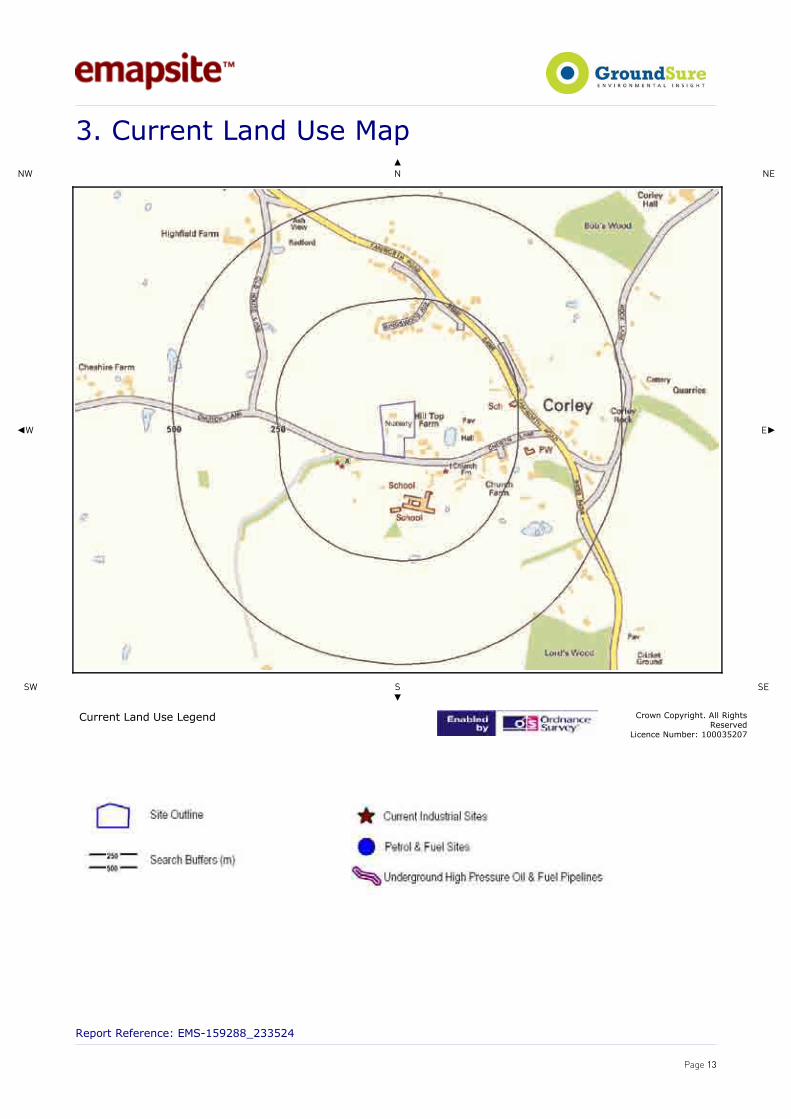
3. Current Land Uses
3.1 Current Industrial Data
Records of potentially contaminative industrial sites within 250m of the study site: 3
The following records are represented as points on the Current Land Uses map.
ID Distance Direction Company Address Activity Category1 104.0 E Gary J Venables
Plumbing Heating &Gas Services
Top Meadow, Church Lane, Corley,Coventry, CV7 8AZ
IndustrialRepairs andServicing
Repair andServicing
2A 105.0 W Water Tower CV7 Water PumpingStations
IndustrialFeatures
3A 114.0 W Mast CV7 Telecommunications Features
Infrastructureand Facilities
3.2 Petrol and Fuel Sites
Records of petrol or fuel sites within 500m of the study site: 0
Database searched and no data found.
3.3 Underground High Pressure Oil and Gas Pipelines
Records of high pressure underground pipelines within 500m of the study site: 0
Database searched and no data found.
Report Reference: EMS-159288_233524
Page 14

4. Geology
4.1 Artificial Ground and Made GroundDatabase searched and no data found.
The database has been searched on site, including a 50m buffer.
4.2 Superficial Ground and Drift Geology Database searched and no data found.The database has been searched on site, including a 50m buffer.
4.3 Bedrock and Solid Geology The database has been searched on site, including a 50m buffer.
LEX Code Description Rock TypeKRS-SDST KERESLEY MEMBER SANDSTONE
(Derived from the BGS 1:50,000 Digital Geological Map of Great Britain)
For more detailed geological and ground stability data please refer to the “GroundSure GeoInsight”. Available from our website.
Report Reference: EMS-159288_233524
Page 15

!�,������0����0����63������@��)�������������������0�
<@�
< <�
� @ ��
�@ ��
��
63������@��)��������������������0��:�0��� *��1��*�����0)�,�6�����0)����������
:�������<��5���� ���%!���
��������������������� !"�##$�%%!�&
�������

!5,������0����0����63������@��)���9�����/�����0����� 65����������:�������
<@�
< <�
� @ ��
�@ ��
��
63������@��)���9�����/������0��:�0��� *��1��*�����0)�,�6�����0)����������
:�������<��5���� ���%!���
��������������������� !"�##$�%%!�&
�������

!�,������0����0��E�������������������8������� ����5�� @���� 65��������� :�������
<@�
< <�
� @ ��
�@ ��
��
��8���������5���@�����65����������:�������:�0���
*��1��*�����0)�,�6�����0)����������
:�������<��5���� ���%!���
��������������������� !"�##$�%%!�&
�������

!�,��������0��E�(��������������<��1��/����������I������
<@�
< <�
� @ ��
�@ ��
��
�������0��:�0��� *��1��*�����0)�,�6�����0)����������
:�������<��5���� ���%!���
��������������������� !"�##$�%%!�&
�������

5.Hydrogeology and Hydrology
5.1 Aquifer within Superficial Deposits
Are there records of productive strata within the superficial geology at or in proximity to the property?Yes
From 1 April 2010, the Environment Agency's Groundwater Protection Policy has been using aquifer designationsconsistent with the Water Framework Directive. For further details on the designation and interpretation of thisinformation, please refer to the GroundSure Enviroinsight User Guide.
The following aquifer records are shown on the Aquifer within Superficial Geology Map (5a):
ID Distance [m] Direction Designation Description 2 185.0 W Unproductive These are rock layers or drift deposits with low
permeability that have negligible significance for watersupply or river base flow
5.2 Aquifer within Bedrock Deposits
Are there records of productive strata within the bedrock geology at or in proximity to the property? Yes
From 1 April 2010, the Environment Agency's Groundwater Protection Policy has been using aquifer designationsconsistent with the Water Framework Directive. For further details on the designation and interpretation of thisinformation, please refer to the GroundSure Enviroinsight User Guide.
The following aquifer records are shown on the Aquifer within Bedrock Geology Map (5b):
ID Distance [m] Direction Designation Description 1 0.0 On Site Principal Geology of high intergranular and/or fracture
permeability, usually providing a high level of waterstorage and may support water supply/river base flow on
a strategic scale. Generally principal aquifers werepreviously major aquifers
2 97.0 S Principal Geology of high intergranular and/or fracturepermeability, usually providing a high level of water
storage and may support water supply/river base flow ona strategic scale. Generally principal aquifers were
previously major aquifers3 156.0 E Principal Geology of high intergranular and/or fracture
permeability, usually providing a high level of waterstorage and may support water supply/river base flow on
a strategic scale. Generally principal aquifers werepreviously major aquifers
4 204.0 SE Principal Geology of high intergranular and/or fracturepermeability, usually providing a high level of water
storage and may support water supply/river base flow ona strategic scale. Generally principal aquifers were
previously major aquifers
5.3 Groundwater Abstraction Licences
Are there any Groundwater Abstraction Licences within 1000m of the study site? No
Database searched and no data found.
Report Reference: EMS-159288_233524
Page 20

5.4 Surface Water Abstraction Licences
Are there any Surface Water Abstraction Licences within 1000m of the study site? No
Database searched and no data found.
5.5 Potable Water Abstraction Licences
Are there any Potable Water Abstraction Licences within 2000m of the study site? No
Database searched and no data found.
5.6 Source Protection Zones
Are there any Source Protection Zones within 500m of the study site? Yes
The following Source Protection Zones records are represented on the SPZ and Potable Water Abstraction Map (5c):
ID Distance Direction Type Description1 0.0 On Site 3 Total Catchment2 156.0 E 3 Total Catchment
5.7 River Quality
Is there any Environment Agency information on river quality within 1500m of the study site? No
Biological Quality:
Database searched and no data found.
Chemical Quality:
Database searched and no data found.
5.8 Detailed River Network
Are there any Detailed River Network entries within 500m of the study site? No
Database searched and no data found.
5.9 Surface Water Features
Are there any surface water features within 250m of the study site? Yes
Report Reference: EMS-159288_233524
Page 21
The following surface water records are not represented on mapping:
Distance to Surface Water (m) on-site 0-50 51-250 Surface water features within 250m of the study site No No Yes
Report Reference: EMS-159288_233524
Page 22

4,�������������60�����?�������
�� �
�
��
��
��
���
���
������������60�����?�����:�0��� �*��1� *�����0)�,�6�����0)����������
:�������<��5����� ���%!���
��������������������� !"�##$�%%!�&
�������

6. Flooding
6.1 Zone 2 Flooding
Zone 2 floodplain estimates the annual probability of flooding as one in one thousand (0.1%) or greater from riversand the sea but less than 1% from rivers or 0.5% from the sea. Alternatively, where information is available theymay show the highest known flood level.
Is the site within 250m of an Environment Agency indicative Zone 2 floodplain? No
Database searched and no data found.
6.2 Zone 3 Flooding
Zone 3 estimates the annual probability of flooding as one in one hundred (1%) or greater from rivers and a one intwo hundred (0.5%) or greater from the sea. Alternatively, where information is available they may show the highestknown flood level.
Is the site within 250m of an Environment Agency indicative Zone 3 floodplain? No
Database searched and no data found.
6.3 Flood Defences
Are there any Flood Defences within 250m of the study site? No
6.4 Areas benefiting from Flood Defences
Are there any areas benefiting from Flood Defences within 250m of the study site? No
6.5 Areas used for Flood Storage Are there any areas used for Flood Storage within 250m of the study site? No
6.6 Groundwater Flooding Susceptibility Areas
Are there any British Geological Survey groundwater floodingsusceptibility flood areas within 50m of the boundary of the study site? Yes
What is the highest susceptibility to groundwater flooding inthe search area based on the underlying geological conditions? Very Low
Report Reference: EMS-159288_233524
Page 24

6.7 Groundwater Flooding Confidence Areas
What is the British Geological Survey confidence rating in this result? Low
Notes:
Groundwater flooding is defined as the emergence of groundwater at the ground surface or the rising of groundwater into man-madeground under conditions where the normal range of groundwater levels is exceeded.
The confidence rating is on a threefold scale - Low, Moderate and High. This provides a relative indication of the BGS confidence in theaccuracy of the susceptibility result for groundwater flooding. This is based on the amount and precision of the information used in theassessment. In areas with a relatively lower level of confidence the susceptibility result should be treated with more caution. In otherareas with higher levels of confidence the susceptibility result can be used with more confidence.
Report Reference: EMS-159288_233524
Page 25
�,(���0���������������������������������������
���
���
�� ��
���
���
(���0�������������������������������������:�0���
�*��1��*�����0)�,�6�����0)����������
:�������<��5���� ���%!���
��������������������� !"�##$�%%!�&
�������

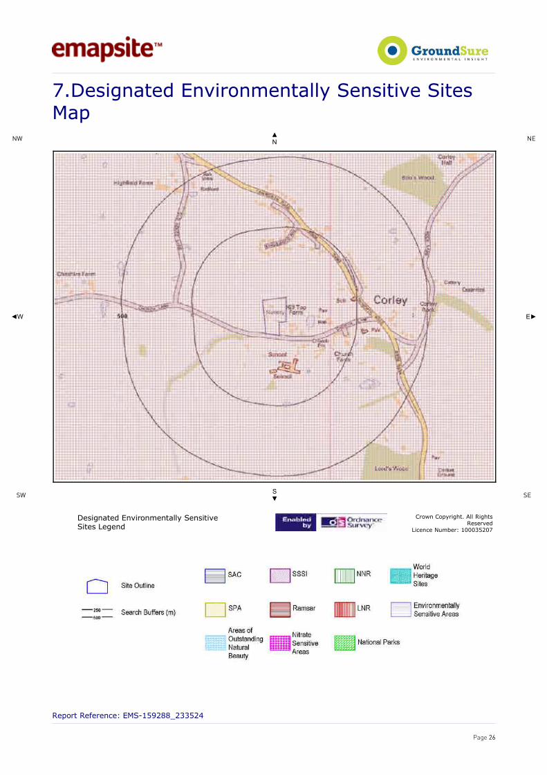
7.Designated Environmentally Sensitive SitesPresence of Designated Environmentally Sensitive Sites within 500m of the study site? Yes
Records of Sites of Special Scientific Interest (SSSI) within 500m of the study site: 0
Database searched and no data found.
Records of National Nature Reserves (NNR) within 500m of the study site: 0
Database searched and no data found.
Records of Special Areas of Conservation (SAC) within 500m of the study site: 0
Database searched and no data found.
Records of Special Protection Areas (SPA) within 500m of the study site: 0
Database searched and no data found.
Records of Ramsar sites within 500m of the study site: 0
Database searched and no data found.
Records of Local Nature Reserves (LNR) within 500m of the study site: 0
Database searched and no data found.
Records of World Heritage Sites within 500m of the study site: 0
Database searched and no data found.
Records of Environmentally Sensitive Areas within 500m of the study site: 0
Database searched and no data found.
Records of Areas of Outstanding Natural Beauty (AONB) within 500m of the study site: 0
Database searched and no data found.
Records of National Parks (NP) within 500m of the study site: 0
Database searched and no data found.
Report Reference: EMS-159288_233524
Page 27

Records of Nitrate Sensitive Areas within 500m of the study site: 0
Database searched and no data found.
Records of Nitrate Vulnerable Zones within 500m of the study site: 2
The following Nitrate Vulnerable Zone records produced by DEFRA are not represented as polygons on the DesignatedEnvironmentally Sensitive Sites Map:
ID Distance Direction NVZ Name Data Source1 0.0 On Site No place name provided DEFRA2 156.0 E No place name provided DEFRA
Report Reference: EMS-159288_233524
Page 28

8. Natural Hazards Findings
8.1 Detailed BGS GeoSure Data
BGS GeoSure Data has been searched to 50m. The data is included in tabular format. If yourequire further information on geology and ground stability, please obtain a GroundSureGeoInsight, available from our website. The following information has been found:
8.1.1 Shrink Swell
What is the maximum Shrink-Swell* hazard rating identified on the study site? Negligible
The following natural subsidence information provided by the British Geological Survey is not represented onmapping:
HazardGround conditions predominantly non-plastic. No special actions required to avoid problems due to shrink-swell clays. No special
ground investigation required, and increased construction costs or increased financial risks are unlikely likely due to potentialproblems with shrink-swell clays.
8.1.2 Landslides
What is the maximum Landslide* hazard rating identified on the study site? Very Low
The following natural subsidence information provided by the British Geological Survey is not represented onmapping:
HazardSlope instability problems are unlikely to be present. No special actions required to avoid problems due to landslides. No special
ground investigation required, and increased construction costs or increased financial risks are unlikely due to potential problemswith landslides.
8.1.3 Soluble Rocks
What is the maximum Soluble Rocks* hazard rating identified on the study site? Null - Negligible
Soluble rocks are not present in the search area. No special actions required to avoid problems due to soluble rocks.No special ground investigation required, and increased construction costs or increased financial risks are unlikely dueto potential problems with soluble rocks.
8.1.4 Compressible Ground
What is the maximum Compressible Ground* hazard rating identified on the study site? Negligible
The following natural subsidence information provided by the British Geological Survey is not represented onmapping:
HazardNo indicators for compressible deposits identified. No special actions required to avoid problems due to compressible deposits. Nospecial ground investigation required, and increased construction costs or increased financial risks are unlikely due to potential
problems with compressible deposits.
Report Reference: EMS-159288_233524
Page 29

8.1.5 Collapsible Rocks
What is the maximum Collapsible Rocks* hazard rating identified on the study site? Very Low
The following natural subsidence information provided by the British Geological Survey is not represented onmapping:
HazardDeposits with potential to collapse when loaded and saturated are unlikely to be present. No special ground investigation required
or increased construction costs or increased financial risk due to potential problems with collapsible deposits.
8.1.6Running Sand
What is the maximum Running Sand* hazard rating identified on the study site? Negligible
The following natural subsidence information provided by the British Geological Survey is not represented onmapping:
HazardNo indicators for running sand identified. No special actions required to avoid problems due to running sand. No special groundinvestigation required, and increased construction costs or increased financial risks are unlikely due to potential problems with
running sand.
* This indicates an automatically generated 50m buffer and site.
Report Reference: EMS-159288_233524
Page 30
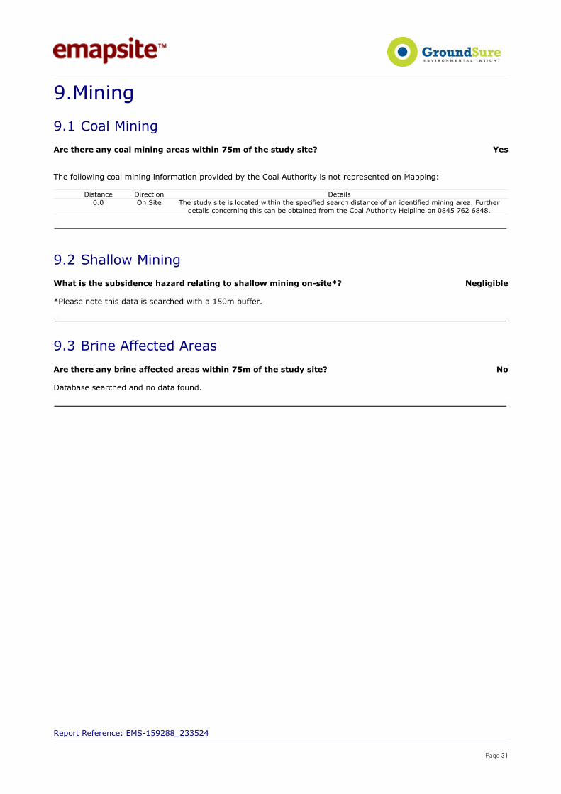
9.Mining
9.1 Coal Mining
Are there any coal mining areas within 75m of the study site? Yes
The following coal mining information provided by the Coal Authority is not represented on Mapping:
Distance Direction Details0.0 On Site The study site is located within the specified search distance of an identified mining area. Further
details concerning this can be obtained from the Coal Authority Helpline on 0845 762 6848.
9.2 Shallow Mining
What is the subsidence hazard relating to shallow mining on-site*? Negligible
*Please note this data is searched with a 150m buffer.
9.3 Brine Affected Areas
Are there any brine affected areas within 75m of the study site? No
Database searched and no data found.
Report Reference: EMS-159288_233524
Page 31

10.Contacts
EmapSiteTelephone: 0118 9736883 [email protected]
British Geological Survey (England & Wales) Kingsley Dunham CentreKeyworth, Nottingham NG12 5GGTel: 0115 936 3143. Fax: 0115 936 3276. Email:[email protected]: www.bgs.ac.ukBGS Geological Hazards Reports and general geologicalenquiries
Environment AgencyNational Customer Contact CentrePO Box 544RotherhamS60 1BYTel: 08708 506 506 Web: www.environment-agency.gov.ukEmail: [email protected]
Health Protection AgencyChilton, Didcot, Oxon, OX11 0RQTel: 01235 822622 www.hpa.org.uk/radiationRadon measures and general radon information andguidance
The Coal Authority200 Lichfield Lane, Mansfield, Notts NG18 4RGTel: 0845 762 6848DX 716176 Mansfield 5 Web: www.groundstability.com
Ordnance SurveyRomsey RoadSouthampton SO16 4GU
Tel: 08456 050505
Local AuthorityAuthority: North Warwickshire Borough CouncilPhone: 01827 715341Web: www.northwarks.gov.ukAddress: The Council House, South Street, Atherstone,Warwickshire, CV9 1BD
Get Mapping PLCVirginia Villas, High Street, Hartley Witney, Hampshire RG278NWTel: 01252 845444
AcknowledgementsThis product includes map data licensed from Landmark Information Group Limited®.© Crown Copyright 2003 and Landmark Information Group Limited® 2003. All Rights Reserved.
Site of Special Scientific Interest, National Nature Reserve, Ramsar Site, Special Protection Area, Special Area of Conservation data isprovided by, and used with the permission of, English Nature who retain the Copyright and Intellectual Property Rights for the data.
PointX © Database Right/Copyright, Thomson Directories Limited © Copyright Link Interchange Network Limited © DatabaseRight/Copyright and Ordnance Survey © Crown Copyright and/or Database Right. All Rights Reserved. Licence Number [03421028].This report has been prepared in accordance with the GroundSure Ltd standard Terms and Conditions of business for work of this nature.
Report Reference: EMS-159288_233524
Page 32

Standard Terms and Conditions1 DefinitionsIn these conditions unless the context otherwise requires:“Beneficiary” means the Client or the customer of the Client for whom the Client has procured the Services.“Commercial” means any building which is not Residential.“Commission" means an order for Consultancy Services submitted by a Client.“Consultancy Services” mean consultancy services provided by GroundSure including, without limitation, carrying out interpretation of third party and in-house environmental data,provision of environmental consultancy advice, undertaking environmental audits and assessments, Site investigation, Site monitoring and related items.“Contract” means the contract between GroundSure and the Client for the performance of the Services which arises upon GroundSure's acceptance of an Order or Commission andwhich shall incorporate these conditions, the relevant GroundSure User Guide, proposal by GroundSure and the content of any subsequent report, and any agreed amendments inaccordance with clause 11.“Client” means the party that submits an Order or Commission.“Data Provider” means any third party providing Third Party Content to GroundSure.“Data Report” means reports comprising factual data with no professional interpretation in respect of the level of likely risk and/or liability available from GroundSure.“GroundSure” means GroundSure Limited, a company registered in England and Wales under number 03421028 and whose registered office is at Greater London House, HampsteadRoad, London NW1 7EJ.“GroundSure Materials” means all materials prepared by GroundSure as a result of the provision of the Services, including but not limited to Data Reports, Mapping and RiskScreening Reports.“Intellectual Property” means any patent, copyright, design rights, service marks, moral rights, data protection rights, know-how, trade mark or any other intellectual propertyrights.“Mapping” an historical map or a combination of historical maps of various ages, time periods and scales available from GroundSure.“Order” means an order form submitted by the Client requiring Services from GroundSure in respect of a specified Site.“Order Website” means online platform via which Orders may be placed.“Report” means a Risk Screening Report or Data Report for commercial or residential property available from GroundSure relating to the Site prepared in accordance with thespecifications set out in the relevant User Guide.“Residential” means any building used as or suitable for use as an individual dwelling.“Risk Screening Report” means one of GroundSure’s risk screening reports, comprising factual data with interpretation in respect of the level of likely risk and/or liability, excluding“Consultancy Services”. “Services” means the provision of any Report, Mapping or Consultancy Services which GroundSure has agreed to carry out for the Client/Beneficiary on these terms and conditions inrespect of the Site."Site" means the landsite in respect of which GroundSure provides the Services.“Third Party Content” means any data, database or other information contained in a Report or Mapping which is provided to GroundSure by a Data Provider."User Guide" means the relevant current version of the user guide, available upon request from GroundSure.
2 Scope of Services2.1 GroundSure agrees to carry out the Services in accordance with the Contract and to the extent set out therein.2.2 GroundSure shall exercise all the reasonable skill, care and diligence to be expected of experienced environmental consultants in the performance of the Services.2.3 The Client acknowledges that it has not relied on any statement or representation made by or on behalf of GroundSure which is not set out and expressly agreed in the Contract.2.4 Terms and conditions appearing on a Client’s order form, printed stationery or other communication, including invoices, to GroundSure, its employees, servants, agents or other
representatives or any terms implied by custom, practice or course of dealing shall be of no effect and these terms and conditions shall prevail over all others.2.5 If a Client/Beneficiary requests insurance in conjunction with or as a result of the Services, GroundSure shall use reasonable endeavours to procure such insurance, but makes no
warranty that such insurance shall be available from insurers or offered on reasonable terms. GroundSure does not endorse or recommend any particular insurance product, policy or insurer. Any insurance purchased shall be subject solely to the terms of the policy issued by insurers and GroundSure will have no liability therefor. The Client/Beneficiaryshould take independent advice to ensure that the insurance policy requested and/or offered is suitable for its requirements.
2.6 GroundSure's quotations/proposals are valid for a period of 30 days only. GroundSure reserves the right to withdraw any quotation at any time before GroundSure accepts an Orderor Commission. GroundSure's acceptance of an Order or Commission shall be effective only where such acceptance is in writing and signed by GroundSure's authorisedrepresentative or where accepted via GroundSure’s Order Website.
3 The Client’s obligations3.1 The Client shall ensure the Beneficiary complies with and is bound by the terms and conditions set out in the Contract and shall provide that Groundsure may in its own right
enforce such terms and conditions against the Beneficiary pursuant to the Contracts (Rights of Third parties) Act 1999. The Client shall be liable for all breaches of the Contract bythe Beneficiary as if they were breaches by the Client. The Client shall be solely responsible for ensuring that the Report/Mapping ordered is appropriate and suitable for theBeneficiary’s needs.
3.2 The Client shall (or shall procure that the Beneficiary shall) supply to GroundSure as soon as practicable and without charge all information necessary and accurate relevant dataincluding any specific and/or unusual environmental information relating to the Site known to the Client/Beneficiary which may pertain to the Services and shall give suchassistance as GroundSure shall reasonably require in the performance of the Services (including, without limitation, access to a Site, facilities and equipment as agreed in theContract).
3.3 Where Client/Beneficiary approval or decision is required, such approval or decision shall be given or procured in reasonable time as not to delay or disrupt the performance of anyother part of the Services.
3.4 The Client shall not and shall not knowingly permit the Beneficiary to, save as expressly permitted by these terms and conditions, re-sell, alter, add to, amend or use out of contextthe content of any Report, Mapping or, in respect of any Services, information given by GroundSure. For the avoidance of doubt, the Client and Beneficiary may make the Report,Mapping or GroundSure’s findings available to a third party who is considering acquiring the whole or part of the Site, or providing funding in relation to the Site, but such thirdparty cannot rely on the same unless expressly permitted under clause 4.
3.5 The Client is responsible for maintaining the confidentiality of its user name and password if using GroundSure’s internet ordering service and accepts responsibility for all activitythat occurs under such account and password.
4 Reliance4.1 Upon full payment of all relevant fees and subject to the provisions of these terms and conditions, the Client and Beneficiary are granted an irrevocable royalty-free licence to
access the information contained in a Report, Mapping or in a report prepared by GroundSure in respect of or arising out of Consultancy Services. The Services may only be usedfor the benefit of the Client and those persons listed in clauses 4.2 and 4.3.
4.2 In relation to Data Reports, Mapping and Risk Screening Reports, the Client shall be entitled to make Reports available to (i) the Beneficiary, (ii) the Beneficiary's professionaladvisers, (iii) any person providing funding to the Beneficiary in relation to the Site (whether directly or as part of a lending syndicate), (iv) the first purchaser or first tenant of theSite (v) the professional advisers and lenders of the first purchaser or tenant of the Site. Accordingly GroundSure shall have the same duties and obligations to those persons inrespect of the Services as it has to the Client and those persons shall have the benefit of any of the Client's rights under the Contract as if those persons were parties to theContract. For the avoidance of doubt, the limitations of GroundSure's liability as set out in clauses 7 and 11.6 shall apply.
4.3 In relation to Consultancy Services, reliance shall be limited to the Client, Beneficiary and named parties on the Report.4.4 Save as set out in clauses 4.2 and 4.3 and unless otherwise agreed in writing with GroundSure, any other party considering the information supplied by GroundSure as part of the
Services, including (but not limited to) insurance underwriters, does so at their own risk and GroundSure has no legal obligations to such party unless otherwise agreed in writing.4.5 The Client shall not and shall not knowingly permit any person (including the Beneficiary) who is provided with a copy of any Report, (except as permitted herein or by separate
agreement with GroundSure) to,: (a) remove, suppress or modify any trade mark, copyright or other proprietary marking from the Report or Mapping; (b) create any productwhich is derived directly or indirectly from the data contained in the Report or Mapping; (c) combine the Report or Mapping with, or incorporate the Report or Mapping into anyother information data or service; or (d) re-format or otherwise change (whether by modification, addition or enhancement) data or images contained in the Report or Mapping.
4.6 Notwithstanding clause 4.5, if the Client acts in a professional capacity, it may make reasonable use of a Report and/or findings made as a result of Consultancy Services to adviseBeneficiaries. However, GroundSure shall have no liability in respect of any opinion or report given to such Beneficiaries by the Client or a third party.
5 Fees and Disbursements5.1 GroundSure shall charge the Client fees at the rate and frequency specified in the Contract together, in the case of Consultancy Services, with all proper disbursements incurred by
GroundSure in performing the Services. For the avoidance of doubt, the fees payable for the Services are as set out in GroundSure's written proposal, Order Website or Orderacknowledgement form. The Client shall in addition pay all value added tax or other tax payable on such fees and disbursements in relation to the provision of the Services.
5.2 Unless GroundSure requires prepayment, the Client shall promptly pay all fees disbursements and other monies due to GroundSure in full without deduction, counterclaim or set offtogether with such value added tax or other tax as may be required within 30 days from the date of GroundSure’s invoice or such other period as may be agreed in writing betweenGroundSure and the Client ("Payment Date"). GroundSure reserves the right to charge interest which shall accrue on a daily basis from 30 days after the date of Payment Dateuntil the date of payment (whether before or after judgment) at the rate of five per cent per annum above the Bank of England base rate from time to time.
5.3 In the event that the Client disputes the amount payable in respect of GroundSure’s invoice it shall notify GroundSure no later than 28 days after the date thereof that it is indispute. In default of such notification the Client shall be deemed to have agreed the amount thereof. As soon as reasonably practicable following receipt of a notification in respectof any disputed invoice, a member of the management team at GroundSure shall contact the Client and the parties shall use all reasonable endeavours to resolve the dispute.
6 Intellectual Property and Confidentiality6.1 Subject to the provisions of clause 4.1, the Client and the Beneficiary hereby acknowledge that all Intellectual Property in the Services and Content are and shall remain owned by
either GroundSure or the Data Providers and nothing in these terms purports to transfer or assign any rights to the Client or the Beneficiary in respect of the Intellectual Property.6.2 The Client shall acknowledge the ownership of the Third Party Content where such Third Party Content is incorporated or used in the Client's own documents, reports, systems or
services whether or not these are supplied to a third party. 6.3 Data Providers may enforce any breach of clauses 6.1 and 6.2 against the Client or Beneficiary.6.4 The Client acknowledges that the proprietary rights subsisting in copyright, database rights and any other intellectual property rights in respect of any data and information
contained in any Report are and shall remain (subject to clause 11.1) the property of GroundSure and/or any third party that has supplied data or information used to create aReport, and that these conditions do not purport to grant, assign or transfer any such rights in respect thereof to a Client and/or a Beneficiary.
6.5 The Client shall (and shall procure that any recipients of the Report as permitted under clause 4.2 shall): (i) not remove, suppress or modify any trademark, copyright or other proprietary marking belonging to GroundSure or any third party from the Services; (ii) use the information obtained as part of the Services in respect of the subject Site only, and shall not store or reuse any information obtained as part of the Services provided in
respect of adjacent or nearby sites;
Report Reference: EMS-159288_233524
Page 33

(iii) not create any product or report which is derived directly or indirectly from the data contained in the Services (save that those acting in a professional capacity to theBeneficiary may provide advice based upon the Services);
(iv) not combine the Services with or incorporate such Services into any other information data or service; and (v) not reformat or otherwise change (whether by modification, addition or enhancement), data contained in the Services (save that those acting in a professional capacity to the
Beneficiary shall not be in breach of this clause 6.5(v) where such reformatting is in the normal course of providing advice based upon the Services), in each case of parts (iii) to (v) inclusive, whether or not such product or report is produced for commercial profit or not.6.6 The Client and/or Beneficiary shall and shall procure that any party to whom the Services are made available shall notify GroundSure of any request or requirement to disclose,
publish or disseminate any information contained in the Services in accordance with the Freedom of Information Act 2000, the Environmental Information Regulations 2004 or anyassociated legislation or regulations in force from time to time.
6.8 Save as otherwise set out in these terms and conditions, any information provided by one party ("Disclosing Party") to the other party ("Receiving Party") shall be treated asconfidential and only used for the purposes of these terms and conditions, except in so far as the Receiving Party is authorised by the Disclosing Party to provide such informationin whole or in part to a third party.
7 LiabilityTHE CLIENT’S ATTENTION IS DRAWN TO THIS PROVISION7.1Subject to the provisions of this clause 7, GroundSure shall be liable to the Beneficiary only in relation to any direct losses or damages caused by any negligent act or omission of
GroundSure in preparing the GroundSure Materials and provided that the Beneficiary has used all reasonable endeavours to mitigate any such losses.7.2GroundSure shall not be liable for any other losses or damages incurred by the Beneficiary, including but not limited to: (i) loss of profit, revenue, business or goodwill, losses relating to business interruption, loss of anticipated savings, loss of or corruption to data or for any special, indirect or
consequential loss or damage which arise out of or in connection with the GroundSure Materials or otherwise in relation to a Contract; (ii) any losses or damages that arise as a result of the use of all or part of the GroundSure Materials in breach of these terms and conditions or contrary to the terms of the relevant
User Guide; (iii) any losses or damages that arise as a result of any error, omission or inaccuracy in any part of the GroundSure Materials where such part is based on any Third Party Content or
any reasonable interpretation of Third Party Content. The Client accepts, and shall procure that any other Beneficiary shall accept, that it has no claim or recourse to any DataProvider in relation to Third Party Content; and/or
(iv) any loss or damage to a Client’s computer, software, modem, telephone or other property caused by a delay or loss of use of GroundSure’s internet ordering service.7.3 GroudSure’s total liability in contract, tort (including negligence or breach of statutory duty), misrepresentation, restitution or otherwise, arising in connection with the GroundSure
Materials or otherwise in relation to the Contract shall be limited to £10 million in total (i) for any one claim or (ii) for a series of connected claims brought by one or more parties.7.4 For the duration of the liability periods set out in clauses 7.5 and 7.6 below, GroundSure shall maintain professional indemnity insurance in respect of its liability under these terms
and conditions provided such insurance is readily available at commercially viable rates. GroundSure shall produce evidence of such insurance if reasonably requested by theClient. A level of cover greater than GroundSure’s current level of cover may be available upon request and agreement with the Client.
7.5 Any claim under the Contract in relation to Data Reports, Mapping and Risk Screening Reports, must be brought within six years from the date when the Beneficiary became awarethat it may have a claim and in no event may a claim be brought twelve years or more after completion of such a Contract. For the avoidance of doubt, any claim in respect ofwhich proceedings are notified to GroundSure in writing prior to the expiry of the time periods referred to in this clause 7.5 shall survive the expiry of those time periods providedthe claim is actually commenced within six months of notification.
7.6 Any claim under the Contract in relation to Consultancy Services, must be brought within six years from the date the Consultancy Services were completed. 7.7 he Client accepts and shall procure that any other Beneficiary shall accept that it has no claim or recourse to any Data Provider or to GroundSure in respect of the acts or omissions
of any Data Provider and/or any Third Party Content provided by a Data Provider. 7.8 Nothing in these terms and conditions: (i) excludes or limits the liability of GroundSure for death or personal injury caused by GroundSure’s negligence, or for fraudulent misrepresentation; or (ii) shall affect the statutory rights of a consumer under the applicable legislation.
8 GroundSure right to suspend or terminate 8.1 In the event that GroundSure reasonably believes that the Client or Beneficiary as applicable has not provided the information or assistance required to enable the proper
performance of the Services, GroundSure shall be entitled on fourteen days written notice to suspend all further performance of the Services until such time as any such deficiencyhas been made good.
8.2 GroundSure may additionally terminate the Contract immediately on written notice in the event that: (i)the Client shall fail to pay any sum due to GroundSure within 28 days of the Payment Date; or (ii)the Client (being an individual) has a bankruptcy order made against him or (being a company) shall enter into liquidation whether compulsory or voluntary or have an
Administration Order made against it or if a Receiver shall be appointed over the whole or any part of its property assets or undertaking or if the Client is struck off the Registerof Companies or dissolved; or
(iii) the Client being a company is unable to pay its debts within the meaning of Section 123 of the Insolvency Act 1986 or being an individual appears unable to pay his debtswithin the meaning of Section 268 of the Insolvency Act 1986 or if the Client shall enter into a composition or arrangement with the Client’s creditors or shall suffer distress orexecution to be levied on his goods; or
(iv)the Client or the Beneficiary breaches any material term of the Contract (including, but not limited to, the obligations in clause 4) incapable of remedy or if remediable, is notremedied within 14 days of notice of the breach.
9 Client’s Right to Terminate and Suspend9.1 Subject to clause 10.2, the Client may at any time after commencement of the Services by notice in writing to GroundSure require GroundSure to terminate or suspend immediately
performance of all or any of the Services.9.2 The Client waives all and any right of cancellation it may have under the Consumer Protection (Distance Selling) Regulations 2000 (as amended) in respect of the Order of a
Report/Mapping. This does not affect the Beneficiary's statutory rights.
10 Consequences of Withdrawal, Termination or Suspension10.1 Upon termination or any suspension of the Services, GroundSure shall take steps to bring to an end the Services in an orderly manner, vacate any Site with all reasonable speed
and shall deliver to the Client/Beneficiary any property of the Client/ Beneficiary in GroundSure’s possession or control.10.2 In the event of termination/suspension of the Contract under clauses 8 or 9, the Client shall pay to GroundSure all and any fees payable in respect of the performance of the
Services up to the date of termination/suspension. In respect of any Consultancy Services provided, the Client shall also pay GroundSure any additional costs incurred inrelation to the termination/suspension of the Contract.
11 General11.1 The mapping contained in the Services is protected by Crown copyright and must not be used for any purpose outside the context of the Services or as specifically provided in
these terms. 11.2 GroundSure reserves the right to amend these terms and conditions. No variation to these terms shall be valid unless signed by an authorised representative of GroundSure.11.3 No failure on the part of GroundSure to exercise and no delay in exercising, any right, power or provision under these terms and conditions shall operate as a waiver thereof.11.4 Save as expressly provided in clauses 4.2, 4.3, 6.3 and 11.5, no person other than the persons set out therein shall have any right under the Contract (Rights of Third Parties) Act
1999 to enforce any terms of the Contract.11.5 The Secretary of State for Communities and Local Government acting through Ordnance Survey may enforce breach of clause 6.1 of these terms and conditions against the Client
in accordance with the provisions of the Contracts (Rights of Third Parties) Act 1999. 11.6 GroundSure shall not be liable to the Client if the provision of the Services is delayed or prevented by one or more of the following circumstances: (i) the Client or Beneficiary’s failure to provide facilities, access or information; (ii) fire, storm, flood, tempest or epidemic; (iii) Acts of God or the public enemy; (iv) riot, civil commotion or war; (v) strikes, labour disputes or industrial action; (vi) acts or regulations of any governmental or other agency; (vii) suspension or delay of services at public registries by Data Providers; or (viii) changes in law.11.7 Any notice provided shall be in writing and shall be deemed to be properly given if delivered by hand or sent by first class post, facsimile or by email to the address, facsimile
number or email address of the relevant party as may have been notified by each party to the other for such purpose or in the absence of such notification the last knownaddress.
11.8 Such notice shall be deemed to have been received on the day of delivery if delivered by hand, facsimile or email and on the second working day after the day of posting if sentby first class post.
11.9 The Contract constitutes the entire contract between the parties and shall supersede all previous arrangements between the parties.11.10 Each of the provisions of the Contract is severable and distinct from the others and if one or more provisions is or should become invalid, illegal or unenforceable, the validity and
enforceability of the remaining provisions shall not in any way be tainted or impaired.11.11 These terms and conditions shall be governed by and construed in accordance with English law and any proceedings arising out of or connected with these terms and conditions
shall be subject to the exclusive jurisdiction of the English courts.11.12 If the Client or Beneficiary has a complaint about the Services, notice can be given in any format eg writing, phone, email to the Compliance Officer at GroundSure who will
respond in a timely manner. © GroundSure Limited January 2012
Report Reference: EMS-159288_233524
Page 34

EmapSiteMasdar House, Eversley, RG27 0RP
Report Reference: EMS-159288_233523
Your Reference: EMS_159288_233523
Report Date Mar 21, 2012
Report DeliveryMethod:
Email - pdf
GroundSure GeoInsight
Address: CV7 8AZ
Dear Sir/Madam,
Thank you for placing your order with GroundSure. Please find enclosed the GroundSure GeoInsightas requested.
If you would like further assistance regarding this report then please contact the emapsite customerservices team on 0118 9736883 quoting the above report reference number.
Yours faithfully,
emapsite customer services team
Enc.GroundSure GeoInsight

�������������0���,(�
3��������45��#36�
'��������� ���� �
��������������������� !"�##$�%%!�%
&�����������������$ !"�##$�%%!�%
7���,(���������2����������
��������������������� !"�##$�%%!�%������������������
������

Aerial Photograph of Study SiteNW
▲N NE
◄ W E►
SW S▼
SE
Aerial photography supplied by Getmapping PLC.© Copyright Getmapping PLC 2003. All Rights Reserved.
Site Name: CV7 8AZ Grid Reference: 429802,285171Size of Site: 0.88 ha
Report Reference: EMS-159288_233523
Page 2
Overview of FindingsThe GroundSure GeoInsight provides high quality geo-environmental information that allowsgeo-environmental professionals and their clients to make informed decisions and beforewarned of potential ground instability problems that may affect the ground investigation,foundation design and possibly remediation options that could lead to possible additional costs.
The report is based on the BGS 1:50,000 Digital Geological Map of Great Britain, BGS Geosuredata; BRITPITS database; Shallow Mining data and Borehole Records, Coal Authority dataincluding brine extraction areas, PBA non-coal mining and natural cavities database, JohnsonPoole and Bloomer mining data and GroundSure's unique database including historical surfaceground and underground workings.
For further details on each dataset, please refer to each individual section in the report aslisted. Where the database has been searched a numerical result will be recorded. Where thedatabase has not been searched '-' will be recorded.
Report Section Number of records found within (X) m of the study siteboundary
1. Geology Description
1.1 Artificial Ground,
1.1.1 Is there any Artificial Ground /Made Ground present beneath the studysite?* No
1.1.2 Are there any records relating to permeability of artificial ground withinthe study site* boundary? No
1.2 Superficial Geology & Landslips
1.2.1 Is there any Superficial Ground/Drift Geology present beneath the studysite?* No
1.2.2 Are there any records relating to permeability of superficial geologywithin the study site* boundary? No
1.2.3 Are there any records of landslip within 500m of the study site boundary? No
1.2.4 Are there any records relating to permeability of landslips within thestudy site* boundary? No
1.3 Bedrock, Solid Geology & Faults
1.3.1 For records of Bedrock and Solid Geology beneath the study site* see thedetailed findings section.
1.3.2 Are there any records relating to permeability of bedrock within the studysite* boundary? Yes
1.3.3 Are there any records of faults within 500m of the study site boundary? Yes
1.3.4 Is the property in a Radon Affected Area as defined by the HealthProtection Agency (HPA) and if so what percentage of homes are above theAction Level?
The property is not in a Radon Affected Area, asless than 1% of properties are above the Action
Level
1.3.5 Is the property in an area where Radon Protection Measures are requiredfor new properties or extensions to existing ones as described inpublication BR211 by the Building Research Establishment?
No radon protective measures are necessary
* This includes an automatically generated 50m buffer zone around the site Source:Scale 1:50,000 BGS Sheet No:169
Report Reference: EMS-159288_233523
Page 3

2. Ground Workings on-site 0-50 51-250 251-500 501-1000
2.1 Historical Surface Ground Working Features from Small ScaleMapping 0 5 24 - -
2.2 Historical Underground Workings Features from Small ScaleMapping 0 0 0 0 0
2.3 Current Ground Workings 0 0 0 1 3
3. Mining, Extraction & Natural Cavities on-site 0-50 51-250 251-500 501-1000
3.1 Historical Mining 0 0 0 0 0
3.2 Coal Mining 1 0 0 0 0
3.3 Johnson Poole and Bloomer Mining Area 0 0 2 0 1
3.4 Non-Coal Mining* 0 0 0 0 0
3.5 Non–Coal Mining Cavities 0 0 0 0 0
3.6 Natural Cavities 0 0 0 0 0
3.7 Brine Extraction 0 0 0 0 0
3.8 Gypsum Extraction 0 0 0 0 0
3.9 Tin Mining 0 0 0 0 0
3.10 Clay Mining 0 0 0 0 0
*This includes an automatically generated 50m buffer zone around the site
4. Natural Ground Subsidence on-site* 0-50 51-250 251-500 501-1000
4.1 Shrink-Swell Clay Negligible - - - -
4.2 Landslides Very Low - - - -
4.3 Ground Dissolution of Soluble Rocks Negligible - - - -
4.4 Compressible Deposits Negligible - - - -
4.5 Collapsible Deposits Very Low - - - -
4.6 Running Sand Negligible - - - -
* This includes an automatically generated 50m buffer zone around the site 5. Borehole Records on-site 0-50 51-250 251-500 501-1000
5.1 BGS Recorded Boreholes 0 0 1 - -
6. Estimated Background Soil Chemistry on-site 0-50 51-250 251-500 501-1000
6.1 Records of Background Soil Chemistry 1 0 0 - -
Report Reference: EMS-159288_233523
Page 4

. �3���������������� ��
89�
8 8�
� 9 ��
�9 ��
��
3�����������������:�,��� �4��-��4�����,(�.�3�����,(����������
:�������8��2���� ���%!���
�����,���������������������������������(��������,������������������(��7���'�,����������,������������������7��������� �!�����������.
��������������������� !"�##$�%%!�%������������������
������

1.1 Artificial Ground
The following geological information represented on the mapping is derived from 1:50,000scale BGS Geological mapping, Sheet No:169
1.1.1 Artificial/Made Ground
Are there any records of Artificial/Made Ground within 500m of the study site boundary? No
Database searched and no data found.
1.1.2 Permeability of Artificial Ground
Are there any records relating to permeability of artificial ground within the study site* boundary? No
Database searched and no data found.
* This includes an automatically generated 50m buffer zone around the site. Report Reference: EMS-159288_233523
Page 6
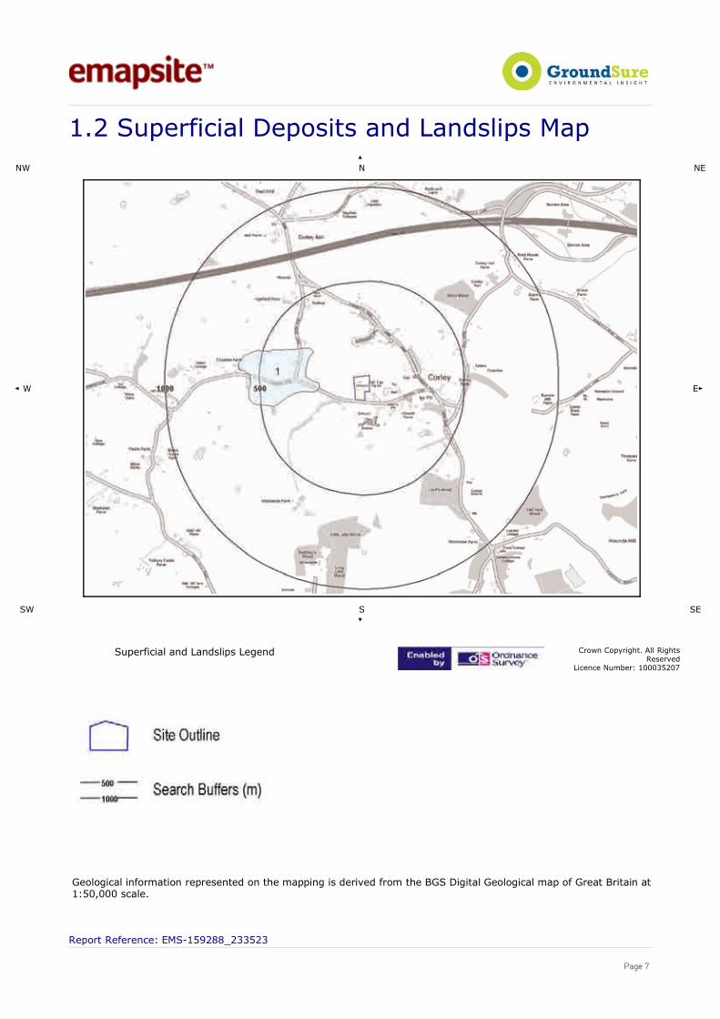
.��������������'������������:�����������
89�
8 8�
� 9 ��
�9 ��
��
����������������:���������:�,��� �4��-��4�����,(�.�3�����,(����������
:�������8��2���� ���%!���
�����,���������������������������������(��������,������������������(��7���'�,����������,������������������7��������� �!�����������.
��������������������� !"�##$�%%!�%������������������
������
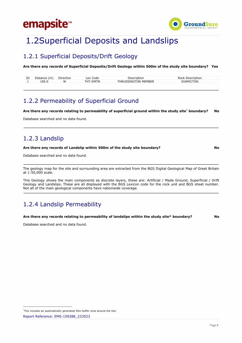
1.2Superficial Deposits and Landslips
1.2.1 Superficial Deposits/Drift Geology
Are there any records of Superficial Deposits/Drift Geology within 500m of the study site boundary? Yes
ID Distance (m) Direction Lex Code Description Rock Description1 185.0 W THT-DMTN THRUSSINGTON MEMBER DIAMICTON
1.2.2 Permeability of Superficial Ground
Are there any records relating to permeability of superficial ground within the study site* boundary? No
Database searched and no data found.
1.2.3 LandslipAre there any records of Landslip within 500m of the study site boundary? No
Database searched and no data found.
The geology map for the site and surrounding area are extracted from the BGS Digital Geological Map of Great Britainat 1:50,000 scale.
This Geology shows the main components as discrete layers, these are: Artificial / Made Ground, Superficial / DriftGeology and Landslips. These are all displayed with the BGS Lexicon code for the rock unit and BGS sheet number.Not all of the main geological components have nationwide coverage.
1.2.4 Landslip Permeability
Are there any records relating to permeability of landslips within the study site* boundary? No
Database searched and no data found.
*This includes an automatically generated 50m buffer zone around the site.
Report Reference: EMS-159288_233523
Page 8
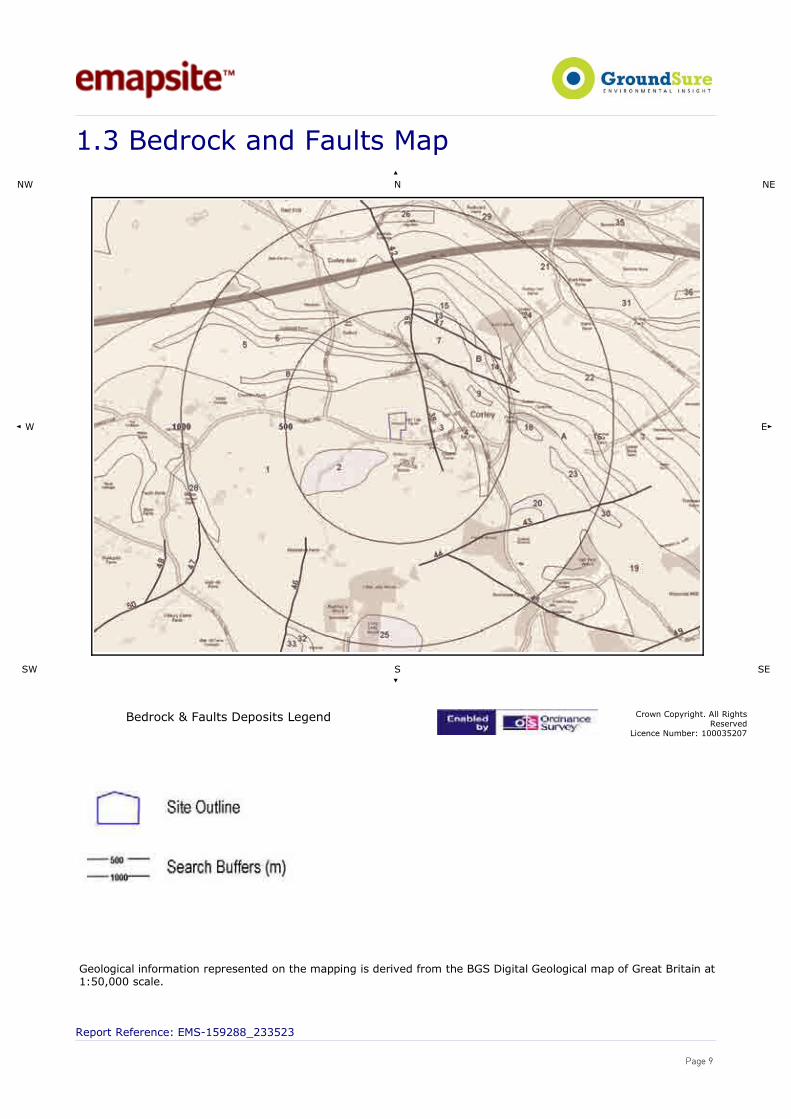
.%�7�����+�����?��������
89�
8 8�
� 9 ��
�9 ��
��
7�����+�K�?������'��������:�,��� �4��-��4�����,(�.�3�����,(����������
:�������8��2���� ���%!���
�����,���������������������������������(��������,������������������(��7���'�,����������,������������������7��������� �!�����������.
��������������������� !"�##$�%%!�%������������������
������

1.3Bedrock, Solid Geology & Faults
The following geological information represented on the mapping is derived from 1:50,000scale BGS Geological mapping, Sheet No:169
1.3.1 Bedrock/Solid Geology
Records of Bedrock/Solid Geology within 500m of the study site boundary:
ID Distance (m) Direction LEX Code Rock Description Rock Age1 0.0 On Site KRS-SDST Keresley Member - Sandstone / Westphalian D2 72.0 S KRS-CONG Keresley Member -
Conglomerate/ Westphalian D
3 105.0 E KRS-ARSC Keresley Member - InterbeddedArgillaceous Rocks And[subordinate/subequal]
Sandstone And Conglomerate
/ Westphalian D
4 148.0 NE KRS-ARSC Keresley Member - InterbeddedArgillaceous Rocks And[subordinate/subequal]
Sandstone And Conglomerate
/ Westphalian D
5 179.0 N KRS-ARSC Keresley Member - InterbeddedArgillaceous Rocks And[subordinate/subequal]
Sandstone And Conglomerate
/ Westphalian D
6 239.0 N KRS-SDST Keresley Member - Sandstone / Westphalian D7 287.0 N KRS-SDST Keresley Member - Sandstone / Westphalian D8 293.0 NW KRS-SDST Keresley Member - Sandstone / Westphalian D9 315.0 E KRS-CONG Keresley Member -
Conglomerate/ Westphalian D
10A
353.0 NE KRS-ARSC Keresley Member - InterbeddedArgillaceous Rocks And[subordinate/subequal]
Sandstone And Conglomerate
/ Westphalian D
11B
371.0 NE KRS-ARSC Keresley Member - InterbeddedArgillaceous Rocks And[subordinate/subequal]
Sandstone And Conglomerate
/ Westphalian D
12A
424.0 NE KRS-SDST Keresley Member - Sandstone / Westphalian D
13 444.0 NE KRS-ARSC Keresley Member - InterbeddedArgillaceous Rocks And[subordinate/subequal]
Sandstone And Conglomerate
/ Westphalian D
14 456.0 NE KRS-SDST Keresley Member - Sandstone / Westphalian D15 456.0 NE KRS-SDST Keresley Member - Sandstone / Westphalian D16 463.0 NE KRS-ARSC Keresley Member - Interbedded
Argillaceous Rocks And[subordinate/subequal]
Sandstone And Conglomerate
/ Westphalian D
1.3.2 Permeability of Bedrock Ground
Are there any records relating to permeability of bedrock ground within the study site* boundary? Yes
Distance (m) Direction Flow type Maximum Permeability Minimum Permeability0.0 On Site Fracture High Moderate
1.3.3 Faults
Are there any records of Faults within 500m of the study site boundary? Yes
* This includes an automatically generated 50m buffer zone around the site. Report Reference: EMS-159288_233523
Page 10
ID Distance (m) Direction Category Description Feature Description38 105.0 E FAULT Normal fault, inferred39 287.0 N FAULT Normal fault, inferred40B
287.0 N FAULT Normal fault, inferred
41 444.0 NE FAULT Normal fault, inferred42 480.0 N FAULT Normal fault, inferred
The geology map for the site and surrounding area are extracted from the BGS Digital Geological Map of Great Britainat 1:50,000 scale.
This Geology shows the main components as discrete layers, these are: Bedrock/ Solid Geology and linear featuressuch as Faults. These are all displayed with the BGS Lexicon code for the rock unit and BGS sheet number. Not all ofthe main geological components have nationwide coverage.
1.3.4 Radon Affected Areas
Is the property in a Radon Affected Area as defined by the Health Protection Agency (HPA) and if so whatpercentage of homes are above the Action Level?
The property is not in a Radon Affected Area, as less than 1% of properties are above the Action Level
1.3.5 Radon Protection
Is the property in an area where Radon Protection are required for new properties or extensions toexisting ones as described in publication BR211 by the Building Research Establishment?
No radon protective measures are necessary
Report Reference: EMS-159288_233523
Page 11

�.��������9��+��,����
89�
8 8�
� 9 ��
�9 ��
��
�������9��+��,��:�,��� �4��-��4�����,(�.�3�����,(����������
:�������8��2���� ���%!���
��������������������� !"�##$�%%!�%������������������
�������

2. Ground Workings
2.1 Historical Surface Ground Working Features derived fromHistorical Mapping
This dataset is based on GroundSure's unique Historical Land Use Database derived from1:10,560 and 1:10,000 scale historical mapping. Are there any Historical Surface Ground Working Features within 250m of the study site boundary? Yes
The following Historical Surface Ground Working Features are provided by GroundSure:
ID Distance (m) Direction NGR Use Date1A 21.0 S 429817,285066 Covered Reservoir 19792A 22.0 S 429818,285058 Unspecified Heap 19683A 22.0 S 429818,285058 Reservoir 19554A 23.0 S 429819,285067 Reservoir 19235 37.0 W 429723,285115 Unspecified Pit 19556B 63.0 E 429924,285150 Pond 19797B 63.0 E 429924,285150 Pond 19558B 63.0 E 429924,285150 Pond 19689B 67.0 E 429928,285151 Pond 190210B
67.0 E 429928,285151 Pond 1902
11B
67.0 E 429928,285151 Pond 1923
12C
115.0 E 429973,285137 Unspecified Pit 1955
13C
117.0 E 429976,285131 Unspecified Pit 1923
14C
117.0 E 429976,285131 Unspecified Pit 1902
15C
117.0 E 429976,285131 Unspecified Pit 1887
16C
117.0 E 429976,285131 Unspecified Pit 1887
17C
117.0 E 429976,285131 Unspecified Pit 1902
18D
206.0 NE 430037,285315 Unspecified Ground Workings 1923
19D
206.0 NE 430037,285315 Unspecified Ground Workings 1902
20D
206.0 NE 430037,285315 Unspecified Ground Workings 1887
21D
206.0 NE 430037,285315 Unspecified Ground Workings 1887
22D
206.0 NE 430037,285315 Unspecified Ground Workings 1902
23E
215.0 NE 430019,285376 Cuttings 1887
24E
215.0 NE 430019,285376 Cuttings 1887
25F
226.0 NE 429978,285424 Cuttings 1887
26F
226.0 NE 429978,285424 Cuttings 1887
27G
233.0 NE 429934,285460 Cuttings 1887
28G
233.0 NE 429934,285460 Cuttings 1887
29G
236.0 N 429925,285468 Cuttings 1955
Report Reference: EMS-159288_233523
Page 13
2.2 Historical Underground Workings Features derived fromHistorical Mapping
This data is derived from the GroundSure unique Historical Land Use Database. It containsdata derived from 1:10,000 and 1:10,560 historical Ordnance Survey Mapping and includessome natural topographical features (Shake Holes for example) as well as manmade featuresthat may have implications for ground stability. Underground and mining features have beenidentified from surface features such as shafts. The distance that these extend underground isnot shown.
Are there any Historical Underground Working Features within 1000m of the study site boundary? No
Database searched and no data found.
2.3 Current Ground Workings
This dataset is derived from the BGS BRITPITS database covering active; inactive mines;quarries; oil wells; gas wells and mineral wharves; and rail deposits throughout the BritishIsles.
Are there any BGS Current Ground Workings within 1000m of the study site boundary? Yes
The following Current Ground Workings information is provided by British Geological Society:
ID Distance (m) Direction NGR CommodityProduced
Pit Name Type of working Status
Notshown
485.0 NW 429517,285642
Clay & Shale Corley Ash A surface mineral working. Itmay be termed Quarry, SandPit, Clay Pit or Opencast Coal
Site
Ceased
Notshown
557.0 NW 429449,285685
Clay & Shale Corley Ash A surface mineral working. Itmay be termed Quarry, SandPit, Clay Pit or Opencast Coal
Site
Ceased
Notshown
571.0 E 430415,285225
Sandstone Corley Cutting A surface mineral working. Itmay be termed Quarry, SandPit, Clay Pit or Opencast Coal
Site
Ceased
Notshown
616.0 E 430460,285205
Sandstone Burrow Hill A surface mineral working. Itmay be termed Quarry, SandPit, Clay Pit or Opencast Coal
Site
Ceased
Report Reference: EMS-159288_233523
Page 14

%.�����,���A���������K�8�������4����������
89�
8 8�
� 9 ��
�9 ��
��
����,���A���������K�8�������4�������:�,���
�4��-��4�����,(�.�3�����,(����������
:�������8��2���� ���%!���
��������������������� !"�##$�%%!�%������������������
�������

3.Mining, Extraction & Natural Cavities
3.1 Historical Mining
This dataset is derived from GroundSure unique Historical Land-use Database that areindicative of mining or extraction activities.
Are there any Historical Mining areas within 1000m of the study site boundary? No
Database searched and no data found.
3.2 Coal Mining
This dataset provides information as to whether the study site lies within a known coal miningaffected area as defined by the coal authority.
Are there any Coal Mining areas within 1000m of the study site boundary? Yes
The following Coal Mining information provided by the Coal Authority is not represented on Mapping:
Distance (m) Direction Details0.0 On Site The study site is located within the specified search distance of an identified mining area. Further
details concerning this can be obtained from the Coal Authority Helpline on 0845 762 6848.
3.3 Johnson Poole and Bloomer
This dataset provides information as to whether the study site lies within an area where JPBhold information relating to mining.
Are there any JPB Mining areas within 1000m of the study site boundary? Yes
The following information provided by JPB is not represented on Mapping:
In addition to being located inside an area where The Coal Authority have information on coal mining activities,Johnson Poole & Bloomer (JPB) have information such as mining plans and maps held within their archive of miningactivities that have occurred within 1km of this property which may supplement this information. Further details and aquote for services can be obtained by emailing this report to [email protected].
3.4 Non – Coal Mining
This dataset provides information as to whether the study site lies within an area which mayhave been subject to non-coal historic mining.
Are there any Non-Coal Mining areas within 1000m of the study site boundary? No
Database searched and no data found.
Report Reference: EMS-159288_233523
Page 16

3.5 Non – Coal Mining Cavities
This dataset provides information from the Peter Brett Associates (PBA) mining cavitiesdatabase (compiled for the national study entitled “Review of mining instability in GreatBritain, 1990” PBA has also continued adding to this database) on mineral extraction bymining.
Are there any Non-Coal Mining cavities within 1000m of the study site boundary? No
Database searched and no data found.
3.6 Natural Cavities
This dataset provides information based on Peter Brett Associates natural cavities database.
Are there any Natural Cavities within 1000m of the study site boundary? No
Database searched and no data found.
3.7 Brine Extraction
This dataset provides information from the Brine Compensation Board which has beendiscontinued and is now covered by the Coal Authority.
Are there any Brine Extraction areas within 1000m of the study site boundary? No
Database searched and no data found.
3.8 Gypsum Extraction
This dataset provides information on Gypsum extraction from British Gypsum records.
Are there any Gypsum Extraction areas within 1000m of the study site boundary? No
Database searched and no data found.
3.9 Tin Mining
This dataset provides information on tin mining areas and is derived from tin mining records.This search is based upon postcode information to a sector level. More detailed information onpotential Tin Mining may be found in Section 3.4 – Non-Coal Mining Hazards.
Are there any Tin Mining areas within 1000m of the study site boundary? No
Database searched and no data found.
3.10 Clay Mining
Report Reference: EMS-159288_233523
Page 17

This dataset provides information on Kaolin and Ball Clay mining from relevant mining records.
Are there any Clay Mining areas within 1000m of the study site boundary? No
Database searched and no data found.
Report Reference: EMS-159288_233523
Page 18

<.�8����������������2�������<. ��(���+��-����4������
89�
8 8�
� 9 ��
�9 ��
��
�(���+��-�����4����:�,��� �4��-��4�����,(�.�3�����,(����������
:�������8��2���� ���%!���
��������������������� !"�##$�%%!�%������������������
�������

<.��:��������� ��
89�
8 8�
� 9 ��
�9 ��
��
:����������:�,��� �4��-��4�����,(�.�3�����,(����������
:�������8��2���� ���%!���
��������������������� !"�##$�%%!�%������������������
�������
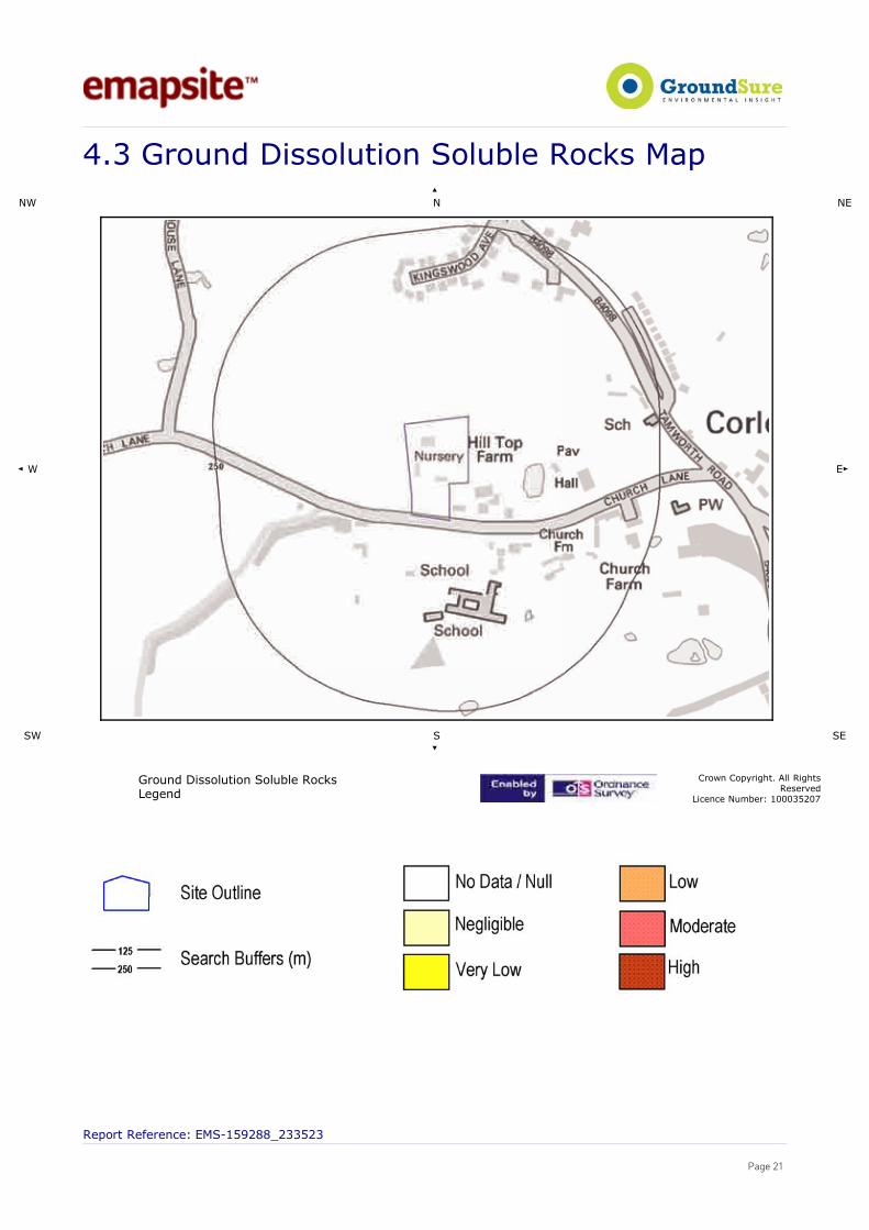
<.%��������'���������������2������+����
89�
8 8�
� 9 ��
�9 ��
��
�������'���������������2������+�:�,���
�4��-��4�����,(�.�3�����,(����������
:�������8��2���� ���%!���
��������������������� !"�##$�%%!�%������������������
�������

<.<�4��������2���'����������
89�
8 8�
� 9 ��
�9 ��
��
4��������2���'��������:�,��� �4��-��4�����,(�.�3�����,(����������
:�������8��2���� ���%!���
��������������������� !"�##$�%%!�%������������������
�������
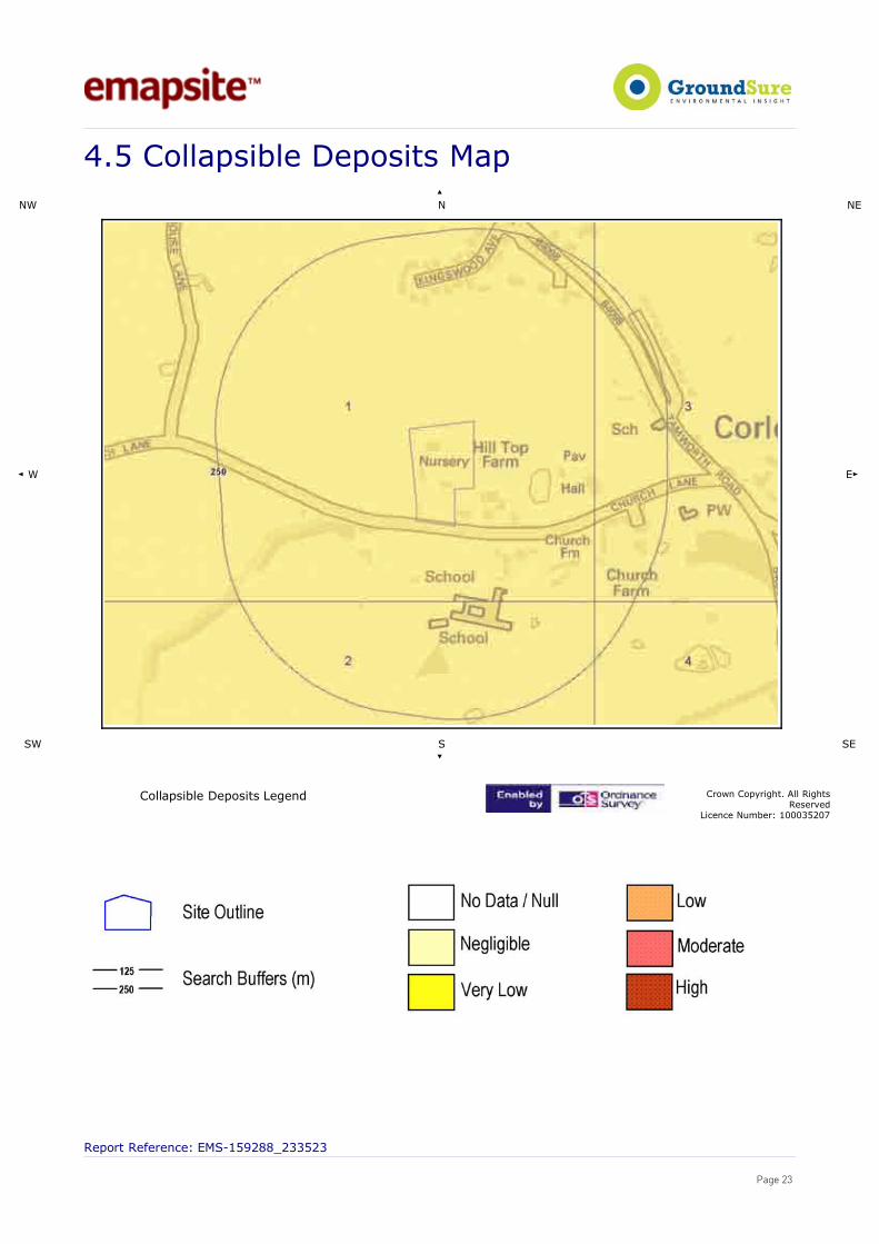
<.!�4�������2���'����������
89�
8 8�
� 9 ��
�9 ��
��
4�������2���'��������:�,��� �4��-��4�����,(�.�3�����,(����������
:�������8��2���� ���%!���
��������������������� !"�##$�%%!�%������������������
�������

<.1�������,��������
89�
8 8�
� 9 ��
�9 ��
��
������,������:�,��� �4��-��4�����,(�.�3�����,(����������
:�������8��2���� ���%!���
��������������������� !"�##$�%%!�%������������������
������

4.Natural Ground Subsidence
The National Ground Subsidence rating is obtained through the 6 natural ground stabilityhazard datasets, which are supplied by the British Geological Survey (BGS).
The following GeoSure data represented on the mapping is derived from the BGS DigitalGeological map of Great Britain at 1:50,000 scale.
What is the maximum hazard rating of natural subsidence within the study site* boundary? Very Low
4.1 Shrink – Swell Clays The following Shrink Swell information provided by the British Geological Survey:
ID Distance (m)* Direction Hazard Rating Details1 0.0 On Site Negligible Ground conditions predominantly non-plastic. No special actions required
to avoid problems due to shrink-swell clays. No special groundinvestigation required, and increased construction costs or increased
financial risks are unlikely likely due to potential problems with shrink-swell clays.
4.2 Landslides The following Landslides information provided by the British Geological Survey:
ID Distance (m)* Direction Hazard Rating Details1 0.0 On Site Very Low Slope instability problems are unlikely to be present. No special actions
required to avoid problems due to landslides. No special ground investigationrequired, and increased construction costs or increased financial risks are
unlikely due to potential problems with landslides.
4.3 Ground Dissolution of Soluble Rocks
The following Soluble Rocks information provided by the British Geological Survey:
Distance (m)* Direction Hazard Rating Details0.0 On site Null-Negligible Soluble rocks are not present in the search area. No special actions required
to avoid problems due to soluble rocks. No special ground investigationrequired, and increased construction costs or increased financial risks are
unlikely due to potential problems with soluble rocks.
4.4 Compressible Deposits The following Compressible Ground information provided by the British Geological Survey:
ID Distance (m)* Direction Hazard Rating Details1 0.0 On Site Negligible No indicators for compressible deposits identified. No special actions required
to avoid problems due to compressible deposits. No special groundinvestigation required, and increased construction costs or increased financial
risks are unlikely due to potential problems with compressible deposits.
*This includes an automatically generated 50m buffer zone around the study site boundary.
Report Reference: EMS-159288_233523
Page 25

4.5 Collapsible Deposits The following Collapsible Rocks information is provided by the British Geological Survey:
IDDistance (m)
* Direction Hazard Rating Details
1 0.0 On Site Very Low Deposits with potential to collapse when loaded and saturated are unlikelyto be present. No special ground investigation required or increased
construction costs or increased financial risk due to potential problemswith collapsible deposits.
4.6 Running Sands The following Running Sands information is provided by the British Geological Survey:
ID Distance (m)* Direction Hazard Rating Details1 0.0 On Site Negligible No indicators for running sand identified. No special actions required to avoid
problems due to running sand. No special ground investigation required, andincreased construction costs or increased financial risks are unlikely due to
potential problems with running sand.
Report Reference: EMS-159288_233523
Page 26

!.�7���(��������������
89�
8 8�
� 9
��
�9 ��
��
7���(������������:�,��� �4��-��4�����,(�.�3�����,(����������
:�������8��2���� ���%!���
��������������������� !"�##$�%%!�%������������������
�������
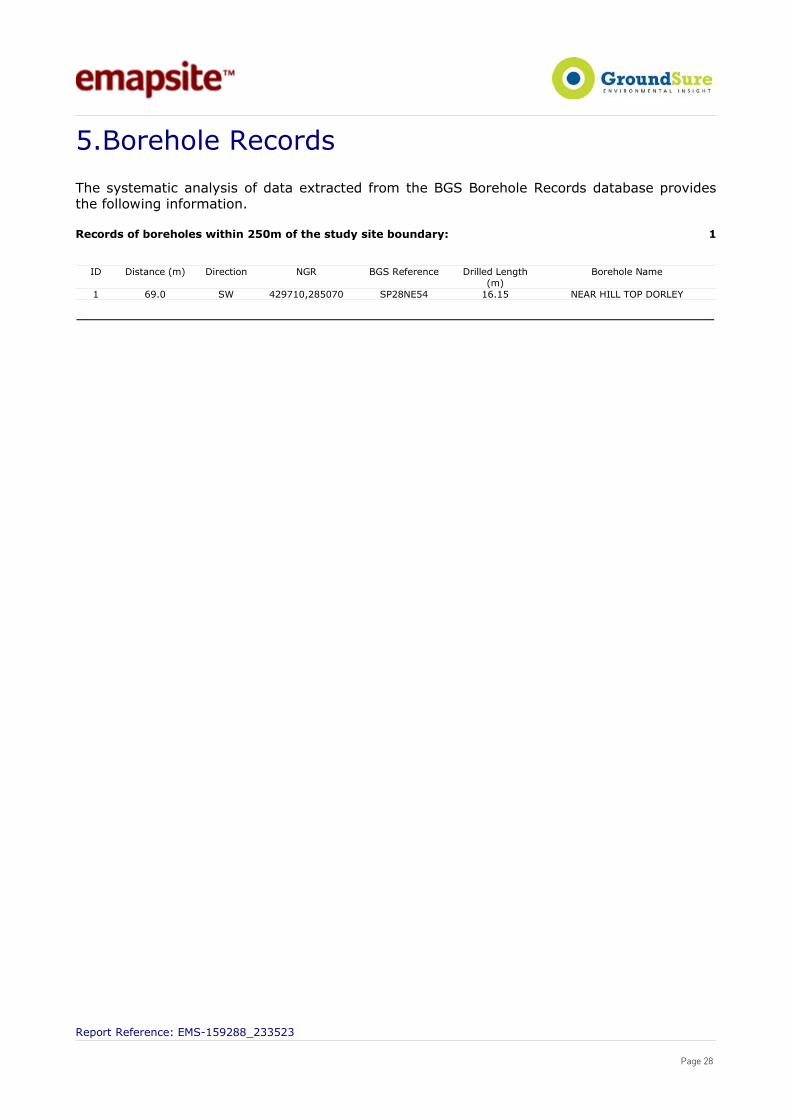
5.Borehole Records
The systematic analysis of data extracted from the BGS Borehole Records database providesthe following information.
Records of boreholes within 250m of the study site boundary: 1
ID Distance (m) Direction NGR BGS Reference Drilled Length
(m)Borehole Name
1 69.0 SW 429710,285070 SP28NE54 16.15 NEAR HILL TOP DORLEY
Report Reference: EMS-159288_233523
Page 28

6.Estimated Background Soil Chemistry
Records of background estimated soil chemistry within 250m of the study site boundary: 1
For further information on how this data is calculated and limitations upon its use, please see the GroundSureGeoInsight User Guide, available on request.
Estimated Geometric Mean Soil Concentrations (mg/kg)
Distance (m)* Direction SampleType
Arsenic (As) Cadmium (Cd) Chromium (Cr) Nickel (Ni) Lead (Pb)
0.0 On Site RuralSoil <15 mg/kg <1.8 mg/kg 40 - 60 mg/kg <15 mg/kg <150 mg/kg
*As this data is based upon underlying 1:50,000 scale geological information, a 50m buffer has been added to the search radius.
Report Reference: EMS-159288_233523
Page 29

7. ContactsEmapSiteTelephone: 0118 9736883 [email protected]
British Geological Survey EnquiriesKingsley Dunham CentreKeyworth, Nottingham NG12 5GGTel: 0115 936 3143. Fax: 0115 936 3276. Email: [email protected]: www.bgs.ac.ukBGS Geological Hazards Reports and general geologicalenquiries
British GypsumBritish Gypsum Ltd, East Leake, Loughborough, Leicestershire,LE12 6HXTel: www.british-gypsum.com
The Coal Authority200 Lichfield Lane, Mansfield, Notts NG18 4RGTel: 0845 762 6848DX 716176 Mansfield 5 www.coal.gov.uk
Johnson Poole & Bloomer LimitedHarris and Pearson Building, Brettel Lane, Brierley Hill, WestMidlands DY5 3LHTel: +44 (0) 1384 262 000Email: [email protected]: www.jpb.co.uk
Ordnance SurveyRomsey Road, Southampton SO16 4GUTel: 08456 050505
Getmapping PLCVirginia Villas, High Street, Hartley Witney,Hampshire RG27 8NWTel: 01252 845444
Peter Brett AssociatesCaversham Bridge House, Waterman Place, ReadingBerkshire RG1 8DNTel: +44 (0)118 950 0761 E-mail: [email protected]
Acknowledgements
PointX © Database Right/Copyright, Thomson Directories Limited © Copyright Link Interchange Network Limited ©Database Right/Copyright and Ordnance Survey © Crown Copyright and/or Database Right. All Rights Reserved.Licence Number [03421028].
This report has been prepared in accordance with the GroundSure Ltd standard Terms and Conditions of business forwork of this nature.
Report Reference: EMS-159288_233523
Page 30

Standard Terms and Conditions1 DefinitionsIn these conditions unless the context otherwise requires:“Beneficiary” means the Client or the customer of the Client for whom the Client has procured the Services.“Commercial” means any building which is not Residential.“Commission" means an order for Consultancy Services submitted by a Client.“Consultancy Services” mean consultancy services provided by GroundSure including, without limitation, carrying out interpretation of third party and in-house environmental data,provision of environmental consultancy advice, undertaking environmental audits and assessments, Site investigation, Site monitoring and related items.“Contract” means the contract between GroundSure and the Client for the performance of the Services which arises upon GroundSure's acceptance of an Order or Commission andwhich shall incorporate these conditions, the relevant GroundSure User Guide, proposal by GroundSure and the content of any subsequent report, and any agreed amendments inaccordance with clause 11.“Client” means the party that submits an Order or Commission.“Data Provider” means any third party providing Third Party Content to GroundSure.“Data Report” means reports comprising factual data with no professional interpretation in respect of the level of likely risk and/or liability available from GroundSure.“GroundSure” means GroundSure Limited, a company registered in England and Wales under number 03421028 and whose registered office is at Greater London House, HampsteadRoad, London NW1 7EJ.“GroundSure Materials” means all materials prepared by GroundSure as a result of the provision of the Services, including but not limited to Data Reports, Mapping and RiskScreening Reports.“Intellectual Property” means any patent, copyright, design rights, service marks, moral rights, data protection rights, know-how, trade mark or any other intellectual propertyrights.“Mapping” an historical map or a combination of historical maps of various ages, time periods and scales available from GroundSure.“Order” means an order form submitted by the Client requiring Services from GroundSure in respect of a specified Site.“Order Website” means online platform via which Orders may be placed.“Report” means a Risk Screening Report or Data Report for commercial or residential property available from GroundSure relating to the Site prepared in accordance with thespecifications set out in the relevant User Guide.“Residential” means any building used as or suitable for use as an individual dwelling.“Risk Screening Report” means one of GroundSure’s risk screening reports, comprising factual data with interpretation in respect of the level of likely risk and/or liability, excluding“Consultancy Services”. “Services” means the provision of any Report, Mapping or Consultancy Services which GroundSure has agreed to carry out for the Client/Beneficiary on these terms and conditions inrespect of the Site."Site" means the landsite in respect of which GroundSure provides the Services.“Third Party Content” means any data, database or other information contained in a Report or Mapping which is provided to GroundSure by a Data Provider."User Guide" means the relevant current version of the user guide, available upon request from GroundSure.
2 Scope of Services2.1 GroundSure agrees to carry out the Services in accordance with the Contract and to the extent set out therein.2.2 GroundSure shall exercise all the reasonable skill, care and diligence to be expected of experienced environmental consultants in the performance of the Services.2.3 The Client acknowledges that it has not relied on any statement or representation made by or on behalf of GroundSure which is not set out and expressly agreed in the Contract.2.4 Terms and conditions appearing on a Client’s order form, printed stationery or other communication, including invoices, to GroundSure, its employees, servants, agents or other
representatives or any terms implied by custom, practice or course of dealing shall be of no effect and these terms and conditions shall prevail over all others.2.5 If a Client/Beneficiary requests insurance in conjunction with or as a result of the Services, GroundSure shall use reasonable endeavours to procure such insurance, but makes no
warranty that such insurance shall be available from insurers or offered on reasonable terms. GroundSure does not endorse or recommend any particular insurance product, policy or insurer. Any insurance purchased shall be subject solely to the terms of the policy issued by insurers and GroundSure will have no liability therefor. The Client/Beneficiaryshould take independent advice to ensure that the insurance policy requested and/or offered is suitable for its requirements.
2.6 GroundSure's quotations/proposals are valid for a period of 30 days only. GroundSure reserves the right to withdraw any quotation at any time before GroundSure accepts an Orderor Commission. GroundSure's acceptance of an Order or Commission shall be effective only where such acceptance is in writing and signed by GroundSure's authorisedrepresentative or where accepted via GroundSure’s Order Website.
3 The Client’s obligations3.1 The Client shall ensure the Beneficiary complies with and is bound by the terms and conditions set out in the Contract and shall provide that Groundsure may in its own right
enforce such terms and conditions against the Beneficiary pursuant to the Contracts (Rights of Third parties) Act 1999. The Client shall be liable for all breaches of the Contract bythe Beneficiary as if they were breaches by the Client. The Client shall be solely responsible for ensuring that the Report/Mapping ordered is appropriate and suitable for theBeneficiary’s needs.
3.2 The Client shall (or shall procure that the Beneficiary shall) supply to GroundSure as soon as practicable and without charge all information necessary and accurate relevant dataincluding any specific and/or unusual environmental information relating to the Site known to the Client/Beneficiary which may pertain to the Services and shall give suchassistance as GroundSure shall reasonably require in the performance of the Services (including, without limitation, access to a Site, facilities and equipment as agreed in theContract).
3.3 Where Client/Beneficiary approval or decision is required, such approval or decision shall be given or procured in reasonable time as not to delay or disrupt the performance of anyother part of the Services.
3.4 The Client shall not and shall not knowingly permit the Beneficiary to, save as expressly permitted by these terms and conditions, re-sell, alter, add to, amend or use out of contextthe content of any Report, Mapping or, in respect of any Services, information given by GroundSure. For the avoidance of doubt, the Client and Beneficiary may make the Report,Mapping or GroundSure’s findings available to a third party who is considering acquiring the whole or part of the Site, or providing funding in relation to the Site, but such thirdparty cannot rely on the same unless expressly permitted under clause 4.
3.5 The Client is responsible for maintaining the confidentiality of its user name and password if using GroundSure’s internet ordering service and accepts responsibility for all activitythat occurs under such account and password.
4 Reliance4.1 Upon full payment of all relevant fees and subject to the provisions of these terms and conditions, the Client and Beneficiary are granted an irrevocable royalty-free licence to
access the information contained in a Report, Mapping or in a report prepared by GroundSure in respect of or arising out of Consultancy Services. The Services may only be usedfor the benefit of the Client and those persons listed in clauses 4.2 and 4.3.
4.2 In relation to Data Reports, Mapping and Risk Screening Reports, the Client shall be entitled to make Reports available to (i) the Beneficiary, (ii) the Beneficiary's professionaladvisers, (iii) any person providing funding to the Beneficiary in relation to the Site (whether directly or as part of a lending syndicate), (iv) the first purchaser or first tenant of theSite (v) the professional advisers and lenders of the first purchaser or tenant of the Site. Accordingly GroundSure shall have the same duties and obligations to those persons inrespect of the Services as it has to the Client and those persons shall have the benefit of any of the Client's rights under the Contract as if those persons were parties to theContract. For the avoidance of doubt, the limitations of GroundSure's liability as set out in clauses 7 and 11.6 shall apply.
4.3 In relation to Consultancy Services, reliance shall be limited to the Client, Beneficiary and named parties on the Report.4.4 Save as set out in clauses 4.2 and 4.3 and unless otherwise agreed in writing with GroundSure, any other party considering the information supplied by GroundSure as part of the
Services, including (but not limited to) insurance underwriters, does so at their own risk and GroundSure has no legal obligations to such party unless otherwise agreed in writing.4.5 The Client shall not and shall not knowingly permit any person (including the Beneficiary) who is provided with a copy of any Report, (except as permitted herein or by separate
agreement with GroundSure) to,: (a) remove, suppress or modify any trade mark, copyright or other proprietary marking from the Report or Mapping; (b) create any productwhich is derived directly or indirectly from the data contained in the Report or Mapping; (c) combine the Report or Mapping with, or incorporate the Report or Mapping into anyother information data or service; or (d) re-format or otherwise change (whether by modification, addition or enhancement) data or images contained in the Report or Mapping.
4.6 Notwithstanding clause 4.5, if the Client acts in a professional capacity, it may make reasonable use of a Report and/or findings made as a result of Consultancy Services to adviseBeneficiaries. However, GroundSure shall have no liability in respect of any opinion or report given to such Beneficiaries by the Client or a third party.
5 Fees and Disbursements5.1 GroundSure shall charge the Client fees at the rate and frequency specified in the Contract together, in the case of Consultancy Services, with all proper disbursements incurred by
GroundSure in performing the Services. For the avoidance of doubt, the fees payable for the Services are as set out in GroundSure's written proposal, Order Website or Orderacknowledgement form. The Client shall in addition pay all value added tax or other tax payable on such fees and disbursements in relation to the provision of the Services.
5.2 Unless GroundSure requires prepayment, the Client shall promptly pay all fees disbursements and other monies due to GroundSure in full without deduction, counterclaim or set offtogether with such value added tax or other tax as may be required within 30 days from the date of GroundSure’s invoice or such other period as may be agreed in writing betweenGroundSure and the Client ("Payment Date"). GroundSure reserves the right to charge interest which shall accrue on a daily basis from 30 days after the date of Payment Dateuntil the date of payment (whether before or after judgment) at the rate of five per cent per annum above the Bank of England base rate from time to time.
5.3 In the event that the Client disputes the amount payable in respect of GroundSure’s invoice it shall notify GroundSure no later than 28 days after the date thereof that it is indispute. In default of such notification the Client shall be deemed to have agreed the amount thereof. As soon as reasonably practicable following receipt of a notification in respectof any disputed invoice, a member of the management team at GroundSure shall contact the Client and the parties shall use all reasonable endeavours to resolve the dispute.
6 Intellectual Property and Confidentiality6.1 Subject to the provisions of clause 4.1, the Client and the Beneficiary hereby acknowledge that all Intellectual Property in the Services and Content are and shall remain owned by
either GroundSure or the Data Providers and nothing in these terms purports to transfer or assign any rights to the Client or the Beneficiary in respect of the Intellectual Property.6.2 The Client shall acknowledge the ownership of the Third Party Content where such Third Party Content is incorporated or used in the Client's own documents, reports, systems or
services whether or not these are supplied to a third party. 6.3 Data Providers may enforce any breach of clauses 6.1 and 6.2 against the Client or Beneficiary.6.4 The Client acknowledges that the proprietary rights subsisting in copyright, database rights and any other intellectual property rights in respect of any data and information
contained in any Report are and shall remain (subject to clause 11.1) the property of GroundSure and/or any third party that has supplied data or information used to create aReport, and that these conditions do not purport to grant, assign or transfer any such rights in respect thereof to a Client and/or a Beneficiary.
6.5 The Client shall (and shall procure that any recipients of the Report as permitted under clause 4.2 shall): (i) not remove, suppress or modify any trademark, copyright or other proprietary marking belonging to GroundSure or any third party from the Services;
Report Reference: EMS-159288_233523
Page 31
(ii) use the information obtained as part of the Services in respect of the subject Site only, and shall not store or reuse any information obtained as part of the Services provided inrespect of adjacent or nearby sites;
(iii) not create any product or report which is derived directly or indirectly from the data contained in the Services (save that those acting in a professional capacity to theBeneficiary may provide advice based upon the Services);
(iv) not combine the Services with or incorporate such Services into any other information data or service; and (v) not reformat or otherwise change (whether by modification, addition or enhancement), data contained in the Services (save that those acting in a professional capacity to the
Beneficiary shall not be in breach of this clause 6.5(v) where such reformatting is in the normal course of providing advice based upon the Services), in each case of parts (iii) to (v) inclusive, whether or not such product or report is produced for commercial profit or not.6.6 The Client and/or Beneficiary shall and shall procure that any party to whom the Services are made available shall notify GroundSure of any request or requirement to disclose,
publish or disseminate any information contained in the Services in accordance with the Freedom of Information Act 2000, the Environmental Information Regulations 2004 or anyassociated legislation or regulations in force from time to time.
6.8 Save as otherwise set out in these terms and conditions, any information provided by one party ("Disclosing Party") to the other party ("Receiving Party") shall be treated asconfidential and only used for the purposes of these terms and conditions, except in so far as the Receiving Party is authorised by the Disclosing Party to provide such informationin whole or in part to a third party.
7 LiabilityTHE CLIENT’S ATTENTION IS DRAWN TO THIS PROVISION7.1Subject to the provisions of this clause 7, GroundSure shall be liable to the Beneficiary only in relation to any direct losses or damages caused by any negligent act or omission of
GroundSure in preparing the GroundSure Materials and provided that the Beneficiary has used all reasonable endeavours to mitigate any such losses.7.2GroundSure shall not be liable for any other losses or damages incurred by the Beneficiary, including but not limited to: (i) loss of profit, revenue, business or goodwill, losses relating to business interruption, loss of anticipated savings, loss of or corruption to data or for any special, indirect or
consequential loss or damage which arise out of or in connection with the GroundSure Materials or otherwise in relation to a Contract; (ii) any losses or damages that arise as a result of the use of all or part of the GroundSure Materials in breach of these terms and conditions or contrary to the terms of the relevant
User Guide; (iii) any losses or damages that arise as a result of any error, omission or inaccuracy in any part of the GroundSure Materials where such part is based on any Third Party Content or
any reasonable interpretation of Third Party Content. The Client accepts, and shall procure that any other Beneficiary shall accept, that it has no claim or recourse to any DataProvider in relation to Third Party Content; and/or
(iv) any loss or damage to a Client’s computer, software, modem, telephone or other property caused by a delay or loss of use of GroundSure’s internet ordering service.7.3 GroudSure’s total liability in contract, tort (including negligence or breach of statutory duty), misrepresentation, restitution or otherwise, arising in connection with the GroundSure
Materials or otherwise in relation to the Contract shall be limited to £10 million in total (i) for any one claim or (ii) for a series of connected claims brought by one or more parties.7.4 For the duration of the liability periods set out in clauses 7.5 and 7.6 below, GroundSure shall maintain professional indemnity insurance in respect of its liability under these terms
and conditions provided such insurance is readily available at commercially viable rates. GroundSure shall produce evidence of such insurance if reasonably requested by theClient. A level of cover greater than GroundSure’s current level of cover may be available upon request and agreement with the Client.
7.5 Any claim under the Contract in relation to Data Reports, Mapping and Risk Screening Reports, must be brought within six years from the date when the Beneficiary became awarethat it may have a claim and in no event may a claim be brought twelve years or more after completion of such a Contract. For the avoidance of doubt, any claim in respect ofwhich proceedings are notified to GroundSure in writing prior to the expiry of the time periods referred to in this clause 7.5 shall survive the expiry of those time periods providedthe claim is actually commenced within six months of notification.
7.6 Any claim under the Contract in relation to Consultancy Services, must be brought within six years from the date the Consultancy Services were completed. 7.7 he Client accepts and shall procure that any other Beneficiary shall accept that it has no claim or recourse to any Data Provider or to GroundSure in respect of the acts or omissions
of any Data Provider and/or any Third Party Content provided by a Data Provider. 7.8 Nothing in these terms and conditions: (i) excludes or limits the liability of GroundSure for death or personal injury caused by GroundSure’s negligence, or for fraudulent misrepresentation; or (ii) shall affect the statutory rights of a consumer under the applicable legislation.
8 GroundSure right to suspend or terminate 8.1 In the event that GroundSure reasonably believes that the Client or Beneficiary as applicable has not provided the information or assistance required to enable the proper
performance of the Services, GroundSure shall be entitled on fourteen days written notice to suspend all further performance of the Services until such time as any such deficiencyhas been made good.
8.2 GroundSure may additionally terminate the Contract immediately on written notice in the event that: (i)the Client shall fail to pay any sum due to GroundSure within 28 days of the Payment Date; or (ii)the Client (being an individual) has a bankruptcy order made against him or (being a company) shall enter into liquidation whether compulsory or voluntary or have an
Administration Order made against it or if a Receiver shall be appointed over the whole or any part of its property assets or undertaking or if the Client is struck off the Registerof Companies or dissolved; or
(iii) the Client being a company is unable to pay its debts within the meaning of Section 123 of the Insolvency Act 1986 or being an individual appears unable to pay his debtswithin the meaning of Section 268 of the Insolvency Act 1986 or if the Client shall enter into a composition or arrangement with the Client’s creditors or shall suffer distress orexecution to be levied on his goods; or
(iv)the Client or the Beneficiary breaches any material term of the Contract (including, but not limited to, the obligations in clause 4) incapable of remedy or if remediable, is notremedied within 14 days of notice of the breach.
9 Client’s Right to Terminate and Suspend9.1 Subject to clause 10.2, the Client may at any time after commencement of the Services by notice in writing to GroundSure require GroundSure to terminate or suspend immediately
performance of all or any of the Services.9.2 The Client waives all and any right of cancellation it may have under the Consumer Protection (Distance Selling) Regulations 2000 (as amended) in respect of the Order of a
Report/Mapping. This does not affect the Beneficiary's statutory rights.
10 Consequences of Withdrawal, Termination or Suspension10.1 Upon termination or any suspension of the Services, GroundSure shall take steps to bring to an end the Services in an orderly manner, vacate any Site with all reasonable speed
and shall deliver to the Client/Beneficiary any property of the Client/ Beneficiary in GroundSure’s possession or control.10.2 In the event of termination/suspension of the Contract under clauses 8 or 9, the Client shall pay to GroundSure all and any fees payable in respect of the performance of the
Services up to the date of termination/suspension. In respect of any Consultancy Services provided, the Client shall also pay GroundSure any additional costs incurred inrelation to the termination/suspension of the Contract.
11 General11.1 The mapping contained in the Services is protected by Crown copyright and must not be used for any purpose outside the context of the Services or as specifically provided in
these terms. 11.2 GroundSure reserves the right to amend these terms and conditions. No variation to these terms shall be valid unless signed by an authorised representative of GroundSure.11.3 No failure on the part of GroundSure to exercise and no delay in exercising, any right, power or provision under these terms and conditions shall operate as a waiver thereof.11.4 Save as expressly provided in clauses 4.2, 4.3, 6.3 and 11.5, no person other than the persons set out therein shall have any right under the Contract (Rights of Third Parties) Act
1999 to enforce any terms of the Contract.11.5 The Secretary of State for Communities and Local Government acting through Ordnance Survey may enforce breach of clause 6.1 of these terms and conditions against the Client
in accordance with the provisions of the Contracts (Rights of Third Parties) Act 1999. 11.6 GroundSure shall not be liable to the Client if the provision of the Services is delayed or prevented by one or more of the following circumstances: (i) the Client or Beneficiary’s failure to provide facilities, access or information; (ii) fire, storm, flood, tempest or epidemic; (iii) Acts of God or the public enemy; (iv) riot, civil commotion or war; (v) strikes, labour disputes or industrial action; (vi) acts or regulations of any governmental or other agency; (vii) suspension or delay of services at public registries by Data Providers; or (viii) changes in law.11.7 Any notice provided shall be in writing and shall be deemed to be properly given if delivered by hand or sent by first class post, facsimile or by email to the address, facsimile
number or email address of the relevant party as may have been notified by each party to the other for such purpose or in the absence of such notification the last knownaddress.
11.8 Such notice shall be deemed to have been received on the day of delivery if delivered by hand, facsimile or email and on the second working day after the day of posting if sentby first class post.
11.9 The Contract constitutes the entire contract between the parties and shall supersede all previous arrangements between the parties.11.10 Each of the provisions of the Contract is severable and distinct from the others and if one or more provisions is or should become invalid, illegal or unenforceable, the validity and
enforceability of the remaining provisions shall not in any way be tainted or impaired.11.11 These terms and conditions shall be governed by and construed in accordance with English law and any proceedings arising out of or connected with these terms and conditions
shall be subject to the exclusive jurisdiction of the English courts.11.12 If the Client or Beneficiary has a complaint about the Services, notice can be given in any format eg writing, phone, email to the Compliance Officer at GroundSure who will
respond in a timely manner. © GroundSure Limited January 2012
Report Reference: EMS-159288_233523
Page 32