
DETERMINING THE PERMEABILITY OF SOIL AT UNVERSITI
MALAYSIA PAIHANG, GAMI3ANG CAMPUS USING GUELPH
PERMEAMETER KIT
ALAN TING 1K FONG
This thesis is submitted in fuilfilment of the requirements for the award of the
degree of Bachelor of Civil Engineering
Faculty of Civil Engineering & Earth Resources
Universiti Malaysia Pahang
NOVEMBER 2010

ABSTRACT
The measure of the soil's ability to permit water to flow through its pores or
voids is termed as permeability. Different types of soil give different value of
permeability because their abilities to permit water to flow through their pores are
different. Several factors that affect the permeability of the soil are type of soil,
vegetation management, surface moisture, soil compaction, rainfall intensity and
temperature. This study was carried out to determine the permeability of the soil and
identify the soil classification for ten locations in the compound of Universiti
Malaysia Pahang, Gambang Campus. Guelph Permeameter test was used to
determine the permeability of soil of each location. The lowest permeability of soil is
at Guard house and construction site 2 with the rate of 0 cm/sec while the highest is
at sport complex with the rate of 2.19x10 4 cm/sec. The results indicated the slow
permeability at the ten locations were due to less voids in the soil structures.
iv

ABSTRAK
Saiz kemampuan tanah untuk membenarkan air mengalir melalui pori-pori
atau rongga disebut sebagai ketelapan. Berbagai jenis tanah memberikan nilai
kebolehtelapan yang berbeza kerana kemampuan mereka untuk membolehkan air
mengalir melalui pori-pori yang berbeza. Beberapa faktor yang mempengaruhi
kebolehtelapan tanah adalah jenis tanah, pengurusan tumbuhan, kelembapan
permukaan, pemadatan tanah, kekuatan curah hujan dan suhu. Kajian mi dilakukan
untuk menentukan ketelapan tanah dan mengenalpasti kiasifikasi tanah untuk
sepuluh lokasi di Kampus Gambang Universiti Malaysia Pahang. "Guelph
Permeameter" digunakan untuk menentukan ketelapan tanah di lokasi yang dipilih.
Ketelapan terendah tanah adalah di Rumah Jaga dan Laman Pembinaan 2 dengan
tahap 0 cm / saat dan ketelapan tertinggi adalah di Kompleks Sukan dengan tahap
2.19x10' cm / saat. Kajian mendapati ketelapan rendah di sepuluh lokasi yang
dipilih. mi adalah disebabkan oleh kurang rongga dalam struktur tanah tersebut.
IY1
vi
TABLE OF CONTENTS
CHAPTER
TITLE PAGE
DECLARATION ii
ACKNOWLEDGEMENT iii
ABSTRACT iv
ABSTRAK v
TABLE OF CONTENT vi
LIST OF TABLES x
LIST OF FIGURES xi
LIST OF SYMBOLS xiii
1 INTRODUCTION
1.1 Background 1
1.2 Problem Statement 3
1.3 Research Objectives 5
1.4 Scope of Study 5
LITERATURE REVIEW
2.1 Introduction
2.2 Soil Properties
2.3 Porosity
2.4 Hydraulic Conductivity
2.5 Darcy Law
2.6 Method to Measure Permeability of Soil
2.6.1 Guelph Permeameter
2.6.2 Single Ring Infiltrometer
2.6.3 Double Ring Infiltrometer
2.7 Factors Influencing , Permeameter of Soil
2.7.1 Soil Characteristics
2.7.2 Plants and Animals
2.7.3 Runoff and Flooding
2.7.4 Runoff and Urban Development
3 METHODOLOGY
3.1 Introduction 20
3.2 Site Investigation 22
3.3 Site and Soil Evaluation 24
3.4 Apparatus 24
3.4.1 Permeameter Assembly 24
3.4.2 Step to Assemble Guelph Permeameter Kit 25
3.4.3 Placement of Permeameter 26
3.5 Data Collection 27
3.5.1 Measurement Permeability of Soil 28
3.6 Data Analysis 30
3.7 Discussion 30
vii
6
6
8
9
11
12
12
14
15
17
17
17
18
18
vii'
4 ANALYSIS AND DISCUSSION
4.1 Introduction 31
4.2 Permeability of Soil 32
4.2.1 Type of Soil 32
4.2.2 Calculation for Permeability of Soil 33
4.2.3 Classification of Soil 35
4.3 Steady State Rate of Flow Curve 36
4.3.1 Steady State Rate of Flow Curve 37
(Height of Water at 5cm)
4.3.1.1 Guard House 37
4.3.1.2 Sport Complex 37
4.3.1.3 Civil Lab 38
4.3.1.4 Access Road to Kolej 38
Kediaman 2
4.3.1.5 Construction Site 1 39
4.3.1.6 Football Field 39
4.3.1.7 Beside Kolej Kediaman 2 40
4.3.1.8 Constuction Site 2 40,
4.3.1.9 Kolej Kediaman 2 41
4.3.1.10 Behind Kolej Kediaman 2 41
4.3.2 Steady State Rate of Flow Curve 42
(Height of Water at 10cm)
4.3.2.1 Guard House 42
4.3.2.2 Sport Complex 42
4.3.2.3 Civil Lab 43
4.3.2.4 Access Road to Kolej 43
Kediaman 2
4.3.2.5 Construction Site 1 44
4.3.2.6 Football Field 44
4.3.2.7 Beside Kolej Kediaman 2 45
4.3.2.8 Constuction Site 2 45
4.3.2.9 Kolej Kediaman 2 46

lx
4.3.2. 10 Behind Kolej Kediaman 2 46
4.4. Permeability and change in water level in 47
different of height of Water
4.5 Discussions 48
4.5.1 Guard House 48
4.5.2 Sport Complex 48
4.5.3 Civil Lab 49
4.5.4 Access Road to Kolej 49
Kediaman 2
4.5.5 Construction Site 1 50
4.5.6 Football Field 50
4.5.7 Beside Kolej Kediaman 2 51
4.5.8 ConstuctioxjSitë2 51
4.5.9 Kolej Kediarnan 2 51
4.5.10 Behind Kolej Kediaman 2 52
4.5 Conclusion V 52
5 CONCLUSION AND RECOMMENDATION
5.1 Summary 53
5.1.1 Permeability of Soil 53
5.1.2 Classification of Soil 54
5.2 Conclusion 55
5.3 Recommendations 56
REFERENCE 56
APPENDICES 59
APPENDIX A 59
APPENDIX B 70
x
LIST OF TABLE
TABLE NO. TITLE PAGE
2.1 Soil Permeability 7
3.1 Location for the permeability of soil study 22
3.2 Step to assemble Guelph Permeameter kit 25
3.3 Guelph Permeameter Field Data Sheet 29
4.1 Soil permeability 32
4.2 Guelph Permeameter Data 33
4.3 Classification of soil 35
5.1 Soil permeability 53
5.2 Classification of Soil 54

xi
LIST OF FIGURES
FIGURE NO. TITLE PAGE
1.1 Plan for UMP Campus, gambang 4
2.1 Guelph Permeameter kit 13
2.2 Single Ring Infiltrometer 14
2.3 (a) Double Ring Infiltrometer 16
30-cm diameter (inner) and 60-cm diameter (outer)
(b) Double Ring Infiltrometer 16
15-cm diameter (inner) and 30-cm diameter (outer)
(c) Constant Inner Head in the Infiltration Rings 16
3.1 Flow Chart of Research Methodology 21
3.2 Plan of University Malaysia Pahang 23
3.3 Placement of Permeameter 26
3.4 Guelph Permeameter field data sheet 28
4.1 Steady state rate of flow curve for Guard House - 37
4.2 Steady state rate of flow curve for Sport Complex 37
4.3 Steady state rate of flow curve for Civil Lab 38
4.4 Steady state rate of flow curve for Access Road to 38
Kolej Kediaman 2
4.5 Steady state rate of flow curve for Construction site 1 39
4.6 Steady state rate of flow curve for Football Field 39
4.7 Steady state rate of flow curve for Beside Kolej Kediaman 2 40
4.8 Steady state rate of flow curve for Construction Site 2 40
4.9 Steady state rate of flow curve for Kolej Kediaman 2 41
4.10 Steady state rate of flow curve for Behind Kolej Kediaman 2 41
4.11 Steady state rate of flow curve for Guard House 42
4.12 Steady state rate of flow curve for Sport Complex 42
4.13 Steady state rate of flow curve for Civil Lab 43

xli
4.14 Steady state rate of flow curve for Acess Road to 43
Kolej Kediaman 2
4.15 Steady state rate of flow curve for Construction site 1 44
4.16 Steady state rate of flow curve for Football Field 44
4.17 Steady state rate of flow curve for Beside Kolej Kediaman 2 45
4.18 Steady state rate of flow curve for Construction Site 2 45
4.19 Steady state rate of flow curve for Kolej Kediaman 2 46
4.20 Steady state rate of flow curve for Behind Kolej Kediaman 2 46

LIST OF SYMBOL
Q - The quantity of water per unit of time
Ksat - Saturated hydraulic conductivity
A - The cross-sectional area of the column
L - The length of the column
AP - Hydrostatic pressure
Q - Rate of water flow (volume per time)
K - Hydraulic conductivity
A - Column cross sectional area
dhldl - Hydraulic gradient
Kfs - The field-saturated hydraulic conductivity, (m s 1)
H - The ponded depth, (m)
a - The radius of the well, (m)
C - The matric potential as well as the H/a ratio
xlii
t'm - Matric flux potential
R - Rate of water level change

xiv
% - Percent
cm/min - Centimeter per minute
cm - Centimeter
CHAPTER 1
INTRODUCTION
1.1 Background
The study of permeability of soil is important for flood or flash flood. Soil
permeability is the property of the soil pore system that allows fluid to flow. It is
generally the pore sizes and their connectivity which determines whether soil has
high or low permeability. Water will flow easily through soil with large pores with
good connectivity between them and it is high permeability. Small pores with the
poor connectivity between them which would have lower permeability, because
water would flow through the soil more slowly. It is possible to have zero
permeability which is no flow with high porosity soil if the pores are isolated (not
connected). It is also to have zero permeability if the pores are very small, such as in
clay (Roy David Nurmi, 2009).
The measurement of the soil's ability to permit water to flow through its
pores or voids are termed as permeability. In other words, permeability is a
measurement of a material's ability to transmit liquids. Material which contain
continuous void is easily permeable. Different types of soil will have different value
of permeability because their ability to permit water to flow through its pores is
different. A low and high permeability means the water flows through the soil is
slow, and fast respectively.
2
Many factors controlling the proportion of precipitation that is converted to
runoff in a given landscape, and the time it takes for runoff to enter a stream. Human..
changes to these landscape features can greatly influence runoff. Where soil is absent
and little-fractured bedrock is exposed, water cannot soak in and will run off rapidly.
If soil is present, but is very fine-grained and clay-rich, the pore spaces that water
must pass through are extremely small; hence, water will infiltrate very slowly
compared to sandy soils that readily soak up water. Some finer-grained soils have
vertical cracks that form when the soil shrinks as it dries. These cracks allow water to
enter more readily, but may close up after the soil is wetted (Dingman, S. Lawrence,
1994).
Besides that, compaction of soils reduces the size of pore spaces and the
infiltration rate. This will affect the runoff. Water commonly runs off areas that were
compacted through repeated passage of people, large animals, or heavy machinery.
Raindrops falling on bare soil also can compact the soil surface in plowed fields,
leading to increased runoff and erosion of farmland (Dingman, S. Lawrence, 1994).
Weathering also will affect the permeability of soil. During the wet weather,
moisture content of the soil is higher compare to that of hot weather. Rain water
cannot infiltrate through the soil. It causes surface runoff during rainfall. For dry
weather, porosity and moisture content of the soil will decreased. High volume of
rain water can transmit to the ground.
Several others factors that affect the permeability of soil, for example,
vegetation management, initial soil condition, surface moisture, soil compaction,
rainfall intensity and temperature. The rate at which water is transmit through surface
level of the ground is normally depends on the condition of the surface. This is
because some fine materials may block or seal the surface so it affect infiltration rate
even though underlying soils are high permeable. Infiltration rate is affected also by
the volume of storage available below the ground. In this case, flash flood or flood
might take place.

1.2 Problem statements
During heavy rain period, flash flood occurred at the roadside and this is not
only affect cars and motorcyclists but also students' movement along the roadside in
Universiti Malaysia Pahang. These are the problems which allow flash flood to
occur:
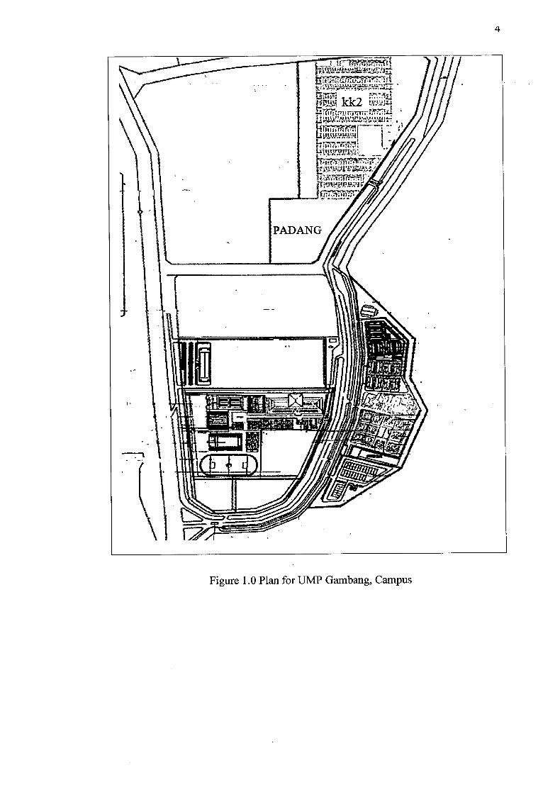
1. Around 50% of areas in UMP are occupied with building. (Figure 1.0)
2. Drains are always over flow during heavy rain.
3. Around 20% of area around the Gambang Campus are paved area.
4
flTr ki )LI I ,f II !t1Iii I II ' 17...
Figure 1.0 Plan for UMP Gambang, Campus
1.3 Research objectives
The objectives of this project are:
1. To determine permeability of the soil by using Guelph Permeameter
kit
2. To identify the soil classification in UMP.
1.4 Scope of Study
The studies scopes are as follows:
1. Identify ten locations around UMP Gambang Campus.
2. Use Guelph Permeameter kit to determine permeability of soil in UMP Gambang Campus.
3. Use hand auger to dig and collect the soil samples at the specified location.
4. Determine the type of soil in UMP Gambang Campus.

CHAPTER 2
LITERATURE REVIEW
2.1 Introduction
This chapter covered about the characteristic of the soils, formula for analysis
the permeability of soil and method to measure it. Factor affecting the soil
permeability was included.
2.2 Soil Properties
Soil can be divided into three major categories which are organic soil,
cohesive and cohesionless. Cohesionless soils which the soil particle do not stick
together. Cohesion means the act or state of cohering, uniting, or sticking together.
While the cohesive soil contains clay minerals and posses plasticity and the particles
of soil stick to each other cause by water- particle interaction and attractive force
between particles. Organic soils are typically spongy, crumbly and compressible. The
most important property of soil related to rainfall induced slope failure is
permeability (Cheng and Jack, 2005).

7
Soil permeability is the property of the soil pore system that allows fluid to
flow. It is generally the pore sizes and their connectivity that determine whether a
soil has high or low permeability. Water will flow easily through soil with large
pores with good connectivity between them. Small pores with the same degree of
connectivity would have lower permeability because water would flow through the
soil more slowly. It is possible to have zero permeability (no flow) in a high porosity
soil if the pores are isolated (not connected). It is also to have zero permeability if the
pores are very small, such as in clay (Cheng and Jack, 2005).
Actual water movement is thought of as small, interconnected, irregular
conduits. Because the water moves through the voids, it follows that the soils with
large voids such as sands are generally more permeable than those with smaller voids
such as clays. Additionally, because soils with large voids generally have large void
ratios, it may be generalized that permeability tends to increase as the void ratio
increase. Because water movement can have profound effects on soil properties and
characteristics, it is an important consideration in certain engineering application.
Tables 2.1 show the lists of some soil permeabilities (Cheng and Jack, 2005).
Table 2.1 Soil Permeability (Cheng and Jack, 2005)
Soil Permeability Coefficient, k Relative (cm/sec) Permeability
Coarse gravel High >101
Sand, clean Medium 101 iø
Sand, dirty 10 -1 _ io
Low
Silt Very Low io- io
Clay<1 Impervious
8
There are several factors which influence the permeability of soil such as soil
texture, organic content in soil, the density of soil and vegetation. Soil texture refers
to the proportions of the sand, silt, clay in soil. Course textured sandy and gravelly
have the largest pores and the most rapid permeability. Fine textured clayey soils
have tiny pores and very slow permeability rates. Medium textured barns, silt barns
and clay barns have intermediate rate of permeability (Cheng and Jack, 2005).
Soil organic matter contributes to soil productivity in several ways, but there
is no direct quantitative relationship between soil productivity and total soil organic
matter. In fact, it has been the decline in organic matter that has contributed to the
productivity of the crop-fallow system. Organic soils often have varying degrees of
organic compounds in different states of decomposition. Organic matters help create
and stabilize aggregates of the grains of sands, clay and silt. This- aggregates or units
of soils structure, have relatively large spaces between them, permitting more rapid
water movement. Dense, compacted or cemented soil layers have very slow rates of
permeability. Roots, burrowing insects and animals create large voids or macropores
which can transmit water very rapidly under saturated conditions. Macropores also
are common in very coarse textured soils and in soils that crack extensively upon
drying (Cheng and Jack, 2005)
2.3 Porosity
Soil porosity refers to that part of a soil volume that is not occupied by soil
particles or organic matter. Pore spaces are filled with either air, other gases, or
water. Large pores (macropores) allow the ready movement of air and the drainage
of water. They are also large enough to accommodate plant roots and the wide range
of tiny animals that inhabit the soil. Large pore spaces permit fast infiltration and
percolation of water through a soil or soil horizon. Small pores (micropores) exhibit
attractive forces strong enough to hold water in the pore. They are the water retention
system of the soil which provides water storage for plant roots. During precipitation,
macropores conduct water into the soil where it fills the micropores. At field capacity

all pores small enough to retain water against the pull of gravity are filled (Brady and
Weil, 1999; Munshower, 1994).
Clay soils have numerous micropores and hold large quantities of water, but
since they have few macropores they produce very slow infiltration rates. The pores
in the clays may be so small and hold water so tenaciously that the water is not
available to plants. Sandy soils with numerous macropores but few micropores have
higher infiltration and percolation rates but a lower water-holding capacity than other
soil textures. A lower water-holding capacity can mean less available water for plant
roots. For revegetation purposes, plants perform best in intermediate soil textures
(barns) where soils contain mixtures of micro and macropores (Munshower, 1994).
2.4 Hydraulic Conductivity
Water can move through soil as saturated flow, unsaturated flow, or vapor
flow. Saturated flow takes place when the soil pores are completely filled (or
saturated) with water. Unsaturated flow occurs when the larger pores in the soil are
filled with air, leaving only the smaller pores to hold and transmit water. Vapor flow
occurs as vapor pressure differences develop in relatively dry soils. Vapor migrates
from an area of high vapor pressure to an area of low vapor pressure. Hydraulic
conductivity is a soil property that describes the ease with which the soil pores
permit water (not vapor) movement. It depends on the type of soil, porosity, and the
configuration of the soil pores. In saturated soils, the hydraulic conductivity is
represented as Ksat and in unsaturated soils, the hydraulic conductivity is represented
as K (Ecorestoration.2004).
The quantity of water per unit of time, Q, that flows through a column of
saturated soil can be expressed by Darcy's Law, as follows:

10
- KsatMP
L
Where:
Q = the quantity of water per unit of time
Ksat = saturated hydraulic conductivity
A = the cross-sectional area of the column
L = the length of the column
AP = hydrostatic pressure
Flow through an unsaturated soil is more complicated than flow through
continuously saturated pore spaces. Macropores are filled with air, leaving • only fmer
pores to accommodate water movement. The movement of water in unsaturated soils
is dictated by differences in matric potential, not gravity. The matric potential
gradient is the difference in the matric potential of the moist soil areas (high matric
potential) and nearby drier areas (low matric potential) into which the water is
moving (Brady and Weil, 1999).
Hydraulic conductivity is an important soil property when determining the
potential for widespread groundwater contamination by a contaminating source.
Soils with high hydraulic conductivities and large pore spaces are likely candidates
for far reaching contamination. The hydraulic conductivity in a saturated soil can be
measured by injecting a non-reactive tracer (i.e. bromide) in a monitoring well and
measure the time it takes for the tracer to reach a down gradient monitoring well.
Remediation of contaminated groundwater can be a likely step in the reclamation
process (Ecorestoration.2004).
11
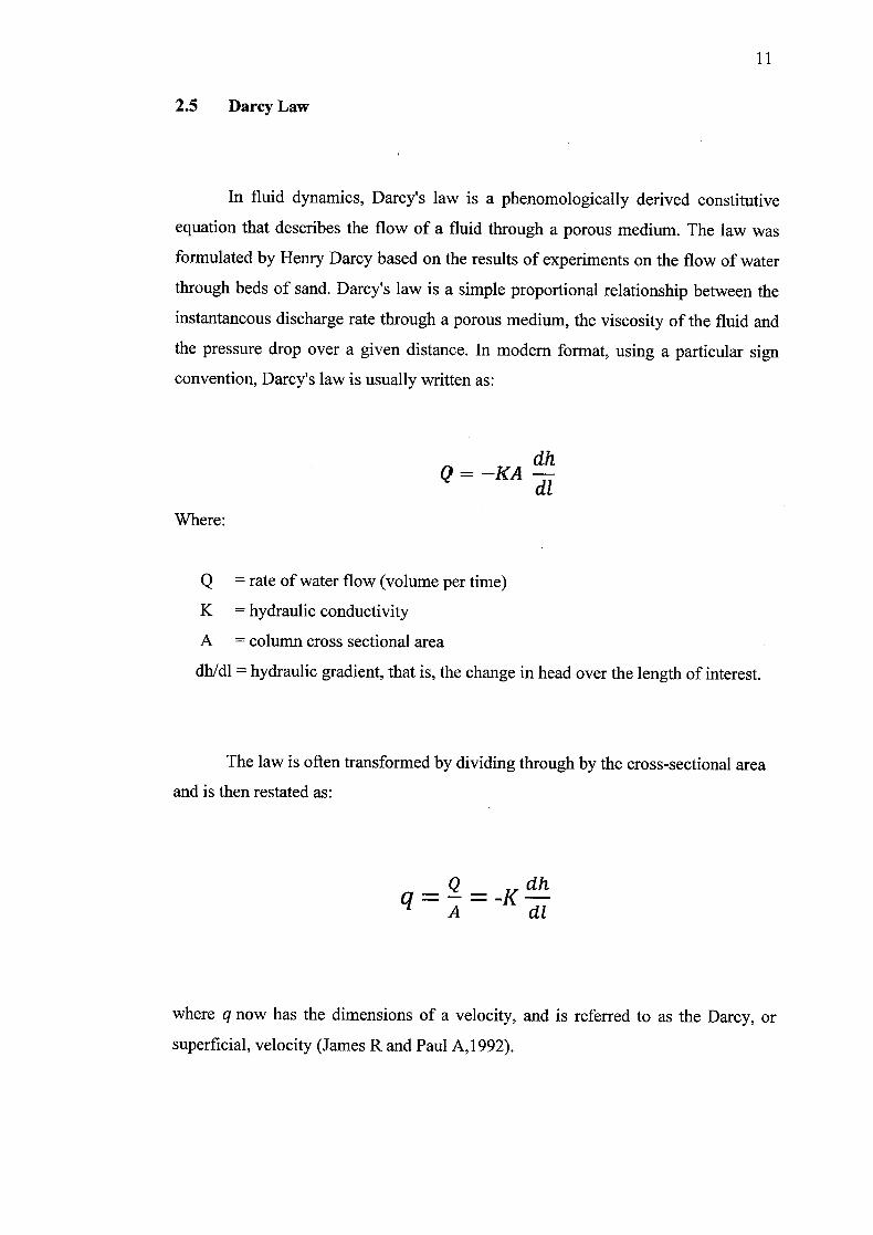
2.5 Darcy Law
In fluid dynamics, Darcy's law is a phenomologically derived constitutive
equation that describes the flow of a fluid through a porous medium. The law was
formulated by Henry Darcy based on the results of experiments on the flow of water
through beds of sand. Darcy's law is a simple proportional relationship between the
instantaneous discharge rate through a porous medium, the viscosity of the fluid and
the pressure drop over a given distance. In modern format, using a particular sign
convention, Darcy's law is usually written as:
dh Q==—KA
dl Where:
Q = rate of water flow (volume per time)
K = hydraulic conductivity
A = column cross sectional area
dhldl = hydraulic gradient, that is, the change in head over the length of interest.
The law is often transformed by dividing through by the cross-sectional area
and is then restated as:
q==-K A cli
where q now has the dimensions of a velocity, and is referred to as the Darcy, or
superficial, velocity (James R and Paul A,1992).

2.6 Method to Measure Permeability of Soil
2.6.1 Guelph Permeameter
The permeability can be measured efficiently in situ by using Guelph
Permeameter. The Guelph Permeameter is an easy to use instrument for quickly and
accurately measuring in-situ permeability of soil. The equipment is portable and
friendly use so it can be transported, installed and operated easily by one person.
Measurements can be made in half to two hours, depending on soil type, and require
only around 2.5 liters of water. Measurements can be made in the range of 15 to 75
cm below the soil surface. Accurate evaluation of soil hydraulic conductivity and
matrix flux potential can be made in all types of soils.
The Guelph permeameter, a constant-head well permeameter, regulates the
ponded head level, while measuring the flux of water into the soil from a cylindrical
Auger hole (Reynolds and Elrick, 1983). Reynolds and Elrick (1985) described the
steady flow of water out of a well into the soil in terms of three fluxes. The water
flows out of the well by a radial pressure gradient-induced flux and through the base
of the well, driven by both vertical pressure and the gravity gradient. The total flux is
described by Richard's equation for steady flow out of a cylindrical well:
Q = 2irH [! +(a)
C + Where
Kfs = the field-saturated hydraulic conductivity, (m s 1)
H = the ponded depth, (m)
A = the radius of the well, (m)
C = the matric potential as well as the H/a ratio
0. = matric flux potential


