Ircham Habib Anggara, Barandi Sapta Widartono, Florence Elfriede Silalahi, and Suprajaka
Developing Prototype for Telecommunications Network Information System of PT. Telkom to Determine
Optimal Route in Phone Interference Handling Based on Floyd - Warshall Algorithm (8042)
FIG Working Week 2016
Recovery from Disaster
Christchurch, New Zealand 2-6 May 2016
1/25
Developing Prototype for Telecommunications Network Information
System of PT. Telkom to Determine Optimal Route in Phone Interference
Handling Based on Floyd - Warshall Algorithm
Ircham Habib ANGGARA, Barandi Sapta WIDARTONO, Florence Elfriede
SILALAHI, Suprajaka SUPRAJAKA, INDONESIA
Key words: optimal route, network analysis, Floyd-Warshall algorithm, telephone network,
geographical information system
Geoinformation, Spatial Planning
SUMMARY
Nowdays, many providers are emerging in Indonesia so that they lead high competition
among telecommunication operators to win over the public. As a state owned company that
has authorities on the development of telecommunications sector, especially for cables
telephone, PT. TELKOM also realize that, so they strive for a better service to the customers.
This research aims to create a spatial database and interactive telephone network information
system model of PT. Telkom by using Quickbird imagery derived from Google Earth, Global
Position System (GPS) and Geographical Information Systems (GIS) to determine the optimal
route telephone network for error handling based on Floyd-Warshall algorithm. Determination
of the optimal route is based on the variable impedance of the travel distance and travel time
derived from the length of road divided by the average speed of vehicles per road segment.
Subsequent tissue analysis results are integrated with GPS navigation technology to help a
network technician search for location of interference and network technicians to assist the
movement towards the location of the phone to crash in the field.
The result of the research is Telkom Bantul Optimal Route Information System (SIROTOL)
desktop based and stand alone application. This information system is made by combining a
visual programming language called Microsoft Visual Basic with ESRI Map Objects 2.2,
geographic information system applications developer software. SIROTOL optimal route
program can be acquired by ‘Spatial Programming with Floyd-Warshall Algorithm’, so it can
be applied to determine the optimal route accurately on Telkom Bantul’s error handling or at
least close to field conditions. It can be proved by field validation results which resulted in
accurate optimal route test value based on travel distance of 97.06% and travel time of
96.14%.
Ircham Habib Anggara, Barandi Sapta Widartono, Florence Elfriede Silalahi, and Suprajaka
Developing Prototype for Telecommunications Network Information System of PT. Telkom to Determine
Optimal Route in Phone Interference Handling Based on Floyd - Warshall Algorithm (8042)
FIG Working Week 2016
Recovery from Disaster
Christchurch, New Zealand 2-6 May 2016
2/25
Developing Prototype for Telecommunications Network Information
System of PT. Telkom to Determine Optimal Route in Phone Interference
Handling Based on Floyd - Warshall Algorithm
Ircham Habib ANGGARA, Barandi Sapta WIDARTONO, Florence Elfriede
SILALAHI, Suprajaka SUPRAJAKA, INDONESIA
1. INTRODUCTION
Indonesian national policy in the telecommunications sector has outlined substantially as set
out in the 1988 Broad Guidelines of State Policy (GBHN) that telecommunications
development continued to increase the range and quality of services by expanding networks
and telecommunications connections as well as improve efficiency. In line with that, public
telecommunications facilities has developed, spread, and reach out to the wider community.
The telecommunications company has a fundamental duty to provide public
telecommunications services in the country. The role of telecommunications services is
essentially enhances the efficiency and productivity of the industrial sector, trade, and
economy in general, so that the common priorities to be implemented is the range expansion
and increasing the services (Umar, 1995).
PT. Telkom as the a business entity in charge of the construction and development of the
telecommunications sector, particularly the telephone wires, trying to improve
telecommunications services to their customers. Improving the quality of telecommunication
services is currently focused on the addition new features and service improvement on
interrupt or error handling (phone interference handling) that occurred in the
telecommunication network. Improvements in the speed and precision on the interference
handling is an effort to improve the telecommunications service currently. Interference
handling is conducted by PT. Telkom based on the customer reports who are experiencing
interference on the telephone network.
Delays in phone interference handling is often caused by non-technical factors, the network
technicians were sent sometimes have difficulty in finding the location or address of the
customer who reports. The network technician who has been sent sometimes have difficulty
in finding a location or address disturbed customers. This is can be avoided if a network
technician know the spatial information about the telephone cable network and the road
network. PT. Telkom could solved the problem by preparing a database of spatial information
system of the customer's address and phone network components along with the analysis of
the optimal route determination to solve the problem delays phone interference handling.
Advances in technology remote sensing, geographic information systems (GIS) and Global
Positioning System (GPS) will facilitate the preparation of a database and information system
for determining the optimal route in efforts to increase telecommunications services,
especially in terms of speed and accuracy of handling phone interference.
PT. Telkom have an information system that is commonly called SISKA (Customers

Ircham Habib Anggara, Barandi Sapta Widartono, Florence Elfriede Silalahi, and Suprajaka
Developing Prototype for Telecommunications Network Information System of PT. Telkom to Determine
Optimal Route in Phone Interference Handling Based on Floyd - Warshall Algorithm (8042)
FIG Working Week 2016
Recovery from Disaster
Christchurch, New Zealand 2-6 May 2016
3/25
Information System) and COC (Customers Operation Center). Both of these information
systems were used to manage variety of existing data with high security and accuracy, from
network data, customer data, Service Level Guaranty for Customer (segmentation of service),
and customers subscription data. However, it was not enough to maximize customer service.
For example, information regarding the customer's address or components of the telephone
network, sometimes addressing consist of various kinds, such as addressing based on the
administrative location, street names, or landmarks, where the customer's home or
components of the telephone network. Sometimes there is still a confusing location while
search on the system, so it requires an addressing system that is unique and has a high
accuracy. That means an address of an information that a unique, single, and only imposed on
those locations.
This kind of information can only be found if addressing is based on the geographical
position. Spatially addressing system is done based on the plotting coordinates using a Global
Positioning System (GPS). Satellite use for positioning will facilitate the users of information
systems to obtain the information they wants, basically the basic concept of GPS positioning
is resection with distance, ie with distance measurement simultaneously to multiple GPS
satellites known coordinates (Abidin, 2002). GPS technology is also used to simplify the
search of phone interference handling location and to assist the movement of network
technicians to the location. The development of geographic information systems which grew
rapidly and particularly in network analyst. Analysis carried out for example to localize the
trouble happened through the analysis of query and determining the optimal route through the
network analyst. Network analyst of this research are used to solve effectiveness of the
network problems, in particular to resolve the problems of the optimal route in the handling of
interference phone.
Good modeling is approaching reality, reliable, and the results obtained high accuracy and
correctly. There are many algorithms that can be used to solve the optimal route search, both
conventional methods and heuristic methods. However, determining the optimal route in this
study requires algorithms that are able to provide the exact and accurate results. Thus, the
utilization of Floyd-Warshall algorithm is the right choice to resolve the issue of the optimal
route in aiding the handling of interference telephone network in this study.
2. DETERMINATION OF OPTIMAL ROUTE
2.1 Determination of Impedance Value
Determination of the optimal route related to sum of impedance values of every road that is
impassable. Optimal route is a route that has the smallest impedance value. Impedance value
commonly used is the mileage and travel times are derived from mathematical calculations
between road length divided by the speed of the vehicle speed per unit time. Length of the
road can be obtained easily from the interpretation of high-resolution remote sensing imagery
such as Quickbird imagery. However, data on vehicle speed per unit time at each road can’t
be obtained through image interpretation, so that direct measurements in the field is required.
The travel time is derived from road length (mileage) divided by the speed of the vehicle

Ircham Habib Anggara, Barandi Sapta Widartono, Florence Elfriede Silalahi, and Suprajaka
Developing Prototype for Telecommunications Network Information System of PT. Telkom to Determine
Optimal Route in Phone Interference Handling Based on Floyd - Warshall Algorithm (8042)
FIG Working Week 2016
Recovery from Disaster
Christchurch, New Zealand 2-6 May 2016
4/25
speed per unit time. Determination of the optimal route is based on the sum of impedance
values of every road that passed between the starting point to the destination point.
V = t
S............................................. (1)
t = V
S............................................. (2)
Where :
V = average speed (km/ h)
S = the distance travelled by the object (length segments – km)
t = the duration of the interval travel time along the road segment (h)
The database network in this study was based on results of Quickbird image interpretation
which captured from Google Earth. GPS navigation is used to determine GCP (ground control
point) on geometric correction for Quickbird imagery sourced from Google Earth. GPS
navigation is also used as a tool for plotting and tracking Telkom network to test the model's
accuracy for optimal route. Use of Quickbird imagery is to get road network data more
accurate (in accordance with actual conditions in the field). The length of road derived from
road network data from the Quickbird image interpretation which captured from Google
Earth, while data regarding vehicle speed per unit time at each road segment is obtained from
direct measurements in the field with velocity method point (spot speed). Based on calculated
distance (mileage) and impedance factor, the most efficient path can be determined, more than
just the shortest path. Nodes can be coded as a point of stopping, which shows the traffic
control lights and interchange. Based on the difficulty of turning left or turning right at an
intersection, and even could also marked as obstacles that slow the velocity of the vehicle to
go somewhere. As well mileage, all variable are taken from road condition, intersection, etc.
(Arham, 2002).
2.2 Algorithm For Determination of Optimal Route
Determination of the optimal route from one point / point to point / elsewhere is a problem
which is faced in everyday life. Along with running time, the problem of determining the
optimal route has been solved by various algorithms. Some popular algorithms that can solve
the problem of finding the optimal route is the Dijkstra algorithm and Floyd-Warshall
algorithm. Dijkstra's algorithm is a variant of the greedy algorithm, which is one form of
popular algorithms in solving problems related to optimization problems.
In accordance with the meaning which literally means greedy, but not in a negative context,
greedy algorithm is only thinking of the best solution which will be taken at each step without
thinking of the consequences ahead. In principle, take what you can get at the moment, and
the decisions taken at each step can’t be changed back. The point of this greedy algorithm
seeks to make a selection of local optimum value at every step and hope that this leads to a
local optimum value to the global optimum value (Novandi, 2007). Floyd-Warshall algorithm
is one of the optimal route search algorithm which is a variant of the dynamic programming,

Ircham Habib Anggara, Barandi Sapta Widartono, Florence Elfriede Silalahi, and Suprajaka
Developing Prototype for Telecommunications Network Information System of PT. Telkom to Determine
Optimal Route in Phone Interference Handling Based on Floyd - Warshall Algorithm (8042)
FIG Working Week 2016
Recovery from Disaster
Christchurch, New Zealand 2-6 May 2016
5/25
the algorithm considers that a solution will be obtained a decision interrelated, so that the
solution formed from the solution coming from the previous stage. That is, the Floyd-
Warshall algorithm compares all possible trajectories in a graph / line for each side of all
nodes.
Things that differentiate finding optimal solutions using the dynamic programming with the
greedy algorithm is that the decisions taken at each stage of the greedy algorithm is only
based on limited information so that the optimum value obtained at that time. On the greedy
algorithm, we do not think about the consequences that would happen if we choose a decision
at any stage. In some cases, the greedy algorithm fails to provide the best solution because of
its weakness earlier. This is where the role of dynamic programming try to provide solutions
which have a thought for the consequences arising from the decision-making on a stage.
Dynamic programming can reduce the enumeration decisions which isn’t lead to a solution.
That principle held by dynamic programming is the principle of optimality, that is if the
optimal total solution then the solution to a stage (for example stage-i) is also optimal
(Novandi, 2007).
SIROTOL testing program is in addition aimed to test the function of all controls contained in
SIROTOL program, also aimed to compare the results of the optimal route program with the
actual situation in the field, where field testing done with several different routes to get to
error location. Determination of the optimal route in the program done based on the road
network and telephone cable network. Determination of the optimal route based on the road
network is done by two methods, the optimal route by considering the closest distance and
optimal route taking into account the fastest time. While determining the route based
telephone cable network is a method of determining the route to search telephone cable
network (tracing).
The selected study area is a service area of automatic telephone exchange (STO) Bantul in the
form local copper network access with ration indirectly. Bantul district is located between 07º
44 '04' - 08º 00 '27 "South latitude and 110º 12' 34" - 110º 31 '08 "East Longitude. Bantul
Regency has an area of 506.85 km2 is divided administratively into 17 districts, 75 villages
and 933 hamlets. Indirect supply network is a local cable network where customers air
supplied from the Distribution Point (DP) nearby connected prior to the Feeder Point (RK)
before being connected to the Main Distribution Frame (RPU) as in Figure 1 and Figure 2.
The use of indirect supply network is also used in cities and towns and are used to distribute
local customers scattered and far away. The telephone network in Bantul almost distributed in
every region, both in the urban areas, the city of Bantul, as well as in other sub-districts is still
a rural area, so that variations in the location of the customer and the type of the existing road
network makes it possible to obtain results more complex analysis.
Figure 1. Basic Configuration of Local Copper Network Access

Ircham Habib Anggara, Barandi Sapta Widartono, Florence Elfriede Silalahi, and Suprajaka
Developing Prototype for Telecommunications Network Information System of PT. Telkom to Determine
Optimal Route in Phone Interference Handling Based on Floyd - Warshall Algorithm (8042)
FIG Working Week 2016
Recovery from Disaster
Christchurch, New Zealand 2-6 May 2016
6/25
Figure 2. Indirect Supply Network Configuration.
(Source:http://pogotel.blogspot/2008/07/jaringan-lokal-akses-tembaga-jarlokar.html)
Where :
STO : automatic telephone exchange (Sentral Telepon Otomat)
RPU / MDF : Main Distribution Frame (Rangka Pembagi Utama)
KP / DP : Distribution Point (Kotak Pembagi)
KTB / TB : Terminal Block (Kotak Terminal Batas)
Pswt : telephone
Kabel Primer : The primary cable
2.3 The preparation of Road Network Database
Network database can basically be made from shapefile type of line, either pre-existing or
feature class type of line which contained in the geodatabase. Network database has two
characteristics as follow :
a. Between the arc must be connected, because if it is not connected then the road will be
considered broken.
b. Field name that contains information about the condition of the road network must
also follow the standard naming rules. Standard field name is used to declare the unit
cost of the network database can be seen in Table 1. Besides field names are listed in
Table 1,
Table 1. The Field Standard Name of Network Database
Unit cost
Field Standard Name
FT = TF
From-To = To-From
Field Standard Name
FT ≠ TF
From-To ≠ To-From
Seconds SECONDS FT_SECONDS and TF_SECONDS
Minutes MINUTES
FT_MINUTES and TF_MINUTES or
FT_DRIVETIME and TF_DRIVETIME or
FT_IMPEDANCE and TF_IMPEDANCE or
FT_TRAVELTIME and TF_TRAVELTIME
Hours HOURS FT_HOURS and TF_HOURS
Milimeters MILIMETERS FT_MILIMETERS and TF_MILIMETERS
Centimeters CENTIMETERS FT_ CENTIMETERS and TF_ CENTIMETERS
Meters METERS FT_METERS and TF_METERS
Kilometers KILOMETERS FT_ KILOMETERS and TF_ KILOMETERS
Inches INCHES FT_ INCHES and TF_ INCHES
Ircham Habib Anggara, Barandi Sapta Widartono, Florence Elfriede Silalahi, and Suprajaka
Developing Prototype for Telecommunications Network Information System of PT. Telkom to Determine
Optimal Route in Phone Interference Handling Based on Floyd - Warshall Algorithm (8042)
FIG Working Week 2016
Recovery from Disaster
Christchurch, New Zealand 2-6 May 2016
7/25
Yards YARDS FT_ YARDS and TF_ YARDS
Feet FEET FT_FEET and TF_FEET
Miles MILES FT_ MILES and TF_ MILES
Nautical miles NAUTICALMILES FT_ NAUTICALMILES and TF_
NAUTICALMILES
Non-time/
non-distance units,
such as monetary unit
COST or UNITS
FT_COST and TF_COST
FT_UNITS and TF_UNITS
Source: Raharja, 2010
There are other field namely ONEWAY or ONE_WAY to declare that a line can be
passed in two directions, one direction, or closed to pass. The information regarding
road conditions should be included in the preparation of the network database (see
Table 2)
Table 2. Field Information Network Database Field Type Field Size Contents
TF_MINUTES Short Integer Default According table of travel time
FT_MINUTES Short Integer Default
ONEWAY Text 10
According to the route :
FT = dari From ke To junction
TF = dari To ke From junction
B = two-way street
N = the road can ‘t be bypassed
Jalan Text 25 Address / road names
Length Long Integer Default Length of road
Source: Raharja, 2010
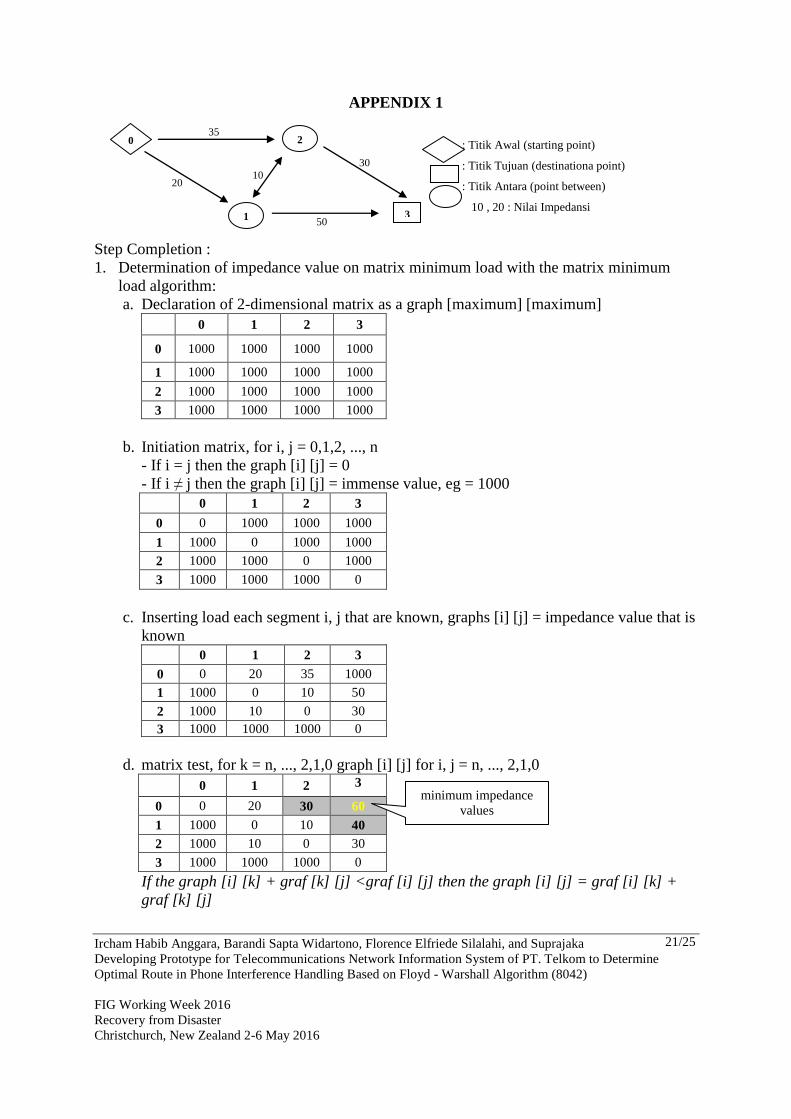
2.4 Determination of Optimal Route Based on Floyd-Warshall Algorithm
The default starting point in this study is automatic telephone exchange or sentral telepon
otomat (STO) Bantul, a place for complaints phone interference for service area STO Bantul
and also from other network component or even from other customers, while the point of aim
is a component phone network (Feeder Point and Distribusion Point) and customers who
reported phone interference.
Floyd-Warshall algorithm is an algorithm for finding the optimal route with the smallest
impedance value of all the paths that connect a pair of points and do it all at once to all the
other pair of points, so it would be advantageous in finding the optimal solution for the
shortest path. There are two main algorithms in determining the optimal route with the Floyd-
Warshall algorithm, that minimum load matrix algorithm and minimum load path matrix
algorithm. Minimum load matrix algorithm is an algorithm used to calculate the smallest
impedance value obtained in a movement from point of origin to point of destination. The
minimum load path matrix algorithm is an algorithm used to determine the route to be taken
from the origin to the destination point which has the smallest impedance value as that
produced in the matrix algorithm minimum load. Examples of determining the optimal route
from the starting point to the destination point by Floyd-Warshall algorithm see Appendix 1.

Ircham Habib Anggara, Barandi Sapta Widartono, Florence Elfriede Silalahi, and Suprajaka
Developing Prototype for Telecommunications Network Information System of PT. Telkom to Determine
Optimal Route in Phone Interference Handling Based on Floyd - Warshall Algorithm (8042)
FIG Working Week 2016
Recovery from Disaster
Christchurch, New Zealand 2-6 May 2016
8/25
3. PREPARING THE IMAGE
Remote sensing imagery used in this study is the Quickbird imagery sourced from Google
Earth. Quickbird image acquisition is done through the process of capturing. This process
begins with determining the boundary preferred area then do capturing process. The scope of
this study area is in the latitude and longitude coordinates, whether it boundary the the top and
bottom of latitude, and boundary coordinates the leftmost and rightmost of longitude from the
coverage preferred area. The digitization process in this research is conducted to obtain data
on the road network from Quickbird image. Results of subsequent digitization is used as input
in the preparation of the road network in the network database analyst.
This study only uses magnification of 18 (a maximum magnification of Google Satellite Maps
Downloader 6:46, could reach 22), the quality of the resulting image has been considered
good enough for object recognition in the the appearance of the road network. Moreover,
determination of the amount of magnification also affect the length of the capturing process
and memory size of the resulting image file. The amount of memory image file produced is
also considered in this study because that image will be used as the background display in the
information system, where the file sizes will affect the process of loading data and execution
of a system, so that the files used in the construction of this information system be pursued in
minimum size.
Quickbird image capturing results from Google Earth has quality under the original, either
spatial resolution or radiometric resolution of the image. Quickbird original has high spatial
resolution up to 0.6 m and a radiometric resolution with 11 bit digital coding in the Google
Earth application has experience the process of resampling, resulting in geometry and size of
the new pixel value. Based on data analysis known that this resampling process has caused
shortening size of the pixel image from its original size 0.60 meters to 0.59 meters. This will
certainly have an impact on the reduction of detail of presented information and the geometric
quality of the image. Radiometric quality of the images reflected in the ability of the sensor to
record the spectral response of the object to be reflected or emitted. The ability of the sensor
associated with the coding capability (digital coding) that is expressed in bits. Quickbird
image of the original has a 11-bit coding systems that change the intensity of the reflected or
emitted into 211
= 2048 levels of brightness. Unlike the Quickbird image capturing results of
Google Earth has 8-bit coding system, wherein the signal with the same intensity range of the
image to be converted into 28 = 256 levels of brightness.
This resulted in the image ability to visualize the appearance in which the image with a higher
bit coding is able to present the appearance with the number of color levels more, so that an
object appearance will be more obvious or more easily distinguished by the other. This
happens because the satellite images on Google Earth in general has deteriorated, especially
in spatial resolution and radiometric resolution. Decline in quality is also caused by the
treatment in the process of capturing. Nevertheless, it can be said Quickbird image quality
good enough to be used as a relatively good spatial resolution, there is no cloud cover, and the
data to be extracted is the road network data is relatively easy to recognize.
Ircham Habib Anggara, Barandi Sapta Widartono, Florence Elfriede Silalahi, and Suprajaka
Developing Prototype for Telecommunications Network Information System of PT. Telkom to Determine
Optimal Route in Phone Interference Handling Based on Floyd - Warshall Algorithm (8042)
FIG Working Week 2016
Recovery from Disaster
Christchurch, New Zealand 2-6 May 2016
9/25
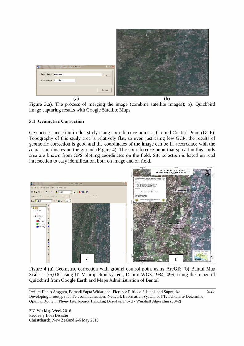
(a) (b)
Figure 3.a). The process of merging the image (combine satellite images); b). Quickbird
image capturing results with Google Satellite Maps
3.1 Geometric Correction
Geometric correction in this study using six reference point as Ground Control Point (GCP).
Topography of this study area is relatively flat, so even just using few GCP, the results of
geometric correction is good and the coordinates of the image can be in accordance with the
actual coordinates on the ground (Figure 4). The six reference point that spread in this study
area are known from GPS plotting coordinates on the field. Site selection is based on road
intersection to easy identification, both on image and on field.
Figure 4 (a) Geometric correction with ground control point using ArcGIS (b) Bantul Map
Scale 1: 25,000 using UTM projection system, Datum WGS 1984, 49S, using the image of
Quickbird from Google Earth and Maps Administration of Bantul
a b
Ircham Habib Anggara, Barandi Sapta Widartono, Florence Elfriede Silalahi, and Suprajaka
Developing Prototype for Telecommunications Network Information System of PT. Telkom to Determine
Optimal Route in Phone Interference Handling Based on Floyd - Warshall Algorithm (8042)
FIG Working Week 2016
Recovery from Disaster
Christchurch, New Zealand 2-6 May 2016
10/25
3.2 Interpretation of Road Network
Road network data is digital data entry in the analysis for the determination of the optimal
handling phone interference. The road network data was obtained through the image
interpretation of road network from Quickbird with on-screen digitizing method. The
difficulties that often faced is the interpretation of the road network that went into the village,
covered by the residential building, and sometimes covered by high density of vegetation.
However, this can be resolved by using Topographic Map of Indonesia (RBI), namely Map
RBI Bantul and Yogyakarta sheet’s with scale 1: 25,000, as well a map of the road network
which is sourced from the Department of Public Works Bantul as a guide in the process of
interpretation network road. Map of the road network which is sourced from the Bantul
Department of Public Work, and also used as input data to fulfill attribute name of road in this
study.
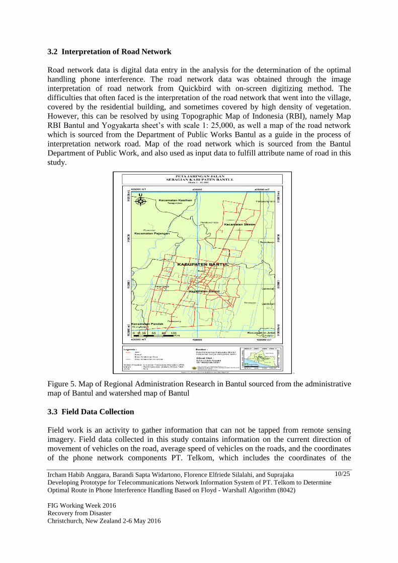
Figure 5. Map of Regional Administration Research in Bantul sourced from the administrative
map of Bantul and watershed map of Bantul
3.3 Field Data Collection
Field work is an activity to gather information that can not be tapped from remote sensing
imagery. Field data collected in this study contains information on the current direction of
movement of vehicles on the road, average speed of vehicles on the roads, and the coordinates
of the phone network components PT. Telkom, which includes the coordinates of the

Ircham Habib Anggara, Barandi Sapta Widartono, Florence Elfriede Silalahi, and Suprajaka
Developing Prototype for Telecommunications Network Information System of PT. Telkom to Determine
Optimal Route in Phone Interference Handling Based on Floyd - Warshall Algorithm (8042)
FIG Working Week 2016
Recovery from Disaster
Christchurch, New Zealand 2-6 May 2016
11/25
customer, Distribution Point, Feeder Point, and STO. Information about the current direction
of vehicles movement and vehicle speed data average on roads are used to construct the road
network database. Information about the current direction of vehicles movement on the road
obtained through field checks to determine the condition of a road, whether the road is a one
way or a two-way.
Selection of the sample in the check direction of movement of vehicles on the roads is done
by using purposive sampling method, the sample selection is only aimed at the road network
is not yet known and preferred direction of movement of vehicles on the road section that
passed by cable network telephone PT. Telkom. Data on average vehicle speed for each road
segment is obtained by direct measurements in the field. Measurement speed of the vehicle is
done by using a speed survey point (spot speed), the method of measuring the speed of
moving vehicles where the observer to observe the speed of vehicles which have been
classified, which in this study in the form of two-wheeled vehicles (motorcycles), the road is
restricted as far as 100 meter, and observers began to take the time when the vehicle began to
cross the mark I to mark II. Observations were carried out three times in a row on any road.
a vehicle speed measurement in this study did not take the peak time, but adapted to the
working hours of employees of PT. Telkom, who handling phone interference is served from
08.00am to 16.00pm. Measurement speed of the vehicle is using spot speed survey, the
method of measuring by observing the speed of vehicles that have been classified on two-
wheeled vehicles (motorcycles), roads is limited to maximum 100 meters, and observers
began take the time when the vehicle began to cross the mark I to mark II. These observations
were performed three times in a row for each road. Field activities intended to perform
plotting the coordinates of the phone network components PT. Telkom and build road
network database. Data collected includes the coordinates of the customer, Distribution Point
(DP), Feeder point (RK), and automatic telephone exchange (STO) through plotting the
coordinates with the GPS. This coordinate data is the data compilers spatial database PT.
Telkom and also aimed to check the telephone cable network PT Telkom.
3.4 Preparation of Spatial Data Bases PT. Telkom
Spatial database PT. Telkom that built in this research include telephone customer databases
and databases of telephone cable network. Telephone customer database PT. Telkom is a
collection of spatial information about the customer position/coordinate with telephone
history information, such as customer name, customer address, telephone number, and
information components of the telephone network. This database is the result between the
spatial data customer in the form of coordinates which is obtained from plotting with GPS in
the field and tabular data (attributes) about telephone history information from Customer
Information System (SISKA) PT. Telkom.
Ircham Habib Anggara, Barandi Sapta Widartono, Florence Elfriede Silalahi, and Suprajaka
Developing Prototype for Telecommunications Network Information System of PT. Telkom to Determine
Optimal Route in Phone Interference Handling Based on Floyd - Warshall Algorithm (8042)
FIG Working Week 2016
Recovery from Disaster
Christchurch, New Zealand 2-6 May 2016
12/25
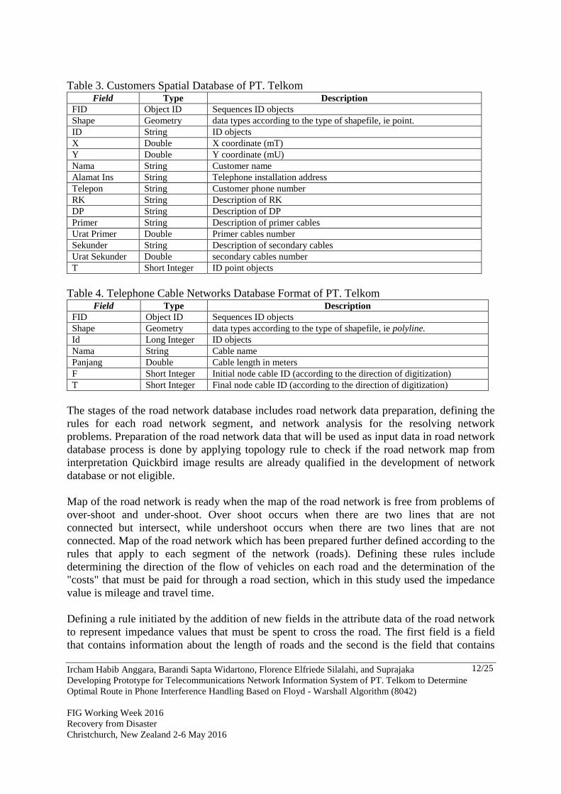
Table 3. Customers Spatial Database of PT. Telkom Field Type Description
FID Object ID Sequences ID objects
Shape Geometry data types according to the type of shapefile, ie point.
ID String ID objects
X Double X coordinate (mT)
Y Double Y coordinate (mU)
Nama String Customer name
Alamat Ins String Telephone installation address
Telepon String Customer phone number
RK String Description of RK
DP String Description of DP
Primer String Description of primer cables
Urat Primer Double Primer cables number
Sekunder String Description of secondary cables
Urat Sekunder Double secondary cables number
T Short Integer ID point objects
Table 4. Telephone Cable Networks Database Format of PT. Telkom Field Type Description
FID Object ID Sequences ID objects
Shape Geometry data types according to the type of shapefile, ie polyline.
Id Long Integer ID objects
Nama String Cable name
Panjang Double Cable length in meters
F Short Integer Initial node cable ID (according to the direction of digitization)
T Short Integer Final node cable ID (according to the direction of digitization)
The stages of the road network database includes road network data preparation, defining the
rules for each road network segment, and network analysis for the resolving network
problems. Preparation of the road network data that will be used as input data in road network
database process is done by applying topology rule to check if the road network map from
interpretation Quickbird image results are already qualified in the development of network
database or not eligible.
Map of the road network is ready when the map of the road network is free from problems of
over-shoot and under-shoot. Over shoot occurs when there are two lines that are not
connected but intersect, while undershoot occurs when there are two lines that are not
connected. Map of the road network which has been prepared further defined according to the
rules that apply to each segment of the network (roads). Defining these rules include
determining the direction of the flow of vehicles on each road and the determination of the
"costs" that must be paid for through a road section, which in this study used the impedance
value is mileage and travel time.
Defining a rule initiated by the addition of new fields in the attribute data of the road network
to represent impedance values that must be spent to cross the road. The first field is a field
that contains information about the length of roads and the second is the field that contains
Ircham Habib Anggara, Barandi Sapta Widartono, Florence Elfriede Silalahi, and Suprajaka
Developing Prototype for Telecommunications Network Information System of PT. Telkom to Determine
Optimal Route in Phone Interference Handling Based on Floyd - Warshall Algorithm (8042)
FIG Working Week 2016
Recovery from Disaster
Christchurch, New Zealand 2-6 May 2016
13/25
information about the travel time where there are two different conditions that affect the
naming of this field, are: 1) if both directions (back and forth) in one segment of the line has
impedance values the same (FT = TF), and 2) if both directions have different impedance
values (FT ≠ TF). The road network in this study had a different impedance values in both
directions, then there are two fields that are added, the field FT_MINUTES and
TF_MINUTES. MINUTES suffix used for travel time unit used is minutes away, while the
FT and TF prefix indicates the value of the load on the road section on each segment
differentiated according to the direction of digitization.
Tabel 5. Road Network Database Format Field Name Type Description
FID Object ID Sequences ID objects
Shape Geometry Data types according to the type of shapefile
Id Long Integer ID objects
Nama String Road name
Panjang Double Road length in meters
ft_V Double The average vehicle speed from initial node to final node
tf_V Double The average vehicle speed from final node to initial node
FT_MINUTES Double The travel time from initial node to final node (according to the direction
of digitization)
TF_MINUTES Double The travel time from final node to initial node (according to the direction
of digitization)
F Short Integer initial node ID (according to the direction of digitization)
T Short Integer final node ID (according to the direction of digitization)
4. DEVELOPING OPTIMAL ROUTE INFORMATION SYSTEM PT. TELKOM
BANTUL BASED ON FLOYD - WARSHALL ALGORITHM
Optimal route information system for handling phone interference PT. Telkom is based on
GIS-desktop which is operated through the computer without connecting to the internet
(stand-alone application). This is due to the use of GIS Component, where geographic
information system products such as ESRI Map Objects inserted into Visual Basic
programming language. The program consists of three main parts (program code in appendix
2), namely the part of the map, a menu bar and tool bar. Part of the map is the main content of
the information system that includes data raster and vector data. Raster data consists of
Quickbird imagery that function as the background of this information system, whereas the
vector data consists of a map of the road network, map of telephone cable network, map of
telephone network components, and map of administrative boundary. Section menu bar itself
is divided into three submenus, namely: location determination, sequence locations, and route
determination. Location determination menu is the first menu in determining the optimal route
when handling phone interference happen. In this menu the user must specify the starting
point departure of technician which is from STO Bantul office or network components other
phone, as well as customer data telephone and location to be addressed (destination point) or
phone network components that susceptible to interference (DP and RK).

Ircham Habib Anggara, Barandi Sapta Widartono, Florence Elfriede Silalahi, and Suprajaka
Developing Prototype for Telecommunications Network Information System of PT. Telkom to Determine
Optimal Route in Phone Interference Handling Based on Floyd - Warshall Algorithm (8042)
FIG Working Week 2016
Recovery from Disaster
Christchurch, New Zealand 2-6 May 2016
14/25
Figure 6. Optimal Route Information System Telkom Bantul (a) display program (b) location
determination menu (c) route determination menu (d) sequence locations menu
5. Optimal Route Information System Testing
Testing program is presented in three different cases for the know the benefits of this
information system. The first case is the determination of the optimal route of Bantul STO
office in Jalan Wahidin Sudiro Husodo, to address the impaired telephone customers, which
in this case is PT Cahaya Mulia Persada. Method of determining the optimal route here is
done in two ways: first, obtained the optimal route based on the shortest mileage, wherein the
impedance value in determining the routes obtained from the attribute data path length
(meters); second, the optimal route is obtained based on the fastest travel time, where the
value of the impedance in determining the routes obtained from the data attributes and
TF_MINUTES FT_MINUTES.
Table 6. Testing Results from STO Bantul to PT Cahaya Mulia Persada
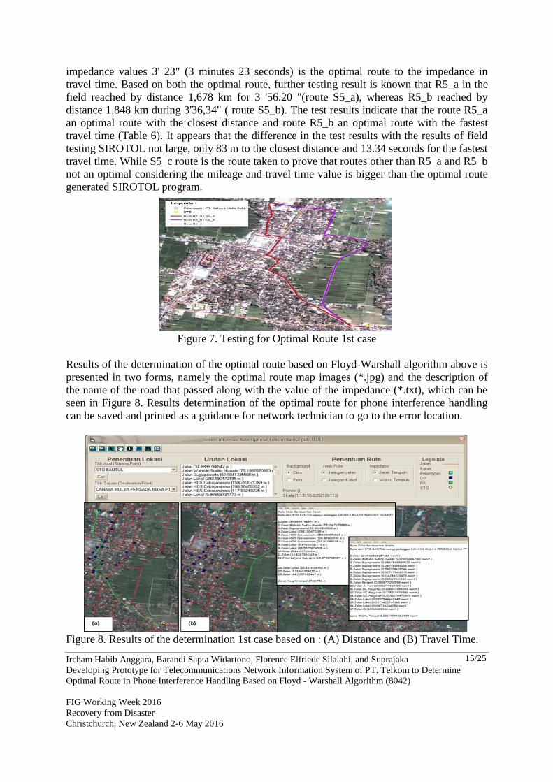
Optimal route R5_a with impedance value of 1,761 km is the optimal route test results
SIROTOL program with an impedance in the mileage, whereas the optimal route R5_b with
SIROTOL RESULT FIELD SURVEY
Impedance Result
Sample Impedance
Optimal Route Impedance Length time
Length R5_a 1,761 km S5_a 1,678 km 3’ 56,20”
time R5_b 3’ 23”
S5_b 1,848 km 3’ 36,34”
S5_c 2,476 km 4’ 08,10”
a
b
c
d
Ircham Habib Anggara, Barandi Sapta Widartono, Florence Elfriede Silalahi, and Suprajaka
Developing Prototype for Telecommunications Network Information System of PT. Telkom to Determine
Optimal Route in Phone Interference Handling Based on Floyd - Warshall Algorithm (8042)
FIG Working Week 2016
Recovery from Disaster
Christchurch, New Zealand 2-6 May 2016
15/25
impedance values 3' 23" (3 minutes 23 seconds) is the optimal route to the impedance in
travel time. Based on both the optimal route, further testing result is known that R5_a in the
field reached by distance 1,678 km for 3 '56.20 "(route S5_a), whereas R5_b reached by
distance 1,848 km during 3'36,34" ( route S5_b). The test results indicate that the route R5_a
an optimal route with the closest distance and route R5_b an optimal route with the fastest
travel time (Table 6). It appears that the difference in the test results with the results of field
testing SIROTOL not large, only 83 m to the closest distance and 13.34 seconds for the fastest
travel time. While S5_c route is the route taken to prove that routes other than R5_a and R5_b
not an optimal considering the mileage and travel time value is bigger than the optimal route
generated SIROTOL program.
Figure 7. Testing for Optimal Route 1st case
Results of the determination of the optimal route based on Floyd-Warshall algorithm above is
presented in two forms, namely the optimal route map images (*.jpg) and the description of
the name of the road that passed along with the value of the impedance (*.txt), which can be
seen in Figure 8. Results determination of the optimal route for phone interference handling
can be saved and printed as a guidance for network technician to go to the error location.
Figure 8. Results of the determination 1st case based on : (A) Distance and (B) Travel Time.

Ircham Habib Anggara, Barandi Sapta Widartono, Florence Elfriede Silalahi, and Suprajaka
Developing Prototype for Telecommunications Network Information System of PT. Telkom to Determine
Optimal Route in Phone Interference Handling Based on Floyd - Warshall Algorithm (8042)
FIG Working Week 2016
Recovery from Disaster
Christchurch, New Zealand 2-6 May 2016
16/25
The second case is similar to the first case, but in this case the optimal route SIROTOL
program show that the optimal route based on the impedance value of mileage and travel time
have the same route. Testing of the second case is intended to find the optimal route from
STO Bantul to the Office of the Election Commission (KPUD) Bantul in Wakhid Hashim
street. The results of this second case, the optimal route taken through routes R3_a with
distance 2,224 km for 3 '30 " (Table 7). These SIROTOL optimal program outcomes showed
the same results with the results of testing in the field, where the route S3_a taken at a
distance of 2,194 km for 3 '24.96 "is the route with the distance of the closest and fastest
travel time (Figure 9 and Figure 10).
Table 7. Testing Results from STO Bantul to the Election Commission (KPUD) Bantul
Figure 9. Testing for Optimal Route 2nd case
SIROTOL RESULT FIELD SURVEY
Impedance Result
sample Impedance
Optimal Route Impedance length time
Length R3_a 2,224 km S3_a 2,194 km 3’ 24,96”
Time R3_a 3 ‘ 30” S3_b 2,718 km 4’ 21,63”
S3_c 2,341 km 4’ 14,28”
Ircham Habib Anggara, Barandi Sapta Widartono, Florence Elfriede Silalahi, and Suprajaka
Developing Prototype for Telecommunications Network Information System of PT. Telkom to Determine
Optimal Route in Phone Interference Handling Based on Floyd - Warshall Algorithm (8042)
FIG Working Week 2016
Recovery from Disaster
Christchurch, New Zealand 2-6 May 2016
17/25
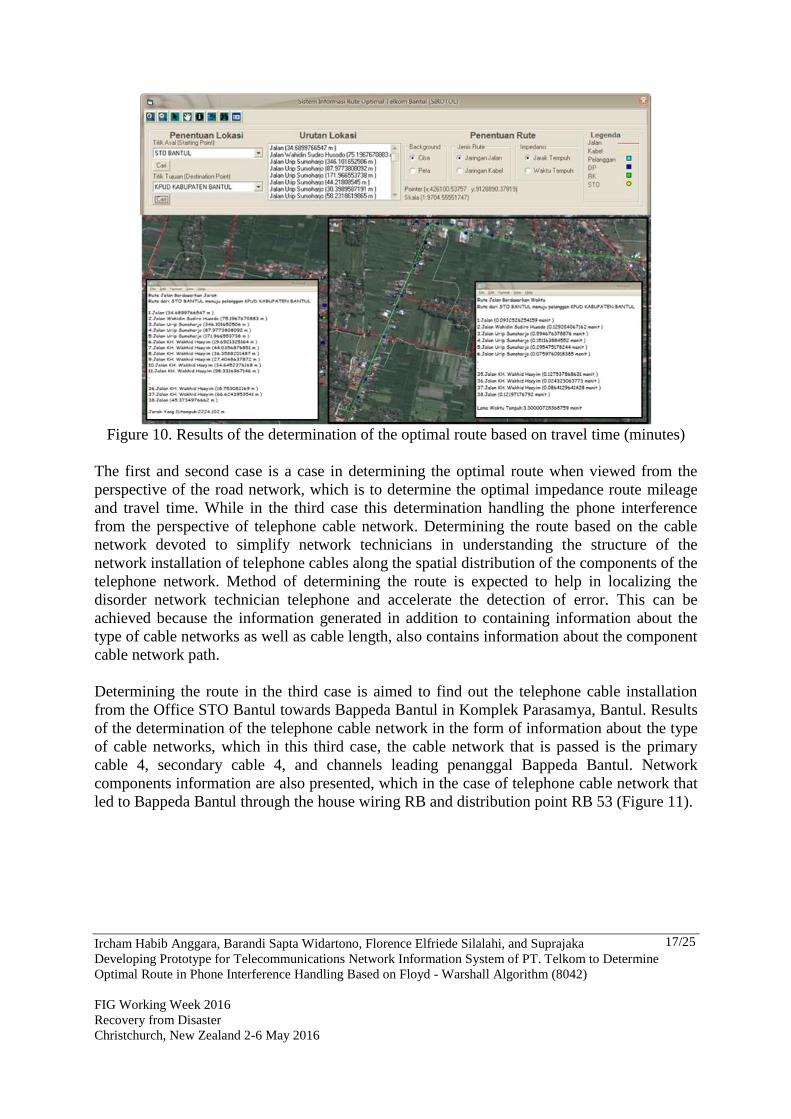
Figure 10. Results of the determination of the optimal route based on travel time (minutes)
The first and second case is a case in determining the optimal route when viewed from the
perspective of the road network, which is to determine the optimal impedance route mileage
and travel time. While in the third case this determination handling the phone interference
from the perspective of telephone cable network. Determining the route based on the cable
network devoted to simplify network technicians in understanding the structure of the
network installation of telephone cables along the spatial distribution of the components of the
telephone network. Method of determining the route is expected to help in localizing the
disorder network technician telephone and accelerate the detection of error. This can be
achieved because the information generated in addition to containing information about the
type of cable networks as well as cable length, also contains information about the component
cable network path.
Determining the route in the third case is aimed to find out the telephone cable installation
from the Office STO Bantul towards Bappeda Bantul in Komplek Parasamya, Bantul. Results
of the determination of the telephone cable network in the form of information about the type
of cable networks, which in this third case, the cable network that is passed is the primary
cable 4, secondary cable 4, and channels leading penanggal Bappeda Bantul. Network
components information are also presented, which in the case of telephone cable network that
led to Bappeda Bantul through the house wiring RB and distribution point RB 53 (Figure 11).

Ircham Habib Anggara, Barandi Sapta Widartono, Florence Elfriede Silalahi, and Suprajaka
Developing Prototype for Telecommunications Network Information System of PT. Telkom to Determine
Optimal Route in Phone Interference Handling Based on Floyd - Warshall Algorithm (8042)
FIG Working Week 2016
Recovery from Disaster
Christchurch, New Zealand 2-6 May 2016
18/25
Figure 11. Results of the determination of the telephone cable network.
Analytical ability and level of usefulness of this program in providing optimal route
information is done by comparing the analysis results with the results of the field survey
program. The less difference between the results of the analysis with the results of the field
program, the level of confidence in the data and analysis results higher. Field testing is done
by tracing some of the results of the program is the optimal route using two-wheeled vehicles
(motorcycles) during office hours or when the phone service interference lasted, between
08.00am - 16.00pm. The parameters tested include mileage and travel time when an optimal
route taken by the vehicle speed range between 45 km/h to 60 km/h. Based on the results of
testing known that the accuracy test the optimal route based on mileage of 97.06% and an
accuracy test value based on the optimal route travel time of 96.14% (Table 8). Value test
accuracy of 95% indicates that the information system has been successfully completed and
the optimal route problems can be utilized in the handling of phone interference PT. Telkom,
especially in the search for fault location and optimal route to get to the fault location, either
nearby or travel route takes the quickest route.
Table 8. the results of the optimal route program from STO Bantul to customer
Customers
Optimal Route
Program Field survey
Difference/
deviation Akurasi (%)
length time
length time
length Waktu length time
(km) (km) (km) (sec)
Bappeda Kab. Bantul 1.325 2’ 59” 1.25 2’ 42” 0.075 17 94.34 90.50
Perusahaan Kayu Jati
Agung 2.01 3’ 15” 1.944 3’ 13” 0.066 2 96.72 98.97
KPUD Kab Bantul 2.224 3’ 3” 2.194 3’ 25” 0.03 5 98.65 97.62
Suminah Jamhari 4.071 5' 59" 3.994 6' 06" 0.077 7 98.11 98.05
Drs. Pardiyono 3.785 5' 16" 3.756 5' 22" 0.029 6 99.23 98.10
PT Cahaya Mulia
Persada 1.761 3’ 23” 1.678 3’ 36” 0.083 13 95.29 93.60
Accuracy (%) 97.06 96.14
Ircham Habib Anggara, Barandi Sapta Widartono, Florence Elfriede Silalahi, and Suprajaka
Developing Prototype for Telecommunications Network Information System of PT. Telkom to Determine
Optimal Route in Phone Interference Handling Based on Floyd - Warshall Algorithm (8042)
FIG Working Week 2016
Recovery from Disaster
Christchurch, New Zealand 2-6 May 2016
19/25
REFERENCES
Abidin, H. Z., (2002). Survei dengan GPS (Survey using GPS). Jakarta : PT. Pradnya
Paramita.
Arham, A. (2002). Penentuan Rute Optimal Mobil Pemadam Kebakaran dengan
Memanfaatkan Foto Udara Pankromatik Hitam Putih dan PC Network di Kecamatan
Gedongtengen Kota Yogyakarta (Determination of optimal route for fire engine by
utilizing aerial photo Panchromatic and PC Network in Gedongtengen district,
Yogyakarta). Yogyakarta: Fakultas Geografi UGM.
DeMers, M. N. (1997). Fundamentals of Geographic Information Systems. New York: John
Wiley and Sons, Inc.
ESRI, (2006). ArcGIS®
Schematics:Automatic Schematic Generation for ArcGIS, An
ESRI®
White Paper. New York: ESRI.
Kamal, M. (2006). Pemodelan dan Analisis Jaringan Menggunakan ArcView Network
Analyst (Network modeling and analysis using ArcView network analyst).
Yogyakarta: Fakultas Geografi UGM.
Lillesand, T. M., dan R. W. Kiefer. (1990). Penginderaan Jauh dan Interpretasi Citra (Remote
Sensing and Imagery Interpretation - translation) Yogyakarta: Gadjah Mada
University Press.
Millington, Ian. (2009). Constant Time Game Pathfinding with the Roy-Floyd-Warshall
Algorithm
Novandi, R. A. D. (2007). Perbandingan Algoritma Dijkstra dan Algoritma Floyd-Warshall
dalam Penentuan Lintasan Terpendek (Comparison of Algorithm Dijkstra and Floyd-
Warshall algorithm in the determination of trails - Single Pair Shortest Path), dalam :
Makalah IF2251 Strategi Algoritmik Tahun 2007. Bandung : ITB.
Raharja, B. M. I. (2010). Pemodelan Spasial untuk Penentuan Jalur Penanganan Korban
Kecelakaan Lalu Lintas di Kota Yogyakarta dan Sekitarnya Menggunakan Citra
Quickbird dan Network Analyst (Spatial modeling for determining track management
for victims of traffic accidentsin the Yogyakarta city and surrounding using Quickbird
Imagery and Network Analyst). Yogyakarta: Fakultas Geografi UGM.
Stojanovic, D. H. GeoTT Geographic Information System Support for Telecommunication
Network Planning and Design. Yugoslavia: Computer Science Department, Faculty of
Electronic Engineering, University of NIS.
Umar. (1995). Pemetaan Data Perteleponan di Kotamadya Yogyakarta Tahun 1988 – 1992
(Telephone data mapping in Yogyakarta city from 1988 to 1992). Yogyakarta:
Fakultas Geografi UGM.
Wahid, F. (2003). Dasar-Dasar Algoritma dan Pemrograman (Basics Algorithms and
Programming). Yogyakarta: Penerbit Andi.
BIOGRAPHICAL NOTES
Ircham Habib Anggara, born in Bantul, 25 October 1987, graduated bachelor in geography
science from Gadjah Mada University (2011), work as surveyor for thematic geospatial
information (Geospatial Information Agency), active in remote sensing analysis,
programming, and land cover specialist.
Barandi Sapta Widartono, graduated bachelor in geography science from Gadjah Mada
Ircham Habib Anggara, Barandi Sapta Widartono, Florence Elfriede Silalahi, and Suprajaka
Developing Prototype for Telecommunications Network Information System of PT. Telkom to Determine
Optimal Route in Phone Interference Handling Based on Floyd - Warshall Algorithm (8042)
FIG Working Week 2016
Recovery from Disaster
Christchurch, New Zealand 2-6 May 2016
20/25
University (1997), graduated master degree in disaster management from Joint
Education UGM - ITC The Netherland (2007), work as lectur for Cartography and
Remote Sensing Department (Gadjah Mada University), active in remote sensing
analysis, photogrammetry, geographical information system, and urban studies.
Florence Elfriede Silalahi, born in Bengkulu, 30 March 1990, graduated bachelor in geomatic
engineering from Sepuluh Nopember Institute of Technology (2012), work as
researcher candidate for boundary mapping and standardization of geospatial
information (Geospatial Information Agency), active in boundary and geospasial
standard analysis.
Suprajaka, born in Bantul, 29 September 1964, graduated bachelor in Geomorphology from
Gadjah Mada University (1989), graduated master degree in urban and rural planning
from Gadjah Mada University (1999), graduated Doctoral Degree in Geography from
Gadjah Mada University (2012), works in thematic geospatial information (Geospatial
Information Agency) since 1991, and now as a head of Center For Standardization and
Institutional of Geospatial Information. Research interests are applied remote sensing
and GIS for natural resource analysis, spatial fragmentation analysis, spatial stocktaking
analysis. He is also on the editorial boards for Geomantic Journal (Geospatial
Information Agency Journal).
CONTACTS
Head of Center For Standardization and Institutional of Geospatial Information
Geospatial Information Agency (Badan Informasi Geospasial – BIG)
INDONESIA
Jl. Raya Jakarta-Bogor Km 46Cibinong - Bogor 19611, INDONESIA
Phone/Faks : 62218752062-63 / 62218752064
Email : [email protected]
Ircham Habib Anggara, Barandi Sapta Widartono, Florence Elfriede Silalahi, and Suprajaka
Developing Prototype for Telecommunications Network Information System of PT. Telkom to Determine
Optimal Route in Phone Interference Handling Based on Floyd - Warshall Algorithm (8042)
FIG Working Week 2016
Recovery from Disaster
Christchurch, New Zealand 2-6 May 2016
21/25
APPENDIX 1
Step Completion :
1. Determination of impedance value on matrix minimum load with the matrix minimum
load algorithm:
a. Declaration of 2-dimensional matrix as a graph [maximum] [maximum]
0 1 2 3
0 1000 1000 1000 1000
1 1000 1000 1000 1000
2 1000 1000 1000 1000
3 1000 1000 1000 1000
b. Initiation matrix, for i, j = 0,1,2, ..., n
- If i = j then the graph [i] [j] = 0
- If i ≠ j then the graph [i] [j] = immense value, eg = 1000
0 1 2 3
0 0 1000 1000 1000
1 1000 0 1000 1000
2 1000 1000 0 1000
3 1000 1000 1000 0
c. Inserting load each segment i, j that are known, graphs [i] [j] = impedance value that is
known
0 1 2 3
0 0 20 35 1000
1 1000 0 10 50
2 1000 10 0 30
3 1000 1000 1000 0
d. matrix test, for k = n, ..., 2,1,0 graph [i] [j] for i, j = n, ..., 2,1,0
0 1 2 3
0 0 20 30 60
1 1000 0 10 40
2 1000 10 0 30
3 1000 1000 1000 0
If the graph [i] [k] + graf [k] [j] <graf [i] [j] then the graph [i] [j] = graf [i] [k] +
graf [k] [j]
: Titik Awal (starting point)
: Titik Tujuan (destinationa point)
: Titik Antara (point between)
10 , 20 : Nilai Impedansi
minimum impedance
values
30
50
20 10
35
1
2 0
3
Ircham Habib Anggara, Barandi Sapta Widartono, Florence Elfriede Silalahi, and Suprajaka
Developing Prototype for Telecommunications Network Information System of PT. Telkom to Determine
Optimal Route in Phone Interference Handling Based on Floyd - Warshall Algorithm (8042)
FIG Working Week 2016
Recovery from Disaster
Christchurch, New Zealand 2-6 May 2016
22/25
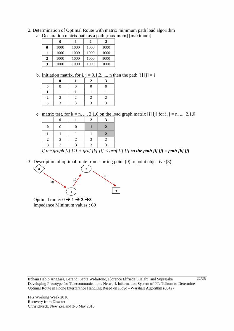
2. Determination of Optimal Route with matrix minimum path load algorithm
a. Declaration matrix path as a path [maximum] [maximum]
0 1 2 3
0 1000 1000 1000 1000
1 1000 1000 1000 1000
2 1000 1000 1000 1000
3 1000 1000 1000 1000
b. Initiation matrix, for i, j = 0,1,2, ..., n then the path [i] [j] = i
0 1 2 3
0 0 0 0 0
1 1 1 1 1
2 2 2 2 2
3 3 3 3 3
c. matrix test, for k = n, ..., 2,1,0 on the load graph matrix [i] [j] for i, j = n, ..., 2,1,0
0 1 2 3
0 0 0 1 2
1 1 1 1 2
2 2 2 2 2
3 3 3 3 3
If the graph [i] [k] + graf [k] [j] < graf [i] [j] so the path [i] [j] = path [k] [j]
3. Description of optimal route from starting point (0) to point objective (3):
Optimal route: 0 1 2 3
Impedance Minimum values : 60
30
20 10
1
2 0
3
Ircham Habib Anggara, Barandi Sapta Widartono, Florence Elfriede Silalahi, and Suprajaka
Developing Prototype for Telecommunications Network Information System of PT. Telkom to Determine
Optimal Route in Phone Interference Handling Based on Floyd - Warshall Algorithm (8042)
FIG Working Week 2016
Recovery from Disaster
Christchurch, New Zealand 2-6 May 2016
23/25
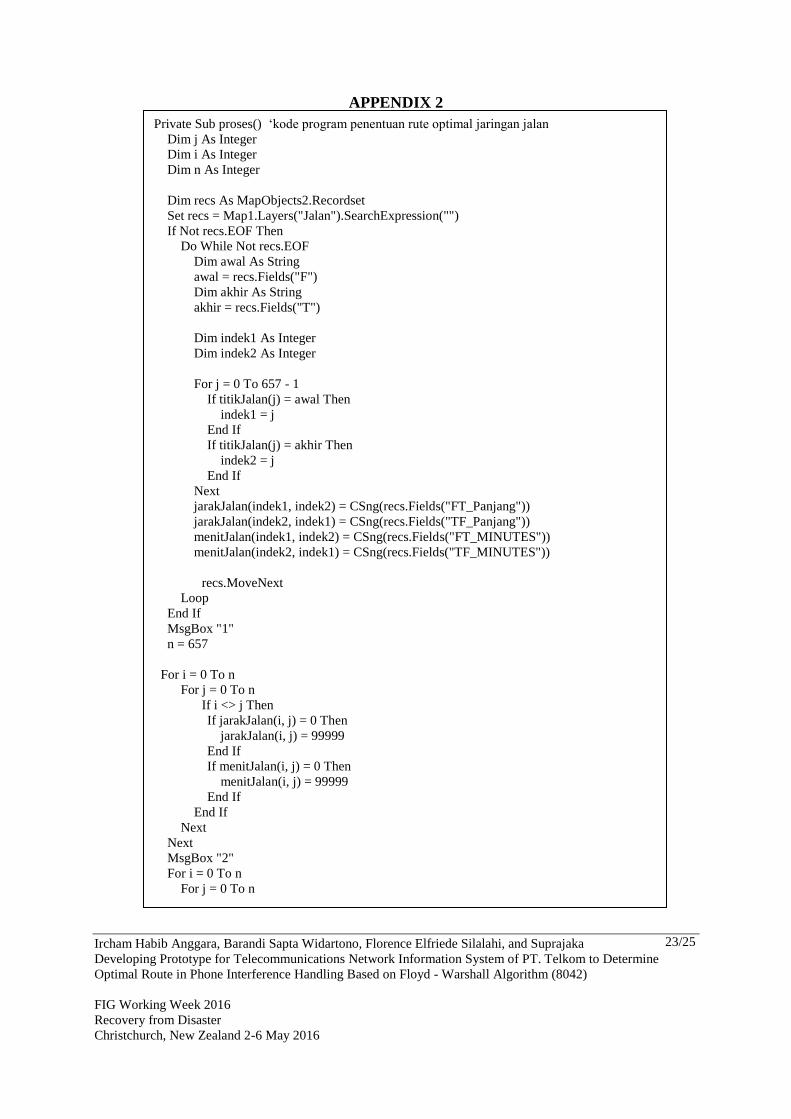
APPENDIX 2
Private Sub proses() ‘kode program penentuan rute optimal jaringan jalan
Dim j As Integer
Dim i As Integer
Dim n As Integer
Dim recs As MapObjects2.Recordset
Set recs = Map1.Layers("Jalan").SearchExpression("")
If Not recs.EOF Then
Do While Not recs.EOF
Dim awal As String
awal = recs.Fields("F")
Dim akhir As String
akhir = recs.Fields("T")
Dim indek1 As Integer
Dim indek2 As Integer
For j = 0 To 657 - 1
If titikJalan(j) = awal Then
indek1 = j
End If
If titikJalan(j) = akhir Then
indek2 = j
End If
Next
jarakJalan(indek1, indek2) = CSng(recs.Fields("FT_Panjang"))
jarakJalan(indek2, indek1) = CSng(recs.Fields("TF_Panjang"))
menitJalan(indek1, indek2) = CSng(recs.Fields("FT_MINUTES"))
menitJalan(indek2, indek1) = CSng(recs.Fields("TF_MINUTES"))
recs.MoveNext
Loop
End If
MsgBox "1"
n = 657
For i = 0 To n
For j = 0 To n
If i <> j Then
If jarakJalan(i, j) = 0 Then
jarakJalan(i, j) = 99999
End If
If menitJalan(i, j) = 0 Then
menitJalan(i, j) = 99999
End If
End If
Next
Next
MsgBox "2"
For i = 0 To n
For j = 0 To n

Ircham Habib Anggara, Barandi Sapta Widartono, Florence Elfriede Silalahi, and Suprajaka
Developing Prototype for Telecommunications Network Information System of PT. Telkom to Determine
Optimal Route in Phone Interference Handling Based on Floyd - Warshall Algorithm (8042)
FIG Working Week 2016
Recovery from Disaster
Christchurch, New Zealand 2-6 May 2016
24/25
If j <> i Then
For k = 0 To n
If k <> i Then
If (jarakJalan(j, i) + jarakJalan(i, k)) < jarakJalan(j, k) Then
jarakJalan(j, k) = (jarakJalan(j, i) + jarakJalan(i, k))
jalurJarakJalan(j, k) = j & "," & i & "-" & i & "," & k
End If
If (menitJalan(j, i) + menitJalan(i, k)) < menitJalan(j, k) Then
menitJalan(j, k) = (menitJalan(j, i) + menitJalan(i, k))
jalurMenitJalan(j, k) = j & "," & i & "-" & i & "," & k
End If
End If
Next
End If
Next
Next
MsgBox "3"
Call conn.Execute("delete from data_jarak")
Call conn.Execute("delete from data_menit")
For i = 0 To n
For j = 0 To n
Call conn.Execute("insert into data_jarak(indek1,indek2,jarak,jalur)_
values(" & i & "," & j & "," & jarakJalan(i, j) & ",'" _
& jalurJarakJalan(i, j) & "')")
Call conn.Execute("insert into data_menit(indek1,indek2,menit,jalur)_
values(" & i & "," & j & "," & menitJalan(i, j) & ",'" _
& jalurMenitJalan(i, j) & "')")
Next
Next
End Sub
Private Sub proses2()‘kode program penentuan rute optimal jaringan kabel
Dim j As Integer
Dim i As Integer
Dim n As Integer
Dim recs As MapObjects2.Recordset
Set recs = Map1.Layers("Kabel").SearchExpression("")
If Not recs.EOF Then
Do While Not recs.EOF
Dim awal As String
awal = recs.Fields("F")
Dim akhir As String
akhir = recs.Fields("T")
Dim indek1 As Integer
Dim indek2 As Integer
For j = 0 To 334 - 1
If titikKabel(j) = awal Then
indek1 = j
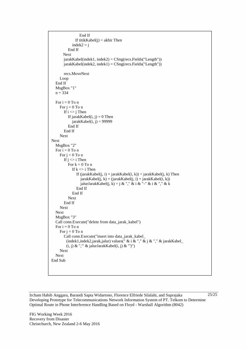
Ircham Habib Anggara, Barandi Sapta Widartono, Florence Elfriede Silalahi, and Suprajaka
Developing Prototype for Telecommunications Network Information System of PT. Telkom to Determine
Optimal Route in Phone Interference Handling Based on Floyd - Warshall Algorithm (8042)
FIG Working Week 2016
Recovery from Disaster
Christchurch, New Zealand 2-6 May 2016
25/25
End If
If titikKabel(j) = akhir Then
indek2 = j
End If
Next
jarakKabel(indek1, indek2) = CSng(recs.Fields("Length"))
jarakKabel(indek2, indek1) = CSng(recs.Fields("Length"))
recs.MoveNext
Loop
End If
MsgBox "1"
n = 334
For i = 0 To n
For j = 0 To n
If i <> j Then
If jarakKabel(i, j) = 0 Then
jarakKabel(i, j) = 99999
End If
End If
Next
Next
MsgBox "2"
For i = 0 To n
For j = 0 To n
If j <> i Then
For k = 0 To n
If k <> i Then
If (jarakKabel(j, i) + jarakKabel(i, k)) < jarakKabel(j, k) Then
jarakKabel(j, k) = (jarakKabel(j, i) + jarakKabel(i, k))
jalurJarakKabel(j, k) = j & "," & i & "-" & i & "," & k
End If
End If
Next
End If
Next
Next
MsgBox "3"
Call conn.Execute("delete from data_jarak_kabel")
For i = 0 To n
For j = 0 To n
Call conn.Execute("insert into data_jarak_kabel_
(indek1,indek2,jarak,jalur) values(" & i & "," & j & "," & jarakKabel_
(i, j) & ",'" & jalurJarakKabel(i, j) & "')")
Next
Next
End Sub


