Download - Developing Regional Long Range Plans

PHONE 7177872862
FAX 7177875274
PUB - 575 (September 2010)
Developing Regional Long Range Plans
Resource Guidance for Pennsylvania Planning Partners
Center for Program Development and Management
PO Box 3365
Harrisburg PA 17105-3365
2
Table of Contents
Introduction Purpose of this Document 4
Creating a Direction 5
Overview of the Transportation and Comprehensive Planning Structure 6
Key Changes to the 2010 Long Range Transportation Plan Guidance 7
Planning Regulations and Polices for a Long Range
Transportation Plan Characteristics of Successful Long Range Plans 12
Regional Long Range Plan Checklist 15
Federal Regulatory Requirements 18
SAFETEA-LU Items Impacting the Development of LRTPs 19
State Policies 22
Linking Planning and NEPA Linking Planning and NEPA 28
Documenting for the NEPA Process 35
Planning Components Trends Issues and Implications 39
Inventories 40
VisioningTransportation Goals and Objectives 45
Financial Planning and Guidance 46
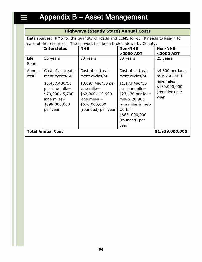
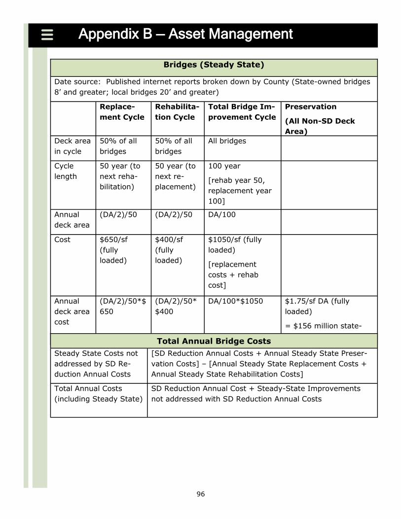
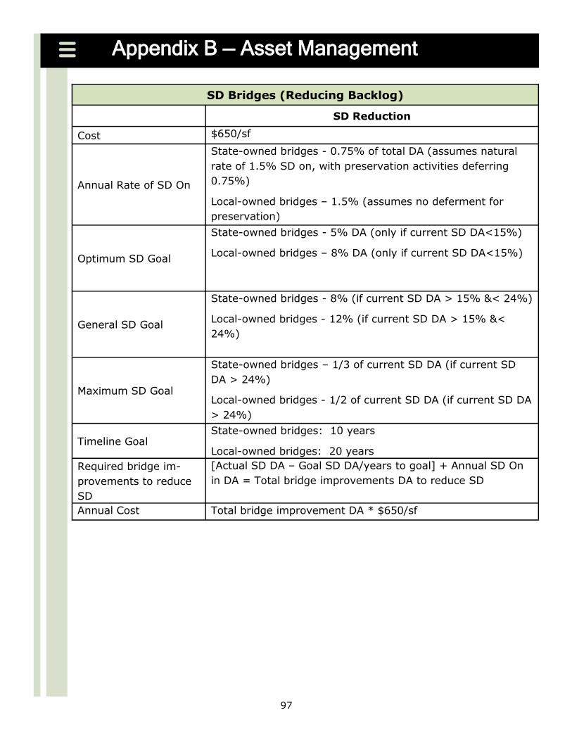
Asset Management 47
Cost Estimation 58
Project Prioritization and Selection 59
Project Lists 61
Identification of Performance Measures 63
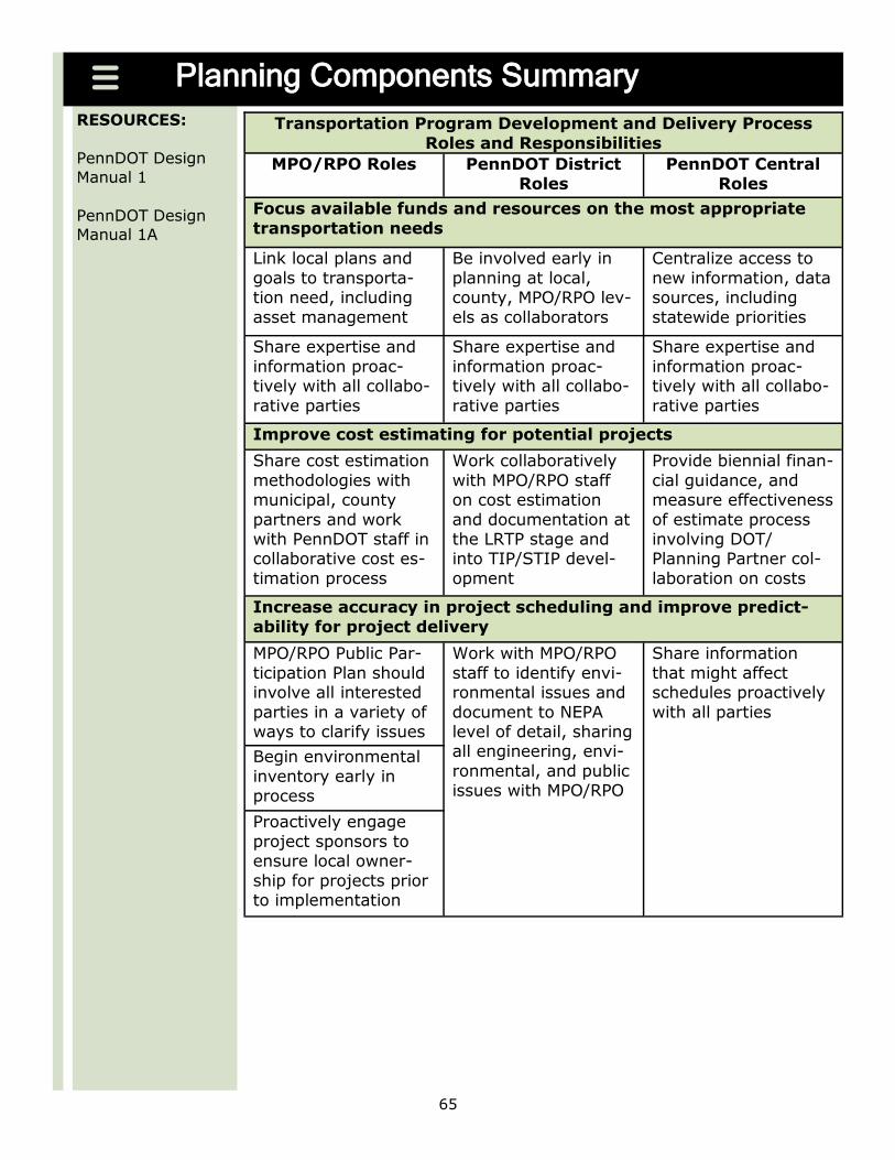
Planning Component Summary 65
Activities of the Process Collaborative Planning 68
Coordinated Planning 73
Air Quality Conformity 81
Scenario Analysis 83
Continuous Planning 87
Appendices A Identification of NHS Intermodal ConnectorsIntermodal Connector Assessment 93
B Asset Management 94
C Project Prioritization and Selection 101
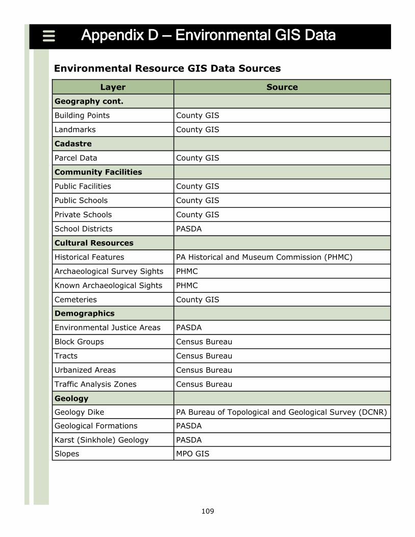
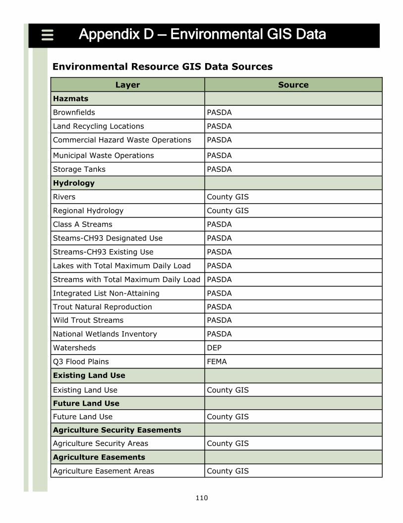
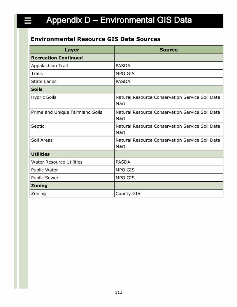
D Environmental GIS Data Sources 108
E Regional Long Range Transportation Plan Links 113
F Regional Public Participation Plan Links 114
G Acronym Glossary 115
H Glossary 118
3
INTRODUCTION
4
Purpose of this Document
The purpose of this document is to assist the Pennsylvania Department of Transporta-
tion (PennDOT) and the Metropolitan and Rural Planning Organizations (MPORPO) in developing more effective long range transportation plans
Without clear requirements and structure many planning partners have been forced to advance their individual Long Range Transportation Plan (LRTP) process with little
or no guidance as to what constitutes a good plan or product This has resulted in plans varying widely in quality substance and content It is important to recognize
Pennsylvaniarsquos unique and progressive treatment of the rural portions of the state in that RPOs though not federally recognized are considered to be equal PennDOT part-ners with the MPOs
This document presents guidelines for MPOs and RPOs for the development of their
LRTP It incorporates a checklist of federal and state requirements as well as pro-vides best practices and resources in each of the chapters to help MPOs and RPOs in the development and update of their long range planning documents Our expecta-
tion is that over time this guidance will enable planning organizations to develop their plans more effectively and will further improve the quality of long range transporta-
tion planning in Pennsylvania
In developing this document we have focused the discussion and recommendations on issues and challenges identified by Pennsylvania planning organizations county and municipal planners local government associations and federal highway officials
In the interest of keeping the document most useful we have limited its length while including suggested sources of additional information on each topic It is expected
that this guide will continue to be updated as planning requirements and best prac-tices evolve with the assistance of our MPORPO planning partners
5
Creating a Direction
While long range planning is required under both the statewide and metropolitan planning regulations it is more importantly a key power and tool that the state and
MPORPO have to effectively utilize to shape transportation and economic investments that help establish regional development form
First the planning process provides an opportunity for citizens government officials planners and associated stakeholders to come together to visualize a regionrsquos future
identify trends taking place within the region and set goals for what the region hopes to achieve within the next 20 or more years Furthermore the planning process allows for update cycles to consistently revisit the vision and goals and re-assess the
regionrsquos changing needs and support the regionrsquos desired transportation direction
A LRTP presents values and priorities that coordinate direction across various planning disciplines and geographies Planners can include these values and priorities in other plans that address the environment housing and economic development in order to
make improvements more strategic and effective across their region Planning part-ners can also work in tandem with neighboring regions the state and localities to
better coordinate planning approaches for more productive results Transportation needs and issues are not contained within political boundaries so long-term planning
provides the opportunity for regions to openly communicate their vision to local plan-ning partners officials and communities are working in a common direction
LRTPs also routinely address smart growth principles the land use and transportation connection the evaluation of alternative growth strategies and the regionrsquos vision for
future growth The integration and the linkage between planning and the National Environmental Pol-
icy Act (NEPA) principles is also an important element of a planrsquos direction The LRTP can reinforce and strengthen the process for planning for proposed transportation pri-
orities In the early stages of transportation planning the LRTP can evaluate purpose and need transportation infrastructure balance developing alternatives environ-mental protection or communityneighborhood preservation NEPA fatal flaws and
other factors
Overall the LRTPmdashboth the document and the processmdashis an opportunity for a region to invest in its identity and future Given the scale and longevity of investment and the impact it has on a regionrsquos economy and quality of life the transportation system
demands thoughtful planning A LRTP is critical in helping a region realize its vision for the future
6
Overview of the Transportation and Comprehensive
Planning Structure
RESOURCES
PennDOT Linking
Land Use and
Transportation
Planning
Subdivision and
Land Development
Ordinances
Policies and Proce-
dures for Transpor-
tation Impact Stud-
ies Related to High-
way Occupancy
Permits
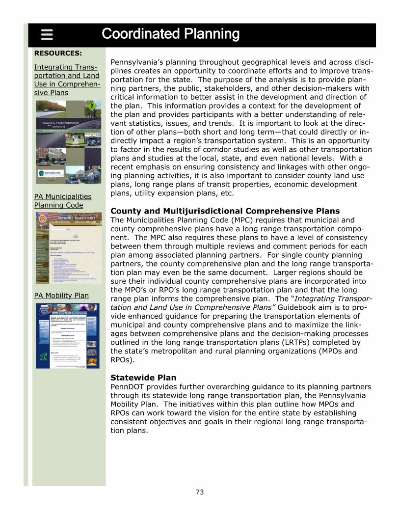
Integrating Trans-
portation and Land
Use in Comprehen-
sive Plans
One of the goals of this document is to establish a stronger relationship between the regional LRTP the statewide LRTP (PA Mobility Plan) the Transportation Improvement Program (TIP)Statewide Transportation
Improvement Program (STIP)Twelve Year Program (TYP) and county comprehensive plans Transportation planners are aware of the impor-
tant role land use patterns play in supporting transportation plans and systems The LRTP provides the opportunity for transportation land use and economic development planning to be integrated which can
lead to less disparity between transportation goals and land use and de-velopment patterns The coordination of the regional LRTP and the
county comprehensive plan(s) is important to support appropriate growth and development throughout the region as well as to effec-tively plan future transportation and land use patterns
7
Key Changes to the 2010 LRTP Guidance
This document is an update to the 2006 Developing Regional Long Range Plans A Guidance for Pennsylvania Planning Partners The following section outlines the key
changes found in the 2010 update Recognizing that each of Pennsylvaniarsquos planning partners has unique regional issues it
is neither PennDOTrsquos desire nor intent to impose specific requirements regarding the process of developing a regional LRTP PennDOT recognizes that each planning partner
must customize its approach according to local conditions and circumstancesmdashfactoring in considerations such as the geographic size of the region current and expected future conditions specific regional opportunities and challenges and budgetary and staffing
constraints Planning organizations may choose to use the general framework provided with minimal changes or work with the PennDOT Office of Planning to develop a spe-
cialized process that better reflects their needs and circumstances In addition several general long range transportation planning resources are available
via resource links located throughout the document These sites are updated on an on-going basis and should be periodically checked for new and updated guidance and re-
sources when updating a regionrsquos LRTP
For each major activity presented there is a general discussion of the activity a list of issues that should be considered and resources and examples These items are not intended to provide an exhaustive or mandatory approach but are presented to expe-
dite thinking about each activity
8
RESOURCES
Keystone Principles
Smart Transportation
PA Mobility Planmdash
Userrsquos Guide
Federal Rulemaking
Key Changes to the 2010 LRTP Guidance
Incorporation of the Keystone Principles and Criteria Pennsylvaniarsquos Keystone Principles and Criteria layout general goals
and objectives for economic development and resource conservation agreed upon among state agencies and programs that participated in
their development Aligning plans with the Keystone Principles and Criteria will enable regions to better compete for an increasingly lim-ited range of funding sources
Incorporation of Livability Principles and Themes In preparing a LRTP the MPORPO is encouraged to consider the in-corporation of livability principles and themes Smart Growth pro-
poses to manage capacity by better integrating land use and trans-portation planning The desire to go ―through a place must be bal-anced with the desire to go ―to a place Roadways have many pur-
poses providing local and regional mobility offering access to homes and businesses and supporting economic growth Focusing
plans on a more sustainable paradigm provides a framework to bal-ance the value and cost of projects allows for greater flexibility in project identification and design and presents an opportunity to
build better communities for future generations of Pennsylvanians
Consideration of statewide LRTP goals and objectives as
outlined in the PA Mobility Plan Document The Mobility Plan was developed to be responsive to federal and state policy supportive of economic development and quality of life strategic in how we invest our time and money unified in the priori-
ties we pursue systems oriented in supporting all modes collabora-tive in establishing and working toward a desired future direction
and focused on implementation and results Coordinating statewide and regional goals and objectives lays the foundation for a stronger linkage between planned and programmed projects
Improved Financial Guidance for Long Range Planning Financial planning takes a long range look at how transportation in-vestments are funded and the possible sources of funds PennDOT
MPOsRPOs and Public Transportation Operators must consider fund-ing needs over both the 20+ year period of the LRTP and the 4 year period of the TIPSTIP LRTPs must contain a financial plan that
identifies currentpotential funding sources for needed investments while still demonstrating a reasonably reliable means to maintain
and operate the existing system
9
Key Changes to the 2010 LRTP Guidance
Asset Management Tools Transportation asset management is a strategic framework for making cost-effective de-cisions about allocating resources and managing infrastructure It is based on a process
of monitoring the physical condition of assets predicting deterioration over time and providing information on how to invest in order to maintain or enhance the performance
of assets over their useful life The goals of a transportation asset management pro-gram are to minimize the life-cycle costs for managing and maintaining transportation assets including pavements bridges tunnels (if applicable) Intelligent Transportation
Systems (ITS) traffic signals and modernization of public facilities and equipment
Cost Estimation Process LRTPs must present a methodology for developing cost estimates throughout the project
development process by taking into account a projects complexity To successfully ad-dress transportation needs MPOsRPOs must have reliable cost estimate factors and as-sociated documentation that support the development from early conceptual alterna-
tives through to definitive project Plans Specifications amp Estimates (PSampE)
As a result of SAFETEA-LU costs of future transportation projects must use ―year of ex-penditure (YOE) dollars rather than ―constant dollars in cost and revenue estimates to better reflect the time-based value of money MPOsRPOs must make certain project
costs identified in both the LRTP and the TIP are in YOE dollars The cost estimate should clearly specify how inflation was considered for the project and the LRTP clearly
shows that the estimate is expressed in YOE dollars
Project Selection Criteria Maintaining existing assets should be the first priority in the selection of projects Ap-plying the Keystone Principles and Smart Transportation to maintenance as well as
new investment can focus maintenance dollars on the most important assets This may facilitate growth in the most desirable areas and through increased economic activity
and fuel tax receipts (and other funding mechanisms) result in more cost effective use of limited state and federal transportation funds Utilizing the Keystone Principles and Smart Transportation concepts would help guide development influence land use deci-
sions and mitigate the related impacts on the transportation system When selecting projects that will utilize safety funds fatal and serious injury crash locations which indi-
cate the highest safety needs on the transportation system should be reviewed
10
Key Changes to the 2010 LRTP Guidance
Guidelines to incorporate Linking Planning and NEPA in the Long Range
Transportation Plan (LRTP) MPOs RPOs state and local agencies can achieve significant benefits by incorporating
environmental and community values into transportation decisions early in the planning stage Linking Planning and NEPA is an integral part of long range-transportation plan-
ning Agenciesrsquo inclusions of these considerations in transportation planning can carry activities or decisions into the NEPA process For example transportation and environ-mental staff can identify a projects purpose and need and begin alternatives analysis in
planning and use that information when conducting environmental reviews These ac-tivities can lead to streamlined processes by reducing duplication of work and better de-
cisions by promoting early coordination of planning and environmental staff
Performance Measures Performance measures demonstrate how well a regionrsquos transportation system is doing its job in meeting the goals and expectations of the regionrsquos LRTP Measuring perform-
ance of the LRTP is a way to gauge the impacts of the decision making process Per-formance measures answer questions as to whether the transportation system is getting
better or worse over time and whether transportation investments are correlated or linked to stated goals and outcomes
11
PLANNING REGULATIONS AND
POLICIES FOR A LONG RANGE
TRANSPORTATION PLAN
12
Characteristics of Successful Long Range Plans
Based on a review of best practices in the development of long range transportation plans (LRTPs) both within Pennsylvania and nationally there are many common attrib-
utes of the more successful plans While not every plan will display all of these quali-ties Metropolitan Planning Organizations (MPOs) and Rural Planning Organizations (RPOs) should strive to achieve these qualities in their plans
Create LocalRegional Ownership Developing the plan with an active focus on
and engagement of its stakeholders increases the likelihood that they are fully vested in the plan and that it will be fully implemented
Emphasize Planning not Programming Although the plan must include a fiscally-constrained list of projectssolutions the emphasis should be on defining the
planning vision for the future and determining what priorities or types of projects best achieve that vision rather than simply generating a project list
Collaborate with Other Stakeholders Plan development should include meaningful and ongoing consultation with PennDOT counties municipalities neighboring planning
regions and other partners This will take into account the issues and concerns of other stakeholders and that it is coordinated with their planning efforts
Support Other Relevant Plans A long range transportation plan exists within the larger context of community planning infrastructure development and political reali-
ties and should therefore take into consideration other relevant local regional and statewide plans that are likely to impact the transportation system
Articulate Clear Goals and Objectives The goals and objectives articulated within the plan should be straightforward and easily understood relate to the overall vision of
the region and provide a basis for making investment decisions
Address Quality of Life Issues Although they are not easily quantified issues such as safety health recreation and access to employment and services have taken on increasing importance in transportation and community planning The plan should ex-
plicitly describe how these issues are addressed in the decision-making process
Maintain an Open and Transparent Process Because the process used to develop a long range plan is not always clear from the final products the plan should include a description of how the plan was developed including public and resource agency out-
reach technical analyses and other critical work program elements From the outset and in consultation with key stakeholders develop a process that works for the region
and those involved in the planrsquos development Capitalize on the Experience of Others While it is important that every plan be
tailored to the issues and context of the particular region there is also much to be learned from what has been done successfully by others whether in terms of public
participation technical analysis document presentation or other areas of plan devel-opment
13
Characteristics of Successful Long Range Plans
Consider Multiple Futures (Scenario Planning) To convey the impacts that differ-
ent courses of action could have planning organizations should use the plan as an op-portunity to explore possible ―differing futures in terms of issues such as financing modal emphasis and land use
Develop an Evaluation Framework In developing evaluation criteria that flow from
the overall goals and objectives planning organizations need to determine how they can measure the performance of proposed solutions in a structured manner
Employ Strong Technical Analyses To provide a basis for properly evaluating po-tential solutions the plan should be based onmdashbut not necessarily solely driven bymdasha
strong technical analysis that is clearly described in the plan document Link Solution Prioritization to Goals Objectives and Policies Rather than sim-
ply maintaining the existing project pipeline prioritization of solutions should be clearly tied to the planrsquos goals objectives and policies through the use of linked evaluation cri-
teria
Support a Multi-modal and Intermodal Future LRTPs should integrate all modes and identify how those modes interact This is an opportunity to more efficiently move people and goods and strengthen the economy Congestion on both our freight and
passenger networks costs billions of dollars a year in direct costs and lost productivity for businesses and citizens alike Identifying multi-modal and intermodal strategies to
alleviate congestion and reduce travel times may also lead to better uses of very lim-ited transportation dollars
Integrate Land Use and Transportation Considering the transportation conse-quences of land use decisions and identifying strategies to manage growth during the
LRTP development helps to alleviate concerns about traffic congestion reduce pollution protect habitats and pristine environments preserve farmland and open space en-hance community character and helps to create a more affordable livable and sus-
tainable future for a region
Distribute Investments Equitably (Environmental Justice) The plan should pro-pose transportation solutions that the burden or benefits are distributed fairly both geographically and across racial or socioeconomic groups
Organize Solutions in a Relevant Format The plan should organize potential solu-
tions in a format that is relevant and useful for the region The presentation of findings could be organized by mode by geography by corridor or by some hybrid of these ap-proaches
14
Characteristics of Successful Long Range Plans
Structure the Plan to be Relevant to Local Issues Planning partners should con-sider the types of problems and solutions that are most relevant to the region and
structure the plan to be responsive to these issues If the region is experiencing sig-nificant corridor congestion it may make sense to structure the plan in terms of corri-dors whereas a region that is experiencing concentrated growth in specific areas may
want to structure its plan according to geographic centers
Include an Implementation Plan Because the plan defines a framework for future programminginvestment decisions it should clearly define how the planrsquos goals ob-jectives and policies will transfer to the development of programming documents
such as the Twelve-Year Plan (TYP) and Transportation Improvement Programs (TIP) and other planningproject development initiatives
Be Creative PennDOT wishes to see planning partners tailor their approach and product to local issues and conditions While there are some basic requirements as
well as some typical elements of most long range plans PennDOT challenges its plan-ning partners to push themselves to set a compelling direction for transportation plan-
ning in their region Utilizing visualization techniques has become an increasingly es-sential part of transportation planning Providing a clear idea of proposed policies and
plans can strengthen public participation and help maintain a shared awareness about the collective implications of decisions
15
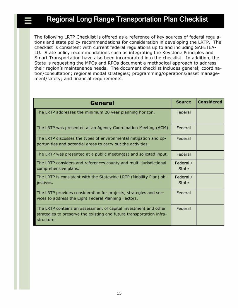
Regional Long Range Transportation Plan Checklist
The following LRTP Checklist is offered as a reference of key sources of federal regula-tions and state policy recommendations for consideration in developing the LRTP The
checklist is consistent with current federal regulations up to and including SAFETEA-LU State policy recommendations such as integrating the Keystone Principles and Smart Transportation have also been incorporated into the checklist In addition the
State is requesting the MPOs and RPOs document a methodical approach to address their regionrsquos maintenance needs The document checklist includes general coordina-
tionconsultation regional modal strategies programmingoperationsasset manage-mentsafety and financial requirements
General Source Considered
The LRTP addresses the minimum 20 year planning horizon Federal
The LRTP was presented at an Agency Coordination Meeting (ACM) Federal
The LRTP discusses the types of environmental mitigation and op-
portunities and potential areas to carry out the activities
Federal
The LRTP was presented at a public meeting(s) and solicited input Federal
The LRTP considers and references county and multi-jurisdictional
comprehensive plans
Federal
State
The LRTP is consistent with the Statewide LRTP (Mobility Plan) ob-
jectives
Federal
State
The LRTP provides consideration for projects strategies and ser-
vices to address the Eight Federal Planning Factors
Federal
The LRTP contains an assessment of capital investment and other
strategies to preserve the existing and future transportation infra-
structure
Federal
16
Regional Long Range Transportation Plan Checklist
Consultation Cooperation Source Considered
The LRTP considers and references the MPORPO Public Participa-
tion Plan (PPP)
Federal
Was the required comment period provided to those specified in
the regionrsquos PPP
Federal
Consultation occurred with relevant federal state and local repre-
sentatives including those responsible for responsible for natural
resources environmental protection conservation and historic
preservation
Federal
Does the LRTP include an environmental overview Federal
The LRTP addresses Smart Transportation Principles and Themes State
The LRTP considers the Keystone Principles and Criteria State
Consultation occurred with relevant private sector organizations Federal
Consultation occurred with appropriate Native American Tribal Gov-
ernments
Federal
Consultation occurred with relevant regional air quality planning
authorities (if applicable)
Federal
Does the LRTP include your Coordinated Public Transit Human Ser-
vices Transportation Plan
Federal
Is the LRTP posted on the internet Federal Regional Modal Strategies Source Considered
The LRTP identifies and addresses the regionrsquos intermodal and con-
nectivity issues
Federal
Identifies and addresses the regionrsquos bridges and highways Federal
Identifies and addresses the regionrsquos mass transportation includ-
ing passenger rail (if applicable)
Federal
Identifies and addresses the regionrsquos airport system (if applicable) Federal
Identifies and addresses the regionrsquos bicycle and pedestrian needs Federal
Identifies and addresses the regionrsquos rail freight Federal
Identifies and addresses the regionrsquos ports (if applicable) Federal
Identifies and addresses the regionrsquos goods movement Federal
Identifies and addresses a Transportation Security Evacuation Plan Federal
17
Regional Long Range Transportation Plan Checklist
ProgrammingOperations
Asset Management Safety
Source Considered
If applicable does the LRTP consider and reference your conges-
tion management process (CMP) including the identification of sin-
gle occupancy vehicle (SOV) projects in non-attainment areas
Federal
Is the LRTP consistent with the regional Intelligent Transportation
System (ITS) architecture plan
Federal
Does the LRTP identify performance measures State
Does the LRTP meet the statewide highway asset management
goals
State
Does the LRTP meet the statewide bridge asset management
goals
State
Does the LRTP identify and address transportation safety needs
and is consistent with the Strategic Highway Safety Plan and avail-
able IT data
Federal
Does the LRTP contain system-level estimates of costs and revenue
sources that are reasonably available to adequately operate and
maintain federal-aid highways and public transportation
Federal
Financial Source Considered
Is the LRTP fiscally constrained Federal
Are all regionally significant projects identified Federal
Includes a constrained project list as well as an optional list of un-
funded needs for illustrative purposes
Federal
Accurately projects available funds including discretionary funds
and earmarks
Federal
and State
Utilizes inflation rates to reflect ―Year of Expenditure (YOE) dol-
lars
Federal
Identifies financial strategies Federal
RESOURCES
United States Code Title 23 Part 450
United State Code Title 49 Subtitle III Chapter 53
18
Federal Regulatory Requirements
Federal Planning Regulations Federal planning regulations date to the early 1960s when under the Kennedy Admini-
stration the federal government created requirements that transportation planning be conducted in a ―comprehensive continuous and coordinated manner The Federal-Aid
Highway Act of 1973 further formalized the 3-Crsquos process by mandating the creation of MPOs in each urbanized area with a population of 50000 or greater While long range transportation planning was conducted in some fashion over the next three decades it
wasnrsquot until the Intermodal Surface Transportation Efficiency Act of 1991 (ISTEA) that planning requirementsmdashand the role of the MPO and by extension RPOmdashwere signifi-
cantly strengthened
ISTEA (1991) Federal long range planning regulations promulgated under ISTEA state that the pur-pose of the metropolitan planning process is to establish a ―framework for making
transportation investment decisions in metropolitan areas This language was crafted with the intent of enabling states and regions in cooperation with transit agencies to
develop regional transportation plans that reflect unique state and local priorities The legislation strengthened the linkage between transportation planning and programming (prioritizing and funding specific projects) and formalized the way metropolitan areas
were to address transportation and transportation-related impacts However the regu-latory requirements were still rather broadly defined and non-prescriptive
TEA-21 (1998) The Transportation Equity Act for the 21st Century (TEA-21) was enacted in 1998 TEA-21 maintained most of the regulatory requirements of ISTEA providing guidance on what needs to be considered in a plan without actually prescribing how to get there
Planning regulations relating to long range transportation planning are published in the Code of Federal Regulations (CFR) Part 23
With the authorization of TEA-21 the Federal Highway Administration (FHWA) and Fed-eral Transit Administration (FTA) were charged with revisiting the existing planning
regulations Discussions regarding proposed modifications to planning regulations per-sisted during the early years of the reauthorization but the general consensus was
there was not a need to substantially change the planning requirements of ISTEA
SAFETEA-LU (2005) On August 10 2005 after nearly two years of extensions the successor to TEA-21 was signed into law The legislation is known as the Safe Accountable Flexible Efficient
Transportation Equity Act A Legacy for Users (SAFETEA-LU) While states and MPOs were not required to abandon their current plan and program cycles to immediately in-
corporate changes from SAFETEA-LU plans adopted after July 1 2007 must be in com-pliance with the new requirements
19
SAFETEA-LU Items Impacting the Development of LRTPs
Public Participation PlanOutreach Each planning organization shall provide citi-
zens affected public agencies representatives of public transportation employees freight shippers private transportation providers representatives of public transporta-tion users representatives of pedestrian walkways and bicycle transportation facilities
users representatives of the disabled and other interested parties with a ―reasonable opportunity to comment on the LRTP The PPP must be developed prior to updating
the LRTP and Statewide Transportation Improvement Program (STIP) and shall provide for input from the stakeholders and other interested parties during its preparation
Contents of the Participation Plan Shall Include Development of the LRTP in con-sultation with all interested parties provision that all interested parties have reason-
able opportunities to comment on the contents of the LRTP all public meetings are held at convenient and accessible locations employment of visualization techniques to de-scribe the LRTP (such as a geographic information system (GIS) maps graphs charts
and other visual methods of interpreting data and information) and making the infor-mation available to the public in electronic accessible format and means such as a web
site in order to afford a reasonable opportunity for all parties including the general pub-lic to comment on the LRTP A minimum public comment period of 45 days shall be provided before the initial or revised PPP is adopted by the planning organization
Changes to Federal Planning Factors The planning factor to ―protect and enhance
environment promote energy conservation and improve quality of life was expanded to also include ―promote consistency between transportation improvements and State and local planned growth and economic development patterns Equally important
safety and security were separated into individual planning factors to highlight the im-portance of each issue
Public TransitHuman Services Transportation Plan A public transithuman ser-
vices transportation plan should be consistent with the transportation planning process Long Range Transportation Plan Cycle Updates A LRTP shall be updated every
four years or more frequently if the planning organization elects to do so In attain-ment regions the planning organization may elect to update their LRTPs every five
years Identify Transportation Facilities A LRTP shall include an identification of transpor-
tation facilities including major roadways multimodal and intermodal facilities and in-termodal connectors
Identify Mitigation Activities A LRTP shall include a discussion of types of potential environmental mitigation activities and potential areas to carry out these activities that
may have the greatest potential to restore and maintain the environmental functions affected by the plan
20
SAFETEA-LU Items Impacting the Development of
LRTPs
Consultation and Coordination The LRTPs environmental mitigationopportunities
discussions shall be developed in consultation with Federal State and Tribal land man-agement wildlife and regulatory agencies Additional consultation as appropriate
with State and local agencies responsible for land use natural resources environ-mental protection conservation and historic preservation during development of the LRTP is required
Financial Plan A Financial Plan shall demonstrate how an adopted LRTP can be im-
plemented indicate resources that can reasonably be expected to be available to carry out the plan and recommends any additional financing strategies for needed projects and programs Total dollar amount for projects included in the STIP must take into ac-
count a projected rate of inflation The MPO transit operators and State shall coopera-tively develop estimates of funds that will be available to support plan implementation
Identify Operational and Management Strategies Operational amp Management Strategies shall be included in order to improve the performance of the existing trans-
portation facilities to relieve vehicular congestion and maximize the safety and mobility of people and goods
Identify Capital Investment Strategies Capital investment strategies and other
strategies shall be included to preserve the existing and projected future transportation infrastructure and provide for multimodal capacity increases based on regional priori-ties and needs
Congestion Management Process The CMP should be an integral part of developing
LRTPs and STIPs for MPOs that also serve as transportation management areas (TMAs) Visualization Techniques and LRTP Publication A LRTP shall include visualization
techniques such as GIS based graphs maps bar charts pie charts and other visual aids that a public participant understands without great technical detail but more com-
prehensive and basic The LRTP shall be available on a website and for the life of the plan
Safety Issues SAFETEA-LU separated ―safety and ―security as planning factors LRTPs should include a safety element that incorporates and summarizes the goals
such as reduction of fatalities priorities and projects that will reduce serious injury crashes and fatalities and align with the Pennsylvania Strategic Highway Safety Plan
Security Issues LRTPs should include a security element that incorporates and sum-marizes the goals priorities and projects that are contained in emergency relief and
disaster preparedness plans that support homeland security and the personal security of the public
RESOURCES SAFETEA-LU
21
SAFETEA-LU Items Impacting the Development of LRTPs
It is important to recognize that SAFETEA-LU expired on September 30 2009
Among the initial proposals identified for the new transportation authorization legisla-tion include livability and greenhouse gas emission reduction
Livability The livability initiative would establish a focal point to advance environ-mentally sustainable modes of transportation including transit walking and bicy-
cling This initiative encourages integrated planning linking land use and transporta-tion planning to support the creation of livable communities It also recognizes that roadways should be built with the needs of all users in mind and that States and met-
ropolitan regions should consider comprehensive street design principles Compre-hensive street design takes into account the needs of all users including motorists
motorcyclists transit riders cyclists pedestrians the elderly and individuals with disabilities Comprehensive street design principles are not prescriptive do not man-date any particular design elements and result in greatly varied facilities depending
on the specific needs of the community in which they are located
Greenhouse Gas Emission Reduction The greenhouse gas emission reduction ini-tiative would change the transportation planning process by linking transportation planning with greenhouse gas emissions reductions The Environmental Protection
Agency in consultation with USDOT is expected to establish national transportation related greenhouse gas emissions reduction goals USDOT under the existing trans-
portation planning process is expected to require States and metropolitan regions to develop surface transportation-related greenhouse gas emission reduction targets and incorporate strategies to meet these targets into their transportation plans USDOT
through performance measures would verify that States and metropolitan areas achieve progress towards national transportation-related greenhouse gas emissions
reduction goals
22
Keystone Principles
Redevelop first
Provide efficient infrastructure Concentrate development (ie redevelopment infill etc) Increase job opportunities
Foster sustainable businesses Restore and enhance the environment
Enhance recreational and heritage resources Expand housing opportunities Plan regionally implement locally
Be fair
RESOURCES
Commonwealth of
Pennsylvania Key-
stone Principles for
Growth Invest-
ment and Resource
Conservation ndash May
2005
Transportation
Land Use and Eco-
nomic Development
Initiative
State Policies Keystone Principles for Growth Investment and Resource Con-servation The Keystone Principles and Criteria for Growth Invest-
ment and Resource Conservation were adopted by the statersquos Economic Development Cabinet in May 2005 The Principles and Criteria are de-
signed as a coordinated interagency approach to fostering sustainable economic development and conservation of resources through the statersquos investments in Pennsylvaniarsquos diverse communities The Princi-
ples lay out general goals and objectives for economic development and resource conservation
The Long Range Transportation Plan (LRTP) should consider the Key-stone Principles as they develop the vision goals and objectives by do-
ing so the region can guide investment and support local growth and economic development
Land Use Transportation and Economic Development (LUTED) Initiative In order to help make the most strategic investments and
efforts for land use transportation economic development and conser-vation state and regional agencies have been working together on the
LUTED initiative The goal is to coordinate these activities and yield high impact and benefits for communities and regions
Regional action plans were developed to pursue projects of greater im-pact to a larger number of people and places to advance projects that
are regionally strategic to articulate the desire to leverage various agency funds to support the most meaningful projects to collaborate and leverage resources on a more regional basis and to make decisions
and investments for land use transportation resource conservation and economic development in a more coordinated process at a regional
level
23
RESOURCES
Smart Transporta-
tion Website
State Policies
Livability Livability is defined as ―partnering to build great communi-ties for future generations of Pennsylvanians by linking transportation
investments and land use planning and decision-making Livability re-quires accepting and embracing the evolving financial environmental
technological and community contexts when approaching the next gen-eration of transportation challenges It is about consistently applying the most innovative tools and ideas to meet these new challenges In
contrast to the singular vision of building bigger wider roadways to pro-vide utmost vehicular mobility Smart Growth calls for linking land use
and transportation planning a focus on system maintenance and pres-ervation balancing priorities among all transportation modes collabora-tion with planning partners and true fiscal responsibility
Project delays and escalating costs are discouraging to everyone in-
volved in the transportation planning process Early identification of plans and design solutions that are not affordable and cannot be imple-mented are necessary In addition projects should be advanced that
meet the transportation agencies community and the general public expectations and are consistent with the LRTP The application of the
items listed below will help to promote a better understanding of the problem key issues potential solutions community participation and an early schedule and budget for the process The intended result is
that projects listed on the LRTP can be implemented with more certainty and be completed within the estimated time frame and budget
Application of Statewide Livability Criteria are designed to
Allocate financial resources to projects that address local regional
and statewide priorities Achieve consistent expectations between project proponents com-munities and entities that evaluate and fund projects
Achieve the optimum accommodation of all modes Insure context sensitivity in the planning and design of projects
Decrease the amount of re-work in the preliminary engineering and final design phases of the project
24
State Policies
Money Counts Considered
Shall identify scalable cost estimates (baseline costs) and schedules for
projects on the Long Range Transportation Plan (Pub 352)
Should identify innovative funding sources and opportunities to
leverage transportation investments
Should identify costbenefit effective transportation options for all modes
that are scaled to the size of the problem
Statewide Livability Evaluation Criteria
Leverage and Preserve Existing Investment Considered
Shall identify preservation goals and maintenance needs
Choose Projects with a High Value to Price Ratio Considered
Shall identify project evaluation criteria for maintenance of roads and
bridges capacity improvements transit goods movement safety and en-hancements
Safety Always and Maybe Safety Only Considered
Shall develop and implement safety initiatives that lead to the
reduction of serious crashes and fatalities
Shall identify high crash locations and implement improvements to meas-
ure reduction in serious injury crashes and fatalities
Look Beyond Level of Service Considered
Shall document community and government involvement during project
purpose and needs identification
Should identify opportunities to incorporate environmental justice con-
cerns natural resource features and preservation of wetlands surface and ground water resources and air quality
Should identify opportunities to preserve the unique features and re-
sources of the project area
Should identify opportunities to make adaptive reuse of significant archi-
tectural or historic resources
Should identify strategies to reduce greenhouse gas emissionsenergy
use and sustain environmentally sensitive land for health habitat and bio-diversity
25
State Policies
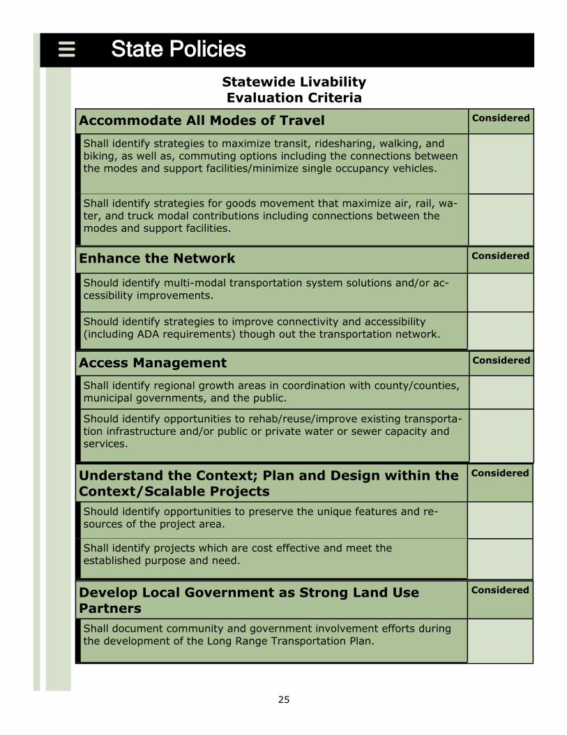
Accommodate All Modes of Travel Considered
Shall identify strategies to maximize transit ridesharing walking and
biking as well as commuting options including the connections between the modes and support facilitiesminimize single occupancy vehicles
Shall identify strategies for goods movement that maximize air rail wa-
ter and truck modal contributions including connections between the modes and support facilities
Statewide Livability Evaluation Criteria
Enhance the Network Considered
Should identify multi-modal transportation system solutions andor ac-
cessibility improvements
Should identify strategies to improve connectivity and accessibility
(including ADA requirements) though out the transportation network
Access Management Considered
Shall identify regional growth areas in coordination with countycounties
municipal governments and the public
Should identify opportunities to rehabreuseimprove existing transporta-
tion infrastructure andor public or private water or sewer capacity and services
Understand the Context Plan and Design within the ContextScalable Projects
Considered
Should identify opportunities to preserve the unique features and re-
sources of the project area
Shall identify projects which are cost effective and meet the
established purpose and need
Develop Local Government as Strong Land Use Partners
Considered
Shall document community and government involvement efforts during
the development of the Long Range Transportation Plan
26
RESOURCES
PA Mobility Plan
Userrsquos Guide
State Policies
PA Mobility Plan The PA Mobility Plan is Pennsylvaniarsquos LRTP The
Plan defines a transportation direction and establishes transportation
priorities expressed through its goals and objectives The goals and objectives were designed to coordinate activities across modes and enti-
ties as well as to provide tools to guide future transportation invest-ment and ultimately improve the movement of people and goods His-torically there have always been more proposed transportation projects
than there is money to fund them Long range plans consider the future transportation needs and resources based on alternative conditions
along with the priorities of residents businesses and visitors The aim is to target expenditures on the most worthwhile transportation projects
that provide the greatest value
Goal 1 Move people safely and securely
Reduce the number of fatalities serious injuries and crashes Ensure the uninterrupted operation of vital transportation ser-
vices Goal 2 Improve the quality of life by linking transportation land use economic development and environmental steward-
ship Direct resources to support economic and community develop-
ment Integrate land use and transportation Preserve natural historical and cultural resources
Promote energy conservation Goal 3 Develop and sustain quality transportation infrastruc-
ture Advance a program to achieve desired maintenance cycles Accelerate the use of innovative construction techniques better
materials and improved maintenance practices Goal 4 Provide mobility for people goods and commerce
Improve connectivity and accessibility throughout the transporta-tion network
Improve transportation system operating efficiency Improve transportation system reliability
Goal 5 Maximize the benefit of transportation investments
Improve transportation investment decision-making Focus planning and investments on a core transportation system
Secure funding to preserve Pennsylvaniarsquos transportation infra-structure and to make strategic capacity improvements Improve project delivery to expedite project development and re-
duce costs
27
LINKING PLANNING AND NEPA
28
RESOURCES
Linking the Trans-
portation Planning
and NEPA Processes
ndash February 2007
AASHTO Center for
Environmental Ex-
cellence
Linking Planning and NEPA
Regional and local agencies can achieve significant benefits by incorpo-rating community and environmental values into transportation deci-
sions early in planning and carrying these considerations through pro-ject development and delivery Waiting until the project development stage of transportation decision-making to deal with community and en-
vironmental issues can result in significant delays in project completion Considering community and environmental issues in identifying defin-
ing and prioritizing projects in the long range transportation planning (LRTP) process can lead to better results
The goal of linking planning and National Environmental Policy Act (NEPA) initiative is to successfully integrate NEPA-type activities into the
planning phases by Establishing a clear link from the existingplanned land use in mu-nicipalities counties and regions to the transportation planning and
programming processes which are affected by land use decisions and which can affect future land use decisions All involved should
understand how each part of the process affects another Establishing a clear understanding of the types of information to be
collected activities to be conducted the time of both and docu-menting each to the appropriate levels so that the documentation meets standards to be used in state (PA Act 120) and federal (NEPA)
environmental study documentation
Identification of significant resources and then avoidance minimization and mitigation of impacts of projects on communities and resources are often consistent with the goals and objectives set forth in long range
planning
Community ContextImpacts amp MitigationPublic amp Agency Coordination
Linking Planning and NEPA
NEPA Decision MakingTransportation Planning
Documentation Documentation
Transportation Deficiencies amp Needs
Problem Statement(s)
Solutions Evaluation amp Screening
Preferred Solutions
Project Scoping
Purpose amp Need
Preferred Alternative
Alternatives
29
RESOURCES
FHWA Environ-
mental Review Tool
Kit
Using Transporta-
tion Planning to
Support the NEPA
Process
Needs Study Hand-
book
Linking Planning and NEPA
In the past environmental analyses conducted in the NEPA process were often disconnected from the analysis used to prepare transporta-
tion plans transportation improvement programs and supporting sub area studies through statewide metropolitan and rural transportation planning processes in Pennsylvania Analyses and decisions occurring
during transportation planning often were not well documented and did not carry through to the NEPA process The analyses were either not
adequately documented or overlooked and had to be repeated in the NEPA process resulting in additional project costs and delays in imple-mentation of transportation projects
Documentation of how transportation deficiencies and needs support
the problem statement andor vision goals and objectives of the LRTP Plan can often contribute to the definition of purpose and need in the NEPA process Utilization of existing publicstakeholder involvement
data and analysis identification of controversy and the subsequent documentation as well as the elimination of unreasonable alternatives
are examples of where long range planning can influence and expedite the NEPA decision-making process
Details scope and challenges associated with transportation problems that eventually will be included on the Transportation Improvement
Program (TIP) and Statewide Transportation Improvement (STIP) should be identified in the LRTP planning process The budget scope
and schedule can then be identified sooner because costs needs and environmental impacts are identified examined and understood ear-lier
Problem Assessment (Project Delivery Step 1) Problem Assessment is the term applied to the initial advancement of any transportation-related problem intended for consideration as part
of the regional LRTP Transportation problems can be advocated by any citizen or organization municipal or county entity the Metropolitan Planning Organization (MPO) or Rural Planning Organization (RPO) or
state agency including PennDOT
Potential sources of problems to be identified in the LRTP Citizens municipal councils school district boards or commissions
Municipal Comprehensive Plans
County Comprehensive Plans
PennDOT District Business Plans
Performance-based assessments or tools
Bus rail or air transit providers
Bicycle andor pedestrian groups
Legislative initiatives
Private developers
30
RESOURCES
PennDOT Design
Manual 1
PennDOT Design
Manual 1A
Screening Forms
Linking Planning and NEPA
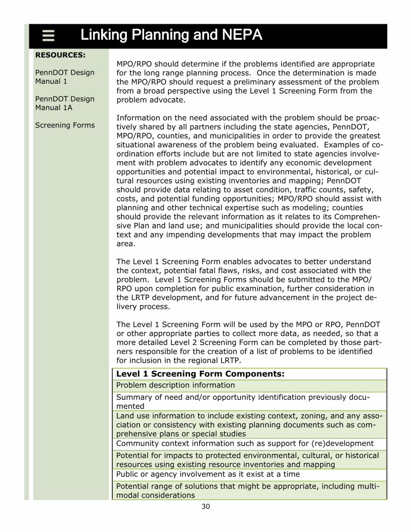
MPORPO should determine if the problems identified are appropriate for the long range planning process Once the determination is made
the MPORPO should request a preliminary assessment of the problem from a broad perspective using the Level 1 Screening Form from the problem advocate
Information on the need associated with the problem should be proac-
tively shared by all partners including the state agencies PennDOT MPORPO counties and municipalities in order to provide the greatest situational awareness of the problem being evaluated Examples of co-
ordination efforts include but are not limited to state agencies involve-ment with problem advocates to identify any economic development
opportunities and potential impact to environmental historical or cul-tural resources using existing inventories and mapping PennDOT should provide data relating to asset condition traffic counts safety
costs and potential funding opportunities MPORPO should assist with planning and other technical expertise such as modeling counties
should provide the relevant information as it relates to its Comprehen-sive Plan and land use and municipalities should provide the local con-
text and any impending developments that may impact the problem area
The Level 1 Screening Form enables advocates to better understand the context potential fatal flaws risks and cost associated with the
problem Level 1 Screening Forms should be submitted to the MPORPO upon completion for public examination further consideration in the LRTP development and for future advancement in the project de-
livery process
The Level 1 Screening Form will be used by the MPO or RPO PennDOT or other appropriate parties to collect more data as needed so that a more detailed Level 2 Screening Form can be completed by those part-
ners responsible for the creation of a list of problems to be identified for inclusion in the regional LRTP
Level 1 Screening Form Components
Problem description information
Summary of need andor opportunity identification previously docu-
mented
Land use information to include existing context zoning and any asso-
ciation or consistency with existing planning documents such as com-prehensive plans or special studies
Community context information such as support for (re)development
Potential for impacts to protected environmental cultural or historical
resources using existing resource inventories and mapping
Public or agency involvement as it exist at a time
Potential range of solutions that might be appropriate including multi-
modal considerations
31
Linking Planning and NEPA
Problem Identification in LRTP (Project Delivery Step 2) The LRTP process provides an opportunity for citizens government officials planners
associated stakeholders and other interested parties to come together to visualize the regionrsquos future identify needs within the region set goals establish projected
revenue amounts and prioritize transportation proposals for what the region hopes to achieve within the next twenty or more years
Furthermore the planning process allows for update cycles to make certain that the vision and goals are consistently revisited and reassessed to address a regionrsquos
changing needs to support a regionrsquos desired transportation direction Given the scale and longevity of transportation investments and the impact they may have on a re-gionrsquos economy and quality of life improvements to the transportation system de-
mand deliberate and thoughtful planning A realistic long range plan is critical in helping a region realize its vision for the future
Clarification of purpose and need should be defined during problem identification in the LRTP A need is a tangible fact-based problem which establishes evidence of a
current or future transportation issue is factual and quantifiable justifies commit-ment of financial resources and impacts to the environment identifies a problem that
is fixable or solvable and establishes logical termini The purpose is what the problem is intended to accomplish A problemrsquos purpose is
an overarching statement as to why the proposal is being pursued and the objectives that will be met to address the transportation deficiency The level of specificity for
defining purpose should be considered in relation to how that may impact the number or range of alternatives that will be developed The purpose and need should not be defined so narrowly as to artificially limit the range of alternatives considered particu-
larly those problems that may require an Environmental Impact Statement or Envi-ronmental Assessment Elements of a problemrsquos purpose include that it can be used
to develop and evaluate potential solutions is achievable is unbiased is comprehen-sive enough to allow for a reasonable range of alternatives and specific enough to
limit the range of alternatives and allow for a range of alternatives that are in context with the setting
32
RESOURCES
Screening Forms
Linking Planning and NEPA
Problems advanced from the assessment to the identification stage are studied further and additional data is collected and documented on the
Level 2 Screening Form by the MPORPO This allows for additional evaluation in terms of the community context and consistency with re-gional state and national goals Also this permits problems to become
more clearly defined in terms of need and alternatives are identified and compared prior to their inclusion in the LRTP This analysis will
also identify any high level engineering issues that may effect the range of costs anticipated for the problem
The Level 2 Screening Form should provide more detailed information on the problem arearsquos land use community context environmental
historical and cultural impacts updated information on potential solu-tions or approaches and updated costs and funding information The desired outcome of this stage is the identification of the problem on the
regional LRTPrsquos prioritized project list which provides a clear balance between short range (TIP) and long range (LRTP) goals However
some problems may be deferred or require additional definition
Prioritization and selection of problems in LRTP is a challenging task that requires the balancing of needs resources and priorities across many political jurisdictions The selection cannot be solely driven by
rigid rules however it is necessary to meet basic minimum criteria to remain aligned among regions and with state and federal rules regu-
lations and policies A balanced fiscal plan is also critical when evalu-ating needs in the LRTP MPOs and RPOs should work with partners to develop a list of prioritized proposals and programs suitable for evalua-
tion as part of the planning process and adopt them into their LRTP (Guidance for project prioritization and selection is located in Section
III and Appendix C)
Problem Identification Activities
Clarification of problem purpose and need
Preparation of the LRTP draft
Application of selection and prioritization criteria (Appendix C)
Coordination with PennDOT Districts and Central Office
Cultural historical and environmental resource issues identification
and mapping
Municipal multimunicpal and comprehensive plan coordination
Coordination with advocates of problems not advanced
Adoption of the LRTP project list
33
RESOURCES
Screening Forms
Linking Planning and NEPA
Proposal Initiation and Definition (Project Delivery Step 3 and 4) Problems included in the LRTP project list may not have significant im-pacts to resources and may be within existing right-of-way These
problems often include highway and bridge preservation activities and technology such as ITS data collectors message boards or radios
These problems can be advanced directly from project identification to consideration for inclusion on the TIP and the STIP without additional analysis However more complex problems that have been identified
in the LRTP will advance to the proposal initiation stage as the next step toward inclusion in the TIP and the STIP In either case the LRTP
can provide specific data to support the project delivery process The MPORPO Technical or Coordinating Committee in each region re-
views the Level 1 and 2 Screening Forms as part of the Proposal Initia-tion phase for completeness and make the preliminary determinations
on the necessary level of documentation and public outreach Each Technical or Coordinating Committee should include the appropriate PennDOT District and Central Office representatives County and Mu-
nicipal officials and technical experts to assist in making the prelimi-nary determinations of whether a proposal is suitable for advancement
If additional study is required a Level 3 Screening Forms should be
completed to provide further analysis of the potential impacts to envi-ronmental societal and cultural resources bicycle and pedestrian is-sues conceptual engineering public participation and additional coor-
dination activities as well as documents cost estimates
The Program Advisory Committee (PAC) will receive recommendations for advancement of specific study or project proposal from MPORPO Technical or Coordinating Committees to review the need for and scope
of further study evaluate the financial impacts and investment strate-gies and make a recommendation to the MPORPO for further action
The PAC is comprised of the PennDOT Deputy Secretaries for Highway Administration and Planning and the affected PennDOT District Execu-tive and MPORPO Executive Director or their designees
As a problem advances through the Proposal Definition Phase the
MPORPO has the responsibility and authority to identify those propos-als or projects that should be collaboratively discussed with the PAC Then after receiving the recommendation(s) from the PAC proceed
with deferment or funding additional studies The PAC is reengaged at the conclusion of the studies to determine whether adequate considera-
tion has been given to problem alternatives prior to TIP consideration Here again the MPORPO TechnicalCoordinating Committee has the authority and responsibility to defer or identify the problem as a project
on the LRTP or TIP
34
RESOURCES
Screening Forms
Linking Planning and NEPA
35
RESOURCES
PA Spatial Data Ac-
cess (PASDA)
AASHTO Defining
the Purpose and
Need and Deter-
mining the Range
of Alternatives for
Transportation Pro-
jects
Documenting for the NEPA Process
For studies analyses or conclusions from the transportation planning process to be used in the NEPA process they must meet certain stan-
dards established by the NEPA The information and products coming from the planning process must be sufficiently comprehensive that the
Federal government may reasonably rely upon them in its NEPA analysis and documentation Transportation planning processes vary greatly from locality to locality Some transportation planning processes will al-
ready meet these standards while others might need some modification to do so
The NEPA calls for a Purpose and Need statement to briefly specify the underlying purpose and need to which the agency (MPORPO) is re-
sponding in proposing alternatives including the proposed action A Pur-pose and Need statement can be derived from the transportation plan-
ning process
Guidance for Establishing the Purpose and Need Statement in
Planning
Should be a statement of the transportation problem (not a statement
of a solution)
Should be specific enough so that the range of alternatives developed
will offer real potential for solutions to the transportation problem
Must not be so specific as to reverse engineer a solution
May reflect other priorities and limitations in the area such as growth
management land use planning and economic development
Example of Needs Example of Purpose
There is existing congestion on the
roadways serving the subject area this is projected to worsen in the fu-
ture
The purpose of the proposal is to provide transportation mo-bility and safety improve-
ments relieve further conges-tion and provide east-west ac-
cess and mobility in the circumferential corridor south of the city
There are safety concerns because of
deficiencies in the roadway network
There is poor east-west mobility for
truck access to redevelopment sites in the region
There is no circumferential transit
service
There is poor east-west mobility from
the region to the international air-port
36
RESOURCES
Integration of Plan-
ning and NEPA
Processes
Documenting for the NEPA Process
Planning-based analysis of alternatives can be forwarded into the NEPA process when the planning process is used to screen or narrow the
range of alternatives either by excluding certain alternatives from de-tailed study based on good documentation or by prescribing modes or corridors for transportation development which can result in eliminating
alternative modes or corridors from detailed study again based on good documentation
FTA may also narrow the alternatives considered in detail in the NEPA
analysis and documentation to the No-Build (No-Action) alternative and the Locally Preferred Alternative
Guidance for Screening or Narrowing the Range of Alternatives
Should describe the rationale for determining the reasonableness of
the alternative or alternatives
Should include an explanation of why an eliminated alternative would
not meet the purpose and need or was otherwise unreasonable
Should be made available for public involvement during the NEPA
scoping process
Guidance for Eliminating Modal Choices from Detailed Study be-
fore the NEPA Review
During the planning Alternatives Analysis all of the reasonable alter-
natives under consideration must be fully evaluated in terms of their transportation impacts capital and operating costs social economic
and environmental impacts and technical considerations
There must be appropriate public involvement in the planning Alterna-
tives Analysis
The appropriate Federal State and local resource agencies must be
engaged in the planning Alternatives Analysis
The results of the planning Alternatives Analysis must be documented
The NEPA scoping participants must agree on the alternatives that will
be considered in the NEPA review
The NEPA document must incorporate by reference the evaluation of
alternatives from the planning Alternatives Analysis
37
Documenting for the NEPA Process
Long range planning activities that can be used for Proposal Initia-
tion and carried forwarded to Preliminary Design for the NEPA Proc-ess Completed Level 1 and 2 Screening Forms
Regional development and growth analyses
Population and employment projections and demographic trends and forecasts
Geographic Information Systems (GIS) overlays showing the past current or pre-
dicted future conditions of the natural and built environments
Environmental reviews that identify resources and sensitive areas from existing
mapping and inventories
Descriptions of airsheds and watersheds
Projections of future land use natural resource conservation areas and develop-
ment
Establishing community context
General travel corridor or general mode definition
Travel demand forecasts
Documentation of the problem statement
Preliminary screeningelimination of alternatives
Results of public resource agency and stakeholder involvement
Design concept and scope descriptions of all existing and proposed transportation
facilities
For major transportation investments for which analyses are not complete indicate
that the design concept and scope (mode and alignment) have not been fully deter-mined and will require further analysis
38
PLANNING COMPONENTS
39
RESOURCES
American Commu-
nity Survey
A Guidebook for
Using American
ACS Data for Trans-
portation Planning
Northern Tier Re-
gional Planning amp
Development Com-
mission
DVRPC Trends and
Forces
Trends Issues and Implications
Trends Issues and Implications When developing a long range plan it is critical to analyze probable fu-
ture conditions and how these will affect the transportation system and transportation needs Providing information on trends and where possi-
ble projections serves to better inform both regional partners and deci-sion-makers about critical long-term issues In many cases this infor-mation is collected as part of ongoing monitoring efforts To the great-
est extent possible planning partners should use existing sources of data to minimize primary data (mapping and inventories) collection and
analysis Understanding the trends issues and the identification of po-tential implications provides needed context and is vital to developing an
appropriate plan vision goals and objectives
Trends Issues and Implications
Demographic data
Economic indicators
Development patterns
Travel demand (trips vehicle-miles-traveled ridership mode share)
Mode choice (ie transit bike pedestrian etc)
Travel patterns
Goods movement and trucking
Safety (types of accidents and accident rates)
Operational performance
Congestion and delay
Environmental impacts ndash air quality water
Energy consumption
Infrastructure condition
Construction costs
Productivity and efficiency
Funding and finance
ADA compliance
Marcellus Shale
40
RESOURCES
Bureau of Transpor-
tation Statistics
Lebanon County
Transportation Pro-
file
UNJAM 2025 Ex-
isting Transporta-
tion System
Inventories
Regional Inventories An inventory of transportation facilities and an assessment of its capac-ity to serve its users provides a snapshot from which an MPO or RPO can begin to identify sufficiencies and deficiencies in the system both in
terms of maintenance and capacity Including historic and forecasted user demand of the transportation facilities and a discussion of need
and opportunities helps to plan for a more sustainable and livable future for a region In addition an overview of the regionrsquos natural historical
and cultural resources and identifying potential conflicts and mitigation opportunities early in the long range planning process can create a stronger linkage to the planning and project development processes
MPO and RPO should collaborate with the appropriate PennDOT District(s) and Central Office to identify resources to complete the inventories
RESOURCES
Bureau of Transpor-
tation Statistics
Lebanon County
Transportation Pro-
file
UNJAM 2025 Ex-
isting Transporta-
tion System
41
Highways Bridges Local Streets and Roads
An overview of the bridges primary highway and arterial road system
including the National and State highway system and regionally sig-nificant streets and roads within the region NOTE Regions should
delineate between those facilities eligible for federal-aid including lo-cally owned roads on the federal-aid system and local bridges greater
than 20 feet in length from other significant locally owned facilities
RESOURCES
PA Highway Statis-
tics
MPMS
PennDOT County
Traffic Volume
Maps
Bridge Information
Public Transporta-
tion Services and
Programs Map
Public Transporta-
tion Annual Per-
formance Report
Inventories
Transportation Inventories The major elements of the existing transportation system should be
documented This information can be easily inventoried within a geo-graphic information system if available In many cases this information
may be available for free from PennDOT or other providers Elements that should be documented are highway bridges local streets and roads public transportation ITS and traffic signals goods movement
(ports rail trucking and aviation) trails bicycle and pedestrian facili-ties and other major transportation hubs In addition regions should
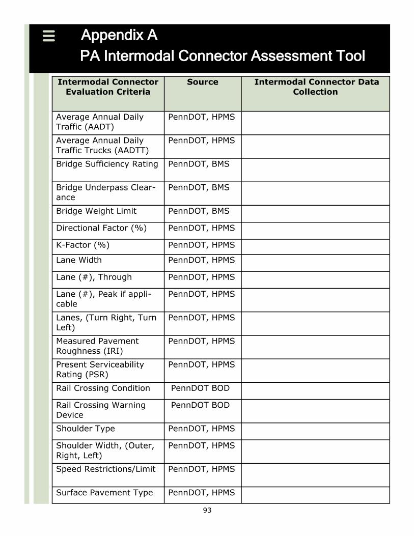
inventory the existing NHS Intermodal connectors (where applicable) and identify any facilities that should be added To assist regions an in-
termodal connector assessment tool has been developed and is located in Appendix A Once documented this information can be presented both graphically via mapping and descriptively in tables Once the key
elements of the system are documented subsequent plan updates re-quire only reviewing and updating this work
Public Transportation
Identification of passenger transit modes within the region (bus light
and heavy rail etc)
Integration with transit highway street and road projects (including
identification of priorities and consideration of transit oriented design)
Operational integration between transit fleets and other modes
(passenger rail aviation taxis etc)
Short and long range transit plans and capital finance plans for the
LRTP period
Inventory of bus fleets by ―age and fuel type (diesel natural gas and
other alternative fuels)
Urban and commuter rail project priorities
42
RESOURCES
Traffic Signal Loca-
tions
FHWA Freight
Analysis Framework
National Highway
System Freight
Connectors
Guidebook for Inte-
grating Freight into
Transportation
Planning and Pro-
ject Selection Proc-
esses
Inventories
Goods MovementIntermodal Linkages
(Ports Rail Trucking and Aviation)
The role of goods movement within the region (this general discussion
will include intermodal connectivity between all applicable maritime facilities rail freight lines inventory of major routes used for trucking
major warehouses and freight transfer facilities and aviation cargo
facilities)
Identification of NHS Intermodal ConnectorsIntermodal Connector As-
sessment (PA ICAT) located in Appendix A
Plans for future expansion of ports and airport cargo handling facilities
and issues regarding access to these ports
Projections for future expansion of rail freight lines within the region
Rail airport and port access issues (if applicable)
ITS and Traffic Signals
An overview of the regionrsquos existing ITS infrastructure including those
that increase efficiency safety and level of service
An overview of the regionrsquos existing and proposed Traffic Signals
43
RESOURCES
Pennsylvania Public
Airports
FAA Passenger
Boardings and All
Cargo Data
PennDOT Bicycle
and Pedestrian In-
formation
Bicycling Directory
of Pennsylvania
PA Outdoor Recrea-
tion Plan
Transportation En-
hancement Activi-
ties
Inventories
Trails Bicycle and Pedestrian
An overview of the bicycle and pedestrian facilities in the region and
volumes where available (include agencymunicipality responsible for
the facility)
Policies plans and programs used to promote the usage of bikes and
walking
Transit interface with trails bicyclists and pedestrians
Identification of Transportation Enhancements Home Town Streets
and Safe Routes to School activities and identify missing links on the network
Regional Airport System
An overview of the role the airport system within the region
An airport inventory of the commercial and general aviation airports
within the region This should include a general description of each airport (number of commercial flight based aircraft number of annual
operations etc)
Short and long range capital improvement plans and projects for the
airports within the region
Outcomes of the State Aviation System Plan (SASP) update and re-
gional aviation system planning efforts
44
RESOURCES
PA Spatial Data Ac-
cess (PASDA)
PennDOT Cultural
Resources
PHMC Cultural Re-
sources GIS
DEP GIS
DCNR GIS
PA Fish and Boat
Commission GIS
ESRI TIGER Line
Data Census 2000
Integrating Climate Change into the Transportation
Planning Process
Inventories
Environmental Inventories Natural historical and cultural assets should be documented This in-
formation can be inventoried within a geographic information system if available In many cases this information may be available for free
from the Pennsylvania Historical and Museum Commission the Pennsyl-vania Department of Conservation and Natural Resources the Pennsyl-vania Department of Environmental Protection the Pennsylvania Fish
and Boat Commission or other information providers Once docu-mented this information can be presented both graphically and descrip-
tively in tables
Environmental Overview Natural Historical and Cultural In-
ventories A general overview and documentation of naturalhistoricalcultural resources
See Appendix D for Environmental Resource GIS Data Sources
Potential impacts associated with improvements to the transportation
system as well as conceptual mitigation opportunities
Potential impacts associated with natural gas drilling as well as concep-
tual mitigation opportunities
A general overview of all existing and future regional greenways and
trails including water trails
Specific resources agency coordination measures
45
VisioningTransportation Goals amp Objectives
The purpose of developing a vision is to clearly articulate a desired overall direction for the region This vision can then be further defined through more specific goals and ob-
jectives The vision goals and objectives should then be supported throughout the plan particularly when evaluating and prioritizing solutions The vision should take into account the overall desires and aspirations of the community and include a variety of
factors beyond transportation that may influence the regionrsquos transportation solutions This broad vision can then be translated into the transportation-related goals and ob-
jectives that set the direction for more specific aspects of the plan The development of a vision goals and objectives needs to be inclusive and should occur primarily through a strong public involvement and outreach process in order to adequately address the
needs of the public for which the future transportation system is intended to serve In addition linking the information in the previous plan to the new plan update provides
for some level of continuity This is particularly an issue when there are unresolved concerns from the previous plan which can often be the case given the short time be-tween new plans Integrating external policies into the vision process is also an impor-
tant consideration since part of the purpose of visioning is to factor non-transportation issues and policies into the transportation plan
During the visioning process and the identification of goals and objectives regions may
want to consider the concepts of livability and sustainability Livability is about tying the quality and location of transportation facilities to broader opportunities such as ac-cess to good jobs affordable housing quality schools and safe streets This includes
addressing safety and capacity issues on all roads through better planning and design maximizing and expanding new technologies such as ITS and the use of quiet pave-
ments using Travel Demand Management approaches to system planning and opera-tions etc Environmental sustainability is providing for the quality of human life while living within the innate carrying capacity of the Earthrsquos eco-systems It is the inten-
tional act of conserving the Earthrsquos natural resources for future generations to the maximum extent possible while addressing both present and future economic and so-
cial needs People must wisely choose the best alternatives that impact the Earthrsquos natural resources the least Such impacts must be understood and managed with a ho-listic consideration of the interaction and interdependency between biological and hu-
man activity across local national and global scales Ecological equity requires such consideration for all walks-of-life all generations and across all geographies At its
core sustainability requires both quality of human life and wherever possible the wise use of renewable reusable and recyclable resources to reduce the unnecessary con-sumption of natural resources By embracing these themes a region can realize the
potential of creating more transportation options at a lower cost
Core Federal Livability Principles Economic Competitiveness Coordinated Policies and Leveraging of Investments
Safe and Efficient Access to Jobs Education Health Care and Goods and Services Mixed Use Mixed-Income Compact and Infill Development
Increased Modal Options (Transit Pedestrian and Bicycle) and TODs Equitable and Affordable Housing Value of Community Character and Public Involvement
46
RESOURCES
Long range plan 28
year financial guid-
ance for each MPO
and RPO
FHWA Innovative
Financing
FHWA Public-
Private Partnerships
DVRPC Options
for Filling the Re-
gions Transporta-
tion Funding Gaps
Financial Planning and Guidance
As required by federal regulations the long range plan must be fiscally constrained based on an analysis of revenues that can reasonably be
expected over the chosen planning horizon Partners should establish the LRTPs fiscal constraint in coordination with PennDOT and federal representatives not only to better predict future funding streams but
also to provide for some level of consistency within the state It is unlikely that most regions will have sufficient funding to meet all their
desired solutions with traditional sources of funding Regions may need to explore alternative funding sources whether through leveraging pri-vate transportation investments public-private partnerships innovative
financing mechanisms or alternative revenue sources and determine how they could realistically be incorporated into a regionrsquos transporta-
tion plan Providing an opportunity to list out solutions that are outside the financial guidance allows for a comparison of the benefits and draw-backs of various revenue-enhancing options
The baseline fiscal constraints were determined by the Financial Guid-
ance Work Group and follows the latest TIPSTIP Financial Guidance for-mulas
Discretionary funding such as spike and economic development may be estimated using a historical average Existing earmarks for projects can
be listed in the Long Range Plan if full project funding can be docu-mented Appalachian Development funding may also be included for
currently approved projects as reflected in the latest cost to complete estimates
The funding estimates provided are a best estimate based on the cur-rent financial and political climate at the Federal and State levels If an
MPO or RPO chooses to use other funding estimates documentation of how these estimates were generated must be provided The estimates must be within reason and consultation with PennDOT Center for Pro-
gram Development and Management and FHWA is required before alter-nate estimates are used
An inflation factor is available through the PennDOT Office of Planning This fac-
tor should be applied to current year estimates and compounded annually to de-
termine future costs by the year of expenditure (YOE)
47
RESOURCES
Transportation Ad-
visory Committee
Transportation
Funding Study
AASHTO Transpor-
tation Asset Man-
agement Today
FHWA Asset Man-
agement Home
FHWA Integrating
Asset Management
into the Metropoli-
tan Planning Proc-
ess
York County Long
Range Transporta-
tion Plan
General and Proce-
dural Guidance
Asset Management Planning for long range asset management identifies the appropriate level of available resources that should be allocated for the preserva-tion of the existing transportation system Having a consistent method and tools to estimate the cost of maintaining and improving the trans-portation infrastructure regionrsquos can direct resources to where they are needed and identify funding shortfalls Long range plans need to reflect stated policy objectives Short term operational planning and capital programming need to translate policies into performance objectives to match planning decisions with strategic priorities A failure to invest available resources properly in managing assets will result in the further deterioration of the system The objective is to provide better decision-making based upon quality information and well-defined objectives It is important for MPOs and RPOs to emphasize asset management planning as part of their LRTP process in a more comprehensive manner A key goal is to begin thinking about maintaining the existing system as early as possible in the planning process and allocate capital funding to projects that will extend the useful life of the existing system and make the most cost-effective improvements to the system Regional LRTPs should be consistent with the identified statewide main-tenance goals in the General and Procedural Guidance ―Transportation system preservation and management continues to be the highest pri-ority in Pennsylvania and the individual MPORPO programs should em-phasize system preservation and management System preservation involves extending the life of existing facilities and their associated equipment and hardware or the repair of damage that impedes mobility or compromises safety while system management involves improving the reliability safety traffic flow and security of existing facilities and their associated equipment and hardware The current TIPSTIP General and Procedural Guidance recommends ―that at a minimum of 90 of a MPO or RPOrsquos program be dedicated to system preservation including 85 of bridge improvement resources directed toward addressing structurally deficient (SD) bridges in or-der to reduce the backlog or structurally deficient bridges The remain-ing 15 should be directed toward bridge preservation once the num-ber and deck area of structurally deficient bridges has reached estab-lished goals for each network and the top statewide quartile of SD bridges (as per PennDOTrsquos Bridge Risk Assessment Tool) within the re-gion is programmed on the TIP a higher percentage of funds can be invested in bridge preservation and non-SD bridges to prevent addi-tional bridges from becoming SD This approach reflects a statewide goal to achieve 83 SD deck area by 2033 while extending the life of the bridges that are not currently SD
48
RESOURCES
Pavement Policy
Manual PUB 242
Asset Management Assets to be included in LRTP preparation are pavements on all state and local federal-aid routes bridges (including all federal eligible bridges over 20 feet and state and local bridges between 8 and 20 feet) tunnels (if applicable) ITS traffic signals and public transporta-tion facilities and equipment Guidance and methodology for consider-ing each of these assets and for determining resource requirements to maintain these assets in a steady state condition and reduce the back-log in each of these areas are presented in Appendix B
Pavement Significant progress has been made in improving the smoothness of Pennsylvania pavements over the past several years The International Roughness Index (IRI) is a measure of highway roughness with lower numbers indicating smoother pavements In 2009 Pennsylvaniarsquos 1700-mile network of interstates carried 24 percent of all the statersquos traffic on only 15 percent of the statersquos total roadway network As a unit these roadways recorded the lowest (best) IRI ratings succes-sively followed by lower-order roadways such as National Highway System (NHS) and non-NHS routes Based on the IRI values the in-terstates can be classified as in ―excellent condition while the other networks are rated ―good However approximately 6800 miles of road remain in poor condition and smooth pavements may not translate into durable long lasting pavements Much of Pennsylvaniarsquos underlying pavement structure has exceeded its design life and there are significant reconstruction and re-habilitation needs Additionally there are substantial roadway appurte-nances (signs drainage structures safety hardware etc) which re-quire periodic replacement A comprehensive asset management sys-tem would include the right mix of pavement preservation and recon-struction projects The result is that subsequent preservation treat-ments would be more effective and last longer However without addi-tional funding there will be more sealing and patching instead of resur-facing and reconstruction resulting in further deterioration in overall pavement condition
Asset Condition and Needs
Description of the current condition and performance of the transpor-
tation
Evaluation of the current system to determine the resources needed
to sustain quality infrastructure
Financial need estimates developed for each asset compared to total
available funding
Documentation of the funding shortfall needed to sustain quality infra-
structure
49
RESOURCES
Annual Pavement
and Appurtenance
Needs by County
Asset Management
An effective pavement management system provides for the assess-ment of pavement condition the prediction of future performance and the generation of reconstruction and preservation strategies that maxi-mizes long term pavement serviceability based on well defined goals and available funding Pavement management goals may place a higher emphasis on high type roadways such as the Interstate but should not neglect other categories of roads A balance of preservation and reconstruction or rehabilitation projects is required to assure that while some roadways are improved others are not allowed to deterio-rate extensively PennDOT has assessed current and future pavement needs based on current condition predicted IRI and treatment cycles and proposed a scenario to improve the overall pavement condition It is critical that pavements be addressed on a treatment cycle which includes eventual reconstruction of the pavement based on observed conditions The proposed cycle for Interstate and NHS pavements addresses pavement reconstruction at the 50-year mark with maintenance activities and in-terim treatments (such as resurfacing or crack sealing) at the appropri-ate points within the 50-year cycle For the lower level networks a similar cycle is proposed with a less expensive treatment such as a full betterment at the 50-year mark on Non-NHS roads greater than 2000 ADT or a continuous seal coat cycle with paving on the most critical portions of the Non-NHS roads less than 2000 ADT Appendix B shows the annual required funding to address the pro-posed pavement cycles for each network These figures include annual pavement needs based on this cycle plus a plan to reduce the backlog of reconstruction needs over a 25-year period In addition appurte-nance needs were included for the non-NHS network This would in-clude items such as signs guiderail paint lines delineators retaining walls lighting and drainage
50
Asset Management
Methodology
The recommended reconstructionbetterment and preservation cycles for state owned roadways were established to maintain the system at the cur-rent condition A 50-year pavement life was assumed so all facilities would be reconstructed once during that period and the NHS facilities would be preserved three times during that period
The recommended cost per mile for reconstructionbetterment and preser-vation were established to facilitate planning for assets statewide Unit costs and mileage may be obtained from Appendix B
Consult with the Bureau of Planning and Research to identify mileage of lo-cally owned roads eligible for federal aid and apply the appropriate cost and treatment cycle as identified in the methodology in Appendix B
An inflation factor is available through the PennDOT Office of Planning This factor should be applied to current year estimates and compounded annu-ally to determine future costs by the year of expenditure (YOE)
Maintenance Planning Factors for Pavement
Measure Indicator Level of Detail
IRI by Network ( Excellent + Good) Poor County
Backlog Miles Out of Cycle County
OPI by Network TBD County
STAMPP by Segment Total Dollar Needs County
Source PennDOT Bureau of Maintenance and Operations Note See glossary for acronyms and definitions
51
RESOURCES
Accelerated Bridge
Program
Asset Management
Bridges
Bridge conditions in Pennsylvania have long been a concern The Com-monwealthrsquos Rebuild PA initiative emphasizes addressing the enormous bridge problem across the state This includes bridge rehabilitations and replacements as well as preservation and maintenance to defer more bridges falling into the structurally deficient category each year Positive progress has been made possible by dedicating most Act 44 funds to bridges using bond proceeds for bridges and dedicating any available highway funds to bridges PennDOT has proposed a new bridge initiative with the goal to reduce the percentage of structurally deficient bridge deck area to the national average within 10 years and to 5 percent over a 20 year period It has been estimated that to accomplish this goal 500 bridges would be re-habilitated or replaced annually for the first 10 years with emphasis on the bridges on the National Highway System This total could be re-duced to 300 bridges for each of the following 10 years This would as-sume that revenues to this program would keep pace with inflation In addition it is recognized some areas have a low level of structural defi-cient bridges and the emphasis needs to be preservation An effective asset management strategy for bridges centers on the most appropriate treatment strategy including routine maintenance rehabilitation and reconstruction based on recent bridge inspections and the Bridge Risk Assessment Tool outputs
52
RESOURCES
Annual Bridge
Needs by County
Asset Management Methodology
For the purpose of the LRTP the needs assessment should include all state bridges greater than 8 feet and local bridges greater than 20 feet and not just those that are structurally deficient This approach focuses on the advantages of asset management as it relates to preventative maintenance By maintaining non-structurally deficient bridges their life can be extended before they need replaced
Inventory all structures using the Bridge Management System (BMS) from the PennDOT Bureau of Design and calculate the total square footage by county A 20 contingency factor may be added
Obtain the recommended preservation activities and unit costs from Appendix B to determine need for the LRTP plan-ning period Utilize the Bridge Risk Assessment Tool to deter-mine the recommended nearer term maintenance approach from the appropriate PennDOT District(s)
An inflationary factor is provided through the PennDOT Office of Planning This factor should be applied to current year es-timates and compounded annually to determine future costs by the year of expenditure (YOE)
Inventory all locally-owned bridges greater than 8 feet and less than 20 feet The inventory should include structural type an estimate of the deck area and general condition particularly if a routine inspection report is not available and obtain the recommended preservation activities and unit costs from Appendix B to determine need for the LRTP plan-ning period
Maintenance Planning Factors for Bridges
Measure Indicator Level of Detail
SD by Network SD County
SD Deck Area by Network SD Bridges Deck Area
County
$ Spent on SD Bridges by Network
of $ Spent on SD County
Change in SD Condition Change in SD Condition
County
Source PennDOT Bureau of Design
53
Asset Management
Tunnels A tunnel is an underground highway that in many cases is equipped with a conglom-erate of interrelated systems and components that need to be properly inspected maintained and tested to insure the tunnel is open and performing reliably as de-signed A preventive maintenance plan which considers future upgrading of systems should be developed Decision makersowners can then provide the necessary capital expenditure budget to insure the continued viability of the tunnel and its supporting systems Methodology
For the purpose of the LRTP the owner should perform a needs assessment which should include cyclic maintenance and replacement of key life-safety and structural components and identify and establish target levels of condi-tion system reliability and performance for each tunnel Employing these standards and evaluating the cost of preserving the long-term viability of tunnels can be used to calculate funding requirements over the period of the LRTP
The financial management plan for tunnels should not only include costs for rehabilitation but should also address future preservation and required en-hancements to meet new emerging requirements for life-safety Agencies should work with local planning organizations to accomplish this task
Tunnel systems are generally complex and expensive in terms of capital costs The use of peer review teams and technical advisory panels with subject matter expertise should be considered in developing site-specific cri-teria and best practices
An inflationary factor is provided through the PennDOT Office of Planning This factor should be applied to current year estimates and compounded an-nually to determine future costs by the year of expenditure (YOE)
54
RESOURCES
Management and
Operation in the
Metropolitan Trans-
portation Plan
511PA
Annual Pavement
and Appurtenance
Needs by County
Asset Management
ITS Assets Congestion is a result of several root causes including physical bottle-necks traffic incidents traffic signals work zones weather and special events Nationally and in Pennsylvania congestion has worsened over the past 20 years It is estimated that congestion costs Pennsylvanians $27 billion each year according to the Texas Transportation Institute Conservative estimates indicate that congestion will increase by 50 to 60 percent in Pennsylvania by 2035 unless a multifaceted congestion mitigation program is established ITS technology has been deployed on the heaviest travelled highways in Pennsylvania $136 million is spent annually to operate and main-tain ITS equipment and Regional Traffic Management Centers (RTMC) across the state In addition specific projects are programmed across the state to add ITS equipment either as standalone projects or as part of larger projects To provide traveler information 511PA data is compiled from public sources including PennDOT PA Turnpike traffic op-erations Pennsylvania Emergency Management Agency (PEMA) and Pennsylvania State Police (PSP) As part of 511PA traffic speed data is purchased from a private supplier for 488 miles of Interstates and ex-pressways With the growing amount of ITS equipment already deployed across the state it is necessary to begin a replacement program for old or outdated equipment This is currently estimated to cost $74 million per year in 2010 dollars (Appendix B)
Asset management for ITS consists primarily in budgeting for equip-ment upgrades repairs and replacements Typical life-cycles for ITS assets vary considerably due to the wide range of device types and op-erational conditions The nature of ITS equipment requires fairly fre-quent maintenance and replacement as compared to more traditional assets like roads bridges and static signs Moreover an ITS asset may become outdated if its functional requirements change prior to the assetrsquos useful service life These costs should be included in LRTP budgeting
55
RESOURCES
Traffic Signal Re-
source Portal
Asset Management Methodology
The MPORPO should request an inventory of ITS devices by year of installation from the PennDOT Bureau of Highway Safety and Traffic Engineering and the appropriate replace-ment cycles through the plan horizon The product will be the number of assets by ITS device type and the year that they were installed
The MPORPO should determine the ITS maintenance and re-placement costs by multiplying the total number of devices by its operations and maintenance unit cost Replacement costs should be added in the future planning years as appro-priate based on the recommended replacement frequency (Appendix B)
An inflationary factor is provided through the PennDOT Office of Planning This factor should be applied to current year es-timates and compounded annually to determine future costs by the year of expenditure (YOE)
Traffic Signals Pennsylvania has nearly 14000 traffic signals that are owned and oper-ated by approximately 1200 of Pennsylvaniarsquos municipalities A major-ity of these municipalities have neither the technical expertise nor the resources to adequately maintain and operate their traffic signals There is minimal operational oversight at the state level after initial in-stallation Improved operation of traffic signals could have a significant impact on major arterials and other corridors throughout the state Traffic signal retiming has been shown to be one of the most effective ways to improve traffic movement and make streets safer Retiming has benefits to the traveling public through reducing delay reducing motorist frustration improving safety and reducing fuel consumption and emissions Identifying the costs associated to better time and modernize signals could reduce congestion and assist local governments Based on rec-ommended practices by the FHWA traffic signals should be retimed at least every 5 years and modernized every 10 years It is estimated to cost approximately $182 million statewide annually in current dollars
56
RESOURCES
Annual Traffic Sig-
nals by County
Asset Management Methodology
The planning partner should obtain the Departmentrsquos inven-tory from the PennDOT Bureau of Highway Safety and Traffic Engineering and a review of traffic signal map locations at ftpftpdotstatepauspublicBureausHighwaySafetyTraffic20Signal20Maps
Review the Departmentrsquos inventory and traffic signal map lo-cations to determine discrepancies with the previous Depart-mentrsquos traffic signal listing
Obtain the recommended preservation activities and unit costs from Appendix B to determine need for the LRTP plan-ning period
An inflationary factor is provided through the PennDOT Office of Planning This factor should be applied to current year es-timates and compounded annually to determine future costs by the year of expenditure (YOE)
NOTE A GIS shapefile containing the traffic signal locations is available through the PennDOT Office of Planning
Maintenance Planning Factors for Traffic Signals
Measure Indicator Level of Detail
of Signals Maintained Maintained County
of Signals Retimed Retimed County
of Signals Modernized Modernized County
Source PennDOT Bureau of Design
57
RESOURCES
FTA State of Good
Repair
Asset Management Public Transportation
Capital assistance is intended to keep current transit assets such as buses rolling stock and fixed guideway infrastructure in a state of good repair It is widely acknowledged that there are substantial shortfalls that will constrain transit providersrsquo ability to maintain assets in a state of good repair and implement strategic capital improvements to ad-dress the demand associated with growing areas The LRTP should identify the need for transit asset management and account of it in financial projections Those assets that are eligible to receive Federal funds to assist with modernization of transit fleet(s) and facilities should be included in the analysis The intent is to cap-ture the capital costs associated with maintaining and improving ser-vices over time
Methodology
The MPORPO should request an inventory of the existing fleet by year of purchase from the public transportation pro-vider(s) in the region The product will be the number of as-sets by type and the year it was purchased
The MPORPO should contact the Federal Transit Administra-tion and the public transportation provider(s) in their region to determine the cost associated with the modernization of their fleet(s) using appropriate replacement cycles up to the plan horizon
Similar data should be collected for transit facilities and fixed guideways based upon planned improvements or replace-ments
A capital cost escalator of 3 percent should be used for fore-casting purposes (NOTE This is consistent with the as-sumption used by Transportation Funding and Reform Com-mission)
NOTE An update to these recommendationsmethodology is expected to be completed in early 2011
Maintenance Planning Factors for Public Transportation
Measure Indicator Level of Detail Average Fleet Age Past Useful Life Transit Agency
Facility ConditionCapacity
Condition Age and Capacity Transit Agency
Fixed Guideway Condition
Condition Analysis Transit Agency
Source Transit Service ProvidersBureau of Public Transportation
58
RESOURCES
Guidance for Cost
Estimation
PennDOT Transpor-
tation Project Cost
Management
Screening Forms
Cost Estimation
Cost estimates are required for each phase of a project and are to be created as early as possible during the development of the Long Range
Transportation Plan (LRTP) and during the project development process The initial cost estimate should be identified in the Level 2 screening form Updates during the project development process should occur at
the project milestones of Problem Identification Proposal Initiation Pro-posal Definition Project Identification in the Transportation Improve-
ment Program (TIP) Preliminary EngineeringNEPA Decision (Design Field View) Final Design (Final Design Office Meeting) and Final Esti-mate The cost estimate method used must fit the information available
at the time the estimate is developed and take into account project complexity Providing environmental information at the earliest possible
point in time is consistent with Federal and State efforts to streamline project delivery and the NEPA review process It is recommended that the LRTP also include preliminary cost estimation for mitigation activities
that are identified For projects of significant complexity Environmental Assessments and Environmental Impact Statements only the study
phases should be on the LRTP until the project has been clearly defined Transit cost estimates for capital improvements are to be created during
the development of the LRTP and the project development process Up-dates during the project development process should occur as required for TIP development finalization of specification and solicitation of bids
in coordination with the appropriate transit agency
Cost estimations must be based on work that can reasonably be accom-plished over the planning horizon Each project phase must be assigned to the appropriate segment of the LRTP project list Project phases that
are cash flowed must be based upon realistic milestones
Consistent cost estimates can be developed through the Metropolitan Planning Organizations and Rural Planning Organizations in collaboration with the appropriate District Design Unit(s) or Transit Agency(s) All
projects in the LRTP must provide accurate cost escalation factors (Year of Expenditure) while maintaining fiscal constraint
Cost Estimation Checklist
Estimate is escalated to year of expenditure dollars for each phase of the project
Process includes risk-based assessments of cost drivers and of unknown and all uncertain costs
Estimate is consistent with project scope
Estimate includes costs for each project phase
Estimate includes all right-of-way and administrative costs
Estimate includes all third party (eg utility railroad) costs
Estimate includes cost contingencies and known or potential risk factors
Estimate includes inspection costs
Other items may be added depending on the projectrsquos characteristics
59
Project Prioritization and Selection
Prioritizing transportation projects is essentially a three-step process First transporta-tion system needs (problems) and project ideas (solutions) are identified through public involvement processes County Comprehensive Plans PennDOT District planning ef-forts transit provider plans freight carriers economic development agencies and vari-ous other sources Since financial resources will never be sufficient to address every problem needs and projects must be prioritized The second step is to identify needs and projects that are a high enough priority to be included on the regionrsquos fiscally-constrained long range transportation plan The third step is to identify needs and pro-jects that are a high enough priority to be included in Stage 1 of the plan which corre-sponds to the short-range Transportation Improvement Program Once these project are identified they proceed into the problem development and project delivery proc-esses which includes environmental review design and construction There are four basic considerations incorporated into the decision-making process at the key prioritization points local needs and priorities regional needs and priorities technical evaluation and the money mix Recent efforts have focused on improving the technical evaluation component of this process in order to provide decision makers with better information from which to base their decisions Establishing a project selection process helps to provide consistency between the goals and policies implemented through plans and programs and the mix of projects and in-
vestments of the Transportation Improvement Program (TIP) Establishing a process during the Long Range Transportation Plan (LRTP) development process allows for a
more robust collaborative effort including input from both the public and stakeholders However project prioritization is not a mechanical process It cannot and should not
be overly prescriptive or inflexible The minimum project criteria located in Appendix C should be viewed as a baseline for identifying a process to evaluate projects Addi-tional criteria and the weights assigned for all the criteria should be considered per any
feedback received during the public participation process
60
RESOURCES
Harrisburg Area
Transportation
Study Project Rank-
ing Criteria
York County Long
Range Transporta-
tion Plan
Project Prioritization and Selection
The desired outcome is to create a better maintained system than under the current approach Applying the Keystone Principles and Smart
Transportation concepts helps to guide development influence land use decisions and mitigate the related impacts on infrastructure
In addition to using the road management pavement cycles and the bridge risk assessment tool to help identify maintenance needs Metro-
politan Planning Organizations (MPOs) and Rural Planning Organizations (RPOs) may consider identifying targets based on measures like Inter-national Roughness Index (IRI) or percent structurally deficient (SD)
bridge deck area that provide prioritization for all classes of assets Measures can also consider highway safety volume land use economic
impact and the population served This approach recognizes that the total cost to maintain the current system will be several times the pro-jected funding available and place a stronger emphasis on targeting in-
vestment decisions
Developing two sets of criteria one specific to the project type for ex-ample highway or transportation enhancements (TE) and a second set
which incorporates the smart transportation principles is recommended The first set of criteria is relative to the type of project This approach
recognizes that the criteria used to select a good bridge project would be different from the criteria used to select a TE project The project would then be sent through the second set of criteria used as a filter to
determine if the proposed project meets certain requirements and has support from the community (ie smart transportation) Once the pro-
ject has been scored by both lists of criteria its overall score is used to rank it among like projects The MPORPO will then have to determine
the amount of funding that will be spent on each type of project and the ranked list can then be used to select projects up to the determined funding level
GIS can also be used as a tool to assist in the selection of projects by
providing greater context of the area Overlaying candidate projects over current asset condition data may show which projects address the greatest areas of need Also overlaying demographic data would help
with the equitable distribution of projects across the communities in the region
A guide to various project characteristics criteria for project types and overall transportation criteria can be found in Appendix C
61
Project Lists
In order for a project to be included in the regional Transportation Improvement Pro-gram (TIP) it must first be consistent with the most recent update to the long range
transportation plan To be in compliance the long range plan must include a list of projects that may be implemented during its planning horizon This project list must be fiscally constrained However it is becoming more common for additional projects
to be included either in a supplementary list or as part of a scenario in which addi-tional transportation revenues will become available during the planning horizon (the
projects are often referred to as an ―illustrative list of projects) Because the plan-ning horizon is 20 years or more different projects will be defined at varying levels of detail ranging from near-term projects that are well defined and have reasonably ac-
curate cost estimates to long range projects that are likely to undergo changes in terms of scope and budget before approaching implementation In some cases pro-
jects may also be defined more broadly as solutions to encompass operations and management improvements that are less capital-intensive than typical transportation projects
The LRTP project lists should be divided into three segments the TIP plus two years
the remaining Twelve Year Program (TYP) and the rest of the years through the Plan horizon MPOs and RPOs may choose to further divide the outer years of the plan
The LRTP project list should be consistent with the current TIP and all project phases should be identified in the appropriate yearly increments if pre-construction funding is identified For the remainder of the TYP all project phases for moderately complex
and complex projects should be identified in the appropriate increment Minor pro-jects or non-complex betterments beyond the TIP plus two years may be listed as line
items The remaining years of the long range plan must consider what can reasona-bly be accomplished over the life of the plan The intent of the breakdown structure is to fully fund projects throughout the life of the plan
If a project is removed from the TIP MPOsRPOs should update their LRTPs to address
the movement of projects from a TIP to a regionrsquos TYP In addition the regionrsquos LRTP should remain fiscally constrained and each project or project phase identified be fully funded as amendments occur
Reasonably expected revenues should then be allocated to the different expenditure categories based on policy and identified need In order to better demonstrate fiscal constraint by project type the LRTP project lists should be grouped in categories for example Highway Bridge Transit Intelligent Transportation Systems (ITS) Traffic Signals Rail Freight Aviation and Non-Motorized These categories will vary from region to region based upon available funding and the specific needs identified in their LRTP An inflationary factor is provided through the PennDOT Office of Planning This factor should be applied to current year estimates and compounded annually to determine future costs by the year of expenditure (YOE)
62
Project Lists
Project List Checklist
Include a project list and map where appropriate for each of the project
categories listed in the plan
Include the short-term TIP projects and the more long-term projects that will
make up the plan
Include a map number the project name the municipality where each project
is located the project limits a general scope of work a cost estimate and the
anticipated funding timeframe
At a minimum divide the funding timeframes into the TIP (yearly segments)
plus two years by project phase the rest of the TYP by project phase if
known and the remaining years to the Plan horizon
Each segment includes projects that could reasonably be funded during that
timeframe
Projects that are outside of fiscal constraint should be listed in the Appendix
for information purposes
Project specific planning studies that have been completed should be listed in
the Appendix for information purposes
63
RESOURCES
TRB Performance
Measurement Ex-
change
AASHTO Perform-
ance Management
References and Re-
sources
Identification of Performance Measures
As transportation planning and operating agencies strive to improve their efficiency and effectiveness they have increasingly turned to per-
formance measures to provide credible quantitative information to sup-port their analysis and decision-making Measurement of transportation system condition and performance has become a more explicitly ac-
knowledged component not only of the planning process but also in programming budgeting and system operation Measures help agen-
cies provide accountability to the public stay focused on intended re-sults improve communication with internal and external customers and improve delivery of services
Ideally the planrsquos goals and objectives would easily translate into quan-
tifiable performance measures to permit an objective analysis and com-parison of investment alternatives The reality is that many goals and objectives are difficultmdashor nearly impossiblemdashto quantify In the ab-
sence of quantitative analysis many regions have employed the use of qualitative measures Qualitative measures can be just as valid as
quantitative measures (particularly for analyzing quality of life issues) if they are used in a structured and objective manner However it is im-
portant to be aware of the challenges inherent in qualitative measures including the potential for subjectivity problems in separating percep-tion from reality the need to carefully describe each solution so it can
be fairly rated and the difficulty in predicting the qualitative benefits of any given solution
There are literally hundreds of potential evaluation measures each with its own strengths and weaknesses making it challenging to determine
which measures are most appropriate for a given region Developing performance measures will likely require significantly more effort to
reach consensus than one might expect Adequate time and resources should be devoted to this task so delays do not occur in the overall plan development process
Principles for Identifying Transportation Performance Measures
Directly reflect and relate to one or more transportation objectives
Be technically sound
Be understandable to decision-makers and the public
Be focused on outcomes rather than outputs
Be relevant to system usersrsquo interests
Be possible to analyze using clear and transparent tools or frameworks
Be applicable to multiple modes whenever possible
Be easily and accurately predicted or estimated using current models and data
Be limited in number
Be potentially transferable to any transportation system or plan monitoring effort
64
RESOURCES
Maryland DOT An-
nual Attainment Re-
port on Transporta-
tion System Per-
formance
A Primer on Safety
Performance Meas-ure for the Trans-
portation Planning Process
Identification of Performance Measures
Metropolitan Planning Organizations and Rural Planning Organizations should consider tracking performance in the following areas which are
consistent with the statewide transportation plan (PA Mobility Plan) safety transportation land use economic development and environ-
mental stewardship sustaining quality infrastructure mobility and ac-cessibility and maximizing benefits
Sample Performance Measures
Decrease Annual Fatalities and Fatality Rate All Vehicles (PennDOT
Bureau of Highway Safety and Traffic Engineering (BHSTE))
Decrease Annual Serious Injury Crashes All Vehicles (PennDOT
BHSTE)
Increase Number of Transportation Strategies Implemented that Mini-
mize Impacts to Natural Historical and Cultural Resources (MPORPO)
Decrease Number of Structurally Deficient Bridges (PennDOT Bureau of
Design)
Percentage of InterstateNHS Mileage by IRI Rating (PennDOT Bureau
of Planning and Research)
Commute Passenger Mode Split (ACS)
Decrease Total Regional Annual VMT All Vehicles Per Capita
(PennDOT Bureau of Planning and Research)
Percent of Funding Designated for System Preservation (MPORPO)
Actual Project Cost (Includes Preliminary and Final Design and Con-
struction) Compared to LRTP and TIP Estimates (PennDOT Districts)
Percentage of Projects Where the Actual Let Date Is On or Before the
TIP Projected Let Date (PennDOT Districts)
Percentage of Projects Requiring Design Supplements After the TIP to
Address Unanticipated Environmental Issues (PennDOT Districts)
Percentage of Projects Placed on the TIP That Were Not Identified in
the LRTP Excluding Asset Management Projects (Accelerated Bridge Program System Preservation etc) That Are Incorporated into a Line
Item (MPORPO)
Increase Percentage of Projects on the STIP That Are Advanced
(PennDOT CPDM)
Information is not currently available in all areas (Cameron Forest
Fulton Potter Sullivan)
65
RESOURCES
PennDOT Design
Manual 1
PennDOT Design
Manual 1A
Planning Components Summary
Transportation Program Development and Delivery Process
Roles and Responsibilities
MPORPO Roles PennDOT District
Roles
PennDOT Central
Roles
Focus available funds and resources on the most appropriate
transportation needs
Link local plans and
goals to transporta-tion need including
asset management
Be involved early in
planning at local county MPORPO lev-
els as collaborators
Centralize access to
new information data sources including
statewide priorities
Share expertise and
information proac-tively with all collabo-
rative parties
Share expertise and
information proac-tively with all collabo-
rative parties
Share expertise and
information proac-tively with all collabo-
rative parties
Improve cost estimating for potential projects
Share cost estimation
methodologies with municipal county
partners and work with PennDOT staff in collaborative cost es-
timation process
Work collaboratively
with MPORPO staff on cost estimation
and documentation at the LRTP stage and into TIPSTIP devel-
opment
Provide biennial finan-
cial guidance and measure effectiveness
of estimate process involving DOTPlanning Partner col-
laboration on costs
Increase accuracy in project scheduling and improve predict-
ability for project delivery
MPORPO Public Par-
ticipation Plan should involve all interested
parties in a variety of ways to clarify issues
Work with MPORPO
staff to identify envi-ronmental issues and
document to NEPA level of detail sharing all engineering envi-
ronmental and public issues with MPORPO
Share information
that might affect schedules proactively
with all parties
Begin environmental
inventory early in process
Proactively engage
project sponsors to ensure local owner-
ship for projects prior to implementation
66
Planning Components Summary
Transportation Program Development and Delivery Process
Roles and Responsibilities
MPORPO Roles PennDOT District Roles PennDOT Central Roles
Develop better and more accurate project scopes
Use existing studies or
develop screening activi-ties associated with Level
2 forms preparation
Share design criteria and
study issues with all part-ners
Share information on how
NEPA documentation should be done
Plan to do screening ac-
tivities in collaboration with MPORPO
Better reflect national state and local goals in the project prioritization
and selection process
Align initiatives of the
DOT PA Governor and Legislature PennDOT the
statewide LRTP county and municipal compre-hensive plans with the re-
gional project prioritiza-tion and selection process
Assist MPORPO in identi-
fying measures to priori-tize and select projects
which consider communi-ties the environment land use and transporta-
tion planning
Assist planners in meas-
ures to prioritize projects linking land use to trans-
portation planning
Select projects which con-
sider communities the environment land use
and transportation plan-ning
Commence communication coordination and cooperation within and be-
tween PennDOT the MPORPOs the Federal Highway Administration (FHWA) Federal Transit Administration (FTA) other transportation plan-
ning entities tribal nations and the resource agencies in planning
Involve interested parties
in LRTP process facilitate PennDOT interaction with
local planners
Liaison with Federal agen-
cies resource agencies MPORPO and other
transportation planning agencies proactively and regularly
Liaison with Federal agen-
cies and resource agen-cies (as needed) monitor
District and Central Office involvement in meetings with partners
Promote early public participation and public involvement
Proactive and inclusive
public and agency oppor-tunities are provided at
MPORPO plan level
Coordination of NEPA pub-
lic and agency involve-ment activities when ap-
propriate
Stress public participation
in State Transportation Commission hearings
process
67
ACTIVITIES OF THE PROCESS
68
RESOURCES
FHWA Transporta-
tion Capacity Build-
ing Public Involve-
ment Techniques
IAP2s Public Par-
ticipation Toolbox
Public Involvement
Techniques for
Transportation De-
cision-Making
Public Involvement Legislation Regula-tions and Guidance
PennDOT Public
Participation Plan for Statewide Plan-
ning
Collaborative Planning
Public Involvement Requirements Public involvement is integral to good planning Without meaningful
public participation there is a risk of making poor decisions or deci-sions that have unintended negative consequences With it it is possi-
ble to make a lasting contribution to an arearsquos quality of life Public in-volvement is more than an agency requirement and more than a means of fulfilling a statutory obligation Meaningful public participation is cen-
tral to good decision making
The fundamental objective of public involvement programs is to make certain that the concerns and issues of everyone with an interest in
transportation decisions are identified and addressed in the develop-ment of policies programs and projects being proposed in their com-munities
SAFETEA-LU requires Metropolitan Planning Organizations (MPOs) to de-
velop and document in consultation with interested parties a Public Participation Plan that details strategies for incorporating visualization techniques using electronic media holding public meetings and re-
sponding to public input among other things prior to the development of the Long Range Transportation Plan (LRTP) In Pennsylvania this re-
quirement is extended to Rural Planning Organizations The public involvement process shall include the publication and distri-
bution of draft versions of the proposed plan providing adequate oppor-tunity for review and comment The approved plan must also be pub-
lished or made readily available in other ways for information purposes Where possible this process should include visualization techniques and make use of the Internet Finally in non-attainment areas there also
needs to be at least one formal public meeting annually to review plan-ning assumptions and the plan development process
Federal regulations require that public officials (elected and appointed) and citizens have adequate opportunity to participate in the develop-
ment of the LRTP before it is approved and adopted The regulations explicitly identify several parties who should be engaged and involved throughout the plan developmentupdate process
69
RESOURCES
SPC 2035 Trans-
portation and De-
velopment Plan for
Southwestern
Pennsylvania Public
Participation
Collaborative Planning
The MPORPO is responsible for actively involving all interested parties
in an open cooperative and collaborative process that provides mean-ingful opportunities to influence transportation decisions Transporta-tion has a profound influence on the lives of people Decision makers
must consider fully the social economic and environmental conse-quences of their actions and assure the public that transportation pro-
grams support adopted land use plans and community values
Interested Parties
Citizens
Affected public agencies
Representatives of transportation agencies
Freight shippers
Providers of freight transportation services
Private providers of transportation
Representatives of users of public transit
Tribal organizations
Bicycle interests
Pedestrian interests
Organizations representing the disabled
State and local agencies responsible for land use management natural
resources environmental protection conservation and historic preser-
vation
Other interested parties
Elements in Planning for an Effective Public
Participation Process A clearly defined purpose and objectives for initiating a public dialogue
on transportation issues
Specific identification of the affected public and other stakeholder
groups with respect to the plans and programs under development
Identification of techniques for engaging the public in the process
Notification procedures that effectively target affected groups
Methods and measures for evaluating the effectiveness of the public
involvement program
Education and assistance techniques which result in an accurate and
full public understanding of transportation issues
Follow-through by the MPO demonstrating that decision makers seri-
ously considered public input
Solicitation of feedback from the public and stakeholders on the effec-
tiveness of the public involvement process
70
Collaborative Planning
Stakeholder Local Official amp Citizen Involvement Engaging the public local officials and stakeholders in the development of the plan will
result in a better long range planning process and outcome However engaging the public in something as potentially abstract as regional long range transportation plan-
ning is challenging At the outset of the plan development or update process planning partners should review their public involvement plan to make certain that it is still ap-propriate for the scope and scale of their plan Public and stakeholder involvement
should be incorporated throughout the process to develop goals policies and solutions that address the issues and concerns that are most relevant to the public not simply
those identified by transportation agencies
One common means of improving stakeholder participation and involvement is to es-tablish a long range plan steering committee to guide the process Any steering com-mittee formed should include representatives of PennDOT and USDOT staff Other
participants might include political leaders representatives of the general public mo-dal interests freight shippers advocacy groups environmental organizations andor
business associations In addition to a steering committee planning partners might encourage the participa-
tion of a larger group of stakeholders by establishing an advisory committee that can be periodically asked to review materials or participate in strategic discussions This
approach not only creates additional interest in the plan but also broadens the num-ber of constituents and stakeholders who support and champion the plan While stakeholder involvement must be balanced manageable and practical opportunities
to actively engage a wide variety of stakeholders should be pursued Consider reach-ing out beyond the existing membership of the MPO or RPO in the creation of the
Steering Committee To better disseminate information and to keep everyone in the public involvement
process informed planning partners should consider developing a communications strategy that outlines communication with plan participantsmdashand goes beyond simply
hosting public meetings Some of the more common means include project brochures newsletters web sites social networking and press releases Much work has been performed on this front and many of the resources on this page can suggest innovative
approaches to engaging stakeholders and the public
71
RESOURCES
Title VI
Environmental Jus-
tice Requirements
Americans with Dis-abilities Act of 1990
Every Voice Counts
Collaborative Planning
The stakeholder and public involvement process should be ongoing throughout plan development but may vary in frequency and intensity
depending on the activities being undertaken at any given time Some activities such as the development of goals and objectives lend them-selves to significant stakeholder involvement Others such as informa-
tion gathering and technical analysis do not It is important to realize that simply making a draft plan available for public review at the end of
the process does not constitute an effective public involvement strategy because it does not provide an opportunity for substantive public input to help shape the plan Planning partners should take advantage of the
resources provided as well as the experience of peer planning agencies as they develop a public and stakeholder involvement program
Issues to be Considered
Determining the scope and scale of the public involvement process and
ensuring that it meets the needs of the general public and stake-holders within the region
Developing the schedule for public involvement incorporating public
input throughout the entire development of the plan
Identifying specific stakeholders and groups to be included in the proc-
ess
Ensuring that Title VI and Environmental Justice issues are substan-
tively incorporated into the process
Developing creative ways to keep the public engaged and involved
throughout development of the plan
Obtaining input from a broad cross section of the public not just spe-
cial interest groups and professional activists
Managing expectations for public input and the impact that this input
will have on development of the plan
Resolving tensions among constituencies with differing experiences
and viewpoints such as cities versus suburbs urban versus rural growth versus environmental preservation local versus regional inter-
ests and differing fiscal priorities
Documenting the public involvement process used in developing the
regionrsquos plan and identifying what efforts were successful and what ac-tivities were not Also recommend any changes to be considered for
the next plan update
Was the LRTP presented at an Agency Coordination Meeting (ACM)
72
RESOURCES
York MPO ACM
Presentation
North Central
SEDA-COG Cen-
tre District 2-0-
State Transporta-
tion Commission
Presentation
Collaborative Planning
Agency Coordination Meeting SAFETEA-LU requires that regions include a discussion of potential en-
vironmental mitigation activities along with potential sites to carry out the activities to be included The discussion is to be developed in con-
sultation with Federal State tribal wildlife land management and regulatory agencies In Pennsylvania the presentation of the LRTP at an Agency Coordination Meeting satisfies this consultation requirement
The ACM consists of members of representing Federal Agencies includ-ing the Federal Highway Administration Army Corps of Engineers En-
vironmental Protection Agency and US Fish and Wildlife Service State Agencies including the Departments of Agriculture Community
and Economic Development Environmental Protection Conservation and Natural Resources and Transportation as well as various State Commissions including Fish and Boat Game Historical and Museum
and the Turnpike For identification of opportunities to present to the ACM please contact the PennDOT Center for Program Development and
Management or the Bureau of Design Environmental Quality Assurance Division
One of the benefits of this process is to involve the agencies in the planning process to try to avoid impacts Strong visualization tech-
nique can be employed such as utilizing GIS to overlay the existing re-sources with the location of the projects as identified on the LRTP
Opportunities to Consider for ACM Presentation 1 Overview of the regionrsquos transportation system and land use 2 Overview of the regionrsquos environmental societal and cultural re-
sources 3 Discussion of the public involvement process
4 Overview of the Planrsquos vision goals and objectives 5 Discussion of the consideration or inclusion of Federal State tribal
and Local policies and Plans
6 Project prioritization and selection process by mode (include safety)
7 Overview of the project list 8 Discussion of avoidance of resources and mitigation opportunities
73
RESOURCES
Integrating Trans-
portation and Land
Use in Comprehen-
sive Plans
PA Municipalities
Planning Code
PA Mobility Plan
Coordinated Planning
Pennsylvaniarsquos planning throughout geographical levels and across disci-plines creates an opportunity to coordinate efforts and to improve trans-
portation for the state The purpose of the analysis is to provide plan-ning partners the public stakeholders and other decision-makers with critical information to better assist in the development and direction of
the plan This information provides a context for the development of the plan and provides participants with a better understanding of rele-
vant statistics issues and trends It is important to look at the direc-tion of other plansmdashboth short and long termmdashthat could directly or in-directly impact a regionrsquos transportation system This is an opportunity
to factor in the results of corridor studies as well as other transportation plans and studies at the local state and even national levels With a
recent emphasis on ensuring consistency and linkages with other ongo-ing planning activities it is also important to consider county land use plans long range plans of transit properties economic development
plans utility expansion plans etc
County and Multijurisdictional Comprehensive Plans The Municipalities Planning Code (MPC) requires that municipal and
county comprehensive plans have a long range transportation compo-nent The MPC also requires these plans to have a level of consistency between them through multiple reviews and comment periods for each
plan among associated planning partners For single county planning partners the county comprehensive plan and the long range transporta-
tion plan may even be the same document Larger regions should be sure their individual county comprehensive plans are incorporated into the MPOrsquos or RPOrsquos long range transportation plan and that the long
range plan informs the comprehensive plan The ―Integrating Transpor-tation and Land Use in Comprehensive Plansrdquo Guidebook aim is to pro-
vide enhanced guidance for preparing the transportation elements of municipal and county comprehensive plans and to maximize the link-
ages between comprehensive plans and the decision-making processes outlined in the long range transportation plans (LRTPs) completed by the statersquos metropolitan and rural planning organizations (MPOs and
RPOs)
Statewide Plan PennDOT provides further overarching guidance to its planning partners through its statewide long range transportation plan the Pennsylvania
Mobility Plan The initiatives within this plan outline how MPOs and RPOs can work toward the vision for the entire state by establishing
consistent objectives and goals in their regional long range transporta-tion plans
74
RESOURCES
Metro Washington Council of Govern-
ments Vision and the Federal Plan-ning Factors
Coordinated Planning
Federal Factors Federal regulations require that the following eight factors be explicitly
considered analyzed as appropriate and reflected in planning products
Although plans must consider each of these factors the broad nature of each factor offers great flexibility in determining how these mandates
align with regional planning efforts
Strategic Highway Safety Plan The Strategic Highway Safety Plan (SHSP) has been developed in order
to target priority Safety Focus Areas (SFAs) and strategiesactions to reduce highway fatalities on Pennsylvaniarsquos roadways This plan details how by 2011 Pennsylvania will reach the goal of reducing annual fa-
talities to 1150 or less using a comprehensive approach to highway safety improvement that employs our best thinking resources and
partners
Safety stakeholders and partners from both the public and private sec-tor (including representatives from PennDOT Engineering Districts and
Planning Organizations) representing the 4 Ersquos of highway safety (EngineeringEnforcementEducation Emergency Services) contributed
to the development of this plan
Eight Federal Factors
Support the economic vitality of the metropolitan area especially by
enabling global competitiveness productivity and efficiency
Increase the safety of the transportation system for motorized and non
-motorized users
Increase security for transportation system users
Increase the accessibility and mobility options available to people and
for freight
Protect and enhance the environment promote energy conservation
improve quality of life and promote consistency between transporta-
tion improvements and state and local planned growth and economic
development patterns
Enhance the integration and connectivity of the transportation system
across and between modes for people and freight
Promote efficient system management and operation
Emphasize preservation of the existing transportation system
75
RESOURCES
PA Highway Safety
5 Report Method-
ology
FHWA Roadway
Safety Audit Guide-
lines
Pedestrian Roadway
Safety Audit Guide-
lines and Prompt
Lists
Coordinated Planning
SAFETEA-LU Section 148 created a new Highway Safety Improvement Program (HSIP) as a ―core FHWA program with separate funding The
purpose of the HSIP is to reduce traffic fatalities and serious injuries on public roads The HSIP provides funds for safety improvement projects and rail-grade crossing improvement projects in Pennsylvania As part
of the new HSIP States are required to submit an annual report de-scribing not less than 5 percent of their highway locations exhibiting the
most severe safety needs In order to comply with regulation PennDOT used a data driven approach to identify the top 25 locations for each MPORPO that exhibit the most severe safety needs and could poten-
tially be addressed with these funds This list of locations has been dis-tributed to the respective Planning Organization and Engineering Dis-
trictrsquos for their use This will be updated by PennDOT every even year and will be passed on to the Planning Organizations and Engineering
Districtrsquos once completed
Roadway Safety Audits (RSA) can also be conducted during the develop-ment of the LRTP to identify needed safety improvement RSA can be
used as proactive approach to improving transportation safety on future or existing roadways and is adaptable to local needs and conditions
RSA are usually done at a particular location or stretch of roadway where there is a perceived or documented safety problem A team of experts are assembled who are preferably unfamiliar with the area and
the issues to increase the likelihood of an objective analysis Data is examined the site is field reviewed observations and recommendations
are made from strictly a safety viewpoint to the plan stakeholders
76
RESOURCES
Crafting an Effec-
tive Plan for Public
Participation
Coordinated Planning
Public Participation Plan SAFETEA-LU requires that ―the MPO shall develop and use a docu-
mented participation plan that defines a process for providing citizens affected public agencies representatives of public transportation em-
ployees freight shippers providers of freight transportation services private providers of transportation representatives of users of public transportation representatives of users of pedestrian walkways and bi-
cycle transportation facilities representatives of the disabled and other interested parties with reasonable opportunities to be involved in the
metropolitan transportation planning process In Pennsylvania this
requirement is extended to the RPO
The purpose of the MPOsRPOs participation plan is to establish the
process by which the public can participate in the development of re-gional transportation plans and programs The public participation plan
should be designed to assist MPORPO staff in implementing an effective public participation process through a variety of strategies It provides MPORPO staff with a menu of techniques or activities from which they
can tailor their specific programrsquos input process Which public participa-tion methods the MPORPO uses will require a careful analysis of what is
wished to be accomplished as well as the scope of the particular trans-portation project Plenty of flexibility is available to MPOsRPOs in de-veloping specific public involvement programs Every given situation or
region in Pennsylvania is different and each approach to a specific pub-lic involvement challenge will be unique When significant written and
oral comments are received on the draft LRTP and as a result of the participation process or the interagency consultation process required under the transportation conformity regulations a summary analysis
and report of the proposed comments shall be made as part of the final
LRTP
It is important to note the public participation plan should be prepared prior to the development of the LRTP The public participation plan
should have public input during its preparation and have a 45-day com-ment period before the MPORPO board adopts it
77
RESOURCES
PA Human Services
Transportation Co-
ordinated Study
York Coordinated
Public Transit-
Human Service
Transportation Plan
SPC Congestion
Management Proc-
ess
Coordinated Planning
Coordinated Public TransitHuman Services Transportation
Plans The aim of the Coordinated Public TransitHuman Services Transporta-tion Plan is to improve transportation services for persons with disabili-
ties older adults and individuals with lower incomes by ensuring that communities coordinate the available transit resources Coordination enhances transportation access minimizes duplication of services and
facilitates the most appropriate cost-effective transportation possible with available resources Federal transit law requires that projects se-
lected for funding under the following Federal Transit Administration (FTA) programs be derived from a coordinated plan including the Elderly
Individuals and Individuals with Disabilities Program Job Access and Reverse Commute Program and the New Freedom Program
MPOs and RPOs are not required to be the lead agency in the develop-ment of the coordinated plan but Federal guidance states that the coor-
dinated plan may be developed separately or as a part of the metropoli-tan transportation planning process In any case MPOs and RPOs should make certain that the plan is coordinated and consistent with
their regions transportation planning process
Congestion Management Process Federal transportation legislation (SAFETEA-LU) requires that each met-
ropolitan planning area in the United States with a population greater than 200000 have what is called a Congestion Management Process (CMP) The CMP is a regional program that addresses and manages
congestion within a region in order to facilitate the movement of people and goods
The CMP is a broad regional level planning tool designed to help man-age congestion by indentifying congested corridors and recommending
multi-modal strategies for congestion mitigation The goal of a CMP is to provide information that helps transportation planners professionals
and others to understand the overall congestion climate in individual corridors and the region Data on the congestion climate helps MPOs in partnership with other agencies to formulate congestion management
strategies Data and information from the CMP benefits the transporta-tion planning process by helping the region to focus limited federal
transportation dollars where they can have their greatest impact
78
RESOURCES
Planning for Opera-
tions Regional ITS
Architecture
Regional Operation
Plans
Coordinated Planning
Intelligent Transportation System Architecture Plan Intelligent transportation systems (ITS) encompass a broad range of
wireless and wire line communications-based information and electron-ics technologies When integrated into the transportation systems in-
frastructure and in vehicles themselves these technologies relieve con-gestion and improve safety ITS is one way to increase the efficiency safety and security of a transportation system ITS involves the use of
advanced computer electronic and communications technologies and emphasizes enhancing travel on existing infrastructure (highways
streets bridges trains) Some examples of ITS technologies include advanced traffic signals roadway and weather monitoring stations bus and maintenance vehicle location systems electronic roadside informa-
tion signs and automated vehicle control systems
The National ITS Program was established by ISTEA in 1991 Further federal regulations focused on extending ITS to regional planning efforts and training transportation professionals to deal with the range of issues
associated with the adoption of advanced transportation technology The development of the regional ITS architecture is not meant to com-
pete with the formal transportation planning process In fact key ITS projects and initiatives are targeted early in the planning process When updating LRTPs MPOsRPOs should be sure to comply with cur-
rent federal regulations
Intelligent transportation system architecture and standards calls for the development of the regional ITS architecture to be consistent with the transportation planning process It is important to coordinate the
general LRTP planning efforts with plans for specific projects that entail the use of ITS technology These plans should be developed in an open
forum and they should be consistent The resultant plans would reflect consideration of both documents during the planning process
Regional Operations Plan Regional Operation Plans (ROP) are designed to outline transportation operations projects programs and policies to be implemented in a re-gion Operations improves safety and security for transportation sys-tem users and helps to improve accessibility and mobility through better management of incidents and events that affect the transportation sys-tem The ROP development process explores the needs of the opera-tions area and identifies priority deployments programs and policies that best meet those needs both for highways and public transporta-tion
79
RESOURCES
The Role of the
Metropolitan Plan-
ning Organization
(MPO) In Preparing
for Security Inci-
dents and Trans-
portation System
Response
Summary Report
MPO Peer Workshop on Addressing Se-
curity Planning and Natural amp Manmade Disasters
Coordinated Planning
Transportation Security Evacuation Plan In accordance with the heightened attention to the security of travelers
on our Nationrsquos transportation system emergency reliefdisaster pre-paredness plans and strategies and policies that support homeland se-
curity (as appropriate) and safeguard the personal security of all motor-ized and non-motorized users has been identified as a distinct factor to be considered in the transportation planning processes
Previously security had been coupled with safety De-coupling the two
concepts in SAFETEA-LU signified a heightened importance of both safety and security to transportation decision-making This guidance
aims to promote greater attention coordination and planning for secu-rity among MPORPO planners
USDOT included language within the planning regulations to clarify that there are differences across regions and disasters to encourage devel-
opment of an approach that fits locally specific needs Consideration of the planning factors shall be reflected as appropriate in the transporta-tion planning process The degree of consideration and analysis of the
planning factors should be based on the scale and complexity of the many issues associated with readiness Minimally a transportation se-
curity evacuation plan must be identified for the region in the plan docu-mentation
80
RESOURCES
Greenway Planning
Toolbox
Coordinated Planning
County Greenway and Open Space Planning The Department of Conservation and Natural Resources (DCNR) estab-
lished the County Greenways and Open Space Network Planning Pro-gram to assist counties in planning for greenway corridors Working in
cooperation with municipalities counties are developing visions for their greenway networks and integrating those visions into county land use documents Greenways are an important strategy for achieving land
use management recreation open space protection and community revitalization goals
County Greenway and Open Space Plans contribute to Pennsylvaniarsquos
statewide greenway network by Identifying the countyrsquos overall greenways network and setting a framework for municipal greenways planning
Establishing an inventory of natural resources and open space to be protected a critical component of the greenways network
Setting priorities for implementing the countys identified greenways network
Coordinated Planning Checklist Considered
County and Multijurisdictional Comprehensive Plans Statewide Plan
Federal Factors
Comprehensive Strategic Highway Safety Improve-
ment Plan
Public Participation Plan Coordinated Public TransitHuman Services Transpor-
tation Plans
Congestion Management Process Intelligent Transportation System Architecture Plan Regional Operations Plan Transportation Security Evacuation Plan County Greenway and Open Space Plan
81
RESOURCES
Project Review and
Classification
Guidelines for Re-
gional Air Quality
Conformity
Project Level Air
Quality Handbook
DVRPC Air Quality
Partnership
Air Quality Conformity
―Nonattainment areas are geographic areas that do not meet the fed-eral air quality standards and maintenance areas are areas that for-
merly violated but currently meet the federal air quality standards If no violations of air quality standards have been found the area is con-sidered to be in compliance or attainment with federal air quality stan-
dards
An area can be designated ―nonattainment for one pollutant and in at-tainment for another Transportation conformity is required for all ozone carbon monoxide nitrogen dioxide and particulate matter in
nonattainment or maintenance areas
The Clean Air Act (CAA) of 1990 identifies the actions states and MPOsRPOs must take to reduce emissions from on-road mobile sources in nonattainment or maintenance areas In addition regionally significant
projects identified in the LRTP should be in sufficient detail to develop cost estimates including a design concept and design scope descriptions
of all existing and proposed transportation facilities regardless of the funding source in nonattainment and maintenance areas for conformity
determinations under the EPAs transportation conformity rule The challenge for MPOsRPOs in nonattainment or maintenance areas is
to decide on a mix of transit and highway investments that combined with measures such as Inspection and Maintenance (IM) programs or
reformulated gasoline will keep emissions within the allowable limits for motor vehicles
MPOsRPOs are encouraged to participate in air quality planning and to identify transportation strategies that will help reduce emissions from on
-road mobile sources of pollution
Though not required many MPOsRPOs have developed public educa-
tion and communications campaigns about the connection between transportation and air quality these encourage the public to make
travel choices that will benefit air quality
According to the CAA transportation plans TIPs and projects
cannot
Create new violations of the National Ambient Air Quality Standards
(NAAQS)
Increase the frequency of severity of existing violations of the stan-
dards or
Delay attainment of the standards
82
RESOURCES
Clean Air Act
EPA Conformity
Regulations
Air Quality Conformity
In non-attainment and maintenance areas for transportation-related pollutants FHWA and FTA as well as the MPO or RPO must make a
conformity determination on any new or revised plan in accordance with the Clean Air Act (CAA) and Environmental Protection Agency (EPA)
conformity regulations The intent of the conformity process is to make certain that regions do not undertake projects that are inconsistent with state obligations to meet National Ambient Air Quality Standards
(NAAQS) To determine conformity MPOs are required to forecast emissions of criterion pollutants and compare these forecasted levels to
permissible levels as outlined in the State Implementation Plan Confor-mity regulations require that planning partners collaborate with FHWA FTA and EPA to evaluate whether proposed plans would result in in-
creased pollution levels andor non-conformance Regions where plans do not meet conformity requirements risk the loss or disruption of fed-
eral transportation funding
83
RESOURCES
New Trends in
Transportation and
Land Use Scenario
Planning
Scenario Analysis
Scenario planning provides a framework for developing a shared vision for the future by analyzing various forces (ie health transportation
economics environmental land use etc) that affect growth Scenario planning can be done at the statewide level or for metropolitan or rural areas Scenario planning tests various future alternatives that meet
state county and community needs Effective scenario planning will ac-tively involve the public and elected officials on a broad scale educating
them about growth trend and trade offs and incorporating their values into future plans
One challenge of long range planning is that none of us can know how the world (or our region) may change over the next 25 years To im-
prove the likelihood that planning translates into better decision-making it can be useful to project what impacts alternative futures may hold for a region and its transportation system
These alternative futures or ―context scenarios can assist in identify-
ing future transportation problems and opportunities under various ―what ifs Any context scenarios should be developed with current
trends and issues in mind Scenarios may also flow logically from the development of a planrsquos vision goals and objectives as stakeholders and the general public begin to think creatively about the future of the
region
The rationale for the development of alternative futures may be rooted in external factors (changing economy market-driven growth patterns etc) or could be crafted to reflect conscious policy choices (incentives
for infill development etc) Some context scenarios used elsewhere have included considering the effects of differing levels of population
and employment growth continued or accelerated dispersion of growth re-densification (infill development) and changes in the regional econ-omy While it is unlikely that any of these will represent the actual fu-
ture they can provide useful information to assist in decision-making They should be viewed as an opportunity to educate planners the pub-
lic and stakeholders about what different futures may hold and to dem-onstrate the sensitivity of the transportation system to external factors
84
Scenario Analysis
This type of analysis can be used for several purposes It can Serve to educate the public about the effects of alternative futures on system
characteristics such as mobility accessibility safety land use and consumption air quality etc Identify locations or corridors that are or will be overtaxed with traffic and those
that may have excess capacity and are better suited to accommodate growth Identify whether continued (or restricted) development in certain areas might lead
to (or avoid the need for) expensive capacity expansion projects Identify areas or corridors that would experience problems under any scenario and require attention
Determine whether changes in growth and travel patterns would produce signifi-cant impacts
Be used in identifying proposed solutions Prior to analysis planning partners should make every effort to gain reasonable buy-
in regarding assumptions Third-party data may be the most appropriate source for items such as population and employment projections because they are based on an
objective source Third-party projections are often prepared at the county level so some assumptions may still need to be made regarding where within the study area
projected population and employment changes may occur The development of these assumptions can at times become contentious Because growth projections can greatly affect a long range plan it is critically important that the allocation of growth
and land uses be done in as impartial and realistic a manner as possible
Finally scenarios will likely produce location-specific impacts so partners should be aware that policy-driven scenarios that ―work in one region should not be assumed to be applicable elsewhere
Issues to Consider for Scenario Analysis
Deciding which issues are important enough to warrant testing through the use of
scenarios
Deciding how many scenarios are appropriate to analyze given available resources
and the range of potential scenarios that are of interest to the region
Defining the ―baseline scenario
Determining the appropriate level of detail for defining each scenario again given
available resources This may depend on whether the scenario is to be used in a qualitative or quantitative analysis
Determining which trends and projections to use and how to resolve or reconcile dif-
ferences
Determining resources handbooks and tools (including software) to support sce-
nario planning efforts
85
Scenario Analysis
This activity requires the development of a baseline scenario and several alternative scenarios The baseline should represent what is truly expected to occur over the
planning horizon While never perfect planners will ultimately need to develop a baseline using current best information and professional judgment
The most critical set of variables that affects a transportation system over the long term tends to be population and employment and the demographics and future loca-
tion of both variables The estimation of these is often a source of contention and de-bate
When developing context scenarios it is most useful to change only one of the inputs in order to present a clear picture of the impacts of the scenario While these scenar-
ios will represent an oversimplification of what is likely to occur the purpose is simply to explore what might happen if one of these assumptions is significantly changed Partners should not be overly concerned about trying to represent every possible op-
tion for the future
NOTE Because the impacts of scenarios can typically best be measured with the as-sistance of a travel demand model this activity will likely be most valuable in regions
that have such capabilities
Analytic Framework amp Tools The purpose of this activity is to define and develop the tools to analyze both the overall transportation system as well as specific solutions For many planning organi-
zations this involves the use of a network-based travel demand model For other planning organizations (particularly those with more limited resources) this may in-volve simply developing a structured evaluation methodology based on a combination
of qualitative assessment and relatively simple quantitative analysis tools
In most cases evaluation criteria and analytical tools are developed in tandem to ar-rive at a set of evaluation measures that accurately reflect goals and objectives and
can be effectively analyzed However evaluation criteria should not be selected only according to ease of analysis
Due to the considerable time and investment needed to develop sound analytical tools MPOsRPOs should be realistic in determining how much they can and should
take on within the plan development process Experience has shown that expecta-tions about level of effort and development timeframes are often too optimistic While MPOsRPOs should challenge themselves they should recognize that delays in
tool delivery can lead to delays in plan development Advance consideration should also be given to how the outputs from an analytical tool will be used rather than de-
veloping the tool and later realizing that its output is not particularly valuable in the subsequent analyses Planning partners may wish to develop a long-term plan for the development and incorporation of additional analytical tools This will help make cer-
tain that the analytical capabilities of the planning partner are being advanced both during and outside of plan development
86
Scenario Analysis
Once an analytical framework has been developed and refined the approach should be documented and circulated for review to make certain that it is technically sound
It is usually desirable to document it in a technical report or appendix for future refer-ence and to increase the transparency of the process Steps for improving the capa-bilities of the analytical framework should also be identified and prioritized These
recommendations can be acted upon in the years between updates to improve ongo-ing use of the analytical framework and upgrade it for the next plan update
Issue to Consider When Adopting An Analytical Framework or Tools
Balancing qualitative and quantitative analysis Quantitative tools are often pre-
sumed to be more reliable but they donrsquot always provide answers to all questions It
is important that qualitative analyses be conducted in a structured and reproducible
manner and that the results are sound and understandable
Determining the level of resources that can be dedicated to modelingmdashboth for the
plan and on an ongoing basis In some cases it may be possible (and preferable) to
share and build upon work completed by other regions
Identifying and collecting reasonably accurate and reliable data
Developing a means to properly evaluate the performance of non-traditional solu-
tions such as operational improvements
Developing an analytical framework that allows for meaningful comparisons among
potentially different sets of evaluation criteria
87
Continuous Planning
Plan Implementation amp Monitoring Long range plans should include elements related to both implementation and moni-
toring For this document we are treating these related topics as one although for each element there are really two steps The first which should be completed as part
of the plan is for planning partners to develop specific strategies for how they will execute implementation and monitoring The second step is the actual process of im-plementing and monitoring the plan While this second step occurs outside the plan
development process it is this ―follow through that will ultimately determine the last-ing value and impact of the plan and which will feed into the development of the next
plan update
The planrsquos implementation section should outline how to translate the planrsquos policies programs and projects into reality particularly through the Twelve-Year Program and the Transportation Improvement Program While it is usually clear how the required
list of projects will be translated into programming documents integrating the more theoretical policies and programs can be more challenging The most common ap-
proach entails identifying actions related to plan development the parties responsible for their completion significant implementation issues and timelines for milestone completion However planning partners must carefully consider the contents of their
plan as well as the local context and develop an implementation plan that is tailored to their specific needs
In addition the implementation section should address the manner in which the more theoretical concepts in the plan will translate into the day-to-day activities of regional
planning agencies as well as their local regional and state partners Finally the im-plementation section should also address how the planrsquos vision goals and objectives
will be used on an ongoing basis for interim decision-making related to regional trans-portation polices and investments Without developing an explicit connection be-tween the plan and ongoing process and programming responsibilities planning part-
ners will not realize the full benefits of the efforts that they invested in developing their long range transportation plan
The plan should also include a section devoted to monitoring which should outline a framework or process through which the planning partner intends to track the imple-
mentation of the plan This section should describe the specific items that are to be monitored how they will be monitored and the frequency with which they will be
monitored Planning partners should also think carefully about how the items that are monitored will be recorded categorized analyzed and presented to make certain that the monitoring process has value while being manageable and realistic to imple-
ment
88
Continuous Planning
In an era of increasing demands for accountability on the part of public agencies many have demanded that plans be ―measurable However this term is used rather
loosely and can mean a wide array of things outcomes of the plan completion of ac-tivities system performance etc Most often the term is taken to mean that a plan should be measurable using a set of defined performance criteria However there are
several challenges that accompany this approach
First this can imply a monitoring effort for a long range plan Most of the actions outlined in such a plan will take years to implement and may be impossible to monitor prior to the next plan update
Second there are many external factors that can greatly affect the more common transportation performance measures such as VMT congestion and accidents
Planning partners can often influence these but they are not necessarily within the control of PennDOT or its planning partners Third data related to many of the more valuable measures are difficult andor ex-
pensive to collect and second-best measures and proxies are often not as techni-cally sound
Finally certain objectives commonly included in plans such as creating long term economic development simply donrsquot lend themselves to performance measure-ment
A long range plan is intended to take a long term perspective and will include many
actions strategies and policies that may take years or decades to be fully imple-mented Attempting to measure the effectiveness of a long range plan through the
use of short term indicators is neither fair nor appropriate However this does not mean that performance measurement is not valuable This process is often extremely useful for better informing decisions but needs to be given an appropriate weight
given that the focus on near term results may not be appropriate for a long term plan
A second approach is to focus monitoring on ensuring that actions outlined in the plan are implemented The most obvious shortcoming of this approach is that it focuses
on outputs (simply completing actions) as opposed to outcomes (effectiveness of ac-tions) However given the challenges of using performance measures as mentioned
above this approach might be entirely appropriate particularly considering the data and resource limitations that affect most partners While not guaranteeing that all actions undertaken as part of the plan are being measured for effectiveness at a
minimum this approach makes certain that a partner is simply following through with their stated program of plan implementation activities Partners that employ this ap-
proach should also think carefully about the implementation actions that they define in the plan and closely relate these activities to their goals and objectives
89
Continuous Planning
MPOsRPOs may wish to consider yet another approach to implementation monitor-ing This would entail ―monitoring in two parts The first component would be to sim-
ply monitor the completion of actions identified in the plan This is relatively easy to do and reflects follow through on the plan The second would be to develop an addi-tional monitoring effort that uses performance measures focused primarily on the per-
formance and condition of the transportation system or other transportation related factors such as land use air quality economic impact etc The intent of this second
component would not be to assign responsibility but instead to simply provide better information for decision makers and stakeholders Such information would be valu-able in the background analysis portion of subsequent plan development To prevent
the performance measures from becoming a yardstick by which the success of the plan is measured it might also be best to separate such an effort from the long range
plan Over a long period of time and given a stable set of performance measures it might also eventually be possible to relate the content of the plan to the performance of the transportation system although careful interpretation of any such analysis
would be required
Issues to Consider
Involving external parties to lead or champion actions and initiatives contained in the
plan
Linking long range planning with day-to-day planning partner activities policy deci-
sions and the programming process
Determining an appropriate level of monitoring effort for the plan recognizing that it
may require significant resources
Ensuring that the monitoring program is meaningfully tracking the implementation of
the plan
Incorporating the results and lessons learned from the implementation and monitor-
ing process into the next plan update
90
Continuous Planning
Creating a Living Plan The long range transportation planning process will result in a document that includes
a needs assessment financial plan list of projects the air quality conformity analysis and a variety of other analyses and reports specific to the region The facts and
analysis will remain unchanged but the plan itself must be a ―living plan with ongo-ing relevance and usefulness to the region
There are three main elements that go into making a long range transportation plan a living plan
Ongoing Updates Although planning organizations are required to make regu-
lar updates to the plan there may be issues that arise over time (such as changes in the economy or major developments) that may occur between the cyclical up-dates While these should not necessarily require a full update of the plan it may
be useful to make minor updates to the plan or undertake supplementary plan-ning exercises that use the plan as a starting point and for overall context These
efforts may also include supplemental corridor and area studies that look in greater depth at problems identified during the plan and which will be used to in-form subsequent updates
Use in Ongoing Transportation Planning In Pennsylvania planning or-
ganizations are required to produce Transportation Improvement Programs with a four-year planning horizon and also to collaborate with PennDOT to develop the Commonwealth Twelve-Year Program The long range transportation plan should
serve as a vital input into these shorter-range planning efforts to coordinate be-tween the different types of planning This coordination should take into account
both the projects in the pipeline that are being plannedprogrammed and the more general issues such as goals and objectives and evaluation criteria Over time
this ongoing coordination between the various planning processes will provide the framework to develop and implement projects that achieve the regionrsquos larger goals and objectives
91
Continuous Planning
Inclusion in Other Planning Efforts In addition to taking the plan into con-
sideration as part of the overall transportation planning process the plan should
also serve as an input to (and take inputs from) the statewide long range trans-portation plan and other planning activities that are ongoing in the region This
could encompass a wide range of issues such as open space planning general community planning affordable housing planning solid waste planning greenways planning and other planning activities that are critical to the regionrsquos ongoing de-
velopment This exchange of information among the various planning activities within the region will make certain that the various plans are coordinated and
help to maximize the value of each individual planning effort by creating an under-standing how that effort fits within the larger regional planning context
The creation of a living plan requires an ongoing effort to coordinate with other plan-ning activities and keep the planrsquos concept up to date This reinforces the idea that
regional long range transportation planning is a continuous process that is punctuated by the development and publication of a plan as opposed to a project based activity that is oriented around the production of the long range transportation plan By view-
ing the plan development process as an ongoing planning effort that involves coordi-nation with the entire range of regional planning activities planning partners can
maximize the utility of their efforts and develop a cohesive and comprehensive trans-portation system
92
APPENDICES
93
Appendix A Appendix A
PA Intermodal Connector Assessment Tool
Intermodal Connector
Evaluation Criteria
Source Intermodal Connector Data
Collection
Average Annual Daily
Traffic (AADT)
PennDOT HPMS
Average Annual Daily
Traffic Trucks (AADTT)
PennDOT HPMS
Bridge Sufficiency Rating PennDOT BMS
Bridge Underpass Clear-
ance
PennDOT BMS
Bridge Weight Limit PennDOT BMS
Directional Factor () PennDOT HPMS
K-Factor () PennDOT HPMS
Lane Width PennDOT HPMS
Lane () Through PennDOT HPMS
Lane () Peak if appli-
cable
PennDOT HPMS
Lanes (Turn Right Turn
Left)
PennDOT HPMS
Measured Pavement
Roughness (IRI)
PennDOT HPMS
Present Serviceability
Rating (PSR)
PennDOT HPMS
Rail Crossing Condition PennDOT BOD
Rail Crossing Warning
Device
PennDOT BOD
Shoulder Type PennDOT HPMS
Shoulder Width (Outer
Right Left)
PennDOT HPMS
Speed RestrictionsLimit PennDOT HPMS
Surface Pavement Type PennDOT HPMS
94
Appendix B mdash Asset Management
Highways (Steady State) Annual Costs
Data sources RMS for the quantity of roads and ECMS for our $ needs to assign to
each of the resources The network has been broken down by County
Interstates NHS Non-NHS
gt2000 ADT
Non-NHS
lt2000 ADT
Life
Span
50 years 50 years 50 years 25 years
Annual
cost
Cost of all treat-
ment cycles50
$348748650
per lane mile=
$70000x 5700
lane miles=
$399000000
per year
Cost of all treat-
ment cycles50
$309748650 per
lane mile=
$62000x 10900
lane miles =
$676000000
(rounded) per year
Cost of all treat-
ment cycles50
$117348650
per lane mile=
$23470 per lane
mile x 28900
lane miles in net-
work =
$665 000000
(rounded) per
year
$4300 per lane
mile x 43900
lane miles=
$189000000
(rounded) per
year
Total Annual Cost $1929000000
95
Appendix B mdash Asset Management
Highways (Steady State) Treatment Cycles
Data sources RMS for the quantity of roads and ECMS for our $ needs to assign to each of the
resources The network has been broken down by County
Interstates NHS Non-NHS
gt2000 ADT
Non-NHS
lt2000 ADT
50 year life span 50 year life span 50 year life span 25 year life span
Begin wreconstruct
Yr 5 ndash crack seal
Yr 6 ndash microsurface
Yr 7 ndash shoulder cut
Yr 10 ndash crack seal
Yr 14 ndash 2 mill amp fill
shoulder cut amp chip seal
Yr 18 ndash crack seal
Yr 19 ndash microsurface
Yr 21 ndash shoulder cut
Yr 23 ndash crack seal
Yr 26 ndash 4 mill amp fill
shoulder cut amp chip seal
Yr 30 ndash crack seal
Yr 31 ndash microsurface
Yr 33 ndash shoulder cut
Yr 34 ndash crack seal
Yr 38 ndash 2 mill amp fill
shoulder cut amp chip seal
Yr 42 ndash crack seal amp
shoulder cut
Yr 43 - microsurface
Yr 50 ndash new pavmt
Begin wreconstruct
Yr 5 ndash crack seal
Yr 7 ndash shoulder cut
Yr 6 - microsurface
Yr 10 ndash crack seal
Yr 14 ndash 2 mill amp fill
shoulder cut amp chip seal
Yr 18 ndash crack seal
Yr 19 - microsurface
Yr 21 ndash shoulder cut
Yr 23 ndash crack seal
Yr 26 ndash 4 mill amp fill w
drainage updates
shoulder cut amp chip seal
Yr 30 ndash crack seal
Yr 31 - microsurface
Yr 33 ndash shoulder cut
Yr 34 ndash crack seal
Yr 38 ndash 2 mill amp fill
shoulder cut amp chip seal
Yr 42 ndash crack seal
shoulder cut
Yr 43 - microsurface
Yr 50 ndash new pavmt
Begin wbetterment
wguiderail amp drain-
age
Yr 5 ndash crack seal
Yr 6 - microsurface
Yr 7 ndash shoulder cut
Yr 10 ndash crack seal
Yr 14 ndash 2 mill amp fill
shoulder cut amp chip
seal
Yr 18 ndash crack seal
Yr 19 - microsurface
Yr 21 ndash shoulder cut
Yr 23 ndash crack seal
Yr 26 ndash 4 mill amp fill
shoulder cut amp chip
seal
Yr 30 ndash crack seal
Yr 31 - microsurface
Yr 33 ndash shoulder cut
Yr 34 ndash crack seal
Yr 38 ndash 2 mill amp fill
shoulder cut amp chip
seal
Yr 42 ndash crack seal
shoulder cut
Yr 43 - microsurface
Yr 50 ndash new pavmt
Initial high level
treatment - 180 lb
leveling15 hot
mix asphalt
Yr 0 ndash shoulder cut
Yr 7 ndash seal coat amp
shoulder cut
Yr 10 ndash crack seal
Yr 14 ndash seal coat
Yr 15 ndash shoulder
cut
Yr 16 ndash crack seal
Yr 20 ndashseal coat
Yr 22 ndash crack seal
shoulder cut
Yr 25 - high level
treatment
96
Appendix B mdash Asset Management
Bridges (Steady State)
Date source Published internet reports broken down by County (State-owned bridges
8rsquo and greater local bridges 20rsquo and greater)
Replace-
ment Cycle
Rehabilita-
tion Cycle
Total Bridge Im-
provement Cycle
Preservation
(All Non-SD Deck
Area)
Deck area
in cycle
50 of all
bridges
50 of all
bridges
All bridges
Cycle
length
50 year (to
next reha-
bilitation)
50 year (to
next re-
placement)
100 year
[rehab year 50
replacement year
100]
Annual
deck area
(DA2)50 (DA2)50 DA100
Cost $650sf
(fully
loaded)
$400sf
(fully
loaded)
$1050sf (fully
loaded)
[replacement
costs + rehab
cost]
Annual
deck area
cost
(DA2)50$
650
(DA2)50
$400
DA100$1050 $175sf DA (fully
loaded)
= $156 million state-
wide Total Annual Bridge Costs
Steady State Costs not
addressed by SD Re-
duction Annual Costs
[SD Reduction Annual Costs + Annual Steady State Preser-
vation Costs] ndash [Annual Steady State Replacement Costs +
Annual Steady State Rehabilitation Costs]
Total Annual Costs
(including Steady State)
SD Reduction Annual Cost + Steady-State Improvements
not addressed with SD Reduction Annual Costs
97
Appendix B mdash Asset Management
SD Bridges (Reducing Backlog)
SD Reduction
Cost $650sf
Annual Rate of SD On
State-owned bridges - 075 of total DA (assumes natural
rate of 15 SD on with preservation activities deferring
075)
Local-owned bridges ndash 15 (assumes no deferment for
preservation)
Optimum SD Goal
State-owned bridges - 5 DA (only if current SD DAlt15)
Local-owned bridges ndash 8 DA (only if current SD DAlt15)
General SD Goal
State-owned bridges - 8 (if current SD DA gt 15 amplt 24)
Local-owned bridges - 12 (if current SD DA gt 15 amplt
24)
Maximum SD Goal
State-owned bridges ndash 13 of current SD DA (if current SD
DA gt 24)
Local-owned bridges - 12 of current SD DA (if current SD DA
gt 24)
Timeline Goal State-owned bridges 10 years
Local-owned bridges 20 years
Required bridge im-
provements to reduce
SD
[Actual SD DA ndash Goal SD DAyears to goal] + Annual SD On
in DA = Total bridge improvements DA to reduce SD
Annual Cost Total bridge improvement DA $650sf
98
Appendix B mdash Asset Management
Appurtenance Steady State
Item Amount Replace-
mentother
Cycle
Cost per unit Yearly Cost
Sign Replacement 13 million
signs
statewide
12 yr Approx $175 each
(Approx 110000 signs re-
placed per year)
$19000000
(rounded)
Guiderail Wood
posts
cable
guide-
rail
(old)
32300000
ft on
non-NHS
25 yr 1292000
ft
$1105
$14300000 $40000000
End
treat-
ment
226400 on
non-NHS
25 yr 9056 at
$1825
$16500000
Add 30 for contract work vs Dept force
Roadway Delinea-
tion RPM
(markers lines
assets)
Traffic Line Painting $21000000 $25000000
All Weather Pavement
Marking Program (AWPM)
$4000000
Retaining Walls $13600000
Highway Lighting $4900000
Drainage
Pipe
Re-
placem
ent
57
million
ft
50 yrs 540000 ft
$7165
per ft
$38800000 $79800000
Pipe
Clean-
ing
27
million
ft
10 yrs 2700000
ft 524
per ft
$14100000
Shoul-
der
Cut-
ting
7 yrs $82090
per lane mi
$8500000
Add 30 for contract work vs Dept force
Traffic
Management
Complete ITS in Urban
areas
$50000000 $74000000
Deploy ITS in Rural areas $20000000
Provide statewide TMC $2000000
Enhance 511 $2000000
Total Cost Per Year $350000000
99
Appendix B mdash Asset Management
Appurtenance Backlog Recovery Plan
Item Recovery Timeframe Yearly Cost
Retaining Walls 25 yr $8000000
Highway lighting State owned $1700000
$2400000 Local owned $700000
Total Backlog Cost Per Year $10400000
100
Appendix B mdash Asset Management
Traffic Signal Cost Estimate Methodology
Assumptions 14000 signals today
15000 signals in 10 years 1yr new 10 ^ over 10 yrs
New signal cost $125000Intersection
Signal modernization $100000Intersection
Retiming $7500Intersection
Maintenance costintersection $3500yrIntersection
Operation cost-(energy)
intersection $1500yrIntersection1
State Program Administration $25200000 15yr
Item Estimated CostYear Yearly Cost
Statewide Modernization and Optimization
Costyr for new signals 140 per year$125000 per signal $17500000
Signal modernization 13170$100000 per major upgrade01
per year $137100000
Retiming (RET)
Existing signal
13710$7500 per RET2 retiming 01
per year $20570000
Retiming
New signal
140 per year10 yrs1 RET$7500 per
RET01 per year $10290000
Municipal Maintenance and Operations
Maintenance cost 15000$3500 per year $52500000
Operation (energy) cost 15000$1500 per year $22500000
Yearly Total Estimated Cost (Statewide and Municipal)
Statewide Modernization and Optimization $193200000
Municipal Maintenance Cost $75000000
Total Cost $286200000 1Use of LED would significantly reduce costs
101
Appendix C mdash Project Prioritization amp Selection
Project Characteristics
Project Type General Characteristics
Economic Development -Improves access to airport or intermodal freight
facility -Leads to the redevelopment of a brownfield or in-
fill development -Assist tourismrecreational travel -Enhances freight movement (truck percentage
served links to railfreight yard or industrial parks) -Improves mobility to job centers
Safety -Reduces fatalities and serious injury crashes
-Reduces head-on and cross-median crashes -Improves intersection safety
-Reduces run-off the road crashes -Reduces the severity and frequency of hit fixed object crashes
-Enhances safety on local roads -Improves pedestrian safety
-Improves bicycle safety -Reduces vehicle speeds or traffic volumes (traffic calming)
-Enhances safety in work zones -Reduces vehicle-train crashes
Security -Improves bridge or roadway poor conditions on
emergency or evacuation routes -Avoids breakdowns or disasters (flooding rock
slides) -Addresses geometric deficiencies -Relieves recurrent congestion
-Improves emergency management
Accessibility and Mobility -Reduces travel time
-Relieves congestion (CMS strategies) -Improves information convenience to users in-
termodal linkages -Extends alternative modes to an area previously served only by motor vehicles
-Optimizes existing capacity -Minimizes conflicts between vehicle movements
-Increases access to bus andor train stations -Adds frequency and service of bustrainrail -Bicycle and pedestrian facilities
-Reduces the portion of heavy vehicle or commuter trips carried out on low classification roadways
-Improves signalizationsignal progression
102
Appendix C mdash Project Prioritization amp Selection
Project Characteristics
Project Type General Characteristics
Environment -Improves air qualityreduces Green House Gas (GHG) -Eliminates vehicle trips (promotes bicycle pedestrian and
transit facilities) -Generates positive effect on water quality (limits impervious surfaces runoff)
-Abates noise -Uses recycled materials -Aesthetics considered in design (context sensitive solutions
landscaping visual easements scenic overlooks) -Incorporates preservation of recognized environmental re-sources -Improves access to and appropriate use of designated envi-
ronmental resources
Integration and Connectivity -Supports redevelopments infill and mixed use development in existing activity centers
-Promotes intermodalism (use of alternative modes park and ride lots access to transitrail bicycle and pedestrian facili-ties feeder service signage airports)
-Eliminates major barriers in regional corridor provides gap closure links jurisdictions and connects major activity cen-ters
-Provides linkages to other regional systems and states -Removes height or weight restrictions
ManagementOperationsIntelligent Transportation
Systems
-Results of or establishes multi-municipal or publicprivate partnership
-Supports coordination of land use transportation systems -Reduces existingprevents future congestion (Improves flow reduces travel time)
-Reduces single occupancy vehicle (SOV) trips and promotes transit -Promotes access management
-Reduces vehicular stops
System Preservation -Optimal replacement cycledelays need for repairreconstruction
-Reduces truck vehicle miles traveled (VMT) diverts heavy truck traffic -Facility or fleet replacement or modernization
-Traffic signals and railroad grade crossing improvements
Air quality -Reduces pollution emissions by use of technology including alternative fuels hybrid vehicles engine retrofits and ad-
vanced truck technologies -Improves traffic flow but does not add lanescapacity or re-locate facilities
-Reduces vehicle miles traveled (VMT) discourages single oc-cupancy vehicles (SOV) -Reduces congestion or supports transit and more compact
development -Reduces truck idling or improves truck way-finding -Includes bicycle and pedestrian projects
103
Appendix C mdash Project Prioritization amp Selection
The following tables show examples of criteria for the preliminary project type based evaluations of projects
Highway - Restoration
Project Criteria Guidelines
What network is the project on -Is the project on a core transportation
system andor in a regional growth invest-ment area
What is the AADT -On average how many vehicles use the
highway per day
What is the IRI -How smooth is the pavement What is
the condition of the pavement if available
Percentage of Trucks -Out of all the vehicles using the highway
what is the percentage of trucks
Resurfacing Date -How many years ago was the highway
last resurfaced Reconstructed
Highway ndash New CapacityRoadway
Project Criteria Guidelines
What network is the project on -Is the project on a core transportation
system andor in a regional growth invest-ment area
Project Effectiveness -Does the project significantly address the
congestion and mobility issues of the ex-isting roadway
Supporting Business Growth -Does the project support existing or
emerging businesses and industries -Does it attract new businesses and indus-
tries to the region
Percentage of Trucks -Out of all the vehicles using the highway
what is the percentage of trucks
Cost Factors -Is the cost reasonable and can it be af-
forded based upon financial guidance -Can the project be afforded out of the
TIP -Does the project cost consider inflation and year of expenditure
-Have other funding sources been consid-ered (ie private-public partnerships in-
centives etc)
104
Appendix C mdash Project Prioritization amp Selection
State Bridges gt 8 Feet
Project Criteria Guidelines
What network is the project on -Is the project on a core transportation
system andor in a regional growth invest-ment area
Bridge Risk Assessment Score -Is the bridge one of the top 100 highest
risk bridges
Structurally Deficient -Is the bridge structurally deficient
Critical to commerce or emergency ac-
cess
-Is the bridge on a primary route for
emergency responders -Is it used by school buses or does it pro-
vide access to businesses or industry
Posted or Closed -Does the bridge have a posted weight
limit or is it closed -What length of detour is imposed if the
structure is closed -Does the bridge provide sole access for one or more homes businesses or facili-
ties
Percentage of Trucks -Out of all the vehicles using the highway
what is the percentage of trucks
Bridge Inspection -When was the last bridge inspection re-
port completed
Date of Last Improvement -When was the date of last expenditure of
federal funds on the structure
105
Local Bridges gt 20 Feet
Project Criteria Guidelines
The municipality has the local match -Does the municipality have the match or
a source for the match
What is the AADT -On average how many vehicles use the
bridge per day
Is the bridge deficient -Will the project preserve a bridge to keep
it from becoming SD or will it replace an SD bridge
Critical to commerce or emergency ac-
cess
-Is this bridge the primary route for emer-
gency access school buses or to access a business
Is the length of the detour significant
Posted or Closed -Does the bridge have a posted weight
limit or is it closed -What length of detour is imposed if the
structure is closed -Does the bridge provide sole access for one or more homes businesses or facili-
ties
Percentage of Trucks -Out of all the vehicles using the highway
what is the percentage of trucks
Bridge Inspection -When was the last bridge inspection re-
port completed
Date of Last Improvement -When was the date of last expenditure of
federal funds on the structure
Appendix C mdash Project Prioritization amp Selection
106
Appendix C mdash Project Prioritization amp Selection
Safety
Project Criteria Guidelines
What network is it on -Is the project on a core transportation system
andor in a regional growth investment area
What is the AADT -On average how many vehicles use the asset
per day
High Crash Location -Is the project identified on the MPORPO High
Crash Location List (PennDOT BHSTE)
Project Effectiveness -How well does the project effectively address
the crash causation at the location -Does the project incorporate countermeasures
to reduce crashes -What would be the crash reduction after the completion of the project
Field View -Did the field view indicate that this project
would reduce crashes
Transportation EnhancementsHome Town StreetsSafe Routes to
Schools
Project Criteria Guidelines
Design Standards -Is the project consistent with PennDOT design
andor other industry standards
Matching funds -Are matching funds available from the project
sponsor or have they identified a source of funds to use as the match
Project Readiness -Is the project currently under design or has a
bid package been prepared
Potential BenefitsImpacts -Does the project provide a positive impact on
the quality of life or promotes other modes of transportation
Other Beneficial Values -Does the project serve as part of a larger
community initiative
107
Appendix C mdash Project Prioritization amp Selection
The table below is sample of what could be used in the second set of criteria
Overall Transportation Criteria
Project Criteria Guidelines
Statewide Long Range Transportation Plan -Is the proposed project consistent with the
goals and objectives of the statewide long range
transportation plan
County or Multi-municipal Comprehensive
Plan
-Is the proposed project on one or more County
or Multi-municipal Comprehensive Plans or con-
sistent with specific actionsstrategies recom-
mended in those plans
Intermodal Benefits -Does the proposed project support or provide
intermodal benefits Is the project on a transit route or an intermodal
connector
PublicPrivate Involvement -Is there municipal or private funding offered as
part of the project If so what percentage of
the project would be funded
Leadership and Political Support -What level of leadership and political support
does the project have
Maximizes Existing Infrastructure -Does the project require the development of
new infrastructure or does it improve existing
infrastructure
Environmental -What types of resources are impacted
-What is the level of environmental impacts
Land Use -Does or will the project impact the existing land
use or require the addition of right of way -Does or will the municipality or county have
land use controls in place -Does the project utilize the context sensitive
solution approach -How does the project impact land use and com-
munity characterloss
Vehicle Trip Reduction -Does the project encourage the reduction of
motor vehicle trips and SOVs -Has Transit Oriented Development (TOD) been
considered
Promotes Other Modes -Does the project promote the use of other
modes of transportation If so which ones
CommunityRegional Benefits -Does the project provide positive impacts on
one or more communities -How broad is that impact how many communi-
ties benefit
Travel Time -Does the project improve travel timereduce
energy consumption
Emergency Vehicle Access -Does the project improve access for emergency
vehicles and does it reduce their travel time
Safety -Does this project improve safety -What safety issue or deficiency does the project
solve -Is the project identified in an existing safety
plan
108
Appendix D mdash Environmental GIS Data
Environmental Resource GIS Data Sources
Layer Source
Project Development
TIP Projects PennDOT (MPMS)
ARRA Projects PennDOT (MPMS)
CMP Corridors MPO GIS
Transportation
Road Shields PennDOT (RMS)
Traffic Signals PennDOT (BHSTE)
Transit Nodes MPO GIS
Transit Routes Transit AgencyMPO GIS
Interstate Highway Exits PennDOT (BPR)
Roads (State) PennDOT (BPR)
Roads (Local) PA Spatial Data Access (PASDA)
State Bridges PennDOT (BPR)
Local Bridges PennDOT (BPR)
Bridge Events PennDOT (BMS)
Segment Events PennDOT (RMS)
Traffic Events PennDOT (RMS)
Administrative Events PennDOT (RMS)
Phase View Events PennDOT (MPMS)
Project View Events PennDOT (MPMS)
Projects View Events PennDOT (MPMS)
County
Centerline County GIS
Railroad County GIS
Geography
Geographic Name Information System US Geological Survey
Municipal Boundaries County GIS
Plan Development Sections MPO (County Municipal Boundaries GIS)
109
Appendix D mdash Environmental GIS Data
Environmental Resource GIS Data Sources
Layer Source
Geography cont
Building Points County GIS
Landmarks County GIS
Cadastre
Parcel Data County GIS
Community Facilities
Public Facilities County GIS
Public Schools County GIS
Private Schools County GIS
School Districts PASDA
Cultural Resources
Historical Features PA Historical and Museum Commission (PHMC)
Archaeological Survey Sights PHMC
Known Archaeological Sights PHMC
Cemeteries County GIS
Demographics
Environmental Justice Areas PASDA
Block Groups Census Bureau
Tracts Census Bureau
Urbanized Areas Census Bureau
Traffic Analysis Zones Census Bureau
Geology
Geology Dike PA Bureau of Topological and Geological Survey (DCNR)
Geological Formations PASDA
Karst (Sinkhole) Geology PASDA
Slopes MPO GIS
110
Appendix D mdash Environmental GIS Data
Environmental Resource GIS Data Sources
Layer Source
Hazmats
Brownfields PASDA
Land Recycling Locations PASDA
Commercial Hazard Waste Operations PASDA
Municipal Waste Operations PASDA
Storage Tanks PASDA
Hydrology
Rivers County GIS
Regional Hydrology County GIS
Class A Streams PASDA
Steams-CH93 Designated Use PASDA
Streams-CH93 Existing Use PASDA
Lakes with Total Maximum Daily Load PASDA
Streams with Total Maximum Daily Load PASDA
Integrated List Non-Attaining PASDA
Trout Natural Reproduction PASDA
Wild Trout Streams PASDA
National Wetlands Inventory PASDA
Watersheds DEP
Q3 Flood Plains FEMA
Existing Land Use
Existing Land Use County GIS
Future Land Use
Future Land Use County GIS
Agriculture Security Easements
Agriculture Security Areas County GIS
Agriculture Easements
Agriculture Easement Areas County GIS
111
Appendix D mdash Environmental GIS Data
Environmental Resource GIS Data Sources
Layer Source
Easements Other
Other Conservation Districts County GIS
The Conservation Fund Protected Land Inventory (PLI)
PLI County Local PASDA
PLI County Agriculture Easements PASDA
PLI Federal PASDA
PLI Nonprofit and Private Lands PASDA
PLI State Lands PASDA
Local Points of Interest
Office Parks MPO GIS
Warehouse and Distribution Centers MPO GIS
Truck Terminals MPO GIS
Planned Growth Areas MPO GIS
Community Service Areas MPO GIS
Rural Focus Areas MPO GIS
Regional Growth Areas MPO GIS
Natural Resources
PA Wilds and Natural Areas PASDA
Natural Areas Inventories (NAI)
NAI Polygons PA Science Office of The
Nature Conservancy
NAI Forest Blocks PA Science Office of The
Nature Conservancy
Recreation
ParksPlaygrounds Variable
State Park Boundaries PASDA
State Forrest Lands PASDA
State Game Lands PASDA
Water Trails PASDA
Appalachian Trail PASDA
112
Appendix D mdash Environmental GIS Data
Environmental Resource GIS Data Sources
Layer Source
Recreation Continued
Appalachian Trail PASDA
Trails MPO GIS
State Lands PASDA
Soils
Hydric Soils Natural Resource Conservation Service Soil Data
Mart
Prime and Unique Farmland Soils Natural Resource Conservation Service Soil Data
Mart
Septic Natural Resource Conservation Service Soil Data
Mart
Soil Areas Natural Resource Conservation Service Soil Data
Mart
Utilities
Water Resource Utilities PASDA
Public Water MPO GIS
Public Sewer MPO GIS
Zoning
Zoning County GIS
113
Appendix E mdash Regional LRTP Plan Links
Pennsylvania Long Range Transportation Plan Links Adams County Adams County Comprehensive Plan
Berks County FFY 2009-2030 Long Range Transportation Plan and Air Quality Confor-
mity Analysis Blair County Long Range Transportation Plan for Blair County 2007-2031
Cambria County Johnstown MPO Long Range Transportation Plan 2007-2035
Centre County Centre County Long Range Transportation Plan 2030
DVRPC Connections 2035
Erie County Erie County 2030 Transportation Plan Fulton County Moving Fulton Forward A Joint Comprehensive Plan
Lackawanna and Luzerne Counties Come Shape the Future-Lackawanna and Luzerne
Counties Comprehensive Plan Long Range Transportation Plan and Hazard Mitigation Plan
Lancaster County Connections 2009-2035 Long Range Transportation Plan
Lebanon County Lebanon County 2009-2034 Long Range Transportation Plan
Lehigh Valley Lehigh Valley Surface Transportation Plan 2007 - 2030 Lycoming County WATS Long Range Transportation Plan 2007-2026
Mercer County Mercer County Long Range Transportation Plan
North Central PA RPDC North Central Pennsylvania 2007-2035 Long Range Transporta-tion Plan
Northern Tier RPDC Long Range Transportation Plan 2009-2035
Northwest PA RPDC 2007-2032 Long Range Transportation Plan
SPC 2035 Transportation and Development Plan for Southwestern Pennsylvania
Tri-County 2030 Regional Transportation Plan York County 2009-2035 York County Long Range Transportation Plan (LRTP)
114
Appendix F mdash Regional PPP Links
Pennsylvania Public Participation Plan Links
Berks County Public Participation Plan
Blair County Public Participation Plan
Cambria County Public Participation Plan
Centre County Public Participation Plan
Erie County Public Participation Plan
DVRPC Public Participation Plan
Lebanon County Transportation Planning Process Public Involvement Policy
Lehigh Valley Transportation Study Public Participation Plan
LackawannaLuzerne Counties Public Involvement Plan
Lycoming County Public Participation Plan
North Central Public Participation Plan
Northern Tier Public Involvement Plan
Shenango Valley Public Participation Plan
SPC Public Participation Plan
Tri-County Public Education and Public Involvement Plan
York County Public Involvement Plan
115
Appendix G mdash Acronym Glossary
Acronym Glossary
AADT Annual Average Daily Traffic AASHTO American Association of State Highway and Transportation Officials
ACM Agency Coordination Meeting
ACS American Community Survey
BHSTE Bureau of Highway Safety and Traffic Engineering
BMS Bridge Management System BOD Bureau of Design
BOMO Bureau of Maintenance and Operations
BPR Bureau of Planning and Research
CAA Clean Air Act
CE Categorical Exclusion
CFR Code of Federal Regulations CMP Congestion Management Process
CPTS Core Pennsylvania Transportation System
DCNR Department of Conservation and Natural Resources
DEP Department of Environmental Protection
EA Environmental Assessment EIS Environment Impact Statement
EJ Environmental Justice
EPA Environmental Protection Agency
FAA Federal Aviation Administration
FHWA Federal Highway Administration GIS Geographic Information System
FTA Federal Transit Administration
116
Appendix G mdash Acronym Glossary
HPMS Highway Performance Monitoring System
IM Inspection and Maintenance
IAP2 International Association from Public Participation
ICAT Intermodal Corridor Assessment Tool
ISTEA Intermodal Surface Transportation Efficiency Act IRI International Roughness Index
ITS Intelligent Transportation System
LRTP Long Range Transportation Plan
LUTED Land Use Transportation and Economic Development
MGT Million Gross Tons
MOU Memorandum of Understanding MPC Municipalities Planning Code
MPO Metropolitan Planning Organization
MSA Metropolitan Statistical Area
NAAQS National Ambient Air Quality Standards
NEPA National Environmental Policy Act NHS National Highway System
OPI Overall Pavement Index
PAC Program Advisory Committee
PASDA Pennsylvania Spatial Data Access
PASDC Pennsylvania State Data Center PEMA Pennsylvania Emergency Management Agency
PennDOT Pennsylvania Department of Transportation
PHMC Pennsylvania Museum and Historical Commission
PPP Public Participation Plan
117
Appendix G mdash Acronym Glossary
PSampE Plans Specifications amp Estimates
PSP Pennsylvania State Police RMS Roadway Management System
ROP Regional Operations Plan
RPO Rural Planning Organization
RTMC Regional Traffic Management Centers
SAFETEA-LU Safe Accountable Flexible Efficient Transportation Equity Act-A Legacy for Users
SASP State Aviation System Plan
SD Structurally Deficient
SEPTA Southeastern Pennsylvania Transportation System SOV Single Occupancy Vehicle
STAMPP Systematic Technique to Analyze and Manage Pennsylvania Pavements
STC State Transportation Commission
STIP Statewide Transportation Improvement Program
TE Transportation Enhancements TEA-21 Transportation Equity Act for the 21st Century
TIGER Topologically Integrated Geographic Encoding and Referencing
TIP Transportation Improvement Program
TMA Transportation Management Area
TRB Transportation Research Board TYP Twelve-Year Program
USDOT United States Department of Transportation
VMT Vehicle Miles Traveled
YOE Year of Expenditure
118
Appendix H mdash Glossary
Glossary Agency Coordination Meeting (ACM) A meeting of various state and federal trans-portation and environmental agencies to review project status and issues This meeting
involves agencies during a projects development The resource agencies are Pennsyl-vania Department of Environmental Protection Pennsylvania Department of Agriculture
Pennsylvania Fish and Boat Commission Pennsylvania Game Commission Pennsylvania Historical and Museum Commission US Army Corps of Engineers US Environmental Protection Agency US Fish and Wildlife Service
Air Quality Conformity The link between air quality planning and transportation plan-
ning Alternative Any one number of transportation proposals for a project including no-
build new alignment (offline) and network upgrade (online) Alternatives are devel-oped during the preliminary alternatives analysis phase
Alternative Fuels The Energy Policy Act of 1992 defines alternative fuels as methanol denatured ethanol and other alcohol mixtures containing 85 or more (but not less
than 75 as determined by the Secretary of Energy to provide for requirement relating to cold start safety or vehicle functions) by volume by methanol denatured ethanol
hydrogen coal-derived liquid fuels fuels other than alcohols derived from biological ma-terials electricity or any other fuels the Secretary of Energy determines by rule is sub-
stantially not petroleum and would yield substantial energy security and environmental benefits
Alternatives Analysis Preliminary engineering and environmental studies of a wide range of alternatives The object of this analysis is to reduce the number of alternatives
for more detailed study and then after substantial and detailed engineering and envi-ronmental studies to select a preferred alternative
Asset Management The strategic framework for managing transportation infrastruc-
ture aligning resource allocation to maintain andor improve the system to a specific
level
Includes a systematic process for monitoring evaluation investment analysis
and stakeholder feedback
Provides input to short amp long range planning to allocate available resources to
preserve and improve the existing transportation system
Maximizes the benefits to its owners and users over the longest time period using
available resources
Average Daily Traffic Volume (ADT) The average number of vehicles that travel on a road during the day To calculate the ADT traffic engineers take the total traffic vol-
ume during a given time period in whole days (24-hour periods) and divide it by the number of days in that time period
119
Appendix H mdash Glossary
Bridge Management System (BMS) PennDOT maintained inventory of all state bridges greater than 8 feet in length and all local bridges greater than 20 feet in length
The BMS inventory consists of detailed information of all listed bridges in terms of their location statistics engineering specifications and other related items
Bridge Risk Assessment Tool Tool to assess and manage risk level of bridges to maintain a functional cost effective and safe transportation system Development risk
scores includes the following factors Structurally Deficient Risk Score
Determination of Risk Level Type of structure (fracture critical) network
and current condition rating for structural elements Application of Importance Factors Size feature under structure ADT
(total) ADT (truck) scour condition detour length Weighted Composite Risk Scores
Overall Risk Scores Prioritized (by score value)
Statewide ranking District ranking
Final District ranking based on regional priority and adjusted for other im-pacts (ie critical route for schools hospitals etc)
Business Plan Network PennDOT roadway classification system for the purpose de-veloping District Business Plans and system monitoring
Interstate Federally designated freeway routes meeting the Interstate geomet-ric and construction standards for future traffic The highest classification of arte-
rial roads providing the highest level of mobility at the highest speed for a long uninterrupted distance National Highway System (Non-Interstate) Federally designated principal
arterials not categorized as Interstates serving major population centers and in-termodal transportation facilities
Non-National Highway System gt= 2000 Comprised of state-owned road-ways that are not federally designated which have an annual average daily traffic (AADT) of 2000 or more vehicle per day
Non-National Highway System lt 2000 Comprised of state-owned roadways that are not federally designated which have an annual average daily traffic
(AADT) of less than 2000 or vehicle per day
Capacity The capacity of a facility (such as a freeway or signalized intersection) is de-
fined as the maximum hourly rate at which persons or vehicles can reasonably be ex-pected to traverse a uniform section of a roadway during a given time period under pre-
vailing roadway traffic and control conditions Capacity is usually expressed in vehicles per hour
Categorical Exclusion Evaluation (CE) Environmental documentation required by NEPA for federally-aided projects that do not have a significant effect on the environ-
ment
120
Appendix H mdash Glossary
Comprehensive Plan The general inclusive long range plan for future development of a community The plan identifies needed infrastructure improvements and funding
needs for future capital improvements in an area Conformity The US Clean Air Act stipulates that any approved transportation project
plan or program must conform to the State Implementation Plan a document which prescribes procedures for the implementation maintenance and enforcement of primary
and secondary pollutants
Congestion Management Process A systematic approach collaboratively developed
and implemented throughout a metropolitan region that provides for the safe and effec-
tive management and operation of new and existing transportation facilities through the
use of demand reduction and operational management strategies
Corridor Land between two termini within which traffic transit land use topography
environment and other characteristics are evaluated for transportation purposes Cumulative Effects As it relates to NEPA Cumulative Effects are effects that result
from adding the impacts of an action to other past present and reasonably foreseeable future actions regardless of which agency (federal or non-federal) or person undertakes
the individual actions Design Criteria State and national standards and procedures that guide the establish-
ment of roadway layouts alignments geometry and dimensions for specified types of roadways in certain defined conditions The principal design criteria for roadways are
traffic volumes design speed the physical characteristics of vehicles the classification of vehicles and the percentage of various vehicle classification types that use the road-
way Design Year The year for which a roadway facility is designed normally 20 years after
planned completion taking into consideration projected volumes of traffic
Detailed Alternatives Analysis Intensive engineering and environmental studies of a small range of alternatives that are modified during this analysis to avoid or minimize disruptions to environmental resources The objective of this analysis is to select a pre-
ferred alternative
Direct Effects Influences or occurrences caused by a given action and occurring at the same time and place as the action Changes in noise levels traffic volumes or visual conditions are some examples of direct effects of a new highway
Environmental Features Significant resources facilities or other features of a study
area that serve to restrain restrict or prevent the implementation of proposed trans-portation improvements in a given area Features may include natural or physical re-sources important structures communitiesrsquo facilities or topographic features
121
Appendix H mdash Glossary
Environmental Justice The fair treatment and meaningful involvement of all people regardless of race color national origin or income with respect to the development im-
plementation and enforcement of environmental laws regulations and policies (US Environmental Protection Agency)
Environmental Overview A beginning inventory or summary assessment of environ-mental features in a study area usually performed during systems planning or prelimi-
nary environmental activities From this preliminary information the environmental im-pacts of the study alternative will be determined This overview may sometimes be re-ferred to as Environmental Screening
Environmental Protection Agency (EPA) The federal agency responsible for enforc-
ing federal environmental regulations such as the National Environmental Policy Act Clean Air Act and Clean Water Act
Federal Highway Administration Federal agency responsible for overseeing the use of Federal funds for a variety of roadway bridge and other transportation programs
One agency of the US Department of Transportation
Federal Transit Administration Formerly known as the Urban Mass Transportation Administration (UMTA) Federal agency responsible for overseeing the use of Federal funds for a variety of public transportation programs One agency of the US Depart-
ment of Transportation
Fiscal Year Federal fiscal year is October 1 to September 30 State fiscal year is July 1 to June 30
Geographic Information System A computer-based system that links the geographic location of map features to text information or databases
Historic Resource A building structure site district or object which is significant in
American history architecture archaeology engineering and culture
Hydric Soils Soil that is saturated or flooded long enough during the growing season
to develop conditions which indicate the possible presence of wetlands
Impacts Positive or negative effects upon the natural or human environment resulting
from transportation projects
Intermodal Surface Transportation Efficiency Act of 1991 (ISTEA) Previous Fed-eral legislation authorizing the expenditure of Federal funds for transportation improve-ment projects It was a six-year bill
122
Appendix H mdash Glossary
International Roughness Index (IRI) The worldwide standard for measuring pave-ment smoothness The index measures pavement roughness in terms of the number of
inches per mile that a laser mounted in a specialized van jumps as it is driven across a single wheel path of the road surface The lower the IRI number the smoother the ride
Average IRI The numeric value approximating the statistical norm of any se-
ries of roadway segments Median IRI The numeric value separating the higher half of any series of road-
way segments from the lower half Excellent IRI Interstatelt=70 NHSlt=75 ADTgt=2000lt=100 and ADTlt2000lt=120
Good IRI Interstatelt=100 NHSlt=120 ADTgt=2000lt=150 and ADTlt2000lt=170
Fair IRI Interstatelt=150 NHSlt=170 ADTgt=2000lt=195 and ADTlt2000lt=220 Poor IRI Interstategt=151 NHSgt=171 ADTgt=2000gt=196 and
ADTlt2000gt220
Level of Service (LOS) A qualitative rating of the effectiveness of a transportation component (such as a freeway or a signalized intersection) measured in terms of oper-
ating conditions The Highway Capacity Manual identifies operating LOS ranging from A to F briefly described below for signalized intersections
LOS A - Excellent traffic flow favorable progression most vehicles do not stop at
all LOS B - Very good traffic flow short delays more vehicles stop than under LOS
A causing higher levels of delay LOS C - Traffic flow is still good but the number of vehicles stopping is signifi-cant Many vehicles still proceed without stopping
LOS D - The influence of congestion becomes noticeable Few vehicles advance through the intersection without stopping
LOS E - Virtually no vehicles proceed without stopping The limit of acceptable delay for many agencies LOS F - Traffic volume exceeds available capacity All vehicles must stop at least
once and possibly must wait through several signal cycles before proceeding
Local Development District (LDD) A federal designation given to agencies which are responsible for handling Appalachian Regional Commission funds for their region
Logical Termini The rational beginning and ending point of a transportation project that enhance good planning and serve to make the proposed improvement usable
Metropolitan Planning Organization Required by Federal law for all urbanized areas over 50000 in population in the United States Responsible for a coordinated compre-
hensive and continuous transportation planning program Must approve the use of Fed-eral funds for projects in its geographic area and prepare and maintain a long range
transportation plan
123
Appendix H mdash Glossary
National Environmental Policy Act of 1969 (NEPA) The federal law that requires the preparation of specific environmental documentation for major undertakings using
federal funds To comply with NEPA PennDOT developed a 10-step process to address all potential environmental social cultural and economic impacts of a proposed highway project before decisions are reached on design Public involvement is an integral compo-
nent of this process
Natural Resources Resources such as wetlands wildlife streams aquatic life etc which must be considered in the development of NEPA documentation
Out-of-Cycle Facilities that deviate from the established asset treatment cycles in-cluding activities designed to increase or optimize expected average life replacement
or reconstruction Overall Pavement Index (OPI) A rating scale ranging from 0 (worst) to 100 (best)
used to evaluate and prioritize maintenance rehabilitation and reconstruction of the highway system on an annual basis The OPI was first developed in 1988 It includes
the following factors Ride Index (45) International Roughness Index (IRI)
Structural Index (30) 20 transverse cracking 15 transverse joint spalling 15 joint faulting 25 broken slab 20 bituminous patching and 5 surface defect
Surface Distress Index (20) 15 joint seal failure 25 longitudinal joint spalling 20 transverse cracking 20 transverse joint spalling 15 surface
defects and 5 rutting Safety index (5) 5 longitudinal joint spalling 5 transverse cracking 10 transverse joint spalling 5 faulting 5 broken slab 10 bituminous
patching 20 surface defect 20 rutting and 20 shoulder dropoff
Pennsylvania Department of Conservation and Natural Resources (PA DCNR) Established on July 1 1995 the agency is charged with maintaining and preserving the 116 state parks managing the 21 million acres of state forest land providing informa-
tion on the states ecological and geologic resources and establishing community con-servation partnerships with grants and technical assistance to benefit rivers trails
greenways local parks and recreation regional heritage parks open space and natural areas
Pennsylvania Department of Environmental Protection (PA DEP) The Depart-ment of Environmental Protections mission is to protect Pennsylvanias air land and
water from pollution and to provide for the health and safety of its citizens through a cleaner environment We will work as partners with individuals organizations govern-ments and businesses to prevent pollution and restore our natural resources This
agency is responsible for enforcing state environmental regulations
Pennsylvania Department of Transportation (PennDOT) PennDOT is responsible for the integration of programs and policies for all transportation modes PennDOTrsquos di-rect responsibilities include the maintenance restoration and expansion of the state-
owned system of 40500 miles or highways and 25000 bridges
124
Appendix H mdash Glossary
Pennsylvania Fish and Boat Commission (PFBC) The mission of the PA Fish and Boat Commission is to provide fishing and boating opportunities through the protection
and management of aquatic resources As partners in transportation development PFBC provides PennDOT with information on the location of Pennsylvanias trout stock fisher-ies as well as streams and rivers where endangered species of aquatic biota have been
identified
Pennsylvania Game Commission (PGC) Under the provisions of PA Game Law this independent administrative agency is directed to protect propagate manage and preserve the game forbearing animals and protected birds of the State The PA
Game and Wildlife Code confers upon the Game Commission executive jurisdiction over the administration and management of all the states wildlife resources The Game Com-
mission participates in the review of major transportation projects that have the poten-tial to affect wildlife resources but it does not exercise regulatory authority over these projects
Pennsylvania Historical amp Museum Commission (PHMC) Through its Bureau for
Historic Preservation PHMC is responsible for identifying evaluating and protecting his-toric resources in the Commonwealth of Pennsylvania In Pennsylvania PHMC is the
State Historic Preservation Officer (SHPO) Preliminary Alternatives Analysis A wide range of preliminary alternatives is first
developed and evaluated based on preliminary engineering and environmental studies The objective of this analysis is to reduce the number of alternatives for more detailed
study in the Detailed Alternatives Analysis Preliminary Engineering Early phases of technical studies undertaken to determine
all relevant aspects of transportation location to identify feasible route alternatives or design options and to assess various cost and benefit parameters before advancing the
project into more detailed final design development Public Meeting An announced meeting conducted by transportation officials designed
to facilitate participation in the decision-making process and to assist the public in gain-ing an informed view of a proposed project Such a gathering may be referred to as a
Public Information Meeting Regional Long Range Transportation Plan Federal law requires that the Common-wealth of Pennsylvania and Metropolitan Planning Organizations adopt and update a long range transportation plan to cover a period of at least twenty years Regional Operations Plan A plan which lays out the strategic transportation opera-tions program for the region including specification of regional projects The program delineated in the ROP is to be implemented and mainstreamed in transportation plan-ning documents and day-to-day activities
125
Appendix H mdash Glossary
Resource Agencies A group of approximately ten federal and state agencies or com-missions which review projects for their consistency and sensitivity to environmental
laws and policies Regulatory agencies are empowered to issue permits or recommend approval or denial of a permit
Roadway Management System (RMS) PennDOTrsquos primary means for defining and monitoring the State-owned highway network maintaining an inventory of the roadway
features conditions and characteristics and providing decision-makers with the infor-mation that is necessary for funding business planning project design and mainte-nance programming
Rural Planning Organization Name for the transportation planning entity of a non-
metropolitan region Consistent with Local Development Districts Acts the same as MPOs for rural areas in Pennsylvania
Safe Accountable Flexible Efficient Transportation Equity Act A Legacy for Us-ers (SAFETEA-LU) Federal legislation authorizing the expenditure of Federal funds for
transportation improvement projects A five-year bill signed into law in August 2005
State Transportation Commission Created by Act 120 of 1970 to be responsible for adopting the states Twelve Year Transportation Program Comprised of fifteen mem-bers Chaired by the Commonwealths Secretary of Transportation with four members
from the state legislature and ten members appointed by the Governor
Statewide Long Range Transportation Plan Federal transportation policy requires state departments of transportation (DOTs) to develop a long range transportation plan (LRTP) that articulates transportation policy for the state addressing all applicable
transportation modes and covering eight planning areas economic vitality safety secu-rity mobility and accessibility for persons and freight system integration and coordina-
tion environmental protection system management and operation and system preser-vation
Statewide Transportation Improvement Program Document required by Federal law by which states submit list of projects illustrating use of Federal funds Usually up-
dated every two years In Pennsylvania comprised of TIPs from all MPO and RPO areas Must be fiscally constrained
Structurally Deficient (SD) Indication of bridgersquos overall status in terms of structural soundness and ability to service traveling public ―SD indicates that the bridge has de-
terioration to one or more of its major components (NOTE A structurally deficient bridge is safe but in need of costly repairs or replacement to bring it to current stan-dards)
SD by Bridge The total number of bridges meeting the definition of structurally deficient in a given sample
SD by Deck Area Total square foot deck area meeting the definition of SDtotal square foot deck area of all bridges in a given sample
126
Appendix H mdash Glossary
Systematic Technique to Analyze and Manage Pennsylvania Pavements (STAMPP) Index based on the total cost of each county of standardized repair strate-
gies sufficient to correct the existing pavement and shoulder distress conditions as de-termined by a field survey or VideoLog The STAMPP index for a county is expressed as a proportion of the total number for the State The STAMPP system identifies thirty-
three categories of improvements including pavement shoulder guiderail and drain-age needs Treatments range from routine maintenance to major reconstruction The
data collected from the STAMPP program provides systematic pavement condition data that is filtered through a treatment matrix and is used to identify appropriate treat-ments for each roadway network The data is also used to monitor the performance of
the highway system and aids in identifying candidate projects for maintenance pave-ment preservation and major rehabilitation (NOTE Please consult PennDOT PUBs 33
73 343 and 336 for additional information on field and automated surveying proce-dures)
Transportation Improvement Program Document required by Federal law by which MPOs approve the use of Federal funds for surface transportation programs and pro-
jects Usually updated every two years Must be fiscally constrained
Transportation Equity Act for the 21st Century Federal legislation authorizing the expenditure of Federal funds for transportation improvement projects A six-year bill signed into law in June 1998 and extended beyond the original expiration date of Sep-
tember 2003
Twelve Year Transportation Program Document used to list transportation pro-grams and projects to be funded in next twelve years in Pennsylvania Required by Act 120 of 1970 Approved by the State Transportation Commission Includes projects from
all modes (air rail public transit ports roadways bridges etc) Divided into three fourndashyear segments First Four Year segment is identical to the TIP (eg TIP is the First
Four Year Segment of the TYP)
2
Table of Contents
Introduction Purpose of this Document 4
Creating a Direction 5
Overview of the Transportation and Comprehensive Planning Structure 6
Key Changes to the 2010 Long Range Transportation Plan Guidance 7
Planning Regulations and Polices for a Long Range
Transportation Plan Characteristics of Successful Long Range Plans 12
Regional Long Range Plan Checklist 15
Federal Regulatory Requirements 18
SAFETEA-LU Items Impacting the Development of LRTPs 19
State Policies 22
Linking Planning and NEPA Linking Planning and NEPA 28
Documenting for the NEPA Process 35
Planning Components Trends Issues and Implications 39
Inventories 40
VisioningTransportation Goals and Objectives 45
Financial Planning and Guidance 46
Asset Management 47
Cost Estimation 58
Project Prioritization and Selection 59
Project Lists 61
Identification of Performance Measures 63
Planning Component Summary 65
Activities of the Process Collaborative Planning 68
Coordinated Planning 73
Air Quality Conformity 81
Scenario Analysis 83
Continuous Planning 87
Appendices A Identification of NHS Intermodal ConnectorsIntermodal Connector Assessment 93
B Asset Management 94
C Project Prioritization and Selection 101
D Environmental GIS Data Sources 108
E Regional Long Range Transportation Plan Links 113
F Regional Public Participation Plan Links 114
G Acronym Glossary 115
H Glossary 118
3
INTRODUCTION
4
Purpose of this Document
The purpose of this document is to assist the Pennsylvania Department of Transporta-
tion (PennDOT) and the Metropolitan and Rural Planning Organizations (MPORPO) in developing more effective long range transportation plans
Without clear requirements and structure many planning partners have been forced to advance their individual Long Range Transportation Plan (LRTP) process with little
or no guidance as to what constitutes a good plan or product This has resulted in plans varying widely in quality substance and content It is important to recognize
Pennsylvaniarsquos unique and progressive treatment of the rural portions of the state in that RPOs though not federally recognized are considered to be equal PennDOT part-ners with the MPOs
This document presents guidelines for MPOs and RPOs for the development of their
LRTP It incorporates a checklist of federal and state requirements as well as pro-vides best practices and resources in each of the chapters to help MPOs and RPOs in the development and update of their long range planning documents Our expecta-
tion is that over time this guidance will enable planning organizations to develop their plans more effectively and will further improve the quality of long range transporta-
tion planning in Pennsylvania
In developing this document we have focused the discussion and recommendations on issues and challenges identified by Pennsylvania planning organizations county and municipal planners local government associations and federal highway officials
In the interest of keeping the document most useful we have limited its length while including suggested sources of additional information on each topic It is expected
that this guide will continue to be updated as planning requirements and best prac-tices evolve with the assistance of our MPORPO planning partners
5
Creating a Direction
While long range planning is required under both the statewide and metropolitan planning regulations it is more importantly a key power and tool that the state and
MPORPO have to effectively utilize to shape transportation and economic investments that help establish regional development form
First the planning process provides an opportunity for citizens government officials planners and associated stakeholders to come together to visualize a regionrsquos future
identify trends taking place within the region and set goals for what the region hopes to achieve within the next 20 or more years Furthermore the planning process allows for update cycles to consistently revisit the vision and goals and re-assess the
regionrsquos changing needs and support the regionrsquos desired transportation direction
A LRTP presents values and priorities that coordinate direction across various planning disciplines and geographies Planners can include these values and priorities in other plans that address the environment housing and economic development in order to
make improvements more strategic and effective across their region Planning part-ners can also work in tandem with neighboring regions the state and localities to
better coordinate planning approaches for more productive results Transportation needs and issues are not contained within political boundaries so long-term planning
provides the opportunity for regions to openly communicate their vision to local plan-ning partners officials and communities are working in a common direction
LRTPs also routinely address smart growth principles the land use and transportation connection the evaluation of alternative growth strategies and the regionrsquos vision for
future growth The integration and the linkage between planning and the National Environmental Pol-
icy Act (NEPA) principles is also an important element of a planrsquos direction The LRTP can reinforce and strengthen the process for planning for proposed transportation pri-
orities In the early stages of transportation planning the LRTP can evaluate purpose and need transportation infrastructure balance developing alternatives environ-mental protection or communityneighborhood preservation NEPA fatal flaws and
other factors
Overall the LRTPmdashboth the document and the processmdashis an opportunity for a region to invest in its identity and future Given the scale and longevity of investment and the impact it has on a regionrsquos economy and quality of life the transportation system
demands thoughtful planning A LRTP is critical in helping a region realize its vision for the future
6
Overview of the Transportation and Comprehensive
Planning Structure
RESOURCES
PennDOT Linking
Land Use and
Transportation
Planning
Subdivision and
Land Development
Ordinances
Policies and Proce-
dures for Transpor-
tation Impact Stud-
ies Related to High-
way Occupancy
Permits
Integrating Trans-
portation and Land
Use in Comprehen-
sive Plans
One of the goals of this document is to establish a stronger relationship between the regional LRTP the statewide LRTP (PA Mobility Plan) the Transportation Improvement Program (TIP)Statewide Transportation
Improvement Program (STIP)Twelve Year Program (TYP) and county comprehensive plans Transportation planners are aware of the impor-
tant role land use patterns play in supporting transportation plans and systems The LRTP provides the opportunity for transportation land use and economic development planning to be integrated which can
lead to less disparity between transportation goals and land use and de-velopment patterns The coordination of the regional LRTP and the
county comprehensive plan(s) is important to support appropriate growth and development throughout the region as well as to effec-tively plan future transportation and land use patterns
7
Key Changes to the 2010 LRTP Guidance
This document is an update to the 2006 Developing Regional Long Range Plans A Guidance for Pennsylvania Planning Partners The following section outlines the key
changes found in the 2010 update Recognizing that each of Pennsylvaniarsquos planning partners has unique regional issues it
is neither PennDOTrsquos desire nor intent to impose specific requirements regarding the process of developing a regional LRTP PennDOT recognizes that each planning partner
must customize its approach according to local conditions and circumstancesmdashfactoring in considerations such as the geographic size of the region current and expected future conditions specific regional opportunities and challenges and budgetary and staffing
constraints Planning organizations may choose to use the general framework provided with minimal changes or work with the PennDOT Office of Planning to develop a spe-
cialized process that better reflects their needs and circumstances In addition several general long range transportation planning resources are available
via resource links located throughout the document These sites are updated on an on-going basis and should be periodically checked for new and updated guidance and re-
sources when updating a regionrsquos LRTP
For each major activity presented there is a general discussion of the activity a list of issues that should be considered and resources and examples These items are not intended to provide an exhaustive or mandatory approach but are presented to expe-
dite thinking about each activity
8
RESOURCES
Keystone Principles
Smart Transportation
PA Mobility Planmdash
Userrsquos Guide
Federal Rulemaking
Key Changes to the 2010 LRTP Guidance
Incorporation of the Keystone Principles and Criteria Pennsylvaniarsquos Keystone Principles and Criteria layout general goals
and objectives for economic development and resource conservation agreed upon among state agencies and programs that participated in
their development Aligning plans with the Keystone Principles and Criteria will enable regions to better compete for an increasingly lim-ited range of funding sources
Incorporation of Livability Principles and Themes In preparing a LRTP the MPORPO is encouraged to consider the in-corporation of livability principles and themes Smart Growth pro-
poses to manage capacity by better integrating land use and trans-portation planning The desire to go ―through a place must be bal-anced with the desire to go ―to a place Roadways have many pur-
poses providing local and regional mobility offering access to homes and businesses and supporting economic growth Focusing
plans on a more sustainable paradigm provides a framework to bal-ance the value and cost of projects allows for greater flexibility in project identification and design and presents an opportunity to
build better communities for future generations of Pennsylvanians
Consideration of statewide LRTP goals and objectives as
outlined in the PA Mobility Plan Document The Mobility Plan was developed to be responsive to federal and state policy supportive of economic development and quality of life strategic in how we invest our time and money unified in the priori-
ties we pursue systems oriented in supporting all modes collabora-tive in establishing and working toward a desired future direction
and focused on implementation and results Coordinating statewide and regional goals and objectives lays the foundation for a stronger linkage between planned and programmed projects
Improved Financial Guidance for Long Range Planning Financial planning takes a long range look at how transportation in-vestments are funded and the possible sources of funds PennDOT
MPOsRPOs and Public Transportation Operators must consider fund-ing needs over both the 20+ year period of the LRTP and the 4 year period of the TIPSTIP LRTPs must contain a financial plan that
identifies currentpotential funding sources for needed investments while still demonstrating a reasonably reliable means to maintain
and operate the existing system
9
Key Changes to the 2010 LRTP Guidance
Asset Management Tools Transportation asset management is a strategic framework for making cost-effective de-cisions about allocating resources and managing infrastructure It is based on a process
of monitoring the physical condition of assets predicting deterioration over time and providing information on how to invest in order to maintain or enhance the performance
of assets over their useful life The goals of a transportation asset management pro-gram are to minimize the life-cycle costs for managing and maintaining transportation assets including pavements bridges tunnels (if applicable) Intelligent Transportation
Systems (ITS) traffic signals and modernization of public facilities and equipment
Cost Estimation Process LRTPs must present a methodology for developing cost estimates throughout the project
development process by taking into account a projects complexity To successfully ad-dress transportation needs MPOsRPOs must have reliable cost estimate factors and as-sociated documentation that support the development from early conceptual alterna-
tives through to definitive project Plans Specifications amp Estimates (PSampE)
As a result of SAFETEA-LU costs of future transportation projects must use ―year of ex-penditure (YOE) dollars rather than ―constant dollars in cost and revenue estimates to better reflect the time-based value of money MPOsRPOs must make certain project
costs identified in both the LRTP and the TIP are in YOE dollars The cost estimate should clearly specify how inflation was considered for the project and the LRTP clearly
shows that the estimate is expressed in YOE dollars
Project Selection Criteria Maintaining existing assets should be the first priority in the selection of projects Ap-plying the Keystone Principles and Smart Transportation to maintenance as well as
new investment can focus maintenance dollars on the most important assets This may facilitate growth in the most desirable areas and through increased economic activity
and fuel tax receipts (and other funding mechanisms) result in more cost effective use of limited state and federal transportation funds Utilizing the Keystone Principles and Smart Transportation concepts would help guide development influence land use deci-
sions and mitigate the related impacts on the transportation system When selecting projects that will utilize safety funds fatal and serious injury crash locations which indi-
cate the highest safety needs on the transportation system should be reviewed
10
Key Changes to the 2010 LRTP Guidance
Guidelines to incorporate Linking Planning and NEPA in the Long Range
Transportation Plan (LRTP) MPOs RPOs state and local agencies can achieve significant benefits by incorporating
environmental and community values into transportation decisions early in the planning stage Linking Planning and NEPA is an integral part of long range-transportation plan-
ning Agenciesrsquo inclusions of these considerations in transportation planning can carry activities or decisions into the NEPA process For example transportation and environ-mental staff can identify a projects purpose and need and begin alternatives analysis in
planning and use that information when conducting environmental reviews These ac-tivities can lead to streamlined processes by reducing duplication of work and better de-
cisions by promoting early coordination of planning and environmental staff
Performance Measures Performance measures demonstrate how well a regionrsquos transportation system is doing its job in meeting the goals and expectations of the regionrsquos LRTP Measuring perform-
ance of the LRTP is a way to gauge the impacts of the decision making process Per-formance measures answer questions as to whether the transportation system is getting
better or worse over time and whether transportation investments are correlated or linked to stated goals and outcomes
11
PLANNING REGULATIONS AND
POLICIES FOR A LONG RANGE
TRANSPORTATION PLAN
12
Characteristics of Successful Long Range Plans
Based on a review of best practices in the development of long range transportation plans (LRTPs) both within Pennsylvania and nationally there are many common attrib-
utes of the more successful plans While not every plan will display all of these quali-ties Metropolitan Planning Organizations (MPOs) and Rural Planning Organizations (RPOs) should strive to achieve these qualities in their plans
Create LocalRegional Ownership Developing the plan with an active focus on
and engagement of its stakeholders increases the likelihood that they are fully vested in the plan and that it will be fully implemented
Emphasize Planning not Programming Although the plan must include a fiscally-constrained list of projectssolutions the emphasis should be on defining the
planning vision for the future and determining what priorities or types of projects best achieve that vision rather than simply generating a project list
Collaborate with Other Stakeholders Plan development should include meaningful and ongoing consultation with PennDOT counties municipalities neighboring planning
regions and other partners This will take into account the issues and concerns of other stakeholders and that it is coordinated with their planning efforts
Support Other Relevant Plans A long range transportation plan exists within the larger context of community planning infrastructure development and political reali-
ties and should therefore take into consideration other relevant local regional and statewide plans that are likely to impact the transportation system
Articulate Clear Goals and Objectives The goals and objectives articulated within the plan should be straightforward and easily understood relate to the overall vision of
the region and provide a basis for making investment decisions
Address Quality of Life Issues Although they are not easily quantified issues such as safety health recreation and access to employment and services have taken on increasing importance in transportation and community planning The plan should ex-
plicitly describe how these issues are addressed in the decision-making process
Maintain an Open and Transparent Process Because the process used to develop a long range plan is not always clear from the final products the plan should include a description of how the plan was developed including public and resource agency out-
reach technical analyses and other critical work program elements From the outset and in consultation with key stakeholders develop a process that works for the region
and those involved in the planrsquos development Capitalize on the Experience of Others While it is important that every plan be
tailored to the issues and context of the particular region there is also much to be learned from what has been done successfully by others whether in terms of public
participation technical analysis document presentation or other areas of plan devel-opment
13
Characteristics of Successful Long Range Plans
Consider Multiple Futures (Scenario Planning) To convey the impacts that differ-
ent courses of action could have planning organizations should use the plan as an op-portunity to explore possible ―differing futures in terms of issues such as financing modal emphasis and land use
Develop an Evaluation Framework In developing evaluation criteria that flow from
the overall goals and objectives planning organizations need to determine how they can measure the performance of proposed solutions in a structured manner
Employ Strong Technical Analyses To provide a basis for properly evaluating po-tential solutions the plan should be based onmdashbut not necessarily solely driven bymdasha
strong technical analysis that is clearly described in the plan document Link Solution Prioritization to Goals Objectives and Policies Rather than sim-
ply maintaining the existing project pipeline prioritization of solutions should be clearly tied to the planrsquos goals objectives and policies through the use of linked evaluation cri-
teria
Support a Multi-modal and Intermodal Future LRTPs should integrate all modes and identify how those modes interact This is an opportunity to more efficiently move people and goods and strengthen the economy Congestion on both our freight and
passenger networks costs billions of dollars a year in direct costs and lost productivity for businesses and citizens alike Identifying multi-modal and intermodal strategies to
alleviate congestion and reduce travel times may also lead to better uses of very lim-ited transportation dollars
Integrate Land Use and Transportation Considering the transportation conse-quences of land use decisions and identifying strategies to manage growth during the
LRTP development helps to alleviate concerns about traffic congestion reduce pollution protect habitats and pristine environments preserve farmland and open space en-hance community character and helps to create a more affordable livable and sus-
tainable future for a region
Distribute Investments Equitably (Environmental Justice) The plan should pro-pose transportation solutions that the burden or benefits are distributed fairly both geographically and across racial or socioeconomic groups
Organize Solutions in a Relevant Format The plan should organize potential solu-
tions in a format that is relevant and useful for the region The presentation of findings could be organized by mode by geography by corridor or by some hybrid of these ap-proaches
14
Characteristics of Successful Long Range Plans
Structure the Plan to be Relevant to Local Issues Planning partners should con-sider the types of problems and solutions that are most relevant to the region and
structure the plan to be responsive to these issues If the region is experiencing sig-nificant corridor congestion it may make sense to structure the plan in terms of corri-dors whereas a region that is experiencing concentrated growth in specific areas may
want to structure its plan according to geographic centers
Include an Implementation Plan Because the plan defines a framework for future programminginvestment decisions it should clearly define how the planrsquos goals ob-jectives and policies will transfer to the development of programming documents
such as the Twelve-Year Plan (TYP) and Transportation Improvement Programs (TIP) and other planningproject development initiatives
Be Creative PennDOT wishes to see planning partners tailor their approach and product to local issues and conditions While there are some basic requirements as
well as some typical elements of most long range plans PennDOT challenges its plan-ning partners to push themselves to set a compelling direction for transportation plan-
ning in their region Utilizing visualization techniques has become an increasingly es-sential part of transportation planning Providing a clear idea of proposed policies and
plans can strengthen public participation and help maintain a shared awareness about the collective implications of decisions
15
Regional Long Range Transportation Plan Checklist
The following LRTP Checklist is offered as a reference of key sources of federal regula-tions and state policy recommendations for consideration in developing the LRTP The
checklist is consistent with current federal regulations up to and including SAFETEA-LU State policy recommendations such as integrating the Keystone Principles and Smart Transportation have also been incorporated into the checklist In addition the
State is requesting the MPOs and RPOs document a methodical approach to address their regionrsquos maintenance needs The document checklist includes general coordina-
tionconsultation regional modal strategies programmingoperationsasset manage-mentsafety and financial requirements
General Source Considered
The LRTP addresses the minimum 20 year planning horizon Federal
The LRTP was presented at an Agency Coordination Meeting (ACM) Federal
The LRTP discusses the types of environmental mitigation and op-
portunities and potential areas to carry out the activities
Federal
The LRTP was presented at a public meeting(s) and solicited input Federal
The LRTP considers and references county and multi-jurisdictional
comprehensive plans
Federal
State
The LRTP is consistent with the Statewide LRTP (Mobility Plan) ob-
jectives
Federal
State
The LRTP provides consideration for projects strategies and ser-
vices to address the Eight Federal Planning Factors
Federal
The LRTP contains an assessment of capital investment and other
strategies to preserve the existing and future transportation infra-
structure
Federal
16
Regional Long Range Transportation Plan Checklist
Consultation Cooperation Source Considered
The LRTP considers and references the MPORPO Public Participa-
tion Plan (PPP)
Federal
Was the required comment period provided to those specified in
the regionrsquos PPP
Federal
Consultation occurred with relevant federal state and local repre-
sentatives including those responsible for responsible for natural
resources environmental protection conservation and historic
preservation
Federal
Does the LRTP include an environmental overview Federal
The LRTP addresses Smart Transportation Principles and Themes State
The LRTP considers the Keystone Principles and Criteria State
Consultation occurred with relevant private sector organizations Federal
Consultation occurred with appropriate Native American Tribal Gov-
ernments
Federal
Consultation occurred with relevant regional air quality planning
authorities (if applicable)
Federal
Does the LRTP include your Coordinated Public Transit Human Ser-
vices Transportation Plan
Federal
Is the LRTP posted on the internet Federal Regional Modal Strategies Source Considered
The LRTP identifies and addresses the regionrsquos intermodal and con-
nectivity issues
Federal
Identifies and addresses the regionrsquos bridges and highways Federal
Identifies and addresses the regionrsquos mass transportation includ-
ing passenger rail (if applicable)
Federal
Identifies and addresses the regionrsquos airport system (if applicable) Federal
Identifies and addresses the regionrsquos bicycle and pedestrian needs Federal
Identifies and addresses the regionrsquos rail freight Federal
Identifies and addresses the regionrsquos ports (if applicable) Federal
Identifies and addresses the regionrsquos goods movement Federal
Identifies and addresses a Transportation Security Evacuation Plan Federal
17
Regional Long Range Transportation Plan Checklist
ProgrammingOperations
Asset Management Safety
Source Considered
If applicable does the LRTP consider and reference your conges-
tion management process (CMP) including the identification of sin-
gle occupancy vehicle (SOV) projects in non-attainment areas
Federal
Is the LRTP consistent with the regional Intelligent Transportation
System (ITS) architecture plan
Federal
Does the LRTP identify performance measures State
Does the LRTP meet the statewide highway asset management
goals
State
Does the LRTP meet the statewide bridge asset management
goals
State
Does the LRTP identify and address transportation safety needs
and is consistent with the Strategic Highway Safety Plan and avail-
able IT data
Federal
Does the LRTP contain system-level estimates of costs and revenue
sources that are reasonably available to adequately operate and
maintain federal-aid highways and public transportation
Federal
Financial Source Considered
Is the LRTP fiscally constrained Federal
Are all regionally significant projects identified Federal
Includes a constrained project list as well as an optional list of un-
funded needs for illustrative purposes
Federal
Accurately projects available funds including discretionary funds
and earmarks
Federal
and State
Utilizes inflation rates to reflect ―Year of Expenditure (YOE) dol-
lars
Federal
Identifies financial strategies Federal
RESOURCES
United States Code Title 23 Part 450
United State Code Title 49 Subtitle III Chapter 53
18
Federal Regulatory Requirements
Federal Planning Regulations Federal planning regulations date to the early 1960s when under the Kennedy Admini-
stration the federal government created requirements that transportation planning be conducted in a ―comprehensive continuous and coordinated manner The Federal-Aid
Highway Act of 1973 further formalized the 3-Crsquos process by mandating the creation of MPOs in each urbanized area with a population of 50000 or greater While long range transportation planning was conducted in some fashion over the next three decades it
wasnrsquot until the Intermodal Surface Transportation Efficiency Act of 1991 (ISTEA) that planning requirementsmdashand the role of the MPO and by extension RPOmdashwere signifi-
cantly strengthened
ISTEA (1991) Federal long range planning regulations promulgated under ISTEA state that the pur-pose of the metropolitan planning process is to establish a ―framework for making
transportation investment decisions in metropolitan areas This language was crafted with the intent of enabling states and regions in cooperation with transit agencies to
develop regional transportation plans that reflect unique state and local priorities The legislation strengthened the linkage between transportation planning and programming (prioritizing and funding specific projects) and formalized the way metropolitan areas
were to address transportation and transportation-related impacts However the regu-latory requirements were still rather broadly defined and non-prescriptive
TEA-21 (1998) The Transportation Equity Act for the 21st Century (TEA-21) was enacted in 1998 TEA-21 maintained most of the regulatory requirements of ISTEA providing guidance on what needs to be considered in a plan without actually prescribing how to get there
Planning regulations relating to long range transportation planning are published in the Code of Federal Regulations (CFR) Part 23
With the authorization of TEA-21 the Federal Highway Administration (FHWA) and Fed-eral Transit Administration (FTA) were charged with revisiting the existing planning
regulations Discussions regarding proposed modifications to planning regulations per-sisted during the early years of the reauthorization but the general consensus was
there was not a need to substantially change the planning requirements of ISTEA
SAFETEA-LU (2005) On August 10 2005 after nearly two years of extensions the successor to TEA-21 was signed into law The legislation is known as the Safe Accountable Flexible Efficient
Transportation Equity Act A Legacy for Users (SAFETEA-LU) While states and MPOs were not required to abandon their current plan and program cycles to immediately in-
corporate changes from SAFETEA-LU plans adopted after July 1 2007 must be in com-pliance with the new requirements
19
SAFETEA-LU Items Impacting the Development of LRTPs
Public Participation PlanOutreach Each planning organization shall provide citi-
zens affected public agencies representatives of public transportation employees freight shippers private transportation providers representatives of public transporta-tion users representatives of pedestrian walkways and bicycle transportation facilities
users representatives of the disabled and other interested parties with a ―reasonable opportunity to comment on the LRTP The PPP must be developed prior to updating
the LRTP and Statewide Transportation Improvement Program (STIP) and shall provide for input from the stakeholders and other interested parties during its preparation
Contents of the Participation Plan Shall Include Development of the LRTP in con-sultation with all interested parties provision that all interested parties have reason-
able opportunities to comment on the contents of the LRTP all public meetings are held at convenient and accessible locations employment of visualization techniques to de-scribe the LRTP (such as a geographic information system (GIS) maps graphs charts
and other visual methods of interpreting data and information) and making the infor-mation available to the public in electronic accessible format and means such as a web
site in order to afford a reasonable opportunity for all parties including the general pub-lic to comment on the LRTP A minimum public comment period of 45 days shall be provided before the initial or revised PPP is adopted by the planning organization
Changes to Federal Planning Factors The planning factor to ―protect and enhance
environment promote energy conservation and improve quality of life was expanded to also include ―promote consistency between transportation improvements and State and local planned growth and economic development patterns Equally important
safety and security were separated into individual planning factors to highlight the im-portance of each issue
Public TransitHuman Services Transportation Plan A public transithuman ser-
vices transportation plan should be consistent with the transportation planning process Long Range Transportation Plan Cycle Updates A LRTP shall be updated every
four years or more frequently if the planning organization elects to do so In attain-ment regions the planning organization may elect to update their LRTPs every five
years Identify Transportation Facilities A LRTP shall include an identification of transpor-
tation facilities including major roadways multimodal and intermodal facilities and in-termodal connectors
Identify Mitigation Activities A LRTP shall include a discussion of types of potential environmental mitigation activities and potential areas to carry out these activities that
may have the greatest potential to restore and maintain the environmental functions affected by the plan
20
SAFETEA-LU Items Impacting the Development of
LRTPs
Consultation and Coordination The LRTPs environmental mitigationopportunities
discussions shall be developed in consultation with Federal State and Tribal land man-agement wildlife and regulatory agencies Additional consultation as appropriate
with State and local agencies responsible for land use natural resources environ-mental protection conservation and historic preservation during development of the LRTP is required
Financial Plan A Financial Plan shall demonstrate how an adopted LRTP can be im-
plemented indicate resources that can reasonably be expected to be available to carry out the plan and recommends any additional financing strategies for needed projects and programs Total dollar amount for projects included in the STIP must take into ac-
count a projected rate of inflation The MPO transit operators and State shall coopera-tively develop estimates of funds that will be available to support plan implementation
Identify Operational and Management Strategies Operational amp Management Strategies shall be included in order to improve the performance of the existing trans-
portation facilities to relieve vehicular congestion and maximize the safety and mobility of people and goods
Identify Capital Investment Strategies Capital investment strategies and other
strategies shall be included to preserve the existing and projected future transportation infrastructure and provide for multimodal capacity increases based on regional priori-ties and needs
Congestion Management Process The CMP should be an integral part of developing
LRTPs and STIPs for MPOs that also serve as transportation management areas (TMAs) Visualization Techniques and LRTP Publication A LRTP shall include visualization
techniques such as GIS based graphs maps bar charts pie charts and other visual aids that a public participant understands without great technical detail but more com-
prehensive and basic The LRTP shall be available on a website and for the life of the plan
Safety Issues SAFETEA-LU separated ―safety and ―security as planning factors LRTPs should include a safety element that incorporates and summarizes the goals
such as reduction of fatalities priorities and projects that will reduce serious injury crashes and fatalities and align with the Pennsylvania Strategic Highway Safety Plan
Security Issues LRTPs should include a security element that incorporates and sum-marizes the goals priorities and projects that are contained in emergency relief and
disaster preparedness plans that support homeland security and the personal security of the public
RESOURCES SAFETEA-LU
21
SAFETEA-LU Items Impacting the Development of LRTPs
It is important to recognize that SAFETEA-LU expired on September 30 2009
Among the initial proposals identified for the new transportation authorization legisla-tion include livability and greenhouse gas emission reduction
Livability The livability initiative would establish a focal point to advance environ-mentally sustainable modes of transportation including transit walking and bicy-
cling This initiative encourages integrated planning linking land use and transporta-tion planning to support the creation of livable communities It also recognizes that roadways should be built with the needs of all users in mind and that States and met-
ropolitan regions should consider comprehensive street design principles Compre-hensive street design takes into account the needs of all users including motorists
motorcyclists transit riders cyclists pedestrians the elderly and individuals with disabilities Comprehensive street design principles are not prescriptive do not man-date any particular design elements and result in greatly varied facilities depending
on the specific needs of the community in which they are located
Greenhouse Gas Emission Reduction The greenhouse gas emission reduction ini-tiative would change the transportation planning process by linking transportation planning with greenhouse gas emissions reductions The Environmental Protection
Agency in consultation with USDOT is expected to establish national transportation related greenhouse gas emissions reduction goals USDOT under the existing trans-
portation planning process is expected to require States and metropolitan regions to develop surface transportation-related greenhouse gas emission reduction targets and incorporate strategies to meet these targets into their transportation plans USDOT
through performance measures would verify that States and metropolitan areas achieve progress towards national transportation-related greenhouse gas emissions
reduction goals
22
Keystone Principles
Redevelop first
Provide efficient infrastructure Concentrate development (ie redevelopment infill etc) Increase job opportunities
Foster sustainable businesses Restore and enhance the environment
Enhance recreational and heritage resources Expand housing opportunities Plan regionally implement locally
Be fair
RESOURCES
Commonwealth of
Pennsylvania Key-
stone Principles for
Growth Invest-
ment and Resource
Conservation ndash May
2005
Transportation
Land Use and Eco-
nomic Development
Initiative
State Policies Keystone Principles for Growth Investment and Resource Con-servation The Keystone Principles and Criteria for Growth Invest-
ment and Resource Conservation were adopted by the statersquos Economic Development Cabinet in May 2005 The Principles and Criteria are de-
signed as a coordinated interagency approach to fostering sustainable economic development and conservation of resources through the statersquos investments in Pennsylvaniarsquos diverse communities The Princi-
ples lay out general goals and objectives for economic development and resource conservation
The Long Range Transportation Plan (LRTP) should consider the Key-stone Principles as they develop the vision goals and objectives by do-
ing so the region can guide investment and support local growth and economic development
Land Use Transportation and Economic Development (LUTED) Initiative In order to help make the most strategic investments and
efforts for land use transportation economic development and conser-vation state and regional agencies have been working together on the
LUTED initiative The goal is to coordinate these activities and yield high impact and benefits for communities and regions
Regional action plans were developed to pursue projects of greater im-pact to a larger number of people and places to advance projects that
are regionally strategic to articulate the desire to leverage various agency funds to support the most meaningful projects to collaborate and leverage resources on a more regional basis and to make decisions
and investments for land use transportation resource conservation and economic development in a more coordinated process at a regional
level
23
RESOURCES
Smart Transporta-
tion Website
State Policies
Livability Livability is defined as ―partnering to build great communi-ties for future generations of Pennsylvanians by linking transportation
investments and land use planning and decision-making Livability re-quires accepting and embracing the evolving financial environmental
technological and community contexts when approaching the next gen-eration of transportation challenges It is about consistently applying the most innovative tools and ideas to meet these new challenges In
contrast to the singular vision of building bigger wider roadways to pro-vide utmost vehicular mobility Smart Growth calls for linking land use
and transportation planning a focus on system maintenance and pres-ervation balancing priorities among all transportation modes collabora-tion with planning partners and true fiscal responsibility
Project delays and escalating costs are discouraging to everyone in-
volved in the transportation planning process Early identification of plans and design solutions that are not affordable and cannot be imple-mented are necessary In addition projects should be advanced that
meet the transportation agencies community and the general public expectations and are consistent with the LRTP The application of the
items listed below will help to promote a better understanding of the problem key issues potential solutions community participation and an early schedule and budget for the process The intended result is
that projects listed on the LRTP can be implemented with more certainty and be completed within the estimated time frame and budget
Application of Statewide Livability Criteria are designed to
Allocate financial resources to projects that address local regional
and statewide priorities Achieve consistent expectations between project proponents com-munities and entities that evaluate and fund projects
Achieve the optimum accommodation of all modes Insure context sensitivity in the planning and design of projects
Decrease the amount of re-work in the preliminary engineering and final design phases of the project
24
State Policies
Money Counts Considered
Shall identify scalable cost estimates (baseline costs) and schedules for
projects on the Long Range Transportation Plan (Pub 352)
Should identify innovative funding sources and opportunities to
leverage transportation investments
Should identify costbenefit effective transportation options for all modes
that are scaled to the size of the problem
Statewide Livability Evaluation Criteria
Leverage and Preserve Existing Investment Considered
Shall identify preservation goals and maintenance needs
Choose Projects with a High Value to Price Ratio Considered
Shall identify project evaluation criteria for maintenance of roads and
bridges capacity improvements transit goods movement safety and en-hancements
Safety Always and Maybe Safety Only Considered
Shall develop and implement safety initiatives that lead to the
reduction of serious crashes and fatalities
Shall identify high crash locations and implement improvements to meas-
ure reduction in serious injury crashes and fatalities
Look Beyond Level of Service Considered
Shall document community and government involvement during project
purpose and needs identification
Should identify opportunities to incorporate environmental justice con-
cerns natural resource features and preservation of wetlands surface and ground water resources and air quality
Should identify opportunities to preserve the unique features and re-
sources of the project area
Should identify opportunities to make adaptive reuse of significant archi-
tectural or historic resources
Should identify strategies to reduce greenhouse gas emissionsenergy
use and sustain environmentally sensitive land for health habitat and bio-diversity
25
State Policies
Accommodate All Modes of Travel Considered
Shall identify strategies to maximize transit ridesharing walking and
biking as well as commuting options including the connections between the modes and support facilitiesminimize single occupancy vehicles
Shall identify strategies for goods movement that maximize air rail wa-
ter and truck modal contributions including connections between the modes and support facilities
Statewide Livability Evaluation Criteria
Enhance the Network Considered
Should identify multi-modal transportation system solutions andor ac-
cessibility improvements
Should identify strategies to improve connectivity and accessibility
(including ADA requirements) though out the transportation network
Access Management Considered
Shall identify regional growth areas in coordination with countycounties
municipal governments and the public
Should identify opportunities to rehabreuseimprove existing transporta-
tion infrastructure andor public or private water or sewer capacity and services
Understand the Context Plan and Design within the ContextScalable Projects
Considered
Should identify opportunities to preserve the unique features and re-
sources of the project area
Shall identify projects which are cost effective and meet the
established purpose and need
Develop Local Government as Strong Land Use Partners
Considered
Shall document community and government involvement efforts during
the development of the Long Range Transportation Plan
26
RESOURCES
PA Mobility Plan
Userrsquos Guide
State Policies
PA Mobility Plan The PA Mobility Plan is Pennsylvaniarsquos LRTP The
Plan defines a transportation direction and establishes transportation
priorities expressed through its goals and objectives The goals and objectives were designed to coordinate activities across modes and enti-
ties as well as to provide tools to guide future transportation invest-ment and ultimately improve the movement of people and goods His-torically there have always been more proposed transportation projects
than there is money to fund them Long range plans consider the future transportation needs and resources based on alternative conditions
along with the priorities of residents businesses and visitors The aim is to target expenditures on the most worthwhile transportation projects
that provide the greatest value
Goal 1 Move people safely and securely
Reduce the number of fatalities serious injuries and crashes Ensure the uninterrupted operation of vital transportation ser-
vices Goal 2 Improve the quality of life by linking transportation land use economic development and environmental steward-
ship Direct resources to support economic and community develop-
ment Integrate land use and transportation Preserve natural historical and cultural resources
Promote energy conservation Goal 3 Develop and sustain quality transportation infrastruc-
ture Advance a program to achieve desired maintenance cycles Accelerate the use of innovative construction techniques better
materials and improved maintenance practices Goal 4 Provide mobility for people goods and commerce
Improve connectivity and accessibility throughout the transporta-tion network
Improve transportation system operating efficiency Improve transportation system reliability
Goal 5 Maximize the benefit of transportation investments
Improve transportation investment decision-making Focus planning and investments on a core transportation system
Secure funding to preserve Pennsylvaniarsquos transportation infra-structure and to make strategic capacity improvements Improve project delivery to expedite project development and re-
duce costs
27
LINKING PLANNING AND NEPA
28
RESOURCES
Linking the Trans-
portation Planning
and NEPA Processes
ndash February 2007
AASHTO Center for
Environmental Ex-
cellence
Linking Planning and NEPA
Regional and local agencies can achieve significant benefits by incorpo-rating community and environmental values into transportation deci-
sions early in planning and carrying these considerations through pro-ject development and delivery Waiting until the project development stage of transportation decision-making to deal with community and en-
vironmental issues can result in significant delays in project completion Considering community and environmental issues in identifying defin-
ing and prioritizing projects in the long range transportation planning (LRTP) process can lead to better results
The goal of linking planning and National Environmental Policy Act (NEPA) initiative is to successfully integrate NEPA-type activities into the
planning phases by Establishing a clear link from the existingplanned land use in mu-nicipalities counties and regions to the transportation planning and
programming processes which are affected by land use decisions and which can affect future land use decisions All involved should
understand how each part of the process affects another Establishing a clear understanding of the types of information to be
collected activities to be conducted the time of both and docu-menting each to the appropriate levels so that the documentation meets standards to be used in state (PA Act 120) and federal (NEPA)
environmental study documentation
Identification of significant resources and then avoidance minimization and mitigation of impacts of projects on communities and resources are often consistent with the goals and objectives set forth in long range
planning
Community ContextImpacts amp MitigationPublic amp Agency Coordination
Linking Planning and NEPA
NEPA Decision MakingTransportation Planning
Documentation Documentation
Transportation Deficiencies amp Needs
Problem Statement(s)
Solutions Evaluation amp Screening
Preferred Solutions
Project Scoping
Purpose amp Need
Preferred Alternative
Alternatives
29
RESOURCES
FHWA Environ-
mental Review Tool
Kit
Using Transporta-
tion Planning to
Support the NEPA
Process
Needs Study Hand-
book
Linking Planning and NEPA
In the past environmental analyses conducted in the NEPA process were often disconnected from the analysis used to prepare transporta-
tion plans transportation improvement programs and supporting sub area studies through statewide metropolitan and rural transportation planning processes in Pennsylvania Analyses and decisions occurring
during transportation planning often were not well documented and did not carry through to the NEPA process The analyses were either not
adequately documented or overlooked and had to be repeated in the NEPA process resulting in additional project costs and delays in imple-mentation of transportation projects
Documentation of how transportation deficiencies and needs support
the problem statement andor vision goals and objectives of the LRTP Plan can often contribute to the definition of purpose and need in the NEPA process Utilization of existing publicstakeholder involvement
data and analysis identification of controversy and the subsequent documentation as well as the elimination of unreasonable alternatives
are examples of where long range planning can influence and expedite the NEPA decision-making process
Details scope and challenges associated with transportation problems that eventually will be included on the Transportation Improvement
Program (TIP) and Statewide Transportation Improvement (STIP) should be identified in the LRTP planning process The budget scope
and schedule can then be identified sooner because costs needs and environmental impacts are identified examined and understood ear-lier
Problem Assessment (Project Delivery Step 1) Problem Assessment is the term applied to the initial advancement of any transportation-related problem intended for consideration as part
of the regional LRTP Transportation problems can be advocated by any citizen or organization municipal or county entity the Metropolitan Planning Organization (MPO) or Rural Planning Organization (RPO) or
state agency including PennDOT
Potential sources of problems to be identified in the LRTP Citizens municipal councils school district boards or commissions
Municipal Comprehensive Plans
County Comprehensive Plans
PennDOT District Business Plans
Performance-based assessments or tools
Bus rail or air transit providers
Bicycle andor pedestrian groups
Legislative initiatives
Private developers
30
RESOURCES
PennDOT Design
Manual 1
PennDOT Design
Manual 1A
Screening Forms
Linking Planning and NEPA
MPORPO should determine if the problems identified are appropriate for the long range planning process Once the determination is made
the MPORPO should request a preliminary assessment of the problem from a broad perspective using the Level 1 Screening Form from the problem advocate
Information on the need associated with the problem should be proac-
tively shared by all partners including the state agencies PennDOT MPORPO counties and municipalities in order to provide the greatest situational awareness of the problem being evaluated Examples of co-
ordination efforts include but are not limited to state agencies involve-ment with problem advocates to identify any economic development
opportunities and potential impact to environmental historical or cul-tural resources using existing inventories and mapping PennDOT should provide data relating to asset condition traffic counts safety
costs and potential funding opportunities MPORPO should assist with planning and other technical expertise such as modeling counties
should provide the relevant information as it relates to its Comprehen-sive Plan and land use and municipalities should provide the local con-
text and any impending developments that may impact the problem area
The Level 1 Screening Form enables advocates to better understand the context potential fatal flaws risks and cost associated with the
problem Level 1 Screening Forms should be submitted to the MPORPO upon completion for public examination further consideration in the LRTP development and for future advancement in the project de-
livery process
The Level 1 Screening Form will be used by the MPO or RPO PennDOT or other appropriate parties to collect more data as needed so that a more detailed Level 2 Screening Form can be completed by those part-
ners responsible for the creation of a list of problems to be identified for inclusion in the regional LRTP
Level 1 Screening Form Components
Problem description information
Summary of need andor opportunity identification previously docu-
mented
Land use information to include existing context zoning and any asso-
ciation or consistency with existing planning documents such as com-prehensive plans or special studies
Community context information such as support for (re)development
Potential for impacts to protected environmental cultural or historical
resources using existing resource inventories and mapping
Public or agency involvement as it exist at a time
Potential range of solutions that might be appropriate including multi-
modal considerations
31
Linking Planning and NEPA
Problem Identification in LRTP (Project Delivery Step 2) The LRTP process provides an opportunity for citizens government officials planners
associated stakeholders and other interested parties to come together to visualize the regionrsquos future identify needs within the region set goals establish projected
revenue amounts and prioritize transportation proposals for what the region hopes to achieve within the next twenty or more years
Furthermore the planning process allows for update cycles to make certain that the vision and goals are consistently revisited and reassessed to address a regionrsquos
changing needs to support a regionrsquos desired transportation direction Given the scale and longevity of transportation investments and the impact they may have on a re-gionrsquos economy and quality of life improvements to the transportation system de-
mand deliberate and thoughtful planning A realistic long range plan is critical in helping a region realize its vision for the future
Clarification of purpose and need should be defined during problem identification in the LRTP A need is a tangible fact-based problem which establishes evidence of a
current or future transportation issue is factual and quantifiable justifies commit-ment of financial resources and impacts to the environment identifies a problem that
is fixable or solvable and establishes logical termini The purpose is what the problem is intended to accomplish A problemrsquos purpose is
an overarching statement as to why the proposal is being pursued and the objectives that will be met to address the transportation deficiency The level of specificity for
defining purpose should be considered in relation to how that may impact the number or range of alternatives that will be developed The purpose and need should not be defined so narrowly as to artificially limit the range of alternatives considered particu-
larly those problems that may require an Environmental Impact Statement or Envi-ronmental Assessment Elements of a problemrsquos purpose include that it can be used
to develop and evaluate potential solutions is achievable is unbiased is comprehen-sive enough to allow for a reasonable range of alternatives and specific enough to
limit the range of alternatives and allow for a range of alternatives that are in context with the setting
32
RESOURCES
Screening Forms
Linking Planning and NEPA
Problems advanced from the assessment to the identification stage are studied further and additional data is collected and documented on the
Level 2 Screening Form by the MPORPO This allows for additional evaluation in terms of the community context and consistency with re-gional state and national goals Also this permits problems to become
more clearly defined in terms of need and alternatives are identified and compared prior to their inclusion in the LRTP This analysis will
also identify any high level engineering issues that may effect the range of costs anticipated for the problem
The Level 2 Screening Form should provide more detailed information on the problem arearsquos land use community context environmental
historical and cultural impacts updated information on potential solu-tions or approaches and updated costs and funding information The desired outcome of this stage is the identification of the problem on the
regional LRTPrsquos prioritized project list which provides a clear balance between short range (TIP) and long range (LRTP) goals However
some problems may be deferred or require additional definition
Prioritization and selection of problems in LRTP is a challenging task that requires the balancing of needs resources and priorities across many political jurisdictions The selection cannot be solely driven by
rigid rules however it is necessary to meet basic minimum criteria to remain aligned among regions and with state and federal rules regu-
lations and policies A balanced fiscal plan is also critical when evalu-ating needs in the LRTP MPOs and RPOs should work with partners to develop a list of prioritized proposals and programs suitable for evalua-
tion as part of the planning process and adopt them into their LRTP (Guidance for project prioritization and selection is located in Section
III and Appendix C)
Problem Identification Activities
Clarification of problem purpose and need
Preparation of the LRTP draft
Application of selection and prioritization criteria (Appendix C)
Coordination with PennDOT Districts and Central Office
Cultural historical and environmental resource issues identification
and mapping
Municipal multimunicpal and comprehensive plan coordination
Coordination with advocates of problems not advanced
Adoption of the LRTP project list
33
RESOURCES
Screening Forms
Linking Planning and NEPA
Proposal Initiation and Definition (Project Delivery Step 3 and 4) Problems included in the LRTP project list may not have significant im-pacts to resources and may be within existing right-of-way These
problems often include highway and bridge preservation activities and technology such as ITS data collectors message boards or radios
These problems can be advanced directly from project identification to consideration for inclusion on the TIP and the STIP without additional analysis However more complex problems that have been identified
in the LRTP will advance to the proposal initiation stage as the next step toward inclusion in the TIP and the STIP In either case the LRTP
can provide specific data to support the project delivery process The MPORPO Technical or Coordinating Committee in each region re-
views the Level 1 and 2 Screening Forms as part of the Proposal Initia-tion phase for completeness and make the preliminary determinations
on the necessary level of documentation and public outreach Each Technical or Coordinating Committee should include the appropriate PennDOT District and Central Office representatives County and Mu-
nicipal officials and technical experts to assist in making the prelimi-nary determinations of whether a proposal is suitable for advancement
If additional study is required a Level 3 Screening Forms should be
completed to provide further analysis of the potential impacts to envi-ronmental societal and cultural resources bicycle and pedestrian is-sues conceptual engineering public participation and additional coor-
dination activities as well as documents cost estimates
The Program Advisory Committee (PAC) will receive recommendations for advancement of specific study or project proposal from MPORPO Technical or Coordinating Committees to review the need for and scope
of further study evaluate the financial impacts and investment strate-gies and make a recommendation to the MPORPO for further action
The PAC is comprised of the PennDOT Deputy Secretaries for Highway Administration and Planning and the affected PennDOT District Execu-tive and MPORPO Executive Director or their designees
As a problem advances through the Proposal Definition Phase the
MPORPO has the responsibility and authority to identify those propos-als or projects that should be collaboratively discussed with the PAC Then after receiving the recommendation(s) from the PAC proceed
with deferment or funding additional studies The PAC is reengaged at the conclusion of the studies to determine whether adequate considera-
tion has been given to problem alternatives prior to TIP consideration Here again the MPORPO TechnicalCoordinating Committee has the authority and responsibility to defer or identify the problem as a project
on the LRTP or TIP
34
RESOURCES
Screening Forms
Linking Planning and NEPA
35
RESOURCES
PA Spatial Data Ac-
cess (PASDA)
AASHTO Defining
the Purpose and
Need and Deter-
mining the Range
of Alternatives for
Transportation Pro-
jects
Documenting for the NEPA Process
For studies analyses or conclusions from the transportation planning process to be used in the NEPA process they must meet certain stan-
dards established by the NEPA The information and products coming from the planning process must be sufficiently comprehensive that the
Federal government may reasonably rely upon them in its NEPA analysis and documentation Transportation planning processes vary greatly from locality to locality Some transportation planning processes will al-
ready meet these standards while others might need some modification to do so
The NEPA calls for a Purpose and Need statement to briefly specify the underlying purpose and need to which the agency (MPORPO) is re-
sponding in proposing alternatives including the proposed action A Pur-pose and Need statement can be derived from the transportation plan-
ning process
Guidance for Establishing the Purpose and Need Statement in
Planning
Should be a statement of the transportation problem (not a statement
of a solution)
Should be specific enough so that the range of alternatives developed
will offer real potential for solutions to the transportation problem
Must not be so specific as to reverse engineer a solution
May reflect other priorities and limitations in the area such as growth
management land use planning and economic development
Example of Needs Example of Purpose
There is existing congestion on the
roadways serving the subject area this is projected to worsen in the fu-
ture
The purpose of the proposal is to provide transportation mo-bility and safety improve-
ments relieve further conges-tion and provide east-west ac-
cess and mobility in the circumferential corridor south of the city
There are safety concerns because of
deficiencies in the roadway network
There is poor east-west mobility for
truck access to redevelopment sites in the region
There is no circumferential transit
service
There is poor east-west mobility from
the region to the international air-port
36
RESOURCES
Integration of Plan-
ning and NEPA
Processes
Documenting for the NEPA Process
Planning-based analysis of alternatives can be forwarded into the NEPA process when the planning process is used to screen or narrow the
range of alternatives either by excluding certain alternatives from de-tailed study based on good documentation or by prescribing modes or corridors for transportation development which can result in eliminating
alternative modes or corridors from detailed study again based on good documentation
FTA may also narrow the alternatives considered in detail in the NEPA
analysis and documentation to the No-Build (No-Action) alternative and the Locally Preferred Alternative
Guidance for Screening or Narrowing the Range of Alternatives
Should describe the rationale for determining the reasonableness of
the alternative or alternatives
Should include an explanation of why an eliminated alternative would
not meet the purpose and need or was otherwise unreasonable
Should be made available for public involvement during the NEPA
scoping process
Guidance for Eliminating Modal Choices from Detailed Study be-
fore the NEPA Review
During the planning Alternatives Analysis all of the reasonable alter-
natives under consideration must be fully evaluated in terms of their transportation impacts capital and operating costs social economic
and environmental impacts and technical considerations
There must be appropriate public involvement in the planning Alterna-
tives Analysis
The appropriate Federal State and local resource agencies must be
engaged in the planning Alternatives Analysis
The results of the planning Alternatives Analysis must be documented
The NEPA scoping participants must agree on the alternatives that will
be considered in the NEPA review
The NEPA document must incorporate by reference the evaluation of
alternatives from the planning Alternatives Analysis
37
Documenting for the NEPA Process
Long range planning activities that can be used for Proposal Initia-
tion and carried forwarded to Preliminary Design for the NEPA Proc-ess Completed Level 1 and 2 Screening Forms
Regional development and growth analyses
Population and employment projections and demographic trends and forecasts
Geographic Information Systems (GIS) overlays showing the past current or pre-
dicted future conditions of the natural and built environments
Environmental reviews that identify resources and sensitive areas from existing
mapping and inventories
Descriptions of airsheds and watersheds
Projections of future land use natural resource conservation areas and develop-
ment
Establishing community context
General travel corridor or general mode definition
Travel demand forecasts
Documentation of the problem statement
Preliminary screeningelimination of alternatives
Results of public resource agency and stakeholder involvement
Design concept and scope descriptions of all existing and proposed transportation
facilities
For major transportation investments for which analyses are not complete indicate
that the design concept and scope (mode and alignment) have not been fully deter-mined and will require further analysis
38
PLANNING COMPONENTS
39
RESOURCES
American Commu-
nity Survey
A Guidebook for
Using American
ACS Data for Trans-
portation Planning
Northern Tier Re-
gional Planning amp
Development Com-
mission
DVRPC Trends and
Forces
Trends Issues and Implications
Trends Issues and Implications When developing a long range plan it is critical to analyze probable fu-
ture conditions and how these will affect the transportation system and transportation needs Providing information on trends and where possi-
ble projections serves to better inform both regional partners and deci-sion-makers about critical long-term issues In many cases this infor-mation is collected as part of ongoing monitoring efforts To the great-
est extent possible planning partners should use existing sources of data to minimize primary data (mapping and inventories) collection and
analysis Understanding the trends issues and the identification of po-tential implications provides needed context and is vital to developing an
appropriate plan vision goals and objectives
Trends Issues and Implications
Demographic data
Economic indicators
Development patterns
Travel demand (trips vehicle-miles-traveled ridership mode share)
Mode choice (ie transit bike pedestrian etc)
Travel patterns
Goods movement and trucking
Safety (types of accidents and accident rates)
Operational performance
Congestion and delay
Environmental impacts ndash air quality water
Energy consumption
Infrastructure condition
Construction costs
Productivity and efficiency
Funding and finance
ADA compliance
Marcellus Shale
40
RESOURCES
Bureau of Transpor-
tation Statistics
Lebanon County
Transportation Pro-
file
UNJAM 2025 Ex-
isting Transporta-
tion System
Inventories
Regional Inventories An inventory of transportation facilities and an assessment of its capac-ity to serve its users provides a snapshot from which an MPO or RPO can begin to identify sufficiencies and deficiencies in the system both in
terms of maintenance and capacity Including historic and forecasted user demand of the transportation facilities and a discussion of need
and opportunities helps to plan for a more sustainable and livable future for a region In addition an overview of the regionrsquos natural historical
and cultural resources and identifying potential conflicts and mitigation opportunities early in the long range planning process can create a stronger linkage to the planning and project development processes
MPO and RPO should collaborate with the appropriate PennDOT District(s) and Central Office to identify resources to complete the inventories
RESOURCES
Bureau of Transpor-
tation Statistics
Lebanon County
Transportation Pro-
file
UNJAM 2025 Ex-
isting Transporta-
tion System
41
Highways Bridges Local Streets and Roads
An overview of the bridges primary highway and arterial road system
including the National and State highway system and regionally sig-nificant streets and roads within the region NOTE Regions should
delineate between those facilities eligible for federal-aid including lo-cally owned roads on the federal-aid system and local bridges greater
than 20 feet in length from other significant locally owned facilities
RESOURCES
PA Highway Statis-
tics
MPMS
PennDOT County
Traffic Volume
Maps
Bridge Information
Public Transporta-
tion Services and
Programs Map
Public Transporta-
tion Annual Per-
formance Report
Inventories
Transportation Inventories The major elements of the existing transportation system should be
documented This information can be easily inventoried within a geo-graphic information system if available In many cases this information
may be available for free from PennDOT or other providers Elements that should be documented are highway bridges local streets and roads public transportation ITS and traffic signals goods movement
(ports rail trucking and aviation) trails bicycle and pedestrian facili-ties and other major transportation hubs In addition regions should
inventory the existing NHS Intermodal connectors (where applicable) and identify any facilities that should be added To assist regions an in-
termodal connector assessment tool has been developed and is located in Appendix A Once documented this information can be presented both graphically via mapping and descriptively in tables Once the key
elements of the system are documented subsequent plan updates re-quire only reviewing and updating this work
Public Transportation
Identification of passenger transit modes within the region (bus light
and heavy rail etc)
Integration with transit highway street and road projects (including
identification of priorities and consideration of transit oriented design)
Operational integration between transit fleets and other modes
(passenger rail aviation taxis etc)
Short and long range transit plans and capital finance plans for the
LRTP period
Inventory of bus fleets by ―age and fuel type (diesel natural gas and
other alternative fuels)
Urban and commuter rail project priorities
42
RESOURCES
Traffic Signal Loca-
tions
FHWA Freight
Analysis Framework
National Highway
System Freight
Connectors
Guidebook for Inte-
grating Freight into
Transportation
Planning and Pro-
ject Selection Proc-
esses
Inventories
Goods MovementIntermodal Linkages
(Ports Rail Trucking and Aviation)
The role of goods movement within the region (this general discussion
will include intermodal connectivity between all applicable maritime facilities rail freight lines inventory of major routes used for trucking
major warehouses and freight transfer facilities and aviation cargo
facilities)
Identification of NHS Intermodal ConnectorsIntermodal Connector As-
sessment (PA ICAT) located in Appendix A
Plans for future expansion of ports and airport cargo handling facilities
and issues regarding access to these ports
Projections for future expansion of rail freight lines within the region
Rail airport and port access issues (if applicable)
ITS and Traffic Signals
An overview of the regionrsquos existing ITS infrastructure including those
that increase efficiency safety and level of service
An overview of the regionrsquos existing and proposed Traffic Signals
43
RESOURCES
Pennsylvania Public
Airports
FAA Passenger
Boardings and All
Cargo Data
PennDOT Bicycle
and Pedestrian In-
formation
Bicycling Directory
of Pennsylvania
PA Outdoor Recrea-
tion Plan
Transportation En-
hancement Activi-
ties
Inventories
Trails Bicycle and Pedestrian
An overview of the bicycle and pedestrian facilities in the region and
volumes where available (include agencymunicipality responsible for
the facility)
Policies plans and programs used to promote the usage of bikes and
walking
Transit interface with trails bicyclists and pedestrians
Identification of Transportation Enhancements Home Town Streets
and Safe Routes to School activities and identify missing links on the network
Regional Airport System
An overview of the role the airport system within the region
An airport inventory of the commercial and general aviation airports
within the region This should include a general description of each airport (number of commercial flight based aircraft number of annual
operations etc)
Short and long range capital improvement plans and projects for the
airports within the region
Outcomes of the State Aviation System Plan (SASP) update and re-
gional aviation system planning efforts
44
RESOURCES
PA Spatial Data Ac-
cess (PASDA)
PennDOT Cultural
Resources
PHMC Cultural Re-
sources GIS
DEP GIS
DCNR GIS
PA Fish and Boat
Commission GIS
ESRI TIGER Line
Data Census 2000
Integrating Climate Change into the Transportation
Planning Process
Inventories
Environmental Inventories Natural historical and cultural assets should be documented This in-
formation can be inventoried within a geographic information system if available In many cases this information may be available for free
from the Pennsylvania Historical and Museum Commission the Pennsyl-vania Department of Conservation and Natural Resources the Pennsyl-vania Department of Environmental Protection the Pennsylvania Fish
and Boat Commission or other information providers Once docu-mented this information can be presented both graphically and descrip-
tively in tables
Environmental Overview Natural Historical and Cultural In-
ventories A general overview and documentation of naturalhistoricalcultural resources
See Appendix D for Environmental Resource GIS Data Sources
Potential impacts associated with improvements to the transportation
system as well as conceptual mitigation opportunities
Potential impacts associated with natural gas drilling as well as concep-
tual mitigation opportunities
A general overview of all existing and future regional greenways and
trails including water trails
Specific resources agency coordination measures
45
VisioningTransportation Goals amp Objectives
The purpose of developing a vision is to clearly articulate a desired overall direction for the region This vision can then be further defined through more specific goals and ob-
jectives The vision goals and objectives should then be supported throughout the plan particularly when evaluating and prioritizing solutions The vision should take into account the overall desires and aspirations of the community and include a variety of
factors beyond transportation that may influence the regionrsquos transportation solutions This broad vision can then be translated into the transportation-related goals and ob-
jectives that set the direction for more specific aspects of the plan The development of a vision goals and objectives needs to be inclusive and should occur primarily through a strong public involvement and outreach process in order to adequately address the
needs of the public for which the future transportation system is intended to serve In addition linking the information in the previous plan to the new plan update provides
for some level of continuity This is particularly an issue when there are unresolved concerns from the previous plan which can often be the case given the short time be-tween new plans Integrating external policies into the vision process is also an impor-
tant consideration since part of the purpose of visioning is to factor non-transportation issues and policies into the transportation plan
During the visioning process and the identification of goals and objectives regions may
want to consider the concepts of livability and sustainability Livability is about tying the quality and location of transportation facilities to broader opportunities such as ac-cess to good jobs affordable housing quality schools and safe streets This includes
addressing safety and capacity issues on all roads through better planning and design maximizing and expanding new technologies such as ITS and the use of quiet pave-
ments using Travel Demand Management approaches to system planning and opera-tions etc Environmental sustainability is providing for the quality of human life while living within the innate carrying capacity of the Earthrsquos eco-systems It is the inten-
tional act of conserving the Earthrsquos natural resources for future generations to the maximum extent possible while addressing both present and future economic and so-
cial needs People must wisely choose the best alternatives that impact the Earthrsquos natural resources the least Such impacts must be understood and managed with a ho-listic consideration of the interaction and interdependency between biological and hu-
man activity across local national and global scales Ecological equity requires such consideration for all walks-of-life all generations and across all geographies At its
core sustainability requires both quality of human life and wherever possible the wise use of renewable reusable and recyclable resources to reduce the unnecessary con-sumption of natural resources By embracing these themes a region can realize the
potential of creating more transportation options at a lower cost
Core Federal Livability Principles Economic Competitiveness Coordinated Policies and Leveraging of Investments
Safe and Efficient Access to Jobs Education Health Care and Goods and Services Mixed Use Mixed-Income Compact and Infill Development
Increased Modal Options (Transit Pedestrian and Bicycle) and TODs Equitable and Affordable Housing Value of Community Character and Public Involvement
46
RESOURCES
Long range plan 28
year financial guid-
ance for each MPO
and RPO
FHWA Innovative
Financing
FHWA Public-
Private Partnerships
DVRPC Options
for Filling the Re-
gions Transporta-
tion Funding Gaps
Financial Planning and Guidance
As required by federal regulations the long range plan must be fiscally constrained based on an analysis of revenues that can reasonably be
expected over the chosen planning horizon Partners should establish the LRTPs fiscal constraint in coordination with PennDOT and federal representatives not only to better predict future funding streams but
also to provide for some level of consistency within the state It is unlikely that most regions will have sufficient funding to meet all their
desired solutions with traditional sources of funding Regions may need to explore alternative funding sources whether through leveraging pri-vate transportation investments public-private partnerships innovative
financing mechanisms or alternative revenue sources and determine how they could realistically be incorporated into a regionrsquos transporta-
tion plan Providing an opportunity to list out solutions that are outside the financial guidance allows for a comparison of the benefits and draw-backs of various revenue-enhancing options
The baseline fiscal constraints were determined by the Financial Guid-
ance Work Group and follows the latest TIPSTIP Financial Guidance for-mulas
Discretionary funding such as spike and economic development may be estimated using a historical average Existing earmarks for projects can
be listed in the Long Range Plan if full project funding can be docu-mented Appalachian Development funding may also be included for
currently approved projects as reflected in the latest cost to complete estimates
The funding estimates provided are a best estimate based on the cur-rent financial and political climate at the Federal and State levels If an
MPO or RPO chooses to use other funding estimates documentation of how these estimates were generated must be provided The estimates must be within reason and consultation with PennDOT Center for Pro-
gram Development and Management and FHWA is required before alter-nate estimates are used
An inflation factor is available through the PennDOT Office of Planning This fac-
tor should be applied to current year estimates and compounded annually to de-
termine future costs by the year of expenditure (YOE)
47
RESOURCES
Transportation Ad-
visory Committee
Transportation
Funding Study
AASHTO Transpor-
tation Asset Man-
agement Today
FHWA Asset Man-
agement Home
FHWA Integrating
Asset Management
into the Metropoli-
tan Planning Proc-
ess
York County Long
Range Transporta-
tion Plan
General and Proce-
dural Guidance
Asset Management Planning for long range asset management identifies the appropriate level of available resources that should be allocated for the preserva-tion of the existing transportation system Having a consistent method and tools to estimate the cost of maintaining and improving the trans-portation infrastructure regionrsquos can direct resources to where they are needed and identify funding shortfalls Long range plans need to reflect stated policy objectives Short term operational planning and capital programming need to translate policies into performance objectives to match planning decisions with strategic priorities A failure to invest available resources properly in managing assets will result in the further deterioration of the system The objective is to provide better decision-making based upon quality information and well-defined objectives It is important for MPOs and RPOs to emphasize asset management planning as part of their LRTP process in a more comprehensive manner A key goal is to begin thinking about maintaining the existing system as early as possible in the planning process and allocate capital funding to projects that will extend the useful life of the existing system and make the most cost-effective improvements to the system Regional LRTPs should be consistent with the identified statewide main-tenance goals in the General and Procedural Guidance ―Transportation system preservation and management continues to be the highest pri-ority in Pennsylvania and the individual MPORPO programs should em-phasize system preservation and management System preservation involves extending the life of existing facilities and their associated equipment and hardware or the repair of damage that impedes mobility or compromises safety while system management involves improving the reliability safety traffic flow and security of existing facilities and their associated equipment and hardware The current TIPSTIP General and Procedural Guidance recommends ―that at a minimum of 90 of a MPO or RPOrsquos program be dedicated to system preservation including 85 of bridge improvement resources directed toward addressing structurally deficient (SD) bridges in or-der to reduce the backlog or structurally deficient bridges The remain-ing 15 should be directed toward bridge preservation once the num-ber and deck area of structurally deficient bridges has reached estab-lished goals for each network and the top statewide quartile of SD bridges (as per PennDOTrsquos Bridge Risk Assessment Tool) within the re-gion is programmed on the TIP a higher percentage of funds can be invested in bridge preservation and non-SD bridges to prevent addi-tional bridges from becoming SD This approach reflects a statewide goal to achieve 83 SD deck area by 2033 while extending the life of the bridges that are not currently SD
48
RESOURCES
Pavement Policy
Manual PUB 242
Asset Management Assets to be included in LRTP preparation are pavements on all state and local federal-aid routes bridges (including all federal eligible bridges over 20 feet and state and local bridges between 8 and 20 feet) tunnels (if applicable) ITS traffic signals and public transporta-tion facilities and equipment Guidance and methodology for consider-ing each of these assets and for determining resource requirements to maintain these assets in a steady state condition and reduce the back-log in each of these areas are presented in Appendix B
Pavement Significant progress has been made in improving the smoothness of Pennsylvania pavements over the past several years The International Roughness Index (IRI) is a measure of highway roughness with lower numbers indicating smoother pavements In 2009 Pennsylvaniarsquos 1700-mile network of interstates carried 24 percent of all the statersquos traffic on only 15 percent of the statersquos total roadway network As a unit these roadways recorded the lowest (best) IRI ratings succes-sively followed by lower-order roadways such as National Highway System (NHS) and non-NHS routes Based on the IRI values the in-terstates can be classified as in ―excellent condition while the other networks are rated ―good However approximately 6800 miles of road remain in poor condition and smooth pavements may not translate into durable long lasting pavements Much of Pennsylvaniarsquos underlying pavement structure has exceeded its design life and there are significant reconstruction and re-habilitation needs Additionally there are substantial roadway appurte-nances (signs drainage structures safety hardware etc) which re-quire periodic replacement A comprehensive asset management sys-tem would include the right mix of pavement preservation and recon-struction projects The result is that subsequent preservation treat-ments would be more effective and last longer However without addi-tional funding there will be more sealing and patching instead of resur-facing and reconstruction resulting in further deterioration in overall pavement condition
Asset Condition and Needs
Description of the current condition and performance of the transpor-
tation
Evaluation of the current system to determine the resources needed
to sustain quality infrastructure
Financial need estimates developed for each asset compared to total
available funding
Documentation of the funding shortfall needed to sustain quality infra-
structure
49
RESOURCES
Annual Pavement
and Appurtenance
Needs by County
Asset Management
An effective pavement management system provides for the assess-ment of pavement condition the prediction of future performance and the generation of reconstruction and preservation strategies that maxi-mizes long term pavement serviceability based on well defined goals and available funding Pavement management goals may place a higher emphasis on high type roadways such as the Interstate but should not neglect other categories of roads A balance of preservation and reconstruction or rehabilitation projects is required to assure that while some roadways are improved others are not allowed to deterio-rate extensively PennDOT has assessed current and future pavement needs based on current condition predicted IRI and treatment cycles and proposed a scenario to improve the overall pavement condition It is critical that pavements be addressed on a treatment cycle which includes eventual reconstruction of the pavement based on observed conditions The proposed cycle for Interstate and NHS pavements addresses pavement reconstruction at the 50-year mark with maintenance activities and in-terim treatments (such as resurfacing or crack sealing) at the appropri-ate points within the 50-year cycle For the lower level networks a similar cycle is proposed with a less expensive treatment such as a full betterment at the 50-year mark on Non-NHS roads greater than 2000 ADT or a continuous seal coat cycle with paving on the most critical portions of the Non-NHS roads less than 2000 ADT Appendix B shows the annual required funding to address the pro-posed pavement cycles for each network These figures include annual pavement needs based on this cycle plus a plan to reduce the backlog of reconstruction needs over a 25-year period In addition appurte-nance needs were included for the non-NHS network This would in-clude items such as signs guiderail paint lines delineators retaining walls lighting and drainage
50
Asset Management
Methodology
The recommended reconstructionbetterment and preservation cycles for state owned roadways were established to maintain the system at the cur-rent condition A 50-year pavement life was assumed so all facilities would be reconstructed once during that period and the NHS facilities would be preserved three times during that period
The recommended cost per mile for reconstructionbetterment and preser-vation were established to facilitate planning for assets statewide Unit costs and mileage may be obtained from Appendix B
Consult with the Bureau of Planning and Research to identify mileage of lo-cally owned roads eligible for federal aid and apply the appropriate cost and treatment cycle as identified in the methodology in Appendix B
An inflation factor is available through the PennDOT Office of Planning This factor should be applied to current year estimates and compounded annu-ally to determine future costs by the year of expenditure (YOE)
Maintenance Planning Factors for Pavement
Measure Indicator Level of Detail
IRI by Network ( Excellent + Good) Poor County
Backlog Miles Out of Cycle County
OPI by Network TBD County
STAMPP by Segment Total Dollar Needs County
Source PennDOT Bureau of Maintenance and Operations Note See glossary for acronyms and definitions
51
RESOURCES
Accelerated Bridge
Program
Asset Management
Bridges
Bridge conditions in Pennsylvania have long been a concern The Com-monwealthrsquos Rebuild PA initiative emphasizes addressing the enormous bridge problem across the state This includes bridge rehabilitations and replacements as well as preservation and maintenance to defer more bridges falling into the structurally deficient category each year Positive progress has been made possible by dedicating most Act 44 funds to bridges using bond proceeds for bridges and dedicating any available highway funds to bridges PennDOT has proposed a new bridge initiative with the goal to reduce the percentage of structurally deficient bridge deck area to the national average within 10 years and to 5 percent over a 20 year period It has been estimated that to accomplish this goal 500 bridges would be re-habilitated or replaced annually for the first 10 years with emphasis on the bridges on the National Highway System This total could be re-duced to 300 bridges for each of the following 10 years This would as-sume that revenues to this program would keep pace with inflation In addition it is recognized some areas have a low level of structural defi-cient bridges and the emphasis needs to be preservation An effective asset management strategy for bridges centers on the most appropriate treatment strategy including routine maintenance rehabilitation and reconstruction based on recent bridge inspections and the Bridge Risk Assessment Tool outputs
52
RESOURCES
Annual Bridge
Needs by County
Asset Management Methodology
For the purpose of the LRTP the needs assessment should include all state bridges greater than 8 feet and local bridges greater than 20 feet and not just those that are structurally deficient This approach focuses on the advantages of asset management as it relates to preventative maintenance By maintaining non-structurally deficient bridges their life can be extended before they need replaced
Inventory all structures using the Bridge Management System (BMS) from the PennDOT Bureau of Design and calculate the total square footage by county A 20 contingency factor may be added
Obtain the recommended preservation activities and unit costs from Appendix B to determine need for the LRTP plan-ning period Utilize the Bridge Risk Assessment Tool to deter-mine the recommended nearer term maintenance approach from the appropriate PennDOT District(s)
An inflationary factor is provided through the PennDOT Office of Planning This factor should be applied to current year es-timates and compounded annually to determine future costs by the year of expenditure (YOE)
Inventory all locally-owned bridges greater than 8 feet and less than 20 feet The inventory should include structural type an estimate of the deck area and general condition particularly if a routine inspection report is not available and obtain the recommended preservation activities and unit costs from Appendix B to determine need for the LRTP plan-ning period
Maintenance Planning Factors for Bridges
Measure Indicator Level of Detail
SD by Network SD County
SD Deck Area by Network SD Bridges Deck Area
County
$ Spent on SD Bridges by Network
of $ Spent on SD County
Change in SD Condition Change in SD Condition
County
Source PennDOT Bureau of Design
53
Asset Management
Tunnels A tunnel is an underground highway that in many cases is equipped with a conglom-erate of interrelated systems and components that need to be properly inspected maintained and tested to insure the tunnel is open and performing reliably as de-signed A preventive maintenance plan which considers future upgrading of systems should be developed Decision makersowners can then provide the necessary capital expenditure budget to insure the continued viability of the tunnel and its supporting systems Methodology
For the purpose of the LRTP the owner should perform a needs assessment which should include cyclic maintenance and replacement of key life-safety and structural components and identify and establish target levels of condi-tion system reliability and performance for each tunnel Employing these standards and evaluating the cost of preserving the long-term viability of tunnels can be used to calculate funding requirements over the period of the LRTP
The financial management plan for tunnels should not only include costs for rehabilitation but should also address future preservation and required en-hancements to meet new emerging requirements for life-safety Agencies should work with local planning organizations to accomplish this task
Tunnel systems are generally complex and expensive in terms of capital costs The use of peer review teams and technical advisory panels with subject matter expertise should be considered in developing site-specific cri-teria and best practices
An inflationary factor is provided through the PennDOT Office of Planning This factor should be applied to current year estimates and compounded an-nually to determine future costs by the year of expenditure (YOE)
54
RESOURCES
Management and
Operation in the
Metropolitan Trans-
portation Plan
511PA
Annual Pavement
and Appurtenance
Needs by County
Asset Management
ITS Assets Congestion is a result of several root causes including physical bottle-necks traffic incidents traffic signals work zones weather and special events Nationally and in Pennsylvania congestion has worsened over the past 20 years It is estimated that congestion costs Pennsylvanians $27 billion each year according to the Texas Transportation Institute Conservative estimates indicate that congestion will increase by 50 to 60 percent in Pennsylvania by 2035 unless a multifaceted congestion mitigation program is established ITS technology has been deployed on the heaviest travelled highways in Pennsylvania $136 million is spent annually to operate and main-tain ITS equipment and Regional Traffic Management Centers (RTMC) across the state In addition specific projects are programmed across the state to add ITS equipment either as standalone projects or as part of larger projects To provide traveler information 511PA data is compiled from public sources including PennDOT PA Turnpike traffic op-erations Pennsylvania Emergency Management Agency (PEMA) and Pennsylvania State Police (PSP) As part of 511PA traffic speed data is purchased from a private supplier for 488 miles of Interstates and ex-pressways With the growing amount of ITS equipment already deployed across the state it is necessary to begin a replacement program for old or outdated equipment This is currently estimated to cost $74 million per year in 2010 dollars (Appendix B)
Asset management for ITS consists primarily in budgeting for equip-ment upgrades repairs and replacements Typical life-cycles for ITS assets vary considerably due to the wide range of device types and op-erational conditions The nature of ITS equipment requires fairly fre-quent maintenance and replacement as compared to more traditional assets like roads bridges and static signs Moreover an ITS asset may become outdated if its functional requirements change prior to the assetrsquos useful service life These costs should be included in LRTP budgeting
55
RESOURCES
Traffic Signal Re-
source Portal
Asset Management Methodology
The MPORPO should request an inventory of ITS devices by year of installation from the PennDOT Bureau of Highway Safety and Traffic Engineering and the appropriate replace-ment cycles through the plan horizon The product will be the number of assets by ITS device type and the year that they were installed
The MPORPO should determine the ITS maintenance and re-placement costs by multiplying the total number of devices by its operations and maintenance unit cost Replacement costs should be added in the future planning years as appro-priate based on the recommended replacement frequency (Appendix B)
An inflationary factor is provided through the PennDOT Office of Planning This factor should be applied to current year es-timates and compounded annually to determine future costs by the year of expenditure (YOE)
Traffic Signals Pennsylvania has nearly 14000 traffic signals that are owned and oper-ated by approximately 1200 of Pennsylvaniarsquos municipalities A major-ity of these municipalities have neither the technical expertise nor the resources to adequately maintain and operate their traffic signals There is minimal operational oversight at the state level after initial in-stallation Improved operation of traffic signals could have a significant impact on major arterials and other corridors throughout the state Traffic signal retiming has been shown to be one of the most effective ways to improve traffic movement and make streets safer Retiming has benefits to the traveling public through reducing delay reducing motorist frustration improving safety and reducing fuel consumption and emissions Identifying the costs associated to better time and modernize signals could reduce congestion and assist local governments Based on rec-ommended practices by the FHWA traffic signals should be retimed at least every 5 years and modernized every 10 years It is estimated to cost approximately $182 million statewide annually in current dollars
56
RESOURCES
Annual Traffic Sig-
nals by County
Asset Management Methodology
The planning partner should obtain the Departmentrsquos inven-tory from the PennDOT Bureau of Highway Safety and Traffic Engineering and a review of traffic signal map locations at ftpftpdotstatepauspublicBureausHighwaySafetyTraffic20Signal20Maps
Review the Departmentrsquos inventory and traffic signal map lo-cations to determine discrepancies with the previous Depart-mentrsquos traffic signal listing
Obtain the recommended preservation activities and unit costs from Appendix B to determine need for the LRTP plan-ning period
An inflationary factor is provided through the PennDOT Office of Planning This factor should be applied to current year es-timates and compounded annually to determine future costs by the year of expenditure (YOE)
NOTE A GIS shapefile containing the traffic signal locations is available through the PennDOT Office of Planning
Maintenance Planning Factors for Traffic Signals
Measure Indicator Level of Detail
of Signals Maintained Maintained County
of Signals Retimed Retimed County
of Signals Modernized Modernized County
Source PennDOT Bureau of Design
57
RESOURCES
FTA State of Good
Repair
Asset Management Public Transportation
Capital assistance is intended to keep current transit assets such as buses rolling stock and fixed guideway infrastructure in a state of good repair It is widely acknowledged that there are substantial shortfalls that will constrain transit providersrsquo ability to maintain assets in a state of good repair and implement strategic capital improvements to ad-dress the demand associated with growing areas The LRTP should identify the need for transit asset management and account of it in financial projections Those assets that are eligible to receive Federal funds to assist with modernization of transit fleet(s) and facilities should be included in the analysis The intent is to cap-ture the capital costs associated with maintaining and improving ser-vices over time
Methodology
The MPORPO should request an inventory of the existing fleet by year of purchase from the public transportation pro-vider(s) in the region The product will be the number of as-sets by type and the year it was purchased
The MPORPO should contact the Federal Transit Administra-tion and the public transportation provider(s) in their region to determine the cost associated with the modernization of their fleet(s) using appropriate replacement cycles up to the plan horizon
Similar data should be collected for transit facilities and fixed guideways based upon planned improvements or replace-ments
A capital cost escalator of 3 percent should be used for fore-casting purposes (NOTE This is consistent with the as-sumption used by Transportation Funding and Reform Com-mission)
NOTE An update to these recommendationsmethodology is expected to be completed in early 2011
Maintenance Planning Factors for Public Transportation
Measure Indicator Level of Detail Average Fleet Age Past Useful Life Transit Agency
Facility ConditionCapacity
Condition Age and Capacity Transit Agency
Fixed Guideway Condition
Condition Analysis Transit Agency
Source Transit Service ProvidersBureau of Public Transportation
58
RESOURCES
Guidance for Cost
Estimation
PennDOT Transpor-
tation Project Cost
Management
Screening Forms
Cost Estimation
Cost estimates are required for each phase of a project and are to be created as early as possible during the development of the Long Range
Transportation Plan (LRTP) and during the project development process The initial cost estimate should be identified in the Level 2 screening form Updates during the project development process should occur at
the project milestones of Problem Identification Proposal Initiation Pro-posal Definition Project Identification in the Transportation Improve-
ment Program (TIP) Preliminary EngineeringNEPA Decision (Design Field View) Final Design (Final Design Office Meeting) and Final Esti-mate The cost estimate method used must fit the information available
at the time the estimate is developed and take into account project complexity Providing environmental information at the earliest possible
point in time is consistent with Federal and State efforts to streamline project delivery and the NEPA review process It is recommended that the LRTP also include preliminary cost estimation for mitigation activities
that are identified For projects of significant complexity Environmental Assessments and Environmental Impact Statements only the study
phases should be on the LRTP until the project has been clearly defined Transit cost estimates for capital improvements are to be created during
the development of the LRTP and the project development process Up-dates during the project development process should occur as required for TIP development finalization of specification and solicitation of bids
in coordination with the appropriate transit agency
Cost estimations must be based on work that can reasonably be accom-plished over the planning horizon Each project phase must be assigned to the appropriate segment of the LRTP project list Project phases that
are cash flowed must be based upon realistic milestones
Consistent cost estimates can be developed through the Metropolitan Planning Organizations and Rural Planning Organizations in collaboration with the appropriate District Design Unit(s) or Transit Agency(s) All
projects in the LRTP must provide accurate cost escalation factors (Year of Expenditure) while maintaining fiscal constraint
Cost Estimation Checklist
Estimate is escalated to year of expenditure dollars for each phase of the project
Process includes risk-based assessments of cost drivers and of unknown and all uncertain costs
Estimate is consistent with project scope
Estimate includes costs for each project phase
Estimate includes all right-of-way and administrative costs
Estimate includes all third party (eg utility railroad) costs
Estimate includes cost contingencies and known or potential risk factors
Estimate includes inspection costs
Other items may be added depending on the projectrsquos characteristics
59
Project Prioritization and Selection
Prioritizing transportation projects is essentially a three-step process First transporta-tion system needs (problems) and project ideas (solutions) are identified through public involvement processes County Comprehensive Plans PennDOT District planning ef-forts transit provider plans freight carriers economic development agencies and vari-ous other sources Since financial resources will never be sufficient to address every problem needs and projects must be prioritized The second step is to identify needs and projects that are a high enough priority to be included on the regionrsquos fiscally-constrained long range transportation plan The third step is to identify needs and pro-jects that are a high enough priority to be included in Stage 1 of the plan which corre-sponds to the short-range Transportation Improvement Program Once these project are identified they proceed into the problem development and project delivery proc-esses which includes environmental review design and construction There are four basic considerations incorporated into the decision-making process at the key prioritization points local needs and priorities regional needs and priorities technical evaluation and the money mix Recent efforts have focused on improving the technical evaluation component of this process in order to provide decision makers with better information from which to base their decisions Establishing a project selection process helps to provide consistency between the goals and policies implemented through plans and programs and the mix of projects and in-
vestments of the Transportation Improvement Program (TIP) Establishing a process during the Long Range Transportation Plan (LRTP) development process allows for a
more robust collaborative effort including input from both the public and stakeholders However project prioritization is not a mechanical process It cannot and should not
be overly prescriptive or inflexible The minimum project criteria located in Appendix C should be viewed as a baseline for identifying a process to evaluate projects Addi-tional criteria and the weights assigned for all the criteria should be considered per any
feedback received during the public participation process
60
RESOURCES
Harrisburg Area
Transportation
Study Project Rank-
ing Criteria
York County Long
Range Transporta-
tion Plan
Project Prioritization and Selection
The desired outcome is to create a better maintained system than under the current approach Applying the Keystone Principles and Smart
Transportation concepts helps to guide development influence land use decisions and mitigate the related impacts on infrastructure
In addition to using the road management pavement cycles and the bridge risk assessment tool to help identify maintenance needs Metro-
politan Planning Organizations (MPOs) and Rural Planning Organizations (RPOs) may consider identifying targets based on measures like Inter-national Roughness Index (IRI) or percent structurally deficient (SD)
bridge deck area that provide prioritization for all classes of assets Measures can also consider highway safety volume land use economic
impact and the population served This approach recognizes that the total cost to maintain the current system will be several times the pro-jected funding available and place a stronger emphasis on targeting in-
vestment decisions
Developing two sets of criteria one specific to the project type for ex-ample highway or transportation enhancements (TE) and a second set
which incorporates the smart transportation principles is recommended The first set of criteria is relative to the type of project This approach
recognizes that the criteria used to select a good bridge project would be different from the criteria used to select a TE project The project would then be sent through the second set of criteria used as a filter to
determine if the proposed project meets certain requirements and has support from the community (ie smart transportation) Once the pro-
ject has been scored by both lists of criteria its overall score is used to rank it among like projects The MPORPO will then have to determine
the amount of funding that will be spent on each type of project and the ranked list can then be used to select projects up to the determined funding level
GIS can also be used as a tool to assist in the selection of projects by
providing greater context of the area Overlaying candidate projects over current asset condition data may show which projects address the greatest areas of need Also overlaying demographic data would help
with the equitable distribution of projects across the communities in the region
A guide to various project characteristics criteria for project types and overall transportation criteria can be found in Appendix C
61
Project Lists
In order for a project to be included in the regional Transportation Improvement Pro-gram (TIP) it must first be consistent with the most recent update to the long range
transportation plan To be in compliance the long range plan must include a list of projects that may be implemented during its planning horizon This project list must be fiscally constrained However it is becoming more common for additional projects
to be included either in a supplementary list or as part of a scenario in which addi-tional transportation revenues will become available during the planning horizon (the
projects are often referred to as an ―illustrative list of projects) Because the plan-ning horizon is 20 years or more different projects will be defined at varying levels of detail ranging from near-term projects that are well defined and have reasonably ac-
curate cost estimates to long range projects that are likely to undergo changes in terms of scope and budget before approaching implementation In some cases pro-
jects may also be defined more broadly as solutions to encompass operations and management improvements that are less capital-intensive than typical transportation projects
The LRTP project lists should be divided into three segments the TIP plus two years
the remaining Twelve Year Program (TYP) and the rest of the years through the Plan horizon MPOs and RPOs may choose to further divide the outer years of the plan
The LRTP project list should be consistent with the current TIP and all project phases should be identified in the appropriate yearly increments if pre-construction funding is identified For the remainder of the TYP all project phases for moderately complex
and complex projects should be identified in the appropriate increment Minor pro-jects or non-complex betterments beyond the TIP plus two years may be listed as line
items The remaining years of the long range plan must consider what can reasona-bly be accomplished over the life of the plan The intent of the breakdown structure is to fully fund projects throughout the life of the plan
If a project is removed from the TIP MPOsRPOs should update their LRTPs to address
the movement of projects from a TIP to a regionrsquos TYP In addition the regionrsquos LRTP should remain fiscally constrained and each project or project phase identified be fully funded as amendments occur
Reasonably expected revenues should then be allocated to the different expenditure categories based on policy and identified need In order to better demonstrate fiscal constraint by project type the LRTP project lists should be grouped in categories for example Highway Bridge Transit Intelligent Transportation Systems (ITS) Traffic Signals Rail Freight Aviation and Non-Motorized These categories will vary from region to region based upon available funding and the specific needs identified in their LRTP An inflationary factor is provided through the PennDOT Office of Planning This factor should be applied to current year estimates and compounded annually to determine future costs by the year of expenditure (YOE)
62
Project Lists
Project List Checklist
Include a project list and map where appropriate for each of the project
categories listed in the plan
Include the short-term TIP projects and the more long-term projects that will
make up the plan
Include a map number the project name the municipality where each project
is located the project limits a general scope of work a cost estimate and the
anticipated funding timeframe
At a minimum divide the funding timeframes into the TIP (yearly segments)
plus two years by project phase the rest of the TYP by project phase if
known and the remaining years to the Plan horizon
Each segment includes projects that could reasonably be funded during that
timeframe
Projects that are outside of fiscal constraint should be listed in the Appendix
for information purposes
Project specific planning studies that have been completed should be listed in
the Appendix for information purposes
63
RESOURCES
TRB Performance
Measurement Ex-
change
AASHTO Perform-
ance Management
References and Re-
sources
Identification of Performance Measures
As transportation planning and operating agencies strive to improve their efficiency and effectiveness they have increasingly turned to per-
formance measures to provide credible quantitative information to sup-port their analysis and decision-making Measurement of transportation system condition and performance has become a more explicitly ac-
knowledged component not only of the planning process but also in programming budgeting and system operation Measures help agen-
cies provide accountability to the public stay focused on intended re-sults improve communication with internal and external customers and improve delivery of services
Ideally the planrsquos goals and objectives would easily translate into quan-
tifiable performance measures to permit an objective analysis and com-parison of investment alternatives The reality is that many goals and objectives are difficultmdashor nearly impossiblemdashto quantify In the ab-
sence of quantitative analysis many regions have employed the use of qualitative measures Qualitative measures can be just as valid as
quantitative measures (particularly for analyzing quality of life issues) if they are used in a structured and objective manner However it is im-
portant to be aware of the challenges inherent in qualitative measures including the potential for subjectivity problems in separating percep-tion from reality the need to carefully describe each solution so it can
be fairly rated and the difficulty in predicting the qualitative benefits of any given solution
There are literally hundreds of potential evaluation measures each with its own strengths and weaknesses making it challenging to determine
which measures are most appropriate for a given region Developing performance measures will likely require significantly more effort to
reach consensus than one might expect Adequate time and resources should be devoted to this task so delays do not occur in the overall plan development process
Principles for Identifying Transportation Performance Measures
Directly reflect and relate to one or more transportation objectives
Be technically sound
Be understandable to decision-makers and the public
Be focused on outcomes rather than outputs
Be relevant to system usersrsquo interests
Be possible to analyze using clear and transparent tools or frameworks
Be applicable to multiple modes whenever possible
Be easily and accurately predicted or estimated using current models and data
Be limited in number
Be potentially transferable to any transportation system or plan monitoring effort
64
RESOURCES
Maryland DOT An-
nual Attainment Re-
port on Transporta-
tion System Per-
formance
A Primer on Safety
Performance Meas-ure for the Trans-
portation Planning Process
Identification of Performance Measures
Metropolitan Planning Organizations and Rural Planning Organizations should consider tracking performance in the following areas which are
consistent with the statewide transportation plan (PA Mobility Plan) safety transportation land use economic development and environ-
mental stewardship sustaining quality infrastructure mobility and ac-cessibility and maximizing benefits
Sample Performance Measures
Decrease Annual Fatalities and Fatality Rate All Vehicles (PennDOT
Bureau of Highway Safety and Traffic Engineering (BHSTE))
Decrease Annual Serious Injury Crashes All Vehicles (PennDOT
BHSTE)
Increase Number of Transportation Strategies Implemented that Mini-
mize Impacts to Natural Historical and Cultural Resources (MPORPO)
Decrease Number of Structurally Deficient Bridges (PennDOT Bureau of
Design)
Percentage of InterstateNHS Mileage by IRI Rating (PennDOT Bureau
of Planning and Research)
Commute Passenger Mode Split (ACS)
Decrease Total Regional Annual VMT All Vehicles Per Capita
(PennDOT Bureau of Planning and Research)
Percent of Funding Designated for System Preservation (MPORPO)
Actual Project Cost (Includes Preliminary and Final Design and Con-
struction) Compared to LRTP and TIP Estimates (PennDOT Districts)
Percentage of Projects Where the Actual Let Date Is On or Before the
TIP Projected Let Date (PennDOT Districts)
Percentage of Projects Requiring Design Supplements After the TIP to
Address Unanticipated Environmental Issues (PennDOT Districts)
Percentage of Projects Placed on the TIP That Were Not Identified in
the LRTP Excluding Asset Management Projects (Accelerated Bridge Program System Preservation etc) That Are Incorporated into a Line
Item (MPORPO)
Increase Percentage of Projects on the STIP That Are Advanced
(PennDOT CPDM)
Information is not currently available in all areas (Cameron Forest
Fulton Potter Sullivan)
65
RESOURCES
PennDOT Design
Manual 1
PennDOT Design
Manual 1A
Planning Components Summary
Transportation Program Development and Delivery Process
Roles and Responsibilities
MPORPO Roles PennDOT District
Roles
PennDOT Central
Roles
Focus available funds and resources on the most appropriate
transportation needs
Link local plans and
goals to transporta-tion need including
asset management
Be involved early in
planning at local county MPORPO lev-
els as collaborators
Centralize access to
new information data sources including
statewide priorities
Share expertise and
information proac-tively with all collabo-
rative parties
Share expertise and
information proac-tively with all collabo-
rative parties
Share expertise and
information proac-tively with all collabo-
rative parties
Improve cost estimating for potential projects
Share cost estimation
methodologies with municipal county
partners and work with PennDOT staff in collaborative cost es-
timation process
Work collaboratively
with MPORPO staff on cost estimation
and documentation at the LRTP stage and into TIPSTIP devel-
opment
Provide biennial finan-
cial guidance and measure effectiveness
of estimate process involving DOTPlanning Partner col-
laboration on costs
Increase accuracy in project scheduling and improve predict-
ability for project delivery
MPORPO Public Par-
ticipation Plan should involve all interested
parties in a variety of ways to clarify issues
Work with MPORPO
staff to identify envi-ronmental issues and
document to NEPA level of detail sharing all engineering envi-
ronmental and public issues with MPORPO
Share information
that might affect schedules proactively
with all parties
Begin environmental
inventory early in process
Proactively engage
project sponsors to ensure local owner-
ship for projects prior to implementation
66
Planning Components Summary
Transportation Program Development and Delivery Process
Roles and Responsibilities
MPORPO Roles PennDOT District Roles PennDOT Central Roles
Develop better and more accurate project scopes
Use existing studies or
develop screening activi-ties associated with Level
2 forms preparation
Share design criteria and
study issues with all part-ners
Share information on how
NEPA documentation should be done
Plan to do screening ac-
tivities in collaboration with MPORPO
Better reflect national state and local goals in the project prioritization
and selection process
Align initiatives of the
DOT PA Governor and Legislature PennDOT the
statewide LRTP county and municipal compre-hensive plans with the re-
gional project prioritiza-tion and selection process
Assist MPORPO in identi-
fying measures to priori-tize and select projects
which consider communi-ties the environment land use and transporta-
tion planning
Assist planners in meas-
ures to prioritize projects linking land use to trans-
portation planning
Select projects which con-
sider communities the environment land use
and transportation plan-ning
Commence communication coordination and cooperation within and be-
tween PennDOT the MPORPOs the Federal Highway Administration (FHWA) Federal Transit Administration (FTA) other transportation plan-
ning entities tribal nations and the resource agencies in planning
Involve interested parties
in LRTP process facilitate PennDOT interaction with
local planners
Liaison with Federal agen-
cies resource agencies MPORPO and other
transportation planning agencies proactively and regularly
Liaison with Federal agen-
cies and resource agen-cies (as needed) monitor
District and Central Office involvement in meetings with partners
Promote early public participation and public involvement
Proactive and inclusive
public and agency oppor-tunities are provided at
MPORPO plan level
Coordination of NEPA pub-
lic and agency involve-ment activities when ap-
propriate
Stress public participation
in State Transportation Commission hearings
process
67
ACTIVITIES OF THE PROCESS
68
RESOURCES
FHWA Transporta-
tion Capacity Build-
ing Public Involve-
ment Techniques
IAP2s Public Par-
ticipation Toolbox
Public Involvement
Techniques for
Transportation De-
cision-Making
Public Involvement Legislation Regula-tions and Guidance
PennDOT Public
Participation Plan for Statewide Plan-
ning
Collaborative Planning
Public Involvement Requirements Public involvement is integral to good planning Without meaningful
public participation there is a risk of making poor decisions or deci-sions that have unintended negative consequences With it it is possi-
ble to make a lasting contribution to an arearsquos quality of life Public in-volvement is more than an agency requirement and more than a means of fulfilling a statutory obligation Meaningful public participation is cen-
tral to good decision making
The fundamental objective of public involvement programs is to make certain that the concerns and issues of everyone with an interest in
transportation decisions are identified and addressed in the develop-ment of policies programs and projects being proposed in their com-munities
SAFETEA-LU requires Metropolitan Planning Organizations (MPOs) to de-
velop and document in consultation with interested parties a Public Participation Plan that details strategies for incorporating visualization techniques using electronic media holding public meetings and re-
sponding to public input among other things prior to the development of the Long Range Transportation Plan (LRTP) In Pennsylvania this re-
quirement is extended to Rural Planning Organizations The public involvement process shall include the publication and distri-
bution of draft versions of the proposed plan providing adequate oppor-tunity for review and comment The approved plan must also be pub-
lished or made readily available in other ways for information purposes Where possible this process should include visualization techniques and make use of the Internet Finally in non-attainment areas there also
needs to be at least one formal public meeting annually to review plan-ning assumptions and the plan development process
Federal regulations require that public officials (elected and appointed) and citizens have adequate opportunity to participate in the develop-
ment of the LRTP before it is approved and adopted The regulations explicitly identify several parties who should be engaged and involved throughout the plan developmentupdate process
69
RESOURCES
SPC 2035 Trans-
portation and De-
velopment Plan for
Southwestern
Pennsylvania Public
Participation
Collaborative Planning
The MPORPO is responsible for actively involving all interested parties
in an open cooperative and collaborative process that provides mean-ingful opportunities to influence transportation decisions Transporta-tion has a profound influence on the lives of people Decision makers
must consider fully the social economic and environmental conse-quences of their actions and assure the public that transportation pro-
grams support adopted land use plans and community values
Interested Parties
Citizens
Affected public agencies
Representatives of transportation agencies
Freight shippers
Providers of freight transportation services
Private providers of transportation
Representatives of users of public transit
Tribal organizations
Bicycle interests
Pedestrian interests
Organizations representing the disabled
State and local agencies responsible for land use management natural
resources environmental protection conservation and historic preser-
vation
Other interested parties
Elements in Planning for an Effective Public
Participation Process A clearly defined purpose and objectives for initiating a public dialogue
on transportation issues
Specific identification of the affected public and other stakeholder
groups with respect to the plans and programs under development
Identification of techniques for engaging the public in the process
Notification procedures that effectively target affected groups
Methods and measures for evaluating the effectiveness of the public
involvement program
Education and assistance techniques which result in an accurate and
full public understanding of transportation issues
Follow-through by the MPO demonstrating that decision makers seri-
ously considered public input
Solicitation of feedback from the public and stakeholders on the effec-
tiveness of the public involvement process
70
Collaborative Planning
Stakeholder Local Official amp Citizen Involvement Engaging the public local officials and stakeholders in the development of the plan will
result in a better long range planning process and outcome However engaging the public in something as potentially abstract as regional long range transportation plan-
ning is challenging At the outset of the plan development or update process planning partners should review their public involvement plan to make certain that it is still ap-propriate for the scope and scale of their plan Public and stakeholder involvement
should be incorporated throughout the process to develop goals policies and solutions that address the issues and concerns that are most relevant to the public not simply
those identified by transportation agencies
One common means of improving stakeholder participation and involvement is to es-tablish a long range plan steering committee to guide the process Any steering com-mittee formed should include representatives of PennDOT and USDOT staff Other
participants might include political leaders representatives of the general public mo-dal interests freight shippers advocacy groups environmental organizations andor
business associations In addition to a steering committee planning partners might encourage the participa-
tion of a larger group of stakeholders by establishing an advisory committee that can be periodically asked to review materials or participate in strategic discussions This
approach not only creates additional interest in the plan but also broadens the num-ber of constituents and stakeholders who support and champion the plan While stakeholder involvement must be balanced manageable and practical opportunities
to actively engage a wide variety of stakeholders should be pursued Consider reach-ing out beyond the existing membership of the MPO or RPO in the creation of the
Steering Committee To better disseminate information and to keep everyone in the public involvement
process informed planning partners should consider developing a communications strategy that outlines communication with plan participantsmdashand goes beyond simply
hosting public meetings Some of the more common means include project brochures newsletters web sites social networking and press releases Much work has been performed on this front and many of the resources on this page can suggest innovative
approaches to engaging stakeholders and the public
71
RESOURCES
Title VI
Environmental Jus-
tice Requirements
Americans with Dis-abilities Act of 1990
Every Voice Counts
Collaborative Planning
The stakeholder and public involvement process should be ongoing throughout plan development but may vary in frequency and intensity
depending on the activities being undertaken at any given time Some activities such as the development of goals and objectives lend them-selves to significant stakeholder involvement Others such as informa-
tion gathering and technical analysis do not It is important to realize that simply making a draft plan available for public review at the end of
the process does not constitute an effective public involvement strategy because it does not provide an opportunity for substantive public input to help shape the plan Planning partners should take advantage of the
resources provided as well as the experience of peer planning agencies as they develop a public and stakeholder involvement program
Issues to be Considered
Determining the scope and scale of the public involvement process and
ensuring that it meets the needs of the general public and stake-holders within the region
Developing the schedule for public involvement incorporating public
input throughout the entire development of the plan
Identifying specific stakeholders and groups to be included in the proc-
ess
Ensuring that Title VI and Environmental Justice issues are substan-
tively incorporated into the process
Developing creative ways to keep the public engaged and involved
throughout development of the plan
Obtaining input from a broad cross section of the public not just spe-
cial interest groups and professional activists
Managing expectations for public input and the impact that this input
will have on development of the plan
Resolving tensions among constituencies with differing experiences
and viewpoints such as cities versus suburbs urban versus rural growth versus environmental preservation local versus regional inter-
ests and differing fiscal priorities
Documenting the public involvement process used in developing the
regionrsquos plan and identifying what efforts were successful and what ac-tivities were not Also recommend any changes to be considered for
the next plan update
Was the LRTP presented at an Agency Coordination Meeting (ACM)
72
RESOURCES
York MPO ACM
Presentation
North Central
SEDA-COG Cen-
tre District 2-0-
State Transporta-
tion Commission
Presentation
Collaborative Planning
Agency Coordination Meeting SAFETEA-LU requires that regions include a discussion of potential en-
vironmental mitigation activities along with potential sites to carry out the activities to be included The discussion is to be developed in con-
sultation with Federal State tribal wildlife land management and regulatory agencies In Pennsylvania the presentation of the LRTP at an Agency Coordination Meeting satisfies this consultation requirement
The ACM consists of members of representing Federal Agencies includ-ing the Federal Highway Administration Army Corps of Engineers En-
vironmental Protection Agency and US Fish and Wildlife Service State Agencies including the Departments of Agriculture Community
and Economic Development Environmental Protection Conservation and Natural Resources and Transportation as well as various State Commissions including Fish and Boat Game Historical and Museum
and the Turnpike For identification of opportunities to present to the ACM please contact the PennDOT Center for Program Development and
Management or the Bureau of Design Environmental Quality Assurance Division
One of the benefits of this process is to involve the agencies in the planning process to try to avoid impacts Strong visualization tech-
nique can be employed such as utilizing GIS to overlay the existing re-sources with the location of the projects as identified on the LRTP
Opportunities to Consider for ACM Presentation 1 Overview of the regionrsquos transportation system and land use 2 Overview of the regionrsquos environmental societal and cultural re-
sources 3 Discussion of the public involvement process
4 Overview of the Planrsquos vision goals and objectives 5 Discussion of the consideration or inclusion of Federal State tribal
and Local policies and Plans
6 Project prioritization and selection process by mode (include safety)
7 Overview of the project list 8 Discussion of avoidance of resources and mitigation opportunities
73
RESOURCES
Integrating Trans-
portation and Land
Use in Comprehen-
sive Plans
PA Municipalities
Planning Code
PA Mobility Plan
Coordinated Planning
Pennsylvaniarsquos planning throughout geographical levels and across disci-plines creates an opportunity to coordinate efforts and to improve trans-
portation for the state The purpose of the analysis is to provide plan-ning partners the public stakeholders and other decision-makers with critical information to better assist in the development and direction of
the plan This information provides a context for the development of the plan and provides participants with a better understanding of rele-
vant statistics issues and trends It is important to look at the direc-tion of other plansmdashboth short and long termmdashthat could directly or in-directly impact a regionrsquos transportation system This is an opportunity
to factor in the results of corridor studies as well as other transportation plans and studies at the local state and even national levels With a
recent emphasis on ensuring consistency and linkages with other ongo-ing planning activities it is also important to consider county land use plans long range plans of transit properties economic development
plans utility expansion plans etc
County and Multijurisdictional Comprehensive Plans The Municipalities Planning Code (MPC) requires that municipal and
county comprehensive plans have a long range transportation compo-nent The MPC also requires these plans to have a level of consistency between them through multiple reviews and comment periods for each
plan among associated planning partners For single county planning partners the county comprehensive plan and the long range transporta-
tion plan may even be the same document Larger regions should be sure their individual county comprehensive plans are incorporated into the MPOrsquos or RPOrsquos long range transportation plan and that the long
range plan informs the comprehensive plan The ―Integrating Transpor-tation and Land Use in Comprehensive Plansrdquo Guidebook aim is to pro-
vide enhanced guidance for preparing the transportation elements of municipal and county comprehensive plans and to maximize the link-
ages between comprehensive plans and the decision-making processes outlined in the long range transportation plans (LRTPs) completed by the statersquos metropolitan and rural planning organizations (MPOs and
RPOs)
Statewide Plan PennDOT provides further overarching guidance to its planning partners through its statewide long range transportation plan the Pennsylvania
Mobility Plan The initiatives within this plan outline how MPOs and RPOs can work toward the vision for the entire state by establishing
consistent objectives and goals in their regional long range transporta-tion plans
74
RESOURCES
Metro Washington Council of Govern-
ments Vision and the Federal Plan-ning Factors
Coordinated Planning
Federal Factors Federal regulations require that the following eight factors be explicitly
considered analyzed as appropriate and reflected in planning products
Although plans must consider each of these factors the broad nature of each factor offers great flexibility in determining how these mandates
align with regional planning efforts
Strategic Highway Safety Plan The Strategic Highway Safety Plan (SHSP) has been developed in order
to target priority Safety Focus Areas (SFAs) and strategiesactions to reduce highway fatalities on Pennsylvaniarsquos roadways This plan details how by 2011 Pennsylvania will reach the goal of reducing annual fa-
talities to 1150 or less using a comprehensive approach to highway safety improvement that employs our best thinking resources and
partners
Safety stakeholders and partners from both the public and private sec-tor (including representatives from PennDOT Engineering Districts and
Planning Organizations) representing the 4 Ersquos of highway safety (EngineeringEnforcementEducation Emergency Services) contributed
to the development of this plan
Eight Federal Factors
Support the economic vitality of the metropolitan area especially by
enabling global competitiveness productivity and efficiency
Increase the safety of the transportation system for motorized and non
-motorized users
Increase security for transportation system users
Increase the accessibility and mobility options available to people and
for freight
Protect and enhance the environment promote energy conservation
improve quality of life and promote consistency between transporta-
tion improvements and state and local planned growth and economic
development patterns
Enhance the integration and connectivity of the transportation system
across and between modes for people and freight
Promote efficient system management and operation
Emphasize preservation of the existing transportation system
75
RESOURCES
PA Highway Safety
5 Report Method-
ology
FHWA Roadway
Safety Audit Guide-
lines
Pedestrian Roadway
Safety Audit Guide-
lines and Prompt
Lists
Coordinated Planning
SAFETEA-LU Section 148 created a new Highway Safety Improvement Program (HSIP) as a ―core FHWA program with separate funding The
purpose of the HSIP is to reduce traffic fatalities and serious injuries on public roads The HSIP provides funds for safety improvement projects and rail-grade crossing improvement projects in Pennsylvania As part
of the new HSIP States are required to submit an annual report de-scribing not less than 5 percent of their highway locations exhibiting the
most severe safety needs In order to comply with regulation PennDOT used a data driven approach to identify the top 25 locations for each MPORPO that exhibit the most severe safety needs and could poten-
tially be addressed with these funds This list of locations has been dis-tributed to the respective Planning Organization and Engineering Dis-
trictrsquos for their use This will be updated by PennDOT every even year and will be passed on to the Planning Organizations and Engineering
Districtrsquos once completed
Roadway Safety Audits (RSA) can also be conducted during the develop-ment of the LRTP to identify needed safety improvement RSA can be
used as proactive approach to improving transportation safety on future or existing roadways and is adaptable to local needs and conditions
RSA are usually done at a particular location or stretch of roadway where there is a perceived or documented safety problem A team of experts are assembled who are preferably unfamiliar with the area and
the issues to increase the likelihood of an objective analysis Data is examined the site is field reviewed observations and recommendations
are made from strictly a safety viewpoint to the plan stakeholders
76
RESOURCES
Crafting an Effec-
tive Plan for Public
Participation
Coordinated Planning
Public Participation Plan SAFETEA-LU requires that ―the MPO shall develop and use a docu-
mented participation plan that defines a process for providing citizens affected public agencies representatives of public transportation em-
ployees freight shippers providers of freight transportation services private providers of transportation representatives of users of public transportation representatives of users of pedestrian walkways and bi-
cycle transportation facilities representatives of the disabled and other interested parties with reasonable opportunities to be involved in the
metropolitan transportation planning process In Pennsylvania this
requirement is extended to the RPO
The purpose of the MPOsRPOs participation plan is to establish the
process by which the public can participate in the development of re-gional transportation plans and programs The public participation plan
should be designed to assist MPORPO staff in implementing an effective public participation process through a variety of strategies It provides MPORPO staff with a menu of techniques or activities from which they
can tailor their specific programrsquos input process Which public participa-tion methods the MPORPO uses will require a careful analysis of what is
wished to be accomplished as well as the scope of the particular trans-portation project Plenty of flexibility is available to MPOsRPOs in de-veloping specific public involvement programs Every given situation or
region in Pennsylvania is different and each approach to a specific pub-lic involvement challenge will be unique When significant written and
oral comments are received on the draft LRTP and as a result of the participation process or the interagency consultation process required under the transportation conformity regulations a summary analysis
and report of the proposed comments shall be made as part of the final
LRTP
It is important to note the public participation plan should be prepared prior to the development of the LRTP The public participation plan
should have public input during its preparation and have a 45-day com-ment period before the MPORPO board adopts it
77
RESOURCES
PA Human Services
Transportation Co-
ordinated Study
York Coordinated
Public Transit-
Human Service
Transportation Plan
SPC Congestion
Management Proc-
ess
Coordinated Planning
Coordinated Public TransitHuman Services Transportation
Plans The aim of the Coordinated Public TransitHuman Services Transporta-tion Plan is to improve transportation services for persons with disabili-
ties older adults and individuals with lower incomes by ensuring that communities coordinate the available transit resources Coordination enhances transportation access minimizes duplication of services and
facilitates the most appropriate cost-effective transportation possible with available resources Federal transit law requires that projects se-
lected for funding under the following Federal Transit Administration (FTA) programs be derived from a coordinated plan including the Elderly
Individuals and Individuals with Disabilities Program Job Access and Reverse Commute Program and the New Freedom Program
MPOs and RPOs are not required to be the lead agency in the develop-ment of the coordinated plan but Federal guidance states that the coor-
dinated plan may be developed separately or as a part of the metropoli-tan transportation planning process In any case MPOs and RPOs should make certain that the plan is coordinated and consistent with
their regions transportation planning process
Congestion Management Process Federal transportation legislation (SAFETEA-LU) requires that each met-
ropolitan planning area in the United States with a population greater than 200000 have what is called a Congestion Management Process (CMP) The CMP is a regional program that addresses and manages
congestion within a region in order to facilitate the movement of people and goods
The CMP is a broad regional level planning tool designed to help man-age congestion by indentifying congested corridors and recommending
multi-modal strategies for congestion mitigation The goal of a CMP is to provide information that helps transportation planners professionals
and others to understand the overall congestion climate in individual corridors and the region Data on the congestion climate helps MPOs in partnership with other agencies to formulate congestion management
strategies Data and information from the CMP benefits the transporta-tion planning process by helping the region to focus limited federal
transportation dollars where they can have their greatest impact
78
RESOURCES
Planning for Opera-
tions Regional ITS
Architecture
Regional Operation
Plans
Coordinated Planning
Intelligent Transportation System Architecture Plan Intelligent transportation systems (ITS) encompass a broad range of
wireless and wire line communications-based information and electron-ics technologies When integrated into the transportation systems in-
frastructure and in vehicles themselves these technologies relieve con-gestion and improve safety ITS is one way to increase the efficiency safety and security of a transportation system ITS involves the use of
advanced computer electronic and communications technologies and emphasizes enhancing travel on existing infrastructure (highways
streets bridges trains) Some examples of ITS technologies include advanced traffic signals roadway and weather monitoring stations bus and maintenance vehicle location systems electronic roadside informa-
tion signs and automated vehicle control systems
The National ITS Program was established by ISTEA in 1991 Further federal regulations focused on extending ITS to regional planning efforts and training transportation professionals to deal with the range of issues
associated with the adoption of advanced transportation technology The development of the regional ITS architecture is not meant to com-
pete with the formal transportation planning process In fact key ITS projects and initiatives are targeted early in the planning process When updating LRTPs MPOsRPOs should be sure to comply with cur-
rent federal regulations
Intelligent transportation system architecture and standards calls for the development of the regional ITS architecture to be consistent with the transportation planning process It is important to coordinate the
general LRTP planning efforts with plans for specific projects that entail the use of ITS technology These plans should be developed in an open
forum and they should be consistent The resultant plans would reflect consideration of both documents during the planning process
Regional Operations Plan Regional Operation Plans (ROP) are designed to outline transportation operations projects programs and policies to be implemented in a re-gion Operations improves safety and security for transportation sys-tem users and helps to improve accessibility and mobility through better management of incidents and events that affect the transportation sys-tem The ROP development process explores the needs of the opera-tions area and identifies priority deployments programs and policies that best meet those needs both for highways and public transporta-tion
79
RESOURCES
The Role of the
Metropolitan Plan-
ning Organization
(MPO) In Preparing
for Security Inci-
dents and Trans-
portation System
Response
Summary Report
MPO Peer Workshop on Addressing Se-
curity Planning and Natural amp Manmade Disasters
Coordinated Planning
Transportation Security Evacuation Plan In accordance with the heightened attention to the security of travelers
on our Nationrsquos transportation system emergency reliefdisaster pre-paredness plans and strategies and policies that support homeland se-
curity (as appropriate) and safeguard the personal security of all motor-ized and non-motorized users has been identified as a distinct factor to be considered in the transportation planning processes
Previously security had been coupled with safety De-coupling the two
concepts in SAFETEA-LU signified a heightened importance of both safety and security to transportation decision-making This guidance
aims to promote greater attention coordination and planning for secu-rity among MPORPO planners
USDOT included language within the planning regulations to clarify that there are differences across regions and disasters to encourage devel-
opment of an approach that fits locally specific needs Consideration of the planning factors shall be reflected as appropriate in the transporta-tion planning process The degree of consideration and analysis of the
planning factors should be based on the scale and complexity of the many issues associated with readiness Minimally a transportation se-
curity evacuation plan must be identified for the region in the plan docu-mentation
80
RESOURCES
Greenway Planning
Toolbox
Coordinated Planning
County Greenway and Open Space Planning The Department of Conservation and Natural Resources (DCNR) estab-
lished the County Greenways and Open Space Network Planning Pro-gram to assist counties in planning for greenway corridors Working in
cooperation with municipalities counties are developing visions for their greenway networks and integrating those visions into county land use documents Greenways are an important strategy for achieving land
use management recreation open space protection and community revitalization goals
County Greenway and Open Space Plans contribute to Pennsylvaniarsquos
statewide greenway network by Identifying the countyrsquos overall greenways network and setting a framework for municipal greenways planning
Establishing an inventory of natural resources and open space to be protected a critical component of the greenways network
Setting priorities for implementing the countys identified greenways network
Coordinated Planning Checklist Considered
County and Multijurisdictional Comprehensive Plans Statewide Plan
Federal Factors
Comprehensive Strategic Highway Safety Improve-
ment Plan
Public Participation Plan Coordinated Public TransitHuman Services Transpor-
tation Plans
Congestion Management Process Intelligent Transportation System Architecture Plan Regional Operations Plan Transportation Security Evacuation Plan County Greenway and Open Space Plan
81
RESOURCES
Project Review and
Classification
Guidelines for Re-
gional Air Quality
Conformity
Project Level Air
Quality Handbook
DVRPC Air Quality
Partnership
Air Quality Conformity
―Nonattainment areas are geographic areas that do not meet the fed-eral air quality standards and maintenance areas are areas that for-
merly violated but currently meet the federal air quality standards If no violations of air quality standards have been found the area is con-sidered to be in compliance or attainment with federal air quality stan-
dards
An area can be designated ―nonattainment for one pollutant and in at-tainment for another Transportation conformity is required for all ozone carbon monoxide nitrogen dioxide and particulate matter in
nonattainment or maintenance areas
The Clean Air Act (CAA) of 1990 identifies the actions states and MPOsRPOs must take to reduce emissions from on-road mobile sources in nonattainment or maintenance areas In addition regionally significant
projects identified in the LRTP should be in sufficient detail to develop cost estimates including a design concept and design scope descriptions
of all existing and proposed transportation facilities regardless of the funding source in nonattainment and maintenance areas for conformity
determinations under the EPAs transportation conformity rule The challenge for MPOsRPOs in nonattainment or maintenance areas is
to decide on a mix of transit and highway investments that combined with measures such as Inspection and Maintenance (IM) programs or
reformulated gasoline will keep emissions within the allowable limits for motor vehicles
MPOsRPOs are encouraged to participate in air quality planning and to identify transportation strategies that will help reduce emissions from on
-road mobile sources of pollution
Though not required many MPOsRPOs have developed public educa-
tion and communications campaigns about the connection between transportation and air quality these encourage the public to make
travel choices that will benefit air quality
According to the CAA transportation plans TIPs and projects
cannot
Create new violations of the National Ambient Air Quality Standards
(NAAQS)
Increase the frequency of severity of existing violations of the stan-
dards or
Delay attainment of the standards
82
RESOURCES
Clean Air Act
EPA Conformity
Regulations
Air Quality Conformity
In non-attainment and maintenance areas for transportation-related pollutants FHWA and FTA as well as the MPO or RPO must make a
conformity determination on any new or revised plan in accordance with the Clean Air Act (CAA) and Environmental Protection Agency (EPA)
conformity regulations The intent of the conformity process is to make certain that regions do not undertake projects that are inconsistent with state obligations to meet National Ambient Air Quality Standards
(NAAQS) To determine conformity MPOs are required to forecast emissions of criterion pollutants and compare these forecasted levels to
permissible levels as outlined in the State Implementation Plan Confor-mity regulations require that planning partners collaborate with FHWA FTA and EPA to evaluate whether proposed plans would result in in-
creased pollution levels andor non-conformance Regions where plans do not meet conformity requirements risk the loss or disruption of fed-
eral transportation funding
83
RESOURCES
New Trends in
Transportation and
Land Use Scenario
Planning
Scenario Analysis
Scenario planning provides a framework for developing a shared vision for the future by analyzing various forces (ie health transportation
economics environmental land use etc) that affect growth Scenario planning can be done at the statewide level or for metropolitan or rural areas Scenario planning tests various future alternatives that meet
state county and community needs Effective scenario planning will ac-tively involve the public and elected officials on a broad scale educating
them about growth trend and trade offs and incorporating their values into future plans
One challenge of long range planning is that none of us can know how the world (or our region) may change over the next 25 years To im-
prove the likelihood that planning translates into better decision-making it can be useful to project what impacts alternative futures may hold for a region and its transportation system
These alternative futures or ―context scenarios can assist in identify-
ing future transportation problems and opportunities under various ―what ifs Any context scenarios should be developed with current
trends and issues in mind Scenarios may also flow logically from the development of a planrsquos vision goals and objectives as stakeholders and the general public begin to think creatively about the future of the
region
The rationale for the development of alternative futures may be rooted in external factors (changing economy market-driven growth patterns etc) or could be crafted to reflect conscious policy choices (incentives
for infill development etc) Some context scenarios used elsewhere have included considering the effects of differing levels of population
and employment growth continued or accelerated dispersion of growth re-densification (infill development) and changes in the regional econ-omy While it is unlikely that any of these will represent the actual fu-
ture they can provide useful information to assist in decision-making They should be viewed as an opportunity to educate planners the pub-
lic and stakeholders about what different futures may hold and to dem-onstrate the sensitivity of the transportation system to external factors
84
Scenario Analysis
This type of analysis can be used for several purposes It can Serve to educate the public about the effects of alternative futures on system
characteristics such as mobility accessibility safety land use and consumption air quality etc Identify locations or corridors that are or will be overtaxed with traffic and those
that may have excess capacity and are better suited to accommodate growth Identify whether continued (or restricted) development in certain areas might lead
to (or avoid the need for) expensive capacity expansion projects Identify areas or corridors that would experience problems under any scenario and require attention
Determine whether changes in growth and travel patterns would produce signifi-cant impacts
Be used in identifying proposed solutions Prior to analysis planning partners should make every effort to gain reasonable buy-
in regarding assumptions Third-party data may be the most appropriate source for items such as population and employment projections because they are based on an
objective source Third-party projections are often prepared at the county level so some assumptions may still need to be made regarding where within the study area
projected population and employment changes may occur The development of these assumptions can at times become contentious Because growth projections can greatly affect a long range plan it is critically important that the allocation of growth
and land uses be done in as impartial and realistic a manner as possible
Finally scenarios will likely produce location-specific impacts so partners should be aware that policy-driven scenarios that ―work in one region should not be assumed to be applicable elsewhere
Issues to Consider for Scenario Analysis
Deciding which issues are important enough to warrant testing through the use of
scenarios
Deciding how many scenarios are appropriate to analyze given available resources
and the range of potential scenarios that are of interest to the region
Defining the ―baseline scenario
Determining the appropriate level of detail for defining each scenario again given
available resources This may depend on whether the scenario is to be used in a qualitative or quantitative analysis
Determining which trends and projections to use and how to resolve or reconcile dif-
ferences
Determining resources handbooks and tools (including software) to support sce-
nario planning efforts
85
Scenario Analysis
This activity requires the development of a baseline scenario and several alternative scenarios The baseline should represent what is truly expected to occur over the
planning horizon While never perfect planners will ultimately need to develop a baseline using current best information and professional judgment
The most critical set of variables that affects a transportation system over the long term tends to be population and employment and the demographics and future loca-
tion of both variables The estimation of these is often a source of contention and de-bate
When developing context scenarios it is most useful to change only one of the inputs in order to present a clear picture of the impacts of the scenario While these scenar-
ios will represent an oversimplification of what is likely to occur the purpose is simply to explore what might happen if one of these assumptions is significantly changed Partners should not be overly concerned about trying to represent every possible op-
tion for the future
NOTE Because the impacts of scenarios can typically best be measured with the as-sistance of a travel demand model this activity will likely be most valuable in regions
that have such capabilities
Analytic Framework amp Tools The purpose of this activity is to define and develop the tools to analyze both the overall transportation system as well as specific solutions For many planning organi-
zations this involves the use of a network-based travel demand model For other planning organizations (particularly those with more limited resources) this may in-volve simply developing a structured evaluation methodology based on a combination
of qualitative assessment and relatively simple quantitative analysis tools
In most cases evaluation criteria and analytical tools are developed in tandem to ar-rive at a set of evaluation measures that accurately reflect goals and objectives and
can be effectively analyzed However evaluation criteria should not be selected only according to ease of analysis
Due to the considerable time and investment needed to develop sound analytical tools MPOsRPOs should be realistic in determining how much they can and should
take on within the plan development process Experience has shown that expecta-tions about level of effort and development timeframes are often too optimistic While MPOsRPOs should challenge themselves they should recognize that delays in
tool delivery can lead to delays in plan development Advance consideration should also be given to how the outputs from an analytical tool will be used rather than de-
veloping the tool and later realizing that its output is not particularly valuable in the subsequent analyses Planning partners may wish to develop a long-term plan for the development and incorporation of additional analytical tools This will help make cer-
tain that the analytical capabilities of the planning partner are being advanced both during and outside of plan development
86
Scenario Analysis
Once an analytical framework has been developed and refined the approach should be documented and circulated for review to make certain that it is technically sound
It is usually desirable to document it in a technical report or appendix for future refer-ence and to increase the transparency of the process Steps for improving the capa-bilities of the analytical framework should also be identified and prioritized These
recommendations can be acted upon in the years between updates to improve ongo-ing use of the analytical framework and upgrade it for the next plan update
Issue to Consider When Adopting An Analytical Framework or Tools
Balancing qualitative and quantitative analysis Quantitative tools are often pre-
sumed to be more reliable but they donrsquot always provide answers to all questions It
is important that qualitative analyses be conducted in a structured and reproducible
manner and that the results are sound and understandable
Determining the level of resources that can be dedicated to modelingmdashboth for the
plan and on an ongoing basis In some cases it may be possible (and preferable) to
share and build upon work completed by other regions
Identifying and collecting reasonably accurate and reliable data
Developing a means to properly evaluate the performance of non-traditional solu-
tions such as operational improvements
Developing an analytical framework that allows for meaningful comparisons among
potentially different sets of evaluation criteria
87
Continuous Planning
Plan Implementation amp Monitoring Long range plans should include elements related to both implementation and moni-
toring For this document we are treating these related topics as one although for each element there are really two steps The first which should be completed as part
of the plan is for planning partners to develop specific strategies for how they will execute implementation and monitoring The second step is the actual process of im-plementing and monitoring the plan While this second step occurs outside the plan
development process it is this ―follow through that will ultimately determine the last-ing value and impact of the plan and which will feed into the development of the next
plan update
The planrsquos implementation section should outline how to translate the planrsquos policies programs and projects into reality particularly through the Twelve-Year Program and the Transportation Improvement Program While it is usually clear how the required
list of projects will be translated into programming documents integrating the more theoretical policies and programs can be more challenging The most common ap-
proach entails identifying actions related to plan development the parties responsible for their completion significant implementation issues and timelines for milestone completion However planning partners must carefully consider the contents of their
plan as well as the local context and develop an implementation plan that is tailored to their specific needs
In addition the implementation section should address the manner in which the more theoretical concepts in the plan will translate into the day-to-day activities of regional
planning agencies as well as their local regional and state partners Finally the im-plementation section should also address how the planrsquos vision goals and objectives
will be used on an ongoing basis for interim decision-making related to regional trans-portation polices and investments Without developing an explicit connection be-tween the plan and ongoing process and programming responsibilities planning part-
ners will not realize the full benefits of the efforts that they invested in developing their long range transportation plan
The plan should also include a section devoted to monitoring which should outline a framework or process through which the planning partner intends to track the imple-
mentation of the plan This section should describe the specific items that are to be monitored how they will be monitored and the frequency with which they will be
monitored Planning partners should also think carefully about how the items that are monitored will be recorded categorized analyzed and presented to make certain that the monitoring process has value while being manageable and realistic to imple-
ment
88
Continuous Planning
In an era of increasing demands for accountability on the part of public agencies many have demanded that plans be ―measurable However this term is used rather
loosely and can mean a wide array of things outcomes of the plan completion of ac-tivities system performance etc Most often the term is taken to mean that a plan should be measurable using a set of defined performance criteria However there are
several challenges that accompany this approach
First this can imply a monitoring effort for a long range plan Most of the actions outlined in such a plan will take years to implement and may be impossible to monitor prior to the next plan update
Second there are many external factors that can greatly affect the more common transportation performance measures such as VMT congestion and accidents
Planning partners can often influence these but they are not necessarily within the control of PennDOT or its planning partners Third data related to many of the more valuable measures are difficult andor ex-
pensive to collect and second-best measures and proxies are often not as techni-cally sound
Finally certain objectives commonly included in plans such as creating long term economic development simply donrsquot lend themselves to performance measure-ment
A long range plan is intended to take a long term perspective and will include many
actions strategies and policies that may take years or decades to be fully imple-mented Attempting to measure the effectiveness of a long range plan through the
use of short term indicators is neither fair nor appropriate However this does not mean that performance measurement is not valuable This process is often extremely useful for better informing decisions but needs to be given an appropriate weight
given that the focus on near term results may not be appropriate for a long term plan
A second approach is to focus monitoring on ensuring that actions outlined in the plan are implemented The most obvious shortcoming of this approach is that it focuses
on outputs (simply completing actions) as opposed to outcomes (effectiveness of ac-tions) However given the challenges of using performance measures as mentioned
above this approach might be entirely appropriate particularly considering the data and resource limitations that affect most partners While not guaranteeing that all actions undertaken as part of the plan are being measured for effectiveness at a
minimum this approach makes certain that a partner is simply following through with their stated program of plan implementation activities Partners that employ this ap-
proach should also think carefully about the implementation actions that they define in the plan and closely relate these activities to their goals and objectives
89
Continuous Planning
MPOsRPOs may wish to consider yet another approach to implementation monitor-ing This would entail ―monitoring in two parts The first component would be to sim-
ply monitor the completion of actions identified in the plan This is relatively easy to do and reflects follow through on the plan The second would be to develop an addi-tional monitoring effort that uses performance measures focused primarily on the per-
formance and condition of the transportation system or other transportation related factors such as land use air quality economic impact etc The intent of this second
component would not be to assign responsibility but instead to simply provide better information for decision makers and stakeholders Such information would be valu-able in the background analysis portion of subsequent plan development To prevent
the performance measures from becoming a yardstick by which the success of the plan is measured it might also be best to separate such an effort from the long range
plan Over a long period of time and given a stable set of performance measures it might also eventually be possible to relate the content of the plan to the performance of the transportation system although careful interpretation of any such analysis
would be required
Issues to Consider
Involving external parties to lead or champion actions and initiatives contained in the
plan
Linking long range planning with day-to-day planning partner activities policy deci-
sions and the programming process
Determining an appropriate level of monitoring effort for the plan recognizing that it
may require significant resources
Ensuring that the monitoring program is meaningfully tracking the implementation of
the plan
Incorporating the results and lessons learned from the implementation and monitor-
ing process into the next plan update
90
Continuous Planning
Creating a Living Plan The long range transportation planning process will result in a document that includes
a needs assessment financial plan list of projects the air quality conformity analysis and a variety of other analyses and reports specific to the region The facts and
analysis will remain unchanged but the plan itself must be a ―living plan with ongo-ing relevance and usefulness to the region
There are three main elements that go into making a long range transportation plan a living plan
Ongoing Updates Although planning organizations are required to make regu-
lar updates to the plan there may be issues that arise over time (such as changes in the economy or major developments) that may occur between the cyclical up-dates While these should not necessarily require a full update of the plan it may
be useful to make minor updates to the plan or undertake supplementary plan-ning exercises that use the plan as a starting point and for overall context These
efforts may also include supplemental corridor and area studies that look in greater depth at problems identified during the plan and which will be used to in-form subsequent updates
Use in Ongoing Transportation Planning In Pennsylvania planning or-
ganizations are required to produce Transportation Improvement Programs with a four-year planning horizon and also to collaborate with PennDOT to develop the Commonwealth Twelve-Year Program The long range transportation plan should
serve as a vital input into these shorter-range planning efforts to coordinate be-tween the different types of planning This coordination should take into account
both the projects in the pipeline that are being plannedprogrammed and the more general issues such as goals and objectives and evaluation criteria Over time
this ongoing coordination between the various planning processes will provide the framework to develop and implement projects that achieve the regionrsquos larger goals and objectives
91
Continuous Planning
Inclusion in Other Planning Efforts In addition to taking the plan into con-
sideration as part of the overall transportation planning process the plan should
also serve as an input to (and take inputs from) the statewide long range trans-portation plan and other planning activities that are ongoing in the region This
could encompass a wide range of issues such as open space planning general community planning affordable housing planning solid waste planning greenways planning and other planning activities that are critical to the regionrsquos ongoing de-
velopment This exchange of information among the various planning activities within the region will make certain that the various plans are coordinated and
help to maximize the value of each individual planning effort by creating an under-standing how that effort fits within the larger regional planning context
The creation of a living plan requires an ongoing effort to coordinate with other plan-ning activities and keep the planrsquos concept up to date This reinforces the idea that
regional long range transportation planning is a continuous process that is punctuated by the development and publication of a plan as opposed to a project based activity that is oriented around the production of the long range transportation plan By view-
ing the plan development process as an ongoing planning effort that involves coordi-nation with the entire range of regional planning activities planning partners can
maximize the utility of their efforts and develop a cohesive and comprehensive trans-portation system
92
APPENDICES
93
Appendix A Appendix A
PA Intermodal Connector Assessment Tool
Intermodal Connector
Evaluation Criteria
Source Intermodal Connector Data
Collection
Average Annual Daily
Traffic (AADT)
PennDOT HPMS
Average Annual Daily
Traffic Trucks (AADTT)
PennDOT HPMS
Bridge Sufficiency Rating PennDOT BMS
Bridge Underpass Clear-
ance
PennDOT BMS
Bridge Weight Limit PennDOT BMS
Directional Factor () PennDOT HPMS
K-Factor () PennDOT HPMS
Lane Width PennDOT HPMS
Lane () Through PennDOT HPMS
Lane () Peak if appli-
cable
PennDOT HPMS
Lanes (Turn Right Turn
Left)
PennDOT HPMS
Measured Pavement
Roughness (IRI)
PennDOT HPMS
Present Serviceability
Rating (PSR)
PennDOT HPMS
Rail Crossing Condition PennDOT BOD
Rail Crossing Warning
Device
PennDOT BOD
Shoulder Type PennDOT HPMS
Shoulder Width (Outer
Right Left)
PennDOT HPMS
Speed RestrictionsLimit PennDOT HPMS
Surface Pavement Type PennDOT HPMS
94
Appendix B mdash Asset Management
Highways (Steady State) Annual Costs
Data sources RMS for the quantity of roads and ECMS for our $ needs to assign to
each of the resources The network has been broken down by County
Interstates NHS Non-NHS
gt2000 ADT
Non-NHS
lt2000 ADT
Life
Span
50 years 50 years 50 years 25 years
Annual
cost
Cost of all treat-
ment cycles50
$348748650
per lane mile=
$70000x 5700
lane miles=
$399000000
per year
Cost of all treat-
ment cycles50
$309748650 per
lane mile=
$62000x 10900
lane miles =
$676000000
(rounded) per year
Cost of all treat-
ment cycles50
$117348650
per lane mile=
$23470 per lane
mile x 28900
lane miles in net-
work =
$665 000000
(rounded) per
year
$4300 per lane
mile x 43900
lane miles=
$189000000
(rounded) per
year
Total Annual Cost $1929000000
95
Appendix B mdash Asset Management
Highways (Steady State) Treatment Cycles
Data sources RMS for the quantity of roads and ECMS for our $ needs to assign to each of the
resources The network has been broken down by County
Interstates NHS Non-NHS
gt2000 ADT
Non-NHS
lt2000 ADT
50 year life span 50 year life span 50 year life span 25 year life span
Begin wreconstruct
Yr 5 ndash crack seal
Yr 6 ndash microsurface
Yr 7 ndash shoulder cut
Yr 10 ndash crack seal
Yr 14 ndash 2 mill amp fill
shoulder cut amp chip seal
Yr 18 ndash crack seal
Yr 19 ndash microsurface
Yr 21 ndash shoulder cut
Yr 23 ndash crack seal
Yr 26 ndash 4 mill amp fill
shoulder cut amp chip seal
Yr 30 ndash crack seal
Yr 31 ndash microsurface
Yr 33 ndash shoulder cut
Yr 34 ndash crack seal
Yr 38 ndash 2 mill amp fill
shoulder cut amp chip seal
Yr 42 ndash crack seal amp
shoulder cut
Yr 43 - microsurface
Yr 50 ndash new pavmt
Begin wreconstruct
Yr 5 ndash crack seal
Yr 7 ndash shoulder cut
Yr 6 - microsurface
Yr 10 ndash crack seal
Yr 14 ndash 2 mill amp fill
shoulder cut amp chip seal
Yr 18 ndash crack seal
Yr 19 - microsurface
Yr 21 ndash shoulder cut
Yr 23 ndash crack seal
Yr 26 ndash 4 mill amp fill w
drainage updates
shoulder cut amp chip seal
Yr 30 ndash crack seal
Yr 31 - microsurface
Yr 33 ndash shoulder cut
Yr 34 ndash crack seal
Yr 38 ndash 2 mill amp fill
shoulder cut amp chip seal
Yr 42 ndash crack seal
shoulder cut
Yr 43 - microsurface
Yr 50 ndash new pavmt
Begin wbetterment
wguiderail amp drain-
age
Yr 5 ndash crack seal
Yr 6 - microsurface
Yr 7 ndash shoulder cut
Yr 10 ndash crack seal
Yr 14 ndash 2 mill amp fill
shoulder cut amp chip
seal
Yr 18 ndash crack seal
Yr 19 - microsurface
Yr 21 ndash shoulder cut
Yr 23 ndash crack seal
Yr 26 ndash 4 mill amp fill
shoulder cut amp chip
seal
Yr 30 ndash crack seal
Yr 31 - microsurface
Yr 33 ndash shoulder cut
Yr 34 ndash crack seal
Yr 38 ndash 2 mill amp fill
shoulder cut amp chip
seal
Yr 42 ndash crack seal
shoulder cut
Yr 43 - microsurface
Yr 50 ndash new pavmt
Initial high level
treatment - 180 lb
leveling15 hot
mix asphalt
Yr 0 ndash shoulder cut
Yr 7 ndash seal coat amp
shoulder cut
Yr 10 ndash crack seal
Yr 14 ndash seal coat
Yr 15 ndash shoulder
cut
Yr 16 ndash crack seal
Yr 20 ndashseal coat
Yr 22 ndash crack seal
shoulder cut
Yr 25 - high level
treatment
96
Appendix B mdash Asset Management
Bridges (Steady State)
Date source Published internet reports broken down by County (State-owned bridges
8rsquo and greater local bridges 20rsquo and greater)
Replace-
ment Cycle
Rehabilita-
tion Cycle
Total Bridge Im-
provement Cycle
Preservation
(All Non-SD Deck
Area)
Deck area
in cycle
50 of all
bridges
50 of all
bridges
All bridges
Cycle
length
50 year (to
next reha-
bilitation)
50 year (to
next re-
placement)
100 year
[rehab year 50
replacement year
100]
Annual
deck area
(DA2)50 (DA2)50 DA100
Cost $650sf
(fully
loaded)
$400sf
(fully
loaded)
$1050sf (fully
loaded)
[replacement
costs + rehab
cost]
Annual
deck area
cost
(DA2)50$
650
(DA2)50
$400
DA100$1050 $175sf DA (fully
loaded)
= $156 million state-
wide Total Annual Bridge Costs
Steady State Costs not
addressed by SD Re-
duction Annual Costs
[SD Reduction Annual Costs + Annual Steady State Preser-
vation Costs] ndash [Annual Steady State Replacement Costs +
Annual Steady State Rehabilitation Costs]
Total Annual Costs
(including Steady State)
SD Reduction Annual Cost + Steady-State Improvements
not addressed with SD Reduction Annual Costs
97
Appendix B mdash Asset Management
SD Bridges (Reducing Backlog)
SD Reduction
Cost $650sf
Annual Rate of SD On
State-owned bridges - 075 of total DA (assumes natural
rate of 15 SD on with preservation activities deferring
075)
Local-owned bridges ndash 15 (assumes no deferment for
preservation)
Optimum SD Goal
State-owned bridges - 5 DA (only if current SD DAlt15)
Local-owned bridges ndash 8 DA (only if current SD DAlt15)
General SD Goal
State-owned bridges - 8 (if current SD DA gt 15 amplt 24)
Local-owned bridges - 12 (if current SD DA gt 15 amplt
24)
Maximum SD Goal
State-owned bridges ndash 13 of current SD DA (if current SD
DA gt 24)
Local-owned bridges - 12 of current SD DA (if current SD DA
gt 24)
Timeline Goal State-owned bridges 10 years
Local-owned bridges 20 years
Required bridge im-
provements to reduce
SD
[Actual SD DA ndash Goal SD DAyears to goal] + Annual SD On
in DA = Total bridge improvements DA to reduce SD
Annual Cost Total bridge improvement DA $650sf
98
Appendix B mdash Asset Management
Appurtenance Steady State
Item Amount Replace-
mentother
Cycle
Cost per unit Yearly Cost
Sign Replacement 13 million
signs
statewide
12 yr Approx $175 each
(Approx 110000 signs re-
placed per year)
$19000000
(rounded)
Guiderail Wood
posts
cable
guide-
rail
(old)
32300000
ft on
non-NHS
25 yr 1292000
ft
$1105
$14300000 $40000000
End
treat-
ment
226400 on
non-NHS
25 yr 9056 at
$1825
$16500000
Add 30 for contract work vs Dept force
Roadway Delinea-
tion RPM
(markers lines
assets)
Traffic Line Painting $21000000 $25000000
All Weather Pavement
Marking Program (AWPM)
$4000000
Retaining Walls $13600000
Highway Lighting $4900000
Drainage
Pipe
Re-
placem
ent
57
million
ft
50 yrs 540000 ft
$7165
per ft
$38800000 $79800000
Pipe
Clean-
ing
27
million
ft
10 yrs 2700000
ft 524
per ft
$14100000
Shoul-
der
Cut-
ting
7 yrs $82090
per lane mi
$8500000
Add 30 for contract work vs Dept force
Traffic
Management
Complete ITS in Urban
areas
$50000000 $74000000
Deploy ITS in Rural areas $20000000
Provide statewide TMC $2000000
Enhance 511 $2000000
Total Cost Per Year $350000000
99
Appendix B mdash Asset Management
Appurtenance Backlog Recovery Plan
Item Recovery Timeframe Yearly Cost
Retaining Walls 25 yr $8000000
Highway lighting State owned $1700000
$2400000 Local owned $700000
Total Backlog Cost Per Year $10400000
100
Appendix B mdash Asset Management
Traffic Signal Cost Estimate Methodology
Assumptions 14000 signals today
15000 signals in 10 years 1yr new 10 ^ over 10 yrs
New signal cost $125000Intersection
Signal modernization $100000Intersection
Retiming $7500Intersection
Maintenance costintersection $3500yrIntersection
Operation cost-(energy)
intersection $1500yrIntersection1
State Program Administration $25200000 15yr
Item Estimated CostYear Yearly Cost
Statewide Modernization and Optimization
Costyr for new signals 140 per year$125000 per signal $17500000
Signal modernization 13170$100000 per major upgrade01
per year $137100000
Retiming (RET)
Existing signal
13710$7500 per RET2 retiming 01
per year $20570000
Retiming
New signal
140 per year10 yrs1 RET$7500 per
RET01 per year $10290000
Municipal Maintenance and Operations
Maintenance cost 15000$3500 per year $52500000
Operation (energy) cost 15000$1500 per year $22500000
Yearly Total Estimated Cost (Statewide and Municipal)
Statewide Modernization and Optimization $193200000
Municipal Maintenance Cost $75000000
Total Cost $286200000 1Use of LED would significantly reduce costs
101
Appendix C mdash Project Prioritization amp Selection
Project Characteristics
Project Type General Characteristics
Economic Development -Improves access to airport or intermodal freight
facility -Leads to the redevelopment of a brownfield or in-
fill development -Assist tourismrecreational travel -Enhances freight movement (truck percentage
served links to railfreight yard or industrial parks) -Improves mobility to job centers
Safety -Reduces fatalities and serious injury crashes
-Reduces head-on and cross-median crashes -Improves intersection safety
-Reduces run-off the road crashes -Reduces the severity and frequency of hit fixed object crashes
-Enhances safety on local roads -Improves pedestrian safety
-Improves bicycle safety -Reduces vehicle speeds or traffic volumes (traffic calming)
-Enhances safety in work zones -Reduces vehicle-train crashes
Security -Improves bridge or roadway poor conditions on
emergency or evacuation routes -Avoids breakdowns or disasters (flooding rock
slides) -Addresses geometric deficiencies -Relieves recurrent congestion
-Improves emergency management
Accessibility and Mobility -Reduces travel time
-Relieves congestion (CMS strategies) -Improves information convenience to users in-
termodal linkages -Extends alternative modes to an area previously served only by motor vehicles
-Optimizes existing capacity -Minimizes conflicts between vehicle movements
-Increases access to bus andor train stations -Adds frequency and service of bustrainrail -Bicycle and pedestrian facilities
-Reduces the portion of heavy vehicle or commuter trips carried out on low classification roadways
-Improves signalizationsignal progression
102
Appendix C mdash Project Prioritization amp Selection
Project Characteristics
Project Type General Characteristics
Environment -Improves air qualityreduces Green House Gas (GHG) -Eliminates vehicle trips (promotes bicycle pedestrian and
transit facilities) -Generates positive effect on water quality (limits impervious surfaces runoff)
-Abates noise -Uses recycled materials -Aesthetics considered in design (context sensitive solutions
landscaping visual easements scenic overlooks) -Incorporates preservation of recognized environmental re-sources -Improves access to and appropriate use of designated envi-
ronmental resources
Integration and Connectivity -Supports redevelopments infill and mixed use development in existing activity centers
-Promotes intermodalism (use of alternative modes park and ride lots access to transitrail bicycle and pedestrian facili-ties feeder service signage airports)
-Eliminates major barriers in regional corridor provides gap closure links jurisdictions and connects major activity cen-ters
-Provides linkages to other regional systems and states -Removes height or weight restrictions
ManagementOperationsIntelligent Transportation
Systems
-Results of or establishes multi-municipal or publicprivate partnership
-Supports coordination of land use transportation systems -Reduces existingprevents future congestion (Improves flow reduces travel time)
-Reduces single occupancy vehicle (SOV) trips and promotes transit -Promotes access management
-Reduces vehicular stops
System Preservation -Optimal replacement cycledelays need for repairreconstruction
-Reduces truck vehicle miles traveled (VMT) diverts heavy truck traffic -Facility or fleet replacement or modernization
-Traffic signals and railroad grade crossing improvements
Air quality -Reduces pollution emissions by use of technology including alternative fuels hybrid vehicles engine retrofits and ad-
vanced truck technologies -Improves traffic flow but does not add lanescapacity or re-locate facilities
-Reduces vehicle miles traveled (VMT) discourages single oc-cupancy vehicles (SOV) -Reduces congestion or supports transit and more compact
development -Reduces truck idling or improves truck way-finding -Includes bicycle and pedestrian projects
103
Appendix C mdash Project Prioritization amp Selection
The following tables show examples of criteria for the preliminary project type based evaluations of projects
Highway - Restoration
Project Criteria Guidelines
What network is the project on -Is the project on a core transportation
system andor in a regional growth invest-ment area
What is the AADT -On average how many vehicles use the
highway per day
What is the IRI -How smooth is the pavement What is
the condition of the pavement if available
Percentage of Trucks -Out of all the vehicles using the highway
what is the percentage of trucks
Resurfacing Date -How many years ago was the highway
last resurfaced Reconstructed
Highway ndash New CapacityRoadway
Project Criteria Guidelines
What network is the project on -Is the project on a core transportation
system andor in a regional growth invest-ment area
Project Effectiveness -Does the project significantly address the
congestion and mobility issues of the ex-isting roadway
Supporting Business Growth -Does the project support existing or
emerging businesses and industries -Does it attract new businesses and indus-
tries to the region
Percentage of Trucks -Out of all the vehicles using the highway
what is the percentage of trucks
Cost Factors -Is the cost reasonable and can it be af-
forded based upon financial guidance -Can the project be afforded out of the
TIP -Does the project cost consider inflation and year of expenditure
-Have other funding sources been consid-ered (ie private-public partnerships in-
centives etc)
104
Appendix C mdash Project Prioritization amp Selection
State Bridges gt 8 Feet
Project Criteria Guidelines
What network is the project on -Is the project on a core transportation
system andor in a regional growth invest-ment area
Bridge Risk Assessment Score -Is the bridge one of the top 100 highest
risk bridges
Structurally Deficient -Is the bridge structurally deficient
Critical to commerce or emergency ac-
cess
-Is the bridge on a primary route for
emergency responders -Is it used by school buses or does it pro-
vide access to businesses or industry
Posted or Closed -Does the bridge have a posted weight
limit or is it closed -What length of detour is imposed if the
structure is closed -Does the bridge provide sole access for one or more homes businesses or facili-
ties
Percentage of Trucks -Out of all the vehicles using the highway
what is the percentage of trucks
Bridge Inspection -When was the last bridge inspection re-
port completed
Date of Last Improvement -When was the date of last expenditure of
federal funds on the structure
105
Local Bridges gt 20 Feet
Project Criteria Guidelines
The municipality has the local match -Does the municipality have the match or
a source for the match
What is the AADT -On average how many vehicles use the
bridge per day
Is the bridge deficient -Will the project preserve a bridge to keep
it from becoming SD or will it replace an SD bridge
Critical to commerce or emergency ac-
cess
-Is this bridge the primary route for emer-
gency access school buses or to access a business
Is the length of the detour significant
Posted or Closed -Does the bridge have a posted weight
limit or is it closed -What length of detour is imposed if the
structure is closed -Does the bridge provide sole access for one or more homes businesses or facili-
ties
Percentage of Trucks -Out of all the vehicles using the highway
what is the percentage of trucks
Bridge Inspection -When was the last bridge inspection re-
port completed
Date of Last Improvement -When was the date of last expenditure of
federal funds on the structure
Appendix C mdash Project Prioritization amp Selection
106
Appendix C mdash Project Prioritization amp Selection
Safety
Project Criteria Guidelines
What network is it on -Is the project on a core transportation system
andor in a regional growth investment area
What is the AADT -On average how many vehicles use the asset
per day
High Crash Location -Is the project identified on the MPORPO High
Crash Location List (PennDOT BHSTE)
Project Effectiveness -How well does the project effectively address
the crash causation at the location -Does the project incorporate countermeasures
to reduce crashes -What would be the crash reduction after the completion of the project
Field View -Did the field view indicate that this project
would reduce crashes
Transportation EnhancementsHome Town StreetsSafe Routes to
Schools
Project Criteria Guidelines
Design Standards -Is the project consistent with PennDOT design
andor other industry standards
Matching funds -Are matching funds available from the project
sponsor or have they identified a source of funds to use as the match
Project Readiness -Is the project currently under design or has a
bid package been prepared
Potential BenefitsImpacts -Does the project provide a positive impact on
the quality of life or promotes other modes of transportation
Other Beneficial Values -Does the project serve as part of a larger
community initiative
107
Appendix C mdash Project Prioritization amp Selection
The table below is sample of what could be used in the second set of criteria
Overall Transportation Criteria
Project Criteria Guidelines
Statewide Long Range Transportation Plan -Is the proposed project consistent with the
goals and objectives of the statewide long range
transportation plan
County or Multi-municipal Comprehensive
Plan
-Is the proposed project on one or more County
or Multi-municipal Comprehensive Plans or con-
sistent with specific actionsstrategies recom-
mended in those plans
Intermodal Benefits -Does the proposed project support or provide
intermodal benefits Is the project on a transit route or an intermodal
connector
PublicPrivate Involvement -Is there municipal or private funding offered as
part of the project If so what percentage of
the project would be funded
Leadership and Political Support -What level of leadership and political support
does the project have
Maximizes Existing Infrastructure -Does the project require the development of
new infrastructure or does it improve existing
infrastructure
Environmental -What types of resources are impacted
-What is the level of environmental impacts
Land Use -Does or will the project impact the existing land
use or require the addition of right of way -Does or will the municipality or county have
land use controls in place -Does the project utilize the context sensitive
solution approach -How does the project impact land use and com-
munity characterloss
Vehicle Trip Reduction -Does the project encourage the reduction of
motor vehicle trips and SOVs -Has Transit Oriented Development (TOD) been
considered
Promotes Other Modes -Does the project promote the use of other
modes of transportation If so which ones
CommunityRegional Benefits -Does the project provide positive impacts on
one or more communities -How broad is that impact how many communi-
ties benefit
Travel Time -Does the project improve travel timereduce
energy consumption
Emergency Vehicle Access -Does the project improve access for emergency
vehicles and does it reduce their travel time
Safety -Does this project improve safety -What safety issue or deficiency does the project
solve -Is the project identified in an existing safety
plan
108
Appendix D mdash Environmental GIS Data
Environmental Resource GIS Data Sources
Layer Source
Project Development
TIP Projects PennDOT (MPMS)
ARRA Projects PennDOT (MPMS)
CMP Corridors MPO GIS
Transportation
Road Shields PennDOT (RMS)
Traffic Signals PennDOT (BHSTE)
Transit Nodes MPO GIS
Transit Routes Transit AgencyMPO GIS
Interstate Highway Exits PennDOT (BPR)
Roads (State) PennDOT (BPR)
Roads (Local) PA Spatial Data Access (PASDA)
State Bridges PennDOT (BPR)
Local Bridges PennDOT (BPR)
Bridge Events PennDOT (BMS)
Segment Events PennDOT (RMS)
Traffic Events PennDOT (RMS)
Administrative Events PennDOT (RMS)
Phase View Events PennDOT (MPMS)
Project View Events PennDOT (MPMS)
Projects View Events PennDOT (MPMS)
County
Centerline County GIS
Railroad County GIS
Geography
Geographic Name Information System US Geological Survey
Municipal Boundaries County GIS
Plan Development Sections MPO (County Municipal Boundaries GIS)
109
Appendix D mdash Environmental GIS Data
Environmental Resource GIS Data Sources
Layer Source
Geography cont
Building Points County GIS
Landmarks County GIS
Cadastre
Parcel Data County GIS
Community Facilities
Public Facilities County GIS
Public Schools County GIS
Private Schools County GIS
School Districts PASDA
Cultural Resources
Historical Features PA Historical and Museum Commission (PHMC)
Archaeological Survey Sights PHMC
Known Archaeological Sights PHMC
Cemeteries County GIS
Demographics
Environmental Justice Areas PASDA
Block Groups Census Bureau
Tracts Census Bureau
Urbanized Areas Census Bureau
Traffic Analysis Zones Census Bureau
Geology
Geology Dike PA Bureau of Topological and Geological Survey (DCNR)
Geological Formations PASDA
Karst (Sinkhole) Geology PASDA
Slopes MPO GIS
110
Appendix D mdash Environmental GIS Data
Environmental Resource GIS Data Sources
Layer Source
Hazmats
Brownfields PASDA
Land Recycling Locations PASDA
Commercial Hazard Waste Operations PASDA
Municipal Waste Operations PASDA
Storage Tanks PASDA
Hydrology
Rivers County GIS
Regional Hydrology County GIS
Class A Streams PASDA
Steams-CH93 Designated Use PASDA
Streams-CH93 Existing Use PASDA
Lakes with Total Maximum Daily Load PASDA
Streams with Total Maximum Daily Load PASDA
Integrated List Non-Attaining PASDA
Trout Natural Reproduction PASDA
Wild Trout Streams PASDA
National Wetlands Inventory PASDA
Watersheds DEP
Q3 Flood Plains FEMA
Existing Land Use
Existing Land Use County GIS
Future Land Use
Future Land Use County GIS
Agriculture Security Easements
Agriculture Security Areas County GIS
Agriculture Easements
Agriculture Easement Areas County GIS
111
Appendix D mdash Environmental GIS Data
Environmental Resource GIS Data Sources
Layer Source
Easements Other
Other Conservation Districts County GIS
The Conservation Fund Protected Land Inventory (PLI)
PLI County Local PASDA
PLI County Agriculture Easements PASDA
PLI Federal PASDA
PLI Nonprofit and Private Lands PASDA
PLI State Lands PASDA
Local Points of Interest
Office Parks MPO GIS
Warehouse and Distribution Centers MPO GIS
Truck Terminals MPO GIS
Planned Growth Areas MPO GIS
Community Service Areas MPO GIS
Rural Focus Areas MPO GIS
Regional Growth Areas MPO GIS
Natural Resources
PA Wilds and Natural Areas PASDA
Natural Areas Inventories (NAI)
NAI Polygons PA Science Office of The
Nature Conservancy
NAI Forest Blocks PA Science Office of The
Nature Conservancy
Recreation
ParksPlaygrounds Variable
State Park Boundaries PASDA
State Forrest Lands PASDA
State Game Lands PASDA
Water Trails PASDA
Appalachian Trail PASDA
112
Appendix D mdash Environmental GIS Data
Environmental Resource GIS Data Sources
Layer Source
Recreation Continued
Appalachian Trail PASDA
Trails MPO GIS
State Lands PASDA
Soils
Hydric Soils Natural Resource Conservation Service Soil Data
Mart
Prime and Unique Farmland Soils Natural Resource Conservation Service Soil Data
Mart
Septic Natural Resource Conservation Service Soil Data
Mart
Soil Areas Natural Resource Conservation Service Soil Data
Mart
Utilities
Water Resource Utilities PASDA
Public Water MPO GIS
Public Sewer MPO GIS
Zoning
Zoning County GIS
113
Appendix E mdash Regional LRTP Plan Links
Pennsylvania Long Range Transportation Plan Links Adams County Adams County Comprehensive Plan
Berks County FFY 2009-2030 Long Range Transportation Plan and Air Quality Confor-
mity Analysis Blair County Long Range Transportation Plan for Blair County 2007-2031
Cambria County Johnstown MPO Long Range Transportation Plan 2007-2035
Centre County Centre County Long Range Transportation Plan 2030
DVRPC Connections 2035
Erie County Erie County 2030 Transportation Plan Fulton County Moving Fulton Forward A Joint Comprehensive Plan
Lackawanna and Luzerne Counties Come Shape the Future-Lackawanna and Luzerne
Counties Comprehensive Plan Long Range Transportation Plan and Hazard Mitigation Plan
Lancaster County Connections 2009-2035 Long Range Transportation Plan
Lebanon County Lebanon County 2009-2034 Long Range Transportation Plan
Lehigh Valley Lehigh Valley Surface Transportation Plan 2007 - 2030 Lycoming County WATS Long Range Transportation Plan 2007-2026
Mercer County Mercer County Long Range Transportation Plan
North Central PA RPDC North Central Pennsylvania 2007-2035 Long Range Transporta-tion Plan
Northern Tier RPDC Long Range Transportation Plan 2009-2035
Northwest PA RPDC 2007-2032 Long Range Transportation Plan
SPC 2035 Transportation and Development Plan for Southwestern Pennsylvania
Tri-County 2030 Regional Transportation Plan York County 2009-2035 York County Long Range Transportation Plan (LRTP)
Pennsylvania Long Range Transportation Plan Links Adams County Adams County Comprehensive Plan
Berks County FFY 2009-2030 Long Range Transportation Plan and Air Quality Confor-
mity Analysis Blair County Long Range Transportation Plan for Blair County 2007-2031
Cambria County Johnstown MPO Long Range Transportation Plan 2007-2035
Centre County Centre County Long Range Transportation Plan 2030
DVRPC Connections 2035
Erie County Erie County 2030 Transportation Plan Fulton County Moving Fulton Forward A Joint Comprehensive Plan
Lackawanna and Luzerne Counties Come Shape the Future-Lackawanna and Luzerne
Counties Comprehensive Plan Long Range Transportation Plan and Hazard Mitigation Plan
Lancaster County Connections 2009-2035 Long Range Transportation Plan
Lebanon County Lebanon County 2009-2034 Long Range Transportation Plan
Lehigh Valley Lehigh Valley Surface Transportation Plan 2007 - 2030 Lycoming County WATS Long Range Transportation Plan 2007-2026
Mercer County Mercer County Long Range Transportation Plan
North Central PA RPDC North Central Pennsylvania 2007-2035 Long Range Transporta-tion Plan
Northern Tier RPDC Long Range Transportation Plan 2009-2035
Northwest PA RPDC 2007-2032 Long Range Transportation Plan
SPC 2035 Transportation and Development Plan for Southwestern Pennsylvania
Tri-County 2030 Regional Transportation Plan York County 2009-2035 York County Long Range Transportation Plan (LRTP)
114
Appendix F mdash Regional PPP Links
Pennsylvania Public Participation Plan Links
Berks County Public Participation Plan
Blair County Public Participation Plan
Cambria County Public Participation Plan
Centre County Public Participation Plan
Erie County Public Participation Plan
DVRPC Public Participation Plan
Lebanon County Transportation Planning Process Public Involvement Policy
Lehigh Valley Transportation Study Public Participation Plan
LackawannaLuzerne Counties Public Involvement Plan
Lycoming County Public Participation Plan
North Central Public Participation Plan
Northern Tier Public Involvement Plan
Shenango Valley Public Participation Plan
SPC Public Participation Plan
Tri-County Public Education and Public Involvement Plan
York County Public Involvement Plan
115
Appendix G mdash Acronym Glossary
Acronym Glossary
AADT Annual Average Daily Traffic AASHTO American Association of State Highway and Transportation Officials
ACM Agency Coordination Meeting
ACS American Community Survey
BHSTE Bureau of Highway Safety and Traffic Engineering
BMS Bridge Management System BOD Bureau of Design
BOMO Bureau of Maintenance and Operations
BPR Bureau of Planning and Research
CAA Clean Air Act
CE Categorical Exclusion
CFR Code of Federal Regulations CMP Congestion Management Process
CPTS Core Pennsylvania Transportation System
DCNR Department of Conservation and Natural Resources
DEP Department of Environmental Protection
EA Environmental Assessment EIS Environment Impact Statement
EJ Environmental Justice
EPA Environmental Protection Agency
FAA Federal Aviation Administration
FHWA Federal Highway Administration GIS Geographic Information System
FTA Federal Transit Administration
116
Appendix G mdash Acronym Glossary
HPMS Highway Performance Monitoring System
IM Inspection and Maintenance
IAP2 International Association from Public Participation
ICAT Intermodal Corridor Assessment Tool
ISTEA Intermodal Surface Transportation Efficiency Act IRI International Roughness Index
ITS Intelligent Transportation System
LRTP Long Range Transportation Plan
LUTED Land Use Transportation and Economic Development
MGT Million Gross Tons
MOU Memorandum of Understanding MPC Municipalities Planning Code
MPO Metropolitan Planning Organization
MSA Metropolitan Statistical Area
NAAQS National Ambient Air Quality Standards
NEPA National Environmental Policy Act NHS National Highway System
OPI Overall Pavement Index
PAC Program Advisory Committee
PASDA Pennsylvania Spatial Data Access
PASDC Pennsylvania State Data Center PEMA Pennsylvania Emergency Management Agency
PennDOT Pennsylvania Department of Transportation
PHMC Pennsylvania Museum and Historical Commission
PPP Public Participation Plan
117
Appendix G mdash Acronym Glossary
PSampE Plans Specifications amp Estimates
PSP Pennsylvania State Police RMS Roadway Management System
ROP Regional Operations Plan
RPO Rural Planning Organization
RTMC Regional Traffic Management Centers
SAFETEA-LU Safe Accountable Flexible Efficient Transportation Equity Act-A Legacy for Users
SASP State Aviation System Plan
SD Structurally Deficient
SEPTA Southeastern Pennsylvania Transportation System SOV Single Occupancy Vehicle
STAMPP Systematic Technique to Analyze and Manage Pennsylvania Pavements
STC State Transportation Commission
STIP Statewide Transportation Improvement Program
TE Transportation Enhancements TEA-21 Transportation Equity Act for the 21st Century
TIGER Topologically Integrated Geographic Encoding and Referencing
TIP Transportation Improvement Program
TMA Transportation Management Area
TRB Transportation Research Board TYP Twelve-Year Program
USDOT United States Department of Transportation
VMT Vehicle Miles Traveled
YOE Year of Expenditure
118
Appendix H mdash Glossary
Glossary Agency Coordination Meeting (ACM) A meeting of various state and federal trans-portation and environmental agencies to review project status and issues This meeting
involves agencies during a projects development The resource agencies are Pennsyl-vania Department of Environmental Protection Pennsylvania Department of Agriculture
Pennsylvania Fish and Boat Commission Pennsylvania Game Commission Pennsylvania Historical and Museum Commission US Army Corps of Engineers US Environmental Protection Agency US Fish and Wildlife Service
Air Quality Conformity The link between air quality planning and transportation plan-
ning Alternative Any one number of transportation proposals for a project including no-
build new alignment (offline) and network upgrade (online) Alternatives are devel-oped during the preliminary alternatives analysis phase
Alternative Fuels The Energy Policy Act of 1992 defines alternative fuels as methanol denatured ethanol and other alcohol mixtures containing 85 or more (but not less
than 75 as determined by the Secretary of Energy to provide for requirement relating to cold start safety or vehicle functions) by volume by methanol denatured ethanol
hydrogen coal-derived liquid fuels fuels other than alcohols derived from biological ma-terials electricity or any other fuels the Secretary of Energy determines by rule is sub-
stantially not petroleum and would yield substantial energy security and environmental benefits
Alternatives Analysis Preliminary engineering and environmental studies of a wide range of alternatives The object of this analysis is to reduce the number of alternatives
for more detailed study and then after substantial and detailed engineering and envi-ronmental studies to select a preferred alternative
Asset Management The strategic framework for managing transportation infrastruc-
ture aligning resource allocation to maintain andor improve the system to a specific
level
Includes a systematic process for monitoring evaluation investment analysis
and stakeholder feedback
Provides input to short amp long range planning to allocate available resources to
preserve and improve the existing transportation system
Maximizes the benefits to its owners and users over the longest time period using
available resources
Average Daily Traffic Volume (ADT) The average number of vehicles that travel on a road during the day To calculate the ADT traffic engineers take the total traffic vol-
ume during a given time period in whole days (24-hour periods) and divide it by the number of days in that time period
119
Appendix H mdash Glossary
Bridge Management System (BMS) PennDOT maintained inventory of all state bridges greater than 8 feet in length and all local bridges greater than 20 feet in length
The BMS inventory consists of detailed information of all listed bridges in terms of their location statistics engineering specifications and other related items
Bridge Risk Assessment Tool Tool to assess and manage risk level of bridges to maintain a functional cost effective and safe transportation system Development risk
scores includes the following factors Structurally Deficient Risk Score
Determination of Risk Level Type of structure (fracture critical) network
and current condition rating for structural elements Application of Importance Factors Size feature under structure ADT
(total) ADT (truck) scour condition detour length Weighted Composite Risk Scores
Overall Risk Scores Prioritized (by score value)
Statewide ranking District ranking
Final District ranking based on regional priority and adjusted for other im-pacts (ie critical route for schools hospitals etc)
Business Plan Network PennDOT roadway classification system for the purpose de-veloping District Business Plans and system monitoring
Interstate Federally designated freeway routes meeting the Interstate geomet-ric and construction standards for future traffic The highest classification of arte-
rial roads providing the highest level of mobility at the highest speed for a long uninterrupted distance National Highway System (Non-Interstate) Federally designated principal
arterials not categorized as Interstates serving major population centers and in-termodal transportation facilities
Non-National Highway System gt= 2000 Comprised of state-owned road-ways that are not federally designated which have an annual average daily traffic (AADT) of 2000 or more vehicle per day
Non-National Highway System lt 2000 Comprised of state-owned roadways that are not federally designated which have an annual average daily traffic
(AADT) of less than 2000 or vehicle per day
Capacity The capacity of a facility (such as a freeway or signalized intersection) is de-
fined as the maximum hourly rate at which persons or vehicles can reasonably be ex-pected to traverse a uniform section of a roadway during a given time period under pre-
vailing roadway traffic and control conditions Capacity is usually expressed in vehicles per hour
Categorical Exclusion Evaluation (CE) Environmental documentation required by NEPA for federally-aided projects that do not have a significant effect on the environ-
ment
120
Appendix H mdash Glossary
Comprehensive Plan The general inclusive long range plan for future development of a community The plan identifies needed infrastructure improvements and funding
needs for future capital improvements in an area Conformity The US Clean Air Act stipulates that any approved transportation project
plan or program must conform to the State Implementation Plan a document which prescribes procedures for the implementation maintenance and enforcement of primary
and secondary pollutants
Congestion Management Process A systematic approach collaboratively developed
and implemented throughout a metropolitan region that provides for the safe and effec-
tive management and operation of new and existing transportation facilities through the
use of demand reduction and operational management strategies
Corridor Land between two termini within which traffic transit land use topography
environment and other characteristics are evaluated for transportation purposes Cumulative Effects As it relates to NEPA Cumulative Effects are effects that result
from adding the impacts of an action to other past present and reasonably foreseeable future actions regardless of which agency (federal or non-federal) or person undertakes
the individual actions Design Criteria State and national standards and procedures that guide the establish-
ment of roadway layouts alignments geometry and dimensions for specified types of roadways in certain defined conditions The principal design criteria for roadways are
traffic volumes design speed the physical characteristics of vehicles the classification of vehicles and the percentage of various vehicle classification types that use the road-
way Design Year The year for which a roadway facility is designed normally 20 years after
planned completion taking into consideration projected volumes of traffic
Detailed Alternatives Analysis Intensive engineering and environmental studies of a small range of alternatives that are modified during this analysis to avoid or minimize disruptions to environmental resources The objective of this analysis is to select a pre-
ferred alternative
Direct Effects Influences or occurrences caused by a given action and occurring at the same time and place as the action Changes in noise levels traffic volumes or visual conditions are some examples of direct effects of a new highway
Environmental Features Significant resources facilities or other features of a study
area that serve to restrain restrict or prevent the implementation of proposed trans-portation improvements in a given area Features may include natural or physical re-sources important structures communitiesrsquo facilities or topographic features
121
Appendix H mdash Glossary
Environmental Justice The fair treatment and meaningful involvement of all people regardless of race color national origin or income with respect to the development im-
plementation and enforcement of environmental laws regulations and policies (US Environmental Protection Agency)
Environmental Overview A beginning inventory or summary assessment of environ-mental features in a study area usually performed during systems planning or prelimi-
nary environmental activities From this preliminary information the environmental im-pacts of the study alternative will be determined This overview may sometimes be re-ferred to as Environmental Screening
Environmental Protection Agency (EPA) The federal agency responsible for enforc-
ing federal environmental regulations such as the National Environmental Policy Act Clean Air Act and Clean Water Act
Federal Highway Administration Federal agency responsible for overseeing the use of Federal funds for a variety of roadway bridge and other transportation programs
One agency of the US Department of Transportation
Federal Transit Administration Formerly known as the Urban Mass Transportation Administration (UMTA) Federal agency responsible for overseeing the use of Federal funds for a variety of public transportation programs One agency of the US Depart-
ment of Transportation
Fiscal Year Federal fiscal year is October 1 to September 30 State fiscal year is July 1 to June 30
Geographic Information System A computer-based system that links the geographic location of map features to text information or databases
Historic Resource A building structure site district or object which is significant in
American history architecture archaeology engineering and culture
Hydric Soils Soil that is saturated or flooded long enough during the growing season
to develop conditions which indicate the possible presence of wetlands
Impacts Positive or negative effects upon the natural or human environment resulting
from transportation projects
Intermodal Surface Transportation Efficiency Act of 1991 (ISTEA) Previous Fed-eral legislation authorizing the expenditure of Federal funds for transportation improve-ment projects It was a six-year bill
122
Appendix H mdash Glossary
International Roughness Index (IRI) The worldwide standard for measuring pave-ment smoothness The index measures pavement roughness in terms of the number of
inches per mile that a laser mounted in a specialized van jumps as it is driven across a single wheel path of the road surface The lower the IRI number the smoother the ride
Average IRI The numeric value approximating the statistical norm of any se-
ries of roadway segments Median IRI The numeric value separating the higher half of any series of road-
way segments from the lower half Excellent IRI Interstatelt=70 NHSlt=75 ADTgt=2000lt=100 and ADTlt2000lt=120
Good IRI Interstatelt=100 NHSlt=120 ADTgt=2000lt=150 and ADTlt2000lt=170
Fair IRI Interstatelt=150 NHSlt=170 ADTgt=2000lt=195 and ADTlt2000lt=220 Poor IRI Interstategt=151 NHSgt=171 ADTgt=2000gt=196 and
ADTlt2000gt220
Level of Service (LOS) A qualitative rating of the effectiveness of a transportation component (such as a freeway or a signalized intersection) measured in terms of oper-
ating conditions The Highway Capacity Manual identifies operating LOS ranging from A to F briefly described below for signalized intersections
LOS A - Excellent traffic flow favorable progression most vehicles do not stop at
all LOS B - Very good traffic flow short delays more vehicles stop than under LOS
A causing higher levels of delay LOS C - Traffic flow is still good but the number of vehicles stopping is signifi-cant Many vehicles still proceed without stopping
LOS D - The influence of congestion becomes noticeable Few vehicles advance through the intersection without stopping
LOS E - Virtually no vehicles proceed without stopping The limit of acceptable delay for many agencies LOS F - Traffic volume exceeds available capacity All vehicles must stop at least
once and possibly must wait through several signal cycles before proceeding
Local Development District (LDD) A federal designation given to agencies which are responsible for handling Appalachian Regional Commission funds for their region
Logical Termini The rational beginning and ending point of a transportation project that enhance good planning and serve to make the proposed improvement usable
Metropolitan Planning Organization Required by Federal law for all urbanized areas over 50000 in population in the United States Responsible for a coordinated compre-
hensive and continuous transportation planning program Must approve the use of Fed-eral funds for projects in its geographic area and prepare and maintain a long range
transportation plan
123
Appendix H mdash Glossary
National Environmental Policy Act of 1969 (NEPA) The federal law that requires the preparation of specific environmental documentation for major undertakings using
federal funds To comply with NEPA PennDOT developed a 10-step process to address all potential environmental social cultural and economic impacts of a proposed highway project before decisions are reached on design Public involvement is an integral compo-
nent of this process
Natural Resources Resources such as wetlands wildlife streams aquatic life etc which must be considered in the development of NEPA documentation
Out-of-Cycle Facilities that deviate from the established asset treatment cycles in-cluding activities designed to increase or optimize expected average life replacement
or reconstruction Overall Pavement Index (OPI) A rating scale ranging from 0 (worst) to 100 (best)
used to evaluate and prioritize maintenance rehabilitation and reconstruction of the highway system on an annual basis The OPI was first developed in 1988 It includes
the following factors Ride Index (45) International Roughness Index (IRI)
Structural Index (30) 20 transverse cracking 15 transverse joint spalling 15 joint faulting 25 broken slab 20 bituminous patching and 5 surface defect
Surface Distress Index (20) 15 joint seal failure 25 longitudinal joint spalling 20 transverse cracking 20 transverse joint spalling 15 surface
defects and 5 rutting Safety index (5) 5 longitudinal joint spalling 5 transverse cracking 10 transverse joint spalling 5 faulting 5 broken slab 10 bituminous
patching 20 surface defect 20 rutting and 20 shoulder dropoff
Pennsylvania Department of Conservation and Natural Resources (PA DCNR) Established on July 1 1995 the agency is charged with maintaining and preserving the 116 state parks managing the 21 million acres of state forest land providing informa-
tion on the states ecological and geologic resources and establishing community con-servation partnerships with grants and technical assistance to benefit rivers trails
greenways local parks and recreation regional heritage parks open space and natural areas
Pennsylvania Department of Environmental Protection (PA DEP) The Depart-ment of Environmental Protections mission is to protect Pennsylvanias air land and
water from pollution and to provide for the health and safety of its citizens through a cleaner environment We will work as partners with individuals organizations govern-ments and businesses to prevent pollution and restore our natural resources This
agency is responsible for enforcing state environmental regulations
Pennsylvania Department of Transportation (PennDOT) PennDOT is responsible for the integration of programs and policies for all transportation modes PennDOTrsquos di-rect responsibilities include the maintenance restoration and expansion of the state-
owned system of 40500 miles or highways and 25000 bridges
124
Appendix H mdash Glossary
Pennsylvania Fish and Boat Commission (PFBC) The mission of the PA Fish and Boat Commission is to provide fishing and boating opportunities through the protection
and management of aquatic resources As partners in transportation development PFBC provides PennDOT with information on the location of Pennsylvanias trout stock fisher-ies as well as streams and rivers where endangered species of aquatic biota have been
identified
Pennsylvania Game Commission (PGC) Under the provisions of PA Game Law this independent administrative agency is directed to protect propagate manage and preserve the game forbearing animals and protected birds of the State The PA
Game and Wildlife Code confers upon the Game Commission executive jurisdiction over the administration and management of all the states wildlife resources The Game Com-
mission participates in the review of major transportation projects that have the poten-tial to affect wildlife resources but it does not exercise regulatory authority over these projects
Pennsylvania Historical amp Museum Commission (PHMC) Through its Bureau for
Historic Preservation PHMC is responsible for identifying evaluating and protecting his-toric resources in the Commonwealth of Pennsylvania In Pennsylvania PHMC is the
State Historic Preservation Officer (SHPO) Preliminary Alternatives Analysis A wide range of preliminary alternatives is first
developed and evaluated based on preliminary engineering and environmental studies The objective of this analysis is to reduce the number of alternatives for more detailed
study in the Detailed Alternatives Analysis Preliminary Engineering Early phases of technical studies undertaken to determine
all relevant aspects of transportation location to identify feasible route alternatives or design options and to assess various cost and benefit parameters before advancing the
project into more detailed final design development Public Meeting An announced meeting conducted by transportation officials designed
to facilitate participation in the decision-making process and to assist the public in gain-ing an informed view of a proposed project Such a gathering may be referred to as a
Public Information Meeting Regional Long Range Transportation Plan Federal law requires that the Common-wealth of Pennsylvania and Metropolitan Planning Organizations adopt and update a long range transportation plan to cover a period of at least twenty years Regional Operations Plan A plan which lays out the strategic transportation opera-tions program for the region including specification of regional projects The program delineated in the ROP is to be implemented and mainstreamed in transportation plan-ning documents and day-to-day activities
125
Appendix H mdash Glossary
Resource Agencies A group of approximately ten federal and state agencies or com-missions which review projects for their consistency and sensitivity to environmental
laws and policies Regulatory agencies are empowered to issue permits or recommend approval or denial of a permit
Roadway Management System (RMS) PennDOTrsquos primary means for defining and monitoring the State-owned highway network maintaining an inventory of the roadway
features conditions and characteristics and providing decision-makers with the infor-mation that is necessary for funding business planning project design and mainte-nance programming
Rural Planning Organization Name for the transportation planning entity of a non-
metropolitan region Consistent with Local Development Districts Acts the same as MPOs for rural areas in Pennsylvania
Safe Accountable Flexible Efficient Transportation Equity Act A Legacy for Us-ers (SAFETEA-LU) Federal legislation authorizing the expenditure of Federal funds for
transportation improvement projects A five-year bill signed into law in August 2005
State Transportation Commission Created by Act 120 of 1970 to be responsible for adopting the states Twelve Year Transportation Program Comprised of fifteen mem-bers Chaired by the Commonwealths Secretary of Transportation with four members
from the state legislature and ten members appointed by the Governor
Statewide Long Range Transportation Plan Federal transportation policy requires state departments of transportation (DOTs) to develop a long range transportation plan (LRTP) that articulates transportation policy for the state addressing all applicable
transportation modes and covering eight planning areas economic vitality safety secu-rity mobility and accessibility for persons and freight system integration and coordina-
tion environmental protection system management and operation and system preser-vation
Statewide Transportation Improvement Program Document required by Federal law by which states submit list of projects illustrating use of Federal funds Usually up-
dated every two years In Pennsylvania comprised of TIPs from all MPO and RPO areas Must be fiscally constrained
Structurally Deficient (SD) Indication of bridgersquos overall status in terms of structural soundness and ability to service traveling public ―SD indicates that the bridge has de-
terioration to one or more of its major components (NOTE A structurally deficient bridge is safe but in need of costly repairs or replacement to bring it to current stan-dards)
SD by Bridge The total number of bridges meeting the definition of structurally deficient in a given sample
SD by Deck Area Total square foot deck area meeting the definition of SDtotal square foot deck area of all bridges in a given sample
126
Appendix H mdash Glossary
Systematic Technique to Analyze and Manage Pennsylvania Pavements (STAMPP) Index based on the total cost of each county of standardized repair strate-
gies sufficient to correct the existing pavement and shoulder distress conditions as de-termined by a field survey or VideoLog The STAMPP index for a county is expressed as a proportion of the total number for the State The STAMPP system identifies thirty-
three categories of improvements including pavement shoulder guiderail and drain-age needs Treatments range from routine maintenance to major reconstruction The
data collected from the STAMPP program provides systematic pavement condition data that is filtered through a treatment matrix and is used to identify appropriate treat-ments for each roadway network The data is also used to monitor the performance of
the highway system and aids in identifying candidate projects for maintenance pave-ment preservation and major rehabilitation (NOTE Please consult PennDOT PUBs 33
73 343 and 336 for additional information on field and automated surveying proce-dures)
Transportation Improvement Program Document required by Federal law by which MPOs approve the use of Federal funds for surface transportation programs and pro-
jects Usually updated every two years Must be fiscally constrained
Transportation Equity Act for the 21st Century Federal legislation authorizing the expenditure of Federal funds for transportation improvement projects A six-year bill signed into law in June 1998 and extended beyond the original expiration date of Sep-
tember 2003
Twelve Year Transportation Program Document used to list transportation pro-grams and projects to be funded in next twelve years in Pennsylvania Required by Act 120 of 1970 Approved by the State Transportation Commission Includes projects from
all modes (air rail public transit ports roadways bridges etc) Divided into three fourndashyear segments First Four Year segment is identical to the TIP (eg TIP is the First
Four Year Segment of the TYP)