
Drought Management in PAAnd Current Conditions
DRBC WMAC
October27, 2016
Hoss Liaghat, P.E.
Presented to an advisory committee of the DRBC. Contents should not be published or re-posted in whole or in part withoutthe permission of the author(s) or the DRBC Water Management Advisory
Committee.
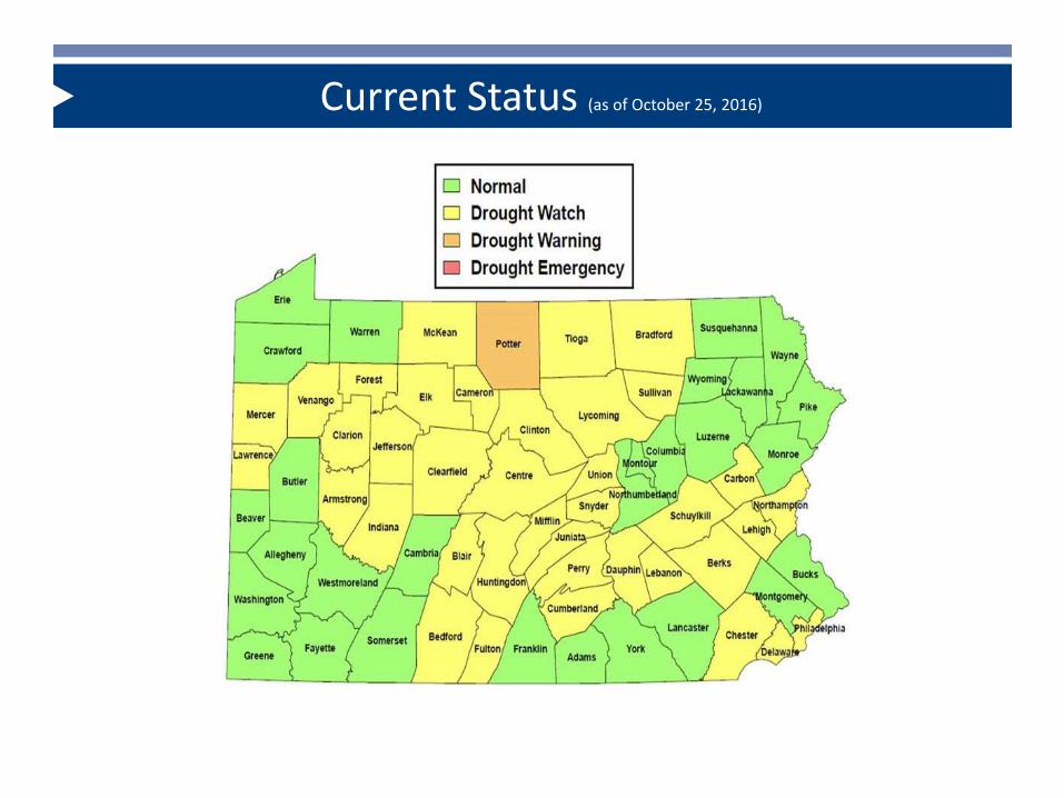
Current Status (as of October 25, 2016)

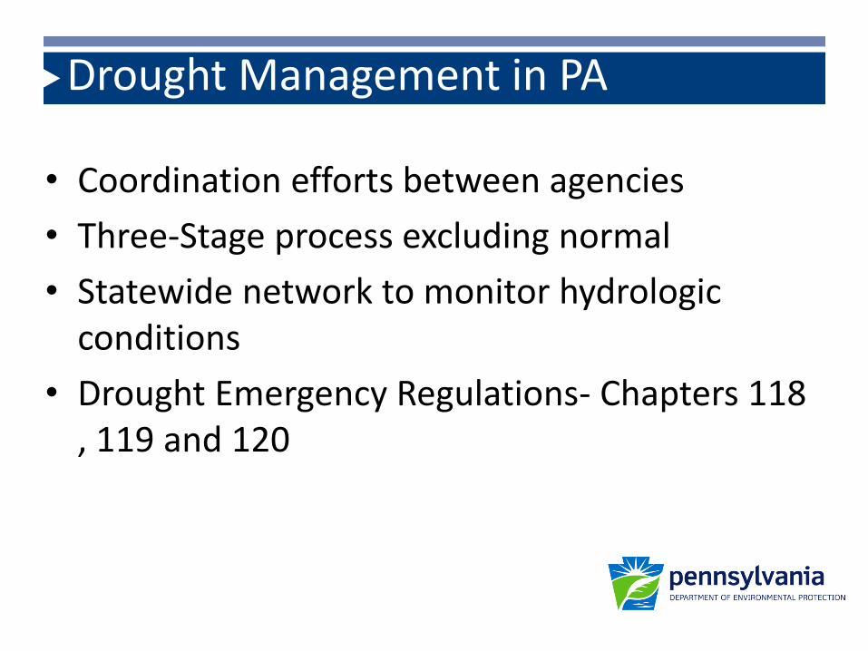
Drought Management in PA
• To assure sufficient water is available to serve essential health, safety and economic needs
Drought Management in PA
• Coordination efforts between agencies
• Three-Stage process excluding normal
• Statewide network to monitor hydrologic conditions
• Drought Emergency Regulations- Chapters 118 , 119 and 120
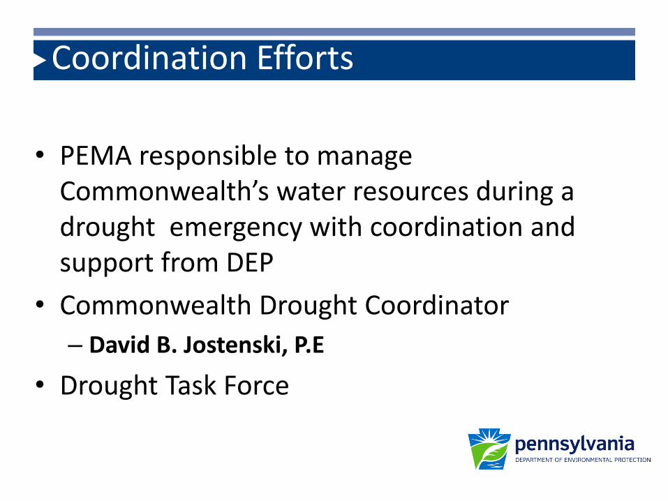
Coordination Efforts
• PEMA responsible to manage Commonwealth’s water resources during a drought emergency with coordination and support from DEP
• Commonwealth Drought Coordinator
– David B. Jostenski, P.E
• Drought Task Force

Drought Status/Declarations
Normal
Watch DEP Secretary issues press release
Voluntary 5 % reduction
Warning DEP Secretary issues press release
Voluntary 10-15% reduction
Emergency Governor declares proclamation
Nonessential use bans
Local water rationing plans
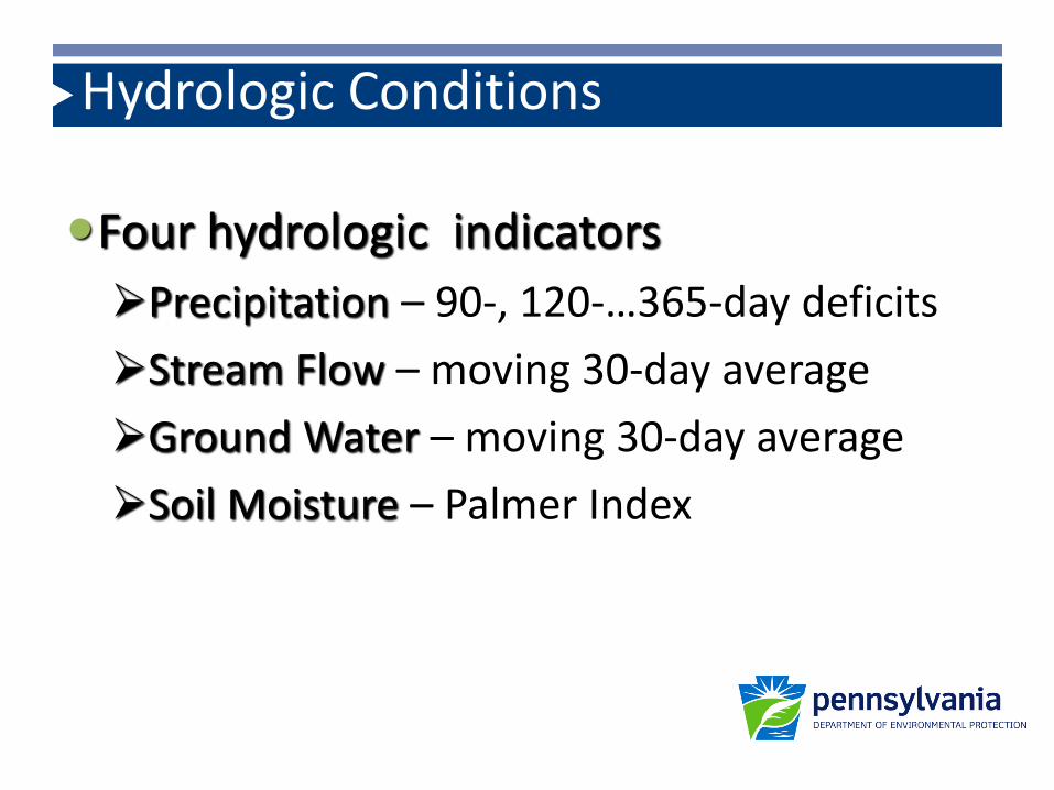
Hydrologic Conditions
Four hydrologic indicators
Precipitation – 90-, 120-…365-day deficits
Stream Flow – moving 30-day average
Ground Water – moving 30-day average
Soil Moisture – Palmer Index

• Stream flows and groundwater levels are collected through a cooperative program with United States Geologic Survey (USGS)
• National Weather Service (NWS) provides daily updates of precipitation data and weekly updates on the Palmer Drought-Severity Index
Hydrologic Data Collection
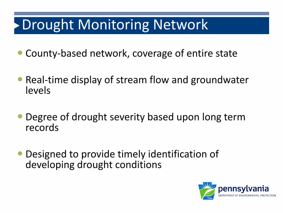
Drought Monitoring Network
County-based network, coverage of entire state
Real-time display of stream flow and groundwater levels
Degree of drought severity based upon long term records
Designed to provide timely identification of developing drought conditions
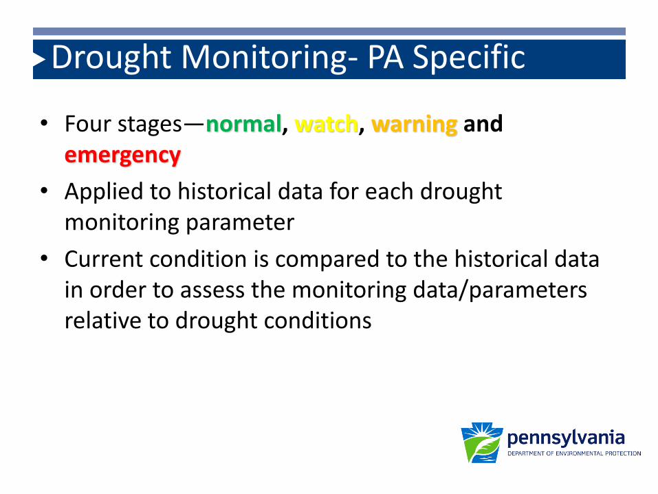
Drought Monitoring- PA Specific
• Four stages—normal, watch, warning and emergency
• Applied to historical data for each drought monitoring parameter
• Current condition is compared to the historical data in order to assess the monitoring data/parameters relative to drought conditions

Surface Water Indicator Map (Based on 30-day Moving Average Stream Flow)
Aug 1, 2016
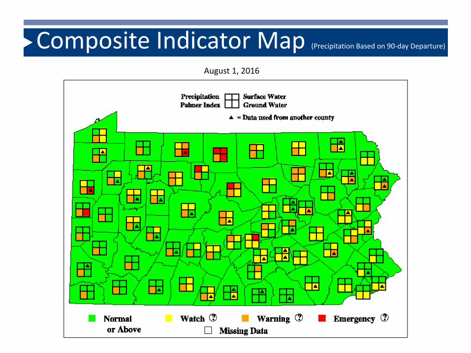
Composite Indicator Map (Precipitation Based on 90-day Departure)
August 1, 2016

Composite Indicator Map (Precipitation Based on 90-day Departure)
Aug 1, 2016 July 1, 2016
June 1, 2016 May 2, 2016

Precipitation
• Earliest indicators of a potential drought are precipitation deficits
• Precipitation is monitored in terms of departures (surpluses or deficits) from 30-year normal monthly precipitation quantities
• Droughts result from accumulations of precipitation deficits over periods of three or more months
• We closely follow the PPT forecast – NWS products

Precipitation Drought Monitoring Criteria
Duration of Deficit Accumulation
(months)
Drought Watch (deficit as % of normal precipitation)
Drought Warning (deficit as % of normal
precipitation)
Drought Emergency (deficit as % of normal
precipitation)
3 (90 days) 25.0 35.0 45.04 (120 days) 20.0 30.0 40.0
6 (180 days)
9
12

Precipitation Indicator Map (Precipitation Based on 90-day Departure)
Aug 1, 2016

Stream Flows (Surface Water)
• Streamflows typically lag one to two months behind precipitation in signaling a drought
• USGS stream-gage records are used to compute the 30-day moving average daily flow, which serves as a stream-flow indicator
• Stream-flow indicators compared with statistical flow values known as “percentiles” derived from historic stream-gage records

Stream Flows (Surface Water)
• A flow percentile is a value on a scale from 0 to 100 that indicates the percent of the time on that given date throughout the gage period of record that flow has been equal to or below that value
• DEP has defined that an average flow over the last 30 days having a percentile range of:
– 10 to 25 as entry into drought watch
– 5 to 10 as entry into drought warning
– 0 to 5 as entry into drought emergency
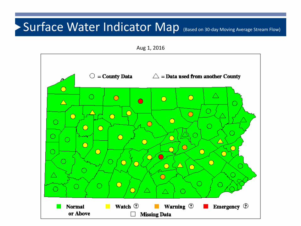
Surface Water Indicator Map (Based on 30-day Moving Average Stream Flow)
Aug 1, 2016
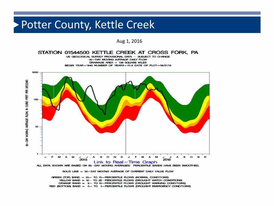
Potter County, Kettle Creek Aug 1, 2016

Groundwater Levels
• Groundwater typically lags two to three months behind precipitation, largely because of the storage effect
• Groundwater levels are used to indicate drought status in a manner similar to stream flows
• Every day, groundwater levels in USGS observation wells are used to compute an average level of the last 30 days preceding that day (called the “30-day moving average groundwater level”), that serves as a ground water indicator

Groundwater Levels
• The groundwater indicators are then compared with statistical groundwater-level values known as “percentiles” derived from historic observation-well records
• DEP has defined that groundwater percentile ranges of 10 to 25, 5 to 10, and 0 to 5 to represent entry into watch, warning and emergency, respectively

Groundwater Indicator Map (Based on 30-day Moving Average Groundwater Level)
Aug 1, 2016

Lehigh County
Aug 1, 2016

Palmer Drought Severity Index
• The Palmer Drought Severity Index is a value computed as a function of both meteorological and hydrologic data to measure soil moisture conditions
• It is compiled weekly by the Climate Prediction Center of the U.S. National Weather Service for each of their climatological regions
• The computed value ranges from +6.0 to -6.0
• Pennsylvania uses values between -2.0 and --2.99 to indicate watch, between -3.0 and -3.99 to indicate warning and -4.0 or below to indicate emergency

Palmer Indicator Map (Based on Weekly Palmer Drought Severity Index)
Aug 1, 2016
Drought Management Response Levels
• Drought Stages– Watch - public notice of possible development of
a drought• DEP requests meeting of Drought Task Force
• DEP issues press release
• DEP notifies public water suppliers
• 5% voluntary reductions in water use
Response Levels cont.
• Drought Stages
– Warning - impending drought emergency conditions
• DEP issues press release
• DEP notifies public water suppliers
• 10-15% voluntary reductions in water use

Response Levels cont.
• Drought Stages
– Emergency - water shortages exist that threaten health, safety or welfare• Governor declares emergency - confirmed within 72
hours by Emergency Management Council• Drought Emergency Regulations Effective
– Mandatory nonessential water use restrictions– Variances – Rationing

Drought Emergency Regulations
Chapter 118 Public Water Supply Agencies & Industrial Drought Contingency Plans
Chapter 119 Bans on Nonessential Uses
Chapter 120 Local Water Rationing Plans
(Emergency Management Services Code, 35 Pa.C.S. § § 7101-7707)


Drought Task Force
• Statewide internal group (PEMA, DEP, DCNR, PUC, PDA, DOH, PennVEST, PSP, NWS, USGS, USDA, SRBC, DRBC) whose operations/programs may be impacted by drought or drought management operations.
• Will meet when hydrologic conditions indicate the beginning of a drought period and throughout the drought period.
• Presentations from the NWS and DEP, discussion amongst Task Force members regarding appropriate actions necessary to address drought conditions.

Chapter 118
Purpose: provide for the preparation and implementation of
contingency plans by Public Water Supply Agencies to reduce water use in response to a state of drought or water shortage emergency.
Objective: conserve water, balance demand with limited available
supplies and assure that sufficient water is available to serve essential health, safety and economic needs.
Reductions of Major Water Use in a Commonwealth Basin Drought Emergency Area

Public Water Supply Agencies
• Governor’s Drought Emergency Declaration
– Prepare and submit a Drought Contingency Plan
– May use previously approved plan if not more than 3 years old prior to Governor’s proclamation
– Implement approved DCP

Chapter 119
• Watering grass, irrigating trees and landscaped areas
• Irrigating athletic fields and golf courses without an emergency operations plan
• Washing paved surfaces
• Using water for ornamental use
• Washing mobile equipment (e.g. cars)
• Serving water in restaurants except when requested
• Filling or topping off pools
• Using water from fire hydrants except to fight fires
(each has exceptions and there is a variance process)
Prohibition of Nonessential Water Uses in a Commonwealth Drought Emergency Area

Chapter 120
Purpose: establish procedures for reviewing and approving plans by Public
Water Supply Agencies or political subdivisions in response to a state of drought or water shortage emergency
Objective: balance the daily demands placed upon a public water supply
agency with the requirement to maintain a sufficient water supply to meet the long term needs that may be placed upon the public water supply agency during a period of water shortage or drought emergency
Local Water Rationing Plans


