Download - E J uw rl inj D A O 3 R S TR E Kalgoorlie
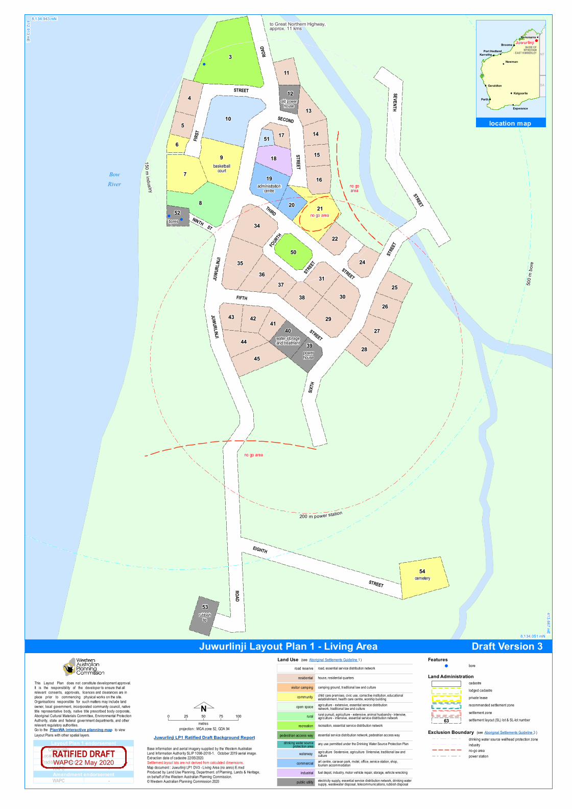
e lectricity supply, esse ntial se rv ice d istribution ne twork, d rink ing wate rsupply, wastewate r d isposal, te lecom m unications, rubbish d isposalpublic utility
fue l d e pot, ind ustry, m otor v e h icle re pair, storage, ve h icle wreck ingind ustrial
art ce ntre, carav an park, m ote l, office, se rv ice station, sh op,tourism accom m odationcom m e rcial
esse ntial se rv ice d istribution ne twork, pe d estrian access waype d e strian access way
recreation, esse ntial se rv ice d istribution ne tworkre cre ation
rural pursuit, agriculture - exte nsiv e, anim al h usband ry - inte nsiv e,agriculture - inte nsiv e, essential se rv ice d istribution ne tworkrural
ch ild care prem ises, civ ic use, correctiv e institution, e d ucationalestablish m e nt, h ealth care ce ntre, worsh ip build ingcom m unityagriculture - extensiv e, esse ntial se rv ice d istributionne twork, trad itional law and cultureope n space
cam ping ground, trad itional law and culturev isitor cam ping
h ouse, resid e ntial quarte rsre sid e ntial
road, esse ntial se rv ice d istribution ne tworkroad re se rv e
any use pe rm itte d und e r th e Drink ing Wate r S ource Protection Pland rink ing wate r sourceprotection area
Land Use (se e Aboriginal S e ttle m e nts Guid e line 1)
agriculture – exte nsiv e, agriculture – inte nsiv e, trad itional law andculturewate rway
Nproje ction : MGA zone 52, GDA 94
0 25 50 75 100m e tre s
S e ttle m e nt layout lots are not d e riv e d from calculate d d im e nsions.
Base inform ation and ae rial im age ry supplie d by th e Weste rn AustralianLand Inform ation Auth ority S LIP 1096-2018-1. Octobe r 2019 ae rial im age.Extraction date of cadastre 22/05/2020.
Map d ocum e nt : Juwurlinji LP1 DV3 - Liv ing Are a (no anno) E.mxdProd uce d by Land Use Planning, De partm e nt. of Planning, Land s & He ritage,on be h alf of th e Weste rn Australian Planning Com m ission.© Weste rn Australian Planning Com m ission 2020
Juwurlinji LP1 Ratified Draft Background Report
Land Administrationcadastrelod ge d cadastreprivate le asere com m e nd e d se ttle m e nt zonese ttle m e nt zonese ttle m e nt layout (S L) lot & S L-lot num be r63
Th is Layout Plan d oes not constitute d e v e lopm e nt approv al.It is th e responsibility of th e d e v e lope r to e nsure that allre le v ant conse nts, approv als, lice nce s and cle arances are inplace prior to com m e ncing ph ysical works on th e site .Organisations responsible for such matte rs may includ e landowne r, local gov e rnm e nt, incorporate d com m unity council, nativ etitle re prese ntativ e body, nativ e title pre scribe d bod y corporate ,Aboriginal Cultural Mate rials Com m itte e , Env ironm e ntal Prote ctionAuth ority, state and fe d e ral gov e rnm e nt d e partm e nts, and oth e rre le v ant re gulatory auth oritie s.Go to th e PlanWA interactive planning map to v ie wLayout Plans with oth e r spatial laye rs. Exclusion Boundary
d rink ing wate r source we llh e ad prote ction zoneind ustryno-go are apowe r station
(se e Aboriginal S e ttle m e nts Guid e line 3)
Featuresbore!
Com m unity
Trad itional Owne rsWAPC
-Local Gov e rnm e nt -
--
WAPC -
Layout Plan 1 endorsement
Amendment endorsementWAPC 22 May 2020RATIFIED DRAFT
!!
!
3
8
9
7
10
21
54
35
34
4
19
45
29
30
50
5
18
36
4440
38
53
27
31
16
25
26
24
28
22
39
42
13
43
6
11
14
20
37
12
15
41
52
1751
1 50 mindus try
500 m
bore
200 m power station
no go area
no goarea
bores
ce m e te ry
no go area
powe rh ouse
old powe rh ouse
rubbishtip
bask e tballcourt
ad m inistrationce ntre
wate r storageand treatm e nt
BowRiver
ROAD
STREET
EIGHTH
FIFTH
SIXTH
JUWURLINJI
THIRD
ST
FIRST
SEVENTH
NINTH
FOURTH
SECOND
ROAD
STREET
STREET
STREET
STREET
STREET
STREET
STREET
JUWU
RLINJ
I
8,134,943 mN412,913 mE
413,667 mE
8,134,051 mN
location map
NT
SA
Perth
Broome
Karratha
Geraldton
Port Hedland
Kalgoorlie
Kununurra
NewmanAlice
Spr ings
Esperance
NT
SA
SHIRE OFWYNDHAM- EAST KIMBERLEY
Juwurlinji
to Great Northern Highway,approx. 11 kms
Draft Version 3Juwurlinji Layout Plan 1 - Living Area

proje ction : MGA zone 52, GDA 94
Base inform ation and ae rial im age ry supplie d by th e Weste rn Australian Land Inform ationAuth ority S LIP 1096-2018-1. Cad astre d ate 22/05/2020. Octobe r 2019 ae rial im age.Map d ocum e nt : Juwurlinji LP1 DV3 - Context E.m xdProd uce d by Land Use Planning, De partm e nt of Planning, Lands & He ritage on be h alf ofth e We ste rn Australian Planning Com m ission.© Weste rn Australian Planning Com m ission 2020
S e ttle m e nt layout lots are not d e riv e d from calculate d d im e nsions.
N0 50 100 150 200 250 300
m e tre s
Land Administrationcadastrelod ge d cadastreprivate le asere com m e nd e d se ttle m e nt zonese ttle m e nt zonese ttle m e nt layout (S L) lot & S L-lot num be r63
Go to th e
Th is Layout Plan d oes not constitute d e v e lopm e nt approval.It is th e responsibility of th e d e v e lope r to e nsure th at all re le vant conse nts, approvals, lice ncesand clearances are in place prior to com m e ncing ph ysical works on th e site.Organisations re sponsible for such m atte rs m ay includ e land owne r, local gove rnm e nt,incorporate d com m unity council, nativ e title re pre se ntativ e body, nativ e title prescribe dbody corporate, Aboriginal Cultural Mate rials Com m itte e, Environm e ntal Protection Auth ority,state and fe d e ral gov e rnm e nt d e partm e nts, and oth e r re le vant regulatory auth orities.
PlanWA interactive planning map to v ie w Layout Plans with oth e r spatial laye rs.
Featuresbore!
Exclusion Boundaryd rink ing wate r source we llh e ad prote ction zoneno-go are autility
electricity supply, essential se rv ice d istribution ne twork, d rink ing wate rsupply, wastewate r d isposal, te lecom m unications, rubbish d isposalpublic utility
fue l d e pot, ind ustry, m otor v e h icle re pair, storage, ve h icle wreck ingind ustrial
art ce ntre, carav an park, m ote l, office, se rv ice station, sh op,tourism accom m odationcom m e rcial
esse ntial se rv ice d istribution ne twork, pe d estrian access waype d e strian access way
recreation, esse ntial se rv ice d istribution ne tworkre cre ation
rural pursuit, agriculture - exte nsiv e, anim al h usband ry - inte nsiv e,agriculture - inte nsiv e, esse ntial se rv ice d istribution ne tworkrural
ch ild care pre m ises, civ ic use, correctiv e institution, e d ucationalestablish m e nt, h ealth care ce ntre, worsh ip build ingcom m unityagriculture - extensiv e, esse ntial se rv ice d istributionne twork, trad itional law and cultureope n space
cam ping ground, trad itional law and culturev isitor cam ping
h ouse, resid e ntial quarte rsre sid e ntial
road, esse ntial se rv ice d istribution ne tworkroad re se rv e
any use pe rm itte d und e r th e Drink ing Wate r S ource Protection Pland rink ing wate r sourceprotection areaagriculture – exte nsiv e, agriculture – inte nsiv e, trad itional law andculturewate rway
Land Use
! !
!
55
54
53
500m bor
e
2000 m rubbish tip
boresno goare a
no goarea
no goarea
ce m e te ry
rubbishtip
sch ool &cultural ce ntre
412,566 mE
8,135,795 mN
8,133,627 mN
415,101 mE
location map
NT
SA
Perth
Broome
Karratha
Geraldton
Port Hedland
Kalgoorlie
Kununurra
NewmanAlice
Spr ings
Esperance
NT
SA
SHIRE OFWYNDHAM- EAST KIMBERLEY
Juwurlinjito Great Northern Highway,approx. 9 kms
Com m unity
Trad itional Owne rsWAPC
-Local Gov e rnm e nt -
--
WAPC -
Layout Plan 1 endorsement
Amendment endorsementWAPC 22 May 2020RATIFIED DRAFT
JuwurlinjiLayout Plan 1
- ContextRatified Draft 3

projection : MGA zone 52, GDA 94
Base information supplied by the Western Australian Land Information AuthoritySLIP 1096-2018-1. Cadastre date 22/05/2020.
Map document : Juwurlinji LP1 DV3 - Land Tenure E.mxdProduced by Land Use Planning, Department of Planning, Lands & Heritage on behalf ofthe Western Australian Planning Commission.© Western Australian Planning Commission 2020
Settlement layout lots are not derived from calculated dimensions.
N0 1 2 3 4
kilometres
Land Tenurecrown reservecrown reserve - Aboriginal Lands TrustDepartment of Biodiversity, Conservation & Attractions managedfreeholdleaseholdotherpastoral lease
unallocated crown landwater reserve
pastoral lease - Aboriginal Lands Trust
Go to the
This Layout Plan does not constitute development approval.It is the responsibility of the developer to ensure that all relevant consents, approvals, licencesand clearances are in place prior to commencing physical works on the site.Organisations responsible for such matters may include land owner, local government,incorporated community council, native title representative body, native title prescribedbody corporate, Aboriginal Cultural Materials Committee, Environmental Protection Authority,state and federal government departments, and other relevant regulatory authorities.
PlanWA interactive planning map to view Layout Plans with other spatial layers.
Roadsnational highwaystate highwaymajor roadminor roadtrack
Land Administrationcadastrelodged cadastreprivate leaserecommended settlement zonesettlement zonesettlement layout (SL) lot
lot 1523Pastoral lease PL N050285
Texas Downs Mabel Downs
lot 65Pastoral lease PL N049619
Bow River
lot 65Pastoral lease PL N049619
Bow River
lot 56Pastoral lease PL N050126
Lissadell
405,740 mE
8,140,208 mN
8,119,886 mN
429,500 mEJuwurlinji
GREA
T NOR
THERN
HIGHW
AY
BowRoad
River
location map
NT
SA
Perth
Broome
Karratha
Geraldton
Port Hedland
Kalgoorlie
Kununurra
NewmanAlice
Spr ings
Esperance
NT
SA
SHIRE OFWYNDHAM- EAST KIMBERLEY
Juwurlinji
Community
Traditional OwnersWAPC
-Local Government -
--
WAPC -
Layout Plan 1 endorsement
Amendment endorsementWAPC 22 May 2020RATIFIED DRAFT
Juwurlinji Layout Plan 1- Land TenureRatified Draft 3


