
TECHNISCHE UNIVERSITAT MUNCHEN
Lehrstuhl fur Steuerungs- und Regelungstechnik
Extraction of Probabilistic Route
Information Representations from
Human-Robot Dialogs
Andrea M. Bauer
Vollstandiger Abdruck der von der Fakultat fur Elektrotechnik und Informationstechnik
der Technischen Universitat Munchen zur Erlangung des akademischen Grades eines
Doktor-Ingenieurs
genehmigten Dissertation.
Vorsitzender: Univ.-Prof. Dr.-Ing. habil. Gerhard Rigoll
Prufer der Dissertation:
1. TUM Junior Fellow Dr.-Ing. Dirk Wollherr
2. Univ.-Prof. Dr. Manfred Tscheligi
Universitat Salzburg / Osterreich
Die Dissertation wurde am 21.04.2010 bei der Technischen Universitat Munchen einge-
reicht und durch die Fakultat fur Elektrotechnik und Informationstechnik am 26.11.2010
angenommen.


Foreword
This thesis is the result of three years of research at the Institute of Automatic Control
Engineering (LSR) of Technische Universitat Munchen. I am grateful to all people who
contributed to my research and supported me during this time.
First of all, I would like to thank my doctoral advisor Dr. Dirk Wollherr for all open
discussions and constructive feedback. I would like to express my gratitude towards Prof.
Martin Buss who trusted in my abilities and provided an inspiring working environment
for my research. For the great interdisciplinary collaboration I thank Dr. Astrid Weiss and
Prof. Manfred Tscheligi of the ICT&S Center, University of Salzburg. For their advice
on experimental design and statistics I would like to thank my colleague Raphaela Groten
and Stephan Haug from TUMStat. Great thanks go to Prof. Niall Palfreyman for the
thorough proofreading of this thesis.
I enjoyed the pleasant and supportive working environment at the LSR to which all
of my colleagues have contributed. For the great team work, fruitful discussions, and
assistance, I would like to thank the other members of the ACE -team: Klass Klasing,
Georgios Lidoris, Quirin Muhlbauer, Florian Rohrmuller, Stefan Sosnowski, Tingting Xu,
and Tianguang Zhang. Special thanks go to my colleagues Michelle Karg, Markus Rank,
Michael Scheint, Ulrich Unterhinninghofen, and Tingting Xu, who have supported me with
their technical knowledge, proofreading of parts of this thesis, encouragement, and most
importantly friendship. I would like to thank all students who contributed to this thesis:
Adrian Garcea, Barbara Gonsior, Raul Heinrich, Lilian Kettner, Taru Laamannen, and
Jens-Nikolas Martens.
For always supporting me, I would like to thank my mom who is my technical hero. And
last but not least, I thank my boyfriend Philipp for his love and encouragement.
Munich, April 2010 Andrea Bauer
iii

To my grandmother Marie Fetterova
and my dog Hexi.
iv

Contents
1 Introduction 1
1.1 Motivation and Challenges . . . . . . . . . . . . . . . . . . . . . . . . . . . 1
1.2 Overview of Human-Robot Interaction . . . . . . . . . . . . . . . . . . . . 3
1.2.1 Design Implications . . . . . . . . . . . . . . . . . . . . . . . . . . . 3
1.2.2 Human-Robot Communication . . . . . . . . . . . . . . . . . . . . . 4
1.2.3 Applications . . . . . . . . . . . . . . . . . . . . . . . . . . . . . . . 6
1.2.4 Interactive Robots Extracting Spatial Information . . . . . . . . . . 7
1.3 Overview of Spatial Cognition and Computation . . . . . . . . . . . . . . . 7
1.3.1 Spatial Representations in Humans . . . . . . . . . . . . . . . . . . 7
1.3.2 Spatial Representations in Technical Systems . . . . . . . . . . . . 9
1.4 Main Contributions and Outline of the Thesis . . . . . . . . . . . . . . . . 10
2 Identification of Research Questions from an Outdoor Experiment 13
2.1 Problem Description and State of the Art . . . . . . . . . . . . . . . . . . 13
2.2 The Autonomous City Explorer Robot . . . . . . . . . . . . . . . . . . . . 14
2.3 The Autonomous City Explorer Experiment . . . . . . . . . . . . . . . . . 16
2.4 Open Research Questions . . . . . . . . . . . . . . . . . . . . . . . . . . . 18
2.5 Discussion . . . . . . . . . . . . . . . . . . . . . . . . . . . . . . . . . . . . 19
3 Human-Robot Dialog for Route Information Extraction 21
3.1 Problem Description and State of the Art . . . . . . . . . . . . . . . . . . 21
3.2 Linguistic Principles Relevant to Direction Inquiry . . . . . . . . . . . . . . 23
3.2.1 Dialog Structure . . . . . . . . . . . . . . . . . . . . . . . . . . . . 23
3.2.2 Deixis Theory . . . . . . . . . . . . . . . . . . . . . . . . . . . . . . 24
3.2.3 The Origo . . . . . . . . . . . . . . . . . . . . . . . . . . . . . . . . 24
3.2.4 Problems in Interpreting Deictics . . . . . . . . . . . . . . . . . . . 25
3.3 Guidelines for Human-Robot Communication . . . . . . . . . . . . . . . . 26
3.4 Dialog System for Proactive Route Information Extraction . . . . . . . . . 29
3.4.1 System Overview . . . . . . . . . . . . . . . . . . . . . . . . . . . . 29
3.4.2 Implementation of the Dialog Guidelines . . . . . . . . . . . . . . . 32
3.5 Evaluation . . . . . . . . . . . . . . . . . . . . . . . . . . . . . . . . . . . . 33
3.5.1 Experimental Setting . . . . . . . . . . . . . . . . . . . . . . . . . . 33
3.5.2 Results . . . . . . . . . . . . . . . . . . . . . . . . . . . . . . . . . . 34
3.6 Discussion . . . . . . . . . . . . . . . . . . . . . . . . . . . . . . . . . . . . 40
v

Contents
4 Probabilistic Models of Route Information 43
4.1 Problem Description and State of the Art . . . . . . . . . . . . . . . . . . 43
4.2 Models for Direction and Distance Information . . . . . . . . . . . . . . . . 45
4.2.1 Certainty Value of Direction Information . . . . . . . . . . . . . . . 45
4.2.2 Posterior Probability of Distance Information . . . . . . . . . . . . 48
4.3 Data Analysis . . . . . . . . . . . . . . . . . . . . . . . . . . . . . . . . . . 50
4.3.1 Direction Information . . . . . . . . . . . . . . . . . . . . . . . . . . 50
4.3.2 Quantitative Distance Information . . . . . . . . . . . . . . . . . . 54
4.3.3 Qualitative Distance Information . . . . . . . . . . . . . . . . . . . 59
4.4 Evaluation . . . . . . . . . . . . . . . . . . . . . . . . . . . . . . . . . . . . 64
4.5 Discussion . . . . . . . . . . . . . . . . . . . . . . . . . . . . . . . . . . . . 66
5 Simultaneous Reasoning and Mapping 69
5.1 Problem Description and State of the Art . . . . . . . . . . . . . . . . . . 69
5.2 Types of Differences between Route Descriptions . . . . . . . . . . . . . . . 70
5.3 Simultaneous Reasoning and Mapping . . . . . . . . . . . . . . . . . . . . 71
5.3.1 Information Representation by Topological Route Graphs . . . . . . 72
5.3.2 Vector Similarity . . . . . . . . . . . . . . . . . . . . . . . . . . . . 73
5.3.3 Pattern Matching . . . . . . . . . . . . . . . . . . . . . . . . . . . . 74
5.3.4 Route Similarity Assessment . . . . . . . . . . . . . . . . . . . . . . 77
5.3.5 Inquiry about Conflicting Information . . . . . . . . . . . . . . . . 77
5.3.6 Building and Updating Route Belief . . . . . . . . . . . . . . . . . . 78
5.4 Evaluation . . . . . . . . . . . . . . . . . . . . . . . . . . . . . . . . . . . . 80
5.5 Discussion . . . . . . . . . . . . . . . . . . . . . . . . . . . . . . . . . . . . 83
6 Conclusion and Outlook 85
6.1 Concluding Remarks . . . . . . . . . . . . . . . . . . . . . . . . . . . . . . 85
6.2 Outlook . . . . . . . . . . . . . . . . . . . . . . . . . . . . . . . . . . . . . 87
A The Autonomous City Explorer 89
A.1 Hardware . . . . . . . . . . . . . . . . . . . . . . . . . . . . . . . . . . . . 89
A.2 Software . . . . . . . . . . . . . . . . . . . . . . . . . . . . . . . . . . . . . 90
B Contextual Dependence of Distance Information 91
B.1 Quantitative Distance Information . . . . . . . . . . . . . . . . . . . . . . 91
B.2 Qualitative Direction Information . . . . . . . . . . . . . . . . . . . . . . . 94
C Questionnaires 97
C.1 Questionnaire for Dialog-System Assessment . . . . . . . . . . . . . . . . . 97
C.2 Questionnaire for Qualitative Distance Assessment . . . . . . . . . . . . . . 99
Bibliography 103
vi

Abstract
This thesis addresses methods that enable robots to extract missing route knowledge by
asking humans for directions. In a first step an experiment was conducted in which a
robot had to navigate to a designated goal in an unknown urban environment without
any prior map knowledge or GPS, but solely by asking passers-by for directions. While
the experiment was successful, at the same time the results point up further challenges
for extracting route information through human-robot communication. Hence, research
questions are derived that are answered in the remainder of the thesis, namely proactive
extraction of route information from human-robot dialogs, probabilistic representation of
route information, and reasoning about extracted route descriptions. Linguistic principles
relevant to direction-inquiry dialogs are reviewed. Guidelines for human-robot dialogs are
derived from these and implemented in a dialog system. This renders the dialog natu-
ral to humans and facilitates proactive extraction of unambiguous route information. As
route information is usually simplified and distorted, probabilistic models of individual
route information are developed. Certainty values are computed from direction and error
probabilities to assess the reliability of direction information. Quantitative and qualita-
tive distance information is modeled by posterior probability distributions that assess the
accuracy of distance information. Finally, a system is developed that allows robots to
reason about different route descriptions. Route descriptions are represented as graphs
and evaluated for plausibility by pattern matching and route similarity assessment. Rea-
sonable route information is included in the route belief of the robot, while conflicting
information is inquired about if necessary. All methods are evaluated experimentally with
collected data or by human participants. The methods and systems introduced are de-
signed in adaptable ways and can be expanded for extracting and representing other types
of information from human-robot dialogs.
Zusammenfassung
Diese Arbeit beschaftigt sich mit Methoden, die es Robotern ermoglichen, sich fehlendes
Wegwissen anzueignen indem sie Menschen gezielt nach dem Weg fragen. Zunachst wurde
ein Experiment durchgefuhrt, in dem ein Roboter seinen Weg zu einem vorgegebenen Ziel in
in einer unbekannten Umgebung ohne vorheriges Kartenwissen oder GPS, sondern allein
durch Wegangaben von Passanten erreichen musste. Dieses Experiment war erfolgreich,
zeigt aber auch auf, welche Herausforderungen fur die Aneignung von Wegwissen durch
Mensch-Roboter-Kommunikation noch bestehen. Daraus leiten sich die Forschungsschwer-
punkte dieser Arbeit ab, namlich Extraktion von Weginformationen aus Mensch-Roboter-
Dialogen, probabilistische Reprasentation von Weginformationen und das Schlussfolgern
uber gegebene Wegbeschreibungen. Aus linguistischen Erkenntnissen werden Richtlinien
fur Mensch-Roboter-Dialoge uber Wegwissen abgeleitet und in einem Dialogsystem im-
plementiert. Dies ermoglicht eine fur den Menschen naturliche Kommunikation und die
zuverlassige Extraktion von inhaltlich eindeutigen Weginformationen. Da Weginformatio-
nen ublicherweise Schatzwerte und Vereinfachungen der tatsachlichen Werte wiedergeben,
werden in einem nachsten Schritt probabilistische Modelle fur einzelne Weginformationen
erstellt. Aus Richtungs- und Fehlerwahrscheinlichkeiten werden Zuverlassigkeitswerte fur
vii

Contents
Richtungsangaben berechnet. Quantitative und qualitative Distanzangaben werden durch
bedingte Wahrscheinlichkeitsdichteverteilungen modelliert, die Aufschluss uber die Genau-
igkeit der einzelnen Angaben liefern. Zuletzt wird ein System vorgestellt, das es Robotern
ermoglicht, verschiedene Wegauskunfte zu vergleichen. Dabei werden die Wegauskunfte
graphentheoretisch reprasentiert und uber Pattern-Matching und Wegvektorahnlichkeit auf
Plausibilitat untersucht. Sinnvolle Weggraphen werden in die Wissensbasis aufgenommen,
wahrend das System gegebenenfalls gezielt bei widerspruchlichen Informationen nachfragt.
Alle Methoden werden mit durch Umfragen erhobene Daten oder mit Probanden experi-
mentell evaluiert. Die Vorgestellten Systeme und Verfahren sind modular gehalten und
lassen sich auf Aneignung und Reprasentation allgemeiner Informationen durch Mensch-
Roboter-Dialoge erweitern.
viii

Notations
Abbreviations
ACE Autonomous City Explorer
ANOVA analysis of variance
Concl dialog system state: conclusion
Conf dialog system state: confirmation
FSM finite state machine
GivDir dialog system state: give directions
GPS Global Positioning System
GUI graphical user interface
DG dialog guideline
HRI human-robot interaction
Intro dialog system state: introduction
pdf probability density function
SRAM Simultaneous Reasoning and Mapping
s.t. subject to
SSH Spatial Semantic Hierarchy
XML Extensible Markup Language
Conventions
Scalars, Vectors, and Matrices
Scalars are denoted by letters in italic type. Vectors are denoted by bold lower case letters
in italic type, vector x is composed of elements xi. Matrices are denoted by bold upper
case letters in italic type, matrix M is composed of elements Mij (ith row, jth column).
x, X scalar
x vector
X matrix
XT transposed of X
x ◦ y Hadamard product of x and y
g(·) scalar function
|·| absolute value
‖·‖ Euclidean norm
ix

Notations
List of Symbols
Roman Symbols
Ai path in B
Ai vector spanned by path Ai
ai,j edge in path Ai as vector
B belief
BH , BR belief of human/robot
Bprel,i preliminary belief
bhc border between ‘here’ and ‘close’
bcf border between ‘close’ and ‘far’
CB, CR conflicting information in B, R
ck certainty value
cMk certainty value in a metric graph
csensork confidence value of sensor data
DM(x, y) pattern matching metric
dk length of edge
dMk length of edge in metric graph
dest estimated distance
dreal real distance
Ek edge
EMk edge in metric graph
ETk edge in topological graph
e(Mi,j) number of edges in Mi,j
eAd relative absolute error of distance estimate
eAt relative absolute error of time estimate
eCd relative constant error of distance estimate
eCt relative constant error of time estimate
fc frequency of qualitative distance ‘close’
FE,k cumulative error frequency
fE,k error frequency
ff frequency of qualitative distance ‘far’
fh frequency of qualitative distance ‘here’
G route graph
grat rational function
gpow power function
Hi human participant
k route segment
li landmark type
lMi landmark type in metric graph
Mi,j sub-match
Ni node
OH personal reference system of human
x

Notations
OHR common reference system of human and robot
OR personal reference system of robot
P transition probability matrix
P , p probability
PD,k direction probability
PD,rel relative direction probability
PE,k error probability
P (d) marginal probability of distance information d
P (d|dreal) conditional probability of distance information d
P (dreal) prior probability of distance information d
P (dreal|d) posterior probability of distance information d
Prel(dreal|d) relative posterior probability
pij transition probability between states si and sj
R route
R vector spanned by route graph R
rk edge in path R as vector
rpowyest
sum of squared residuals of power function
rratyest
sum of squared residuals of rational function
rk edge in route r as vector
rreal range of real distances
S set of direction states
S(m,n) similarity function/metric
SD(m,n) direction similarity metric
SM(m,n) magnitude similarity function
SV (m,n) vector similarity function
SV vector similarity matrix
si direction stateHTHR coordinate transformation from OH to OHRRTHR coordinate transformation from OR to OHR
test estimated time
u random effects
vk global direction state vector
vk direction prediction based on overall previous route
vwalk walking velocity
w weight vector
wD weight for direction probability
wE weight for error probability
X, Z design matrices
xk direction state vector
xi fraction of discrete direction
xk prediction of direction state at segment k
xk direction prediction based on previous route segment
xR, yR coordinates in the reference system of a robot
y data
xi

Notations
Greek Symbols
α1, α2 variables of grat
αf , βf variables of P (‘far’|dreal)
β effects of variables
β1, β2 variables of gpow
γ (Mi,j) diagonal of match Mi,j
δk direction of edge/vector
δMk direction in metric graph
ǫ random errors
µ mean value
µd, σd variables of P (dest|dreal)
µE, σE variables of PE,k
µh variable of P (‘here’|dreal)
µc, σc variables of P (‘close’|dreal)
µt, σt variables of P (test|dreal)
π initial probability vector
πi initial state probability
σ standard deviation
τe threshold for the number of edges in a sub-match
τM pattern matching threshold
τPrelthreshold for relative posterior
τS threshold for highest similarity value
τSv threshold for similarity value
xii

List of Figures
1.1 Schematic outline of the thesis. . . . . . . . . . . . . . . . . . . . . . . . . 10
2.1 The ACE robot with principal hardware components. . . . . . . . . . . . . 14
2.2 The FSM of the interaction module of the ACE robot. . . . . . . . . . . . 16
2.3 ACE following the pointing gesture of a passer-by with its camera head. . . 17
2.4 Example of a route graph extracted by ACE from human instructions. . . 18
3.1 Typical structure of direction-inquiry dialogs. . . . . . . . . . . . . . . . . 26
3.2 A location referred to differently from different personal reference systems. 27
3.3 The architecture of the dialog system. . . . . . . . . . . . . . . . . . . . . . 30
3.4 The FSM of the Dialog System controlling the dialog phases. . . . . . . . . 31
3.5 Screenshot of the GUI used during the evaluation experiment. . . . . . . . 34
3.6 Box-whisker plot of the durations of the dialog states. . . . . . . . . . . . . 36
3.7 Transitions between system states over the time. . . . . . . . . . . . . . . . 36
3.8 Four examples of routes extracted in the experiment. . . . . . . . . . . . . 37
4.1 Overview over the process of modeling route information probabilistically. . 45
4.2 Digraph of transition probabilities between direction states. . . . . . . . . . 52
4.3 Relative frequency, cumulative frequency, and fitted pdf of direction errors. 52
4.4 Direction probability error probability, and certainty values. . . . . . . . . 53
4.5 Estimation data of traveling distances and times. . . . . . . . . . . . . . . 55
4.6 Histograms of quantitative distance and time estimates. . . . . . . . . . . . 56
4.7 Sums of squared residuals over the maximum real distance. . . . . . . . . . 57
4.8 Fitted functions of µ and σ for the conditional probabilities. . . . . . . . . 58
4.9 Posterior probability distributions for distance and time estimates. . . . . . 59
4.10 Histogram and modeled conditional pdf for deictic ‘here’ . . . . . . . . . . . 62
4.11 Histogram and modeled conditional pdf for deictic ‘close’ . . . . . . . . . . 62
4.12 Histogram and modeled conditional pdf for deictic ‘far’ . . . . . . . . . . . 63
4.13 Posterior pdf’s for qualitative distance expressions. . . . . . . . . . . . . . 64
4.14 Modeled accuracy of information in an exemplary route description. . . . . 65
5.1 Examples of different route descriptions. . . . . . . . . . . . . . . . . . . . 70
5.2 General schematic of the SRAM system. . . . . . . . . . . . . . . . . . . . 71
5.3 Example graphs with respective vector similarity matrices. . . . . . . . . . 76
5.4 Flowchart of plausibility assessment and route belief building. . . . . . . . 78
5.5 City map used for the experimental evaluation of the SRAM system. . . . 80
5.6 The resulting route belief in robot coordinates. . . . . . . . . . . . . . . . . 82
5.7 Certainty values of all edges in the belief over the time. . . . . . . . . . . . 83
xiii
List of Figures
A.1 Development of the hardware of ACE over the time. . . . . . . . . . . . . 89
A.2 The software architecture of ACE . . . . . . . . . . . . . . . . . . . . . . . 90
B.1 Box-Whisker plots of relative errors of distance and time estimates. . . . . 92
B.2 Box-Whisker plots of relative estimation errors for variable gender. . . . . . 92
B.3 Box-Whisker plots of relative estimation errors for variable age. . . . . . . 93
B.4 Box-Whisker plots of relative estimation errors for variable self-assessment. 94
B.5 Box-whisker plots for the logarithmic borders bhc and bc
f . . . . . . . . . . . . 95
C.1 Questionnaire for the subjective assessment of the dialog system. . . . . . . 98
C.2 Questionnaire for relative borders of deictics for abstract environment. . . . 99
C.3 Questionnaire for relative borders of deictics for urban environment. . . . . 100
C.4 Questionnaire for relative borders of deictics for large scale environment. . 101
C.5 Questionnaire for spatial deictics in an urban environment. . . . . . . . . . 102
xiv

List of Tables
3.1 Common deictics with relevant semantic attributes. . . . . . . . . . . . . . 28
3.2 Example dialog between dialog system and human participant H7. . . . . . 35
3.3 Performance given by the accuracy of understanding route descriptions. . . 38
3.4 Questions about user satisfaction with subjective assessment. . . . . . . . . 39
4.1 Identified coefficients of grat describing µd, σd, µt, and σt. . . . . . . . . . . 58
4.2 Numerical values of relevant data of route information in the example. . . 65
4.3 Relative posteriors of alternative real distances of k = 1. . . . . . . . . . . 66
5.1 Properties of similarity metrics. . . . . . . . . . . . . . . . . . . . . . . . . 73
5.2 Process of building a route belief B during the experiment. . . . . . . . . . 81
B.1 Parameter estimates of the fixed effects in the fitted mixed linear models. . 95
xv


1 Introduction
Asking humans for information is a reasonable approach for
robots to come by missing knowledge about complex, dynamic
human-populated environments. This chapter provides an in-
troduction to the thesis, reviews the state of the art of related
research fields, and discusses the main scientific contributions.
1.1 Motivation and Challenges
It is a longstanding research goal to develop service robots that aid human users in their
everyday lives [1, 2, 6]. Tasks that humans are envisioned to be relieved of by robots are
daily chores such as preparing meals, loading dishwashers, and shop for groceries. However,
service robots assisting humans in such intelligent and versatile ways may still be decades
away. One of the reasons for this is that service robots need to be able to operate in human-
populated environments which are unstructured, complex, and highly dynamic and a huge
amount of up-to-date information is needed by robots operating in such settings.
Standard approaches for robots to come by knowledge, necessary to fulfil a task, are
pre-programming and machine learning. As not every bit of information can be contained
in program code, pre-programming is not feasible in real environments. Since complex
dynamic environments would require a vast number of training sets to be able to make
intelligent decisions, machine learning is not efficient in such scenarios. Therefore these
standard approaches are not suitable to provide robots with all information necessary to
operate in real-world environments. An alternative for robots to close gaps in their task
1

1 Introduction
knowledge is to ask humans for missing information, as this is a fast way to come by relevant
and up-to-date information. Task descriptions extracted from human-robot dialogs can
then be translated into machine understandable instructions, i.e. broken down into a
sequence of action instructions. This approach is relatively new in robotics, as opposed
to the more common unilateral scenario of robots solely aiding humans and providing
information to them. Therefore there are still many unsolved problems and challenges. In
particular these challenges include proactively extracting missing information from often
vague and ambiguous human-robot communication, representing the information given by
humans in a way that can be processed by technical systems, and reasoning about it in order
to identifying inaccurate or erroneous information. Robots that overcome these problems
are able to act more robustly in the face of new and unforeseen tasks and situations, and
thus reach higher levels of autonomy and dependability.
This thesis addresses the challenges posed by the general problem of extracting task
information from human-robot dialogs, based on the special case of extracting route in-
formation for navigation tasks. This is a prerequisite to reaching a goal location in an
unknown or changing environment, as it provides robots with a basis for autonomous na-
vigation and global path planning. Even with access to the internet or GPS systems,
robots are bound to have gaps in their map knowledge of complex and dynamic human-
populated environments. Applications that can benefit from this are for example running
errands and shopping. Such applications are of use to personal service robotics and elderly
care, where human staff can be relieved of such tasks and gain time that could be used for
medical and psychological treatment as well as to keep the persons in their care company.
This thesis focuses on extracting a probabilistic route information representation from
human-robot dialogs. In particular the presented research includes a dialog system for
robots asking for directions, probabilistic models for individual route information, and a
system for reasoning about route descriptions and simultaneously building a route belief as
an internal representation of the plausible route descriptions. The dialog system includes
findings from human-human communication, in order to render the dialogs more natural to
humans and to unambiguously extract route information. The probabilistic models provide
robots with means to assess individual directions and distances for reliability and accuracy.
Finally, a system for reasoning about route information compares different route descrip-
tions, assesses them for plausibility, inquires about conflicting information if necessary, and
builds a route belief as a representation of the assumed route within the environment.
In this chapter the research areas related to the thesis are reviewed. This chapter
does not provide a comprehensive overview of the state of the art, as the more specific
research developments relevant to each chapter are covered at the beginning of each re-
spective chapter. Overviews of the broad research fields of human-robot interaction and
spatial cognition and computation are provided in the following. A comprehensive view of
human-robot interaction (HRI), with design implications, ways of communication, and ap-
plications, is necessary for providing a robot with the ability to ask humans for directions,
as these factors can affect the outcome of human-robot dialogs. An overview of spatial
cognition and computation is needed to understand the ways that humans and technical
systems represent and process spatial information.
This chapter is structured as follows. An overview of the state of the art in human-
2

1.2 Overview of Human-Robot Interaction
robot interaction is provided in Section 1.2. The state of the art in spatial cognition and
computation is reviewed in Section 1.3. Finally, Section 1.4 presents the main contributions
and the outline of the thesis.
1.2 Overview of Human-Robot Interaction
Human-robot interaction is a wide research field and constitutes a framework of insights
useful to proactively extract information from human-robot dialogs. HRI includes inter-
disciplinary cooperation between classical robotics, cognitive sciences, and psychology and
is a field with many implications for design and communication and with various appli-
cations. As the research done in this field is vast, only the aspects most relevant to this
thesis are surveyed here. Extensive overviews of interactive robots and HRI are provided
for example by Fong et al. [45, 178] and Kiesler et al. [79].
The first impression a human gets about a robot is how it is designed, i.e. the appearance
of the robot, whether social distances are respected, and the subjective feeling of safety.
1.2.1 Design Implications
Design specifications for interactive robots are manifold and different from purely func-
tional industrial robots. Among the issues that have to be considered when designing
robots for HRI are the safety of humans, social distances, and robot appearance.
Safety is a crucial aspect of the design of interactive robots [97, 186]. A robot must
not endanger a human under any circumstances. Since the very beginning of robotics this
has been an evident fact and was formulated by Isaac Asimov in his famous Three Laws
of Robotics [7]. On the one hand, the hardware of the robot must not be dangerous for
humans, banning sharp edges, points and accessible electric current. On the other hand,
control theoretic methods and suitable software design have to be applied to guarantee
safety even in the face of disturbances or unforeseen events [96].
Robots interacting with human partners, do not only have to respect safety distances,
but also social distances. Such distances are studied in proxemics [63] for interaction be-
tween humans. Proxemics discern between different social distances [64], i.e. intimate,
personal, social, and public distance. Proxemic studies are performed with humans inter-
acting with robots [177, 178] in order to define and control interaction distances that feel
comfortable to humans and thus in theory improve the human’s subjective feeling and the
performance of the interaction.
Thought has to be given to the appearance of interactive robots, as it might effect the
expectation of the human in the robot, and therefore on the long run the outcome of the
human-robot interaction. Robot appearance design is studied for example from a tradi-
tional design theoretic view [176], for humanoid robots [179], and for robot heads [38].
Depending on the purpose and character of the interaction, robots are designed to look
more or less similar to humans. Mori [124] found a function, called the “uncanny valley”
that maps similarity to acceptance. He states that acceptance increases the more similar
a robot is to a human, until a point is reached where the similarity is not quite 100 %
and subtle deviations from human appearance and behaviour create an unnerving effect.
3

1 Introduction
Contrary to design policies that attempt to make robots more similar to humans a study
by Yamada et al. [204] suggest that robots with typical robot appearance and a primitive
expression of emotions are more easily understood by humans than more life-like appearing
robots with complex ways of expressing emotions, concluding that the appearance and ex-
pressions of robots should resemble their abilities. Another aspect that has to be taken into
account, when designing robots, is the culture a robot is supposed to work in, as there are
differences in the acceptance of robots by people with different cultural backgrounds [77].
Especially in Japan robots are accepted more positively than in Europe and America.
Another important aspect that has to be taken into account when designing robots for
HRI is communication, as it allows for exchanging information during interaction. Human-
robot communication is surveyed below.
1.2.2 Human-Robot Communication
Communication is a crucial aspect of interactive robots, since efficient interaction necessi-
tates the exchange of complex information. Communication can be distinguished by the
specificity, i.e. implicit or explicit information; the direction of the information exchange,
i.e. the roles of human and robots as emitter and receiver of information; and the mode of
communication, the main modes being haptic signals, physiological signals, gestures, and
natural language.
Haptic communication can be maintained when the partners are connected physically
either directly or through an object they both manipulate. Haptic communication usually
conveys explicit information. It occurs through applied forces and torques or joint angles
and orientations. It is studied from different perspectives, such as joint object manipula-
tion [87, 88], dancing [53, 86] or handshaking [99].
Implicit information such as intentions and emotions are also communicated involun-
tarily through physiological signals such as heart rate and brain or muscle activity. Physi-
ological signals can be analyzed by robots to deduce the level of approval and arousal [95]
or the stress level [146]. Based on this information, robots can select appropriate actions.
Gestures are used to convey information implicitly or explicitly. Explicit gestures hold
complex information, and are communicative gestures such as pointing gestures, primi-
tive signs, or sign language. Implicit gestures include manipulative gestures and facial
expressions. Robots can apply gesture recognition to extract information from gestures.
Pointing gestures can be interpreted for example from camera images by matching an arm
model [137] or interpreting kinematic information [113]. Some HRI approaches use a set
of predefined gestures which the robot is able to recognize [84]. Intentions of humans can
be inferred by robots from manipulative gestures [105], from head gestures such as eye
gaze direction [156], or from facial expressions [76]. Some robots are able to use facial
expressions [17, 169] for communication in return and thereby act socially. There are also
robots that can generate hand and arm gestures [65] to communicate with humans.
Natural language communication provides explicit information through words and sen-
tences, but can also provide information about emotions implicitly. Methods for processing
and generating natural language are reviewed in detail below.
4

1.2 Overview of Human-Robot Interaction
Natural Language Communication
For humans a very natural way to interact and exchange information is through speech,
as it is suitable to efficiently convey complicated information. Therefore to render human-
robot communication efficient and natural to humans, interactive robots need to be able
to communicate through natural language. Natural language communication can convey
information both explicitly and implicitly [208]. Implicit information in speech signals
can be extracted by robots through emotion recognition [207] and also encoded in synthe-
sized speech [161]. In the following, techniques and methods for explicit natural language
communication are presented, as most of the relevant information is conveyed over this
channel. A detailed overview of the history of explicit natural-language communication
with computers is given, e.g. in [140]. Speech and language processing is reviewed in [75].
The research field of computational linguistics studies language from a computational
perspective, thus connecting linguistics and computer engineering. Extensive overviews of
computational linguistics are given for example in [13, 33]. Natural language processing em-
braces many major subfields of computational linguistics, such as speech recognition, text
pre-processing, machine translation, information extraction, text generation, and speech
synthesis. Speech recognition is concerned with the conversion of an acoustic signal cap-
tured by a microphone to a set of words. An overview of the developments in speech
recognition technologies is presented in [73, 131]. Speech synthesis allows technical sys-
tems to produce speech; a broad overview of speech synthesis methods is presented in [103].
Text generation is a relatively new subfield of natural language processing, and deals with
generating texts from symbolic formal representations; an overview of the main methods
is provided in [9]. The field of text pre-processing includes techniques such as text parsing,
spell checking, and referencing. Machine translation is concerned with translating texts
from one language to another; an overview of techniques and tools is given in [69]. Speech
synthesis and speech recognition is surveyed in [131].
Speech understanding is regarded as the major problem of natural language process-
ing as it is the most general and complex task. Speech understanding requires a great
variety of knowledge about the environment, context, speaker, topic, lexical frequency,
semantically related topics, to name just a few aspects. Important approaches to speech
understanding are semantic networks [202] that represent semantics as nodes connected by
directed edges, and conceptual dependency [160] that is based on semantic networks, but
uses edges that represent different dependencies. Recent approaches use the availability
of high-performance computing systems with large spoken and written data collections,
e.g. [114, 145], and by using statistical machine learning techniques [138, 190].
A sub-field of speech understanding is information extraction. Information extraction
deals with the automatic extraction of structured information from unstructured machine
readable text [159]. It is a special case of information retrieval [166] which is the search
for content in large document databases. Information extraction techniques are surveyed
in [159]. It has recently expanded into the domain of human-robot interaction, e.g. [74].
Human-robot communication in general and information extraction in specific are key
requirements for robots that depend on task information from humans to achieve their
goals. These abilities are useful in a wide variety of applications of HRI. The main appli-
cations are reviewed below.
5

1 Introduction
1.2.3 Applications
Applications for HRI are manifold, with the main application areas in home service, health-
care, tour guiding, entertainment, construction, as well as search and rescue. These areas
have different requirements and the degree to which they are presently integrated varies.
Robots with any of these applications benefit from the ability to extract and represent
missing task information, as it provides robots with a greater autonomy and a robustness
against gaps in the task knowledge.
Home service will be a major application area for HRI in the future. First commercially
available robots have been developed that vacuum-clean [153] and mow the lawn [150].
The household robot Wakamaru [195] developed by Mitsubishi is commercially available
as well. It can connect itself to the home network to provide information for daily life, look
after the house while the inhabitants are absent, and communicate with humans. A robot
that acts as home security [206] is being developed. Truly collaborative home service robots
are still a matter of research, such as robots assisting humans in the kitchen [11, 135].
Diverse healthcare robots are being developed, such as robots that guide the blind [70,
98, 189], robotic walkers [152], wheelchairs [71], elderly care robots [121, 142, 193], and
robots for the therapy of autistic children [200]. These robots are all designated to aid
diseased or fragile humans and must be especially well designed and scrutinized. Ethical
issues have to be considered particularly in the field of healthcare and medicine.
Some robots are used as tour guides in Museums, i.e. RHINO [24] and its successor
MINERVA [181], and office environments [116, 134]. They can guide humans to certain
rooms or exhibitions and provide information. Toomas [59] is a robot guiding humans
through a home improvement store. Tour guide robots need to be able to autonomously
navigate through constrained human populated environments, and to communicate with
humans in natural and intuitive ways.
Various entertainment robots capable of HRI are already commercially available, such
as robotic pets [143, 170] and humanoid robots [100, 151].
A seminal field for HRI is construction, where robots can support human construction
workers in carrying heavy loads and ease repetitive construction tasks. First steps toward
joint construction have been taken by the mobile robot helper [88] that can share loads
and handle objects in collaboration with a human. The JAST system [48] is capable of
solving a small scale construction task collaboratively with a human.
Another field in which robots support humans and take on dangerous tasks is urban
search and rescue [128, 129]. Robots are designed to move into collapsed buildings, collect
data, and try and find human victims, who can then be rescued by human staff members.
Though most of these systems are still under development, it is only a matter of time
until truly assistive and interactive robots will be commercially available and part of our
everyday lives. Such robots need to be able to assisting humans in intelligent and versatile
ways [19]. For this purpose robots need the ability to extract missing information from
HRI. Asking humans for information about their spatial environments will enable robots
to operate in unknown environments and fulfill new and unforeseen tasks.
6

1.3 Overview of Spatial Cognition and Computation
1.2.4 Interactive Robots Extracting Spatial Information
Recently researchers have started developing robots that are able to extract information
about their spatial environments from HRI. A robot that creates a map of its environment
by exploration and asks humans to label areas of interest is presented in [68]. The robot
Biron [171] integrates spoken dialog and visual localization to learn and label new places.
Both robots use HRI as a means to attach human understandable labels to their sensor-
based spatial belief. Also there are robots that ask humans for directions in structured
indoor environments. A wheelchair robot [119] can be given coarse qualitative route de-
scriptions. The office robot Jijo-2 [8] learns the locations of offices and staff by moving
around and asking humans for information. A robot asking for the way at a robotics con-
ference is presented in [118], and was the winner of the AAAI-2002 robot challenge [94].
A global inference approach [197] aims at having a robot automatically find a path within
an office environment based upon human directions. Finally, a miniature robot that can
find its way in a model town by asking humans for directions is described in [101]. All of
these robots operate in highly structured and often static indoor environments, and only
a few use natural language as the mode of communication.
For truly assistive, autonomous robots it will be necessary to implement the skills to
adapt to new situations in complex dynamic outdoor environments and to communicate
in a natural way with non-expert human users. Therefore theories from spatial cognition
and computation need to be included in interactive robots.
1.3 Overview of Spatial Cognition and Computation
The subject of spatial cognition comprises cognitive functions that allow humans or animals
to deal with spatial relations and orientations of objects in space, tackle visual spatial
tasks, have an awareness of self-location, and solve navigational tasks. The equivalent of
spatial cognition for robots and technical systems is spatial computation which can be
implemented to model spatial cognition or provide technical systems with representations
of spatial environments. These areas are important to this thesis as they provide methods
and systems that inspire representation of and reasoning about spatial information.
1.3.1 Spatial Representations in Humans
One of the first researchers to study cognitive representations of large-scale spatial en-
vironments was Trowbridge. He used the term “imaginary map” [187] to describe an
individual’s spatial representation of relations in the real environment. Tolman introduced
the term “cognitive map” for the mental representation of the layout of one’s environment
in humans and other animals [185]. Contrary to common belief at the time, he stated that
complex behaviour, such as the learning of routes, cannot be explained by simple stimuli
and reactions, but only by a mental representation of the routes under certain expecta-
tions. Later, additionally the term “mental map” was introduced by Gould and White [57].
The ability to construct and use different forms of spatial knowledge and acquire cognitive
maps has been researched in children of different ages [139, 165] and in elderly people [42]
7

1 Introduction
as well. The cognitive map gives answers to where certain things are in one’s environment
and how to get to them from the current location. An operational definition of a cognitive
map is given as “a representation of spatial relationships that enables computation of novel
shortcuts between known locations” [132]. Characteristic attributes of cognitive maps are
individuality, simplification of relations in the real environment, as well as a dependence
on personal and social factors.
Cognitive maps are distorted representations of relations in the real world. Such dis-
tortions include the alignment and rotation of objects relative to each other [188] and
geometrical simplification of objects [25, 120, 172] or distances [107]. Errors in cognitive
maps can be caused by various sources, such as the general topography [27], barriers [85],
the familiarity with an environment [18], or the number of turns or intersections on a
route [155]. The representation of distances depends on proximity to subjective reference
points [66]. Tversky [188] has discovered that distortions can be caused by the way humans
encode spatial information into their memory which is based on cognitive hierarchical or-
ganization [117]. Individuals usually simplify the complex geometrical structure of their
environment by representing it as a matrix of straight lines and right angle junctions [5],
where the spatial extent of familiar and salient areas is exaggerated [58].
Cognitive mapping in spatial cognition was first described in [185] and is defined as
the process by which spatial information about an environment is acquired, coded, stored,
recalled, and decoded. The product of this process is a cognitive map. As humans have
only limited sensing, information processing, and storage capabilities, cognitive mapping
forms constricted and simplified representations of a complex, uncertain, and changing
environment [40]. Cognitive mapping takes place in connection with the formation of travel
plans which are adapted to facilitate travel [52]. It may even depend on an individual’s
personal value system [158].
Lynch [110] describes how humans perceive and organize spatial information in cities.
He states that spatial knowledge consists not only of topological maps and geometrical
models of the environment, but also of procedures for getting from one place to another.
Lynch speculates that humans form mental maps of their environment, consisting of five
elements, namely paths that can be navigated, edges representing perceived boundaries,
districts as large areas with common properties, nodes such as focal points or intersections,
and landmarks serving as reference points. By contrast, Golledge [56] supposes that an
urban cognitive map is simply composed of a set of nodes and connecting paths. He points
out that such a cognitive map develops over time as the individual gains experience.
Cognitive maps are the basis for wayfinding. The modern term wayfinding was coined
by Lynch [110], who defined it as “a consistent use and organization of definite sensory cues
from the external environment”. Passini [136] expanded the term to include graphic and
audible communication, tactile information, and logical spatial planning. Wayfinding can
occur actively through navigating in an unknown environment, or passively by studying a
map of an unknown environment before navigating.
The equivalent of spatial cognition in robots is spatial computation. A review of spatial
computation is presented below.
8

1.3 Overview of Spatial Cognition and Computation
1.3.2 Spatial Representations in Technical Systems
Spatial representations are the basis for navigation and path planning for technical sys-
tems. Autonomous robots require an internal representation of their spatial environment
to be able to operate in it. Therefore “mapping is one of the core competencies of truly
autonomous robots” [182]. Robot mapping is the action of acquiring a coherent repre-
sentation of the surrounding environment. Spatial representations and mapping in robots
are reviewed in [201]. A general problem of local robot mapping is that the robot needs
to simultaneously localize itself within the environment while building a map of it. The
general method that tackles this dual problem is Simultaneous Localization and Mapping
(SLAM) [39, 121] which solves problems such as loop closure, uncertainty management,
mapping and localization. The immediate environment can be mapped by robots based on
scanning the surroundings with sensors, e.g. laser-range finders, sonar sensors, or camera
systems. The raw sensor data is processed to extract relevant information and represent
it as the most likely map of the real environment. The commonly used occupancy grid
maps introduced by Moravec and Elfes [123] represent the environment by a grid of cells,
each including the probability that the respective location is occupied by an obstacle.
Grid based maps offer a relatively high resolution of the close environment and are the
basis for local navigation and path planning. However, they are not suitable as long-term
representations of dynamic large scale environments, where salient objects, relations and
orientations between them, and passages are of interest.
Recently there are attempts to represent large scale spatial relations in such a way that
not only geometrical information needed for navigation is stored, but also topological infor-
mation for higher level operations such as task planning and HRI: Some approaches model
route-based navigational knowledge of (indoor) environments such as route graphs [89, 199].
A robotic environmental model composed of different levels of abstractions, including a
metric line map, a navigation graph, and a topological map is provided by a multi-layered
conceptual map [210]. A similar approach introduces a multi-hierarchical semantic map
for mobile robots [51] where spatial and semantic hierarchical information is linked. A
spatial representation for a robot interacting with humans including metric, symbolic, and
cognitive layers for individual robot and robot-human team behavior is presented in [78].
Hierarchical probabilistic representations of space based on objects are applied to equip a
robot with spatial cognition [191]. Kuipers [91, 92] has developed a computational theory
of the cognitive map, the Spatial Semantic Hierarchy (SSH). This theory was motivated by
human spatial reasoning. It models the spatial belief of a technical system as a hierarchy
of representations consisting of a control level, a procedural level, a topological level, and a
geometrical level. The central element of the SSH is the topological layer which is logically
prior to the metric representation. Recently, calculi for qualitative reasoning have been
aplied to reasoning about spatial relations between objects and areas [32, 148]. Kuipers [93]
also applied qualitative spatial reasoning to robot navigation and path planning.
Human-robot interaction as well as spatial cognition and computation are emerging
research fields both in cognitive sciences and robotics. Combining knowledge from both of
these areas can come by the challenges posed by enabling robots to extract representations
of task information by asking humans for instructions.
9

1 Introduction
1.4 Main Contributions and Outline of the Thesis
This thesis addresses methods for presenting robotic systems with abilities necessary for
acquiring probabilistic representations of task information extracted from human-robot
dialogs, based on the application example of extracting and representing missing route
information. The thesis is organized into 6 chapters. The general outline of the main
chapters of the thesis and the connections between the presented methods are visualized
in Fig. 1.1. Chapter 2 presents an experiment with an interactive mobile robot. Research
questions for the remainder of the thesis are deduced from the experimental results. In
Chapter 3, guidelines for direction-inquiry dialogs between humans and robots are derived
from linguistic principles and implemented in a dialog system. The dialog system consti-
tutes the interface between human and robot and proactively extracts route information
through HRI. Probabilistic models of route information, such as directions and distances
are presented in Chapter 4. The probabilistic models serve as means to assess the reliability
and accuracy of direction and distance information of individual route segments. Comple-
mentary to Chapter 4, Chapter 5 introduces a system for reasoning about overall route
descriptions. If route information is assessed as plausible by this system, it is included
in the route belief of a robot, i.e. the internal representation of the route information,
otherwise the dialog system in Chapter 3 inquires about all conflicting information. The
route belief can be augmented by metric sensor data during navigation. In the following
the main scientific contributions of Chapters 2 to 5 are summarized.
HU
MA
NE
NV
IRO
NM
EN
T
DialogSystem
RouteBelief
ProbabilisticModels
PlausibilityAssessment
InformationRepresentation ROBOT
Chap. 3
Chap. 4
Chap. 5
Fig. 1.1: Schematic outline of the thesis.
In order to define challenges and problems with which a robot asking humans for direc-
tions might be confronted, Chapter 2 describes an experiment that was conducted with the
Autonomous City Explorer robot. The robot was developed at the Institute of Automatic
Control Engineering of Technische Universitat Munchen for the task of autonomously nav-
igating to a designated goal location without any previous map knowledge or GPS, but
solely by asking passers-by for directions [224]. Previous experiments by other researchers
included either robots navigating autonomously through outdoor environments, or human-
robot interaction in well-defined indoor environments. This experiment was the first to
combine the challenges of autonomous outdoor navigation and HRI and enable a robot to
navigate based on human route information.
10

1.4 Main Contributions and Outline of the Thesis
Research questions are derived from the results of the ACE experiment, namely proac-
tive information extraction from human-robot dialogs, probabilistic representation of route
information, and reasoning about different route descriptions. Methods and systems that
answer these research questions are introduced in the following chapters.
Chapter 3 introduces a dialog system for robots inquiring for directions. In order to
render the human-robot dialogs natural to humans and proactively extract unambiguous
route information, the dialog system includes guidelines derived from human-human com-
munication. For this purpose, principles from linguistics relevant to spatial discourse are
reviewed and dialog guidelines are derived as policies for HRI. The dialog system is de-
signed in a modular way to be extendable to other communication modalities and further
discourse topics. An experimental evaluation shows that human participants subjectively
rate the dialogs as natural and assess the applied guidelines derived from human-human
communication favorably. At the same time the objective results of system performance
are comparable to results from other researchers. While other researchers focused on the
technical aspects of natural language communication when developing dialog systems, this
dialog system includes guidelines based on principles from human-human communication
that render the dialog natural to humans and allow for proactively extracting unambiguous
route information.
Information in route descriptions given by humans can be distorted, simplified, and
even erroneous. Therefore probabilistic models of direction and distance information for
individual route segments in route descriptions are derived in Chapter 4. These models
provide robots with means to assess the accuracy and reliability of such information. To
assess the reliability of directions a probabilistic model for direction information assigns
certainty values to individual route segments, based on the direction of the previous route
and overall error probabilities. Posterior probability distributions of quantitative and qua-
litative distances provide means to assess whether locations in the real environments are
referred to given corresponding descriptions. The effectiveness of the identified information
models is visualized by representing an example route probabilistically. Related work by
other researchers provides only models for cognitive directions and distances which are
different from the directions and distances given in route descriptions. This chapter does
not only introduce probabilistic models for route description information that are novel to
spatial cognition and computation, but has a meaningful application in robotics as well.
Chapter 5 presents a system for Simultaneous Reasoning and Mapping (SRAM ). The
system includes the dialog system presented in Chapter 3 and the probabilistic models from
Chapter 4 and presents a novel framework for representing, reasoning about, and storing
route information. Extracted route descriptions are represented as route graphs and as-
sessed for plausibility by comparing them with existing route belief using pattern matching
and route similarity assessment. In this way rotations, gaps, or excess segments in route
descriptions as well as distinct descriptions leading to the same goal can be identified. If
necessary, the system causes the dialog system to inquire about conflicting information.
A route graph that is assessed as plausible is combined with the existing route belief,
while implausible information is discarded. Furthermore the route belief is augmented
by sensor data during navigation. An experiment with human participants demonstrates
the capability of the presented approach. Reasoning about spatial concepts and relations
11

1 Introduction
has been studied by other researchers, however there is no state of the art work that tack-
les the problem of representing and comparing overall route descriptions. The presented
SRAM system constitutes a novel framework for representing and reasoning about route
descriptions coming from different sources, and building a route belief from them.
Finally, Chapter 6 provides conclusions of the methods and approaches presented in the
thesis and discusses possible directions for future research.
12

2 Identification of Research Questions from
an Outdoor Experiment
An experiment where a robot was given the task to au-
tonomously navigate to a designated goal location without any
previous map knowledge or GPS, but solely by asking passers-
by for directions is described. Research directions for the
following chapters are deduced from the experimental results.
2.1 Problem Description and State of the Art
The goal of this thesis is to enable robots to construct route beliefs through human-robot
dialogs as a basis for global robot navigation and path planning. An experiment was
conducted in collaboration with several researchers1 at the Institute of Automatic Control
Engineering of Technische Universitat Munchen, in which a robot was given the task to
reach the city center of Munich, starting at the university campus, without any previous
map knowledge or GPS, but solely by asking passers-by for directions. On the basis of the
experimental results, research questions that are answered in Chapters 3 to 5 are derived.
Robotics researchers have conducted experiments usually focusing either on autonomous
outdoor navigation or on human-robot interaction. Among these are experiments on ro-
bust perception, navigation, and manipulation in everyday settings. Progress has been
made in the field of unmanned outdoor navigation in unstructured terrains [184] and more
recently in urban environments [21, 122]. However, all of these robots were provided global
waypoints in the form of GPS coordinates, as well as topological information about the
route in advance. These experiments did not involve any human-robot interaction. On
the other hand, experiments have been conducted in the field of human-robot interac-
tion in structured indoor environments. Prominent examples are robots as tour guides
for museums [24, 181] and shopping malls [59] that successfully relay useful pre-compiled
information to humans. These robots are typical service robots with classical roles, provid-
ing information to humans. However, they are not able to extract missing information and
thereby adapt to unforeseen situations. A few experiments studied the problem of robots
extracting information by asking humans for it. These include a space robot asking for
information in cooperative manipulation tasks [46], a robot asking the way at a robotics
conference [118], a miniature robot finding its way in a model town by asking for direc-
tions [101], and a robot that creates a map of its environment by exploring it and asking
a human to label areas of interest [68]. However, all of these robots operate in structured
indoor environments.
1The team in alphabetical order: Andrea Bauer, Martin Buss, Klaas Klasing, Kolja Kuhnlenz, GeorgiosLidoris, Quirin Muhlbauer, Florian Rohrmuller, Stefan Sosnowski, Dirk Wollherr, Tingting Xu.
13

2 Identification of Research Questions from an Outdoor Experiment
In the presented outdoor experiment, the Autonomous City Explorer (ACE ) robot is
given no prior map knowledge or GPS, and has to ask passers-by for directions on the way
in order to acquire the necessary direction information, build an internal representation
of that information, and use it for navigation. The experimental results are positive in
general, point out limitations of this system, and call attention to specific research questions
that are answered in the remainder of the thesis.
This chapter is structured as follows. In Section 2.2 the ACE robot is introduced
and a brief system description is given, while an extensive description can be found in
Appendix A. Section 2.3 describes the experiment and discusses the experimental results
and the limitations of the system. Open research questions are derived in Section 2.4.
Finally, Section 2.5 provides a discussion of the experiment and the open research questions.
2.2 The Autonomous City Explorer Robot
The ACE robot comprises hardware and software for stereo image processing, interacting
with non-expert human users, and autonomous outdoor navigation [214, 224]. ACE as
depicted in Figure 2.1 is equipped with an active-stereo camera head for human tracking
and gesture recognition, an animated mouth, a loudspeaker, and a touch screen for HRI,
as well as a differential wheel mobile platform and laser range finders for navigation. The
software of the robot is broken down into three main subsystems; the interaction system
is presented in this chapter; while the navigation system is described extensively in [106];
and the vision system is presented in detail in [126]. More details on the hardware and
software of ACE are provided in Appendix A.
stereo camera
animated mouth
touch screen
loudspeaker
mobile platform
Fig. 2.1: The ACE robot with principal hardware components.
14

2.2 The Autonomous City Explorer Robot
The robot communicates with humans by synthesized speech, using MaryTTS [162],
which is augmented by a synchronously animated mouth displayed on a small monitor.
Additionally the robot presents spoken text on a touch screen for robustness and conve-
nience, along with informative images, e.g. camera views. As robustness to environmental
disturbances such as noise is an important requirement for the system, the touch screen, is
the main means of information input from the human. A graphical user interface (GUI),
displayed on the touch screen, comprises buttons for possible answers and buttons that
allow the user to change the language, go back to the previous step in the dialog, or quit
the interaction. Speech is not included as a mode of input because speech recognition does
not work robustly in outdoor environments, especially as traffic and human noises have
the same frequency band as the interesting speech signals from the human partner. The
robot recognizes and interprets pointing gestures, as described in [126]. These components
constitute the basis for human-robot interaction in the experiment.
Human-Robot Interaction System
The interaction system is an integral part of ACE , as it communicates with humans,
extracts route descriptions, and represents such information internally. As a starting point
for the interaction system, a finite state machine (FSM) was developed on the basis of an
interaction flowchart that includes all steps necessary for extracting route information. The
FSM as the core component of the interaction system is responsible for interfacing with
the hardware for communication and with the navigation and vision systems; it selects
appropriate interaction behavior depending on the situation and controls human-robot
communication. The FSM is depicted in Fig. 2.2, where the text the robot utters is noted
under each respective state, marked by a speaker icon. Transitions between the states can
be triggered by inputs from humans (marked by hand icons or boxed icons) or by signals
from the navigation or vision system of the robot (denoted in grey).
During human-robot communication the robot asks the human to give directions to a
designated goal location and extracts route information. Typical communications with
ACE proceed as follows. Firstly, the robot addresses a human, introduces itself, and asks
the human to give directions to the designated goal location. The robot asks the human to
point in the direction it has to go first. The human is subsequently asked to give further
directions through touch screen commands, where buttons for the four basic directions
are provided. All direction information is depicted on the touch screen immediately. This
allows the human to verify whether the robot has interpreted an input accurately and if
necessary correct it. When the human has finished giving directions the robot thanks the
human for the help and starts moving along the given route.
The information extracted from gestures and touch screen commands is represented
internally as a route graph, similarly to [90, 199]. The route graph G 〈N, E〉 consists
of nodes Ni representing intersections and edges Ek representing actions connecting the
intersections. Edges store the topological spatial relations distance and direction relative
to the last direction between intersections. The nodes in the route graph serve as global
waypoints for path planning. During navigation the directions and distances of edges are
updated by metrical data from on-board sensors.
15

2 Identification of Research Questions from an Outdoor Experiment
ASK FORGESTURE
get gesture
WAIT FORINTERACTION
GET HELP
INTERSECTIONREACHED?
CROSSSTREET?
STARTFOLLOW
STOPFOLLOW
start
DIRECTIONSRIGHT?
SHOWIMAGE
FURTHERDIRECTIONS?
HOW FARTO GOAL?
CHECKANSWER
ENDINTERACTION
NO &knowledge
angle& image
crossroad
crossroad
& nofurther directions
distancenew
< distance
path blocked v
old
intersection reached v
NO & noknowledge
look for human
start following
stop following
navigate
human found
NO
NO
NO
NO
YES
YES YES
START
NO
STOP
STOP
YES
DONE
&
& no
DONE
Hello, my name is ACE.I need to get to the Marienplatz.
Have I reachedan intersection?
Please look intomy eyes and point ...
Please touch thescreen to help me.
Please indicate theexact position in the image.
Please tellme how I shouldproceed then.
Is it correctthat I have to go
?<knowledge>
Thank you verymuch for your help.
How far is itto the Marienplatz?
Are you surethe Marienplatzis so far away?
Please help me acrossthe street. I will follow you.
Have we crossedthe street?
Do I have tocross the street?
distancenew
≥ distanceold
Fig. 2.2: FSM of the interaction module of the ACE robot. Transitions can be triggeredby pressing buttons (boxed icons), by touching the screen (hand icons), or bysignals from the navigation or vision system of the robot (grey text).
2.3 The Autonomous City Explorer Experiment
An outdoor experiment was conducted in the city of Munich, where the ACE robot had
to reach Marienplatz, i.e. the central city square, starting from the campus of Technische
Universitat Munchen. The robot did not have any prior map knowledge or GPS sensors,
and therefore had to ask passers-by for directions in order to complete its task. The
distance ACE had to cover was approximately 1.5 km, partly on sidewalks in a traffic zone
and partly in a crowded pedestrian area.
The robot managed to travel the distance between the campus and Marienplatz in
five hours. ACE interacted with 38 passers-by which explains in part the relatively long
duration of the experiment. Many people stopped the robot on the way to interact with it
out of curiosity. As ACE was designed as an interactive robot, the number of interactions
was a positive sign, and not a limitation. In an application where the task of a robot is to
reach a goal location efficiently, a robot would need to interact only as often as necessary.
The interaction partners were chosen according to random choice by the robot, and their
willingness to interact with it. There were male and female interaction partners of all ages
from children to elderly persons. The average duration of an interaction was 1.5 minutes.
A snapshot of an interaction between ACE and a passer-by is shown in Figure 2.3. A
passer-by points in the direction the robot has to go while ACE follows the gesture with
its camera head to take an image and present it to the human.
16

2.3 The Autonomous City Explorer Experiment
Fig. 2.3: ACE following the pointing gesture of a passer-by with its camera head.
The fact that the robot reached its goal solely with the help of instructions from passers-
by who were not previously instructed on how to interact, leads to the conclusion that the
human-robot communication was successful. Difficulties arose where the human partners
had too high expectations of the abilities of the robot. Many humans expected the robot
to be able to understand speech at first and tried to answer through natural language
until they realized that they had to use the touch screen to communicate. Also the robot
had limited gesture recognition abilities when occlusions or inconspicuous pointing ges-
tures occurred. This was compensated by the robot, by asking humans to specify their
pointing gestures in a camera image presented on the touch screen. Limitations that
can be identified here are the perception capabilities of ACE which arose from the re-
quirement of robustness. In scenarios where robots rely on information given by humans,
natural-language communication would be the interaction modality most natural to hu-
mans. Natural-language dialogs can also be designed to have a more flexible structure
than that caused by the FSM in Fig. 2.2.
The social acceptance and people’s willingness to support the ACE robot was investi-
gated in collaboration with the ICT&S Center, University of Salzburg. The results of the
survey conducted with bystanders and people who interacted with ACE [226] reveal that
ACE achieved a high acceptability rate and that passers-by were willing to support the
robot in its task. Furthermore, the interaction system was found to be intuitive above all to
children, and supports short-term interaction in public space. Generally the participants
stated that they did not have the feeling that they needed additional training to handle
the robot, which shows that the chosen approach is intuitive to non-expert human users.
The route graph G built by the robot is depicted in Fig. 2.4 along with a corresponding
occupancy grid in a satellite image of the real environment. The robot was currently
positioned at node N2, where it had extracted topological information of the route that
lay ahead, shown as white lines. The part of the route the robot had already covered has
been updated with metric data, shown as black lines. A limitation of this procedure is that
the latest direction information is presumed to be the most reliable and therefore is followed
by the robot during navigation. The system does not compare the route information to
information by other humans in order to assess it for plausibility.
17

2 Identification of Research Questions from an Outdoor Experiment
50m
topological route graph
occupancy grid
N0
N1
N2
N3N4
N5
Fig. 2.4: Example of a route graph extracted by ACE from human instructions.
The robot was sent in the wrong direction by a passer-by once. This wrong information
was corrected by the next interaction partner when the robot stopped again. A clear
limitation of the interaction approach in the ACE robot is that direction information is
not assessed for plausibility in order to identify erroneous information.
The experimental results are positive in general with a few limitations. From these,
open research questions can be derived that are answered in the remainder of the thesis.
2.4 Open Research Questions
The results of the ACE experiment confirm the appropriateness of the approaches for
extracting route information for navigation from human-robot dialogs, while at the same
time they point out some limitations of the implemented approaches for HRI. Based on
these, research questions are identified that are answered in the following chapters.
Research questions are derived from the limitations in the results of human-robot com-
munication, information verification, and route belief building. The research questions
that need to be answered in order to enable a robot to extract route information from HRI
and represent it for navigation are:
• How can robots proactively extract route information from natural-language dialogs?
• How can robots identify and represent inaccuracy in route-description information?
• How can robots build a plausible route belief from extracted information?
These research questions are answered in the remainder of the thesis. Chapter 3 presents
a natural-language dialog system for robots extracting route information proactively from
human-robot dialogs. Probabilistic models for individual direction and distance informa-
tion are derived from route description data sets in Chapter 4. Finally, Chapter 5 presents
a system for simultaneously assessing route descriptions for plausibility by comparing them
to other descriptions and building a route belief from plausible information.
18

2.5 Discussion
2.5 Discussion
In order to be truly assistive in intelligent and versatile ways robots need the abilities to
extract missing task information, such as route descriptions, from HRI and represent it
in an internal representation. In order to define relevant research questions about these
abilities, results from an experiment are analyzed where a robot is given the task to navigate
to a designated goal location in an unknown outdoor environment by asking passers-by
for directions. The Autonomous City Explorer robot is presented with a focus on the
implemented interaction system. A description of the experiment with a discussion of the
experimental results is given and open research questions are identified.
Experiments by other researchers included either robots navigating autonomously through
outdoor environments, or human-robot interaction in well-defined indoor environments.
The experiment described above presented a novel robotic system capable of reaching a spec-
ified goal location in an unknown, complex, and dynamic urban environment by extracting
route information from passers-by.
The success of this experiment suggests that the steps taken towards proactively ex-
tracting route information from HRI were appropriate in general, while there was some
room for improvement. Research questions are deduced from the experimental results and
the limitations of the system. They are answered in the following chapters.
Many humans expected the robot to be able to communicate through natural language
and tried to talk to the robot. This shows the need for a natural-language dialog sys-
tem that extracts route information proactively. As natural language is often vague and
ambiguous, such a dialog system needs to adapt mechanisms from human-human com-
munication to compensate these challenges. Chapter 3 reviews principles from linguistics
relevant to spatial discourse, derives guidelines for HRI, and presents a dialog system for
proactively extracting route information from natural-language dialogs.
The fact that the robot did not verify extracted route information and consequently was
sent in the wrong direction once, indicates a need for methods to reason about given infor-
mation and to assess route descriptions for plausibility. Both, individual sections of route
descriptions and whole route descriptions can be inaccurate or even erroneous. Therefore,
methods for representing route information probabilistically and reasoning about different
route descriptions need to be developed. Chapter 4 solves the problem of possible errors or
inaccuracies of individual route segments by presenting probabilistic models for direction
and distance information in route descriptions. These probabilistic models can be used by
robots to assess the reliability and accuracy of individual route information. Chapter 5
presents a system for reasoning about route descriptions. In this system extracted route
descriptions given by different humans are compared and assessed for plausibility while
simultaneously building a route belief as an internal representation of the plausible route
information. This system interfaces with the dialog system in Chapter 3 and applies the
probabilistic models in Chapter 4 to individual route information.
19


3 Human-Robot Dialog for Route
Information Extraction
This chapter presents aspects of human-robot communication
necessary for extracting a route belief. Principles from linguis-
tics relevant to spatial discourse are discussed and guidelines
for human-robot direction-inquiry dialogs are derived. Based
on these guidelines, a dialog system is developed that allows for
natural language communication between humans and robots
as well as for proactive route information extraction.
3.1 Problem Description and State of the Art
The first step towards building an internal representation of information about an unknown
environment is to access this information. A legitimate approach for robots to come by
missing knowledge about complex and dynamic environments is to ask humans for infor-
mation. As natural-language is the most common and intuitive mode of communication
for humans, natural-language communication is a necessary requirement for this task and
has to be included in robot dialog systems. Considering that “vagueness is one of the most
salient, but also one of the most effective features of natural language” [82], dialog systems
for robots have to cope with possible ambiguities and interpret information extracted from
dialogs with humans correctly. Therefore it is essential to include findings from linguistics
relevant to the respective discourse topic in robot dialog systems.
As a specific example of acquiring missing task information through HRI, this chapter
concentrates on robots asking humans for directions. The ability to ask for directions
gives robots the competence to react quickly and flexibly to changes in task requirements
or the environment. Furthermore, spatial discourse in general and route descriptions in
particular provide a well-defined contextual field with all the challenges of natural language
processing, such as ambiguity, vagueness, and contextual dependency.
Dialog systems are being developed for various technical applications and contexts. Ex-
tensive surveys of spoken language dialog systems are presented in [72, 168]. As one of
the first dialog systems ELIZA was developed by Weizenbaum [198]. Similar techniques
are still used in chat-bots, as e.g. presented in [41, 141], that try to carry on a conver-
sation without understanding the given information. Currently deployed dialog systems
include information for travelers calling airlines, car rentals, and other travel providers;
automatic speech recognition and text-to-speech systems in cars; and interactive virtual
agents serving as tutors for children [34]. Exemplary dialog systems with spatial content
are a multimodal urban information system [60], and dialog systems for information about
public transport [147, 174].
21

3 Human-Robot Dialog for Route Information Extraction
Robotics researchers have understood the need of robots to exchange spatial information
with humans. A robot that extracts spatial information from a grid map and translates
it into linguistic spatial descriptions is presented in [167]. Robots that create maps from
sensory information and asking humans to label places and areas of interest are presented
in [68, 171]. These robots only use HRI as a means to assign human understandable labels
to regions and features in their spatial belief. Deictic communication between humans
and robots has been investigated in [175], where a human pointed out certain objects in
a room to a robot by speech and gesture. An approach for conversational mobile robots
that can give spatial information to humans is presented in [209]. MACK, an embodied
conversational kiosk that can provide humans with information and give directions via
speech and gestures is described in [28].
Robots that ask humans for directions in order to extract information about their en-
vironments mostly still operate in very simple structured indoor environments. Coarse
qualitative route descriptions can be understood by some robots [8, 118, 119]. However,
these robots cannot cope with the complexity and vagueness of natural language. Wei et.
al. have introduced a global inference approach [197] that aims at having a robot automa-
tically find a path within an office environment based upon human directions. A miniature
robot that can find its way in a model town by asking for directions is described in [101].
An action inference approach [112] was found to improve task success of a virtual agent fol-
lowing human route descriptions, compared to following purely explicit instructions which
indicates that a deeper understanding of implicit information in route directions is indis-
pensable. A situation with reversed roles is presented in [133], where a robot gives route
descriptions via speech and gestures in a shopping center. All of these studies concentrate
on robots exchanging route descriptions or spatial information through HRI in structured
and mostly static indoor environments.
As the ability to ask for directions is expedient for robotic systems, while route descrip-
tions may be vague and ambiguous, the need arises for linguistic guidelines for direction-
inquiry dialog systems. These will facilitate human-robot dialogs and enable robots to
reason with humans about the extracted spatial information and interpret the route infor-
mation correctly. For that purpose linguistic principles relevant to human-human spatial
discourse are reviewed, and guidelines for human-robot dialogs are deduced. A dialog
system implementing these guidelines is described here. This dialog system constitutes a
basis for extracting probabilistic representations of route information from human-robot
dialogs. Probabilistic models of extracted individual route information in route descrip-
tions are presented in Chapter 4. A system for comparing and reasoning about different
route descriptions is introduced in Chapter 5.
The remainder of this chapter is structured as follows. In Section 3.2 linguistic principles
relevant to direction-inquiry dialogs are reviewed. Based on these guidelines for human-
robot dialogs are derived in Section 3.3. A dialog system implementing these guidelines is
presented in Section 3.4 and evaluated experimentally in Section 3.5. Finally, Section 3.6
provides a discussion of the experimental results and the contribution of this chapter.
22
3.2 Linguistic Principles Relevant to Direction Inquiry
3.2 Linguistic Principles Relevant to Direction
Inquiry
Linguistic theories in general deal with the structure of complex verbal actions within
human-human communication and can therefore serve as models for HRI. Two of the most
prominent and relevant works in linguistics are those of Chomsky [30] who introduced
formal description tools for various languages and Fillmore [43] who introduced semantic
cases as a form of semantic grammar opposed to syntactic grammar. These works rep-
resent the groundwork for computational linguistics as well. Other fundamental concepts
in human-human communication include turn-taking [154] which consists of a turn con-
structional and a turn allocational component, and grounding [31] which is the collective
process by which the communication partners try to reach a mutual belief.
This section reviews linguistic principles pertinent to spatial discourse. Principles for
reasoning about space can be found in linguistics including the analysis of direction-inquiry
dialogs and of the different semantic meanings of verbal expressions or gestures. Theories
relevant to the problem of asking for directions are the analysis of dialog structures and
the complex deixis theory founded by Buhler [23].
3.2.1 Dialog Structure
Wunderlich [203] analyzed direction-inquiry dialogs and identified a common structure of
four consecutive phases:
I Introduction: The questioner addresses a respondent and defines the task, i.e. giving
directions to a specified goal location, possibly defining the mode of transportation
or other individual requirements.
II Giving directions : The respondent provides the necessary information by means of
natural language and gestures, sometimes additionally with the help of a sketch.
III Confirmation: Either of the two partners confirms the information. Further inquiries
and corrections can be made.
IV Conclusion: The questioner thanks the respondent and they part.
This schematic structure is very flexible, i.e. some phases may be interchanged or recur.
Nevertheless it is a well-proven guideline for human-human dialogs reflecting the intrinsic
cognitive processes involved. One of these cognitive processes for the respondent is planning
the description by building a cognitive map [110, 165, 185, 187] which is based on individual
experiences. This cognitive map includes “objects which are salient landmarks for nearly
everybody” [81]. The respondent has to complete the task of separating these salient
landmarks from individual experiences and present them to the questioner. If this is
achieved by using appropriate means of communication, the questioner is able to build a
corresponding cognitive map that represents the route to the goal, structured by landmarks.
Spatial information in general and route descriptions in specific are communicated using
deictics, or deictic words, which are analyzed by deixis theory.
23

3 Human-Robot Dialog for Route Information Extraction
3.2.2 Deixis Theory
Deixis theory [23] is based on the assumption that communication acts can be assigned
to two different fields of language, namely the symbolic field, comprising nouns which are
symbols independent of the context; and the deictic field, including relating expressions,
i.e. deictics, which vary depending on the context. In natural language communication
referring is generally managed by deictics which point to subspaces within the deictic
field and are the verbal equivalents to pointing gestures. They can be accompanied by
gestures and/or movement verbs. In order to point to those subspaces both speaker and
listener have to share a common “deictic space”. At the beginning of a face-to-face route
description this deictic space is given through the range of the visual perception. In the
course of the conversation the route description usually leaves the shared visual perception
range and a new deictic space is built by the geographical knowledge of both partners.
Another deictic space can be introduced by involving a map or a sketch that represents
the real geographic space.
Referring to subspaces in a certain deictic space by using deictics depends on particular
contextual factors such as the position of the speaker and the direction of gaze [81]. These
factors form a personal reference system.
3.2.3 The Origo
Buhler introduces the term “origo” [23] which is conceptually conceived as the point of
origin of a “coordinate system of subjective orientation”. It is derived from the need
of a “basic reference point” [81] in a given deictic space which includes three deictic di-
mensions [3]: the personal dimension including personal pronouns; the spatial dimension
including spatial demonstratives, adverbs, prepositions, and movement verbs; and the tem-
poral dimension encompassing temporal expressions. Thus the origo, as the point of origin
of the personal reference system, is defined by the personal mark ‘I’, the spatial mark
‘here’ and the temporal mark ‘now’. Accordingly the origo is the initial reference point for
personal, spatial and temporal deixis which relates to other elements within these three
deictic dimensions. Thus deictics can only be interpreted relative to the origo. Deictics
have certain roles within a direction-inquiry dialog depending on their deictic dimension:
• Personal deictics define the actors within communication.
• Spatial deictics indicate the directions from one decision point to the next.
• Temporal deictics refer to the time domains of actions which have to be carried out
to reach one decision point from another.
The roles of deictics can be refined further on the basis of contextual factors and relations,
as described by Fillmore [44] and Lyons [111].
In some cases deictics can only be located by using an additional “relatum”, an object
which is related to the origo [50]. For instance if a subspace is referred to relative to a
landmark, the landmark functions as a relatum which is given relative to the perspective
of the origo. However, if it is referred to a subspace relative to the speaker’s body, then the
24

3.2 Linguistic Principles Relevant to Direction Inquiry
origo, or the speaker, functions as a relatum. If not given explicitly in a route description
the last decision point is the relatum.
Problems and difficulties in interpreting deictics can occur, as deictics can be interpreted
differently according to the deictic dimension, the context or whether or not they are used
in combination with a relatum.
3.2.4 Problems in Interpreting Deictics
Several problems and difficulties have been identified by Klein [81], and may occur while
interpreting deictics and identifying the subspaces to which they refer.
• Coordination problem: In a dialog situation each participant has her own origo. Since
the origo is usually defined by the position and orientation of the current speaker,
the listener must project that origo into her own system of orientation. As soon as
the roles of speaker and listener are exchanged, the origo of the new speaker becomes
essential and the other person has to adapt to it. Sometimes it is not clear whether
the origo in a route description is the one of the speaker or the one of the listener.
In the case of a direction-inquiry dialog the origines of the speaker and the listener
are the same in terms of the position, as ‘here’ encloses both speaker and listener.
However, the orientations of the two communication partners differ. This leads to
ambiguous deictic meaning.
• Problem of the shifted origo: In the course of the direction-inquiry dialog both speaker
and listener shift their origines into the perspective of an “imaginary walker” [81]
representing the addressee on her way projected into the future. A place that would
be normally referred to as ‘there’ may be called ‘here’ within the route description,
e.g. ‘go straight until you see the park, here you need to turn left’. Thus the deictic
‘here’ does not necessarily refer to the actual location but to the position of the
shifted origo depending on the context.
• Problem with the use of an analogon: When humans use a sketch or a map to
illustrate the described route, they introduce a new deictic space. Consequently there
are two deictic spaces involved, the map and the real geographic space represented
by the map. The map functions as an analogon, where pointing to an element within
it represents pointing to an element in the real space. Problems arise when the
assignment of the two deictic spaces is not clear.
• Delimitation problem: The subspace of the deictic space that a deictic points to can-
not be fully identified simply by coordinating the origines of the dialog partners. The
extent of a subspace is often vague and depends on context and environment, where
the borders of the subspace must be established by gestures, verbal explanations or
factual knowledge. For example, ‘here’ can only be characterized as a subspace of
the deictic space including the origo.
Even for humans it is sometimes hard to interpret deictics accurately, as any of these
problems may occur in dialogs. For robots it is even harder, as they have to infer the
intended meaning from a series of keywords extracted by their speech recognition systems.
25

3 Human-Robot Dialog for Route Information Extraction
In the following guidelines are proposed in the form of guidelines that can be implemented
in robotic systems to circumvent or solve the above problems in HRI.
3.3 Guidelines for Human-Robot Communication
From the linguistic principles reviewed above, guidelines for HRI are deduced that can be
seen as policies for dialog systems for robots asking for directions. These guidelines are
summarized below and should in hypothesis make a dialog more successful in terms of ren-
dering it more natural and intuitive for the human partner, enabling the robot to interpret
the possibly vague deictics unambiguously, and extract unambiguous route information.
The identified dialog guidelines (DG) are adopted from mechanisms in human-human com-
munication reviewed above and specify requirements for technical systems.
DG 1 Transfer of dialog structure from human-human communication
This guideline should in hypothesis render the interaction natural and intuitive for humans,
as the dialog structure is familiar to them from human-human communication. Therefore
the dialog is structured according to the four phases Introduction, Giving Directions, Con-
firmation, and Conclusion, as shown in Fig. 3.1.
Introduction Giving Directions Confirmation Conclusion
Fig. 3.1: Typical structure of direction-inquiry dialogs.
DG 2 Initial alignment of the personal reference systems
When directions are given it is not immediately clear whether they are given relative to
the personal reference system of the human or the robot. As outlined in Fig. 3.2, a point of
interest is described as being located in opposite directions relative to the reference system
of the human OH and the robot OR, rendering the information ambiguous. The human
can be asked for example to point in the first direction of the route to solve this problem,
as a gesture is unambiguous. In mathematical terms, the pointing introduces a common
reference system OHR which is oriented towards the indicated direction, and specifies the
necessary transformations, RTHR and HTHR of the reference systems OH and OR. This
guideline solves the coordination problem and is crucial for the success of the whole dialog.
DG 3 Internal representation of the route as route graph
The robot needs an internal representation of the route information to be able to reason
about it and to navigate by it. Therefore the perceived route description is broken down
into route segments and stored as a topological route graph.
26

3.3 Guidelines for Human-Robot Communication
point ofinterest
left
rightri
ght
OHOR
OHR
x
x
x
y
y
y
HTHR
RTHR
Fig. 3.2: A point of interest is referred to differently from different personal reference sys-tems OH and OR. After coordinate transformations, RTHR and HTHR respectively,both dialog partners use a common reference system OHR and refer to a point ofinterest in the same way.
DG 4 Interpretation of basic directions
The deictics ‘left’, ‘right’, ‘straight’, and ‘back’ are the most important and basic infor-
mation in a direction-inquiry dialog; interpreting these is the minimal requirement for a
dialog system. These deictics represent actions and constitute the edges in a route graph.
DG 5 Identification of explicitly given landmarks
Landmarks, or decision points, structure the route description by providing start and end
points of route segments. They correspond to nodes in the route graph, and must be
identified when they occur in the route description.
DG 6 Interpretation of implicitly given landmarks
To solve the problem of the shifted origo, it has to be considered that the deictics ‘here’
and ‘there’ are usually linked with explicitly given landmarks, i.e. they either stand in the
place of landmarks or accompany them. Thus they are implicit landmarks, and structure
the route description just as other landmarks do. They are represented internally as nodes
in the route graph.
DG 7 Identification of distance information
Distance information in a route description provides further information on actions that
connect nodes in the route graph. This information must be added to the route belief
and ideally be evaluated for accuracy by a probabilistic model (see Chapter 4), as distance
information is only an estimation by the human and not an accurate measurement.
27

3 Human-Robot Dialog for Route Information Extraction
DG 8 Differentiation between different types of movement verbs
Movement verbs can be differentiated as translational or rotational verbs. Translational
movement verbs define actions that connect the landmarks and must be identified by the
robot. On the other hand verbs describing rotational movements denote a change in the
orientation of the origo and are necessary for the interpretation of subsequent information.
DG 9 Storage of deictics with relevant semantic attributes
In order to simplify and disambiguate the interpretation of deictics, their relevant semantic
attributes must be stored in the dictionary of the dialog system. This guideline helps
solving the problem of the shifted origo, as deictics can only be interpreted unambiguously
in relation to the context. Semantic attributes of deictics are part of the context. They
can be the deictic dimension, the distance range, the delimitation, and whether or not
a relatum is needed. Table 3.1 gives an overview of the most common deictics with the
relevant semantic attributes; it does not provide an exhaustive list of deictics, but gives
the reader an idea of how to classify deictics.
Tab. 3.1: Common deictics with relevant semantic attributes.
deictic dimension distance to origo delimitation relatumspat. temp. pers. inclusive close far yes no yes no
‘here’ × × × ×‘there’ × × × × ×‘close’ × × × ×
‘far from’ × × × ×‘left’ × × ×‘right’ × × ×
‘in front of ’ × × ×‘behind’ × × ×‘this’ × × × ×‘that’ × × × ×‘now’ × × × ×‘then’ × × × × ×‘soon’ × × × ×‘later’ × × × ×
‘I’ × × × ×‘you’ × × × × × ×
DG 10 Mapping of temporal to spatial domain
In a route description the passing of time corresponds to traveling along the route. Thus
time and space have a similar structure and can be mapped to one another. In this way
the number of expressions to be analyzed is reduced and the interpretation of the route
description is simplified.
28

3.4 Dialog System for Proactive Route Information Extraction
DG 11 Modeling of distance ranges of spatial deictics
Spatial deictics such as ‘here’ , ‘close’ , and ‘far’ define different distance ranges. It is
only clear that the deictic ‘here’ denotes the position of the actual or shifted origo and
that ‘close’ and ‘far’ do not include the origo. However, the actual extents of the regions
referred to depend on several contextual factors. In order to solve the delimitation problem
the corresponding distance ranges must be estimated using models found through user
studies, as presented in Chapter 4.
DG 12 Clear assignment of sketch and real environment
A sketch depicted by the robot while a route description is given can be assigned un-
ambiguously to the real environment by depicting the route with directions and relations
between landmarks. The problem with the use of an analogon is solved in this way. An
assignment to the real environment is given through the shared perspective of the common
reference system both dialog partners use.
These dialog guidelines solve the problems that can occur in interpreting deictics and
present policies for robot dialog systems for asking humans for directions. These guidelines
are implemented in a dialog system as presented below.
3.4 Dialog System for Proactive Route Information
Extraction
A dialog system is developed that proactively extracts route information from direction-
inquiry dialogs. It is based upon the proposed guidelines derived from linguistics theories
and designed in a modular way to be able to cope with multiple communication modalities
and be extendable to various discourse topics. The dialog system guides the human through
a direction-inquiry dialog and extracts all necessary route information. The implemented
guidelines ensure that the dialog is natural to the human partners and that unambiguous
information is extracted. In the following the structure of the dialog system and the
integration of the proposed guidelines are presented.
3.4.1 System Overview
The architecture of the dialog system depicted in Fig. 3.3 consists of four main compo-
nents: the User Interface, the Dialog Manager, the DataBase, and the Route
Representation. The User Interface provides the communication port between the
human user and the system. The Dialog Manager is the core component of the dialog
system. It processes the input provided by the User Interface, extracts the relevant in-
formation, and generates feedback and answers. The proposed guidelines are implemented
in the Dialog Manager and as dialog policies in the Database. The data necessary
for processing the information is stored in the Database. It includes lists of associated
keywords, general keywords, and dialog policies. The route information extracted from the
dialog is stored as a route graph in the Route Representation of the robot.
29

3 Human-Robot Dialog for Route Information Extraction
keywordsubstitution
executepolicies
feedbackgeneration
keywordsearch
associatedkeywords
dialogpolicies
D MIALOG ANAGERU ISER NTERFACE DATABASE
REPRESENTATION
topologicalroute graphtr
an
sla
te
speech speechrecognition
gesture gesturerecognition
gesture gesturerecognition
speech speechsynthesis
texttext input
image inputimage
text outputtext
imageimage output
tra
nsla
te
generalkeywords
Fig. 3.3: The architecture of the dialog system.
Connection to Humans: The User Interface
The User Interface represents the connection between the human and the dialog sys-
tem. It receives and pre-processes information from the human partner. Possible modes of
communication are text, images, speech, and gestures. Perceived information is translated
into text or symbols and a tag for the modality is attached. The input text is forwarded
to the Dialog Manager. For example, a pointing gesture is translated into a direction,
while a simultaneously given deictic is translated into text. Both information units are
processed jointly in the dialog manager.
The feedback generated in the Dialog Manager is translated into corresponding
modalities and subsequently presented to the user by the User Interface.
Core of the System: The Dialog Manager
The Dialog Manager is the core component of the dialog system. Based on DG 1 a
finite state machine structures the dialog into dialog phases as depicted in Fig. 3.4. The
FSM includes the four dialog states Intro, GivDir, Conf, and Concl representing the
dialog phases Introduction, Giving Directions, Confirmation, and Conclusion, respectively.
The additional system state Idle is active when no dialog is in process.
The system is initiated in the Idle state. If the system has no or only an incomplete
route belief BR, the FSM switches into state Intro and begins a dialog with a human
by introducing itself and the task. If the human has a belief BH about the route and is
willing to share it, the transition to state GivDir is made. Otherwise (BH) the system
switches to state Concl and ends the dialog. When the human is done giving directions,
30

3.4 Dialog System for Proactive Route Information Extraction
Intro
Idle
Conf
Concl
GivDir
start
done
BR
BH
BR
BH
BR 6= BH
BR ≡ BH
Fig. 3.4: The FSM of the Dialog Manager with five states controlling the dialog phases.
the robot saves the route information as belief BR and the transition to state Conf is
made where the extracted route information is confirmed. Should the belief of system and
human differ, the system switches back to the GivDir state for grounding. During the
Conf state the system recapitulates the extracted route information segment wise and
asks the human to confirm each segment. If the belief BR and BH correspond (BR ≡ BH),
the system switches to state Concl. In the case that the human disagrees with a route
information (BR 6= BH), the FSM switches back to the GivDir state to allow the human
to correct the respective route segment by providing new route information. Similarly, if
the direction in a route segment is not included in belief BR, a transition to GivDir is
made and the human is asked for the missing direction. After each correction the system
changes to Conf again, and finally to state Concl. After the dialog is concluded in state
Concl the transition to state Idle is made.
The input from the human is processed by the Dialog Manager as follows. First the
input string of words is compared to a list of keywords, i.e. associated keywords, in the
Database. The associated keywords identified in this way are replaced by corresponding
high-level keywords, i.e. general keywords. Thus a list of general keywords is assembled
from the input information. In the next step the general keywords trigger the appropriate
dialog policies for each state, stored in the Database. On the one hand dialog poli-
cies effect that the route information extracted in the GivDir state is forwarded to the
Route Representation to be stored. On the other hand they permit the generation of
appropriate feedback which is sent to the User Interface to be presented to the human.
Dialog Content: The Database
The Database contains associated keywords, general keywords, and the dialog policies as
Extensible Markup Language (XML) files which can be extended easily. The associated
31
3 Human-Robot Dialog for Route Information Extraction
keywords include all expressions that can be recognized by the system. There can be
several associated keywords with the same meaning. General keywords abstract associated
keywords with the same semantic content on a higher level, i.e. all synonymous associated
keywords map to one general keyword. The Database contains dialog policies which
define actions triggered by general keywords or by other policies. These actions include
storage of extracted information in the route belief and feedback to the human partner.
Most of the presented guidelines are implemented as dialog policies, as described below.
Representation of Information: The Route Belief
As postulated by DG 3 the extracted route information is represented internally as a
topological route graph in the Route Representation of the system. Information in
the topological route graph consists in directions, landmarks, and distances extracted from
the dialog, as proposed by DG 4, DG 5, DG 6, and DG 7.
The topological route graph G 〈N, E〉 includes nodes Ni(li) representing landmarks
along the route of type li, and edges Ek(Ni, Nj, δk, dk) representing actions connecting the
landmarks. Edges hold information about the direction δk from node Ni to Nj, i.e. the
input direction information is represented as an angle relative to the previous direction,
and the distance dk between the nodes Ni and Nj. The landmark types li and the distances
between the landmarks dk are optional information, i.e. they are not necessarily provided
by the human, and if missing are represented by default values. A more extensive de-
scription the construction of topological route graphs and an approach for reasoning about
them is given in Chapter 5.
3.4.2 Implementation of the Dialog Guidelines
The guidelines for HRI derived from linguistic principles relevant to direction inquiry have
been implemented in the dialog system.
An FSM structures the dialog according to DG 1, as depicted in Fig. 3.4. The FSM in-
cludes the four states Intro, GivDir, Conf, and Concl. Before asking for further route
information the human is asked to point in the first direction according to DG 2. This has
been implemented in the ACE robot as described in Chapter 2, where the robot found the
way to a designated goal location without previous map knowledge or GPS, but by asking
humans for directions. The direction extracted through the gesture recognition system of
the robot is forwarded via the Dialog Manager to the Route Representation to be
stored as the first direction information.
A topological route graph is constructed according to DG 3 in the Route Represen-
tation component of the system. According to DG 4 the robot recognizes directions in
the input text, and includes them in the topological route graph as direction δk of edge Ek.
Landmarks are recognized and forwarded to the Route Representation component as
suggested by DG 5 and integrated in the topological route graph as node Ni(li). When a
landmark type is not given explicitly, a default type, i.e. intersection, is inserted for li ac-
cording to DG 6, when associated keywords representing landmarks are found, e.g. ‘there’,
‘then’. A representation of the extracted route can be depicted by the system including
spatial relations between landmarks, such as directions and distances, according to DG 12.
32
3.5 Evaluation
Movement verbs are identified according to DG 8. Most movement verbs can be mapped
to the general expression ‘move’ which defines the action along an edge in the route graph.
If no verb is given explicitly, ‘move’ is inserted. The verb ‘turn’ is not mapped in this
way, as it does not define an action along an edge, but a change of the orientation, i.e. the
origo, at a certain node, therefore defining a direction.
As suggested by DG 9, relevant semantic attributes of deictics are stored in the database
within the dialog policies. This for example includes analyzing the meanings of deictics
that need a relatum together with the reference object, or interpreting spatial relations
according to the distance to the origo and the delimitation of deictics.
According to DG 10, temporal deictics are mapped to spatial expressions. Deictics ac-
companying or representing landmarks, e.g. ‘then’, are treated as their spatial equivalents,
e.g. ‘there’. Accordingly, these temporal deictics are substituted by the same general
keywords as the respective spatial deictics. Information about remaining walking time is
converted to the equivalent walking distance, assuming a constant mean walking velocity.
The spatial extents of the non-delimited spatial deictics ‘here’ , ‘close’ , and ‘far’ are
derived probabilistically from a model presented in Chapter 4 according to DG 11, to
facilitate the interpretation of those deictic words and obtain an assessment of distance dk.
DG 7, stating that distance information should be recognized by the system, was imple-
mented in such a way that distance information is allocated to the respective edge Ek and
represented as distance dk. If no distance is provided explicitly, a default value is inserted.
The next section presents an experimental evaluation of the dialog system including the
dialog guidelines derived from linguistics.
3.5 Evaluation
An experimental evaluation of the dialog system has been conducted in order to assess the
objective measure of system performance and the subjective measure of user satisfaction.
The dialog guidelines are evaluated subjectively by the human subjects as well.
3.5.1 Experimental Setting
The dialog system has been evaluated by 20 undergraduate university students, 7 female
and 13 male, aged between 20 years and 49 years, with a mean age of 27 years. The
subjects interacted with the dialog system running on a PC in a laboratory to ensure equal
experimental conditions. The input modality was restricted to text to ensure comparability
between subjects and to interaction in outdoor environments, as speech recognition is to
date still highly dependent on the speaker and on environmental noise. The graphical
user interface used in the experiment was text-based where the subjects could type in
their utterances. To simulate imperfect recognition, as it occurs in all speech recognition
systems and even in human speech perception, the text was not pre-processed in terms of a
spell check, but processed raw including typos or colloquial expressions that were unknown
to the system. Additionally the GUI showed a simulated urban environment to give the
subjects an overview of the simulated situation. The GUI is depicted in Fig. 3.5. The
robot position and orientation within a map was predefined and had to be employed as
33
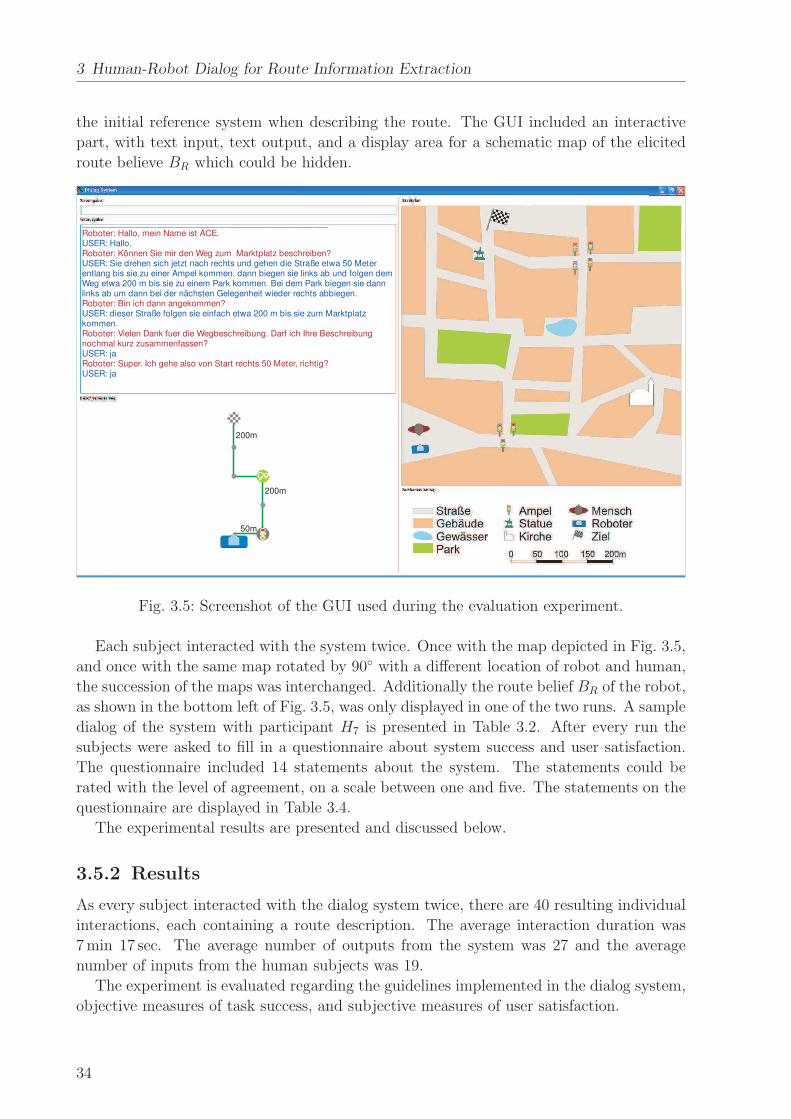
3 Human-Robot Dialog for Route Information Extraction
the initial reference system when describing the route. The GUI included an interactive
part, with text input, text output, and a display area for a schematic map of the elicited
route believe BR which could be hidden.
200m
Roboter: Hallo, mein Name ist ACE.
Roboter: Können Sie mir den Weg zum Marktplatz beschreiben?
Roboter: Bin ich dann angekommen?
Roboter: Vielen Dank fuer die Wegbeschreibung. Darf ich Ihre Beschreibungnochmal kurz zusammenfassen?
Roboter: Super. Ich gehe also von Start rechts 50 Meter, richtig?
USER: Hallo.
USER: Sie drehen sich jetzt nach rechts und gehen die Straße etwa 50 Meterentlang bis sie zu einer Ampel kommen. dann biegen sie links ab und folgen demWeg etwa 200 m bis sie zu einem Park kommen. Bei dem Park biegen sie dannlinks ab um dann bei der nächsten Gelegenheit wieder rechts abbiegen.
USER: dieser Straße folgen sie einfach etwa 200 m bis sie zum Marktplatzkommen.
USER: ja
USER: ja
50m
200m
Fig. 3.5: Screenshot of the GUI used during the evaluation experiment.
Each subject interacted with the system twice. Once with the map depicted in Fig. 3.5,
and once with the same map rotated by 90◦ with a different location of robot and human,
the succession of the maps was interchanged. Additionally the route belief BR of the robot,
as shown in the bottom left of Fig. 3.5, was only displayed in one of the two runs. A sample
dialog of the system with participant H7 is presented in Table 3.2. After every run the
subjects were asked to fill in a questionnaire about system success and user satisfaction.
The questionnaire included 14 statements about the system. The statements could be
rated with the level of agreement, on a scale between one and five. The statements on the
questionnaire are displayed in Table 3.4.
The experimental results are presented and discussed below.
3.5.2 Results
As every subject interacted with the dialog system twice, there are 40 resulting individual
interactions, each containing a route description. The average interaction duration was
7 min 17 sec. The average number of outputs from the system was 27 and the average
number of inputs from the human subjects was 19.
The experiment is evaluated regarding the guidelines implemented in the dialog system,
objective measures of task success, and subjective measures of user satisfaction.
34

3.5 Evaluation
Tab. 3.2: Example dialog between dialog system and human participant H7.
Robot: Hello, my name is ACE.Human: Hello.Robot: Can you tell me, how to get to the market place?Human: You have to turn left and follow the street for about 50 meters, until you
reach the traffic lights. Then go left and follow the road for approximately200 meters until you reach a park. Turn left at the park and as soon aspossible right again.
Robot: Am I at my goal then?Human: follow the street for about 200 meters to the market place.Robot: Thanks for the route description. May I sum up the route briefly?Human: yesRobot: Great. I have to go right for 50 meters, right?Human: yesRobot: There I turn left then?Human: yesRobot: Ok. I have to go straight for 200 meters, right?Human: yesRobot: Then I have to turn left?Human: yesRobot: Ok. And then I will turn right?Human: yesRobot: I have to go straight for 200 meters to the goal, right?Human: yesRobot: Thank you for your help. Good bye.Human: Good bye.
Evaluation of the guidelines
Motivated by DG 1 the dialog phases are implemented as an FSM. This guarantees the
possibility to jump back and forth between states GivDir and Conf to correct certain
information if necessary. To assess the effectiveness of this structure, the dialogs are
analyzed focussing on the active states over the time. Fig. 3.6 shows a box-whisker plot of
the durations of the dialog system in the four states Intro, GivDir, Conf, and Concl.
The durations for states GivDir and Conf are the cumulative durations, as there may be
several switchings between those states. State Intro has a mean duration of 1 min 32 sec
with a standard deviation of 1 min 13 sec. GivDir is the central dialog state and has
the longest duration as expected, i.e. a mean duration of 6 min 07 sec and a standard
deviation of 2 min 37 sec. The mean value of the duration of state Conf is 43 sec while the
standard deviation is 25 sec. Finally, Concl has a mean duration of 12 sec with a standard
deviation of 5 sec. State GivDir represents the phase in which the crucial information is
communicated. The fact that state Intro has the second longest duration with a large
standard deviation can be explained easily. During the Introduction phase the human is
asked to give directions to a certain goal. The system switches to the next state when the
35

3 Human-Robot Dialog for Route Information Extraction
0
2
4
6
8
10
12
dialog states
dura
tion
[min
]
Intro GivDir Conf Concl
Fig. 3.6: Box-whisker plot of the durations of the dialog states.
human starts giving directions. As argued in [80] some humans first review the whole route
and plan the complete route description before beginning to give directions in one big block
which leads to long durations of state Intro; this occurred in 30 % of the dialogs. Others
plan the route description piecewise and provide the description sequentially which results
in a short duration of Intro, but prolongs the duration of state GivDir; as observed in
70 % of the dialogs in the experiment.
The states and the transitions between them are depicted in Fig. 3.7 for four example
dialogs from the experiment. The dialog with participant H7 is presented in Table 3.2.
0 1 2 3 4 5
dia
log
stat
es
time [min]
Intro
Giv
Dir
Conf
Concl
Idle
H1
H7
H8
H19
Fig. 3.7: Transitions between system states over the time in four example dialogs from theexperiment (participants H1, H7, H8, H19).
As can be seen some dialogs included more than one transition between state GivDir
and state Conf, where erroneous information was corrected. The mean number of tran-
sitions from state Conf back to state GivDir is 1.45 with a standard deviation of 1.15.
This gives evidence of the necessity of a flexible dialog structure which allows to change
36

3.5 Evaluation
back and forth between states and correct faulty information.
DG 2 suggests that the robot asks the human to define the first direction with a point-
ing gesture and thus solve the coordination problem. Gestures were not included in the
simulation presented above, however they were considered in the outdoor experiment with
the ACE robot [224], as described in Chapter 2. Only in one case the robot was given a
faulty direction by gesture. All other gestures were expedient and served to align the per-
sonal reference systems of human and robot, so that subsequent route information could
be given unambiguously.
As proposed by DG 3 the system extracted route information from the dialogs in the
experiment and represented the routes as topological route graphs. The route graphs
included directions (DG 4, DG 8), distances (DG 7), and landmarks (DG 5, DG 6). Fig. 3.8
depicts four example route graphs constructed during the experiment. For reference: dialog
with participant H7 is presented in Table 3.2, while the transitions between the states over
the time for this participant are depicted in Fig. 3.7. The route graphs vary in detail,
especially in the number of nodes, as some subjects gave a more detailed description,
naming more landmarks along the way or providing metrical estimates of distances.
Landmark types:
IntersectionLightsParkGoal
H1 H7 H11 H14
50 m 100
m
200
m
200
m
Fig. 3.8: Four routes extracted in the experiment (participants H1, H7, H11, H14).
The route belief of the system was depicted in the GUI as proposed by DG 12. This
depiction did not result in significant differences of the objective performance, however was
rated well subjectively by the humans, as discussed further in the following. The objective
results of extracting route information and representing it are discussed below.
Objective Measures
In order to evaluate the performance of the dialog system objectively, it is important to
compare it to human performance. To assess the correctness of the route descriptions
provided by the subjects during the experiment, all route descriptions were given to other
subjects to reconstruct the routes. The subjects were 20 PhD students, 6 female and
14 male, aged between 25 years and 32 years. These subjects were provided with a city
map that included the detail map from the GUI and additionally depicted surrounding
environment to give more options for interpretation of the route description. A mask to
37

3 Human-Robot Dialog for Route Information Extraction
block out parts of the city map and thus restrict the view was used to imitate a movement
along the path without further knowledge of the surrounding map. Each subject was asked
to reconstruct two route descriptions by drawing a line along a path on the map following
the instructions in each route description. The descriptions were rated as correct when the
path ended at the goal point which occurred in 24 cases (60 %). Paths that ended along the
way to the goal were associated with partially correct route descriptions which happened
in one case (2.5 %). In the other cases the route descriptions were rated as incorrect.
The route information extracted by the dialog system was classified in the same way and
compared to the results from the route reconstructions by humans. In 11 cases (27.5 %) the
extracted routes were correct. The routes were partially correct in 9 cases (22.5 %), i.e. the
route was correct, but did not reach all the way to the goal. The number of partially correct
routes can be explained by the fact that the system represents each direction information as
a route segment delimited by intersections by default if no specific landmarks are extracted
which renders some routes too short.
Random guessing results in reaching the goal point in 1.92 %, as there are 52 locations
within the same radius as the goal around the robot position. Of those positions 12 are
accepted as being located along a route to the goal.
The results of the accuracy of the routes interpreted by humans, extracted by the dialog
system, and achieved by random guessing is shown in Table 3.3. The column entitled
correct destination lists the accuracy of understanding the route description completely,
i.e. reaching the goal. The column entitled partially correct route lists the accuracy of
understanding the route description including cases in which the goal point is not reached
but the path is correct as far as it reaches. For the cumulated completely and partially
correct routes the system performance is 2025
= 80 % of the human performance which is
quite good taking into account that the text recognition does not work perfectly in order
to simulate imperfect speech recognition.
Tab. 3.3: Performance given by the accuracy of understanding route descriptions.
correct destination partially correct route
human performance 24/40 (60 %) 25/40 (62.5 %)
dialog system 11/40 (27.5 %) 20/40 (50 %)
random guessing 0.77/40 (1.92 %) 9.22/40 (23 %)
The results are in line with the results of other researchers. A direction instruction inter-
pretation algorithm based on probabilistic inference presented by Wei et. al. [197] achieved
an accuracy of 85 % of the human performance. However, this system was given keywords
extracted by hand from written text as input, and did not process raw text. MacMahon
et. al. found that the interpretation of implicit information in route instructions by action
inference [112] raises task performance of a virtual agent navigating by human route in-
structions to 88 % of the human performance, while following purely explicit instructions
led to only 41 % of the human performance. Again the system input was “the hand-verified
‘gold-standard’ parse treebank”, not the raw text. Bugmann et. al. presented an instruc-
tion based learning system processing speech signals [22] that achieved a recognition rate
38

3.5 Evaluation
of 75.9 % compared to human performance. Compared to these studies, the objective
results of this work are very good, as the presented system simulates imperfect speech
recognition by interpreting raw text input which led to most of the encountered extraction
problems. Spell check, or even hand verified keyword input would further improve the
system performance.
The recognition accuracy showed no significant differences for the variable of displaying
the route belief of the robot in the GUI. Objectively it is not important for information
extraction whether the route belief of the robot is displayed or not.
Subjective Measures
The results presented so far are the objective measures of system performance. However
in HRI subjective measures such as user satisfaction are important factors for success as
well. Therefore a questionnaire has been composed, inspired by established questions for
subjectively evaluating dialog systems presented by [196] and [67]. Table 3.4 displays the
questionnaire used to evaluate the subjective measures of user satisfaction and subjective
assessment of features of the dialog systems. The level of agreement was rated between
one (strongly agree) and five (disagree) by the subjects. The mean values and standard
deviations of the answers are displayed in Table 3.4 next to the respective questions.
Tab. 3.4: Questions about user satisfaction with subjective assessment.
No. Statement µ σ
1. The system was easy to use. 2.05 0.93
2. The system understood the information I entered. 3.25 1.28
3. I knew at all times what I could enter. 2.78 1.25
4. The system reacted as I expected it to. 3.20 1.07
5. The length of the interaction was adequate. 2.40 1.13
6. The system understood my route description correctly straightaway.
3.73 1.38
7. If not: The system understood my route description correctly afterthe correction.
2.97 1.48
8. The structure of the dialog was sensible. 2.13 1.09
9. I knew from whose point of view I had to describe the route. 1.28 0.64
10. It is important that the point of view is clear. 1.48 0.85
11. The system understood landmarks during the route description. 2.38 1.17
12. It is important that the system understands landmarks. 1.45 0.81
13. The system understood distance information well. 2.23 1.14
14. It is important that the system understands distance information. 1.88 0.94
The results of the survey show that the ease of use was rated as good according to
statement 1. However, the answers to statements 2, 4, and 6 show that the subjects were
39

3 Human-Robot Dialog for Route Information Extraction
not entirely content with what the system understood and how it reacted. In the cases
where the users stated that the system did not understand their instructions straight away,
a significant improvement (dependent t-test of mean answers: t(19) = 4.32, p < .001) was
established through the correction of information in the Conf phase, as resulting from
statements 6 and 7 respectively.
Statements 8 to 14 assess the subjects’ views on the usefulness and realization of the
implemented guidelines. The results show that the users assessed these rules as reasonable
and useful. The implementation of these guidelines was rated well by the subjects, i.e.
mean values lie between 1.45 and 2.23.
The answers to statements 6 and 11 about how well the robot understood infor-
mation depends considerably on the objective results. The mean value of statement
6 for correct routes was 3.00, while for incorrect routes it was 4.16 (independent t-
test: t(18) = −1.47, p = 0.16). Similarly, the mean values of statement 7 were not
significant with 2.17 for correct routes and 3.60 for incorrect routes, (independent t-
test: t(18) = −1.92, p = 0.075). For statement 11 the mean values of 2.00 for cor-
rect and 3.22 for incorrect routes showed a significant difference (independent t-test:
t(18) = −2.38, p = 0.029). Other differences between ratings of statements for the dif-
ferent objective results were not significant.
All subjects were asked whether the displaying of the robot’s route knowledge, as pro-
posed in DG 12, helped during the interaction. This question was answered yes by 14
subjects (70 %). Some gave the explanation that they were not used to interacting with
a machine so freely and thus were not always sure whether the system did understand
them without the graphical information. Consequently humans interacting with a natural
language dialog system seem to prefer some additional feedback modality to be able to
evaluate the cognitive capabilities of the system.
Overall, the dialog system was perceived as natural by the human subjects and the
implemented dialog guidelines were assessed as useful.
3.6 Discussion
A legitimate approach for robots to close gaps in their route knowledge is to ask humans
for directions. Therefore a robot needs a dialog system that can proactively extract route
descriptions from human-robot dialogs. There are two main requirements for such a dialog
system: the extracted information must be unambiguous, in order to be usable during
navigation; the dialog must be natural to humans, in order to facilitate the communication
between non-expert human users and a robot.
This chapter presented a dialog system for robots asking humans for directions and
proactively extracting the necessary information. As natural language communication is
an important skill for robotic systems interacting with non-expert users, principles from
linguistics research have been surveyed to identify implications for HRI from human-human
communication. Guidelines for robots asking humans for directions have been subsequently
derived as policies for human-robot dialogs. A dialog system has been developed with
a modular architecture in order to allow for several communication modalities and for
extension of discourse topics. The guidelines derived from findings from human-human
40
3.6 Discussion
communication are implemented in the dialog system. These guidelines render the dialog
natural for the human partner and enable the system to extract missing route information
unambiguously. The dialog system comprises four major components with the dialog
manager at its core and an FSM controlling the progress of the dialog.
The dialog system was evaluated in an experiment in which the system interacted with
human subjects and extracted route information. Questionnaires about user satisfaction
and subjective assessment were evaluated. The results showed that the system is generally
natural and easy to use to humans, and that the implemented guidelines were assessed
as reasonable by the users. At the same time the system performance of understanding
human route directions of 80 % relative to human performance is more than comparable
to results from other researchers.
The main contribution of this chapter lies within the successful application of guidelines
for human-robot communication derived from human-human communication in a dialog
system for robots. The dialog system extracts unambiguous route information and facil-
itates natural-language dialogs between non-expert human users and robots. The dialog
system is designed in a modular way to allow expandability. It can be used with various
combinations of input modalities. Other discourse topics can be implemented by adding
adequate guidelines for human-robot dialogs.
The dialog system proactively asks humans for missing information and extracts given
route descriptions. It does not evaluate extracted information or assess it for plausibility.
As route descriptions are abstractions of humans’ cognitive representations of spatial rela-
tions in the real environments, they can be overly simplified, distorted or even erroneous.
Therefore methods are presented for evaluating the reliability of individual route informa-
tion in Chapter 4 and assessing the plausibility of whole route descriptions in Chapter 5.
41

4 Probabilistic Models of Route Information
Probabilistic models for information in route descriptions ex-
tracted during human-robot dialogs are presented in this chap-
ter. The presented models for direction and distance informa-
tion allow robots to assess the reliability and accuracy of the
often simplified and distorted information in route descriptions.
4.1 Problem Description and State of the Art
This chapter presents probabilistic models for individual direction and distance information
provided by humans in route descriptions. These models can be used by robots to represent
information probabilistically and assess the accuracy and reliability of it.
Representational accounts of cognition propose that humans store and represent spatial
relations in the real world in so-called cognitive maps, as introduced in [185]. A cognitive
map is constructed in a sequence of psychological transformations [40], including change
in scale, rotation, and perspective. Route descriptions are verbal abstractions of routes
represented in cognitive maps, where a series of processes is involved, such as selection of
important elements, temporal structuring, and selection of reference frames [49]. There-
fore a route description involves two transformations of spatial relations, i.e. from the
real world into a cognitive map [40] and from the cognitive map into a verbal descrip-
tion [49]. These transformations are not mathematical mappings, but cognitive processes,
and therefore prone to simplifications, inaccuracy, and even errors. Thus, information in
route descriptions is not exact, but noisy.
Robots, constructing a route belief from human route descriptions, need information
models that account for the uncertainty of route information. Route information that can
be modeled probabilistically are directions, quantitative distances, i.e. metric distance
values, and qualitative distances, such as distance ranges described by spatial deictics.
Based on a probabilistic representation of information, robots can establish the reliability
and accuracy of the acquired information. This can be used as one of several measures when
merging route information from different sources. A process of comparing different route
descriptions and building a probabilistic representation by merging the route information
is presented in Chapter 5.
Researchers are trying to model the cognitive processes involved in mentally representing
spatial relations [57, 132, 187]. These cognitive models have even been applied to technical
systems [91]. Probabilistic models of cognition reflect the degrees of belief [29, 62]. There
is a large body of literature presenting models of cognitive representations of spatial rela-
tions, while there is very little research done on modeling the verbal abstractions of these
cognitive representations in the form of route descriptions. However, for the application
of robots extracting spatial information from HRI, probabilistic models of information in
43

4 Probabilistic Models of Route Information
route descriptions are needed. These probabilistic models enable robots to construct a
route belief for navigation based on a probabilistic interpretation of the information.
The most essential information embedded in route descriptions are directions between
decision points, i.e. landmarks. Direction information may be erroneous because of an
incomplete [120] or oversimplified [25, 107] cognitive spatial representation, or because of
difficulties in conveying the spatial representation as for example in the case of left-right
confusion [15]. Distortions of cognitive directions have been described by [180, 194] which
analyze continuous angular directions, rather than discrete distinct directions used in route
descriptions. Route direction structure diagrams [149] have been introduced as tools for the
structural analysis of direction information; they depict aspects of route descriptions such
as directions over decision points. Subjective concepts of directions in route descriptions
have been researched in [83] as well. However, to date there are no works on modeling the
reliability or soundness of direction information in route descriptions.
Other essential information given in route descriptions are distances between decision
points. Researchers have modeled cognitive distances, i.e. the distance represented in an
individual’s cognitive map. There are different approaches to how the distances were given
in such studies, e.g. route distances vs. flight distances, and to which functions should
model the relationship between cognitive and real distance. Linear functions have been
used to model cognitive distances within cities [36] and between cities [26]. However, the
results of those works and of other researchers, e.g. [107], show that there is a tendency to
overestimate small and great distances, while underestimating distances in medium range
which points out that the linear function is not the most appropriate model. Furthermore,
the linear function has been found to be inappropriate, because the constant term does not
approximate to zero as would be expected [18]. Cognitive distances were also modeled by
power functions [16, 18], as the power function is generally accepted as the psychophysical
law [173]. The cognitive distance depends on factors such as emotional involvement [16],
familiarity with a route [35], the location relative to the city center [18, 55, 102], and even
vegetation along a route [157]. The perceptual relationship between visual distance per-
ception and real distance has been modeled as well [54], based on a mathematically defined
metric for visual space [108]. The perceived distance has been found to depend on the real
distance and a finite limit of perceived distance as a rational function, where both the
numerator and the denominator are first order polynomials [54]. Several external and in-
dividual influencing factors to visual perception of distances have been identified [47, 144].
A probabilistic model for visual space depending on the topological properties of the en-
vironment based on Bayesian inference is discussed in [205].
Researchers have found that the remembered distance is generally smaller than the per-
ceived distance [14, 125, 127]. In all experiments cognitive distances or perceived distances
were compared to the real distances. The cognitive distance, however, is not the same as
the distance humans give in route descriptions which is a much coarser estimate of the
real distance, often provided as salient travelling distance or time values. Again, there
are no research results on the conceptual relationship between real distances and distances
estimated during while giving route descriptions.
This chapter presents probabilistic models of information in route descriptions, in par-
ticular of directions and quantitative as well as qualitative distances. These models can be
44

4.2 Models for Direction and Distance Information
applied to route information extracted by the dialog system presented in Chapter 3. They
allow robots to reason about individual segments within route descriptions, while a sys-
tem for reasoning about whole route descriptions is introduced in Chapter 5. Inspiration
for such probabilistic models for route information is found in probabilistic robot map-
ping [182], in Markov chains [115], and Bayesian inference [12]. These probabilistic models
are meant for technical systems to serve as tools for assessing the accuracy and depend-
ability of individual information in route descriptions extracted from dialogs with humans.
The probabilistic modeling of direction and distance information in route descriptions in
itself goes beyond current spatial cognition research that focuses on models of cognitive
directions and distances. Furthermore, the presented models find specific applications in
robotics, as means to assess the accuracy of given route information.
This chapter is structured as follows. Section 4.2 presents probabilistic models for
direction and distance information from a theoretic point of view. In Section 4.3 survey
data is analyzed and numerical models for direction, quantitative, and qualitative distance
information are extracted. An evaluation is presented in Section 4.4, where an exemplary
route is represented probabilistically. Section 4.5 discusses the presented models.
4.2 Models for Direction and Distance Information
Route information, such as directions and distances, are imprecise representations of rela-
tions in the real environment and can even be erroneous. Therefore a robot that has to
build a route belief from route directions given by humans requires a model of the accu-
racy and reliability of such information. A common way to consider such uncertainty is by
modeling it probabilistically. In this chapter theoretical approaches to probabilistic models
for directions and distances are investigated. Fig. 4.1 schematically shows the process of
probabilistically modelling route information extracted from human-robot dialogs.
Route InformationExtraction
Direction and ErrorProbability
Quantitative/QuantitativeDistance Probabilities
Probabilistic InformationRepresentation
direction
distance posterior
certainty
Chap. 3 Chap. 5
Fig. 4.1: Overview over the process of modeling route information probabilistically.
4.2.1 Certainty Value of Direction Information
The aim of this subsection is to enable a technical system to assign certainty values to
each direction information in a route description, as an assessment of their reliability. Such
certainty values have to comprise all factors that can possibly influence the reliability of
direction information. The reliability of direction information in a route description clearly
depends on the route segment k it is given in. The probability for a certain direction of
45

4 Probabilistic Models of Route Information
route segment k depends on the current direction, the direction of the previous route
segment and the direction of the previous route up to route segment k − 1. Additionally
the probability that route segment k is erroneous is regarded in calculating the reliability
of a direction information.
On the way to obtain certainty values for direction information a suitable representation
of directions has to be chosen. At first, all direction information is transformed into global
directions relative to the orientation in the point of origin. The succession of directions in
a route description can be regarded as a descriptive process which has a distinct direction
state at each route segment k. The discrete set of direction states
S = {s1, s2, s3, s4} = {sleft, sstraight, sright, sback} , (4.1)
includes the four orthogonal directions that are represented as unit vectors, e.g.
s1 =(
1 0 0 0)T
. The observations are the directions at each route segment k in a route
description which are composed of fractions of distinct direction states. A discrete global
direction xk in the route description is represented as direction state vector
xk =(
x1 x2 x3 x4
)T=
(
xleft xstraight xright xback
)T, (4.2)
with fractions 0 ≤ xi ≤ 1 of discrete directions and4
∑
i=1
xi = 1. The description of a direction
observation as a state vector allows for the application of a Markov chain inspired approach
for the calculation of the direction probabilities. Furthermore, the general direction model
takes into account not only the four orthogonal directions, but non-orthogonal directions
such as ‘sharp left’, ‘veer right’, or numerical angles, as well.
Direction Probability
A direction probability model is derived from transition probabilities between the distinct
directions xk. The state transition probabilities are given by
pij = P (xk = sj|xk−1 = si) (4.3)
and have the properties pij ≥ 0 and4
∑
j=1
pij = 1. Furthermore the probabilistic description
is time independent, as it is truncated to the current and the predecessor state:
pij = P (xk = sj|xk−1 = si, xk−2 = sh, . . .) = P (xk = sj|xk−1 = si) (4.4)
A transition matrix P comprises all state transition probabilities pij, such that
P =
p11 . . . p14...
. . ....
p41 . . . p44
. (4.5)
46

4.2 Models for Direction and Distance Information
The transition matrix P applies to route segments k > 1. Initial state probabilities πi for
route segment k = 1, are combined in an initial state probability vector
π = P (xi) =(
π1 π2 π3 π4
)T, (4.6)
with the properties πi ≥ 0 and4
∑
i=1
πi = 1.
The initial state probabilities π and the state transition probabilities P are used to
calculate the direction probability PD,k of each route segment k which depends on the
global direction xk−1 of the previous route segment and the global direction vk−1 of the
overall previous route up to the previous route segment. An overal direction vector vk
is of unit length4
∑
i=1
vi = 1 and includes entries that are fractions of discrete directions
0 ≤ vi ≤ 1. The direction of the previous route segment is considered by multiplying
the global direction vector xk−1 and the probability matrix. The prediction vector xk of
the direction of xk which is independent of the route before segment k − 1, is given by a
Markov chain of length one, as
xk = xk−1 P . (4.7)
Additionally, the prediction vk of direction xk depending on the overall previous route
vk = vk−1 P , (4.8)
is considered, because it can be expected that a global overall direction is followed in
the long-run. The predictions xk in (4.7) and vk in (4.8) are combined in a direction
prediction xk by an entry-wise multiplication in a Hadamard product (denoted by xk ◦ vk)
and a normalization by division by the dot product. Prediction xk considers both the
direction of the previous segment and the direction of the overall previous route:
xk =xk ◦ vk
xTk vk
(4.9)
The probability PD,k of the direction xk at route segment k is gained by multiplying
the predictions by the actual direction, such that
PD,k =
{
πT xk, if k = 1
xTk xk, otherwise
. (4.10)
The direction probability PD,k takes into account the current direction at k, the previous
direction at k − 1, and the overall direction of the previous route up to k − 1. It does not
yet consider the possibility that route segment k might be erroneous at route segment k.
Error Probability
To assess the reliability of an individual direction information, not only the direction prob-
ability PD,k is important, but also the probability PE,k that a route segment is erroneous.
Erroneous direction information in a route description at route segment k, affects the sub-
47

4 Probabilistic Models of Route Information
sequent direction information in such a way that the following segments are erroneous as
well. Therefore the error probability PE,k of an individual direction information in a route
description is modeled by a cumulative distribution, as
PE,k =
∫ k
−∞
pE(x)dx , (4.11)
where pE(k) is the probability density function (pdf) of the first occurence of an erroneous
route segments. A cumulative distribution function conforms to the boundary conditions
that PE,k increases with the route segment k. The error probability is used as a heuristic
to weight the direction probability and result in a certainty value for each route segment k.
PE,k reflects the fact that information at the beginning of a route description is in general
more reliable than information that is farther away in the description.
Certainty Value
The direction probability PD and the error probability PE are mixed by a weighted average,
in analogy to sensor models in probabilistic robot mapping [182]. The resulting certainty
value is defined by the weight vector
w =[
wD wE
]T, (4.12)
with weight wD for the direction probability and weight wE for the error probability, where
wD + wE = 1. The certainty value results to
ck = wT
[
PD,k
1 − PE,k
]
. (4.13)
The certainty value ck is assigned to the direction information of each segment in the route
belief of a robot and provides an assessment of the reliability of the information. In the
case that the direction plausibility PD,k or PD,k−1 equals zero, the weight wD is set to one
and subsequently the certainty value ck is assigned the value zero, as the whole route is
assumed to be faulty after an erroneous route segment. In this way each segment in a
route description is assigned an individual certainty value which reflects the reliability of
that particular direction information.
4.2.2 Posterior Probability of Distance Information
Distance information provided in route descriptions is usually a rounded value of the cog-
nitive representation of the real distance. Therefore a probabilistic model for such distance
estimates is needed for robots that are using route descriptions from humans as a basis for
global navigation. Probabilistic distance models allow robots to assess during navigation
whether a location in the real environment corresponds to the respective description.
48

4.2 Models for Direction and Distance Information
Posterior Probability
Bayesian inference [10] is used to determine the probability that a location in the environ-
ment at the real distance dreal corresponds to an estimate dest in a route description. This
probability is given by the posterior probability which calculates as
P (dreal|dest) =P (dest|dreal) P (dreal)
P (dest), (4.14)
with the prior probability P (dreal), the marginal probability P (dest), and the conditional
probability P (dest|dreal).
A robot can assess whether a distance in the real environment is likely to correspond
to a given distance estimate, by evaluating the relative posterior. If the relative posterior
Prel(dreal|dest) is above a certain threshold the real distance may well correspond to the
distance described. The condition is given by
Prel(dreal|dest) =P (dreal|dest)
max (P (dreal|dest))≥ τPrel
. (4.15)
Additionally, the posterior of a real distance can be compared to other candidate real
distances, in this way determining the most probable real distance given a distance estimate
in a route description.
Prior Probability
The real distance is distributed uniformly, as every real distance value is as likely as another,
therefore the prior probability depends only on the distance range rreal, such that
P (dreal) =1
rreal
. (4.16)
The distance range rreal results from the boundaries of the considered environment.
Marginal Probability
Distance and time estimations in route descriptions do not reflect the real distance or
the cognitive distance, but are usually roughly rounded estimates of these. They are
not uniformly distributed, but rather the frequency increases for some round and salient
values or personal preferences. The marginal probability P (dest) takes into account that the
probabilities for estimations are not distributed uniformly, and balances higher frequencies
of certain salient estimates in the posterior probabilities.
Conditional Probability
The conditional probability P (dest|dreal) constitutes the likelihood that an estimation value
dest given during a route description refers to a certain real distance dreal. The conditional
probability is the crucial component for calculating the posterior probability.
49

4 Probabilistic Models of Route Information
The models for direction and distance information presented above provide robots with
the means of assessing route information for plausibility and reliability. In order to obtain
metric values for the certainty values and posterior probabilities, numerical values are
required in the models. These specific numerical values are obtained by collecting and
analyzing route information data.
4.3 Data Analysis
Theoretical approaches to equip robots with probabilistic models of route information
have been discussed above. Numerical values for the theoretical models are derived from
survey data. In this way technical systems are provided with specific models for direction,
quantitative and qualitative distance information. This work focuses on robots operating
in urban environments on sidewalks and in pedestrian areas. Therefore the models derived
in the following are intended and valid for walking distances in such environments, while for
other scales of environments the models may differ and must be extracted from appropriate
data.
4.3.1 Direction Information
A specific model for the reliability of relative directions in route descriptions is needed by
robotic systems in order to assess the plausibility of this information in route descriptions.
Such a model is provided by the certainty value ck in (4.13) which depends on the direction
probability PD,k, and the error probability PE,k. These probabilities are calculated from
the analysis of data from real route descriptions.
Route Description Data
Route description data was collected in the city of Munich in 2009 [222]. In total 48 passers-
by were randomly selected and asked to give directions to well known goals within walking
distance. All dialogs were recorded with a voice recorder and transcribed to text. In 5 cases
the persons asked did not know the destination and could not give a route description,
resulting in 43 analyzable dialogs. In order to analyze the route descriptions with regard
to direction accuracy, the route directions were verified on a city map, and erroneous route
segments were marked. For a more representative amount of data, route descriptions
collected in Trier [61] were evaluated additionally. There are 101 route descriptions in
the dataset from Trier, in which erroneous route segments were marked as well. There is
no significant difference between the lengths of the route descriptions, i.e. the numbers
of route segments (t-test, p = 0.4339) and therefore the route description data sets are
assumed to belong to the same distribution. Thus the route descriptions from Trier and
Munich are evaluated collectively. The combined data set contains 144 route descriptions.
The 92 correct route descriptions and 24 erroneous descriptions result in an overall error
ratio of 24116
≈ 21%. The number of segments in the route descriptions ranges from one to
seven with a mean value of 2.811 and a standard deviation of 1.075.
50

4.3 Data Analysis
Direction Probability
The direction probability PD,k in (4.10) is calculated from the current and previous global
direction state vectors and the state transition matrix P , or the initial probability vector π.
The numerical variables that need to be derived to model the direction probability are the
state transition probabilities pij and the initial state probabilities πi. Therefore the data is
analyzed by transforming the extracted distance information in all route descriptions into
global directions and analyzing the transition frequencies between the individual states, or
by analyzing the frequencies of the initial directions in the route descriptions.
Analysis of the directions of segment k = 1 of the route descriptions provides numerical
values for the initial state probability vector π in (4.6), as
π =[
0.09 0.77 0.10 0.04]
. (4.17)
The transition probabilities might look surprising at first glance, as opposed to an expec-
tation of having equal probabilities for all states, the transition probabilities are varying.
It makes sense however, as the data have been collected in real experiments where not all
orthogonal direction options were available which explains the relatively high probability
π2 for the direction ‘straight’. The initial probabilities π1 for ‘left’ and π3 for ‘right’ are
found to be approximately the same, as expected from unbiased data.
The transition matrix (4.5) results from the frequencies of the transitions in the data to
P =
0.56 0.18 0 0.26
0.25 0.50 0.25 0
0 0.12 0.58 0.30
0.28 0 0.26 0.46
. (4.18)
As expected the main diagonal, i.e. the probabilities for transitions between the same
global directions have the highest values of pii ≈ 0.5, while transitions to states representing
orthogonal directions are pi(i±1) ≈ 0.25, and the transition probabilities to states of reverse
directions are pi(i±2) = 0.
The initial state probabilities πi in (4.17) and the state transition probabilities pij in
(4.18) are depicted in Fig. 4.2 as a digraph of transition probabilities between direction
states in a route description.
It is noted that the transition probabilities are not symmetrical. Although, a large num-
ber of route descriptions with a number different combinations of start and end points has
been evaluated to identify these transition probabilities, a bias towards certain directions
cannot be excluded. However, the numerical initial and transition probabilities provide a
sound model to compute the direction probability PD,k in (4.10).
Error Probability
In order to find a specific model PE,k for the error probability, the erroneous route descrip-
tions are analyzed further. An important question is in which route segment k the first
error occurs. For this analysis only route descriptions with k ≤ 5 are used, as there are
too few longer route descriptions to draw significant conclusions from. The relative error
51

4 Probabilistic Models of Route Information
0.77
0.10
0.100.03
0.56
0.18
0.26
0.58
0.12
0.30
0.50
0.25
0.25
0.46
0.28
0.26
‘start’
sstraightsleft
srightsback
Fig. 4.2: Digraph of transition probabilities between direction states.
frequency fE,k, i.e. the ratio of errors at route segment k, is depicted in Fig. 4.3 marked
by squares, over the number of route segments k. The relative frequency fE,k represents
the first occurrence of an error in the route descriptions in the data set.
Erroneous direction information in a route description affects the subsequent direction
information in such a way that the directions in the following segments are erroneous
as well. Therefore the cumulative relative error frequency FE,k =k
∑
i=1
fE,k represents the
overall ratio of errors in each route segment. The cumulative frequency Fk is marked by
circles in Fig. 4.3 over the number of route segments k.
1 2 3 4 50
0.1
0.2
0.3
0.4
0.5fE,k
FE,k
PE,k
k
Fig. 4.3: Relative frequency fE,k, relative cumulative frequency FE,k, and fitted cumulativeprobability distribution PE,k of an error at route segment k.
The cumulative error frequency FE,k increases with the number of route segments k. As
there is not enough route description data with more than five route segments the shape
of the function for k > 5 is unknown, but is expected to converge to one, as it is assumed
52

4.3 Data Analysis
that the longer a route description is the likelier it becomes that there is an error in it.
Therefore the error probability distribution is modeled as a normal cumulative probability
distribution, such that
PE,k =1
σE
√2π
k∫
−∞
e−(x−µE)2
2σ2E dx . (4.19)
The method of least squares minimizes the vertical quadratic error between the cumulative
relative frequency and the fitted normal function, with
minµE ,σE
5∑
k=1
(FE,k − PE(k|µE, σE))2, s.t. (4.19) . (4.20)
In this way the values µE = 5.7 and σE = 3.3 are identified. The error model PE,k is
depicted in Fig. 4.3 as a line.
Certainty Value
The certainty value ck in (4.13) is fully described by the probabilities PD and PE and
the weight vector w. The weights wD and wE are assigned heuristically for the proba-
bilistic direction information model ck. The weight wE influences the offset and weight
wD influences the variance of the certainty value ck. The certainty values for all direction
information in the route description data set is calculated to demonstrate the procedure
and outcome. Fig. 4.4 shows the resulting probabilities PD,k as dotted lines, 1 − PE,k as a
dashed line, and the resulting certainty values ck as solid lines.
1 2 3 4 5 6 70
0.2
0.4
0.6
0.8
1
PD,k
1 − PE,k
ck
k
Fig. 4.4: Overview of direction and error probabilities and resulting certainty values for alldirection information in the data set of route descriptions. Direction probabilityPD,k in dotted lines, error probability 1 − PE,k in dashed line, and the resultingcertainty values ck in solid lines, with w =
[
0.5 0.5]
.
The probabilities PD,k and 1 − PE,k and the certainty value ck decrease with a growing
number of route segments k, as the probabilities that either the route description is at its
53

4 Probabilistic Models of Route Information
end or an error occurs increases with every route segment. The certainty values ck provide
a robot with an assessment of the reliability of the respective direction information.
4.3.2 Quantitative Distance Information
Robots navigating based on global route information extracted from HRI, need specific
models of the accuracy of distance information given in route descriptions. Such models
of quantitative distance estimates allow them to assess whether a location in the real
environment can be allocated to a location mentioned in a route description by a distance
estimate. Quantitative distance information in route descriptions is typically provided as a
numerical travelling distance dest or time test estimate. The functions and numerical values
of the posterior probabilities P (dreal|dest) and P (dreal|test), the prior probability P (dreal),
the conditional probabilities P (dest|dreal) and P (test|dreal), and the marginal probabilities
P (dest) and P (test) are identified by analyzing collected survey data.
Quantitative Distance Estimation Data
As distance estimates are not included in every route direction, distance estimation data
was collected in a separate survey by means of asking 110 randomly selected passers-by for
the way and the remaining distance to three different well-known landmarks in the center
of Munich. The participants were all asked at different locations to estimate how far it was
to one of the three landmarks which was not visible but within walking distance. In order
to record the distance estimation in a route description and not the more precise cognitive
distance, the subjects were not told that the data was for a scientific survey until after
they gave their estimations, as not to influence their estimation efforts. Interestingly after
they were told that the data was intended for a scientific study, some participants wanted
to modify their distance estimate. This supports the assumption that a distance estimate
given in a route description differs from the respective cognitive distance. Each participant
gave either an estimation of the remaining distance, usually in [m], or the remaining time,
usually in [min], or in some cases both. In total the data consists of 71 distance estimates
and 65 time estimates. The real distances dreal are rounded to an accuracy of 10 m, and
range from 100 m to 1000 m.
Fig. 4.5 on the left depicts the real distances dreal over the estimated distances dest of the
data collected in the survey. A dashed line marks the correspondence of real and estimated
distance dest = dreal. The real distances dreal over the estimated times test are shown in
Fig. 4.5 on the right. A dashed line marks the correspondence of the real distance with
the estimated time multiplied by an average walking velocity as test vwalk = dreal, with the
walking velocity vwalk = 4.5 kmh
.
Generally it is noted that for short real distances dreal the estimates tend to be lower,
whereas for longer distances the estimates tend to be higher than the real values.
Effects of Personal Factors on the Distance Estimation Accuracy: The data of
60 of the subjects includes each subject’s gender, age, self-assessment of the estimation,
and an explanation of the given self-assessment. The effects of the personal factors gender,
age, and self-assessment on the estimation accuracy are evaluated. For that purpose,
54

4.3 Data Analysis
0 500 1000 1500 2000 25000
200
400
600
800
1000d
real[m
]
dest [m]
datadest = dreal
0 5 10 150
200
400
600
800
1000
dre
al[m
]
test [min]
datatest vwalk = dreal
Fig. 4.5: Estimation data of traveling distances on the left and traveling times on the right.The dashed lines indicate the match of estimated and real data.
relative constant and absolute errors of the distance and time estimation data are compared
statistically with t-tests and analyses of variances (ANOVAs), respectively. The full results
are given in Appendix B.1, while condensed results are presented here.
Both relative constant and absolute errors for the time data are significantly lower
than for the distance data which suggests that time estimates are generally more reliable
than distance estimates. The personal variable gender does not show significant differences
between data from female and male participants for the relative errors of distance and time
estimates respectively, however female participants showed a preference for giving time
estimates, while males preferred to give distance estimates. The differences between three
different age groups of the relative errors of the data were also not significant. Similarly, the
variable self-assessment did not provide significant relative error differences between three
different groups of self-assessment, except for the relative constant distance estimation error
which arose from the fact that participants who assessed their estimate as ‘bad’ tended to
underestimate distances more often than other participants.
The fact that differences of the relative errors are not significant for the variables gender,
age, and self-assessment, with only one exception, shows that those personal variables have
no important influence on the accuracy of quantitative walking distance or time estimation
within route descriptions. Therefore these factors do not have to be taken into account by
a robot when searching for and selecting a person whom to ask for directions. Further-
more these personal factors are of no importance when modeling the relation between real
distance and estimated distance or time.
Prior Probability
The real distance data dreal was limited to a range of 100 m to 1000 m in an urban envi-
ronment, resulting in a distance range rreal = 900 m for which this model is valid. Thus,
the prior probability in (4.16) is
P (dreal) =1
900. (4.21)
55

4 Probabilistic Models of Route Information
Marginal Probabilities
The marginal probabilities P (dest) and P (test) consider a non-uniform distribution of the
frequency of the estimates, i.e. a preference of humans to provide salient and rounded
values as distance estimates. Histograms of the frequencies fdest and ftest of the data are
presented in Fig. 4.6, for distance estimates on the left, and time estimates on the right.
The histograms display higher frequencies for salient distances, e.g. 500 m and 1000 m,
and salient times, e.g. 5 min and 10 min, slightly raised frequencies between those salient
values, and an overall decrease in the frequency with an increasing real distance.
500 1000 1500 2000 25000
5
10
15
fdest
dest [m]
2 4 6 8 10 12 140
10
20
ft e
st
test [min]
Fig. 4.6: Histograms of quantitative distance and time estimates.
The marginal probabilities can be determined by a lookup table of the relative frequen-
cies or alternatively by a fitted function. In both cases it has to be considered that the
experimental data has gaps at some estimation values which have to be interpolated.
Conditional Probabilities
Conditional probabilities reflect the likelihood that a distance dest or time test estimate is
provided in a route description given a certain real distance dreal in the environment. It is
assumed that these probabilities are modeled by normal functions, where the mean values
and standard deviations are functions of the real distance. The conditional probability for
distance estimates is given by
P (dest|dreal) = P (dest|µd, σd) =1
σd
√2π
e−(dest−µd)2
2σ2d , (4.22)
where µd and σd are functions of dreal. Analogously the conditional probability for time
estimates is modeled by
P (test|dreal) = P (test|µt, σt) =1
σt
√2π
e−(dest−µt)
2
2σ2t , (4.23)
where µt and σt are functions of dreal. The functions for the mean values µd and µt represent
the conceptual relations between the real distance dreal and the estimated distance dest and
estimated time test respectively. An appropriate function for describing these variables is
chosen in the following.
The data distribution, as shown in Fig. 4.5, is consistent with the data distributions for
perceived distances within visual space [54] and with data distributions for cognitive dis-
tances [16]. In the literature different types of functions are found modeling perceived and
56

4.3 Data Analysis
remembered distance over real distances. Therefore the two most common functions, a ra-
tional function and a power function are compared and subsequently the more appropriate
function is used to describe µd, µt, σd, and σt.
Approaches applying rational functions and power functions found in the literature are
both applied to the collected data and compared by their residuals. A rational function
with first order polynomials as numerator and denominator similar to the model for visually
perceived distances [54] is given by
grat(dreal) =dreal
α1 dreal + α2
. (4.24)
A power function in line with results for cognitive distances [16, 107] is written as
gpow(dreal) = β1drealβ2 . (4.25)
The two alternative functions are fitted to the data sets for distance and time estimations
by the method of least squares.
The functions grat(dreal) in (4.24) and gpow(dreal) in (4.25) are compared by the sum
of squared residuals of the data points(
dreal,i dest,i
)
and(
dreal,i test,i)
and the modeled
values. The sum of squared residuals are
rratyest
=n
∑
i=1
(yest,i − grat(dreal,i, α1, α2))2
,
rpowyest
=n
∑
i=1
(yest,i − gpow(dreal,i, β1, β2))2
, (4.26)
with the data type yest = dest for distance or yest = test for time estimates. They are
compared for data with stepwise increased maximum real distances. Fig. 4.7 compares
rratyest
to rpowyest
over the maximum real distance max(dreal), as solid lines for grat(dreal) and as
dashed lines for gpow(dreal), for distance estimates on the left and time estimates on the
right.
300 400 500 600 700 800 900 1000
0
2
4x 10
4
max(dreal) [m]
r d
rrat
rpow
200 400 600 800 10000
5000
10000
max(dreal) [m]
r t
rrat
rpow
Fig. 4.7: Sums of squared residuals rratyest
and rpowyest
over the maximum real distance comparethe goodness of fit of functions grat(dreal) and gpow(dreal) for distance estimates onthe left and time estimates on the right.
The sum of squared residuals is smaller for grat(dreal) for a small real distance maximum
under 500 m and again for a big maximum distance at 1000 m both for the distance and
time estimation data, while the sum of squared residuals is smaller for gpow(dreal) for
57
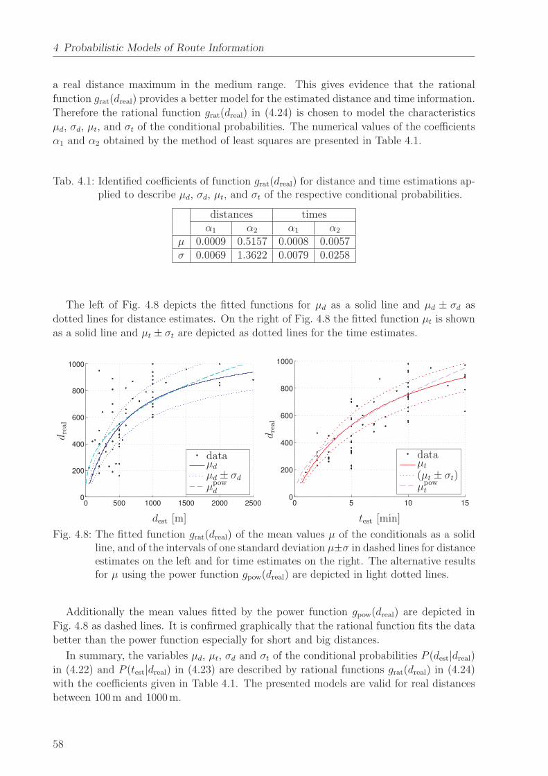
4 Probabilistic Models of Route Information
a real distance maximum in the medium range. This gives evidence that the rational
function grat(dreal) provides a better model for the estimated distance and time information.
Therefore the rational function grat(dreal) in (4.24) is chosen to model the characteristics
µd, σd, µt, and σt of the conditional probabilities. The numerical values of the coefficients
α1 and α2 obtained by the method of least squares are presented in Table 4.1.
Tab. 4.1: Identified coefficients of function grat(dreal) for distance and time estimations ap-plied to describe µd, σd, µt, and σt of the respective conditional probabilities.
distances timesα1 α2 α1 α2
µ 0.0009 0.5157 0.0008 0.0057σ 0.0069 1.3622 0.0079 0.0258
The left of Fig. 4.8 depicts the fitted functions for µd as a solid line and µd ± σd as
dotted lines for distance estimates. On the right of Fig. 4.8 the fitted function µt is shown
as a solid line and µt ± σt are depicted as dotted lines for the time estimates.
0 500 1000 1500 2000 25000
200
400
600
800
1000
µd
µd ± σd
data
µpowd
dre
al
dest [m]
0 5 10 150
200
400
600
800
1000
µt
(µt ± σt)
data
µpowt
dre
al
test [min]
Fig. 4.8: The fitted function grat(dreal) of the mean values µ of the conditionals as a solidline, and of the intervals of one standard deviation µ±σ in dashed lines for distanceestimates on the left and for time estimates on the right. The alternative resultsfor µ using the power function gpow(dreal) are depicted in light dotted lines.
Additionally the mean values fitted by the power function gpow(dreal) are depicted in
Fig. 4.8 as dashed lines. It is confirmed graphically that the rational function fits the data
better than the power function especially for short and big distances.
In summary, the variables µd, µt, σd and σt of the conditional probabilities P (dest|dreal)
in (4.22) and P (test|dreal) in (4.23) are described by rational functions grat(dreal) in (4.24)
with the coefficients given in Table 4.1. The presented models are valid for real distances
between 100 m and 1000 m.
58
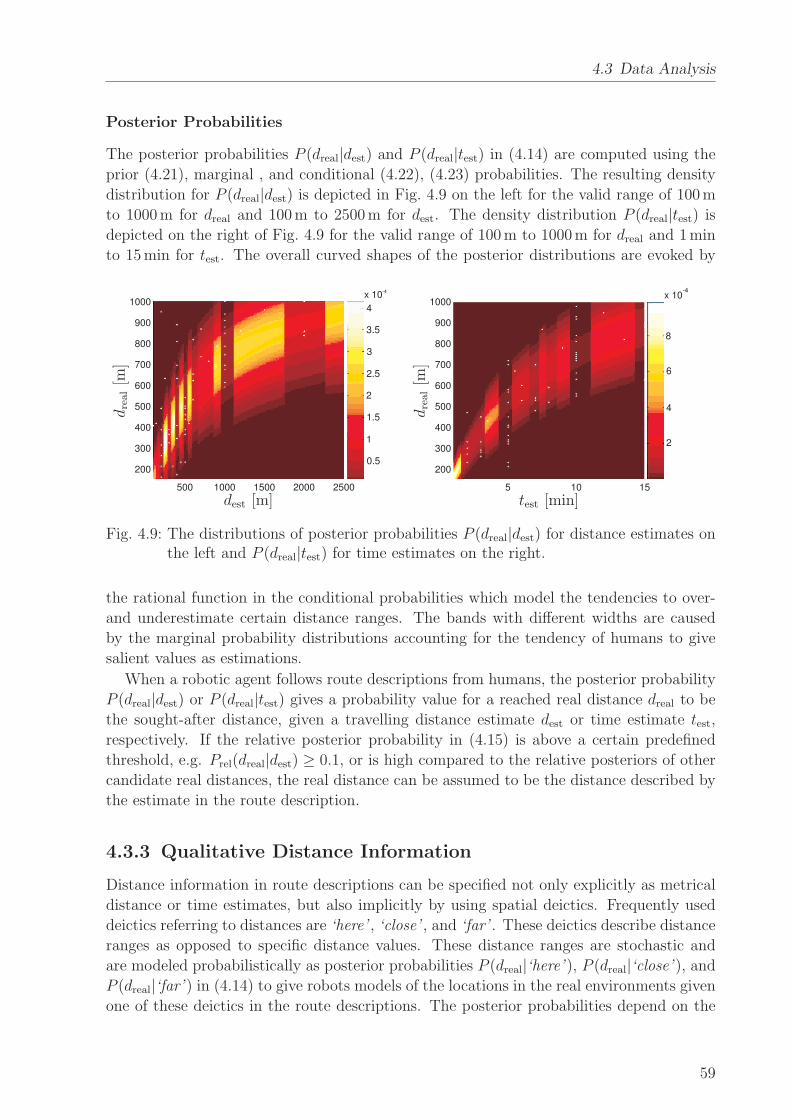
4.3 Data Analysis
Posterior Probabilities
The posterior probabilities P (dreal|dest) and P (dreal|test) in (4.14) are computed using the
prior (4.21), marginal , and conditional (4.22), (4.23) probabilities. The resulting density
distribution for P (dreal|dest) is depicted in Fig. 4.9 on the left for the valid range of 100 m
to 1000 m for dreal and 100 m to 2500 m for dest. The density distribution P (dreal|test) is
depicted on the right of Fig. 4.9 for the valid range of 100 m to 1000 m for dreal and 1 min
to 15 min for test. The overall curved shapes of the posterior distributions are evoked by
200
300
400
500
600
700
800
900
1000
500 1000 1500 2000 2500
x 10-4
4
3.5
3
2.5
2
1
0.5
1.5dre
al[m
]
dest [m]5 10 15
200
300
400
500
600
700
800
900
1000
2
4
6
8
x 10-4
dre
al[m
]
test [min]
Fig. 4.9: The distributions of posterior probabilities P (dreal|dest) for distance estimates onthe left and P (dreal|test) for time estimates on the right.
the rational function in the conditional probabilities which model the tendencies to over-
and underestimate certain distance ranges. The bands with different widths are caused
by the marginal probability distributions accounting for the tendency of humans to give
salient values as estimations.
When a robotic agent follows route descriptions from humans, the posterior probability
P (dreal|dest) or P (dreal|test) gives a probability value for a reached real distance dreal to be
the sought-after distance, given a travelling distance estimate dest or time estimate test,
respectively. If the relative posterior probability in (4.15) is above a certain predefined
threshold, e.g. Prel(dreal|dest) ≥ 0.1, or is high compared to the relative posteriors of other
candidate real distances, the real distance can be assumed to be the distance described by
the estimate in the route description.
4.3.3 Qualitative Distance Information
Distance information in route descriptions can be specified not only explicitly as metrical
distance or time estimates, but also implicitly by using spatial deictics. Frequently used
deictics referring to distances are ‘here’ , ‘close’ , and ‘far’ . These deictics describe distance
ranges as opposed to specific distance values. These distance ranges are stochastic and
are modeled probabilistically as posterior probabilities P (dreal|‘here’ ), P (dreal|‘close’ ), and
P (dreal|‘far’ ) in (4.14) to give robots models of the locations in the real environments given
one of these deictics in the route descriptions. The posterior probabilities depend on the
59

4 Probabilistic Models of Route Information
prior probability P (dreal), the conditional probabilities P (‘here’ |dreal), P (‘here’ |dreal), and
P (‘far’ |dreal), and the marginal probabilities P (‘here’ ), P (‘close’ ), and P (‘far’ ).
Qualitative Distance Estimation Data
An experiment was conducted with 36 PhD students of engineering as participants. There
were 4 female and 32 male participants aged between 24 years and 37 years, with an average
age of 27 years. The participants were given a questionnaire showing a map of the city
center of Munich. A start point was marked in the center of the map and 44 locations
marked by boxes were randomly assigned around it , as shown in Fig. C.5 in Appendix C.2.
The box farthest away from the start point corresponded to a real distance of 1130 m in the
corresponding real environment. The participants were all familiar with the area around
the start point. They were asked to label the boxes as either ‘here’ , ‘close’ , or ‘far’ , if
they could clearly associate them with one of these deictics.
Contextual Dependence: Before modeling qualitative distances, a question that needs
to be answered is whether the deictics ‘here’ , ‘close’ , and ‘far’ are contextually indepen-
dent, i.e. whether they are used to refer to relative distances from a starting point indepen-
dently of the considered environment. An experiment was conducted to discover whether
or not the deictics ‘here’ , ‘close’ , and ‘far’ describe different distance ranges in different
environments. In the experiment the borders between pairs of adjacent deictics, are ana-
lyzed depending on the given environment. The experiment is based on a questionnaire, as
presented in Appendix C.2, where the participants had to mark the borders between ‘here’
and ‘close’ , and between ‘close’ and ‘far’ in three different maps of different environments,
i.e. an abstract environment, an urban environment, and a large scale environment.
The results of the evaluation of contextual dependence are presented in detail in Ap-
pendix B.2; here the results are summarized. A mixed linear model is fitted to the data and
analyzed statistically. The variable map is statistically significant with a strong effect both
on the borders between ‘here’ and ‘close’ and between ‘close’ and ‘far’ . The variable age
is significant for the border between ‘here’ and ‘close’ , but has only a weak effect. Thus
it is argued that the environment has to be taken into account when modeling qualitative
distance information, while effects of personal variables can be neglected. Therefore the
models for the spatial deictics ‘here’ , ‘close’ , and ‘far’ , presented in the following hold
only for the considered urban environment.
Prior Probability
The distance data dreal was limited to a range of 0 m to 1130 m in an urban environment,
resulting in a distance range of rreal = 1130 m for which this model is valid. Thus, the
prior probability in (4.16) is
P (dreal) =1
1130. (4.27)
60

4.3 Data Analysis
Marginal Probabilities
The marginal probabilities P (‘here’ ), P (‘close’ ), and P (‘far’ ) denote the likeliness that the
respective deictic is used to describe a distance in a route description. These probabilities
are inferred from the frequency of the use of the deictics ‘here’ , ‘close’ , and ‘far’ in real
route descriptions, i.e. from the data set described in Section 4.3.1. In the data set the
deictic ‘here’ is given 29 times, while ‘close’ and ‘far’ are used twice each. The marginal
probabilities correspond to the frequencies of the data, resulting in
P (‘here’ ) =29
33,
P (‘close’ ) =2
33, (4.28)
P (‘far’ ) =2
33.
Conditional Probabilities
The results are evaluated separately for the deictics ‘here’ , ‘close’ , and ‘far’ , and truncated
functions are used to model the probability distributions in the following.
The frequencies fh of the physical distances between the start point and all locations
that were marked as ‘here’ are shown in the histogram on the top of Fig. 4.10. The start
point is always referred to as ‘here’ . The farther the distance is from the start point, the
less likely it is referred to as ‘here’ . To model the probability density function for the
deictic ‘here’ a truncated exponential function is fitted to the data by the method of least
squares. The resulting distribution is
P (‘here’ |dreal) =
1µh
edrealµh
1 − e1130µh
, if 0 ≤ dreal ≤ 1130
0, otherwise
, (4.29)
with µh = 148.67 identified by the method of least squares. The conditional probability
P (‘here’ |dreal) is shown on the bottom of Fig. 4.10.
61

4 Probabilistic Models of Route Information
200 400 600 800 100000
50
100
0 200 400 600 800 10000
2
4
6
8x 10
-3
200 400 600 800 1000
fh
P(‘her
e’|d
real)
drealdreal
Fig. 4.10: Histogram of the data for ‘here’ on top. The resulting conditional probabilitydistribution modeled by a truncated exponential function on the bottom.
The frequency fc of the data of deictic ‘close’ is depicted in Fig. 4.11 as a histogram.
It resembles a lognormal distribution, therefore a truncated lognormal function is fitted to
the data by the method of least squares, such that
P (‘close’ |dreal) =
1dreal
e−(ln(dreal)−µc)2
2σ2c
1130∫
0
1xe
−(ln(dreal)−µc)2
2σ2c dx − 1
, if 0 ≤ dreal ≤ 1130
0, otherwise
, (4.30)
where µc = 5.81 and σc = 0.51 are identified. The probability density function is shown
on the bottom of Fig. 4.11.
200 400 600 800 100000
50
100
150
0 200 400 600 800 10000
2
4x 10
-3
fc
P(‘cl
ose
’ |dre
al)
dreal
Fig. 4.11: Histogram of the data for ‘close’ on the top, and the resulting conditional pro-bability distribution modeled as a truncated lognormal function on the bottom.
62

4.3 Data Analysis
The frequency ff for the data of the deictic ‘far’ over the relative distance dreal is shown
on the top of Fig. 4.12. A right truncated Weibull function approximates the data, as
P (‘far’ |dreal) =
αf βf drealβf−1 e−αf dreal
βf
1 − e−αf 1130βf, if 0 ≤ dreal ≤ 1130
0, otherwise
. (4.31)
The variables αf = 1510.07 and βf = 3.82 are identified by the method of least squares.
The pdf P (‘far’ |dreal) is depicted in Fig. 4.12 on the bottom.
200 400 600 800 100000
200
400
0 200 400 600 800 10000
2
4x 10
-3
ff
P(‘fa
r’|d
real)
dreal
Fig. 4.12: The histogram of the data for ‘far’ on the top. The resulting conditional proba-bility distribution modeled as a right truncated Weibull function on the bottom.
The identified conditional probability distributions P (‘here’ |dreal), P (‘close’ |dreal), and
P (‘far’ |dreal) are crucial for calculating the posterior probabilities of real distances given
route information in the form of deictics ‘here’ , ‘close’ , or ‘far’ .
Posterior Probabilities
The posterior probabilities P (dreal|‘here’ ), P (dreal|‘close’ ), and P (dreal|‘far’ ) in (4.14) are
computed using the modeled prior probabilities in (4.27), marginal probabilities in (4.28),
and conditional probabilities in (4.29), (4.30), and (4.31). The three resulting posterior
pdf’s for the deictics ‘here’ , ‘close’ , and ‘far’ are depicted in Fig. 4.13.
The resulting posterior probability density functions P (dreal|‘here’ ), P (dreal|‘close’ ), and
P (dreal|‘far’ ) model the distance reaches of the spatial deictics ‘here’ , ‘close’ , and ‘far’ , in
the real environment. They can be used to assess whether a feature in the real environment
corresponds to the information given in a route description by assigning a threshold for
the relative posteriors in (4.15).
Analogously, to quantitative distance estimates, qualitative distances can be given in
the time domain, e.g. ‘now’ or ‘soon’. However, this occurs too rarely to model posteriors.
In the case it does occur, the expressions can be simply mapped to their spatial equivalents
and posterior probabilities are computed as described above.
63

4 Probabilistic Models of Route Information
0 200 400 600 800 10000
1
2
3
4
5
6x 10
-5
farf
dreal
P (dreal|‘here’ )P (dreal|‘close’ )P (dreal|‘far’ )
Fig. 4.13: Posterior distance probabilities for the qualitative distance expressions ‘here’ ,‘close’ , and ‘far’ over the real distance in an urban environment.
4.4 Evaluation
The soundness of the assignment of certainty values to direction information, and of poste-
rior distributions to distance information is demonstrated by applying the models presented
above to a sample route description.
An example route between two locations within the city center of Munich is depicted
in Fig. 4.14 on the right. An according route description can be given as ‘Go straight for
500 meters and turn right. Veer left after 3 minutes. Then the market is close by.’ The
direction and distance information given in this route description is visualized by arrows
of proportional directions and lengths in the center of Fig. 4.14.
The direction and distance information given in the route description is represented
probabilistically using the models identified above. The direction probability density dis-
tribution PD,k in (4.10) is calculated and certainty values ck are assigned to the direction
information according to (4.13), with w =[
0.5 0.5]
. The posterior distributions for dis-
tance information in (4.14) for the quantitative distance estimate, the quantitative time
estimate, and the qualitative distance estimate in the route description are computed. The
accuracy of the information in the route description is visualized on the right of Fig. 4.14 in
the reference system of a robot. The route segments are depicted as proportional arrows of
different lightness according to the corresponding certainty value (a darker color signifies a
higher certainty value). The direction probability distribution and the posterior distance
distributions are multiplied and depicted as point clouds of likely locations of the next
decision point relative to the last.
An overview of the values of relevant data in the evaluation is presented in Table 4.2.
The data presented for each route segment k are the corresponding real distances dreal,
certainty values ck, probabilities of the distance information PD,k, relative distance proba-
bilities PD,rel =PD,rel,k
max(PD,rel,k), posteriors of the direction P (dreal|dest), and relative direction
posteriors Prel(dreal|dest) in (4.15).
64

4.4 Evaluation
str
aig
ht,
500 m
right, 3 min
veer
left,
close
-600 -400 -200 0 200 400 600 800
200
400
600
800
0
xR
yR
real route route description
Fig. 4.14: Modeled accuracy of information in an exemplary route description. Left: routein the real environment, alternative branch-offs from the first route segment aremarked as dashed lines; center: direction and distance information from a corre-sponding route description; right: modeled accuracy of route information, wherethe lightness of an arrow reflects the certainty value of the direction informationit represents, the direction probabilities multiplied with the distance posteriordistributions are illustrated by overlaid point clouds for each node.
Tab. 4.2: Numerical values of relevant data of route information in the example.
k dreal ck PD,k PD,rel P (dreal|dest) Prel(dreal|dest)1 414 m 0.8392 0.7600 1.0000 3.1112 · 10−5 0.54362 134 m 0.4554 0.0485 0.0576 2.8848 · 10−8 0.00033 110 m 0.6167 0.4489 0.7309 1.3697 · 10−4 0.2467
The table presents numerical values for the modeled accuracy depicted in Fig. 4.14.
Interestingly, the relative distance posterior probability at route segment k = 2 is very
low, i.e. Prel(dreal|dest) < 0.1, which gives evidence to the fact that the corresponding time
information was a poor estimate of the real walking time.
The relative posteriors Prel(dreal|dest) of the alternative branch-offs from the first route
segment, as depicted in Fig. 4.14 on the left as arrows with dashed lines, are compared
in Table 4.3. As can be seen there are real distances in the physical environment that
achieve lower and some that achieve higher relative posterior probabilities than the correct
distance dreal = 414 m, given the estimated distance of 500 m.
The results show that the presented models provide reasonable assessments of the ac-
curacy of individual information given in route descriptions and are thus suitable as in-
formation models. They are not sufficient as the only means to assess the accuracy and
reliability of route information for robot navigation and global path planning. Therefore
the next chapter presents a system for reasoning about whole route descriptions, assessing
them for plausibility, and combining plausible information in the route belief.
65

4 Probabilistic Models of Route Information
Tab. 4.3: Relative posteriors of alternative real distances of k = 1, given dest = 500 m.
dreal [m] Prel(dreal|dest)130 0.0006174 0.0030281 0.0585325 0.1465414 0.5436470 0.8522612 0.7264
4.5 Discussion
Direction or distance information in route descriptions is usually a simplified, distorted, or
even erroneous representation of relations in the real environment. Therefore robots need
to take these uncertainties into account when building a route belief for navigation and
global path planning based on such information.
This chapter presented probabilistic models for individual direction and distance in-
formation occurring in route descriptions. These models facilitate the assessment of the
accuracy and reliability of uncertain route information. Probabilistic models are provided
for route information extracted for example by the dialog system presented in Chapter 3.
The modeled information includes directions, quantitative distances, i.e. distance and time
estimates, and qualitative distances in the form of deictic distance descriptions. Direction
information is modeled in this chapter as a descriptive process. The model simultaneously
takes into account the conditional probability of the direction information given the direc-
tion of the previous route and the likelihood of an error occurring during the length of the
route description. The direction and error probabilities are combined as a weighted average
analogously to sensor models, resulting in a certainty value for distance information. Dis-
tance information in route descriptions is modeled by posterior probabilities which allow
to assess whether a real distance is the sought-after distance given an estimate. The pos-
terior probability distribution takes into account people’s tendency to overestimate some
distance ranges while underestimating others, as well as a preference for naming salient
values when estimating distances in route descriptions. The presented specific models with
their numerical values are valid for walking distances within urban environments. A gen-
eralization of the models would be possible by collecting an even larger set of data and
including the effects of contextual factors.
The probabilistic models for directions and quantitative and qualitative distances have
been evaluated by applying them to an example route description and calculating cer-
tainty values and distance posteriors for all information. The evaluation showed that the
developed models serve well for assessing reliability and accuracy of information in route
descriptions, but are not sufficient as the only means to assess route information. There-
fore, the next chapter presents a system that compares route descriptions, and builds a
route belief from plausible information.
66
4.5 Discussion
The main contributions of this chapter are the derived probabilistic models for individual
information in route descriptions. As related research focussed only on modeling cognitive
representations of directions and distances which are different from information given in
route descriptions, the presented probabilistic models are novel to spatial cognition and
spatial computation. Additionally, these models are well suited to robotics, as they provide
means to assess the reliability and accuracy of route information.
Route information represented probabilistically by the presented route information mo-
dels reflects the reliability and accuracy of certain given data and can be used as a measure
of certainty when merging route descriptions from different sources. These models can
only be applied to evaluate individual direction and distance information within route
descriptions, but not whole route descriptions. A system for comparing different whole
route descriptions and building a probabilistic representation by merging the plausible
descriptions is presented in Chapter 5.
67


5 Simultaneous Reasoning and Mapping
This chapter proposes a system for Simultaneous Reasoning
and Mapping (SRAM ). It assesses whole route descriptions ex-
tracted from human-robot dialogs for plausibility, represents
them internally as route graphs, and adds plausible informa-
tion to a route belief. The proposed system allows for detecting
and correcting gaps, excess, rotations, or errors in route graphs.
5.1 Problem Description and State of the Art
While the approach of extracting missing route knowledge by asking humans for directions
is fast and adaptable, information extracted in this way can be simplified, distorted, or
erroneous. While Chapter 4 presents probabilistic models to assess direction and distance
information of individual route segments for accuracy and reliability, this chapter aims at
providing a robot with a procedure to represent and reason about whole route descriptions
extracted from human-robot dialogs. This is necessary as different route descriptions have
different degrees of refinement or can even be erroneous.
Researchers are working on methodologies for representing and reasoning about spatial
information. On the basis of the cognitive map [185] as the cognitive representation of
spatial relations in environments, Kuipers [91, 92] has developed a computational theory,
the SSH. A probabilistic approach of combining metric and topological map knowledge is
presented by Thrun et al. [183], who joined the ideas of the SSH with classical robot map-
ping. Werner et al. [199] propose modeling navigational knowledge as route graphs. In an
extended approach [164] route descriptions in HRI are represented as Voronoi-based route
graphs including metric information. Brosset et al. [20] model human route descriptions
based on locations and actions. Recently, qualitative spatial reasoning [32, 148] has been
applied to robot navigation and path planning. Researchers have started developing robots
that can extract and store spatial information about their environments or even route de-
scriptions from human-robot interaction, among others [101, 119, 171, 197]. However, none
of these robots reason about the spatial information provided by humans.
The main contribution of this chapter is a general method for Simultaneous Reason-
ing and Mapping (SRAM ) that processes route descriptions extracted from human-robot
dialogs. The framework includes a dialog system, as presented in Chapter 3, which inter-
faces with human partners and extracts route information from human-robot dialogs. Each
extracted direction and distance information is represented probabilistically, as described
in Chapter 4. In this way certainty values for directions and posteriors for distances are
calculated. The SRAM system represents extracted route descriptions as topological route
graphs including certainty values, reasons about these routes based on existing route be-
lief, inquires about conflicting information, and integrates plausible route information into
69

5 Simultaneous Reasoning and Mapping
the route belief of the robot. As this extracted route information is not necessarily cor-
rect or complete, the system performs pattern matching and vector similarity assessment
to evaluate whether or not the information is plausible. If necessary the system inquires
about conflicting route information, such as missing or excess route segments, or rotations.
Finally, plausible information is included in the route belief of the robot. In this way, a
reasonable representation of the route in the environment is obtained and forms the basis
for global navigation and path planning.
This chapter is structured as follows. The main types of possible differences between
route descriptions are reviewed in Section 5.2. As a general procedure for representing
extracted route information and reasoning about it, the SRAM system is introduced in
Section 5.3. An evaluation of the system is presented in Section 5.4. Finally, the chapter
is concluded in Section 5.5.
5.2 Types of Differences between Route Descriptions
There are several possible types of errors or differences between route descriptions that
can occur. The most common differences between routes are depicted in Fig. 5.1.
straightleftright
leftrightstraightstraight
straightstraightleftright
leftstraightleftright
straightrightrightstraight
R1 R2 R3 R4 R5
Fig. 5.1: Examples of different route descriptions that may represent the same route withsome differences or errors.
The most common types of differences between route descriptions are:
• Two routes can be different from one another but still lead to the same goal, as for
example routes R1 and R2.
• A routes can have missing route segments which may hint to a different degree of
refinement compared to another route description, as in the case of example route
R1 compared to R3.
• Reversely a route can have excess route segments, as in the case of example route R3
compared to R1.
• Routes may have some different segments, resulting in rotations, as shown by example
routes R1 and R4.
• Finally, two routes can be completely different from one another, such as route R5
compared to R1; concluding that at least one of them is not plausible.
70

5.3 Simultaneous Reasoning and Mapping
The different types of errors or differences between routes have to be assessed for plausibility
by different methods. Different routes that lead to the same goal can be identified by
assessing the similarity of the vectors spanned between the start and the end node of the
routes. Excess or missing route segments, as well as rotation, caused by differing route
segments, can be found by pattern matching. Both route similarity assessment and pattern
matching are adequate to classify completely different routes as implausible. A system is
needed that binds the methods for plausibility assessment together and builds a plausible
route belief. This system is introduced in the following section.
5.3 Simultaneous Reasoning and Mapping
An approach to solve the problem of reasoning about route information extracted from HRI
and simultaneously building a route belief as an internal representation of the plausible
route information is introduced here. The approach is further referred to as Simultaneous
Reasoning and Mapping, or SRAM . The general schematic of SRAM is shown in Fig. 5.2.
Add NewFeatures
Belief Building and UpdatingDialogSystem
HUMAN
SensorObservations
ConflictingInformation
RefineParameters
RouteBelief
InformationModels
ENVIRONMENT
TopologicalRoute Graph
PatternMatching
SimilarityAssessment
Plausibility Assessment
Chap. 3
Chap. 4
Fig. 5.2: General schematic of the SRAM system.
The system receives route information extracted from human-robot dialogs by a dialog
system, see Chapter 3, as input. The route description is represented internally as a
topological route graph applying probabilistic models for route information presented in
Chapter 4. The route graph is then compared to existing route belief by pattern matching
and similarity assessment in order to cover all kinds of possible errors listed above. If
necessary the dialog system is caused to inquire about information that conflicts with
existing information. Finally, plausible route information is included in the route belief,
while implausible information is discarded. The individual modules of the SRAM system
are described in detail below.
71
5 Simultaneous Reasoning and Mapping
5.3.1 Information Representation by Topological Route Graphs
The dialog system, as in Chapter 3, asks humans for directions and extracts route descrip-
tions from human-robot dialogs. Information extracted by the dialog system includes a
sequence of route segments that are delimited by decision points and defined by directions
and distances. Within route descriptions the directions represent the actions that are ne-
cessary to complete a route towards a goal. The distances between decision points refine
the actions in terms of their duration. Individual actions are delimited by landmarks, i.e.
decision points such as intersections, traffic lights, or buildings.
Information on individual route segments can be distorted, simplified, and erroneous.
Therefore it is represented probabilistically. Probabilistic models for direction and distance
information are introduced in Chapter 4. The probabilistic models allow robots to assess
the accuracy and reliability of direction information by certainty values and of distance
information by posterior probabilities. The certainty values are included in the topological
route graphs when representing route descriptions and the posteriors can be used during
navigation to assess whether a location corresponds to a description.
Extracted route information R and the route belief B of the robot are represented as
directed topological route graphs. A topological route graph G 〈N, E〉 includes nodes
Ni(li) representing landmarks of type li along the route and edges Ek(Ni, Nj, δk, dk, ck)
representing actions connecting the landmarks. Edges hold information about the direction
δk from node Ni to Nj, i.e. the given direction information is represented as an angle
relative to the previous direction, and the distance dk between the respective nodes Ni
and Nj. The landmark types li, lj and the distance dk between the landmarks, i.e. the
nodes, are optional information, as they are not necessarily provided explicitly by the
human. They are represented by default values, if missing. An edge Ek additionally
holds a certainty value ck reflecting the fact that the information is extracted from human
route descriptions, where miscommunications or misunderstandings [109] can occur, or
the provided route description may be inaccurate or even erroneous. The certainty value
ck is calculated as described in Chapter 4 in (4.13), as a weighted average of a direction
probability and an error probability. It takes into account the direction of the previous
route segment, the direction of the overall previous route, and the probability that an error
occurs depending on the number of route segments k. The certainty value ck is usually
higher for small k, and decreases with the number of route segments. The certainty value
is assigned initially when information is extracted. It is updated when new information is
combined with the route belief, as discussed below.
Both new route descriptions and existing route belief are represented as topological
route graphs. Therefore they share a common structure and can be compared in the
plausibility assessment module. After it has been extracted and translated into a route
graph, a route description is assessed for plausibility by comparing it to the existing route
belief. Plausibility assessment consists of pattern matching and route similarity analysis,
in order to cover all types of differences listed in Section 5.2. Both methods use a vector
similarity function to compare two vectors.
72

5.3 Simultaneous Reasoning and Mapping
5.3.2 Vector Similarity
As the main component of route descriptions are directions and distances, individual route
segments and whole route graphs can be represented as vectors including both characteris-
tics. Therefore a possibility for comparing route graphs is a suitable similarity measure for
vectors. Both of the two properties magnitude and direction have to be taken into account
when assessing the similarity between vectors. A magnitude similarity and a direction
similarity are introduced, and then superposed to obtain a vector similarity function.
When introducing a similarity metric or function, basic properties must be satisfied. A
similarity metric S(n,m) : R2 × R
2 → R satisfies the properties shown in Table 5.1: non-
negativity and reflexivity which guarantee positive definiteness, symmetry which ensures
an unbiased comparison of two characteristics, and finally the triangle inequality. If the
triangle inequality is not satisfied, but all other properties hold, the weaker measure is not
called a similarity metric, but a similarity function.
Tab. 5.1: Properties of similarity metrics.
Non-negativity 0 ≤ S(n,m) ≤ 1Symmetry S(n,m) = S(m,n)
Triangle inequality S(n,m) + S(m,k) ≤ 1 + S(n,k)Reflexivity S(n,m) = 1 iff n = m
In the following a vector similarity function is introduced based on a direction similarity
metric and a magnitude similarity function. Direction similarity of vectors n, m ∈ R2 with
angles δn and δm respectively is defined as
SD(n, m) :=
∣
∣
∣
∣
1 − |δn − δm|π
∣
∣
∣
∣
, (5.1)
with δn, δm ∈ [0, 2π[. It can be shown that all four properties for similarity metrics in
Table 5.1 hold. Therefore the presented direction similarity SD is a similarity metric. It
reflects the similarity of the directions of two vectors.
Magnitude similarity of vectors n and m with magnitudes ‖n‖ =√
n2x + n2
y and
‖m‖ =√
m2x + m2
y is defined as
SM(n, m) := 1 −∣
∣
∣
∣
‖n‖ − ‖m‖‖n‖ + ‖m‖
∣
∣
∣
∣
. (5.2)
The magnitude similarity SM satisfies the properties of non-negativity, symmetry, and
reflexivity, but not the triangle inequality, therefore it is a similarity function. It describes
the similarity between directions of two vectors.
A vector similarity function that accounts for both the similarity in magnitudes and
the similarity in directions of two vectors is obtained by the superposition of the direction
73

5 Simultaneous Reasoning and Mapping
similarity in (5.1) and the magnitude similarity in (5.2) as
SV (n, m) := SD(n, m) SM(n, m)
= 1 −∣
∣
∣
∣
δn − δm
π
∣
∣
∣
∣
−∣
∣
∣
∣
‖n‖ − ‖m‖‖n‖ + ‖m‖
∣
∣
∣
∣
+
∣
∣
∣
∣
δn − δm
π
∣
∣
∣
∣
∣
∣
∣
∣
‖n‖ − ‖m‖‖n‖ + ‖m‖
∣
∣
∣
∣
. (5.3)
The vector similarity SV is a similarity function, as it satisfies the properties of non-
negativity, symmetry, and reflexivity, but does not satisfy the triangle inequality.
The vector similarity function can be applied to assess the similarities of both individual
route segments, represented as vectors along edges, in pattern matching and whole routes,
represented by a vector connecting the start and end nodes, in route similarity assessment.
5.3.3 Pattern Matching
To identify identical route graphs or gaps, excess, or rotations of individual route segments,
new route graphs are compared to the existing route belief. Since the compared route
graphs are simple connected graphs they cannot be matched by comparing the connectivity
of the nodes as in classical graph-matching approaches, but have to be compared in terms
of the properties of the edges Ek by pattern matching. Pattern matching is applied to
compare the sequence of edges in the new route graph R to the sequences of edges of all
paths Ai in route belief B.
Pattern or string matching is employed to find a certain pattern sequence of length m in
a sequence of length n, with n ≥ m. Typical pattern matching applications are analyzing
genetic sequences [163] in computational biology and text search [192] in signal processing.
The problem of identifying similar sequences or patterns, potentially with slight differences,
gaps, or excess, is tackled by approximate pattern matching [4, 130]. Approximate pattern
matching identifies similar patterns by calculating a matching metric and comparing it
to a given threshold. A typical matching metric is the Levenshtein distance [104]. This
metric measures the amount of difference between two sequences as the minimum number
of substitutions, insertions, and deletions necessary to transform one string into the other.
In the SRAM system a matching metric similar to the Levenshtein distance is used to
solve the pattern matching problem. The matching metric DM(R,Ai) used to compare the
different route graphs R and Ai is based on the Levenshtein metric. However, DM(R,Ai)
comprises not only the number of necessary substitutions, insertions, and deletions, but
also the number of matching sub-sequences. The matching metric is defined as
DM(R,Ai) =m
∑
j=1
e(Mi,j) , (5.4)
with the number of edges e(Mi,j) in sub-match Mi,j. In a first step, the minimum number
of sub-matches between route R and a path Ai in the belief is identified. Then a solution
to the pattern matching problem
DM(R,Ai) > τM (5.5)
74

5.3 Simultaneous Reasoning and Mapping
with a matching threshold τM is searched for. The pattern matching threshold is chosen
heuristically, as a percentage of the number of edges in R. In the following this process is
described in detail.
All edges in R are compared sequentially to all successive edges within all paths Ai of
B. The paths Ai are all paths between the current node and the goal node. They can
easily be found by a breadth first search in B. Each pair of edges is compared as vectors
rk and ai,j by the vector similarity function in (5.3).The length of the compared vectors
is δrkand δai,j
respectively, if both values are provided or unit length otherwise. A vector
similarity matrix SV is computed for each path such that
SV (R,Ai) =
SV (r1,ai,1) · · · SV (rn,ai,1)...
. . ....
SV (r1,ai,m) · · · SV (rn,ai,m)
. (5.6)
Diagonals of SV reveal whether R is identical to Ai; whether it is contained in Ai com-
pletely; or with gaps or excess; or some edges in R conflict with Ai; or R does not match
Ai at all. Sub-matches Mi,j are identified in the matrix as sequences of high values in the
same diagonal. The minimum number of edges e(Mi,j) in sub-match Mi,j is defined by a
threshold τe, such that
e(Mi,j) > τe . (5.7)
High vector similarity values are defined as being above a certain threshold, with
SV (rk,ai,j) > τSv . (5.8)
The threshold τSv ensures that not only edges with exactly the same directions are mapped,
but also that more specific directions such as ‘veer left’ or numeric angles can be mapped
to similar corresponding directions.
The algorithm that matches the patterns starts by searching for the longest pattern
match Mi,j between graphs R and Ai, i.e. the longest sequence of similarity values satisfying
(5.7) and (5.8) in any diagonal. The certainty values of the individual route segments are
respected by starting the search at diagonals with higher certainty values, usually the main
diagonal. After that it restricts the search space to avoid redundant pattern matches. The
search space in the matrix SV is restricted to the block matrices up left of the first value
in a match Mi,j and below right of the last value of Mi,j. The next pattern has to lie at
least partially within the resulting search space. The search spaces of several matches are
overlaid to create an overall search space.
The relative positions of the sub-matches, i.e. the numbers of the diagonals γ (Mi,j),
hold information about missing, surplus, or conflicting route segments, as listed below.
The sub-match following sub-match Mi,j is denoted Mi,j+1.
• γ (Mi,j) = γ (Mi,j+1): Differing route segments are identified, by two subsequent sub-
matches that are located on the same diagonal. The number of entries in the diagonal
between the two sub-matches denotes the number of differing route segments.
• γ (Mi,j) < γ (Mi,j+1): Excess route segments in R are identified, if the number of the
diagonal of a successive sub-match is higher than that of the previous sub match.
75

5 Simultaneous Reasoning and Mapping
• γ (Mi,j) > γ (Mi,j+1): Route segments missing in R are identified, when the number
of the diagonal of the latter sub-match is lower than that of the previous one.
The composition and interpretation of vector similarity matrices is depicted in Fig. 5.3,
with three different pairs of compared routes Ai and R. The differences between the routes
are highlighted and the respective similarity matrices SV are depicted below the routes.
Pattern matches Mi,j are encircled in the matrices. The search spaces are marked in white
while the restricted spaces marked in darker shades demonstrate the overlap of different
search spaces.
1
1
1
1
1
1
1
1
1
1
1
1
1
1 1
1
1
1
11
1
1
1
11
11
1
1
1
1
1
1
1
1
11
11 1
1 1
1
1
1
1
1 1 1
1
rightstraightstraight
rightleftstraight
left
rightstraightstraight
rightleftstraight
rightstraight
rightstraightstraightleftveer rightleft
rightstraight
straightleftstraightrightstraight
straight
rightstraightstraightleftrightleftstraight
rightstraightstraightleft
leftstraight
right
1.75
.75
.75
.75
.75
.75
.75
.75
.75
Mi,1Mi,1Mi,1
Mi,2
Mi,2 Mi,3
AiAiAi
R R R
Fig. 5.3: Example graphs on the top (differences highlighted in lighter color) and respectivevector similarity matrices SV on the bottom. Sub-matches Mi,j are encircled inSV and search spaces and restricted spaces are marked in different shades.
A complete match Mi,1 of route R with the path Ai of belief B is shown on the left of
Fig. 5.3. The center of Fig. 5.3 shows two sub-matches, Mi,1 and Mi,2. As γ (Mi,2) is higher
by one than γ (Mi,1), route R holds one edge more at that position than Ai. Additionally,
there is one entry missing between the matches which indicates that at that position one
edge of R is different from the corresponding edge in Ai. As can be seen, there are no more
matches within the search space. On the right of Fig. 5.3 three pattern matches Mi,1, Mi,2,
76

5.3 Simultaneous Reasoning and Mapping
and Mi,3 are shown. As γ (Mi,2) is higher than γ (Mi,1), again R holds one more edge than
Ai. Route R has two edges less than Ai between the last two sub-matches, as γ (Mi,3)
is lower than γ (Mi,2) by two. A sufficient pattern match is identified if problem (5.5) is
solved, i.e. if the number of edges in all sub-matches is above a certain threshold.
The pattern match over all paths Ai in B is analyzed further. If a complete pattern
match is found, the route graph R is forwarded to be included in the route belief B. Oth-
erwise if partial pattern matches are found with gaps, excesses, or rotations, the conflicting
information is sent to the dialog system and inquired about. If the conflicting information
is corrected, the route graph is revised and propagated to be included in the route belief B,
as well. Route information that has not been found plausible by pattern matching in this
way, is assessed for vector similarity as described below. This permits the identification of
other possibly plausible route information, i.e. a different route leading to the same goal.
5.3.4 Route Similarity Assessment
A vector similarity assessment between route graph R and all paths Ai in belief B is
performed if no, or only an insufficient, pattern match is found, i.e. problem (5.5) is
not solved. The vector R spanned by start node and end node of graph R is computed,
assuming unit lengths of all edges. It is compared to the vectors Ai between the current
node to all reachable end nodes, i.e. nodes with the landmark type given as ‘goal’, in
B by the vector similarity function (5.3). If the highest similarity value of the compared
vectors exceeds a threshold τS, the route graph R is assumed to be plausible. Otherwise
it is assumed to be implausible and is discarded. The condition for plausibility by route
similarity assessment is given as
maxk
(SV (R,Ai)) > τS . (5.9)
If the new route information R is assessed to be plausible by route similarity assessment,
it is assumed to be a different, previously unknown route to the same goal, and is included
in the route belief B.
5.3.5 Inquiry about Conflicting Information
If a conflict between the new route graph R and the current route belief B is identified
during pattern matching; the human partner is asked about this conflict by the dialog
system. Conflicts CR that are inquired about are missing, surplus, or differing route
segments at the beginning or end of the route, or between consecutive sub-matches.
The conflicting information CR, i.e. the gap in front of, between, or after sub-matches, is
presented to the human along with the identified alternative information CB from the route
belief of the robot. The human partner is asked to confirm or to correct the conflicting
information CR. According to the human’s answer the conflicting information is either
retained or replaced by the respective information CB from the route belief. In the case
that more than one conflict is found, the next conflicting information is inquired about in
the same way. After confirming or replacing all conflicts, the new route graph R is included
in the belief B, possibly adding new nodes and edges.
77

5 Simultaneous Reasoning and Mapping
This procedure gives the human the possibility of correcting errors in the extracted
route description, but also the possibility of confirming a differing route description that
either gives an alternative to or provides a specification of an existing route section.
5.3.6 Building and Updating Route Belief
The route belief of a robot represents the route information internally and serves as a basis
for navigation and global path planning. It is constructed in the SRAM system from plau-
sible route information and augmented by metric sensor data from the real environment.
New route information in the form of a route graph R is assessed for plausibility by
pattern matching and route similarity assessment and eventually discarded or included in
the route belief B of the robot. This process is depicted as a flowchart in Fig. 5.4.
no
inquire aboutgap/excess/rotation
similarityassessment
include inroute belief
patternmatching
discard
yes
no
no
yes
complete
match
confirmedplausible correctno
yes
yes
Fig. 5.4: Flowchart of the processes of plausibility assessment and route belief building.
Route information that has been found plausible by the plausibility assessment module
is included in the route belief of the robot. The route to be included and the information
about which edges of route R match which edges of belief B are forwarded to the route
belief building and updating module.
The edges of R are included in B successively. If an edge Ek of R does not match an
edge El in B, it is added to the belief B including the direction δk, the certainty value ck,
distance dk, and the respective landmark types li and lj.
If an edge Ek of R corresponds to an edge El in B, the properties of edge El are updated.
Existing landmark types li and lj are added to the list of landmark types of the nodes Ni
and Nj corresponding to edge El. If one of the matching edges holds distance information
this information is assigned to edge El. If both of the edges from R and B hold a distance
78

5.3 Simultaneous Reasoning and Mapping
information, the values are combined as a weighted average where the weights are provided
by the relative posterior probabilities calculated as in (4.15) presented in Chapter 4. The
certainty value cl of edge El in belief B increases with
cl = 1 − (1 − ck) (1 − cl) , (5.10)
where ck is the certainty value of edge Ek in R. In this way the route belief is refined and
supplemented with each new plausible route graph.
Initialization of Route Belief
When the system starts without any route belief, i.e. B = ∅, new route information cannot
be validated and assessed for plausibility at first. Therefore initially a preliminary route
belief Bprel is generated. As long as the belief is empty, new route information is translated
into a topological route graph as described above and stored as the preliminary route be-
lief Bprel,i. When a new route description is extracted from a dialog with another human
partner, the corresponding topological route graph is saved in the preliminary belief as
Bprel,i and compared to the existing preliminary route graphs Bprel,1 to Bprel,i−1. If two of
these route graphs are found to be plausible by pattern matching or similarity assessment,
they are combined as described above to form the route belief B. The remaining prelim-
inary beliefs Bprel,j are classified as implausible and therefore discarded. If all the graphs
Bprel,1 to Bprel,i are in conflict with each other, more information is extracted through
communication with other humans and plausibility assessment is applied.
Augmenting the Route Belief with Metric Data
The route belief acquired by the SRAM system in the way introduced above can be used
by the robot to navigate along a route towards the designated goal location. The best path
Ai in the belief B to navigate is the one with the highest certainty values of the individual
edges, and simultaneously the shortest path. The optimization problem is
maxi
∑
k
c(i)k
∑
k
d(i)k
, (5.11)
where the lengths dk equal one if not all edges in B hold a distance information. This opti-
mization guarantees a high probability to reach the goal with low travelling costs. The most
certain shortest path in (5.11) can be found for example by the Dijkstra Algorithm [37].
During navigation the robot collects sensor observations which are used to augment the
route belief. Sensor observations present the system with metric information about the
environment. Values in the route graph that can be augmented by sensor information are
the direction and the distance, as well as recognizable landmark types. The respective edge
Ek is added metric information EMk on top of the topological information ET
k . The metric
edges EMk (Ni(l
Mi ), Nj(l
Mj ), δM
k , dMk , cM
k ) include the gained sensor information direction δMk ,
distance dMk , and landmark types lMk . The metric layer additionally holds a certainty value
cMk , as the measured information is extracted probabilistically by imperfect sensors. The
79

5 Simultaneous Reasoning and Mapping
certainty value is set to the confidence value csensork of the processed sensor data
cMk = csensor
k . (5.12)
In this way the robot validates the information extracted from human route information
and adds metric data which corresponds to the layers in the SSH [91].
5.4 Evaluation
The SRAM system presented above was evaluated by six participants who communicated
with the dialog system and gave route directions. The participants were asked to memorize
the route between the robot and the goal marked on a city map, as depicted on the left
side of Fig. 5.5. On the next day they each interacted with the system and gave directions
which were extracted by the dialog system. The participants were all given the same start
point and orientation in the map to keep the experimental conditions constant. The system
works in the same way if the start point is changed while the robot navigates.
0 50 100 150 200m
HumanRobotStreetBuildingWaterParkLightsStatueChurchGoalIntersection
Legend
Fig. 5.5: City map used for the experimental evaluation of the SRAM system.
The initial route graphs R1 to R6 extracted from the route descriptions, the information
given by the participants, and the internal processes of the SRAM system are presented
in Table 5.2 for each new participant. Initially, both route graphs built from the route
descriptions R1 and R2 are not found to be plausible and are therefore stored in a prelim-
inary belief. Route description R1 is correctly identified as implausible and is discarded
when the third participant gives a route description and route information R2 and R3 are
combined to form the belief B. Route R4 is different from the other routes, but is classified
as plausible by the route similarity assessment module, as the maximum vector similarity
SV (r, b) = 0.91 between the vectors from the start nodes to the end nodes of the new route
R and the belief B is higher than the chosen threshold. On the other hand route descrip-
tion R5 is identified as plausible but missing the first route segment. It is corrected after
80

5.4 Evaluation
inquiring about the missing route segment and the human confirms that route segment
of direction ‘right’ needs to be inserted at the beginning of the route. Finally, route R6
presents a refined description compared to the other route descriptions already included in
the route belief. After inquiring about the differing route segments, they were confirmed
by the human participant and included in the route belief B by the system. (The values
of the thresholds in plausibility assessment were assigned as τM = 0.6, τSV= 0.75, and
τS = 0.8 in the experiment.)
Tab. 5.2: Process of building a route belief B during the experiment.
Route Human information SRAM system action
R1
R1
R3
R4
R5
R6
straight, left, straight (goal) store R1 as preliminary belief Bprel,1
right, left, straight (park), left,right, straight (goal)
compare R2 to Bprel,1 → no match(e(Mj) = 2, max(SV ) = 0.46)
store R2 as preliminary belief Bprel,2
right, left, straight, left, right,straight (goal)
compare R3 to Bprel,1 → no match(e(Mj) = 2, route sim. = 0.46)compare R3 to Bprel,2 → match(e(Mj) = 6)store R3 with Bprel,2 as belief B
discard implausible Bprel,1
right (lights), straight (park),left, straight (water), straight(lights), straight (intersection),left (goal)
compare R4 to B → plausible(max(SV ) = 0.91)
combine R4 with B
left, straight, left, right,straight (goal)
compare R5 to B → plausible(e(Mj) = 5)‘Should direction ’right’ be inserted
at the beginning?’
‘yes’ correct route graph R5
combine R5 with B
right (lights), left, straight,straight (park), left, right,straight (lights), straight (goal)
compare R6 to B → plausible(e(Mj) = 6)
‘Third route segment superfluous?’
‘no’ ‘Last route segment superfluous?’
‘no’ combine R6 with B
The route belief B formed during the experiment is depicted in Fig. 5.6 in robot coor-
dinates, with the different paths A1 to A3 marked in different line styles and colors. The
81

5 Simultaneous Reasoning and Mapping
extracted landmark types li are depicted by icons. A default value was inserted where no
explicit landmark type was extracted.
-1 0 1 2 3-1
0
1
2
3
4
5
E1
E2
E3
E4
E5
E6
E7
E8
E9
E10
E11
E12
E13
E14
E15 A1A2A3
xR
yR
Fig. 5.6: The resulting route belief B in robot coordinates.
The certainty values of the individual edges in the route belief B over the time are
depicted in Fig. 5.7. The dashed lines represent values of edges in the preliminary belief
Bprel,1 (denoted by points in light color) and Bprel,2 (denoted by circles in dark color)
respectively. Solid lines represent certainty values of edges in the route belief B. The
certainty values of the edges in the preliminary belief Bprel,1 drop to zero when Bprel,1 is
assessed as not plausible and rejected. The certainty values ck of the edges of the belief
given by four of the participants increase towards value one. While less frequently stated
routes have lower certainty values. The certainty values c13 and c14 of the route segments
that have been added from route description R6 are relatively low compared to certainty
values c4 and c5 of the alternative route segments. As route description R6 has a higher
granularity than the alternative descriptions and the human has confirmed the given route,
the corresponding route segments could be assigned higher certainty values by the route
building and maintenance module. Furthermore, in a scenario where a robot navigates
along the route towards the goal and asks for directions along the way, the certainty values
that are initially assigned to the individual edges of the route descriptions are higher for
route segments close to the current position. In such a scenario the certainty values c13
and c14 of the latest route description would be higher.
The outcome of the route belief of the robot would be basically the same if the sequence
of given route descriptions were interchanged. In the worst case the route descriptions R1
and R4 would be the first to form the preliminary belief and the faulty route R1 would be
found to be plausible as it is a complete sub-match of R5. In this case, as a route segment is
missing at the beginning of R1, the SRAM system would feedback to the dialog system to
clarify the conflict with the human, i.e. inquire whether a first segment of direction ‘right’
has to be inserted. Either the route graph would be corrected, if the human confirmed
82

5.5 Discussion
0
0.2
0.4
0.6
0.8
1
cert
ainty
valu
es
route description inputR1 R2 R3 R4 R5 R6
c1c2
c3
c4
c5c6
c7
c8
c9c10c11
c12
c13
c14
c15
Fig. 5.7: Certainty values of all edges in belief B over the time. Dashed lines denotecertainty values of edges in the preliminary belief Bprel.
that a segment has to be inserted, or if the human insisted on the erroneous information,
the graph would be retained in the given form and added to the route belief. In that last
case, the belief would contain an implausible route. However, as this route is not confirmed
by other persons the certainty values would not change, while the certainty values in the
other routes would increase which would therefore be selected for navigation due to the
optimization of (5.11). This shows that the order in which the route descriptions are given
does not make a difference to the outcome of the process in the SRAM system.
5.5 Discussion
Robots, navigating based on route descriptions extracted from human-robot dialogs, need
to reason about these route descriptions, as they are not necessarily correct and can have
different degrees of refinement. Route descriptions can include minor differences that
emerge from different granularities of information, small errors that can be corrected by
inquiring about them, or they can be erroneous as a whole. Therefore robots must assess
the plausibility of route descriptions in comparison with other information.
This chapter presented a system for Simultaneous Reasoning and Mapping (SRAM ).
It provides a general procedure for reasoning about whole route descriptions extracted
from human-robot dialogs, representing route information, reasoning about the informa-
tion, clarifying conflicting information, and building a route belief. The system uses the
dialog system presented in Chapter 3 to extract missing route information, and giving
feedback to humans. The route description is represented internally using the probabilistic
models presented in Chapter 4. The SRAM system interfaces with the systems and meth-
ods presented in the previous chapters and enables a robot to represent route information
extracted from HRI as route graphs and to compare the information to the current route
belief by pattern matching and vector similarity assessment, in this way identifying plau-
sible or conflicting information. If a conflict of the extracted information with the route
83
5 Simultaneous Reasoning and Mapping
belief is found, the dialog system inquires about this conflicting information. A route belief
is formed from all plausible and verified route information. Additionally the system adds
metric information to the route belief from sensor observations during navigation.
The SRAM system has been tested by non-expert users in an experiment. In summary,
all correct route descriptions were identified as plausible and were subsequently included
in the route belief. The system correctly identified an incorrect route description as im-
plausible and discarded it. An incomplete route was identified as such and after feedback
to the human participant the route was corrected and included in the belief of the robot.
A route describing a different way to the same goal was classified as plausible as well by
means of vector similarity assessment and was subsequently included in the route belief.
The certainty values of route segments that were given in route descriptions by several
participants increase, reflecting a higher confidence in that certain information. The eval-
uation showed the procedure and effectiveness of the presented SRAM approach. The
system is robust to a permuted sequence.
Other researchers have studied reasoning about spatial concepts before, however they have
not tackled the problem of representing and comparing overall route descriptions and as-
sessing them for plausibility. The presented SRAM system provides a novel framework for
extracting route information, representing route information probabilistically, and reason-
ing about it. The major contribution of this chapter is the plausibility assessment method
which consists of a pattern matching metric applied to compare different route graphs to
identify similar routes possibly with slight differences and a complementary route similarity
assessment method for identifying different routes with the same goal. SRAM is a novel
framework that can be applied not only to extracting and reasoning about route informa-
tion but other information that can be represented as graphs, e.g. relations between persons,
objects, or concepts.
84

6 Conclusion and Outlook
This thesis investigated methods that allow robots to fill gaps
in their route knowledge by asking humans for directions, rea-
son about the extracted route information, and represent it in a
route belief. In this chapter, the presented approaches are sum-
marized and possible directions for future work are proposed.
6.1 Concluding Remarks
An essential ability for robots assisting humans in intelligent and versatile ways is to extract
missing task knowledge to be able to operate in new and unforeseen situations as well as
unstructured, complex, and dynamic environments. A legitimate approach for robots to
come by missing knowledge in general is to ask humans for information. In the special
case where a robot is given the task to navigate to a given goal within an unknown or
changing environment, it can extract missing route knowledge by asking humans the way.
Challenges of this strategy are proactive extraction of unambiguous information from HRI,
assessing information for reliability and plausibility, as well as representing it internally in
the route belief of a robot.
In this thesis methods for extracting probabilistic representations of route information
from human-robot dialogs were presented. In the following the individual chapters of the
thesis are summarized and the main contributions are presented.
To derive specific research questions, an experiment conducted with the interactive out-
door robot ACE was analyzed in Chapter 2. In the experiment, ACE was given the task of
navigating to a designated goal location in an unknown environment, without any previous
map knowledge or GPS, but solely by asking passers-by for directions. The experiment
was successful in general. A few limitations are pointed out by the experimental results.
These suggest further research questions, namely how to proactively extract route infor-
mation from natural-language dialogs, how to model route information probabilistically to
evaluate the accuracy and reliability of it, and how to assess extracted route descriptions
for plausibility by comparing them to descriptions from other persons. These questions are
tackled in Chapters 3 to 5. Experiments by other researchers either dealt with autonomous
robot navigation in outdoor environments or with HRI in structured indoor environments.
The ACE robot was the first to interact with non-expert human users in an urban outdoor
environment and extract missing route information for navigation from HRI.
Chapter 3 focuses on natural-language direction-inquiry dialogs between humans and
robots. It introduces a dialog system enabling robots to close gaps in their route knowledge
by asking humans for missing information. Mechanisms from human-human communica-
tion from linguistic principles are adapted to derive guidelines for human-robot dialogs.
The guidelines are implemented in the dialog system to render the human-robot com-
85
6 Conclusion and Outlook
munication natural and intuitive to non-expert human users and to extract unambiguous
route information. The dialog system is evaluated experimentally under laboratory con-
ditions. Subjective results from the evaluation show that the application of mechanisms
from human-human communication in the form of guidelines for HRI were favorably eval-
uated by human users. The users perceived the dialogs as natural. At the same time
objective results show that the system performance is comparable to the work of other
researchers. State-of-the-art dialog systems usually tackled communication only from a
technical point of view and focused on objective measures in their evaluations where they
used hand pre-selected keyword input to their systems. This system analyzes raw text input
and specifically applies guidelines for HRI derived from linguistics to render dialogs more
natural to humans, and close knowledge gaps by asking for missing information.
Probabilistic models for individual direction and distance information in route descrip-
tions are presented in Chapter 4. Information given in route descriptions such as directions
and distances between decision points are approximations and simplifications of relations
in the real world. In order to provide robots with mechanisms to assess the accuracy
and reliability of it, such information is modeled probabilistically. Models for direction
information consider the direction of the previous route and the possibility of errors in the
route description, resulting in certainty values that reflect the reliability of the direction
information in each segment of a route description. Distance information in route descrip-
tions is modeled as posterior probabilities of real distances, given the estimated distance,
in order to provide robots with the means of assessing the accuracy of such information.
The validity of the models is demonstrated by representing an example route description
probabilistically including certainty values and probability distributions of directions and
distances of all route segments. The evaluation confirms that the presented models pro-
vide reasonable assessment of individual route information. The presented probabilistic
models of route information provide a means to assess the accuracy and reliability of given
information. While models of cognitive directions and distances have been found by other
researchers, models for information given during route descriptions which differ from the
former have not been derived before. The presented probabilistic route information models
are not only novel in the field of spatial cognition, but find a meaningful application in
robotics as well.
Chapter 5 presents an approach to assess entire route descriptions for plausibility. Just
like direction or distance information of individual route segments, whole route descriptions
are prone to simplifications, distortions, and errors. Thus, different routes from descrip-
tions by different persons are compared in order to identify plausible and implausible routes
and possibly correct conflicting information. A method for Simultaneous Reasoning and
Mapping (SRAM ) is presented. The developed SRAM method assesses routes for plausi-
bility by pattern matching and route similarity assessment, gives feedback to the human
to inquire about conflicting information if necessary, and builds a graph-based route belief
from plausible routes. The SRAM system links the dialog system in Chapter 3 and the
probabilistic models in Chapter 4 in a framework for reasoning about route information
and representing it. The effectiveness of the SRAM approach is shown in an experimen-
tal evaluation where the system identified all correct and erroneous route descriptions
correctly and built a plausible route belief. Additionally, the system exhibits robustness
86

6.2 Outlook
to interchanging the sequence of route description input. The SRAM system provides a
sound method for reasoning about information from different sources before including it
into a route belief. No comparable approach has been presented by other researchers before.
This system is necessary for robots to have the means of comparing different information,
inquiring about conflicting information, and including sound information into the belief.
In a nutshell, this thesis provides robotic systems with methodologies for explicitly ask-
ing humans for missing route information and building a route belief as a probabilistic
internal representation of the extracted information. The presented approaches go be-
yond the state of the art: they allow robots not only to proactively extract information from
human-robot dialogs by explicitly asking for missing knowledge, but also to reason about the
extracted information; means of probabilistically representing individual route information
in route descriptions are provided; finally, SRAM presents a novel system for simultane-
ously reasoning about different route descriptions and building a route belief as an internal
representation. The presented methods are expandable and generalizable to extracting and
reasoning about other types of missing information.
6.2 Outlook
The research presented in this thesis is a first step towards general information extraction
and belief construction through human-robot communication. In light of the broad field of
involved research topics and applications there are still a number of open research questions
and interesting future directions.
This thesis focuses on the specific problem of extracting a probabilistic representation
of route information from descriptions given by humans. In general, robots operating in
unstructured, complex, and dynamic human-populated environments need a wide range
of information to be able to complete their tasks. Therefore it would be useful to enable
them to extract and represent any kind of missing task information. For this purpose the
presented methods have to be extended and adapted to the respective applications.
Additionally, the presented methods have applications in the currently growing research
areas of service robotics and multi-robot systems. In these fields interaction with non-
expert human users and between humans and multi-robot systems are upcoming challenges
which will bring along new research questions.
• The developed dialog system is expandable to ask for any kind of missing task know-
ledge. Many of the derived guidelines for human-robot dialogs are applicable for
general discourse topics, while more guidelines have to be deduced from linguistics
for different dialog contents. These guidelines have to be integrated in robot dialog
systems in order to overcome the vagueness of natural language and render the dialogs
natural to humans.
In order to render dialogs with robots even more natural and intuitive to humans,
other means can be applied. Robots would profit from the ability to identify, mend,
and ideally avoid possible miscommunications in human-robot dialogs inspired by
human-human communication. Other strategies that may further improve the com-
87

6 Conclusion and Outlook
munication between humans and robots include rhetoric, robot body language, prox-
emics, and emotional behavior.
In multi-robot scenarios, thought has to be given to how information is extracted and
to which agents to allocate which tasks. Several robots could extract information
from different humans simultaneously. Or different agents might be allocated tasks
of asking different humans for different information. Such an approach would be time
efficient and would provide the multi-robot system with a lot of information which
can be stored and processed centrally.
• The presented probabilistic models are valid for route information in urban envi-
ronments with an appropriate distance range. These models could be extended to
include the effects of contextual and personal factors, and thereby become applica-
ble to a wide range of contexts and adaptable to a variety of environmental scopes
interaction partners.
To give credit to the simplified and distorted character of any kind of information
extracted from human-robot dialogs, probabilistic models need to be found not only
for route information, but for other types of information as well.
• The presented SRAM architecture is generalizable and can be applied to other in-
formation, as long as it can be represented in graph structures. It can be used to
compare and assess any kind of complex information coming from different sources.
The SRAM system is designed to compare information from different humans. In this
way it could be used in multi-robot systems to compare all information extracted by
different robots. In such a scenario, SRAM can be applied to build a belief consisting
of plausible information that would be usable by the whole multi-robot system.
These possible extensions and applications provide many directions in different research
fields. Each of these directions requires an even closer collaboration between engineers,
computer scientists, psychologists, linguists and other researchers.
88

A The Autonomous City Explorer
The hardware and the software of the ACE robot are presented
here. In particular, the components and modules for the vision,
interaction, and navigation systems are described.
A.1 Hardware
The Autonomous City Explorer robot was developed at the Institute of Automatic Control
Engineering as a cooperative project of several researchers1, as presented in [214, 224].
The ACE robot comprises a differential drive mobile platform with wheel encoders, de-
veloped by BlueBotics SA, two laser range finders for navigation and traversability assess-
ment, respectively, a speaker, a touch screen, an animated mouth, as well as a sophisticated
stereo vision system based on a multi-focal active camera head for image processing. The
complete system measures 78 cm in length, 56 cm in width, and 178 cm in height, including
the camera head, and weighs approximately 160 kg. Fig. A.1 shows the development of the
robot hardware over the time, with the final design used in the experiment on the right.
Fig. A.1: Development of ACE over the time, from basic platform to complete system.
The mobile platform has a maximum payload of 150 kg and is moved by two wheelchair
drive wheels (30 cm diameter) with differential drive and treads. It has two castor wheels
(12 cm diameter) in the rear and two castor wheels on springs in the front (10.5 cm di-
ameter). The maximum velocity is 1.4 ms, the maximum acceleration is 1.35 m
s2 . It has an
autonomy of up to 10 km depending on the paving. The climbing ability of the platform
has been thoroughly tested, since this is an essential factor for outdoor navigation. The
robot is capable of climbing a slope of 6◦ and steps of 35 mm. For urban environments
1The team in alphabetical order: Andrea Bauer, Martin Buss, Klaas Klasing, Kolja Kuhnlenz, GeorgiosLidoris, Quirin Muhlbauer, Florian Rohrmuller, Stefan Sosnowski, Dirk Wollherr, Tingting Xu.
89

A The Autonomous City Explorer
this means that the robot can safely navigate on sidewalks and smooth surfaces but must
avoid larger steps, such as the curbside.
The vision system consists of a wide-angle stereo camera mounted on a central pan/tilt-
platform. The main camera used for human tracking is a 3-sensor, multi-baseline Bumble-
bee XB3 by Point Grey Research, with a focal length of 3.8 mm and enhanced flexibility
and accuracy due the switchable baseline. A second Bumblebee stereo camera, with a focal
length of 6 mm, for traffic sign detection and posture recognition is mounted underneath.
The central platform is driven by DC drives with harmonic drive gears. An embedded
RISC processor (MPC555, Motorola) controls the camera motions on joint levels. The
camera system is encapsulated and accepts camera pose commands from a higher-level
decision and planning unit via a CAN-based interface.
A.2 Software
The software is run on two onboard Linux PCs (one for navigation and interaction and one
for vision processing) with four 2.2 GHz cores each, powered by an array of rechargeable
lithium polymer batteries that provide power for up to 8 hours. A third PowerPC controls
the differential wheel platform and receives asynchronous driving commands from the
navigation PC. Processes run at fixed update rates in a pull architecture fashion, meaning
data is queried from sensors and processes are refined at fixed intervals.
The system architecture is broken down into a sensor layer, a perception layer, a control
layer, and an actuator layer. The three main subsystems of the ACE robot, for navigation,
vision, and interaction, are interconnected through the different layers and each of them
consists of several modules. Fig. A.2 shows the individual modules, subsystems, and layers
of the ACE architecture.
LMS 200(Navigation)
LMS 400(Traversability)
PlatformOdometry
SLAMTraversabilityAssessment
OccupancyGrid FusionP
ER
CE
PT
ION
ObstacleAvoidance
MobilePlatform
BehaviorControl
BehaviorSelection
NAVIGATION
PathPlanning
VISION
Multi-FocalCameras
IntersectionDetection
Body PoseEstimation
HumanTracking
VisionControl
CameraHead
TouchScreen
RouteKnowledge
HRIControl
ScreenLoud
Speaker
human informationSE
NS
OR
SC
ON
TR
OL
AC
TU
AT
OR
S
images
sound image pant tiltangle
motion command
waypointdirection
position
behavior command
position of human
2.5D grid
gridgrid
free area
triggers
results
odometry data local laser data
behavior
local laser data
directions
INTERACTION
Fig. A.2: The software architecture of ACE , with modules, subsystems, and layers.
90

B Contextual Dependence of Distance
Information
Distance information in route descriptions given by humans
may depend on personal variables, such as gender or age, and
on contextual factors, such as the scale of the environment. The
contextual dependence is analyzed for quantitative and quali-
tative distance information.
B.1 Quantitative Distance Information
The effects of the variables gender, age, and self-assessment on the estimation of quanti-
tative distances are assessed by statistically comparing the relative constant and absolute
errors of all data points. The relative constant error of the distance estimation eCd computes
as the relative difference between real distance and estimated distance, as
eCd =
dreal − dest
dreal
, (B.1)
while the relative absolute distance error eAd computes as
eAd =
|dreal − dest|dreal
. (B.2)
The relative constant error for the time estimates eCt is accordingly the relative difference
between real distance and estimated time multiplied by a mean walking velocity, such that
eCt =
dreal − test vwalk
dreal
, (B.3)
with the assumed walking velocity vwalk = 4.5kmh
. Accordingly the relative absolute error
for the time estimates eAt is
eAt =
|dreal − test vwalk|dreal
. (B.4)
The relative estimation errors for distances and times are depicted in Fig. B.1 as box-
whisker plots with constant errors on the left and absolute errors on the right.
The relative constant time error eCt is significantly lower than the relative constant
distance error eCd (t-test, p = 0.0018), as is the relative absolute time error eA
t compared to
the relative absolute distance error eAd (t-test, p = 0.0017). Thus walking time information
is generally more accurate than metric distance information in a route description.
91

B Contextual Dependence of Distance Information
-0.5
0
0.5
1
1.5
0
0.5
1
1.5
eC eA
distance(n = 35)
distance(n = 35)
time(n = 43)
time(n = 43)
Fig. B.1: Box-Whisker plots comparing the relative constant errors on the left, and therelative absolute errors on the right, of distance and time estimates.
Effects of Gender
The survey data reveals that there are differences between genders in the preference of
giving distance and time estimates. While 73.0 % of the male subjects gave a distance
estimation, 60.1 % of the female subjects gave a time estimation.
A box-whisker plot for the estimation errors for male and female subjects is presented
in Fig. B.2, with the errors for distance estimation on the left, and the errors for time
estimation on the right.
-0.5
0
0.5
1
1.5
0
0.5
1
1.5
0
0.2
0.4
0.6
-0.6
-0.4
-0.2
0
0.2
eCeA
distance error time error
male(n = 25)
female(n = 10)
male(n = 16)
female(n = 27)
Fig. B.2: Box-Whisker plots comparing the variable gender as the relative constant errorson the top and relative absolute errors on the bottom, for distance estimates onthe left and time estimates on the right.
T-tests show that the differences in the estimation errors between males and females
are not significant (eCd : p = 0.2078, eC
t : p = 0.6911, eAd : p = 0.9122, eA
t : p = 0.8501).
Effects of Age
The subjects are divided into three age groups. To obtain adequate sample sizes, the
subjects are classified into three groups, namely below 30, 30 to 49, and 50 and over. A
box-whisker plot for the relative errors of distance and time estimates for the different age
groups is depicted in Fig. B.3. The upper row shows the relative constant errors, while
92

B.1 Quantitative Distance Information
below the relative absolute errors are depicted for distance estimates on the left and time
estimates on the right, respectively.
-0.5
0
0.5
1
1.5
0
0.5
1
1.5
0
0.2
0.4
0.6
-0.6
-0.4
-0.2
0
0.2
eCeA
distance error time error
< 30(n = 12)
30 to 49(n = 18)
≥ 50(n = 5)
< 30(n = 18)
30 to 49(n = 13)
≥ 50(n = 17)
Fig. B.3: Box-Whisker plots depicting estimation errors for the variable age as the relativeconstant errors on the top and relative absolute errors on the bottom, for distanceestimates on the left and time estimates on the right.
The estimation errors for the three age groups have been compared by ANOVAs. The
differences between the groups were not significant, neither for distance estimates (eCd :
p = 0.0941, eCd : p = 0.1777), nor for time estimates (eA
d : p = 0.8234, eAd : p = 0.6766).
Effects of Self-Assessment
The subjects were asked to give an assessment of the accuracy of their given distance or
time estimate. The answers were categorized in three self-assessment groups, namely ‘bad’,
‘average’, and ‘good’. Box-whisker plots for the estimation errors of distance and time for
the variable self-assessment is depicted in Fig. B.4.
An ANOVA shows a significant difference for the relative constant distance estimation
errors between the self-assessment groups (eCd : p = 0.0176). This comes about because
subjects who assessed their own estimation abilities as ‘bad’ tended to underestimate
distances, while others tended to overestimate them. However, there are no significant
differences between the relative constant time errors (eCt : p = 0.1043) or the relative
absolute errors of distances and times (eAd : p = 0.1742, eA
t : p = 0.4129).
The fact that differences of the relative errors are not significant for the variables gen-
der, age, and self-assessment, except for eCd , shows that those personal variables have no
important influence on the accuracy of walking distance or time estimation within route
descriptions. Therefore these factors do not have to be taken into account when search-
ing for and selecting a person whom to ask for directions, in order to get good distance
estimations. Furthermore these personal factors are of no importance when modeling the
relation between real distance and estimated distance or time.
93

B Contextual Dependence of Distance Information
-0.5
0
0.5
1
1.5
0
0.5
1
1.5
0
0.2
0.4
0.6
-0.6
-0.4
-0.2
0
0.2
eCeA
distance error time error
‘bad’(n = 5)
‘average’
(n = 16)‘good’
(n = 14)‘bad’
(n = 2)‘average’
(n = 16)
‘good’
(n = 25)
Fig. B.4: Box-Whisker plots showing estimation errors for the variable self-assessment asthe relative constant errors on the top and relative absolute errors on the bottomfor distance estimates on the left and time estimates on the right.
B.2 Qualitative Direction Information
An experiment was conducted to discover whether or not the deictics ‘here’ , ‘close’ , and
‘far’ describe different distance ranges in different environments. The borders between
pairs of adjacent deictics, i.e. between ‘here’ and ‘close’ , and between ‘close’ and ‘far’ ,
are analyzed depending on the given environment, i.e. abstract, urban, or large scale
environment. The participants of the experiment were 36 PhD students of engineering as
participants. There were 4 female and 32 male participants aged between 24 years and 37
years, with an average age of 27 years. Each participant had to fill in questionnaires, as
shown Appendix C.2, for an abstract environment, as in Fig. C.2, for an urban environment,
as in Fig. C.3, and for a large scale environment, as in Fig. C.4.
The distance between start and goal point marked in the city map corresponds to an
actual distance of 15 m, while the distance in the road map corresponds to a distance of
303 km in the real environment.
The test was designed with repeated measures, i.e. the sequence in which the maps
were presented was alternated for every person. There were six different sequences for the
three maps and every sequence of tasks was given to six participants. The participants
were asked to imagine themselves traveling the depicted distance by according modes of
transportation, i.e. walk in the city, drive by car between cities, and navigate the abstract
distance. Subsequently they were asked to mark the borders bhc between ‘here’ and ‘close’
and bcf between ‘close’ and ‘far’ in each map on the line connecting start and goal.
Results
During the survey the two borders bhc and bc
f were evaluated for each map and all partici-
pants. Participants reported that it influenced their decisions about placing the borders,
when they knew the particular route, or if places were located within walking distance.
They were also influenced by the fact that the depicted line did not correspond to the
94

B.2 Qualitative Direction Information
route they would normally take.
To compare the results from the different maps the data was scaled to a relative dis-
tance. A relative distance of zero marks the start point and 100 marks the goal point.
The variances of the data differ strongly between the maps. To adjust the variances for
comparability the logarithm of the data is used for further analysis. The box-whisker plots
of the logarithmic data are shown in Fig. B.5.
0
1
2
3
2
3
4
citycity roadroad abstractabstract
log(b
h c)
log(b
c f)
Fig. B.5: Box-whisker plots for the logarithmic borders bhc and bc
f depending on the map.
A mixed linear model is fitted to the logarithmic data y to model the effects of the
different maps, such that
y = Xβ + Zu + ǫ , (B.5)
with the design matrices X and Z. The effects β of map and age, the random effects u
for the subjects, and the random errors ǫ, are estimated from the data y. The borders bhc
and bcf are independent of each other and therefore two mixed linear models are fitted for
the data of the respective borders. The random effects and the random errors are normally
distributed.
The resulting fixed effects of map and age with a total of 70 degrees of freedom, es-
timated for the mixed linear models, are presented in Table B.1. The intercept value
represents the city map.
Tab. B.1: Parameter estimates of the fixed effects in the fitted mixed linear models.
effect estimate std error p-value
log(bhc )
intercept 5.00 1.05 0.0000age -0.11 0.04 0.0061road map -0.43 0.11 0.0003abstract map 0.08 0.11 0.4928
log(bcf )
intercept 4.55 0.61 0.0000age -0.03 0.02 0.1357road map -0.50 0.09 0.0000abstract map 0.01 0.09 0.9347
The variable road map was statistically significant with a strong effect in both models.
The variable age was significant in the model for bhc , but has only a weak effect.
The results of the survey show that the environment in which the deictics ‘here’ , ‘close’ ,
and ‘far’ are used to describe a qualitative distance cannot be neglected, but must be
95

B Contextual Dependence of Distance Information
considered when interpreting them. Also other contextual or personal factors such as
the age of the person may have an effect on the meaning of these deictics. Thus for
each environment different probabilistic models describe the relations between the spatial
deictics ‘here’ , ‘close’ , and ‘far’ used in a route description and the real distance.
The presented statistical analyses of conceptual dependence of distance information
show that personal variables have no strong effect and do not have to be taken into account
when modeling posteriors. At the same time the effect of the scale of the environment
with suitable modes of transport has a strong effect on distance information in route
descriptions. Thus this effect must be taken into account in distance information models.
96

C Questionnaires
Questionnaires were used for the subjective evaluation of the
dialog system as well as for collecting data for modeling quali-
tative distance information in route descriptions.
C.1 Questionnaire for Dialog-System Assessment
The questionnaire in Fig. C.1 was used to gain a subjective evaluation of the dialog system
presented in Section 3.5. Here the original German version of the questionnaire is presented
which was used for subjective system assessment.
97

C Questionnaires
Im Folgenden sehen Sie einige Fragen zum Dialogsystem.
Bitte Kreuzen Sie die entsprechende Antwort an.
Stimme
voll zu
Stimme
nicht zu
Das System war einfach zu benutzen. (1) (2) (3) (4) (5)
Das System hat verstanden, was ich eingegeben habe. (1) (2) (3) (4) (5)
Die Dauer der Interaktion war angemessen. (1) (2) (3) (4) (5)
Ich wusste immer, was ich dem System eingeben konnte. (1) (2) (3) (4) (5)
Das System hat reagiert, wie ich es erwartet habe. (1) (2) (3) (4) (5)
Das System hat meine Wegbeschreibung auf Anhieb
richtig verstanden.
(1) (2) (3) (4) (5)
Wenn nicht: Das System hat meine Wegbeschreibung
nach der Korrektur richtig verstanden.
(1) (2) (3) (4) (5)
Die Struktur des Dialogs war sinnvoll. (1) (2) (3) (4) (5)
Es war mir klar, aus wessen Perspektive ich den Weg
beschreiben sollte.
(1) (2) (3) (4) (5)
Es ist mir wichtig, dass die Perspektive der
Wegbeschreibung geklärt ist.
(1) (2) (3) (4) (5)
Das System hat Landmarken in der Wegbeschreibung gut
verstanden.
(1) (2) (3) (4) (5)
Es ist sehr wichtig, dass das System Landmarken versteht. (1) (2) (3) (4) (5)
Das System hat Entfernungsangaben gut verstanden. (1) (2) (3) (4) (5)
Es ist sehr wichtig, dass das System Entfernungsangaben
versteht.
(1) (2) (3) (4) (5)
Hat die Skizze in dem betreffenden Durchgang wesentlich
zu einem besseren Verständnis beigetragen?
Ja O Nein O
Verbesserungsvorschläge:
allgemeine Anmerkungen:
Fig. C.1: Questionnaire for the subjective assessment of the dialog system.
98

C.2 Questionnaire for Qualitative Distance Assessment
C.2 Questionnaire for Qualitative Distance
Assessment
The questionnaires depicted in Fig. C.2, C.4, and C.3 were applied to identify a contextual
dependence for the spatial deictics ‘here’ , ‘close’ , and ‘far’ , as described in Appendix B.2.
The questionnaire in Fig. C.5 was applied to gain data about the distance reaches of
the qualitative distance descriptions ‘here’ , ‘close’ , and ‘far’ . The resulting models, based
upon the collected data were presented in Section 4.3.3.
Start Goal
Imagine you want to travel an abstract distance as indicated below.Please think about where you would locate the terms 'here', 'near', and 'far'.
1) Please mark the place on the line, where you would locate theborder between 'here' and 'near'.
2) Please mark the place on the line, where you would locate theborder between 'near' and 'far'.
Question A1
Fig. C.2: Questionnaire used to determine the relative borders between spatial deictics foran abstract environment.
99

C Questionnaires
Question A2
Goal:Marienplatz
Start:TUM, N5
Imagine you want to walk from building N5 to Marienplatz. Have a look at the map belowand think about where you would locate the terms 'here', 'near', and 'far'
1) Please mark the place on the line between N5 and Marienplatz, where you would locatethe border between 'here' and 'near'.
2) Please mark the place on the line between N5 and Marienplatz, where you would locatethe border between 'near' and 'far'.
Fig. C.3: Questionnaire used to determine the relative borders between spatial deictics foran urban environment.
100

C.2 Questionnaire for Qualitative Distance Assessment
Question A3
Goal:Frankfurt
Start:München
Imagine you want to drive from Munich to Frankfurt. Have a look at the map belowand think about where you would locate the terms 'here', 'near', and 'far'.
1) Please mark the place on the line between Munich and Frankfurt, where you would locatethe border between 'here' and 'near'.
2) Please mark the place on the line between Munich and Frankfurt, where you would locatethe border between 'near' and 'far'.
Fig. C.4: Questionnaire used to determine the relative borders between spatial deictics fora large scale environment.
101
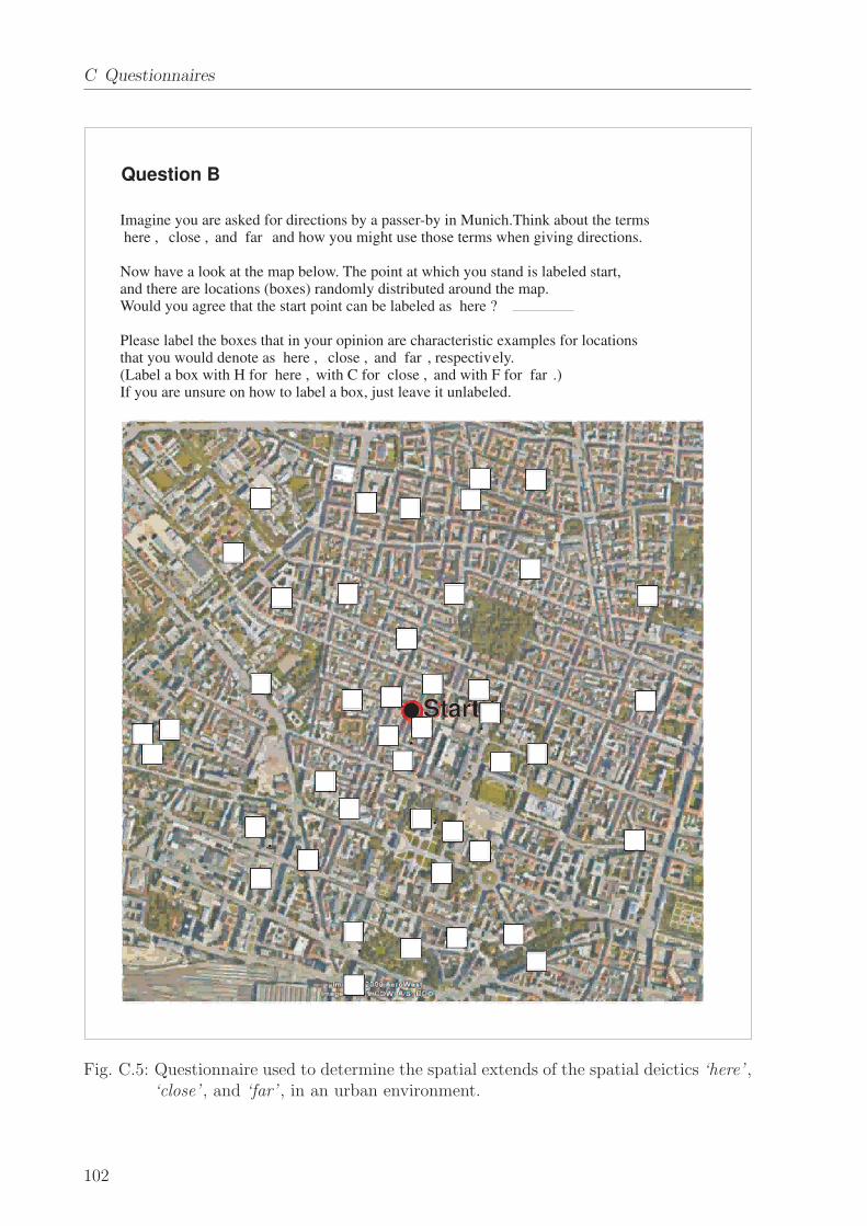
C Questionnaires
Question B
Imagine you are asked for directions by a passer-by in Munich.Think about the terms�here�, �close�, and �far � and how you might use those terms when giving directions.
Now have a look at the map below. The point at which you stand is labeled start,and there are locations (boxes) randomly distributed around the map.Would you agree that the start point can be labeled as �here�?
Please label the boxes that in your opinion are characteristic examples for locationsthat you would denote as �here�, �close�, and �far �, respectively.(Label a box with H for �here�, with C for �close�, and with F for �far �.)If you are unsure on how to label a box, just leave it unlabeled.
Start
Fig. C.5: Questionnaire used to determine the spatial extends of the spatial deictics ‘here’ ,‘close’ , and ‘far’ , in an urban environment.
102

Bibliography
[1] Summary report on technology strategy for creating a ’robot society’ in the 21st
century. Report, 2001. Japan Robot Association.
[2] Robotic visions to 2020 and beyond – the strategic research agenda for robotics in
europe. Report, 2009. European Robotics Technology Platform.
[3] S. Anderson and E. Keenan. Language typology and syntactic description, volume 3:
Grammatical categories and the lexicon, chapter Deixis, pages 259–308. Cambridge
University Press, 1985.
[4] G. Apostolico. Pattern Matching Algorithms. Oxford Univ Press, 1997.
[5] D. Appleyard. Styles and methods of structuring a city. Environment and Behavior,
2(1):100–117, 1970.
[6] H. Asada, M. S. Branicky, C. R. Carignan, H. I. Christensen, R. Fearing, W. Hamel,
J. Hollerbach, S. LaValle, M. Mason, B. Nelson, G. Pratt, A. Requicha, B. Ruddy,
M. Sitti, G. Sukhatme, R. Tedrake, R. Voyles, and M. Zhang. A roadmap for us
robotics: From internet to robotics. Report, 2009.
[7] I. Asimov. I, Robot. Voyager, 1968.
[8] H. Asoh, Y. Motomura, F. Asano, I. Hara, S. Hayamizu, N. Vlassis, and B. Krose.
Jijo-2: An office robot that communicates and learns. Intelligent Systems, 19(5):46–
55, 2001.
[9] J. Bateman and M. Zock. Oxford Handbook of Computational Linguistics, chapter
Natural language generation, pages 284–304. Oxford University Press, 2002.
[10] T. Bayes. An essay towards solving a problem in the doctrine of chances. Philosoph-
ical Transactions of the Royal Society of London, 53:370–418, 1763.
[11] M. Beetz, J. Bandouch, A. Kirsch, A. Maldonado, A. Muller, and R. B. Rusu.
The assistive kitchen - a demonstration scenario for cognitive technical systems. In
Proceedings of the COE Workshop on Human Adaptive Mechatronics, 2007.
[12] D. Berry. Statistics: A Bayesian Perspective. Duxbury, 1995.
[13] I. A. Bolshakov and A. Gelbukh. Computational Linguistics: Models, Resources,
Applications. Centro de Investigacion en Computacion, Mexico City, 2004.
[14] D. R. Bradley and D. Vido. Psychophysical functions for perceived and remembered
distance. Perception, 13(3):315–320, 1984.
103

Bibliography
[15] J. Brandt and W. Mackavey. Left-right confusion and the perception of bilateral
symmetry. International Journal on Neuroscience, 12:87–94, 1981.
[16] O. Bratfisch. A further study of the relation between subjective distance and emo-
tional involvement. Acta Psychologica, 29:244–255, 1969.
[17] C. Breazeal and B. Scassellati. How to build robots that make friends and influence
people. In Proceedings of the International Conference on Intelligent Robots and
Systems, pages 858–863, Kyongju, Korea, 1999.
[18] R. Briggs. Image and environment: Cognitive mapping and spatial behavior, chapter
Urban Cognitive Distances, pages 361–88. Aldine Publishing, 1973.
[19] R. Brooks. New approaches to robotics. Science, 253:1227–1232, 1991.
[20] D. Brosset, C. Claramunt, and E. Saux. A location and action-based model for route
descriptions. In Lecture Notes in Computer Science: GeoSpatial Semantics, volume
4853, pages 146–159. Springer, 2007.
[21] M. Buehler, K. Lagnemma, and S. Singh, editors. Journal of Field Robotics: Special
Issue on the 2007 DARPA Urban Challenge, Part I. Wiley Periodicals, Inc., 2008.
[22] G. Bugmann, E. Klein, S. Lauria, and T. Kyriacou. Corpus-based robotics: A route
instruction example. In Proceedings of Intelligent Autonomous Systems, pages 96–
103, 2004.
[23] K. Buhler. Theory of language. The representational function of language. Ben-
jamins, 1934/1990.
[24] W. Burgard, A. B. Cremers, D. Fox, D. Hahnel, G. Lakemeyer, D. Schulz, W. Steiner,
and S. Thrun. Experiences with an interactive museum tour-guide robot. Artificial
Intelligence, 114:3–55, 1999.
[25] R. Byrne. Memory for urban geography. Quarterly Journal of Experimental Psy-
chology, 31:147–154, 1979.
[26] M. Cadwaller. A methodological analysis of cognitive distance. Environmental Design
Research, 2:193–199, 1973.
[27] D. Canter and S. Tagg. Distance estimation in cities. Environment and Behavior,
7(1):63–63, 1975.
[28] J. Cassell, T. Stocky, T. Bickmore, Y. Gao, Y. Nakano, K. Ryokai, D. Tversky,
C. Vaucelle, and H. Vilhjalmsson. Mack: Media lab autonomous conversational
kiosk. In Proceedings of Imagina: Intelligent Autonomous Agents, 2002.
[29] N. Chater, J. Tenenbaum, and A. Yuille. Probabilistic models of cognition: Concep-
tual foundations. Trends in Cognitive Sciences, 10(7):287–291, 2006.
[30] N. Chomsky. Syntactic Structures. The Hague: Mouton, 1957.
104

[31] H. Clark and S. Brennan. Perspectives on socially shared cognition, chapter Ground-
ing in communication, pages 127–149. American Psychological Association, 1991.
[32] A. Cohn and J. Renz. Handbook of Knowledge Representation, chapter Qualitative
spatial reasoning, pages 551–596. Elsevier, 2007.
[33] R. Cole, J. Mariani, H. Uszkoreit, A. Zaenen, and V. Zue. Survey of the State of the
Art in Human Language Technology. Cambridge University Press, 1997.
[34] R. Cole, B. Wise, and S. van Vuuren. How marni teaches children to read. Educational
Technology, 47:14–18, 2006.
[35] A. Crompton. Perceived distance in the city as a function of time. Environment and
Behavior, 38(2):173–182, 2006.
[36] R. Day. Urban distance cognition: review and contribution. Australian Geographer,
13(3):193–200, 1976.
[37] E. W. Dijkstra. A note on two problems in connexion with graphs. Numerische
Mathematik, 1:269–271, 1959.
[38] C. F. DiSalvo, F. Gemperle, J. Forlizzi, and S. B. Kiesler. All robots are not created
equal: the design and perception of humanoid robot heads. In Proceedings of the
Symposium on Designing Interactive Systems, pages 321–326, 2002.
[39] G. Dissanayake, P. Newman, S. Clark, H. Durrant-Whyte, and M. Csorba. A solution
to the simultaneous localization and map building (SLAM) problem. Transactions
on Robotics and Automation, 17(3):229–241, 2001.
[40] R. Downs and D. Stea. Image and environment: Cognitive mapping and spatial
behavior, chapter Cognitive maps and spatial behavior: Process and products, pages
8–26. Aldine Publishing, 1973.
[41] S. DuPreez, M. Lall, and S. Sinha. An intelligent web-based voice chat bot. In
Eurocon, pages 386–39, 2009.
[42] G. Evans, P. Brennan, M. A. Skorpanich, , and D. Held. Cognitive mapping and
elderly adults: Verbal and location memory for urban landmarks. Journal of Geron-
tology, 36(4):452–457, 1984.
[43] C. Fillmore. Universals in linguistic theory, chapter The case for case, pages 1–88.
Holt, Rinehart, and Winston, New York, 1968.
[44] C. Fillmore. Lectures on Deixis. University of Chicago Press, 1997.
[45] T. Fong, I. Nourbakhsh, and K. Dautenhahn. A survey of socially interactive robots:
Concepts, design, and applications. Technical Report CMU-RI-TR-02-29, Robotics
Institute, Carnegie Mellon University, Pittsburgh, PA, 2002.
105

Bibliography
[46] T. W. Fong, I. Nourbakhsh, R. Ambrose, R. Simmons, A. Schultz, and J. Scholtz.
The peer-to-peer human-robot interaction project. In Proceedings of the AIAA Space
2005, 2005.
[47] R. Forgus. Perception: The Basic Process in Cognitive Development. McGraw-Hill,
New York, 1966.
[48] M. E. Foster, T. By, M. Rickert, and A. Knoll. Symmetrical joint action in human-
robot dialogue. In RSS 2006 Workshop on Intuitive Human-Robot Interaction for
Getting the Job done, 2006.
[49] N. Franklin. The Construction of Cognitive Maps, chapter Language as a Means of
Constructing and Conveying Cognitive Maps, pages 275–295. Springer, 1996.
[50] E. Fricke. Origo, pointing, and speech: the impact of co-speech gestures on linguistic
deixis theory. Gesture, 2(2):207–226, 2002.
[51] C. Galindo, A. Saffiotti, S. Coradeschi, P. Buschka, J. Fernandez-Madrigal, and
J. Gonzalez. Multi-hierarchical semantic maps for mobile robotics. In Proceedings of
the Int. Conference on Intelligent Robots and Systems, pages 2278–2283, 2005.
[52] T. Garling, A. Book, and E. Lindberg. Cognitive mapping of large-scale environ-
ments. Environment and Behavior, 16(1):3–34, 1984.
[53] S. Gentry and R. Murray-Smith. Haptic dancing: human performance at haptic de-
coding with a vocabulary. In Proceedings of the International conference on Systems
Man and Cybernetics, volume 4, pages 3432–3437, Washington D.C., USA, 2003.
[54] A. S. Gilinsky. Perceived size and distance in visual space. Psychological Review,
58:460–482, 1951.
[55] R. Golledge, R. Briggs, and D. Demko. The configuration of distances in intra-urban
space. In Proceedings of the Ass. of American Geographers, pages 60–65, 1969.
[56] R. Golledge and N. Spector. Comprehending the urban environment: theory and
practice. Geographical Analysis, 14:305–325, 1978.
[57] P. Gould and R. White. Mental Maps. Penguin Books, 1974.
[58] D. Griffin. Foundations of Psychology, chapter Topographical Orientation, pages
380–392. Wiley, New York, 1948.
[59] H.-M. Gross, H.-J. Bohme, C. Schroter, S. Muller, A. Konig, C. Martin, M. Merten,
and A. Bley. Shopbot: Progress in developing an interactive mobile shopping as-
sistant for everyday use. In Proceedings of theInternational Conference on Systems,
Man and Cybernetics, 2008.
[60] A. Gruenstein and S. Seneff. Releasing a multimodal dialogue system into the wild:
User support mechanisms. In Proceedings of the Workshop on Discourse and Dia-
logue, pages 111–119, 2007.
106

[61] C. Habel. Wegbeschreibungen in Trier, 1985 / 2008.
[62] A. Hajek. The Stanford Encyclopedia of Philosophy, chapter Interpretations of prob-
ability. 2003.
[63] E. Hall. A system for the notation of proxemic behaviour. American Anthropologist,
65:1003–1026, 1963.
[64] E. Hall. The Hidden Dimension. Doubleday, New York, 1966.
[65] Y. Hattori, H. Kozima, K. Komatani, T. Ogata, and H. G.Okuno. Robot gesture
generation from environmental sounds using inter-modality mapping. In Proceedings
of the International Workshop on Epigenetic Robotics: Modeling Cognitive Devel-
opment in Robotic Systems, number 123, pages 139–140, Nara, Japan, 2006. Lund
University Cognitive Studies.
[66] K. Holyoak and W. Mah. Cognitive reference points in judgments of symbolic mag-
nitude. cognitive psychology, 14(3):328–352, 1982.
[67] K. Hone and R. Graham. Towards a tool for the subjective assessment of speech
system interfaces (SASSI). Natural Language Engineering, 6(3–4):287–303, 2000.
[68] H. Huttenrauch, K. S. Eklundh, and E. A. T. A. Green. Investigating spatial rela-
tionships in human-robot interaction. In Proceedings of the International Conference
on Intelligent Robots and Systems, pages 5052–5059, 2006.
[69] J. Hutchins. A new spectrum of translation studies, chapter Machine translation and
computer-based translation tools., pages 13–48. University of Valladolid, 2004.
[70] K. Iwatsuka, K. Yamamoto, and K. Kato. Development of a guide dog system for the
blind with character recognition ability. In Proceedings of the Canadian Conference
on Computer and Robot Vision, pages 401–405, Washington, DC, USA, 2004. IEEE
Computer Society.
[71] P. Jia and H. Hu. Head gesture based control of an intelligent wheelchair. In Pro-
ceedings of the Conference of the Chinese Automation and Computing Society in the
UK, pages 85–90, Sheffield, UK, 2005.
[72] K. Jokinen and M. McTear. Spoken Dialogue Systems. Morgan & Claypool Publish-
ers, 2008.
[73] B. H. Juang and L. R. Rabiner. Encyclopedia of Language and Linguistics, chapter
Automatic Speech Recognition - A Brief History of the Technology. Elsevier, second
edition, 2005.
[74] H. Jung, C.-N. Seon, J. H. Kim, J. C. Sohn, W.-K. Sung, and D.-I. Park. Information
extraction for user’s utterance processing on ubiquitous robot companion. Natural
Language Processing and Information Systems, 3513:337–340, 2005.
[75] D. Jurafsky and J. Martin. Speech and Language Processing. Prentice Hall, 2008.
107

Bibliography
[76] T. Kanade, J. Cohn, and Y.-L. Tian. Comprehensive database for facial expression
analysis. In Proceedings of the International Conference on Automatic Face and
Gesture Recognition, pages 46–53, 2000.
[77] F. Kaplan. Who is afraid of the humanoid? investigating cultural differences in the
acceptance of robots. Int. Journal of Humanoid Robotics, 1(3):465–480, 2004.
[78] W. Kennedy, M. Bugajska, M. Marge, W. Adams, B. Fransen, D. Perzanowski,
A. Schultz, and G. Trafton. Spatial representation and reasoning for human-robot
collaboration. In Proceedings of the Conference on Artificial Intelligence, pages 1554–
1559, 2007.
[79] S. Kiesler and P. Hinds. Introduction to this special issue on human-robot interaction.
Human-Computer Interaction, 19(1):1–8, 2004.
[80] W. Klein. Wegauskunfte. Zeitschrift fur Literaturwissenschaft und Linguistik, 33:9–
57, 1979.
[81] W. Klein. Speech, Place, and Action: Studies in Deixis and Related Topics, chapter
Local Deixis in Route Directions, pages 161–182. New York: Wiley, 1982.
[82] W. Klein. Spatial Orientation: Theory, Research, and Application, chapter Deixis
and spatial orientation in route directions, pages 283–311. New York: Plenum, 1983.
[83] A. Klippel, C. Dewey, M. Knauff, K.-F. Richter, D. R. Montello, C. Freksa, and
E.-A. Loeliger. Direction concepts in wayfinding assistance systems. In Proceedings
of the Workshop on Artificial Intelligence in Mobile Systems, pages 1–8, 2004.
[84] D. Kortenkamp, E. Huber, and R. P. Bonasso. Recognizing and interpreting ges-
tures on a mobile robot. In Proceedings of the National Conference on Artificial
Intelligence, volume 2, pages 915–921, Portland, USA, 1996.
[85] S. Kosslyn, H. Pick, and G. Fariello. Cognitive maps in children and men. Child
Development, 45(3):707–716, 1974.
[86] K. Kosuge, T. Hayashi, Y. Hirata, and R. Tobiyama. Dance partner robot - ms
dancer. In Proceedings of the International Conference on Intelligent Robots and
Systems, volume 4, pages 3459–3464, Las Vegas, USA, 2003.
[87] K. Kosuge and N. Kazamura. Control of a robot handling an object in cooperation
with a human. In Proceedings of the International Workshop on Robot and Human
Communication, pages 142–147, Sendai, Japan, 1997.
[88] K. Kosuge, M. Sato, and N. Kazamura. Mobile robot helper. In Proceedings of the
International Conference of Robotics and Automation, pages 583–588, 2000.
[89] B. Krieg-Bruckner, U. Frese, K. Luttich, and C. Mandel. Specification of an ontology
for route graphs. In Lecture Notes in Computer Science: Spatial Cognition IV –
Reasoning, Action, and Interaction, pages 390–412. Springer-Verlag, Berlin, 2005.
108

[90] B. Kuipers. A hierarchy of qualitative representations for space. In Proceedings of
the International Workshop on Qualitative Reasoning about Physical Systems, pages
113–120. AAAI Press, 1996.
[91] B. Kuipers. The spatial semantic hierarchy. Artificial Intelligence, 119:191–233,
2000.
[92] B. Kuipers and Y. Byun. A robust qualitative method for spatial learning in unknown
environments. In Proceedings of the National Conference on Artificial Intelligence,
pages 774–779, 1988.
[93] B. Kuipers and T. Levitt. Navigation and mapping in large-scale space. AI Magazine,
9(2):25–43, 1988.
[94] B. Kuipers and A. Stroupe. The AAAI-2002 robot challenge. Artificial Intelligence
Magazine, 24(1):65–71, 2003.
[95] D. Kulic and E. Croft. Estimating intent for human-robot interaction. In Proceedings
of the International Conference on Advanced Robotics, pages 810–815, 2003.
[96] D. Kulic and E. Croft. Real-time safety for human-robot interaction. Robotics and
Autonomous Systems, 54(1):1–12, 2006.
[97] D. Kulic; and E. A. Croft. Safe planning for human-robot interaction. Journal of
Robotic Systems, 22(7):383–396, 2005.
[98] V. A. Kulyukin, C. Gharpure, J. Nicholson, and G. Osborne. Robot-assisted wayfind-
ing for the visually impaired in structured indoor environments. Autonomous Robots,
21(1):29–41, 2006.
[99] Y. Kunii and H. Hashimoto. Tele-handshake using handshake device. In Proceedings
of the International Conference on Industrial Electronics, Control, and Instrumen-
tation, pages 179–182, 1995.
[100] Y. Kuroki, M. Fujita, T. Ishida, K. Nagasaka, and J. Yamaguchi. A small biped
entertainment robot exploring attractive applications. In Proceedings of the Inter-
national Conference on Robotics and Automation, pages 471–476. IEEE, 2003.
[101] S. Lauria, G. Bugmann, T. Kyriacou, and E. Klein. Instruction based learning: how
to instruct a personal robot to find HAL. In Proceedings of the European Workshop
on Learning Robots, pages 15–24, 2001.
[102] T. Lee. Perceived distance as a function of direction in the city. Environment and
Behavior, 2(1):40–51, 1970.
[103] S. Lemmetty. Review of speech synthesis technology. Master’s thesis, Helsinki Uni-
versity of Technology, Department of Electrical and Communications Engineering,
1999.
109

Bibliography
[104] V. Levenshtein. Binary codes capable of correcting deletions, insertions, and rever-
sals. Soviet Physics Doklady, 10(8):707–710, 1966.
[105] Z. Li, N. Hofemann, J. Fritsch, and G. Sagerer. Hierarchical modeling and recognition
of manipulative gesture. In Proceedings of the Workshop on Modeling People and
Human Interaction, Beijing, China, 2005.
[106] G. Lidoris, F. Rohrmuller, D. Wollherr, and M. Buss. The autonomous city explorer
(ace) project - mobile robot navigation in highly populated urban environments. In
Proceedings of the International Conference on Robotics and Automation, 2009.
[107] R. Lloyd and C. Heivly. Systematic distortions in urban cognitive maps. Annals of
the Association of American Geographers, 77(2):191–207, 1987.
[108] R. K. Luneburg. Mathematical Analysis of Binocular Vision. Princeton University
Press, 1947.
[109] M. Lohse, M. Hanheide, K. Rohlfing, and G. Sagerer. Systemic interaction analy-
sis (sina) in hri. In Proceedings of the International Conference on Human-Robot
Interaction, pages 93–100, 2009.
[110] K. Lynch. The Image of the City. MIT PRess, 1960.
[111] J. Lyons. Linguistic Semantics: An Introduction. Cambridge University Press, 1995.
[112] M. MacMahon, B. Stankiewicz, and B. Kuipers. Walk the talk: connecting language,
knowledge, and action in route instructions. In Proceedings of the Conference On
Artificial Intelligence, pages 1475–1482, 2006.
[113] P. Maes, T. Darrell, B. Blumberg, and A. Pentland. The alive system: full-body
interaction with autonomous agents. Computer Animation, 1:11–18, 1995.
[114] M. Marcus, B. Santorini, and M. Marcinkiewicz. Building a large annotated corpus
of english: the penn treebank. Computational Linguistics, 19(2):313–330, 1993.
[115] A. Markov. Dynamic Probabilistic Systems, volume 1: Markov Chains, chapter
Extension of the limit theorems of probability theory to a sum of variables connected
in a chain, pages 552–577. Dover Publications, 1971.
[116] T. Matsui, H. Asoh, F. Asano, T. Kurita, I. Hara, Y. Motomura, K. Itou, and J. Fry.
Integration of real-world interaction functions on the jijo-2 office robot. Bulletin of
the Electrotechnical Laboratory, 64:51–60, 2001.
[117] T. McNamara, J. Hardy, and S. Hirtle. Subjective hierarchies in spatial memory.
Journal of Experimental Psychology: Learning, Memory and Cognition, 15:211–227,
1989.
[118] M. Michalowski, S. Sabanovic, C. DiSalvo, D. B. Font, L. Hiatt, N. Melchior, and
R. Simmons. Socially distributed perception: Grace plays social tag at AAAI 2005.
Autonomous Robots, 22(4):385–397, 2007.
110
[119] R. Muller, T. Rofer, A. Lankenau, R. Musto, K. Stein, and A. Eisenkolb. Lec-
ture Notes in Computer Science: Spatial Cognition II – Integrating Abstract Theo-
ries, Empirical Studies, Formal Methods, and Practical Applications, chapter Coarse
Qualitative Descriptions in Robot Navigation, pages 265–276. Number 1849. Springer
Berlin / Heidelberg, 2000.
[120] I. Moar and G. Bower. Inconsistency in spatial knowledge. Memory & Cognition,
11:107–113, 83.
[121] M. Montemerlo, S. Thrun, D. Koller, and B. Wegbreit. FastSLAM: A factored
solution to simultaneous localization and mapping. In Proceedings of the Conference
on Artificial Intelligence, 2002.
[122] Y. Morales, E. Takeuchi, A. Carballo, W. Tokunaga, H. Kuniyoshi, A. Aburadani,
A. Hirosawa, Y. Nagasaka, Y. Suzuki, and T. Tsubouchi. 1km autonomous robot
navigation on outdoor pedestrian paths. In Proceedings of the International Confer-
ence on Intelligent Robots and Systems, 2008.
[123] H. Moravec and A. Elfes. High resolution maps from wide angle sonar. In Proceedings
of the International Conference on Robotics and Automation, pages 116–121, 1985.
[124] M. Mori. The uncanny valley. Energy, 7(4):33–35, 1970.
[125] R. S. Moyer, D. R. Bradley, M. H. Sorensen, J. C. Whitin, and D. P. Mansfield.
Psychophysical functions for perceived and remembered size. Science, 200:330–332,
1978.
[126] Q. Muhlbauer, S. Sosnowski, T. Xu, T. Zhang, K. Kuhnlenz, and M. Buss. Naviga-
tion through urban environments by visual perception and interaction. In Proceedings
of the International Conference on Robotics and Automation, 2009.
[127] A. Murata. Basic characteristics of human’s distance estimation. In Proceedings of
the International Conference on Systems, Man, and Cybernetics, volume 2, pages
38–43, 1999.
[128] R. R. Murphy. Human-robot interaction in rescue robotics. Transactions on Systems,
Man, and Cybernetics, Part C: Applications and Reviews, 34(2):138–153, 2004.
[129] R. R. Murphy, D. Riddle, and E. Rasmussen. Robot-assisted medical reachback: A
survey of how medical personnel expect to interact with rescue robots. In Proceedings
of the International Workshop on Robot and Human Interactive Communication,
pages 301–306, 2004.
[130] G. Navarro. A guided tour to approximate string matching. ACM Computing Sur-
veys, 33(1):31–88, 2001.
[131] P. Nugues. An overview of speech synthesis and recognition. In An Introduction to
Language Processing with Perl and Prolog, pages 1–22. Springer, 2006.
111
Bibliography
[132] J. O’Keefe and L. Nadel. The Hippocampus as a Cognitive Map. Oxford University
Press, 1978.
[133] Y. Okuno, T. Kanda, M. Imai, H. Ishiguro, and N. Hagita. Providing route directions:
Design of robot’s utterance, gesture, and timing. In Proceedings of the International
Conference on Human-Robot Interaction, pages 53–60, 2009.
[134] E. Pacchierotti, H. Christensen, and P. Jensfelt. Design of an office guide robot
for social interaction studies. In Proceedings of the International Conference on
Intelligent Robots and Systems, 2006.
[135] M. Pardowitz, R. Zollner, S. Knoop, and R. Dillmann. Incremental learning of tasks
from user demonstrations, past experience, and vocal comments. Transactions on
Systems, Man and Cybernetics, 37(2):322–332, 2007.
[136] R. Passini. Wayfinding in Architecture. John Wiley & Sons Inc., 1984.
[137] V. Pavlovic, R. Sharma, and T. S. Huang. Visual interpretation of hand gestures
for human-computer interaction: A review. IEEE Transactions on Pattern Analysis
and Machine Intelligence, 19(7):677–695, 1997.
[138] J. Pearl. Bayesian networks: A model of self-activated memory for evidential rea-
soning. In Proceedings of the Conference of the Cognitive Science Society, pages
329–334, 1985.
[139] J. Piaget and B. Inhelder. The Child’s Conception of Space. Norton, New York,
1948.
[140] R. Pieraccini and D. Lubensky. Spoken language communication with machines: the
long and winding road from research to business. In Proceedings of the International
conference on Innovations in Applied Artificial Intelligence, pages 6–15. Springer-
Verlag, 2005.
[141] G. Pilato, A. Augello, G. Vassallo, and S. Gaglio. Ehebby: An evocative humorist
chat-bot. Mobile Information Systems, 4(3):165–181, 2008.
[142] J. Pineau, M. Montemerlo, M. Pollack, N. Roy, and S. Thrun. Towards robotic assis-
tants in nursing homes: Challenges and results. Robotics and Autonomous Systems,
42(3–4):271–281, 2003.
[143] Pleo. Innvo labs, www.pleoworld.com.
[144] D. R. Proffitt. Distance perception. Current Directions in Psychological Research,
15:131–135, 2006.
[145] J. Pustejovsky, P. Hanks, R. Sauri, A. See, R. Gaizauskas, A. Setzer, D. Radev,
B. Sundheim, D. Day, L. Ferro, and M. Lazo. The timebank corpus. In Proceedings
of Corpus Linguistics, pages 647–656, 2003.
112

[146] P. Rani, N. Sarkar, C. A. Smith, and L. D. Kirby. Anxiety detecting robotic system
– towards implicit human-robot collaboration. Robotica, 22(1):85–95, 2004.
[147] A. Raux, B. Langner, D. Bohus, A. Black, and M. Eskenazi. Let’s go public! taking a
spoken dialog system to the realworld. In Proceedings of the International Conference
on Speech Communication and Technology, pages 885–888, 2005.
[148] J. Renz and B. Nebel. Handbook of Spatial Logics, chapter Qualitative Spatial Rea-
soning using Constraint Calculi, pages 161–215. Springer, 2007.
[149] K.-F. Richter. Route direction structure diagrams. In Proceedings of the International
Space Syntax Symposium, 2005.
[150] Robomow. Friendly robotics, http://www.friendlyrobotics.com/.
[151] RobosapienV2. Wowwee, http://www.robosapienv2online.com/.
[152] D. Rodriguez-Losada, F. Matia, A. Jimenez, R. Galan, and G. Lacey. Implement-
ing map based navigation in guido, the robotic smartwalker. In Proceedings of the
International Conference on Robotics and Automation, pages 3390–3395, 2005.
[153] Roomba. irobot, http://www.irobot.com.
[154] H. Sacks, E. Schegloff, and G. Jefferson. A simplest systematics for the organization
of turn-taking for conversation. Language, 50:696–735, 1974.
[155] E. Sadalla and L. Staplin. The perception of traversed distance. Environment and
Behavior, 12(2):167–182, 1980.
[156] K. Sakita, K. Ogawara, and S. Murakami. Flexible cooperation between human and
robot by interpreting human intention from gaze information. In Proceedings of the
International Conference on Intelligent Robots and Systems, pages 846–851, Sendal,
Japan, 2004.
[157] G. Samarasekara, K. Fukahori, and Y. Kubota. Distance cognition at route knowl-
edge level affected by urban vegetation. SLSAJ Annual Research Journal, 6:28–33,
2006.
[158] A. Samsonovich and G. Ascoli. Cognitive map dimensions of the human value system
extracted from natural language. In B. Goertzel and P. Wang, editors, Advances in
Artificial General Intelligence: Concepts, Architectures and Algorithms, pages 111–
124. IOS Press, Amsterdam, 2007.
[159] S. Sarawagi. Foundations and Trends in Databases: Information Extraction. Now
Publishers, 2008.
[160] R. Schank. Conceptual dependency: A theory of natural language understanding.
Cognitive Psychology, 3:552–631, 1972.
113

Bibliography
[161] M. Schroder. Emotional speech synthesis: A review. In Proceedings of the European
Conference on Speech Communication and Technology, volume 1, pages 561–564,
Aalborg, Denmark, 2001.
[162] M. Schroder and J. Trouvain. The german text-to-speech synthesis system mary:
A tool for research, development and teaching. International Journal of Speech
Technology, 6:365–377, 2003.
[163] P. Sellers. The theory and computation of evolutionary distances: Pattern recogni-
tion. Journal of Algorithms, 1(4):359–373, 1980.
[164] H. Shi and B. Krieg-Bruckner. Modelling route instructions for robust human-robot
interaction on navigation tasks. International Journal of Software and Informatics,
2:33–60, 2008.
[165] A. Siegel and S. White. The development of spatial representations of large-scale
environments, volume 10. Academic Press, 1975.
[166] A. Singhal. Modern information retrieval: A brief overview. In Bulletin of the IEEE
Computer Society Technical Committee on Data Engineering, volume 24, pages 35–
43. IEEE, 2001.
[167] M. Skubic, D. Perzanowski, S. Blisard, A. Schultz, W. Adams, M. Bugajska, and
D.Brock. Spatial language for human-robot dialogs. Transactions on Systems, Man,
and Cybernetics, 34(2):154–167, 2004.
[168] R. Smith and R. Hipp. Spoken Natural Language Dialog Systems: A Practical Ap-
proach. Oxford Univ Press, 1994.
[169] S. Sosnowski, A. Bittermann, K. Kuhnlenz, and M. Buss. Design and evaluation of
emotion-display eddie. In Proceedings of the International Conference on Robotics
and Intelligent Systems, pages 3113–3118, Bejing, China, 2006.
[170] R. Sparrow. The march of the robot dogs. Ethics and Information Technology,
4(4):305–318, 2002.
[171] T. Spexard, S. Li, B. Wrede, J. Fritsch, G. Sagerer, O. Booij, Z. Zivkovic, B. Terwijn,
and B. Krose. Biron, where are you? Enabling a robot to learn new places in
a real home environment by integrating spoken dialog and visual localization. In
Proceedings of the International Conference on Intelligent Robots and Systems, pages
943–940, 2006.
[172] A. Stevens and P. Coupe. Distortions in judged spatial relations. Cognitive Psychol-
ogy, 10:422–437, 1978.
[173] S. Stevens. On the psychophysical law. Psychological Review, 64(3):153–181, 1957.
[174] H. Strik, A. Russel, H. V. D. Heuvel, C. Cucchiarini, and L. Boves. A spoken dialog
system for the dutch public transport information service. International Journal of
Speech Technology, 2:121–131, 1997.
114

[175] O. Sugiyama, T. Kanda, M. Imai, H. Ishiguro, and N. Hagita. Natural deictic com-
munication with humanoid robots. In Proceedings of the International Conference
on Intelligent Robots and Systems, pages 1441–1448, 2007.
[176] W. Sung, M. Song, and K. won Chung. Applying sasang typology theory to robot ap-
pearance design. In Proceedings of the International Conference on Robot & Human
Interactive Communication, pages 1066–1071, 2007.
[177] D. Syrdal, K. Dautenhahn, M. Walters, and K. Koay. Sharing spaces with robots
in a home scenario – anthropomorphic attributions and their effect on proxemic
expectations and evaluations in a live hri trial. In Proceedings of the Symposium on
AI in Eldercare: New Solutions to Old Problems, 2008.
[178] D. S. Syrdal, K. L. Koay, M. Walters, and K. Dautenhahn. A personalized robot
companion? – the role of individual differences on spatial preferences in hri scenar-
ios. In Proceedings of the International Conference on Robot & Human Interactive
Communication, pages 1143–1148, 2007.
[179] A. Takanishi, Y. Ogura, and K. Itoh. Robotics Research, chapter Some Issues in
Humanoid Robot Design, pages 357–372. Springer Berlin Heidelberg, 2007.
[180] P. Thorndyke and B. Hayes-Roth. Differences in spatial knowledge acquired from
maps and navigation. Cognitive Psychology, 14(4):560–589, 1982.
[181] S. Thrun, M. Bennewitz, W. Burgard, A. B. Cremers, F. Dellaert, D. Fox, D. Hahnel,
C. R. Rosenberg, N. Roy, J. Schulte, and D. Schulz. MINERVA: A tour-guide robot
that learns. In Proceedings of the German Conference on Artificial Intelligence:
Advances in Artificial Intelligence, pages 14–26, 1999.
[182] S. Thrun, W. Burgard, and D. Fox. Probabilistic Robotics. MIT Press, 2005.
[183] S. Thrun, J. Gutmann, D. Fox, W. Burgard, and B. J. Kuipers. Integrating topo-
logical and metric maps for mobile robot navigation: A statistical approach. In
Proceedings of the Conference on Artificial Intelligence, pages 989–995, 2008.
[184] S. Thrun, M. Montemerlo, H. Dahlkamp, D. Stavens, A. Aron, J. Diebel, P. Fong,
J. Gale, M. Halpenny, G. Hoffmann, K. Lau, C. Oakley, M. Palatucci, V. Pratt,
P. Stang, S. Strohband, C. Dupont, L.-E. Jendrossek, C. Koelen, C. Markey, C. Rum-
mel, J. van Niekerk, E. Jensen, P. Alessandrini, G. Bradski, B. Davies, S. Ettinger,
A. Kaehler, A. Nefian, and P. Mahoney. Stanley: The robot that won the DARPA
grand challenge: Research articles. Journal of Robotic Systems, 23:661–692, 2006.
[185] E. Tolman. Cognitive maps in rats and men. Psychological Review, 55:189–208, 1948.
[186] V. Traver, A. del Pobil, and M. Perez-Francisco. Making service robots human-safe.
In Proceedings of the International Conference on Intelligent Robots and Systems,
volume 1, pages 696–701, Takamatsu, Japan, 2000.
115

Bibliography
[187] C. Trowbridge. On fundamental methods of orientation and ’imaginary maps’. Sci-
ence, 38(990):888–897, 1913.
[188] B. Tversky. Distortions in memory for maps. Cognitive Psychology, 13:407–433,
1981.
[189] I. Ulrich and J. Borenstein. The GuideCane - applying mobile robot technologies
to assist the visually impaired. Transactions on Systems, Man, and Cybernetics,
31(2):131–136, 2001.
[190] W. Vapnik. The Nature of Statistical Learning Theory. Springer Verlag, 1995.
[191] S. Vasudevan, S. Gachter, M. Berger, and R. Siegwart. Cognitive maps for mobile
robots – an object based approach. Robotics and Autonomous Systems, 55(5):359–
371, 2007.
[192] T. Vintsyuk. Speech discrimination by dynamic programming. Cybernetics, 4:52–58,
1968.
[193] K. Wada and T. Shibata. Robot therapy in a care house - its sociopsychological and
physiological effects on the residents. In Proceedings of the International Conference
on Robotics and Automation, pages 3966–3971, 2006.
[194] Y. Wakabayashi. Geographical Reports of Tokyo Metropolitan University, volume 29,
chapter Spatial analysis of cognitive maps, pages 57–102. 1994.
[195] Wakamaru. Mitsubishi heavy industries ltd.,
www.mhi.co.jp/en/products/detail/wakamaru.html.
[196] M. Walker, R. Passonneau, and J. Boland. Quantitative and qualitative evaluation of
darpa communicator spoken dialogue systems. In Proceedings of the Annual Meeting
of the Association for Computational Linguistics, pages 515–522, 2001.
[197] Y. Wei, E. Brunskill, T. Kollar, and N. Roy. Where to go: Interpreting natural
directions using global inference. In Proceedings of the International Conference on
Robotics and Automation, pages 3761–3767, 2009.
[198] J. Weizenbaum. Eliza - a computer program for the study of natural language
communication between man and machine. Communications of the ACM, 9(1):36–
45, 1966.
[199] S. Werner, B. Krieg-Bruckner, and T. Herrmann. Lecture Notes in Computer Sci-
ence: Spatial Cognition II – Integrating Abstract Theories, Empirical Studies, Formal
Methods, and Practical Applications, volume 1849, chapter Modelling Navigational
Knowledge by Route Graphs, pages 295–316. Springer-Verlag, Berlin, 2000.
[200] I. Werry, K. Dautenhahn, B. Ogden, and W. Harwin. Investigating a robot as a
therapy partner for children with autism. In Proceedings of the European Conference
for the Advancement of Assistgive Technology. Ljubljana, Slovenia, 2001.
116

[201] D. Wolter. Spatial Representation and Reasoning for Robot Mapping. Springer,
Berlin, 2008.
[202] W. A. Woods. Understanding subsumption and taxonomy: A framework for progress.
In J. F. Sowa, editor, Principles of Semantic Networks: Explorations in the Repre-
sentation of Knowledge, pages 45–94. Kaufmann, San Mateo, 1991.
[203] D. Wunderlich. Linguistische Berichte, volume 53, chapter Wie analysiert man
Gesprache? Beispiel: Wegauskunfte, pages 41–76. Helmut Buske Verlag, 1978.
[204] S. Yamada and T. Komatsu. Designing simple and effective expression of robot’s
primitive minds to a human. In Proceedings of the International Conference on
Intelligent Robots and Systems, pages 2614–2619, 2006.
[205] Z. Yang and D. Purves. A statistical explanation of visual space. Nature Neuro-
science, 6:632–640, 2003.
[206] B.-J. You, M. Hwangbo, S.-O. Lee, S.-R. Oh, Y. D. Kwon, and S. Lim. Development
of a home service robot ’issac’. In Proceedings of the International Conference on
Intelligent Robots and Systems, pages 2630–2635, 2003.
[207] M. You, C. Chen, J. Bu, J. Liu, and J. Tao. A hierarchical framework for speech
emotion recognition. In Proceedings of the International Symposium on Industrial
Electronics, volume 1, pages 515–519, 2006.
[208] F. Yus. Misunderstandings and explicit/implicit communication. Pragmatics,
9(4):487–517, 1999.
[209] H. Zender, G. Kruijff, and I. Kruijff-Korbayova. A situated context model for resolu-
tion and generation of referring expressions. In Proceedings of the European Workshop
on Natural Language Generation, pages 126–129, 2009.
[210] H. Zender, O. M. Mozos, P. Jensfelt, G.-J. Kruijff, and W. Burgard. Conceptual
spatial representations for indoor mobile robots. Robotics and Autonomous Systems,
56(6):493–502, 2008.
Author’s Publications
[211] A. Bauer and M. Buss. Acquiring route graphs from human instructions. In Poster
Proceedings International Conference on Spatial Cognition, pages 45–48, 2008.
[212] A. Bauer, B. Gonsior, D. Wollherr, and M. Buss. Rules for human-robot interaction
based on principles from linguistics - asking for directions. In Proceedings of the
AISB Symposium on New Frontiers in Human-Robot Interaction, pages 24–30, 2009.
[213] A. Bauer, B. Gonsior, D. Wollherr, and M. Buss. Dialog system for human-robot
interaction for asking for directions guidelines for robots proactively obtaining infor-
mation. Computational Linguistics, under review.
117
Bibliography
[214] A. Bauer, K. Klasing, G. Lidoris, Q. Muhlbauer, F. Rohrmuller, S. Sosnowski, T. Xu,
K. Kuhnlenz, D. Wollherr, and M. Buss. The autonomous city explorer: Towards
natural human-robot interaction in urban environments. International Journal of
Social Robotics, 1(2):127–140, 2009.
[215] A. Bauer, K. Klasing, T. Xu, S. Sosnowski, G. Lidoris, Q. Muhlbauer, T. Zhang,
F. Rohrmuller, D. Wollherr, K. Kuhnlenz, and M. Buss. The autonomous city ex-
plorer (video). In Proceedings of the International Joint Conference on Artificial
Intelligence, 2009. Most Innovative Video Award.
[216] A. Bauer, K. Klasing, T. Xu, S. Sosnowski, G. Lidoris, Q.Muhlbauer, T. Zhang,
F. Rohrmuller, D. Wollherr, K. Kuhnlenz, and M. Buss. The autonomous city ex-
plorer project (video). In Proceedings of the International Conference on Robotics
and Automation, pages 1595–1596, 2009.
[217] A. Bauer, D. Wollherr, and M. Buss. Human-robot collaboration: A survey. Inter-
national Journal of Humanoid Robotics, 5(1):47 – 66, 2008.
[218] A. Bauer, D. Wollherr, and M. Buss. Information retrieval system for human-robot
communication - asking for directions. In Proceedings of the International Conference
on Robotics and Automation, pages 4150–4155, 2009.
[219] A. Bauer, D. Wollherr, and M. Buss. Route information retrieval through hri
(poster). AISB Convention, 2009. Best Student Poster.
[220] A. Bauer, D. Wollherr, and M. Buss. Probabilistic models for route description
information by humans. SMC, under review.
[221] A. Bauer, D. Wollherr, and M. Buss. Simultaneous reasoning and mapping: Building
reasonable route belief from human route directions. AI, under review.
[222] B. Gonsior and A. Bauer. Wegbeschreibungen in Munchen, 2010.
www.lsr.ei.tum.de/fileadmin/publications/MuenchenKorpus 2009.pdf.
[223] K. Klasing, G. Lidoris, A. Bauer, F. Rohrmuller, D. Wollherr, and M. Buss. The
autonomous city explorer: Towards semantic navigation in urban environments. In
Proceedings of the International Workshop on Cognition for Technical Systems, 2008.
[224] G. Lidoris, K. Klasing, A. Bauer, T. Xu, K. Kuhnlenz, D. Wollherr, and M. Buss.
The autonomous city explorer project: Aims and system overview. In Proceedings
of the Int. Conference on Intelligent Robots and Systems, pages 560–565, 2007.
[225] Q. Muhlbauer, T. Xu, A. Bauer, K. Klaasing, G. Lidoris, F. Rohrmuller, S. Sos-
nowski, K. Kuhnlenz, D. Wollherr, and M. Buss. Wenn Roboter nach dem Weg
fragen. at – Automatisierungstechnik, 58 11:647–656, 2010.
[226] A. Weiss, J. Igelsbock, M. Tscheligi, A. Bauer, K. Kuhnlenz, D. Wollherr, and
M. Buss. Robots asking for directions: The willingness of passers-by to support
robots. In Proceedings of the International Conference on Human-Robot Interaction,
pages 23–30, 2010.
118


