
1
HEIGHT MODERNIZATION
WESTERN STATES REGIONAL WEBINAR MEETING
SilverSpring,MD
November19,2013
FinalReport

2
CONTENTS Executive Summary ....................................................................................................................................................... 3
Background and Goals ................................................................................................................................................... 3
Agenda and presentations ............................................................................................................................................. 3
Organization .......................................................................................................................................................... 3
Presenter ............................................................................................................................................................... 3
Summary ............................................................................................................................................................... 3
Next Steps ...................................................................................................................................................................... 5
Acknowledgments ......................................................................................................................................................... 5
Appendices .................................................................................................................................................................... 6
APPENDIX A: Attendees Summary ............................................................................................................................. 6
APPENDIX B: Agenda ................................................................................................................................................. 7
APPENDIX C: Presentations ....................................................................................................................................... 8
APPENDIX D: Live Poll Questions/Answers ................................................................................................................ 9
APPENDIX E: Live Questions/Answers from Audience ............................................................................................ 11

3
EXECUTIVE SUMMARY The National Geodetic Survey’s National Height Modernization Program (NHMP) organized a webinar that was
intended to focus on issues and challenges from the Western States Region. Over 350 people registered, and more
than 250 people attended most of the 4 hour 20 minute webinar. The webinar had broad participation across
sectors, geography, and many participants expressed an interest in starting a western regional coordinated effort
or community of practice. The presentations from NGS updated stakeholders on the history of the NHMP, the
work being completed to transition to a new vertical datum in 2022, and information about products and tools
that are available (or nearly available) for the public to use. Guest speakers from other agencies highlighted state
specific challenges, examples how to collaborate with other states, and how to advance projects involving more
than one federal agency. The feedback was generally positive, with the exception of some technical difficulties that
caused delays. Overall, the meeting was successful, and future meetings could be planned in a similar manner to
reach a broad audience without significant travel costs.
BACKGROUND AND GOALS Since many Western States are not currently active Height Modernization (or Height Mod) “partners,” the
objective of the webinar was to give context and background to participants that have a varying level of familiarity
with Height Mod. Additionally, we hoped that the webinar would generate interest from local stakeholders in
establishing their own regional framework, similar to the structure of the Great Lakes states.
AGENDA AND PRESENTATIONS A brief summary of the presentations is included below, and the presentation materials, if available, are included
in the appendices.
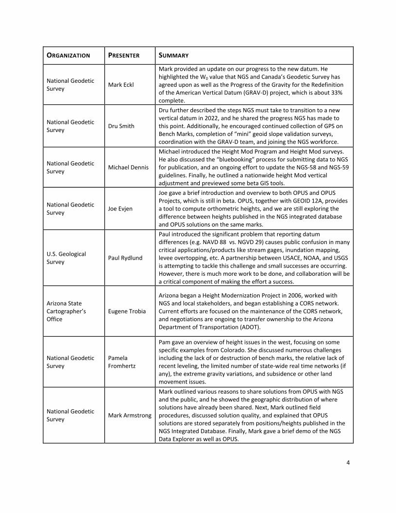
Table 1: Session 1 Presentation Summary
ORGANIZATION PRESENTER SUMMARY
National Geodetic Survey
Christine Gallagher
Christine gave an overview of Height Modernization. It developed as GPS was improving to help establish accurate heights, included past congressionally directed funding of some states, and today is expanding its scope to help prepare for and transition to the new vertical datum.
Wisconsin Department of Transportation
Diane Arendt
Diane gave an overview of the Wisconsin Height Modernization Program which includes control station construction, GPS observations, geodetic leveling, and the WISCORS network. She also highlighted the partnerships and successes of the Great lakes Region Height Modernization Consortium.
4
ORGANIZATION PRESENTER SUMMARY
National Geodetic Survey
Mark Eckl
Mark provided an update on our progress to the new datum. He highlighted the W0 value that NGS and Canada’s Geodetic Survey has agreed upon as well as the Progress of the Gravity for the Redefinition of the American Vertical Datum (GRAV‐D) project, which is about 33% complete.
National Geodetic Survey
Dru Smith
Dru further described the steps NGS must take to transition to a new vertical datum in 2022, and he shared the progress NGS has made to this point. Additionally, he encouraged continued collection of GPS on Bench Marks, completion of “mini” geoid slope validation surveys, coordination with the GRAV‐D team, and joining the NGS workforce.
National Geodetic Survey
Michael Dennis
Michael introduced the Height Mod Program and Height Mod surveys. He also discussed the “bluebooking” process for submitting data to NGS for publication, and an ongoing effort to update the NGS‐58 and NGS‐59 guidelines. Finally, he outlined a nationwide height Mod vertical adjustment and previewed some beta GIS tools.
National Geodetic Survey
Joe Evjen
Joe gave a brief introduction and overview to both OPUS and OPUS Projects, which is still in beta. OPUS, together with GEOID 12A, provides a tool to compute orthometric heights, and we are still exploring the difference between heights published in the NGS integrated database and OPUS solutions on the same marks.
U.S. Geological Survey
Paul Rydlund
Paul introduced the significant problem that reporting datum differences (e.g. NAVD 88 vs. NGVD 29) causes public confusion in many critical applications/products like stream gages, inundation mapping, levee overtopping, etc. A partnership between USACE, NOAA, and USGS is attempting to tackle this challenge and small successes are occurring. However, there is much more work to be done, and collaboration will be a critical component of making the effort a success.
Arizona State Cartographer’s Office
Eugene Trobia
Arizona began a Height Modernization Project in 2006, worked with NGS and local stakeholders, and began establishing a CORS network. Current efforts are focused on the maintenance of the CORS network, and negotiations are ongoing to transfer ownership to the Arizona Department of Transportation (ADOT).
National Geodetic Survey
Pamela Fromhertz
Pam gave an overview of height issues in the west, focusing on some specific examples from Colorado. She discussed numerous challenges including the lack of or destruction of bench marks, the relative lack of recent leveling, the limited number of state‐wide real time networks (if any), the extreme gravity variations, and subsidence or other land movement issues.
National Geodetic Survey
Mark Armstrong
Mark outlined various reasons to share solutions from OPUS with NGS and the public, and he showed the geographic distribution of where solutions have already been shared. Next, Mark outlined field procedures, discussed solution quality, and explained that OPUS solutions are stored separately from positions/heights published in the NGS Integrated Database. Finally, Mark gave a brief demo of the NGS Data Explorer as well as OPUS.

5
NEXT STEPS 1. Work with Geodetic Advisors to engage participants who expressed an interest in organizing a Western
Regional Team.
2. Use Lessons Learned from webinar when planning the 2014 Height Modernization Partner Meeting
(planned April 29‐30, 2014)
ACKNOWLEDGMENTS Thank you to everyone participated, especially:
Meeting Planners and Support
Erika Little, NGS Training Coordinator
Mark Armstrong, Oregon State Geodetic Advisor
Bill Stone, Western Regional Geodetic Advisor
Pam Fromhertz, Colorado State Geodetic Advisor
Aida Polite, NGS Observations and Analysis Division
Guest Presenters
Diane Arendt, Geodesist, Wisconsin Department of Transportation
Paul Rydlund, hydrologist, USGS Missouri Water Science Center
Sincerely,
Christine Gallagher, Height Modernization Program Analyst
6
APPENDICES
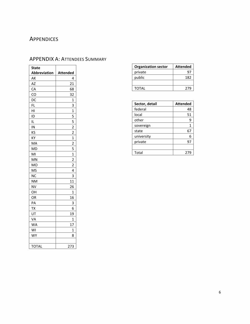
APPENDIX A: ATTENDEES SUMMARY
State Abbreviation Attended
AK 4
AZ 21
CA 68
CO 32
DC 1
FL 3
HI 1
ID 5
IL 5
IN 2
KS 2
KY 1
MA 2
MD 5
MI 1
MN 2
MO 2
MS 4
NC 3
NM 11
NV 26
OH 1
OR 16
PA 3
TX 6
UT 19
VA 1
WA 17
WI 1
WY 8
TOTAL 273
Organization sector Attended
private 97
public 182
TOTAL 279
Sector, detail Attended
federal 48
local 51
other 9
sovereign 1
state 67
university 6
private 97
Total 279

7
APPENDIX B: AGENDA
National Height Modernization Partner Meeting Tuesday, November 19, 2013 10 am to 2 pm Pacific Time Teleconference only Agenda
10:00‐10:05 Introductory Remarks
Juliana Blackwell, Director, NGS ● Welcome
10:05‐10:15 Overview of Height Modernization
Christine Gallagher, Program Analyst, NGS ● History of Height Modernization ● Height Modernization as we prepare for a new vertical datum
10:15‐10:30 Height Modernization in Wisconsin and the Great Lakes Region
Diane Arendt, Geodesist, Wisconsin Department of Transportation ● Chair of Great Lakes Regional Height Modernization Consortium ● Registered Land Surveyor in the state of Wisconsin
10:30‐10:45 Planning for the next vertical datum Mark Eckl, Observations and Analysis Division Chief, NGS ● Implementation Plan to Replace NAVD 88 ● GRAV‐D data and product releases ● NGS geoid models
10:45‐11:00 Leveraging height information from the public
Dru Smith, Chief Geodesist, NGS ● Major steps to the new vertical datum ● Progress to date ● Future help from the public
11:00‐11:05 break 11:05‐11:50 “Height Mod” Surveys
Michael Dennis, Geodesist, NGS ● Overview of survey planning (NGS 58 and NGS 59) ● Bluebooking and Adjust ● Where we are going (testing to update NGS 58 and NGS 59) ● GIS tools
11:50‐12:05 Tools to help complete “Height Mod” Surveys Joe Evjen, Geodesist, NGS ● OPUS ● OPUS Projects

8
12:05‐12:40 Lunch break 12:40‐12:55 Height Modernization and United States Geological Survey (USGS)
Paul Rydlund, hydrologist, USGS Missouri Water Science Center ● Applications to stream gages and USGS hydrologists ● Coordination with US Army Corp and others
12:55‐1:10 Arizona Height Modernization Speaker to be announced
1:10‐1:25 Height issues in western states
Pam Fromhertz, Colorado Geodetic Advisor ● Lack/Destruction of NAVD 88 bench marks ● Analysis of Heights in CO ● Vertical land motion
1:25‐1:30 Concluding remarks
Christine Gallagher, Program Analyst, NGS ● Next steps
1:30‐2:00 1:30 ‐ 2:00 PT, OPUS‐DB (Publishing to OPUS demonstration)
Mark Armstrong, Oregon Geodetic Advisor ● Live Demo ‐ NGS Data Explorer (Find a bench mark to observe) ● Field procedures and requirements to Publish your OPUS solution ● Live Demo ‐ OPUS Publishing (Sharing your solution with the public) ● The OPUS datasheet
APPENDIX C: PRESENTATIONS
Presentations, when available, were posted to the following web page:
http://www.ngs.noaa.gov/corbin/class_description/HM_WesternRegion.shtml
9
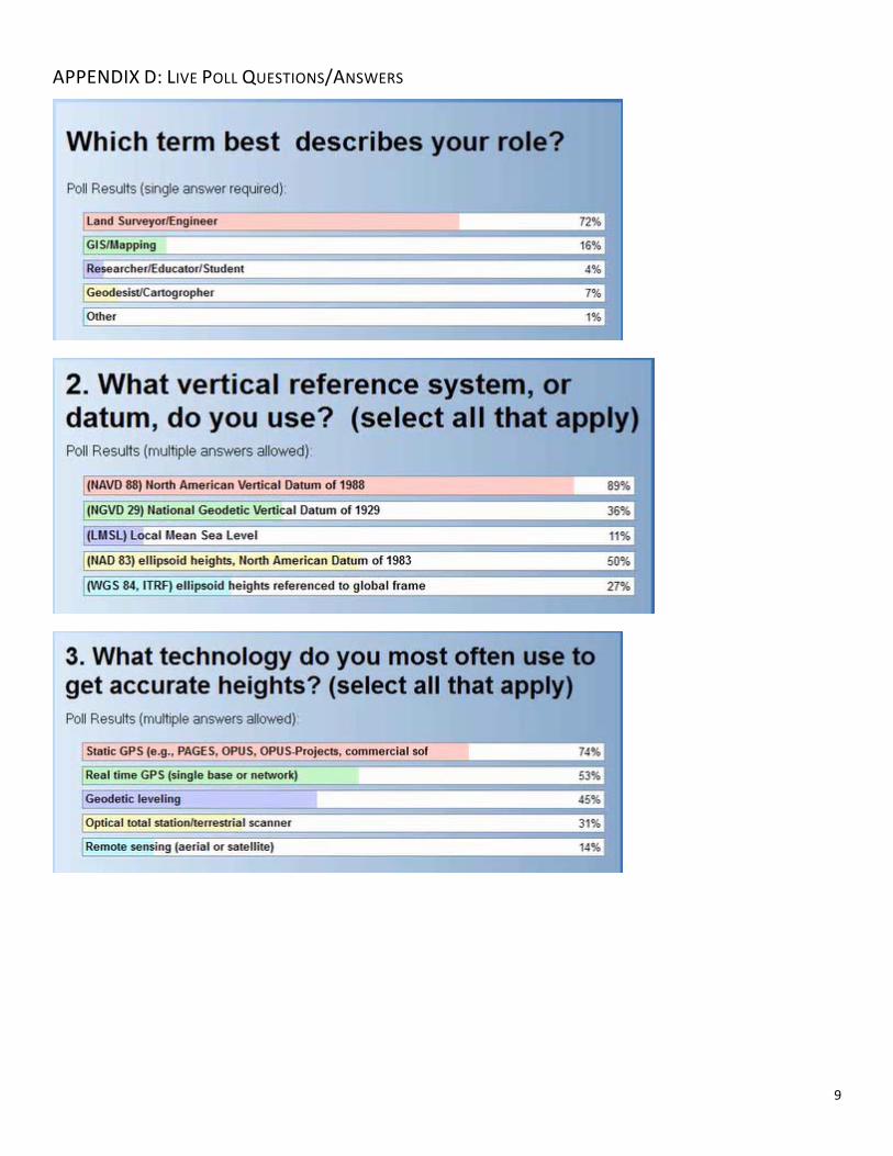
APPENDIX D: LIVE POLL QUESTIONS/ANSWERS

10

11
APPENDIX E: LIVE QUESTIONS/ANSWERS FROM AUDIENCE
SUBJECTS I. Wisconsin Height Modernization
II. GRAV‐D and geoid models
III. GPS on BMs
IV. NGS 58‐59
V. GIS
VI. USGS
VII. OPUS and OPUS Projects
VIII. Webinar administration/follow‐up
IX. COMMENTS AND MISCELLANEOUS QUESTIONS
I. WISCONSIN HEIGHT MODERNIZATION 1. Has Wisconsin tried using InSAR in the State of Wisconsin to monitor land subsidence?
Wisconsin Department of Transportation has not. There may be other agencies (e.g. WI Department of
Natural Resources, U.S. Department of Agriculture Farm Service Agency or Natural Resources Conservation
Service) that have used this technology), or one of the University of Wisconsin Geology Departments.
2. Where can we get access to the document on State run RTN's done by Wisconsin?
It is linked to the Great Lakes Region Height Modernization Consortium webpage on the NGS website, or
Diane Arendt can provide a digital copy.
3. Did Diane Arendt say that they created a state specific Geoid for Wisconsin?
The GEOID12A model included the Wisconsin statewide vertical readjustment which impacted large
portions of our state.
II. GRAV-D AND GEOID MODELS
1. How many planes/gravity meters are being used on the GRAV‐D flights?
Typically one airborne gravity meter is on an aircraft at a time, although we have flown two at a time for
experimental purposes. NGS currently has two of these meters, and they are flown on four different
aircrafts. At this time we only have one team working at a time.
2. When will Nevada be flown?
Likely in the last three years of the project, when the interior of the U.S. is flown.
3. We're about to fly the NOAA Sandy recovery project. Why don't we put gravimeters on our planes for
that?
12
We are flying airborne gravity for the Sandy recovery project. We do not add gravity meters to the
photogrammetry aircraft because flying parameters (i.e. height, speed, and survey layout) for airborne
gravity are different from those of photography/lidar.
4. Alaska data released: what does “released” mean and how do I access it? Is there a new geoid model that
I can download for Alaska?
Airborne gravity data is a precursor to the geoid model. Released means the airborne gravity data is
available on our website www.ngs.noaa.gov/GRAV‐D . GRAV‐D data has not yet been used to develop
geoid models for Alaska. The latest hybrid and gravimetric geoid models available are GEOID12A and
USGG2012, respectively.
5. We have a Cessna 172 in Oregon. Could that be used to fly a GRAV‐D sensor around Oregon as a private
partner / NGS services provider?
This particular aircraft would be too small for a heavy payload required by GRAV‐D.
6. How will the new geoids be disseminated to the public and software developers? Annual geoid updates is
VERY ambitious. Some software still doesn't support Geoid12A.
NGS does not intend to release new hybrid geoid models annually. We will continue with the approach
used so far, to create new hybrid geoid models as needed, likely every few years or so. However, new
(mainly gravimetric) geoid models will be determined more frequently by NGS for internal use in research,
but not for public release. An important motivation for research is to prepare for the new U.S. vertical
datum, which will be based on a gravimetric geoid.
7. Can I use Geoid12A with NAD 83 and NAD 83 (2011)?
For deriving NAVD 88 orthometric heights from NAD 83 ellipsoid heights, GEOID12A should be used only
with NAD 83(2011). By “NAD 83” alone I assume you mean “original” NAD 83(1986). Stations with the
1986 datum tag do not have ellipsoid heights at all and so cannot be used to derive orthometric heights.
The previous hybrid geoid model, GEOID09, should only be used with NAD 83(2007) ellipsoid heights.
GEOID03 (and GEOID06 in Alaska) should be used with the earlier High Accuracy Reference Network
(HARN) ellipsoid heights. HARN stations have datum tags prior to 2007, and they vary based on location
(mainly on a state‐by‐state basis). NGS does not recommend using earlier geoid models (GEOID99,
GEOID96, and GEOID93), except for legacy projects.
8. We consistently record 5+ hour sessions on a daily basis. How do we contribute this data to the Height
Mod and geoid dataset?
Individual GPS data files on these NGS bench marks can be easily shared, along with mark photos and
description, by uploading to OPUS http://geodesy.noaa.gov/OPUS with the “publish” or “share” option. If
the observations are on leveled NAVD 88 bench marks, then they will be candidates for use in the next
hybrid geoid model. Using these observations to establish Height Mod stations requires that they be
performed in accordance with the NGS 58 and 59 guidelines, and that the results be submitted to NGS via
the formal “Bluebooking” process.

13
III. GPS ON BMS 1. What is meant as a GPS BM? Does it mean GPS on a leveled station?
Yes, specifically a mark with both a valid NAVD 88 leveled orthometric height and an accurate GPS‐derived
NAD 83 ellipsoid height on NGS data sheet. In most cases the leveled orthometric heights have an
“adjusted” vertical source, but other types of leveled marks are also used (such as “resets”). Orthometric
heights derived from NGVD 29 leveled values with VERTCON are never used for GPS BMs.
2. Can GPS on BMs be OPUS‐DB?
Yes, OPUS shared solutions were used in GEOID12A, in areas where none are published via bluebooking.
We encourage more collection of OPUS‐DB on bench marks.
3. GPS collected on benchmarks‐ is the requirement still to use only geodetic quality antennas? (Trimble R8s
and R10s or Leica GS12s are not sufficient?)
All dual frequency, full wavelength antennas listed on the NGS antenna calibration web pages
(http://www.ngs.noaa.gov/ANTCAL/) can be used for Height Mod surveys. This includes integrated units
such as Trimble 4800, 5800, R8, and R10 models; Leica SR399, ATX1230, and GS08‐GS15 models; Topcon
Hiper, GR3, and GR5 models; and many others.
IV. NGS 58-59
1. I am curious that, based on NGS‐58/59, 5 hour occupations are required. I understand much of the NGS is
claiming negligible improvement beyond 4 hours (specifically noted for OPUS‐DB). Are we moving toward
a 4 hour total time? Assume this may be transient in years to come.
We are examining the improvement based on length of occupations as part of the NGS 58/59 study. Based
on those results and other studies, we will continue to update our guidance and the related requirements
when sending data to NGS for publication. It is likely that the 5 hour occupations will be formally
decreased. We are also investigating the viability of using real‐time observations, which would
dramatically reduce occupation times and processing requirements.
2. Are the 3 day 5 hour sessions necessary for our mapping to obtain 2 cm orthometric heights?
(Same as above) We are examining the improvement based on length of occupations as part of the NGS
58/59 study. Based on those results and other studies, we will continue to update our guidance and the
related requirements when sending data to NGS for publication. It is likely that the 5 hour occupations will
be formally decreased. We are also investigating the viability of using real‐time observations, which
would dramatically reduce occupation times and processing requirements.
3. Is there going to be any studies for new NGS 59 in mountainous states?
To develop sound guidance, we will have to complete studies and/or rigorously examine data from
different areas of the country with different existing conditions. Such an assortment of geographic areas
would likely include a mountainous state, especially in the interior western US.

14
4. Is there a timeline for the updated 58/59 guidelines?
Given the time and resources needed for data collection, analysis, guideline development, and review, we
are planning on completing the revised guidelines by March 2016.
5. In California, the California Spatial Reference Center is in charge of publishing coordinates for our CORS
and CGPS stations that we use to constrain to. Are we correct in constraining to those stations to
determine orthometric heights? And how do we go about it since we aren’t occupying passive
benchmarks like NGS 59 calls out to do?
In some cases CORS can be used for vertical constraints, if they also have published “valid” NAVD 88
orthometric heights. NGS 59 requires constraints to valid NAVD 88 control to determine GPS‐derived
orthometric heights that can be published to the nearest cm and be specifically identified by NGS as
“Height Mod” stations (shown as a message near the top of NGS datasheets).
Valid NAVD 88 control must be published by NGS, and these are usually leveled bench marks (this does not
include VERTCON‐derived NAVD 88 heights). GPS‐derived orthometric heights from previous Height Mod
surveys can also be used, but ultimately all Height Mod heights are traceable to leveled bench marks.
Both passive marks and CORS can serve this purpose, but they must be either leveled or have a Height
Mod orthometric height.
In California there are presently 36 CORS that can possibly serve as valid NAVD 88 control (8 are 2nd‐order
leveled and 28 are Height Mod). There are also about 19,000 leveled NAVD 88 bench marks that can
possibly provide constraints to determine Height Mod orthometric heights on other CORS (although many
may be destroyed or no longer appropriate due to movement). Doing so would require following NGS 58
and 59 guidelines, which includes evaluating the NAVD 88 control used as constraints. Finally, NGS
intends to perform a nationwide Height Mod adjustment, which will provide Height Mod orthometric
heights on many more stations, including CORS. Resources permitting, we hope to accomplish this in
2014.
6. One of the items that must be addressed with the new/revised Height Mod guidelines (NGS 58/59) is to
include a section that was written by the California State advisor before retiring and submitted to State
Advisor Branch Chief on resetting a Height Mod control mark.
The project manager for the NGS 58/59 study is aware that this section needs to be included in the
updated guidelines.
V. GIS
1. Any estimated date for "public" access to GIS Tools?
No date is set, although we hope to accomplish that in early 2014. In the meantime, you can obtain
preliminary versions of the NGS GIS tools by emailing Michael Dennis ([email protected]) or Brian
Shaw ([email protected]).
2. How can I get a GIS Beta Toolkit for our GIS department?

15
(Same as above). You can obtain preliminary versions of the NGS GIS tools by emailing Michael Dennis
([email protected]) or Brian Shaw ([email protected]).
3. I encourage you to make the new shapefile format production ASAP! I'm having difficulty helping people
map Ht Mod control because they used the old format to retrieve shapefiles. They didn't know about the
BETA new format. Please make it a priority to get done before end of year, thank you.
Thank you for your comment. We plan to prioritize the effort, and in the meantime you can use the beta
shapefiles. Link to zipped shape files:
ftp://ftp.ngs.noaa.gov/dist/BETA_PRODUCTS/DS_ARCHIVE/Shapefiles/. Document listing changes:
ftp://ftp.ngs.noaa.gov/dist/BETA_PRODUCTS/DS_ARCHIVE/Shapefiles/DS_Changes.doc
VI. USGS
1. RE: Stream gage update workgroup (NOAA/USGS), COMMENT: FEMA could/should also be part of the
workgroup. Even Bureau of Reclamation could be part of it.
Agreed that both of these agencies would be good additions. I am trying to get more direction from our
bureau regarding the unfunded mandate of 88 datum conversions and support required from our agency
itself.
2. How do I get Paul/s newsletter or website about "Community of Practice" and the slide before that?
The slides will be made available. There are several websites that may be of interest regarding assistance:
a. NGS Geodetic Advisors ‐ http://www.ngs.noaa.gov/ADVISORS/AdvisorsIndex.shtml
b. U.S. Army Corps of Engineers Geospatial Center ‐
http://www.agc.army.mil/Missions/USMART.aspx.
c. U.S. Geological Survey GPS Committee ‐ http://water/usgs/gov/usgs/osw/gps
3. Can you make the USGS gage descriptions available?
Unfortunately these descriptions are still internal; however, they can be requested with a call to any local
USGS office.
VII. OPUS AND OPUS PROJECTS
1. Will there be improvements in OPUS uploading to detect that a monument description (etc.) has already
been submitted for a particular project?
Good suggestion, but difficult to accomplish in single‐web‐session, as OPUS doesn’t immediately know
which mark your upload belongs to. Providing durable access to return and modify an upload session, or
posting status updates on the upload complete screen when the solution is complete and catalogued may
work, but require some pretty fancy scripting on our end. It is something for us to consider.
2. If a true duplicate dataset (the exact same data) is submitted to OPUS (to be published), does the NGS
human NOT publish it?
She can’t if she tried, thanks to OPUS publishing filters. Data files which overlap in space are assigned to
one mark. Data files which overlap in time AND space are flagged as duplicates and rejected. Publishing
the duplicate is possible, but requires manual destruction of the original first.

16
3. If the GPS observations available are only from OPUS users [not enough] why can't NGS ask "every" GPS
user to submit their files for adjustment? Nevada DOT has years of files that will never be submitted to
OPUS.
Asking is free … building our tools friendly and useful enough to encourage such sharing is the key. The
GPS data is probably the easy part, managing the mark descriptions would take the most time. Via OPUS,
such sharing is vastly simplified over traditional Bluebooking, and we are open to ideas to make such
sharing even easier, to the extent that it supports a useful product.
4. Will OPUS Projects be used as the data submittal method for the new geoid?
OPUS‐S has this method, under upload options > “share/publish my solution.”
OPUS projects v.1 lacks automated “submittal” capability, but paths from OPUS projects to submit are
being worked on.
5. This slide suggests that OPUS project runs baselines between my stations. I have not observed that
behavior in OPUS Project. Can you clarify?
OPUS Project uses the NGS program PAGES to process baselines between simultaneously observed marks
(sessions) with GNSS geodetic grade receivers. Then processed sessions may be combined into a network
and a least squares adjustment performed. Although there are some limitations in designing a network in
OPUS‐Projects, there is considerable latitude. It is often possible to create a network with baselines that
run between passive marks, but of course they must be simultaneously observed.
6. How do we get the OPUS Projects User's Manual?
The “OPUS Project User Instruction and Technical Guide V2.2” should be available at the header of the
OPUS Project “Create” a project page as a PDF download once OPUS Projects becomes operations.
7. When, where and how often will OPUS Projects trainings be in or near New Mexico, northern Nevada,
Utah, CA or the West?
Classes are currently being scheduled. Please email [email protected] to request notification when
classes are scheduled, or see http://www.ngs.noaa.gov/corbin/calendar.shtml. If your state has a state or
regional advisor, please email him/her to express your interest
(http://www.ngs.noaa.gov/ADVISORS/AdvisorsIndex.shtml).
VIII. WEBINAR ADMINISTRATION/FOLLOW-UP
1. Where can I access an agenda?
The final version of the agenda is posted online as a pdf:
http://www.ngs.noaa.gov/corbin/class_description/WestRegHMOD_agendaNov13.pdf. Also feel free to
review the entire meeting webpage to download presentations and watch video recordings:
http://www.ngs.noaa.gov/corbin/class_description/HM_WesternRegion.shtml

17
2. How many participants attended the webinar?
279 people attended the webinar.
3. How many people participated in the webinar from each state?
Participants were from 30 states, with the strongest attendance from western states (e.g. California had
68 participants). More information about the attendees will be included in a final report, to be posted at:
http://www.ngs.noaa.gov/heightmod/Events.shtml.
4. Will presentations (i.e. power point slides) be available after the presentation?
Yes, you can visit the meeting webpage to download presentations and watch video recordings:
http://www.ngs.noaa.gov/corbin/class_description/HM_WesternRegion.shtml
5. Will this webinar be available online to view on our own time?
Yes, you can visit the meeting webpage to download presentations and watch video recordings:
http://www.ngs.noaa.gov/corbin/class_description/HM_WesternRegion.shtml
6. Will you speak to the PDH certification?
Certificates were emailed to attendees the day following the webinar. If you did not receive a certificate
and believe that you should have, contact the webinar organizer.
IX. COMMENTS AND MISCELLANEOUS QUESTIONS
1. That [GPS on BMs map, OPUS solutions] is an embarrassing show for Nevada; must be an inherent
reluctance to publish through OPUS? We do all kinds of observations on bench marks!
We welcome any additions. There are over 500 different groups sharing data via OPUS nationwide, but
only 9 from Nevada, led by the Wyoming Department of Transportation.
2. Nevada Bench Mark collections: http://apps.nevadadot.com/Lois/
3. Just FYI, I'm not sure about the Western States, but another great resource for finding monuments in the
Midwest is www.geocaching.com. Local "geocachers" are constantly hunting up, logging locations, and
photographing monuments.
Agreed, DSWorld tool provides links to geocache where appropriate.
4. Unfortunately, antiquated survey marks are not listed in Data Explorer. They're usually where you most
need them.
What is meant by “antiquated” marks? NGS Data Explorer shows ALL publishable NGS control, which is
currently about 780,000 stations.
5. Where can I obtain Data slides for Utah like Pam has for Colorado?

18
These were created based on a specific request using GIS and the shape files we provide to users. We can
see if we can create others based on requests.
6. What is "TEQC"?
TEQC is software developed by UNAVCO ‐ http://facility.unavco.org/software/teqc/ TEQC — The Toolkit
for GPS does translation, editing, and quality checking. It has many features and functions. The NGS uses
TEQC to look at all files uploaded to OPUS and to perform a quality check and then convert them from a
proprietary file type to a RINEX file type as needed. It also changes the data epoch to 30 seconds.
7. What was the outcome of the AZ statewide vertical adjustment? Meaning, was it 'submitted' to NGS and
the new heights published? Or published locally (only) somewhere?
The results of the AZ statewide vertical adjustment were “submitted” and the new GPS‐derived
orthometric heights published by NGS in January 2012. Height Mod orthometric heights were determined
for 1091 stations, based on GEOID09 and vertically constrained to 353 leveled NAVD 88 bench marks.
8. What would be the best location to download CORS data? I am currently using California Spatial
Reference Center. The data from CSRC does not have GLONASS data with it.
see beta UFCORS which may become operational soon. In the beta version, GLONASS data can be
included for all CORS where available,
9. What options exist to determine which control points are photo‐identifiable? Also, can standards and
best practices be established to select locations for control points that would be photo‐identifiable? Most
government agencies need photo‐identifiable ground control for inspecting and/or creating ortho‐
imagery.
Unfortunately, convenient, stable, and photo‐identifiable are seldom in the same place. Agreed, mark
setting guides should mention techniques for making marks more photo‐ and field‐identifiable, e.g.,
placing within center of a 1 meter square gravel box (which also helps drainage and keeps lawnmowers
away) or placing on extended centerlines or range‐markers‐of‐opportunity (which also helps mark
recovery.) Often, control which isn’t visible does reference other visible features in the description (e.g., 2
meters south from a telephone pole, 4.4 meters west from centerline of road.) Older triangulation‐based
geodetic control includes “intersection” stations like church spires and water tanks which are still visible
today.
10. What is the accuracy is considered "mapping‐grade" [regarding transformation tools]?
Usually 1 meter or greater.
11. Which database gets populated during the ""Bluebooking"" process?
NGSIDB, the “integrated” database.
12. Where would I go to view [employment] positions available?
https://www.usajobs.gov/


